montara groundwater exploration project project … water and sanitary...montara groundwater...
TRANSCRIPT

Page 1 of 3 BACWA PROJECT ELEMENT NO. 13
MONTARA WATER & SANITARY DISTRICT
PROJECT COMPLETION REPORT
MONTARA GROUNDWATER EXPLORATION PROJECT
Project Completion Report
ELEMENT 13
MONTARA GROUNDWATER EXPLORATION PROJECT
(MONTARA WATER AND SANITARY DISTRICT)
EXECUTIVE SUMMARY
Work Proposed
The project consisted of drilling up to 2 test wells in the vicinity of the Montara Water
and Sanitary District (MWSD) service area for the purposes of characterizing the various
aquifers in terms of their optimal use for potable water supply. This data extends the
regional groundwater assessment work already conducted by San Mateo County. The
San Mateo County Midcoast Aquifers: Literature and Data Review (Balance
Hydrologics, April 2002) and the San Mateo County Midcoast Groundwater Study:
Phase II (Kleinfelder, February 2004) provided guidance as to where the most productive
strata were located. Data from the test well program allow evaluation of the local
aquifers in terms of their suitability for public and private potable water supply. A matrix
of potential beneficial uses of the groundwater and desired characteristics for that use was
constructed and the local aquifers ranked as to how close they meet the desired
characteristics for a given beneficial use. The last step in the data analysis was to
optimize the existing and projected groundwater levels for potable supply according to
the results of the matrix analysis. Data collection of well water quality was conducted
consistent with Groundwater Ambient Monitoring and Assessment (GAMA) Program
protocols. There is no current GAMA monitoring in the Midcoast Region and data from
the test wells could help establish a baseline for the area.
Work Completed
The Project Assessment and Evaluation Plan (PAEP) outlined steps to enhance the
MWSD potable water supply by characterizing local aquifers through groundwater
exploration. The work outlined in the project work plan specified two test wells would be
drilled.
The first well site was located near the intersection of Tierra Alta Street and Loma Vista
Street. The well was drilled to a depth of 640 feet below ground surface (bgs), nearly 200
feet deeper than the depth initially thought to yield an adequate flow rate. Prior to
drilling, it was believed the well could achieve a higher yield from the more shallow
aquifer (between 250 to 400 bgs). When a higher yield was not discovered at this depth,
the well was drilled to access the deeper aquifer, just beyond 640 bgs. However, at the
final depth, the well still yielded only 2 gallons per minute (gpm) during a 1.5 hour air-
lift test. The water quality analysis showed elevated levels of dissolved solids, chloride,

Page 2 of 3 BACWA PROJECT ELEMENT NO. 13
MONTARA WATER & SANITARY DISTRICT
PROJECT COMPLETION REPORT
sodium and fluoride, exceeding Title 22 Drinking Water Requirements (see Table 1
below and Exhibit A).
Table 1. Well Site No. 1 (Tierra Alta/Loma Vista ) Water Quality Analysis
Parameter Result Units Detection
Limit MCL
Total Dissolved Solids (TDS) 1500 mg/L 10 1000
Chloride (Cl) 320 mg/L 1 250
Sodium (Na) 210 mg/L 0.5 –
Fluoride 1.7 mg/L 0.1 1
Balance Hydrologics, Inc., the Hydrologist/Geologist responsible for the analysis, stated
in an April 2006 letter to MWSD that the well site was not recommended for a municipal
well primarily because of the low yield. Balance Hydrologics further explained that the
well may be feasible for a domestic well. However, San Mateo County requires a 2.5
gpm yield to permit a well for domestic use and the well will likely require treatment.
The well was abandoned, back-filled with sand and gravel and sealed with 75 feet of
cement. Inspection by San Mateo County staff occurred on February 27, 2008. The
project was completed in April 2008. There will be no discharge to surface water or
groundwater. This project included no design and construction, as the project was limited
to exploratory drilling.
Deviations from Work Proposed
It was determined that the original budgetary estimate was not adequate for the
exploratory drilling of the second planned groundwater well. As stated above, the first
well required additional drilling of 240 feet beyond the assumed depth of 400 bgs at a
cost of $40 to $46 per linear foot depth (see Exhibit B). Additionally, the well was
abandoned based on the recommendation of Balance Hydrologics due to the poor water
quality and low yield. The abandonment of the test hole is a cost of $7 per each linear
foot (640 linear feet total). Both items are beyond the original estimate provided for this
project.
Based on the limit of the original estimate and increased cost to drill the additional depth
and abandon the well, the budget was completely expended on drilling of the Tierra
Alta/Loma Vista Well Site. Thus, the project was limited to one well due to the
exhaustion of the current budget.
Project Performance Monitoring
The project was completed in April 2008. The well has been abandoned. Therefore there
will be no need for a mechanism or process that allows for continued performance
monitoring of the project as the project is complete.

Page 3 of 3 BACWA PROJECT ELEMENT NO. 13
MONTARA WATER & SANITARY DISTRICT
PROJECT COMPLETION REPORT
Updates or Changes to the IRWM Plan
No updates or changes are required per Element 13 Montara Groundwater Exploration
Project.
REPORTS
Due to the low yield of the test well the well was deemed infeasible for municipal water
supply. The test well was abandoned following the analysis by Balance Hydrologics, Inc.
The complete Balance Hydrologics is included in the 3rd
Quarter Report (Exhibit C).
COST & DISPOSITION OF FUNDS INFORMATION
Project Invoicing
February 10, 2009 – BACWA submitted Invoice No. 1 to DWR
◦ Groundwater Optimization Project – Invoice No. 1 Total $42,100.00
October 9th
, 2009 – DWR Check received by MWSD
◦ Amount received from DWR – $33,390.00
Final Funds Disbursement
See Exhibit B Montara Groundwater Exploration Project No. 13 Grant Invoice 1.
Summary of Project Cost
See Exhibit B Montara Groundwater Exploration Project No. 13 Grant Invoice 1 and
Exhibit C Montara Groundwater Exploration Project No. 13 3rd
Quarter Report.

Exhibit A
Montara Groundwater Exploration Project No. 13
Summary of Field Measurements and Water Quality Analysis

Table 2. Summary of field measurements and water quality analyses,
Montara Water and Sanitary District, San Mateo County, California
PARAMETER UNITS DETECTION
LIMITMCL Tierra Alta and
Loma Vista,
Moss Beach, CA
DESCRIPTORS
Sample I.D. 8020627-01
Assessors parcel number 037-071-090
Latitude, NAD83 degrees N37.5314
Longitude, NAD83 degrees W122.5099
Elevation, NGVD29 feet 234
Lab used Soil Control
Sample collected by gp
Sample filtering yes
FIELD MEASUREMENTS
Date MM/DD/YY 9/22/2004
Time HH:MM 15:15
Specific conductance (@ 25 C°) umhos/cm 825
Conductance (@ field temp) umhos/cm 730
Temperature deg C 18.9
Air-lift test for 1.5 hours gpm 2.0
WATER QUALITY INDICATORS
Alkalinity (total) mg/L CaCO3 1 130
Hardness (total) mg/L CaCO3 5 190
pH pH Units 0.1 10.6 8.3
Specific conductance (@ 25 C°) umhos/cm 1 1600 1300
Total dissolved solids (TDS) mg/L 10 1000 1500
GENERAL MINERALS
Bicarbonate (as CaCO3) mg/L 1 160
Calcium (Ca) mg/L 0.5 31
Carbonate (as CaCO3) mg/L 1 120 0
Chloride (Cl) mg/L 1 250 320
Iron (Fe) mg/L 0.05 0.3 0
Magnesium (Mg) mg/L 0.5 27
Manganese (Mn) mg/L 0.02 0.05 0.023
Potassium (K) mg/L 0.5 8
Sodium (Na) mg/L 0.5 210
Sulfate (SO4) mg/L 1 250 40
TITLE 22 PRIMARY STANDARDS, INORGANIC
Aluminum (Al) mg/L 0.05 1 0
Antimony (Sb) mg/L 0.006 0.006 0
Arsenic (As) mg/L 0.002 0.010 0
Barium (Ba) mg/L 0.1 1 0
Beryllium (Be) mg/L 0.001 0.004 0
Cadmium (Cd) mg/L 0.001 0.005 0
Chromium (Cr) mg/L 0.001 0.05 0
207220 MWSD water quality 4-15-08.xls, 2008 samples 1 of 2 ©2008 Balance Hydrologics, Inc.

PARAMETER UNITS DETECTION
LIMITMCL Tierra Alta and
Loma Vista,
Moss Beach, CA
Fluoride (F) mg/L 0.1 1 1.7
Mercury (Hg) mg/L 0.0002 0.002 0
Nickel (Ni) mg/L 0.01 0.1 0
Nitrate as (NO3) mg/L 1 45 4.6
Selenium (Se) mg/L 0.005 0.05 0
Thallium (Tl) mg/L 0.001 0.002 0
OTHER CONSTITUENTS
Boron (B) mg/L 0.1 0.18
Copper (Cu) mg/L 0.05 1 0
Cyanide (total) mg/L 0.1 0.2 0
Lead (Pb) mg/L 0.005 0.015 0
MBAS (surfactants) mg/L 0.025 0.5 0
Nitrite (as N) mg/L 0.5 0
Sliver (Ag) mg/L 0.01 0
Zinc (Zn) mg/L 0.05 5 0
LAB CHECK
Major Cations (Ca+Mg+K+Na+Fe+Mn) meq/L -- -- 13.11
Major Anions (HCO3+CO3+Cl+SO4+F+NO3) meq/L -- -- 13.22
Ion Balance (Cations/Anions) -- -- -- 0.99
NOTES
Observer key: mw = Mark Woyshner; jp = Jason Parke; gp = Gustavo Porras; va = Vic Abadie
Lab results: 0 = not detected; blank value = not tested
MCL = Title 22 Maximum Contaminant Level as of June 12, 2003; the MCL of Lead is the Regulatory Action
207220 MWSD water quality 4-15-08.xls, 2008 samples 2 of 2 ©2008 Balance Hydrologics, Inc.

Exhibit B Montara Groundwater Exploration Project No. 13
Grant Invoice 1


Exhibit CMontara Groundwater Exploration Project No. 13
3rd Quarter Report

Page 1 of 3 BACWA PROJECT ELEMENT NO. 13 MONTARA WATER & SANITARY DISTRICT
3RD QUARTER – 2008
MONTARA GROUNDWATER EXPLORATION PROJECT 3rd Quarter Report – October 2008
ELEMENT 13 – MONTARA GROUNDWATER EXPLORATION PROJECT (MONTARA WATER AND SANITARY DISTRICT) PROJECT DESCRIPTION The project consists of drilling up to 2 test wells in the vicinity of the Montara Water and Sanitary District (MWSD) service area for the purposes of characterizing the various aquifers in terms of their optimal use for potable water supply. This data would extend the regional groundwater assessment work already conducted by San Mateo County. The San Mateo County Midcoast Aquifers: Literature and Data Review (Balance Hydrologics, April 2002) and the San Mateo County Midcoast Groundwater Study: Phase II (Kleinfelder, February 2004) provide guidance as to where the most productive strata are located. Data from the test well program will allow evaluation of the local aquifers in terms of their suitability for public and private potable water supply. A matrix of potential beneficial uses of the groundwater and desired characteristics for that use will be constructed. Uses such as standby firefighting supply, private residential supply, and public water system conjunctive use supply will be considered. Then the local aquifers will be ranked as to how close they meet the desired characteristics for a given beneficial use. The last step in the data analysis will be to optimize the existing and projected groundwater levels for potable supply according to the results of the matrix analysis. Data collection of well water quality will be conducted consistent with Groundwater Ambient Monitoring and Assessment (GAMA) Program protocols. There is no current GAMA monitoring in the Midcoast Region and data from the test wells would help establish a baseline for the area. PROJECT INFORMATION (Thru September 2008) Legal Matters There are no legal matters as of September 2008.
Engineering Matters • Borehole drilling completed Friday, February 21, 2008.
• Water quality sample collected February 21, 2008.
• Well abandoned and backfilled Monday, February 25, 2008.
• Well sealed and inspected Wednesday, February 27, 2008.
• Project completed.
Environmental Matters • No environmental matters encountered through September 2008.

Page 2 of 3 BACWA PROJECT ELEMENT NO. 13 MONTARA WATER & SANITARY DISTRICT
3RD QUARTER – 2008
Status of permits, easements, rights-of-way and approvals • A San Mateo County subsurface drilling permit obtained December 2007.
• There are no other permits required.
Major accomplishments thru April 2008 • Geotechnical drilling permit obtained.
• Borehole drilling completed February 22, 2008.
• Water Quality sample tested by Soil Control Labs determined elevated levels of dissolved solids, sodium, chloride, and fluoride.
• Borehole abandoned, backfilled, sealed and inspected by San Mateo County staff on February 27, 2008.
• Site not recommended for a municipal well due to low yield, by Balance Hydrologics, Inc. in April 16, 2008 correspondence to MWSD.
Ambient surface water and groundwater data submittals The well has been abandoned. There will be no discharge to surface water or groundwater. Issues/concerns that affect the schedule or budget Project completed April 2008; therefore there are no issues or concerns that affect the schedule as of September 2008.
Differences between work performed and the work outlined in project work plan The work outlined in the project work plan specified two test wells would be drilled due to budgetary constraints only one test well was completed. Project performance relative to the criteria established in the Project Assessment and Evaluation Plan (PAEP) The PAEP outlined steps to enhance MWSD’s potable water supply by characterizing local aquifers through groundwater exploration. Due to budgetary restraints the exploration was limited to one well site located near the intersection of Tierra Alta Street and Loma Vista Street. This well yielded 2gpm with elevated levels of dissolved solids, sodium, chloride and floride. Balance Hydrologics, Inc. stated in an April 2006 letter to MWSD that the well site was not recommended for a municipal well primarily because of the low yield. COST INFORMATION Task #4 cost was higher than anticipated due to the extended drilling period caused by heavy rains and wet soils, as stated in the April 16, 2008 letter to MWSD (Attachment 1). This increase was partially offset by lower costs for other tasks.

Page 3 of 3 BACWA PROJECT ELEMENT NO. 13 MONTARA WATER & SANITARY DISTRICT
3RD QUARTER – 2008
Task No. Task Description
Initial Project Cost
Revised Project Cost
Total Costs Incurred as
of Last Quarter
Costs Incurred
this Quarter
Total Costs Incurred as
of this Quarter
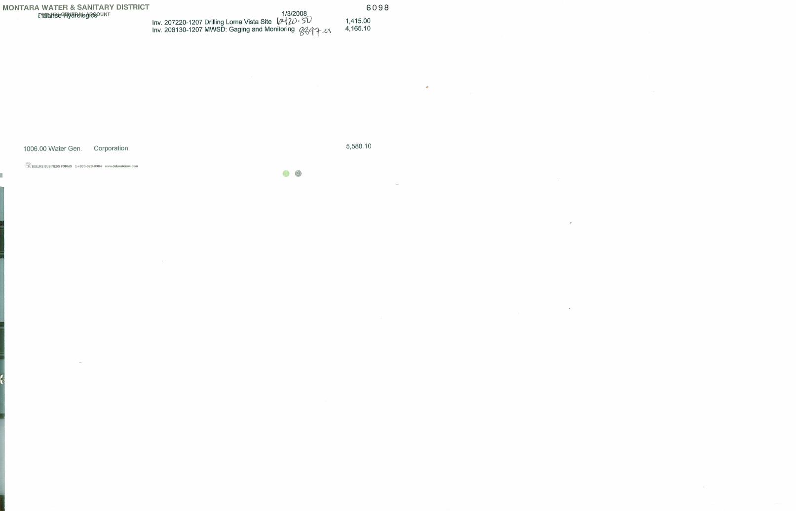
1 Direct Project Administration $900 $0 $0 $0 $0
2 Land Purchase/Easement $0 $0 $0 $0 $0
3
Planning / Design / Engineering / Environmental Documentation $10,000 $1,415.00 $1,415.00 $0 $1,415.00
4
Construction / Implementation / Environmental Mitigation/ Enhancement $36,600 $65,976.84** $65,976.84** $0 $65,976.84**
5 Construction Administration $500 $0 $0 $0 $0
6 Other Costs NA NA NA $0 NA
7 Contingency NA NA NA $0 NA
TOTALS $48,000 $67,391.84 $67,391.84 $0 $67,391.84**See Attachment 2 SCHEDULE INFORMATION The project was completed as of April 2008. ANTICIPATED ACTIVITIES NEXT QUARTER The project was completed as of April 2008. Attachments: 1. Balance Hydrologics, Inc. letter to Montara Water and Sanitary District, April 16,
2008 2. Invoices:
• Balance Hydrologics, Inc. Invoice # 207220-1207 dated December 27, 2007 • Balance Hydrologics, Inc. Invoice # 207220-0208 dated March 3, 2008 • Balance Hydrologics, Inc. Invoice # 207220-0308 dated April 1, 2008 • Balance Hydrologics, Inc. Invoice # 207220-0408 dated May 9, 2008 • Maggiora Bros. Drilling, Inc. Invoice # 71172-1 dated March 24, 2008

BACWA PROJECT ELEMENT NO. 13 MONTARA WATER & SANITARY DISTRICT
3RD QUARTER – 2008
ATTACHMENT 1

April 16, 2008 Mr. Clemens Heldmaier Montara Water and Sanitary District 8888 Cabrillo Highway Montara, California 94037 RE: Ground-water evaluation for municipal water supply at APN 037-071-090 at Tierra Alta
Street and Loma Vista Street, Moss Beach, CA Dear Mr. Heldmaier:
You have asked us to evaluate subsurface conditions and the potential for a municipal water supply well on Montara Water and Sanitary District property APN 037-071-090, located at the intersection of Tierra Alta Street and Loma Vista Street in Moss Beach, California. The property is at an approximate elevation of 230 feet above sea, on marine terrace deposits identified as upper Pleistocene (Qt2) by Brabb and Pampeyan (1972). This hilly area of Moss Beach between Stetson Street and Montara Creek, on which the property is found, is part of the Upper Moss Beach ground-water sub-unit of Hecht and others (1989). It consists of about 40 feet marine terrace deposits underlain by Montara Mountain granitic rock, and ground-water storage was estimated at 210 acre-feet with a generally low transmissivity. Several faults splay across the area, related to the Denniston Creek fault and the regional Seal Cove fault (Pampeyan 1994), and related fracturing suggested a possible higher yield from a well drilled on site.
Drilling was conducted under a County geotechnical drilling permit rather than a County water well drilling permit because the former is consistent with your charge to us and proved simpler to permit. The permit, however, did require borehole abandonment, and not cased as a well (see attached permit).
Drilling Activities and Ground-Water Findings
Maggiora Bros. Drilling, Inc. (Watsonville) drilled the borehole using an air-rotary/hammer rig (Ingersoll Rand TH-60/HR 2.5). The rig was mobilized to the site on January 21, 2008 but drilling didn’t start until February 7, 2008 due to heavy rains and wet soils. The attached site map (Figure 1) shows the location of the borehole. Table 1 is a daily log of the drilling activities.
Maggiora drilled to a depth of 45 feet below ground surface (bgs) with a 12 ¼- inch bit and installed 12-inch diameter steel conductor casing. From 45 to 105 feet depth an 8 ¾-inch rotary bit was used, and from 105 to the borehole's final depth of 640 feet a 6 ¼-inch hammer bit was used.
BalanceHydrologics, Inc.
841 Folger Ave. • Berkeley, CA 94710-2800 • (510) 704-1000224 Walnut Ave., Ste. E • Santa Cruz, CA 95060-3836 • (831) 457-9900
281 Nevada St. • Auburn, CA 95603-4617 • (530) 887-9988
www.balancehydro.com • email: [email protected]
Integrated Surface and Ground Water Hydrology • Wetland and Channel Restoration • Water Quality • Erosion and Sedimentation • Storm Water and Floodplain Management

Mr. Clemens Heldmaier April 16, 2008 Page 2
207220 MWSD Borehole Drilling and Testing 4-16-08.doc
In general, the geologic section encountered during drilling was similar to those described in the logs for the other wells drilled in the general vicinity. The attached log (Figure 2) illustrates the borehole drilling history and shows the hydrogeologic observations taken during drilling. A 6-foot layer of soil was underlain by approximately 34 feet of marine terrace deposits, which lie uncomformably over weathered granitic rock extending down to 75 feet. Below 75 feet, and to the borehole's final depth of 640 feet, we encountered relatively competent phaneritic granitic rock with abundant plagioclase feldspars. The apparent principal fracture encountered in this section (between 275 and 278 feet) was filled with sandy silty clay.
First water encountered during drilling was at 62 feet below ground surface. While drilling, flow rates from the well varied between 2 and 5 gallons per minute (gpm). After reaching the final depth of 640 feet bgs on February 22, 2008, an air-lift flow test was conducted in the open borehole for 1.5 hours that produced about 2 gallons per minute.
A water quality sample was collected at the end of the air-lift test and sent to Soil Control Labs (Watsonville), a state-certified laboratory, for analyses of general mineral and Title 22 inorganics. Results were generally similar to other near-coast wells such as the 900-foot Vallemar Bluffs well, located about 2000 feet to the southwest. Relative to other granitic wells in Montara, the borehole yielded elevated levels of dissolved solids, sodium, chloride, and fluoride. Results are shown in Table 2 and Figure 3. Comparably elevated chloride and dissolved solids levels have been reported for one or two nearby monitoring wells by San Mateo County Environmental Health (Hedlund 2003).
A geophysical log was also conducted to evaluate fracture densities and orientations (attached). However, the borehole sloughed at a depth of 265 feet bgs, limiting the depth of the geophysical log. Fracture dip and dip directions (a.k.a. discontinuities) were poorly populated but coarsely showed a population dip azimuth of north 03 degrees east and a magnitude of 58 degrees. It strikes north 87 degrees west.
The borehole was abandoned, backfilled with sand and gravel and sealed with 75 feet of cement. Inspection by San Mateo County staff occurred on February 27, 2008.
Conclusions
A borehole was dilled to 640 feet below ground surface and yielded 2 to 5 gpm while drilling and 2 gpm during a 1.5 hour air-lift test. Ground water was sampled from the borehole and concentrations of dissolved solids, sodium, chloride, and fluoride exceeded State Title 22 drinking water requirements. We have requested of the lab to re-test the sample because our field measurements of specific conductance (SC) were lower (825 umhos @ 25 C, as compared to 1300 umhos @ 25 C from the lab), and SC is as surrogate for total dissolved solids (TDS). In general, SC multiplied by 0.6 estimates TDS. Using our field measurement of SC, the TDS should be about 500 mg/L.
Although a completed and developed well may have slightly higher yields and slightly improved water quality, the site is not recommended for a municipal well primarily because of its low yield. The site may
Balance Hydrologics, Inc.

Mr. Clemens Heldmaier April 16, 2008 Page 3
207220 MWSD Borehole Drilling and Testing 4-16-08.doc
be feasible for a domestic well, though. San Mateo County requires a 2.5 gpm yield to permit a well for domestic use. Water treatment, however, may be needed or desired.
Closure
As with all subsurface analyses, we note that the values presented are estimates based on conditions actually encountered on site during drilling the borehole. Though the tests were conducted at a standard level of practice, more accurate tests could be conducted if the borehole was completed as a well.
If there are any follow-up questions regarding the above assessment or if there is a need to conduct more detailed analyses please give a call.
Sincerely, BALANCE HYDROLOGICS, Inc. ™ Gustavo Porras Hydrologist/Geologist Mark Woyshner Principal Hydrologist/Hydrogeologist Reviewed by Barry Hecht, CHg 50 Enclosures: Tables 1 and 2 Figures 1 through 3 Appendices 1 and 2
Balance Hydrologics, Inc.

Mr. Clemens Heldmaier April 16, 2008 Page 4
207220 MWSD Borehole Drilling and Testing 4-16-08.doc
References
Brabb, E.E. and Pampeyan, E.H., 1972, Preliminary geologic map of San Mateo County, California: USGS Miscellaneous Field Studies Map MF-328.
Hecht, B., O’Connor, M., Renshaw, D., and Petersen, T., 1989, Draft Montara-Moss Beach water well EIR: Kleinfelder & Associates, consulting report in association with Balance Hydrologics, Inc., Thomas Reid Associates and Diane Renshaw, Biologist, to the San Mateo County Department of Environmental Management, 157 p. + 4 appendices.
Hedlund, C., 2003, Hydrogeology and geochemistry of the northern groundwater basin, San Mateo County, California: Masters of Science in Applied Geosciences, San Francisco State University, advisor LaForce
Pampeyan, E.H., 1994, Geologic map of the Montara Mountain and San Mateo 7-1/2’ quadrangles, San Mateo County, California: U.S. Geological Survey Map I-2390.
Woyshner, M.R., and Hecht, B., 1999, Preliminary feasibility assessment of ground water in the Martini Creek, McNee Ranch and Upper Montara Creek area – Interim status report: Balance Hydrologics, Inc., consulting report prepared for the Montara Sanitary District. 10 p. + 8 appendices.
Woyshner, M.R., Hedlund, C., and Hecht, B., 2002, San Mateo County Mid-Coast aquifers: Literature and data review: Balance Hydrologics, Inc., consulting report prepared for the San Mateo County Planning Department. 23 p. + 6 appendices.
Woyshner, M.R., Parke, J., Hecht, B., Porras, G., 2005, Drilling and testing of Montara Water and Sanitary District’s well 2004-4, APN 036-180-030, San Mateo County, California: Well Completion Report: Balance Hydrologics, Inc., consulting report prepared for the Montara Water and Sanitary District. 36 p. + 4 appendices.
Balance Hydrologics, Inc.

Date Activity
Monday, January 21, 2008 13:00 - Site visit: GP and MW meet with Clemens Heldmaier (MSWD) and Dave Perez (Maggiora) to select the location of the borehole.
Tuesday, January 22, 2008 8:00 - GP calls Mark Maggiora. They will not be drilling today or tomorrow.Wednesday, January 23, 2008 No activity on project.Thursday, January 24, 2008 8:00 - GP calls Mark Maggiora. They will not be drilling today or tomorrow.Friday, January 25, 2008 Major storm throughout Bay AreaSaturday, January 26, 2008Sunday, January 27, 2008Monday, January 28, 2008 7:30 - GP calls Maggiora. Mike Maggiora tells him that they will not be drilling
today because the ground is too wet at the site. Mike doesn't know when the mats will be available. GP left a message for Mark Maggiora requesting that information. Rain most of this week.
Tuesday, January 29, 2008 No activity on project.Wednesday, January 30, 2008 No activity on project.Thursday, January 31, 2008 No activity on project.Friday, February 01, 2008 No activity on project.Saturday, February 02, 2008 Significant rain storm overnight.Sunday, February 03, 2008 No rain in forecast for the next week or so.Monday, February 04, 2008 Call to Mark Maggiora: left a message asking when the mats will be available. GP
did not get a call back today but he is told on the phone the next day by Maggiora secretary (?) that Mark Maggiora went today to Sacramento to buy the mats.
Tuesday, February 05, 2008 Installation of new mats to allow rig access to site. Borehole will be 10 ft. north of initially proposed location because rig mast needs clearance to avoid power lines. GP on site.
Wednesday, February 06, 2008 13:30 8.75" bit at start of exploratory borehole. 1 ft. bgs drill bit hits a large root. DP decides not to drill though it with 8.75" bit since it could deviate borehole away from vertical. CH was onsite at this time. Since DP does not have a larger bit onsite, we stop drilling at 13:45; will return tomorrow with a much larger bit to go through root. Silt fence was installed this afternoon following aborted attempt to drill. GP on site.
Thursday, February 07, 2008 First drilling day: 0 to 105 ft. GP on site. First water at 64 feet bgs. Flow at 71 feet bgs 0.5 gpm. Flow at 105 ft 2 gpm. Specific conductance 434 umhos at 19.9 C (480 umhos @ 25 C).
Friday, February 08, 2008 Ream hole with 12 inch bit down to 40 ft bgs. Begin installing conductor casing. Left for the day with 15 ft. of casing above ground. No drilling today. GP did not visit site.
Saturday, February 09, 2008Sunday, February 10, 2008Monday, February 11, 2008 Continue pushing conductor casing. Last 9 feet of casing are not going in. David
decided to cut off the top of the casing and leave 2.5 of stick up. Contrary to expectations, no drilling today. GP on site.
Tuesday, February 12, 2008 11:15 re drilling back to 105 ft. 0 to 40 ft. = 12-inch bore; 40 to 45 ft. = 10-inch; 45 to 105 ft. = 8.75-inch; 105 ft. on = 6.25-inch bore. 14:20 drilling rate slows down; Measured flow is 2 gpm 14:45 DP decides to stop for the day to check on the bit. To do so, they need to trip up. GP leaves after drilling stops. Drilling today: 105 to 175 ft. GP on site. Flow at 175 ft 2 gpm. Specific conductance 665 umhos at 23.3 C (686 umhos @ 25 C).
Table 1. Log of drilling activities for borehole 2008-1 at Tierra Alta Street and Loma Vista Street, APN 037-071-090, Moss Beach, California
207220 Log of drilling activities 4-15-08.xls, Table1 Page 1 of 2 © 2008 Balance Hydrologics, Inc.

Date Activity
Wednesday, February 13, 2008 Drillers arrive as expected at 10am; they collect water from corner hydrant (Tierra Alta and Loma Vista); Grasses on the property are finally dry - no rain since 2/3/08. Bit was getting increasingly stuck yesterday, today DP will add small amounts of water to prevent this from happening again. 11:10 begin tripping back in; 12:00 noon start drilling from 175 ft. 13:50 Flow increased from 2 gpm to 5 gpm at 200 ft. bgs. Drilling today: 175 to 240 ft. GP on site. Flow at 240 ft 5 gpm. Specific conductance 510 umhos at 23.9 C (511 umhos @ 25).
Thursday, February 14, 2008 Environmental bag installed today: conductor casing stick up needs to be cut to accommodate flow diverter to bag. Drilling today: 0 ft. GP on site.
Friday, February 15, 2008 Trench was dug up to allow bag overflow to eventually go onto Tierra Alta street. Bag was placed to the north of rig to allow settling before it reaches street. . Tripping starts at 11:10 am. 12:35 water is first noticed to be percolating down through topsoil unto next door neighbor's driveway (max 0.3 gpm). More trenches are dug and this flowthrough stops in less than 1 hr (it did not go beyond the neighbor's yard unto the street). Started drilling at 240 ft. 11:55am. Drilling today: 240 to 320 ft. GP on site. Flow difficult to estimate. Specific conductance 804 umhos at 24 C (817 umhos @ 25).
Saturday, February 16, 2008Sunday, February 17, 2008Monday, February 18, 2008 President's Day holiday. No drilling today. GP did not visit site.Tuesday, February 19, 2008 Rain expected for today -> Scattered showers all day; first rain since 2/3/08.
Because we were drilling through harder material last Friday, we start the day by changing bit to 6" hammer (trip out-trip in). Diverter coupling to bag had rubber gaskets replaced prior to continued drilling. Back on bit at 13:40. Stopped for the day at 15:20 because the environmental bag needs to be better secured. Drilling today: 320 to 360 ft. GP on site.
Wednesday, February 20, 2008 No rain today. Back on bit at 10:45; stopped drilling for the day at 15:30. Drilling today: 360 to 480 ft. GP on site. Specific conductance 851 umhos at 22.8 C (883 umhos @ 25).
Thursday, February 21, 2008 Rain in the morning tapering off by noon; windy and cold. Back on bit at 10:45; stopped drilling for the day at 15:30. Slightly over 1 hour to drill from 485 to 500 ft. Drilling today: 480 to 580 ft. GP on site.
Friday, February 22, 2008 Back on bit at 11:20. Drilling today: 580 to 640 ft. End of drilling. Air lift test for 1.5 hours, 2 gpm, specific conductance 730 umhos at 18.9 C (825 umhos @ 25). Sampled and sent out by FedEx to Soil Control Labs. GP on site.
Saturday, February 23, 2008 Third (and biggest) storm in a series of three coming in every other day.Sunday, February 24, 2008Monday, February 25, 2008 Optical Televiewer and Caliper tools run by NorCal Geophysics (Bill Henrich). Hole
turns muddy at 257 ft. with a likely bridge at 262 ft. GP on site.Tuesday, February 26, 2008 Well is abandoned and backfilled from 640 to 75 with sand and gravel. A 75
cement seal was poured form 75 feet up to the surface. GP did not visit site.Wednesday, February 27, 2008 Well sealed and inspected. GP did not visit site.
Notes: (GP) is Gustavo Porras; (MW) is Mark Woyshner, Balance Hydrologics, Inc.Conducted under the supervision of Barry Hecht, CHg 50, CEG 1245
207220 Log of drilling activities 4-15-08.xls, Table1 Page 2 of 2 © 2008 Balance Hydrologics, Inc.

Table 2. Summary of field measurements and water quality analyses, Montara Water and Sanitary District, San Mateo County, California
PARAMETER UNITS DETECTION LIMIT
MCL Tierra Alta and Loma Vista,
Moss Beach, CA
DESCRIPTORSSample I.D. 8020627-01Assessors parcel number 037-071-090Latitude, NAD83 degrees N37.5314Longitude, NAD83 degrees W122.5099Elevation, NGVD29 feet 234Lab used Soil ControlSample collected by gpSample filtering yes
FIELD MEASUREMENTSDate MM/DD/YY 9/22/2004Time HH:MM 15:15Specific conductance (@ 25 C°) umhos/cm 825Conductance (@ field temp) umhos/cm 730Temperature deg C 18.9Air-lift test for 1.5 hours gpm 2.0
WATER QUALITY INDICATORSAlkalinity (total) mg/L CaCO3 1 130Hardness (total) mg/L CaCO3 5 190pH pH Units 0.1 10.6 8.3Specific conductance (@ 25 C°) umhos/cm 1 1600 1300Total dissolved solids (TDS) mg/L 10 1000 1500
GENERAL MINERALSBicarbonate (as CaCO3) mg/L 1 160Calcium (Ca) mg/L 0.5 31Carbonate (as CaCO3) mg/L 1 120 0Chloride (Cl) mg/L 1 250 320Iron (Fe) mg/L 0.05 0.3 0Magnesium (Mg) mg/L 0.5 27Manganese (Mn) mg/L 0.02 0.05 0.023Potassium (K) mg/L 0.5 8Sodium (Na) mg/L 0.5 210Sulfate (SO4) mg/L 1 250 40
TITLE 22 PRIMARY STANDARDS, INORGANICAluminum (Al) mg/L 0.05 1 0Antimony (Sb) mg/L 0.006 0.006 0Arsenic (As) mg/L 0.002 0.010 0Barium (Ba) mg/L 0.1 1 0Beryllium (Be) mg/L 0.001 0.004 0Cadmium (Cd) mg/L 0.001 0.005 0Chromium (Cr) mg/L 0.001 0.05 0
207220 MWSD water quality 4-15-08.xls, 2008 samples 1 of 2 ©2008 Balance Hydrologics, Inc.

PARAMETER UNITS DETECTION LIMIT
MCL Tierra Alta and Loma Vista,
Moss Beach, CA
Fluoride (F) mg/L 0.1 1 1.7Mercury (Hg) mg/L 0.0002 0.002 0Nickel (Ni) mg/L 0.01 0.1 0Nitrate as (NO3) mg/L 1 45 4.6Selenium (Se) mg/L 0.005 0.05 0Thallium (Tl) mg/L 0.001 0.002 0
OTHER CONSTITUENTSBoron (B) mg/L 0.1 0.18Copper (Cu) mg/L 0.05 1 0Cyanide (total) mg/L 0.1 0.2 0Lead (Pb) mg/L 0.005 0.015 0MBAS (surfactants) mg/L 0.025 0.5 0Nitrite (as N) mg/L 0.5 0Sliver (Ag) mg/L 0.01 0Zinc (Zn) mg/L 0.05 5 0
LAB CHECKMajor Cations (Ca+Mg+K+Na+Fe+Mn) meq/L -- -- 13.11Major Anions (HCO3+CO3+Cl+SO4+F+NO3) meq/L -- -- 13.22Ion Balance (Cations/Anions) -- -- -- 0.99
NOTESObserver key: mw = Mark Woyshner; jp = Jason Parke; gp = Gustavo Porras; va = Vic AbadieLab results: 0 = not detected; blank value = not testedMCL = Title 22 Maximum Contaminant Level as of June 12, 2003; the MCL of Lead is the Regulatory Action
207220 MWSD water quality 4-15-08.xls, 2008 samples 2 of 2 ©2008 Balance Hydrologics, Inc.

!.
APN 037-071-090
Tierra Alta Street Lom
a Vi
sta
Stre
et
2008-1
0 100 200Feet
Figure 1. Borehole location on MWSD property APN 037-071-090Moss Beach, San Mateo County, California
Legend
!. Borehole
Parcel Boundary
Creek {
W:\Projects\207220\207220_037071090.mxd
M o n t a r a C r e e k
Source: USGS TerraServer, captured 2/27/04
2008 Balance Hydrologics, Inc.

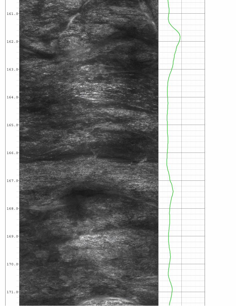
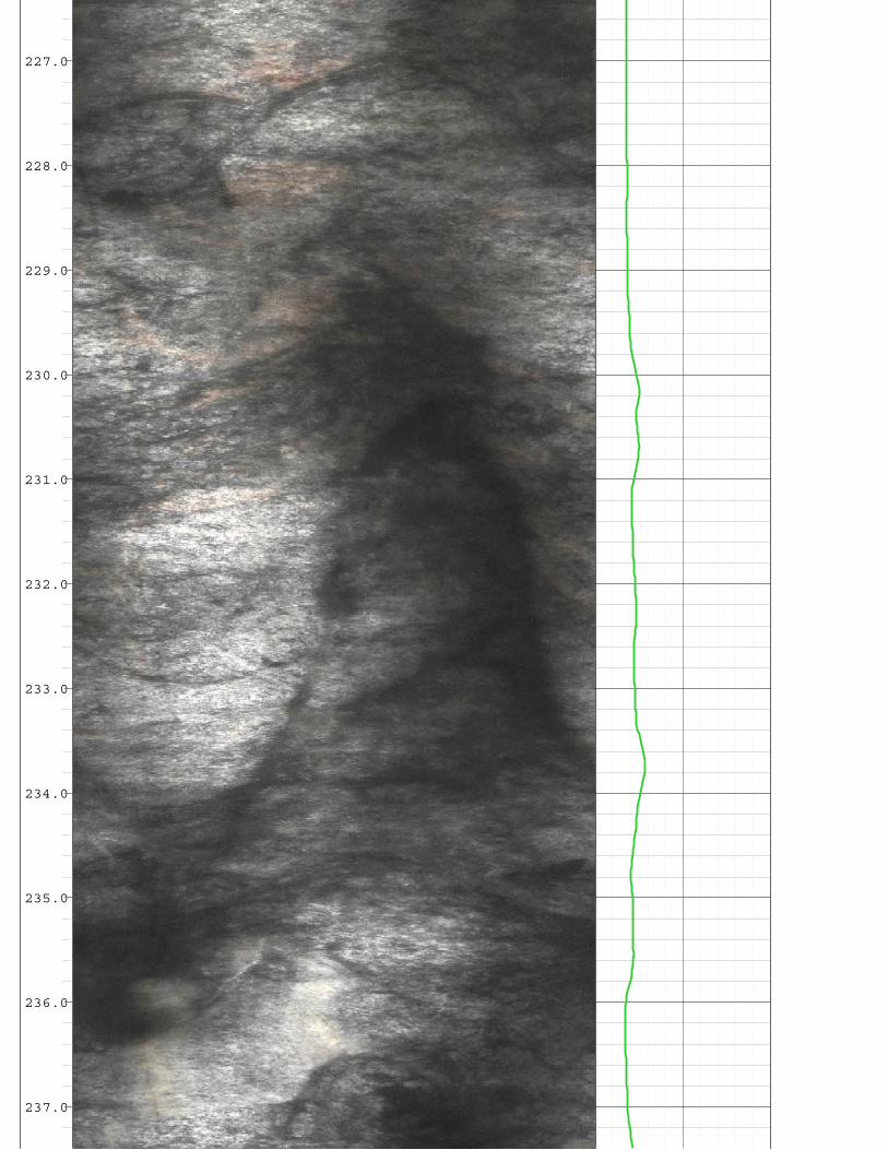
Geophysical log:
Depth of borehole:
Hydrology
166
Borehole geologist:
Start drilling date:
Driller:
Ground surface elevation:
Latitude, Longitude:
Location:
Dep
th
Lithology
Caliper
0-5
0-1
00-1
50-2
00-2
50-3
00-3
50-4
00-4
50-5
00-5
50-6
00
Bor
ehol
eD
iam
eter
Remarks
Balance Hydrologics Project Number: Figure 2: Page 1 of 1
Inches
© 2008 Balance Hydrologics, Inc.
Drill bits:
Well completion date:
Drilling rig:
APN:
Preliminary Data Subject To Revision
Cutting samples taken every 5 feet
Optical Tele Viewer
2008-1 Location
Depth of casing:
Diameter of casing:
feet
Amplitude(360° view)
N E S W N
0 to 45 ft.: 12¼" bit
45 to 105 ft.: 8¾" bit
105 to 640 ft.: 6¼" bit
0 to 75 ft.: cement seal (10.5 sack)
75 to 640 ft.: backfilled with sand and gravel
Cuttings are fine to medium sand size.
Cuttings are medium to coarse sand sizeafter change in drill bit at 105 feet.
40 ft.: drill rate is 1 ft/min
70 ft.: drill rate is 0.4 ft/min
100 ft.: drill rate is 0.6 ft/min
150 ft.: drill rate is 0.4 ft/min
200 ft.: drill rate is 0.2 ft/min
250 ft.: drill rate is 0.4 ft/min
310 ft.: drill rate is 0.3 ft/min
410 ft.: drill rate is 0.5 ft/min
510 ft.: drill rate is 0.8 ft/min
610 ft.: drill rate is 0.4 ft/min
350 ft.: drill rate is 0.4 ft/min
455 ft.: drill rate is 0.4 ft/min
555 ft.: drill rate is 0.4 ft/min
640 ft.: borehole is abandoned
0 ft.: start drilling at 11:00
Figure 2: Geologic and geophysical logs for borehole 2008-1,APN 037-071-090, San Mateo County, California
TOP SOIL: 0 to 6 ft.: Brown sandyloam, silty clay (CL)
TERRACE DEPOSITS: 6 to 40 ft.:Orange-tan sandy silty clay, fine tomedium sand with increasingamounts of weathered granitics (SC-SP)
WEATHERED GRANITICS: 40 to 75ft.: Brown to olive gray, gravellymedium to coarse sand (SW)
GRANITICS: 75 to 275 ft.:Phaneritic, leucocratic, withplagioclase feldspars.
CLAY AND SAND (GRAY): 275 to278 ft.: Greenish gray sandy siltyclay (CH-CL)
GRANITICS: 278 to 640 ft.:Phaneritic, meso to melanocratic,with plagioclase feldspars.
February 7, 2008
Bill Henrich, Norcal Geophysics, February 25, 2008Gustavo Porras
Maggiora Bros. Drilling, Inc.
234 feet (est.)
N37.5314°, W122.5099°, NAD83Moss Beach, California
6 ft.: Slightlymoist
62 ft.: Firstwaterencounteredduring drilling64 ft.:Saturated
105 ft.: Flow is2 gpm; [email protected]°C (480umhos@25°C)
175 ft.: Flow is2 gpm; [email protected]°C (686umhos@25°C)
240 ft.: Flow is5 gpm; [email protected]°C (511umhos@25°C)
320 ft.: Flow isdifficult toestimate; [email protected]°C (817umhos@25°C)
480 ft.: [email protected]°C (883umhos@25°C)
640 ft.:2/22/08 1.5hour air-lifttest flow is 2gpm; [email protected]°C (825umhos@25°C)
207220
12 ¼" 0-45 ft bgs; 8 ¾" 45-105 ft bgs; 6 ¼" 105-640 ft bgs
Well sealed and inspected February 27, 2008
Ingersoll Rand TH-60/HR 2.5037-071-090
640 feet
Not casedNot cased
Optical Tele Viewer image ispresented as Attachment A
_________________________
_________________________Hole sloughed at 265
feet prior to conductinggeophysical log.

This diagram shows cations in the ternary graph on the left and anions on the right graph. The diamond graph in the center illustrates both cations and anions. Hardness dominated water plots to the left and top of the diamond graph, soft monovalent-salt dominated water to the right, and soft alkaline water towards the bottom. The radius of circle around the plotted points represents the concentration of dissolved solids, calibrated to the scale shown.
Piper diagram illustrating the ionic signature of a water sample collected from a 640-foot deep borehole during an air-lift yield test. The sample is compared to regional well and surface waters, Moss Beach, San Mateo County, California.
Figure 3.
Tierra Alta and Loma Vista, Moss Beach
San Mateo County, California
C A T I O N S A N I O N S%meq/l
Na+K HCO +CO3 3 Cl
Mg SO4
CaCalcium (Ca) Chloride (Cl)
Sulfa
te(S
O4)
+Chl
orid
e(Cl
)
Calcium(Ca)+M
agnesium(M
g)
Carb
onat
e(CO
3)+B
icarb
onat
e(HC
O3)Sodium
(Na)+Potassium(K)
Sulfate(SO4)Mag
nesiu
m(M
g)
80 60 40 20 20 40 60 80
80
60
40
20
20
40
60
80
20
40
60
80
80
60
40
20
20
40
60
8020
40
60
80
80
60
40
20
80
60
40
20
Total Dissolved Solids(Parts Per Million)
0 400
800
1,20
0
1,60
0
2,00
0
Tierra Alta and Loma Vista APN 037-071-090 (2/22/08)Alta Vista well APN 036-180-030 (2/22/08)Martini Creek (10-7-04)Vallemar Bluffs 910-foot Well APN 037-086-270
207220 MWSD water quality 4-15-08.xls, rpt figure ©2008 Balance Hydrologics, Inc.


RU
NB
OR
EHO
LE REC
OR
DC
ASIN
G R
ECO
RD
NO
.B
ITFR
OM
TOSIZE
WG
T.FR
OM
TO
AB
OV
E PERM
. DA
TUM
ELEVA
TION
NA
STE CA
DEN
SITY
40
OPER
ATIN
G R
IG TIM
E4 hours
STEEL12
WELL ID
TIERA
A A
LTA #1
K.B
.
TYPE LO
GC
ALIPER
OPTV
SALIN
ITY
CA
LIPERO
PTV
TOP LO
GG
ED IN
TERV
AL
262
WITN
ESSED B
YG
USTA
VO
DR
ILLING
MEA
S. FRO
MG
RO
UN
D SU
RFA
CE
CTY MOSS BEACH
MA
X. R
EC. TEM
P.
D.F.
OTH
ER SER
VIC
ES
OPTV
8.75
DEPTH
-DR
ILLER600
FIELDM
OSS B
EAC
H
6.25
CO
MPA
NY
BA
LAN
CE
RU
N N
o2 A
ND
3
12 PERM
AN
ENT D
ATU
M
TWP
LOG
MEA
S. FRO
MG
RO
UN
D SU
RFA
CE
400
LOC
ATIO
N
MO
SS BEA
CH
TYPE FLU
ID IN
HO
LEW
ATER
FLD MOSS BEACH
112112
CO SAN MATEO
RG
E
600
DEPTH
-LOG
GER
262
SEC
G.L.
BTM
LOG
GED
INTER
VA
L262
STATE
CA
LIFOR
NIA
LEVEL
53
CO
UN
TRY
850
REC
OR
DED
BY
W H
ENR
ICH
FILING No
DA
TE25 Feb 08
WELL TIRRA ALTA #1
Depth
1ft:12ft
CALIPER
5 15INCH
BOREHOLE VIEW TIERRA ALTA ROAD
0° 0°180°90° 270°
14.0
15.0
16.0
17.0

18.0
19.0
20.0
21.0
22.0
23.0
24.0
25.0
26.0
27.0
28.0

29.0
30.0
31.0
32.0
33.0
34.0
35.0
36.0
37.0
38.0
39.0

40.0
41.0
42.0
43.0
44.0
45.0
46.0
47.0
48.0
49.0
50.0

51.0
52.0
53.0
54.0
55.0
56.0
57.0
58.0
59.0
60.0
61.0

62.0
63.0
64.0
65.0
66.0
67.0
68.0
69.0
70.0
71.0
72.0

73.0
74.0
75.0
76.0
77.0
78.0
79.0
80.0
81.0
82.0
83.0

84.0
85.0
86.0
87.0
88.0
89.0
90.0
91.0
92.0
93.0
94.0

95.0
96.0
97.0
98.0
99.0
100.0
101.0
102.0
103.0
104.0
105.0

106.0
107.0
108.0
109.0
110.0
111.0
112.0
113.0
114.0
115.0
116.0

117.0
118.0
119.0
120.0
121.0
122.0
123.0
124.0
125.0
126.0
127.0

128.0
129.0
130.0
131.0
132.0
133.0
134.0
135.0
136.0
137.0
138.0

139.0
140.0
141.0
142.0
143.0
144.0
145.0
146.0
147.0
148.0
149.0

150.0
151.0
152.0
153.0
154.0
155.0
156.0
157.0
158.0
159.0
160.0
161.0
162.0
163.0
164.0
165.0
166.0
167.0
168.0
169.0
170.0
171.0

172.0
173.0
174.0
175.0
176.0
177.0
178.0
179.0
180.0
181.0
182.0

183.0
184.0
185.0
186.0
187.0
188.0
189.0
190.0
191.0
192.0
193.0

194.0
195.0
196.0
197.0
198.0
199.0
200.0
201.0
202.0
203.0
204.0

205.0
206.0
207.0
208.0
209.0
210.0
211.0
212.0
213.0
214.0
215.0

216.0
217.0
218.0
219.0
220.0
221.0
222.0
223.0
224.0
225.0
226.0
227.0
228.0
229.0
230.0
231.0
232.0
233.0
234.0
235.0
236.0
237.0

238.0
239.0
240.0
241.0
242.0
243.0
244.0
245.0
246.0
247.0
248.0

249.0
250.0
251.0
252.0
253.0
254.0
255.0
256.0
257.0
258.0
259.0

260.0
261.0
262.0


BACWA PROJECT ELEMENT NO. 13 MONTARA WATER & SANITARY DISTRICT
3RD QUARTER – 2008
ATTACHMENT 2