national trust - cornwall · pdf filethe national trust; and kim auston, ... • analyse...
TRANSCRIPT
National Trust
TrengwaintonSetting Study
January 2015
Trengwainton January 2015 ______________________________________________________________________________________________
______________________________________________________________________________________________ NT.155 1 Nicholas Pearson Partnership LLP Setting Study
CONTENTS
ACKNOWLEDGEMENTS
1.0 INTRODUCTION
2.0 METHODOLOGY
3.0 HERITAGE ASSETS AND POLICY CONTEXT
4.0 HISTORICAL BACKGROUND
5.0 THE VISUAL ENVELOPE
6.0 THE SETTING
7.0 CONCLUSIONS AND RECOMMENDATIONS
Figures
1. Location Plan and Viewpoints
2. Ordnance Survey Old Series map, 1813
3. Estate Plan, 1866
4. Ordnance Survey, first edition, 1878
5. Ordnance Survey, 1952-66
6. Conservation Designations and Heritage Assets
7. Planning Policy
8. Zone of Theoretical Visibility: from Trengwainton House
9. Zone of Theoretical Visibility: from the Main Terrace
10. Identified setting of the Heritage Asset
Viewpoint sheets
Viewpoint 1: Trengwainton House
Viewpoint 2: East Terrace
Viewpoint 3: Main Terrace – West
Viewpoint 4: Main Terrace – East
Viewpoint 5: The Lawn
Viewpoint 6: Approach drive
Viewpoint 7: Approach drive
Viewpoint 8: Walled Garden
Viewpoint 9: Entrance gate
Viewpoint10: Adjacent Park Lodge
Viewpoint 11: North boundary
Viewpoint 12: Zig-Zag Drive
Trengwainton January 2015 ______________________________________________________________________________________________
______________________________________________________________________________________________ NT.155 2 Nicholas Pearson Partnership LLP Setting Study
Viewpoint 13: Boswednan
Viewpoint 14: The Pond
Viewpoint 15: Polclose Approach
Viewpoint 16: Trengwainton Carn
Viewpoint 17: West of Bosednan
Viewpoint 18: Tremethick Cross
Viewpoint 19: Close to West Lodge
Viewpoint 20: Lesingey
Viewpoint 21: Near Rosehill
Viewpoint 22: Overlooking Boscathnoe
Appendices
1. References
2. Historic Environment Record
Trengwainton January 2015 ______________________________________________________________________________________________
______________________________________________________________________________________________ NT.155 3 Nicholas Pearson Partnership LLP Setting Study
ACKNOWLEDGEMENTS
We are most grateful to the steering group who has reviewed and advised on this study,
namely Michael Calder, Phil Griffiths, Emma Jones, Ian Marsh, James Parry and Ian Wright of
the National Trust; and Kim Auston, English Heritage.
We would also like to thank Col. and Mrs. Bolitho for allowing access to Trengwainton
House.
The historic overview for this study has been based on research by Jonathan Lovie and Ian
Wright, with additional material from the Trengwainton property archives.

Trengwainton January 2015 ______________________________________________________________________________________________
______________________________________________________________________________________________ NT.155 4 Nicholas Pearson Partnership LLP Setting Study

Trengwainton January 2015 ______________________________________________________________________________________________
______________________________________________________________________________________________ NT.155 5 Nicholas Pearson Partnership LLP Setting Study
1.0 INTRODUCTION
1.1 Purpose of the Study
Trengwainton is a historic house, gardens, park and estate in southwest Cornwall,
just two miles outside Penzance (figure 1). This report has been commissioned by
the National Trust to identify the setting of Trengwainton, and help to inform
decisions about local development. Trengwainton comprises a group of heritage
assets including several grade II listed buildings and a grade II* English Heritage
Registered Park and Garden. The study seeks to:
• analyse the current and historic landscape context of Trengwainton;
• map the visual envelope of the heritage assets;
• and identify the significance and sensitivity of the setting to the registered
landscape and its listed buildings, which necessitates identifying an extent of that
setting for the purposes of this analysis.
The intended use of this study is twofold:
• To contribute to the evidence available to all parties involved in managing
change by assisting in any assessment of how the significance of Trengwainton
might be affected by a development proposal that would impact upon its setting.
Local Planning authorities are required by national policy to take such
assessments into account to avoid or minimise conflict between the heritage asset’s
conservation and any aspect of a proposal. (NPPF; para 129)
• To form part of a positive strategy for the conservation of Trengwainton by
helping the local planning authority ensure that their Local Plan is based upon
up-to-date evidence about the historic environment as required by national
policy (NPPF; para 169), and as evidence for any other development or
management plans, including any Neighbourhood Plan.
1.2 The Need for a Setting Study
The setting of listed buildings, registered landscapes, and the views from them are
not formally identified or mapped by English Heritage, and yet often play a significant
role in how a heritage asset was originally developed, and is now understood,
experienced or appreciated. The importance of the setting of the heritage assets at
Trengwainton was identified in the Trengwainton Garden Conservation Management
Plan: Policy Document (Internal report for The National Trust, 2010). A principal
significance of the Trengwainton buildings and gardens are the designed views,
particularly from the upper garden: Views within and beyond the garden are of
Trengwainton January 2015 ______________________________________________________________________________________________
______________________________________________________________________________________________ NT.155 6 Nicholas Pearson Partnership LLP Setting Study
fundamental importance to the impact of the landscape design (Section 6, p.20). The
policies proposed to protect these views, and therefore, the setting of Trengwainton
were as follows:
Policy (general)…External views (those which take in land beyond the garden and the
Estate/National Trust ownership) must be identified, documented and incorporated into the
Local Development Framework in order that they can be considered as a material matter in
any planning process which might affect that land (Section 6, p.20)
The most notable view from the registered landscape is that from the Terrace,
looking over Penzance towards Mount’s Bay. Due to its critical role in the design,
this view was given an individual policy in the Conservation Management Plan:
Policy (Terrace View): This view is the most significant in the Grade II* designated
landscape. It must be identified as such within the Local Development Framework in order
that due weight can be given to its importance in any planning process affecting the land
within the view (Section 6, p.20).
1.3 The importance of understanding and more accurately identifying the setting of
Trengwainton has been heightened by a number of recent proposals in the revised
Local Plan to develop parcels of land within the vicinity of the heritage assets, in
particularly, within the principal Terrace view. The need has also been highlighted
by the recent construction of the Zennor Building and associated 50m high turbine
at Penwith College in Penzance. Completed in 2010, these structures intrude
directly and centrally into a designed view of Mount’s Bay from Trengwainton
House.
1.4 National Policy and Recent Planning Decisions
A number of recent high profile planning cases have highlighted the increasing
appreciation of the role of setting in the significance of heritage assets. The NPPF
states that significance can be harmed or lost through alteration or destruction of the
heritage asset or development within its setting. As heritage assets are irreplaceable, any
harm or loss should require clear and convincing justification. Substantial harm to or loss
of a grade II listed building, park or garden should be exceptional. Substantial harm to or
loss of designated heritage assets of the highest significance, notably scheduled
monuments,…grade I and II* listed buildings and grade I and II* registered parks and
gardens…should be wholly exceptional (para. 132).
Trengwainton January 2015 ______________________________________________________________________________________________
______________________________________________________________________________________________ NT.155 7 Nicholas Pearson Partnership LLP Setting Study
1.5 Despite the stress on substantial harm, a recent application for 70 houses in the
setting of Wymondham Abbey in Norfolk, a grade I listed building, was rejected by
the Communities Secretary even though it was considered to have less than
substantial harm to the heritage asset. The adverse impacts of the development
were said to outweigh the benefit of providing additional housing in an area with an
acknowledged shortfall. Similarly, following a High Court judgement, the adverse
impacts of the development of a wind farm on the setting of the grade I listed
mansion and grade I registered landscape of Lyveden New Bield, Northamptonshire,
were also considered to outweigh any renewable energy benefits, despite being
identified as causing less than substantial harm to the heritage asset by a planning
inspector. These cases stress that any harm, substantial or less than substantial, to
the setting of a designated heritage asset can be unacceptable without an exceptional
and convincing justification.
1.6 Definition of Setting
Setting is defined in The Setting of Heritage Assets (English Heritage, 2011) and the
National Planning Policy Framework (DCLG, 2012) as The surroundings in which a
heritage asset is experienced. Its extent is not fixed and may change as the asset and its
surroundings evolve. Elements of setting may make a positive or negative contribution to
the significance of an asset, may affect the ability to appreciate that significance, or may be
neutral (NPPF, Annex 2: Glossary). In addition to this definition, The Setting of
Heritage Assets goes on to define the key principles of understanding setting:
• All heritage assets have a setting.
• The extent and importance of setting is usually expressed in visual terms,
but the way we experience an asset is also influenced by other
environmental factors, spatial associations and by an understanding of the
historic relationship between places.
• Setting is more extensive than curtilage and its extent may change as an
asset and its surroundings evolve, or as understanding of the asset improves.
• Setting can enhance the significance of a heritage asset, whether or not it
was designed to do so.
• The contribution that setting makes to significance does not depend on
there being public access to it.
Setting is, therefore, a complex concept to interpret and define. It is made more
challenging by the fact that it is wholly specific to the character, history and
Trengwainton January 2015 ______________________________________________________________________________________________
______________________________________________________________________________________________ NT.155 8 Nicholas Pearson Partnership LLP Setting Study
significance of a particular historic site, structure or landscape – every heritage asset
is unique with its own, individual setting.
1.7 In order to establish the setting of Trengwainton, investigations have been based on
the definition of setting in English Heritage’s Conservation Principles. The three
components of setting identified by this definition have been interpreted as visibility,
spatial context and function. Visibility is, perhaps, the most straightforward aspect
of the three, being the reality of what can be seen from within a historic site and the
visual influences on how a historic site is perceived. Spatial context is a less tangible
aspect, relating to the physical, cultural and spatial values of the surrounding
landscape in which a historic site is experienced. Function addresses the past and
present functional relationships of a site with its surroundings, relating to elements
which may include land use, communications and ownership.
1.8 In practice, this has resulted in the application of three methods to identify the
specific setting of Trengwainton: an objective identification of the zone of theoretical
visibility (ZTV) using computer modelling; a more subjective analysis of individual
historic and present day views into and out of the registered landscape, addressing
the significance, landscape character and sensitivity of the views in question and the
spatial context of the heritage assets; and an assessment of the currently known
history of Trengwainton from documentary records and recent reports to
understand the historic development and past function of the heritage assets and
their settings. The purpose of these exercises is to: gain a detailed understanding of
the setting of the heritage asset; to enable identification of the setting and what it
contributes to significance; and to identify the landscape character of the setting, and
the sensitivity of the setting to change.
1.9 This study has been prepared, produced and reviewed in consultation with The
National Trust, the Bolitho Estate, Cornwall Council and English Heritage. Survey
work was carried out during August and September 2014, when trees were still in
full leaf.
Trengwainton January 2015 ______________________________________________________________________________________________
______________________________________________________________________________________________ NT.155 9 Nicholas Pearson Partnership LLP Setting Study
2.0 METHODOLOGY
2.1 Current guidance
2.1.1 When devising a methodology for assessing the setting of Trengwainton, a number
of key advisory documents were consulted:
• Conservation Principles (English Heritage, April 2008)
• Seeing the History in the View (English Heritage, May 2011)
• The Setting of Heritage Assets (English Heritage, October 2011)
• National Planning Policy Framework (Department for Communities and Local
Government, March 2012)
• Planning Practice Guidance web-based resource (Department for Communities
and Local Government, launched March 2014)
• English Heritage Good Practice Advice on Setting and Decision-Taking (English
Heritage, consultation draft, July 2014)
2.1.2 In the recently published draft Good Practice Advice, English Heritage sets out the
following methodology for assessing the impact of a proposed development on
heritage assets and their settings:
• Step 1: Identifying the heritage assets affected and their settings.
• Step 2: Assessing whether, how and to what degree these settings make a
contribution to the significance of the heritage asset(s):
− identification of the key attributes of a heritage asset
− consideration of the physical surroundings of the asset, including its
relationship with other heritage assets
− consideration of the way the asset is appreciated
− consideration of asset’s associations and patterns of use.
• Step 3: Assessing the effect of the proposed development on the significance of
the asset(s).
• Step 4: Maximising enhancement and minimising harm.
• Step 5: Making and documenting the decision and monitoring outcomes.
2.1.3 The objective of the Trengwainton Setting Study is to identify the setting of the
heritage assets in advance of proposed development, in order to inform planning
policy and decisions. The above methodology has therefore been applied in part as
a basis for the current study, following steps 1 and 2.
Trengwainton January 2015 ______________________________________________________________________________________________
______________________________________________________________________________________________ NT.155 10 Nicholas Pearson Partnership LLP Setting Study
2.2 Setting Study Methodology
The following tasks were undertaken to identify the setting of Trengwainton:
2.2.1 Task 1: Identifying the Heritage Assets
The first stage was to identify the heritage assets to which the setting study needs to
apply. This was achieved through the following tasks:
i. Ascertaining all designated and undesignated identified heritage assets lying
within the property owned by the National Trust and within a surrounding
study area, including and beyond the registered landscape. The data was
collected from English Heritage’s National Heritage List, the National Trust’s
Sites, Buildings and Monuments Record and the Cornwall Historic
Environment Record. The assets identified included those historically
related to Trengwainton, but no longer linked by ownership.
ii. Using previous reports, studies and certain primary documentary sources,
an outline history of Trengwainton was prepared in order to understand the
historic development of building, its landscape and associated structures.
The sources are illustrated or listed in appendix 1. The results of this
research are presented in section 2, Historical Background.
iii. Crosschecking the officially recognised heritage assets with the historic
landscape analysis to identify any additional assets and historic character
areas.
iv. Assessing the heritage values and significance of the identified heritage
assets.
v. Researching any current policies or non-heritage designations that relate to
the heritage assets.
2.2.2 Task 2: Selection of Viewpoints
The second stage was to identify viewpoints for the visual appraisal. The close
relationship between views and setting is discussed in the Good Practice Advice, which
states that views can be static or dynamic, can include views of, across, including and
from a heritage asset, and may involve overlap with the visual setting of other
heritage assets. They contribute to the significance of a heritage asset by revealing
relationships and historic associations with other assets, places or natural features
and, in terms of parks and gardens, by helping to understand and experience the
design of a landscape and its key buildings.

Trengwainton January 2015 ______________________________________________________________________________________________
______________________________________________________________________________________________ NT.155 11 Nicholas Pearson Partnership LLP Setting Study
2.2.3 The identification of viewpoints for Trengwainton was based on the results of the
historic landscape analysis and, in particular, key designed views identified in historic
photographs, engravings, drawings and paintings of Trengwainton. The two principal
viewpoints offering, therefore, the principal designed views from Trengwainton,
were the first floor of the House and the Terrace. These were considered to be the
most significant historic viewpoints as they are demonstrably critical to the design of
the buildings and landscape, and they offer the greatest extent of views from
Trengwainton, helping to identify the full, visually sensitive setting for the heritage
assets. If the principal and key designed views were to be lost or eroded, the cultural
and aesthetic heritage values of an asset would be diminished.
2.2.4 The identification of key and principal designed views to and from Trengwainton is
based on our current understanding of the heritage assets, their historic
development, and on the current condition of their surroundings. The dynamic
nature of landscapes means that views can become concealed or revealed over time,
for example, as a result of tree growth, or loss through disease or storm damage.
Future historic research may also reveal the existence of designed views no longer
apparent in today’s landscape. This underlines the importance of conserving a core
setting around heritage assets in order to protect potential views that may be
identified in the future. It is also important to review this study periodically to verify
and revise viewpoints and views, as local landscapes change and new information
comes to light. The estate landscape north of Carn Lodge, for example, might yet
prove to be a significant component of the wider ornamental estate, following
further research.
2.2.5 Secondary, contextual viewpoints, located outside the registered park, were also
identified for assessment during the site survey. These were selected on the basis of
publicly accessible viewpoints with views to or including Trengwainton, including
known historic viewpoints and views from local topographic high points. As publicly
accessible viewpoints, these are the most widely experienced locations where
Trengwainton and its registered landscape can be appreciated, and therefore of
social and cultural significance. Viewpoints from high points in the local landscape
generally offer the greatest extent of views to and from Trengwainton. Views from
private land not otherwise accessible may be significant and form part of the setting,
but were only identified by a mapping exercise.

Trengwainton January 2015 ______________________________________________________________________________________________
______________________________________________________________________________________________ NT.155 12 Nicholas Pearson Partnership LLP Setting Study
2.2.6 Task 3: Mapping the Zone of Theoretical Visibility (ZTV)
The third exercise was to identify the zone of theoretical visibility around
Trengwainton, primarily by reference to the full extent of the area visible from the
two principal designed viewpoints identified in task 2. This technique is
recommended in English Heritage’s Good Practice Advice and uses the latest, robust
technology proven at public inquiry. A photogrammetrically derived digital surface
model with a 2m horizontal resolution, and a vertical accuracy of ± 24cm, was used
to generate a three dimensional topographic model. To cover an area around
Trengwainton that incorporated the western edge of Penzance, 20km² of digital
surface model (DSM)data was used. The ZTV was plotted for this 20km² area,
assuming either no development (0.5m crop-level changes); development involving
typical two-storey building elevations of 7m; or industrial elevations of 10m or 12m.
Tall masts and turbines may be of much greater heights, but are generally subject to
detailed landscape and visual impact appraisals including site-specific ZTV studies.
2.2.7 DSM has the particular advantage of including woodland crown canopies, but may
exclude hedgerows and individual trees that could be felled or die at any time, and
therefore cannot be relied upon as tree screens. DSM data is not solely based on
terrain, taking into account established tree blocks and woodlands, as well as large
landscape features such as existing buildings. This method is used partly to define
the visual sensitivity of Trengwainton to changes in landscape management, as well as
built development.
2.2.8 This specification of ZTV is primarily concerned with the potential effects of urban
and village extensions and substantial residential developments, rather than individual
small-scale developments, or, alternatively, very tall development such as major
industrial, wind turbine or infrastructure development. The study methodology
does not address urban or village extensions beyond about three kilometres due to
the effects of distance, topography and the existing geographic distribution of
settlements in this particular area.
2.2.9 The viewpoint appraisal has also identified views that extend beyond this local
vicinity, and considers the impact of potential major developments, such as wind
farms or highway realignments, on the key viewpoints and wider setting of the
property.

Trengwainton January 2015 ______________________________________________________________________________________________
______________________________________________________________________________________________ NT.155 13 Nicholas Pearson Partnership LLP Setting Study
2.2.10 Task 4: Site Survey
Following the background analyses of the location of heritage assets, the historic
development of Trengwainton, the significance of its assets, the historic viewpoints,
the contextual viewpoints and the Zone of Theoretical Visibility, a site survey was
undertaken to test the validity of the results on the ground. This involved visiting,
assessing and recording views and viewpoints and recording the physical and visual
surroundings of each heritage asset, including their relationships with each other and
the landscape character of those surroundings. The site survey was carried out in
September 2014. The results of this exercise are illustrated in the landscape
character descriptions and individual Viewpoint Sheets 1 to 22.
2.2.11 Task 5: Identifying the setting and its role
On the basis of the documentary research, mapping and site survey, the final stage
was to identify the nature of the setting of Trengwainton’s heritage assets, as a
group, and define how this setting contributes to the heritage values and significance
of the historic house and its landscape.
2.2.12 English Heritage guidance notes the impossibility of mapping a fixed boundary to the
setting of a heritage asset and states that it cannot be definitively and permanently
described as a spatially bounded area or as lying within a set distance from a heritage asset
(Setting of Heritage Assets, para. 2.2). However, in practice, as part of a process of
assessing to what degree the setting makes a contribution to the significance of the
heritage assets concerned – what matters and why – some guide as to the present
day geographical area is an effective way to communicate and inform decision-
making over change within that area. With this in mind, this Setting Study has
mapped and annotated the core setting of Trengwainton, and also indicated the
wider setting in figure 10.
2.2.13 Assessing the role of the setting for the heritage assets has taken the following
aspects into consideration:
• The contribution of setting in the past, in particular, when Trengwainton was
first built (following EH guidance).
• How the role of the setting has changed over time.
• The present attributes of the setting and its contribution to the surviving
heritage assets and how they are experienced and appreciated.
Trengwainton January 2015 ______________________________________________________________________________________________
______________________________________________________________________________________________ NT.155 14 Nicholas Pearson Partnership LLP Setting Study
• The sensitivity of different parts of the setting and the capacity it may, or may
not, have for change.
Trengwainton January 2015 ______________________________________________________________________________________________
______________________________________________________________________________________________ NT.155 15 Nicholas Pearson Partnership LLP Setting Study
3.0 HERITAGE ASSETS AND POLICY CONTEXT
The following section is divided into four sections: the first identifies the recognised
designated and non-designated heritage assets within and around Trengwainton; the
second sets out national guidance about the role and nature of setting; the third
addresses local planning policy in Cornwall; and the fourth explores existing
appraisals of the setting of Trengwainton and local landscape character.
3.1 Heritage Assets
3.1.1 This setting study is focussed on a group of identified heritage assets that together
form the core of the Trengwainton Estate (figure 6; appendix 2). These comprise of:
• Trengwainton gardens and wooded valley – grade II* on the English Heritage
Register of Historic Parks and Gardens of Special Historic Interest in England. Grade
II* sites are particularly important, of more than special interest (English Heritage
website, visited September 2014). Trengwainton was entered on the Register in
1987.
• Trengwainton House – grade II listed building (listed in 1988)
• Trengwainton House coach house, stables, courtyard walls, gate piers and
mounting block – all grade II listed buildings
• The walled garden, bothy and potting shed and head gardeners’ cottages – grade
II listed buildings
• The gate lodge (northern building) – grade II listed building
• The well and spout, east of the walled garden – grade II listed structure
• The nineteenth century apiary and walled garden dipping well – recorded on
the Cornwall HER
• A Bronze Age findspot in the woods behind Trengwainton House - recorded on
the Cornwall HER
• An early nineteenth century icehouse - recorded on the Cornwall HER
• Early nineteenth century fish and duck decoy ponds - recorded on the Cornwall
HER
3.1.2 This key group is surrounded by a number of additional heritage assets (figure 6)
related to the local, ancient agricultural landscape and to neighbouring estates
(designations stated where applicable). In close proximity are the medieval
settlements of Boswednan and Hendra (grade II listed farmstead), the post medieval
corn mill at Polteggan, the mid nineteenth century farmhouse at Parc an Growes
Trengwainton January 2015 ______________________________________________________________________________________________
______________________________________________________________________________________________ NT.155 16 Nicholas Pearson Partnership LLP Setting Study
(grade II listed building) and a number of prehistoric features on the higher ground
and moorland above Trengwainton House. The nearby village of Madron
incorporates a number of medieval and post medieval sites and listed buildings, and
is also a Conservation Area. Lesingey Round, to the south east of Trengwainton, is
a scheduled monument Iron Age hillfort. Castle Horneck was rebuilt as a country
house in the eighteenth century and is now a grade II* listed building, as are the
neighbouring eighteenth and nineteenth century houses of Rosehill, Roscadghill and
Nancealverne. Trewern Round to the northwest of Trengwainton is also a
scheduled monument.
3.2 Guidance on Setting
3.2.1 National Planning Policy Framework
The National Planning Policy Framework (NPPF) states that In determining planning
applications, local planning authorities should require an applicant to describe the
significance of any heritage assets affected, including any contribution made by their setting
(para 128)…This is reiterated in paragraph 129: Local planning authorities should
identify and assess the particular significance of any heritage asset that may be affected by
a proposal (including by development affecting the setting of a heritage asset) taking
account of the available evidence and any necessary expertise. They should take this
assessment into account when considering the impact of a proposal on a heritage asset, to
avoid or minimise conflict between the heritage asset’s conservation and any aspect of the
proposal.
This advice applies to designated and non-designated heritage assets.
Local planning authorities are encouraged to look for opportunities for new
development…within the setting of heritage assets to enhance or better reveal their
significance. Proposals that preserve those elements of the setting that make a positive
contribution or better reveal the significance of the asset should be treated favourably
(para.137).
Setting is defined as The surroundings in which a heritage asset is experienced. Its extent
is not fixed and may change as the asset and its surroundings evolve. Elements of setting
may make a positive or negative contribution to the significance of an asset, may affect the
ability to appreciate that significance, or may be neutral (NPPF, Annex 2: Glossary).

Trengwainton January 2015 ______________________________________________________________________________________________
______________________________________________________________________________________________ NT.155 17 Nicholas Pearson Partnership LLP Setting Study
The accompanying Planning Policy Guidance published in March 2014 by the
Department of Communities and Local Government as a web-based resource,
highlights the issue of cumulative change:
When assessing any application for development which may affect the setting of a heritage
asset, local planning authorities may need to consider the implications of cumulative
change…(Paragraph 013 Reference ID: 18a-013-20140306)
It also includes advice on minimising harm to the significance of a heritage asset
through studies produced at an early stage:
A clear understanding of the significance of a heritage asset and its setting is necessary to
develop proposals which avoid or minimise harm. Early appraisals, a conservation plan or
targeted specialist investigation can help to identify constraints and opportunities arising
from the asset at an early stage…(Paragraph 019 Reference ID: 18a-019-20140306)
This report aims to provide this specialist investigation.
3.2.2 English Heritage Guidance
English Heritage have produced four key documents which address the setting of
heritage assets:
• Conservation Principles (English Heritage, April 2008)
• Seeing the History in the View (English Heritage, May 2011)
• The Setting of Heritage Assets (English Heritage, October 2011)
• English Heritage Good Practice Advice on Setting and Decision-Taking (English
Heritage, consultation draft, July 2014)
English Heritage’s Conservation Principles: Policies and Guidance for the Sustainable
Management of the Historic Environment (1) makes the following comments on the
contribution of setting and context:
Paragraph 76
‘Setting’ is an established concept that relates to the surroundings in which a place is
experienced, its local context, embracing present and past relationships to the adjacent
landscape. Definition of the setting of a significant place will normally be guided by the
extent to which material change within it could affect (enhance or diminish) the place’s
significance.
Trengwainton January 2015 ______________________________________________________________________________________________
______________________________________________________________________________________________ NT.155 18 Nicholas Pearson Partnership LLP Setting Study
Paragraph 77
‘Context’ embraces any relationship between a place and other places. It can be, for
example, cultural, intellectual, spatial or functional, so any one place can have a multi-
layered context. The range of contextual relationships of a place will normally emerge from
an understanding of its origins and evolution. Understanding context is particularly relevant
to assessing whether a place has greater value for being part of a larger entity, or sharing
characteristics with other places.
The guidance set out in Conservation Principles was developed further in English
Heritage’s subsequent documents Seeing History in the View and The Setting of
Heritage Assets. The former sets out a method for understanding and assessing
heritage significance within views and aims to provide a consistent and positive approach to
managing change. Significant views might include those recognised as part of the
plan-making process (e.g. those of the London and Oxford skylines), views identified
in character area appraisals, and views identified when assessing sites as part of the
development process. Importantly, the guidance applies to views that are historically
significant as designed views from, to and within historic parks and gardens that have been
identified as part of the evidence base for development plans, such as those noted during
English Heritage’s 2001 upgrading of the national Register of Parks and Gardens (p. 4).
The document sets out the two key stages of their methodology as:
• Phase A: baseline analysis: defines and analyses heritage significance within a view.
• Phase B: assessment: assesses the potential impact of a specific development
proposal on heritage significance within a view, as analysed in Phase A.
This report aims to address Phase A.
In focussing on historic views, Seeing History in the View addresses the visual aspects
of the setting of heritage assets. The Setting of Heritage Assets provides more holistic
guidance, dealing with all aspects of setting. The document continues to use the
same definition of setting as originally published in the Planning Policy Statement 5:
Planning for the Historic Environment and retained in the NPPF. The document makes
a clear distinction between setting, curtilage, character and context:
• Curtilage is a legal term used to described an area around a building the boundary of
which is defined by matters including past and present ownership and functional
Trengwainton January 2015 ______________________________________________________________________________________________
______________________________________________________________________________________________ NT.155 19 Nicholas Pearson Partnership LLP Setting Study
association and interdependency. The setting of a historic asset will include but
generally be more extensive than its curtilage (if it has one).
• The character of a historic place is the sum of all its attributes. This may include
relationships with people, now and through time; its visual aspects; and the features,
materials, and spaces associated with its history, including its original configuration
and subsequent losses and changes. Heritage assets and their settings contribute to
character, but it is a broader and non-statutory concept, often used in relation to
entire historic areas and landscapes.
• The context of a heritage asset is a non-statutory term used to describe any
relationship between it and other heritage assets, which are relevant to its
significance. These relationships can be cultural, intellectual, spatial or functional.
They apply irrespective of distance, extending well beyond what might be considered
an asset’s setting, and can include the relationship of one heritage asset to another
of the same period or function, or with the same designer or architect.
The Setting of Heritage Assets retains the key principles for understanding setting that
were originally published in paragraphs 113 to 117 of PPS 5 Planning for the Historic
Environment: Historic Environment Planning Practice Guide:
• 113. Setting is the surroundings in which an asset is experienced. All heritage assets
have a setting, irrespective of the form in which they survive and whether they are
designated or not. Elements of a setting may make a positive or negative contribution
to the significance of an asset, may affect the ability to appreciate that significance,
or may be neutral.
• 114. The extent and importance of setting is often expressed by reference to visual
considerations. Although views of or from an asset will play an important part, the
way in which we experience an asset in its setting is also influenced by other
environmental factors such as noise, dust and vibration; by spatial associations; and,
by our understanding of the historic relationship between places. For example,
buildings that are in close proximity but not visible from each other may have a
historic or aesthetic connection that amplifies the experience of the significance of
each. They would be considered to be within one another’s setting.
• 115. Setting will, therefore, generally be more extensive than curtilage and its
perceived extent may change as an asset and its surroundings evolve or as
understanding of the asset improves.
• 116. The setting of a heritage asset can enhance its significance whether or not it
was designed to do so. The formal parkland around a country house and the
Trengwainton January 2015 ______________________________________________________________________________________________
______________________________________________________________________________________________ NT.155 20 Nicholas Pearson Partnership LLP Setting Study
fortuitously developed multi-period townscape around a medieval church may both
contribute to the significance.
• 117. The contribution that setting makes to the significance does not depend on
there being public rights or an ability to access or experience that setting. This will
vary over time and according to circumstance. Nevertheless, proper evaluation of the
effect of change within the setting of a heritage asset will usually need to consider
the implications, if any, for public appreciation of its significance.
The Setting of Heritage Assets makes a special reference to designed settings:
Many heritage assets have settings that have been designed to enhance their presence and
visual interest or to create experiences of drama or surprise. Views and vistas, or their
deliberate screening, are key features of these designed settings, providing design axes and
establishing their scale, structure, layout and character. These designed settings may also
be regarded as heritage assets in their own rights, which, themselves, have a wider setting:
a park may form the immediate setting for a great house, while having its own setting that
includes lines-of-sight to more distant heritage assets or natural features beyond the park
boundary.
Although an understanding of setting and views is an important element of the register
entry on the English Heritage Register of Parks and Gardens of Special Historic Interest in
England, the designated area is often restricted to the ‘core’ elements, such as a formal
park. It is important, therefore, that the extended and remote elements of design are
taken into account when the setting of a designed landscape is being evaluated.(p. 10)
Other key comments in The Setting of Heritage Assets that relate to this study
include:
• Local development plans should: address the conservation and enhancement of
setting through criteria-based and site specific policies and, where appropriate,
through supplementary planning documents. (p. 13)
• Mapping of setting: While it is not practicable to definitively map setting (as a
geographically bounded area) in advance of unforeseen future developments, it is
possible for a plan to define which aspects and qualities of a heritage asset’s setting
contribute to or detract from its significance, to analyse and illustrate particularly
important views or to provide appropriate design guidance.(p. 13).
• Change: Protection of the setting of heritage assets need not prevent change (p.15).
Trengwainton January 2015 ______________________________________________________________________________________________
______________________________________________________________________________________________ NT.155 21 Nicholas Pearson Partnership LLP Setting Study
The most recent guidance on setting issued by English Heritage is the English
Heritage Good Practice Advice on Setting and Decision-Taking (English Heritage,
consultation draft, July 2014). This document summarises much of the advice set
out in The History in the View and The Setting of Heritage Assets. The document
includes a useful checklist of potential attributes of a setting to help elucidate its
contribution to the significance of a heritage asset:
The asset’s physical surroundings
• Topography
• Other heritage assets (including buildings, structures, landscapes, areas or
archaeological remains)
• Definition, scale and ‘grain’ of surrounding streetscape, landscape and spaces
• Formal design
• Historic materials and surfaces
• Land use
• Green space, trees and vegetation
• Openness, enclosure and boundaries
• Functional relationships and communications
• History and degree of change over time
• Integrity
• Issues such as soil chemistry and hydrology
Experience of the asset
• Surrounding landscape or townscape character
• Views from, towards, through, across and including the asset
• Visual dominance, prominence or role as focal point
• Intentional intervisibility with other historic and natural features
• Noise, vibration and other pollutants or nuisances
• Tranquillity, remoteness, ‘wildness’
• Sense of enclosure, seclusion, intimacy or privacy
• Dynamism and activity
• Accessibility, permeability and patterns of movement
• Degree of interpretation or promotion to the public
• The rarity of comparable survivals of setting
• The asset’s associative attributes

Trengwainton January 2015 ______________________________________________________________________________________________
______________________________________________________________________________________________ NT.155 22 Nicholas Pearson Partnership LLP Setting Study
• Associative relationships between heritage assets
• Cultural associations
• Celebrated artistic representations
• Traditions
• take account of the landscape context and setting of buildings and
settlements; of building materials; and of the patterns of fields, hedgerows and
walls that distinguish one area from another.
3.2.3 International Conservation Policy
The Burra Charter is a widely respected document, written by the Australian branch
of ICOMOS (revised 1999), which sets out the basic principles and procedures to be
followed in the conservation of places of cultural significance. Based on the
principles of the Venice Charter of 1964, it has been accepted worldwide as a very
useful document for practitioners involved in historic buildings and conservation. A
principle of the Burra Charter is that the cultural significance of a place is embodied in
its physical material (fabric), its setting and its contents; in its use; in the associated
documents; and in its meaning to people through their use and associations with the place.
One aim of the Charter is to care for the place’s setting.
3.3 Local Planning Policy
3.3.1 Cornwall Local Plan
Cornwall Council is currently preparing a new local plan, with consultation on the
Local Plan Strategic Policies Proposed Submission Document 2010-2030 (March
2014) commencing in September 2014. The Historic Environment – a non-
renewable, outstanding and distinctive resource that contributes to Cornwall’s economy,
tourism, education, and culture and community identity (para. 2.99) – is covered by
Policy 24 of this document, which currently reads as follows:
Policy 24 - Historic Environment
Development proposals will need to sustain Cornwall’s local distinctiveness and character
and protect or and enhance Cornwall’s historic environment and assets according to their
international, national and local significance through the following measures:
a. Protect, conserve and enhance the historic environment of designated and undesignated
heritage assets and their settings, including historic landscapes, settlements, Conservation
Areas, marine environments, archaeological sites, parks and gardens and historic buildings.

Trengwainton January 2015 ______________________________________________________________________________________________
______________________________________________________________________________________________ NT.155 23 Nicholas Pearson Partnership LLP Setting Study
b. Protect, enhance and promote the outstanding universal value of the World Heritage Site
and its setting; supporting the adopted management plan.
Assessment and mitigation
Development and management proposals should be informed by proportionate historic
environment assessments and evaluations. Where the balance of a decision in favour of
development results in the loss or significant damage of a heritage asset, the council will
seek require appropriate and proportionate mitigation by using planning conditions,
management agreements and obligations.
Until the Cornwall Local Plan is adopted, the planning policies prepared by the
former district councils have been saved and used to determine planning
applications, together with the guidance provided by the NPPF. Trengwainton used
to lie within Penwith District and is covered by the following heritage policies
adopted in 2004. Heritage policies would, of course, be balanced with other Local
Plan policies in planning decisions:
Policy CC-17 Historic Parks and Gardens
Proposals for development which would adversely affect historic parks and gardens and
their setting will not be permitted.
Policy CC-5 Areas of Great Landscape Value
Development will not be permitted where it would cause significant harm to the character
and amenity of the areas of great landscape value.
This policy identifies landscapes of county importance. Trengwainton lies in the St
Buryan AGLV, described as enclosed farmland which separates the higher granite
moorland to the north from the coastal margins to the south and west.
Policy CC-16 Areas of Great Historic Value
Proposals for development within the areas of great historic value and those affecting
archaeological remains of county importance will not be permitted where it would harm: i.
the historic character of the landscape, ii. The value, character or setting of the remains.
Trengwainton falls within the Penwith Moors and Coast AGHV, designated for its
extensive archaeological remains which form one of the greatest concentrations of
Scheduled Monuments in Britain. It also has good surviving examples of ancient field
systems and considerable industrial heritage.

Trengwainton January 2015 ______________________________________________________________________________________________
______________________________________________________________________________________________ NT.155 24 Nicholas Pearson Partnership LLP Setting Study
Policy CC-8 Areas of Great Scientific Value and County Wildlife Site
Development would not be permitted where it would significantly harm the nature
conservation or geological interest of Areas of Great Scientific Value, County Wildlife Sites…
The northwestern part of Trengwainton registered landscape, including
Trengwainton House, lies within the Penwith Moors AGSV.
Policy TV-10 Listed Buildings
Proposals for development which would directly or indirectly affect a listed building will not
be permitted unless they respect: i. Its intrinsic architectural and historic value; ii. Its design
and particular physical features and; iii. Its setting and contribution to the local scene.
Policy CC-3 Area of Outstanding Natural Beauty
Proposals for development conflicting with the objective to conserve and enhance the Area
of Outstanding Natural Beauty will not be permitted.
Trengwainton lies adjacent the Cornwall Area of Outstanding Natural Beauty.
3.3.2 Penzance and Newlyn Area Action Plan and Framework
The Penzance and Newlyn Area Action Plan 2006-2026 was commenced as part of
Penwith District Council’s Local Development Framework before the creation of
Cornwall Council in 2009. The document went out for consultation in January
2008. The Area Action Plan mapped two potential development sites in northwest
Penzance, namely P4 Land at Luthergwearne Farm and P5 Roscadguill Road.
Cornwall Council later developed the Penzance and Newlyn Area Framework Plan –
Options to 2030 in which three potential new neighbourhoods and eleven potential
neighbourhood extensions options were identified and taken forward in the Core
Strategy Area Based Discussion Paper in 2012 as part of the Our Preferred Approach
for a Core Strategy consultation. This showed the previously proposed development
sites P4 and P5 as urban extension option PNE6 and new neighbourhood option
PNN1. The framework also proposed development between Castle Horneck and
Trereife Farm, coded PNN2. Supporting evidence at that time included The
Penzance and Newlyn: Urban Extension Assessment (December 2011).
Trengwainton January 2015 ______________________________________________________________________________________________
______________________________________________________________________________________________ NT.155 25 Nicholas Pearson Partnership LLP Setting Study
3.3.3 Cornwall Strategic Housing Land Availability Assessment
The Cornwall SHLAA was produced by Cornwall Council in September 2013 and
updates an earlier SHLAA published in 2009. It identifies and maps potential housing
sites, but does not allocate the land. The purpose of the SHLAA is to provide an
important piece of evidence that will help the Council in deciding the best sites to meet our
housing need in the most sustainable way (Cornwall Council website, visited August
2014). The document will form part of the evidence base for the Local Plan.
Two potential housing sites have been located at Heamoor: S848 and S460. The
latter comprises the two sites proposed on the 2008 Area Action Plan (P4 and P5)
and the 2011 plan (PNE6 and PNN1) (figure 7) measuring a total of 20ha, with a
capacity for 400 units. S848 is an additional area due north of PNE6, measuring just
under 3ha with a capacity for 42 units. Both sites have been classified Phase 2: 2018-
2022. A further two development sites are located on the north side of Madron,
the larger infilling the land between Mount View and Madron Village.
The Site Allocations Document that will form part of the Cornwall Local Plan is yet to
emerge, and has not been subject to public consultation, beyond the consultation on
the scoping report in 2013.
3.4 Existing Appraisals
3.4.1 Studies commissioned by the National Trust
The importance of the setting of the heritage assets at Trengwainton was identified
in the Trengwainton Garden Conservation Management Plan: Policy Document (Jonathan
Lovie for The National Trust, 2010). A principal feature of the structures and their
designed landscape are views, particularly from the upper garden: Views within and
beyond the garden are of fundamental importance to the impact of the landscape design
(Section 6, p.20). The policies proposed to protect these views, and therefore, the
setting of Trengwainton were as follows:
Policy (general)…External views (those which take in land beyond the garden and the
Estate/National Trust ownership) must be identified, documented and incorporated into the
Local Development Framework in order that they can be considered as a material matter in
any planning process which might affect that land (Section 6, p.20)

Trengwainton January 2015 ______________________________________________________________________________________________
______________________________________________________________________________________________ NT.155 26 Nicholas Pearson Partnership LLP Setting Study
The key view from the registered landscape is that from the Terrace, looking over
Mount’s Bay. Due to its critical role in the design, this view was given an individual
policy in the Conservation Management Plan:
Policy (Terrace View): This view is the most significant in the Grade II* designated
landscape. It must be identified as such within the Local Development Framework in order
that due weight can be given to its importance in any planning process affecting the land
within the view (Section 6, p.20).
In the same year, the Trust produced an initial analysis of the setting of
Trengwainton, mapping key Mount’s Bay views and the key setting. The latter
comprised the farmland between Heamoor and the A3071, southeast of the
registered landscape and central to the designed views.
In 1998, the National Trust and the Bolitho Estate jointly commissioned A Landscape
Appraisal of Land Adjacent to Trengwainton (Chris Blandford Associates, November
1998). The report was prepared in order to support objections made by the Trust
and the Estate to the exclusion of land from the proposed extension to the St
Buryan Area of Great Landscape Value (AGLV) – a county-level designation designed
to safeguard the landscape’s character and amenity value. The AGLV included the
registered historic park and garden, but excluded the farmland to the northeast and
southeast (figure 6). As a pastoral landscape with enfolding valley woodlands, this
was thought to comply with the requirements of the AGLV. It was also considered
to contribute to the character and amenity value of the gardens in providing an extension
of this wooded character and visual amenity value such that visual definition between
parkland and its surrounding landscape is indistinct. This gradual transition continues away
from the parkland and its associated mature woodland towards Penzance to the east (9).
The proposed extension was not adopted by Penwith District Council and the land
remains undesignated.
Most recently, the National Trust has prepared the Trengwainton Gardens Statement
of Significance. This highlights the importance of the designed landscape’s setting and
extensive views: Trengwainton House stands at the height of the Garden and its
prominent facades are a major constituent of the upper garden. However, the principal
feature of this area is the extensive views, from the House through a gap in the planting to
St Michael’s Mount and from the lawn and Terrace over farmland to a panorama of
Mounts Bay from Mousehole round to the Lizard Point.(12).

Trengwainton January 2015 ______________________________________________________________________________________________
______________________________________________________________________________________________ NT.155 27 Nicholas Pearson Partnership LLP Setting Study
3.4.2 Cornwall and Isles of Scilly Landscape Character Study
Trengwainton’s registered landscape lies in two Landscape Character Areas (LCAs).
The southeastern half falls within CA04 Mount’s Bay and the northwestern half lies
within CA03 Penwith Central Hills.
The key characteristics of CA03 have been listed in the LCA Description (Cornwall
County Council, 2008) as:
• Core of an exposed, windswept granite peninsula rising to a chain of gently rounded
hills with prominent rocky outcrops.
• Rugged boulder-strewn moorland of Lowland Heathland, bracken and scrub on the
upland areas.
• Open landscape with few trees except linear broadleaved woodland in small river
valleys, shallow depressions and around farmsteads.
• Prominent rocky outcrops.
• Internationally important concentration of archaeological remains from Neolithic,
Bronze and Iron Ages through to the medieval and post-medieval periods, with
extensive remains of post-medieval mining.
• Historically important, small scale, field pattern with sinuous boundaries, much of it
of prehistoric origin. Hedges often drystone, without earth.
• Dispersed small granite farmsteads and small nucleated hamlets/villages.
• Pasture and rough ground dominate with some arable/horticulture to the south and
east.
• Highly visible evidence of tin mining, china clay and quarrying.
• Extensive views to north and south coast from highest hills.
Pressures on this landscape character include the development of wind farms and
communication masts on sensitive exposed sites.
The key characteristics of CA04 have been listed in the LCA Description (Cornwall
County Council, 2008) as:
• Large-scale extensive curving south-west facing bay and hinterland towards the
western end of county.
• Large settlements, Penzance and Newlyn, concentrated at the western end of the
bay.
• Mixed land cover of farmland in medium-scale pattern with wooded river valleys.
• High quality arable and horticulture and some pasture.
• Exposed narrow natural open flat foreshore with St Michael's Mount the major
landmark.

Trengwainton January 2015 ______________________________________________________________________________________________
______________________________________________________________________________________________ NT.155 28 Nicholas Pearson Partnership LLP Setting Study
• St Michael's Mount occupies a high, small, rocky island linked to the mainland by a
causeway to Marazion.
• Large area of Reedbeds and open water with Saline Lagoon at Marazion Marsh
• Well wooded, with many small farm woodlands, Wet Woodland in valleys, many
hedgerow trees and characteristically tall Cornish hedges, particularly along the
lanes.
• Intimate and contained natural river floodplain, internally unenclosed with ribbon
development along edges.
• Main rail and road communications corridor.
Trengwainton is listed as one of the historic features in the LCA, along with the
other ornamental landscapes at Castle Horneck and Trevethoe, and the unusual Iron
Age hillfort of Lesingey Round is also specifically mentioned. St Michael’s Mount is
described as a dominant topographical and historic feature, and other distinctive
features included the church towers of St Mary’s, Penzance, Ludgvan, Gulval and
Madron. Residential, commercial and industrial development associated with
Penzance/Newlyn was cited as a pressure on the landscape. One of the Planning and
Management Guidelines is to Conserve key viewpoints of St Michael’s Mount; survey bay
area to define key view corridors and protect them from intrusive development or
concealment.
3.4.3 National Character Area
While the Local Character Areas are restricted to single counties or districts,
National Character Areas (NCAs) define the geographical, ecological and historical
variations in landscape character on a national level, with character area borders
following natural rather than administrative boundaries. Trengwainton lies within
NCA 156 West Penwith, described as a sparsely populated peninsula separated from
the rest of Cornwall by a low-lying isthmus (land adjacent to the A30 between Hayle and
Penzance). It has a number of small villages, narrow ancient lanes bounded by granite
walls and considerable wildlife value.
3.4.4. Cornwall Historic Landscape Characterisation Study
A countywide Historic Landscape Characterisation study was undertaken by
Cornwall County Council in 1994 as part of the general Landscape Assessment
(published in 1996). It was funded by the Countryside Commission, English Heritage
and Cornwall Council. The registered landscape at Trengwainton was classed as
Ornamental, as was the area of moorland around Trengwainton Carn. Farmland
Trengwainton January 2015 ______________________________________________________________________________________________
______________________________________________________________________________________________ NT.155 29 Nicholas Pearson Partnership LLP Setting Study
between the moor and the registered landscape and immediately around West
Lodge was identified as Farmland: post medieval, while the rest of the agricultural
landscape setting was classed as Farmland: prehistoric.
In the associated written analysis of each landscape type, Trengwainton’s ornamental
landscape is discussed as being a later garden, smaller, darker and more intricately
planned, being enclosed by planted shelter belts and is grouped with the other examples
of Heligan, Trebah and Glendurgan. Farmland: post medieval is summarised as Land
enclosed in the 17th, 18th and 19th centuries, usually from land that was previously Upland
Rough Ground and often medieval commons. Generally in relatively high, exposed or
poorly-drained parts of the county. Characteristics include straight boundaries,
drystone walls, less mature or varied vegetation cover, little woodland, and usually
pasture. Farmland: prehistoric is defined as The agricultural heartland, with farming
settlements documented before the 17th century AD…and whose field patterns are
morphologically distinct from the general straight-sided fields of later enclosure. Either
medieval or prehistoric origins. Other characteristics include relatively sheltered land,
network of deeply cut winding lanes, irregular farming settlements – often shrunken
hamlets, typically tranquil and rich in archaeology.
3.5 Conclusion
• The study area consists of several nationally and locally significant heritage assets,
including a grade II* registered landscape, seven listed buildings and structures,
and five historic features identified by the Cornwall Historic Environment
Record. These assets are surrounded by numerous historic features and sites,
largely associated with prehistoric settlement and ancient field enclosures.
• The National Planning Policy Framework highlights the importance of setting to
the significance of a heritage asset and how local authorities should assess the
impact on setting when evaluating a development proposal.
• English Heritage guidance reinforces the general principles of the NPPF and
notes how setting is commonly expressed in visual terms, but is also intrinsically
linked with other environmental factors, spatial associations and the historic
relationship between places. Setting is more extensive than curtilage, can make
a positive or negative contribution and is not dependent on public access. A
wider designed setting with key views and deliberate screening can be critical to
a designed park or garden.
Trengwainton January 2015 ______________________________________________________________________________________________
______________________________________________________________________________________________ NT.155 30 Nicholas Pearson Partnership LLP Setting Study
• Understanding and recognition of the importance of the setting of heritage
assets is noted in other regional and international conservation policy.
• The Local Plan heritage policies seek to protect listed buildings and registered
landscapes and their settings, although any decision-making will be balanced with
other non-heritage plan policies.
• Trengwainton lies adjacent to the Cornwall Area of Outstanding Natural Beauty
and within an Area of Great Landscape Value and an Area of Great Historic
Value. The grounds around Trengwainton House and the wooded valley have
been designated as an Area of Great Scientific Value.
• The Cornwall Strategic Housing Land Availability Assessment has identified two
potential development sites southeast of Heamoor and these areas are also
shown on the consultation map for the Penzance and Newlyn Framework. A
further potential development site has been identified between Castle Horneck
and Trereife Farm.
• Previous reports on the history and conservation of Trengwainton have
identified the importance of the external views, particularly those towards
Mount’s Bay from the Terrace. In 1998, the significant role played by the
farmland to the northeast, east and southeast of Trengwainton in the setting of
the registered landscape was highlighted in a report to support the extension of
the Area of Great Landscape Value.
• Trengwainton lies within the Penwith Central Hills and the Mount’s Bay local
Landscape Character Areas, and the West Penwith National Character Area.
It is mapped as a historic ornamental landscape, surrounded by farmland of
prehistoric origin and farmland created by post-medieval enclosure of moorland.
Trengwainton January 2015 ______________________________________________________________________________________________
______________________________________________________________________________________________ NT.155 31 Nicholas Pearson Partnership LLP Setting Study
4.0 HISTORICAL BACKGROUND
4.1 The following section summarises the history of Trengwainton and concludes with
some of the key aspects of the heritage assets.
4.2 Early history
4.2.1 The landscape around Trengwainton is rich in prehistoric archaeological features
and findspots, and falls within the Penwith Moors and Coast Area of Great Historic
Value (as designated by the former local authority, Penwith District Council, and
remaining current until adoption of the Cornwall Council Local Plan). This has been
designated for its extensive archaeological remains, which form what is described as
one of the greatest concentrations of Scheduled Monuments in Britain. It also has good
surviving examples of ancient field systems and considerable industrial heritage. To
the northwest of the house and gardens is Trengwainton Carn and Hill. An
archaeological assessment in 2010 identified 41 sites and 31 historic field boundaries
in this area of moor and heath, including many prehistoric and medieval features,
ranging from chambered tombs to a suspected post-medieval shooting stand, the
evidence suggesting dense, varied and long-term use of the moor.
4.2.2 The area to the southeast of Trengwainton played a significant defensive role in the
local area, featuring the prehistoric hillfort of Lesingey Round and, what is thought to
have been, a twelfth century castle known as Castle Horneck. The latter was later
incorporated into an eighteenth century house of the same name and occupied by
the Borlase family. The surrounding agricultural landscape has been classed as
Anciently Enclosed by the Cornwall Archaeological Unit, recognising a field pattern
and prehistoric finds that suggest the land has been farmed for thousands of years.
Castle Horneck and Lesingey were two of the many medieval farming hamlets that
are recorded around Trengwainton. Some of these grew into villages, while others
remain today as single houses, hamlets or farmsteads. Penzance, two miles away,
originated as a medieval fishing village and small market town, only growing to its
present size in the late nineteenth and twentieth centuries.
4.3 Gentleman’s Manor House, pre 1813
4.3.1 Evidence for the nature and extent of the Trengwainton estate during the
seventeenth and eighteenth century is limited. From 1668 to 1760, it was held by
the Arundell family, and a 1692 date stone on the house provides evidence for a late
Trengwainton January 2015 ______________________________________________________________________________________________
______________________________________________________________________________________________ NT.155 32 Nicholas Pearson Partnership LLP Setting Study
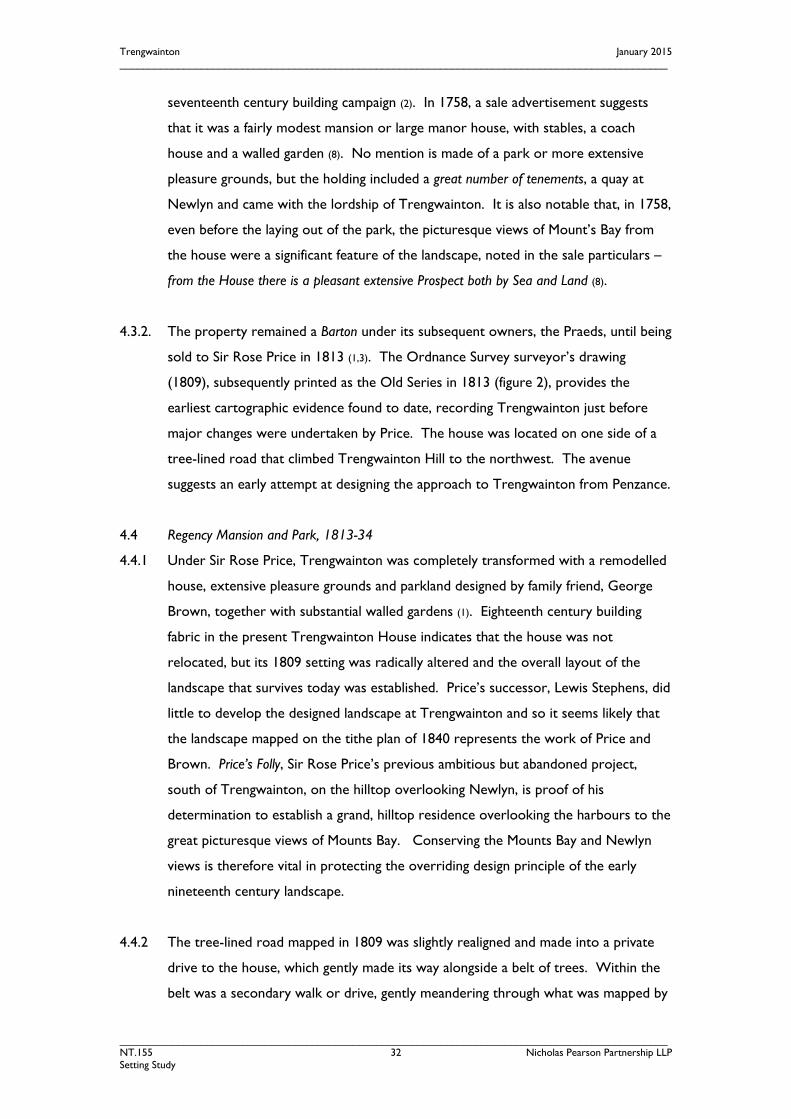
seventeenth century building campaign (2). In 1758, a sale advertisement suggests
that it was a fairly modest mansion or large manor house, with stables, a coach
house and a walled garden (8). No mention is made of a park or more extensive
pleasure grounds, but the holding included a great number of tenements, a quay at
Newlyn and came with the lordship of Trengwainton. It is also notable that, in 1758,
even before the laying out of the park, the picturesque views of Mount’s Bay from
the house were a significant feature of the landscape, noted in the sale particulars –
from the House there is a pleasant extensive Prospect both by Sea and Land (8).
4.3.2. The property remained a Barton under its subsequent owners, the Praeds, until being
sold to Sir Rose Price in 1813 (1,3). The Ordnance Survey surveyor’s drawing
(1809), subsequently printed as the Old Series in 1813 (figure 2), provides the
earliest cartographic evidence found to date, recording Trengwainton just before
major changes were undertaken by Price. The house was located on one side of a
tree-lined road that climbed Trengwainton Hill to the northwest. The avenue
suggests an early attempt at designing the approach to Trengwainton from Penzance.
4.4 Regency Mansion and Park, 1813-34
4.4.1 Under Sir Rose Price, Trengwainton was completely transformed with a remodelled
house, extensive pleasure grounds and parkland designed by family friend, George
Brown, together with substantial walled gardens (1). Eighteenth century building
fabric in the present Trengwainton House indicates that the house was not
relocated, but its 1809 setting was radically altered and the overall layout of the
landscape that survives today was established. Price’s successor, Lewis Stephens, did
little to develop the designed landscape at Trengwainton and so it seems likely that
the landscape mapped on the tithe plan of 1840 represents the work of Price and
Brown. Price’s Folly, Sir Rose Price’s previous ambitious but abandoned project,
south of Trengwainton, on the hilltop overlooking Newlyn, is proof of his
determination to establish a grand, hilltop residence overlooking the harbours to the
great picturesque views of Mounts Bay. Conserving the Mounts Bay and Newlyn
views is therefore vital in protecting the overriding design principle of the early
nineteenth century landscape.
4.4.2 The tree-lined road mapped in 1809 was slightly realigned and made into a private
drive to the house, which gently made its way alongside a belt of trees. Within the
belt was a secondary walk or drive, gently meandering through what was mapped by
Trengwainton January 2015 ______________________________________________________________________________________________
______________________________________________________________________________________________ NT.155 33 Nicholas Pearson Partnership LLP Setting Study
the tithe surveyors as plantation, and almost certainly was one large wooded area of
pleasure grounds. Open farmland to the north of the main drive, with openings
alongside pleasure ground walks, suggest places where views of the surrounding
landscape were enjoyed, in particular, due south of the house, to the east. This was
later formalised as the main terrace and, with the House, was a principal designed
viewpoint in the pleasure grounds. The main façade of the house also faced east,
towards Penzance and St Michael’s Mount, with stables and yards tucked away to
the northwest. A single gate lodge marked the entrance to the estate and stood
adjacent to extensive walled gardens and the estate hamlet of Nanseglos.
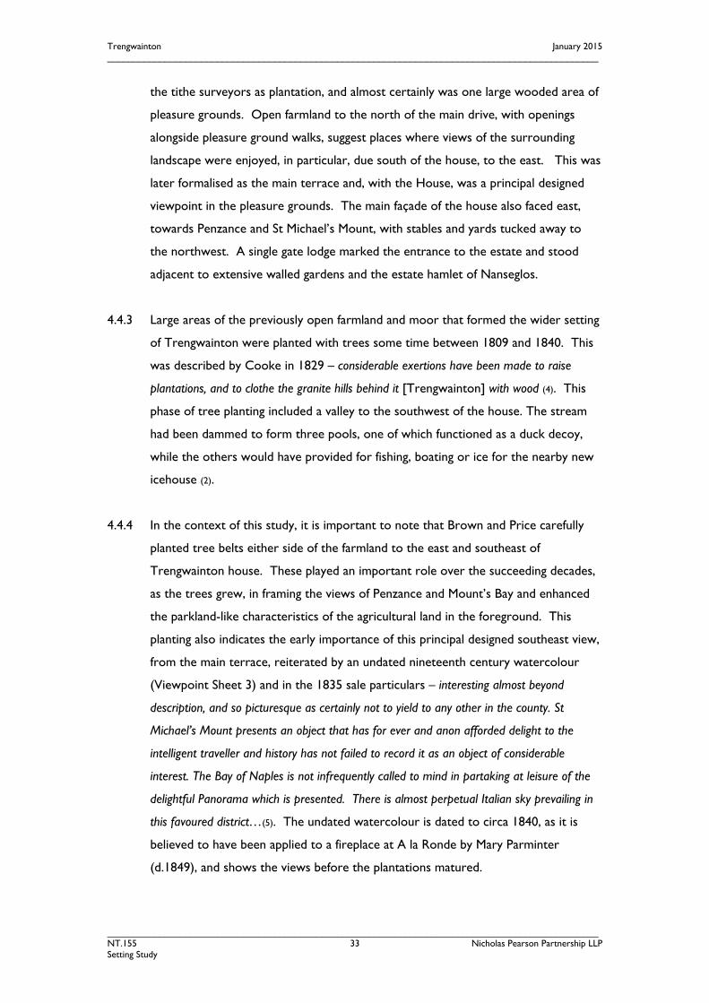
4.4.3 Large areas of the previously open farmland and moor that formed the wider setting
of Trengwainton were planted with trees some time between 1809 and 1840. This
was described by Cooke in 1829 – considerable exertions have been made to raise
plantations, and to clothe the granite hills behind it [Trengwainton] with wood (4). This
phase of tree planting included a valley to the southwest of the house. The stream
had been dammed to form three pools, one of which functioned as a duck decoy,
while the others would have provided for fishing, boating or ice for the nearby new
icehouse (2).
4.4.4 In the context of this study, it is important to note that Brown and Price carefully
planted tree belts either side of the farmland to the east and southeast of
Trengwainton house. These played an important role over the succeeding decades,
as the trees grew, in framing the views of Penzance and Mount’s Bay and enhanced
the parkland-like characteristics of the agricultural land in the foreground. This
planting also indicates the early importance of this principal designed southeast view,
from the main terrace, reiterated by an undated nineteenth century watercolour
(Viewpoint Sheet 3) and in the 1835 sale particulars – interesting almost beyond
description, and so picturesque as certainly not to yield to any other in the county. St
Michael’s Mount presents an object that has for ever and anon afforded delight to the
intelligent traveller and history has not failed to record it as an object of considerable
interest. The Bay of Naples is not infrequently called to mind in partaking at leisure of the
delightful Panorama which is presented. There is almost perpetual Italian sky prevailing in
this favoured district…(5). The undated watercolour is dated to circa 1840, as it is
believed to have been applied to a fireplace at A la Ronde by Mary Parminter
(d.1849), and shows the views before the plantations matured.

Trengwainton January 2015 ______________________________________________________________________________________________
______________________________________________________________________________________________ NT.155 34 Nicholas Pearson Partnership LLP Setting Study
4.5 Decline and Revival 1835-1961
4.5.1 Sir Rose Price’s successor, Lewis Stephens, appears to have had no intention of
occupying or maintaining Trengwainton as a grand country house, partially
demolishing and letting the mansion, and subdividing the estate for commercial
purposes (3). However, the uninterrupted view of Mount’s Bay from the main terrace
continued to capture the imagination of visitors and commentators, such as
Twycross in 1846 (7).
4.5.2 In 1866, the freehold estates of Trengwainton, Nanseglos, Boswednan, Boswarthen,
Pulteggan and Hendra were advertised for sale as a single lot. The estate was
purchased by T. S. Bolitho, a banker and descendent of an ancient Cornish family
who had prospered from the mining industry. The sales particulars included an
estate plan (figure 3), very similar to the earlier tithe map, and an engraving of a view
of Trengwainton House with Mount’s Bay in the background (Viewpoint Sheet 2).
4.5.3 Thomas S. Bolitho (1808-87) and his son, Thomas R. Bolitho (1840-1925), extended
and remodelled the house and developed the pleasure grounds (1,2). Bolitho’s Bank
had a central commercial role in Penzance from 1806 to 1905. Their works are
recorded on the first and second editions of the 25-inch Ordnance Survey maps
(figure 4), and on a series of detailed plans made in 1877 to record Trengwainton’s
water supply and drainage. Additions in the 1870s included Trengwainton Farm to
the north of the mansion; a formalised, surfaced terrace on the remodelled eastern
façade of the house as well as the reworked main terrace along the pleasure ground
boundary to the south; and the reworking of Price’s woodland walk into the new
Penzance approach drive, with a turning circle outside the north front and a spur
drive to the stables. It is presumed this latter work was to enhance the approach
drive, but also to expand the space for garden planting.
4.5.4 By 1908, the date of the second edition of the Ordnance Survey map, the approach
drive had been altered once again. What was referred to as the Old Carriage Drive in
the 1877 drainage plans was re-adopted as the main drive from the entrance lodge.
The previous ‘new’ drive was retained as a garden path, whilst the re-established
route ran along the northern side of the pleasure grounds, bounding an area of park-
like pasture, cleared of field boundaries and planted with clumps and a few infield
trees. Further extensions of mixed tree planting around the fringes of the pleasure
grounds and removal of field boundaries to the south, together indicate a conscious

Trengwainton January 2015 ______________________________________________________________________________________________
______________________________________________________________________________________________ NT.155 35 Nicholas Pearson Partnership LLP Setting Study
effort to create a greater parkland setting to the house and gardens. Notably the
drive shelterbelt had been widened with new planting, to improve shelter in the
pleasure ground, slightly restricting the main terrace views.
4.5.5 In 1894, the Gardeners’ Chronicle magazine visited Trengwainton. The article
concentrated on the walled gardens and, of the rest of the pleasure grounds,
reported that the flower gardens near the house do not call for particular notice, except
the lovely views (obtainable from the terrace on the south side of the building), of Mount’s
Bay and St Michael’s Mount (6). Once again this highlights the ongoing key role of the
eastern Mount’s Bay views throughout Trengwainton’s history. By 1908, the south
terrace ha-ha had been extended into the surrounding parkland allowing the
Mount’s Bay views to be enjoyed from a more spacious terrace and front lawn to
the east and south of the house.
4.5.6 Lt. Col. E.H.W. Bolitho, who inherited Trengwainton in 1925, is credited with the
major development of the gardens. His plant collections were inspired and
influenced by fellow plantsmen, particularly J.C. Williams of Caerhays, P. D. Williams
of Lanarth, Canon Boscawen of Ludgvan, George Johnstone of Trewithen and
Lawrence Johnston of Hidcote (1). Under Lt Col Bolitho’s capable gardener, Alfred
Creek, seeds gathered from northeast Assam and the Mishmi Hills by plant
collector, Frank Kingdon-Ward, formed the foundation of a significant
rhododendron collection at Trengwainton in the late 1920s and 1930s. The gardens
were opened to the public in 1931 and attracted large numbers of visitors (4).
4.5.7 While there was considerable development of the gardens, the map evidence for the
mid twentieth century recorded relatively few changes to the overall layout of the
designed landscape surrounding Trengwainton House. The terrace and east lawn
remained principal viewpoints, and the approach drive continued to enjoy views of
the parkland pasture to the east. However, the wider landscape setting of
Trengwainton to the southeast changed during the twentieth century with the
expansion of Penzance. Development of the former outlying villages of Heamoor
(figure 5) and Alverton was particularly extensive and, while the topography of the
land helped to screen much of the suburbs, housing around Heamoor and tall
developments in Penzance, notably Penwith College, have encroached into
Trengwainton’s historic views (in which, only the distant roof-tops in the centre of
Penzance were previously visible) and have, to an extent, undermined the estate’s
Trengwainton January 2015 ______________________________________________________________________________________________
______________________________________________________________________________________________ NT.155 36 Nicholas Pearson Partnership LLP Setting Study
rural context. In response to this, and to storm damage, the ‘drive’ shelterbelt has
been further widened since 1963 to improve shelter, and reinforce the planted
screen between the main terrace, and views towards the reservoirs and Heamoor.
4.6 Conclusion
• Trengwainton is a nationally important historic designed landscape
incorporating several listed buildings and locally designated features and sites. It
lies within an ancient landscape, with extensive evidence for prehistoric
settlement and very early field enclosure.
• A large house has been standing at Trengwainton since at least 1692, with
extensive tenements, a quay at Newlyn and the lordship of the Manor of
Trengwainton.
• The general layout of today’s landscape originates from the pleasure grounds
laid out by Sir Rose Price in the 1820s to a design by George Brown. The
collection of rhododendrons, magnolias and other half-hardy trees and shrubs
planted by the Bolitho family in the early and mid twentieth century is of
national importance.
• The views of St Michael’s Mount and Mount’s Bay have been a key feature of
Trengwainton since at least 1758. In the 1820s, Sir Rose Price created a terrace
to maximise experience of this view and it was also fundamental to the design
of the house during various remodelling phases of the late 1800s.
• Since the 1850s, Penzance has expanded, bringing built development closer to
the Trengwainton Estate. Development has also encroached on the principal
Mount’s bay views. These changes reflect the changing nature of the setting of
Trengwainton over the last 150 years, but the recent higher level and larger
scale development illustrate the damage that can be caused when the scale and
nature of change is not controlled.

Trengwainton January 2015 ______________________________________________________________________________________________
______________________________________________________________________________________________ NT.155 37 Nicholas Pearson Partnership LLP Setting Study
5.0 THE VISUAL ENVELOPE
5.1 Identifying the Visual Envelope
5.1.1 The visual envelope of the registered landscape has been assessed through mapping
a Zone of Theoretical Visibility (ZTV), using satellite-derived digital surface
modelling, as detailed in paragraphs 2.2.6 to 2.2.9 above. This has produced an
objective assessment of the area within which changes in land use and the
development of structures ranging from 0.5m, 7m (a typical house height), 10m and
12m (typical industrial units) will be visible from Trengwainton, and, therefore, could
have an influence or effect on the visual amenity and historic integrity of the heritage
assets. Being computer modelled, the zone of theoretical visibility does not take
into account the subjectivity of the human eye, nor the loss or growth of individual
trees that may highlight or obscure particular features or views.
5.1.2 In order to identify the ZTV for Trengwainton, the two most significant viewpoints
within the registered landscape were selected, and used to generate the plans.
These were identified as the first floor of Trengwainton House, and the garden
Terrace, significant because:
• both have functioned as designed, purpose-built viewpoints during the history of
Trengwainton. Views to Mount’s Bay are integral to the use and experience of
the buildings, the registered landscape and their setting;
• the House and Terrace provide the highest accessible viewpoints in the
landscape and, therefore, both viewpoints provide the greatest extent of views
over the landscape and its setting;
• the Terrace is readily and regularly accessible by modern visitors to
Trengwainton as part of the visitor experience since the property opened to
the public in 1931.
5.2 ZTV Analysis
5.2.1 The Zones of Theoretical Visibility for Trengwainton are illustrated in figure 8, from
the House, and figure 9, from the Terrace. The following overall observations can
be made.
5.2.2 From Trengwainton House, clear views could be obtained (were development to
take place) of standard built development, such as two-storey houses, on higher
ground north of Gulval, between Heamoor and Trevaylor, across Southern

Trengwainton January 2015 ______________________________________________________________________________________________
______________________________________________________________________________________________ NT.155 38 Nicholas Pearson Partnership LLP Setting Study
Heamoor, around Penwith College location, north of Lesingey Round, west of
Alveton, and north of Newlyn. In winter, or in the event of tree dieback or storm
damage, a much wider area could become visible. Taller development (10m-12m in
height) southwest of Madron would become visible, and this area will become more
sensitive with the progressive decline of the shelterbelt which currently obscures
some views to Madron Church.
5.2.3 From the terrace, even ground level (0.5m) development is highly visible on the
north-facing slopes between Lesingey and Heamoor. This area helps to define the
core setting area on figure 10. Higher level development (10m-12m in height) east
of Gulval, north of Newlyn and around southern Heamoor would be visible,
together with parts of Alverton, and Penwith College area.

Trengwainton January 2015 ______________________________________________________________________________________________
______________________________________________________________________________________________ NT.155 39 Nicholas Pearson Partnership LLP Setting Study
6.0 THE SETTING
6.1 Identifying Setting
6.1.1 The ZTV provides the base work for one of the three methods of identifying setting,
based on English Heritage’s Conservation Principles, that of visibility. This information
now needs to be combined with an understanding of the context and function of the
landscape surrounding Trengwainton to establish heritage significance within a view
and to complete the identification of the setting, its contribution to significance, and
its sensitivity to change.
6.1.2 The setting of Trengwainton’s house and registered landscape plays an essential part
in the significance and character of the heritage assets. Unlike the visual envelope,
setting is a subtler concept, to include the surrounding landscape that influences how
Trengwainton’s heritage is experienced and understood. Setting, therefore, is not
just to do with visual amenity or what can and cannot be seen, but also relates to
the cultural and functional relationships, past and present, of the historic site and its
local landscape, and also how the historic landscape contributes to, and integrates
with, the surrounding landscape character and contributes to Trengwainton’s
significance. Unlike the objective process in identification of the ZTV, identifying
setting is more conditioned by subjective judgement, and the priorities or knowledge
of a particular generation.
6.1.3 The identified setting of Trengwainton has been plotted for the purposes of this
study in figure 10, distinguishing between the core setting and the wider setting.
The outer line of each setting has been subdivided into sections and the rationale for
the boundary line is discussed further in 6.3 below.
6.2 Analysis of Views
6.2.1 The analysis of views, illustrated on Viewpoint Sheets 1 to 22, has three specific
purposes to contribute to identification of the setting of Trengwainton:
i. to check and assess the validity of the ZTV modelling, illustrated on figures 8
and 9, in particular noting the condition of vegetation screens, and the potential
for seasonal changes;
ii. to assess the survival and significance of known historic views to or from
Trengwainton, taken from historic research;
Trengwainton January 2015 ______________________________________________________________________________________________
______________________________________________________________________________________________ NT.155 40 Nicholas Pearson Partnership LLP Setting Study
iii. to assess the role and significance of landscape character and condition to our
understanding of Trengwainton.
6.2.2 From each of the viewpoints, there is one or more views, which are described in
this study as follows:
Principal Views are the views of greatest importance, and which reveal most about the
significance of Trengwainton. These are the primary designed views which explain
why Trengwainton and its landscape was laid out where it is, and why. The principal
views are those of St. Michael’s Mount and the wider Mount’s Bay from
Trengwainton House and the garden terraces, and reflect a clear appreciation of the
picturesque qualities of the site.
Key Views are the main identified designed views, by reference to recorded historic
views, the alignment of historic paths and gaps in plantations, and similar evidence.
Other designed views may well exist, but have not yet been identified, and might
only be revealed by further research. These key views are mostly outward views
but, at Trengwainton, a few of the intended inward views associated with known
approach routes or circuit ridings are also considered to be key views, where there is
a historic record, as with viewpoints 9 and 16.
Other inward views include views from within the historic estate, and beyond, where
Trengwainton plays a significant or distinctive role in the character and quality of the
local landscape.
6.2.3 A summary of the views is included in table 1 below, and described and illustrated in
detail on sheets 1 to 22.
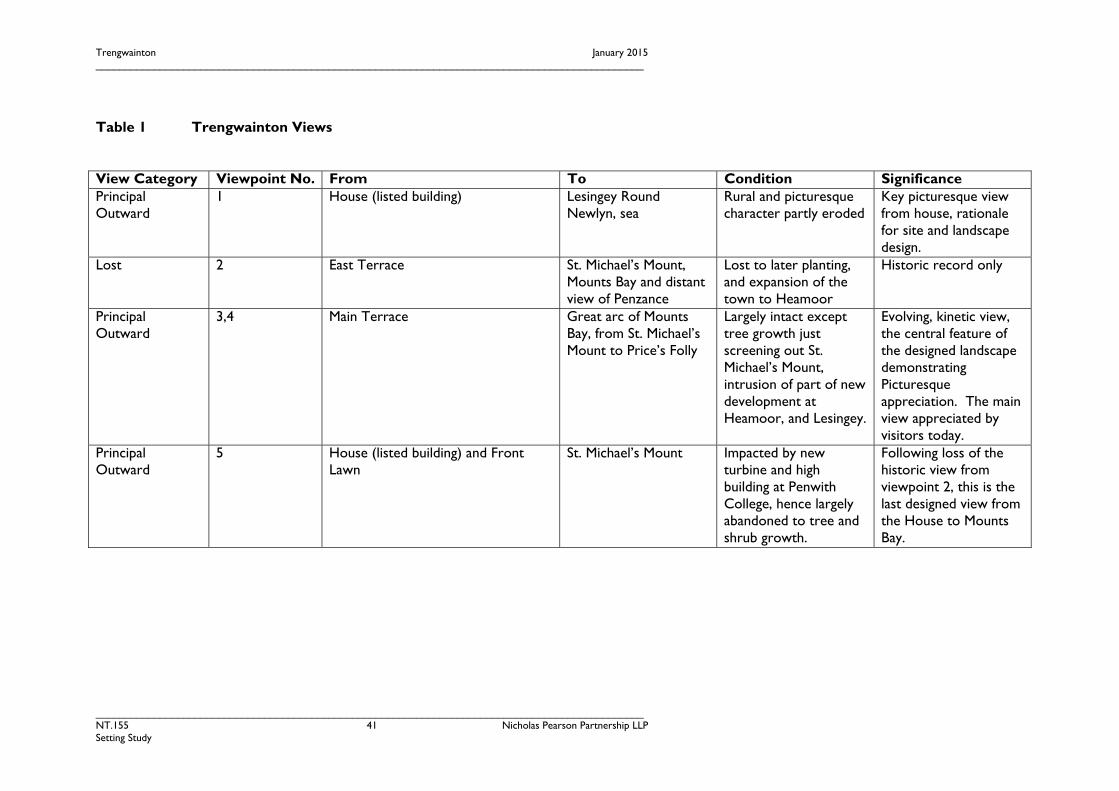
Trengwainton January 2015 ______________________________________________________________________________________________
______________________________________________________________________________________________ NT.155 41 Nicholas Pearson Partnership LLP Setting Study
Table 1 Trengwainton Views
View Category Viewpoint No. From To Condition Significance Principal Outward
1 House (listed building)
Lesingey Round Newlyn, sea
Rural and picturesque character partly eroded
Key picturesque view from house, rationale for site and landscape design.
Lost 2 East Terrace St. Michael’s Mount, Mounts Bay and distant view of Penzance
Lost to later planting, and expansion of the town to Heamoor
Historic record only
Principal Outward
3,4 Main Terrace Great arc of Mounts Bay, from St. Michael’s Mount to Price’s Folly
Largely intact except tree growth just screening out St. Michael’s Mount, intrusion of part of new development at Heamoor, and Lesingey.
Evolving, kinetic view, the central feature of the designed landscape demonstrating Picturesque appreciation. The main view appreciated by visitors today.
Principal Outward
5 House (listed building) and Front Lawn
St. Michael’s Mount Impacted by new turbine and high building at Penwith College, hence largely abandoned to tree and shrub growth.
Following loss of the historic view from viewpoint 2, this is the last designed view from the House to Mounts Bay.
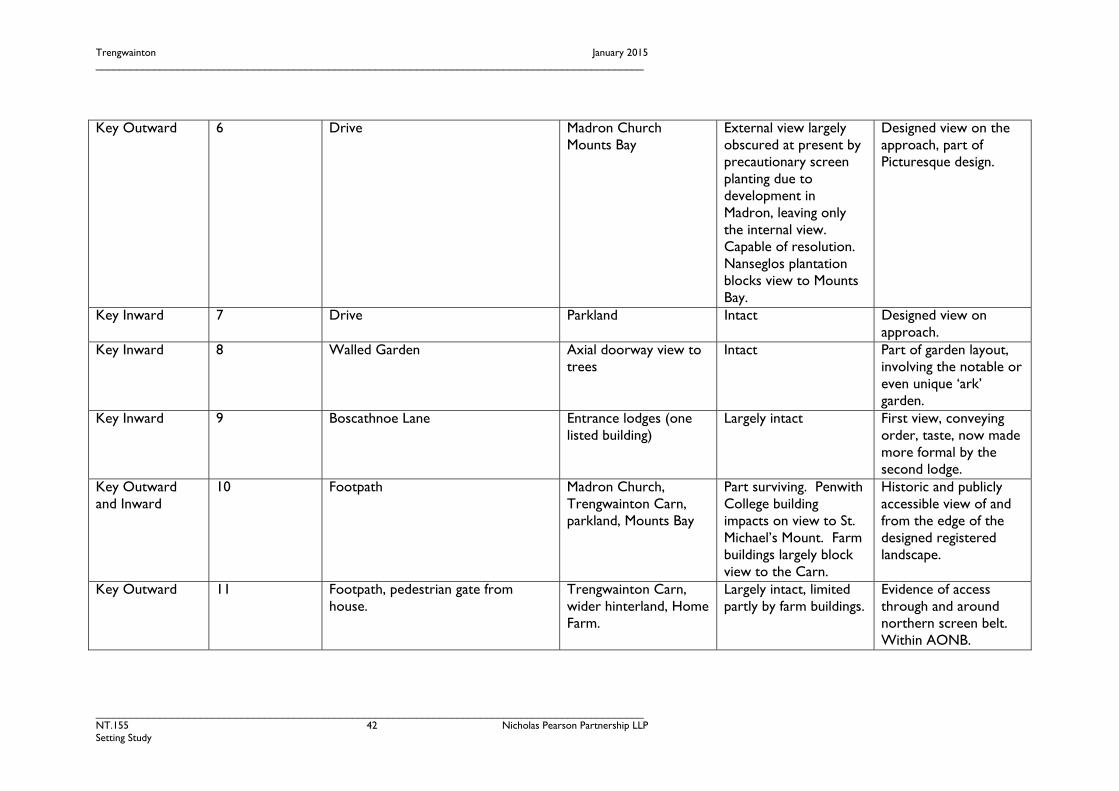
Trengwainton January 2015 ______________________________________________________________________________________________
______________________________________________________________________________________________ NT.155 42 Nicholas Pearson Partnership LLP Setting Study
Key Outward 6 Drive Madron Church Mounts Bay
External view largely obscured at present by precautionary screen planting due to development in Madron, leaving only the internal view. Capable of resolution. Nanseglos plantation blocks view to Mounts Bay.
Designed view on the approach, part of Picturesque design.
Key Inward 7 Drive Parkland Intact Designed view on approach.
Key Inward 8 Walled Garden Axial doorway view to trees
Intact Part of garden layout, involving the notable or even unique ‘ark’ garden.
Key Inward 9 Boscathnoe Lane Entrance lodges (one listed building)
Largely intact First view, conveying order, taste, now made more formal by the second lodge.
Key Outward and Inward
10 Footpath Madron Church, Trengwainton Carn, parkland, Mounts Bay
Part surviving. Penwith College building impacts on view to St. Michael’s Mount. Farm buildings largely block view to the Carn.
Historic and publicly accessible view of and from the edge of the designed registered landscape.
Key Outward 11 Footpath, pedestrian gate from house.
Trengwainton Carn, wider hinterland, Home Farm.
Largely intact, limited partly by farm buildings.
Evidence of access through and around northern screen belt. Within AONB.

Trengwainton January 2015 ______________________________________________________________________________________________
______________________________________________________________________________________________ NT.155 43 Nicholas Pearson Partnership LLP Setting Study
Key Outward 12 Zig-zag drive Wooded valley with ponds
Largely disused, but surviving.
Evidence of the link and appreciation of the western valley and west drive. Within registered landscape.
Key Outward and Inward
13 Boswednan gate. West drive woodlands. Largely disused, but surviving.
Evidence of the link and appreciation of the western valley and west drive. Within registered landscape.
Key Inward 14 Pond Pond Neglected but surviving Evidence of romantic and artistic appreciation as well as functional use for sport. Within registered landscape.
Longer distance inward
15 Polclose Home Farm Intact Evidential role of the improved agricultural Home Farm in sustaining the estate. Within AONB and AGHV.
Longer distance inward Key view
16 Trengwainton Carn Trengwainton, Madron Church and Workhouse, distant view of Penzance, Mounts Bay.
Largely intact Evidence of the breadth of the landscape setting to the Picturesque landscape and estate, contrasting the rough carn, symbolised by goats, with the ancient stones of Madron Church and St. Michael’s Mount, and the productive Home
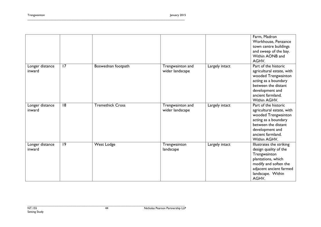
Trengwainton January 2015 ______________________________________________________________________________________________
______________________________________________________________________________________________ NT.155 44 Nicholas Pearson Partnership LLP Setting Study
Farm, Madron Workhouse, Penzance town centre buildings and sweep of the bay. Within AONB and AGHV.
Longer distance inward
17 Boswednan footpath Trengwainton and wider landscape
Largely intact Part of the historic agricultural estate, with wooded Trengwainton acting as a boundary between the distant development and ancient farmland. Within AGHV.
Longer distance inward
18 Tremethick Cross Trengwainton and wider landscape
Largely intact Part of the historic agricultural estate, with wooded Trengwainton acting as a boundary between the distant development and ancient farmland. Within AGHV.
Longer distance inward
19 West Lodge Trengwainton landscape
Largely intact Illustrates the striking design quality of the Trengwainton plantations, which modify and soften the adjacent ancient farmed landscape. Within AGHV.

Trengwainton January 2015 ______________________________________________________________________________________________
______________________________________________________________________________________________ NT.155 45 Nicholas Pearson Partnership LLP Setting Study
Longer distance inward
20 Lesingey Trengwainton landscape
Largely intact Illustrates the striking design quality of the Trengwainton plantations, which modify and soften the adjacent ancient farmed landscape.
Longer distance inward
21 Near Rosehill, footpath Trengwainton landscape
Largely intact, but subject to some visible urban fringe.
Illustrates the striking design quality of the Trengwainton plantations, which modify and soften the adjacent ancient farmed landscape.
Longer distance inward
22 Adjacent Boscathnoe, footpath Trengwainton landscape
Partly intact, but subject to some notable urban fringe intrusion.
The plantations of the Trengwainton landscape help to separate it from the foreground urban fringe activity in summer.

Trengwainton January 2015 ______________________________________________________________________________________________
______________________________________________________________________________________________ NT.155 46 Nicholas Pearson Partnership LLP Setting Study
6.3 The Wider Setting
6.3.1 The setting defined by Conservation Principles, includes:
• The surroundings in which a place is experienced,;
• ..its local context, including elements which appear in the same view as the
registered landscape;
• present and past relationships which include historic estate ownership, the water
catchment area for the valley ponds, but may include other linkages to the
medieval and prehistoric context yet to be fully identified.
6.3.2 Depending on the nature of the historic landscape, some parts of its setting will be
more sensitive than others, and therefore more or less able to accept change of a
particular type or scale, without unacceptable adverse effects upon its character.
The sensitivity of the wider setting areas to development is generally lower than the
sensitivity of the core areas due to location and visibility. However, this sensitivity is
entirely dependent on the nature of the development and needs to be judged on a
case-by-case basis.
6.3.3 The setting area identified on figure 10 includes the areas of core setting, (where the
registered landscape is sensitive to changes in landscape management and land use,
as well as built development); and the wider setting. The wider setting is sensitive
to larger scale changes in the character of the landscape, as set out below.
6.3.4 However, an even wider area, particularly along the line of principal and key views,
should be reviewed whenever large size or highly visible developments are under
consideration. Examples include tall developments (telecommunication masts, wind
turbines and the like), large buildings, extensive night time lighting (trunk road
service area, floodlit sports pitches etc.), and highly reflective features (such as solar
panels, glasshouses, and field-scale fabric ‘cloche’ systems).
6.3.5 In order to identify the wider visual setting of the Trengwainton heritage assets, 22
viewpoints into and out of the registered landscape were analysed to understand
their significance, landscape character, the current issues affecting their quality and
integrity, and their sensitivity to change. The findings of this analysis are illustrated in
Viewpoint Sheets 1 to 22, attached to this report, summarised on table 1.
Trengwainton January 2015 ______________________________________________________________________________________________
______________________________________________________________________________________________ NT.155 47 Nicholas Pearson Partnership LLP Setting Study
6.3.6 Analysis of the 22 views looking into and out of the registered landscape reveals six
broad character types that lie within the two county Landscape Character Areas
(LCAs) of the Penwith Central Hills and Mount’s Bay and, together, form the wider
landscape setting of Trengwainton (figure 10). Both the LCAs and the Historic
Landscape Characterisation (HLC) have been used, but modified, to establish
character types, for three reasons:
i. As a setting study, the discrepencies between the mapping of the LCAs and
HLCs for the registered landscape are not considered material. The LCA
divides the ornamental landscape along an ill-defined boundary into two LCAs,
yet it is described in only one.
ii. The subdivision of the anciently enclosed HLC is considered, for the purposes of
this report, to be a reflection on the condition of the HLC, rather than a
fundamental character description. The landscape between Trengwainton and
Rosehill is therefore described as anciently enclosed.
iii. Recently developed areas of Heamoor within the mapped setting are treated
differently from the historically built-up areas under HLC, and are not allocated
a defined landscape character type in this study.
The HLCs have therefore been modified and adapted to create the following six
historic landscape character types, as mapped on figure 10:
6.3.7 Anciently Enclosed Pastoral Farmland
Description
Ancient enclosed pastures on the open hillside possess a strong prehistoric
character, with distinctive wrought iron gates as a link to the Bolitho estate. The
estate boundary in 1866 is plotted on figure 10.
Role as Wider Setting
Open and exposed, allowing long distance views over the Penwith landscape.
Backdrop to the northwestern area of ponds in the registered landscape.
The Trengwainton landscape forms part of the boundary to this Landscape
Character type. The southeastern part is affected by reservoir and infrastructure
development close to Penzance.

Trengwainton January 2015 ______________________________________________________________________________________________
______________________________________________________________________________________________ NT.155 48 Nicholas Pearson Partnership LLP Setting Study
6.3.8 Boulder-strewn Moorland – Trengwainton Carn
Description
Boulder-strewn moorland which has lost its ‘ornamental’ overlay since the removal
of invasive rhododendron and conifers.
Role as Wider Setting
Principal inward viewpoint, but also with deep historical layers of land use. Critical
as a contextual link between the Penwith ‘hinterland’ of moors and mines, and the
commerce of Penzance, and Picturesque qualities of Mount’s Bay. The potential role
of the woodland, small fields, cross and holy well north of Carn Lodge merit further
historic research, and were part of the historic estate.
6.3.9 Linear, Wooded River Valleys
Description
Overgrown, scrubby valley above the pond area.
Role as Wider Setting
Catchment area for the ponds, and wildlife corridor. This character type continues
within the registered landscape.
6.3.10 Built-up Areas with visible church towers
Description
The historic town of Penzance, and its surrounding villages, provided the market and
port services required by the historic estates, with links back to a medieval and
spiritual landscape of church towers and Cornish saints.
Role as Wider Setting
Distant views to small towns and villages, with a historic centre of landmark
buildings, act as features in designed views and artistic representations of the wider
landscape. The modern extent of Madron is mapped, as it continues to be clustered
around two core structures, the church and Mount View. Notably, the modern
extension of Heamoor within the mapped setting was not included in the description
of this part of the HLC.
6.3.11 Mixed arable and pastoral farmland with wooded hedgerows and valleys
Description
Post-medieval rectilinear enclosures and estate farms, with woodland belts where
there is no topographic shelter. More intensively managed.

Trengwainton January 2015 ______________________________________________________________________________________________
______________________________________________________________________________________________ NT.155 49 Nicholas Pearson Partnership LLP Setting Study
Role as Wider Setting
Direct, productive link to the improved and parkland landscape, with the park’s
perimeter shelterbelts to frame views and increase productivity.
6.3.12 Ornamental landscapes of Castle Horneck, Rosehill, Nancealverne and
Roscadghill
Description
Historic, ornamental landscapes outside historic Penzance town, with striking
seaward views and Picturesque views of Mount’s Bay. Ornamental mixed planting
and pocket parks, now converted to residential and holiday use. Castle Horneck,
for example, is a Youth Hostel.
Role as Wider Setting
Planting frames hilltop views, but also creates visual balance across the vale to
Trengwainton, and hints at a landscape ‘conversation’ between the properties.
6.4 The Core Setting
6.4.1 English Heritage does not seek to plot or distinguish the essential setting of registered
parks and gardens, in contrast to Cadw’s approach in Wales. In the Setting of
Heritage Assets, a distinction is made between the ‘immediate’ (or core) setting of, for
example, a great house, which might be the park, and the wider setting of that park
which may include lines-of-sight to more distant heritage assets or natural features
beyond the park boundary. The implication of this is that the ‘great house’ might
have both an immediate or core setting and a wider setting. Similarly, a park such as
Trengwainton might also have a core setting and a wider setting. Although the
registered park would normally include all that area subject to conscious designed
works, the core setting could include areas which are needed to complement its
design or function, to enable a present-day appreciation of this. At Trengwainton,
areas of the core setting of the registered landscape should include, therefore,
pastoral land that survives in the immediate setting of the registered landscape,
conserving at least some sense of original rural context of the park and garden, as
well as protecting key designed views to the east. The wider setting, due to the
nature of the relationship with the asset, will generally contribute less to the
significance of the heritage asset than the core setting, although sightlines to more
distant features can be of particular significance, as already established under the
views analysis.

Trengwainton January 2015 ______________________________________________________________________________________________
______________________________________________________________________________________________ NT.155 50 Nicholas Pearson Partnership LLP Setting Study
6.4.2 The rural context of Trengwainton is significant for a number of reasons:
• Productive agricultural land forms, in the middle ground, an essentially
picturesque counterpoint to the more sublime and wild landscapes and coastal
seascapes which are the subjects of key designed views, including Mount’s Bay
and Trengwainton Carn.
• Low-lying agricultural land forms an essential middle ground to the principal
designed views to Mount’s Bay from the House and Terrace. These views were
a major, if not, the reason why the sites for Trengwainton House and pleasure
grounds were selected and certainly influenced their subsequent remodelling.
Not only was the scene highly picturesque, centred on the distinctive and iconic
silhouette of St Michael’s Mount, but Mount’s Bay was also vital in Cornish
maritime trading and, with Penzance and Newlyn, played a key role in the
sources of Price’s and the Bolithos’ wealth –respectively, produce from a
Jamaican plantation, and the latter as bankers and shipping agents.
• The rural separation of the estate from the urban area of Penzance reinforces
the role of the heritage assets as a country house and park. This was the
intention of its creators, Sir Rose Price and the Bolitho family, who were
wealthy, ambitious businessmen wanting to reflect and raise their status in
society. Land and a large, private house, which could be handed down to future
generations, were a key element of this aspiration. Land was also central to
political influence in previous centuries.
• As with all country estates, an extensive area of tenanted farmland provided a
major source of income for the landowner. A large part of the core setting of
Trengwainton formed part of the estate and therefore plays a significant
functional role in the development of the heritage assets. The post-medieval
enclosed landscape is a direct association with the history of the ‘improved’
Trengwainton estate.
• It protects the tranquillity of the gardens as a landscape away from the busy
streets of Penzance. Historically, towns were subject to a variety of vices and
ills. Typhus was a particular concern, even in small towns, as late as the early
twentieth century.
• The continuity of the rural setting protects the integrity of as yet unknown
designed views that might be identified in the future (see para 2.2.4 above).
• The ancient enclosure of the western and southern setting creates a distinctive
landscape, to contrast with the designed landscape. This landscape character is
appealing to present-day visitors to Cornwall, as well as of interest to modern
Trengwainton January 2015 ______________________________________________________________________________________________
______________________________________________________________________________________________ NT.155 51 Nicholas Pearson Partnership LLP Setting Study
landscape archaeologists. The distinctive wrought iron field gates of Bolitho
estate farms are a notable detail component of the associated rural landscape
(see view 13).
6.4.3 While the town of Penzance and parts of Madron village were historically part of the
setting of Trengwainton, these appear in the historic views as distant, widely
separated and isolated features, focussed on the ornamental buildings, almost like
garden temples widely dispersed around a landscape park. In the picturesque mode,
St. Michael’s Mount and Madron church are the epitome of the gothic; Madron
workhouse is a bold fortress in a heathy wilderness; the dome of the Market house
in Penzance ornaments the beauty of Mount’s Bay. The ordinary town and village
buildings are only very modestly represented. As Penzance grew, Rose Price’s
plantations grew to frame and obscure some of these views. Notably, after 1878,
the southern plantation belts were slightly extended and deepened to reduce views
to Boscathnoe reservoirs, and the Nanseglos plantations has grown to conceal the
view of Poltair House, now Heamoor hospital. More substantial widening of the
belts was undertaken to improve garden shelter in response to storm damage in
1990, but also to improve screening of development at Heamoor after 1963. This
later planting is now also impinging on the principal terrace view 3 to Mounts Bay,
which the Trust plan to reopen by careful thinning.
6.4.4 The core setting area is plotted on figure 10, subdivided into character areas, with
justifications set out below. The areas outside the registered landscape have been
identified through the documentary review, ZTV and views analysis as the immediate
setting of Trengwainton, and, therefore, form the core setting of the designed
landscape with the least capacity for change. These are, as plotted on figure 10:
6.4.5 Core Setting Area 1: Ancient Enclosure – Boswednan Farmland –
Viewpoints 13, 17-20
Character and role as core setting
Tight patchwork of fields, enclosed with scrubby dry stone banks, generally open on
the higher ground. Hedgebank trees in more sheltered areas increase the wooded
character of the farmland, which is predominantly in pasture. Enclosed at a very
early date, this landscape has formed the historic setting of Trengwainton
throughout its history and creates a distinctive rural context to the designed
landscape. It plays an important role as the setting of the wooded valley and ponds
Trengwainton January 2015 ______________________________________________________________________________________________
______________________________________________________________________________________________ NT.155 52 Nicholas Pearson Partnership LLP Setting Study
to the northwest of Trengwainton House, created in the 1820s and part of the
registered landscape. The identity of the area as part of the Bolitho estate is
reinforced by the use of signature wrought iron field gates (for example, View 13).
The core setting area is limited to those areas with significant and close visual
connections to the registered landscape.
Vulnerability
This intact part of the landscape setting is highly sensitive to land use change,
removal of field boundaries and the development of farming infrastructure and
development – for instance, at Boswednan – which would alter its landscape
character and the contextual setting of Trengwainton. The ZTV mapping reveals that
development and land use change in this area would not be visible from the principal
viewpoints of the Terrace and Trengwainton House, but private outward, and
western inward views towards the registered landscape would be affected.
6.4.6 Core setting area 2: Trengwainton Carn – Viewpoints 11,16
Character and role as core setting
Formerly rocky and barren high ground around Trengwainton Carn, recently
cleared of rhododendron and conifers, but now partly dominated by gorse. This
part of the setting contrasts with the verdant enclosed farmland and wooded
grounds and valley of Trengwainton, adding visual interest and a reminder of the
wildness and prehistory of the pre-enclosure landscape. Some sense of the
romantic, almost Highland character of the moorland as a setting to Trengwainton is
depicted in nineteenth century paintings (Views 14 and 16). The moorland is an
important part of the setting of Trengwainton, historically forming the backdrop to
views from the wooded valley and ponds, but also as a viewpoint looking over
Trengwainton. The northern area is not included in the core setting as it plays
little direct role in the setting of Trengwainton.
Vulnerability
In recent years, the moorland has been cleared of rhododendron and most of the
‘ornamental’ character previously recorded by the Cornwall Historic Landscape
Characterisation Study in 1994 has been removed. However, it now requires
grazing management to control the regeneration of gorse which is threatening the
rocky and barren landscape character. As open access land, part of the Cornwall
AONB and part of the Bolitho Estate, it is unlikely to be subject to development
Trengwainton January 2015 ______________________________________________________________________________________________
______________________________________________________________________________________________ NT.155 53 Nicholas Pearson Partnership LLP Setting Study
issues, although the erection of communication masts and turbines is a special risk to
the setting of this landscape character.
6.4.7 Core setting area 3: Trengwainton Farm – Viewpoints 10,11,1 5, 16
Character and role as core setting
A plateau of larger, more regular, quadrangular fields enclosed by well-defined hedge
banks and mature hedgerows. Mainly consisting of pasture at the time of survey,
they form the planned and ‘improved’ agricultural setting to the perimeter of the
registered landscape and in views of Trengwainton from the Carn. The farmland
plays a limited role in designed views from the house and grounds, with the
exception of a closed pedestrian gateway north of the house and glimpse views
through the trees from woodland rides behind Trengwainton House. This farmland
is as mapped in 1866 and has therefore formed the setting of Trengwainton for at
least 150 years, and remains part of the Bolitho estate.
Vulnerability
This largely intact part of the landscape setting is less sensitive to land use change,
but moderately sensitive to the development of farming infrastructure and
development, as exemplified by new farm buildings, earth bunds and feed hoppers at
Trengwainton Farm. A more intensive farming operation may also have an impact on
the tranquillity of Trengwainton’s rural setting. Expansion of the village of Madron
may also intrude on views from the edge of the registered landscape, however, the
gently rising topography of the land will help to screen the development site
proposed on the north side of the village.
6.4.8 Core setting area 4: Lower Park and Hendra – Viewpoints 1,3,4,20,21,22
Character and role as core setting
The lower park farmland appears in views to and from the registered landscape, but
also retains a productive agricultural character critical to the understanding of the
early estate, complete with the ancient leat to Pulteggan Mill, forming the parish
boundary. Historically, the lower park was more visible from the pleasure ground
walk, until the belt was widened, after 1878, partly to screen the Boscathnoe
reservoir developments. This area was also part of the historically owned estate, as
mapped in 1866.

Trengwainton January 2015 ______________________________________________________________________________________________
______________________________________________________________________________________________ NT.155 54 Nicholas Pearson Partnership LLP Setting Study
Vulnerability
This area is vulnerable to further loss of historic landscape fabric, including the lower
well-wooded hedgerows and leat, and development at Pulteggan. Reopening and
restoration of the historic visual links from the gardens to the lower park could only
take place if there is confidence that further development towards Heamoor is
unlikely to occur.
6.4.9 Core setting area 5: Boscathnoe and Approach – Viewpoints 9, 21,22
Character and role as core setting
This area separates the Penzance town fringe from the rural setting of the
Trengwainton landscape, but this character has been weakened by development
west of Mounts Bay Academy secondary school in Heamoor, and by the semi-
derelict, semi-industrial character of the Boscathnoe reservoir sites. Historically,
although largely outside the estate’s ownership, map evidence suggests an enclosed,
pastoral landscape as the approach to Trengwainton, prior to the development of
the reservoirs and orchards either side of the lane, with avenue-like hedgerow tree
planting enclosing the reservoirs from the 19th century. The historic experience of
the approach would have been from town, through village, across countryside,
through avenue, to the gate, providing a sequential, graduated experience. In recent
times, this has developed into a less managed, more wooded and shady final
approach to the Trengwainton entrance. This area is also the key setting for
modern visitors approaching Trengwainton, generating communal as well as aesthetic
values.
Vulnerability
This zone is highly sensitive to continuing degradation comprising residential
development, lighting, urban fringe fencing and infrastructure, and urgently needs a
clear, and robust edge to the already developed area, as well as a robust zone to
separate the park entrance from the urban edge. At present this relies on a narrow
belt of Trust-owned woodland just beyond the registered landscape. A recent pre-
application planning enquiry for the development of 100 dwellings on land south of
Boscathnoe Lane highlights the pressure this area is under in terms of new
development. It is at high risk of losing any rural character and forming an urban
extension of Heamoor. This part of the setting is sensitive to changes which are
bringing urban fringe elements and character closer to the gates of Trengwainton,

Trengwainton January 2015 ______________________________________________________________________________________________
______________________________________________________________________________________________ NT.155 55 Nicholas Pearson Partnership LLP Setting Study
risking the loss of the rural breathing space, and its replacement with a much more
abrupt, suburbanised approach.
6.4.10 Core setting area 6: Ancient Enclosure – Rose Hill Farm and Lesingey
Round – Viewpoints 1,3,4, 21 and 22
Character and role as core setting
Patchwork of fields, adjoining the small eighteenth and nineteenth century estates of
Rosehill and Castle Horneck, and modern infrastructure including overhead cable
networks. Mature woodland and numerous hedgebank trees increase the wooded
character of the farmland. While not historically part of the estate, this area plays a
key role as the middle ground in designed eastern and southern views from the
House, pleasure grounds and Terrace (principal viewpoints 1,3 and 4), and is
therefore of evidential, aesthetic and present-day communal value, the Terrace being
the major destination for garden visitors today. The boundaries of this core area
are primarily defined by direct visual links to the registered landscape (see ZTV
analysis under 5.2.3 above). The decline of openness and uninterrupted views
shown in historic illustrations has occurred partly in response to urban fringe
development, as discussed in 6.4.3 above, although the pastoral land use largely
remains as recorded on historic maps. The framed views, that remain, preserve
important parts of the historic views, and the fundamental intent of the original
designed landscape (see 4.4.1 above).
Vulnerability
This largely intact and highly sensitive part of the landscape setting is vulnerable to
land use change, and highly sensitive to development. This has already begun with
the intrusion of housing at Heamoor into the periphery of the setting and the
erection of a mast to the southeast of Lesingey Round, on Mount Pleasant above
Wherrytown. The modern built-up area is no longer part of the adjacent landscape
character type, so is mapped without colour. Several proposed development sites
reveal that this remains an ongoing and relevant issue which could seriously
compromise the integrity of the historic views from Trengwainton towards the sea
and Newlyn. The power lines, the current state of field boundaries, and views to
encroaching development create an ‘urban fringe’ character to some of this land.
Given the impact of the College development on the principal view to St. Michaels
Mount from the house and front lawn (viewpoint 5), the cumulative impacts of
further built development and loss of pastoral context in this second principal view
Trengwainton January 2015 ______________________________________________________________________________________________
______________________________________________________________________________________________ NT.155 56 Nicholas Pearson Partnership LLP Setting Study
from the Terrace (viewpoints 3 and 4), over this core area, would probably be
deemed to be of substantial harm to the significance of Trengwainton in National
Planning Policy Framework terms.
6.5. Existing Harmful Impacts
6.5.1 Residential Development on the edge of Penzance
Issue
Expansion of Penzance since the mid-nineteenth century has reduced the rural
separation of Trengwainton from the town. This has escalated in the late twentieth
century, particularly as a result of housing development in and around the previously
outlying village of Heamoor.
Cause
The population of Penzance has grown rapidly over the last century, from 3,088
inhabitants in 1901 to 21,200 in 2011. This has inevitably placed great pressure on
Penzance’s services and housing provision, compounded by a high level of need for
affordable housing.
Recommendation
The Trust should seek for the setting of Trengwainton to be formally recognised and
protected in local planning policy. It is important that this includes the farmland
visible in views from the terrace and house in order to preserve the rural middle
ground and context to the principal designed views. The significance of the
principal views from the Terrace (viewpoints 3 and 4) is at risk if the last remaining
visible pasture in the view were to be lost to development or vegetation screens.
6.5.2 Penwith College development
Issue
In 2010, work was completed on a major redevelopment of Penwith College in
Penzance, including the tall Zennor Building and an associated 50m-high wind turbine
to improve the College’s use of sustainable energy.
Cause
Penwith College was established in 1981 and provides the only source of over-16
education in Penzance, fed by three secondary schools. The visual impact of this
turbine appears not to have been fully considered by the planning process.
Trengwainton January 2015 ______________________________________________________________________________________________
______________________________________________________________________________________________ NT.155 57 Nicholas Pearson Partnership LLP Setting Study
Recommendation
All future high-rise development in Penzance should be subject to a Landscape and
Visual Impact Appraisal to Landscape Institute guidelines, to address wider external
views towards the town, including from Trengwainton. At the end of economic life
of the turbine, it should be removed and replaced with alternative technology, or in
a less detrimental location. The principal outward long distance views to Mounts
Bay merit specific protection in Local Plan policy.
6.5.3 Modern infrastructure
Issue
Several views towards Lesingey Round feature a prominent communications mast,
located above Wherrytown, and there is a similar issue in some of the long-distance
views looking to the northwest. The intrusive wind turbine in key views is that at
Penwith College, but there is also a small domestic turbine on the Trengwainton
Estate at Sunny Corner, only visible from a small area. South east of Trengwainton,
close-hand views back to the registered landscape are, in some places, dominated by
criss-crossing overhead services, which detract from the traditional pastoral
landscape setting.
Cause
The impacts of sustainable energy sources and communications infrastructure are
often not understood or acknowledged, particularly because the benefits and the
economic advantages in Cornwall have been considered to outweigh the detrimental
impacts on heritage assets or landscape character. Apart from the specific impact of
the Penwith College wind turbine, the main issue is the impact of such infrastructure
on weakening the landscape character of the setting to the approach from Heamoor,
including the impact of derelict reservoir infrastructure.
Recommendation
The impact of modern infrastructure associated with strategic development on the
setting of heritage assets, and the key designed long distance views, should be
addressed as part of the planning process.

Trengwainton January 2015 ______________________________________________________________________________________________
______________________________________________________________________________________________ NT.155 58 Nicholas Pearson Partnership LLP Setting Study
6.5.4 Changes in tree belts
Issue
Mature trees within and around the registered landscape are critical for screening
the parts of Penzance that are most visually intrusive and also play an important role
in framing views from Trengwainton. Loss of these trees could have a serious
impact on the quality of the setting and designed views.
Cause
Climate change and novel tree diseases increase the risk of such losses. By contrast,
trees have also been allowed to grow up to conceal views of adjacent development,
at Penwith College, but also in the past in response to the Boscathnoe reservoirs,
and the spread of housing at Heamoor. This is an arms race which has limits, as
screen trees age, mature, or blow over. Increasing the depth of screen belts, to
allow for periodic regeneration, can also result in the loss of views and historic
character.
Recommendation
Designed views should, in general, be retained open, rather than obscured so as to
screen off site development, wherever development may be short-lived, or where
the visual impact may be reduced at source, for example, by garden and landscape
planting by a developer. This is not always feasible, and the Penwith College turbine
is a case in point. Where this occurs, S.106 or other compensatory funding should
be sought to recreate or reopen equivalent view features, for example, using tree
surgery or selective felling to reopen the view from the east end of the Terrace to
St. Michael’s Mount, or to enhance other vulnerable areas of the landscape setting.
6.6 Potential Future Issues
6.6.1 Further expansion of Penzance and Madron
The Cornwall Strategic Housing Land Availability Assessment has identified a
number of sites around the outskirts of Penzance for new development, together
with the identification of the land on the north side of Madron, joining the
workhouse site and the main village. Additional development could impact on the
quality and significance of the setting to Trengwainton, increase traffic, and generate
the need for further communication and transport infrastructure. Proposals for any
such development should be assessed in accordance with national policy and English
Heritage guidance on setting.
Trengwainton January 2015 ______________________________________________________________________________________________
______________________________________________________________________________________________ NT.155 59 Nicholas Pearson Partnership LLP Setting Study
6.6.2 Conversion of pasture to arable
Conversion of pasture to arable land depends, in part, on land quality, but farmland
to the south of the terrace was previously cultivated. A key characteristic of
Trengwainton’s setting is its pastoral character. Cultivation of this land as a result of
future changes in agriculture and climate change could undermine this character and
its key role as the foreground in designed views, as well as leading to changes from
closely maintained boundary hedgebanks to overgrown scrub areas where
inaccessible to farm machinery.
6.6.3 Adaption to Change
While this study seeks to identify the key characteristics of the setting of
Trengwainton, so that the significance of the site can be conserved, it is accepted
that landscape is subject to change. Examples of change within the setting which
have not undermined the significance of the site include:
• the ongoing reversion of Trengwainton Carn from an ornamental landscape to
an earlier, semi-natural moorland landscape;
• the intensive cultivation of some part of the ancient Boswednan farmland for
field-scale horticulture, and the associated growth of hedgerows for shelter;
• low level residential development to parts of Madron village;
• adaptive reuse of traditional farm buildings.

Trengwainton January 2015 ______________________________________________________________________________________________
______________________________________________________________________________________________ NT.155 60 Nicholas Pearson Partnership LLP Setting Study
Trengwainton January 2015 ______________________________________________________________________________________________
______________________________________________________________________________________________ NT.155 61 Nicholas Pearson Partnership LLP Setting Study
7.0 CONCLUSION AND RECOMMENDATIONS
7.1 The documented history, the local and national planning policy, and the evidence
from the views analysis, together reveal the high sensitivity of the setting of
Trengwainton, and the specific role of the setting in the significance of the registered
landscape. The surrounding landscape of farmland, woodland, moor and historic
buildings contributes to the registered landscape visually (physically framing the
designed landscape and outward views in particular); functionally, as the source of
water, building materials, estate income, and the place for circuit walks; and
contextually, allowing the modern visitor to experience a small part of the historic
relationship between the ornamental gardens and parkland, and the wider, coastal,
agricultural and geological landscapes. These considerations have defined the areas
of setting as set out above and on figure 10.
7.2 Trengwainton’s historic landscape setting has been affected in the twentieth century
through the demands of modern communications, educational facilities and housing.
In particular, the development of housing at Heamoor, the now-redundant
reservoirs at Boscathnoe, and redevelopment of Penwith College, have all intruded
significantly into this landscape setting and context. While the harm to date is not
considered to be so extensive as to negate the integrity, or preclude the enjoyment
of, Trengwainton’s buildings and designed landscape, which retain many historic
views and vistas, these have been altered and the impact of cumulative change which
threatens to exacerbate previous harm caused by twentieth century development, is
a serious concern.
7.3 The potential for impacts on the defined setting of Trengwainton will need to be an
important planning consideration in future decision-making around the settlement
limit of Penzance. To conserve the setting of the designed historic landscape and
other heritage assets at Trengwainton, the following actions are proposed:
A. Actions for the Trust to seek from Cornwall Council
• Cornwall Council should consult the National Trust on any development within
the setting identified on figure 10, and on any development within the long
distance views shown on figure 10 that might have implications for the
significance of the heritage assets concerned.

Trengwainton January 2015 ______________________________________________________________________________________________
______________________________________________________________________________________________ NT.155 62 Nicholas Pearson Partnership LLP Setting Study
• The National Trust should write to Cornwall Council to formally request that
this study should be incorporated into their evidence base to inform the
emerging local plan, including the Site Allocations Plan, and any neighbourhood
plan. The Trust should also seek for the study to be formally recognised within
the emerging local plan.
• The National Trust should also write to Cornwall Council to request that the
study should be published on the Council’s website, and that it be made
possible for applicants for planning permission to easily identify the area within
which the setting study was undertaken and the principal views. This would
assist applicants in determining if the settings of the heritage assets covered by
this study might be affected by their proposed development and whether an
assessment is necessary as part of any historic landscape assessment and
evaluation required in line with Policy 24 in the draft Cornwall Local Plan
(March 2014). Any such assessment of impact should be carried out following
current best practice guidance (The Setting of Heritage Assets – English Heritage
Guidance (2011); and Draft Historic Environment Good Practice Advice in Planning
Note 3: The Setting of Heritage Assets (July, 2014)).
• Further development on the western edge of Penzance should avoid any further
intrusion into the Trengwainton principal views, and should be set at a level, or
otherwise be permanently screened, to avoid adverse impact on the
Trengwainton landscape and its setting. It is especially critical that the farmland
visible in the views from the Terrace should be protected in order to preserve
this principal designed view, noted as the most significant view in the
Trengwainton Garden Conservation Management Plan (2010). Conserving key
viewpoints of St Michael’s Mount, and protection of the key view corridors, was
also identified as an objective in the Planning and Management Guidelines for
Landscape Character Area CA04 Mounts Bay (paragraph 3.4.2).
• Further development on the western edge of Penzance should also seek to
conserve the rural setting and tranquillity of Trengwainton, and, in particular,
the setting of the main approach from Heamoor, and the important separation
of the town edge from the estate entrance.
• In accordance with the recommendation of NPPF paragraph 137 (Local Planning
Authorities should look for opportunities for new development within the
setting of heritage assets to enhance or better reveal their significance),
development in northwest Penzance should include S.106 contributions
towards enhancing the setting of, and improving public access to, National Trust

Trengwainton January 2015 ______________________________________________________________________________________________
______________________________________________________________________________________________ NT.155 63 Nicholas Pearson Partnership LLP Setting Study
land and open access land at Trengwainton. These contributions would, of
course, need to pass the legal and policy tests for S.106 agreements.
B. National Trust Management Actions
• The National Trust should make use of the information revealed in this study to
inform its future property management.
• The National Trust should formally request Cornwall Council to address the
actions identified above.
• Measures to enhance the setting of Trengwainton within the National Trust
ownership could include intensified and highly selective management of the main
garden tree belt so as to reopen a designed view from the Main Terrace, west
end, to St. Michael’s Mount.
• This report should be shared with local stakeholders to raise awareness of the
importance of the setting, including the Cornwall Council as highway authority
and in terms of their responsibility for safeguarding the historic environment,
local landowners, and the Town and Parish Councils. It should also be shared
with statutory consultees, including English Heritage, the Garden History
Society, the Cornwall Gardens Trust, the Victorian Society and the Georgian
Society.
C. South West Water Actions
• South West Water should be encouraged to replace the partially redundant
reservoir infrastructure at Boscathnoe, in close proximity to the main approach
of the registered landscape, with a less visually intrusive pumping station if
required, and also to enhance the management of screen woodland separating
Trengwainton from Heamoor.
D. English Heritage Actions
• At the next review of the Register, English Heritage should be asked to review
the addition of the lower park field to the register (see 6.4.8), and the omission
of a field west of the pond at the northwest end of the Register area (shown
with mixed plantation in 1908; felled by 1960s).
Trengwainton January 2015 ______________________________________________________________________________________________
______________________________________________________________________________________________ NT.155 64 Nicholas Pearson Partnership LLP Setting Study
E. Other Actions
• With financial support from the New Environmental Land Management Scheme
and other sources, the sheep fold and grazing management of heathland at
Trengwainton Carn should be reinstated, to enhance a key part of the setting of
Trengwainton.