nye county early warning drilling program.nye county early warning drilling program dear mr....
TRANSCRIPT

NUCLEAR WASTE REPOSITORY PROJECT OFFICEP.O. BOX 1767 * TONOPAH, NEVADA 89049
(702) 482-8183 FAX (702) 482-9289
December 1, 1997
Mr. Russell L. PattersonU.S. Department of EnergyYucca Mountain Site Characterization OfficePost Office Box 30307
North Las Vegas, Nevada 89036-0307
Nye County Early Warning Drilling Program
Dear Mr. Patterson:I am submitting to the DOE/YMP for review a description and detailed cost estimate of anexpanded Nye County drilling program. These new wells will be located down gradient ofYucca Mountain and are designed to investigate the saturated zone hydrology in the AmargosaValley area. This program will establish a Nye County Early Warning Monitoring Network'and create a comprehensive baseline of critical aquifer parameters that will be available to allinterested parties. Nye County believes that this network will be critical for assuring the down-gradient public that changes in the system will be observed in time for mitigating measures to beimplemented. This program Is a three-year program beginning in FY98 and will extend throughFY2000.
As you are well aware, Phase I of the Nye County program was initiated in December 1994 withthe drilling of well ONC#I and the subsequent instrumenting of this hole along with DOE holeNRG-4. This data has been used by Nye County technical staff and scientists from the NRC,NWTRB and DOE. The project also demonstrated an alternative drilling system and down holemonitoring equipment. Although limited in scope, these two wells have provided valuableinformation on the character of the unsaturated and shallow saturated zone along the Bow Ridgefault off the southeast edge of Yucca Mountain. It has become apparent, however, based onrecent data and results of DOE's own that additional information is urgently needed in theshallow and deep saturated zones down gradient of the Yucca Mountain repository site. Thisprogram will assist in obtaining this data in a timely and cost effective manner.
9804240239 971201
Nye County is requesting DOE consider funding this program under a new grant or an addendumto the existing Grant#DE-FG08-96.12027 since it is anticipating substantial fewer resourcesbeing available for oversight in FY98. The cost of the Phase I holes were bore solely by NyeCounty Oversight funds. This program therefore must necessarily be funded by some othermeans.If you have any questions regarding details of this program, please call me at (702) 794-5547 or727-7727. Thank you for your prompt consideration of this important proposal.
Sincerely,
Nick StellavatoOn-Site Geotechnical Representative
cc: Les W. Bradshaw, Nye County ManagerPhil Niedrielski-Eichner, Nye CountyMal Murphy, Nye County
NYE COUNTY PROPOSAL FOR A PHASED DRILLING AND TESTING PROGRAMFOR A SERIES OF EARLY WARNING WELLS DOWN GRADIENT OF THE YUCCA
MOUNTAIN SITE
INTRODUCTION
Nye County's Technical Grant is currently limited in focus and is addressing the key issue ofpneumatic response of the unsaturated zone at Yucca Mountain. This work is exclusively focusedon pressure, temperature, and relative humidity data derived from the unsaturated zone in wellsONC#I and NRG4 and in the ESF. Little data is currently being acquired from the shallow aquiferand no data from the deeper aquifer.
Nye County's program also evaluates DOEs general scientific program and identifies areas that theCounty feels are not being adequately investigated. One of these areas is the sparse data set fromthe saturated zone In and down gradient of Yucca Mountain. DOE's saturated zone program wasreduced or delayed in favor of other budget priorities at a time when the unsaturated zone wasbelieved to offer a tight barrier from radionuclide migration to the accessible environment.
To the contrary, the latest Information coming from testing in the ESF and from pneumatic responsedata from various wells at Yucca Mountain, 'potential fast flow paths' apparently exist through outthe unsaturated zone. The existence of 'fast paths' to the saturated zone greatly increases theimportance of understanding the saturated zone flow and transport properties. These properties willbecome increasingly Important for Total System Performance Assessment/Viability Assessmentcalculations that will be performed in FY98. Other recent data from the NTS concerning plutoniummigration on colloids In the saturated zone on Pahute Mesa have raised another warning flag.
EARLY WARNING AND DATA BASE DEVELOPMENT
More data and a long-term baseline are critical to understanding any changes in the natural systemfrom future development at Yucca Mountain. Unfortunately, a meaningful database on the saturatedzone In the area of Yucca Mountain does not exist. Out of concern for this deficiency, Nye Countyproposes to develop these critical databases by drilling a series of shallow and deep wells to obtain

aquifer parameters. followed by pump testing and long-term monitoring of water chemistry andwater levels in each well.
This new drilling and testing program is referred to by Nye County as the Early Warning DrillingProgram (EWDP) and will be a phased program of planned drilling, testing. well completion. long-term monitoring, and data collection taking place over a three year period. This monitoring networkis critically important and must be installed well in advance of any development. Advancedinstallation will make it possible to observe and mitigate, if needed, any impacts from developmentof a repository on the natural groundwater system down gradient of Yucca Mountain. This programwould begin in early 1998 and be completed in 2000.
SHALLOW MONITORING WELLS
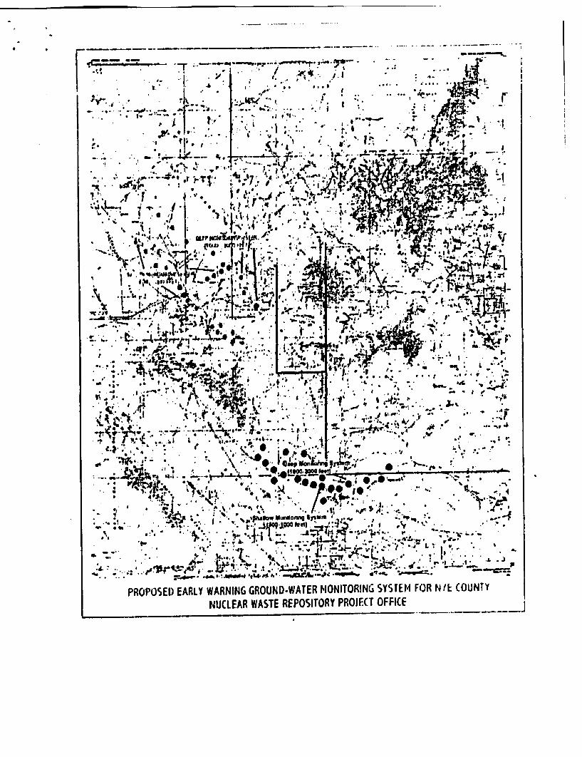
The purpose of the shallow monitoring system is to acquire aquifer parameters of the alluvial andupper tuff aquifers. This series of wells will allow detection of any potentially contaminatedgroundwater that may bypass the deep monitoring system. Narrow contamination plumes couldpotentially bypass the deep monitoring system due to 1) the uncertainty in the dispersivity of thefractured system and 2) the proposed distance between the deep monitoring system wells. Therelative uniformity of the dispersivity of the alluvial aquifer, however, may permit any plume tobypass the deep monitoring system without being detected. If this were to happen, the radioactivitywould be sufficiently dispersed in the alluvial aquifers that it would be detected by the shallowsystem.
The distance between the shallow wells can be designed with more certainty once the hydraulic anddispersive properties of the shallow aquifers are better understood. Because the depth to the watertable varies significantly in the Amargosa Desert, these shallow wells may vary in depth from a fewhundred feet to as much as 1000 feet. These wells will partially penetrate the bedrock if possible.
Phase I of the EWDP will consist of five wells to be drilled in FY98 down gradient of YuccaMountain. The exact location of the wells depends on 1) land accessibility, 2) the potential valueof the information to be obtained, and 3) the potential for maximizing confidence in the system, afterconsultation with YMP technical staff. These wells will be completed with multiport piezometers(preferably Westbay Corporation equipment) so samples and aquifer characteristics of specific zonescan be obtained. By isolating specific aquifer zones, head and water chemistry differences can bedetermined.
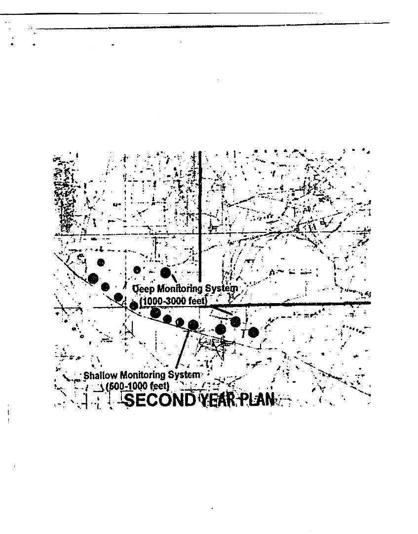
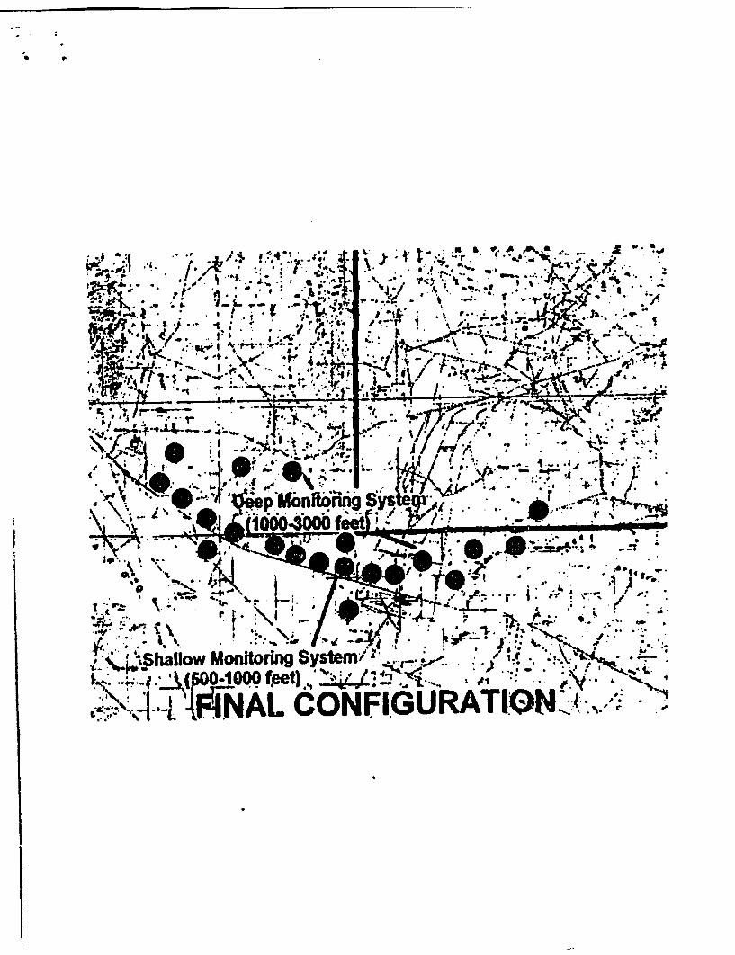
Phase II will consist of five additional wells drilled in FY99. These wells will also be down gradientof Yucca Mountain and will be located after results of FY98 drilling are known. Again, testing willbe performed similar to FY98 testing. The final Phase will be completed in FY2000 with the drillingof five additional holes. These holes will again be located based on results of FY98 and FY99drilling. As is always the case with Nye County data. posting of data sets will be on the Nye Countyweb page, www.nyecounty.com . A map of the proposed locations has been attached to this requestalong with costs of drilling, testing, logging, completions, and program supervision.
DEEP MONITORING WELLS
The purpose for installing deep monitoring wells will be to:* develop a comprehensive database of aquifer parameters in the deep carbonate aquifer down
gradient of Yucca Mountain:* help define the inter-relationships of the deep carbonate aquifer and the upper tuff aquifers down
gradient of Yucca Mountain:* help define the relationship of the carbonate aquifer to the Death Valley and Franklin Lake Playa
discharge sites;* help define flow paths down gradient of Yucca Mountain; and* build the capacity to detect any contaminant plume that might travel vertically from the Yucca
Mountain repository site into the deep volcanic or carbonate aquifer systems.
Two wells will be drilled in the FY98 Phase I program that will penetrate the deep carbonate aquifersystem down gradient of Yucca Mountain. The first well will be drilled near Forty-Mile Wash andthe other at the mouth of Crater Flat. The carbonate aquifer lies at a depth of 2000 to 4000 feet Atleast the upper 200 feet of this aquifer should be penetrated and completed. A multiport Westbaysampling and monitoring system will be installed to help obtain aquifer parameters of the deepsystem.
Once the hydrologic and hyrochemical system in these two wells is understood, additional wells canbe drilled at various depths for monitoring purposes. After the initial wells have been monitored fora period of one year, a second set of wells will be installed based on the information obtained in theinitial wells.
This stepwise drilling program will continue until a high confidence is achieved that the system willdetect any potential migration of radionuclides from the Yucca Mountain site. A map is attachedthat shows the proposed locations of the deep well network along with costs of the three-yearprogram. All drilling will be conducted under the Nye County Quality Assurance plan thus ensuringthat the data can be used in the licensing process.
COSTS
The costs in the attached table are based on information obtained from selected vendors, contractors,and past experience. If funds were approved for this program, official Nye County bid requestswould be obtained for all phases of the program. All samples will be split 50-50 with DOE and itscontractors. Well locations will be finalized based on DOE contractor and Nye/Inyo County input.All drilling will be under the supervision of Nye County with Inyo County providing technical
input. DOE can work with Nye and Inyo in developing the testing and sampling program and maytake samples for their program requirements.
The EWDP is planned as a three-year drilling and testing program with reduced sampling of themonitoring network in the years following. The program is broken into three Phases; Phase I inFY98. Phase II in FY99, and Phase III in FY2C00. The program will consist of drilling and testing
five shallow wells and two deep wells, along with completion of previously drilled oil and gas testwell Felderhoff 25.1 in FY98. The cost of this first Phase is S3.046350 and will be initiated in thefirst quarter 1998. Drilling will commence as soon as all environmental requirements and landaccess issues are resolved. Phase 11 will begin in early FY99 with the drilling of five additionalshallow and two additional deep monitoring wells. The testing program will be basically the sameas FY98 but may be adjusted based on results obtained in the FY98 program. Costs of the FY99program are $3,279,485 based on a 10 percent inflation factor. The FY2000 program will again beadjusted based on input from Nye/Inyo County technical staff and DOE hydrologists. The FY2000program tentatively consists of live additional shallow wells and two more deep wells with a costestimate of $3,607,433. The total estimated cost for the three-year program is just under $ 10 million.The Yucca Mountain data set for the shallow and deep aquifer units will be increased by 15 new
shallow long-term monitoring wells and six new deep carbonate aquifer wells added to an all butnonexistent saturated zone dataset.

[COULD NOT BE CONVERTED TO SEARCHABLE TEXT]
[COULD NOT BE CONVERTED TO SEARCHABLE TEXT]
PROPOSED EARLY WARNING GROUND-WATER MONITORING SYSTEM FOR NYE COUNTYNUCLEAR WASTE REPOSITORY PROJECT OFFICE

[COULD NOT BE CONVERTED TO SEARCHABLE TEXT]
[COULD NOT BE CONVERTED TO SEARCHABLE TEXT]

[COULD NOT BE CONVERTED TO SEARCHABLE TEXT]
[COULD NOT BE CONVERTED TO SEARCHABLE TEXT]