oil and gas plays uintah and ouray reservation...from the utah-colorado border west to the wasatch...
TRANSCRIPT

UINTAH AND OURAY RESERVATION
Introduction
The Uintah and Ouray Indian Reservation is located in the Uinta Ba-sin, in northeast Utah (FIGURES UO-1 and UO-2). The terrain is High Mountain desert in the central part of the basin, which is surrounded by mountain ranges on the edge of the basin. Elevation varies from approximately 5,600 feet to over 11,000 feet above sea level. The area's main transportation conduit is U.S. Highway 40, which leads east to Salt Lake City, Utah, and west to Denver, Colorado. The ba-sin covers approximately 11,500 square miles, and Ute Indian Tribe jurisdiction comprises just over 4 million acres of this area, reaching from the Utah-Colorado border west to the Wasatch Mountain range.
Mineral Ownership
The Uintah and Ouray Indian Reservation is a checkerboard owner-ship reservation containing Ute Indian Tribe, Ute Indian Allotted, Ute Indian Tribe and Ute Distribution Corporation Jointly Managed Indian Trust minerals, along with fee (privately owned) and federal minerals. Indian properties cover approximately 1.2 million surface-owned acres, and 400,000 mineral-owned acres within the 4 million-acre jurisdictional boundary. Ute Indian Allottees, the Ute Indian Tribe, and the Ute Distribution Corporation own both surface and mineral properties in joint management.
Currently, the Ute Tribe, Ute Allottees, and the Ute Distri-bution Corporation in joint management hold 102,000 acres under lease, and more than 490 wells in production. The Utah Oil, Gas, and Mining Board conduct conservation spacing in cooperation with the Ute Tribe. Spacing rules for the Altamont-Bluebell field are set at a multi-well level allowing two wells per section, while undesignated field spacing is 40 acres for oil and 640 acres for gas. Some variations or exceptions exist by special ruling and order (Anderson, 1995).
Figure UO-2. Index map showing the Uintah and Ouray Indian Reservation in yellow (modified after Anonymous, 1995).
0 5 10 20 30
Scale, miles
N
L E G E N D
Oil Field
Gas Field
Reservation Boundary
COUNTY
CARBON
DUCHESNE COUNTY
COUNTY
Price
CARBON COUNTY COUNTY
MERY
PETERS POINT
COUNTY
UTAH
WASATCH
NUTTER CANYON
CHOKECHERRY CANYON
INDIAN RIDGE
FLAT ROCK
UINTAH COUNTY
COUNTYGRAND
MOON RIDGE
SEGUNDO CANYON
GR
EE
N
UINTAH
DUCHESNE
BLUE BENCH
FLAT MESA
WEST PLEASANT VALLEY
RIVER
PARIETTE BENCH
CASTLE PEAK
REFUGE
RANDLETT GYPSUM
HILLS
Fort Duchesne
Duchesne
MONUMENT BUTTE
WEST GUSHER
EAST GUSHER
Vernal
BITTER CREEK
SOUTH OURAY
UTE TRAIL
CHAPITA WELLS
Ouray
WONSITS VALLEY
BRENNER BOTTOM
HORSE SHOE BEND
BLUEBELL
ROOSEVELT
COTTONWOOD WASH
STARR FLATS
ALTAMONT TREND
CEDAR RIM
CEDAR STARVATION
ALTAMONT
DAGGET
UINTAH
DUCHESNE
COUNTY
COUNTYCOUNTY
COUNTY
COUNTY
SUM
MIT
WASATCH
RED WASH
112O 111O 110O 109OO
40O
39O
0 50Miles
108O 107O
41O WYOMING
RA
NG
E MOUNTAINS UINTA
AH
UT
TCH
AS
A CO
LOR
AD
O
W UINTA BASIN
U D
OU
GLA
SC
RE
EK
AR
CH
TCH
TEA
AS
AW P
LA
BO
OK
CLIFFS PIC
EA
NC
E C
RE
EK
AS
IN
AEL
UNCOMP
B
SAN R
AFSW
ELL UPLIFT
AHGRE
0 80Kilometers
Figure UO-1. Location of Uinta Basin and surrounding structural and physiographic features. Yellow area shows approximate boundary of Uintah and Ouray Indian Reservation (modified after Cashion, 1992).
UINTAH AND OURAY INDIAN RESERVATION UTAH
Overview 1

Uintah and Ouray Reservation no
Petroleum Exploration and Development salClimeThe Uinta Basin is a rich source of many energy-producing minerals. araThe greatest portion of the energy resources is hydrocarbons in the lasform of coal, oil, gas, oil shale, and bituminous sandstone and lime-UOstone.
Resources contained within the Uintah and Ouray Reservation 35 include conventional and unconventional hydrocarbon deposits of oil grand gas, oil shale, and tar sands in major quantity; coal, uranium, sil-
ver, copper, gold, gypsum, and phosphate are also present in minor to mid-economic quantities.
Cretaceous and older rocks contain many productive oil and gas zones. However, the major portion of the energy production from the Uinta Basin is from Tertiary rocks, and the distribution of the hydro-carbons and minerals is directly related to their depositional environ-ment.
Uinta Basin production of oil and gas began in the late 1940's, with major development commencing in the late 1960's and expand-ing in the late 1970's and early 1980's. Over 300 million barrels of oil (MMBO) have been produced from the Greater Altamont-Blue-bell field alone. Conventional oil and gas deposits have been exten-sively explored and developed. The Green River and Wasatch For-mations contain the bulk of the producing zones, with depth to these zones ranging from 6,000 to 18,000 feet. This has resulted in the de-velopment of the Greater Altamont-Bluebell oil field, and numerous undesignated smaller fields (FIGURES UO-2, UO-6).
The oil produced is high in paraffin content (pour point = 120 de-grees F), making it an excellent gasoline refining feedstock. It is ex-tremely rich with associated natural gas, with values falling between 900 and 1700 British thermal units (Btu). Only one natural gas field has been developed, and it is located east and south of the Green and White Rivers. It is bordered by the Natural Buttes Gas Field Unit, which covers 76,000 acres.
Total Ute Indian oil production approximates 1,250 barrels per day, a level that has held for the last 10 years. New well development and workover activity has been sufficient to offset the normal decline of the many oil and gas fields within the basin and the reservation area (Anderson, 1995).
Geology of the Uinta Basin
The Uinta Basin is a major sedimentary basin in the western-central Rocky Mountain province. It is bounded by the Uinta Mountain Up-lift on the north and by the Wasatch Mountain Uplift and the eastern faulted margin of the Wasatch Plateau on the west. On the southwest and south, the San Rafael Swell and the Uncompahgre Uplift border the basin (FIGURES UO-2 and UO-3). The southern basin edge is gen-erally considered to be the Book and Roan Cliffs, escarpments of Up-per Cretaceous and Lower Tertiary formations which dip northwest,
rth, and northeast into the basin. The northwest-southeast trending t folds of the northern Paradox Basin plunge beneath the Book ffs in the southernmost part of the basin, and the two downwarps rge imperceptibly in this area. On the east, the Uinta Basin is sep-ted from the Piceance Basin of northwest Colorado by the Doug- Creek Arch, which parallels the Utah-Colorado border (FIGURE
-3). The basin is quite asymmetric. Beds on the north flank dip 10 to
degrees south, whereas beds on the south flank dip only 4 to 6 de-ees north (Chidsey, 1993). The north flank is highly complex, with
major faulting, steep to overturned beds, and multiple unconformi-ties that allow youngest Eocene rocks to lie unconformably on top of Precambrian rocks. The basin axis is close to the mountain flank and moves northward with depth.
The Uinta Basin formed in Late Cretaceous and Paleocene time when, in response to rapid uplift and formation of the Uinta Moun-tains, the dominant north-south tectonic and sedimentation patterns of Cretaceous time shifted to west-east. The Uintas impose a domi-nant west-east trend through most of the basin; however, structures in the southeast portion have a strong northwest grain, reflecting the older buried Uncompahgre and Paradox trends.
Figure UO-3. Location and structural element map of the Uinta and PiceanceBasin Provinces (modified after Gautier et al., 1995).
EXPLANATION
Upper Cretaceous rocks present
Thrust fault
0
0 25 50
25 50 MILES
KILOMETERS
SAN
RA
FAEL
SWEL
LGreen River
38o
40o
UT WY CO SANDWASH
BASIN
AXIAL
UPLIFT
Vernal
Rangely
Glenwood Springs
Grand Junction
CLIFFSBOOK
UINTA
BASIN
BOOK CLIFFS
PICEANCE CREEK
BASIN
GUNNISON UPLIFT
WHITE RIVER
UPLIFT
UNCOMPAHGRE UPLIFT
SAWATC
H R
AN
GE
EAGLE BASIN
DO
UG
LA
SC
RE
EK
AR
CH
Craig
UPPER CRETACEOUS
ABSENT BY EROSION
UINTA MTNS. UPLIFT
Price
PROVINCE BOUNDARY
o110 o
108 o106
Upper Cretaceous rocks absent
UT CO
UINTAH AND OURAY INDIAN RESERVATION UTAH
Geology 2

The Uinta Basin is filled with 30,000 to 32,000 feet of sediment in its northern and deepest portion (Figs. UO-4 and UO-5). Although the majority of the rocks exposed on the reservation are of Tertiary age, some pre-Tertiary age rocks are exposed on the northern and northwestern boundaries. Percentages of basin strata are subdivided as follows:
Tertiary (Eocene - Paleocene) - 55% Upper Cretaceous - 25% Triassic - Lower Cretaceous - 10% Paleozoic - 10%
YT
IAR
TE
RC
RE
TAC
EO
US
JUR
AS
SIC
TR
IAS
SIC
PE
RM
.P
EN
N.
MIS
S.
DE
V.
SIL. ORD.
CA
MB
.p
C
UINTA BASIN DOUGLAS CREEK PICEANCE BASIN AXIAL UPLIFTARCH
Browns Park Fm.
UTAH COLORADO
Duchesne River Fm. Uinta Fm. Green River Formation
Colton Fm. Wasatch Fm.
Wasatch Flagstaff Limestone Fort Union FormationsNorth Horn Lance Formation Formation
Lewis Shale Price Mesaverde Gp.
River Fm. Sego Sandstone
Castlegate Sandstone Blackhawk Fm.
Mancos "B"
Mancos Shale
Emery Sandstone
Ferron Sandstone Frontier Formation Tununk Shale
Mowry Shale
Dakota Sandstone
Cedar Mountain Formation
Morrison Formation
Stump Formation Curtis Formation
Preuss Formation Entrada Sandstone
Twin Creek–Carmel Formation
Navajo Sandstone Chinle Formation Gartra Member
Ankareh Fm. Shinarump Conglomerate
Thaynes Limestone Moenkopi Formation State Woodside Shale Bridge
Park City Fm. (Phosphoria) Cutler Formation Fm.
Upper Weber Sandstone Upper Weber Sandstone
Lower Weber Sandstone Lower Weber Sandstone
Minturn
MaroonMorgan Formation Morgan Formation Formation
Formation
Round Valley Limestone Belden Shale Manning Canyon Shale
Humbug Fm. — Doughnut Sh.
Deseret Limestone Madison Formation Leadville Limestone Madison Formation
Pinyon Peak Fm. Chaffee Fm.
Manitou Fm.
Ophir Shale Dotsero Fm.
Lodore Sandstone Sawatch Sandstone
Precambrian
S
S
Conglom
erate
Currant C
reek
S
S S
S S
S
S S S
Significant oil production
Significant gas production
S Source rocksS S
S
S
S S
S ?
Figure UO-5. Diagram showing general correlation of rock units from the Uinta Basin, Utah, to the Axial Uplift, Colorado, and significant producing and source horizons (modified after Spencer and Wilson, 1988)
THICKNESS (ft.) GEOLOGIC GROUP AND CHARACTER OF BEDS TIME FORMATION EAST WEST
Quaternary Alluvium Alluvium, gravel surfaces, talus deposits, and other windblown deposits
Pleistocene Glacial Deposits Glacial drift, alluvium, and terrace deposits 0-70 0-70
Miocene Bishop Conglomerate Conglomerate, boulders 1 to 6 feet in diameter, 0-500 0-500 sand and gravel
y Oligocene Duchesne River Formation Varicolored shale, sandstone, and conglomerate 1370 1500
tiar
Eocene Uinta Formation Shale with sandstone interbeds 700-1650 1800-5400
er T Green River Formation Green to white shale, sandstone, oil shale in 1800-2400 0-5000 middle of formation
Wasatch Formation Varicolored sandstone, shale, limestone 0-5000
Paleocene deposits absent due to unconformity
Cretaceous Currant Creek Formation Conglomerate, sandstone, and varicolored shale 0-4800
North Horn Formation Varicolored shale with sandstone interbeds 0-400 0-200
Upper Mesaverde Group Upper section - Brackish-water sandstone, sandy 0-3000 1000-2200 Cretaceous shale, carbonaceous shale, and coal
Lower section - Marine sandstone 0-500 300-1000
Mancos Shale (including Black marine shale, thick massive sandstone, 5000-6000 800-3500 Frontier Sandstone Member) shaly sandstone
Dakota Sandstone Cross-bedded tan sandstone 30-50 30-50
Jurassic Morrison Formation Varicolored shale with sandstone interbeds 780-800 780-800
Triassic Chinle Formation Shale with minor sandstone and conglomerate 230 300-380
Moenkopi Formation Shale, sandstone, siltstone, and limestone 2300 800
Permian Park City Formation Argillaceous, sandy limestone 80-500 80-500
Pennsylvanian Weber Sandstone Massive sandstone 1000-1500 1000-1500
Morgan Formation Varicolored shale and limestone with sandstone 300-800 300-800
Mississippian Manning Canyon Shale
Upp
er Humbug Formation
Great Blue Formation Interbedded shale, limestone, and sandstone 0-900 0-900 Molas Formation Doughnut Formation
Redwall Formation
er
Leadville Formation w Massive dolomite and limestone 0-1100 0-1100
Lo Deseret Formation Madison Formation
Devonian Sandstone, shale, carbonate 1000 2000
No identifiable Silurian or Ordovician deposits
Cambrian Tintic Quartzite or Sandstone, shale, and carbonate 0-2000 0-2000 Lodore Formation
Precambrian Uinta Mountain Group Quartzite with shale and conglomerate 12,000-20,000
Uncompahgre Suite Schist, gneiss, and granite
Figure UO-4. General stratigraphic column of the Uinta Basin (modified after Anonymous, 1995).
UINTAH AND OURAY INDIAN RESERVATION UTAH
Geology Overview 3

�During Eocene time (38-50 million years ago) lar ge amounts of sediment from adjacent higher areas were deposited in lacustrine and fluvial environments in the basin. These sediments, assigned to the Wasatch, Green River, and Uinta Formations, are perhaps more than 15,000 feet thick in the center of the basin, and contain important mineral resources (FIGURE UO-6). �Much of the area no w occupied by the Uinta Basin was covered by a large lake during Eocene time. Lacustrine marlstone, oil shale, limestone, siltstone, and sandstone of the Green River Formation were deposited in the lake. During the lake's expansionary periods, fluvial sediments were deposited which are now beneath and periph eral to the lacustrine sediments. These fluvial deposits form the shale, sandstone, and conglomerate of the Wasatch Formation. As the lake receded, fluvial sediments were deposited on its periphery, and eventually covered the entire area formerly occupied by the lake. These deposits comprise the Uinta Formation (Anderson,1995).�
Uinta Formation The Late Eocene Uinta Formation consists of fluvial deposits that overlie the Green River Formation from the last phase of Lake Uinta. Later, the lake filled up with volcaniclastic material, followed by abundant bedded evaporites. Depths to the top of the formation range from 2,566 feet to 3,678 feet, with the average being 3,554 feet. �Most of the production is from the Lo wer Uinta, which is a tran sitional unit between the Green River Formation and the fluvial Up per Uinta. The Lower Uinta is 350 to 450 feet thick in the Horse shoe Bend field, a reservoir that has produced over 15 BCF of non-associated gas and 5,000 barrels of condensate. This is the only res ervoir that has produced at least 5 BCFG from the Uinta Formation, although minor production exists elsewhere in the basin (FIGURES
UO-6 and UO-7). �The primary dri ve mechanism is gas expansion and gravity, and
the trap is an updip stratigraphic pinch-out. The average monthly gas production has been increasing since 1981 due to development drilling and new wells that were drilled in the ear ly to mid-1980s. �The Uinta F ormation is rarely a primary drilling target, but it is a shal low, low cost target with potential for new discoveries (Morgan, 1993a).
�Green River Formation � The Eocene-Paleocene Green River Formation is 2,000 to over 8,000 feet thick. It accumulated in and around ancestral Lake Flagstaff and Lake Uinta, along with the alluvial-fluvial deposits of the Wasatch Formation. The Green River Formation was de posited as thick, regionally extensive stratigraphic sequences in marginal and open lacustrine environments. Depths to the top of the formation range from 2,315 to 7,456 feet, and most wells produce from zones 3-4,000 feet below the top. �The majority of the producing zones are channel sandstones about 10 to 30 feet thick, but some reservoirs produce from carbonate grainstones 10 to 20 feet in thickness (FIGURE UO-
8). The porosity and permeability of these zones can be either reduced or enhanced by diagenetic effects. The
average porosity of Green River reservoirs ranges from 5 to 20 per cent, and the permeability ranges from 0.1 to 42 millidarcies (mD). �The source rocks for oil and associated g as found in the Green River Formation are interbedded organic-rich carbonate mudstones located at depths of 8,500 to 12,500 feet in the north-central part of the basin. Hydrocarbons, which were generated in deep overpres sured zones, migrated laterally along fracture systems to shallow reservoirs located on the south and east flanks of the basin. �There are more than 60 kno wn reservoirs producing from the Green River Formation, 9 of which have each produced more than 5 BCFG (FIGURE UO-6). The Roosevelt reservoir was the first to pro duce gas from this formation in 1949. Monthly production peaked in the mid-1970s, and decreased to a low in 1982. It has been increas ing since then due to in-fill drilling programs in several reservoirs (Chidsey, 1993b). �
Figure UO-6. The Uinta Basin with the maximum extent of play areas based on production and hy drocarbon shows. Reservoirs are labeled: 1, Uinta Formation; 2, Green River Formation; and 3, Wa satch Formation. Note outline for Federal Energy Regulatory Commission (FERC) tight formation designated area (Wasatch/Mesaverde) in the east part of the basin. Hachured line indicates approx imate limits of Tertiary units in the Uinta Basin (modified after Chidsey, 1993a).
N
UINTA MOUNTAINS
WYOMING UTAH
UINTA
BASIN
UTAH COLORADO
0
0
10
10 20 30 40 20 30mi
50km
FERC Tight formation designated area
Rock House
3
Natural Buttes
2,3
Powder Springs
2 Walker Hollow
2 Horseshoe
Bend 1
Wonsits Valley
2
Vernal
Monument Butte
2
Bluebell 2,3
Cedar Rim 2,3
2,3 Altamont
Maximum extent of Uinta Basin plays
CO
LOR
AD
O
Rangeley Duchesne
Producing gas well
Abandoned gas well
0
0
1
1
2 3
2 3mi
4km
Horseshoe Bend Field boundary
Federal no. 3
1600
D
U
1400
1800
2000
2200
R21E R22E
T 6 S
T 7 S
6 1 6
31 31
6
31 36 31
Figure UO-7. Structure contour map of the Horseshoe Bend area. Datum is the top of Unit A, Uinta Formation with a contour interval of 200 ft. Only wells that have produced from the Uinta Formation are shown (modified after Morgan, 1993a).
UINTAH AND OURAY INDIAN RESERVATION UTAH
Producing F ormations 4
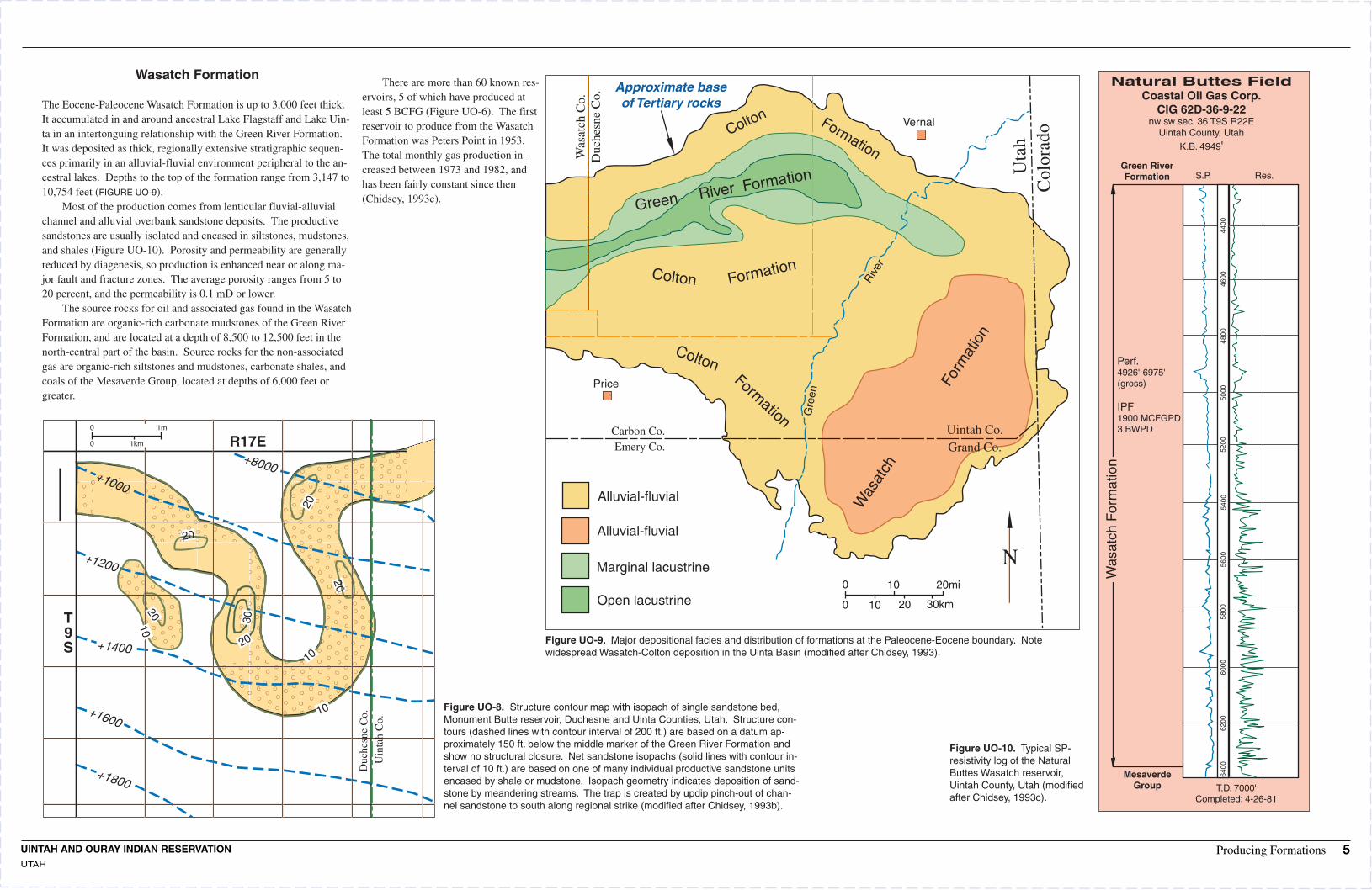
Wasatch Formation
The Eocene-Paleocene Wasatch Formation is up to 3,000 feet thick. It accumulated in and around ancestral Lake Flagstaff and Lake Uin-ta in an intertonguing relationship with the Green River Formation. It was deposited as thick, regionally extensive stratigraphic sequen-ces primarily in an alluvial-fluvial environment peripheral to the an-cestral lakes. Depths to the top of the formation range from 3,147 to 10,754 feet (FIGURE UO-9).
Most of the production comes from lenticular fluvial-alluvial channel and alluvial overbank sandstone deposits. The productive sandstones are usually isolated and encased in siltstones, mudstones, and shales (Figure UO-10). Porosity and permeability are generally reduced by diagenesis, so production is enhanced near or along ma-jor fault and fracture zones. The average porosity ranges from 5 to 20 percent, and the permeability is 0.1 mD or lower.
The source rocks for oil and associated gas found in the Wasatch Formation are organic-rich carbonate mudstones of the Green River Formation, and are located at a depth of 8,500 to 12,500 feet in the north-central part of the basin. Source rocks for the non-associated gas are organic-rich siltstones and mudstones, carbonate shales, and coals of the Mesaverde Group, located at depths of 6,000 feet or greater.
There are more than 60 known res-ervoirs, 5 of which have produced at least 5 BCFG (Figure UO-6). The first reservoir to produce from the Wasatch Formation was Peters Point in 1953. The total monthly gas production in-creased between 1973 and 1982, and has been fairly constant since then (Chidsey, 1993c).
asat
ch C
o.
Vernal
W Duc
hesn
e C
o.
er
Riv
Gre
en
Carbon Co. Uintah Co. Emery Co. Grand Co.
Alluvial-fluvial
Alluvial-fluvial
Marginal lacustrine N 0 10 20mi
Open lacustrine 0 10 20 30km
Approximate base of Tertiary rocks
Price
Colton Formation
Uta
h
er Formation Riv C
olor
ado
Green
Colton Formation
Colton orm
atio
n
For F
mation
Was
atch
Figure UO-9. Major depositional facies and distribution of formations at the Paleocene-Eocene boundary. Note widespread Wasatch-Colton deposition in the Uinta Basin (modified after Chidsey, 1993).
GrMes
Natural Buttes Field Coastal Oil Gas Corp.
CIG 62D-36-9-22 nw sw sec. 36 T9S R22E
Uintah County, Utah
K.B. 4949'
Green River Formation S.P. Res.
oup T.D. 7000' Completed: 4-26-81
Was
atch
For
mat
ion
5200
6400
6200
6000
5800
5600
5400
5000
4800
4600
4400
averde
Perf. 4926'-6975' (gross)
IPF 1900 MCFGPD 3 BWPD
Figure UO-10. Typical SP-resistivity log of the Natural Buttes Wasatch reservoir, Uintah County, Utah (modified after Chidsey, 1993c).
N
T 9 S
R17E
+1000
+1200
+1400
+1600
+1800
+8000
0
0 1km
1mi
20
20
10
10
20
30
20
20 10
Duc
hesn
e C
o.U
inta
h C
o.
Figure UO-8. Structure contour map with isopach of single sandstone bed, Monument Butte reservoir, Duchesne and Uinta Counties, Utah. Structure con-tours (dashed lines with contour interval of 200 ft.) are based on a datum ap-proximately 150 ft. below the middle marker of the Green River Formation and show no structural closure. Net sandstone isopachs (solid lines with contour in-terval of 10 ft.) are based on one of many individual productive sandstone units encased by shale or mudstone. Isopach geometry indicates deposition of sand-stone by meandering streams. The trap is created by updip pinch-out of chan-nel sandstone to south along regional strike (modified after Chidsey, 1993b).
UINTAH AND OURAY INDIAN RESERVATION UTAH
Producing Formations 5

Mesaverde Group
Gas from Mesaverde Group reservoirs is found in both structural and stratigraphic traps. Some reservoirs, like those in Natural Buttes Field, are part of larger, basin-centered gas traps where the gas collects downdip from more permeable water-filled reservoirs. Average depth to the top of productive reservoirs ranges from 1300 to >8500 feet.
The terminology of the Mesaverde Group is complex, due to fa-cies changes that occurred as the Cretaceous Interior Sea trans-gressed and regressed along its western margin in the Piceance-Uin-ta Basin area. The Mesaverde consists of three dominant reservoir facies: lenticular, fluvial sandstones of the Williams Fork Forma-tion, coals that occur in the basal portion of the Williams Fork For-mation, and extensive shoreline-marine sandstones of the Iles For-mation.
The fluvial sandstones of the Williams Fork Formation are ap-proximately 4000 feet thick in the eastern part of the Piceance Ba-sin, thinning to <2000 feet on the Douglas Creek Arch and 2200-2900 feet in Natural Buttes Field in the Uinta Basin. These sand-stones are lithic arkoses and feldspathic arenites containing authi-genic quartz and carbonate cement. They have low porosities, rang-ing from 7-12%, and low matrix permeabilities (<0.1 mD) due to the abundance of authigenic clays.
The shoreline-marine sandstones of the lower Mesaverde Iles Formation were deposited during transgressive and regressive cycles along northeast-southwest trending shorelines. These sandstones merge with fluvial facies to the northwest and the Mancos Shale to the southeast. The most productive members are the Cozzette, Cor-coran, and Castlegate Sandstones.
The Castlegate Sandstone is a clean, fine-grained, subarkose to sublitharenite, with low porosity and permeability due to pore-filling authigenic clays. It was deposited along ancient shorelines or as offshore bars. In the southeastern part of the Uinta Basin, 50-70 feet thick Castlegate sandstones produce from structural traps at depths of 8000 feet. Permeabilities range from 0.5-0.9 mD. All fields that produce from the Castlegate involve some type of structural closure, and several close against faults. Production rates are enhanced by the associated tectonic fractures.
Source rocks for gas produced from the fluvial sandstones at Natural Buttes Field are coals and carbonaceous shales. The source for the shoreline-marine sandstones is probably the Mancos Shale. Porosities of the Mesaverde Group sandstones remain unusually sta-ble over a large vitrinite reflectance interval (FIGURES UO-11 and UO-
12), implying that sparsely explored deep central basins may hold some promise (Tremain, 1993).
Figure UO-11. Plot of core-plug porosity vs. reflectance for 25th
and 75th porosity percentiles (joined by vertical lines) of nonmarine sandstone intervals of the Mesaverde Group, Uinta and Piceance Creek Basins. Mesaverde data are compared with type curve and to 10th and 90th porosity percentiles representing sandstones in general. Note that the porosity does not decrease within the win-dow of hydrocarbon generation (Ro of 0.070-1.8%) (modified after Nuccio et al., 1992).
30
25
20
15
10 9
8
25th to 75th PERCENTILES
10th percentile
Type curve
90th percentile
PO
RO
SIT
Y, I
N P
ER
CE
NT
7
6
5
4
3
2
1 0.4 0.5 0.6 0.7 0.8 0.9 1.0 1.5 2.0 2.5
VITRINITE REFECTANCE, IN PERCENT
3.0
Figures UO-12A and 12B. Map showing the region (pink area) between Ro 0.70 and 1.8%, where porosity of sandstones at the base of the Mesaverde Group does not decrease as a function of increasing Ro. This region defines the area of optimum gas recovery for A, Upper Mesaverde; B, Lower Mesa-verde (modified after Nuccio et al., 1992).
o o o o o o o o o o o o o o o o o o111 00' 110 45' 110 30' 110 15' 110 00' 109 45' 109 30' 109 15' 109 00' 111 00' 110 45' 110 30' 110 15' 110 00' 109 45' 109 30' 109 15' 109 00'
A B
Price
Duchesne
Altamont
Vernal
Jensen
Gre
en R
iver
MILES0
0
10 20 30
10 20 30 KILOMETERS
1.50
1.10
0.75
0.65
UT
AH
CO
LO
RA
DO
Price
Duchesne
Altamont
Vernal
Jensen
Gre
en R
iver
MILES0
0
10 20 30
10 20 30 KILOMETERS
UT
AH
CO
LO
RA
DO
2.00
1.10
0.75
0.60
0.50
o40 30'o40 30'
oo 40 15'40 15'
oo 40 00'40 00'
o39 45'o39 45'
o39 30'39 30'o
o39 15'o39 15'
UINTAH AND OURAY INDIAN RESERVATION UTAH
Producing Formations 6

3000
Man
cos
Sha
le
4000
3000
4000
1000
2000
1000
2000
1000
2000
1000
2000
1000
2000
Mancos Shale
As of December 1990, almost 359.5 BCF of natural gas have been produced from Upper Cretaceous Mancos Shale reservoirs (FIGURE
UO-13). Most of the production comes from the silty, tight gas sand-stone reservoirs of the Mancos B (also called the Emery Sandstone) in the middle of the Mancos Shale. Gas is also produced from the Mancos A/Morapos Sandstone, a conventional, clean sandstone found in the upper transition zone between the Mancos Shale and the overlying Mesaverde Group (FIGURE UO-14).
The Douglas Creek North Field has produced >5 BCFG from the Upper Mancos/Morapos Sandstone (figure 13). In this area, the Up-per Mancos consists of up to 34 feet of mud to coarse-grained, well-sorted sandstone with 20% porosity and 100 mD permeability. It was deposited as shelf sands in a marginal-marine setting, and is probably time-equivalent to the Castlegate Sandstone.
The Mancos B consists of 500 to >1000 feet of finely interbed-ded and discontinuous claystone, siltstone, and very fine- to fine-grained sandstone, with an average net pay interval of 30-250 feet. It is characterized by low porosities and permeabilities, with porosities ranging from 10-11% on the Douglas Creek Arch, to <2% on the flanks. Permeabilities are <0.1 mD on the average. Mancos B sedi-ments were deposited on a northerly prograding submarine slope or foreslope, approximately 100 miles to the east of the time-equivalent Emery shoreline in Utah (Noe, 1993a).
0
0 20,000
6,000
40,000 ft
12,000 m
Vertical exaggeration 50:1
Douglas Creek fault
Datum 3000 ft above sea level
00
100
500
200 750
300 1000
m ft
Argo Unit 2-20
sec 20, T5S, R102W
Cities Service USA 1
sec 7, T4S, R102W
Nat. Assoc. Pet Govt. 1
sec 6 T3S, R102W Superior
Unit 3 sec 1 T3S, R102W
Texas Douglas Cr. 1
sec 9 T2S,R101W
Phillips Unit B-1
sec 18, T1S, R101W
G. E. Kadane Moran 1
sec 2, T1N, R101W
Mesaverde Group
Anchor Tongue
Mancos A
Mancos B(Emery)
Mancos B
(Morapos)
L. SegoU. Sego
Mancos A
U. Sego
L. Sego
Buck Tongue
(Morapos)
Silt Marker
S.P. R
S.P. RS.P. R
S.P. RS.P. RS.P. RSP RS.P. R
5000
5000
S N
Figure UO-14. South to north structural cross section along the Douglas Creek Arch of the Mancos B interval and other sandstones in the transitional zone between the Mancos Shale and Mesaverde Group (modified after Noe, 1993a).
Utah Colorado
Gas fields <5BCF >5BCF
FERC tight sand areas
Approximate line of section
Mancos Marine Sandstone play
Grand Junction
0
0
10 20 30mi
50km40302010
Rangeley Douglas Cr. N.
Philadelphia Cr.
Cathedral
Douglas Cr. W.
Dragon Trail
Lower Horse Draw
UIN
TA
BA
SIN
UNCOMPAHGRE UPLIFT
PARADOX BASIN Mesa
Delta
DO
UG
LA
S C
RE
EK
AR
CH
CO
LO
RA
DO
UTA
H
PICEANCE BASIN
C
AB
C'
A'B
'
Douglas Cr.
Figure UO-13. Gas fields of the Upper Cretaceous Mancos Shale (modified after Noe, 1993a)
UINTAH AND OURAY INDIAN RESERVATION UTAH
Producing Formations 7

Dakota Sandstone, Cedar Mountain Formation, Morrison Formation
The Dakota Sandstone, Cedar Mountain Formation, and Morrison Formation are similar in lithologic succession. Each contains a bas-al, continuous, conglomeratic sandstone or conglomerate, like the Salt Wash Member of the Morrison Formation, the Buckhorn Con-glomerate of the Cedar Mountain Formation, and the lower part of the Dakota Sandstone. This is overlain by interbedded shales and lenticular sandstones, like the Brushy Basin Member of the Morrison and the upper units of the Cedar Mountain and Dakota (Figure UO-15). The basal conglomeratic units are braided stream deposits, while the upper units of the Morrison and Cedar Mountain Forma-tions are thought to be floodplain and meandering stream deposits. The Upper Dakota was deposited in a complex coastal setting con-
ALLUVIAL
VALLEY
COASTAL
PLAIN
FORSHORE
SHOREFACE
Fiof en(m
gure UO-16. Three dimensional model Dakota Sandstone depositional vironments at Hell's Hole Field odified after Moretti et al., 1992).
Distributary Channel
Braided Stream
Coastal Plain with Marshes
Cross Bedding
Beach Ridges
Foreshore Sand
Shoreface Slope and Sand 50
Highlands 25
FE
ET
M I L E S 0
0 1 2 3Marine Shale
TYPE LOG S a n A r r o y o F i e l d
D A K O TA S I LT
D A K O TA
S A N D S T O N E
48
00
C E D A R M O U N TA I N
F O R M AT I O N
B u c k h o r n M e m b e r
B r u s h y B a s i n M O R R I S O N M e m b e r
F O R M AT I O N
50
00
S a l t W a s h M e m b e r
52
00
54
00
E N T R A D A S A N D S T O N E
Figure UO-15. Type log from the San Arroyo Field (modified after Hill and Bereskin, 1993).
sisting of coastal plain, fluvial, swamp, marsh, tidal flat, delta, beach, rand nearshore marine environments (Fig. UO-16).
The Morrison Formation is approximately 350-450 feet thick, the Cedar Mountain Formation is approximately 0-150 feet thick, and the Dakota Sandstone is approximately 40-250 feet thick (Noe, 1993b).
Entrada Sandstone
In northeastern Utah, the Entrada Sandstone consists of dune and in-terdune eolian deposits associated with the northerly retreat of a Ju-rassic sea. The sandstones are gray to orange, fine- to medium-grained, well-sorted and cross-bedded.
Gas and some oil are produced from traps formed by anticlinal closures on Laramide structures. Three Entrada reservoirs have pro-duced >44 BCF gas; most of this production comes from San Arroyo Field (FIGURE UO-17). Average depth to the top of the reservoir var-ies from 5250 feet at San Arroyo to 6700 feet at Wilson Creek Field in Colorado. Average net pay thickness in the Uinta Basin is 118 feet at Westwater Field. Average porosity ranges from 16% at San Ar-
oyo to 24% at Westwater. Source rocks for San Arroyo and
Westwater Fields may have been or-ganic-rich marine deposits of the Per-mian Phosphoria and Pennsylvanian Paradox Formations (Morgan, 1993b). 1000
500
2000 2500
1500
1000
500
-500
500
-500
R 24 E R 25 E R 26 E
U D
U U D
D
T 16
0 1 2 3 4 mi San Arroyo
0 1 2 3 4 5 6 km S
0
R 23 E
Bar X 0
D U D
D T500 UU 17Westwater
S
Figure UO-17. Structure contour map of the top of the Entrada Sandstone, San Arroyo/Westwater area, Grand County, Utah. The area that is productive from the Entrada Sandstone is colored in pink. The Bar X Field has produced less than 5 BCF of gas from theEntrada Sandstone. Contour interval is 500 feet (modified after Morgan, 1993b).
UINTAH AND OURAY INDIAN RESERVATION UTAH
Producing Formations 8

Weber Sandstone
The Weber Sandstone is a fine-grained, subarkosic to quartz arenite of eolian origin deposited during Desmoinesian, Missourian, and Wolfcampian time. In Rangely Field, productive eolian sands were deposited in dune, interdune, and extradune environments (FIGURE
UO-19). These sandstones are either cross-laminated or massively-bedded, the cross-laminated lithofacies being the major producer with an average porosity of 12%. Permeability along laminae averages 2 mD, while permeability across laminae averages 0.4 mD.
Cumulative production from the Weber Sandstone as of 1990 is
724.7 BCF of associated gas and 772 MMBO. The Rangely Weber reservoir contributed 98.9% of the total gas production (FIGURE UO-
18). Average depth to the top of the Weber is 6500 feet, and the trap-ping mechanism in all Weber reservoirs is anticlinal closure (Hem-borg, 1993).
GREEN RIVER BASIN111o 110o 109o 108o
Henry's Fork fault o WY WYOMING41 OMING
UTAH Ui t COLORADO ult n MOFFt la fau AT ROUTT
fank
orth FlaN
SAND WASH BASIN
ary fault Split Mtd n unWASA bo anticlinTCH
es n Vernal
asi Danforth B Yampa fault Hills Craig
ta Elk inU Wolf C Springsreek fault Moffat
Skull Cr. anticline MaudlinAshley Valley Winter Thornburg GulchValley Willow CreekWonsits faAltamont - Bluebell ult N Valley Rangely
Red Wash
UINTA40o
AH
UT
CO
LO
RA
DO
White RiverBASIN
h c
AH
Dou
glas
uplift
Cre
ek A
r PICEANCE DUCHESNE UINT BASIN
RIO BLANCO>5BCF Weber associated gas fields
<5BCF Weber associated gas fields
Grand hogbacUncompahgre
k
Major oil and gas fields without Weber production
Precambrian outcrop uplift Glenwood
Springs Weber Sandstone play GARFIELD
MESA 0 10 20 30 40 50 mi UTAH COLO 0 10 40 60 80 km
Figure UO-18. Location map of Rangely Field and other major and minor Weber Sandstone reservoirs (modified after Hemborg, 1993).
Gamma ray Depth Density porosity (API units) Sedimentary Depth(ft) 30 (%)0 150 10 structure (ft)
5600Fluvial
Dune Ext
raD
un
e
Extra
Dune
Du
ne
- 5800 Extra
5700 Dune
Fluvial Dune D
un
e
Extra
Dune
Ext
raD
un
e
Extra- 5820
5800
5900
- 5840 Extra x
Dune
Dune
Dune
Du
ne
Co
mp
le
6000
Fluvial Extra
- 5860 Fluvial
Extra
Fluvial
6100
Extra
Fluvial
Ext
raD
un
e - 5880
Extra6200
Fluvial
Dune
Fluvial
Extra Flu
vial
- 5900
6300Fluvial
Extra= Extradune
Horizontal Cross- Convolute Burrows Root castslamination lamination lamination
Figure UO-19. Wireline log and core description of the No. 139Y UPRR, Rangely Field. Core shows one cycle of Weber deposition (modified after Hemborg, 1993)
UINTAH AND OURAY INDIAN RESERVATION UTAH
Producing Formations 9

Play Summary The United States Geological Survey identifies several petroleum plays in the Uinta-Piceance Basin Province and classifies them as Conventional and Unconventional (Gautier et al., 1995). The discussions that follow are limited to those with direct significance for future petroleum development in the Uintah and Ouray Indian Reservation (TABLE 1).
Play Ty esConventional Plays- Discr t d posits, usually bound d by a downdip wat r contact, from which oil, gas or NGL can b x-
tract d using traditional d v lopm nt practic s, including production at th surfac from a w ll as a cons qu nc of natural
pr ssur within th subsurfac r s rvoir, artificial lifting of oil from th r s rvoir to th surfac wh r applicabl , and th main-
t nanc of r s rvoir pr ssur by m ans of wat r or gas inj ction.
Unconventional Plays- A broad class of hydrocarbon d posits of a typ (such as gas in tight sandston s, gas shal s, and
coal-b d gas) that historically has not b n produc d using traditional d v lopm nt practic s. Such accumulations includ
most continuous-typ d posits.
Reservation: Uintah and Ouray Total Production in Geologic Province: Uinta-Piceance Basin Province as of 1996 Uinta-Piceance Basin Undiscovered resources and numbers of fields are
Province Area: 40,000 sq. miles (25.6 million acres) Oil: 486,712 MBO for Province-wide plays. No attempt has been made
Reservation Area: 6250 sq. miles (4 million acres) Gas: 1,992,627 MMCFG to estimate number of undiscovered fields within the NGL: 40,262 MBNGL Uintah and Ouray Indian Reservation.
USGS Undiscovered Accumulations > 1 MMBOE Play Probability Drilling depths Play Type Description of Play Oil or Gas Known Accumulations Pay Thickness Porosity/Permeability Designation Field Size and Number (chance of success) (min., mean, max.)
Uinta Tertiary Oil and Gas Field Size (median, mean) Gas (15 BCFG, 18.9 BCFG)
Play Gas Fluvial and lacustrine sandstones Gas (917,288 MMCFG) Oil (2 MMBO, 2.8 MMBO)
in the Wasatch and Green River Both (500, 3000, 6000)ft Variable 10-15%/v, low to 1000 md
1 2002 Oil (485,592 MBO) No. of Undiscovered Fields (min., median, max., mean) 1 Oil Formations. Gas (2, 6, 15, 7.1) (1000, 5000, 14000)ft
Oil (4, 13, 30, 14.7)
Upper Cretaceous Field Size (median, mean)
Conventional Play Shallow sandstones of the Mostly Gas Gas (129,540 MMCFG) Gas (12 BCFG, 15.2 BCFG) Gas
2 12003 up to 80 feet 8-18%/<0.1md Mesaverde Group. No. of Undiscovered Fields (min., median, max., mean) (500, 3500, 6000)ft
Gas (10, 23, 50, 25.9)
Cretaceous Dakota Field Size (median, mean) Gas to Jurassic Play
Fluvial Dakota Sandstone, Gas (10 BCFG, 13.1 BCFG) 2004 90% Gas Gas (579,169 MMCFG) Dakota - 25 feet
discontinuous fluvial Morrison Oil (1 MMBOE, 1.5 MMBOE)
3 1 (500, 3500, 6000)ft 10-25%/
10% Oil Buckhorn - 26 feet Sandstone, blanket eolian No. of Undiscovered Fields (min., median, max., mean) Oil Unknown Permeability Entrada Sandstone. Morrison - 11 feet Gas (3, 15, 25, 14.6) (1000, 4000, 6500)ft
Oil (1, 2, 4, 2.2)
Permian-Pennsylvanian Field Size (median, mean) Sandstones and Very high risk
2005 Oil (9 MMBO, 25.0 MMBO) 11-14%/ Permian-Pennsylvanian Oil Carbonates Play No. of Undiscovered Fields (min., median, max., mean) 1 275 feet
4 Mostly Oil Oil EUR (980.5 MMBO) sandstones and carbonates. (6000, 10000, 12000)ft Unknown Permeability
Gas EUR (>706 BCFG) Oil (1, 4, 15, 5.7)
Basin Margin Field Size (median, mean) Oil (2 MMBO, 5.3 MMBO) Oil
Subthrusts Play Closures beneath thrusts, reservoirs range from Both N/A Gas (15 BCFG, 25.0 BCFG) (5000, 12000, 18000)ft Unknown
(hypothetical)
5 2014 0.18
No. of Undiscovered Fields (min., median, max., mean) Paleozoic to Tertiary in age. Gas Oil (1, 2, 7, .05) (5000, 14000, 25000)ft Gas (1, 3, 10, .07)
Cretaceous Self-Sourced Fractured Shales Play Upper Mancos fractured shale.
Oil/Gas Best fracturing occurs in brittle 10->50 feet (hypothetical, continuous) 2009 Both 1 10-20%/0.01-100md
6 Oil EUR(14 MMBO) Per well EUR estimates vary (500, 2800, 6000)ftsiltstones, carbonates, and
calcareous shales.
Tight Gas Uinta Medium- to fine-grained fluvial
Tertiary East Play 2015 sandstones interbedded with Gas (continuous) Gas 1N/A up to 80 feet
7 mudstones, siltstones, shales, N/A <5-9%/<0.1md
(3000, 6400, 10500)ftand some coal of the Wasatch Fm.
Tight Gas Uinta Tertiary West Play Medium- to fine-grained fluvial
Gas sandstones interbedded with Gas N/A 1 up to 80 feet (hypothetical, continuous) 2016 N/A (4500, 7500, 11000)ft 4-8%/<0.01md
8 mudstones, siltstones, shales, and some coal of the Wasatch Fm.
Basin Flank Uinta Mesaverde Play Based on widespread occurrence Gas
2018 (hypothetical, continuous) of tight, gas-saturated continental Gas N/A 1N/A (8000, 9500, 15000)ft 4->12%/<0.1md
9 and marginal marine sandstone.
Deep Synclinal Uinta Mesaverde Play Based on expected occurrence of Gas 3-8%
(hypothetical, continuous) 2020 gas-saturated tight Mesaverde Gas N/A N/A 1 N/A
10 (15000, 20000, 25000)ft Unknown permeability
Sandstone at depths >15,000 feet.
Table 1. Play summary chart. Conventional play type Unconventional/Hypothetical play type
UINTAH AND OURAY INDIAN RESERVATION UTAH
Play Summary Table 10

Summary of Play Types
The United States Geological Survey has identified many petroleum plays in the Uinta-Piceance Basin Province, classifying them as Con-ventional and Unconventional. The discussions that follow are limit-ed to those plays with direct significance for future petroleum devel-opment on the Uintah and Ouray Indian Reservation. Most of the following is extracted from USGS CD-ROMs DDS-30 and 35 (Gaut-ier et al., 1995). Table 1 is a summary of applicable USGS plays of the Uinta-Piceance Basin Province pertaining to the Uintah and Our-ay Reservation.
Conventional Plays Definition - Discrete deposits, usually bounded by a downdip water contact, from which oil, gas, or NGL can be extracted using tradi-tional development practices, including production at the surface from a well as a consequence of natural pressure within the subsur-face reservoir, artificial lifting of oil from the reservoir to the surface where applicable, and the maintenance of reservoir pressure by means of water or gas injection.
PLAY 1 - UINTA TERTIARY OIL AND GAS PLAY The Uinta Tertiary Oil and Gas Play is based on oil and gas accumu-lations primarily in stratigraphic traps in fluvial and lacustrine sand-stones in the Wasatch and Green River Formations. The play area is limited updip by the presence of brackish and fresh water in rocks near the outcrop.
Reservoirs: Reservoir sandstones of the Wa-satch and Green River Formations are Paleo-cene and Eocene in age and are predominant-ly litharenites and feldspathic litharenites over most of the basin. Some lacustrine limestones produce in the deeper part of the basin. Po-rosities range from <10 percent in the deep Altamont-Bluebell field area to >15 percent at shallower depths (<4,000 feet).
Source rocks: The source rocks for much of the non-associated Wasatch gas in the basin are the underlying Cretaceous Mesaverde gas-prone coals, shales, and mudstones, but some may have a Tertiary origin. In the northern part of the basin, oil is the predominant hy-drocarbon. This oil comes from lipid-rich la-custrine shales and marlstones in the Green River Formation. A complex mixing of oil and gas from different sources has resulted in more gas fields at shallower depths and pre-dominantly oil in deeper reservoirs. This is the opposite of what occurs in many other ba-sins.
Timing and migration: The Mesaverde Group began generating gas in the Early Terti-ary, and the Green River Formation began generating oil and gas in the Middle Tertiary to the present. The deep (>10,000 feet) Terti-ary oil fields are highly overpressured as a re-sult of present-day hydrocarbon generation. Traps: The traps are mostly stratigraphic, but some structural-stratigraphic traps occur, such as the Red Wash Field area (EUR 175 MMBO, 373 BCFG). The largest producing area is the greater Altamont-Bluebell area, which has an estimated ultimate recovery of
260 MMBO and 378 BCFG; however, the field is being actively downspaced from 640 acres per well to 320 acres per well. This ad-ditional drilling should significantly increase recovery.
Exploration status and resource potential: The conventional gas part of this play is fairly well explored, but a maximum of 15 conven-tional fields greater than 6 BCFG may be found, according to U.S.G.S. estimates (Table 1). Because of the very large volume of oil generated deep in the basin, a maximum of 30 oil fields greater than 1 MMBO may remain to be found.
Analog Example: Greater Altamont - Bluebell Figures: UO-20 and UO-21
Location: T 1 N - 4 S, R 2 E - 7 W, on Reservation Producing formations: Wasatch and Green River Formations Other significant shows: Mesaverde Sandstone, gas;
Uintah Formation, gas and oil Lithology: Fluvial sandstone, lacustrine sandstones,
limestones, dolomites Type of drive: Solution gas Net pay thickness: Multiple zones with variable thickness Porosity: 2-20%, average >10% Permeability: Variable in individual pay sections, ranges
from very low up to 1,000 mD in unconsolidated sands
Estimated primary 316 MMBO, 360.5 BCFG, 330.2 MMBW recovery: Other major analog fields: Greater Natural Buttes
Monument Buttes Red Wash Walker Hollow Wonsits Valley
WY 41N OMING o
o o o
111 UTAH
110
109
Uinta uplift
AH
UT
Vernal CO
LOR
AD
O
A' 9000'
Uinta and Duchesne Duchesne
8000' River outcrop
7000' 40o
6000
'
Colton 5000
'
outcrop 40
00'
A Price
North 3000
'
Horn Green outcrop River Green
outcrop River outcrop
Wasatch outcrop
0 10 20 30mi 39o
0 10 20 30 40 50km
Figure UO-20. Combined thickness of the Green River, Wasatch/Colton, and North Horn Formations with outcrop areas indicated. Contour interval is 1000 feet. Cross section A-A' is shown in Figure UO-21 (modified after Chidsey, 1993a).
A A'SW Altamont - Bluebell fields NE
9000
6000Duchesne River Fm.
North Horn Fm.
Colton Fm.
Green River Fm. 3000
(parUinta Fm.
SLt)
-3000North Horn Fm.
W
Colton Fm. (part) & Mesa
asatch Fm
.
-6000
-9000 ft m ver
20006000
de GrArea of fluid-pressure
oup gradients >0.5 psi/ft
10003000 Paleozoic-Mesozoic rock 4 8 12 16 20 mi
0 0 5 10 15 20 km
Figure UO-21. Generalized southwest to northeast cross section of Tertiary rocks in the Uinta Basin showing major facies, intertonguing relationships, and stratigraphic names. Area of fluid-pressure gradients >0.5 psi/ft indicated in red. Line of section is shown in Figure UO-11 (modified after Chidsey, 1993a).
UINTAH AND OURAY INDIAN RESERVATION UTAH
CONVENTIONAL PLAY TYPE: Uinta Tertiary Oil and Gas Play 11

UPPER CRETACEOUS CONVENTIONAL PLAY
This is primarily a gas play in sandstones of the Mesaverde Group at shallow depths in both the Piceance and Uinta Basins; however, dis-covered fields are mostly in the Piceance Basin. Fields are localized by structure, but stratigraphic traps have also been found. The play is limited downdip where the reservoirs become unconventional (tight) and is limited updip by fresh-water flushing. The Mesaverde part of this play has some areal overlap with tight Mesaverde reser-voirs. The tight rocks are generally beneath and/or downdip of con-ventional Mesaverde reservoirs.
Reservoirs: The reservoir rocks are Cretaceous Mesaverde Group sandstones deposited in marginal-marine, fluvio-deltaic, and fluvial environments. Some very fine-grained sandstone and siltstone reser-voirs were deposited in a shallow-marine shelf environment seaward of, and in part beneath, the Mesaverde Group. These reservoirs in-clude the Mancos Shale "B" and equivalents, but much of the Man-cos "B" fields are tight and developed by drilling, although there is some potential for field growth.
Source Rocks: The Mesaverde Group source beds are organic shales (including some coals) interbedded with sandstones.
Timing and Migration: Time of generation is Late Tertiary to pres-ent. Traps: Traps are predominantly structural-stratigraphic and strati-graphic. Accumulations are found at depths of <1,000 feet to 6,000 feet, with a median depth of 3,500 feet.
Exploration Status: The conventional part of the play is well ex-plored in the Piceance Basin and only moderately explored in the Uinta Basin. Because of the large volume of gas generated by Me-saverde source beds, the U.S.G.S. estimates that a minimum of 10 and a maximum of 50 conventional fields may be discovered (Table 1).
0 6mi
0 10km
R21E R22E R23E
er
R18E
Riv
White
T
9 S
Gre
en
River
T
10 S
Outline of gas field T N
Outline of oil field 11 SLine of cross section
Fault (E-W) dashed where uncertain
Gilsonite vein (NW-SE) dashed where uncertain
A'
A
Figure UO-22. Map of the Greater Natural Buttes Gas Field (modified after Osmond, 1992).
A A'31 MILES
GREEN RIVER FM.
WASATCH FM.
2000 FT.
VERDE GROUP
MESA FT. 2500
ONE
CASTLEGATE SANDST
MANCOS SHALE
Figure UO-23. Diagrammatic west-east cross section showing stratigraphy of the Greater Natural Buttes Field and position of Wasatch producing sandstones that overlie the Mesaverde. Line of section is shown in Figure UO-14 (modified after Osmond, 1992).
NORTH HORN FM.
Analog Field Greater Natural Buttes Figures: UO-22 to UO - 25
Location: T 8-10 S, R 19-23 E (SLB&M), T 36 S, R 25-26 E (SLPM), Uinta County, Utah, on Reservation
Producing formations: Green River Formation, Wasatch Formation Mesaverde Group
Other significant shows: None Lithology: Fluvial and lacustrine sandstones,
limestones, dolomites Type of drive: Pressure depletion Net pay thickness: Individual sands may be up to 80 feet in
thickness Porosity: 8-18%, average 12% (logs) Permeability: Generally less than 0.1 mD Estimated ultimate recovery: 0.5 BCFG Other major analog fields: Devil's Playground
Red Wash Wonsits Valley
Figure UO-24. Structural contour map of Natural Buttes Field. Bold line depicts approximate Reservation boundary (modified after Hill and Bereskin, 1993).
Field Outline - 500
+ _0
+500
- 500
+1000 +1000
+ _0
+500
+1000
R 20 E R 21 E R 22 E R 23 E
T 8 S
Salt Lake Meridian
Uintah Special Meridian T 9 S
T 1 0 S
Datum: Top Wasatch Formation Contour Interval: 500 feet T
1 1 S
Gray-Green Shale and Fluvial SandstoneUINTA
FM.
0-1700
Gilsonite Veins
GREEN
RIVER
FM.
3800'
MAHOGANY OIL SHALE BED
'H' MARKER
Lacustrine and Marginal Lacustrine Gray-Green Shale,
Marlstone and Sandstone
DOUGLAS CREEK MEMBER
PRODUCTION
Horseshoe Bend 12 Miles N of GNB
WASATCH
FM.
2000'
White River, 5 Miles North of GNB OIL with ASSOCIATED GAS
Red Wash/Wonsits to N and NE Monument Butte and Other Fields to W
GAS Greater Natural Buttes, SE Red Wash/Powder Springs 9 Miles NE of GNB
Greater Natural Buttes Peters Point, 20 Miles SW of GNB
Red Shale and Fluvial Sandstone
NORTH HORN - FLAGSTAFF Varicolored Shales, Fluvial Sandstone, Lacustrine Limestone and Coal 'OHIO CRK CGL' - BEDS AT DARL CYN' Sandstone with Dark Chert Pebbles
West
Farrer FM. Tight Sands and Siltstones, Gray Shale and Coal
NELSEN FM. - 700FT. COAL BEARING
IMMATURE FOR GAS
MATURE
East
MESAVERDE
GROUP
2200' - 2900'
MANCOS SHALE - 5000' (Marine)
Dakota Sandstone (Fluvial)
Upper Level for Gas Generation Cuts Down, Stratigraphically, Eastward Across GNB from 1000' Above Mesaverde to below the Base of Mesaverde; Based on Coal Rank High Volitile A Bituminous R 0.85%
(Nuccio and Johnson 1986)
+-
o
Greater Natural Buttes
Book Cliffs 30 Miles S of GNB
PAL
EO
-C
EN
EC
RE
TA
CE
OU
S
EO
CE
NE
SURFACE
Figure UO-25. Stratigraphic column for Greater Natural Buttes (GNB) Field, showing formations which produce oil and gas in GNB and nearby fields (modified after Osmond, 1992).
UINTAH AND OURAY INDIAN RESERVATION UTAH
CONVENTIONAL PLAY TYPE: Upper Cretaceous Conventional Play 12

CRETACEOUS DAKOTA TO JURASSIC PLAY
This is primarily a conventional reservoir play, but tight reservoirs are mixed with the conventional rocks. The discovered fields are mostly structurally controlled. Based on known fields, it appears to be predominantly a gas play (90 percent gas, 10 percent oil). The Cretaceous Dakota Group (including the Cedar Mountain Formation) and the Jurassic rocks were combined into one play by the U.S.G.S. because many fields produce from rocks of both ages and any struc-ture drilled has the potential for accumulations in both. The Wilson Creek Field is the southeasternmost structure along a series of pro-ducing structures that includes the Maudlin Gulch Field. The down-dip limits of the play are where the rocks become tight and reservoirs are unconventional (>6,000 feet).
Reservoirs: The Cretaceous Dakota reservoirs vary from lenticular to continuous, and are predominantly fluvial in the play area. The Jurassic reservoirs range from discontinuous fluvial sandstones of the Morrison Formation to blanket eolian sandstones of the Entrada Sandstone. Porosities range from <11 percent to about 25 percent.
Source rocks: Source rock data for this play are lacking in the pub-lic record, but some dark shales, mudstones, and thin coals are pres-ent in the Dakota Group. The overlying marine Cretaceous Mowry and Mancos Shales are both known source beds (mostly oil prone).
Timing and migration: The hydrocarbons were probably generated in Late Cretaceous to Early Tertiary time, and some may have mi-grated into younger Tertiary structures.
Traps: The known traps are predominantly structural, and some have stratigraphically modified the accumulation. Many of the fields are situated on surface anticlines; they tend to be large and were dis-covered relatively early in the exploration cycle. San Arroyo-East Canyon (EUR 174 BCFG) was discovered in 1955 and produces
from the Dakota Group (including the Cedar Mountain Formation) and the Jurassic Entrada Sandstone (FIG-
URES 27 and 28). Many of the fields have significant amounts of nitrogen and CO (as much as 25 percent). 2Exploration status and resource potential: The play is maturely de-veloped for large fields, but subtle structures and stratigraphic traps may contain as many as 25 signifi-cant accumulations (TABLE 1).
OO
OO
OO
O
OO
OO
O
FENCE CANYON FIELD Uintah and Carbon Counties, Utah
T E X A C O 3 F E N C E C A N Y O N
SP IEL
78
00 MANCOS
SHALE
DATUM
79
00
DAKOTA SILT
MARKER
80
00
DAKOTA SS
CEDAR MTN. FM.
BUCKHORN CGL. 8
10
0 MORRISON
FM.
82
00
PERFS: 7978-8016 Ft. 8079-8106 Ft.
IPF: 877 MCFGPD COMPLETED: 9-29-61
G E O L O G Y B Y J O H N O S M O N D
R 22 E R 23 E R 24 E 26 25 30 29 28
- 710
- 753 - 342 - 990
35 36 31 32 33
T - 600
- 617 15 - 523 -
--1570
400 S - 1200
- 1000
800 - 1600
- 1400
- - 828
UINTAH CO
31 32 33 34 CARBON, CO 35
T 15.5 3 FENCE CANYON
S - 1121 - 351
6 5 4 3 2
T 91
16 S - 13
STRUCTURE MAP 0 2000' 4000' 1 M I L E
DATUM: TOP OF DAKOTA SILT
Figure UO-26. Structure map and typical electric log from Fence Canyon Field (modified after Hill and Bereskin, 1993).
Figure UO-28. Type log from the San Arroyo Field (modified after Hill and Bereskin, 1993).
48
00
50
00
52
00
54
00
TYPE LOGS a n A r r o y o F i e l d
S I LT
S A N D S T O N E
C E D A R M O U N TA I N
F O R M AT I O N
B u c k h o r n M e m b e r
M e m b e r F O R M AT I O N
S a l t W a s h M e m b e r
S A N D S T O N E
D A K O TA
D A K O TA
M O R R I S O N
E N T R A D A
B r u s h y B a s i n
Analog Example: Fence Canyon Figure 26
Location: T 15-16 S, R 22-23 E, (SLB&M), Uinta and Grand Counties, Utah, on Reservation
Producing formations: Dakota Sandstone, Buckhorn Conglomerate, Morrison Formation
Other significant shows: Cretaceous Mancos Shale
Lithology: Sandstone, white, fine-medium grained, conglomeratic
Type of drive: Gas expansion
Net pay thickness: Dakota - 25 ft., Buckhorn - 26 ft., Morrison - 11ft.
Porosity: 10-16%
Permeability: Unknown
Estimated ultimate recovery: 10 BCFG
Other major analog fields: Evacuation Creek, Hell's Hole, Park Mountain, San Arroyo
AH
UT
CO
LO
RA
DO
SAN ARROYO FIELD R 2 5 E R 2 6 E
1 2 0 0
1 3 0 0 1 7 0 0
1 4 0 0
T 1 6 0 0 1 5 0 0
1 6 S
1 7 0 0 2 0 0 0 1 9 0 0
1 8 0 0
A N T I C L I N E
B A R - X
S A N A R RA N T I C L I N E
OYO
DATUM: TOP OF DAKOTA SILT S A N A R R O YO U N I T CONTOUR INTERVAL: 100 FT.
Figure UO-27. Structural contour map of San Arroyo Field (modified after Hill and Bereskin, 1993).
Figures: UO-27, UO-28
Location:
Producing formations:
Other producing zones:
Other significant shows: Lithology:
(Morrison), sandstone (Entrada)
Type of drive: Gas expansion
Net pay thickness: 13-80 feet, variable
Porosity: 10-20%
Permeability: NA
Estimated primary recovery: Not calculated
T 16 S, R 25-26 E, (SLPM), Grand County, Utah, just east of Reservation
Dakota Sandstone
Castlegate Sandstone, Cedar Mountain and Buckhorn Conglomerate Members of the Cedar Mountain Formation, Brushy Basin and Salt Wash Members of the Morrison Formation, Entrada Sandstone None Interbedded sandstone and shale (Dakota), variegated mudstone with sandstone lenses (Cedar Mountain), sandstone to conglomerate (Buckhorn Member), shale with occasional sandstone beds
UINTAH AND OURAY INDIAN RESERVATION UTAH
CONVENTIONAL PLAY TYPE: Cretaceous Dakota to Jurassic Play 13

Analog Field: Greater Hell's Hole Figures: UO-29 to UO-31
Location: T 10 S, R 25 E, (SLB&M), Uinta County, Utah; T 1-2 S, R 104 W, Rio Blanco County, Colorado, east of Reservation
Producing formations: Dakota Group Other significant shows: Mesaverde shales and coals, Mancos Shale (B),
Weber Sandstone (Maroon), Leadville Lithology: Sandstone Type of drive: Gas depletion Net pay thickness: 25 ft. average, max 57 ft., min 5.5 ft. Porosity: 14-18% Permeability: 0.1-10 mD
Estimated ultimate recovery: 26.2 BCFG, 65,000 BC
VALLEY
ALLUVIAL
PLAIN
AL
ASTCO
Distributary Channel
FORESHORE
Braided Stream
Coastal Plain with Marshes
SHOREFACE
Cross Bedding
Beach Ridges
Foreshore Sand
Figure UO-30. Three dimensional model Shoreface Slope and Sand 50 of Dakota Sandstone depositional
FE
ET environments at Hell's Hole Field.
25 Highlands (modified after Moretti et al., 1992).M I L E S
0
Marine Shale 0 1 2 3
COMPOSITE TYPE LOG HELL'S HOLE FIELD
66
00
D a k o t a S i l t M a r i n e S h a l e
U p p e r D a k o t a A
67
00 S h o r e f a c e t o F o r e s h o r e
M a r i n e S a n d s
U p p e r D a k o t a B S h o r e f a c e M a r i n e S a n d s
M i d d l e D a k o t a C C o a s t a l P l a i n ,
F l u v i a l C h a n n e l ,
68
00 O v e r b a n k
L o w e r D a k o t a D B r a i d e d A l l u v i a l
C h a n n e l s
69
00
Figure UO-29. Composite type log for the Dakota section at M o r r i s o n
C o n t i n e n t a l Hell's Hole, Rio Blanco M u d , S i l t , a n d S a n d County, CO, and Uintah
County, UT (modified
70
00
after Moretti et al., 1992). T D
0 100 200 30 20 10 0 -10
O
O
O
O
O11
1 O 107
107
108
110
109
41O
DAGGET SAND WASH MOUNTAINS BASIN
UINTA MOFFAT
UINTAH AXIAL ARCH
AH
CO
LO
RA
DO
Rangely ALTAMONT
UT Field
DUCHESNE RED WASH
PICEANCE UINTA
40O
NATURAL BUTTES RIO BLANCO
BASIN PICEANCE CR.
Hell's Hole N. DOUGLAS
Area
H
CARBON CR
A GARFIELD
KEERC BASIN SGRAND AWYOMING LG MESA
UOD
39O Figure UO-31. Map showing the Hell's Hole UTAH COLORADO area (modified after Moretti et al., 1992).
0 10 20 50mi.
UINTAH AND OURAY INDIAN RESERVATION UTAH
CONVENTIONAL PLAY TYPE: Cretaceous Dakota to Jurassic Play 14

PLAY TYPE 4
PERMIAN-PENNSYLVANIAN SANDSTONES AND CARBONATES PLAY
This is primarily a play for structural and stratigraphic traps in Per-mian and Pennsylvanian sandstones and carbonates. The objective reservoirs were deposited in predominantly marine and eolian envi-ronments. Some redbeds occur, but are not part of the prospective facies.
The eastern part of the play is bounded by the expected limit of porous sandstone. The southern boundary is limited by expected presence of structural and stratigraphic traps in the Uinta Basin; the northern limit is based on the expected limit of conventional reser-voirs. This play is thought by the U.S.G.S to be very high risk.
Reservoirs: The Permian-Pennsylvanian reservoirs are both sand-stone and carbonate. The sandstones have good reservoir quality at shallow depths (<8,000 feet). The carbonates are expected to be po-rous at least as deep as 12,000 feet. The shallow sandstones (Weber Sandstone) have about 11-14 percent porosity in the only two dis-covered fields in the play.
Source rocks: The source rocks for the discovered oil fields are not known, but the Park City (Phosphoria) Formation was probably the source, requiring long-range migration. Some local Pennsylvanian marine shales may also be a source.
Timing and migration: The hydrocarbons must have migrated pri-or to Tertiary tectonism, so generation was probably during the Up-per Cretaceous.
Exploration status and resource potential: Only two fields have been found in the province, both of which are related to anticlinal closures, and both of which produce oil. The play is for oil with as-sociated gas, but it is possible that some gas fields of less than mini-mum size (6 BCFG) may also be found. Several Pennsylvanian sandstone and carbonate reservoirs produce on closures just outside the province in the Maudlin Gulch Field area (Danforth Hills Anti-cline).
The two producing fields in the play are Ashley Valley Field in Utah (EUR 25.5 MMBO) and Rangely Field in Colorado (EUR 955 MMBO, 706 BCFG). Ashley Valley produces from about 4,000 feet and Rangely from 5,500 to more than 6,000 feet. The play depths for undiscovered accumulations range from 6,000 to 12,000 feet. The play below 8,000 feet is relatively unexplored by drilling, but is
Analog Example: Rangely
Location: Producing formations: Other significant shows: Lithology: Type of drive:
Figures: UO-18, 19, 32, 33 Rio Blanco County, Colorado, east of Reservation Weber Sandstone None Sandstone Combination
Net pay thickness: 275 feet Porosity: 15% Permeability: 25 mD Estimated ultimate recovery: Other major analog fields:
904 MMBO Ashley Valley, Thornburg
o 108 107o 112o 111o 110o 109 o
41o
FRONT RANGE WEBER UPLIFT
SANDSTONE Salt Lake City
WEBER SANDSTONE Craig
Gore
Vernal
OQUIRRH f
GROUP
40
AH
CO
LO
RA
DO
ault
o z
MAROON
one
UT FORMATION MAROON
FORMATION Glenwood Springs Price
Garmesa FRYINGPAN
MEMBER fault U zone n loessitecoELEPHANT m SAWATCH p
PAKOON aCANYON hg Grand Junction UPLIFT
DOLOMITE rTION e
39o FORMA Green River fa UNCOMPAHGRE Salina
ult zCUTLER one UPLIFT
FORMATION
Sabkha, playa, restricted shallow-Highland area of high to moderate relief marine setting 0 30 mi 60 mi Shallow- or nearshore-marine Highland area of low to moderate relief 0 50 km 100 km sand-rich environment
Alluvial fan, alluvial plain, delta plain Offshore-marine sand-rich environment
Eolian dune field Carbonate shelf, platform, or reef
Figure UO-32. Map showing the Early Wolfcampian paleogeography of the Uinta-Piceance Basin Region during maximum transgression (modified after Johnson et al., 1992).
UINTAH AND OURAY INDIAN RESERVATION UTAH
CONVENTIONAL PLAY TYPE: Permian-Pennsylvanian Sandstones and Carbonates Play 15

?
?
Maroon Fm
Weber Ss
Park City Fm Park City Fm
Weber Ss
Morgan Fm
Web
erS
s M
orga
n F
m
Maroon Fm
Belden Sh M
intu
mF
m
Web
erS
s
Mar
oon
Fm
Mor
rison
Fm
Round Valley
Ls
Schoolhouse Tongue
Leonardian
Wolfcampian
Virgilian
Missourian
Desmoinesian
Atokan
Morrowan
SeriesSystemEra Eastern Uinta Basin Piceance Basin
PE
RM
IAN
PE
NN
SY
LVA
NIA
N
PAL
EO
ZO
IC
Figure UO-33. Nomenclature and correlation for the Weber Sandstone in the East Uinta and Piceance Basins. Unconformities indicated by white patches (modified after Hemborg, 1993).
PLAY TYPE 5 BASIN MARGIN SUBTHRUSTS PLAY (HYPOTHETICAL)
This play is primarily for closures beneath high- to low-angle thrusts. Figure UO-3 shows some of the flanking thrusts present along the northern to eastern part of the province. The play is hypothetical, and both oil and gas should be present. The only nearby analog is the Tepee Flats Field in the eastern Wind River Basin-Casper Arch area. Here, thick, unfractured Cretaceous marine shale provides a seal for an oil and gas accumulation in the Upper Cretaceous Frontier Formation.
Reservoirs: The reservoirs for this play range in age from Paleozoic to Tertiary. Reservoir quality may be poor, especially for prospects deeper than 12,000 feet. The Mississippian carbonates are expected to be porous in most parts of the play.
Source rocks: The source rocks are within the subthrust section. Possible source
rocks containing more than 1 percent total organic carbon (TOC) are found in the Lower Tertiary, Upper Cretaceous, and Pennsylvanian Belden Shale (FIGURE UO-33). The Jurassic Curtis Formation may be a local source bed.
Timing and migration: The timing is uncertain, but most of the thrusting took place during the Laramide Orogeny.
Traps: Traps are most likely structural and structural-stratigraphic (FIGURES UO-34
and UO-35). Play depths should range from 5,000 feet to as much as 25,000 feet.
Exploration status and resource potential: The play is almost unexplored by drilling and only moderately explored by seismic mapping. Based on the abundant fields near the thrusts in the Uinta Basin, a median field size of 2 MMBO and 15 BCF of non-associated gas, and a maximum field size of approximately 50 MMBO and 150 BCFG are estimated for this play.
Sandstone (modified after Hjellming, 1993).
Figure UO-34. Typical geometry of a shallow east-trending structure, Pineview Nugget Reservoir, Summit County, Utah (not on reservation). Gas is trapped in an asymmetrical thrusted anticline in the hanging wall of the Absaroka Thrust system. Structure contour map of the top of the Nugget
N
R 7 E
T 32 35 3
N Oil-Water contact (-3415')
A 5
T 2 N
8
Dry Hole Twin Creek and Nugget completion
Twin Creek completion Nugget completion
-3800 -3600
-3400-3200
-3000 -2800 -3800
-2600
-3600
-2400
-2800 -3000
-320
0
-3000-3200 -340
0
-3400 Oil-Water -3600contact
-3800 (-3415')
A A'WEST Pineview Field EAST
Evanston Fm (Te) 1 Newton Sheep 3-3 UPRR 2-1 Bingham
4-10S 1 Pineview 3-9 UPRR 2-1 A 2-5 Bingham, Wasatch Fm (Tw) 3-2 UPRR +8000'
Kk +6000'
Evanston Fm (Ke) TW
w-TfFo
asatchwk Te
rontier Fm (Kf) es?
FTe +4000' Ke Ke Jsp
Aspen Sh (Ka) Kk
+2000'
Kelvin Fm (Kk) Kk
Kk Sea level
Jsp
Stump/Preuss Ss (Jsp) -2000'
Jsp
win Creek Ls (Jtc) Oil T Water -4000'
Nugget Ss (Jn)
Ankareh Fm (T Hilliard Sh (Kh) R a) thrust -6000'
ynes Ls (TR t) Tha
Absaroka
0 1 mi
er Fm -8000'
Bear Riv Ka Frontier Fm (Kf) 0 1km
(Kbr) -10000'
Woodside Sh (TR w) B Figure UO-35. Cross section through the reservoir. Line of section shown in Figure UO-34 (modified after Hjellming, 1993).
UINTAH AND OURAY INDIAN RESERVATION UTAH
CONVENTIONAL PLAY: Basin Margin Subthrusts Play (Hypothetical) 16

DEFINITION: Unconventional Plays Unconventional Play- A broad class of hydrocarbon deposits of a type (such as gas in "tight" sandstones, gas shales, and coal-bed gas) that historically has not been produced using traditional development practices. Such accumulations include most continuous-type depos-its.
Cretaceous Self-Sourced Fractured Shales Play (Hypothetical)
Oil is produced from fractured Upper Cretaceous Mancos Shale and its equivalents. The best fracturing occurs in brittle siltstones, carbo-nates, and calcareous shales.
The play outline is based by the U.S.G.S. on the known occur-rence of production and the tectonic features associated with known and suspected potential. In the play, the best open fractures occur at the maximum flexure on anticlines or monoclines. Fractures also produce well where shear zones or faults occur. The play boundary is fairly easy to define except in the area between Rangely and the Axial Uplift, where proprietary seismic data indicate the presence of several subsurface thrusts, including thrusts associated with the White River Field structure.
Reservoirs: The reservoirs are open fractures in brittle siltstones, carbonates, and calcareous and siliceous shales. The producing inter-vals vary from 10 feet to more than 50 feet thick. The fracturing is highly variable, and one well in the play has produced over 1 MMBO.
Source rocks: The enclosing marine shales are the source rocks. The richness varies from about one percent to more than four percent TOC, based on unpublished information.
Timing and migration: The oil was probably generated in the Late Tertiary during maximum burial.
Traps: The traps are formed by the enclosing unfractured, more plastic shale, which contains less silt and carbonate than the brittle facies. The largest accumulation in the play is found in Rangely Field (EUR 14 MMBO). The highest concentration of oil wells pro-ducing from the Mancos Shale at Rangely is along the south flank of the structure at the point of maximum flexure.
Exploration Status and Resource Potential: The play is moderate-ly well explored by vertical wells but nearly unexplored by slant- and horizontal-hole drilling. The U.S.G.S. assumed a low success ratio for the overall play area. Although this play is classified as a contin-uous-type play (e.g., tight gas), production should be localized by in-dividual fractured structures and fracture trends.
EUR estimates per well are extremely variable and, although the play is treated as a continuous-type occurrence, the U.S.G.S also simulat-ed individual undiscovered fields or "sweet spots" within it to assist in assessment. On this basis, the success ratio in well-mapped struc-
tural flexures is considered quite high, perhaps more than 50 percent; also, there is high potential for finding many areas of small produc-tion, and perhaps as many as 10 larger fields (Table 1).
Analog Example: Greater Douglas Creek FIGURES UO-13, UO-14
Location: Rio Blanco County, Colorado west of Reservation
Producing formations: Mancos, Mancos (B) Shale Other significant shows: Morapos Formation Lithology: Sandstone Type of drive: Pressure depletion and water drive Net pay thickness: 30-250 feet Porosity: 2-20% Permeability: 0.01-100 mD
TIGHT GAS UINTA TERTIARY EAST PLAY
This play is based on well-established gas production from the Ute-land Butte, Chapita, and Buck Canyon zones of the Tertiary Wasatch Formation. Updip to the south and east, the play limit is based on an increase in reservoir quality and a change to mostly conventional res-ervoirs that have gas-water contacts, which are included in the Uinta Tertiary Oil and Gas Play. Downdip to the north, the play boundary is defined as the point where it becomes predominantly an oil play and is included in Play Type 1. The western limit is along the Green River drainage, where the play becomes higher risk and has been as-sessed separately by the U.S.G.S. as Tight Gas Uinta Tertiary West Play (Play Type 8). The overall Wasatch tight gas plays (7 and 8) are based on vitrinite reflectance (Ro) levels in the underlying Creta-ceous Mesaverde Group. Rice and others (1992) and Fouch and oth-ers (1992) showed that Wasatch gas has migrated upward from the Mesaverde Group and that the play occurs between the basal Mesa-verde Ro limits at 1.1-1.5 percent.
Reservoirs: Reservoir rocks are generally medium- to fine-grained feldspathic litharenites and litharenites deposited primarily in fluvial environments. They are interbedded with mudstones, siltstones, shales, and some coal. Porosity ranges from less than 5 percent to more than 9 percent. The reservoirs range in depth from about 3,000 feet to about 10,500 feet, having a median depth of 6,400 feet.
Source rocks: The predominant source of the gas is in the underly-ing Mesaverde Group (Fouch and others, 1992; Nuccio and others, 1992; Rice and others, 1992).
Figure UO-36. Generalized geologic map of the Uinta Basin Province showing location of cored wells (modified after Pitman et al., 1986)
112 o 111o 110o 109o 108o
41o T BE
L WYOMING SAND WASH
UPLIFT UINTA BASIN
OG
EN
IC
40o OR
UINTA BASIN
er NB SC
PICEANCE
Riv
CREEK
TC
H B
OO
K
39o
SE
VIE
R
U
AS
A
TE
A
CLIFFS
BASIN
W PLA
AEL
SAN RAF
SWELL
UNCOMP
HENRY Gre
en AHGRE
MOUNTAINS 38o
UPLIFT CLIFFS
CIRCLEUPLIFT
AH
UT
CO
LO
RA
DO
0 30 mi 0 50 km
EXPLANATION
Tertiary volcanic and intrusive Contact rocks
Tertiary sedimentary rocks Fault
Precambrian sedimentary Thrust fault rocks
Gas well that provided Precambrian metamorphic rocks core samples:
Precambrian intrusive rocks NB, Natural Buttes field SC, Southman Canyon field
100 km 60 mi
UNITAH AND OURAY INDIAN RESERVATION UTAH
UNCONVENTIONAL PLAY TYPE: Cretaceous Self-Sourced Fractured Shales Play (Hypothetical) 17

Play 8: TIGHT GAS UINTA TERTIARY WEST PLAY (HYPOTHETICAL)
This play is the western extension of Tight Gas Uinta Tertiary East Play (Play Type 7) and is separated from Play 7 along the Green Riv-er drainage. Although the river is a surface feature, it more or less coincides with a westward decrease in drilling activity and reservoir quality. It is higher risk than Play 7 and, on this basis, it was decided by the U.S.G.S to use separate assessment parameters.
Reservoirs: This play draws on the same reservoirs as Play 7, yet porosities are somewhat lower here, ranging from less than 4 percent to about 8 percent in reservoir sandstones. The play depths range from about 4,500 feet to 11,000 feet, with a median depth of 7,500 feet.
Source rocks: The underlying Mesaverde Group is the gas source. The play limits approximately coincide with maturation levels of R o 1.1-1.5 percent in gas-prone source beds in the basal part of the Me-saverde Group.
Timing and migration: Gas generation began in the Late Tertiary and may be continuing presently in the Mesaverde in the deeper parts of the basin; however, it is possible that vertical gas migration from the Mesaverde may not be as effective as it is in Play 7.
Traps: Traps are both stratigraphic and diagenetic.
Exploration status: There is considerably less drilling activity in this play relative to Play 7. The play is only sparsely to moderately explored by drilling.
1890 1280 A B
Carbonate 1910 1300 marker
t)
ME
TE
RS
1930 1320
IN
mat
ion
DE
PT
H
al m
atio
n (u
pper
par
vin
ter
al
v
Tusc
her
for
1950 1340
asat
ch fo
r
Cor
ed
inte
r
W
1970 1360
Cor
ed
1990 1380
1 10 100 1 10 100
RESISTIVITY, OHM-M 2/M
Figure UO-37. Electric log profile of cored wells (modified after Pitman et al., 1986).
Play 9: BASIN FLANK UINTA MESAVERDE PLAY (HYPOTHETICAL)
This play is based on the widespread occurrence of tight, gas-saturated continental and marginal marine sandstone. The south, east, and west limits of the play are based on thermal maturation levels in the basal part of the Mesaverde Group. The reservoirs grade updip into more conventional Mesaverde reservoirs having gas-water contacts (see Up-per Cretaceous Conventional Play Type 2). Mesaverde burial depths greater than 15,000 feet designate the downdip (north) play boundary (Fouch and others, 1994).
Reservoirs: The reservoirs are fine- to medium-grained litharenites to feldspathic litharenites, becoming coarser to the west. Most reservoir permeabilities are <0.1 md. Porosities range from <4 percent to >12 percent, averaging about 8 percent (FIGURES UO-11 and UO-12) (Nuccio and others, 1992). Play depth varies from 8,000 feet to 15,000 feet, having a median of 9,500 feet.
Source rocks: Source rocks are gas-prone, thermally mature coals, carbonaceous shales, and mudstones of the Mesaverde Group (FIG-
URES UO-11 and UO-12).
Timing and migration: Gas generation began in the Tertiary and may be continuing to the present in the deeper parts of the play. The basalMesaverde has a thermal maturity greater than R 1.1 percent. o
Traps: Traps are both stratigraphic and diagenetic.
Exploration status: The play is essentially unexplored due to depth, economics, poor reservoir quality, and the fact that it is mostly overlain by oil- and gas-producing rocks of the Tertiary Green River Formation.
UINTAH AND OURAY INDIAN RESERVATION UTAH
Unconventional Play 8: Tight Gas Uinta Tertiary East and West Plays 18

DEEP SYNCLINAL UINTA MESAVERDE PLAY (HYPOTHETICAL)
This play is based on the expected occurrence of gas-saturated, tight Mesaverde sandstones at depths greater than 15,000 feet. The limits of the play are based on depth and reservoir quality. This play bor-ders Play 9 and involves the same suite of rocks.
Reservoirs: Reservoir rocks are sandstones interbedded with mud-stones, siltstones, shales, and some coals. Porosity is generally lower than in Play 9, and although there is almost no drilling, the U.S.G.S. expects porosity to be <8 percent to about 3 percent, having a median of 5-6 percent (Table 1). Reservoir depths are >15,000 feet, as deep as 25,000 ft, and have a median of 20,000 feet (FIGURES UO-42 through
UO-44).
Source rocks: Gas-prone organic material interbedded with sandstone has generated large volumes of gas.
Timing and migration: Gas generation commenced in the Tertiary, and may be continuing at the present time. The thermal maturity of the Mesaverde is in excess of Ro 1.5 percent, and the deeper rocks exhibit >Ro 2.0 percent.
Traps: Traps are both stratigraphic and diagenetic.
Exploration status: The play is not well explored, due to the fact that primary interest in the area is in the overlying Tertiary reservoirs.
Figure UO-38. Index map of the Uinta and Piceance Creek Basins area showing location of cross-sections A-A' (Figure UO-43) and B-B' (Figure UO-44) (modified after Nuccio et al., 1992).
111o 110o 109o 108o
Salt Lake City
Oil field UINTA MOUNTAINS
WA
SAMTN
S
Vernal Gas field
TCH
B'
Lak
eM
tns A Greater Red Wash Greater field
Altamont- Roosevelt
Bluebell field Duchesne
Pariette 40o
Riv
er
Bench Rangely Utah field A' Lake
WH
ITE
B Island PICEANCE R
field
Gre
en Natural CREEK
BOOK Buttes
IVE
R
U
Price
CLIFFS
BASIN UINTA field UPLIFT
TEA h
Sunny-side Tar P
CreekPRICE Dou
glas
Cre
ekrc
A arachute
PLA
Sand Glenwood Rifle Springs
CANYON BASIN BOOK CLIFFS
H
39o
TC A
EL U
PLIF
T
CLIFFS
SAN
RA
F Grand Green Junction M ELK
BOOK River
OUNT
SA AINS
AW
AH Approximate outline of
UT Uinta and Piceance Creek
0 25 50 Kilometers
UNCOMP
0 Colo
rado R
iver
CO
LO
RA
DO
20 40 Miles
UPLIFT
AHGRE
Basins
A A'
Altamont- Pariette Bluebell Bench Island
1 2 3 4 5 6 7 8
Mes
aver
de G
roup
0.50% Rm
0.75% Rm
1.10% Rm
Eocene Paleocene
2.0% Rm
Tertiary Upper Cretaceous NonmarineGreen River Fm.
Open Lake; Type I Tuscher and Farrer Fms. Braided and meandering fluvial; Type III
Green River Fm. Marginal Lacustrine Neslen Fm.
Coastal Plain; Type III Type I, II, and III Mixed Lake and Fluvial
Colton and Wasatch Fms. Marine Alluvial; Type III
Sego Sandstone Tertiary and U. Cretaceous Shore, nearshore North Horn Fm.
Mancos Shale Open marine; Type II and III
Alluvial and minor lake Type I, II, and III
Buck Tongue of Mancos Shale
Gas Well
Oil producing zone Oil Well 650 ft Castlegate SS and Dry Hole Blackhawk Fm.; Type III; Gas producing zone 0Littoral and shelf
16 mi
Figure UO-39. Cross section A-A' through theUinta Basin, Utah, showing types of kerogen found at various stratigraphic intervals, levels of thermal maturity (Rm lines), and associated hydrocarbon producing zones. See Figure UO-42 for line of section (modified after Nuccio et al., 1992).
B B' Sunnyside Tar Sand
Natural Buttes Altamont - Bluebell fields (A-B)
6000 2000
3000 1000
0
4 8 12 16 20 mi
ft m
Paleozoic-Mesozoic rock
Duchesne River Fm.
Uinta Fm.
Colton Fm.
Wasatch F
m.
(par
North Hor
Colton Fm.n Fm.t)
Green River Fm.
Redwash Field (RW)
North Horn Fm.BW
(part) & Mesaverde Group
AB
GAS
OIL & GAS
Island Duchesne, Monument
Horseshoe Bend Tertiary
Cretaceous
Pariette Bench 9000
6000
3000
SL
-3000
-6000
-9000
0 5 10 15 20 km
Figure UO-40. Cross section B-B', which ex-tends from outcrops on the southwest flank of the Uinta Basin through the Altamont-Bluebell Field. Producing intervals for some of the basin's fields are projected into the line of section. See Figure UO-42 for line of section (modified after Nuccio et al., 1992).
UINTAH AND OURAY INDIAN RESERVATION UTAH
UNCONVENTIONAL PLAY: Deep Synclinal Uinta Mesaverde Play (Hypothetical) 19

REFERENCES
Anderson, R. C., 1995, ed., The Oil and Gas Opportunity on Indian Lands: Exploration Policies and Procedures, Bureau of Indian Affairs.
Anonymous, 1995, Uintah and Ouray Reservation, in Anderson, Rob-ert C., ed., The Oil and Gas Opportunity on Indian Lands: Explo-ration Policies and Procedures, 1995 Edition, Bureau of Indian Affairs, p.93-106.
Cashion, W.B., 1992, Oil-Shale resources of the Uintah and Ouray In-dian Reservation, Uinta Basin, Utah, in Fouch, T.D., Nuccio, V.F., and Chidsey, T.C., Jr., ed., Hydrocarbon and Mineral Resources of the Uinta Basin, Utah and Colorado: Utah Geological Associ-ation Guidebook 20, Salt Lake City, Utah U.S.A., Utah Geologi-cal Association.
Chidsey, Thomas C. Jr., 1993a, Uinta Basin [UN] Plays-Overview, in Hjellming, Carol A., ed., Atlas of Major Rocky Mountain Gas Reservoirs: New Mexico Bureau of Mines and Mineral Resour-ces, Socorro, New Mexico, p. 83.
Chidsey, Thomas C. Jr., 1993b, Green River Formation, in Hjellming, Carol A., ed., Atlas of Major Rocky Mountain Gas Reservoirs: New Mexico Bureau of Mines and Mineral Resources, Socorro, New Mexico, p. 85-86.
Chidsey, Thomas C. Jr., 1993c, Wasatch Formation, in Hjellming, Carol A., ed., Atlas of Major Rocky Mountain Gas Reservoirs: New Mexico Bureau of Mines and Mineral Resources, Socorro, New Mexico, p. 87.
Fouch, Thomas D., Nuccio, Vito F., Osmond, John C., Macmillan, Logan, Cashion, William B., and Wandrey, Craig J., 1992, Oil and gas in uppermost Cretaceous and Tertiary rock, Uinta Basin, Utah, in Fouch, T.D., Nuccio, V.F., and Chidsey, T.D. Jr.ed., Hy-drocarbon and Mineral Resources of the Uinta Basin, Utah and Colorado: U.S. Geological Association Guidebook 20, Salt Lake City, Utah U.S.A.
Fouch, T.D., Schmoker, J.W., Boone, L.E., Wandrey, C.J., Crovelli, R.A., and Butler, W.C., 1994, Nonassociated gas resources in low-permeability sandstone reservoirs, lower Tertiary Wasatch Formation, and Upper Cretaceous Mesaverde Group, Uinta Ba-sin, Utah: U.S. Geological Survey Open-File Report (in press).
Gautier, Donald L., Dolton, Gordon L., Takahashi, Kenneth I., and Varnes, Katherine L., eds., 1995 National Assessment of United States Oil and Gas resources- Results, Methodology, and Sup-porting Data: U.S. Geological Survey Digital Data Series DDS-30 1995.
Hemborg, H. Thomas, 1993, Weber Sandstone, in Hjellming, Carol A., ed., Atlas of Major Rocky Mountain Gas Reservoirs: New Mexi-
co Bureau of Mines and Mineral Resources, Socorro, New Mex-ico, p. 104.
Hill, Bradley G., and Bereskin, S. Robert, eds., 1993, Oil and Gas Fields of Utah: Utah Geological Association Publication 22, Salt Lake City, Utah, U.S.A.
Hjellming, Carol A., ed., 1993, Atlas of Major Rocky Mountain Gas Reservoirs: New Mexico Bureau of Mines and Mineral Resour-ces, Socorro, New Mexico.
Johnson, Samuel Y., Chan, Marjorie A., and Konopka, Edith A.,1992, Pennsylvanian and Early Permian Paleogeography of the Uinta-Piceance Basin Region, Northwestern Colorado and Northeast-ern Utah: U.S. Geological Survey Bulletin 1787-CC.
Moretti, George, Jr., Lipinski, Paul, Gustafson and Slaughter, Arville, 1992, Dakota Sandstone deposition and trap door structure of Hells Hole Field , eastern Uinta basin, Utah and Colorado, in Fouch, T.D., Nuccio, V.F., and Chidsey, T.C., Jr., eds., Hydrocar-bon and Mineral Resources of the Uinta Basin, Utah and Colorado: Utah Geological Association Guidebook 20, Salt Lake City, Utah U.S.A.
Morgan, Craig D., 1993a, Uinta Formation, in Hjellming, Carol A., ed., Atlas of Major Rocky Mountain Gas Reservoirs: New Mex-ico Bureau of Mines and Mineral Resources, Socorro, New Mexico, p. 84.
Morgan, Craig D., 1993b, Entrada Sandstone, in Hjellming, Carol A., ed., Atlas of Major Rocky Mountain Gas Reservoirs: New Mex-ico Bureau of Mines and Mineral Resources, Socorro, New Mexico, p. 104.
Noe, David C., 1993a, Mancos Marine Sandstones, in Hjellming, Carol A., ed., Atlas of Major Rocky Mountain Gas Reservoirs: New Mexico Bureau of Mines and Mineral Resources, Socorro, New Mexico, p. 99-100.
Noe, David C., 1993b, Dakota Sandstone, Cedar Mountain Forma-tion, and Morrison Formation, in Hjellming, Carol A., ed., Atlas of Major Rocky Mountain Gas Reservoirs: New Mexico Bureau of Mines and Mineral Resources, Socorro, New Mexico, p. 101-102.
Nuccio, V.F., J.W. Schmoker, and T.D. Fouch, 1992, Thermal maturi-ty, porosity, and lithofacies relationships applied to gas genera-tion and production in Cretaceous and Tertiary low permeability (tight) sandstones, Uinta Basin, Utah, in Fouch, T.D., Nuccio, V.F., and Chidsey,T.C., Jr., eds., Hydrocarbon and mineral re-sources of the Uinta Basin, Utah and Colorado: Utah Geologi-cal Association Field Symposium, 1992, Guidebook 20, p. 77-93.
Osmond, John C., 1992, Greater Natural Buttes gas field, Uintah
County, Utah, in Fouch, T.D., Nuccio, V.F., and Chidsey, T.C., Jr., eds., Hydrocarbon and Mineral Resources of the Uinta Ba-sin, Utah and Colorado: Utah Geological Association Guide-book 20, Salt Lake City, Utah U.S.A.
Pitman, J.K., Anders, D.E., Fouch, T.D., and Nichols, D.J., 1986, Hydrocarbon Potential of Nonmarine Upper Cretaceous and Lower Tertiary Rocks, Eastern Uinta Basin, Utah, in Spencer, Charles W., and Mast, Richard F., eds., Geology of Tight Gas Reservoirs, AAPG Studies in Geology #24.
Rice, D.D., Fouch, T.D., and Johnson, R.C., 1992, Influence of source rock type, thermal maturity and migration on composi-tion and distribution of natural gases, Uinta Basin, Utah, in Fouch, T.D., Nuccio, V.F., and Chidsey, T.C., Jr., eds., Hydrocar-bon and mineral resources of the Uinta Basin, Utah and Colora-do: Utah Geological Association Field Symposium, 1992, Guidebook 20, p. 95-109.
Spencer, Charles W., and Wilson, Robert J., 1988, Petroleum Geology and Principal Exploration Plays in the Uinta-Piceance-Eagle Ba-sins Province, Utah and Colorado: U.S. Geological Survey Open-File Report 88-450-G.
Tremain, Carol M., 1993, Mesaverde Group, in Hjellming, Carol A., ed., Atlas of Major Rocky Mountain Gas Reservoirs: New Mex-ico Bureau of Mines and Mineral Resources, Socorro, New Mexico, p. 97-98.
UINTAH AND OURAY INDIAN RESERVATION UTAH
References 20