option agreement signed to acquire rembrandt gold...
TRANSCRIPT

| Terrain Minerals Limited | ASX:TMX | ABN 45 116 153 514 | |Registered Office: S1, Ground Floor, 10 Ord Street, West Perth, WA, 6005|
|Mail: PO BOX 79, West Perth, WA, 6872|Ph: +61 8 9381 5558|www.terrainminerals.com.au|
ASX Release 16th September 2015
OPTION AGREEMENT SIGNED TO ACQUIRE REMBRANDT GOLD PROJECT
HIGHLIGHTS
• Terrain has signed an option agreement to acquire the Rembrandt Gold Project located in Eastern Goldfields Region of Western Australia
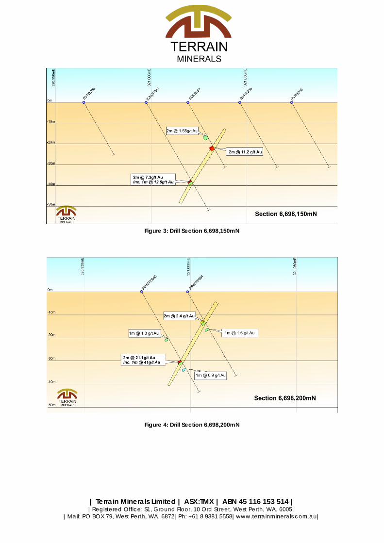
• Historical RAB drilling at Monet Prospect has reported grades of: o 92MZR003: 2m @ 22.79g/t Au from 33m o 92MZR004: 1m @ 4.69g/t Au from 14m o 99MER0965: 2m @ 21.1g/t Au from 34m o 99MER0964: 2m @ 2.35g/t Au 14m o 92MZR044: 2m @ 7.3g/t Au from 43m o BVRB207: 2m @ 11.2g/t Au from 24m
• High grade mineralisation at Monet Prospect untested below 40m • Three drill ready targets defined • Exploration planning underway to complete an RC drilling program at
Monet Prospect o Aiming to delineate a near surface high grade resource
amenable to open cut mining and for toll treatment at local processing facilities
Terrain Minerals Ltd (ASX: TMX)(“Terrain” or “the Company”) is pleased to announce that it has entered into a binding option agreement to potentially acquire the unlisted company Rembrandt Mining Pty Ltd (“Rembrandt”). Rembrandt holds the Rembrandt Gold Project (“the Project”) consisting of two granted exploration licences and two prospecting licences.
Terrain is required to complete a minimum of $25,000 exploration program across the Project prior to electing to proceed with the transaction. Terrain has three months from the date of signing the option agreement to elect to proceed with the acquisition.
An exploration program is currently being devised in consultation with Rembrandt to confirm the high grade historical drill intercepts and determine their potential depth and strike extents.

| Terrain Minerals Limited | ASX:TMX | ABN 45 116 153 514 | |Registered Office: S1, Ground Floor, 10 Ord Street, West Perth, WA, 6005|
|Mail: PO BOX 79, West Perth, WA, 6872|Ph: +61 8 9381 5558|www.terrainminerals.com.au|
Location The Project is located 10km south of Menzies and 110km north of Kalgoorlie in central Western Australia. There are 4 tenements which make up the project (P29/2262, P29/2263, E29/867 and E29/863) and they cover approximately 56km2.
Figure 1: Rembrandt Project Location Plan
| Terrain Minerals Limited | ASX:TMX | ABN 45 116 153 514 | |Registered Office: S1, Ground Floor, 10 Ord Street, West Perth, WA, 6005|
|Mail: PO BOX 79, West Perth, WA, 6872|Ph: +61 8 9381 5558|www.terrainminerals.com.au|
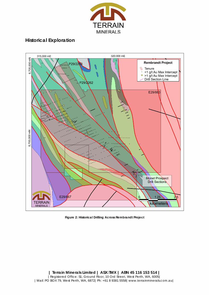
Historical Exploration
Figure 2: Historical Drilling Across Rembrandt Project
| Terrain Minerals Limited | ASX:TMX | ABN 45 116 153 514 | |Registered Office: S1, Ground Floor, 10 Ord Street, West Perth, WA, 6005|
|Mail: PO BOX 79, West Perth, WA, 6872|Ph: +61 8 9381 5558|www.terrainminerals.com.au|
Figure 4: Drill Section 6,698,200mN
Figure 3: Drill Section 6,698,150mN

| Terrain Minerals Limited | ASX:TMX | ABN 45 116 153 514 | |Registered Office: S1, Ground Floor, 10 Ord Street, West Perth, WA, 6005|
|Mail: PO BOX 79, West Perth, WA, 6872|Ph: +61 8 9381 5558|www.terrainminerals.com.au|
Figure 5: Drill Section 6,698,250mN
Historical RAB drilling across the Monet Prospect has delineated high grade near surface gold mineralisation along a strike length of 150m and tested to a depth of less than 40m. The mineralisation is open at depth.
Extensive soil and auger geochemical sampling has been conducted across the Project. The results of the geochemical sampling programs are currently being compiled and further releases will be provided to the market with respect to the results of these campaigns.
Monet Prospect is located 150 meters from a good quality unsealed road which connects to the Goldfields Highway 5km away.
The Rembrandt Project has been held privately for the past seven and a half years and hence has seen minimal modern exploration.
Exploration Program A Reverse Circulation (RC) drilling campaign to test the extent, tenor and continuity of the mineralisation defined at Monet Prospect is currently being devised. The program aims to identify a near surface high grade resource amenable to open cut mining. It is envisaged that material will be treated through nearby processing facilities.

| Terrain Minerals Limited | ASX:TMX | ABN 45 116 153 514 | |Registered Office: S1, Ground Floor, 10 Ord Street, West Perth, WA, 6005|
|Mail: PO BOX 79, West Perth, WA, 6872|Ph: +61 8 9381 5558|www.terrainminerals.com.au|
Acquisition Terms The proposed terms of the option and acquisition are as follows:
1. Option Period a. Terrain Minerals is to complete a minimum of $25,000 of exploration
expenditure across the Rembrandt Project to facilitate a three month exclusive option to acquire 100% of Rembrandt
2. Acquisition a. If the results of the drilling program meet Terrain’s satisfaction, Terrain
can elect to proceed with the acquisition of Rembrandt for $1.00 consideration
b. Rembrandt Mining Pty Ltd and/or its nominee is to receive a free carried profit share from any mining operations across the Project area. Profit share structure:
i. 25% Free carried profit share to Rembrandt for up to 15,000 ounces of gold produced
ii. 15% Free carried profit share to Rembrandt for in excess of 15,000 ounces of gold produced
c. 1% Net Smelter Return will apply to all material mined other than gold d. Both parties maintain mutual first right of refusal over each respective
party’s interest in the project e. Rembrandt to retain prospecting rights
Executive Director, Justin Virgin commented:
“Through the low cost option structure entered into with Rembrandt, Terrain has exposure to a high grade project with significant exploration upside, without an onerous cost structure.
Terrain will rapidly test the potential of Monet Prospect and determine if it represents a near term cash flow opportunity for the company. Additionally Terrain is seeking similar opportunities which have the potential of providing significant shareholder value”
FOR FURTHER INFORMATION CONTACT: Justin Virgin Executive Director Terrain Minerals Limited Email: [email protected] Tel: +61 8 9381 5558

| Terrain Minerals Limited | ASX:TMX | ABN 45 116 153 514 | |Registered Office: S1, Ground Floor, 10 Ord Street, West Perth, WA, 6005|
|Mail: PO BOX 79, West Perth, WA, 6872|Ph: +61 8 9381 5558|www.terrainminerals.com.au|
ABOUT TERRAIN MINERALS LIMITED: Terrain Minerals Limited (ASX: TMX) is a minerals exploration company with a Western Australian based asset portfolio consisting of:
• Rembrandt (Au)- high grade gold project under option, planning drilling program to determine extent and tenor of mineralisation at high Monet Prospect;
• Gimlet (Ni-Cu)- 469km2 exploration licence located in the Fraser Range Province. Geophysical targets delineated, ground reconnaissance planned;
• Great Western (Au)- near term development opportunity, resource estimation and economic study process currently being conducted;
COMPETENT PERSONS STATEMENT: The information in this Announcement that relates to Exploration Results was compiled by Mr Robert Jewson, who is a member of the Australian Institute of Geoscientists, and a consultant to Terrain Minerals limited. Mr Jewson has sufficient experience which is relevant to the style of mineralisation and type of deposit under consideration and to the activity being undertaken to qualify as a Competent Person as defined in the 2012 Edition of the ‘Australasian Code for Reporting of Exploration Results, Minerals Resources and Ore Reserves’. Mr Jewson consents to the inclusion in the Report of the matters based on his information in the form and context in which it appears.
Mr Jewson is a shareholder and a director of Rembrandt Mining Pty Ltd.
DISCLAIMER: Information included in this release constitutes forward looking statements. Often, but not always, forward looking statements can generally be identified by the use of forward looking words such as “may”, “will”, “expect”, “intend”, “plan”, “estimate”, “anticipate”, “continue” and “guidance” or other similar words, and may include, without limitation, statements regarding plans, strategies and objectives of management, anticipated production or construction commencement dates and expected costs or production outputs.
Forward looking statements inherently involve known and unknown risks, uncertainties and other factors that may cause the company’s actual results, performance and achievements to differ materially from any future results, performance or achievements. Relevant factors may include, but are not limited to, changes in commodity prices, foreign exchange fluctuations and general economic conditions, increased costs and demand for production inputs, the speculative nature of exploration and project development, including the risks of obtaining necessary licences and permits and diminishing quantities or grades of reserves, political and social risks, changes to the regulatory framework within which the company operates or may in the future operate environmental conditions including extreme weather conditions, staffing and litigation
Forward looking statements are based on the company and its management’s assumptions made in good faith relating to the financial, market, regulatory and other relevant environments that exist and effect the company’s business operations in the future. Readers are cautioned not to place undue reliance on forward looking statements.
Forward looking statements are only current and relevant for the date of issue. Subject to any continuing obligations under applicable law or any relevant stock exchange listing rules, in providing this information the company does not undertake any obligation to publicly update or revise any of the forward looking statements or advise of any change in events, conditions or circumstances ono which such statement is based.

| Terrain Minerals Limited | ASX:TMX | ABN 45 116 153 514 | |Registered Office: S1, Ground Floor, 10 Ord Street, West Perth, WA, 6005|
|Mail: PO BOX 79, West Perth, WA, 6872|Ph: +61 8 9381 5558|www.terrainminerals.com.au|
Table 1: >1g/t Drilling Intercepts
Hole Type Dip Azimuth Total Depth East North From To Interval Au g/t
92MZR003 RAB -60 66.8 42 321072.6 6698226 33 35 2 23
Including 33 34 1 40.9
321072.6 6698226 36 38 2 2
39 40 1 2
92MZR004 RAB -60 66.8 42 321091 6698234 14 15 1 5
33 34 1 1
92MZR044 RAB -60 66.8 60 321148.7 6698150 43 45 2 7
Including 43 44 1 12.5
93MER0170 RAB -90 180 61 317940.8 6700890 56 60 4 1
99MER0964 RAB -60 66.8 42 321133.7 6698198 14 16 2 3
18 19 1 1
99MER0965 RAB -60 66.8 50 321115.3 6698190 23 24 1 2
34 36 2 21
Including 34 35 1 41
BOH15 RAB -60 72 38 319972.9 6703740 26 28 2 2
BOH16 RAB -60 72 32 320036.2 6703588 6 8 2 2
BOH17 RAB -60 72 26 320008 6703699 12 13 1 1
15 16 1 3
BOH18 RAB -60 72 31 319992.6 6703694 24 26 2 1
28 30 2 1
BVRB152 RAB -60 67 15 320367.7 6702391 12 15 3 2
BVRB207 RAB -60 66.8 36 321167.1 6698158 18 20 2 2
24 26 2 11
BVRC001 RC -60 67 60 320305.5 6702578 20 21 1 1
BVRC002 RC -60 67 60 320337.9 6702378 25 27 2 2
YAG9609 RAB -90 180 76 315037.8 6702655 70 76 6 1
YAG9614 RAB -90 180 48 315919.8 6702121 45 48 3 1
YAK9673 RAB -90 180 89 316273.8 6702666 85 89 4 2
YDA31 RAB -90 180 100 315487.3 6703625 75 80 5 1
Notes: All eastings and northings surveyed by differential GPS and are in MGA94-Z51 Coordinates. All other drill holes with results <1g/t Au have been illustrated in Figure 2: Historical Drilling Across Rembrandt Project.
| Terrain Minerals Limited | ASX:TMX | ABN 45 116 153 514 | |Registered Office: S1, Ground Floor, 10 Ord Street, West Perth, WA, 6005|
|Mail: PO BOX 79, West Perth, WA, 6872|Ph: +61 8 9381 5558|www.terrainminerals.com.au|
JORC Code, 2012 Edition – Table 1
Section 1 Sampling Techniques and Data (Criteria in this section apply to all succeeding sections.)
Criteria JORC Code explanation Comments
Sampling techniques
Nature and quality of sampling (eg cut channels, random chips, or specific specialised industry standard measurement tools appropriate to the minerals under investigation, such as down hole gamma sondes, or handheld XRF instruments, etc). These examples should not be taken as limiting the broad meaning of sampling.
The Rembrandt drill hole database contains 880 drill holes for 37,086.5 meters of drilling. There are 829 RAB holes, 48 AC holes, 2 RC holes and 1 Diamond hole within the tenement E 29/0863.
As all drilling was undertaken by previous project operators, very little specific drilling data has been recorded in exploration reports.
Include reference to measures taken to ensure sample representivity and the appropriate calibration of any measurement tools or systems used.
RAB/RC/AC samples were collected from a cyclone attached to the drill rig and usually placed in rows of 10 samples on the ground. Individual piles were channel sampled and composited over a nominal interval. Samples over 3kg were split by 50% until the sample was under 3kg. Diamond drilling was conducted by previous operators in accordance with industry standards at that point in time.
Aspects of the determination of mineralisation that are Material to the Public Report. In cases where ‘industry standard’ work has been done this would be relatively simple (eg ‘reverse circulation drilling was used to obtain 1 m samples from which 3 kg was pulverised to produce a 30 g charge for fire assay’). In other cases more explanation may be required, such as where there is coarse gold that has inherent sampling problems. Unusual commodities or mineralisation types (eg submarine nodules) may warrant disclosure of detailed information.
RAB drilling samples have been collected as 4-10m composite samples with limited re-splitting of anomalous values. The only Diamond drill hole YDH9701 has been selectively sampled and did not return any anomalous values. RAB/RC/AC samples were collected from a cyclone attached to the drill rig and usually placed in rows of 10 samples on the ground. Individual piles were channel sampled and composited over a nominal interval. Samples over 3kg were split by 50% until the sample was under 3kg.
Drilling techniques
Drill type (eg core, reverse circulation, open-hole hammer, rotary air blast, auger, Bangka, sonic, etc) and details (eg core diameter, triple or standard tube, depth of diamond tails, face-sampling bit or other type, whether core is oriented and if so, by what method, etc).
All drilling reported in this announcement is a combination of RAB, RC and Diamond Drilling undertaken by previous operators of the project. As such specific information relating to all drilling techniques (hammer sizes etc.) has not been accurately preserved.
Drill Sample Recovery
Method of recording and assessing core and chip sample recoveries and results assessed.
As drilling was undertaken by previous project operators- No record of sample recoveries were located in exploration reports or on the original logs during the validation process
Measures taken to maximise sample recovery and ensure representative nature of the samples.
No recovery and representativeness of the samples was recorded.
Whether a relationship exists between sample recovery and grade and whether sample bias may have occurred due to preferential loss/gain of fine/coarse material.
Insufficient historical records exist relating to sample recovery to adequately assess the potential for sample bias.

| Terrain Minerals Limited | ASX:TMX | ABN 45 116 153 514 | |Registered Office: S1, Ground Floor, 10 Ord Street, West Perth, WA, 6005|
|Mail: PO BOX 79, West Perth, WA, 6872|Ph: +61 8 9381 5558|www.terrainminerals.com.au|
Criteria JORC Code explanation Comments
Logging
Whether core and chip samples have been geologically and geotechnically logged to a level of detail to support appropriate Mineral Resource estimation, mining studies and metallurgical studies.
Although one generation of RAB drilling to the North of the tenement has not been logged, most RAB, RC and the diamond drill holes have been logged with basic lithology, alteration and mineralisation data. As the majority of the drill holes are RAB this data cannot be used to support appropriate Mineral Resource estimation, mining studies and metallurgical studies.
Whether logging is qualitative or quantitative in nature. Core (or costean, channel, etc) photography.
Logging is qualitatively with “Rock code” being the only geological description consistently recorded throughout the drilling. As mentioned above a generation of RAB drilling to the north of the tenure has no logging recorded.
The total length and percentage of the relevant intersections logged.
Where logging has been undertaken, The entire length of RAB, RC and Diamond drill holes have been logged in full
Sub-sampling
techniques and sample preparation
If core, whether cut or sawn and whether quarter, half or all core taken.
Only one diamond drill hole has been completed across the Rembrandt Project. This hole was drilled by a previous project operator and no reference to sampling technique was recorded in exploration reports.
If non-core, whether riffled, tube sampled, rotary split, etc and whether sampled wet or dry.
RAB/RC/AC samples were collected from a cyclone attached to the drill rig and usually placed in rows of 10 samples on the ground. Individual piles were channel sampled and composited over a nominal interval. Samples over 3kg were split by 50% until the sample was under 3kg. No moisture data has been recorded
For all sample types, the nature, quality and appropriateness of the sample preparation techniques
From the available information, the nature and quality of the sample preparation techniques documented above are appropriate to producing representative samples in gold exploration. The higher grades intersected in RAB drilling near the southern border of the tenement will need twinning to confirm the grades and the width of the mineralised interval
Quality control procedures adopted for all sub-sampling stages to maximise representivity of samples.
No QA/QC procedures were documented by the previous operators
Measures taken to ensure that the sampling is representative of the in situ material collected, including for instance results for field duplicate/second-half sampling.
No QA/QC procedures were documented by the previous operators
Whether sample sizes are appropriate to the grain size of the material being sampled.
The 3kg sample sizes are considered to be appropriate for the type, style thickness and consistency of mineralisation. The sample size is also appropriate for the sampling methodology employed and the grades returned
Quality of assay data
and laboratory
tests
The nature, quality and appropriateness of the assaying and laboratory procedures used and whether the technique is considered partial or total.
The assay method is designed to measure total gold in the sample. The laboratory procedures are appropriate for the testing of gold given the nature of mineralisation style. A 50g sample charge size was used
For geophysical tools, spectrometers, handheld XRF instruments, etc, the parameters used in determining the analysis including instrument make and model, reading times, calibrations factors applied and their derivation, etc.
Not used for grade reporting or interpretation
Nature of quality control procedures adopted (eg standards, blanks, duplicates, external laboratory checks) and whether acceptable levels of accuracy (ie lack of bias) and precision have been established.
No QA/QC procedures were documented by the previous operators

| Terrain Minerals Limited | ASX:TMX | ABN 45 116 153 514 | |Registered Office: S1, Ground Floor, 10 Ord Street, West Perth, WA, 6005|
|Mail: PO BOX 79, West Perth, WA, 6872|Ph: +61 8 9381 5558|www.terrainminerals.com.au|
Criteria JORC Code explanation Comments
Verification of sampling
and assaying
The verification of significant intersections by either independent or alternative company personnel.
No record of independent verification exists
The use of twinned holes.
No twinned holes were evident in the drill hole database
Documentation of primary data, data entry procedures, data verification, data storage (physical and electronic) protocols.
Drill predates the widespread use of field base data loggers and physical storage of samples is currently unknown. Grades reported in this announcement were cross referenced with original logs and assay reports in annual exploration reports
Discuss any adjustment to assay data. No adjustments were made to assay data presented in this report
Location of Data Points
Accuracy and quality of surveys used to locate drill holes (collar and down-hole surveys), trenches, mine workings and other locations used in Mineral Resource estimation.
Local Grids were established by Aberfoyle in 1986. In in November 19997 and May 1998 DGPS surveying was conducted by Millward Surveys. Wooden DGPS pegs accurate to approximately 2m were emplaced every 100m along E-W lines with infill pin markers at 50m spacing.
Specification of the grid system used. The grid system at Rembrandt is a local grid system constructed by Aberfoyle in 1986 and reactivated by GSR in 1997. The grid system and conversion coordinates from Local to AMG system are documented in Golden State Resources WAMEX report No. a59921:
Local East Local North
AMG East AMG North
97,000mE 10,000mN 321,764mE 6,696,792mN 97,500mE 10,000mN 321,569mE 6,696,752mN
Quality and adequacy of topographic control. The drill hole database currently has nominal collar RL heights assigned with no DTM control. Given the surface over the project is generally flat and has little influence from historical workings, the influence of a terrain model is expected to be minimal. The company intends to acquire or generate a DTM surface in the coming months.
Data spacing and distribution
Data spacing for reporting of Exploration Results. Nominal drill spacing was on a 400x200m grid for RAB holes, infilled to 200x50m around mineralised zones.
Whether the data spacing and distribution is sufficient to establish the degree of geological and grade continuity appropriate for the Mineral Resource and Ore Reserve estimation procedure(s) and classifications applied.
No resources have been stated in this announcement. Given the drilling at Monet Prospect is RAB, subsequent Reverse Circulation, Air Core and/or Diamond Drilling will be required to support the classification of the resource in accordance with the JORC Guidelines (2012 Edition).
Whether sample compositing has been applied. No sample compositing has been applied.
Orientation of data in relation to geological structure
Whether the orientation of sampling achieves unbiased sampling of possible structures and the extent to which this is known, considering the deposit type.
Drilling is orientated East-North-East, perpendicular to the regional strike of mineralisation and geology.
If the relationship between the drilling orientation and the orientation of key mineralised structures is considered to have introduced a sampling bias, this should be assessed and reported if material.
No drilling or sampling bias has been noted
Sample security
The measures taken to ensure sample security. No record has been kept relating to the security of the samples taken by previous operators
Audits or reviews
The results of any audits or reviews of sampling techniques and data.
No record of audits or reviews by previous operators has been located

| Terrain Minerals Limited | ASX:TMX | ABN 45 116 153 514 | |Registered Office: S1, Ground Floor, 10 Ord Street, West Perth, WA, 6005|
|Mail: PO BOX 79, West Perth, WA, 6872|Ph: +61 8 9381 5558|www.terrainminerals.com.au|
Section 2 Reporting of Exploration Results (Criteria listed in the preceding section also apply to this section.)
Criteria JORC Code explanation Commentary
Mineral tenement and land tenure status
Type, reference name/number, location and ownership including agreements or material issues with third parties such as joint ventures, partnerships, overriding royalties, native title interests, historical sites, wilderness or national park and environmental settings.
E 29/0863, E29/867, P29/2262 & P29/2263 are mineral exploration licences and prospecting licences respectively, wholly held by Rembrandt Mining Pty Ltd. Terrain Minerals Ltd has entered into a binding option agreement to potentially acquire the Rembrandt Mining Pty Ltd holder of the Rembrandt Gold Project. Terrain is required to complete a minimum of $25,000 exploration program across the Project prior to electing to proceed with the transaction. Terrain has three months from the date of signing the option agreement to elect to proceed with the acquisition. Rembrandt Mining Pty Ltd and/or its nominee is to receive a free carried profit share from any mining operations across the Project area. Profit share structure: i.i. 25% Free carried profit share to Rembrandt for first 15,000 ounces of gold produced iii. 15% Free carried profit share to Rembrandt for over 15,000 ounces of gold produced
The security of the tenure held at the time of reporting along with any known impediments to obtaining a licence to operate in the area.
E 29/863, E29/867, P29/2262 & P29/2263 are granted and free from encumbrances. At this time the tenement is believed to be in good standing. There are no known impediments to obtaining a licence to operate, other than those set out by statutory requirements which have not yet been applied for.
Exploration Acknowledgment and appraisal of exploration by other parties.
Exploration by previous operators include Golden State Resources, Helix Resources and CRA The historical data and database has been appraised and is of acceptable quality.
Geology Deposit type, geological setting and style of mineralisation.
The Rembrandt project is in the North West margin of the Comet Vale Monzogranite. The greenstone package comprises a steeply east-dipping north-west to north-north-west striking sequence of ultramafics overlying komatiite flows, gabbros and basalts. This is a relatively sediment-poor package and is reasonably consistent over many kilometres of strike. A thin ductile ultramafic is believed to form the east margin of the mafic-ultramafic package. This unit does not outcrop but is interpreted from Aeromagnetics. In parts of the mine sequence, metabasalt and sedimentary rocks are commonly interlayered with sheared slivers of the thin ultramafic. To the North the conglomerates may be represented by much thinner units in the basalt-sediment package of the mine sequence and/or adjoining rocks, however if so, they have thinned dramatically due possibly to facies changes or tectonic interleaving.
Drill Hole Information
A summary of all information material to the understanding of the exploration results including a tabulation of the following information for all Material drill holes:
The drill holes reported in this announcement have the following parameters applied. All drill holes completed, including holes with no significant gold intersections are reported in this announcement.
o easting and northing of the drill hole collar Easting and northings are in MGA94- Zone 51.
o elevation or RL (Reduced Level – elevation above sea level in metres) of the drill hole collar
RL is AHD (A nominal 500m RL has been applied).
o dip and azimuth of the hole Dip is the inclination of the hole from the horizontal (i.e. a vertically down drilled hole from the surface is -90o) . Azimuth is reported in degrees as the direction towards which the hole is drilled. The relevant surveying method is quoted in the collar table of announcement.
o down hole length and interception depth Down hole length of the hole is the distance from the surface to the end of the hole, as measured along the drill trace. Interception depth is the distance down from the surface to the end of the hole, as measured along the drill trace. Interception depth is the distance down the hole as measured along the drill trace. Intersection with is the downhole distance of an intersection as measured along the drill trace,

| Terrain Minerals Limited | ASX:TMX | ABN 45 116 153 514 | |Registered Office: S1, Ground Floor, 10 Ord Street, West Perth, WA, 6005|
|Mail: PO BOX 79, West Perth, WA, 6872|Ph: +61 8 9381 5558|www.terrainminerals.com.au|
Criteria JORC Code explanation Commentary
o hole length. Hole length is the distance from the surface to the end of the hole, as measured along the drill trace.
If the exclusion of this information is justified on the basis that the information is not Material and this exclusion does not detract from the understanding of the report, the Competent Person should clearly explain why this is the case.
All results relating to the drill sections provided have been stated including “not significant intercepts”. Inclusion of all historical data would make Table too large, although data is representative of all drilling.
Data Aggregation Methods
In reporting Exploration Results, weighting averaging techniques, maximum and/or minimum grade truncations (eg cutting of high grades) and cut-off grades are usually Material and should be stated.
No weighting averaging techniques, maximum and/or minimum grade truncations (eg cutting of high grades) and cut-off grades have been applied.
Where aggregate intercepts incorporate short lengths of high grade results and longer lengths of low grade results, the procedure used for such aggregation should be stated and some typical examples of such aggregations should be shown in detail.
No aggregate intercepts have been applied to the data quoted
The assumptions used for any reporting of metal equivalent values should be clearly stated.
No metal equivalents are reported.
Relationship between
mineralisation widths and intercept
lengths
These relationships are particularly important in the reporting of Exploration Results.
The intersection width is measured down the hole trace, it is not usually the true width. Cross sections provided in the announcement allow the relationship between true and down hole width to be viewed.
If the geometry of the mineralisation with respect to the drill hole angle is known, its nature should be reported.
The geometry of the mineralisation is perpendicular to the azimuth of the drilling
If it is not known and only the down hole lengths are reported, there should be a clear statement to this effect (eg ‘down hole length, true width not known’).
All drill results within this announcement are downhole intervals only and due to variable mineralisation, true widths are not able to be calculated until further diamond drilling has been conducted.
Diagrams Appropriate maps and sections (with scales) and tabulations of intercepts should be included for any significant discovery being reported These should include, but not be limited to a plan view of drill hole collar locations and appropriate sectional views.
A plan view and drill sections have been provided in this announcement.
Balanced Reporting
Where comprehensive reporting of all Exploration Results is not practicable, representative reporting of both low and high grades and/or widths should be practiced to avoid misleading reporting of Exploration Results.
All results including those with no significant interceptions have been reported.
Other substantive exploration data
Other exploration data, if meaningful and material, should be reported including (but not limited to): geological observations; geophysical survey results; geochemical survey results; bulk samples – size and method of treatment; metallurgical test results; bulk density, groundwater, geotechnical and rock characteristics; potential deleterious or contaminating substances.
No other exploration data is considered meaningful and material to this announcement
Further Work The nature and scale of planned further work (eg tests for lateral extensions or depth extensions or large-scale step-out drilling).
Pending the outcomes of preliminary economic studies, strategic infill holes will be drilled to define detailed oxidation profiles and obtain Specific Gravity, metallurgical and geotechnical samples to improve the confidence of the resource
Diagrams clearly highlighting the areas of possible extensions, including the main geological interpretations and future drilling areas, provided this information is not commercially sensitive.
Drill planning has commenced, further releases will be made to market upon finalising the drill program to be undertaken.