photogrammetric methods for the … · the corral del veleta (in sierra nevada) since the year...
TRANSCRIPT
PHOTOGRAMMETRIC METHODS FOR THE OBTAINING OF DETAILED CARTOGRAPHY IN ACTIVE MOUNTAIN GLACIERS
Alan D.J. Atkinson Gordo1, José Juan de Sanjosé Blasco2, Nuria Andrés de Pablo3, Ferran Salvador Franch4
(1) Universidad de Extremadura, [email protected] (2) Universidad de Extremadura, [email protected]
(3) Universidad Complutense de Madrid, [email protected] (4) Universidad Central de Barcelona, [email protected]
ABSTRACT
In the studies of active mountain glacier dynamics many inconveniences exist, and one of the most important is the scarcity of detailed cartography (scale 1/2000, 1/1000 or even 1/500). From the investigation group in Geomatic Engineering and Urban Heritage of the UEX (Spain), in collaboration with the Universities of Madrid (Complutense), Valladolid, Barcelona (Central) and Mexico (UNAM), we have employed different photogrammetric techniques for the study of rock glaciers (Spain) and ice or white glaciers (Mexico). With respect to rock glaciers, we have analyzed the cases of Las Argualas (in the Pyrenees) since the year 1991 and of the Corral del Veleta (in Sierra Nevada) since the year 2001, employing converging land photogrammetric techniques (Argualas) and land photogrammetry with almost normal shots (Corral del Veleta). Along with the detailed cartography, the geodetic data is integrated into the dynamic of the glaciers, determining a behaviour similar (magnitude of displacement) to the Argualas glacier with respect to the Alpine glaciers. A different behaviour exists (less displacement and greater sinking) in the Corral del Veleta glacier. This is due to the specific conditions of the temperature (43ºC in summer) of the area, given that it is the northern most active rock glacier on the European continent. Concerning the case of the ice or white glacier; the study that we made in the framework of the investigation project of the Ministry of Science and Technology: �Development of an integrated system for hydro volcanic hazard prevention�. In this investigation, the activity of the Popocatépetl volcano (Mexico) is studied using detailed cartography; specifically its volcanic dome and the relationship of the volcanic activity with the dimensions of the glacier located on its summit (Ventorrillo glacier). For this, cartography was obtained using photogrammetric flights with great difficulties caused by the extreme working conditions: volcanic activity, meteorology, changes in scale due to the steep slopes and differences in altitude of the flights, localization of the control points,�
1. INTRODUCCIÓN
For the study of glaciers in high mountain zones it is necessary to possess detailed cartography that allows the analysis of its evolution and behaviour throughout time. Trough the use of geomatic techniques (geodesy, global positioning system, photogrammetry) it is possible to study the dinamics of structures geomorphologyc with high precision, and also to get a more detailed cartography. In order to do cartography of the glaciers, conventional photogrammetry (metric camera and normal shots) can be used and also cheaper methods (semi-metric cameras, and photographs of �close range� objects) (Sanjosé & col., 2004-a). In the following article we present the methodology applied to the rock glaciers of Argualas, Corral de la Veleta and the ice glacier of the Popocatépetl volcano with the latest results of the campaigns carried out in September 2004.
2. ROCK GLACIERS
A rock glacier is a mass of rubble with interstice ice that flows on a slope or in the bottom of a valley characterized in its exterior by grooves, arches, cords and lobes, and an abrupt front in which fine materials crop out. Rock glaciers are generated in high mountain environments that respond to precise environmental conditions, such as median air temperatures inferior to -1ºC and precipitations of less than 2500 mm (Serrano, Silió, & Sanjosé, 1995). For a glacier to form it is necessary that the snowfall is greater than the snow melt, and this occurs when there are large snowfalls and
low temperatures that allow it to be preserved. If stone rubble also exists in the thick walls that surround the glacier where ice accumulates, then a rock glacier will be formed. Extensive documentation of some alpine glaciers exists, many analyzing their dynamics and others their cartography. This isn�t the case in Spain, in spite of having active glaciers (white and rock) nearer to the equator of the European continent. Presently, small scale cartography isn�t available, nor is the value of their dynamics. However, exceptions do exist, given that since 1991 (directed by the geographer Enrique Serrano Cañadas � University of Valladolid) the behavior of the Argualas rock glacier (central Pyrenees) has been under investigation and since 2001 (directed by geographer Antonio Gómez Ortiz � University of Barcelona) the dynamic of the Corral del Veleta rock glacier (Sierra Nevada) has also been under investigation (Sanjosé & col., 2004-b).
2.1. The �Argualas� rock glacier
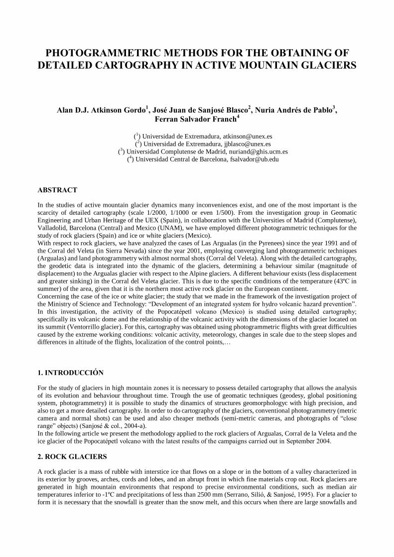
It is oriented to the northwest and located at the base of the mountain mass of the Argualas (3032 m) with a drop of the large walls that surrounds it at 300 m. The extensions of the glacier are 750 m in length by 400 m in width and the front has a slope of 25 m and a 42º pitch where fine materials crop out. The geophysical drillings that were done on the glacier have shown a superficial layer of stones between 2 m and 4m and below that a layer of permafrost between 10 m (border) and 20 m (centre) (Fabre, García, & Evin, 1995) (figure 1).
Figure 1: General view of Las Argualas glacier.
In order to obtain the detailed cartography of the work area, we have made a low altitude helicopter flight over the central zone of the glacier. Given the dimensions of the glacier and the scarce financing on the part of public and private institutions, we have only used photogrammetric techniques during the field campaign of 2000 for the central zone of this glacier. So, 9 convergent and inclined shots were taken above the glacier using a photogrammetric land Rolei 6008 camera (see table 1). For the convergent and inclined shots digital restitution was employed, using the �Close Range Digital Workstation� program (CDW).
Rollei 6008 camera Total station Topcon GTS-502
Film format: 60 mm x 60 mm Number of frames reseau: 121 Minimum length of exposure: 1/1000 sg Lenses used: 40 mm, 60 mm, 120 mm, 250 mm
Magnification: 30 X Sensibility: 90cc Evaluation: 10cc Distance error: 2 mm ± 2 ppm
Table 1: Technical characteristics of the Rollei 6008 camera and the total station GTS-502 E from Topcon.
The control points necessary for the restitution photogrammetry were obtained by means of geodetic techniques with a Topcon GTS-502 total station (table 1). The errors obtained in the determination of the coordinates XYZ employing repetition techniques from various stations, have been inferior to ± 4cm. On the land location of the control points, steel nails were used and metal rods of 1.20 m long were used on big rocks. For the localization in the photographs, 1 x 1 m bi-colour targets were used (figure 2). In the photogrammetric restitution 250 points per automatic correlation were obtained for the generation of the Digital Terrain Model (DTM) and the generation of the cartography with a scale of 1/500 with equidistance of 0.5 m (figure 3). The errors obtained in the DTM were inferior to 10 cm. In order to study the behaviour of the CDW program, a study was realized of the residuals of errors obtained using different combinations of photographs for the generation of the DTM. The study was based on the number of control

points, the spatial distribution of the control points, the number of photographs used and the position. After the analysis, we established the recommendations that are summarized in table 2.
Figure 2: Photograph of the control points and detail of a target.
1. Regarding the number of photographs to be used.
The best results are obtained using a reduced number of photographs (the software needs a minimum of 3 photographs), but they should be correctly distributed. If a large quantity is used (7 or more), the work becomes very costly and the results do not improve significantly.
2. Regarding the geometry of the photographs. If the angles of the intersection of the photographs are not very convergent, the results of the adjustment of the model will not be adequate. The photographic shots should have significant angles of intersection.
3. Regarding the control points. In order to be able to achieve the adjustment of the convergent photographs, there must be a minimum of 10 points common to all of them. Although these points do not have to coincide with the control points, it certainly makes it easier to identify the targets in all of the photographs.
Table 2: Recommendations for the production of cartography using inclined and convergent shots with CDW.
10 m
Equidistance curves: 0,5 m
Approximately
Origin angle
Figure 3: Cartography of a scale of 1/500 of the Argualas glacier.
2.2. �Corral del Veleta� rock glacier
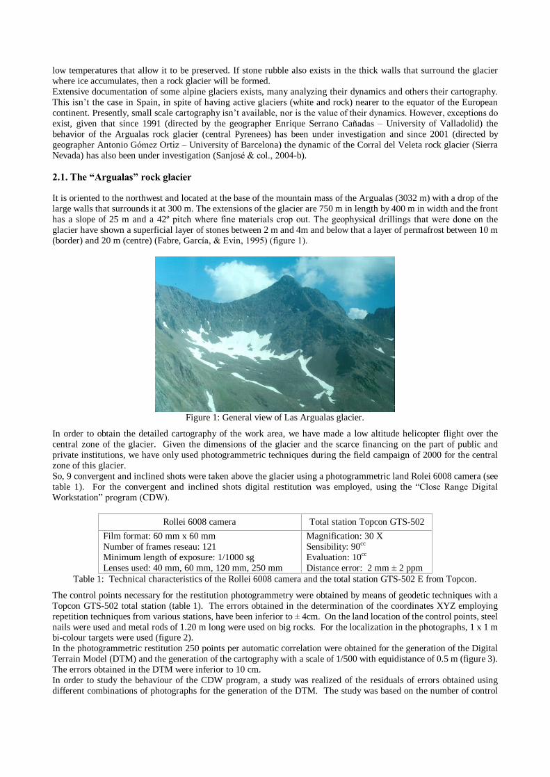
The �Corral del Vleta� has a longitude of approximately 600 m by 200 m width (Figure 4). The glacier is oriented to the northwest and is bordered on the south by the vertical wall (300 m) of Veleta Peak (3396 m). The Corral del Veleta is formed by a combination of forms of glacier and periglacier origins between which small moraine forms stand out. At the present time, The Corral del Veleta maintains profound permafrost of varying thickness in a continuous process of degradation (Gómez, Palacios, & Ramos, 2003).
Figure 4: General view of the Corral del Veleta glacier.
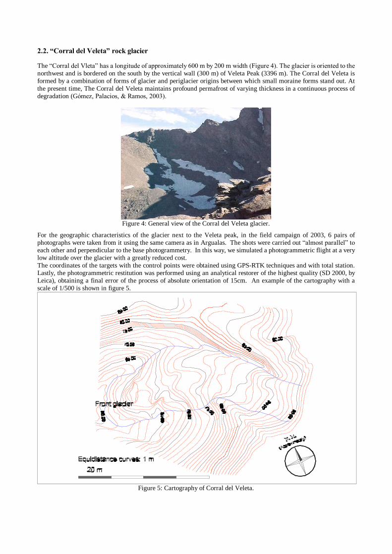
For the geographic characteristics of the glacier next to the Veleta peak, in the field campaign of 2003, 6 pairs of photographs were taken from it using the same camera as in Argualas. The shots were carried out �almost parallel� to each other and perpendicular to the base photogrammetry. In this way, we simulated a photogrammetric flight at a very low altitude over the glacier with a greatly reduced cost. The coordinates of the targets with the control points were obtained using GPS-RTK techniques and with total station. Lastly, the photogrammetric restitution was performed using an analytical restorer of the highest quality (SD 2000, by Leica), obtaining a final error of the process of absolute orientation of 15cm. An example of the cartography with a scale of 1/500 is shown in figure 5.
Figure 5: Cartography of Corral del Veleta.

3. VENTORRILLO GLACIER IN THE POPOCATÉPETL VOLCANO
The projects realized in the Popocatépetl volcano (Mexico) are financed in the framework of the national project of investigation �Development of an integrated system for hydro-volcanic hazard prevention� � �LAHAR� (REN2003-06388), of the Ministry of Science and Technology of the Spanish Government. The Popocatépetl volcano is situated in the middle of the Transmexican Volcanic mountain range, at less that 80 km. between the centre of Mexico City and the city of Puebla (Figure 6). This is elevated from 4000m, forming a considerably regular cone of some 13 km. in diameter at its base.
Figure 6: Situation of the Popocatépetl Volcano.
The project has an objective of contributing to the methodology and the techniques necessary to perform an effective monitoring of the volcano and its possible risks of catastrophe provoked by lahars. The last active volcanic period began December 21, 1994, and is currently still active. The most characteristic eruptive process has been the formation of lava domes in the interior of the crater, its gradual growth and its posterior destruction from the explosive activity, with the consequent pyroclastic emissions. Neither of the laterals of the volcanic cones of the Ventorrillo glacier, any volcanic activity promotes the generations of lahars that place the nearest populations in danger. In July 1997, rock displacements were produced of rocks that were 2 m in diameter and were displaced more than 17 km of distance. Control and direct monitoring of the crater and the glacier is impossible while the volcanic activity lasts. For scientific and preventative motives, access is absolutely prohibited within a radius of 10 km of the volcano because of the frequency of falling rocks. In order to solve this problem, the Secretary of Communication and Transport (SCT) of the Mexican government made photographic flights on a monthly basis, providing information to the National Centre for the Prevention of Disasters (CENAPRED), the organization responsible for the surveillance and prevention of risks (Sanjosé & col. 2004-a).
3.1. Previously realized projects
During 2002 and 2003, both under the �Lahar� project and the previous project (�The lahars of Popocatépelt (Mexico): control and prevention of risks� � REN2000-0742), topographic removals/upheavals/upliftings were performed with total station with and without reflector (�reflector less�) in the intermediate area around the ravine at a scale of 1/500. Likewise, restorations were made at a scale of 1/5000 (equidistance of 10 m) and 1/20000 of both the volcanic cone and the area surrounding of Popocatépetl. For this, the flights made by SCT in December 1998, June 1999, June 2002, December 2002 and February 2003 were used. For the production and the cartography, we encountered some inconveniences: - Arial Photographs in which the problem exists of smoke emitted from the volcano in such a way that it makes the
restitution difficult in some areas (figure 7). - The summit of the volcano is located at 5260 m and in front of the glacier it is at 4500 m, which provokes different
scales of flight for the same cartography. Also, each photogrammetric flight has different scales for the changes in the altitude of the flight.
- Because of the inaccessibility of the zone, we could not have �control points�. The solution was to turn to existing cartography from 1982 with a scale of 1/10000, from which we obtained the reference points. Given that the same control points have always been used, the relative errors between the different restorations were reduced to 2 m of the absolute orientation.

Figure 7: Flight (February 2003) of Popocatépetl with clouds that make restoration difficult.
For the digital restoration the photographs were scanned at 21 microns with a Vexcel 5000 photogrammetric scanner. The cartography was produced using both the �SD 2000� analytical restorer and the digital restorer �Photopol�. Some of the results are shown in figure 8: cartography of the volcanic cone and cartography of the surrounding area.
Figure 8: Cartography of the volcanic cone at a scale of 1/5000 and of the surrounding area at a scale of 1/20000.
3.2. Campaign 2004
For the field campaign of September 2004, a work plan was realized that improved the results obtained until then: - Georrefering of the absolute coordinates UTM of the detailed cartography for the year 2003 at 1/500. - Obtaining of control points for the photogrammetric flights of the different work areas. - Obtaining of detailed cartography with a scale of 1/500 of the high zone (4350 m) and the low zone of the ravine
(5550 m) using total station. - Obtaining of detailed cartography of the front of the glacier using land photogrammetry. For this, the necessary scientific equipment was taken to Mexico (3 bi-frequency GPS, total station, and photogrammetric camera). However, given the work characteristics of the area and the climatology during the time of the field campaign (September), we encountered some inconveniences: - Geodetic vertices do not exist near the volcano, in the majority of the cases they have been destroyed by the hands
of humans (Figure 9). This made it impossible to calculate the local parameters of transformation between the WGS-84 system and the local (UTM-NAD27). In order to solve this problem, the GPS observations have been linked to with 3 stations the National Active Geodetic Network (RGNA) of INEGI, applying global transformation parameters. In this way, the coordinates of all the UTM points are possessed in the new ITRF-92 system (Epoch

1988.0)1, the differences with the NAD-27 system are approximately 3 m. Although this makes the new reference coordinates differ from de those used up to now, it makes a new, more precise absolute georrefering possible.
Figure 9: Destroyed geodetic signal.
- The observations with �reflector less� total station in the high part of the ravine could not be performed because the volcanic rock absorbs the infrared beam of the total station..
- The observations using GPS RTK in the high part of the ravine were performed in extreme working conditions (elevated altitude and less oxygen, landslides, storms, rains, hail�), because of these conditions the risks were substantial.
- Because of the climatic conditions and the instable situation of the front of the glacier in the month of September, it was not possible to have access to it in order to situate the control points or to photograph it (figure 10).
However, it was possible to carry out the rest of the programmed work with optimal results. So, for example, the control points obtained using GPS in post-processing have reached the desired precision for the correct georrefering of the cartography produced on previous flights to the UTM � ITRF-92 system.
Figure 10: The weather at Popocatépelt.
4. CONCLUSIONS
There is no doubt that the production of cartography in high mountain areas involves very peculiar and difficult working conditions. These are increased in the cases of active glaciers (rock glaciers and ice glaciers), and even more so if these are found on an active volcano. For all this, we should always keep certain aspects in mind such as: - The actual work conditions tend to be extreme. For example, the climatology, the altitude and the accessibility of
Popocatépelt makes land photogrammetry impossible, having to use aerial photogrammetry in spite of the inconveniences of the change of scale.
- The impediments of the orography of the land influence the methodology to be used. For example, the existence of a wall of vertical rock makes a flight in Corral del Veleta impossible and facilitates the obtaining of land photographs.
- In those cases in which it is possible, flights can be made in helicopter at low altitudes over small work areas in order to obtain detailed cartography using convergent photographs (eg. in Argualas).
1 At the moment we expect the transfer of the geoid data by the INEGI.

APRECIATION
We would like to show our gratitude to all those people and public and private organizations who have collaborated in the realization of the projects in this article: - Participating universities: University of Extremadura, University of Madrid, Central University of Barcelona,
University of Valladolid, and National Autonomous University of Mexico. - Public organizations: Spanish (Ministry of Science and Technology, AECI, The Provincial government of
Extremadura, The Provincial government of Andalusia, National parks,�) and Mexican (Institute of Geography, INEGI,SCT,CENAPRED,�).
- The collaboration of Topcon Spain (www.topcon.es).
5. REFERENCES
- Fabre, D., García, F., Evin, M. (1995). �Structure interne du glacier rocheux actif de las Argualas�. La Houille Blanche, pp. 144-147.
- Gómez, A., Palacios, D. y Ramos, M. (2003). �Permafrost, evolución de formas asociadas y comportamiento térmico en el corral del Veleta. Últimos resultados�. VI Reunión IPA-España. La Granja (Segovia).
- Sanjosé, J.J.; Atkinson, A.D.J.; Andrés, N.; Zamorano, J.J. y Palacios, D. (2004-a). �Utilidad de las técnicas geomáticas para la prevención de catástrofes provocadas por el volcán Popocatépetl (México)�, en VIII Congreso Nacional de Topografía y Cartografía � TopCart 2004.
- Sanjosé, J.J.; Atkinson, A.D.J.; Salvador, F.; Gómez, A. y Serrano, E. (2004-b). �Geomatics techniques applied to the cartography of rocks glaciers. Case studies of the �Argualas� and �Corral del Veleta� glaciers�. Working Group on Mountain Cartography. Vall de Nuria (Lérida).
- Serrano, E., Silió, F. y Sanjosé, J.J. (1995). �Movimiento superficial del glaciar rocoso de las Argualas�. Revista Pirineos, Nº.: 146, pp. 103 � 110. Zaragoza.
6. BIOGRAPHY
6.3. Personal Information
Dr. Alan D.J. Atkinson Gordo; E-mail: [email protected]; web: www.unex.es/igpu/Alan Address: Escuela Politécnica; Av. Universidad s/n; 10.190 Cáceres; Spain Phone: (+34) 927.257.195 (Ext. 7578); Fax: (+34) 927.257.203
6.4. Academic information
Associate Professor T.C. at the University of Extremadura (UEX).
6.5. Investigative Activity
Author of the doctoral thesis �Positional Quality Control in Cartography: Analysis of the Main Standards and Proposal for Improvement�, within the doctorate program in Geodesic Engineering Cartography and Photogrammetry of the University of Jaén. Secretary and founding member of the Investigative team in Geomatic Engineering and Urban Heritage (IGPU) of the UEX (website of IGPU: www.unex.es/igpu). Member of the editorial counsel of the magazine DATUM XXI (Official publication of the Association of Engineers in Geodesy and Cartography) since its foundation (2002). Member of the Directing Counsel of the Association of Engineers in Geodesy and Cartography (AIGC) since its foundation (website for AIGC: www.aigc.es). Participation as investigator in the projects:
Project of National Investigation (I+D): Control de calidad en cartografía por elementos lineales - ConPoCar.
Project of National Investigation (I+D): Elaboración de un sistema integrado para la prevención de riesgos hidrovolcánicos
Project of Regional Investigation (PRI): Influencia de las condiciones de bienestar animal en la optimización de la producción del cerdo ibérico.
Project of Regional Investigation (PRI): Desarrollo de un restituidor digital para la realización de cartografía automática bajo Linex
Project of National Investigation (I+D): Degradación de permafrost y significado geográfico y ambiental en sierra nevada. El caso del corral del veleta.
Project of National Investigation (I+D): Cálculo de abundancias mediante redes neuronales a partir de imágenes hiperespectrales.
Project of National Investigation (I+D): Los lahares del popocatépelt (méxico): control y prevención de riesgos.