planning department public notice of a draft …
TRANSCRIPT

Page 1 of 2
THE CITY OF SAN DIEGO
PLANNING DEPARTMENT Date of Notice: August 30, 2016
PUBLIC NOTICE OF A DRAFT MITIGATED NEGATIVE DECLARATION
WBS No. B-15195.02.06 ___________________________________________________________ The City of San Diego Planning Department has prepared a draft Mitigated Negative Declaration (MND) for the following project and is inviting your comments regarding the adequacy of the document. The draft MND has been placed on the City of San Diego Planning Department website under the heading “Draft CEQA Documents” and can be accessed using the following link: http://www.sandiego.gov/planning/programs/ceqa/index.shtml The draft MND public notice has also been placed on the City Clerk website at: http://www.sandiego.gov/city-clerk/officialdocs/notices/index.shtml Your comments must be received by September 29, 2016 to be included in the final document considered by the decision-making authorities. Please send your written comments to the following address: Myra Herrmann, Environmental Planner, City of San Diego Planning Department, 1010 Second Avenue, Suite 1200, East Tower, MS 413, San Diego, CA 92101 or e-mail your comments to [email protected] with the Project Name and Number in the subject line. General Project Information: Project Name: Lake Hodges Reservoir Hypolimnetic Oxygenation System (HOS) Project No. 459570 / SCH No. Pending Community Plan Area: San Pasqual Council District(s): 5
APPLICANT: City of San Diego – Public Utilities Department SUBJECT: SITE DEVELOPMENT PERMIT (SDP) and Approval of a Subsequent Design/Build Contract by the San Diego City Council or Mayor-Appointed Designee for the design, installation and operation of an oxygen supply and delivery system, coupled with a hypolimnetic oxygenation speece cone diffuser system to improve water quality by managing and controlling excessive algal productivity. The on-shore project component requires demolition of the existing reservoir keepers’ residence, construction of a concrete slab and equipment foundation, and installation of associated equipment to support the HOS operation. The subsequent design/build contract would authorize design, supply and installation of all piping and materials for all systems, including an oxygen supply facility and foundation, oxygen supply piping and appurtenances, controls, scada system, electrical power, in-lake submersible pump, speece cone, diffuser components, and a

Page 2 of 2
driveway capable of supporting 80,000 lbs with adequate turning radius for a 65 foot semi-truck to maneuver in and out of the liquid oxygen (LOX) supply facility. Construction of the in-lake HOS system would be confined to the region approximately 3,000 feet upstream from Lake Hodges dam and approximately 700ft south east from the abandoned reservoir operator residence. The in-lake portion of the system would consist of a single header discharge plenum 20 inches in diameter and 100 feet long, one (1) Speece Cone 12 feet in diameter and 25 feet high, and one 100 HP submersible pump. The HOS system would be placed on a multi-tiered rock base.
Construction Activities would occur at 3 locations: LOX supply facility located at the abandoned reservoir keeper residence, boat launch located 1,300 feet west of the Lake Hodges Visitor Center, and the in-lake HOS system. Construction staging would be within the footprint of the fire buffer which is a 50-ft radius from the perimeter of the LOX supply facility. No improvements or impacts are proposed at the boat launch project site. Staging, launching and access would be within existing developed areas at this location. Typical construction equipment would be utilized to perform the work at the LOX Supply Facility. Hydraulic truck cranes, cement truck, semi-trailer truck, and dump trucks would require access to and from the site to deliver heavy equipment, supplies, and materials using existing dirt and asphalt roads. Only minor improvements are proposed within the existing access road footprint.
The project is located within City-owned open space adjacent to Hodges Reservoir in the San Dieguito Hydrologic Unit in San Diego County, California. This project is located in the City’s Multiple Species Conservation Program (MSCP) Multi-Habitat Planning Area (MHPA); however, all impacts would occur within 300 feet horizontally from the high water level of the water elevation of the spillway and within the existing footprint of the employee residence. These areas are considered to be excluded from the MHPA as a part of the City’s reservoir management program (City of San Diego 1997). Recommended Finding: The recommended finding that the project will not have a significant effect on the environment is based on an Initial Study and project conditions which now mitigate potentially significant environmental impacts in the following area(s): Biological Resources (Indirect), Land Use (MSCP/MHPA – Land Use Adjacency), and Historical Resources (Archaeology/Tribal Cultural Resources) Availability in Alternative Format: To request this Notice, the draft MND, Initial Study, and/or supporting documents in alternative format, call the Planning Department at (619) 235-5200 or (800) 735-2929 (TEXT TELEPHONE). Additional Information: For environmental review information, contact Myra Herrmann at (619) 446-5372. The draft MND and supporting documents may be reviewed, or purchased for the cost of reproduction, in the Planning Department at 1010 Second Avenue, Suite 1200, East Tower, MS 413, San Diego, CA 92101. For information regarding public meetings/hearings on this project, contact Edson Bandoy, Associate Civil Engineer, in the Public Utilities Department at (858) 292-6458 or [email protected]. This notice was published in the SAN DIEGO DAILY TRANSCRIPT and distributed on August 30, 2016. Alyssa Muto Deputy Director Planning Department

Planning Department Environmental & Policy Analysis Division
Project No. 459570 SUBJECT: Lake Hodges Reservoir Hypolimnetic Oxygenation System (HOS) Project. SITE
DEVELOPMENT PERMIT (SDP) and Approval of a Subsequent Design/Build Contract by the San Diego City Council or Mayor-Appointed Designee for the design, installation and operation of an oxygen supply and delivery system, coupled with a hypolimnetic oxygenation speece cone diffuser system to improve water quality by managing and controlling excessive algal productivity. The on-shore project component requires demolition of the existing reservoir keepers’ residence, construction of a concrete slab and equipment foundation, and installation of associated equipment to support the HOS operation. The subsequent design/build contract would authorize design, supply and installation of all piping and materials for all systems, including an oxygen supply facility and foundation, oxygen supply piping and appurtenances, controls, scada system, electrical power, in-lake submersible pump, speece cone, diffuser components, and a driveway capable of supporting 80,000 lbs with adequate turning radius for a 65 foot semi-truck to maneuver in and out of the liquid oxygen (LOX) supply facility.
The proposed project is located within City owned open space adjacent to Hodges Reservoir in the San Dieguito Hydrologic Unit in San Diego County, California (Figure 1). This project is generally located in the Multiple Habitat Planning Area (MHPA). However, all impacts will occur within 300 feet horizontally from the high water level of the water elevation of the spillway and within the existing footprint of the employee residence. These areas are considered to be excluded from the MHPA as a part of the City’s reservoir management program (City of San Diego 1997).
APPLICANT: City of San Diego – Public Utilities Department Owned and operated by the City of San Diego (City) Public Utilities Department (APPLICANT), Hodges Reservoir is in the San Dieguito Hydrologic Unit in San Diego County, California, and has a maximum capacity of 30,251 acre-feet (AF) with 303 square miles of upstream catchment area. Hodges Reservoir is an important part of the San Diego County Water Authority’s (SDCWA) Emergency Storage Project as it provides the ability to store imported water supplies and local water supplies in times of excess. Hodges Reservoir has a dominant and overarching beneficial use as a drinking water supply source to the San Dieguito Water District (SDWD)/Santa Fe Irrigation District (SFID). Construction of the Hodges Pump Station, as part of the SDCWA Emergency Storage Project, connected Hodges Reservoir to Olivenhain Reservoir allowing Hodges Reservoir to be used for storage and supply to the regional water supply system (operated by the SDCWA) and, thus, additional usable local water resource for the City. These management options provide regional water system flexibility in times of drought.
DRAFT MITIGATED NEGATIVE DECLARATION Project No. 459570 SCH# Pending

Page 2 of 18
The Water Quality Control Plan for the San Diego Region (9), commonly known as the Basin Plan, lists ten beneficial uses for Hodges Reservoir: Municipal and Domestic Supply; Agricultural Supply; Industrial Service Supply; Industrial Process Supply; Contact Water Recreation; Warm Fresh Water Habitat; Cold Freshwater Habitat; Wildlife Habitat; and Rare, Threatened or Endangered Species. The highest priority beneficial use of Hodges Reservoir is drinking source water supply. The Regional Water Quality Control Board, 2008 Clean Water Act Sections 305(b) and 303(d) Integrated Report states that Hodges Reservoir currently does not meet water quality objectives for the following five parameters: pH, manganese, turbidity, nitrogen, and phosphorous. This assessment means that one or more of the reservoirs beneficial uses are no longer supported. High algal productivity in the reservoir is fueled by excessive loading of nutrients; specifically, nitrogen and phosphorous. Nutrient loading may be external (surface water runoff into the reservoir] or internal [release of nutrients from sediment to the water column, on an annual cycle). At Hodges Reservoir internal nutrient loading is about ten times greater than external loading. In deep water areas of the reservoir, decomposition of biomass results in anoxic conditions. Internal nutrient loading results when the deep water of the reservoir goes through an annual cycle of anoxic conditions followed by a period of well-oxygenated deep water. Under anoxic conditions nitrogen and phosphorous accumulate in lake bottom sediments, and then are released when the sediment-water interface is well-oxygenated. Under anoxic conditions at the deep sediment-water interface, sulfate-reducing bacteria mediate the methylation of mercury, converting naturally occurring elemental mercury into a form that is bioavailable. The methylmercury is then bioaccumluated up through the food chain from micro-organisms to small fish to larger fish, ultimately posing a risk of toxicity to wildlife and humans at the top of the food chain. The in-lake HOS system would be confined to the region approximately 3,000 feet upstream from Lake Hodges dam and approximately 700 feet south east from the abandoned reservoir operator residence. The in-lake portion of the system shall consist of a single header discharge plenum 20 inches in diameter and 100 feet long, one (1) Speece Cone 12 feet in diameter and 25 feet high, and one 100 HP submersible pump. The HOS system would be placed on a multi-tiered rock base.
Construction Activities would occur at 3 locations: LOX supply facility located at the abandoned reservoir keeper residence, boat launch located 1,300 feet west of the Lake Hodges Visitor Center, and the in-lake HOS system. Construction staging would be within the footprint of the industry standard fire buffer which is a 50-ft radius from the perimeter of the LOX supply facility. No improvements or impacts are proposed at the boat launch project site. Staging, launching and access would be within existing developed areas at this location. Typical construction equipment would be utilized to perform the work at the LOX Supply Facility. Hydraulic truck cranes, cement truck, semi-trailer truck, and dump trucks would require access to and from the site to deliver heavy equipment, supplies, and materials using existing dirt and asphalt roads. Only minor improvements are proposed within the existing access road footprint. Lighting equipment and a portable gas generator would be on site to provide lighting and electrical power during construction.

Page 3 of 18
The project would prevent asbestos emissions from emanating during demolition activities of the reservoir keeper residence, and adhere to all necessary requirements for the removal and disposal of asbestos and or any other hazards prior to normal demolition. A backhoe and/or excavator would be utilized to demo the structure, a hydraulic hammer attached to the backhoe to break up the existing concrete foundation, and a dump truck to haul away the trash, debris, and recycle the concrete. Dump trucks would deliver gravel for the proposed driveway and a road roller-compactor to compact the gravel. A cement truck would deliver cement for the proposed concrete pad foundation for the LOX supply facility. A hydraulic truck crane would be utilized to lift the cryogenic tank and evaporator from the semi-truck trailer and onto the concrete foundation which will require a 10 foot wide construction corridor to the water shoreline. A bobcat with a trencher attachment would be utilized to dig a trench for the installation of the electrical and oxygen supply line from the LOX supply facility to the water shoreline. A concrete anchor block (18” tall x 30” Wide x 18” Depth) would be installed within the vicinity of the water shoreline where the electrical and oxygen supply lines transition from trench to surface. The electrical and oxygen line (strapped to concrete blocks or supported by helical anchors) would continue to run along the ground surface at the bottom of the lake from the shoreline to the HOS. The on-shore project activities include demolition of existing reservoir keeper residence; construction of concrete slab and equipment foundation; installation of a cryogenic tank; installation of an evaporator; installation of security fence and bumper posts; installation of two anchor blocks; trenching for oxygen and electrical line (approximately 327 feet, 10 feet wide and 5 feet deep); and laying of aggregate road. In water activities would require delivery of equipment, materials, and supplies to the boat launch facility. Semi-trailer trucks would be utilized to deliver the barge components with a crane, rip rap, gravel, and HOS components (speece cone, submersible pump, discharge piping, support pad) to the boat launch area. A hydraulic truck crane would be utilized to unload the components of the barge onto the water and all equipment and materials delivered by the semi-truck onto the barge. The boat launch parking lot may be temporarily utilized to assemble the HOS components. The barge would travel back and forth from the boat launch facility to the in water HOS site to deliver personnel, equipment, and materials. The barge would use a crane to lower the rip rap, gravel, and the components of the HOS System to the bottom of the lake. It may be necessary to remove or pump out the sludge/muck at the bottom of the lake so that divers can establish the parameters for the installation of the multi-tiered rock base and the equipment support pad. Underwater divers would assist and coordinate proper placement of the materials and equipment, and connect all ancillary piping onto the HOS. The in-water project activities include placement of drain rock blanket; installation of speece cone and submersible pump; and placement of oxygen and electrical lines with helical torque anchors. The in-water components would be assembled on-shore at the boat launch on the north east side of the lake. The in-water components would then be barged to the proposed project site approximately 470 feet south of the lake margin near the old reservoir keeper’s residence. All activities (on-shore), staging areas, and access roads would be conducted in existing paved roads or previously disturbed areas.

Page 4 of 18
The proposed project would result in temporary, direct impacts on 3,270 square feet (0.075 acres) of disturbed Diegan coastal sage scrub habitat. A Revegetation Plan has been developed in accordance with the City’s Biology Guidelines. Additionally, permanent impacts on approximately 0.100 acre of disturbed/developed land are anticipated from construction of the on-shore facility and will not require mitigation. The project proposes to implement approximately 0.070 acre of components of the project in open water, these activities would not be considered an impact because they would not reduce wildlife habitat or decrease aquatic resource function. Implementation of the open water components would result in a net benefit to aquatic function.
I. PROJECT DESCRIPTION: See attached Initial Study. II. ENVIRONMENTAL SETTING: See attached Initial Study. III. DETERMINATION:
The City of San Diego conducted an Initial Study, which determined that the proposed project could have a significant environmental effect in the following areas(s): Biological Resources, Land Use (MSCP/MHPA-Land Use Adjacency) and Historical Resources (Archaeology/Tribal Cultural Resources). Subsequent revisions in the project proposal create the specific mitigation identified in Section V of this Mitigated Negative Declaration. The project as revised now avoids or mitigates the potentially significant effects previously identified, and the preparation of an Environmental Impact Report will not be required.
IV. DOCUMENTATION:
The attached Initial Study documents the reasons to support the above Determination. V. MITIGATION, MONITORING AND REPORTING PROGRAM:
A. GENERAL REQUIREMENTS – PART I Plan Check Phase (prior to permit issuance)
1. Prior to the issuance of a Notice To Proceed (NTP) for a subdivision, or any
construction permits, such as Demolition, Grading or Building, or beginning any construction related activity on-site, the Development Services Department (DSD) Director’s Environmental Designee (ED) shall review and approve all Construction Documents (CD), (plans, specification, details, etc.) to ensure the MMRP requirements are incorporated into the design.
2. In addition, the ED shall verify that the MMRP Conditions/Notes that apply
ONLY to the construction phases of this project are included VERBATIM, under the heading, “ENVIRONMENTAL/MITIGATION REQUIREMENTS.”
3. These notes must be shown within the first three (3) sheets of the construction
documents in the format specified for engineering construction document templates as shown on the City website:
http://www.sandiego.gov/development-services/industry/standtemp.shtml

Page 5 of 18
4. The TITLE INDEX SHEET must also show on which pages the “Environmental/Mitigation Requirements” notes are provided.
B. GENERAL REQUIREMENTS – PART II Post Plan Check (After permit issuance/Prior to start of construction)
1. PRE CONSTRUCTION MEETING IS REQUIRED TEN (10) WORKING DAYS PRIOR
TO BEGINNING ANY WORK ON THIS PROJECT. The CITY PROJECT MANAGER (PM) of the Public Utilities Department is responsible to arrange and perform this meeting by contacting the City staff from MITIGATION MONITORING COORDINATION (MMC). Attendees must also include the PM, MMC and the following monitors:
Qualified Biologist or Biological Monitor, Qualified Archaeologist, Native American Monitor Note: Failure of all responsible Permit Holder’s representatives and consultants to attend shall require an additional meeting with all parties present. CONTACT INFORMATION:
a) The PRIMARY POINT OF CONTACT is the PM at the Public Utilities Department (858) 292-6300
b) For Clarification of ENVIRONMENTAL REQUIREMENTS, it is also required to
call the PM and MMC at 858-627-3360
2. MMRP COMPLIANCE: This Project, Project Tracking System (PTS) 459570, shall conform to the mitigation requirements contained in the associated Environmental Document and implemented to the satisfaction of the DSD’s ED and MMC. The requirements may not be reduced or changed but may be annotated (i.e. to explain when and how compliance is being met and location of verifying proof, etc.). Additional clarifying information may also be added to other relevant plan sheets and/or specifications as appropriate (i.e., specific locations, times of monitoring, methodology, etc Note: The PM must alert MMC if there are any discrepancies in the plans or notes, or any changes due to field conditions. All conflicts must be approved by MMC BEFORE the work is performed.
3. OTHER AGENCY REQUIREMENTS: Evidence that any other agency requirements
or permits have been obtained or are in process shall be submitted to the MMC for review and acceptance prior to the beginning of work or within one week of the Permit Holder obtaining documentation of those permits or requirements. Evidence shall include copies of permits, letters of resolution or other documentation issued by the responsible agency.
1602 Fish & Wildlife Code - Streambed Alteration Agreement Clean Water Act - Section 404 Permit Clean Water Act - Section 401 Permit

Page 6 of 18
4. MONITORING EXHIBITS: The Qualified Biologist shall submit, to MMC, a monitoring exhibit on an 11x17 reduction of the appropriate biological site plan, marked to clearly show the specific areas including the LIMIT OF WORK, scope of that discipline’s work, and notes indicating when in the construction schedule that work will be performed. When necessary for clarification, a detailed methodology of how the work will be performed shall be included.
5. OTHER SUBMITTALS AND INSPECTIONS: The PM/Owner’s representative shall
submit all required documentation, verification letters, and requests for all associated inspections to MMC for approval per the following schedule:
Document Submittal/Inspection Checklist Issue Area Document submittal Associated Inspection/Approvals/Note General Monitor Qualification Letter Prior to Construction General Monitoring Exhibit Prior to Construction Biology Gnatcatcher Survey Report Prior to Construction Biology Monitoring Reports During/Post Construction Biology Final Monitoring Report Final MMRP Inspection Archaeology Archaeology Reports Archaeology Site Observation
C. SPECIFIC MMRP ISSUE AREA CONDITIONS/REQUIREMENTS:
BIOLOGICAL RESOURCE PROTECTION The Qualified Biologist shall submit all required documentation to MMC verifying that any special mitigation reports including but not limited to, maps, plans, surveys, survey timelines, or buffers are completed or scheduled per City Biology Guidelines, Multiple Species Conservation Program (MSCP), Environmentally Sensitive Lands Regulation (ESL), project permit conditions; California Environmental Quality Act (CEQA); Endangered Species Act (ESA); and/or other local, state or federal requirements. I. Pre-construction - Post Plan check
The Qualified Biologist shall present a Biological Construction Mitigation/Monitoring Exhibit (BCME) which includes the biological documents in D. above. In addition, include: restoration/revegetation plans, plant salvage/relocation requirements (e.g., coastal cactus wren plant salvage, burrowing owl exclusions, etc.), avian or other wildlife surveys/survey schedules (including general avian nesting and USFWS protocol), timing of surveys, wetland buffers, avian construction avoidance areas/noise buffers/ barriers, other impact avoidance areas, and any subsequent requirements determined by the Qualified Biologist and the City MMC.
A. Avian Protection Requirements - To avoid any direct impacts to sensitive, MSCP-
Covered, listed, threatened, or endangered species, or species in the list of raptors provided on Page 12 of the Biology Guidelines, removal of habitat that supports active nests in the proposed area of disturbance should occur outside of the established breeding season for these species (February 1 to September 15). If removal of habitat in the proposed area of disturbance must occur during the breeding season, the Qualified Biologist shall conduct a pre-construction survey to determine the presence or absence of nesting birds on the proposed area of disturbance. The pre-construction survey shall be conducted within 10 calendar days prior to the start of construction activities (including removal of vegetation). The applicant shall submit the results of

Page 7 of 18
the pre-construction survey to City MMC for review and approval prior to initiating any construction activities. If nesting birds are detected, a letter report or mitigation plan in conformance with the City’s Biology Guidelines and applicable State and Federal Law (i.e. appropriate follow up surveys, monitoring schedules, construction barriers/buffers, etc.) shall be prepared and include proposed measures to be implemented to ensure that take of birds or eggs is avoided. The report or mitigation plan shall be submitted to the City for review and approval and implemented to the satisfaction of the City. The City’s MMC Section or RE, and Biologist shall verify and approve that all measures identified in the report or mitigation plan are in place prior to and/or during construction.
B. Noise - Due to the site's location within the MHPA and Cornerstone Lands where the
Qualified Biologist has identified potential nesting habitat for listed avian species, construction noise that exceeds the maximum levels allowed shall be avoided during the breeding seasons for the California Gnatcatcher (3/1-8/15). If construction is proposed during the breeding season for the species, U.S. Fish and Wildlife Service protocol surveys shall be required in order to determine species presence/absence. If protocol surveys are not conducted in suitable habitat during the breeding season for the aforementioned listed species, presence shall be assumed with implementation of noise attenuation and biological monitoring.
When applicable (i.e., habitat is occupied or if presence of the covered species is assumed), adequate noise reduction measures shall be incorporated as further described below for the coastal California gnatcatcher:
COASTAL CALIFORNIA GNATCATCHER (Federally Threatened)
Prior to the issuance of any grading permit (FOR PUBLIC UTILITY PROJECTS: prior to the preconstruction meeting), the City Manager (or appointed designee) shall verify that the Multi-Habitat Planning Area (MHPA) boundaries and the following project requirements regarding the coastal California gnatcatcher are shown on the construction plans: No clearing, grubbing, grading, or other construction activities shall occur between March 1 and August 15, the breeding season of the coastal California gnatcatcher, until the following requirements have been met to the satisfaction of the city manager:
A. Qualified biologist (possessing a valid endangered species act section 10(a)(1)(a)
recovery permit) shall survey those habitat areas within the MHPA that would be subject to construction noise levels exceeding 60 decibels [dB(A)] hourly average for the presence of the coastal California gnatcatcher. Surveys for the coastal California gnatcatcher shall be conducted pursuant to the protocol survey guidelines established by the U.S. fish and wildlife service within the breeding season prior to the commencement of any construction. if gnatcatchers are present, then the following conditions must be met:
I. Between March 1 and August 15, no clearing, grubbing, or grading of occupied
gnatcatcher habitat shall be permitted. Areas restricted from such activities shall be staked or fenced under the supervision of a qualified biologist; and
II. Between March 1 and August 15, no construction activities shall occur within
any portion of the site where construction activities would result in noise

Page 8 of 18
levels exceeding 60 dB(A) hourly average at the edge of occupied gnatcatcher habitat. An analysis showing that noise generated by construction activities would not exceed 60 dB(A) hourly average at the edge of occupied habitat must be completed by a qualified acoustician (possessing current noise engineer license or registration with monitoring noise level experience with listed animal species) and approved by the city manager at least two weeks prior to the commencement of construction activities. prior to the commencement of construction activities during the breeding season, areas restricted from such activities shall be staked or fenced under the supervision of a qualified biologist; or
III. At least two weeks prior to the commencement of construction activities,
under the direction of a qualified acoustician, noise attenuation measures (e.g., berms, walls) shall be implemented to ensure that noise levels resulting from construction activities will not exceed 60 dB(A) hourly average at the edge of habitat occupied by the coastal California gnatcatcher. Concurrent with the commencement of construction activities and the construction of necessary noise attenuation facilities, noise monitoring* shall be conducted at the edge of the occupied habitat area to ensure that noise levels do not exceed 60 dB(A) hourly average. If the noise attenuation techniques implemented are determined to be inadequate by the qualified acoustician or biologist, then the associated construction activities shall cease until such time that adequate noise attenuation is achieved or until the end of the breeding season (August 16).
* Construction noise monitoring shall continue to be monitored at least twice weekly on varying days, or more frequently depending on the construction activity, to verify that noise levels at the edge of occupied habitat are maintained below 60 dB(A) hourly average or to the ambient noise level if it already exceeds 60 dB(A) hourly average. If not, other measures shall be implemented in consultation with the biologist and the City Manager, as necessary, to reduce noise levels to below 60 dB(A) hourly average or to the ambient noise level if it already exceeds 60 dB(A) hourly average. Such measures may include, but are not limited to, limitations on the placement of construction equipment and the simultaneous use of equipment.
B. If coastal California gnatcatchers are not detected during the protocol survey, the
qualified biologist shall submit substantial evidence to the city manager and applicable resource agencies which demonstrates whether or not mitigation measures such as noise walls are necessary between March 1 and August 15 as follows:
I. If this evidence indicates the potential is high for coastal California
gnatcatcher to be present based on historical records or site conditions, then condition A.III shall be adhered to as specified above.
If this evidence concludes that no impacts to this species are anticipated, no mitigation measures would be necessary.
C. Resource Delineation - Prior to construction activities, the Qualified Biologist shall
supervise the placement of orange construction fencing or equivalent along the limits of disturbance adjacent to sensitive biological habitats and verify compliance with any other project conditions as shown on the BCME. This phase shall include flagging

Page 9 of 18
plant specimens and delimiting buffers to protect sensitive biological resources (e.g., habitats/flora & fauna species, including nesting birds) during construction. Appropriate steps/care should be taken to minimize attraction of nest predators to the site.
D. Education –Prior to commencement of construction activities, the Qualified Biologist
shall meet with the owner/permittee or designee and the construction crew and conduct an on-site educational session regarding the need to avoid impacts outside of the approved construction area and to protect sensitive flora and fauna (e.g., explain the avian and wetland buffers, flag system for removal of invasive species or retention of sensitive plants, and clarify acceptable access routes/methods and staging areas, etc.).
II. During Construction A. Monitoring- All construction (including access/staging areas) shall be restricted to
areas previously identified, proposed for development/staging, or previously disturbed as shown on “Exhibit A” and/or the BCME. The Qualified Biologist shall monitor construction activities as needed to ensure that construction activities do not encroach into biologically sensitive areas, or cause other similar damage, and that the work plan has been amended to accommodate any sensitive species located during the pre-construction surveys. Wildlife ladders for reptiles and small mammals, as appropriate, will be provided as a measure to prevent entrapment of these species in the construction trenches. In addition, the Qualified Biologist shall document field activity via the Consultant Site Visit Record (CSVR). The CSVR shall be e-mailed to MMC on the 1st day of monitoring, the 1st week of each month, the last day of monitoring, and immediately in the case of any undocumented condition or discovery.
B. In the event that impacts exceed previously allowed amounts, additional impacts shall be mitigated in accordance with City Biology Guidelines, ESL and MSCP, State CEQA, and other applicable local, state and federal law.
C. The Qualified Biologist shall note/act to prevent any new disturbances to habitat, flora, and/or fauna onsite (e.g., flag plant specimens for avoidance during access, etc). If active nests or other previously unknown sensitive resources are detected, all project activities that directly impact the resource shall be delayed until species specific local, state or federal regulations have been determined and applied by the Qualified Biologist.
III. Post Construction Measures
A. The Qualified Biologist shall submit a final BCME/report to the satisfaction of the City MMC within 30 days of construction completion.
LAND USE (MSCP/MHPA -LAND USE ADJACENCY GUIDELINES) Prior to issuance of any construction permit or notice to proceed, DSD/ LDR, and/or MSCP staff shall verify the Applicant has accurately represented the project’s design in or on the Construction Documents (CD’s/CD’s consist of Construction Plan Sets for Private Projects and Contract Specifications for Public Projects) are in conformance with the associated discretionary permit conditions and Exhibit “A”, and also the City’s Multiple Species Conservation Program (MSCP) Multi-Habitat Planning Area (MHPA) Land Use Adjacency Guidelines. The applicant shall provide an implementing plan and include references on/in CD’s of the following:

Page 10 of 18
A. Grading/Land Development/MHPA Boundaries - MHPA boundaries on- site and adjacent properties shall be delineated on the CDs. DSD Planning and/or MSCP staff shall ensure that all grading is included within the development footprint, specifically manufactured slopes, disturbance, and development within or adjacent to the MHPA. For projects within or adjacent to the MHPA, all manufactured slopes associated with site development shall be included within the development footprint.
B. Drainage - All new and proposed parking lots and developed areas in and adjacent to
the MHPA shall be designed so they do not drain directly into the MHPA. All developed and paved areas must prevent the release of toxins, chemicals, petroleum products, exotic plant materials prior to release by incorporating the use of filtration devices, planted swales and/or planted detention/desiltation basins, or other approved permanent methods that are designed to minimize negative impacts, such as excessive water and toxins into the ecosystems of the MHPA.
C. Toxics/Project Staging Areas/Equipment Storage - Projects that use chemicals or
generate by-products such as pesticides, herbicides, and animal waste, and other substances that are potentially toxic or impactive to native habitats/flora/fauna (including water) shall incorporate measures to reduce impacts caused by the application and/or drainage of such materials into the MHPA. No trash, oil, parking, or other construction/development-related material/activities shall be allowed outside any approved construction limits. Where applicable, this requirement shall incorporated into leases on publicly owned property when applications for renewal occur. Provide a note in/on the CD’s that states: “All construction related activity that may have potential for leakage or intrusion shall be monitored by the Qualified Biologist/Owners Representative or Resident Engineer to ensure there is no impact to the MHPA.”
D. Invasives- No invasive non-native plant species shall be introduced into areas within or adjacent to the MHPA.
E. Noise – See specific mitigation identified above for the coastal California gnatcatcher under Biology
HISTORICAL RESOURCES GUIDELINES
I. Prior to Permit Issuance or Bid Opening/Bid Award
A. Entitlements Plan Check 1. Prior to permit issuance or Bid Opening/Bid Award, whichever is applicable,
the Assistant Deputy Director (ADD) Environmental designee shall verify that the requirements for Archaeological Monitoring and Native American monitoring have been noted on the applicable construction documents through the plan check process.
B. Letters of Qualification have been submitted to ADD 1. Prior to Bid Award, the applicant shall submit a letter of verification to
Mitigation Monitoring Coordination (MMC) identifying the Principal Investigator (PI) for the project and the names of all persons involved in the archaeological monitoring program, as defined in the City of San Diego Historical Resources Guidelines (HRG). If applicable, individuals involved in the archaeological monitoring program must have completed the 40-hour HAZWOPER training with certification documentation.

Page 11 of 18
2. MMC will provide a letter to the applicant confirming the qualifications of the PI and all persons involved in the archaeological monitoring of the project meet the qualifications established in the HRG.
3. Prior to the start of work, the applicant must obtain written approval from MMC for any personnel changes associated with the monitoring program.
II. Prior to Start of Construction
A. Verification of Records Search 1. The PI shall provide verification to MMC that a site specific records search
(1/4 mile radius) has been completed. Verification includes, but is not limited to a copy of a confirmation letter from South Coastal Information Center, or, if the search was in-house, a letter of verification from the PI stating that the search was completed.
2. The letter shall introduce any pertinent information concerning expectations and probabilities of discovery during trenching and/or grading activities.
3. The PI may submit a detailed letter to MMC requesting a reduction to the ¼ mile radius.
B. PI Shall Attend Precon Meetings 1. Prior to beginning any work that requires monitoring; the Applicant shall
arrange a Precon Meeting that shall include the PI, Native American consultant/monitor (where Native American resources may be impacted), Construction Manager (CM) and/or Grading Contractor, Resident Engineer (RE), Building Inspector (BI), if appropriate, and MMC. The qualified Archaeologist and Native American Monitor shall attend any grading/excavation related Precon Meetings to make comments and/or suggestions concerning the Archaeological Monitoring program with the Construction Manager and/or Grading Contractor. a. If the PI is unable to attend the Precon Meeting, the Applicant shall
schedule a focused Precon Meeting with MMC, the PI, RE, CM or BI, if appropriate, prior to the start of any work that requires monitoring.
2. Acknowledgement of Responsibility for Curation (CIP or Other Public
Projects) a. The applicant shall submit a letter to MMC acknowledging their
responsibility for the cost of curation associated with all phases of the archaeological monitoring program.
3. Identify Areas to be Monitored a. Prior to the start of any work that requires monitoring, the PI shall
submit an Archaeological Monitoring Exhibit (AME) (with verification that the AME has been reviewed and approved by the Native American consultant/monitor when Native American resources may be impacted) based on the appropriate construction documents (reduced to 11x17) to MMC identifying the areas to be monitored including the delineation of grading/excavation limits.
b. The AME shall be based on the results of a site specific records search as well as information regarding the age of existing pipelines, laterals and associated appurtenances and/or any known soil conditions (native or formation).
c. MMC shall notify the PI that the AME has been approved. 4. When Monitoring Will Occur

Page 12 of 18
a. Prior to the start of any work, the PI shall also submit a construction schedule to MMC through the RE indicating when and where monitoring will occur.
b. The PI may submit a detailed letter to MMC prior to the start of work or during construction requesting a modification to the monitoring program. This request shall be based on relevant information such as review of final construction documents which indicate conditions such as age of existing pipe to be replaced, depth of excavation and/or site graded to bedrock, etc., which may reduce or increase the potential for resources to be present.
5. Approval of AME and Construction Schedule After approval of the AME by MMC, the PI shall submit to MMC written authorization of the AME and Construction Schedule from the CM.
III. During Construction
A. Monitor Shall be Present During Grading/Excavation/Trenching 1. The Archaeological Monitor shall be present full-time during all soil
disturbing and grading/excavation/trenching activities which could result in impacts to archaeological resources as identified on the AME. The Construction Manager is responsible for notifying the RE, PI, and MMC of changes to any construction activities such as in the case of a potential safety concern within the area being monitored. In certain circumstances OSHA safety requirements may necessitate modification of the AME.
2. The Native American consultant/monitor shall determine the extent of their presence during soil disturbing and grading/excavation/trenching activities based on the AME and provide that information to the PI and MMC. If prehistoric resources are encountered during the Native American consultant/monitor’s absence, work shall stop and the Discovery Notification Process detailed in Section III.B-C and IV.A-D shall commence.
3. The PI may submit a detailed letter to MMC during construction requesting a modification to the monitoring program when a field condition such as modern disturbance post-dating the previous grading/trenching activities, presence of fossil formations, or when native soils are encountered that may reduce or increase the potential for resources to be present.
4. The archaeological and Native American consultant/monitor shall document field activity via the Consultant Site Visit Record (CSVR). The CSVR’s shall be faxed by the CM to the RE the first day of monitoring, the last day of monitoring, monthly (Notification of Monitoring Completion), and in the case of ANY discoveries. The RE shall forward copies to MMC.
B. Discovery Notification Process 1. In the event of a discovery, the Archaeological Monitor shall direct the
contractor to temporarily divert all soil disturbing activities, including but not limited to digging, trenching, excavating or grading activities in the area of discovery and in the area reasonably suspected to overlay adjacent resources and immediately notify the RE or BI, as appropriate.
2. The Monitor shall immediately notify the PI (unless Monitor is the PI) of the discovery.
3. The PI shall immediately notify MMC by phone of the discovery, and shall also submit written documentation to MMC within 24 hours by fax or email with photos of the resource in context, if possible.

Page 13 of 18
4. No soil shall be exported off-site until a determination can be made regarding the significance of the resource specifically if Native American resources are encountered.
C. Determination of Significance 1. The PI and Native American consultant/monitor, where Native American
resources are discovered shall evaluate the significance of the resource. If Human Remains are involved, follow protocol in Section IV below. a. The PI shall immediately notify MMC by phone to discuss significance
determination and shall also submit a letter to MMC indicating whether additional mitigation is required.
b. If the resource is significant, the PI shall submit an Archaeological Data Recovery Program (ADRP) and obtain written approval of the program from MMC, CM and RE. ADRP and any mitigation must be approved by MMC, RE and/or CM before ground disturbing activities in the area of discovery will be allowed to resume. Note: If a unique archaeological site is also an historical resource as defined in CEQA Section 15064.5, then the limits on the amount(s) that a project applicant may be required to pay to cover mitigation costs as indicated in CEQA Section 21083.2 shall not apply.
(1). Note: For pipeline trenching and other linear projects in the public Right-of-Way, the PI shall implement the Discovery Process for Pipeline Trenching projects identified below under “D.”
c. If the resource is not significant, the PI shall submit a letter to MMC indicating that artifacts will be collected, curated, and documented in the Final Monitoring Report. The letter shall also indicate that that no further work is required. (1). Note: For Pipeline Trenching and other linear projects in the public
Right-of-Way, if the deposit is limited in size, both in length and depth; the information value is limited and is not associated with any other resource; and there are no unique features/artifacts associated with the deposit, the discovery should be considered not significant.
(2). Note, for Pipeline Trenching and other linear projects in the public Right-of-Way, if significance can not be determined, the Final Monitoring Report and Site Record (DPR Form 523A/B) shall identify the discovery as Potentially Significant.
D. Discovery Process for Significant Resources - Pipeline Trenching and other Linear Projects in the Public Right-of-Way
The following procedure constitutes adequate mitigation of a significant discovery encountered during pipeline trenching activities or for other linear project types within the Public Right-of-Way including but not limited to excavation for jacking pits, receiving pits, laterals, and manholes to reduce impacts to below a level of significance:
1. Procedures for documentation, curation and reporting a. One hundred percent of the artifacts within the trench alignment and
width shall be documented in-situ, to include photographic records, plan view of the trench and profiles of side walls, recovered, photographed after cleaning and analyzed and curated. The remainder of the deposit within the limits of excavation (trench walls) shall be left intact.
b. The PI shall prepare a Draft Monitoring Report and submit to MMC via the RE as indicated in Section VI-A.

Page 14 of 18
c. The PI shall be responsible for recording (on the appropriate State of California Department of Park and Recreation forms-DPR 523 A/B) the resource(s) encountered during the Archaeological Monitoring Program in accordance with the City’s Historical Resources Guidelines. The DPR forms shall be submitted to the South Coastal Information Center for either a Primary Record or SDI Number and included in the Final Monitoring Report.
d. The Final Monitoring Report shall include a recommendation for monitoring of any future work in the vicinity of the resource.
IV. Discovery of Human Remains If human remains are discovered, work shall halt in that area and no soil shall be exported off-site until a determination can be made regarding the provenance of the human remains; and the following procedures as set forth in CEQA Section 15064.5(e), the California Public Resources Code (Sec. 5097.98) and State Health and Safety Code (Sec. 7050.5) shall be undertaken:
A. Notification 1. Archaeological Monitor shall notify the RE or BI as appropriate, MMC, and the
PI, if the Monitor is not qualified as a PI. MMC will notify the appropriate Senior Planner in the Environmental Analysis Section (EAS) of the Development Services Department to assist with the discovery notification process.
2. The PI shall notify the Medical Examiner after consultation with the RE, either in person or via telephone.
B. Isolate discovery site 1. Work shall be directed away from the location of the discovery and any nearby
area reasonably suspected to overlay adjacent human remains until a determination can be made by the Medical Examiner in consultation with the PI concerning the provenience of the remains.
2. The Medical Examiner, in consultation with the PI, will determine the need for a field examination to determine the provenience.
3. If a field examination is not warranted, the Medical Examiner will determine with input from the PI, if the remains are or are most likely to be of Native American origin.
C. If Human Remains ARE determined to be Native American 1. The Medical Examiner will notify the Native American Heritage Commission
(NAHC) within 24 hours. By law, ONLY the Medical Examiner can make this call.
2. NAHC will immediately identify the person or persons determined to be the Most Likely Descendent (MLD) and provide contact information.
3. The MLD will contact the PI within 24 hours or sooner after the Medical Examiner has completed coordination, to begin the consultation process in accordance with CEQA Section 15064.5(e), the California Public Resources and Health & Safety Codes.
4. The MLD will have 48 hours to make recommendations to the property owner or representative, for the treatment or disposition with proper dignity, of the human remains and associated grave goods.
5. Disposition of Native American Human Remains will be determined between the MLD and the PI, and, if: a. The NAHC is unable to identify the MLD, OR the MLD failed to make a
recommendation within 48 hours after being notified by the Commission, OR;

Page 15 of 18
b. The landowner or authorized representative rejects the recommendation of the MLD and mediation in accordance with PRC 5097.94 (k) by the NAHC fails to provide measures acceptable to the landowner, THEN
c. To protect these sites, the landowner shall do one or more of the following: (1) Record the site with the NAHC; (2) Record an open space or conservation easement; or (3) Record a document with the County. d. Upon the discovery of multiple Native American human remains during a
ground disturbing land development activity, the landowner may agree that additional conferral with descendants is necessary to consider culturally appropriate treatment of multiple Native American human remains. Culturally appropriate treatment of such a discovery may be ascertained from review of the site utilizing cultural and archaeological standards. Where the parties are unable to agree on the appropriate treatment measures the human remains and items associated and buried with Native American human remains shall be reinterred with appropriate dignity, pursuant to Section 5.c., above.
D. If Human Remains are NOT Native American 1. The PI shall contact the Medical Examiner and notify them of the historic era
context of the burial. 2. The Medical Examiner will determine the appropriate course of action with the
PI and City staff (PRC 5097.98). 3. If the remains are of historic origin, they shall be appropriately removed and
conveyed to the San Diego Museum of Man for analysis. The decision for internment of the human remains shall be made in consultation with MMC, EAS, the applicant/landowner, any known descendant group, and the San Diego Museum of Man.
V. Night and/or Weekend Work A. If night and/or weekend work is included in the contract
1. When night and/or weekend work is included in the contract package, the extent and timing shall be presented and discussed at the precon meeting.
2. The following procedures shall be followed. a. No Discoveries In the event that no discoveries were encountered during night and/or
weekend work, the PI shall record the information on the CSVR and submit to MMC via fax by 8AM of the next business day.
b. Discoveries All discoveries shall be processed and documented using the existing
procedures detailed in Sections III - During Construction, and IV – Discovery of Human Remains. Discovery of human remains shall always be treated as a significant discovery.
c. Potentially Significant Discoveries If the PI determines that a potentially significant discovery has been made,
the procedures detailed under Section III - During Construction and IV-Discovery of Human Remains shall be followed.
d. The PI shall immediately contact the RE and MMC, or by 8AM of the next business day to report and discuss the findings as indicated in Section III-B, unless other specific arrangements have been made.
B. If night and/or weekend work becomes necessary during the course of construction 1. The Construction Manager shall notify the RE, or BI, as appropriate, a
minimum of 24 hours before the work is to begin. 2. The RE, or BI, as appropriate, shall notify MMC immediately.

Page 16 of 18
C. All other procedures described above shall apply, as appropriate.
VI. Post Construction A. Submittal of Draft Monitoring Report
1. The PI shall submit two copies of the Draft Monitoring Report (even if negative), prepared in accordance with the Historical Resources Guidelines (Appendix C/D) which describes the results, analysis, and conclusions of all phases of the Archaeological Monitoring Program (with appropriate graphics) to MMC via the RE for review and approval within 90 days following the completion of monitoring. It should be noted that if the PI is unable to submit the Draft Monitoring Report within the allotted 90-day timeframe as a result of delays with analysis, special study results or other complex issues, a schedule shall be submitted to MMC establishing agreed due dates and the provision for submittal of monthly status reports until this measure can be met. a. For significant archaeological resources encountered during monitoring,
the Archaeological Data Recovery Program or Pipeline Trenching Discovery Process shall be included in the Draft Monitoring Report.
b. Recording Sites with State of California Department of Parks and Recreation
The PI shall be responsible for recording (on the appropriate State of California Department of Park and Recreation forms-DPR 523 A/B) any significant or potentially significant resources encountered during the Archaeological Monitoring Program in accordance with the City’s Historical Resources Guidelines, and submittal of such forms to the South Coastal Information Center with the Final Monitoring Report.
2. MMC shall return the Draft Monitoring Report to the PI via the RE for revision or, for preparation of the Final Report.
3. The PI shall submit revised Draft Monitoring Report to MMC via the RE for approval.
4. MMC shall provide written verification to the PI of the approved report. 5. MMC shall notify the RE or BI, as appropriate, of receipt of all Draft
Monitoring Report submittals and approvals. B. Handling of Artifacts
1. The PI shall be responsible for ensuring that all cultural remains collected are cleaned and catalogued
2. The PI shall be responsible for ensuring that all artifacts are analyzed to identify function and chronology as they relate to the history of the area; that faunal material is identified as to species; and that specialty studies are completed, as appropriate.
C. Curation of artifacts: Accession Agreement and Acceptance Verification 1. The PI shall be responsible for ensuring that all artifacts associated with the
survey, testing and/or data recovery for this project are permanently curated with an appropriate institution. This shall be completed in consultation with MMC and the Native American representative, as applicable.
2. When applicable to the situation, the PI shall include written verification from the Native American consultant/monitor indicating that Native American resources were treated in accordance with state law and/or applicable agreements. If the resources were reinterred, verification shall be provided to show what protective measures were taken to ensure no further disturbance occurs in accordance with Section IV – Discovery of Human Remains, Subsection C.

Page 17 of 18
3. The PI shall submit the Accession Agreement and catalogue record(s) to the RE or BI, as appropriate for donor signature with a copy submitted to MMC.
4. The RE or BI, as appropriate shall obtain signature on the Accession Agreement and shall return to PI with copy submitted to MMC.
5. The PI shall include the Acceptance Verification from the curation institution in the Final Monitoring Report submitted to the RE or BI and MMC.
D. Final Monitoring Report(s) 1. The PI shall submit one copy of the approved Final Monitoring Report to the
RE or BI as appropriate, and one copy to MMC (even if negative), within 90 days after notification from MMC of the approved report.
2. The RE shall, in no case, issue the Notice of Completion until receiving a copy of the approved Final Monitoring Report from MMC which includes the Acceptance Verification from the curation institution.
PUBLIC REVIEW DISTRIBUTION: Draft copies or notice of this Mitigated Negative Declaration were distributed to:
United States Government U.S. Army Corps of Engineers (16) U.S. Fish and Wildlife Service (23) State of California California Department of Fish and Wildlife (32A) Native American Heritage Commission (56) Regional Water Quality Control Board (44) State Clearinghouse (46) Resources Agency (43) Parks & Recreation Department -Southern Service Center (428) Water Resources (45) City of San Diego
Mayor’s Office (MS 11A) Council Member Kersey, District 5 City Attorney Shannon Thomas Public Utilities Department Summer Adleberg Edson Bandoy Planning Department Myra Herrmann Kelley Stanco Development Services Department Helene Deisher Library Dept.-Gov. Documents MS 17 (81) Rancho Bernardo Branch Library (MS 17) (81BB)
Other Governments Agencies
San Diego Association of Governments (108) San Diego County Water Authority (73) County of San Diego (68, 72, 75, 76)

Page 18 of 18
Other Groups and Individuals California Native Plant Society (170) Endangered Habitat League (182 and 182A) Sierra Club (165) San Diego Audubon Society (167) Jim Peugh (167A) Carmen Lucas (206) Clint Linton (215b) Ron Christman (215) Louie Guassac (215A) Frank Brown (216) South Coastal Information Center (210) San Diego Archaeological Center (212) San Diego County Archaeological Society (218) Kumeyaay Cultural Repatriation Society (225) Native American Distribution (225 A-S) Kumeyaay Cultural Heritage Preservation (223) Rancho Bernardo Community Council (398) Rancho Bernardo Community Planning Board (400) San Pasqual – Lake Hodges Planning Group (426) San Dieguito River Park JPA (432B)
VI. RESULTS OF PUBLIC REVIEW:
( ) No comments were received during the public input period. ( ) Comments were received but did not address the draft Mitigated Negative
Declaration finding or the accuracy/completeness of the Initial Study. No response is necessary. The letters are attached.
( ) Comments addressing the findings of the draft Mitigated Negative Declaration
and/or accuracy or completeness of the Initial Study were received during the public input period. The letters and responses follow.
Copies of the draft Mitigated Negative Declaration, the Mitigation, Monitoring and Reporting Program and any Initial Study material are available in the office of the Planning Department for review, or for purchase at the cost of reproduction.
_________________________ August 30, 2016 Myra Herrmann, Senior Planner Date of Draft Report Planning Department
__________ Date of Final Report
Analyst: Myra Herrmann Figure 1- Location Map Figure 2- Project Site Plan Initial Study Checklist

ProjectArea
ProjectArea
FIGURE 1General Location Map
Lake Hodges Quagga100044728
\\sdofs01\data\Restricted\Archeology\100044728 TO 16 Lake Hodges Quagga Support\GIS\mxd\Fig1_GeneralLocation.mxd
ProjectProjectLocationLocation
San DiegoCounty
San Diego
San Diego
RiversideOrange
°0 1.5 30.75
Miles

!(
!(!(
!(
ISO-03ISO-02
ISO-01
RK Residence
FIGURE 2Local Vicintiy Aerial Map
Lake Hodges Quagga100044728
!( IsolatesArea of Potential EffectsExtended Area of Potential Effects
Source: ESRI, 2015
C:\Users\BELA7036\Documents\Maps\Working From Home\Lake Hodges\Fig2_VicinityAerial.mxd
° 0 90 18045Feet
1 inch = 175 feet

1
INITIAL STUDY CHECKLIST 1. Project Title/Project number: Lake Hodges Reservoir Hypolimnetic Oxygenation
System (HOS) Project / Project No. 459570 2. Lead agency name and address: City of San Diego, Planning Department, 1010 2nd
Avenue, Suite 1200, East Tower, MS 413, San Diego, CA 92101 3. Contact person and phone number: Edson Bandoy, Associate Civil Engineer, (858) 292-6458 4. Project location: This project is located within City-owned open space adjacent to
Hodges Reservoir in the San Dieguito Hydrologic Unit in San Diego County, California, within the Multi-Habitat Planning Area (MHPA). However, all impacts will occur within 300 feet horizontally from the high water level of the water elevation of the spillway and within the existing footprint of the employee residence. These areas are considered to be excluded from the MHPA as a part of the City’s reservoir management program (City of San Diego 1997).
5. Project Applicant/Sponsor's name and address: City of San Diego - Public Utilities Department, 9192 Topaz Way, San Diego, CA 92123. Contact: Summer Adleberg, (858) 614-5789.
6. General Plan designation: Open Space 7. Zoning: AG-1-1 (Agricultural—General) 8. Description of project: SITE DEVELOPMENT PERMIT (SDP) and Approval of a
Subsequent Design/Build Contract by the San Diego City Council or Mayor-Appointed Designee for the design, installation and operation of an oxygen supply and delivery system, coupled with a hypolimnetic oxygenation speece cone diffuser system to improve water quality by managing and controlling excessive algal productivity. The on-shore project component requires demolition of the existing reservoir keepers’ residence, construction of a concrete slab and equipment foundation, and installation of associated equipment to support the HOS operation. The subsequent design/build contract would authorize design, supply and installation of all piping and materials for all systems, including an oxygen supply facility and foundation, oxygen supply piping and appurtenances, controls, scada system, electrical power, in-lake submersible pump, speece cone, diffuser components, and a driveway capable of supporting 80,000 lbs with adequate turning radius for a 65 foot semi-truck to maneuver in and out of the liquid oxygen (LOX) supply facility.
The proposed project is located within City owned open space adjacent to Hodges Reservoir in the San Dieguito Hydrologic Unit in San Diego County, California (Figure 1). This project is generally located in the Multiple Habitat Planning Area (MHPA). However, all impacts will occur within 300 feet horizontally from the high water level of the water elevation of the spillway and within the existing footprint of the employee residence. These areas are considered to be excluded from the MHPA as a part of the City’s reservoir management program (City of San Diego 1997).

2
Owned and operated by the City of San Diego (City) Public Utilities Department (APPLICANT), Hodges Reservoir is in the San Dieguito Hydrologic Unit in San Diego County, California, and has a maximum capacity of 30,251 acre-feet (AF) with 303 square miles of upstream catchment area. Hodges Reservoir is an important part of the San Diego County Water Authority’s (SDCWA) Emergency Storage Project as it provides the ability to store imported water supplies and local water supplies in times of excess. Hodges Reservoir has a dominant and overarching beneficial use as a drinking water supply source to the San Dieguito Water District (SDWD)/Santa Fe Irrigation District (SFID). Construction of the Hodges Pump Station, as part of the SDCWA Emergency Storage Project, connected Hodges Reservoir to Olivenhain Reservoir allowing Hodges Reservoir to be used for storage and supply to the regional water supply system (operated by the SDCWA) and, thus, additional usable local water resource for the City. These management options provide regional water system flexibility in times of drought.
The Water Quality Control Plan for the San Diego Region (9), commonly known as the Basin Plan, lists ten beneficial uses for Hodges Reservoir: Municipal and Domestic Supply; Agricultural Supply; Industrial Service Supply; Industrial Process Supply; Contact Water Recreation; Warm Fresh Water Habitat; Cold Freshwater Habitat; Wildlife Habitat; and Rare, Threatened or Endangered Species. The highest priority beneficial use of Hodges Reservoir is drinking source water supply.
The Regional Water Quality Control Board, 2008 Clean Water Act Sections 305(b) and 303(d) Integrated Report states that Hodges Reservoir currently does not meet water quality objectives for the following five parameters: pH, manganese, turbidity, nitrogen, and phosphorous. This assessment means that one or more of the reservoirs beneficial uses are no longer supported. High algal productivity in the reservoir is fueled by excessive loading of nutrients; specifically, nitrogen and phosphorous. Nutrient loading may be external (surface water runoff into the reservoir] or internal [release of nutrients from sediment to the water column, on an annual cycle). At Hodges Reservoir internal nutrient loading is about ten times greater than external loading. In deep water areas of the reservoir, decomposition of biomass results in anoxic conditions. Internal nutrient loading results when the deep water of the reservoir goes through an annual cycle of anoxic conditions followed by a period of well-oxygenated deep water. Under anoxic conditions nitrogen and phosphorous accumulate in lake bottom sediments, and then are released when the sediment-water interface is well-oxygenated.
Under anoxic conditions at the deep sediment-water interface, sulfate-reducing bacteria mediate the methylation of mercury, converting naturally occurring elemental mercury into a form that is bioavailable. The methylmercury is then bioaccumluated up through the food chain from micro-organisms to small fish to larger fish, ultimately posing a risk of toxicity to wildlife and humans at the top of the food chain.

3
The in-lake HOS system would be confined to the region approximately 3,000 feet upstream from Lake Hodges dam and approximately 700 feet south east from the abandoned reservoir operator residence. The in-lake portion of the system shall consist of a single header discharge plenum 20 inches in diameter and 100 feet long, one (1) Speece Cone 12 feet in diameter and 25 feet high, and one 100 HP submersible pump. The HOS system would be placed on a multi-tiered rock base.
Construction Activities would occur at 3 locations: LOX supply facility located at the abandoned reservoir keeper residence, boat launch located 1,300 feet west of the Lake Hodges Visitor Center, and the in-lake HOS system. Construction staging would be within the footprint of the industry standard fire buffer which is a 50-ft radius from the perimeter of the LOX supply facility. No improvements or impacts are proposed at the boat launch project site. Staging, launching and access would be within existing developed areas at this location. Typical construction equipment would be utilized to perform the work at the LOX Supply Facility. Hydraulic truck cranes, cement truck, semi-trailer truck, and dump trucks would require access to and from the site to deliver heavy equipment, supplies, and materials using existing dirt and asphalt roads. Only minor improvements are proposed within the existing access road footprint. Lighting equipment and a portable gas generator would be on site to provide lighting and electrical power during construction.
The project would prevent asbestos emissions from emanating during demolition activities of the reservoir keeper residence, and adhere to all necessary requirements for the removal and disposal of asbestos and or any other hazards prior to normal demolition. A backhoe and/or excavator would be utilized to demo the structure, a hydraulic hammer attached to the backhoe to break up the existing concrete foundation, and a dump truck to haul away the trash, debris, and recycle the concrete. Dump trucks would deliver gravel for the proposed driveway and a road roller-compactor to compact the gravel. A cement truck would deliver cement for the proposed concrete pad foundation for the LOX supply facility. A hydraulic truck crane would be utilized to lift the cryogenic tank and evaporator from the semi-truck trailer and onto the concrete foundation which will require a 10 foot wide construction corridor to the water shoreline. A bobcat with a trencher attachment would be utilized to dig a trench for the installation of the electrical and oxygen supply line from the LOX supply facility to the water shoreline. A concrete anchor block (18” tall x 30” Wide x 18” Depth) would be installed within the vicinity of the water shoreline where the electrical and oxygen supply lines transition from trench to surface. The electrical and oxygen line (strapped to concrete blocks or supported by helical anchors) would continue to run along the ground surface at the bottom of the lake from the shoreline to the HOS.
The on-shore project activities include demolition of existing reservoir keeper residence; construction of concrete slab and equipment foundation; installation of a cryogenic tank; installation of an evaporator; installation of security fence and bumper posts; installation of two anchor blocks; trenching for oxygen and electrical line (approximately 327 feet, 10 feet wide and 5 feet deep); and laying of aggregate road.

4
In water activities would require delivery of equipment, materials, and supplies to the boat launch facility. Semi-trailer trucks would be utilized to deliver the barge components with a crane, rip rap, gravel, and HOS components (speece cone, submersible pump, discharge piping, support pad) to the boat launch area. A hydraulic truck crane would be utilized to unload the components of the barge onto the water and all equipment and materials delivered by the semi-truck onto the barge. The boat launch parking lot may be temporarily utilized to assemble the HOS components. The barge would travel back and forth from the boat launch facility to the in water HOS site to deliver personnel, equipment, and materials. The barge would use a crane to lower the rip rap, gravel, and the components of the HOS System to the bottom of the lake. It may be necessary to remove or pump out the sludge/muck at the bottom of the lake so that divers can establish the parameters for the installation of the multi-tiered rock base and the equipment support pad. Underwater divers would assist and coordinate proper placement of the materials and equipment, and connect all ancillary piping onto the HOS.
The in-water project activities include placement of drain rock blanket; installation of speece cone and submersible pump; and placement of oxygen and electrical lines with helical torque anchors. The in-water components would be assembled on-shore at the boat launch on the north east side of the lake. The in-water components would then be barged to the proposed project site approximately 470 feet south of the lake margin near the old reservoir keeper’s residence. All activities (on-shore), staging areas, and access roads would be conducted in existing paved roads or previously disturbed areas.
The proposed project would result in temporary, direct impacts on 3,270 square feet (0.075 acres) of disturbed Diegan coastal sage scrub habitat. A Revegetation Plan has been developed in accordance with the City’s Biology Guidelines. Additionally, permanent impacts on approximately 0.100 acre of disturbed/developed land are anticipated from construction of the on-shore facility and will not require mitigation. The project proposes to implement approximately 0.070 acre of components of the project in open water, these activities would not be considered an impact because they would not reduce wildlife habitat or decrease aquatic resource function. Implementation of the open water components would result in a net benefit to aquatic function.
9. Surrounding land uses and setting: The project lies within the City of San Diego’s Multiple Species Conservation Program (MSCP) Multi-Habitat Planning Area (MHPA). However, all impacts will occur within 300 feet horizontally from the high water level of the water elevation of the spillway and within the existing footprint of the former reservoir keeper’s residence. These areas are considered to be excluded from the MHPA as a part of the City’s reservoir management program (City of San Diego 1997). The site is currently a mixture of developed and undeveloped lands. The developed areas consist of existing dirt and gravel access road and an abandoned reservoir keeper’s residence. The undeveloped areas consist of Diegan coastal sage scrub and disturbed land; and one wetland community; open water. Elevations on site range from 220 feet above mean sea level.

5
10. Other public agencies whose approval is required (e.g., permits, financing approval, or
participation agreement.):
• U.S. Army Corps of Engineers • Regional Water Quality Control Board (dredge or fill in Waters of the U.S.) • California Department of Fish and Wildlife (Streambed Alteration).
ENVIRONMENTAL FACTORS POTENTIALLY AFFECTED: The environmental factors checked below would be potentially affected by this project, involving at least one impact that is a "Potentially Significant Impact" as indicated by the checklist on the following pages.
Aesthetics Greenhouse Gas Population/Housing Emissions
Agriculture and Hazards & Hazardous Materials Public Services Forestry Resources
Air Quality Hydrology/Water Quality Recreation
Biological Resources Land Use/Planning Transportation/Traffic
Cultural Resources Mineral Resources Utilities/Service System
Geology/Soils Noise Mandatory Findings Significance DETERMINATION: (To be completed by Lead Agency) On the basis of this initial evaluation:
The proposed project COULD NOT have a significant effect on the environment, and a NEGATIVE DECLARATION will be prepared.
Although the proposed project could have a significant effect on the environment, there
will not be a significant effect in this case because revisions in the project have been made by or agreed to by the project proponent. A MITIGATED NEGATIVE DECLARATION will be prepared.
The proposed project MAY have a significant effect on the environment, and an
ENVIRONMENTAL IMPACT REPORT is required.
The proposed project MAY have a “potentially significant impact” or “potentially significant unless mitigated” impact on the environment, but at least one effect (a) has been adequately analyzed in an earlier document pursuant to applicable legal standards, and (b) has been addressed by mitigation measures based on the earlier analysis as described on attached sheets. An ENVIRONMENTAL IMPACT REPORT is required.

6
Although the proposed project could have a significant effect on the environment, because all potentially significant effects (a) have been analyzed adequately in an earlier EIR or (MITIGATED) NEGATIVE DECLARATION pursuant to applicable standards, and (b) have been avoided or mitigated pursuant to that earlier EIR or (MITIGATED) NEGATIVE DECLARATION, including revisions or mitigation measures that are imposed upon the proposed project, nothing further is required.
Issue Potentially Significant
Impact
Less Than Significant
with Mitigation
Incorporated
Less Than Significant
Impact No Impact
I) AESTHETICS – Would the project:
a) Have a substantial adverse effect
on a scenic vista?
The project components would be constructed within the footprint of an existing residential building, and under water. No designated scenic vistas have been located on the project site, and project components would not have the potential to impact existing views. No impact would result.
b) Substantially damage scenic resources, including but not limited to, trees, rock outcroppings, and historic buildings within a state scenic highway?
See I.a. No direct impacts to scenic resources would occur and project implementation would not result in impacts to these resources. The project site is not located within a state scenic highway. No impact would result.
c) Substantially degrade the existing visual character or quality of the site and its surroundings?
The on-shore facility would replace an existing abandoned single-family residence. The new facility would be smaller in scale and painted to blend in with the surrounding environment. A native vegetation screening would be implemented as pre the Visual Impact Report. The project area that would disturb existing native vegetation would be revegetated per a detailed Revegetation Plan once the pipe installation and the construction are complete. As such, the project would not substantially degrade the existing visual character or quality of the site and its surroundings. No significant impact would result.
d) Create a new source of
substantial light or glare that would adversely affect day or nighttime views in the area?

7
Issue Potentially Significant
Impact
Less Than Significant
with Mitigation
Incorporated
Less Than Significant
Impact No Impact
The project would incorporate building materials that are not highly reflective. Project activities will take place during daylight hours and any temporary or permanent lighting that may be required will be shielded or directed away from sensitive habitat. As such, project implementation would not create a new source of light or glare that would adversely affect day or nighttime views in the area. No impact would result.
II) AGRICULTURAL AND FOREST RESOURCES: In determining whether impacts to agricultural resources are significant environmental effects, lead agencies may refer to the California Agricultural Land Evaluation and Site Assessment Model (1997) prepared by the California Department of Conservation as an optional model to use in assessing impacts on agriculture and farmland. In determining whether impacts to forest resources, including timberland, are significant environmental effects, lead agencies may refer to information compiled by the California Department of Forestry and Fire Protection regarding the state’s inventory of forest land, including the Forest and Range Assessment Project and the Forest Legacy Assessment project; and forest carbon measurement methodology provided in Forest Protocols adopted by the California Air Resources Board. – Would the project:
a) Converts Prime Farmland, Unique
Farmland, or Farmland of Statewide Importance (Farmland), as shown on the maps prepared pursuant to the Farmland Mapping and Monitoring Program of the California Resources Agency, to non-agricultural use?
The project site is not classified as farmland by the Farmland Mapping and Monitoring Program (FMMP). Similarly, land surrounding the project is not in agricultural production and is not classified as farmland by the FMMP. Therefore, the project would not result in the conversion of farmland to non-agricultural uses. No impact would result.
b) Conflict with existing zoning for agricultural use, or a Williamson Act Contract?
Please see II.a. The project site is zoned AG 1-1 (Agricultural General).The purpose of the AG zones is to accommodate all types of agricultural uses and some minor agricultural sales on a long-term basis. Nonagricultural uses are limited in the AG zones in order to strengthen the presence and retention of traditional agricultural uses. According to the City’s Land Development Code, the AG zones are differentiated based on the minimum lot size as follows: • AG-1-1 requires minimum 10-acre lots • AG-1-2 requires minimum 5-acre lots

8
Issue Potentially Significant
Impact
Less Than Significant
with Mitigation
Incorporated
Less Than Significant
Impact No Impact
Although the project site is zoned for agricultural uses, the site does not support agricultural production or uses and therefore, no impact would result.
c) Conflict with existing zoning for,
or cause rezoning of, forest land (as defined in Public Resources Code section 1220(g)), timberland (as defined by Public Resources Code section 4526), or timberland zoned Timberland Production (as defined by Government Code section 51104(g))?
The project site is not zoned as forest land, and no forest land exists on -site. Therefore, the project would not conflict with existing zoning for forest land. No impact would result.
d) Result in the loss of forest land or conversion of forest land to non-forest use?
See II.c. No impact would result.
e) Involve other changes in the existing environment, which, due to their location or nature, could result in conversion of Farmland to non-agricultural use or conversion of forest land to non-forest use?
The project would not involve changes in the existing environment that would result in the conversion of farmland or forest land, and therefore, no impact would result.
III. AIR QUALITY – Where available, the significance criteria established by the applicable air quality management or air pollution control district may be relied on to make the following determinations - Would the project:
a) Conflict with or obstruct
implementation of the applicable air quality plan?
The project would not generate a substantial amount of emissions as a result of the proposed use (e.g., vehicle miles traveled, etc.). The project proposes to design and build an oxygen supply facility and foundation, oxygen supply piping and appurtenances, controls, scada system, electrical power, in-lake submersible pump, speece cone, diffuser components, and a driveway capable of supporting 80,000 lbs with adequate

9
Issue Potentially Significant
Impact
Less Than Significant
with Mitigation
Incorporated
Less Than Significant
Impact No Impact
turning radius for a 65 foot semi-truck to maneuver in and out of the liquid oxygen (LOX) supply facility. An increase in emissions would occur during construction; however, this increase would be temporary and minimal and would not conflict with implementation of the applicable air quality plan for the County of San Diego. During grading activities, dust suppression methods would be included. Impacts would be less than significant.
b) Violate any air quality standard or contribute substantially to an existing or projected air quality violation?
Please see III.a. The project would not generate a substantial amount of emissions as a result of the proposed use. The project proposes to design and build: oxygen supply facility and foundation, oxygen supply piping and appurtenances, controls, scada system, electrical power, in-lake submersible pump, speece cone, diffuser components, and a driveway capable of supporting 80,000 lbs with adequate turning radius for a 65 foot semi-truck to maneuver in and out of the liquid oxygen (LOX) supply facility. An increase in emissions would occur during construction; however, this increase would be temporary and minimal and would not violate any air quality standard or contribute substantially to any air quality violations. No long-term operational impacts are anticipated. Impacts would be less than significant.
c) Result in a cumulatively
considerable net increase of any criteria pollutant for which the project region is non-attainment under an applicable federal or state ambient air quality standard (including releasing emissions which exceed quantitative thresholds for ozone precursors)?
As described above, construction-related activities could temporarily increase the emissions of dust and other pollutants; however, construction emissions would be temporary and implementation of Best Management Practices (BMPs) would reduce temporary dust impacts. Additionally, the scope and nature of the project would not result in a significant increase in Vehicle Miles Traveled (VMTs) and associated emissions. Therefore, the project would not result in a cumulatively considerable net increase of any criteria pollutant for which the project is non-attainment in the region under applicable federal or state ambient air quality standards. Impacts would be less than significant.

10
Issue Potentially Significant
Impact
Less Than Significant
with Mitigation
Incorporated
Less Than Significant
Impact No Impact
d) Expose sensitive receptors to substantial pollutant concentrations?
The project site is located within open space owned and operated by the City of San Diego (City) Public Utilities Department, at Hodges Reservoir is in the San Dieguito Hydrologic Unit in San Diego County, California. The project would allow for the design and construction of an oxygen supply facility and foundation, oxygen supply piping and appurtenances, controls, scada system, electrical power, in-lake submersible pump, speece cone, diffuser components, and a driveway capable of supporting 80,000 lbs with adequate turning radius for a 65 foot semi-truck to maneuver in and out of the liquid oxygen (LOX) supply facility. There are no sensitive receptors located within the project vicinity that could be affected during project construction and/or operation of the new facility. As such, project implementation would not expose sensitive receptors to substantial concentrations of pollution. Impacts would be less than significant.
e) Create objectionable odors affecting a substantial number of people?
The project would not create objectionable odors. The operation of construction equipment and vehicles could generate odors associated with fuel combustion; however, these odors would dissipate into the atmosphere upon release. Therefore, the project would not create substantial amounts of objectionable odors affecting a substantial number of people. Impacts would be less than significant.
IV. BIOLOGICAL RESOURCES – Would the project:
a) Have substantial adverse effects, either directly or through habitat modifications, on any species identified as a candidate, sensitive, or special status species in local or regional plans, policies, or regulations, or by the California Department of Fish and Wildlife or U.S. Fish and Wildlife Service?
In order to evaluate potential impacts associated with the project, a Biological Assessment was prepared by qualified City staff (City 2016) and was based on a survey conducted by a qualified City Biologist on June 10, 2015. The Biological Assessment is

11
Issue Potentially Significant
Impact
Less Than Significant
with Mitigation
Incorporated
Less Than Significant
Impact No Impact
available for review at the offices of the Planning Department or on the department website.
The assessment included surveys, vegetation mapping and review of satellite imagery. All plant and animal observations were noted, along with general site conditions. Plant identifications were either resolved in the field or were later determined through verification of voucher specimens. Wildlife species within the study area, which included areas outside the impact areas, were identified by direct observation or identification of their songs and calls, tracks, scat, and burrows.
The proposed project would result in temporary, direct impacts on 3,270 square feet (0.075 acres) of disturbed Diegan coastal sage scrub habitat. Additionally, permanent impacts on approximately 0.100 acre of disturbed/developed land are anticipated from construction of the on-shore facility.
A pair of coastal California gnatcatchers was observed during presence absence surveys conducted between April 13 and May 4, 2015 (Rocks Biological 2015). The pair was initially observed more than approximately 1,500 feet from the proposed project area. During subsequent surveys the male was observed approximately 800 feet west of the proposed project area.
The project has been designed to minimize impacts to sensitive biological resources and limit the amount of ground disturbance necessary. However, complete avoidance of sensitive resources is not possible and temporary impacts would occur to 3,270 square feet (0.075 acres) of disturbed Diegan coastal sage scrub. Additionally, permanent impacts on approximately 0.100 acre of disturbed/developed land are anticipated from construction of the on-shore facility.
The proposed project would not result in direct, permanent or temporary impacts (adverse effect) in open water habitat. A 3,032 square foot (0.070 acre) rock drain blanket and two conduit pipes would be placed at the bottom of Hodges Reservoir; however, these activities will not result in the net loss of aquatic resources function or services. It is anticipated that construction of these in-water components will cause temporary displacement of accumulated sludge/muck; however, this sediment will be removed off site. Replacement of the sludge/muck with a rock drain blanket would not reduce habitat for wildlife; including invertebrates and micro biota. The rock drain blanket will not replace any amount of WOUS with dry land or result in any measurable change in elevation of lake bottom.
According to the City of San Diego’s Significance Determination Guidelines under CEQA, the direct impacts to less than 0.075-acre of disturbed Diegan coastal sage scrub habitat are not considered significant and would not require mitigation because the impact does not exceed the threshold of 0.1-acre. No mitigation is required for Tier IV habitats (disturbed land).
On-site habitat revegetation would be implemented post construction for erosion control and to provide habitat functions and values equivalent to what existed prior to temporary

12
Issue Potentially Significant
Impact
Less Than Significant
with Mitigation
Incorporated
Less Than Significant
Impact No Impact
impacts. Erosion control devices such as straw wattles and hydroseed would be installed following construction. Native seed and container plants appropriate for the location would be installed to restore native habitats to previous functions. When implemented, the on-site habitat revegetation plan would be maintained for 25-months per the City of San Diego Municipal Code. Impacts would be less than significant.
In addition, the project will be required to comply the with the City’s MSCP/MHPA Land Use Adjacency Guidelines (See Land Use and Planning discussion in Section X).
b) Have a substantial adverse effect on any riparian habitat or other community identified in local or regional plans, policies, and regulations or by the California Department of Fish and Wildlife or U.S. Fish and Wildlife Service?
See IV.a. The Biological Assessment did not identify any riparian habitat that would be adversely effected by the project and no mitigation is required.
c) Have a substantial adverse effect on federally protected wetlands as defined by Section 404 of the Clean Water Act (including but not limited to marsh, vernal pool, coastal, etc.) through direct removal, filling, hydrological interruption, or other means?
The proposed project would not result in direct, permanent or temporary impacts (adverse effect) in open water habitat. A 3,032 square foot (0.070 acre) rock drain blanket and two conduit pipes would be placed at the bottom of Hodges Reservoir; however, these activities will not result in the net loss of aquatic resources function or services. It is anticipated that construction of these in-water components will cause temporary displacement of accumulated sludge/muck; however, this sediment will be removed off site. Replacement of the sludge/muck with a rock drain blanket would not reduce habitat for wildlife; including invertebrates and micro biota. The rock drain blanket will not replace any amount of WOUS with dry land or result in any measurable change in elevation of lake bottom.
d) Interfere substantially with
the movement of any native resident or migratory fish or

13
Issue Potentially Significant
Impact
Less Than Significant
with Mitigation
Incorporated
Less Than Significant
Impact No Impact
wildlife species or with established native resident or migratory wildlife corridors, or impede the use of native wildlife nursery sites? The biological assessment identifies the project as within the Lake Hodges Open Space Reserve, which serves as a wildlife corridor. Wildlife corridors are important elements of viable habitat protection allowing for movement of animals and maintenance of genetic diversity. The project’s impact areas are small, primarily within the disturbed footprint of an existing facility impact area; any temporary impacts would be revegetated in accordance with the City’s Biology Guidelines; therefore, the project would not significantly impact wildlife corridors. Impacts would be less than significant.
e) Conflict with any local policies or ordinances protecting biological resources, such as a tree preservation policy or ordinance?
The project would not conflict with any local policies or ordinances protecting biological resources, such as a tree preservation policy or ordinance. No impact would result.
f) Conflict with the provisions of an adopted Habitat Conservation Plan, Natural Community Conservation Plan, or other approved local, regional, or state habitat conservation plan?
The project site lies within the boundaries of the City of San Diego Multiple Species Conservation Program (MSCP) Subarea Plan, Multi-Habitat Planning Area (MHPA). As a part of the MSCP, MHPA areas are designated to preserve sensitive habitats, plants, and wildlife that are vital to sustain the unique biodiversity of the San Diego region. The City’s MHPA is mapped adjacent to the project site. However, all impacts will occur within 300 feet horizontally from the high water level of the water elevation of the spillway and within the existing footprint of the former reservoir keeper’s residence. These areas are considered to be excluded from the MHPA as a part of the City’s reservoir management program (City of San Diego 1997) and therefore would not be in conflict with the goals, policies and objectives of an adopted Habitat Conservation Plan, Natural Community Conservation Plan, or other approved local, regional, or state habitat conservation plan. However, due to the location of the project within the MHPA and in Cornerstone Lands, the project would be required to comply with the MHPA Land Use Adjacency Guidelines (Section 1.4.3) of the City’s MSCP Subarea Plan in order to ensure that the project would not result in any indirect impacts to the MHPA. Per the MSCP,

14
Issue Potentially Significant
Impact
Less Than Significant
with Mitigation
Incorporated
Less Than Significant
Impact No Impact
potential indirect effects from drainage, toxics, lighting, noise, barriers, invasives, and brush management from project construction and operation must not adversely affect the MHPA. Refer to Land Use Section X.c. for further details.
V. CULTURAL RESOURCES – Would the project:
a) Cause a substantial adverse change in the significance of an historical resource as defined in §15064.5?
The purpose and intent of the Historical Resources Regulations of the Land Development Code (Chapter14, Division 3, and Article 2) is to protect, preserve and, where damaged, restore the historical resources of San Diego. The regulations apply to all proposed development within the City of San Diego when historical resources are present on the premises. CEQA requires that before approving discretionary projects, the Lead Agency must identify and examine the significant adverse environmental effects, which may result from that project. A project that may cause a substantial adverse change in the significance of a historical resource may have a significant effect on the environment (Sections 15064.5(b) and 21084.1). A substantial adverse change is defined as demolition, destruction, relocation, or alteration activities, which would impair historical significance (Sections 15064.5(b) (1)). Any historical resource listed in, or eligible to be listed in the California Register of Historical Resources (CRHR), including archaeological resources, is considered to be historically or culturally significant.
The project site is located in an area of high sensitivity where archaeological and tribal cultural resources have been recorded and/or observed. As such, an archaeological records search and survey was conducted and a report prepared for the project. According to the cultural resources report, “A Historical Survey Report for Lake Hodges Water Quality and Quagga Mitigation Measure Project), San Diego, California” prepared by ATKINS, in June 2015 three isolated artifacts were identified: a fragment sunbleached, weathered bone of a medium-to-large non-human long bone of indeterminate species which appears to have been burned; a fragment of a medium-to large non-human bone of indeterminate species that also appears to have been burned; and one fragment of Chione and one fragment of Mytilus. Subsequent to review of the draft report by qualified City archaeology staff, a second field visit was conducted on May 21, 2016, to verify that Isolates 1 and 2 were not human. The visit was attended by Dr. Madeline Hinkes a medical examiner, along with Sandra Pentney, Clint Linton of Red Tail Monitoring and Research and staff from the City of San Diego. ISO 1 and ISO 3 were relocated, however ISO #2 was not. The project site had much more lush vegetation than was present during the initial survey and had signs of recent erosion. It is thought that ISO #2 is no longer in the location where it was recorded. In agreement with the original recordation of these isolates, Dr. Hinkes determined the remains to most likely be nonhuman. An evaluation of the remains was sent to Kumayaay tribal representative Clint Linton. Mr. Linton concurred with Sandra Pentney and Dr. Hinkes’ determination. Additionally, two more non-human bone fragments were located, one of which is bone and is associated with a
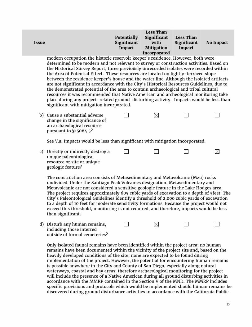
15
Issue Potentially Significant
Impact
Less Than Significant
with Mitigation
Incorporated
Less Than Significant
Impact No Impact
modern occupation the historic reservoir keeper’s residence. However, both were determined to be modern and not relevant to survey or construction activities. Based on the Historical Survey Report; three previously unrecorded isolates were recorded within the Area of Potential Effect. These resources are located on lightly-terraced slope between the residence keeper’s house and the water line. Although the isolated artifacts are not significant in accordance with the City’s Historical Resources Guidelines, due to the demonstrated potential of the area to contain archaeological and tribal cultural resources it was recommended that Native American and archeological monitoring take place during any project-related ground-disturbing activity. Impacts would be less than significant with mitigation incorporated.
b) Cause a substantial adverse change in the significance of an archaeological resource pursuant to §15064.5?
See V.a. Impacts would be less than significant with mitigation incorporated.
c) Directly or indirectly destroy a
unique paleontological resource or site or unique geologic feature?
The construction area consists of Metasedimentary and Metavolcanic (Mzu) rocks undivided. Under the Santiago Peak Volcanics designation, Metasedimentary and Metavolcanic are not considered a sensitive geologic feature in the Lake Hodges area. The project requires approximately 605 cubic yards of excavation to a depth of 5feet. The City’s Paleontological Guidelines identify a threshold of 2,000 cubic yards of excavation to a depth of 10 feet for moderate sensitivity formations. Because the project would not exceed this threshold, monitoring is not required, and therefore, impacts would be less than significant.
d) Disturb any human remains,
including those interred outside of formal cemeteries?
Only isolated faunal remains have been identified within the project area; no human remains have been documented within the vicinity of the project site and, based on the heavily developed conditions of the site; none are expected to be found during implementation of the project. However, the potential for encountering human remains is possible anywhere in the City and County of San Diego, especially along natural waterways, coastal and bay areas; therefore archaeological monitoring for the project will include the presence of a Native American during all ground disturbing activities in accordance with the MMRP contained in the Section V of the MND. The MMRP includes specific provisions and protocols which would be implemented should human remains be discovered during ground disturbance activities in accordance with the California Public

16
Issue Potentially Significant
Impact
Less Than Significant
with Mitigation
Incorporated
Less Than Significant
Impact No Impact
Resources Code and the California Health and Safety Code. This process would include initiating consultation with the state designated Native American MLD, which would reduce the potential for impacts to human remains to be less than significant.
VI. GEOLOGY AND SOILS – Would the project:
a) Expose people or structures to potential substantial adverse effects, including the risk of loss, injury, or death involving:
i) Rupture of a known earthquake fault, as delineated on the most recent Alquist-Priolo Earthquake Fault Zoning Map issued by the State Geologist for the area or based on other substantial evidence of a known fault? Refer to Division of Mines and Geology Special Publication 42.
The City of San Diego Seismic Safety Maps do not indicate a fault in or near the project area. The project would utilize proper engineering design and standard construction practices in order to ensure that potential impacts in this category based on regional geologic hazards would remain less than significant.
ii) Strong seismic ground shaking?
See VI.a.i.
iii) Seismic-related ground failure, including liquefaction?
See VI.a.i.
iv) Landslides?
See VI.a.i.

17
Issue Potentially Significant
Impact
Less Than Significant
with Mitigation
Incorporated
Less Than Significant
Impact No Impact
b) Result in substantial soil erosion or the loss of topsoil?
Erosion control Best Management Practices (BMPs) as outlined in the Biological Assessment and the Contract documents developed for this project would be implemented to make sure no sediment leaves the work areas during construction. In addition, implementation of the Temporary Erosion Control and Planting Plan developed for the project outlines the seeding/planting measures that would be conducted to promote re-growth of native plants, protect soils, and prevent erosion. Impacts would be less than significant.
c) Be located on a geologic unit or soil that is unstable, or that would become unstable as a result of the project, and potentially result in on- or off-site landslide, lateral spreading, subsidence, liquefaction or collapse?
The City of San Diego Seismic Safety Maps indicate the project is located in Hazard Category 52 and 53. The onshore facility is located within Hazard Category 53 which is defined as level or sloping terrain, unfavorable geological structure, low to moderate risk. Even though the onshore portion of the project is located is in an unfavorable geological structure area it is low to moderate risk for the potential to result in on- or off-site landslide, lateral spreading, subsidence, liquefaction or collapse. Furthermore, the project would utilize proper engineering design and standard construction practices in order to ensure that potential impacts in this category based on regional geologic hazards would remain less than significant. The in-water portion of the project is located within Hazard Category 52, which is defined as level areas, gently sloping to steep terrain, favorable geologic structure, and low risk, impacts in this area would be less than significant.
d) Be located on expansive soil, as defined in Table 18-1-B of the Uniform Building Code (1994), creating substantial risks to life or property?
The project is located on San Miguel-Exchequer rocky silt loams, which is not characterized as being expansive. In addition, please see VI.a.i. No impact would result.
e) Have soils incapable of adequately supporting the use of septic tanks or alternative waste water disposal systems where sewers are not available for the disposal of waste water?

18
Issue Potentially Significant
Impact
Less Than Significant
with Mitigation
Incorporated
Less Than Significant
Impact No Impact
The project does not propose any septic tanks or alternative waste disposal methods. No impact would result.
VII. GREENHOUSE GAS EMISSIONS - Would the project:
a) Generate greenhouse gas emissions, either directly or indirectly, that may have a significant impact on the environment?
The City of San Diego is utilizing the California Air Pollution Control Officers Association (CAPCOA) report “CEQA and Climate Change” (CAPCOA 2009) to determine whether a GHG analysis would be required for submitted projects. The CAPCOA report references a 900 metric ton guideline as a conservative threshold for requiring further analysis and possible mitigation. This emission level is based on the amount of vehicle trips, the typical energy and water use associated with projects, and other factors.
Based upon the scope of work, limited temporary construction and limited automobile trips, the project would not generate any substantial Greenhouse Gas (GHG) emissions. Therefore, the emissions would be minimal and would fall under the 900 metric ton screening criteria used by the City to determine if a GHG analysis is required as further identified in the document CEQA & Climate Change (January 2008 by California Air Pollution Control Officers Association (CAPCOA). The project would not cause any significant GHG emissions and no mitigation is required.
b) Conflict with an applicable plan, policy, or regulation adopted for the purpose of reducing the emissions of greenhouse gases?
See VII.a. The project would not conflict with any applicable plans, policies, or regulations related to greenhouse gases. Impacts would be less than significant.
VIII. HAZARDS AND HAZARDOUS MATERIALS – Would the project:
a) Create a significant hazard to the public or the environment through routine transport, use, or disposal of hazardous materials?
The project when completed would not involve the transport, use, or disposal of hazardous materials. During construction all equipment and vehicles would be checked for fluid leaks while working in the project area. Any leaks would be cleaned and any contaminated soils
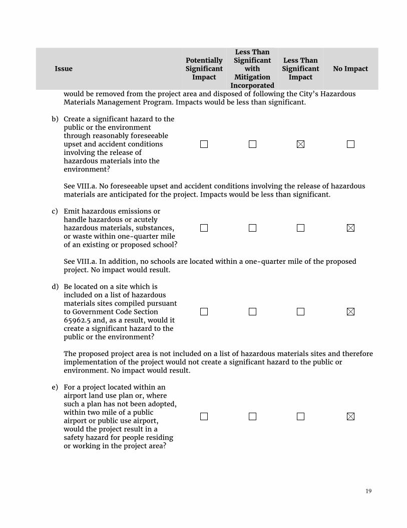
19
Issue Potentially Significant
Impact
Less Than Significant
with Mitigation
Incorporated
Less Than Significant
Impact No Impact
would be removed from the project area and disposed of following the City’s Hazardous Materials Management Program. Impacts would be less than significant.
b) Create a significant hazard to the public or the environment through reasonably foreseeable upset and accident conditions involving the release of hazardous materials into the environment?
See VIII.a. No foreseeable upset and accident conditions involving the release of hazardous materials are anticipated for the project. Impacts would be less than significant.
c) Emit hazardous emissions or handle hazardous or acutely hazardous materials, substances, or waste within one-quarter mile of an existing or proposed school?
See VIII.a. In addition, no schools are located within a one-quarter mile of the proposed project. No impact would result.
d) Be located on a site which is
included on a list of hazardous materials sites compiled pursuant to Government Code Section 65962.5 and, as a result, would it create a significant hazard to the public or the environment?
The proposed project area is not included on a list of hazardous materials sites and therefore implementation of the project would not create a significant hazard to the public or environment. No impact would result.
e) For a project located within an airport land use plan or, where such a plan has not been adopted, within two mile of a public airport or public use airport, would the project result in a safety hazard for people residing or working in the project area?

20
Issue Potentially Significant
Impact
Less Than Significant
with Mitigation
Incorporated
Less Than Significant
Impact No Impact
There is not a public airport or a public use airport within two miles of the project. No impact would result.
f) For a project within the vicinity of a private airstrip, would the project result in a safety hazard for people residing or working in the project area?
The project is not located within the vicinity of a private airstrip. No impact would result.
g) Impair implementation of or physically interfere with an adopted emergency response plan or emergency evacuation plan?
The project would not interfere with any emergency response or evacuation plans. No impact would result.
h) Expose people or structures to a significant risk of loss, injury or death involving wildland fires, including where wildlands are adjacent to urbanized areas or where residences are intermixed with wildlands?
The proposed project will implement Brush Management in accordance with the National Fire Protection Association 55: Compressed Gas and Cryogenic Fluids Code. The proposed project will implement a 50-foot fire buffer per the Minimum Separation Distance Between Bulk Liquid Oxygen System and Exposure Hazards. The fire buffer will consist of a decomposed granite driveway and will not require regular maintenance. Invasive species colonizing the project area could alter the conditions for wildfire. To prevent this, all impacted areas would be revegetated following construction using native species compatible with the surrounding habitat. Monitoring and management of the revegetation areas would occur for 25 months following implementation to ensure survival of the native plants following success criteria identified in the habitat revegetation plan, and to prevent the establishment of non-native invasive species. Impacts would be less than significant.
IX. HYDROLOGY AND WATER QUALITY - Would the project:
a) Violate any water quality standards or waste discharge requirements?

21
Issue Potentially Significant
Impact
Less Than Significant
with Mitigation
Incorporated
Less Than Significant
Impact No Impact
A Water Pollution Control Plan (WPCP) would be prepared as part of the project that outlines storm water BMPs required for the proposed project. Prior to construction, storm water BMPs per the WPCP would be installed to prevent sediment from leaving the work areas. These BMPs would be checked regularly and monitored for efficacy; therefore, the project would not violate any existing water quality standards or discharge requirements while the project is under construction.
b) Substantially deplete groundwater supplies or interfere substantially with groundwater recharge such that there would be a net deficit in aquifer volume or a lowering of the local groundwater table level (e.g., the production rate of pre-existing nearby wells would drop to a level which would not support existing land uses or planned uses for which permits have been granted)?
The project does not propose the use of groundwater nor would it impact groundwater during grading activities. Furthermore, the project would not introduce new impervious surfaces that could interfere with groundwater recharge. Therefore, the project would not deplete groundwater supplies or interfere substantially with groundwater recharge. No impact would result.
c) Substantially alter the existing drainage pattern of the site or area, including through the alteration of the course of a stream or river, in a manner, which would result in substantial erosion or siltation on- or off-site?
Storm water BMPs would be implemented pursuant to the Water Pollution Control Plan that is required for this project to prevent erosion or siltation. The project area would be revegetated and would not substantially alter any existing drainage patterns. The on-shore facility would be constructed within the boundary of an existing concrete foundation. The 50-foot fire buffer would allow for water to penetrate the ground and not alter run-off. The project would be designed to improve the existing drainage of the site, but would not substantially alter the existing pattern. No impact would result.
d) Substantially alter the existing drainage pattern of the site or

22
Issue Potentially Significant
Impact
Less Than Significant
with Mitigation
Incorporated
Less Than Significant
Impact No Impact
area, including through the alteration of the course of a stream or river, or substantially increase the rate or amount of surface runoff in a manner, which would result in flooding on- or off-site? Please see IX.c. and IX.e..
e) Create or contribute runoff water, which would exceed the capacity of existing or planned storm water drainage systems or provide substantial additional sources of polluted runoff?
The on-shore facility would be constructed within the boundary of an existing concrete foundation. The 50-foot fire buffer would allow for water to penetrate the ground and not alter run-off. The project would not create or contribute to runoff water. Impacts would be less than significant.
f) Otherwise substantially degrade
water quality?
See IX.a. through IX.e. No impact would result.
g) Place housing within a 100-year flood hazard area as mapped on a federal Flood Hazard Boundary or Flood Insurance Rate Map or other flood hazard delineation map?
The project does not propose any habitable structures. No impact would result.
h) Place within a 100-year flood hazard area, structures that would impede or redirect flood flows?
The project would replace and existing structure and does not propose any permanent structures within a 100-year flood hazard area that would impede or redirect flood flows. No impact would result.

23
Issue Potentially Significant
Impact
Less Than Significant
with Mitigation
Incorporated
Less Than Significant
Impact No Impact
i) Expose people or structures to a significant risk of loss, injury or death involving flooding, including flooding as a result of the failure of a levee or dam?
See IX.e. The project would not result in the exposure of people or structures to floods as a result of the failure of a levee or dam. The project site is not downstream from either a levee or dam. As such, no impact would occur.
j) Inundation by seiche, tsunami, or mudflow?
The project would not include any new features that would increase the risk associated with seiche, tsunami, or mudflow beyond those of the existing conditions. No impact would result.
X. LAND USE AND PLANNING – Would the project:
a) Physically divide an established community?
The project site is primarily within an existing footprint. The project site is located in an open space and would not physically divide an established community. No impact would result.
b) Conflict with any applicable land use plan, policy, or regulation of an agency with jurisdiction over the project (including but not limited to the general plan, specific plan, local coastal program, or zoning ordinance) adopted for the purpose of avoiding or mitigating an environmental effect?
The on-shore facility will be constructed within an existing disturbed area. Therefore it would not be in conflict with any land use planning document for the community. The project is subject to the City’s environmental regulations through the Site Development Permit process. As such, this Initial Study is being prepared to address all environmental effects for the purpose of avoiding or mitigating those effects. In addition, due to disturbance to a streambed the U.S. Army Corps of Engineers, Regional Water Quality Control Board, and California Department of Fish and Wildlife are involved under the Section 404 and 401 of the Clean Water Act, and Section 1600 of the State Fish and Game Code. The project would not conflict with these regulations. Impacts would be less than significant.

24
Issue Potentially Significant
Impact
Less Than Significant
with Mitigation
Incorporated
Less Than Significant
Impact No Impact
c) Conflict with any applicable
habitat conservation plan or natural community conservation plan?
The proposed project occurs within The Hodges Reservoir/San Pasqual Valley Cornerstone Lands core area. However, all impacts will occur within 300 feet horizontally from the high water level of the water elevation of the spillway and within the existing footprint of the employee residence. These areas are considered to be excluded from the MHPA as a part of the City’s reservoir management program (City of San Diego 1997). Additionally, as specified in the MSCP Subarea Plan, water quality improvement projects, are considered a compatible use within the MHPA. The project would be required to comply with the City’s MSCP/MHPA Land Use Adjacency Guidelines. Implementation of the guidelines ensures that no indirect impacts would result before, during and after construction of the project. Thus, the project would not conflict with any applicable habitat conservation plan or natural community conservation plan. Impacts would therefore be less than significant with mitigation incorporated.
XI. MINERAL RESOURCES – Would the project?
a) Result in the loss of availability of a known mineral resource that would be of value to the region and the residents of the state?
The areas surrounding the project are not being used for the recovery of mineral resources; therefore, the project would not result in the loss of availability of a known mineral resource. No impact would result.
b) Result in the loss of availability of a locally important mineral resource recovery site delineated on a local general plan, specific plan or other land use plan?
The project would not result in the loss of the availability of a locally important mineral resource. There are no existing quarries within close proximity to the site. The project site and the surrounding area are not zoned for mineral resources. As such, project implementation would not result in the loss of availability of a locally important mineral resource. No impact would result.
XII. NOISE – Would the project result in:
a) Exposure of persons to, or generation of, noise levels in

25
Issue Potentially Significant
Impact
Less Than Significant
with Mitigation
Incorporated
Less Than Significant
Impact No Impact
excess of standards established in the local general plan or noise ordinance, or applicable standards of other agencies? The project would not result in a permanent substantial increase in the existing noise environment. No impact would result.
b) Exposure of persons to, or generation of, excessive ground borne vibration or ground borne noise levels?
The project would not generate excessive ground borne vibration or ground borne noise, and therefore, would not result in people being exposed to excessive ground borne vibration or noise levels. No impact would result.
c) A substantial permanent increase in ambient noise levels in the project vicinity above levels existing without the project?
The project would not permanently generate noise, so the noise conditions that exist today would be the same as with the project. No impact would result.
d) A substantial temporary or periodic increase in ambient noise levels in the project vicinity above existing without the project?
A temporary increase in noise would occur from the operation of construction equipment at the project site; however, this is not considered a substantial increase. Monthly deliveries of liquid oxygen would increase noise for approximately 1 to 2 hours per month. The project area is approximately 3,000 feet from the nearest residence. This distance combined with the ambient vehicle noise from Del Dios Highway means the construction noise would not be substantial to the nearby residences. no impact would result.
e) For a project located within an airport land use plan, or, where such a plan has not been adopted, within two miles of a public airport or public use airport would the project expose people residing or working in the area to excessive noise levels?

26
Issue Potentially Significant
Impact
Less Than Significant
with Mitigation
Incorporated
Less Than Significant
Impact No Impact
No public airports or public use airports are within two miles of the project. No impact would result.
f) For a project within the vicinity of a private airstrip, would the project expose people residing or working in the project area to excessive noise levels?
The project is not located within the vicinity of a private airstrip; therefore, people residing or working in the area of the project would not be exposed to excessive airport noise from a private airstrip. No impact would result.
XIII. POPULATION AND HOUSING – Would the project:
a) Induce substantial population growth in an area, either directly (for example, by proposing new homes and businesses) or indirectly (for example, through extension of roads or other infrastructure)?
The project does not propose any residential structures. The project proposes to design and build: oxygen supply facility and foundation, oxygen supply piping and appurtenances, controls, scada system, electrical power, in-lake submersible pump, speece cone, diffuser components, and a driveway capable of supporting 80,000 lbs with adequate turning radius for a 65 foot semi-truck to maneuver in and out of the liquid oxygen (LOX) supply facility. No impact would result.
b) Displace substantial numbers of existing housing, necessitating the construction of replacement housing elsewhere?
Project implementation would not displace any inhabitable housing. Therefore, the construction of housing elsewhere would not be necessitated. No impact would result.
c) Displace substantial numbers of people, necessitating the construction of replacement housing elsewhere?
See XIII.b. No impact would result.
XIV. PUBLIC SERVICES

27
Issue Potentially Significant
Impact
Less Than Significant
with Mitigation
Incorporated
Less Than Significant
Impact No Impact
a) Would the project result in substantial adverse physical impacts associated with the provisions of new or physically altered governmental facilities, need for new or physically altered governmental facilities, the construction of which could cause significant environmental impacts, in order to maintain acceptable service rations, response times or other performance objectives for any of the public services:
i) Fire Protection
The construction of the on-shore facility would incorporate a 50-foot buffer fire protection services. No impact would result.
ii) Police Protection
The construction of the on-shore facility would not require any new or altered police protection services. No impact would result.
iii) Schools The project would not result in the need to physically alter any schools. Additionally, the project would not include construction of future housing or induce growth that could increase demand for schools in the area. No impact would result.
v) Parks The project would not physically alter any parks or create new housing. The project, also, would not create demand for new parks or other recreational facilities. No impact would result.
vi) Other public facilities
The project would not result in the increased demand for gas, or other public facilities. An upgrade to adjacent electrical panel would be conducted. This project includes the The project proposes to design and build: oxygen supply facility and foundation, oxygen supply piping and appurtenances, controls, scada system, electrical power, in-lake submersible pump, speece cone, diffuser components, and a driveway capable of supporting 80,000 lbs with adequate turning radius for a 65 foot semi-truck to

28
Issue Potentially Significant
Impact
Less Than Significant
with Mitigation
Incorporated
Less Than Significant
Impact No Impact
maneuver in and out of the liquid oxygen (LOX) supply facility , and would not impact any other public facilities. No impact would result.
XV. RECREATION –
a) Would the project increase the use of existing neighborhood and regional parks or other recreational facilities such that substantial physical deterioration of the facility would occur or be accelerated?
The project would not result in the construction of residential units and would therefore not result in an increase in demand for recreational facilities. No impact would result.
b) Does the project include recreational facilities or require the construction or expansion of recreational facilities, which might have an adverse physical effect on the environment?
See XV.a. The project would not negatively affect a recreational facility nor require expansion of such facilities. No impact would result.
XVI. TRANSPORTATION/TRAFFIC – Would the project?
a) Conflict with an applicable plan, ordinance or policy establishing measures of effectiveness for the performance of the circulation system, taking into account all modes of transportation including mass transit and non-motorized travel and relevant components of the circulation system, including but not limited to intersections, streets, highways and freeways, pedestrian and bicycle paths, and mass transit?
A temporary increase in traffic would occur from the operation of construction equipment at the project site; however, this is not considered a substantial increase. Monthly deliveries of liquid oxygen would increase traffic for approximately 1 to 2 hours per month.

29
Issue Potentially Significant
Impact
Less Than Significant
with Mitigation
Incorporated
Less Than Significant
Impact No Impact
The project area is approximately 3,000 feet from the nearest residence. The project is also not near any surface streets.
b) Conflict with an applicable congestion management program, including, but not limited to level of service standards and travel demand measures, or other standards established by the county congestion management agency for designated roads or highways?
See XVI.a. A temporary increase in traffic would occur from the operation of construction equipment at the project site; however, this is not considered a substantial increase. Monthly deliveries of liquid oxygen would increase traffic for approximately 1 to 2 hours per month. The project area is approximately 3,000 feet from the nearest residence. Impacts would be less than significant.
c) Result in a change in air traffic patterns, including either an increase in traffic levels or a change in location that results in substantial safety risks?
The project proposes to design and build: oxygen supply facility and foundation, oxygen supply piping and appurtenances, controls, scada system, electrical power, in-lake submersible pump, speece cone, diffuser components, and a driveway capable of supporting 80,000 lbs with adequate turning radius for a 65 foot semi-truck to maneuver in and out of the liquid oxygen (LOX) supply facility. No impact would result.
d) Substantially increase hazards due to a design feature (e.g., sharp curves or dangerous intersections) or incompatible uses (e.g., farm equipment)?
The project proposes to design and build: oxygen supply facility and foundation, oxygen supply piping and appurtenances, controls, scada system, electrical power, in-lake submersible pump, speece cone, diffuser components, and a driveway capable of supporting 80,000 lbs with adequate turning radius for a 65 foot semi-truck to maneuver in and out of the liquid oxygen (LOX) supply facility. No impact would result.
e) Result in inadequate emergency access?
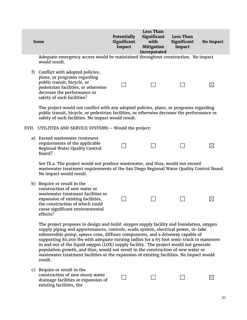
30
Issue Potentially Significant
Impact
Less Than Significant
with Mitigation
Incorporated
Less Than Significant
Impact No Impact
Adequate emergency access would be maintained throughout construction. No impact would result.
f) Conflict with adopted policies, plans, or programs regarding public transit, bicycle, or pedestrian facilities, or otherwise decrease the performance or safety of such facilities?
The project would not conflict with any adopted policies, plans, or programs regarding public transit, bicycle, or pedestrian facilities, or otherwise decrease the performance or safety of such facilities. No impact would result.
XVII. UTILITIES AND SERVICE SYSTEMS – Would the project:
a) Exceed wastewater treatment requirements of the applicable Regional Water Quality Control Board?
See IX.a. The project would not produce wastewater, and thus, would not exceed wastewater treatment requirements of the San Diego Regional Water Quality Control Board. No impact would result.
b) Require or result in the construction of new water or wastewater treatment facilities or expansion of existing facilities, the construction of which could cause significant environmental effects?
The project proposes to design and build: oxygen supply facility and foundation, oxygen supply piping and appurtenances, controls, scada system, electrical power, in-lake submersible pump, speece cone, diffuser components, and a driveway capable of supporting 80,000 lbs with adequate turning radius for a 65 foot semi-truck to maneuver in and out of the liquid oxygen (LOX) supply facility. The project would not generate population growth, and thus, would not result in the construction of new water or wastewater treatment facilities or the expansion of existing facilities. No impact would result.
c) Require or result in the construction of new storm water drainage facilities or expansion of existing facilities, the

31
Issue Potentially Significant
Impact
Less Than Significant
with Mitigation
Incorporated
Less Than Significant
Impact No Impact
construction of which could cause significant environmental effects? See XVII.b. The project would not result in a substantial change to the on-site drainage pattern. Runoff volume generated from the completed project would not be significantly different from the existing runoff volume; and therefore, the project would not require or result in construction of new storm water drainage facilities or the expansion of existing facilities based on a significant increase in run-off volume. No impact would result.
d) Have sufficient water supplies available to serve the project from existing entitlements and resources, or are new or expanded entitlements needed?
The project proposes to design and build: oxygen supply facility to improve water quality of Hodges Reservoir; and therefore, the availability of water is not a factor in the implementation of the project. No impact would result.
e) Result in a determination by the wastewater treatment provider which serves or may serve the project that it has adequate capacity to serve the project’s projected demand in addition to the provider’s existing commitments?
The project proposes to design and build: oxygen supply facility to improve water quality of Hodges Reservoir; and therefore, treatment capacity is not a factor in the implementation of the project. No impact would result.
f) Be served by a landfill with sufficient permitted capacity to accommodate the project’s solid waste disposal needs?
Construction of the project would likely generate minimal waste. This waste would be disposed of in conformance with all applicable local and state regulations pertaining to solid waste including permitting capacity of the landfill serving the project area. Operation of the project would not generate waste and, therefore, would not affect the permitted capacity of the landfill serving the project area. Impacts would be less than significant.
g) Comply with federal, state, and local statutes and regulation related to solid waste?

32
Issue Potentially Significant
Impact
Less Than Significant
with Mitigation
Incorporated
Less Than Significant
Impact No Impact
See XVII.f. Any solid waste generated during construction related activities would be recycled or disposed of in accordance with all applicable local, state and federal regulations. Impacts would be less than significant.
XVIII. MANDATORY FINDINGS OF SIGNIFICANCE –
a) Does the project have the potential to degrade the quality of the environment, substantially reduce the habitat of a fish or wildlife species, cause a fish or wildlife population to drop below self-sustaining levels, threaten to eliminate a plant or animal community, reduce the number or restrict the range of a rare or endangered plant or animal or eliminate important examples of the major periods of California history or prehistory?
The proposed project will directly impact approximately 0.075 acres of upland habitat and 0.100 of disturbed/developed land. According to the City of San Diego’s Significance Determination Guidelines under CEQA, the direct impacts that would occur to 0.075-acre of disturbed Diegan coastal sage scrub habitat are not significant and would not require mitigation because the impact does not exceed the threshold of 0.1-acre. No mitigation is required for Tier IV habitats (disturbed/developed land). A Conceptual Revegetation Plan would be prepared in accordance with the City’s Land Development Code; the Temporary Erosion Control and Planting Plan that is part of the Contract Drawings would be implemented once construction is complete to revegetate the impacted areas. Impacts would be less than significant with mitigation incorporated.
A pair of coastal California gnatcatchers was observed during presence absence surveys conducted between April 13 and May 4, 2015 (Rocks Biological 2015). The pair was initially observed more than approximately 1,500 feet from the proposed project area. During subsequent surveys the male was observed approximately 800 feet west of the proposed project area. All vegetation clearing, ground disturbing, and demolition activities shall be completed outside the bird breeding season - September 16 to January 31 (Breeding Season - February 1 to September 15). For all other construction activities a preconstruction bird nesting survey shall be conducted within 500 feet and no more than 72 hours prior to initiation of construction activities if work occurs during the months of February 1 to September 15. If CAGN are determined to be present; Construction noise monitoring shall be conducted at least twice weekly on varying days, or more frequently depending on the construction activity, to verify that noise levels at the edge of occupied habitat are maintained below 60 dB (A) hourly average or to the ambient noise level if it already exceeds 60 dB (A) hourly average. If not, other measures shall be implemented in

33
Issue Potentially Significant
Impact
Less Than Significant
with Mitigation
Incorporated
Less Than Significant
Impact No Impact
consultation with the biologist and the City, as necessary, to reduce noise levels to below 60 dB(A) hourly average or to the ambient noise level if it already exceeds 60 dB(A) hourly average. Such measures may include, but are not limited to, limitations on the placement of construction equipment and the simultaneous use of equipment. Impacts would be less than significant with mitigation incorporated.
A Cultural Resources Technical Report entitled, “A Historical Survey Report for Lake Hodges Water Quality and Quagga Mitigation Measure Project),San Diego, California” (ATKINS, June 2016) was prepared for the project. The archaeological survey identified faunal isolates within the project APE which were further evaluated and determined not to be human remains. Isolated shell fragments were also identified and determined not significant. Based on the Historical Survey Report these isolate resources were located on lightly-terraced slope between the residence keeper’s house and the water line. Due to the demonstrated potential of the area to have cultural resources it was recommended that Native American and archaeological monitoring be implemented during any project-related ground-disturbing activity. Impacts would be less than significant with mitigation incorporated.
b) Does the project have impacts that are individually limited, but cumulatively considerable? (“Cumulatively considerable” means that the incremental effects of a project are considerable when viewed in connection with the effects of past projects, the effects of other current projects, and the effects of probable futures projects)?
When viewed in connection with the effects of other projects in the area the project may result in minimal dust and GHGs during the construction process; however, these emissions would be relatively minor and would not be cumulatively considerable.
c) Does the project have environmental effects, which will cause substantial adverse effects on human beings, either directly or indirectly?
As stated previously, potentially significant impacts have been identified for Biological and Cultural Resources. The project is consistent with the planning objectives of the community in which it is located. Mitigation has been included in Section V of this MND to reduce impacts to below a level of significance. As such, project implementation would not result in substantial adverse impact to human beings. Impacts would be less than significant with mitigation incorporated.

34
INITIAL STUDY CHECKLIST
REFERENCES
I. AESTHETICS / NEIGHBORHOOD CHARACTER
X City of San Diego General Plan.
Community Plan.
Local Coastal Plan.
X Site Specific Report – Visual Impact Analysis
II. AGRICULTURAL RESOURCES & FOREST RESOURCES
X City of San Diego General Plan.
X U.S. Department of Agriculture, Soil Survey - San Diego Area, California, Part I
and II, 1973.
California Agricultural Land Evaluation and Site Assessment Model (1997)
X Site Specific Report: Visual Impact Analysis June 2016
III . AIR QUALITY
California Clean Air Act Guidelines (Indirect Source Control Programs) 1990.
X Regional Air Quality Strategies (RAQS) - APCD.
Site Specific Report:
IV. BIOLOGY
City of San Diego, Multiple Species Conservation Program (MSCP), Subarea Plan,
1997
City of San Diego, MSCP, "Vegetation Communities with Sensitive Species and
Vernal Pools" Maps, 1996.
X City of San Diego, MSCP, "Multi-Habitat Planning Area" maps, 1997.
Community Plan - Resource Element.
X California Department of Fish and Wildlife, California Natural Diversity Database,
"State and Federally-listed Endangered, Threatened, and Rare Plants of California,"
January 2001.
X California Department of Fish & Wildlife, California Natural Diversity Database,
"State and Federally-listed Endangered and Threatened Animals of California,"
January 2001.
X City of San Diego Land Development Code Biology Guidelines.

35
X Site Specific Report: 45-Day Report for Coastal California Gnatcatcher Surveys at
the Lake Hodges Water Quality and Quagga Mitigation Measures Project, June 12,
2015. Lake Hodges HOS Biological Assessment. July 29, 2016, City of San Diego.
V. CULTURAL RESOURCES (INCLUDES HISTORICAL RESOURCES)
X City of San Diego Historical Resources Guidelines.
X City of San Diego Archaeology Library.
Historical Resources Board List.
Community Historical Survey:
X Site Specific Report: A Historical Survey Report for Lake Hodges Water Quality and
Quagga Mitigation Measure Project, San Diego, California (ATKINS June 2016).
VI. GEOLOGY/SOILS
X City of San Diego Seismic Safety Study.
X U.S. Department of Agriculture Soil Survey - San Diego Area, California, Part I
and II, December 1973 and Part III, 1975.
Site Specific Report:
VII. GREENHOUSE GAS EMISSIONS
Site Specific Report:
VIII. HAZARDS AND HAZARDOUS MATERIALS
X San Diego County Hazardous Materials Environmental Assessment Listing
San Diego County Hazardous Materials Management Division
FAA Determination
State Assessment and Mitigation, Unauthorized Release Listing, Public Use
Authorized.
Site Specific Report:
IX. HYDROLOGY/WATER QUALITY
X Flood Insurance Rate Map (FIRM).
Federal Emergency Management Agency (FEMA), National Flood Insurance
Program - Flood Boundary and Floodway Map.
X Clean Water Act Section 303(b) list, http://www.swrcb.ca.gov/tmdl/303d_lists.html).
X Site Specific Report: Lake Hodges Reservoir Water Quality Assessment Study
36
Final Conceptual Planning Report, Brown and Caldwell (June 2014)
X. LAND USE AND PLANNING
X City of San Diego General Plan.
Airport Land Use Compatibility Plan:
X City of San Diego Zoning Maps
FAA Determination
XI. MINERAL RESOURCES
California Department of Conservation - Division of Mines and Geology, Mineral Land
Classification.
Division of Mines and Geology, Special Report 153 - Significant Resources Maps.
California Geological Survey - SMARA Mineral Land Classification Maps.
Site Specific Report:
XII. NOISE
X Community Plan
San Diego International Airport Master Plan CNEL Maps.
MCAS Miramar ACLUP
Brown Field Airport Master Plan CNEL Maps.
Montgomery Field CNEL Maps.
San Diego Association of Governments - San Diego Regional Average Weekday Traffic
Volumes.
San Diego Metropolitan Area Average Weekday Traffic Volume Maps, SANDAG.
X City of San Diego General Plan.
Site Specific Report:
XIII. PALEONTOLOGICAL RESOURCES
X City of San Diego Paleontological Guidelines.
Deméré, Thomas A., and Stephen L. Walsh, "Paleontological Resources City of San
Diego," Department of Paleontology San Diego Natural History Museum, 1996.
X Kennedy, Michael P., and Gary L. Peterson, "Geology of the San Diego Metropolitan
Area, California. Del Mar, La Jolla, Point Loma, La Mesa, Poway, and SW 1/4
Escondido 7 1/2 Minute Quadrangles," California Division of Mines and Geology
Bulletin 200, Sacramento, 1975.

37
Kennedy, Michael P., and Siang S. Tan, "Geology of National City, Imperial Beach and
Otay Mesa Quadrangles, Southern San Diego Metropolitan Area, California," Map
Sheet 29, 1977.
Site Specific Report:
XIV. POPULATION / HOUSING
X City of San Diego General Plan.
Community Plan.
Series 11 Population Forecasts, SANDAG.
Other:
XV. PUBLIC SERVICES
X City of San Diego General Plan.
Community Plan.
XVI. RECREATIONAL RESOURCES
X City of San Diego General Plan.
X Community Plan.
Department of Park and Recreation
City of San Diego - San Diego Regional Bicycling Map
Additional Resources:
XVII. TRANSPORTATION / CIRCULATION
X City of San Diego General Plan.
X Community Plan.
San Diego Metropolitan Area Average Weekday Traffic Volume Maps, SANDAG.
San Diego Region Weekday Traffic Volumes, SANDAG.
Site Specific Report:
XVIII. UTILITIES
X City of San Diego General Plan.
X Community Plan.
Site Specific Report:

38
XIX. WATER CONSERVATION
City of San Diego General Plan.
Community Plan.
Sunset Magazine, New Western Garden Book. Rev. ed. Menlo Park, CA: Sunset
Magazine.
Site Specific Report: