planning proposal - klep 2013 amendment no. 23 - rezoning ... · preparation of the kempsey bypass...
TRANSCRIPT

Kempsey Shire Council | Planning ProposalKLEP2013-AM-23 i
Planning Proposal
KLEP 2013 Amendment No 23
Rezoning Land – Various Lots
Great North Road; Flanagan Street and Yarrabandinni Road
Frederickton
(issue: 180806_amended_R1)
Kempsey Shire Council 22 Tozer Street West Kempsey 2440

Kempsey Shire Council | Planning ProposalKLEP2013-AM-23 i
Document Control
Document Title
KLEP2013 AM 23 -Planning Proposal Various Lots Frederickton
Issue
Date Author
Note
171120_Draft_Gateway_Council_Report – November 2017
BP For review
180327_Final_Draft_Gateway_Council_Report -March 2018 BP Amended maps
180806_Amended_R1 August 2018 BP PP area amended

Contents
1. PART 1 – OBJECTIVES OR INTENDED OUTCOMES ......................................................................................... 4
1.1 INTRODUCTION ..................................................................................................................................... 4
1.2 Objectives and Aims ................................................................................................................................ 4
1.3 Land to which the planning proposal applies ........................................................................................... 5
1.4 Site context and setting ............................................................................................................................ 6
2. PART 2 – EXPLANATION OF PROVISIONS ........................................................................................................ 7
2.1 Existing Planning Controls ....................................................................................................................... 7
2.2 Proposed Planning Provisions ................................................................................................................. 9
3. PART 3 – JUSTIFICATION .................................................................................................................................. 12
3.1 Section A – Need for the Planning Proposal .......................................................................................... 12
3.1.1 Is the planning proposal a result of any strategic study or report? ....................................... 12
3.1.2 Is the planning proposal the best means of achieving the objectives or intended outcomes,
or is there a better way? ....................................................................................................... 12
3.1.3 Is there a net community benefit? ........................................................................................ 12
3.2 Section B Relationship to strategic planning framework ........................................................................ 12
3.2.1 Is the planning proposal consistent with the objectives and actions contained within the
applicable regional or sub-regional strategy? ....................................................................... 12
3.2.2 Is the planning proposal consistent with the local council’s Community Strategic Plan or
other local strategic plan? .................................................................................................... 13
3.2.3 Is the planning proposal consistent with applicable State Environmental Planning Policies?
............................................................................................................................................. 13
3.2.4 Is the planning proposal consistent with applicable Ministerial Directions (S 117 directions)?
............................................................................................................................................. 13
3.3 Section C – Environmental, Social and Economic Impact ..................................................................... 14
3.3.1 Is there any likelihood that critical habitat or threatened species, populations or ecological
communities, or their habitats, will be adversely affected as a result of the proposal? ........ 14
3.3.2 Are there any other likely environmental effects as a result of the planning proposal and how
are they proposed to be managed? ..................................................................................... 14
3.3.3 How has the planning proposal adequately addressed any social and economic effects? .. 16
3.4 Section D – State and Commonwealth interests.................................................................................... 17
3.4.2 Is there adequate public infrastructure for the planning proposal? ...................................... 17
3.4.3 What are the views of State and Commonwealth public authorities consulted in accordance
with the gateway determination? .......................................................................................... 17
5. PART 4 - COMMUNITY CONSULTATION .......................................................................................................... 18
6. PART 5 – PROJECT TIMELINE .......................................................................................................................... 19

Appendices
Appendix A - Consistency with State Environmental Planning Policies
Appendix B - Consistency with Section 117 Directions

1. PART 1 – OBJECTIVES OR INTENDED OUTCOMES
1.1 INTRODUCTION This planning proposal is a response to the Frederickton Planning Review undertaken during 2015 and 2016. The Frederickton Planning Review (FPR) was prompted in large part through the deviation of the Pacific Highway in 2013 that bypassed South Kempsey, Kempsey town centre and Frederickton. In order to alleviate any negative impacts associated with the bypass, Kempsey shire Council undertook the preparation of the Kempsey Bypass Strategy in 2010 with the objective of positioning Kempsey, south Kempsey and Frederickton in a position to maximise the potential benefits associated with the highway bypass. The Bypass Strategy called up a series of actions to be undertaken and included:
I. Land use strategy for Frederickton to identify opportunities on land in close proximity to (the) Pacific Highway interchange, and
II. Review of Development Control plans in five identified precincts along the affected corridor, including Frederickton
The Frederickton Planning Review commenced in September 2015 with a brief to undertake the reappraisal of land use zonings within a study area bounded, approximately, by properties addressing Raymonds Lane in the north; the M1 Pacific Highway to the east; the Macleay River and Easter Creek to the South; and the North Coast Rail line to the west. The FPR provided an opportunity to assess the feasibility of any future rezoning of land for employment, rural residential and general residential, subject to further detailed investigations, using a master planning approach to develop broad planning imperatives. Through a series of local consultation meetings a general agreement was reached among the local community for Council to undertake further investigations into the viability of:
• The rezoning of land for rural residential purpose in the vicinity of Raymonds Lane
• The rezoning of land for industrial purposes in the vicinity of Quarry Road, Frederickton, and
• The rezoning of land for general residential purposes in the vicinity of Great north Road and Yarrabandini Road Frederickton
The FPR was then placed on public exhibition and reported to Council in early 2016 where it was resolved to progress with further investigations. Subsequently a comprehensive fauna and flora study was undertaken over the investigations area and a noise and odour study to assess the impacts of Eversons Meats abattoir; the Pacific Hwy and the Frederickton Sewerage Treatment Plant on any rezoning. These two (2) studies identified significant environmental constraints over areas identified for possible rezoning. As a result, this planning proposal is limited to an area identified in Figure 1., which has been identified as being relatively unconstrained by environmental, social or cultural constraints.
1.2 Objectives and Aims
The objectives of this planning proposal are:
• To make provision for additional residential housing opportunities through the creation of a new R1 General Residential release in Frederickton
• To increase the residential population of Frederickton to assist in the longer term sustainability of existing services and businesses,
• To assist in expanding the social and cultural demographic of Frederickton by providing affordable housing in close proximity to the Pacific Motorway, and
• To make the most environmental and cost effective use of existing water and sewer infrastructure assets

Kempsey Shire Council Planning Proposal – KLEP2013-AM-23 5
1.3 Land to which the planning proposal applies
Fig 1 – Land to which this planning proposal applies Land to which this planning proposal applies is described at Figure 1 and further at Table 1 Schedule of lands to which this planning proposal applies
Lot / Deposited Plan Address KLEP Land use Zone
228DP752437 YARRABANDINNI RD 867 RU1
227DP752437 YARRABANDINNI RD RU1
1DP857721 YARRABANDINNI RD 573 RU1
7844 ROAD RU1
7845 ROAD RU1
3114 CROWN RU1
1980 CROWN RU1
1967 CROWN RU1
4DP657556 FLANAGAN ST RU5
4DP748840 FLANAGAN ST RU5
2DP545586 GREAT NORTH RD 37 RU5
3DP545586 GREAT NORTH RD 39 RU5
4DP418001 GREAT NORTH RD 41 RU5
3DP748840 GREAT NORTH RD 43 RU5
2DP748840 GREAT NORTH RD 45 RU5
1DP748840 GREAT NORTH RD 47 RU5
3746 FLANAGAN ST RU2,RU5
1DP657659 GREAT NORTH RD 49-63 RU2
Table 1 Schedule of lands to which this planning proposal applies

Kempsey Shire Council Planning Proposal – KLEP2013-AM-23 6
1.4 Site context and setting
The subject land lies directly to the north of the Frederickton village and is bounded by Great North Road on the southern boundary and Yarrabandini Road to the east. The northern boundary of the land falls away to Collombatti Creek, while the western boundary abuts an unnamed Crown road. The subject land is currently covered by the following KLEP 2013 land use zones RU1 Primary Production; RU2 Rural Landscape, and RU5 Village; The land is currently used for a variety of purposes including residential housing, recreation (playing fields) and agricultural uses. Approximately 1,500 sq.m of the subject land/s are affected by the 1% AEP flood event through inundation. This proposal seeks to convert all the subject RU1 Primary Production; RU2 Rural Landscape, and RU5 Village land above the 1%AEP contour to R1 General Residential.

Kempsey Shire Council Planning Proposal – KLEP2013-AM-23 7
2. PART 2 – EXPLANATION OF PROVISIONS
2.1 Existing Planning Controls
The existing zoning of the land is part RU1 Primary Production, part RU2 Rural Landscape and part RU5 Village under Kempsey Local Environment Plan 2013 as indicated at Map 1 below Map 1 Existing Land Use Zones
RU1
RU2
RU5

Kempsey Shire Council Planning Proposal – KLEP2013-AM-23 8
Map 2 Existing Minimum Lot Size
Map 3 Existing Height of Buildings
Kempsey Shire Council Planning Proposal – KLEP2013-AM-23 9
2.2 Proposed Planning Provisions It is proposed to amend the Kempsey local Environment Plan 2013 (KLEP2013) Land Zoning map as it applies to land
subject to this planning proposal as shown in Map 1.
The planning proposal aims to introduce a minimum lot size of 500 square metres in the R1 General Residential zone.
Taking into account the adjacent RU5 zone and heritage items, Frederickton Cemetery and Frederickton Public
School, it is intended to limit the Maximum Building Height across the R1 zone to 8.5m.
It is proposed to amend the Minimum Lot Size Map and Height of Building Map to correspond with the R1 General
Residential zone as shown on the following maps.
The R1 general Residential zone is expressed in KLEP2013 as:
Zone R1 General Residential 1 Objectives of zone
• To provide for the housing needs of the community. • To provide for a variety of housing types and densities.
• To enable other land uses that provide facilities or services to meet the day to day needs of the residents
• To encourage urban infill and redevelopment in areas that surround existing or proposed facilities and services
2 Permitted without consent Environmental protection works; Home-based child care; Home occupations 3 Permitted with consent Attached dwellings; Boarding houses; Child care centres; Community facilities; Dwelling houses; Group homes; Home industries; Hostels; Multi dwelling housing; Neighbourhood shops; Places of public worship; Residential flat buildings; Respite day care centres; Roads; Semi-detached dwellings; Seniors housing; Shop top housing; Any other development not specified in item 2 or 4 4 Prohibited Agriculture; Air transport facilities; Airstrips; Amusement centres; Animal boarding or training establishments; Backpackers’ accommodation; Biosolids treatment facilities; Boat building and repair facilities; Camping grounds; Car parks; Caravan parks; Cemeteries; Commercial premises; Correctional centres; Crematoria; Depots; Eco-tourist facilities; Entertainment facilities; Extractive industries; Farm buildings; Farm stay accommodation; Forestry; Freight transport facilities; Function centres; Heavy industrial storage establishments; Helipads; Highway service centres; Industrial retail outlets; Industrial training facilities; Industries; Information and education facilities; Mortuaries; Passenger transport facilities; Public administration buildings; Recreation facilities (indoor); Recreation facilities (major); Recreation facilities (outdoor); Registered clubs; Restricted premises; Rural industries; Rural workers’ dwellings; Service stations; Sewage treatment plants; Sex services premises; Storage premises; Transport depots; Truck depots; Vehicle body repair workshops; Vehicle repair stations; Veterinary hospitals; Warehouse or distribution centres; Waste or resource management facilities; Wholesale supplies The proposed zone amendments and corresponding maps follow

Kempsey Shire Council Planning Proposal – KLEP2013-AM-23 10
Map 4 Proposed Land Zoning (LZN)
Map 5 Proposed Minimum Lot Size (LSZ)

Kempsey Shire Council Planning Proposal – KLEP2013-AM-23 11
Map 6 Proposed Height of Buildings (HOB)

Kempsey Shire Council Planning Proposal – KLEP2013-AM-23 12
3. PART 3 – JUSTIFICATION
3.1 Section A – Need for the Planning Proposal 3.1.1 Is the planning proposal a result of any strategic study or report?
Yes. The planning proposal is the result of the Frederickton Planning Review undertaken in 2015 which aimed to provide a
master planning framework for the investigation possible variations to existing land use.
The Frederickton Planning Review was endorsed by Council on 15 December 2015.
The planning review itself was the product of the Kempsey Bypass Strategy adopted by Council in 2011. The Bypass
Strategy sought to investigate the existing land use strategies in Frederickton and emerging opportunities on land in close
proximity to the Pacific Highway M1/A1 interchange
3.1.2 Is the planning proposal the best means of achieving the objectives or intended outcomes, or is there a better way?
To provide for additional housing opportunities in Frederickton village, a residential zoning is necessary. Consideration has
been given to whether this should be through a R1-General residential zoning or continuation of the RU5 Village zoning.
Ultimately, an R1 - General Residential zoning is preferred as it will provide a clear delineation, in planning terms, between
the “old” Frederickton village and the “new” residential area.
3.1.3 Is there a net community benefit?
Yes. The subject land provides an opportunity to release new land for residential housing purposes in an area with existing
infrastructure capacity to provide water and sewer. The land is above the 1% AEP flood contour and is largely cleared of
vegetation having been used for agricultural purposes for some generations. Given the site characteristics the following net
benefits to the community are likely to be supported by this proposal.
• Development of new residential housing on desirable, moderately sloping land in close proximity to existing
infrastructure and services
• There is little in the way of available green-field housing land close to the Pacific Highway. A release of this nature
can stimulate new housing opportunities for residents working outside the Shire with reduced travel times to Port
Macquarie, Macksville and Coffs Harbour.
• Opportunities to implement water sensitive urban design principles to moderate volume, and to polish discharge,
of stormwater in order to improve protection of the Collombatti Creek riparian system and Swamp Sclerophyll
Forest Endangered Ecological Community
• New residential housing opportunities are likely to be sought after by first home buyers and families with younger
children given the subject lands close proximity to Frederickton Public School. This in turn provides the school
with continued sustainable enrolments.
3.2 Section B Relationship to strategic planning framework
3.2.1 Is the planning proposal consistent with the objectives and actions contained within the applicable regional or sub-regional strategy?
Yes.
The planning proposal is consistent with the aims and objectives of the North Coast Regional Plan 2036. The
planning proposal meets the criteria outlined in the following Goals and Directions
• Goal 3: Vibrant and engaged communities, and
• Goal 4: Great housing choice and lifestyle options.

Kempsey Shire Council Planning Proposal – KLEP2013-AM-23 13
Creating a new R1 residential precinct will assist in growing the population within an existing community. Existing community
and social infrastructure, such as the public school and golf club, will benefit from the increased population growth.
The proposal offers the opportunity for developers to investigate a mix of housing options suitable for the location and
context of the existing community
Further, the proposal accords with
• Direction 14: Provide great places to live and work and
• Direction 15: Develop healthy, safe, socially engaged and well connected communities
The planning proposal offers the chance to live and work within an established community, or to commute to the regional
city of Port Macquarie, approximately 40 minutes travel by car. Close proximity to the M1/A1 Pacific Highway provides easy
access to destinations north and south of Frederickton.
The release of new residential land provides Council with the opportunity to develop detailed guidelines for the provision of
services and infrastructure, including the expansion of the national broadband Network (NBN) into the community
The planning proposal is consistent with Council’s “Local Growth Management Strategy - Residential Component”
(2010). The planning proposal includes part of the lands identified previously in the “Mid North Coast Regional Strategy” as
FUIA2.
3.2.2 Is the planning proposal consistent with the local council’s Community Strategic Plan or other local strategic plan?
The planning proposal is consistent with Macleay Valley 2036 Community Strategic Plan (2017)).
The following strategies are consistent with the planning proposal:
• Use planning controls to ensure that environmental impacts do not negatively affect lifestyle
The planning proposal is consistent with the “Kempsey Bypass Strategy” (2011).
The following strategies are consistent with the planning proposal:
• Action 10(a): Land Use Strategy Frederickton and South Kempsey - Investigate opportunities on land in
close proximity to the (Pacific Highwau) interchanges
3.2.3 Is the planning proposal consistent with applicable State Environmental Planning Policies?
The planning proposal is consistent with all applicable State Environmental Planning Policies (SEPPs). Comments are provided in Appendix A in regards to each SEPP. 3.2.4 Is the planning proposal consistent with applicable Ministerial Directions (S 117 directions)?
Yes. An evaluation of the consistency of the planning proposal in relation to the s117 directions is provided in Appendix B

Kempsey Shire Council Planning Proposal – KLEP2013-AM-23 14
3.3 Section C – Environmental, Social and Economic Impact
3.3.1 Is there any likelihood that critical habitat or threatened species, populations or ecological communities, or their habitats, will be adversely affected as a result of the proposal?
Careful consideration has been given in regard to the identification and protection of threatened species and endangered
ecological communities likely to be affected by the proposal.
The proposal lies wholly within the catchment of Collombatti Creek. Two (2) non-permanent watercourses lie partly within
the R1 rezoning area and drain to Collombatti Creek.
The planning proposal area was subject to a detailed flora and fauna assessment in 2015 – 2016 undertaken by Dr Anna
McConville (Echo Ecology PL). This study, Frederickton Flora and Fauna Assessment (McConville 2016), was the result of
detailed investigations carried out over an expanded study area, which included the planning proposal area. The study
identified the presence of Swamp Sclerophyll Forest EEC along a section of Collombatti Creek below and to the north west
of the planning proposal area. A small section of this EEC is present within the planning proposal R1 area. These are shown
at Map 7
The study recommended the adoption of a buffer for the Swamp Sclerophyll Forest EEC and for the riparian zone
associated with Collombatti Creek. As a result it is envisaged that further discussions will take place with the Office of
environment and Heriatge during the consultation stage of this proposal. These discussions will assist in framing the design
guidelines for the protection and ongoing conservation management of the EEC.
No threatened species were located within the planning proposal area.
3.3.2 Are there any other likely environmental effects as a result of the planning proposal and how are they proposed to be managed?
The proposed residential area has been determined following a number of investigations relating to the various site
constraints. This included flora and fauna, flooding, odour and noise. The area proposed to be rezoned to residential
has largely been determined by these environmental constraints.
Flora and Fauna
The proposed residential area avoids the Swamp Sclerophyll Forest EEC identified in the flora and fauna
investigations undertaken.
The impact most likely to adversely affect the EEC is urban runoff. To alleviate impacts associated with urban runoff it
is considered that implementation of water sensitive urban design practices would be required prior to progressing to
subdivision approval, and include incorporation of the EEC and riparian buffer zones into a detailed stormwater
management strategy for the site.

Kempsey Shire Council Planning Proposal – KLEP2013-AM-23 15
Map 7 Endangered Ecological Community (EEC) including buffer and riparian buffer in relation to planning proposal
area
Flooding
Map 8. Extent of 1% AEP Flood Inundation
The 1% AEP flood inundation contour has largely determined the extent of the proposed residential land at the
northern end of the subject site.
LEGEND 1. EXTENT OF 1% AEP
FLOOD INUNDATION
1
LEGEND
1. 1% AEP FLOOD INUNDATION

Kempsey Shire Council Planning Proposal – KLEP2013-AM-23 16
Odour
Map 9. Everson Meat Processing Facility Frederickton – 99th Percentile (1 Second) Average Odour Concentration on the
Proposed Re-Zoning Areas (Criterion: 2.0 OU)
The objective of the Odour Assessment (Appendix F) was to determine the magnitude and extent of odour impacts
from the existing Eversons Meat Processing Facility and the Frederickton Sewerage Treatment plant on the area to be
rezoned.
Noise
The Noise Impact Study (Appendix G) investigated potential noise impacts from the Eversons Meat Processing
Facility, the Frederickton Sewerage Treatment plant and the Pacific Motorway.
The study found that noise from Eversons and the Sewerage Treatment Plant had no impact on the proposed
residential area.
In terms of noise from the Pacific motorway, the study found that the proposed residential land would largely comply
with the ‘open window’ scenario in accordance with Clause 102 of the Infrastructure SEPP. A small area at the very
northern tip of the proposed residential area would be within the highway ‘buffer zone’ which would mean that
measures may need to be adopted to meet the relevant LAeq levels for particular developments in this area.
Aboriginal Heritage
The land has been investigated for evidence of shared cultural heritage items and consultation undertaken with the
Local aboriginal land Council regarding the significance of landscape and place. While no items of significance to local
Aboriginal people were located, recommendations contained in the report concerning site earthworks and construction
practices will be implemented.
The Cultural Heritage Impact Assessment is attached at Appendix D.

Kempsey Shire Council Planning Proposal – KLEP2013-AM-23 17
Bushfire
A Bushfire Hazard Assessment was undertaken for the proposed rezoning. The assessment concluded that the
bushfire risk is manageable and consistent with the acceptable bushfire protection measure solutions.
Further consultation will be undertaken with the NSW Rural Fire Service regarding design guidelines for the site during
the consultation phase of the proposal as recommended in the Bushfire Hazard assessment, Appendix E.
3.3.3 How has the planning proposal adequately addressed any social and economic effects?
The planning proposal considers the rezoning will have an overall beneficial effect on the community in terms of the
social, cultural and economic effect. The Frederickton Planning review undertook extensive consultation with the local
community and sought opinions on possible rezoning options. The feedback received supported the rezoning of the
land, subject to further investigations, for residential purposes.
Existing Land Uses - Employment
Investigations undertaken for the proposal considered the impact of noise and odour on the subject land from
Eversons Meat Processing Facility a major employer in Frederickton. While it is imperative from an environmental
health position to locate new residential housing outside of the 99th Percentile (1 Second) Average Odour Concentration
contour, by doing so it also reduces the likelihood of conflict between new residents and existing legitimate industry in the
area by the provision of a buffer zone between the two land uses.
Increased Local Economic Activity
An Economic Study has not been undertaken for this planning proposal. However the site is likely to provide a residential lot
yield over the life of a release upwards of between150 and 180 lots, leading to a likely increased population of 430 persons.
Increased activity in the local building trades is likely to flow from the planning proposal, providing contractors and material
suppliers with increased business. Local businesses are likely to benefit from greater building activity and the resultant
longer term increase in population leading to increased local demand for services
Social and Cultural Effects
Frederickton Public School will benefit from increased population in the area with opportunities provided by the rezoning for
affordable residential land to be made available, suitable for first home buyers and families. Increased population is likely to
benefit local sporting and community groups.
3.4 Section D – State and Commonwealth interests
3.4.1 Is there adequate public infrastructure for the planning proposal?
Yes. Water and sewer infrastructure is available
3.4.2 What are the views of State and Commonwealth public authorities consulted in accordance with the gateway determination?
This section is to be completed following consultation with the State and Commonwealth authorities should the Director General determine to proceed with the Planning Proposal and identifies which authorities are to be consulted with

Kempsey Shire Council Planning Proposal – KLEP2013-AM-23 18
PART 4 - COMMUNITY CONSULTATION As part of the planning proposal a Cultural Heritage Impact Assessment was prepared by Remnant Archaeology PL. Two local Aboriginal organisations were consulted regarding the proposed rezoning. Should the Minister for Planning issue a favourable Gateway determination, the next step will include undertaking community consultation in accordance with the conditions of the Gateway determination and Council’s Rezoning Policy and procedure 1.1.9. Part of this process will be to consult with the relevant Government authorities. Public exhibition of the Planning Proposal would include notification on the Kempsey Shire Council website, Department of Planning and Environment website, notice in the newspapers that circulate in the LGA. Information relating to the Planning Proposal would also be displayed at Kempsey Shire Council Customer Service Centre located on Tozer Street, West Kempsey and Libraries within the Shire.
Kempsey Shire Council Planning Proposal – KLEP2013-AM-23 19
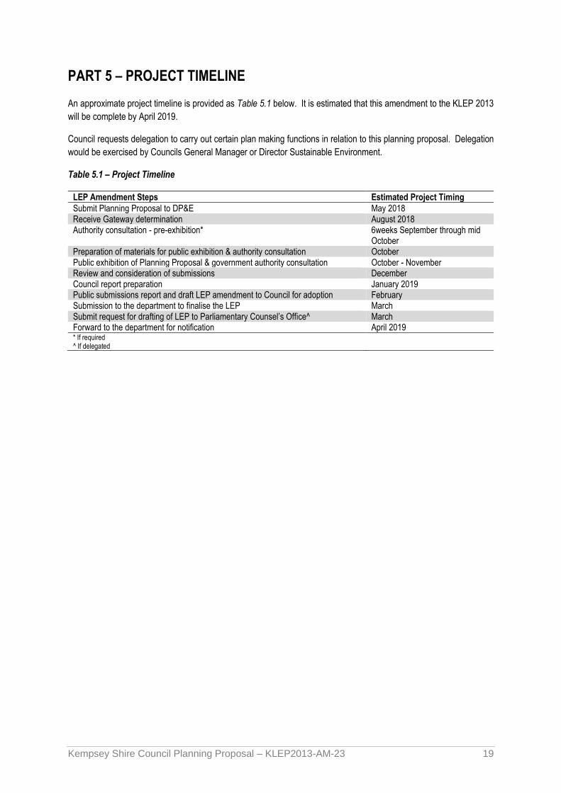
PART 5 – PROJECT TIMELINE
An approximate project timeline is provided as Table 5.1 below. It is estimated that this amendment to the KLEP 2013
will be complete by April 2019.
Council requests delegation to carry out certain plan making functions in relation to this planning proposal. Delegation
would be exercised by Councils General Manager or Director Sustainable Environment.
Table 5.1 – Project Timeline
LEP Amendment Steps Estimated Project Timing
Submit Planning Proposal to DP&E May 2018 Receive Gateway determination August 2018 Authority consultation - pre-exhibition* 6weeks September through mid
October Preparation of materials for public exhibition & authority consultation October Public exhibition of Planning Proposal & government authority consultation October - November Review and consideration of submissions December Council report preparation January 2019 Public submissions report and draft LEP amendment to Council for adoption February Submission to the department to finalise the LEP March Submit request for drafting of LEP to Parliamentary Counsel’s Office^ March Forward to the department for notification April 2019 * If required ^ If delegated

Kempsey Shire Council Planning Proposal – KLEP2013-AM-23 20
Appendix A
Consistency with State Environmental Planning Policies

Kempsey Shire Council Planning Proposal – KLEP2013-AM-23 21
No. SEPP Title Summary Consistency - (consistent/inconsistent/not applicable)) (include a brief discussion on the more relevant points)
14 Coastal Wetlands Seeks to ensure the State’s coastal wetlands are preserved and protected.
Not Applicable
21 Caravan Parks Seeks to facilitate the proper management and development of land used for caravan parks catering to the provision of accommodation to short and long term residents.
Not Applicable
26 Littoral Rainforests Seeks to protect littoral rainforests from development.
Not Applicable
30 Intensive Agriculture Requires development consent and additional requirements for cattle feedlots and piggeries.
Not Applicable
33 Hazardous and Offensive
Development
Seeks to provide additional support and requirements for hazardous and offensive development
Not Applicable
36 Manufactured Home Estates Seeks to facilitate the establishment of manufactured home estates as a contemporary form of residential housing.
Not Applicable
44 Koala Habitat Protection Seeks to encourage proper conservation and management of areas of natural vegetation that provide habitat for koalas
Not Applicable
50 Canal Estate Development Prohibits canal estate development Not Applicable
55 Remediation of Land Provides a State-wide planning approach for the remediation of contaminated land.
Consistent
In consideration of Cl.(4) (c) (i) Contaminated land Planning Guidelines, the subject land has been used for agricultural purposes including livestock grazing and an orchard. Council does not have any knowledge of any other activities or of historical activities that would require further investigations at this time.
62 Sustainable Aquaculture Seeks to encourage and regulate sustainable aquaculture development
Not applicable

Kempsey Shire Council Planning Proposal – KLEP2013-AM-23 22
64 Advertising and Signage Seeks to regulate signage (but not content) and ensure signage is compatible with desired amenity and visual character of the area.
Not Applicable
65 Design Quality of Residential Flat Development
Seeks to improve the design qualities of residential flat building development in New South Wales.
Not Applicable
71 Coastal Protection Seeks to protect and manage the natural, cultural, recreational and economic attributes of the New South Wales coast.
Not applicable
Affordable Rental Housing To provide a consistent planning regime for the provision of affordable rental housing and facilitate the effective delivery of affordable housing
Consistent. The proposed zones under the planning proposal are subject to the provisions of the Affordable Rental Housing SEPP and applications under that SEPP are not restricted by the Planning Proposal. Residential Accommodation, including dual occupancies, multi dwelling housing or residential flat buildings are permissible in the residential zone proposed
Building Sustainability Index:
BASIX 2004
The aim of this Policy is to ensure consistency in the implementation of the BASIX scheme throughout the State
Not Applicable
Exempt and Complying Development Codes 2008
Seeks to provide streamlined assessment process for development that complies with specified development standards.
Consistent. The planning proposal does not alter the application of this SEPP in the precinct. The provisions of the SEPP are available under the R1 General Residential zone
Housing for Seniors or People with a Disability 2004
Seeks to encourage the provision of housing to meet the needs of seniors or people with a disability.
Consistent. The planning proposal specifically includes housing for Seniors or People with a Disability in the list of permissible uses.
Infrastructure 2007 The aim of this policy is to facilitate the effective delivery of infrastructure across the State. Specifies exempt and complying development controls to apply to the range of development types listed in the SEPP.
Consistent. The Noise Impact Assessment (Appendix G) investigated potential noise impacts from the Pacific Motorway and found the proposed residential land would with the ‘open window’ scenario in accordance with Clause 102 of the Infrastructure SEPP. A small area at the very northern tip of the proposed residential area would be within the highway ‘buffer zone’ which would mean that measures may need to be adopted to meet the relevant LAeq levels for particular developments in this area.
Major Development 2005 Aims to facilitate the development or protection of important urban, coastal and regional sites of economic, environmental or social significance to the State. Also to
Not Applicable

Kempsey Shire Council Planning Proposal – KLEP2013-AM-23 23
facilitate service delivery outcomes for a range of public services.
Mining, Petroleum and Extractive Industries 2007
Seeks to provide for the proper management and development of mineral, petroleum and extractive material resources
Not Applicable
Rural Lands 2008 Seeks to facilitate the orderly and economic use and development of rural lands for rural and related purposes
Not inconsistent.
Consideration is given to C 1.7 in this proposal. The subject land is fragmented in to small lots with limited opportunity for commercial land uses, and in close proximity to the existing residential area of Frederickton. This proposal will assist in improving the social, economic and environmental interests of the community.
In consideration of C1.8 the subject land offers limited agricultural opportunities under the current zoning and the proposal would not impact on the supply of suitable agricultural land in the area.
State and Regional Development 2011
Aims to identify State significant development and State significant infrastructure. Also to confer functions on joint regional planning panels to determine development applications.
Not Applicable

Kempsey Shire Council Planning Proposal – KLEP2013-AM-23 24
Appendix B
Consistency with Section 117 Directions

Kempsey Shire Council Planning Proposal – KLEP2013-AM-23 25
Direction Objectives Application Consistency
1. Employment and Resources
1.1 Business and Industrial Zones
Issued 1 July 2009
• To encourage employment growth in suitable locations
• To protect employment land in business and industrial zones, and support the viability of identified strategic centres.
Applies when a planning proposal is prepared that affects land within an existing or proposed business or industrial zone (includes alteration of boundary of any existing business or industrial zone)
N/A
1.2 Rural Zones
Issued 1 July 2009
• To protect the agricultural production value of rural land.
Applies when a planning proposal is prepared that affects land within an existing or proposal rural zone (includes alteration of any existing rural zone boundary)
Justified The objectives of the Direction have been considered. The subject rural zoned land is held over a number of different owners. The lots are relatively small and given that consolidation of the lots into a viable productive whole is remote, its considered that the location of the land in close proximity to the Frederickton urban area would provide a greater benefit to the community through its use for residential housing.
1.3 Mining, Petroleum Production and Extractive Industries
Issued 1 July 2009
• To ensure that the future extraction of State or regionally significant reserves of coal, other minerals, petroleum and extractive materials are not compromised by inappropriate development.
Applies when planning proposal is prepared that would prohibit or restrict the mining or potential development of coal, other minerals, petroleum production or obtaining extractive minerals of State or regional significance permitting incompatible land use.
N/A

Kempsey Shire Council Planning Proposal – KLEP2013-AM-23 26
1.4 Oyster Aquaculture
Issued 1 July 2009
• To protect Priority Oyster Aquaculture Areas and oyster aquaculture outside such an area from land uses that may result in adverse impacts on water quality and consequently, on the health of oysters and oyster consumers.
Applies to Priority Oyster Aquaculture Areas as identified in the NSW Oyster Industry Sustainable Aquaculture Strategy (2006)
N/A
1.5 Rural Lands
Issued 1 July 2009
• To protect the agricultural production value of rural land and facilitate the orderly and economic development of rural land.
Applies to all planning proposals to which State Environmental Planning Policy (Rural Lands) 2008 applies
Justified The objectives of the Direction have been considered. The subject rural zoned land is held by various owners. The lots are relatively small and given that consolidation of the lots into a viable productive whole is remote, it is considered that the location of the land in close proximity to the Frederickton urban area would provide a greater benefit to the community through its use for residential housing.
2. Environment and Heritage
2.1 Environment Protection Zones
Issued 1 July 2009
• To protect and conserve environmentally sensitive areas.
Applies when a planning proposal is prepared.
Consistent
The planning proposal has been subject to an ecological study and has considered the downstream impacts of the rezoning on the adjacent Swamp Sclerophyll Forest Endangered Ecological Community and Collombatti Creek system and identifies mitigation actions to limit the impact of urban development on the EEC.
2.2 Coastal protection
Issued 1 July 2009
• To implement the principles of the NSW Coastal Policy.
Applies to the Coastal Zone as defined in the Coastal Protection Act 1979.
N/A
2.3 Heritage Conservation
Issued 1 July 2009
• To conserve items, areas, objects and places of environmental heritage significance and indigenous heritage significance.
To conserve items, areas, objects and places of environmental heritage significance and indigenous heritage significance.
Consistent
An archaeological study undertaken for this proposal has found no significant evidence of Aboriginal or European Cultural Heritage on the subject land. Consultation has been undertaken with the traditional owners of the land subject to this proposal.
2.4 Recreation Vehicle Areas
Issued 1 July 2009
• To protect sensitive land or land with Significant conservation values from adverse
Limits the development of land for the purpose of a recreational vehicle area.
N/A

Kempsey Shire Council Planning Proposal – KLEP2013-AM-23 27
impacts from recreation vehicles.
3. Housing, Infrastructure and Urban Development
3.1 Residential Zones
Issued 1 July 2009
• To encourage a variety and choice of housing types to provide for existing and future housing needs
• To make efficient use of existing infrastructure and services and ensure that new housing has appropriate access to infrastructure and services, and
• To minimise the impact of residential development on the environment and resource lands.
Applies when a planning proposal affects land within an existing or proposed residential zone (including the alteration of any existing zone boundary) or any other zone in which significant residential development is permitted or proposed to be permitted.
Consistent The land is proposed to be zoned part R1 General Residential It has a suitable level of services available including sealed road frontage (in part), sewer, water, electricity and telecommunications
3.2 Caravan Parks and Manufactured Home Estates
Issued 1 July 2009
• To provide for a variety of housing
• types and opportunities for caravan parks and manufactured home estates
Applies when a planning proposal is prepared. Does not apply to Crown land reserved or dedicated for any purposes under the Crown Lands Act 1989 (except Crown land reserved for accommodation purposes) or land dedicated or reserved under the NP&W Act 1974.
N/A
3.3 Home Occupations
Issued 1 July 2009
• To encourage the carrying out of low-impact small businesses in dwelling houses.
Planning proposals must permit home occupations to be carried out in dwelling houses without the need for development consent.
Consistent. Home occupations are permitted without consent
3.4 Integrating Land Use and Transport
Issued 1 July 2009
• To ensure that urban structures, building forms, land use locations, development designs, subdivision and street layouts:
Applies to planning proposals that create, alter or remove a zone or a provision relating to urban land, including land zoned for residential, business, industrial, village or tourist purposes.
N/A

Kempsey Shire Council Planning Proposal – KLEP2013-AM-23 28
• improve access to housing, jobs and services by walking, cycling and public transport,
• increase transport choice and reduce travel demand and reducing dependence on cars,
• reduce travel demand including distances travelled, especially by car,
• support the efficient and viable operation of public transport services, and
• Provide for the efficient movement of freight.
3.5 Development Near Licensed Aerodromes
Issued 1 July 2009
• To ensure the effective and safe operation of aerodromes
• To ensure that the operation of aerodromes is not compromised by development that constitutes an obstruction, hazard or potential hazard to aircraft flying in the vicinity.
• To ensure development for residential purposes or human occupation incorporates appropriate mitigation measures
Applies to a planning proposal that will create, alter or remove a zone or a provision relating to land in the vicinity of a licensed aerodrome.
N/A
3.6 Shooting Ranges • To maintain appropriate levels of public safety
Applies to a planning proposal that will affect, create, alter or remove a
N/A

Kempsey Shire Council Planning Proposal – KLEP2013-AM-23 29
Issued 16 February 2011 and amenity and reduce land use conflict when rezoning land adjacent to an existing shooting range.
• To identify issues that must be addressed when giving consideration to rezoning land adjacent to a shooting range.
zone or a provision relating to land adjacent to and/ or adjoining an existing shooting range.
4. Hazard and Risk
4.1 Acid Sulfate Soils
Issued 1 July 2009
• To avoid significant adverse environmental impacts from the use of land that has a probability of containing acid sulfate soils.
Applies to planning proposal on land having a probability of containing acid sulfate soils as shown on the Acid Sulfate Soils Planning Maps.
Consistent Exemptions relevant to this planning proposal and future subdivision application are: “(6) Despite subclause (2), development consent is not required under this clause to carry out any works if: (a) the works involve the disturbance of less than 1 tonne of soil, and (b) the works are not likely to lower the watertable.
4. 2 Mine Subsidence and Unstable Land
Issued 1 July 2009
• To prevent damage to life, property and the environment on land identified as unstable or potentially subject to mine subsidence.
Applies when a relevant planning authority prepares a planning proposal that permits development on land that is within a mine subsidence district or that has been identified as unstable in a study, strategy or other assessment
N/A
4.3 Flood Prone Land
Issued 1 July 2009
• To ensure that development of flood prone land is consistent with the NSW Government’s Flood Prone Land Policy and the principles of the Floodplain Development Manual 2005; and
• To ensure that the provisions of an LEP on flood prone land is commensurate with flood hazard and
Applies to a planning proposal that creates, removes or alters a zone or a provision that affects flood prone land.
Consistent The planning proposal is in accordance with Council’s Flood plain risk management policy. It would not introduce any new urban land uses into flood prone areas and increases in future density under the R1 Residential Zone occur is confined to flood free land.

Kempsey Shire Council Planning Proposal – KLEP2013-AM-23 30
includes consideration of the potential flood impacts both on and off the subject land.
4.4 Planning for Bushfire Protection
Issued 1 July 2009
To protect life, property and the environment from bush fire hazards, by discouraging the establishment of incompatible land uses in bush fire prone areas and encourage sound management of bush fire prone areas.
Applies when Council prepares draft LEP that affects, or is in proximity to land mapped as bushfire prone land.
Consistent The proposal has regard for Planning for Bushfire Protection and does not require introduction of additional controls at LEP level. A report by Midcoast Building Environment assessing bushfire hazard
in the vicinity is provided at Appendix E.
5. Regional planning
5.1 Implementation of Regional Strategies
Issued 1 May 2017
To give legal effect to the vision, land use strategy, policies, outcomes and actions contained in regional strategies.
Applies to South Coast, Sydney–Canberra Corridor,
N/A
5.2 Sydney Drinking Water Catchments
Issued 3 March 2011
To protect water quality in the Sydney drinking water catchment.
Applies to; Blue Mountains, Campbelltown, Cooma Monaro, Eurobodalla, Goulburn, Mulwaree, Kiama. Lithgow, Oberon, Palerang, Shoalhaven, Sutherland, Wingecarribee, Wollondilly, Wollongong.
N/A
5.3 Farmland of State Significance on the NSW far North Coast
Issued 1 May 2017
To ensure that the best agricultural land will be available for current and future generations to grow food and fibre,
Applies to; Ballina Shire Council, Byron Shire Council, Kyogle Shire Council, Lismore City Council, Richmond Valley Council, and Tweed Shire Council.
N/A
5.4 Commercial and Retail Development along the Pacific Highway, North Coast
To manage commercial and retail development along the Pacific Highway.
Applies to council areas on the North Coast that the Pacific Highway traverses between Port Stephens
N/A

Kempsey Shire Council Planning Proposal – KLEP2013-AM-23 31
Issued 21 August 2015
Shire Council and Tweed Shire Council, inclusive
5.10 Implementation of Regional Plans
Issued 14 April 2016
To give legal effect to the vision, land use strategy, goals, directions and actions contained in Regional Plans
Applies when a relevant planning authority prepares a planning proposal
Consistent Proposal is consistent with adopted local strategy serving the Regional plan objectives and vision statements
6. Local Plan Making
6.1 Approval and Referral
Requirements
Issued 1 July 2009
To ensure that LEP provisions encourage the efficient and appropriate assessment of development.
Applies when planning proposal prepared. A planning proposal must minimise or prohibit provisions that require the concurrence, consultation or referral of development applications to a Minister or public authority or the nomination of designated development.
Consistent
The planning proposal does not include any provisions that require the concurrence, consultation or referral of development applications to a Minister or public authority, other than those already required by existing “Integrated Development provisions and State Environmental Planning Policies
6.2 Reserving of Land for Public Purposes
Issued 1 July 2009
To facilitate the provision of public services and facilities by reserving land for public purposes and the removal of reservations of land for public purposes where the land is no longer required for acquisition.
Applies when a planning proposal is prepared. A planning proposal must not create, alter or reduce existing zonings or reservations of land for public purposes without the approval of the relevant public authority.
N/A
6.3 Site Specific Provisions
Issued 1 July 2009
To discourage unnecessarily restrictive site specific planning controls.
A planning proposal to amend an environmental planning instrument must either:
• allow that land use to be carried out in the zone the land is situated on, or
• rezone the site to an existing zone that allows that land use
Consistent No development specific provisions are proposed.

Kempsey Shire Council Planning Proposal – KLEP2013-AM-23 32
without imposing any development standards, or
• allow that land use on the relevant land without imposing any development standards in addition to those already contained in the principal environmental planning instrument being amended.
7. Metropolitan planning
7.1 Implementation of the
Metropolitan Plan for Sydney 2036
Issued 1 February 2011
To give legal effect to the vision, transport and land use strategy, policies, outcomes and actions contained in the Metropolitan Plan for Sydney 2036.
Does not apply to the Kempsey local government area.
N/A

Kempsey Shire Council Planning Proposal – KLEP2013-AM-23 33
Appendix C
Frederickton Flora and Fauna Study
(Under separate cover)

Kempsey Shire Council Planning Proposal – KLEP2013-AM-23 34
Appendix D
Frederickton Cultural Heritage Impact Assessment

Kempsey Shire Council Planning Proposal – KLEP2013-AM-23 35
Appendix E
Frederickton Bushfire Hazard Assessment

Kempsey Shire Council Planning Proposal – KLEP2013-AM-23 36
Appendix F
Frederickton Odour Impact Assessment

Kempsey Shire Council Planning Proposal – KLEP2013-AM-23 37
Appendix G
Frederickton Noise Impact Assessment