playful landscapes build a resilient city
TRANSCRIPT

PLAYFUL LANDSCAPES BUILD A RESILIENT CITYHow can playful landscapes build social cohesion to acheive a resilient city in Mobile, Alabama?
Xiaoqing Zhao, Master of Landscape Architecture ThesisSchool of Architecture, Planning and Landscape Architecture
College of Architecture, Design and ConstructionAuburn University, 2015


Xiaoqing ZhaoGraduate Thesis
Master of Landscape ArchitectureAuburn University
PLAYFUL LANDSCAPES BUILD A RESILIENT CITY

2

ACKNOWLEDGEMENTS
This book is a summary and collection of my one-year research study for Master of Landscape Architecture thesis at Auburn University.
This one-year research study really helps me to get more knowledge about the design process in Landscape Architecture as well as the ability to create a design through Research by Design approach.
This book is dedicated first and foremost to my parents. Without their love and support, I would not have been able to complete my master degree in the United States.
This thesis would have been impossible without the support of my thesis advisor, David Hill. Thank you David for helping me build my thesis. Your critique really pushed me forward and helped me to continue to think through the whole thesis.
I would also like to thank Charlene Lebleu and Jocelyn Zanzot for helping me to think of different ideas to achieve my thesis during the time it was hard to move on.
And last, I would thank all of my classmates and friends, for their encouragement, care and support which leaves me with precious memories of Auburn.
3
How can playful landscapes build social cohesion to acheive a resilient city in Mobile, Alabama?
4
ABSTRACT
There are lots of ways to build a resilient city in the world. With different situations, cities should have different ways to build resilient cities, like the case building resilient city in New Orleans is different from building it in Los Angeles.
In so many cases to build a resilient city, through the study and analysis the Mobile City, this thesis just focuses on using the social cohesion to build a resilient city in Mobile, Alabama.
Using social cohesion to build a resilient city is not to response one specific disturbance, which is unpredictable in the future, but to build the entire city's inside abilities for the citizens to prepare for the every disturbances in the future. Building a resilient city to respond to the disturbances is necessary, but it is not enough, especially when we talk a city like Mobile, which does not have that much frequently physical disturbances in history. However, this does not mean it will have no disturbances in the future. Because our limited knowledge to predict the future, we can not make sure what will happen to Mobile City. Besides building the physical response, landscape architecture should use social cohesion as a tool to build a resilient city as well.
Playful is one of a good ways to build the social cohesion. Through playing, people may have the different relationships from before, and playful landscapes can contribute to social cohesion in different ways, such as play can help us to build our sportsmanlike spirit and to increase our belonging.
Overall, this thesis looks at through playful landscapes to build social cohesion to build a resilient city in Mobile, Alabama.
Key words: Resilient, Social cohesion, Playful landscapes
5

TABLE OF CONTENTS
6

TABLE OF CONTENTS
Chapter 1 --- Theoretical Framework
Chapter 2 --- Process of the Changing of Theoretical Framework
Chapter 3 --- Design Investigation Playful build social cohesion to build resilient
7
10
26
46

Resiliency
Increase Diversity
Respond to Source Shortage
Respond to Climate Change
Social Cohesion Playful
Good public space 1
Good public space 2
THEORETICAL FRAMEWORK
CHAPTER 1

THEORETICAL FRAMEWORK
CHAPTER 1

Resiliency
Increase Diversity
Respond to Source Shortage
Respond to Climate Change
Social Cohesion Playful
Good public space 1
Good public space 2
10

Through SOCIAL COHESION
to look at resilience
Just as diagram shows on the left, a resilient city is a broad system. Building a resilient city needs to consider plenty of aspects.Response to the climate change, social cohesion increase, and the source shortage resolution on the Earth. Every aspect is valuable. There is no right answer to tell which aspect is more important than the others. However, based on the different cities' situations, one aspect maybe more urgent than the others. For example, New York City.Due to climate change, storms and hurricane occur more frequently year by year, the urgency of New York City to build resiliency is to solve these problems. On the other hand, Cali, Columbia, there are not such disturbances, the resilient city for them is to build social cohesion in order for the citizens to encounter the different shocks in the future. Social cohesion lets them have a strong relationship with each other to look for thrive as a group.
Mobile, Alabama. Is one of cities which need to Increase resiliency through social cohesion. To build social cohesion in the city to make it resilience to the future shocks come from everywhere. Mobile City resilience should not only include the response to the disturbances, but also the building the capability of citizens. This is because of the unpredictable future. "We do not know when, where and which part of our city will be failed." (ARUPCONNECT) New Orleans is always the case for Mobile. The disturbance-responding thinking is limited to every disturbance. On the other hand, this disturbance-responding thinking is limited to every disturbances. Levee system is resilient to the sea level rise in the 100 years, but is not resilient to the hurricane or flooding. Instead of just responding to the disturbances physically, increasing the city's social cohesion is becoming more important for the Mobile City's resilience. Building the capability of citizens lets them have the chances to fight the disturbances. Isn't it beautiful and also resilient to build a world people will take care and help each other when we need help? Using social cohesion to build a resilient city is what this thesis is for.
11

What is a Resilient CityFrom No Disturbances- Responding point, to build a resilient city is to build the human ability to prepare for every shock in the future. We need to figure out how to build the capability inside the ball in the Figure 1. Social cohesion is a key element to increase the inside capability of the city. And social cohesion can make people react quickly to encounter the shocks.
Figure 1
NO DISTURBANCES-RESPONDING Thinking
A Resilient City is one that has developed capacities to help absorb future shocks and stresses to its social, economic, and technical systems and infrastructures so as to still be able to maintain essentially the same functions, structures, systems, and identity.
In ecology, resilience has been described as the capacity of an ecosystem to tolerate disturbances without collapsing into a qualitatively different state. Thus, a resilient ecosystem is considered to be one that can more effectively withstand external shocks and rebuild itself after experiencing those shocks.
Resilience in human social systems understands there to be the added capacity of humans to be able, to some extent, anticipate and plan for the future.
---Resilient City Organization
12
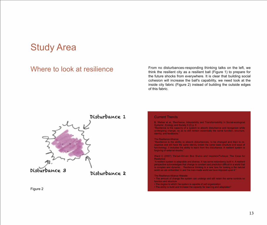
From no disturbances-responding thinking talks on the left, we think the resilient city as a resilient ball (Figure 1) to prepare for the future shocks from everywhere. It is clear that building social cohesion will increase the ball's capability, we need look at the inside city fabric (Figure 2) instead of building the outside edges of this fabric.
Where to look at resilience
Figure 2
Study Area
B. Walker et al, ‘Resilience, Adaptability and Transformability in Social-ecological Systems’, Ecology and Society 9 (2) p. 5“Resilience is the capacity of a system to absorb disturbance and reorganize while undergoing change, so as to still remain essentially the same function, structure, identity, and feedbacks.”
The Resilience Alliance“Resilience is the ability to absorb disturbances, to be changed and then to re-organize and still have the same identity (retain the same basic structure and ways of functioning). It includes the ability to learn from the disturbance. A resilient system is forgiving of external shocks.”
Ward C (2007) ‘Deisel-Driven Bee Slums and ImpotentTurkeys: The Case for Resilience’. “A resilient system is adaptable and diverse. It has some redundancy built in. A resilient perspective acknowledges that change is constant and prediction difficult in a world that is complex and dynamic… Resilience thinking is a new lens for looking a the natural world we are embedded in and the man-made world we have imposed upon it.”
The Resilience Alliance Website• The amount of change the system can undergo and still retain the same controls on function and structure• The degree to which the system is capable of self-organization• The ability to build and increase the capacity for learning and adaptation"
Current Trends
13

CASE STUDIES: New Orleans' Resiliency
This is a study of ArupConnect. They try to look at how strong social ties helped a New Orleans neighborhood bounce back from natural disasters and social challenges.
Katrina destroyed homes and businesses (including fishing boats) across Versailles, displacing almost the entire population and forcing the permanent closure of schools and the nearest hospital. However, within a few weeks after the storm, strong community leaders worked to bring residents back to the neighborhood.
Realizing that the government was unable to provide the necessary resources for recovery as fast as they were needed, the community rebuilt its physical and social infrastructure on its own.
“A lot of residents feel a strong sense of belonging here,” the organization’s deputy director told the resilience framework team. “They had a chance to evacuate and start a life somewhere else, but most of them chose to come back here because it reminded them of a little Vietnam. This really feels like a community — you can’t keep a secret here, people are so close.”
Social Cohesion makes New Orleans Resilient
http://www.arupconnect.com/2014/06/02/understanding-urban-resilience-part-iii-new-orleans/
14

Cali's Resiliency
Cali in Columbia is a very interesting city of 2.5 million that had a big crisis rooted in drug trafficking and corruption. Trafficking basically took over the city. Initially it created massive economic wealth, but then it led to corruption, and then violence and lack of governance.
The way some low-income communities in Cali deal with lack of livelihoods is by organizing themselves. Rather than using physical infrastructure or trying to get money from the government, their tool is to talk to each other, to brainstorm, to develop their own initiatives in order to safeguard their livelihoods.
The behavior of a building, the behavior of infrastructure, can be modeled; and we can understand when things wil l fail safely, and the point in which things wil l fail catastrophically. But we don’t know what’s going to happen afterwards, how people will react and hopefully recover. And that is the process that we need to start understanding in more detail if we want to enable communities, cities, and governments to react effectively to the shocks and stresses they experience. Because the main problem with climate change and resilience is that we don’t know how or when some things will fail.
Understanding urban resilience, part IV: Exploring social dimensions
Strong Social Cohesion to be ready for Future Invisible Shocks
CASE STUDIES:
http://www.arupconnect.com/2014/06/25/understanding-urban-resilience-part-iv-exploring-social-dimensions/
15

Case Studies Evaluation
These two case studies all talked about how social cohesion can contribute to the resilient city in different areas.
The New Orleans's case looks at the relationship between the social cohesion and the natural disasters. After the Katrina Hurricane comes, people who live in New Orleans's have the opportunities to go to other places. However, what they chose is to help the government and also help each other to rebuild the physical and social infrastructure, because everybody who live in this community have a strong sense of belonging. They love the community, they love the city, of course, they love each other.This strong sense of belonging builds their strong social cohesion here and the result is the city becomes resilient.
The case in Cali is talking more about the invisible future shocks. "The behavior of a building, the behavior of infrastructure, can be modeled; and we can understand when things will fail safely, and the point in which things will fail catastrophically. But we don’t know what’s going to happen afterwards, how people will react and hopefully recover. " In this research, Cali's people really believe the way to react and the attitude to recover is a standard of resilience.
The strong social cohesion makes citizens take care of each other and make a strong feeling of loving their city and wanting to recover the city after the disturbance is gone. The powerful thing maybe is not how physically an infrastructure can prevent disasters, or how many diversities we can make for the city. But people's willing to solve the city, solve each other from a disaster can make them strong and resilient.
16


The process of the social cohesion, is trying to find out what landscape architecture can do to increase social cohesion. From the definition and indicators collected from different people's research, we may know where is the opportunity for landscape architecture to build social cohesion in a city.
Definition:"Social cohesion is defined as the willingness of members of a society to cooperate with each other in order to survive and prosper. Willingness to cooperate means they freely choose to form partnerships and have a reasonable chance of realizing goals, because others are willing to cooperate and share the fruits of their endeavors equitably." (Dick Stanley, 2003)
The term social cohesion refers to the bonds, or "glue," that holds a society together, often through common values, beliefs, and behaviors. Strong bonds indicate a higher level of social cohesion as shown by large percentages of the population following the rules of the society and displaying tolerance for one another. It is also demonstrated by cooperation by different groups within the community, particularly when working towards something that will benefit the society as a whole.
Indicators of social cohesion:"1. Social cohesion as participation and solidarity2. Social cohesion as social inclusion – indicated by access to economic activity3. Social cohesion as social inclusion – indicated by access to education and human capital4. Social cohesion as social inclusion – indicated by access to health5. Social cohesion as social inclusion – indicated by access to technology6. Social cohesion as cultural and ethnic homogeneity7. Social cohesion as trust "(Jane Jenson, 2010)
Through Jane's study, 4 important indicators which landscape architecture can build on social cohesion are:1. Trust2. Belonging3. Local Responsibility4. Citizen Participation in making decisions
What Is SOCIAL COHESION
18
What Is SOCIAL COHESION Through these 4 important indicators of social cohesion, what landscape architecture can do in order to build these four indicators to contribute to social cohesion is what I am looking for.PPS (Project of Public Space) through their 27 years experiencing study and effort, try to find what a good public space is, and how the good public space can benefit the people.
THE BENEFITS OF GOOD PUBLIC SPACES
• Places nurture and define community identity through greater community organization, a better sense of dedication and volunteerism, perpetuation of integrity and values, and a common vision.• Places benefit cities economically by encouraging small-scale entrepreneurship, local ownership, more desirable jobs, higher real estate values, and greater tax revenue.• Places promote a greater sense of comfort because they are visually pleasing, generally stimulating, environmentally friendly, promote a sense of belonging, and are safer.• Places draw a diverse population, including more women, elderly, and children, as well as a greater ethnic and cultural mix, by supporting a wider range of activities and uses, new service, retail, and customer niches, and encouraging people to get involved and take pride in the area.• Places create improved accessibility, being more walkable, safer for pedestrians, compatiblewith public transit, less reliant on cars and parking, more efficient in terms of time and money, and offering better connections between uses.• Places foster frequent and meaningful contact through improved sociability, cultural exposure and interaction, exchange and preservation of information, wisdom, and values, reduction of race.(Downtown Moile, Public Space Action Plan, 11,2002)
THE QUALITIES OF GOOD PUBLIC SPACES
Good places can be recognized at a glance, although few people can describe exactly what it is that distinguishes one. PPS has articulated the basic qualities that make up a great place, and distilled them into the following four basic ingredients:ACTIVITIES AND USESA good place has a range of opportunities for people to participate in a variety of activities- from a farmers’ market to a playground, a corner bar, or a sidewalk café, among others. These activities and the variety of people participating in them keeps a downtown lively at all times of day. ACCESS AND LINKAGEA good place is visible and easy to get to. For example, not only the entrance to a park, but also the activities in the park should be visible and accessible to people passing by on foot and in cars.COMFORT AND IMAGEGood places are comfortable to use and help give the city a unique identity. Amenities, such as seating, shade trees, bike racks, and bulletin boards, well designed and in the right place, are essential in any good public space.SOCIABILITYA sociable place is one where people want to go to observe the passing scene.(Downtown Mobile, Public Space Action Plan, 11,2002)
From the study of PPS (Project of Public Space):A good public space is a place that can provide different activities and opportunities that people can participate in. A good public space is easy to get to.A good public space can help the city build the identity.A good public space is where people want to get together, meet their friends and interact with other people within different backgrounds. Also,A good public space a can help the city to build a sense of belonging.A good public space attracts different backgrounds people come together to have a communication and activities.A good public space have the ability to let the citizens get involved in and take pride in the area.A good public space help people to reduce the race and class barriers and help the city to build the interconnection.
Based on the indicators of social cohesion, it is clear that what a good public space request and benefit that I talked about above are all the indicators to build the social cohesion. Therefore, as a landscape architecture, our mission is to build a good public space to encourage social cohesion.
19

PLAYFUL LANDSCAPES Can Build SOCIAL COHESION
According to the studies of social cohesion above, a good public space will build social cohesion through its indicators. Then the question becomes, what kind of space is good? And how can the public space build the social cohesion. A public place which will provide different kinds of play will have the opportunity to increase social cohesion in a city.
Play as a human instinct, always attracts different ages, races, and backgrounds people to come together. Play is a good way to let people to participate in the activities. Citizen's participation is one important indicator of social cohesion. Besides attracts people's participation, play also let people learn how to communicate, tolerant with each other, and how to get the spirit of we as a group to live together. Understanding, sharing and sense of belonging are all the way to increase social cohesion in a city. Play is like a textbook to teach us become a good membership and how to live together in the community, city or even earth.
Play is a magic catalyst that can help people who do not know each other quickly build relationship. From the experience of immigration, people who spend a lot of time playing with the other people, will adapt the environment and understand the local culture faster. Because through playing, we will know each other quickly and become more understanding of others. This playful process increases the communication, creates more understanding, and improves with have different ideas and cultures. Play as a catalyst definitely decrease the social barrier.
Play also has the ability to build the sportsmanlike spirit. Group play will Increase cooperation which in a broadly thinking is social cohesion. Cooperation also makes a sense of team feeling. This feeling helps players to build a sense of belonging in this team.
Playful landscapes, which can provide different kinds of entertainment that l increase social cohesion in different social cohesion indicators. Design investigation part below tested how playful landscapes build different indicators of social cohesion.
There may be lots of ways to build social cohesion's indicators in landscape architecture, however this thesis is just focus on using playful landscape to build social cohesion.
20

PLAYFUL LANDSCAPES Can Build SOCIAL COHESION
Resiliency
Increase Diversity
Respond to Source Shortage
Respond to Climate Change
Social Cohesion
Playful
Good public space 1
Good public space 2
21

This article is from the infed organization. It talks about the playground movement and the settlement movement from the 1890 to the 1930's. And also, this article talks about how important organized recreation is.
According to this article, the settlement movement has a strong relationship with the playgrounds movement in history. This movement changed the social environment and responded to immigration. This means that recreationl really changed our lifes. As the title of this article said: “The playground of today is the republic of tomorrow."
Through recreation, the immigrant children will understand the way Americans live, and children of all classes will be protected from vice and prepared for citizenship. Recreation makes different individulals live together joyfully in a better way of understanding, and take care of each other.
"Recreation has social effects: neighborless and neighborhood action and cohesiveness being crucial to the settlement idea" This article shows that the idea about recreational and social cohesion has some relevence. Playful landscape can be a good public space which can build and also benefit social cohesion.
This article also talks about that recreation can help people become sportsmanlike. Play can increase the cooperation and demolish social barriers especially for immigrants.
22

This article demonstrates the idea on how playful landscape can build social cohesion in many aspects and tells which aspects playful landscapes can build the social cohesion in my case study. Using team build spirit to build cooperation is one of the key points that I learned from this article.
Using playful landscapes to build belonging, participation, communication, understanding, and cooperation are all the indicators I try to use in design investigation. Building these indicators will increase the city's social cohesion.
Playful landscapes is one way to build social cohesion, social cohesion is one way to build a resilient city. This thesis is using playful landscapes to build a resilient city. This is not the only way to build a resilient city, like what I discussed above. This is one way to let the city become resilient and I want to use my design investigation to explore.
Evaluation
23

Chapter 3 --- Process of Changing in Theoritical Framework
CHAPTER 2
PROCESS OF CHANGING THEORETICAL FRAMEWORK

Chapter 3 --- Process of Changing in Theoritical FrameworkChapter 2 --- Theoritical Framework
CHAPTER 2
PROCESS OF CHANGING THEORETICAL FRAMEWORK

During the study of resilience, I found when people talk about engineering strategies, they always have a negative attitude to it. It seems they have no confidence that engineering strategies can provide resilient riverfront. Maybe it is because of the many times engineering structures seem to make the city be more attacked, like the New Orleans’s Levee System that broke during Hurricane Katrina in 2005. Or maybe the reason of this is when talking engineering strategies, people always think of traditional hard engineering, made by concrete, which has the risk to break down and have no wildlife habitat in support of the structure. Hard engineering is generally defined as controlled disruption of natural processes by using man-made structures. Besides hard engineering, there are also soft engineering strategies. Soft engineering is the use of ecological principles and practices to reduce erosion and achieve the stabilization and safety of shorelines and the area surrounding rivers,while enhancing habitat, improving aesthetics, and saving money.
Also hard engineering strategies have lots of opportunities to be resilient. Resilience or not, it is really depends on what standard we use to value it. When we talk a resilient city to response to the sea level rise, hard engineering strategies are resilient, like levees. However, when we talk about the response to the flooding, the levee is not resilient at all, like the New Orlean's levee broke in the hurricane and flooding submerged the city.
RESPONSE To The Sea Levels Rising
27

CASE STUDIES:Dujiang Dam makes Chengdu Resiliency
Another important construction is called a Baopingkou. The name came from the construction shape as it looks like “a bottle neck”. In Baopingkou, digging through one mountain, is a water diversion construction. Through the Baopingkou, the water uses irrigation. It separates water into hundreds of paths to irrigate every agricultural area in Chengdu Plain. Feishayan works with Baopingkou, and can prevent Chengdu Plain from a flooding disaster. When the flooding season is coming, the Feishayan can take the inner river water over to the irrigation level to the outer river to keep from flooding. Also Feishayan can take the sediments to the outer river through centrifugal force. This can protect inner river blocking. This huge hard engineering project, successfully divided the Min River into two parts. It changed the situation which was frequent flooding in the south of the plain, but dry in the north side. It also changes the disadvantage of the water issue into advantageous water benefits. Due to the change of the river, Chengdu City became the land of abundance. For thousands of years, the people who live here have a great life and also it changed the city’s culture.
Dujiangyan was built in 256 BC by Bing Li and his son. The building of this huge hydrological project made Chengdu plain well known as the land of abundance until today. In Sichuan Province, there is a river called Min. This river was always flooding and because the snow on the mountain melted in spring, the water took lots of sediments which polluted the people’s land in Chengdu plain. The frequency of flooding and pollution problems gave people who live there a hard life. So Bing decided to build a hydrological project to solve the Min River problems. Bing used local materials which are bamboos and stones in the nearby mountains. He used bamboos to make ships and sunk the stones into the river making the construction of the famous Fish Mouth, which is the most important part of Dujiangyan. Fish Mouth’s function is separating and controlling the volume of the water. The area west of the Fish Mouth is called “outer river”, It generally contains 60% of the whole volume of Min River. The east is called “inner river”, and contains 40% volume. The “outer river” response is to solve the flooding problem, and the “inner river” response is to provide water to residential irrigation. Over time a small volume of rain water will go 40% into outer river and 60% into inner river to make sure humans had enough water for irrigation. In the big volume of rain water season, the situation would be inverse.
28

www.thetourofchina.com
29

Antwerp’s waterfront used to be one of the most prosperous ports in Europe. Sailing ships and wharf tackle, merchants and vendors, grafters and ordinary citizens have all be seen in Antwerp’s waterfront. Belgium has much of its land below sea level, and now because of global warming, the level of the sea is rising. Besides sea level rise, Scheldt River has normal daily tide spans from zero up to 5m (16.65 feet).Antwerp exists at 1.35 meters (about four and a half feet) port wall, for protection from flooding, tide in and sea level rise. But this port wall prevents people access. Also the wall is not high enough for the sea level rise according to the estimation.In 2006, there was a competition to design this waterfront to solve these problems, to protect the city and to define the embankment as a civic structure and shelter for the local population to explore a better way of life. PROAP and the Belgian architectural planners WIT won this competition. In the design proposal, they deal with the current quay walls and raise the walls 90 cm to meet the safety standard. They used the concept of “composition of a melody of quays as keys”. (Figure 3) The “quays as keys” work with the river’s tidal range of 5m. “The tides of the city become the breath of the quays” (De Meulder 2008)
Antwerp Quays Waterfront Proposal the concept of “composition of a melody of quays as keys”.
“One of the things we rejected was the kind of approach where people arrive at a place that has been studied for years and years, and then propose—with incredible arrogance—to promote a very different image of that place,” Nunes says. “That’s what we see when a big architectural star is invited to a place.” Ten topographical sections that read from above are like the keys of a piano. Each key will address the river in a distinct fashion. One section, resting on pontoons, will rise and fall with the tides; another will slope down gradually from a protective berm; a third will cantilever out over the water. (Figure 4)
This “quays as keys” project is using a hard engineering strategy to raise the existing quays as a protection of the flooding, daily tide in and sea level rise. Thinking of the special condition, normally tidal range is a maximum at 5m, in the Antwerp, the hard engineering raising the wall to protect may be the best strategy to protect the city from flooding and tide. It is a resilient waterfront because it minimizes the disturbance of the water rising thanks to the raising quays. It uses the normal everyday tide to build a dynamic waterfront to provide a great public place for people. These quays create different spatial experiences and encourage diverse development along the river.
CASE STUDIES:
30

This can be seen as adaptive to the disturbance. We should be constrained by the word resilience and also its definition. We should more focus on the function of the capacity to solve the problem instead of exactly follow the definition. Therefore, as I think, this project is a good proposal of building a resilient waterfront, and also this project support the idea: hard engineering strategies also have lots of opportunities to build resilient waterfront. To judge a city resilient or not, it should depend on the situation of this city. Wetlands are good, but they cannot work everywhere in the world. We should include every strategy to think about the word resilient.
Figure 3
Figure 4
www.proap.pt
www.metropolismag.com
31

Sea Level Rise in the Future, Mobile, AlDESIGN INVESTIGATION
32

Sea Level Rise Vulnerability Analysis, Mobile, Al
33

6' Sea Level Rise Situation in Mobile
Sea Level Rise: Vulnerable Situation
34

Sea Level Rise: Vulnerable Situation
Exsiting Pictures
Railroad seperates the river from the city and citizens
This park will be vulnerable to the future sea level rise
Neighborhood beside the highway is inconvenience
How Can I Use
The Levee
System to
Reduce These
Vulnarability
and Build a
Livable Future
for Mobile,
Alabama?
This research study looks at the sea level rise in Mobile, Alabama in the 100 years time range.
35

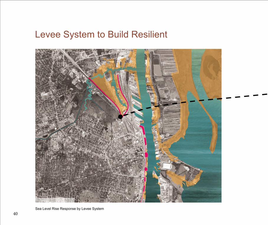
Sea Level Rise Response by Levee System
Levee System to Build Resilient
36

Levee System to Build Resilient
Constructed Landform
Railroad Under the Levee
Levee Greenway
Design Test
A constructed landform proposed before the levee to make the waterfront more adaptive to the sea level rise, at the same time, this constructed landform can reduce the wave energy which may be the key element to erosion the levee.
A levee combined with the existing building provided to build a levee system to help Mobile city to response to the future see level rise disturbance. This levee will be built above the existing railroad infrastructure to rebuild the connection between the downtown area to the waterfront area.
37

4' Sea Leevl RiseLevee System and Plaza
Design Analysis
The landform is also a plaza for people to have fun here even if there will be in the 4' sea level rise in 60 years.Three diagrams in the left show how the constructed landform can be adaptive to the future sea level rise. Right now is a educational and playful plaza. In this plaza, several columns stand there and curved height. These columns try to give people feeling about how high it will be if the water rise in the future. So the column tries to tell people and educate people about future sea level rise. Also, it is a place try to collect people to come here and have lunch or dinner together.
In the 60 years, if the sea level rise is like the predict 4', These constructed landform still can provide places for people to get together and have some activities related to the water.At the same tmie, these constructed landforms can be the protection for the levee erosion by reducing the everyday tide in and tide out wave energy.
38

6' Sea Leevl Rise Constructed Landform Reduce Wave Energy
Building the levee connected to the existing building can shape the space in front of the levee an inner harbor. Because the inner harbor is more peaceful than the other coastline, this inner harbor will be the first step to reduce the erosion and make a peace area in the yellow area. And the second step to reduce the erosion of levee is the constructed landform. It can reduce the wave energy like the last diagram shows.
In 100 years, the water may submerge a lot of this plaza, however the constructed landform can also protect the levee in the same way.
39
Levee System to Build Resilient
Sea Level Rise Response by Levee System40

Levee System to Build ResilientHighway Levee Perspective
This levee system is also supposed to combine with the existing highway and under the highway to build retail shops somewhere near the neighborhood. These retails give more convenience to the surrounding neighborhood. The levee system shows the value today as well as in the future.
41

LIMITATION
At this stage, I think resilient city should be a spring to respond to the disturbance and shock. After my first design investigation, I think the limitation of this spring thinking is one direction response can not respond to other directions.
42

LIMITATION This is a disturbance - response thinking. Using different designs to respond each disturbances to make resilient. "Building the Edge" for the city is really like building a protection for the city.
Study Area
I started to think does the resilient city just mean response to the disturbance? Maybe not. Because the future disturbance is invisable. So what is the efficient way for me to build a resilient city in Mobile. This experience let me think of the right theoretical framework which is using the social cohesion to build the inner capability to build a resilient city.
43

DESIGN INVESTIGATION
CHAPTER 3

DESIGN INVESTIGATION
CHAPTER 3
Context Map
Mobile
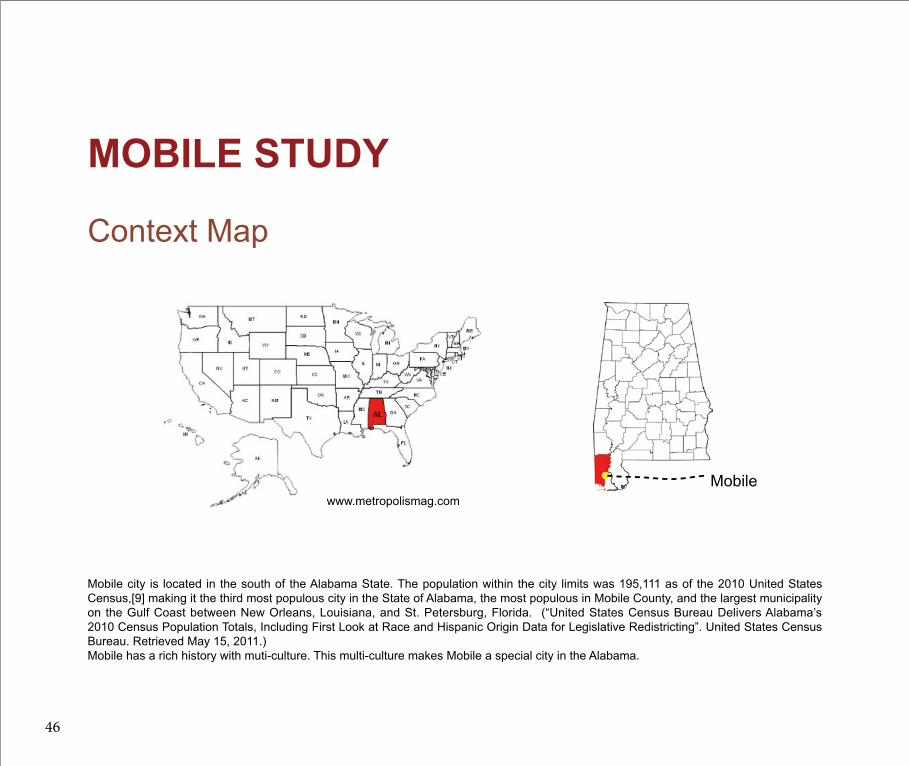
Mobile city is located in the south of the Alabama State. The population within the city limits was 195,111 as of the 2010 United States Census,[9] making it the third most populous city in the State of Alabama, the most populous in Mobile County, and the largest municipality on the Gulf Coast between New Orleans, Louisiana, and St. Petersburg, Florida. (“United States Census Bureau Delivers Alabama’s 2010 Census Population Totals, Including First Look at Race and Hispanic Origin Data for Legislative Redistricting”. United States Census Bureau. Retrieved May 15, 2011.)Mobile has a rich history with muti-culture. This multi-culture makes Mobile a special city in the Alabama.
MOBILE STUDY
www.metropolismag.com
46
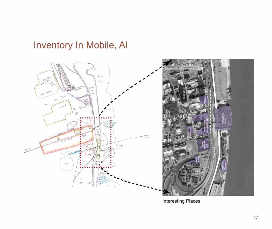
Inventory In Mobile, Al
Interesting Places
47

Downtown area is a very interesting and attractive place in Mobile, Alabama. Dauphine Street and Government Street as the two mainly streets in Mobile, attract lots of people to see the historical as well as modern culture in Mobile. Beautiful skyscrapers, the convention center, historical buildings and many kinds of museums give people, no matter citizens or visitors, different feelings in one city. And because of the revitalizing development in the waterfront, a new Maritime Museum is constructed and opened in 2015!
So A exciting place to live and visit! However, the connection of these places are miss linked. The wide 6 lines Water Street separates the downtown area from the waterfront. The existing railroad prevent people to go to the water front. And the too wide Government Street give a hard time for people to go across. What is more, the Cooper Riverside Park, which is in the waterfront, is invisible because of the huge gap but the park is a nice place to spend leisure time.
Mobile is an exiting place. But because it is hard to access from one part to another, some places in Mobile do not act as good as they should.
Inventory In Mobile, Al
Mobile city has a long history from the colonies came. During this history, lots of people from different areas come here and build their cultures here to let the city thrive.
48

Inventory In Mobile, Al
Dauphine Street
Government Street
Cooper Riverside Park
Overall view
Railroad in the Conventio Center
49

Playful Circulation at Mobile, AlDESIGN INVESTIGATION
50

As I discussed in the Theoretical Framework chapter, playful landscapes can build social cohesion, and social cohesion is a key element to build a resilient city not just focus on responding to the disturbance, but increasing the social capability to prepare for the future inviable disturbances and shocks. So I applied a series of design investigations in the riverfront site to demonstrate this idea about playful landscape can build a resilient city in the future.
At the same time, these series of design investigations also can be a circulation to fix the existing problems in Mobile. Using playful landscapes to connect the downtown area, which is Dauphin Street and Government Street and the Riverfront area.
A cable car structure and mirror landscape together to build the sense of belonging for the citizens. Wishing wall try to build the participation and encourage citizens to share their stories to each other also, care about each other. A football field try to using the group play to demolish the barrier of different races and different backgrounds people. Sense of belonging, participation, love to communicate and spend time with different background people are all the indicator of social cohesion. Overall, these series of playful landscapes proposed can increase the social cohesion in different scenarios through playing in the city of Mobile.
Design Proposal
51

Cable Car
52

Change Your World By Changing Your Angle
These 4 photographs are taken in the same location but different angels. They look like 4 different "world". These photographs try to show that when you see things in different angle, you will get different knowledge, you will understand more. The more you understand, the more careful you will give. This careful is a process to build the belonging.
The idea of playing cable car using this process. Try to increase the different angles for people when they play with it to increase the different understanding to the city, to care more about the city. So they will increase the sense of belonging to live in the city.
http://www.lomography.com/magazine/233495-eye-line
53

London EyesCASE STUDY:
The London eye is 135 meters tall, and it has a diameter of 120 meters. When it was built, in 1999, it was the tallest Ferris wheel in the world. It offers great views over London, and it is a must for every tourist.
The London Eye is on the symbols of the Britain’s capital, and it is a must to visit it during your stay in London. The giant Ferris wheel can be admired on the south side of the Thames River, close to the famous Big Ben. The wheel is also known as the Millennium Wheel.
The London Eye has 32 capsules around its wheel, one for each borough of London. A capsule weighs 10 tones, which means the entire wheel weights 320 tones. Each capsule can carry 25 passengers, and I was really surprised that we are able to walk around in the capsule; they are that big. Also, the capsules have air-condition, and comfortable sits.
en.wikipedia.org
54


Also, as I talked the process of building sense of belonging above, this cable car provides different angles to let the players get more understanding of Mobile City when they have fun on the cable car.
Each car will include 10 people at most. For people can get together as a group in different families and also not easy to break the cable car. Different families can have a conversation and share the different thinkings when they are in the cable car.
This cable car gives another option for people who think Water Street is too wide to get across. Using this cable car to connected the Dauphine Street and the new Maritime Museum provide people who are interested in both a good way to go.
Like the London Eyes did for London, the cable car will be the symbol in Mobile as well. As an icon, when people talk about the Mobile, the first picture may show in their mind maybe not the skyscraper anymore but this giant cable car. Because skyscrapers are existing in every big cities. Inversely, people think about cable car, they will remain Mobile City. Citizens of Mobile will be proud of the icon just like the London people are proud of their famous London Eyes. This will build the citizens belonging and increase the social cohesion.
How Can A Cable Car Build A Sense Of Belonging
56

How Can A Cable Car Build A Sense Of Belonging
Perspective
What You Can See
57
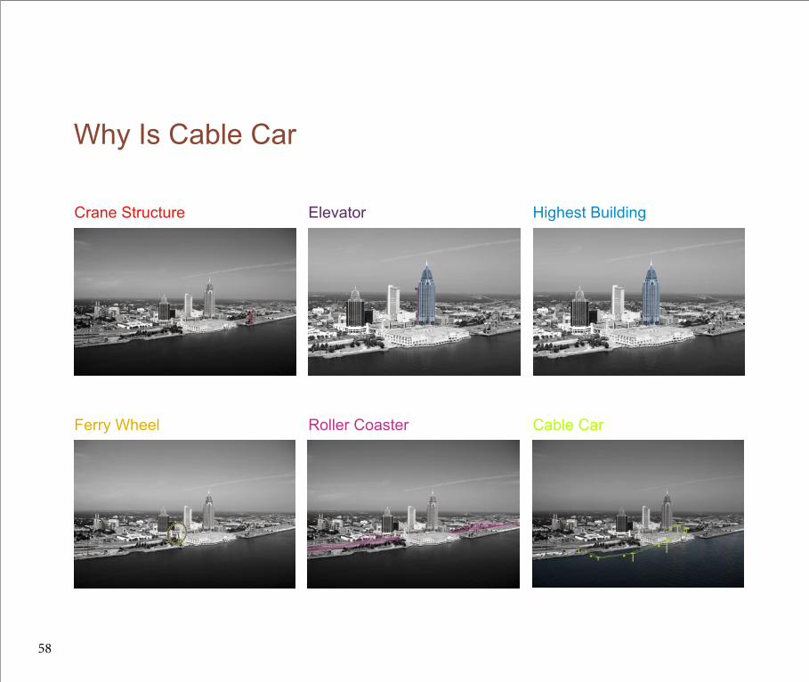
Why Is Cable Car
Crane Structure Elevator Highest Building
Ferry Wheel Roller Coaster Cable Car
58

To show why cable car thinking is better than the others, I try to think what else can have the same function cable car have. And I provided 6 solutions. There solutions above is less playful than the three below. Through this diagram, I found out the less playful solutions have the less opportunities to city the city in different angles. According to the study of building sense of belonging, it is clear that the more playful can provide the more sense of belonging in a city. So in this diagram, cable car have the most opportunities to provide sense of belonging to the city.
59

Mirror
60

To increase the angles of seeing and observing the city, a "mirror landscape " provided above the Water Street. This is also try to build the sense of belonging. At the same time, this mirrow try to encourage people thinking in different ways in normal life.
A stary night, when you walk on this mirror, you feel you walk in the sky. All the stars under your feet. You can see the city upside down. You may find something you never pay attetion. This mirror landscape build the sense of belonging at the same time give player the new experience of playing.

Wishing Wall
62

The wishing wall idea encourage people to write down their wishing and share their stories with other people in the city. People can use the proposed Levee structure as a wall so that everybody can see the wishes. They can share their own stories and take care of other people's stories, making them have the feeling of getting more closer to each other.Participate in the process of building social cohesion!

Football Field
64


This football field site right now is an open space for marketing during events. However, without the events, this place, as a important space in downtown Mobile, is not used as efficiently.
My idea is to paint the football field lines and build some bleachers. So on the one hand, without events, it can be used as a football field to encourage people to play group games together. On the other hand, when the city has events, this place can also be used as a market space as well. A market space provides space to sit.
Group games are really powerful to demolish the barriers from different backgrounds, different races, and different classes. When we play, we have a better understanding of how we as different individuals can live together. Let play educate us what kind of citizens we should be.
Design Proposal
66

Design Proposal
67
REFERENCES
“Sportsmanlike Spirit Goes Global.” 2015. The Sydney Morning Herald. Accessed May 4. http://www.smh.com.au/national/education/sportsmanlike-spirit-goes-global-20120401-1w6q7.html.
Stanley, Dick. 2003. “What Do We Know about Social Cohesion: The Research Perspective of the Federal Government’s Social Cohesion Research Network.” The Canadian Journal of Sociology / Cahiers Canadiens de Sociologie 28 (1): 5–17. doi:10.2307/3341872.
“STREETS | Landscape Architecture Magazine.” 2015. Accessed May 4. http://landscapearchitecturemagazine.org/category/streets/.
“‘The Playground of Today Is the Republic of Tomorrow’: Social Reform and Organized Recreation in the USA, 1890-1930’s.” 2015. Infed.org. Accessed May 4. http://infed.org/mobi/social-reform-and-organized-recreation-in-the-usa/.
“Understanding Coastal Inundation.” 2014. Accessed October 24. http://www.coast.noaa.gov/digitalcoast/inundation/understand/.
“Understanding Urban Resilience, Part III: New Orleans | Arup Connect.” 2015. Accessed May 4. http://www.arupconnect.com/2014/06/02/understanding-urban-resilience-part-iii-new-orleans/.
“Understanding Urban Resilience, Part IV: Exploring Social Dimensions | Arup Connect.” 2015. Accessed May 4.http://www.arupconnect.com/2014/06/25/understanding-urban-resilience-pexploring-social-dimensions/.
“Urban Parks of the Past and Future | Project for Public Spaces.” 2015. Accessed May 4.http://www.pps.org/reference/futureparks/.
US EPA, Climate Change Division. 2014. “Water Resources Impacts & Adaptation”. Overviews & Factsheets,. Accessed November 29. http://www.epa.gov/climatechange/impacts-adaptation/water.html.
Watson, Bruce. 2015. “What Makes a City Resilient?” The Guardian. Accessed May 4. http://www.theguardian.com/cities/2014/jan/27/what-makes-a-city-resilient.
Wood, L., B. Giles-Corti, S. R. Zubrick, and M. K. Bulsara. 2013. “‘Through the Kids . . . We Connected With Our Community’: Children as Catalysts of Social Capital.” Environment and Behavior 45 (3): 344–68. doi:10.1177/0013916511429329.
Douglass, Scott L., and Bradley Pickel. n.d. “‘The Tide Doesn’t Go Out Anymore’- The Effect of Bulkheads on Urban Bay Shorelines.” Civil Engineering and Marine Sciences Departments University of South Alabama. http://www.southalabama.edu/cesrp/Tide.htm.
“City Park | Bradford UK | Gillespies.” 2015. World Landscape Architecture. Accessed May 4. http://worldlandscapearchitect.com/city-park-bradford-uk-gillespies/.
“Climate Variability and Change in Mobile, Alabama.” n.d. http://www.fhwa.dot.gov/environment/climate_change/adaptation/ongoing_and_current_research/gulf_coast_study/phase2_task2/mobile_variability/variablerpt01.cfm.
“Downtown Mobile Alliance.” n.d. http://www.downtownmobile.org/ex plore-downtownmaps.php.
68

“Facts about the London Eye.” n.d. http://www.ilovejourneys.com/top-10-facts-about-the-london-eye/.
Fahim, Adam Nossiter, Damien Cave, Kareem, and James Barron. 2008. “Spared a Direct Hit, New Orleans Exhales.” The New York Times, September 2, sec. US. http://www.nytimes.com/2008/09/02/us/02gustav.html.
“Future Dike.” n.d. Topos Coastal strategies (87).
“Hurricane Rita Pummels Texas, Louisiana Coast.” 2005. Text.Article. Associated Press. September 24. http://www.foxnews.com/story/2005/09/24/hurricane-rita-pummels-texas-louisiana-coast.
Jenson, Jane. n.d. “Defining and Measuring Social Cohesion.”
jhansan. 2015. “Recreation Movement in the United States.” Social Welfare History Project. Accessed May 4. http://www.socialwelfarehistory.com/eras/recreation-movement-in-the-united-states/.
Kao, C.M. 2012. “Environmental Assessment and Restoration of Typhoon Morakot Disaster: A Case Study in Kaohsiung, Chinese Taipei.” In Resilient Cities 2 Cities and Adaptation to Climate Change, Proceedings of the Global Forum 2011, 75–87. Local Sustainability.
Kellie. 2011. “Rising Seas, Imperiled Cities”. Text. Harvard University Center for the Environment. November 39. http://environment.harvard.edu/node/3272.
“Lessons in Resilience From New Orleans.” 2014. Dot Earth Blog. Accessed October 24. http://dotearth.blogs.nytimes.com/2010/08/13/lessons-in-resilience-from-new-orleans/.
“Lomography - Change Your World by Changing Your Angle!” 2015. Accessed May 4. http://www.lomography.com/magazine/233495-eye-line.
“Mean Sea Level Trends for Tropical and Gulf of Mexico Stations.” n.d. http://tidesandcurrents.noaa.gov/sltrends/tropicaltrends.html.
“Michel Corajoud – Water Mirror – Arhitext.” 2015. Accessed May 4. http://www.arhitext.com/english/2012/01/michel-corajoud-water-mirror/.
“Mobile.” 2015. Encyclopedia of Alabama. Accessed May 4. http://www.encyclopediaofalabama.org/article/h-1794.
“Mobile County Emergency Management Agency.” n.d. http://www.mcema.net/.
“New Orleans’ Resilience Challenge.” 2014. Accessed October 24. http://www.100resilientcities.org/cities/entry/new-orleans-resilience-challenge.
“Population Density in Mobile, AL by Zip Code.” n.d. http://zipatlas.com/us/al/mobile/zip-code-comparison/population-density.htm.
69

“Risk Mapping, Assessment and Planning (Risk MAP).” 2014. Accessed October 24. http://www.fema.gov/risk-mapping-assessment-and-planning-risk-map.
“Sea Level Rise and Coastal Flooding Impacts Viewer.” 2014. Accessed October 24. http://coast.noaa.gov/digitalcoast/tools/slr.
[email protected], Theresa Seiger |. 2014. “Mayor Stimpson: Walkable Water Street Key to Revitalization of Mobile’s Waterfront.” AL.com. 3–10. http://blog.al.com/live/2014/03/mayor_stimpson_walkable_water.html.
US EPA, Climate Change Division. 2014a. “Information about Climate Change, Why and How the Climate Is Changing, and What We Can Do about It.” Overviews & Factsheets,. Accessed October 24. http://epa.gov/climatechange/.
“Southeast Impacts & Adaptation”. Overviews & Factsheets,. Accessed January 16. http://epa.gov/climatechange/impacts-adaptation/southeast.html.
Washington, National Geographic Society P. O. Box 98199, Dc 20090-8199 Usa 38.90531943278526, and -77 0376992225647 800-647-5463. 2014. “Los Angeles River: From Concrete Ditch to Urban Oasis.” Accessed October 24. http://news.nationalgeographic.com/news/2014/07/140719-los-angeles-river-restoration-kayaking-greenway/.
70

71

IMAGE CITATIONS
Arup Connect: Understanding urban resilience, part III: New Orleanshttp://www.arupconnect.com/2014/06/02/understanding-urban-resilience-part-iii-new-orleans/
Arup Connect: Understanding urban resilience, part IV: Exploring social dimensionshttp://www.arupconnect.com/2014/06/25/understanding-urban-resilience-part-iv-exploring-social-dimensions/
Dujiangyanwww.thetourofchina.com
http://theresilientearth.com/?q=content/melting-glaciers-ice-caps-and-sea-level-rise
www.proap.pt
www.metropolismag.com
Change Your World by Changing Your Angle!http://www.lomography.com/magazine/233495-eye-line
London Eyesen.wikipedia.org
72

73

