preliminary report on 2014 fieldwork in southwest...
TRANSCRIPT

This is a repository copy of Preliminary Report on 2014 Fieldwork in Southwest Saudi Arabia by the DISPERSE Project : (2) Jizan and Asir Provinces.
White Rose Research Online URL for this paper:http://eprints.whiterose.ac.uk/80965/
Version: Published Version
Monograph:Inglis, Robyn Helen orcid.org/0000-0001-6533-6646, Sinclair, Anthony, Shuttleworth, Andrew et al. (7 more authors) (2014) Preliminary Report on 2014 Fieldwork in Southwest Saudi Arabia by the DISPERSE Project : (2) Jizan and Asir Provinces. Report. Saudi Commission for Tourism and Antiquities
[email protected]://eprints.whiterose.ac.uk/
Reuse Items deposited in White Rose Research Online are protected by copyright, with all rights reserved unless indicated otherwise. They may be downloaded and/or printed for private study, or other acts as permitted by national copyright laws. The publisher or other rights holders may allow further reproduction and re-use of the full text version. This is indicated by the licence information on the White Rose Research Online record for the item.
Takedown If you consider content in White Rose Research Online to be in breach of UK law, please notify us by emailing [email protected] including the URL of the record and the reason for the withdrawal request.

PRELIMINARY REPORT ON 2014 FIELDWORK IN SOUTHWEST
SAUDI ARABIA BY THE DISPERSE PROJECT:
(1) JIZAN AND ASIR PROVINCES
R.H. Inglis1, A.G.M. Sinclair
2, A. Shuttleworth
2, A. Al Maamary
3, W. Budd
2, N.
Hausmann1, M.G. Meredith-Williams
1, A.M. Alsharekh
3, S. Al Ghamdi
3,
and G.N. Bailey1.
1 Department of Archaeology, University of York, The King’s Manor, York, YO1 7EP,
UK
2 Department of Archaeology, Classics and Egyptology, 12-14 Abercromby Square,
University of Liverpool, L69 7WZ, UK
3 Department of Archaeology, King Saud University, P.O. Box 2627, Riyadh 12372,
Saudi Arabia
Contents
1. DISPERSE Survey in South West Saudi Arabia
1.1 Introduction
1.2 Background
1.3 Methods
2. 2014 Survey Results
2.1 Overview
2.2 Jizan Province
2.2.1 Jebel Akwah and Wadi Sabiya
2.2.2 Wadi Jizan Lava Flows and Dam Lake Area
2.2.3 Jizan Shell Midden
2.3 Asir Region
2.3.1 Harrat Al Birk Coastal Deposits
2.3.2 Dhahaban Quarry (L0034)
2.3.3 Hajambar Quarry (WP304)
2.3.4 Al Maolmat Rock Art (L0044).
3. Summary
4. Acknowledgements
5. References
Appendix 1: 2014 Field Team
Appendix 2: 2014 Locality List
Appendix 3: 2014 Lithic Catalogue
Appendix 4: 2014 Geological Sample List

DISPERSE 2014 Report: Fieldwork in Jizan and Asir
! 2
1. DISPERSE Survey in South West Saudi Arabia
1.1 Introduction Archaeological and geomorphological fieldwork was undertaken over eight weeks in
January, February and March 2014 in the provinces of Jizan and Asir. The primary goals
of the work were to:
a) Survey for locations with early stone tools in order to expand the number of
archaeological sites and the range of artefact material from the material observed
in previous seasons (Bailey et al. 2012; Devès et al. 2012, 2013; Inglis et al.
2013, 2014) and;
b) Identify geological deposits and sedimentary sections that might provide
palaeoenvironmental and chronological context for the archaeological material.
As in previous seasons, survey focussed on a selection of areas, chosen because they have
previously yielded evidence of early stone artefacts, or because they are areas identified
in earlier survey work as having potentially attractive geological, geomorphological and
topographic conditions for human occupation and the preservation and visibility of
archaeological evidence.
In total, 40 localities (listed in Appendix 2) were visited during the six weeks of active
field survey, and Palaeolithic artefacts collected and recorded from the vast majority of
these locations. Artefacts included those with Early (ESA), Middle (MSA) and Later
Stone Age (LSA) affinities. 717 stone tools were observed and collected, and their
location logged using GPS. Following the methodology established in the 2012 and 2013
surveys, all artefacts and locations of geological interest visited were given a unique
Waypoint (WP) number with GPS coordinates. Waypoints were grouped by proximity
into Localities (e.g. L0034). Preliminary analysis of the collected lithics was conducted
over a week in late February in Sabiya Museum, Jizan Province (Appendix 3). At the end
of the season, the finds were archived in the museum stores. Artefacts recovered from
Asir region will be retained in Sabiya Museum until the end of DISPERSE activities in
the region (currently March 2015), after which they will be transferred to the SCTA
offices in Abha in accordance with SCTA regulations.
In addition to the artefacts, samples for specialist palaeoenvironmental and dating
analyses, such as Optically Stimulated Luminescence (OSL) and Argon/Argon dating
(Ar/Ar) were collected from a number of locations, and shipped back to the UK for
specialist analysis (Appendix 4).
1.2 Background The investigation of the Palaeolithic of Saudi Arabia has seen two major periods of
archaeological investigation. An initial understanding of the range of artefacts, their
geographical spread, and their association to major geological features was produced
through the work of the Comprehensive Survey of the Kingdom undertaken in the 1970s
(e.g. Zarins et al. 1980, 1981). More recently, a considerable recent body of new work
has focussed on the search for Palaeolithic sites in Saudi Arabia and more widely in the
southern Arabian Peninsula, given its key geographical position between Africa and
Eurasia, with the expectation that there should be an abundant distribution of early human
occupation extending back to very early periods of the Stone Age (Armitage et al. 2011;
Petraglia et al. 2011; Rose et al. 2011; Delagnes et al. 2012; Groucutt & Petraglia 2012).

DISPERSE 2014 Report: Fieldwork in Jizan and Asir
! 3
It seems fair to say, however, that the record is still very patchy; chronological control is
limited, and large areas still remain to be explored in detail. In the DISPERSE project, we
have focused on the Southwest region of Saudi Arabia, because of its proximity to Africa,
the likelihood of relatively easy population movement directly across the southern end of
the Red Sea in the vicinity of the Hanish Sill (Lambeck et al. 2011), the probable
importance of coastal regions in human dispersal, and the generally favourable
environmental conditions for human occupation in the southern Red Sea escarpment and
coastal plain throughout the climatic changes of the Pleistocene, including an extensive
and now-submerged landscape extending for up to 100 km westward of the present
coastline during periods of low sea level.
Our aim in DISPERSE is to undertake new archaeological and geomorphological survey
in the region, combined with mapping techniques to reconstruct landscape evolution from
the regional to the site scale, and to assess the relationship between Palaeolithic sites and
their landscapes and the impact of physical landscape characteristics and environmental
factors on the nature and distribution of early human settlement and dispersal. This work
includes exploration of the now-submerged landscape, which is reported elsewhere
1.3 Methods In previous field seasons, satellite imagery (LandsatGeoCover 2000/ETM+ Mosaics and
imagery accessed through Google Earth imagery) and DEMs (ASTER GDM v2 and
SRTM 90m v4.1) were used to map and classify landforms prior to the survey, with
ground-truthing visits in May–June and November 2012 (Bailey et al. 2012; Devès et al.
2012, 2013; Inglis et al. 2013, 2014). Landforms were assessed for their potential for
preserving surface Palaeolithic archaeology and the location of potentially artefact-
bearing stratigraphy.
Pre-identified areas for ground survey are described here as localities, with individual
numbers and descriptions. Within such localities, artefacts are almost always located by
an individual waypoint GPS reference. In a smaller number of cases, the density and
patterning of artefacts and sometimes their location within in situ deposits enables us to
categorise the artefact cluster as a ‘site’. This is the case, for example, with the Dhahaban
Quarry artefact cluster described in more detail below as the Dhahaban Quarry site.
In response to the findings of field survey in 2012 and 2013, the survey in 2014 focussed
on:
• Consolidating understanding of the patterning of artefact distributions in areas of
low sedimentation around volcanics, and extending on to areas of exposed
basement rock, in southern Jizan.
• Exploration of quarries and wadi cuts in southern Jizan to search for sediments
containing in situ artefacts stratified beneath the volcanic deposits.
• Survey of shoreline features, including fossil coral terraces and raised beaches
along the Harrat Al Birk, western Asir Region.
A four-wheel drive vehicle was used to access target areas, with further exploration on
foot. In the target areas the terrain was slowly traversed on foot by team members spaced
at 5–10m intervals walking along transects of up to 1km distance, the distances and
tracks varying according to local circumstances. Key geomorphological features for

DISPERSE 2014 Report: Fieldwork in Jizan and Asir
! 4
dating landscape evolution, such as raised beach terraces and sections in quarries, were
also targeted for sampling and dating where appropriate, and accessible sections were
examined for the presence of artefacts visible in situ. As in previous years, all artefacts
collected by the survey have been bagged in a re-sealable polythene bag and labelled by
date of collection, GPS co-ordinates or GPS waypoint number, a brief description of the
artefacts and the initials of the collector. Following collection in the field, all artefacts
were cleaned, photographs were taken of their upper and lower surfaces, and the artefacts
described in greater detail in terms of their form and technology. A master spreadsheet
keeps a running record of the survey finds, their locations and their descriptions.
At one site, Dhahaban Quarry, (L0034), a Leica TS407 total station, rather than a
handheld GPS device, was used to record the precise locations of surface and stratified
artefacts, as well as major geomorphological units. Coupled with high-resolution 3D
photogrammetry of the artefact-bearing section at this site, this detail will allow the full
understanding of a this significant stratified site (see Section 2.3.2).
In the sections that follow, many of the artefacts are described as being Early Stone Age /
Lower Palaeolithic (hereafter ESA), or Middle Stone Age / Middle Palaeolithic (hereafter
MSA) or Later Stone Age / Upper Palaeolithic (hereafter (LSA) in character. These
descriptions derive from the typological assessment of the artefacts after collection. In
brief, ESA artefacts usually take the form of flake or core based pieces (such as handaxes
or cleavers) or simple or discoidal flake cores. They were usually made by using a hard
stone hammer. MSA artefacts include prepared cores and their manufacturing debris
(such as radial or convergent Levallois, Nubian Levallois and some flake-blade forms) as
well as the flakes from such cores that may be radial, convergent or blade-like in form.
MSA artefacts sometimes show evidence of use of a soft hammer in their production.
LSA artefacts include pieces made on blade cores, often with clear retouch to create tools
to a predetermined form. LSA artefacts are more difficult to identify and characterise,
since very few artefacts have been located and reported previously, and it is now
accepted that a number of artefacts forms (such as piercers and burins) were also
manufactured during the Middle Stone Age / Middle Palaeolithic.
The typological description of artefacts as being ESA, MSA or LSA in form only permits
a very broad understanding of the age of the pieces when there is no detailed dating of the
deposits in which such materials are found, or under which they lie. In East Africa the
very oldest stone tools now date back to 2.4Mya in Ethiopia, with the first hand axes
dating from 1.8Mya. Middle Stone Age, prepared cores and flakes have usually been
accepted as dating between 300Kya and approximately 60/50Kya (Barham and Mitchell
2008). In the last two years, new dates from southern Africa suggest that the Middle
Stone Age might start from 500Mya (e.g. Wilkins & Chazan 2012). It is reasonable to
assume that the first modern humans crossing into the Arabian Peninsula would have
brought and made tools following an MSA technology.

DISPERSE 2014 Report: Fieldwork in Jizan and Asir
! 5
2. 2014 Survey Results 2.1 Overview
Figure 1: Map of locations showing localities visited by DISPERSE in 2013 and 2014 in
Jizan and Asir regions. Elevation data © CGIAR-CSI SRTM 90m v4.1 database.

DISPERSE 2014 Report: Fieldwork in Jizan and Asir
! 6
2.2 Jizan Province 2.2.1 Jebel Akwah and Wadi Sabiya
Jebel Akwah, Northern Cinder Cone
The twin cinder cones of Jebel Akwah are marked topographic features in the otherwise
flat coastal plain that is covered by Quaternary sedimentation, rising to ~60m. Currently,
their eruption is thought to have taken place at 0.44±0.26mya although these dates are
problematic (K/Ar, Dabbagh et al. 1984).
In 2013, ground survey of the northern cinder cone yielded 23 lithics at three localities
(L0013-15, Figure 2), with artefacts showing signs of ESA technological forms and MSA
forms made on local basalt and andesite (Inglis et al. 2013, 2014). Survey in 2014 was
designed to complete a representative survey across the lava flows surrounding the cinder
cone to identify any spatial patterning in artefact deposition and the relationship of this
patterning to the geomorphological units present on and around the flows (Figure 2).
Figure 2: Map showing northern Jebel Akwah cinder cone, and the localities visited in
2013 and 2014 and major geomorphological features. L0061-63 and L0077 were visited
in 2014. Inset shows overview of Jebel Akwah. Satellite imagery © DigitalGlobe 2014,
accessed through Google Earth. Imagery Date 3/6/2014.

DISPERSE 2014 Report: Fieldwork in Jizan and Asir
! 7
The following localities were visited in 2014:
• L0061 – aeolian-derived sediments overlying the central area of the lava flow to
the W of the collapsed cinder cone. Ceramic sherds and rounded pebbles of
varying lithologies were observed on the surface, along with one indurated shale
LSA flake, as well as a non-diagnostic bi-truncated andesite flake, and quartz
clasts and natural flakes.
• L0062 – colluvial slopes on the western edge of the cinder cone, incorporating a
mixture of aeolian-derived sediments and scoria from the cinder cone reworked
by slopewash. The few artefacts observed on the surface, including quartz
bladelets, an andesite burin spall and a shale-backed blade appear to be LSA or
later in date.
• L0063 – surface of lava flow to SW of cinder cone. As well as an quartz
notch/endscraper (LSA), a basalt core that appears to be in the early stages of
working for an MSA prepared core was observed on the lava surface, along with a
number of small undiagnostic quartz flakes.
• L0077 – an area of lava flow on the SE edge of the main flows. Two transects
were walked, 1km each, but only a single, unretouched quartz flake was
recovered. Two samples of basalt, <503> and <504> were collected for Ar/Ar
dating.
It is clear that, on Jebel Akwah and its surrounding flows, visibility of surface
Palaeolithic artefacts is restricted to areas where there is little or no sedimentation on the
lava flows surrounding the cinder cone. Yet, in areas surveyed in 2014 where the surface
of the lava flow was exposed, there appear to be very few lithics of Palaeolithic age, and
none were observed stratified in the small gullies at L0062 that cut through colluvial
deposits. This is in contrast to the 2013 observations, where ESA and MSA artefacts were
found, albeit in low density, around the outer edges of the lava flows. This patterning
may reflect a preferential usage of the edges of the lava flow by Palaeolithic populations,
yet given the small sample size, robust interpretation of the patterning is difficult. It is,
however, clear that the Jebel Akwah does not appear to have been a major area for tool
manufacture or activity during the Palaeolithic, unlike localities observed on lava flows
around other volcanoes in the region such as L0010, Jebel Umm Al Qummam (Inglis et
al. 2013, 2014).
Wadi Sabiya
To the south of Jebel Akwah, Wadi Sabiya and its tributaries incise wadi floodplain
sediments up to 10m below the surrounding landscape, a process continued by extensive
and ongoing quarrying (Figure 3). These deposits are capped by a volcanic tuff that
extends for kilometres across the surrounding area, and is related to the eruption of Jebel
Akwah (Dabbagh et al. 1984). This tuff is itself overlain by further alluvial deposits,
consisting of reddish sandy silt and well-rolled cobbles of mixed lithology.

DISPERSE 2014 Report: Fieldwork in Jizan and Asir
! 8
Figure 3: Satellite image of the southern cinder cone of Jebel Akwah showing its
relationship to Wadi Sabiya, which runs NE–SW across the figure, identifying the
localities visited during 2014 and discussed in the text. The grey areas to the centre and
centre left of the photo show the extent of exposed volcanic tuff. Image © Digital Globe,
accessed through Google Earth. Imagery Date 29/12/2013.
The area of quarrying to the south of Jebel Akwah was investigated at two localities -
L0020 and L0066. L0020 comprises an area where the upper surface of the tuff has been
exposed by natural erosion over a wide area, erosion that is also incising the tuff and
underlying sediments through a network of dendritic drainage gullies. To the W and S of
the locality, quarrying has exposed deep sections through these sediments. Artefacts
recovered from the surface of the tuff and the gullies appear to be LSA or later in date,
primarily of quartz bladelets and two chert flakes.
In the area affected by quarrying, one quarry section has, at its base, exposed a cross
section through a wadi channel and its associated gravel and coral terraces (Figure 4).
Within one of these terraces a worked shale clast, with three long, blade removals
(potentially the result of soft-hammer percussion, indicative of an MSA technology) was
found in situ (Figure 5). Manufacture and deposition of the clast should pre-date the
eruption of the volcanoes that produced the volcanic tuff that caps the section, and
therefore the artefact is potentially over 0.44±0.26mya old. If this date and the
typological assessment are correct, then this artefact is the earliest dated evidence for the
MSA in Arabia. Given the problems associated with this dating (Dabbagh et al. 1984),
new samples were removed for dating from the section:

DISPERSE 2014 Report: Fieldwork in Jizan and Asir
! 9
Figure 4: Quarry section at L0020, near Wadi Sabiya. The section shows a cross-section
through a wadi channel, with gravel terraces incised by a channel, later filled by a sandy
channel fill. A worked clast (Figure 5) was recovered from the left hand gravel terrace
(blue circle). Dating samples were taken from the channel fill for OSL (yellow circles),
and a sample of tuff was taken from the top of the section (red rectangle). Photo: R.
Inglis.
• Ar/Ar – two samples of volcanic tuff, <501> from the top of the quarried section,
and <502> from an exposure of the tuff c. 15m to the East of the section where
the tuff was more consolidated. These will provide a minimum age for the
deposition of the artefact bearing units as well as a date for the eruption of Jebel
Akwah.
• OSL – three samples (<509>, <534>, <683>) were taken from the fill of the
channel that incised the terraces to provide a minimum age for the wadi terraces
containing the worked clast.
Given the potential for stratified deposits, the under-tuff sediments were further explored
to the SW of L0020, where quarrying has produced sections through wadi floodplain
deposits that continue for over 1km. Here, no convincingly worked clasts were observed
from the sections, yet a sharp convergent blade made on andesite was recovered from
scree at the base of a section, and had probably eroded from sediments above the tuff
given its good preservation.

DISPERSE 2014 Report: Fieldwork in Jizan and Asir
! 10
Figure 5: Worked shale clast from L0020 section. Photo: A. Shuttleworth.
To complete the investigation of the area around Wadi Sabiya and Jebel Akwah, two
localities were visited at the edges of the lava flows that extend south from the southern
cinder cone (Figure 3). At L0084, where the road cuts through the lava flow, samples of
basalt were removed for Ar/Ar dating (<506>, <507>, <508>). No artefacts were
observed here, or on the lava flow further to the south at L0085. At the latter location, the
presence of rolled pebble and gravel and sedimentation on top of the lava flow indicates
that the flow may have been buried at some point in the past by fluvial processes, with
incision to the present level of Wadi Sabiya occurring later.
The Jebel Akwah/Wadi Sabiya area has been a particular focus in the 2013 and 2014
seasons due to the jebel's topographic prominence and the presence of stratified,
accessible deposits in Wadi Sabiya. These surveys have identified potential spatial
patterning around the northern cinder cone, with a potential concentration of artefacts
towards the edges of the lava flows, which could reflect hominin preferential use of these
areas. This distribution, however, is clouded by taphonomic issues and a small sample
size. The location of a stratified artefact in the pre-tuff sediments has the potential to be a
find of major importance in the history of occupation of the Arabian Peninsula, and these
sections and quarries should be explored further to locate any other surviving finds from
this period.
DISPERSE 2014 Report: Fieldwork in Jizan and Asir
! 11
2.2.2 Wadi Jizan Lava Flows and Dam Lake Area
The 2014 survey in the area around the Wadi Jizan Dam Lake, extending West across the
lava flows to the East of Abu Arish, and East, to the foothills of the escarpment across the
large areas of exposed schistic basement above the dam had the following aims:
• To explore the wadi floodplain deposits under the lava flows –the flows are dated
locally to 0.8±0.3mya (K/Ar, Dabbagh et al. 1984) – exposed in Wadi Jizan and
its tributaries downstream of the dam lake for the possibility of locating stratified
artefacts (Devès et al. 2012, 2013).
• To clarify spatial patterning of surface artefacts observed in 2013 that appeared to
indicate concentrations of artefacts in locations where there was access to good
raw material, water and/or good views over the surrounding landscape (Inglis et
al. 2013, 2014).
Deposits Under the Lava Flows
L0064 is a quarry adjacent to a small tributary of Wadi Jizan that joins the main wadi c.
500m to the West. The red sandy sediments preserved beneath a lava flow are exposed
along a section of over 200m, at their deepest point up to 6m thick (Figure 7). During the
inspection of these sediments, a single discoidal flake on reddish coarse chert was
observed protruding from the section, along the orientation of a very thin gravel stone
line in otherwise fine-grained sediments exposed in the quarry section (Figure 8). No
other in situ artefacts were observed, despite small test excavations into the sediments at
a location 200m further East, where the sediments were more safely accessible. A sample
of basalt (<500>) was taken from the overlying lava flow for Ar/Ar dating in order to
provide a minimum age for the deposits and the artefact.
In addition to the single stratified artefact, over 50 artefacts were recovered from an area
of a few km2 on the surface of the lava flow on both sides of the tributary and on the
scree at the base of the quarry sections. These artefacts represent all periods, from a
potential ESA handaxe roughout on coarse yellow chert/fine sandstone and a retouched
basalt clast, to LSA chert and quartz bladelets and flakes including an endscraper and
possible backed knife, as well as a ceramic sherd. The MSA is represented by flakes and
cores on basalt, quartz and the yellow chert/sandstone that outcrops locally on the North
side of the wadi beneath the lava.

DISPERSE 2014 Report: Fieldwork in Jizan and Asir
! 12
Figure 6: Locations of sites visited around the Abu Arish lava flows and upper coastal
plain. The extensive lava flows are visible to the West of Magmatic Line and the Wadi
Jizan Dam Lake, the latter in the lower centre of the figure. To the North and East of the
lake, the exposed schistic basement is visible as a purple colour. Satellite Imagery ©
USGS Landsat ETM+ 2000 Geocover Mosaics.

DISPERSE 2014 Report: Fieldwork in Jizan and Asir
! 13
Figure 7: Section through fine-grained floodplain sediments under lava flow at L0064.
Figure is indicating where discoidal flake was found embedded in section. Photo: G.
Bailey.
Figure 8: Discoidal flake from section under lava at L0064. Photo: A. Shuttleworth.

DISPERSE 2014 Report: Fieldwork in Jizan and Asir
! 14
Two more localities, L0067 and L0068, ~2km downstream of L0064 were visited, also to
inspect the sediments under the lava exposed by quarrying, as well as the surrounding
lava surfaces. No artefacts were observed at L0068, but at L0067, MSA and LSA
artefacts in the form of flakes on chert, basalt and andesite were collected, as well as an
MSA prepared core fragment on basalt, on the surface of the lava flow and on scree
slopes at the base of quarry sections through the lava. In addition, a basalt ESA cleaver
was recovered from the surface in the base of one of these quarries. Whilst the find was
unstratified, the cleaver had a reddish patina consistent with burial in the surrounding
sediments, and it appears to have been heated, potentially indicating that it may have
been buried close to the land surface in the red sediments when the lava flowed over it.
Taken with the L0064 in situ flake, this find indicates potential for locating artefacts
within the deposits that make up the pre-lava landscape in the area, as in Wadi Sabiya.
Given the complexity of the flows in this area, it is difficult to assess whether or not the
date of 0.8±0.3mya (K/Ar, Dabbagh et al. 1984) on basalt from a flow in Wadi Jizan can
be correlated to these specific deposits, but this find does indicate a potentially very early
dateable occupation of the Arabian Peninsula.
Lava Flows
At L0006, on a lava flow above the Wadi Jizan Dam lake, a scatter of lithics was
observed in 2013 (Inglis et al. 2013, 2014), and was revisited in 2014 in order to
determine the extent of the artefact scatter. The assemblage from this area, which extends
around 1km by 500m, has yielded over 80 individual artefacts, with MSA (including a
possible point from a prepared core - Figure 9) and LSA affinities on cherts, basalt,
andesite and quartz.
The assemblage from L0006 marks a relative abundance of artefact when compared to
other localities in the lava flows, both from 2013 and 2014 surveys. During 2014, the
following further localities were surveyed:
• At L0071, atop the lava flow terrace overlooking Wadi Jizan downstream of the
dam lake, 13 artefacts were observed along a 1km transect. Manufactured on
basalt and andesite, they include an MSA flake and prepared core.
• At L0079, close to the centre of the lava flows, three flakes, on quartzite, basalt
and andesite (the latter a medial flake blade section, probably MSA) represent the
only artefacts from a 1km transect.

DISPERSE 2014 Report: Fieldwork in Jizan and Asir
! 15
Figure 9: A view from L0006 looking East across Wadi Jizan Dam Lake. Inset: MSA
prepared core flakes located at L0006. Photos: A. Sinclair.
Schists and Quartzites East of the Magmatic Line
In order to expand the survey into areas of landscape with underlying lithologies other
than that of basalt lava flows, the 2014 survey visited a number of locations on the
exposed basement rock to the East of the Magmatic Line. These areas were targeted due
to their relatively low sediment cover in places, unlike the southern part of the upper
coastal plain that is covered by sedimentation and extensively cultivated (Devès et al.
2012, 2013). These areas of exposed schistic and quartzite bedrock are far more
susceptible to erosion, however, and therefore may present a slightly more unstable
taphonomic setting than that of the lava flows due to the ongoing erosion of
the landscape (Figure 10).

DISPERSE 2014 Report: Fieldwork in Jizan and Asir
! 16
Figure 10: Landscape at L0060, with low jebels and small sediment basins formed by
incision of the schistic bedrock. Photo taken looking East towards Jebel Fayfa.
Photo: R. Inglis
In general, the number of artefacts observed on the schist areas was very low
across all areas:
• In the foothills of the escarpment, four locations were visited (L0060 and L0081-
83), but no artefacts were observed.
• L0070 – 2km to the south of L0006, no artefacts were observed on the slopes of a
schist jebel overlooking the Wadi Jizan Dam area, despite being in a similar
landscape setting to L0006 on the lava flow above the Wadi Jizan Dam.
• L0069 – to the East of the Wadi Jizan Dam lake, this locality yielded two
undiagnostic flakes, on basalt and quartz.
• L0080 – to the north of the dam lake, where a wadi tributary flows through the
foothills of the magmatic line, simple quartzite flakes were observed on the
eroding jebel slopes (Figure 11). Little other material was observed on the
exposed bedrock, yet on the surface of more recent alluvium at the point at which
the wadi flowed through the jebels, five sharp chert flakes were recovered, along
with a broken pressure-flaked Neolithic chert point. This is consistent with the
hypothesis that the deposition of the alluvium dates to the Holocene.

DISPERSE 2014 Report: Fieldwork in Jizan and Asir
! 17
Figure 11: View across L0080 showing jebels of schistic bedrock. The wadi flows from
left to right, marked by the dense vegetation behind the vehicle, to flow through the jebels
at the right of the panorama. The pale alluvium is visible in the centre of the photo.
Photo: R. Inglis.
In summary, it appears that the areas of exposed basement rock to the East of the lava
flows contain far less surface archaeology than the lava flows. Whether this is a
taphonomic issue related to the erosion of the schists constituting a far more
geomorphologically dynamic landscape, or reflects a true preference for basalts, either
through the raw material they provide or for strategic reasons of prey location by
hominins must be explored and discussed further.
As Shugayri Lava Flow
To complete the spatial coverage of the lava flow area, the northernmost edge of the Abu
Arish lava flows was visited along the length of a flow of lava that flowed through a gap
in the Magmatic Line formed by Wadi Damad. From NE to SW, the following localities
were visited.
• L0072 – an alluvial terrace above Wadi Damad visited in 2012 where a rolled
basalt endscraper was observed (Devès et al. 2012, 2013). In 2014, two cores, one
a prepared core on andesite/basalt, potentially exhibiting Nubian Levallois type
1/2 preparation (c.f. Crassard & Hilbert 2013) and the other a single platform core
on coarse chert/sandstone were observed, along with two coarse chert/sandstone
flakes. Given that this alluvium would be expected to be Holocene, finding
Palaeolithic material on these deposits is quite surprising, yet may represent
material being reworked for further upstream in wadi deposits.
• L0073 – the Magmatic Line jebels above the breakthrough of Wadi Damad were
visited, yet only two flakes, on basalt and chert, were observed. The basalt flake
was potentially ESA in origin.
• L0076 – on the South bank of the break in the Magmatic Line, the deeply incised
(up to 30m) wadi terrace is eroded into the lava flow. No artefacts were observed
on its flat top but two possible prepared cores, on andesite and shale, were
collected from the alluvial terrace on the North bank, although they could have
been re-deposited.

DISPERSE 2014 Report: Fieldwork in Jizan and Asir
! 18
• L0075 – an area of quarrying into the lava flow, exposing sections of between 5-
7m of sediments below the lava flow was visited, but no artefacts were observed
on the lava surface or in the sections.
• L0074 - the surface of the lava flow, at its distal end, was investigated, and
yielded 25 artefacts of ESA, MSA and LSA affinities on basalt, chert and
quartzite. The lava surface has been removed in some areas by small-scale
quarrying activity revealing the sandy sediment beneath. In one of these small
quarries, a rolled handaxe of unknown material (potentially a weathered quartize
or sandstone) was observed on the floor of the quarry, and was coated in the
sandy sediments, potentially indicating that it had been buried prior to quarrying.
A sample of basalt, <505>, was taken from a nearby location in order to date the
lava flow using Ar/Ar dating.
Figure 12: Weathered quartzite/sandstone handaxe from base of small quarry at L0074.
Photo: R. Inglis.
L0074 represents the only area on the lava flow that has yielded a significant number of
artefacts, but appears to represent low-density occupation over a long time period, some
of which may date from before the emplacement of the lava. This indicates that the
working hypothesis of a hominin preference for raw material and good views over water,
and the surrounding areas (Inglis et al. 2013, 2014), may not be completely uniformly
applied.

DISPERSE 2014 Report: Fieldwork in Jizan and Asir
! 19
2.2.3 Jizan Shell Midden
At L0065, a deflated shell mound was observed on a sand dune in close proximity to the
present coastline and immediately to the North of Jizan's northern edge. Alongside the
heavily weathered predominantly Strombus gigas shells, pottery sherds and quartz flakes
were also present. Identification of a shell midden on the mainland coast was unexpected
given that palaeoshorelines have been largely covered by Holocene sedimentation, and
indicates the potential for the discovery of to be further shell mounds along the coast that
will mirror those found in abundance on the Farasan Islands (Bailey et al. 2013)
Figure 13: Deflating shell midden at L0065. Photo: R. Inglis.

DISPERSE 2014 Report: Fieldwork in Jizan and Asir
! 20
2.3 Asir Region
2.3.1 Harrat Al Birk Coastal Deposits
Along the coastline of the Harrat Al Birk there are numerous fossil coral terraces and
raised beach deposits that provide the opportunity to examine the potential hominin use
of the coastal zone during the Palaeolithic. A number of locations along the present-day
coastline were visited between Al Qahmah and Markaz As Shurtah where these deposits
were observed overlying lava flows (Figure 14).
Figure 14: Locations of sites along the Harrat Al Birk coast. The dark green areas
correspond to the extent of the lava flows, and the red areas to cinder cones. Satellite
Imagery © USGS Landsat ETM+ 2000 Geocover Mosaics.
From South to North, the localities visited were:

DISPERSE 2014 Report: Fieldwork in Jizan and Asir
! 21
• L0088 and L0089 – a volcanic jebel rises out of the coastal plain to the West of
the coast road, and was investigated on its southern side and top (L0088), as well
as the foot of its western slopes (L0089). No artefacts were recovered from the
slopes of the jebel itself, L0088, save for a discoidal andesite core from the very
top of the jebel. At L0089, an 800m section of fossil beach deposits and
associated coral terraces was investigated (Figure 15). A total of 13 artefacts with
MSA affinities, manufactured on basalt quartz and andesite, was collected from
the surface of these deposits, including prepared cores and points (Figure 16).
Figure 15: Aerial view of L0089 beach and fossil coral deposits. Image ©
CNES/Astrium, accessed through Google Earth. Imagery Date 19/1/2014.
• L0091 – an area of coral terrace overlying a lava flow, 500m SE of the Dhahaban
Quarry deposits (see below), yielded only two surface artefacts, a potential ESA
handaxe roughout on basalt and a rolled basalt clast with retouch.
• L0034 – Dhahaban Quarry – a complex of beach deposits, coral terraces and
associated artefacts (see Section 2.3.2 below).
• L0092 – a 1km long exposure of coral terraces and beach deposits, 1km N of
Wadi Dhahaban. Survey of the exposure yielded eight lithics with MSA affinities,
including basalt cores and a convergent flake (Figure 17).

DISPERSE 2014 Report: Fieldwork in Jizan and Asir
! 22
Figure 16: Basalt lithics from L0089 including a failed MSA prepared core. Photo scale
is 30cm. Photo: R. Inglis.
Figure 17: Stretch of exposed beach rock extending for over 1km at L0092. Figure
circled for scale. Inset: exhausted MSA basalt core. Photos: R. Inglis.

DISPERSE 2014 Report: Fieldwork in Jizan and Asir
! 23
Figure 18: Test pit through shell scatter on coral terrace at L0078. Photo: R. Inglis.
• L0090 – a remnant of a coral terrace adjacent to the modern beach at the end of
the headland that extends from the centre of Al Birk yielded a single MSA
prepared core preform.
• L0093 – a small coral terrace close to a sabkha inlet immediately east of the coast
road 2km North of Al Birk town centre. An MSA single platform basalt core was
observed on the terrace.
• L0078 – a shell scatter (L0078), on a coral terrace at the present day shoreline,
dated to 5560 ± 70 BP (Beta.–191460) in 2004 (Bailey et al. 2007) was revisited.
A small area of the terrace is preserved, despite recent bulldozing for the
construction of the coastal road. The scatter, extending for about 30m and
probably truncated by erosion of the coral terrace by the sea, was investigated
through the digging of a small test pit measuring 50x50cm. A sample of shell was
taken from the pit for further analysis and dating. In addition, six basalt and
andesite artefacts were collected from the surface of the terrace, including MSA
prepared cores and prepared core flakes.
In addition to the locations with preserved coral terraces, a location on a palaeoshoreline
5km inland was visited at the point at which two wadis converged and flowed into the sea

DISPERSE 2014 Report: Fieldwork in Jizan and Asir
! 24
(L0087). This inlet is marked by a semi-circular area of eroded lava covered by marine
sedimentation which extends for over 10km along the coast. At >30m asl the
palaeoshoreline here is probably of quite deep antiquity; it is far higher than estimates of
the Last Interglacial high sea stand (Lambeck et al. 2011). Navigation in the lava field
around this area was very difficult, and identification of the shoreline was unclear on the
ground. A total of 18 lithics was recovered from the low undulating basalt jebels in this
area, with both MSA and ESA affinities, and some potential later pieces, on andesite and
basalt.
2.3.2 Dhahaban Quarry (L0034)
Following the discovery of lithics embedded within deposits at L0034, Dhahaban Quarry
in 2013 (Inglis et al. 2013, 2014), 11 days were spent in 2014 recording the site and its
surrounding geomorphological units in order to place the artefacts in their full
sedimentological context and to collect material for dating (Figure 19).
Figure 19: Aerial view of Dhahaban Quarry, L0034, showing key geomorphological
units at the locality. The circle indicates location of stratified lithics. The square
indicates location of sampling of beach and shallow marine deposits for OSL dating.
Image © DigitalGlobe accessed through Google Earth. Imagery Date 21/9/2009.
The following objectives were achieved in 2014:
• Further inspection and topographic survey (using a total station) of all major
geomorphological units and landforms in the quarry area (Figure 20a).
• Detailed recording (using a total station) and collection of artefacts from
unbulldozed surfaces around the quarry and surrounding lava flows as well as
recording and removal of the lithics embedded within the wadi sediments. The

DISPERSE 2014 Report: Fieldwork in Jizan and Asir
! 25
assemblage from Dhahaban Quarry now numbers over 700 artefacts, 19 of which
were recovered embedded in stratified contexts.
• Detailed photography of the sections containing embedded lithics to allow 3D
graphical reconstructions of the exposure using high-resolution photogrammetry
(Figure 21).
• Sampling of the marine section for OSL dating – four samples were removed,
<625>, <635>, <645> and <655>, and will be submitted to SUERC for dating in
May 2014 (Figure 20b).
Sampling of coral and beach rock was also undertaken for assessment of their suitability
for other dating methods, such as Amino Acid Racemisation and Uranium-Series dating.
The deposits observed at Dhahaban Quarry appear to represent a beach complex, marking
a high sea stand, potentially (given its height of c. +8m asl) dating to as early as MIS5
(Lambeck et al. 2011). This beach complex appears to overlie the cobble unit that
contains the lithics. These lithics are sharp, and do not appear to have been reworked by
later wadi activity. It therefore seems likely that they were deposited within the wadi
relatively close to where they were located. The relationship of the wadi cobble unit to
the beach deposits is currently being clarified, yet the presence of coral cobbles within
the lower parts of the unit suggests that the wadi may have been flowing into the sea at
the time of deposition, rather than being associated with beach deposits merely as a result
of later inundation by a marine transgression. Aside from this relationship, the location of
a stratified assemblage marks a highly significant contribution to our understanding of the
timing and conditions of the occupation of the Arabian Peninsula.
Figure 20: a) A coral terrace towards the North of the locality, dissected by bulldozing.
Scale is 10cm b) Section through marine deposits in main quarry sampled for OSL
dating. Scale is 30cm. Photos: R. Inglis.
DISPERSE 2014 Report: Fieldwork in Jizan and Asir
! 26
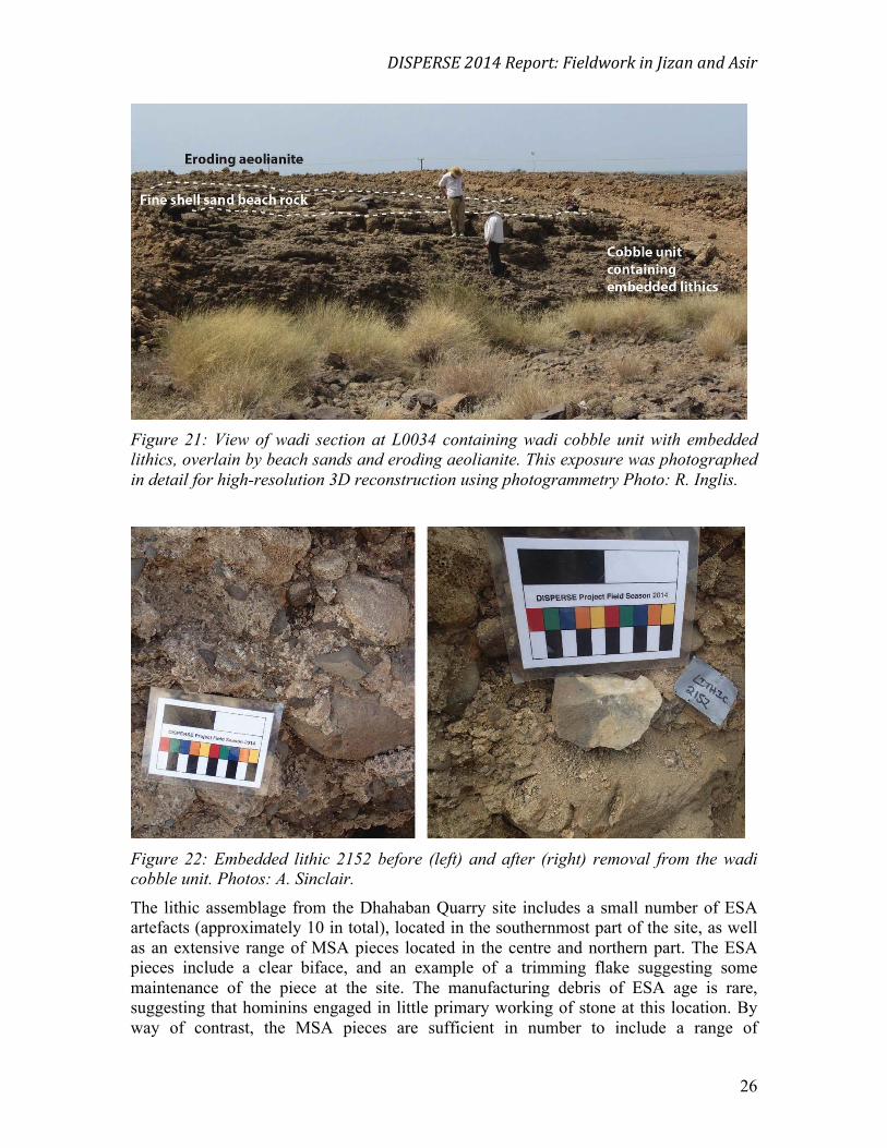
Figure 21: View of wadi section at L0034 containing wadi cobble unit with embedded
lithics, overlain by beach sands and eroding aeolianite. This exposure was photographed
in detail for high-resolution 3D reconstruction using photogrammetry Photo: R. Inglis.
Figure 22: Embedded lithic 2152 before (left) and after (right) removal from the wadi
cobble unit. Photos: A. Sinclair.
The lithic assemblage from the Dhahaban Quarry site includes a small number of ESA
artefacts (approximately 10 in total), located in the southernmost part of the site, as well
as an extensive range of MSA pieces located in the centre and northern part. The ESA
pieces include a clear biface, and an example of a trimming flake suggesting some
maintenance of the piece at the site. The manufacturing debris of ESA age is rare,
suggesting that hominins engaged in little primary working of stone at this location. By
way of contrast, the MSA pieces are sufficient in number to include a range of

DISPERSE 2014 Report: Fieldwork in Jizan and Asir
! 27
recognisable tool forms, including piercers, scrapers and burins. MSA artefacts are
extensively spread across the full extent of the Dhahaban Quarry site and whilst there are
places where the density of artefacts is greater, there are no areas that can be clearly
identified as stone technology working areas. The MSA manufacturing debris and the
presence of both initial early flaking as well as prepared core preparation and
rejuvenation suggests that hominins came to the site in anticipation of being able to
source and work local materials here. It seems reasonable to believe that wave action or
water flow in the wadi was sufficient on occasion to crack the large boulders of the Al
Birk lava flows, providing hominins with a flat surface from which to start flaking.
2.3.3 Hajambar Quarry (WP304)
The quarry north of Hajambar (WP304), identified as containing wadi overbank
sediments overlying lava in June 2012 (Devès et al. 2012) and subsequently sampled for
palaeoenvironmental analyses in November 2012 (Bailey et al. 2012), was re-visited in
order to sample the section for OSL dating. This resampling was, however, hampered by
the recent flooding of the quarry that has submerged at least half of the previously
observed sequence. Two OSL samples (<572> and <591>) were removed from the upper
part of the wadi sediments after cleaning back the accessible deposits.
Figure 23: Hajambar Quarry in 2014 following flooding. The previously sampled section
through the laminated wadi overbank sediments is behind the semi-submerged tree. The
section cleaned and sampled for OSL dating is visible at the centre right of the photo.
Photo: R. Inglis.

DISPERSE 2014 Report: Fieldwork in Jizan and Asir
! 28
2.3.4 Al Moalmat Rock Art (L0044)
During the 2013 survey, an area of basalt lava flow adjacent to Wadi Shafqah, beyond the
northernmost edge of the Harrat Al Birk was identified as containing extensive rock
engravings (Inglis et al. 2013). In 2014 the area, Al Moalmat, was revisited, and further
panels were identified over at least a kilometre. The engravings include abstract forms as
well as hands, feet, paw prints and figures (Figure 24). Detailed recording and analysis of
the art will be coordinated by the staff of the SCTA office in Abha.
Figure 24: Petroglyph at Al Moalmat (L0044) on columnar basalt showing figure with
curved dagger. Figure is approximately 40cm high. Photo: R. Inglis.
3. Summary and Conclusions
• The 2014 survey has consolidated and significantly expanded our understanding
of the Palaeolithic of the Jizan and Asir regions.
• Over 40 new localities were visited, the majority of which contained Palaeolithic
artefacts, and their geomorphological settings were recorded in order to allow the
analysis of landscape choice by early hominin populations in the Arabian
Peninsula.
• Three of these localities contained stratified lithics that will be dated to provide
chronological controls on the occupation of the Arabian Peninsula.
• 717 lithic artefacts, mainly of MSA but also ESA and LSA affinities was added to
the >700 recovered during survey in 2012 and 2013.
• Full preliminary analysis and cataloguing of the artefacts has been undertaken,
creating a significant data set to be used in understanding the technological
strategies employed by Palaeolithic occupations within their landscapes.
In conclusion, fieldwork by the DISPERSE project from 2012 to 2014 has significantly
expanded our understanding of the Palaeolithic occupation of the Jizan and Asir regions,

DISPERSE 2014 Report: Fieldwork in Jizan and Asir
! 29
and has demonstrated the massive potential for the area to inform debates surrounding the
dispersal of hominin populations from Africa during the Pleistocene.
4. Acknowledgements
We thank HRH Prince Sultan bin Salman bin Abdul Aziz, President of the Saudi
Commission for Tourism and Antiquities (SCTA), KSA, Professor Ali Al-Ghabban,
Vice-President, and Jamal Al Omar, Director General for granting fieldwork permission
and for their interest in and support of our work in Saudi Arabia. Grateful thanks are also
extended to the staff of the SCTA offices in Jizan and Sabya. The work is funded by the
European Research Council (ERC) under the Ideas Programme of the 7th Framework
Programme as Advanced Grant 269586 ‘DISPERSE: Dynamic Landscapes, Coastal
Environments and Human Dispersals'.
5. References
Armitage, S.J., S. A. Jasim, A. E. Marks, A. G. Parker, V. I. Usik, and H-P. Uerpmann
(2011). The Southern Route “Out of Africa”: evidence for an early expansion of modern
humans into Arabia. Science 331: 453–6.
Bailey, G.N, A. Alsharekh, N. Flemming, K. Lambeck, G. Momber, A.Sinclair and C.
Vita-Finzi. 2007. Coastal prehistory in the southern Red Sea Basin: underwater
archaeology and the Farasan Islands. Proceedings of the Seminar for Arabian Studies 37:
1–16.
Bailey, G. N., R. H. Inglis, M. G. Meredith-Williams, N. Hausmann, A. M. Alsharekh
and S. Al Ghamdi. (2012). Preliminary Report on Fieldwork in the Farasan Islands and
Jizan Province by the DISPERSE project, November-December 2012. Unpublished
Report to the Saudi Commission for Tourism and Antiquities.
Bailey, G.N., M.G.M. Meredith-Williams, and A. Alsharekh. (2013). Shell mounds of the
Farasan Islands, Saudi Arabia. In G. Bailey, K. Hardy, A. Camara (eds) Shell Energy:
Mollusc Shells as Coastal Resources. Oxford: OxBow. 241−54.
Crassard, R., & Hilbert, Y.H. (2013). A Nubian Complex Site from Central Arabia:
Implications for Levallois Taxonomy and Human Dispersals during the Upper
Pleistocene. PLoS One, 8(7).
Dabbagh, A., R. Emmermann, H. Hötzl, A. R. Jado, H. J. Lippolt, W. Kollman, H.
Moser, W. Rauert and J. G. Zötl. (1984). The development of Tihamat Asir during the
Quaternary. in A. R. Jado and J. G. Zötl, eds., Quaternary Period in Saudi Arabia
Volume 2: Sedimentological, Hydrogeological, Hydrochemical, Geomorphological,
Geochronological and Climatological Investigations in Western Saudi Arabia. Vienna:
Springer-Verlag. 150–73.
Delagnes, A., C. Tribolo, P. Bertran , M. Brenet, R. Crassard, J. Jaubert, L. Khalidi, N.
Mercier, S. Nomade, S. Peigne, L. Sitzia, J. F. Tournepiche, M. Al-Halibi, A. Al-Mosabi,
and R. Macchiarelli. (2012). Inland human settlement in southern Arabia 55,000 years
ago. New evidence from the Wadi Surdud Middle Paleolithic site complex, western
Yemen. Journal of Human Evolution 63: 452–74.

DISPERSE 2014 Report: Fieldwork in Jizan and Asir
! 30
Devès, M., R. H. Inglis, M. G. Meredith-Williams, A. Alsharekh, S. Al Ghamdi and G.
N. Bailey. (2012). Preliminary Report of Reconnaissance Fieldwork in Southwest Saudi
Arabia, May–June, 2012. Unpublished Report to the Saudi Commission for Tourism and
Antiquities.
Devès, M. H., R. H. Inglis, M. G. Meredith-Williams, S. Al Ghamdi, A. Alsharekh and
G. Bailey. (2013). Palaeolithic survey in southwest Saudi Arabia: methodology and
preliminary results. Adumatu 27: 7-30.
Groucutt, H. S. & Petraglia M.D. 2012. The prehistory of the Arabian peninsula: Deserts,
dispersals, and demography. Evolutionary Anthropology 21 (3): 113–25.
Inglis, R. H., A. G. M. Sinclair, A. Shuttleworth, A. M. Alsharekh and S. Al Ghamdi.
(2013). Preliminary Report on 2013 Fieldwork in Southwest Saudi Arabia by the
DISPERSE Project: (2) Jizan and Asir Provinces, February-March 2013. Unpublished
Report to the Saudi Commission for Tourism and Antiquities.
Inglis, R. H., A. Sinclair, A. Shuttleworth, A. Alsharekh, S. Al Ghamdi, M. Devès, M. G.
Meredith-Williams and G. N. Bailey. (2014). Investigating the Palaeolithic Landscapes
and Archaeology of the Jizan and Asir Regions, Southwest Saudi Arabia. Proceedings of
the Seminar for Arabian Studies 44: 193-212.
Lambeck, K., A. Purcell, N. C. Flemming, C. Vita-Finzi, A. M. Alsharekh and G. N.
Bailey. (2011). Sea level and shoreline reconstructions for the Red Sea: isostatic and
tectonic considerations and implications for hominin migration out of Africa. Quaternary
Science Reviews 30 (25-26): 3542-74.
Petraglia, M.D., Alsharekh, A.M., Crassard, R., Drake, N.A., Groucutt, H., Parker, A.G.,
et al. (2011). Middle Paleolithic occupation on a Marine Isotope Stage 5 lakeshore in the
Nefud Desert, Saudi Arabia. Quaternary Science Reviews, 30(13-14), 1555-1559.
Rose J. I., V. I. Usik, A. E. Marks, Y. Hilbert, C. S. Galetti, A. Parton, J. M. Geiling, M.
W. Morley and R. G. Roberts. (2011). The Nubian Complex of Dhofar, Oman: An
African Middle Stone Age Industry in Southern Arabia. PLoS One 6 (11): 1–22.
Wilkins, J., & Chazan, M. (2012). Blade production ∼500 thousand years ago at Kathu
Pan 1, South Africa: support for a multiple origins hypothesis for early Middle
Pleistocene blade technologies. Journal of Archaeological Science, 39(6), 1883-1900.

DISPERSE 2014 Report: Fieldwork in Jizan and Asir
! 31
Appendix 1 - Field Team
University of York, UK
Geoff Bailey
Niklas Hausmann
Robyn Inglis
Matthew Meredith-Williams,
University of Liverpool, UK
William Budd
Andrew Shuttleworth
Anthony Sinclair
King Saud University, KSA
Abdullah Alsharekh
Saud Al Ghamdi
Abdarrazzaq Al Maamary
Saudi Commission for Tourism and Antiquities
Saeed Al Karni, Director of Antiquities, Asir
Saeed Abu Mater, Abha
Faia Asiri, Abha
Hussein Mofareh, Sabiya
Aied Al Hmaed, Dawasir
Abdulaziz As Salman, Riyadh
Abdu Aqeeli, Farasan
National Museum, Riyadh, KSA
Bassam Al Hilal
Mohammed Al Halwi