randolph county gis user’s guide · randolph county gis user’s guide 1 ... ios and windows 8.1...
TRANSCRIPT
Randolph County GIS User’s Guide
1
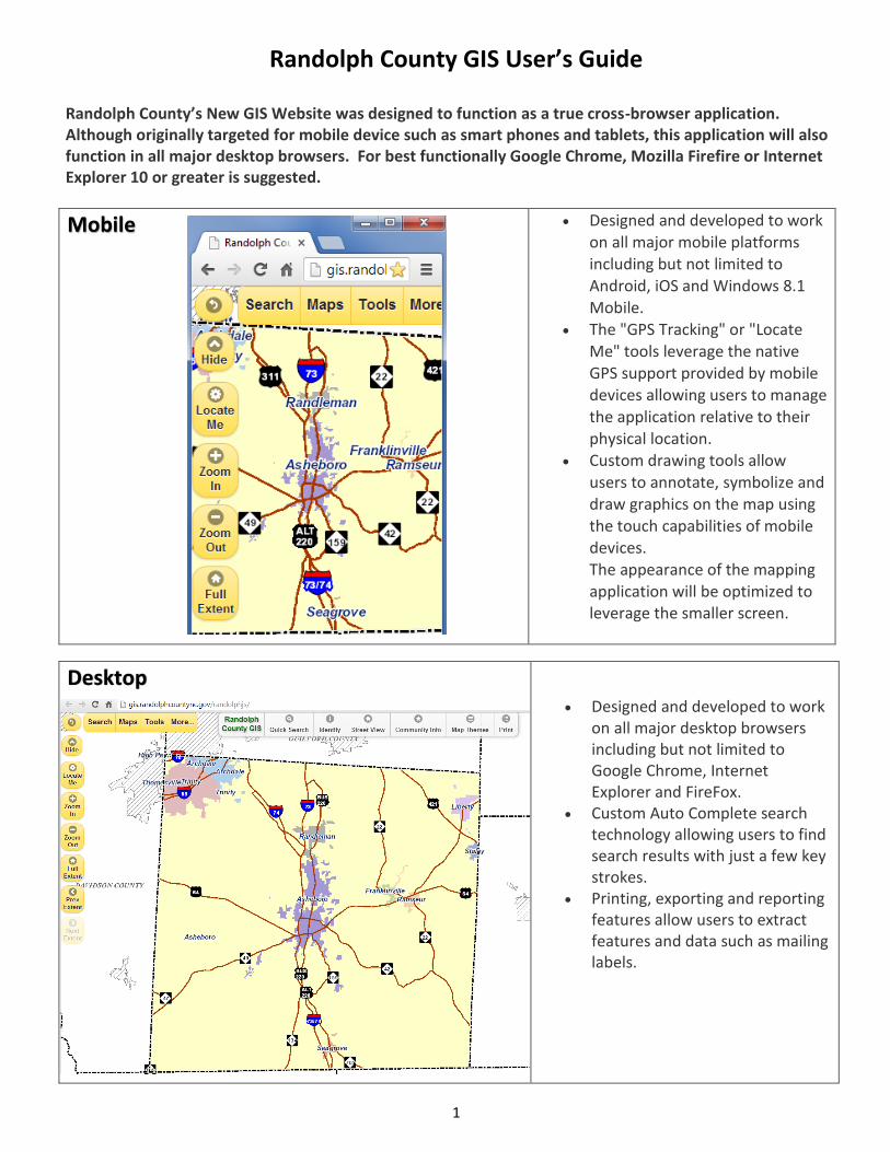
Randolph County’s New GIS Website was designed to function as a true cross-browser application. Although originally targeted for mobile device such as smart phones and tablets, this application will also function in all major desktop browsers. For best functionally Google Chrome, Mozilla Firefire or Internet Explorer 10 or greater is suggested.
Mobile Designed and developed to work on all major mobile platforms including but not limited to Android, iOS and Windows 8.1 Mobile.
The "GPS Tracking" or "Locate Me" tools leverage the native
GPS support provided by mobile devices allowing users to manage the application relative to their physical location.
Custom drawing tools allow users to annotate, symbolize and draw graphics on the map using the touch capabilities of mobile devices.
The appearance of the mapping application will be optimized to leverage the smaller screen.
Desktop
Designed and developed to work on all major desktop browsers including but not limited to Google Chrome, Internet Explorer and FireFox.
Custom Auto Complete search technology allowing users to find search results with just a few key strokes.
Printing, exporting and reporting features allow users to extract features and data such as mailing labels.
Randolph County GIS User’s Guide
2
Navigation
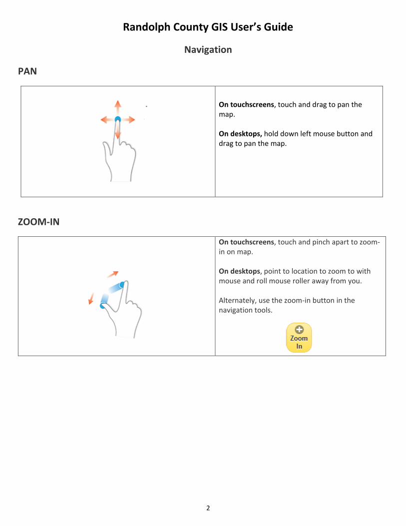
PAN
On touchscreens, touch and drag to pan the map. On desktops, hold down left mouse button and drag to pan the map.
ZOOM-IN
On touchscreens, touch and pinch apart to zoom-in on map. On desktops, point to location to zoom to with mouse and roll mouse roller away from you. Alternately, use the zoom-in button in the navigation tools.
Randolph County GIS User’s Guide
3
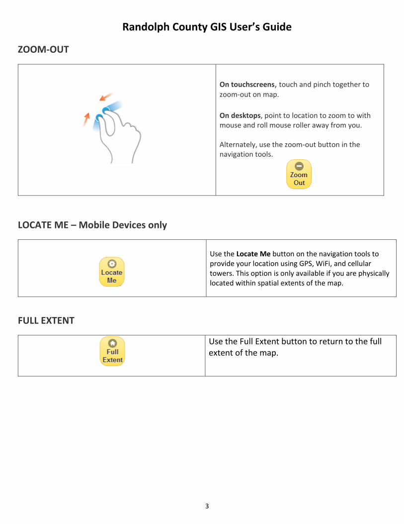
ZOOM-OUT
On touchscreens, touch and pinch together to
zoom-out on map. On desktops, point to location to zoom to with mouse and roll mouse roller away from you. Alternately, use the zoom-out button in the navigation tools.
LOCATE ME – Mobile Devices only
Use the Locate Me button on the navigation tools to provide your location using GPS, WiFi, and cellular towers. This option is only available if you are physically located within spatial extents of the map.
FULL EXTENT
Use the Full Extent button to return to the full extent of the map.
Randolph County GIS User’s Guide
4
SEARCH
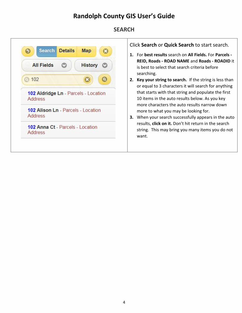
Click Search or Quick Search to start search.
1. For best results search on All Fields. For Parcels -
REID, Roads - ROAD NAME and Roads - ROADID it
is best to select that search criteria before
searching.
2. Key your string to search. If the string is less than
or equal to 3 characters it will search for anything
that starts with that string and populate the first
10 items in the auto results below. As you key
more characters the auto results narrow down
more to what you may be looking for.
3. When your search successfully appears in the auto
results, click on it. Don’t hit return in the search
string. This may bring you many items you do not
want.
Randolph County GIS User’s Guide
5
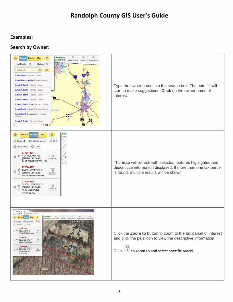
Examples:
Search by Owner:
Type the owner name into the search box. The auto fill will
start to make suggestions. Click on the owner name of
interest.
The map will refresh with selected features highlighted and
descriptive information displayed. If more than one tax parcel
is found, multiple results will be shown.
Click the Zoom to button to zoom to the tax parcel of interest
and click the plus icon to view the descriptive information.
Click to zoom to and select specific parcel.
Randolph County GIS User’s Guide
6
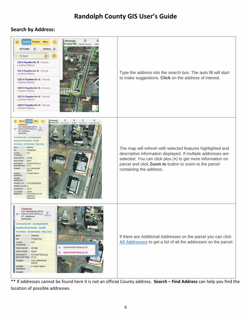
Search by Address:
Type the address into the search box. The auto fill will start
to make suggestions. Click on the address of interest.
The map will refresh with selected features highlighted and
descriptive information displayed. If multiple addresses are
selected. You can click plus (+) to get more information on
parcel and click Zoom to button to zoom to the parcel
containing the address.
If there are Additional Addresses on the parcel you can click
All Addresses to get a list of all the addresses on the parcel.
** If addresses cannot be found here it is not an official County address. Search – Find Address can help you find the
location of possible addresses.
Randolph County GIS User’s Guide
7
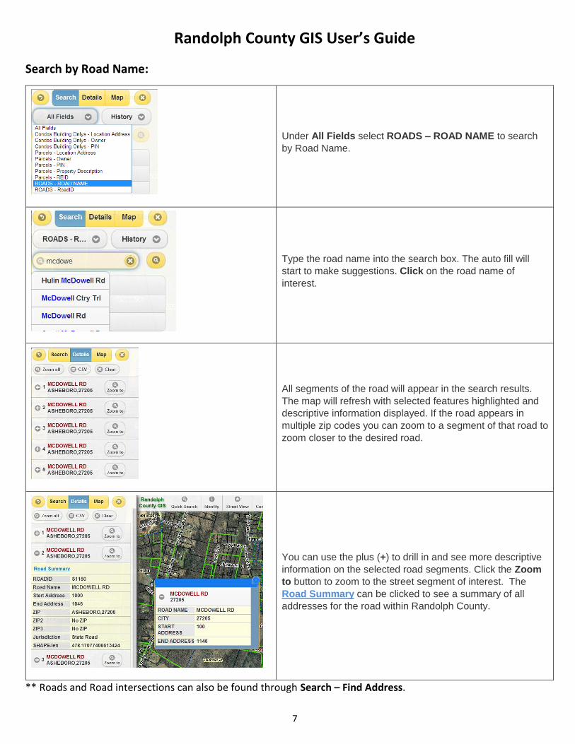
Search by Road Name:
Under All Fields select ROADS – ROAD NAME to search
by Road Name.
Type the road name into the search box. The auto fill will
start to make suggestions. Click on the road name of
interest.
All segments of the road will appear in the search results.
The map will refresh with selected features highlighted and
descriptive information displayed. If the road appears in
multiple zip codes you can zoom to a segment of that road to
zoom closer to the desired road.
You can use the plus (+) to drill in and see more descriptive
information on the selected road segments. Click the Zoom
to button to zoom to the street segment of interest. The
Road Summary can be clicked to see a summary of all
addresses for the road within Randolph County.
** Roads and Road intersections can also be found through Search – Find Address.
Randolph County GIS User’s Guide
8
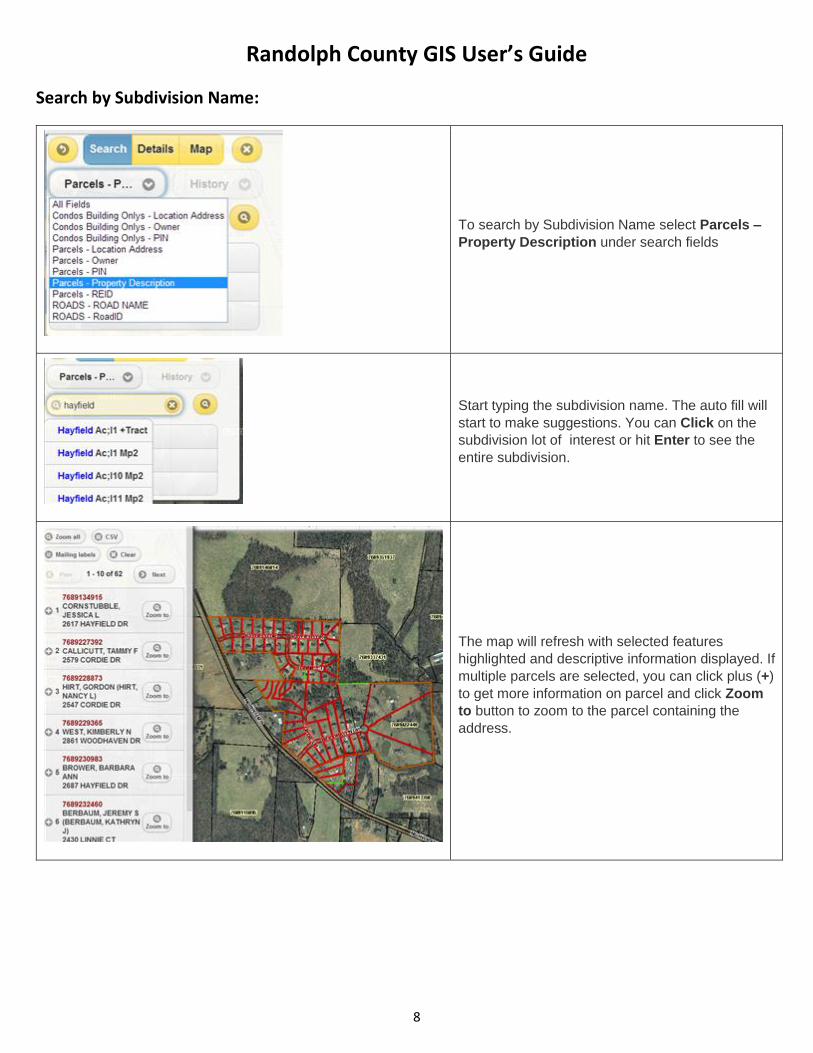
Search by Subdivision Name:
To search by Subdivision Name select Parcels –
Property Description under search fields
Start typing the subdivision name. The auto fill will
start to make suggestions. You can Click on the
subdivision lot of interest or hit Enter to see the
entire subdivision.
The map will refresh with selected features
highlighted and descriptive information displayed. If
multiple parcels are selected, you can click plus (+)
to get more information on parcel and click Zoom
to button to zoom to the parcel containing the
address.
Randolph County GIS User’s Guide
9
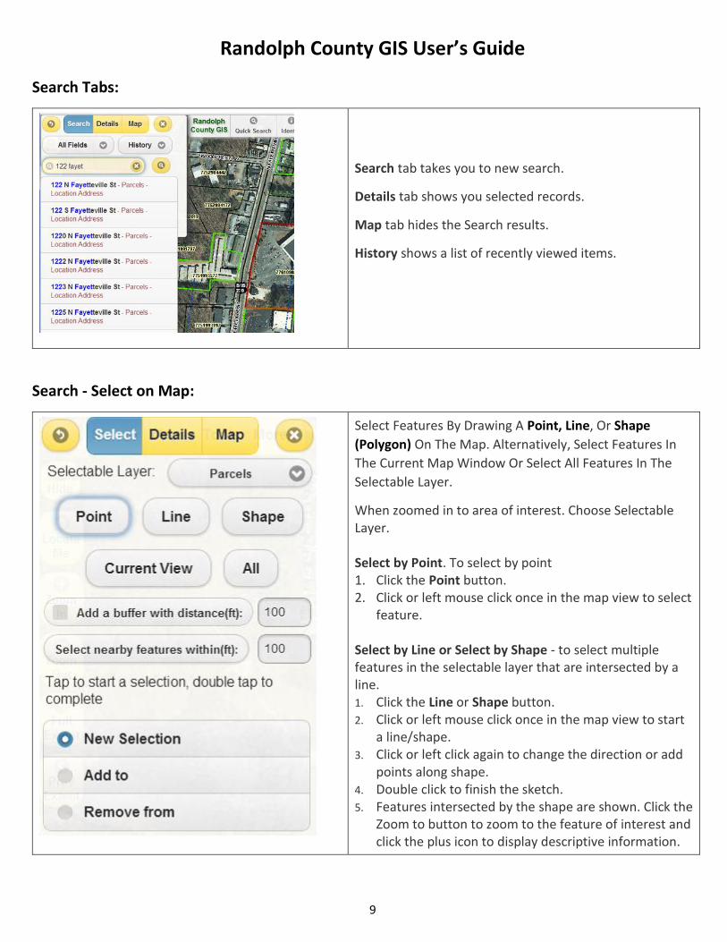
Search Tabs:
Search tab takes you to new search.
Details tab shows you selected records.
Map tab hides the Search results.
History shows a list of recently viewed items.
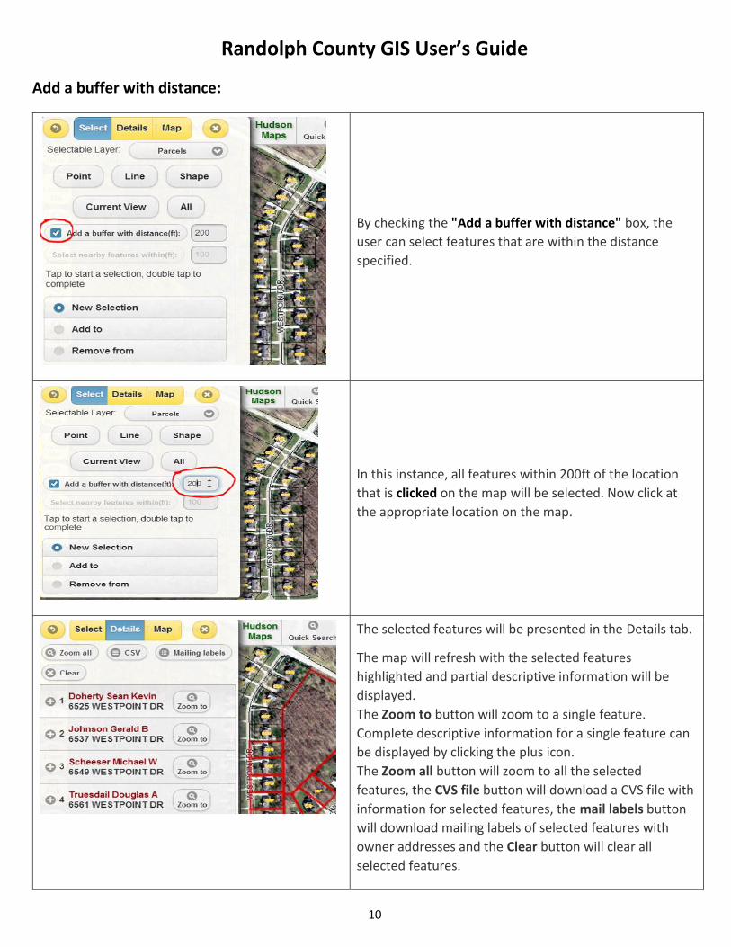
Search - Select on Map:
Select Features By Drawing A Point, Line, Or Shape
(Polygon) On The Map. Alternatively, Select Features In
The Current Map Window Or Select All Features In The
Selectable Layer.
When zoomed in to area of interest. Choose Selectable Layer. Select by Point. To select by point 1. Click the Point button. 2. Click or left mouse click once in the map view to select
feature.
Select by Line or Select by Shape - to select multiple features in the selectable layer that are intersected by a line. 1. Click the Line or Shape button. 2. Click or left mouse click once in the map view to start
a line/shape. 3. Click or left click again to change the direction or add
points along shape. 4. Double click to finish the sketch. 5. Features intersected by the shape are shown. Click the
Zoom to button to zoom to the feature of interest and click the plus icon to display descriptive information.
Randolph County GIS User’s Guide
10
Add a buffer with distance:
By checking the "Add a buffer with distance" box, the
user can select features that are within the distance
specified.
In this instance, all features within 200ft of the location
that is clicked on the map will be selected. Now click at
the appropriate location on the map.
The selected features will be presented in the Details tab.
The map will refresh with the selected features
highlighted and partial descriptive information will be
displayed.
The Zoom to button will zoom to a single feature.
Complete descriptive information for a single feature can
be displayed by clicking the plus icon.
The Zoom all button will zoom to all the selected
features, the CVS file button will download a CVS file with
information for selected features, the mail labels button
will download mailing labels of selected features with
owner addresses and the Clear button will clear all
selected features.
Randolph County GIS User’s Guide
11
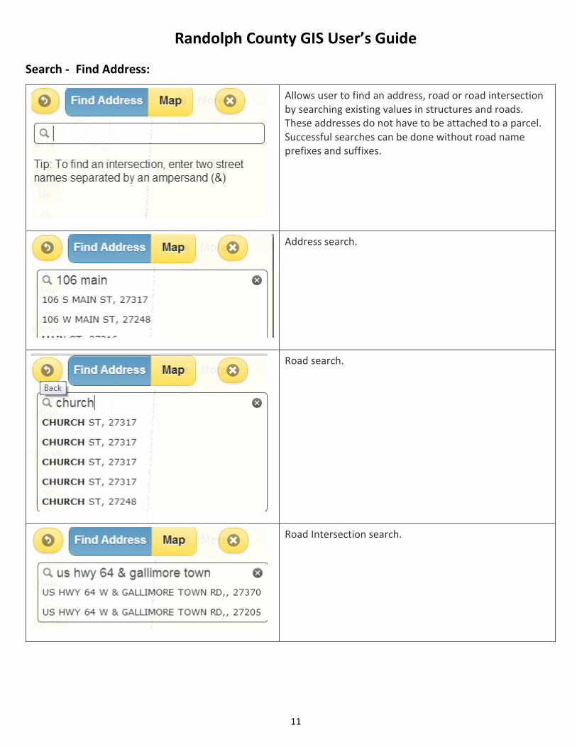
Search - Find Address:
Allows user to find an address, road or road intersection by searching existing values in structures and roads. These addresses do not have to be attached to a parcel. Successful searches can be done without road name prefixes and suffixes.
Address search.
Road search.
Road Intersection search.
Randolph County GIS User’s Guide
12
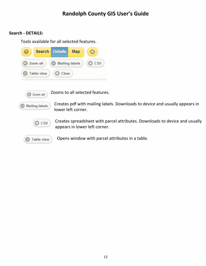
Search - DETAILS:
Tools available for all selected features.
Zooms to all selected features.
Creates pdf with mailing labels. Downloads to device and usually appears in lower left corner.
Creates spreadsheet with parcel attributes. Downloads to device and usually
appears in lower left corner. Opens window with parcel attributes in a table.
Randolph County GIS User’s Guide
13
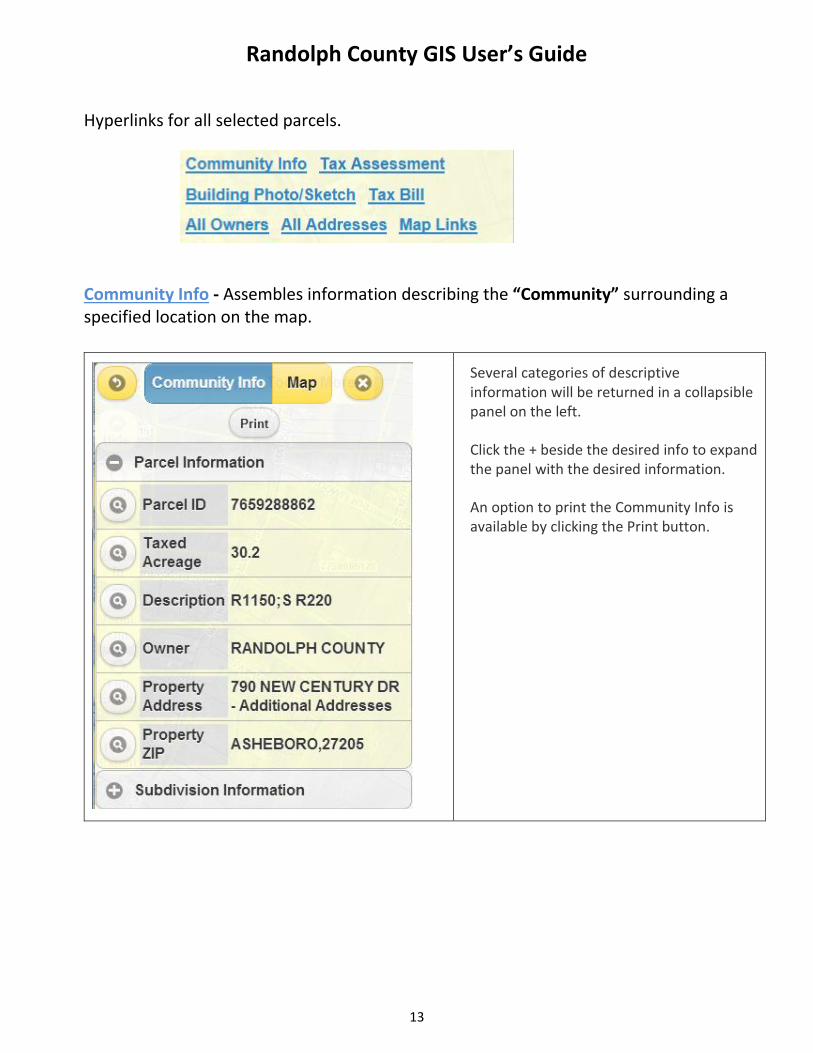
Hyperlinks for all selected parcels.
Community Info - Assembles information describing the “Community” surrounding a specified location on the map.
Several categories of descriptive information will be returned in a collapsible panel on the left.
Click the + beside the desired info to expand the panel with the desired information.
An option to print the Community Info is available by clicking the Print button.
Randolph County GIS User’s Guide
14
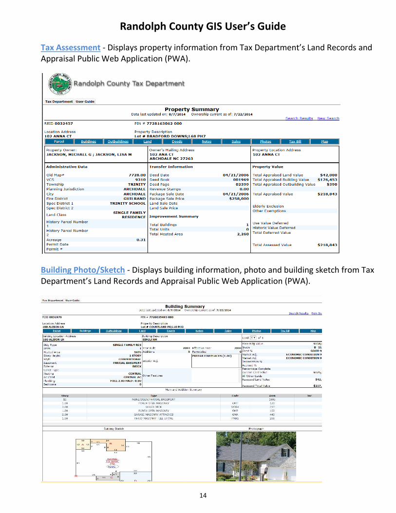
Tax Assessment - Displays property information from Tax Department’s Land Records and Appraisal Public Web Application (PWA).
Building Photo/Sketch - Displays building information, photo and building sketch from Tax Department’s Land Records and Appraisal Public Web Application (PWA).

Randolph County GIS User’s Guide
15
Tax Bill – Links to Tax Department’s Billing and Collections Public Web Application (PWA).
All Owners - Displays a list of all owners for the selected property. This is helpful when
Additional Owners are identified for a property.
Randolph County GIS User’s Guide
16
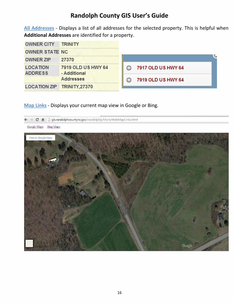
All Addresses - Displays a list of all addresses for the selected property. This is helpful when
Additional Addresses are identified for a property.
Map Links - Displays your current map view in Google or Bing.
Randolph County GIS User’s Guide
17
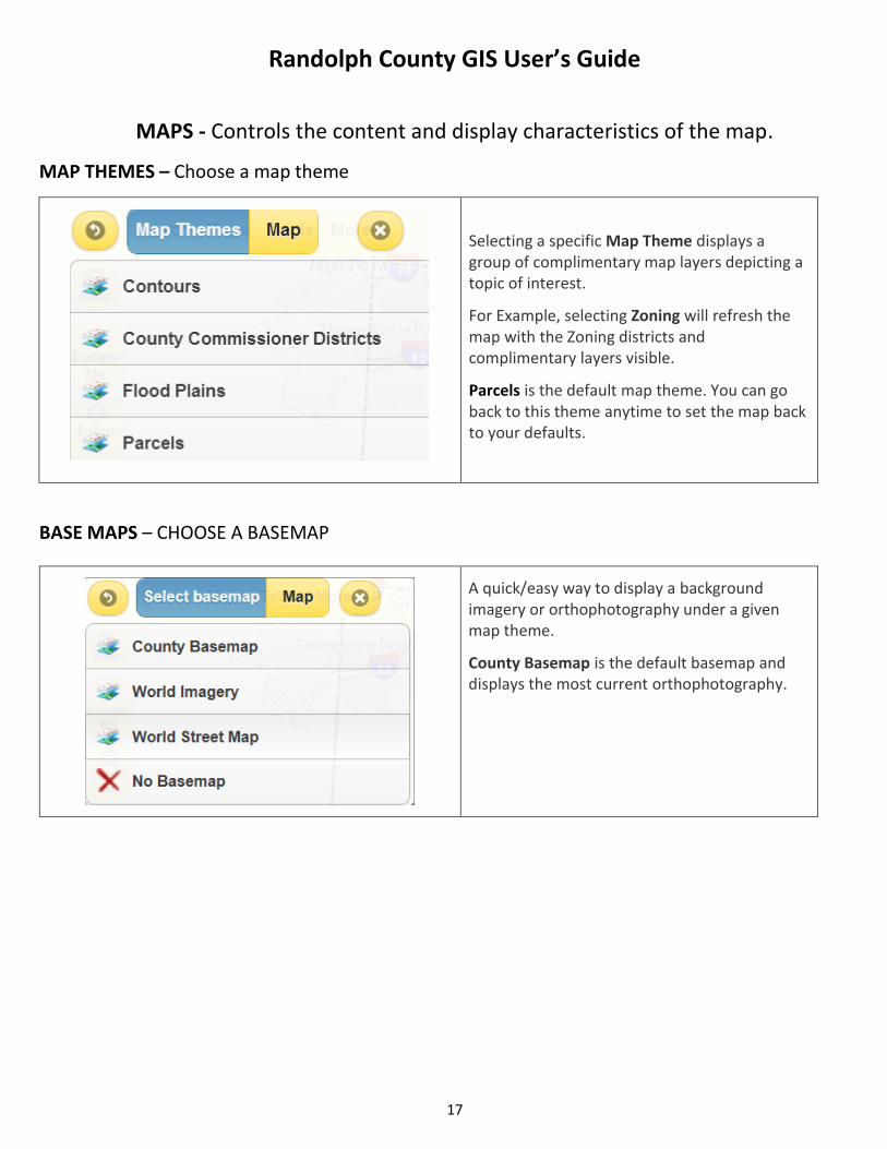
MAPS - Controls the content and display characteristics of the map.
MAP THEMES – Choose a map theme
Selecting a specific Map Theme displays a group of complimentary map layers depicting a topic of interest.
For Example, selecting Zoning will refresh the map with the Zoning districts and complimentary layers visible.
Parcels is the default map theme. You can go back to this theme anytime to set the map back to your defaults.
BASE MAPS – CHOOSE A BASEMAP
A quick/easy way to display a background imagery or orthophotography under a given map theme.
County Basemap is the default basemap and displays the most current orthophotography.
Randolph County GIS User’s Guide
18
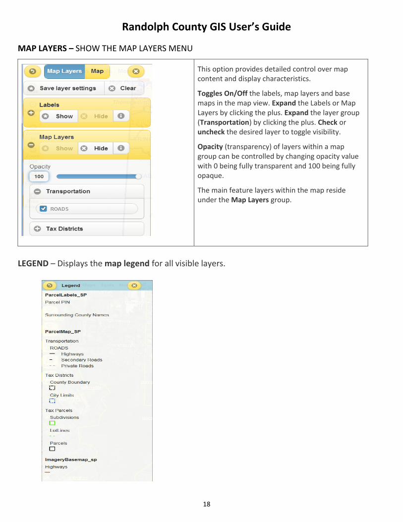
MAP LAYERS – SHOW THE MAP LAYERS MENU
This option provides detailed control over map content and display characteristics.
Toggles On/Off the labels, map layers and base maps in the map view. Expand the Labels or Map Layers by clicking the plus. Expand the layer group (Transportation) by clicking the plus. Check or uncheck the desired layer to toggle visibility.
Opacity (transparency) of layers within a map group can be controlled by changing opacity value with 0 being fully transparent and 100 being fully opaque.
The main feature layers within the map reside under the Map Layers group.
LEGEND – Displays the map legend for all visible layers.
Randolph County GIS User’s Guide
19
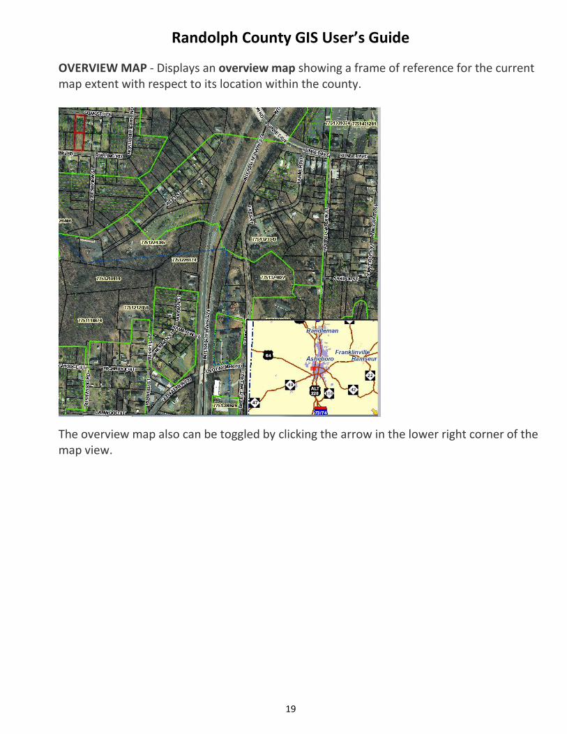
OVERVIEW MAP - Displays an overview map showing a frame of reference for the current map extent with respect to its location within the county.
The overview map also can be toggled by clicking the arrow in the lower right corner of the map view.
Randolph County GIS User’s Guide
20
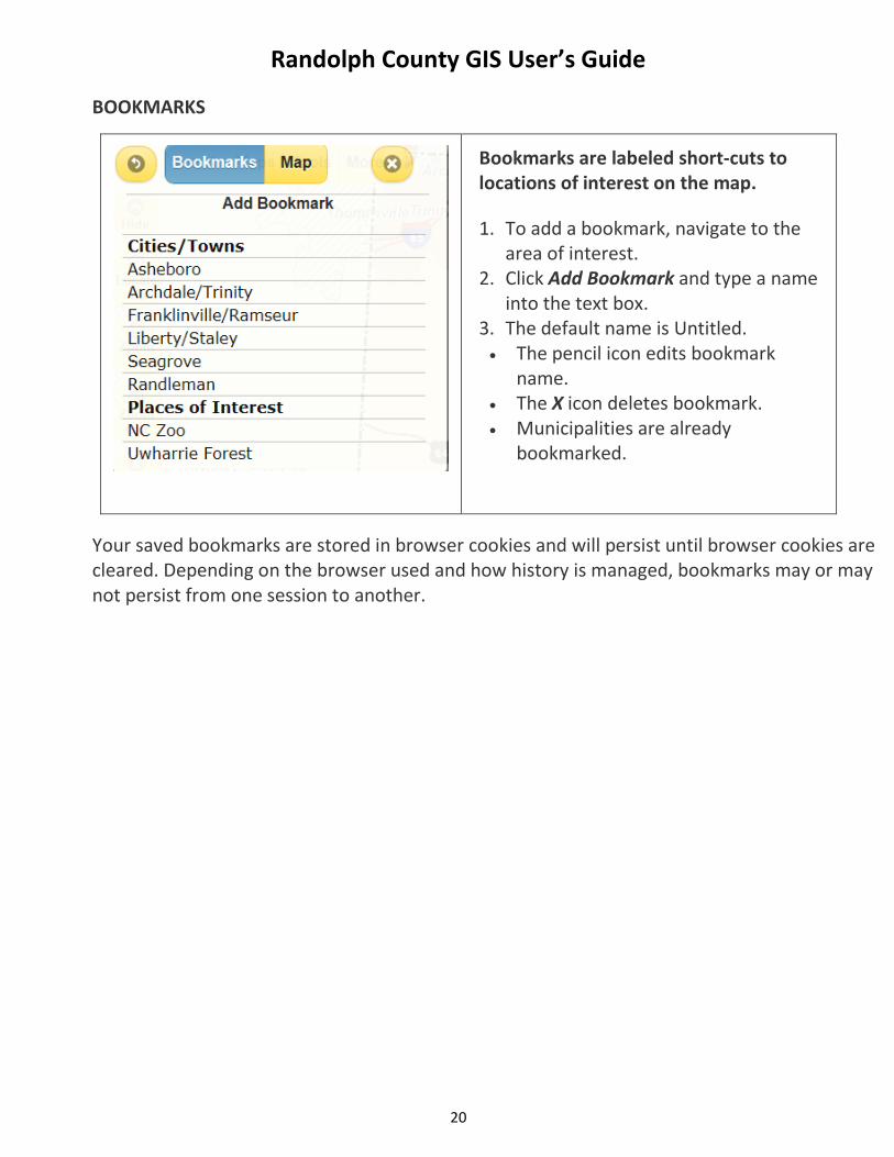
BOOKMARKS
Bookmarks are labeled short-cuts to locations of interest on the map.
1. To add a bookmark, navigate to the area of interest.
2. Click Add Bookmark and type a name into the text box.
3. The default name is Untitled. The pencil icon edits bookmark
name. The X icon deletes bookmark. Municipalities are already
bookmarked.
Your saved bookmarks are stored in browser cookies and will persist until browser cookies are cleared. Depending on the browser used and how history is managed, bookmarks may or may not persist from one session to another.
Randolph County GIS User’s Guide
21
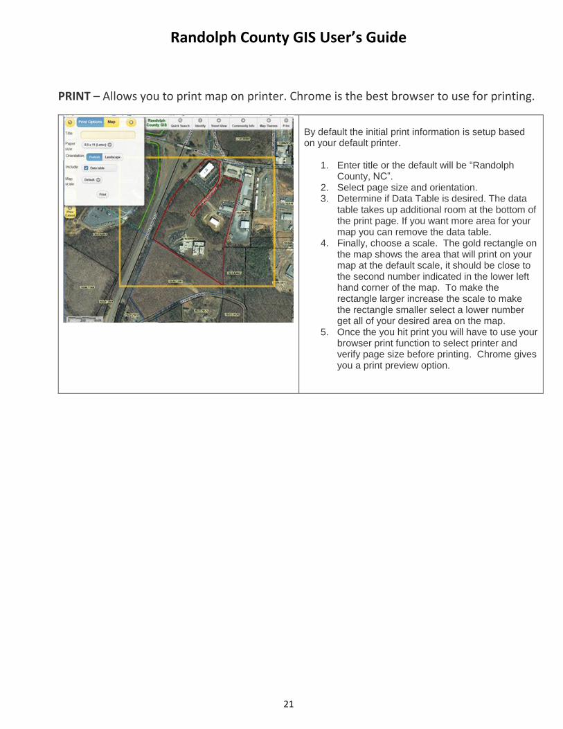
PRINT – Allows you to print map on printer. Chrome is the best browser to use for printing.
By default the initial print information is setup based on your default printer.
1. Enter title or the default will be “Randolph County, NC”.
2. Select page size and orientation. 3. Determine if Data Table is desired. The data
table takes up additional room at the bottom of the print page. If you want more area for your map you can remove the data table.
4. Finally, choose a scale. The gold rectangle on the map shows the area that will print on your map at the default scale, it should be close to the second number indicated in the lower left hand corner of the map. To make the rectangle larger increase the scale to make the rectangle smaller select a lower number get all of your desired area on the map.
5. Once the you hit print you will have to use your browser print function to select printer and verify page size before printing. Chrome gives you a print preview option.
Randolph County GIS User’s Guide
22
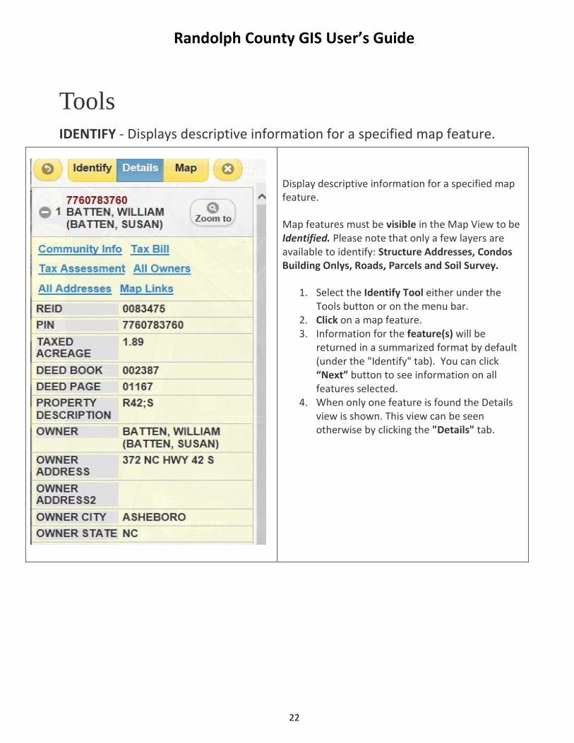
Tools
IDENTIFY - Displays descriptive information for a specified map feature.
Display descriptive information for a specified map feature.
Map features must be visible in the Map View to be Identified. Please note that only a few layers are available to identify: Structure Addresses, Condos Building Onlys, Roads, Parcels and Soil Survey.
1. Select the Identify Tool either under the Tools button or on the menu bar.
2. Click on a map feature. 3. Information for the feature(s) will be
returned in a summarized format by default (under the "Identify" tab). You can click “Next” button to see information on all features selected.
4. When only one feature is found the Details view is shown. This view can be seen otherwise by clicking the "Details" tab.
Randolph County GIS User’s Guide
23
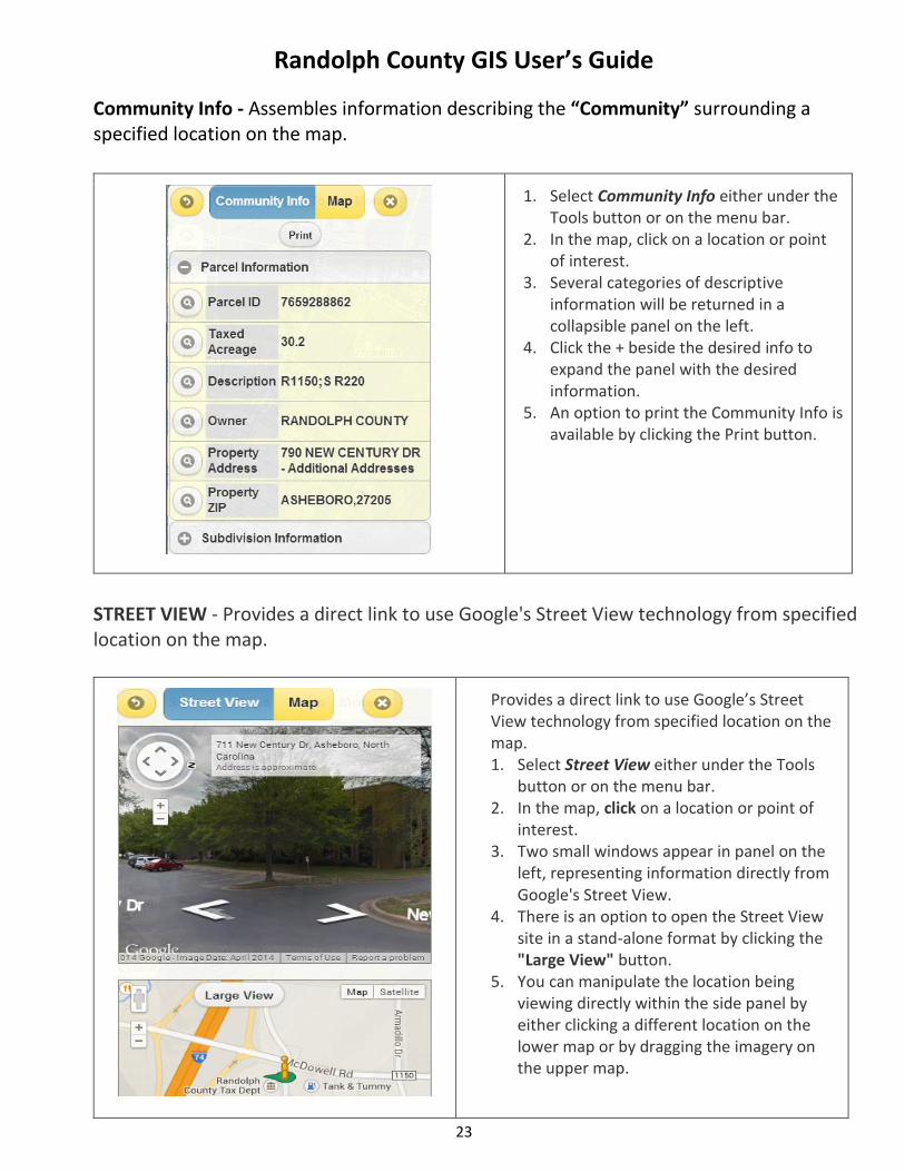
Community Info - Assembles information describing the “Community” surrounding a specified location on the map.
1. Select Community Info either under the Tools button or on the menu bar.
2. In the map, click on a location or point of interest.
3. Several categories of descriptive information will be returned in a collapsible panel on the left.
4. Click the + beside the desired info to expand the panel with the desired information.
5. An option to print the Community Info is available by clicking the Print button.
STREET VIEW - Provides a direct link to use Google's Street View technology from specified location on the map.
Provides a direct link to use Google’s Street View technology from specified location on the map. 1. Select Street View either under the Tools
button or on the menu bar. 2. In the map, click on a location or point of
interest. 3. Two small windows appear in panel on the
left, representing information directly from Google's Street View.
4. There is an option to open the Street View site in a stand-alone format by clicking the "Large View" button.
5. You can manipulate the location being viewing directly within the side panel by either clicking a different location on the lower map or by dragging the imagery on the upper map.
Randolph County GIS User’s Guide
24
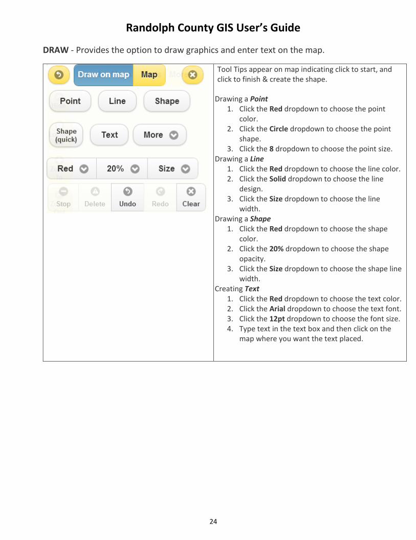
DRAW - Provides the option to draw graphics and enter text on the map.
Tool Tips appear on map indicating click to start, and click to finish & create the shape.
Drawing a Point 1. Click the Red dropdown to choose the point
color. 2. Click the Circle dropdown to choose the point
shape. 3. Click the 8 dropdown to choose the point size.
Drawing a Line 1. Click the Red dropdown to choose the line color. 2. Click the Solid dropdown to choose the line
design. 3. Click the Size dropdown to choose the line
width. Drawing a Shape
1. Click the Red dropdown to choose the shape color.
2. Click the 20% dropdown to choose the shape opacity.
3. Click the Size dropdown to choose the shape line width.
Creating Text 1. Click the Red dropdown to choose the text color. 2. Click the Arial dropdown to choose the text font. 3. Click the 12pt dropdown to choose the font size. 4. Type text in the text box and then click on the
map where you want the text placed.
Randolph County GIS User’s Guide
25
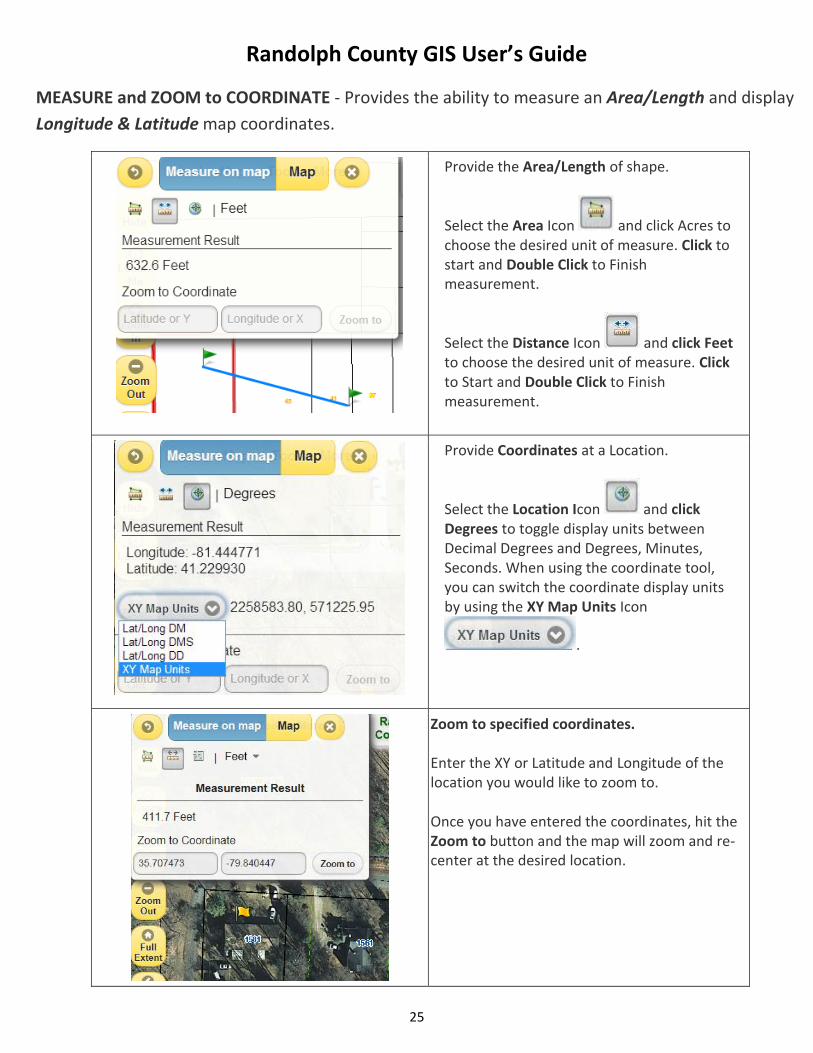
MEASURE and ZOOM to COORDINATE - Provides the ability to measure an Area/Length and display
Longitude & Latitude map coordinates.
Provide the Area/Length of shape.
Select the Area Icon and click Acres to choose the desired unit of measure. Click to start and Double Click to Finish measurement.
Select the Distance Icon and click Feet to choose the desired unit of measure. Click to Start and Double Click to Finish measurement.
Provide Coordinates at a Location.
Select the Location Icon and click Degrees to toggle display units between Decimal Degrees and Degrees, Minutes, Seconds. When using the coordinate tool, you can switch the coordinate display units by using the XY Map Units Icon
.
Zoom to specified coordinates. Enter the XY or Latitude and Longitude of the
location you would like to zoom to. Once you have entered the coordinates, hit the
Zoom to button and the map will zoom and re-center at the desired location.
Randolph County GIS User’s Guide
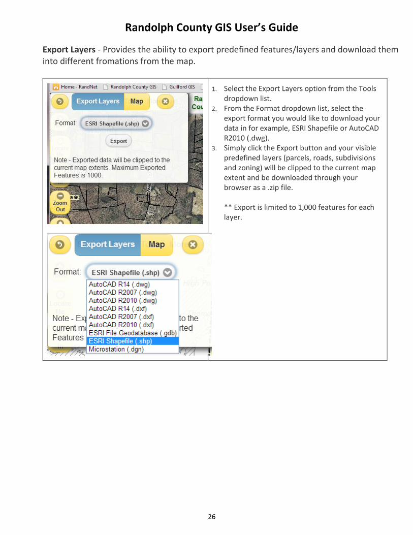
26
Export Layers - Provides the ability to export predefined features/layers and download them into different fromations from the map.
1. Select the Export Layers option from the Tools dropdown list.
2. From the Format dropdown list, select the export format you would like to download your data in for example, ESRI Shapefile or AutoCAD R2010 (.dwg).
3. Simply click the Export button and your visible predefined layers (parcels, roads, subdivisions and zoning) will be clipped to the current map extent and be downloaded through your browser as a .zip file. ** Export is limited to 1,000 features for each layer.
Randolph County GIS User’s Guide
27
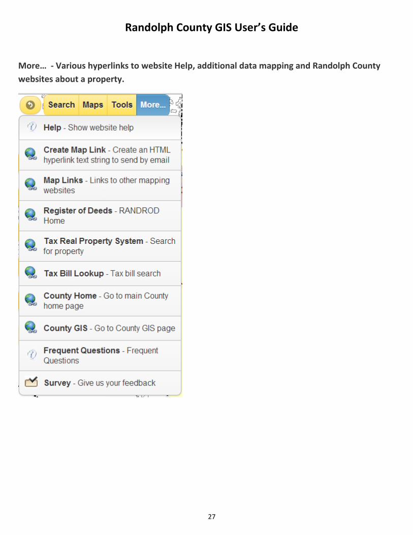
More… - Various hyperlinks to website Help, additional data mapping and Randolph County
websites about a property.