re: groundwater monitoring network – bore …
TRANSCRIPT
Our Ref: S167E/032a Date: 5 September 2013
Rob Hunt Centennial Coal Level 18, BT Tower 1 Market Street Sydney NSW 2000
Dear Rob,
RE: GROUNDWATER MONITORING NETWORK – BORE COMPLETION REPORT
1. INTRODUCTION
RPS was engaged by Springvale Coal Pty to expand the existing groundwater monitoring network at the Centennial Springvale Coal Services operation (Coal Services). The operation is situated at Blackmans Flat, NSW.
This report provides a summary of activities carried out during the hydrogeological field programme undertaken at Coal Services from the 19 August 2013 to the 26 August 2013.
Hydrogeological data acquired during the field programme are presented to provide Coal Services with the required information to enable future data analysis and manipulation of monitoring data from the installed monitoring points.
1.1 Document Structure
The document is laid out as follows:
Section 2: Provides the reasoning behind the hydrogeological field programme and why it was initiated by Coal Services. It describes the aims and objectives of the field programme and the tasks which were undertaken to achieve these objectives.
Section 3: Details the work that has been carried out as a part of the field programme. Schedule of activities are presented, along with the hydrogeological data which was collected during the programme.
Section 4: Presents the conclusions, key outcomes and recommendations which have been made following the completion of the field programme and provides recommendations for ongoing groundwater monitoring.
2. BACKGROUND
Centennial operates the Coal Services site located in the Blackmans Flat, Lidsdale and Wallerawang localities in NSW (Figure 1). The Project is an existing approved facility within the Springvale development consent and consists of a wash plant; reject emplacement facilities and a coal distribution network of conveyors. Centennial intend to upgrade the site to enable up to 7.0Mtpa of coal to be washed with up to 6.3Mtpa of export coal delivered to Lidsdale Siding via the existing overland conveyor system.

F:\Jobs\S167E\600\032a.doc Page 2
Groundwater and surface water have been identified as key environmental issues to be managed on site. The existing surface water monitoring program is outlined in the site surface water assessment and includes monitoring for water quality at a number of locations across the Project site comprising three monitoring stations on Wangcol Creek, one upstream of the Project and two downstream. In addition, visual inspections of all sediment dams are complete weekly.
The existing groundwater monitoring network onsite consists of three monitoring bores (BH1, BH2 and BH3) which monitor the Berry and Marangaroo Formations (Figure 1).
The objective of this programme was to develop and implement an efficient groundwater monitoring network that will satisfy regulators and stakeholders on impact identification and site environmental management.
3. FIELD PROGRAMME
In order to achieve the objectives outlined in section 2, the following tasks were undertaken:
Identification of existing monitoring bores that can be utilised for further monitoring.
The installation of an additional four groundwater monitoring bores.
Hydraulic testing of BH07 and existing monitoring bores BH04 and BH05.
Field water quality parameter sampling from installed monitoring bores (pH, EC and temperature).
3.1 Existing Monitoring Bores
A number of existing monitoring bores have been located on site that can be incorporated into the groundwater monitoring network. Bore details are provided on Table 1 and the locations are shown on Figure 1.
Table 1: Existing Monitoring Bore Details and Nomenclature
Recommended SVCS Name
Previous Name Easting Northing Depth (mbgl)
BH01 BH01 (D&P) 225978.2 6305017.7 18.3
BH02 BH02 (SKM) 225948 6303880 30.0
BH03 BH03 (D&P) 226175.2 6304416.4 18.6
BH04 Unavailable 225614 6304539 27.5
BH05 Unavailable 225769 6304711 30.2
BH06 MPGM4-D2 226183 6304758 9.3
BH11 Unavailable 225088 6304251 35.3
BH12 Unavailable 225667 6304819 19.7
BH13 Unavailable 225667 6304819 13.0
BH14 BH01 (SKM) 224866 6304259 33.2
BH15 BH04 (SKM) 225042 6304667 24.6
*Douglas and Partners (D&P)
*Sinclair Knight Merz (SKM)
3.2 Monitoring Bore Installation
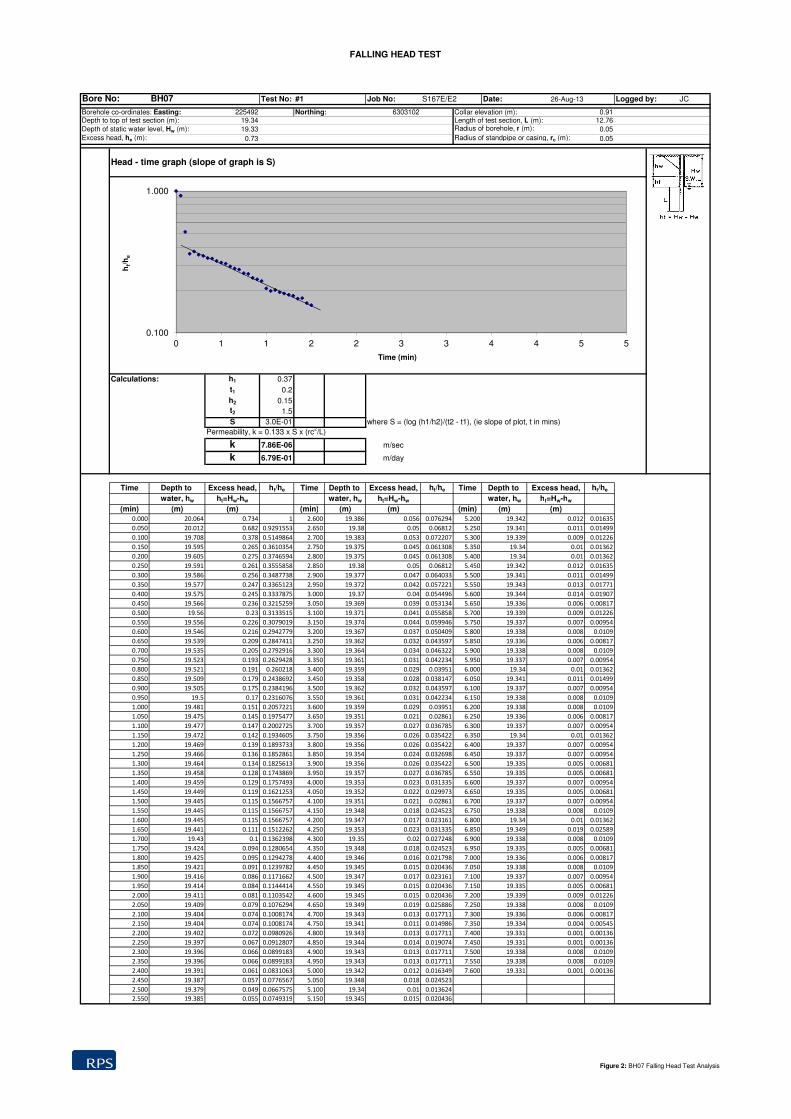
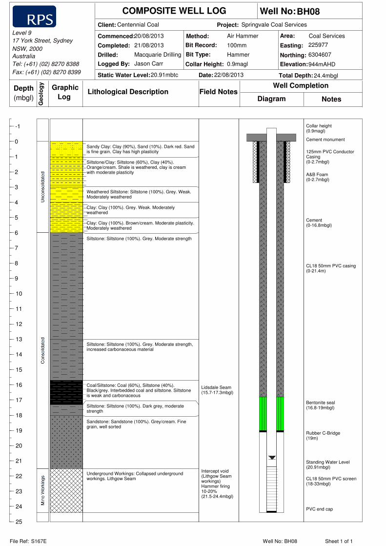
Monitoring bore installations were designed to complement the existing monitoring network targeting the Lithgow coal seam (BH08, BH09 and BH10) and an up gradient site unaffected by operational activity (BH07). Groundwater licenses were obtained prior to the installation of each monitoring bore. Monitoring bore locations are shown on Figure 1.
All four standpipe monitoring bores were completed in accordance with specifications outlined in the Minimum Construction Requirements for Water Bores in Australia (NUDLC, 2012). Table 2 summarises the completion details with detailed construction logs provided in Appendix A.
F:\Jobs\S167E\600\032a.doc Page 3
Holes were drilled using a 100mm diameter conventional air hammer. A 130mm diameter solid stem auger was used to install 125mm PVC Conductor casing up to 3m. The conductor casing was held in place using A&B Foam.
All standpipe monitoring bores were constructed with a 50mm nominal diameter (ND), class 18 (CL18) PVC casing, and completed with lockable a steel surface monument set in a concrete plinth.
BH07: UPGRADIENT MONITORING SITE
Following installation of the casing, the borehole annulus was backfilled with a graded gravel pack (3.2 to 6.4mm grain size) to a level just above the slotted interval. A bentonite plug, approximately 2m thick, was placed above the gravel pack and the annulus was then sealed back to surface using a cement grout.
BH08, BH09 AND BH10: LITHGOW SEAM WORKINGS
Monitoring bores BH08, BH09 and BH10 were drilled and constructed in the cavity of the old underground workings in the Lithgow Seam. Following installation of the casing, the borehole annulus was plugged with a rubber C-Bridge in a competent section of rock above the void space of the mined out Lithgow Seam. A bentonite plug, approximately 2m thick, was placed above the C-Bridge and the annulus was then sealed back to surface using a cement grout.
Screened Interval
A slotted section of the casing (screened interval) providing the targeted monitoring was installed adjacent to the lithology to be monitored (Table 2). The slotted casing consisted of machine slotted (1mm aperture) 50mm ND, CL18 PVC.
The length of the screened interval in each monitoring bore was dictated by the assessed saturated thickness of the targeted groundwater zone or the estimated thicknesses of old mine workings. This was estimated from previous drilling investigations and confirmed during drilling.
Standpipe monitoring bore BH07 was screened in siltstone/sandstone to allow the collection of groundwater level and quality monitoring data from the regolith above the Lithgow Seam.
Monitoring bores BH08, BH09 and BH10 were screened in the old Lithgow Seam workings to provide data on the groundwater level and quality that may be stored in the old workings. The screened interval in these monitoring bores was isolated from the overlying consolidated sediments through the use of bentonite plugs and cement grouting of the bore annulus.
3.3 MONITORING BORE DEVELOPMENT
Following installation, BH07 was developed by airlift pumping and surging. Monitoring bores BH08, BH09 and BH10 were not developed as these bores are screened through the open mine void. Existing monitoring bores BH04 and BH05 were also airlifted to help assess if they are located in the mine void.
The development process removes the fines and drilling fluids from the casing, gravel pack and surrounding aquifer, and develops the monitoring bore interface with the aquifer, increasing the accuracy of monitoring measurements and samples.
When airlifting (surging and pumping), compressed air is introduced into the monitoring bore such that aerated slugs of water are lifted irregularly out of the top of the well casing. This can be cycled on an off to create surging action. Sufficient flow from the top of the monitoring bore will remove sediment and fine particles from the borehole.
BH04, BH05 and BH07 were developed until the water return was assessed (by the onsite hydrogeologist) to be sufficiently free of fine particles to permit collection of accurate and representative water quality samples, water levels and aquifer hydraulic properties.
3.4 WATER LEVEL AND WATER QUALITY FIELD MEASUREMENTS
Water level measurements were taken at each of the monitoring bores that were drilled and developed during the installation program. Water level measurements were taken using a water level dip metre reading the depth from monitoring bore collar. The reading was then subtracted from the surveyed collar elevation to obtain a water level in mAHD (Table 3).

F:\Jobs\S167E\600\032a.doc Page 4
BH10 is noted to be dry and the Lithgow seam and underground workings are shown to be unsaturated at this location.
Key water quality parameters of pH, electrical conductivity (EC) and temperature were measured during the drilling program and in particular during the monitoring bore development process using a hand held multi-parameter water quality meter (Table 3). To ensure the accuracy of measurements was maintained, the probe was calibrated at the start of the project.
F:\Jobs\S167E\600\032a.doc Page 5
Table 2: Installation Details
Current Bore ID
Easting Northing Ground Level Elevation
(mAHD)
Collar Elevation
(mAHD)
Drilling Commenced
Drilling Completed
Drilled depth (mbgl)
Cased depth
Screened interval (mbgl)
Target Aquifer Estimated Coal Seam Interval (mbgl)
C-Bridge
(mbgl)
Bentonite seal (mbgl)
BH07 225485.7 6303099 924.24 925.16 23/08/2013 23/08/2013 33 33 18-33 Up-gradient saturated overburden N/A N/A 15-17
BH08 225978.6 6304608 927.38 928.27 20/08/2013 21/08/2013 24.4 24.4 21.4-24.4 Lithgow Seam workings 21.5-24.4 19 16.8-19
BH09 225875.7 6304526 929.79 930.75 19/08/2013 20/08/2013 25.5 25 22.5-25 Lithgow Seam workings 23.1-25.5 20.7 18-20.7
BH10 225652.9 6304342 936.45 937.4 21/08/2013 23/08/2013 25.2 25 22-25 Lithgow Seam workings 23.0-25.6 16.5 14-16.5
Table 3: Water Level and Water Quality Measurements
Current Bore ID Water Level (mTOC) Water Level (mAHD) EC (mS/cm) pH Temp (C°)
BH04 21.81 908.90 0.67 8.06 16.2
BH05 21.47 908.12 0.94 8.26 14.9
BH06 1.62 904.28 - - -
BH07 20.42 904.92 1.14 8.7 13.8
BH08 21.91 906.36 3.08 7.03 11.9
BH09 23.80 906.95 3.7 6.8 15.7
BH10 Dry Dry Dry Dry Dry
F:\Jobs\S167E\600\032a.doc Page 6
3.5 Hydraulic Testing
Hydraulic testing was undertaken on monitoring bores BH04, BH05 and BH07 to provide an understanding of the properties of the monitored aquifer. Testing was not undertaken on bores BH08, BH09 or BH10 as these are known to be cased through open void and testing would not return any useable data. The testing was undertaken in the form of a slug test. An automated data-logger (In-Situ Level Troll 500) was used to measure and log pressure readings at a high frequency during hydraulic testing.
Hydraulic testing provides estimates of the aquifer characteristics such as hydraulic conductivity, transmissivity and, where possible storativity. This information permits the calculation of groundwater flow gradients through the measured aquifer bed/s and confining formations. This information is also used in numerical groundwater models to assess impact to groundwater systems and associated environmental values.
The program focussed on providing indicative values of hydraulic conductivity (alternatively referred to as permeability). Results of the hydraulic testing are as follows:
BH04 recovered too quickly once the slug was submerged and removed from the water level for the data logger to record any measurable change in the water level. This reveals that this monitoring bore is likely installed within the Lithgow Seam workings.
BH05 did not recover once the slug was submerged and removed from the water table revealing it has a low hydraulic conductivity that is unable to be measured accurately using the slug test methodology. This would indicate that the bore is constructed in a pillar of the Lithgow Seam.
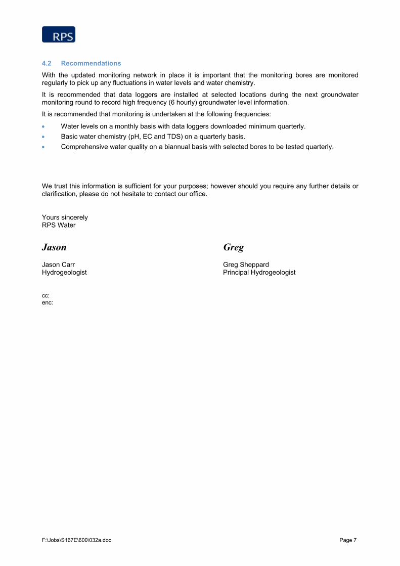
BH07 has an estimated hydraulic conductivity (K) value of 7.86 x 10⁻⁶ m/s (0.68m/d) (Figure 2).
4. KEY OUTCOMES AND RECOMMENDATIONS
4.1 Key Outcomes
The primary purpose of expanding the existing monitoring network was to provide a greater density of monitoring holes to enable future assessment of potential groundwater related impacts. The new groundwater monitoring network and targeted aquifers are summarised in Table 4.
Table 4: Updated Monitoring Network and Target Aquifer
Current Bore ID Aquifer Monitored
BH01 Lithgow Seam
BH02 Marrangaroo formation
BH03 Saturated overburden
BH04 General
BH05 Lithgow Seam
BH06 Lithgow Seam
BH07 Up-gradient overburden (saturated)
BH08 Lithgow Seam
BH09 Lithgow Seam
BH10 Lithgow Seam
BH11 General
BH12 General (paired site)
BH13 General (paired site)
BH14 Lithgow Seam
BH15 Up-gradient Overburden (dry)
F:\Jobs\S167E\600\032a.doc Page 7
4.2 Recommendations
With the updated monitoring network in place it is important that the monitoring bores are monitored regularly to pick up any fluctuations in water levels and water chemistry.
It is recommended that data loggers are installed at selected locations during the next groundwater monitoring round to record high frequency (6 hourly) groundwater level information.
It is recommended that monitoring is undertaken at the following frequencies:
Water levels on a monthly basis with data loggers downloaded minimum quarterly.
Basic water chemistry (pH, EC and TDS) on a quarterly basis.
Comprehensive water quality on a biannual basis with selected bores to be tested quarterly.
We trust this information is sufficient for your purposes; however should you require any further details or clarification, please do not hesitate to contact our office.
Yours sincerely RPS Water
Jason Greg
Jason Carr Greg Sheppard Hydrogeologist Principal Hydrogeologist
cc: enc:

FIGURES

032a_DD01_Coal_Services_Groundwater_Monitoring_Network
0 200 400100
Metres
NEWCASTLE
SYDNEYLITHGOW
PROJECT AREA
"
!.
!.
!.
!.
!.
!.
!.
!.
!.
!.
!.
!.
!.
!.!.BH13BH12
BH11
BH06
BH10
BH09
BH08
BH07
BH05
BH04
BH03
BH01
BH15
BH02
BH14
CASTLEREAGH HIGHWAY
950
1000
1050
1000
950
1000
225000
225000
6304
000
6304
000
±
Figure 1Springvale Coal ServicesGroundwater Monitoring Network
SCALE @ A3GDA 1994 MGA Zone 56
LEGENDStatus!. Current groundwater monitoring network!. Existing bore to be re-commisioned!. Installed monitoring bore
CreekCoal Services Project Boundary
" TownElevation ContourPrincipal Road
AUTHOR JC
CHECKED BY GSDATE 05/09/2013
PROJECT NO S167EREVISION ADRAWING NO DD01
Disclaimer: While all reasonable care has been taken to ensure the information contained onthis map is up to date and accurate, no guarantee is given that the information portrayed isfree from error or omission. Please verify the accuracy of all information prior to use.
Note: The information shown on this map is a copyright of RPS Aquaterra Australia 2012
DATA SOURCESRPS Aquaterra
1:10,000
FALLING HEAD TEST
Bore No: BH07 Test No: #1 Job No: S167E/E2 Date: 26-Aug-13 Logged by: JC
Borehole co-ordinates: Easting: 225492 Northing: 6303102 Collar elevation (m): 0.91Depth to top of test section (m): 19.34 Length of test section, L (m): 12.76
Depth of static water level, Hw (m): 19.33 Radius of borehole, r (m): 0.05
Excess head, he (m): 0.73 Radius of standpipe or casing, rc (m): 0.05
Head - time graph (slope of graph is S)
Calculations: h1 0.37
t1 0.2
h2 0.15
t2 1.5
S 3.0E-01 where S = (log (h1/h2)/(t2 - t1), (ie slope of plot, t in mins)
Permeability, k = 0.133 x S x (rc2/L)
k 7.86E-06 m/sec
k 6.79E-01 m/day
Time Depth to Excess head, ht/he Time Depth to Excess head, ht/he Time Depth to Excess head, ht/he
water, hw ht=Hw-hw water, hw ht=Hw-hw water, hw ht=Hw-hw
(min) (m) (m) (min) (m) (m) (min) (m) (m)
0.000 20.064 0.734 1 2.600 19.386 0.056 0.076294 5.200 19.342 0.012 0.01635
0.050 20.012 0.682 0.9291553 2.650 19.38 0.05 0.06812 5.250 19.341 0.011 0.01499
0.100 19.708 0.378 0.5149864 2.700 19.383 0.053 0.072207 5.300 19.339 0.009 0.01226
0.150 19.595 0.265 0.3610354 2.750 19.375 0.045 0.061308 5.350 19.34 0.01 0.01362
0.200 19.605 0.275 0.3746594 2.800 19.375 0.045 0.061308 5.400 19.34 0.01 0.01362
0.250 19.591 0.261 0.3555858 2.850 19.38 0.05 0.06812 5.450 19.342 0.012 0.01635
0.300 19.586 0.256 0.3487738 2.900 19.377 0.047 0.064033 5.500 19.341 0.011 0.01499
0.350 19.577 0.247 0.3365123 2.950 19.372 0.042 0.057221 5.550 19.343 0.013 0.01771
0.400 19.575 0.245 0.3337875 3.000 19.37 0.04 0.054496 5.600 19.344 0.014 0.01907
0.450 19.566 0.236 0.3215259 3.050 19.369 0.039 0.053134 5.650 19.336 0.006 0.00817
0.500 19.56 0.23 0.3133515 3.100 19.371 0.041 0.055858 5.700 19.339 0.009 0.01226
0.550 19.556 0.226 0.3079019 3.150 19.374 0.044 0.059946 5.750 19.337 0.007 0.00954
0.600 19.546 0.216 0.2942779 3.200 19.367 0.037 0.050409 5.800 19.338 0.008 0.0109
0.650 19.539 0.209 0.2847411 3.250 19.362 0.032 0.043597 5.850 19.336 0.006 0.00817
0.700 19.535 0.205 0.2792916 3.300 19.364 0.034 0.046322 5.900 19.338 0.008 0.0109
0.750 19.523 0.193 0.2629428 3.350 19.361 0.031 0.042234 5.950 19.337 0.007 0.00954
0.800 19.521 0.191 0.260218 3.400 19.359 0.029 0.03951 6.000 19.34 0.01 0.01362
0.850 19.509 0.179 0.2438692 3.450 19.358 0.028 0.038147 6.050 19.341 0.011 0.01499
0.900 19.505 0.175 0.2384196 3.500 19.362 0.032 0.043597 6.100 19.337 0.007 0.00954
0.950 19.5 0.17 0.2316076 3.550 19.361 0.031 0.042234 6.150 19.338 0.008 0.0109
1.000 19.481 0.151 0.2057221 3.600 19.359 0.029 0.03951 6.200 19.338 0.008 0.0109
1.050 19.475 0.145 0.1975477 3.650 19.351 0.021 0.02861 6.250 19.336 0.006 0.00817
1.100 19.477 0.147 0.2002725 3.700 19.357 0.027 0.036785 6.300 19.337 0.007 0.00954
1.150 19.472 0.142 0.1934605 3.750 19.356 0.026 0.035422 6.350 19.34 0.01 0.01362
1.200 19.469 0.139 0.1893733 3.800 19.356 0.026 0.035422 6.400 19.337 0.007 0.00954
1.250 19.466 0.136 0.1852861 3.850 19.354 0.024 0.032698 6.450 19.337 0.007 0.00954
1.300 19.464 0.134 0.1825613 3.900 19.356 0.026 0.035422 6.500 19.335 0.005 0.00681
1.350 19.458 0.128 0.1743869 3.950 19.357 0.027 0.036785 6.550 19.335 0.005 0.00681
1.400 19.459 0.129 0.1757493 4.000 19.353 0.023 0.031335 6.600 19.337 0.007 0.00954
1.450 19.449 0.119 0.1621253 4.050 19.352 0.022 0.029973 6.650 19.335 0.005 0.00681
1.500 19.445 0.115 0.1566757 4.100 19.351 0.021 0.02861 6.700 19.337 0.007 0.00954
1.550 19.445 0.115 0.1566757 4.150 19.348 0.018 0.024523 6.750 19.338 0.008 0.0109
1.600 19.445 0.115 0.1566757 4.200 19.347 0.017 0.023161 6.800 19.34 0.01 0.01362
1.650 19.441 0.111 0.1512262 4.250 19.353 0.023 0.031335 6.850 19.349 0.019 0.02589
1.700 19.43 0.1 0.1362398 4.300 19.35 0.02 0.027248 6.900 19.338 0.008 0.0109
1.750 19.424 0.094 0.1280654 4.350 19.348 0.018 0.024523 6.950 19.335 0.005 0.00681
1.800 19.425 0.095 0.1294278 4.400 19.346 0.016 0.021798 7.000 19.336 0.006 0.00817
1.850 19.421 0.091 0.1239782 4.450 19.345 0.015 0.020436 7.050 19.338 0.008 0.0109
1.900 19.416 0.086 0.1171662 4.500 19.347 0.017 0.023161 7.100 19.337 0.007 0.00954
1.950 19.414 0.084 0.1144414 4.550 19.345 0.015 0.020436 7.150 19.335 0.005 0.00681
2.000 19.411 0.081 0.1103542 4.600 19.345 0.015 0.020436 7.200 19.339 0.009 0.01226
2.050 19.409 0.079 0.1076294 4.650 19.349 0.019 0.025886 7.250 19.338 0.008 0.0109
2.100 19.404 0.074 0.1008174 4.700 19.343 0.013 0.017711 7.300 19.336 0.006 0.00817
2.150 19.404 0.074 0.1008174 4.750 19.341 0.011 0.014986 7.350 19.334 0.004 0.00545
2.200 19.402 0.072 0.0980926 4.800 19.343 0.013 0.017711 7.400 19.331 0.001 0.00136
2.250 19.397 0.067 0.0912807 4.850 19.344 0.014 0.019074 7.450 19.331 0.001 0.00136
2.300 19.396 0.066 0.0899183 4.900 19.343 0.013 0.017711 7.500 19.338 0.008 0.0109
2.350 19.396 0.066 0.0899183 4.950 19.343 0.013 0.017711 7.550 19.338 0.008 0.0109
2.400 19.391 0.061 0.0831063 5.000 19.342 0.012 0.016349 7.600 19.331 0.001 0.00136
2.450 19.387 0.057 0.0776567 5.050 19.348 0.018 0.024523
2.500 19.379 0.049 0.0667575 5.100 19.34 0.01 0.013624
2.550 19.385 0.055 0.0749319 5.150 19.345 0.015 0.020436
0.100
1.000
0 1 1 2 2 3 3 4 4 5 5
ht/h
e
Time (min)
Figure 2: BH07 Falling Head Test Analysis

APPENDIX A

Client: Project:
Commenced:
Drilled:
Static Water Level:
Graphic
LogLithological Description
Well Completion
COMPOSITE WELL LOG
Method: Area:
Diagram NotesField Notes
Australia
(mbgl)
Depth
Ge
olo
gy
Completed: Easting:
Northing:
Elevation:
Bit Record:
Logged By: Collar Height:
Bit Type:
Level 9
17 York Street, Sydney
NSW, 2000
Tel: (+61) (02) 8270 8388
Fax: (+61) (02) 8270 8399
Well No:
Date: Total Depth:
File Ref: Well No: Sheet 1 of 1
-1
0
1
2
3
4
5
6
7
8
9
10
11
12
13
14
15
16
17
18
19
20
21
22
23
24
25
26
27
28
29
30
31
32
33
34
Centennial Coal Springvale Coal Services
943mAHD
Macquarie Drilling
Jason Carr 0.91magl
Air Hammer
Hammer
100mm
6303102
225492
Coal Services
BH07
33mbgl26/08/201320.24mbtc
23/08/2013
23/08/2013
S167E BH07
Lost circulation(5mbgl)
Fast drilling ratethrough softmaterialspossibly coal(16-17mbgl)
Consistentlylifting waterduring drilling~0.5l/s(27-30mbgl)
No sample return(30-33mbgl)
Collar height(0.91magl)Cement monument
125mm PVC ConductorCasing(0-4mbgl)
A&B Foam(0-4mbgl)
Cement(0-15mbgl)
CL18 50mm PVC casing(0-18m)
Bentonite seal(15-17mbgl)
Gravel pack (3-5mm)(17-33mbgl)
Standing Water Level(20.24mbgl)
CL18 50mm PVC screen(18-33mbgl)
PVC end cap
Sandy Clay: Clay (80%), Sand (20%). Yellow/Cream,mottled. Sand is fine to medium grain. Clay has highplasticity. Strongly weathered
Sandy Clay: Clay (80%), Sand (20%). Red/cream,mottled. Sand is fine to medium grain. Clay has highplasticity. Strongly weathered
Sandstone/Clay: Sandstone (80%), Clay (20%).Brown. Sandstone is fine to medium grain. Clay hasmoderate plasticity. Sandstone becoming fresh.Moderate weathering.
Sandstone/Siltstone: Sandstone (90%), Siltstone(10%). Grey. Sandstone is fine to medium grain andwell sorted. Siltstone is weak and thinly laminated.
Siltstone/Sandstone: Siltstone (70%), Sandstone(30%). Grey. Siltstone has moderate strength.Sandstone is fine grain and laminated. Traces ofcarbonate veins and tuff bands.
Client: Project:
Commenced:
Drilled:
Static Water Level:
Graphic
LogLithological Description
Well Completion
COMPOSITE WELL LOG
Method: Area:
Diagram NotesField Notes
Australia
(mbgl)
Depth
Ge
olo
gy
Completed: Easting:
Northing:
Elevation:
Bit Record:
Logged By: Collar Height:
Bit Type:
Level 9
17 York Street, Sydney
NSW, 2000
Tel: (+61) (02) 8270 8388
Fax: (+61) (02) 8270 8399
Well No:
Date: Total Depth:
File Ref: Well No: Sheet 1 of 1
-1
0
1
2
3
4
5
6
7
8
9
10
11
12
13
14
15
16
17
18
19
20
21
22
23
24
25
Centennial Coal Springvale Coal Services
944mAHD
Macquarie Drilling
Jason Carr 0.9magl
Air Hammer
Hammer
100mm
6304607
225977
Coal Services
BH08
24.4mbgl22/08/201320.91mbtc
20/08/2013
21/08/2013
S167E BH08
Lidsdale Seam(15.7-17.3mbgl)
Intercept void(Lithgow Seamworkings)Hammer firing10-20%(21.5-24.4mbgl)
Collar height(0.9magl)
Cement monument
125mm PVC ConductorCasing(0-2.7mbgl)
A&B Foam(0-2.7mbgl)
Cement(0-16.8mbgl)
CL18 50mm PVC casing(0-21.4m)
Bentonite seal(16.8-19mbgl)
Rubber C-Bridge(19m)
Standing Water Level(20.91mbgl)
CL18 50mm PVC screen(18-33mbgl)
PVC end cap
Sandy Clay: Clay (90%), Sand (10%). Dark red. Sandis fine grain. Clay has high plasticity
Siltstone/Clay: Siltstone (60%), Clay (40%).Orange/cream. Shale is weathered, clay is creamwith moderate plasticity
Weathered Siltstone: Siltstone (100%). Grey. Weak.Moderately weathered
Clay: Clay (100%). Grey. Weak. Moderatelyweathered
Clay: Clay (100%). Brown/cream. Moderate plasticity.Moderately weathered
Siltstone: Siltstone (100%). Grey. Moderate strength
Siltstone: Siltstone (100%). Grey. Moderate strength,increased carbonaceous material
Coal/Siltstone: Coal (60%), Siltstone (40%).Black/grey. Interbedded coal and siltstone. Siltstoneis weak and carbonaceous
Siltstone: Siltstone (100%). Dark grey, moderatestrength
Sandstone: Sandstone (100%). Grey/cream. Finegrain, well sorted
Underground Workings: Collapsed undergroundworkings. Lithgow Seam

Client: Project:
Commenced:
Drilled:
Static Water Level:
Graphic
LogLithological Description
Well Completion
COMPOSITE WELL LOG
Method: Area:
Diagram NotesField Notes
Australia
(mbgl)
Depth
Ge
olo
gy
Completed: Easting:
Northing:
Elevation:
Bit Record:
Logged By: Collar Height:
Bit Type:
Level 9
17 York Street, Sydney
NSW, 2000
Tel: (+61) (02) 8270 8388
Fax: (+61) (02) 8270 8399
Well No:
Date: Total Depth:
File Ref: Well No: Sheet 1 of 1
-1
0
1
2
3
4
5
6
7
8
9
10
11
12
13
14
15
16
17
18
19
20
21
22
23
24
25
26
Centennial Coal Springvale Coal Services
953mAHD
Macquarie Drilling
Jason Carr 0.94magl
Air Hammer
Hammer
100mm
6304532
225881
Coal Services
BH09
25.526/08/201323.8mbtc
19/08/2013
20/08/2013
S167E BH09
Carbonaceouschips(12.3mbgl)
Carbonaceouschips(15.3mbgl)Increasedpenetration rate(16-16.3mbgl)
Increasedpenetration ratethrough coal(Lidsdale Seam)(17-17.6mbgl)
Intercept water(19.2mbgl)
Lithgow Seamundergroundworkings (lostreturn)(23.1-25.5mbgl)
Collar height(0.94magl)
Cement monument
125mm PVC ConductorCasing(0-2.4mbgl)
A&B Foam(0-2.4mbgl)
Cement(0-18mbgl)
CL18 50mm PVC casing(0-22.5mbgl)
Bentonite seal(18-20.7mbgl)
Rubber C-Bridge(20.7m)
Standing Water Level(23.8mbgl)
CL18 50mm PVC screen(22.5-25mbgl)
PVC end cap
Fallback
Clay: Clay (100%). Dark red. Clay, high plasticity
Siltstone/Clay: Siltstone (60%), Clay (40%).Orange/cream. Siltstone is weathered and weak.Clay is Cream with moderate plasticity
Siltstone/Clay: Siltstone (60%), Clay (40%). Grey.Siltstone becoming fresh. weak. Clay has moderateplasticity
Clay: Clay (100%). Brown. Clay has moderateplasticity
Siltstone: Siltstone (100%). Grey. Moderate strengthand traces of coal at 6.5m
Siltstone: Siltstone (100%). Grey/dark grey. Moderatestrength, traces of carbonaceous material
Coal: Coal (100%). Black.
Siltstone: Siltstone (100%). Grey/dark grey. Moderatestrength, traces of carbonaceous material and pyrite
Sandstone: Sandstone (100%). Light grey. Fine tomedium grain sand, traces of carbonaceous material.
Underground Workings: Void. Collapsed workings, noreturn.
Client: Project:
Commenced:
Drilled:
Static Water Level:
Graphic
LogLithological Description
Well Completion
COMPOSITE WELL LOG
Method: Area:
Diagram NotesField Notes
Australia
(mbgl)
Depth
Ge
olo
gy
Completed: Easting:
Northing:
Elevation:
Bit Record:
Logged By: Collar Height:
Bit Type:
Level 9
17 York Street, Sydney
NSW, 2000
Tel: (+61) (02) 8270 8388
Fax: (+61) (02) 8270 8399
Well No:
Date: Total Depth:
File Ref: Well No: Sheet 1 of 1
-1
0
1
2
3
4
5
6
7
8
9
10
11
12
13
14
15
16
17
18
19
20
21
22
23
24
25
26
27
28
29
30
Centennial Coal Springvale Coal Services
934mAHD
Macquarie Drilling
Jason Carr 0.91magl
Air Hammer
Hammer
100mm
6304317
225676
Coal Services
BH10
29mbgl26/08/2013Dry
21/08/2013
23/08/2013
S167E BH10
Carbonaceouschips(15.4mbgl)
Tuff band(16.8mbgl)
Lidsdale Seam(17.4mbgl)
Lost circulation(18.7mbgl)
Lost circulation(20.7mbgl)
Hard Band(23.6mbgl)
Void(24.6-25.6mbgl)
ConsolidatedMaterial(27-29mbgl)
Lost blade bitand casingadvancer downhole (Tagged topat 25.2mbgl)
Collar height(0.91magl)
Cement monument
125mm PVC ConductorCasing(0-2.8mbgl)
A&B Foam(0-2.8mbgl)
Cement(0-14mbgl)
CL18 50mm PVC casing(0-22mbgl)
Bentonite seal(14-16.5mbgl)
Rubber C-Bridge(16.5m)
CL18 50mm PVC screen(22-25mbgl)
PVC end cap
Fallback
Sandy Clay: Clay (80%), Sand (20%),.Orange/cream. Clay has high plasticity. Sand is fineto medium grain and contain traces of weatheredsiltstone. Strongly weathered
Sandy Clay: Clay (60%), Sand (40%),.Cream/orange. Clay has high plasticity. Sand is fineto medium grain and contain traces of weatheredsiltstone. Strongly weathered
Siltstone/Clay: Siltstone (80%), Clay (20%). Brown.Siltstone has moderate strength, moderatelyweathered. Clay has weak plasticity , traces of sand(possible contamination).
Clay/Sandstone: Clay (70%), Sandstone (30%).Orange/cream. Clay has moderate plasticity.Sandstone is fine grain and weathered.
Sandstone/Siltstone: Sandstone (80%), Siltstone(20%). Grey. Sandstone is fine grain and friable.Siltstone laminations, siltstone is weak.
Siltstone/Sandstone: Siltstone (80%), Sandstone(20). Grey. Siltstone is weak. Sandstone bands ,veryfine to fine grain. Traces of Tuff and Coal
Coal: Coal (100%). Black. Minor siltstone laminations.
Sandstone/Siltstone: Sandstone (70%), Siltstone(30%). Grey. Sandstone is fine grain. Siltstonelaminations.
Underground Workings: Lost Circulation
Marrangaroo Formation: Inferred MarrangarooFormation - no sample return.