redesign for reconstruction - mass.gov · morrissey boulevard redesign for reconstruction dcr...
TRANSCRIPT

MORRISSEY BOULEVARD
REDESIGN FOR RECONSTRUCTION
DCR Public Meeting – Project Introduction
Monday, March 28, 2016
6:30 PM – 8:30 PM
Leahy Holloran Community Center (Murphy School)
One Worrell Street, Dorchester, MA

Commonwealth of Massachusetts
Governor
Charles D. Baker
Lieutenant Governor
Karyn E. Polito
Energy and Environmental Secretary
Matthew A. Beaton
Department of Conservation and Recreation Commissioner
Leo Roy
DCR Mission Statement
To protect, promote and enhance our
common wealth of natural, cultural
and recreational resources
for the well-being of all.

Tonight’s Meeting - Purpose
• Introduce the Project
- Project Goals
- Design Team
- Scope and Schedule
- Initial Observations and Data Collection
• Obtain Public Input on Key Issues and
Concerns

Project History
• Environmental work and
preliminary design
completed in 1990s

DCR Projects Completed in Area
• Beades Bridge
• Pattens Cove Culvert
• Mt. Vernon Street Bridge

Primary Project Goals
• Stormwater and flooding: Provide
stormwater improvements and climate
resiliency
• Transportation: Provide safe, convenient,
and inviting pedestrian and bicycle
accommodations, balanced with
appropriate vehicular accommodations
• Landscape & Urban Design: Enhance
parkway character and strengthen
connections to recreational facilities,
natural resource areas, and
neighborhoods

Design Team
Civil & Structural Engineering; Drainage & Coastal Design
Stormwater & Flood Control Strategy; Green Infrastructure
Landscape Architecture & Urban Design
Transportation Analysis & Design
Environmental Permitting
Geotechnical & Geoenvironmental
Survey & Right-of-Way
Overall Project Management, Direction and Guidance

Design Project Scope
• Conceptual through final
design and construction
• Public involvement process
• Environmental permits
• Drainage, transportation, and
urban design upgrades
• Safety improvements
• New traffic signals and
roadway lighting

Major Items Accomplished to Date
• New topographic and
right-of-way survey of entire
corridor
• Transportation data
collection and analysis
• Modeling of existing
drainage system
• Coastal and flood-risk
modeling and analysis
• Urban design and landscape
assessment
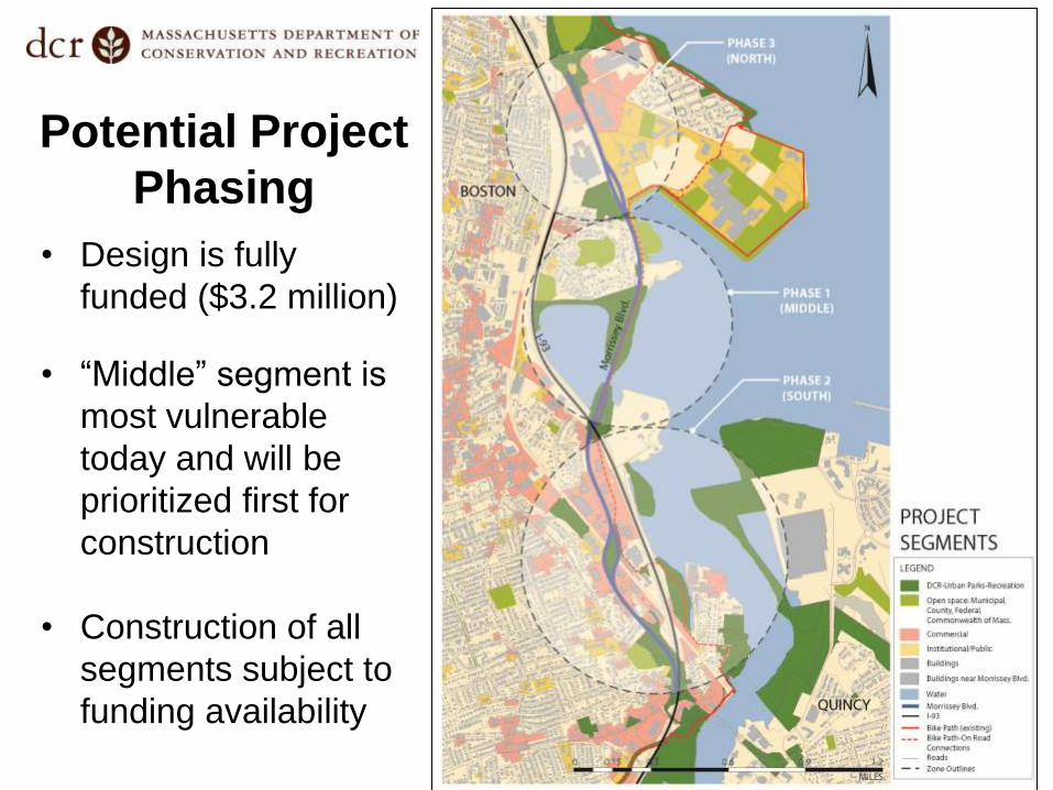
Potential Project
Phasing
• Design is fully
funded ($3.2 million)
• “Middle” segment is
most vulnerable
today and will be
prioritized first for
construction
• Construction of all
segments subject to
funding availability

Design Project and Public Process Timeline
Public Meeting #1 –
Project Introduction and Listening
Session
Public Meeting #2 – Presentation
of Design Concepts*
Public Meeting #3 – Presentation
of 25% Design*
Public Meeting #4
– Presentation
of 75% Design**
Public Meeting #5
– Presentation
of Final Plans**
Pre-Construction
Public Meeting***
March 28, 2016 May 2016 July 2016
October 2016 December 2016 May 2017
* Entire Corridor Length ** Phase 1 (Middle) if phased *** Pending Funding

Project Goal: Stormwater and Flooding
• Provide Stormwater Improvements and Climate Resiliency

Why does Morrissey Boulevard flood?
• Physical Characteristics Low elevation
Coastal exposure
Size, location, and condition of drainage infrastructure (catch
basins, pipes, outfalls)
• Flood Sources Precipitation falling directly on the roadway
Stormwater from “uphill” areas (in pipes and on surface)
Coastal processes (tides/wind/waves/storm surge)
Stormwater and Flooding

Why will it get worse?
• Sea Level Rise (SLR)
“New Normal” of higher tides restricts free flow of stormwater from
roadway to Boston Harbor
• More frequent and stronger coastal storms Higher water = further restrictions on flow through drainage system
Direct flooding due to wind and waves
• Increased rainfall intensity Can overwhelm the drainage system, even without coastal impacts
Stormwater and Flooding

How much worse?
• Increasingly sophisticated modeling and studies have been
performed for the Boston area
Stormwater and Flooding

How much worse?
Year 2070 – 10% Probability*
Stormwater and Flooding
*There is a 1 in 10
chance that sometime in
year 2070 the flood
depths shown on this
map will be reached or
exceeded
Morrissey Boulevard

How much worse?
Year 2070 – 1% Probability*
Stormwater and Flooding
*There is a 1 in 100
chance that sometime in
year 2070 the flood
depths shown on this
map will be reached or
exceeded
Morrissey Boulevard

Potential Adaptation Tools:
Shoreline Protection
Stormwater and Flooding
Source: Delewarestuary.org
“Hard”
Solutions
“Soft”
Solutions

Potential Adaptation Tools:
Roadway Elevation and/or Flood Walls
Stormwater and Flooding
Existing
Roadway
Full
Roadway
Elevation
Existing
Roadway
Partial
Roadway
Elevation

Potential Adaptation Tools:
Green Infrastructure (GI)
Stormwater and Flooding
GI tools such as biofiltration
and pervious surfaces can
both reduce total runoff and
improve water quality.

Potential Adaptation Tools:
Capacity and Conveyance
Stormwater and Flooding
These tools can store water
in the system when tides are
too high to discharge and can
prevent ocean water from
backing up onto the roadway
Tide Gate at Drainage Outfall
Backflow Prevention Device at Drainage Outfall
Cutaway View of Temporary Underground
Stormwater Storage

Project Goal: Transportation
• Provide safe, convenient, and inviting pedestrian and
bicycle accommodations, balanced with appropriate
vehicular accommodations

Transportation:
Study Area
• Covers entire project limits
• Includes:
8 signalized intersections
6 unsignalized locations
2 pedestrian bridges
Transportation

General Transportation Context
Transportation
• Corridor plays both regional and
local role
• 3 distinct and diverse Segments
• Heavily influenced by peak hour
Expressway congestion
• Not presently conducive to bicycle
and pedestrian travel either along or
across

North: Kosciuszko Circle to
Bianculli Boulevard
Transportation
Columbia Point
Evolving land uses and multimodal
users
Large student population
Frontage roads and non-standard
designs
9+ Lanes = Reduction opportunities

Middle: Bianculli Boulevard to
Freeport Street
Transportation
Savin Hill
Recreational uses
Environmentally sensitive
Consistent 6-lane section
Limited width at Beades Bridge
Signals at each end limit capacity

South: Freeport Street to Neponset Circle
Transportation
Commercial land uses
6-lane section
Narrow, unattractive median
Frontage road at northerly end
Intermittent residential abutters
Multiple pedestrian crossings

Vehicular Volumes
• Peak Hours:
Higher volumes
northbound
Higher volumes
north of I-93
Transportation

Pedestrian and
Bicycle Volumes
• Peak hours (AM/PM)
• Highest volumes at
JFK/UMass
• Limited bicycle
volume south of
Freeport Street
• Low volumes probably
not reflective of
potential demand
Transportation

Existing Analysis
• Peak hours
• Vehicle delay:
Level-of-Service
A (best) thru F (worst)
• Heaviest congestion
at Freeport Street;
UMass, and Mt.
Vernon Street
• Little delay at other
intersections
Transportation

Transit
• Limited bus service on
Morrissey – Route 201
& 202 variations only
• Important connection
to JFK/UMass Station
Transportation

Crash Analysis
• All intersections below
state average crash
rate, except Freeport
Street
• Freeport Street
slightly worse than
state average
• Design will look to
incorporate safety
improvements
Transportation
* *
* 3-year totals

Bicycle and Pedestrian Goals
• Provide facilities along entire corridor
• Minimize conflicts between bicycles
and pedestrians and between bicycles,
pedestrians, and vehicles
• Integrate with surrounding
bicycle/pedestrian network
Transportation

Bicycle and Pedestrian Challenges
• Existing roadway is
space-inefficient in places
and presents more conflicts
than necessary
• Constrained areas including
bridge and underpass “pinch
points”
Transportation
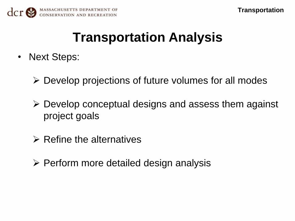
Transportation Analysis
• Next Steps:
Develop projections of future volumes for all modes
Develop conceptual designs and assess them against
project goals
Refine the alternatives
Perform more detailed design analysis
Transportation

Project Goals: Landscape and
Urban Design
• Enhance parkway character and strengthen connections to
recreational facilities and natural resource areas

Landscape and Urban Design
• Other Projects Influencing
Morrissey Boulevard
Columbia Point Master Plan
Mt. Vernon Street
Neponset River Greenway
Landscape / Urban Design
Columbia Point Master Plan
Proposed Mt. Vernon Street Design

Neponset River Greenway
Landscape / Urban Design

Neponset River Greenway
• Bicycle and pedestrian
connections between
Tenean Beach and the
proposed trail at National
Grid may be along
Morrissey Boulevard
• Connections north of the
proposed trail at National
Grid are along Morrissey
Boulevard
Landscape / Urban Design

Key Design Considerations
• Parkway Character
• Coastal Parkway Typology
• Green Space / Bicycle /
Pedestrian Connections
• Neighborhood Connections and
Character
• Neighborhood and Open Space
Connections
Landscape / Urban Design

Parkway Character
• Reduce curb cuts
• Improve trees, lights,
and edges
• Enhance views
Landscape / Urban Design

Parkway Character
Landscape / Urban Design
• One section of Morrissey Boulevard – Option to raise edges, but
not roadway. Blocks views from the Boulevard

Parkway Character
Landscape / Urban Design
• One section of Morrissey Boulevard – Option to raise roadway
and edges. Allows views from the Boulevard and road edge
plantings.
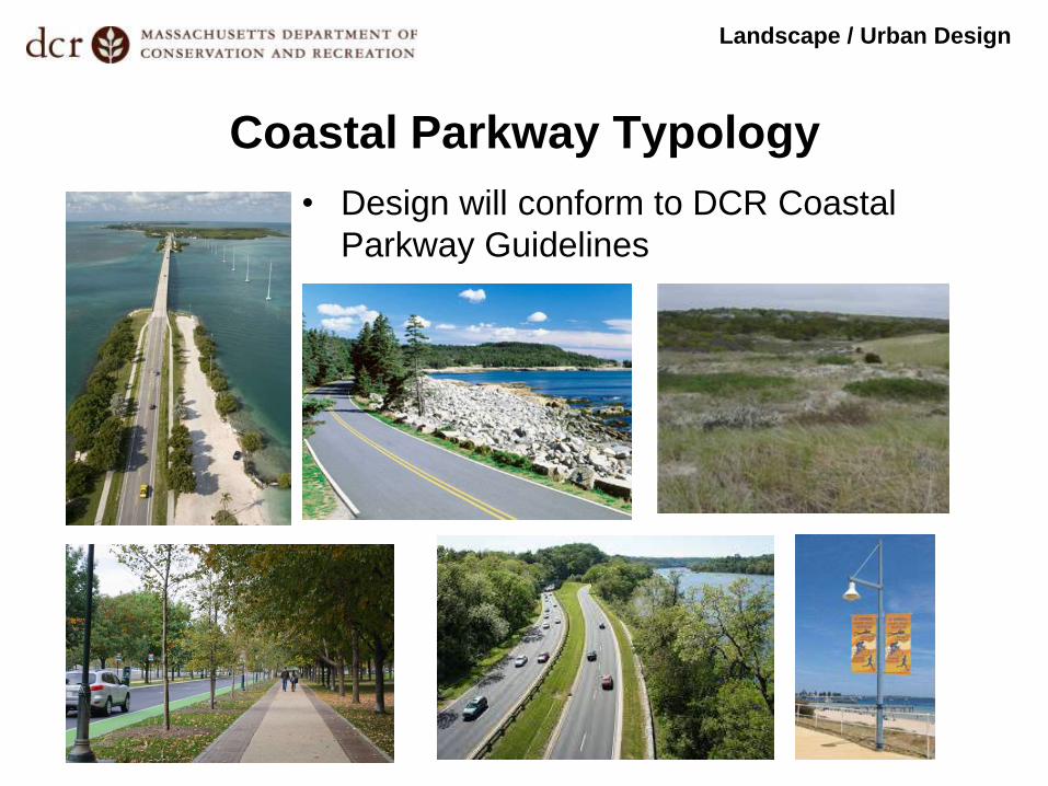
Coastal Parkway Typology
Landscape / Urban Design
• Design will conform to DCR Coastal
Parkway Guidelines

Green Space/Bicycle/Pedestrian
Connections
Landscape / Urban Design
City of Boston “Bike Network Plan”
Morrissey Blvd.
Corridor

Neighborhood Connections and Character
Landscape / Urban Design
• Design will respond
to adjacent
conditions and look
for opportunities to
connect
neighborhoods on
both sides of the
Boulevard

Neighborhood / Open Space Connections
Landscape / Urban Design
• Important open space connections, such as those at
Malibu Beach, will respond to future as well as current
conditions.

Parkway Character and Medians
Landscape / Urban Design
• Observation: Many of the
mature trees along Morrissey
Boulevard are in the median.
• Goal: Preserve and strengthen
mature tree plantings where
possible

Parkway Character and Edges
Landscape / Urban Design
• Observation: Parkway edge
plantings (trees) are sparse
in many locations.
• Goal: Strengthen parkway
edges with plantings where
possible.

Parkway Character and Trees
• Observation: Many existing
parkway plantings struggled
during the winter of 2014/2015.
• Goal: Select tree type and locate
to avoid damage from salting and
other maintenance practices.
Landscape / Urban Design

Enough from us…let’s hear from you!
• General Questions & Answers (15 minutes)
• Table Discussions (40 minutes)
Transportation / Bicycles / Flooding / Engineering
Landscape / Urban Design / Pedestrians
• Report back and wrap-up (20 minutes)
How to provide feedback tonight:

Enough from us…let’s hear from you!
• Complete our online survey at DCR User Experience
Survey - Morrissey Boulevard
• Provide general comments online at
http://www.mass.gov/eea/agencies/dcr/public-
outreach/submit-public-comments/
• Complete our hard-copy survey or general comments
sheet, available at sign-in table, and mail to:
Department of Conservation and Recreation
Office of Public Outreach
251 Causeway Street, Suite 600
Boston, MA 02114
How to provide feedback after tonight:

Enough from us…let’s hear from you!
• Please note:
Comments will be accepted through Monday,
April 18, 2016
Public comments submitted to DCR may be
posted on the DCR website in their entirety.
How to provide feedback after tonight:

General Questions?

Table Discussions • Tables are organized by two major topics:
Transportation/Flooding/Engineering (blue signs)
Landscape/Urban Design (yellow signs)
• Pick a table to start, spend 20 minutes there, and
then switch to the other for another 20 minutes
• We will then reconvene as a group and hear key
points from each table (20 minutes)
• All comments, whether or not verbally reported back,
will be recorded in writing and considered.

For more information: • See materials relative to this meeting posted under
“Materials From Past Public Meetings 2016” at http://www.mass.gov/eea/agencies/dcr/public-outreach/public-meetings/
If you have questions or concerns or wish to subscribe to a DCR general information or project-related listserv: contact DCR’s Office of Community Relations at 617-626-4973 or [email protected].
Additional Information