report of the ices advisory committee on fishery management
TRANSCRIPT

ICES ADVICE 2005
AVIS DU CIEM
Volumes 1- 11
Report of the ICES Advisory
Committee on Fishery Management,
Advisory Committee on the Marine
Environment
and Advisory Committee on
Ecosystems, 2005
Volume 10
International Council for the Exploration of the Sea
Conseil Internat ional pour l Explorat ion de la Mer
H.C. Andersens Boulevard 44-46 DK-1553 Copenhagen V Denmark Telephone (+45) 33 38 67 00 Telefax (+45) 33 93 42 15 www.ices.dk [email protected]
Report of the ICES Advisory Committee on Fishery Management, Advisory Committee on the Marine Environment and Advisory Committee on Ecosystems, 2005.
Volumes 1 - 11 December 2005
Recommended format for purposes of citation:
ICES. 2005. Report of the ICES Advisory Committee on Fishery Management, Advisory Committee on the Marine Environment and Advisory Committee on Ecosystems, 2005. ICES Advice. Volumes 1 - 11. 1,403 pp.
For permission to reproduce material from this publication, please apply to the General Secretary.
ISBN 87-7482-042-7

VOLUME 10
Section Page
1 DEEPWATER FISHERIES RESOURCES SOUTH OF 63ºN...................................................................................1
1.1 The ecosystem .........................................................................................................................................1 1.2 The human use of the ecosystem ....................................................................................................................1
1.2.1 The species .....................................................................................................................................1 1.2.2 The fisheries ...................................................................................................................................2
1.3 Assessments and advice..................................................................................................................................7 1.3.1 Advice for fisheries management ...................................................................................................8 1.3.2 Special Requests...........................................................................................................................10
1.3.2.1 Advice on deepwater stocks (DG Fish) ..........................................................................10 1.3.3.2 Advice on Seamounts, Distribution of cold-water corals and other vulnerable deep-
water habitats (NEAFC and OSPAR) ............................................................................20
1.4 Stock summaries Deepwater fisheries resources South of 63ºN 1.4.1 Deepwater sharks in the northeast Atlantic (ICES Subareas V XIV, mainly Portuguese
dogfish and leafscale gulper shark)..............................................................................................28 1.4.2 Kitefin shark (Subareas V XIV, but mainly X)...........................................................................33


ICES Advice 2005, Volume 10 1
1 DEEP-WATER FISHERIES RESOURCES SOUTH OF 63ºN
The term deep water (or deep sea) includes the waters below the continental shelves. That is all the water deeper than about 200 meters. ICES uses the term deepwater fisheries for those fisheries in depths greater than 400 m. The deep water in the ICES area covers the deep parts of ICES Subareas I, II, III, V-X, XII, and XIV.
1.1 The ecosystem
It can be questioned to what extent the deep-sea constitutes a homogeneous ecosystem. It covers a huge area of several million km2, spans from the arctic north to the sub-tropical south, and it covers ridges and underwater sea mountains often with a quite unique biology. However, in light of the present, very limited knowledge of the ecosystem(s) it seems to be a useful definition for the purpose of management advice.
Productivity is very low in the deep water. Without light the deep water has no primary productivity via the photosynthesis of plants and algae except in the surface waters. Furthermore, nutrient concentrations in the surface water are low, and overall there is very little food compared to the shallow shelf seas. This, together with low temperatures in the deep water results in very low productivity of the organisms living here. Many animals migrate at night up into the surface waters to feed. Otherwise the deep-sea food web is fuelled by a rain of dead plants and animals from surface waters, and the impingement of mesopelagic organisms on the slopes.
The diversity of deep-sea life history strategies is considerable, but many species of fish targeted by fisheries and their communities are particularly vulnerable to disturbance because they grow slowly, mature late in life, and form aggregations easily accessible to fisheries. Recovery rates are much slower than in shallower waters. Examples are the archetypal long-lived fish species orange roughy and grenadiers, but also vulnerable benthic species such as cold-water corals that form important habitats for many fishes.
The knowledge of central biological characteristics such as stock identity, migration, recruitment, growth, feeding, maturation, and fecundity of most deep-sea species still lags considerably behind that of commercially exploited shelf-based species. Such information is required to expand our understanding of the population dynamics of deep-sea fishes, which in turn is needed to underpin stock assessments.
1.2 The human use of the ecosystem
1.2.1 The species
In some parts of the northeast Atlantic where the continental shelf is narrow, such as off Portugal (including Madeira and the Azores), there are traditional fisheries, for example for black scabbardfish (Aphanopus carbo) and red (=blackspot) seabream (Pagellus bogaraveo), which have been exploiting deepwater species for many years. Other traditional species are ling, blue ling, and tusk, which have supported large fisheries in wide areas for several decades. The existence of other potentially exploitable stocks in the ICES area has been known since the 1960s and 1970s. However, before the 1980s, with the exception of a fishery for species such as roundnose grenadier (Coryphaenoides rupestris) there was little interest from the fishing industry in exploiting stocks in international waters. Since the 1980s, dwindling resources on the continental shelves of the North Atlantic have encouraged the development of fisheries in deeper waters. There has been a tendency for fisheries for species such as anglerfish and Greenland halibut to extend into deeper waters, and new fisheries have developed to target the new deepwater species that have been found there. Deepwater species such as the argentine or greater silver smelt (Argentina silus) and roundnose grenadier (Coryphaenoides rupestris), which were previously bycatch species have been targeted within the ICES area for the last two decades. Orange roughy (Hoplostethus atlanticus) has been a target species since the early 1990s.
The following were identified as some of the most important deepwater species for the commercial fishery.
List of deepwater species (species either targeted by deepwater fisheries or occurring as bycatch)
Alepocephalus bairdii Baird's smoothhead Aphanopus carbo Black scabbardfish Argentina silus Argentine, greater silver smelt Beryx splendens Golden eye perch Beryx decadactylus Red bream, alfonsino Brosme brosme Tusk Chimaera monstrosa Rabbitfish Coryphaenoides rupestris Roundnose grenadier
ICES Advice 2005, Volume 10 2
Epigonus telescopus Big eye, deepwater cardinal fish Helicolenus dactylopterus Bluemouth Hoplostethus atlanticus Orange roughy Hoplostethus mediterraneus Silver roughy Lepidopus caudatus Silver scabbardfish Macrourus berglax Roughhead grenadier Molva molva Ling Molva dypterygia Blue ling Mora moro Mora Pagellus bogaraveo Red (=blackspot) seabream Phycis blennoides Greater forkbeard Polyprion americanus Wreckfish Trachyrhynchus trachyrhynchus Roughnose grenadier Chaecon (Geryon) affinis Deepwater red crab Aristeomorpha foliacea Giant red shrimp
Advice on deepwater sharks is provided in ICES Cooperative Research Report No. 225 (2002). The main shark species caught in deepwater fisheries are:
Centrophorus granulosus Gulper shark Centrophorus squamosus Leafscale gulper shark Centroscyllium fabricii Black dogfish Centroscymnus coelolepis Portuguese dogfish Centroscymnus crepidater Longnose velvet dogfish Dalatias licha Kitefin shark Deania calcea Birdbeak dogfish Etmopterus princes Great lantern shark Etmopterus spinax Velvetbelly Scymnodon ringens Knifetooth dogfish
Advice on some other species, which might be considered as deepwater species, is already provided in Section 3.9:
Micromesistius poutassou Reinhardtius hippoglossoides Sebastes spp
Blue whiting Greenland halibut Redfish
In addition, there are other species which have been fished on the continental shelf, but whose distribution extends into deeper waters. This group includes hake (Merluccius merluccius), anglerfish (Lophius spp.), megrim (Lepidorhombus spp.), and conger (Conger conger). An extension of fishing into deeper waters for these species occurs in ICES Subareas VI, VII, VIII, and IX. Advice is provided on some of these species in Sections 3.5-3.7.
1.2.2 The fisheries
In ICES Subareas I+II there are directed longline and gillnet fisheries for ling (Molva molva) and tusk (Brosme brosme). There is also a directed bottom and pelagic trawl fishery for Argentina silus and a minor fjord fishery for roundnose grenadier (Coryphaenoides rupestris). Roughhead grenadier (Macrourus berglax) is taken as bycatch in the trawl, gillnet, and longline fisheries for Greenland halibut and redfish.
In ICES Division IIIa (Skagerrak) there is a targeted trawl fishery for roundnose grenadier and greater silver smelt Argentina silus. These species are also a bycatch of the Pandalus and Nephrops fisheries with trawls, and probably only a minor part of this bycatch is landed.
In ICES Subarea IV (North Sea) there is a bycatch of Argentina silus from the industrial trawl fishery. There is a longline fishery for tusk and ling with forkbeard (Phycis blennoides) and some roughhead grenadier as a bycatch. There is a bycatch of some deepwater species in the trawl fisheries targeting Lophius spp. and Greenland halibut. On the edge of the Wyville-Thompson Ridge (Subareas IV, V, and VI) there is a trawl fishery for redfish (Sebastes spp.) and Greenland halibut Reinhardtius hippoglossoides, with a bycatch of blue ling Molva molva and roughhead grenadier Macrourus berglax. Deepwater sharks are not found in the colder waters, north of the Iceland-Faeroe-Shetland ridge, though there are several skates present. These are starry ray Amblyraja radiata, spinytail ray Bathyraja spinicauda, and Arctic skate Raja hyperborean.

ICES Advice 2005, Volume 10 3
In ICES Subarea V there are trawl fisheries which target blue ling (Molva dypterygia), redfish, argentine (Argentina silus), and occasionally orange roughy (Hoplostethus atlanticus). Bycatch species are typically roundnose grenadier, roughhead grenadier, black scabbard fish (Aphanopus carbo), anglerfish (Lophius piscatorius), bluemouth (Helicolenus dactylopterus), mora (Mora moro), greater forkbeard (Phycis blennoides), argentine (Argentina silus), deepwater cardinal fish (Epigonus telescopus), and the deepwater sharks, mainly Portuguese dogfish Centroscymnus coelolepis and rabbit fish (Chimaera monstrosa). There are traditional longline fisheries for ling and tusk and these species are also bycatches in trawl and gillnet fisheries. There are also targeted trawl and gillnet fisheries for Greenland halibut and Lophius spp which have deepwater bycatch of, e.g. deepwater red crab (Chaceon affinis). There have also been trap fisheries for the deepwater red crab (Chaceon (formerly Geryon) affinis). Deepwater sharks are also discarded in fisheries in this area.
In ICES Subareas VI and VII there are directed trawl fisheries for blue ling, roundnose grenadier, orange roughy (Hoplostethus atlanticus), black scabbard fish, and the deepwater sharks Centroscymnus coelolepis and Centrophorus squamosus. The Argentina silus and blue ling landings from directed fisheries increased until 2002, but then declined in 2003. Bycatch species in these areas include bluemouth (Helicolenus dactylopterus), greater forkbeard (Phycis blennoides), argentine (Argentina silus), deepwater cardinal fish (Epigonus telescopus), and chimaerids, of which Chimaera monstrosa is the most important. There are directed longline fisheries for ling and tusk and also for hake. There are about 10 deepwater shark species that are discarded in this fishery (see advice for deepwater sharks).
A target fishery for deepwater sharks using longlines takes place in Subareas VI and VII. However, most of these boats are now using gillnets or pots. There is a directed gillnet fishery for deepwater sharks and deepwater red crab Geryon affinins that takes place in Subareas VI, VII, and XII (Hatton and Rockall Banks). This fishery is very poorly documented, but there is a bycatch of mora and forkbeard. The fleet that operates in this area also targets anglerfish with tangle nets. There is a directed fishery for deepwater red crab, using pots, in this area also.
In ICES Subarea VIII there is a longline fishery that mainly targets greater forkbeard (Phycis blennoides). There are also some trawl fisheries targeting species such as hake, megrim, anglerfish, and Nephrops that have a bycatch of deepwater species. These include Molva spp., Phycis phycis, Phycis blennoides, Pagellus bogaraveo, Conger conger, Helicolenus dactylopterus, Polyprion americanus, and Beryx spp.
In ICES Subarea IX some deepwater species are a bycatch of the trawl fisheries for crustaceans. Typical species are bluemouth (Helicolenus dactylopterus), greater forkbeard (Phycis blennoides), conger eel (Conger conger), blackmouth dogfish (Galeus melastomus), kitefin shark (Dalatias licha), and gulper shark (Centrophorus squamosus). There is a directed longline fishery for black scabbard fish (Aphanopus carbo) with a bycatch of the deepwater sharks. There is also a longline (Voracera) fishery for Pagellus bogaraveo. Elsewhere along the coast of Subarea IX there are directed longline fisheries for deepwater sharks.
In ICES Subarea X the main fisheries are by handline and longline near the Azores, and the main species landed are red (=blackspot) seabream (Pagellus bogaraveo), wreckfish (Polyprion americanus), conger eel (Conger conger), bluemouth (Helicolenus dactylopterus), golden eye perch (Beryx splendens), and alfonsino (Beryx decadactylus). At present the catches of kitefin shark (Dalatias licha) are made by the longline and handline deepwater vessels and can be considered as accidental. There are no vessels at present catching this species using gillnets. Outside the Azorean EEZ there are trawl fisheries for golden eye perch (Beryx splendens), orange roughy (Hoplostethus atlanticus), cardinal fish (Epigonus telescopus), black scabbard fish (Aphanopus carbo), and wreckfish (Polyprion americanus).
In ICES Subarea XII there are trawl fisheries on the mid-Atlantic Ridge for orange roughy, roundnose grenadier, and black scabbard fish. There is a multispecies trawl and longline fishery on Hatton Bank, and some of this occurs in this subarea, some in Subarea VI. There is considerable fishing on the slopes of the Hatton Bank, and effort may be increasing. This fishery takes an assemblage of species similar to the mixed trawl fishery in VI and VII. However, smoothheads that were normally discarded previously are now being landed.
In ICES Subarea XIV there are trawl and longline fisheries for Greenland halibut and redfish that have bycatches of roundnose grenadier, roughhead grenadier, black dogfish Centroscyllium fabricii, greater lanternshark Etmopterus princeps, and tusk.
Stock status and fisheries impacts
Fisheries on deepwater species have developed rapidly and the resources which they exploit are generally especially vulnerable to overexploitation. Within the ICES area species/stocks have been depleted before appropriate management measures have been implemented. It is also of concern that the landings statistics that are available may not reflect the true scale of the recent fishing activity, especially in waters outside the national EEZs.

ICES Advice 2005, Volume 10 4
Experience shows that some deep-sea species with life history strategies characterised by long life-spans, high age at maturity, and slow growth (e.g. orange roughy, blue ling) can be depleted very quickly and that recovery will be slow. Regeneration and growth are so slow that abundance does not increase in the depleted populations in the short or medium term. Other species with higher productivity have also been severely impacted by fisheries, but show greater resilience and potential for recovery in the medium term.
The survival rates of discards and of fish encountering gears and escaping are unknown, but many species are expected to be very vulnerable to injury, and therefore would be expected to die even if they escaped through meshes. The body shape of many deepwater fish combined with a high age/length at maturity often means that there can be a high fishing mortality of immature fish. Some species, such as blue ling, orange roughy, red sea bream, and alfonsinos aggregate in shoals, often associated with seamounts, and the fisheries have high catch rates once the shoals are located. Localized sub-units of the population can be quickly depleted by fisheries, even within a single season. Sub-units of some species (e.g. red sea bream, blue ling, and orange roughy) are known to have collapsed in some ICES areas.
It is evident that high catch rates can be maintained by moving from one concentration to another and progressively depleting the stock. Furthermore, many deepwater fisheries are on mixtures of species, making it difficult to manage the species components individually.
Fisheries for deepwater species have been developing and changing in areas inside and outside national jurisdictions since the 1970s. But the actual exploitation rates have been difficult to assess and even the current level is unknown. During the last decade exploitation appeared to be increasing on a number of species, as fishing extended into deeper waters or new areas. However, the quantities recorded were not always well estimated, and some landings are reported in grouped categories because of difficulties in separating species. Effort data were frequently uncertain and incomplete. In many cases significant proportions of the catch are discarded at sea and not recorded. All these factors make it difficult to determine which level of exploitation is sustainable. Fisheries on deepwater species have often developed and expanded before sufficient information was available on which to base management advice.
In 2002 ICES concluded that most exploited deepwater species were considered to be harvested outside safe biological limits, and recommended immediate reductions in the fisheries unless they could be shown to be sustainable. New fisheries should be permitted only when they expanded very slowly, and were accompanied by programmes to collect data which would allow evaluation of the stock status. While there has been increasing research activity in deep water the fisheries have expanded more rapidly.
The development in the most recent years prior to 2003 was that some fisheries actually expanded (e.g. orange roughy), whereas most others continued at more or less the same levels of landings. Some fisheries were regulated by unilateral or internationally agreed TACs in 2003, and this may have curbed the expansions. In the NEAFC regulatory area, effort was recommended to be frozen in 2003 and 2004 and an effort regulation has been implemented in EU deep-sea fisheries. But as in 2002 few satisfactory stock assessments could be made in 2004, and information on exploitation rates remains uncertain. Under a precautionary approach regime, and given that no new assessments could be made, the conclusion on stock status in 2004 remains similar to that made in 2002.
In 2004 ICES presented the summary below of the status of the exploited species for which at least some information exists to evaluate abundance is given.

ICES Advice 2005, Volume 10 5
Stock summary for species considered by ICES. Stock units are not well defined for several species (source: ICES 2004)
Salient features Species ICES Subarea/division Assessment type and final year of data
Indicators of stock status
Concerns / comments
IIa,IVa,V,VI Ling (Molva molva) and VII
Catch curves in late 90s. Preliminary age-based assessment for Vb. Trends in CPUEs. 2003.
Average Z very high in late 90s. Survey indices declining in Va. Commercial CPUEs in other areas.
Continued limited provision of data from some major fisheries. Length and age data series still inadequate for analytical assessments.
Indicative holistic assessment for V, VI & VII based on CPUE data.
Blue ling (Molva dypterygia)
I-XII and XIV
2003
Strong decline in CPUE. CPUEs probably not reliable as stock indicators due to fishing on aggregations.
Fishing on spawning concentrations implies that CPUE trend may underestimate the stock trends and should be treated with caution.
Tusk (Brosme brosme) IIa,IVa,V,VI Catch curves in late 90s and trends in CPUEs. CPUE series truncated in mid -1990s. 2003.
Historical CPUE data show strong decline over the past decade in most areas. Trends in most recent years uncertain.
Length and age data series still inadequate for analytical assessment.
Greater Silver Smelt (Argentina silus)
Mainly IIa,III,V,VI,VII No recent assessment. 2003.
Available CPUEs from IIIa and Vb probably not indicative of stock development.
Decline in landings in recent years has been observed for all ICES divisions, except Div. IIa.
No assessments. CPUE data only.
Strong fluctuations in CPUE.
Orange Roughy (Hoplostethus atlanticus)
Mainly VI, VII, X and XII
2003 Due to the aggregational behaviour of this species CPUEs are not readily indicative of stock density .
The fluctuations in CPUE may reflect both fluctuations in fish density on successively exploited aggregations and sequential discovery of new aggregations Recent high landings in VII are unlikely to be sustainable.
Preliminary age-based assessment for stock in V,VI & VII indicates declining stock. Preliminary acoustic assessment for XII.
No clear trends in CPUEs for IIIa, V, VI, VII.
Requirement for age data. Number of large fish declining. Discard data should be collected.
Roundnose Grenadier (Coryphaenoides rupestris)
IIIa,V, VI VII and XII. Data mainly from V,VI & VII
Russian CPUEs for XII & XIV, 1975-2003, declining
Full review of data for area XII and X needed. Mis-reporting suspected in XII (Hatton Bank).
ASPIC model. CPUE data.
Black Scabbardfish (Aphanopus carbo)
Mainly V,VI,VII,VIII and IX
2003
Consistent decline in CPUE in V, VI and VII, but increase in 2002 for VI and VII. CPUE in IXa stable.
Stock structure unknown. Information on reproductive tactics and dynamics is needed.

ICES Advice 2005, Volume 10 6
Salient features Species ICES Subarea/division Assessment type
and final year of data
Indicators of stock status
Concerns / comments
No assessment, because of lack of satisfactory data.
Golden Eye Perch (Beryx splendens)
Mainly X
2003
Concern about sequential depletion and underreporting from international waters.
No assessment attempted due to lack of data.
Red (blackspot) Seabream (Pagellus bogaraveo)
Mainly in X and IX, and residual in VI, VII, VIII
2003
No assessment Greater forkbeard (Phycis blennoides)
All areas but mainly VI, VII, VIII and IX 2003
CPUE data not used because landings statistics may include landings of Morids and concerns about CPUE of bycatch species.
Mainly bycatch.
CPUE trends only Deepwater sharks mainly Centroscymnus coelolepis and Centrophorus squamosus
Entire ICES area All available CPUE data show declines. Stocks depleted
Declines in CPUE more pronounced in the northern area. This is where most of the catch comes from
Kitefin shark Dalatias licha
Mainly X Production model Stock depleted No longer a target fishery. Bycatches possible in other fisheries

ICES Advice 2005, Volume 10 7
1.3 Assessments and advice
Fisheries advice
Mixed fisheries and fisheries interactions
Satisfactory comprehensive quantitative descriptions of fisheries exploiting deep-sea species have not been compiled, but efforts were initiated in 2004 to define fisheries by areas and fleets. This work will continue with an aim to develop future fisheries-based advice.
Most fisheries in outer shelf and continental slope waters have more than one target species, and may thus be considered mixed fisheries exploiting communities or suites of species. There are exceptions, however, e.g. the target fishery for Argentina silus by midwater or semipelagic trawls. Catches from most bottom trawl fisheries consist of 1-3 target species, a further few species that are marketable, and a variable unmarketable fraction that may eventually be discarded. Seamount fisheries or fisheries targeting aggregations (e.g. orange roughy, blue ling, alfonsino) may have catches that are less diverse than trawl fisheries targeting less aggregating slope species (e.g. grenadier, sharks). Longline fisheries for e.g. ling, tusk, and black scabbardfish, usually have more well-defined targets, but may also have a significant bycatch, some of which is unmarketable. Discarding practices vary, and data are being or have been collected from some major fisheries, but not always in a standardised and regular manner.
A further complication in defining fisheries is that several of the species on the deep-sea species list are actually only, or to a very high degree, exploited as bycatch in target fisheries for other species such as e.g. cod, hake, monkfish, and redfish. This is particularly the case for deepwater species that during their life history inhabit a wide depth range from relatively shallow waters of the shelf and coasts into slope waters beyond 400 m. Ling (Molva molva) is an example, partly also tusk (Brosme brosme) which are valuable and marketed even when catches are small. While a high proportion of ling and tusk are landed from aimed longline fisheries where ling is the target, a significant fraction stems from landings by trawl and longliner fleets targeting other species. Greater forkbeard Phycis blennoides is an example of a species almost solely exploited as bycatch and is not landed consistently.
The interactions between the various species in mixed fisheries are presented in the table below.

ICES Advice 2005, Volume 10 8
1.3.1 Advice for fisheries management
ICES provides advice on individual deep water species every second year, last time in 2004 (ICES 2004). In 2005 ICES has supplemented the advice with advice on deep water sharks. The advice given for other deep water stocks than sharks in 2004 was:
Most exploited deepwater species are considered to be harvested unsustainably; however, it is currently not possible to provide advice for specific fisheries for deep-sea species. Consistent with a precautionary approach, ICES recommends immediate reduction in established deep-sea fisheries unless they can be shown to be sustainable. Measures should also be implemented to reduce exploitation of deep-sea species by fisheries primarily targeting shelf species (hake, anglerfish, and megrim). New deep-sea fisheries or expansion of existing fisheries into new fishing areas should not be permitted unless the expansion is very cautious, and is accompanied by programmes to collect data which allow evaluation of stock status as the basis for determining sustainable exploitation levels.
Ling and tusk are in many fisheries taken together and therefore the advised effort reduction, calculated on the basis of ling should apply to all fisheries taking ling and tusk as their main catch. The advised reduction is 30% compared to the 1998 effort level.
ICES Advice 2005, Volume 10 9
Concerning blue ling, there should be no directed fisheries. Technical measures such as closed areas on spawning aggregations should be implemented to minimize catches of this stock in mixed fisheries.
In addition ICES advises regarding deepwater sharks:
The stocks of Portuguese dogfish and Leafscale Gulper shark are considered to be depleted. Given their very poor state, ICES recommends a zero catch of deepwater sharks.
Management considerations
Deepwater sharks are caught in a mixed fishery for deepwater species and as a targeted fishery using longlines and gillnets. Most of the catches of deepwater sharks are taken in the mixed fishery in the northern area. Zero catch of deep water shark in the mixed fisheries will require that means are found to avoid any bycatches of deep water sharks in these fisheries. If this is not possible, in order to reduce catches in the mixed fishery, effort needs to be reduced to the lowest possible level in mixed fisheries taking deepwater sharks as a by-catch.
For several species there is a concern that catch rates can only be maintained by sequential depletion of relatively isolated concentrations/sub-units of a stock. The smallest unit for which data are reported at present is the ICES Subarea and Division, and this spatial resolution may not be appropriate for monitoring or managing this type of fishing activity. The depth range within an area may be very wide, and the sizes of the areas are very different. It is therefore recommended that systems are developed and implemented for recording effort and catches at a finer temporal and geographical scale, and that management actions are implemented that take into account spatial resolution at a finer scale than at present.
Management plan evaluations
ICES has been requested to provide advice on management strategies for deep water fisheries. The advice is presented in Section 1.3.3.1. The management plan advice is based on the advice which ICES has given for several years regarding deepwater species, i.e. that most deep-sea species can only sustain low rates of exploitation. Fisheries on these species should only be allowed to expand when indicators and reference points for future harvest have been identified and a management strategy including appropriate monitoring requirements has been decided and is implemented.
For existing fisheries, the fishing pressure should be reduced considerably to low levels and should only be allowed to expand again very slowly if and when reliable assessments indicate that increased harvests are sustainable.
When new fisheries develop or existing fisheries spread into new areas, relevant pressure, state and impact indicators should be established on basis of small, initial fisheries which should only be allowed to expand very slowly if and when reliable assessments indicate that increased harvests are sustainable.
For both existing and new fisheries in the longer term, when state reference points such as Umax have been established through closely monitored fisheries at low level, a harvest control rule on basis of these reference points and including decision rules about maintaining the pressure within sustainable bounds could be implemented.
Short-term implications
The short-term consequence of the advice on management plans is that such plans, if implemented, will imply considerable reductions to low levels in the activity and/or capacity of major fleets, in particular trawler fleets traditionally targeting the most long-lived target species (e.g. orange roughy, grenadier, blue ling) and aggregating species of which severe depletions have been documented.
The new ICES advice is that the deepwater sharks Centroscymnus coelolepis and Centrophorus squamosus are depleted. The technical interaction table above shows that these species are associated, usually strongly, with most other species and in most fisheries using trawl, longline, and gillnet. ICES has advised a zero TAC for these species, and this advice has implications for most of the deepwater fisheries in the area.
It is likely that most target areas for deep-sea fisheries have been explored and that there is limited scope for expansion into new areas or development of new fisheries. In recent years, new developments have occurred mainly in relatively remote waters of, e.g. the Hatton Bank and the mid-Atlantic Ridge. The exploitation rate on the Hatton Bank seems now rather high and many nations are engaged in the fisheries there. On the mid-Atlantic Ridge, fisheries for e.g. roundnose grenadier have a long history back to the 1970s, but the interest seems now to increase. An implication of the current advice is that any further development in these areas (and other areas that are re-visited or explored) should not be permitted unless a proper evaluation of stock status and sustainable exploitation rate is available.

ICES Advice 2005, Volume 10 10
1.3.2 Special Requests
1.3.2.1 Advice on deepwater stocks (DG FISH)
ICES received the following request from the EC:
a) Advice on the biological basis and practicality of possible subdivisions of the management areas for the following stocks:
Deep-sea sharks in Subareas V, VI, VII, and IX; Black scabbardfish in Subareas I, II, III, and IV; Black scabbardfish in Subareas V, VI, VII, and XII; Alfonsinos in Subareas III, IV, V, VI, VII, VIII, IX, X, and XII; Roundnose grenadier in Subareas VII, IX, XII and XIV; Orange roughy in Subareas I, II, III, IV, V, VIII, IX, X, XII, and XIV.
b) Recommend harvest rules that would govern either or both TACs and effort levels for deep sea species, taking account of availability of data and knowledge concerning these resources and the need to conform to the precautionary approach and the UN straddling stocks agreement.
In considering options for a) the new divisions and subdivisions of the ICES area were used (new as of 2005).
Item a) of the request
For most of these species, only very little or no biological information is available on which to base possible subdivisions of the management areas. When it comes to practicality, there is concern about serial depletion and ICES therefore suggests that TACs be set for areas where no catches have yet been taken in order to avoid misreporting. ICES has not considered whether these proposed subdivisions are manageable with regards to controlling the landings.
Deep-sea sharks in Subareas V, VI, VII, VIII, and IX
The category deep-sea sharks includes several species that all share the characteristics of low fecundity and long life spans. For none of the species is the stock structure known. Advice for deepwater sharks is given elsewhere (see Section 1.4.1).
There is no information on stock structure or biology that would suggest that subdividing of the current management area is justified or practical at the present time. However, it is reiterated that an aim should be to collect and compile species-specific data on areas of distribution, landings, and exploitation levels. Sharks are often taken in mixed fisheries along with e.g. roundnose grenadier and black scabbardfish, and the management should be consistent for all these species.
Black scabbardfish in Subareas I, II, III, and IV and black scabbardfish in Subareas V, VI, VII, and XII
Stock structure
Black scabbardfish (Aphanopus carbo) has a wide distribution in the NE Atlantic at depths between 200 1600 m, but there is very little objective information currently available on the stock structure of this species. The eggs and larvae are unknown and juveniles are rarely caught. Spawning is currently only known to take place off Madeira between November and December (Morales-Nin and Sena-Carvalho, 1996) although it may also occur elsewhere (Zilanov and Shepel, 1975). Spatial differences have been observed in the length range and maturity between northern and southern areas. In Subareas Vb and VIb, the length structure of landings from bottom trawl catches is similar, ranging from approximately 80 110 cm and dominated by sub-adult stages. For example, on Bill Baileys Bank in the Faroese Fishing Zone (Division Vb) individuals of 74 111 cm in length were caught by bottom trawl at a depth of 1020 m. The mean length of males and females was estimated to be 88.8 cm and 89.3 cm, respectively. On the Hatton Bank (Subareas XIIa2 and VIb1a) individual length varied from 76 to 106 cm at 805 815 m (WD Vinnichenko et al., 2005a). Spanish data reported in the WD by Dúran Muñoz et al. (2005), also included length distributions from trawlers fishing on the Hatton Bank over three successive years. Individual lengths varied between 73 121 cm with bimodal peaks at 89 and 97 cm in 2002, 95 and 107 cm in 2003, and a single modal class in 2004 at 100 cm. A wider length range and larger modal length of 111 cm has been estimated in Division IXa, with the total length range of sampled specimens from longliners varying between 79 and 135 cm for the period 2000 2004 (WD Figueiredo and Bordalo Machado, 2005).
A lack of biological information exists for black scabbardfish from the Mid Atlantic Ridge. Length-frequency distributions based on commercial Spanish bottom trawl landings from ICES Subarea XII in 2001 ranged from 71 to

ICES Advice 2005, Volume 10 11
115 cm with a modal peak of around 93 cm (Anon, 2002). Previous studies of otolith microchemistry (elemental composition of the otoliths) found some differences between northern and southern areas and the Mid-Atlantic Ridge, but results were still considered inconclusive (Swan, Gordon, and Shimmield, 2001). However, previous reports from the STEFC of Deep Sea Fisheries Report (2001) stressed that fishes on the Mid-Atlantic Ridge and the Hatton Bank are distributed over quite distant and different features and may constitute separate populations, although there is currently no firm evidence for it.
Although there is no conclusive evidence for stock discrimination, the indications for a northern and southern component can be used as a basis for management areas. The northern component comprises fish exploited by trawl fisheries in Subareas V, VI, VII, and XII, while the southern component is exploited by a longline fishery in Subarea IX.
Catch trends
In Subareas I and II there are no reported landings of black scabbardfish. In Areas III and IV (Figure 1.3.2.1.1) black scabbardfish is not a target species and landings are low, peaking in the early 1990s (57 tonnes in 1990), with 24 tonnes reported in 2002 (Scottish landings).
Figure1.3.2.1.1 Total international landings in ICES Subareas III and IV for black scabbardfish.
Figure 1.3.2.1.2 Total international landings in ICES Subareas Vb, VI+VII, and XII for black scabbardfish.
Much higher landings are reported from areas V, VI, and VII (Figure 1.3.2.1.2). An increasing trend was particularly noticeable in Subarea Vb. This increase, registered in 2002 and 2003, was derived from landings from Faroese deepwater trawlers (with engines larger than 2000 Hp), targeting black scabbard and roundnose grenadier in national waters and further south towards the Hatton Bank in international waters.
0
1000
2000
3000
4000
5000
6000
7000
1988 1989 1990 1991 1992 1993 1994 1995 1996 1997 1998 1999 2000 2001 2002 2003
Vb VI+VII XII
0
400
800
1200
1600
1988 1989 1990 1991 1992 1993 1994 1995 1996 1997 1998 1999 2000 2001 2002 2003 2004
Black scabbardfish Roundnose grenadier

ICES Advice 2005, Volume 10 12
Figure 1.3.2.1.3 Landings of black scabbardfish and roundnose grenadier by Faroese trawlers in Vb.
In Subareas VI and VII the general increasing trend was mainly due to the French landings in Subarea VI, although in 2001 and in 2002 there was also a considerable increase in Scottish and Irish landings. The decrease of landings registered in 2003, particularly in Subareas VI and VII, although still preliminary might reflect the implementation of TAC in these subareas. As in Subarea Vb, the landings of black scabbardfish in Subareas VI and VII seem to be correlated with those of roundnose grenadier as the species are caught together (Figure 1.3.2.1.3).
Recommendations
In the mixed bottom trawl fisheries to the west and north of the British Isles, black scabbardfish and roundnose grenadier are caught together. It is therefore justified to subdivide management areas for these two species in the same way. The suggestions for management area for black scabbardfish below are therefore based on management areas proposed for roundnose grenadier (option 1); if option 2 is chosen for roundnose grenadier this should also be reflected in management areas for black scabbardfish. Of these areas, significant landings have only been reported from two subareas. However, in order to avoid misreporting into other areas, it is suggested that management areas with set TACs are implemented for all of them. Assuming that the new management area scheme should not imply an increase in the overall TAC, the following management areas are proposed:
-Subareas I, II, III, and IV
There have been no significant landings reported in these subareas. In order to avoid misreporting in this area, this area should be regarded as a management area and a TAC should be set.
-Subareas V, VI, VII, and Divisions XIIb and XIIa2
This management area includes the new ICES Division XIIb and Subdivision XIIa2. The latter includes only depths greater than 2000 m but is included in this area in order not to leave areas without quota regulation which potentially may be used for misreporting.
-Divisions XIIa1, XIVb1, and XIIc
These Divisions constitute a management zone for the Mid-Atlantic Ridge. There have been no significant landings reported in these subareas. In order to avoid misreporting in this area, this area should be regarded as a management area and a TAC should be set.
-Subareas VIII and IX
There have been no significant landings reported in Subarea VIII. In order to avoid misreporting in this area, this area should be regarded as a management area and a TAC should be set.
- Subarea X There have been no significant landings reported in Subarea X. In order to avoid misreporting in this area, this area should be regarded as a management area and a TAC should be set.
0
20
40
60
1988 1989 1990 1991 1992 1993 1994 1995 1996 1997 1998 1999 2000 2001 2002 2003
La
nd
ing
s (t
on
nes
)
III+IV
ICES Advice 2005, Volume 10 13
Alfonsinos in Subareas III, IV, V, VI, VII, VIII, IX, X, and XII
Distribution
The geographic distribution of this species is broader than the ICES areas and only some unknown fraction of their geographic distribution has been sampled.
B. splendens
Circumglobal, excluding the northeast Pacific and Mediterranean Sea. Western Atlantic: Gulf of Maine
to the Gulf of Mexico. Eastern Atlantic: off southwestern Europe and the Madeira, Canary Islands to South Africa (Fishbase).
Inhabits the outer shelf (180 m) and slope to at least 1300-m depth, probably moving further from the bottom at night; often found over seamounts and underwater ridges. Juveniles are pelagic.
B. decadactylus
Worldwide in temperate and tropical latitudes, except the eastern Pacific. Eastern Atlantic: Greenland, Iceland, and Norway to Western Sahara and South Africa, including western Mediterranean. Western Atlantic: south to Brazil (Fishbase). Found at ca. 500 m on mud or sandy mud bottom. Occurs on the continental slope; adults demersal, young pelagic.
Both species are caught in EU fisheries on the continental slope and the mid-Atlantic Ridge, but the relative proportion of the two species in catches is unknown.
Landings
Landings in the ICES area come mainly from Areas VI, VII, VIII, IX, and X. Very few landings are reported from Areas IV, V, and XII, and no landings are reported for the other areas.
Landings are also reported from Madeira and Canary Islands in the CECAF area.
Biological information
Reproduction data from the Azores do not provide a description of consistent reproductive cycle and few mature females are found in the Azores EEZ (ICES, 2002), probably related to technological problems and environmental conditions. However, mature females are found in areas north (Area X) and South of the Azores waters (Vinnichenko, 1998; 2002a).
Stock structure
Very little is known about the stock structure of these species (ICES, 2002; 2004).
Russian genetic studies (Titova, 1981) suggest the existence of local groupings of Beryx splendens in the Azores area and in the Corner Rising. This is also indicated by an absence over many years of large aggregations on the seamounts after a period of heavy fishing (Klimenko, 1983; Melnikov et al., 1993; Vinnichenko, 2002a,b).
Hoarau and Borsa (2000) found little genetic variation of Beryx splendens between populations located in the Atlantic and Pacific. However, Menezes et al. (2001) point out that only four samples were obtained from the Atlantic, and consider the Pacific and Atlantic populations to be strongly differentiated. They conclude that there is probably a higher degree of genetic differentiation between oceans than previously thought.
Recommendations
In the ICES Subarea X alfonsinos are often caught on aggregations associated to the many seamounts occurring on this area. However, there is limited information about spatial distributions of the species and the overall abundance and the abundance on each individual seamount.
Subarea X, corresponding to the Mid-Atlantic Ridge region, should be considered a management area separate from the other areas because this comprises the core distribution area of the species where the most important fisheries occur or were conducted.
The other Subareas (VI, VII, VIII, and IX), corresponding to the slope areas, should be aggregated into a single management area.
ICES Advice 2005, Volume 10 14
For Subareas III, IV, V, and XII there are no records of landings and there are no reasons to believe that any fishery will be developed in the near future in those areas. However, in order to avoid misreporting in this area, this area should be regarded as a management area and a TAC should be set.
Roundnose grenadier in Subareas VII, IX, XII, and XIV
Distribution
Roundnose grenadier is mainly distributed from about 750 m to 2000 m depth over slope areas and deep banks of both sides of the North Atlantic basin, as well as on the Reykjanes and Mid-Atlantic Ridges and on isolated oceanic features. It also occurs on the slope of the northern North Sea and in the Norwegian deep and Skagerrak where it forms a dense population. Its abundance decreases at latitude lower than about 50°N although the species occurs at smaller density further south, down the continental slope off Morocco. Limited survey data, in the Bay of Biscay, suggest the density of grenadier to be low there, and the species to be distributed deeper. The same is observed in the Azores. In terms of biogeography, these areas correspond to the southern end of the distribution of a rather boreal species.
Catch trends
The main fisheries in ICES areas are located to the west of the British Isles (current management Areas Vb, VI, and VII) and further offshore along the western slope of the Hatton Bank and on the Reykjanes and northern Mid-Atlantic Ridge (ICES Subarea XII). Landings reported to ICES in Vb, VI, and VII were over 7200 tonnes and close to 7000, respectively, in 2003 and 2004, including 952 t unallocated catch in 2003. In the Subarea XII, reported landings were over 10 000 t in 2003 and 2004.
There are currently almost no fisheries for roundnose grenadier in ICES Subareas VIII, IX, and X.
Recommendation
New management areas
The previous proposal for management areas of roundnose grenadier was based upon inferences of possible population structure derived from bathymetric and hydrographical features in the north Atlantic. No new data of population structure were available and the stock assessments and CPUE trends in previous years do not provide evidence for different trends between areas. As a consequence the advice below is still based upon the bottom and water mass structure in the northeast Atlantic Basin.
Moreover, in the mixed bottom trawl fishery to the west of the British Isles, roundnose grenadier and black scabbardfish are caught together. Therefore, it is justified to set consistent management areas for these two species.
Catches from ICES Subarea XII come mainly from the Mid-Atlantic Ridge and the Western slopes of Hatton Bank. The Northern part of the Western slope of Hatton Bank is included in the new ICES SubdivisionVIb1, while the southern part of the western slope is included in the new ICES Division XIIb. There is no natural boundary between these two parts of the slope of the Hatton Bank and the distribution of the species is continuous throughout the slopes of these areas. Therefore, the catches in these areas are most likely to be from the same population and they should be managed under a single management area.
The roundnose grenadier on the Mid-Atlantic Ridge and the Hatton Bank are separated by a major oceanic basin and may constitute separated populations, although there is no firm evidence for it (see above).
If effort displacement from the slope to international waters is a concern an option may be to separate the Hatton Bank area to the Eastern Rockall and European slope area. Two possible subdivisions of the management areas are therefore presented.
Option 1 [the Hatton Bank not separated from the Eastern Rockall and European slope]
ICES Subareas VIII and IX
The ICES Subarea X
Vb, VI, VII, XIIa2, XIIb (addition of the new ICES Divisions XIIa2 and XIIb to the former management zone Vb, VI, VII)
New ICES Divisions XIVb1, XIIa1, XIIc (management zone for catch on the Mid-Atlantic Ridge). Option 2
ICES Subareas VIII and IX
The ICES Subarea X
ICES Advice 2005, Volume 10 15
Divisions Vb, VIa, VIb2, VII, XIIa2
Divisions VIb1, XIIb (Hatton Bank)
New ICES Divisions XIVb1, XIIa1, XIIc (management zone for catch on the Mid-Atlantic Ridge).
Subdivision XIIa2, which does not include slope depths but only grounds deeper than 2000 m was added to XIIb, Vb, VI, and VII in order to prevent areas without quota regulation being used for misreporting.
The new ICES Division XIVb2 and XIIa3, lying within the Greenland EEZ, as well as Division XIIa4 lying within Iceland s EEZ are under the jurisdiction of these countries. Therefore, the Divisions XIVb1, XIIa1, and XIIc should not be managed independently of these.
Recommendation on TAC per new management area
The sum of the TACs for the new management areas should not exceed the TAC which would be set for the present management area (Subareas VII, IX, XII, and XIV).
There have been no significant landings reported in Subareas VIII+IX and X and all other areas not mentioned above. In order to avoid misreporting in all areas, TACs should be set in all areas.
Orange roughy in I, II, III, IV, V, VIII, IX, X, XII, and XIV
Distribution
Orange roughy is found in both the northern and southern hemispheres. In the southern hemisphere it is found in Australia, New Zealand, Southwest Africa, and off the coast of Chile. In the northern hemisphere it is found on the European continental slope, the Mid-Atlantic Ridge, and the eastern North American continental slope. Throughout its range it is usually found in association with seamounts, canyons, and hydrographic fronts.
Landings
In recent years total landings of this stock have declined dramatically, indicating depletion of the majority of the stocks.
Prior to 2004, the major part of the landings was taken from Subareas VI and VII. Preliminary international declared landings for 2004 (WGDEEP 2005) were 726 t, including 600 t caught by non-EU vessels in Subareas X and XII. An EU TAC was introduced for the first time in 2005. This TAC is for 102 t per year.
Within this large management area there have been no reported landings of orange roughy from Subareas I, II, III, or IV, and only 3 tonnes reported from Subarea IX.
Orange roughy in Subareas VI and VII are treated as separate management units.
Recommendations
Orange roughy are typically associated with seamounts or similar features. Because these features tend to be sequentially depleted, there is a potential for the fishery to expand out of Subareas VI and VII as fisheries decline. Fisheries are developing in Subareas VIII XII.
Experience from around the world shows that management units need to be small as topographical features may be inhabited by separate populations. ICES is of the opinion that management should be at the level of these separate populations.
International information suggests that this species is subject to serial depletion and the recovery time is long. This is confirmed by experience in the EU waters where indications are that the majority of subpopulations in Subareas VI and VII have been depleted.
Therefore, where the small scale distribution is known, this should be used to define smaller and more meaningful management units. Current management units are therefore completely inadequate for orange roughy.
Recent information to ICES does not have a sufficient level of spatial resolution to identify individual exploited aggregations. Because of insufficient spatial information, the depletion of many subpopulations, and the very low quotas involved, it is not currently possible to manage a sustainable fishery of this species.

ICES Advice 2005, Volume 10 16
Item b) of the request
ICES is requested to Recommend harvest rules that would govern either or both TACs and effort levels for deep sea species, taking account of availability of data and knowledge concerning these resources and the need to conform to the precautionary approach and the UN straddling stocks agreement.
Detailed information on the fisheries, including fishing patterns in space and time by gear and catches including discards, is not available for most fisheries. Many fisheries target several species simultaneously and all fisheries have bycatches of other species than the target species. The management should therefore be on a fisheries rather than species or stock basis. ICES presents options for harvest control rules for two generic fishery types: (1) mixed species fisheries (examples of which include the French bottom trawl fishery to the west of Britain, mixed fisheries for anglerfish, hake, and deepwater sharks on the continental slope) and (2) single-species targeted fisheries (e.g. orange roughy in VI, VII, fisheries for blue ling spawning aggregations). ICES recognizes that the management plans may have to be modified to suit individual fisheries, but in the absence of a detailed description of fisheries in the ICES area this generic approach seems the best way forward in the short term.
It is assumed that management tools and supplementary management measures are chosen according to the nature of the fishery. These proposals and monitoring indicators are given in the table below:
Fishery type Main management tools Supplementary measures Monitoring indicators
Mixed Fishing effort Spatial and temporal closures.
Measures to protect sensitive species and vulnerable habitats (e.g from gear impact). TAC.
Overall effective effort.
Stock indicators: CPUE trends (preferably surveys, but usually commercial CPUE), proportion mature in stock, or other species-specific indicators.
Bycatch of sensitve species Habitat impact
Targeted TAC and/or fishing effort Effort ceiling
Correspondence between effort and TAC
Measures to protect sensitive species and vulnerable habitats (e.g from gear impact).
Overall effective effort. Stock indicators: CPUE trends (preferably surveys, but usually commercial CPUE), proportion mature in stock, or other species-specific indicators.
Bycatch of sensitive species.
Habitat impact.
It must be emphasized that these proposals are not definitive and are likely to evolve with further input from ICES and feedback from the Commission and NEAFC.
The composition of catches is not known for most fisheries. Means to curb exploitation of bycatches beyond TACs on target species are therefore considered important for all fisheries and especially so for fisheries which are targeting multiple stocks from the outset.
Monitoring indicators
The management of mixed fisheries or targeted fisheries with bycatches which exploit populations for which the state is poorly known must be guided by indicators, to serve which include both pressure, state, and impact indicators. This is similar to the framework of biomass (state) and fishing mortality (impact) indicators used otherwise by ICES in the advisory framework. However, in the case of deep-sea fisheries, where state and impact parameters will normally be very difficult to measure and where the response to fisheries may be dramatic but with long response time, it is important that state and impact indicators are supplemented by pressure indicators, such as indicators of fishing activity, so that management can control overall pressure directly and not only adjust the fishing pressure on basis of feedback through knowledge about the impact on the stock. The uncertainty, long response time of state and impact indicators, and the low resilience of these stocks necessitates that management focuses on proactive regulation of pressure.

ICES Advice 2005, Volume 10 17
The possible indicators, which could be used to evaluate the status of deepwater fisheries and serve as signposts in decision rules include the following:
Fishing activity indicators (pressure);
Biological indicators: stock abundance and life history (state and impact);
Habitat indicators (impact).
Fishing (pressure) activity indicators
It is necessary to monitor overall effort and both shifts in the spatial distribution of fishing effort and fleet developments. Changes in effort distribution may indicate that fishing vessels target different fish aggregations in different areas. This may result in sequential depletion of local aggregations of targeted stocks or these vessels may re-allocate their effort towards other species, including endangered species or populations with very low resilience to fisheries. Fleet developments may occur through increases in the number of fishing vessels, the number of days fishing, and technical creeping. A fishing activity indicator, which may encompass both spatial changes in effort and fleet development, could then be calculated by adjusting the nominal fishing effort with spatial and temporal effects and for technological creeping. The reliability of such an indicator is highly dependent on spatial data being available at an appropriate temporal and spatial resolution scale. Basically, for an indicator to be sensitive to retargeting sequential depletion data are required on such a high spatial resolution that haul-by-haul data are required.
Biological indicators
Abundance (state) indicators on target species. Survey-based indices would be the most obvious candidates, but long time-series are only available for a limited number of stocks (e.g., blue ling in Va). For most of the stocks, the only abundance indicator available is commercial CPUE. However, for a number of fisheries, CPUE changes reflect partly stock fluctuations, but importantly also shifts in fishing regimes (changes in target species, sequential fishing, technical creeping). If data are available for low exploitation levels an abundance indicator relating to the virgin stock, Umax, may be identified, but time-series can only be related to Umax if they refer to the same subpopulations which is not the case if sequential depletion is taking place.
Life history (impact) indicators on target species. Such indicators describe the demographic balance of stocks. Age-based indicators would be most appropriate for stocks where age-reading procedures have been validated. For the other stocks, length-based indicators could be used as a second choice. The definition of life history indicators may differ across species and or areas.
Impact indicators on sensitive species. The absolute amount of bycatch of sensitive species may serve as an indicator of impact of fisheries on these.
Habitat indicators
Possible indicators could be the state of sensitive benthic communities (e.g. deepwater corals).
Biological reference points
ICES has reviewed the BRP that were initially proposed by ICES and NAFO in 1997 for data-poor situations. For all these stocks, the BRPs were Upa = 0.5*Umax and Ulim = 0.2*Umax (Umax: indicator of the virgin biomass, either based on surveys or commercial CPUE). In 2002, ICES derived a set of potential F reference points. It is recognized that these results provide a valuable background to estimate the BRPs of deepwater species. However, such results cannot be used at the present time because reliable F estimates are not available for these stocks. ICES considers that the definition of BRPs for deepwater species should follow a two-step approach.
In the short term, the thresholds currently used to calculate Upa and Ulim
respectively 50% and 20%
should be revisited according to life history characteristics of these species (e.g. growth rate, age-at-maturity). The text table below provides some background to group species according to these biological characteristics. The different species are grouped into 2 categories, one including slow-growing late-maturing species (category 1: orange roughy, roundnose grenadier, deepwater squalids), and another one including quick-growing early-maturing species (category 2: all other species). The current 50% and 20% thresholds are considered reasonable to define the PA BRPs of the quick-growing early-maturing species. As for the slow-growing late-maturing species, ICES is of the opinion that thresholds should reflect the specific vulnerability of these species to exploitation and their capacity to recover. To quantify these thresholds, two different options were suggested:

ICES Advice 2005, Volume 10 18
1. The thresholds should be higher than those suggested for the quick-growing early-maturing species
(respectively 50% and 20% of the virgin biomass for Upa and Ulim), and their values should be decided by managers;
2. The thresholds should be set provisionally at 75% and 50% of the virgin biomass for Upa and Ulim
respectively, to accommodate the precautionary approach in a data-poor context.
In the longer term, in correspondence with the directions for other stocks, a long-term MSY-based positive target strategy, rather than the current risk avoidance strategies. Experience from around the world suggests that strategies building in positive targets can control fishing mortality more effectively. In addition, it is desirable that BRPs based on SSB and F levels, instead of CPUE levels, should be introduced as more reliable stock assessments become available. The current level of information available on deepwater species does not allow the calculation of MSY-based BRPs in the short term. When data become available in the longer term MSY-based BRPs may be calculated and used as benchmarks in substitution to the current Upa and Ulim.
The text table below ranks deepwater species in the ICES area according to (1) longevity and (2) growth rate (summarized from WGDEEP 2001). Species have been clustered into 2 groups according to their biological characteristics. The numbers given are only indicative as age-reading is poor for most of these species (cf WGDEEP 2001).
Species Longevity (years) Growth rate (k (y-1)) Cluster Orange roughy 125 0.06-0.07 1 Roundnose grenadier >60 0.06-0.13 1 Deepwater squalid sharks: Centroscymnus coelolepis Centrophorus squamosus
Not known 60-70
Not known Not known
1
Blue ling 30 Not known 2 Argentine 35 0.17-0.20 2 Ling 20 Not known 2 Tusk 20? Not known 2 Black scabbardfish 8-12 from whole otoliths
25 from sections 0.25 2
Red (blackspot) seabream 16 0.10-0.17 2 Greater forkbeard 15? Not known 2 Alfonsino: Beryx decadactylus Beryx splendens
13 11
0.11-0.17 0.13-0.14
2
Harvest control rules
In the present situations, where several populations of deep-sea stocks are depleted, Umax is not known. An interim approach is therefore required to recover the stocks and establish the exploitation regime which would be sustainable in the longer term.
ICES has for several years advised that most deep-sea species can only sustain low rates of exploitation. Fisheries on such species should be permitted only when they are accompanied by programmes to collect data and should expand very slowly until reliable assessments indicate that increased harvests are sustainable. This advice identifies the basic harvest control rule for deep-sea stocks.
When new fisheries develop or existing fisheries spread into new areas this should be the approach and Umax and relevant pressure, state, and impact indicators should be established on the basis of small, initial fisheries. Fisheries should be allowed to expand only when indicators and reference points for future harvest have been identified and a management strategy, including appropriate monitoring requirements has been decided upon and is implemented.
For existing fisheries, the extension of this advice is that fishing pressure should be reduced to low levels and should only be allowed to expand again very slowly until reliable assessments indicate that increased harvests are sustainable, indicators and reference points for future harvest have been identified, and a management strategy, including appropriate monitoring requirements has been decided upon and is implemented.
In the longer term, when Umax has been established through exploratory fisheries at low level, a harvest control rule on the basis of Umax could be implemented. For both slow-growing late-maturing species and quick-growing early-maturing species, ICES advice could in principle be provided in a similar way to that given for other stocks for which stock assessments are routinely carried out. For example:

ICES Advice 2005, Volume 10 19
If U < Ulim, fishery should cease;
If Ulim < U < Upa, exploitation should be reduced until U > Upa;
If U > Upa, exploitation should be set so that U remains above Upa.
In both cases Umax should be supplemented with relevant pressure, state, and impact indicators with appropriate reference points as supplementary signposts in a management strategy. It is especially important that a relevant pressure indicator is identified (such as fishing effort standardised according to subpopulation, etc.) and that a management strategy beyond referring to Umax should include decisions about maintaining the pressure within sustainable bounds.
The main difference in advice between the different categories of species would be the recovery time. For the quick-growing early-maturing species, multi-annual HCR may be contemplated, so the recovery time of stocks should be allowed to exceed 1 year. For the slow-growing late-maturing species, multi-annual plans for stock recovery should not be contemplated.
HCR should in addition account for mixed-species fisheries. In relation to biodiversity preservation the poorest stock could be a reasonable candidate to set the HCR.
Data requirements
Countries should be encouraged to maintain existing fisheries-independent surveys and to instigate new surveys in areas supporting important fisheries or containing vulnerable habitats.
In a data-poor situation the harvest control procedures described above are very likely to rely on landings, discard, and effort data from commercial fisheries. These data are required at a high spatial resolution, which for some species, orange roughy for example, will have to be at a higher level than ICES rectangles. These data should be corroborated using VMS data and information from observer schemes. NEAFC has started to compile a database of landings and effective effort in the Regulatory Area and this should be expanded to include discards. Similar databases will be required in the EU management area and in the national zones of Contracting Parties to NEAFC. It is important that a mechanism is in place for these data to be made available at ICES.
Conclusion and recommendations
Biomass (state) and fishing mortality (impact) are used as indicators in the ICES advisory framework. For the deep-sea species, the state and impact indicators are difficult to measure and in addition, because of the life cycle length, it will require a long time to monitor a response or before positive effects can be expected. Consequently, ICES recommends that pressure indicators such as effort be used supplementary in the management of these stocks.
Most deep-sea species can only sustain low rates of exploitation. Fisheries on such species should be permitted only when they are accompanied by programmes to collect data and should expand very slowly until reliable assessments indicate that increased harvests are sustainable.
This advice identifies the basic harvest control rule for deep-sea stocks. Fisheries on these species should only be allowed to expand when indicators and reference points for future harvest have been identified and a management strategy, including appropriate monitoring requirements has been decided upon and is implemented. A management strategy for these fisheries would thus consist of an initial low fishery which is closely monitored, and identification of a long-term strategy for sustainable harvest on the basis of this information. A gradual expansion of the fishery should only be allowed to the extent such a strategy can be identified and has been decided. Such gradual expansion should be accompanied by close monitoring, enabling adjustment of the management plan according to the outcome of the fisheries.
The initial situation will be different for existing and new fisheries:
For existing fisheries, the fishing pressure should be reduced considerably to low levels and should only be allowed to expand again very slowly if and when reliable assessments indicate that increased harvests are sustainable.
When new fisheries develop or existing fisheries spread into new areas, relevant pressure, state, and impact indicators should be established on the basis of small, initial fisheries which should only be allowed to expand very slowly if and when reliable assessments indicate that increased harvests are sustainable.
For both existing and new fisheries in the longer term, when state reference points such as Umax have been established through closely monitored fisheries at low level, a harvest control rule on the basis of these reference points and including decision rules about maintaining the pressure within sustainable bounds could be implemented.

ICES Advice 2005, Volume 10 20
1.3.2.2 Advice on Seamounts, Distribution of cold-water corals and other vulnerable Deep-Water Habitats (NEAFC and OSPAR)
The requests from both OSPAR and NEAFC are related. Therefore, ICES provides one set of advice to both customers as this will avoid the risk that Clients may assume that ICES is sending different messages to different Clients. ICES will also copy this advice to the European Commission as it affects their area of interest.
In February 2005 OSPAR submitted a request to ICES for advice to:
Review the information and references listed at Annex A [a list of references provided by OSPAR], and any other relevant information, to provide advice on the threats to, and/or decline of, the benthic communities and the benthopelagic and pelagic communities associated with seamounts, with a focus on:
a) direct or indirect evidence of damage to seamount communities from different types of fishing activities both within the OSPAR maritime area and elsewhere;
b) assessing the degree of threats to seamount communities in the OSPAR regions from types of fishing activity; c) identifying whether and where there are threats from fishing activities within the OSPAR maritime area, and; d) identifying whether there are indications of vulnerability as a result of the genetic isolation of seamount
communities.
In relation to the proposal for the protection of vulnerable deep-water habitats (Document NEAFC AM2004/28), NEAFC has requested ICES:
a ) To provide information on recent fishing effort in the areas closed to trawling and static gear in the NEAFC Regulatory Area; [ICES has interpreted recent fishing effort as fishing effort before the area closures]
b ) To evaluate if the boundary lines of the closed areas in the NEAFC Regulatory Area reflect the spatial distribution of vulnerable deep-water habitats in those areas;
c ) To provide information on the distribution of cold-water corals on the Hatton Bank; d ) Provide information on the percentage of vulnerable deep-water habitats in the Regulatory Area covered
by the proposal; [ICES has interpreted the proposal to mean the 5 closed areas agreed by NEAFC in November 2004, plus the proposed closure on the Hatton Bank]
e ) Provide information on the distribution of cold-water corals on the Western slopes of the Rockall Bank to indicate appropriate boundaries of any closure of areas where cold-water corals are affected by fishing activities;
f ) Evaluate the destructiveness of different fishing gears with respect to vulnerable deep-water habitats.
General introduction
Both the OSPAR and NEAFC requests relate broadly to the issue of areas affected by fishing in deeper waters of the North-East Atlantic, but approach the issue from different perspectives. The OSPAR request is concerned primarily with the impacts of fishing on deep-water habitats, while NEAFC is concerned with using closed areas to manage fishing activities in such a way as to reduce or minimise damage to valued habitats.
In responding to this request, ICES has necessarily considered the significance of factors that fall outside the specific remit of the OSPAR and NEAFC requests, but must be considered as part of the ecosystem approach.
At Rockall Bank the cold-water coral habitat extends throughout the region into the jurisdictions of both NEAFC and the EU. In applying an ecosystem approach ICES used all available information on the distribution of cold-water corals and fishing activity to provide advice for the protection of the entire habitat, rather than only for that part under the jurisdiction of NEAFC and for which specific advice was requested. To consider options for deep-water habitat protection only within NEAFC waters risks inadvertently displacing effort into other areas supporting cold-water coral. This will have implications in adjacent EU waters, and ICES therefore consider it important to make the European Commission aware of these implications. Recommendations for closed areas at Rockall Bank are therefore holistic and include adjacent EU waters. This advice may be considered part of that provided in response to the letter from the European Commission to ICES in July 2000 asking ICES to identify areas where cold-water corals may be affected by fishing and subsequent more general requests of a similar nature.
ICES Advice 2005, Volume 10 21
Recommendations and advice
OSPAR request
In providing this advice, the term seamount was applied only to those bathymetric features rising at least 1000 m above the surrounding seafloor. This is important because in many documents relating to the OSPAR area, seamounts and banks are often dealt with together.
(a) direct or indirect evidence of damage to seamount communities from different types of fishing activities both within the OSPAR maritime area and elsewhere
A review of information available to ICES found a lack of studies assessing direct or indirect damage to benthic communities on seamounts in the OSPAR area. The lack of studies meant that there was no local evidence of fishing impacts on these communities. Based on knowledge of fishing impacts on benthic communities associated with seamounts in other areas, it is likely that damage to the benthic communities associated with seamounts has occurred in the OSPAR area. However, it cannot be assumed that all seamounts in the OSPAR area have been impacted as some are beyond the fishing range of gear that might damage the benthic communities, while others may not have been fished, for reasons such as a natural lack of fish aggregations. From this it can be inferred that the extent of any damage to benthic communities on the seamounts would depend on the ways fishing gears are deployed and the degree of spatial association between the stocks and seamounts. Neither the details of gear deployment in the seas of seamounts nor the interaction between fishes and seamount habitats have been fully described or quantified for the OSPAR region.
(b) assessing the degree of threats to seamount communities in the OSPAR regions from types of fishing activity
Extensive research of shelf sea and deep-water fisheries and their effects, in ICES and the wider science community, supports several conclusions. Trawl gears that impact the seabed pose the greatest threat to sensitive benthic habitats on seamounts, followed by bottom-set gill-nets and long-lines. Any other gear that has bottom contact also has the potential to threaten sensitive benthic habitats. . The degree of threat will be affected by the sensitivity of the habitats on each particular seamount and by the intensity of the fishing activity. For example, an intensive fishery by gill-nets on a sensitive habitat that has a long recovery time could have as much impact as a lower intensity of a more damaging activity (e.g. trawling). The degree of threat to benthopelagic and pelagic communities on seamounts has not been evaluated, but would again relate to the intensity of each fishery and the catchability and sustainable mortality rate of each species of fish in the community.
(c) identifying whether and where there are threats from fishing activities within the OSPAR maritime area
The absence of comprehensive information on the distribution of seamounts and fishing activity limits the capacity of ICES to advise on the areas where seamounts may be threatened by fishing. Knowledge of the structure of habitats on all seamounts in the OSPAR area is inadequate, so this limits us to providing general advice based on common ecological principles. The information needed to identify threat would be a catalogue of all seamounts and their characteristics (e.g. depth of summit) in the OSPAR area, and geographically disaggregated information on fishing effort by gear that would enable fishing activities on seamounts to be identified. Information from satellite monitoring systems on fishing vessels would also be essential to corroborate records of fishing activities.
(d) identifying whether there are indications of vulnerability as a result of the genetic isolation of seamount communities.
There have been few studies in the OSPAR area of the genetics of species occurring on seamounts. These studies and those from elsewhere suggest that there will be a mix of species types present, ranging from some endemics on a few seamounts to species that show no genetic variation across wide areas. At present, there are insufficient studies to show whether the proportions of species in these categories differ from other deep-water habitats within the OSPAR area.
NEAFC Request
a) To provide information on recent fishing effort in the areas closed to trawling and static gear in the NEAFC Regulatory Area; [ICES has interpreted recent fishing effort as fishing effort before the area closures were implemented]
There are no accurate data on recent fishing effort in the areas of the Regulatory Area that are now closed. Data at the relevant spatial scale has not been made available to ICES, and perhaps does not exist. Fishing effort statistics and landings data for the entire Regulatory Area remain uncertain due to incomplete or imprecise reporting.
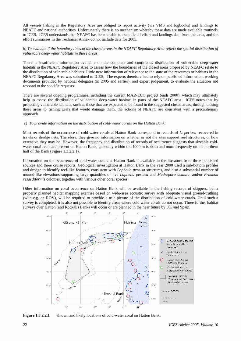
ICES Advice 2005, Volume 10 22
All vessels fishing in the Regulatory Area are obliged to report activity (via VMS and logbooks) and landings to NEAFC and national authorities. Unfortunately there is no mechanism whereby these data are made available routinely to ICES. ICES understands that NEAFC has been unable to compile all effort and landings data from this area, and the effort summaries in the Technical Annex do not include data for 2005.
b) To evaluate if the boundary lines of the closed areas in the NEAFC Regulatory Area reflect the spatial distribution of vulnerable deep-water habitats in those areas;
There is insufficient information available on the complete and continuous distribution of vulnerable deep-water habitats in the NEAFC Regulatory Area to assess how the boundaries of the closed areas proposed by NEAFC relate to the distribution of vulnerable habitats. Little new information of relevance to the state of the resources or habitats in the NEAFC Regulatory Area was submitted to ICES. The experts therefore had to rely on published information, working documents provided by national delegates (in 2005 and earlier), and expert judgement, to evaluate the situation and respond to the specific requests.
There are several ongoing programmes, including the current MAR-ECO project (ends 2008), which may ultimately help to assess the distribution of vulnerable deep-water habitats in parts of the NEAFC area. ICES notes that by protecting vulnerable habitats, such as those that are expected to be found in the suggested closed areas, through closing these areas to fishing gears that would damage them, the actions of NEAFC are consistent with a precautionary approach.
c) To provide information on the distribution of cold-water corals on the Hatton Bank;
Most records of the occurrence of cold water corals at Hatton Bank correspond to records of L. pertusa recovered in trawls or dredge nets. Therefore, they give no information on whether or not the sites support reef structures, or how extensive they may be. However, the frequency and distribution of records of occurrence suggests that sizeable cold-water coral reefs are present on Hatton Bank, generally within the 1000 m isobath and more frequently on the northern half of the Bank (Figure 1.3.2.2.1).
Information on the occurrence of cold-water corals at Hatton Bank is available in the literature from three published sources and three cruise reports. Geological investigation at Hatton Bank in the year 2000 used a sub-bottom profiler and dredge to identify reef-like features, consistent with Lophelia pertusa structures, and also a substantial number of mound-like elevations supporting large quantities of live Lophelia pertusa and Madrepora oculata, and/or Primnoa resaediformis colonies, together with various other coral species.
Other information on coral occurrence on Hatton Bank will be available in the fishing records of skippers, but a properly planned habitat mapping exercise based on wide-area acoustic survey with adequate visual ground-truthing (with e.g. an ROV), will be required to provide a true picture of the distribution of cold-water corals. Until such a survey is completed, it is also not possible to identify areas where cold water corals do not occur. Three further habitat surveys over Hatton (and Rockall) Banks will occur or are planned in the near future by UK and Spain.
Figure 1.3.2.2.1 Known and likely locations of cold-water coral on Hatton Bank.
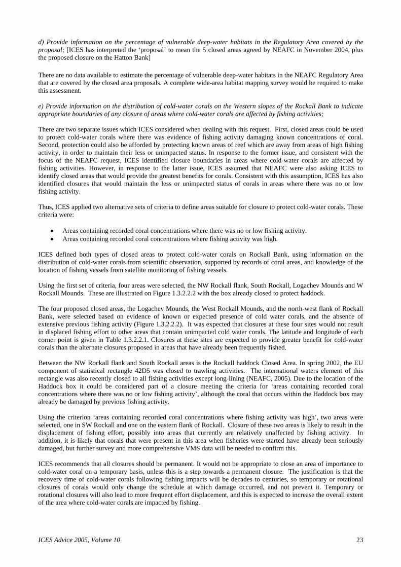
ICES Advice 2005, Volume 10 23
d) Provide information on the percentage of vulnerable deep-water habitats in the Regulatory Area covered by the proposal; [ICES has interpreted the proposal to mean the 5 closed areas agreed by NEAFC in November 2004, plus the proposed closure on the Hatton Bank]
There are no data available to estimate the percentage of vulnerable deep-water habitats in the NEAFC Regulatory Area that are covered by the closed area proposals. A complete wide-area habitat mapping survey would be required to make this assessment.
e) Provide information on the distribution of cold-water corals on the Western slopes of the Rockall Bank to indicate appropriate boundaries of any closure of areas where cold-water corals are affected by fishing activities;
There are two separate issues which ICES considered when dealing with this request. First, closed areas could be used to protect cold-water corals where there was evidence of fishing activity damaging known concentrations of coral. Second, protection could also be afforded by protecting known areas of reef which are away from areas of high fishing activity, in order to maintain their less or unimpacted status. In response to the former issue, and consistent with the focus of the NEAFC request, ICES identified closure boundaries in areas where cold-water corals are affected by fishing activities. However, in response to the latter issue, ICES assumed that NEAFC were also asking ICES to identify closed areas that would provide the greatest benefits for corals. Consistent with this assumption, ICES has also identified closures that would maintain the less or unimpacted status of corals in areas where there was no or low fishing activity.
Thus, ICES applied two alternative sets of criteria to define areas suitable for closure to protect cold-water corals. These criteria were:
Areas containing recorded coral concentrations where there was no or low fishing activity.
Areas containing recorded coral concentrations where fishing activity was high.
ICES defined both types of closed areas to protect cold-water corals on Rockall Bank, using information on the distribution of cold-water corals from scientific observation, supported by records of coral areas, and knowledge of the location of fishing vessels from satellite monitoring of fishing vessels.
Using the first set of criteria, four areas were selected, the NW Rockall flank, South Rockall, Logachev Mounds and W Rockall Mounds. These are illustrated on Figure 1.3.2.2.2 with the box already closed to protect haddock.
The four proposed closed areas, the Logachev Mounds, the West Rockall Mounds, and the north-west flank of Rockall Bank, were selected based on evidence of known or expected presence of cold water corals, and the absence of extensive previous fishing activity (Figure 1.3.2.2.2). It was expected that closures at these four sites would not result in displaced fishing effort to other areas that contain unimpacted cold water corals. The latitude and longitude of each corner point is given in Table 1.3.2.2.1. Closures at these sites are expected to provide greater benefit for cold-water corals than the alternate closures proposed in areas that have already been frequently fished.
Between the NW Rockall flank and South Rockall areas is the Rockall haddock Closed Area. In spring 2002, the EU component of statistical rectangle 42D5 was closed to trawling activities. The international waters element of this rectangle was also recently closed to all fishing activities except long-lining (NEAFC, 2005). Due to the location of the Haddock box it could be considered part of a closure meeting the criteria for areas containing recorded coral concentrations where there was no or low fishing activity , although the coral that occurs within the Haddock box may already be damaged by previous fishing activity.
Using the criterion areas containing recorded coral concentrations where fishing activity was high , two areas were selected, one in SW Rockall and one on the eastern flank of Rockall. Closure of these two areas is likely to result in the displacement of fishing effort, possibly into areas that currently are relatively unaffected by fishing activity. In addition, it is likely that corals that were present in this area when fisheries were started have already been seriously damaged, but further survey and more comprehensive VMS data will be needed to confirm this.
ICES recommends that all closures should be permanent. It would not be appropriate to close an area of importance to cold-water coral on a temporary basis, unless this is a step towards a permanent closure. The justification is that the recovery time of cold-water corals following fishing impacts will be decades to centuries, so temporary or rotational closures of corals would only change the schedule at which damage occurred, and not prevent it. Temporary or rotational closures will also lead to more frequent effort displacement, and this is expected to increase the overall extent of the area where cold-water corals are impacted by fishing.

ICES Advice 2005, Volume 10 24
The Rockall Bank straddles the area managed under the European Union s Common Fisheries Policy and that regulated by NEAFC. The distribution of habitat is continuous in relation to this boundary and a closure in the NEAFC area could displace fishing effort into EU waters where other areas of coral would be damaged.

ICES Advice 2005, Volume 10 25
Table 1.3.2.2.1 Co-ordinates of the corner locations of the Haddock Box and the four areas within which corals are known to occur and in which there is a very low level of fishing activity.
Suggested Closure Area Latitude (N) Longitude (W)
North west Rockall flank
57°57'
13° 9'
57°50'
13°15'
57°57'
13°46'
57°49'
14° 7'
57°29'
14°19'
57°22'
14°19'
57° 0'
14°33'
57° 0'
14°55'
57°24'
14°48'
57°37'
14°41'
57°55'
14°24'
58°14'
13°49'
West Rockall Mounds
56°40'
17°50'
56°21'
17°18'
57° 4'
15°58'
57°20'
16°30'
Haddock box
57° 0'
15° 0'
57° 0'
14° 0'
56°30'
14° 0'
56°30'
15° 0'
Area south and southwest of Haddock 56°30'
15° 0'
56°30'
14°25'
56°19'
14°29'
56° 0'
15° 0'
56° 0'
16° 0'
56°16'
15°58'
56°18'
15° 4'
Logachev Mounds
55°49'
15°15'
55°34'
15° 6'
55°17'
16° 9'
55°33'
16°16'
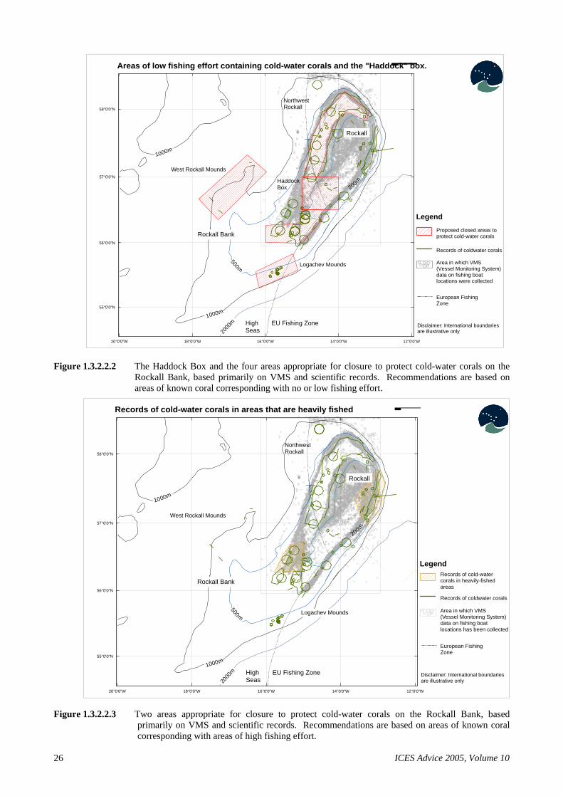
ICES Advice 2005, Volume 10 26
Figure 1.3.2.2.2 The Haddock Box and the four areas appropriate for closure to protect cold-water corals on the Rockall Bank, based primarily on VMS and scientific records. Recommendations are based on areas of known coral corresponding with no or low fishing effort.
Figure 1.3.2.2.3 Two areas appropriate for closure to protect cold-water corals on the Rockall Bank, based primarily on VMS and scientific records. Recommendations are based on areas of known coral corresponding with areas of high fishing effort.
Rockall Bank
1000m
1000m
Rockall
20
00
m
500m
HighSeas
EU Fishing Zone
Logachev Mounds
NorthwestRockall
West Rockall Mounds
200mHaddockBox
20°0'0"W 18°0'0"W 16°0'0"W 14°0'0"W 12°0'0"W
55°0'0"N
56°0'0"N
57°0'0"N
58°0'0"N¯
Disclaimer: International boundaries are illustrative only
Area in which VMS (Vessel Monitoring System) data on fishing boat locations were collected
Legend
European Fishing Zone
Records of coldwater corals
Proposed closed areas to protect cold-water corals
Areas of low fishing effort containing cold-water corals and the "Haddock" box.
Rockall Bank
1000m
1000m
Rockall
20
00
m
500m
HighSeas
EU Fishing Zone
Logachev Mounds
NorthwestRockall
West Rockall Mounds
200m
20°0'0"W
20°0'0"W
18°0'0"W 16°0'0"W 14°0'0"W 12°0'0"W
55°0'0"N
56°0'0"N
57°0'0"N
58°0'0"N¯
Disclaimer: International boundaries are illustrative only
Area in which VMS (Vessel Monitoring System) data on fishing boat locations has been collected
Legend
European Fishing Zone
Records of coldwater corals
Records of cold-water corals in heavily-fished areas
Records of cold-water corals in areas that are heavily fished
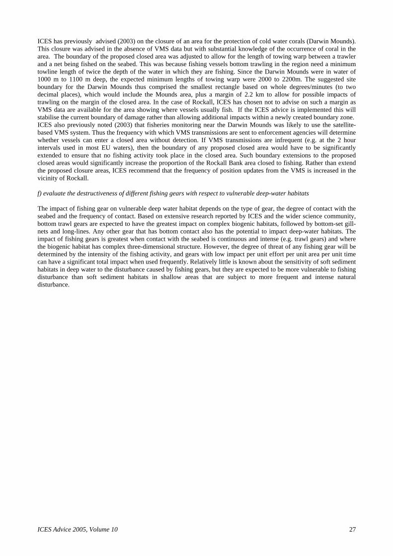
ICES Advice 2005, Volume 10 27
ICES has previously advised (2003) on the closure of an area for the protection of cold water corals (Darwin Mounds). This closure was advised in the absence of VMS data but with substantial knowledge of the occurrence of coral in the area. The boundary of the proposed closed area was adjusted to allow for the length of towing warp between a trawler and a net being fished on the seabed. This was because fishing vessels bottom trawling in the region need a minimum towline length of twice the depth of the water in which they are fishing. Since the Darwin Mounds were in water of 1000 m to 1100 m deep, the expected minimum lengths of towing warp were 2000 to 2200m. The suggested site boundary for the Darwin Mounds thus comprised the smallest rectangle based on whole degrees/minutes (to two decimal places), which would include the Mounds area, plus a margin of 2.2 km to allow for possible impacts of trawling on the margin of the closed area. In the case of Rockall, ICES has chosen not to advise on such a margin as VMS data are available for the area showing where vessels usually fish. If the ICES advice is implemented this will stabilise the current boundary of damage rather than allowing additional impacts within a newly created boundary zone. ICES also previously noted (2003) that fisheries monitoring near the Darwin Mounds was likely to use the satellite-based VMS system. Thus the frequency with which VMS transmissions are sent to enforcement agencies will determine whether vessels can enter a closed area without detection. If VMS transmissions are infrequent (e.g. at the 2 hour intervals used in most EU waters), then the boundary of any proposed closed area would have to be significantly extended to ensure that no fishing activity took place in the closed area. Such boundary extensions to the proposed closed areas would significantly increase the proportion of the Rockall Bank area closed to fishing. Rather than extend the proposed closure areas, ICES recommend that the frequency of position updates from the VMS is increased in the vicinity of Rockall.
f) evaluate the destructiveness of different fishing gears with respect to vulnerable deep-water habitats
The impact of fishing gear on vulnerable deep water habitat depends on the type of gear, the degree of contact with the seabed and the frequency of contact. Based on extensive research reported by ICES and the wider science community, bottom trawl gears are expected to have the greatest impact on complex biogenic habitats, followed by bottom-set gill-nets and long-lines. Any other gear that has bottom contact also has the potential to impact deep-water habitats. The impact of fishing gears is greatest when contact with the seabed is continuous and intense (e.g. trawl gears) and where the biogenic habitat has complex three-dimensional structure. However, the degree of threat of any fishing gear will be determined by the intensity of the fishing activity, and gears with low impact per unit effort per unit area per unit time can have a significant total impact when used frequently. Relatively little is known about the sensitivity of soft sediment habitats in deep water to the disturbance caused by fishing gears, but they are expected to be more vulnerable to fishing disturbance than soft sediment habitats in shallow areas that are subject to more frequent and intense natural disturbance.

ICES Advice 2005, Volume 10
28
1.4.1 Deepwater sharks in the northeast Atlantic (ICES Subareas V XIV, mainly Portuguese dogfish and leafscale gulper shark
State of the stock
Portuguese dogfish (Centroscymnus coelolepis) and leafscale gulper shark (Centrophorus squamosus) are depleted ac-cording to substantial declines in CPUE series in Subareas VI, VII, and XII. The total international catch of these species combined has risen from very low levels to around 8 000 t. The status of other deepwater sharks is unknown.
Management objectives
There is no agreed management plan for these stocks.
Reference points
No reference points have been defined.
Single-stock exploitation boundaries
The rates of exploitation and stock sizes of deepwater sharks cannot be quantified. However, based on the CPUE infor-mation, the stocks of Portuguese dogfish and leafscale gulper shark are considered to be depleted and likely to be below any candidate limit reference point. Given their very poor state, ICES recommends a zero catch of deepwater sharks.
Management considerations
Deepwater sharks are caught in a mixed fishery for deepwater species and as a targeted fishery using longlines and gillnets. Most of the catches of deepwater sharks are taken in the mixed fishery in the northern area. Zero catch of deepwater shark in the mixed fisheries will require that means are identified and implemented to avoid any bycatches of deepwater sharks in these fisheries. If this is not possible, in order to reduce catches in the mixed fishery, effort needs to be reduced to the lowest possible level in mixed fisheries taking deepwater sharks as a bycatch.
Quotas do not appear to restrict the catches of deepwater sharks.
If a fishery is taking place on these species, the catch data should be recorded by species.
In Subareas VI, VII, and XII, CPUE has declined over the history of the fishery while catch levels have increased to high levels. Landings in Subarea IXa have been more stable and the decline in CPUE appears to be less pronounced. The directed fishery on deepwater sharks appears to have increased, which is reflected in the increased landings. The CPUE information from the mixed deepwater fishery, where deepwater sharks are mainly taken as a bycatch, can be used as an indicator of stock development. Despite the increased landings, the CPUE information suggests that the stock abundance of these two species is depleted.
The two species have very different vulnerabilities in relation to exploitation. Most of the international catch is in the northern area (Subareas V VII). In this area, no pregnant leafscale gulper sharks are caught. In contrast all reproductive stages, including mature and pregnant female Portuguese dogfish are found in this area. It is well established that target-ing mature females is detrimental to shark stock status, and the Portuguese dogfish stock is thus more vulnerable to ex-ploitation.
The various Portuguese dogfish CPUE series are initially high and decline quickly, even though they represent different time periods. The declines in CPUE of Portuguese dogfish appear to be steeper than for leafscale gulper shark. This may be because the Portuguese dogfish is a more sedentary species than leafscale gulper shark so that local depletions are evident in the declines in CPUE.
Preliminary information from retrieval surveys of gillnets suggests that excessive soak time leads to high discard rates of sharks. In addition, lost or discarded gillnets ( ghost fishing) adds to deepwater shark mortality.
Ecosystem considerations
Deepwater sharks are found exclusively in waters deeper than 400 m. Leafscale gulper shark is most abundant from 700 to 900 m and Portuguese dogfish in waters of 1100 to 1300 m. Both are important predators and scavengers in the deep-sea habitat. A greater diversity of sharks exists in the deepwater areas compared to the continental shelf. The leafscale gulper shark and Portuguese dogfish were among the most abundant of the deepwater sharks.

ICES Advice 2005, Volume 10 29
The TAC for 2006 and 2007 applies to all deepwater sharks. The TAC for Subareas V, VI, VII, VIII, and IX is 6763 t, for Subarea X 14 t, and for Subarea XII 243 t. These quotas apply to the following list of species: Portuguese dogfish (Centroscymnus coelolepis), leafscale gulper shark (Centrophorus squamosus), birdbeak dogfish (Deania calceus), kite-fin shark (Dalatias licha), greater lanternshark (Etmopterus princeps), velvet belly (Etmopterus spinax), black dogfish (Centroscyllium fabricii), gulper shark (Centrophorus granulosus), blackmouth dogfish (Galeus melastomus), mouse catshark (Galeus murinus), and Iceland catshark (Apristuris spp.). In Subarea XII, Deania histicosa and Deania profun-dorum are also included in the TAC. However, except for Subarea X more than 95% of the catch probably consists of Portuguese dogfish and leafscale gulper shark. The other species are discarded.
Factors affecting the fisheries and the stock
The effects of regulations
A series of TACs is set for EU waters and EU vessels in international waters of Subareas V XII. The TAC applies to all deepwater sharks. The sum of these TACs is 7000 t for 2005 and 2006. The TACs do not appear to restrict the catches of deepwater sharks.
These sharks are often taken in mixed fisheries. An effort restriction regime has been in place since 2003 (EC 2347/2002, 27/2005) for fisheries taking these sharks in EU waters and for EU vessels in international waters.
Norwegian vessels in EU waters are subject to a multispecies quota for these species and spurdog. This quota is about equal to recent Norwegian catches of deepwater sharks in EU waters.
Changes in fishing technology and fishing patterns
The two deepwater sharks were first caught in the late 1980s. They are taken in artisanal longline fisheries in Division IXa, and in mixed fisheries in the northern areas. The trawl fishery takes these sharks as a bycatch, whilst targeting roundnose grenadier, blue ling, orange roughy, or black scabbardfish. Initially, trawl fisheries operated on the upper slope, moving deeper in later years. This implies that leafscale gulper shark was dominant in catches in earlier years, with Portuguese dogfish becoming more important later.
There are longline and gillnet fisheries that target the two deepwater sharks. Recently some gillnet vessels have shifted effort to targeting deepwater red crab, with a bycatch and discard of deepwater sharks.
Scientific basis
Data and methods
No analytical assessment was carried out in 2005. The assessment is based on commercial CPUE trends and survey trends.
Information from the fishing industry
Fishers in the northern area have anecdotally reported the strong decline in Portuguese dogfish.
Comparison with previous assessment and advice
Experimental assessments, using production and depletion models were conducted by ICES in 2000 and 2002. In 2000, the combined stock of these species in Subareas V, VI, and VII was estimated to be depleted to below Upa and possibly Ulim. In 2002, additional data were incorporated, and the strong decline in stock abundance was still evident. In 2002 upward trends in French trawler CPUE were reported, but these were found not to be reflected in fisheries-independent survey CPUE.
In 2002 ICES provided advice on these stocks. In that year it was advised that overall exploitation be reduced and that mixed fishery considerations should be taken into account.
Sources of information
Report of the Working Group on Elasmobranch Fishes 2005 (ICES CM 2005/ACFM:03). Report of the Study Group on the Biology and Assessment of Deep-sea Fisheries Resources (ICES CM 2000/ACFM:8)

ICES Advice 2005, Volume 10
30
Year
ICES Advice
Single-stock ex-ploitation
boundaries
Predicted catch corre-sponding to
advice
Predicted catch cor-responding to single-stock ex-ploitation
boundaries
Agreed TAC1
ACFM landings
Disc. slip.
ACFM Catch
1992
No advice
5
1993
No advice
5
1994
No advice
6
1995
No advice
7
1996
No advice
7
1997
No advice
8
1998
No advice
8
1999
No advice
6
2000
No advice
7
2001
No advice
10
2002
Reduce exploitation 8
2003
No advice
11
2004
No advice
7 9 2005
No advice
7 2006
Zero catch F=0 0
Weights in 000 t. 1) EU only.
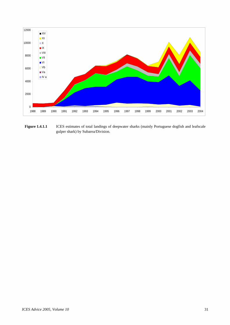
ICES Advice 2005, Volume 10 31
Figure 1.4.1.1 ICES estimates of total landings of deepwater sharks (mainly Portuguese dogfish and leafscale gulper shark) by Subarea/Division.
0
2000
4000
6000
8000
10000
12000
1988 1989 1990 1991 1992 1993 1994 1995 1996 1997 1998 1999 2000 2001 2002 2003 2004
XIV
XII
X
IX
VIII
VII
VI
Vb
Va
IV a

ICES Advice 2005, Volume 10
32
Figure 1.4.1.2 Portuguese dogfish (C. coelolepis). CPUE series from trawls fisheries, longline fisher-ies ,and surveys.
Figure 1.4.1.3 Leafscale gulper shark (C. squamosus). CPUE series from trawls fisheries, longline fisheries, and surveys.

ICES Advice 2005, Volume 10 33
1.4.2 Kitefin shark (Subareas V XIV, but mainly X)
There is still a lack of data that can accurately identify stock identity of kitefin shark in the NE Atlantic. For assessment purposes the Azorean stock was considered as a management unit (ICES Subarea X).
State of the stock
The assessment carried out on kitefin shark in 2002 showed a decline of the stock from the beginning of the time-series and suggested that the stock was recently around half of the virgin biomass. In recent years the catch of kitefin shark from targeted fisheries has been very low. There may be bycatches, but the amount is unknown. There is no recent CPUE data which can be used to monitor the development in the stock.
Management objectives
None have been suggested or adopted.
Reference points
Not defined.
Single-stock exploitation boundaries
Exploitation boundaries in relation to precautionary limits
For any fishery to be permitted for this species, it should be accompanied by a monitoring system that will allow the evaluation of stock dynamics.
Short-term implications
Not applicable.
Management considerations
At present there are no directed fisheries for this species, but there is a small bycatch in the mixed fisheries in the north-ern area. There is a bycatch of deepwater sharks in the fishery for black scabbardfish in Area X. The bycatch in the black scabbardfish fishery should be monitored.
Sporadic small-scale target fisheries may be developed in the Azores, as a function of the markets.
TACs for deepwater sharks (kitefin included), were implemented for 2005 and 2006 for EU member states in ICES Subareas V, VI, VII, VIII, IX, X, and XII (Annex I of Council Regulation 2270/2004). In Subarea X the TAC for deepwater sharks was 120 tonnes in 2005 and 2006.
Exploratory surveys would be useful in order to evaluate the state of the stock.
Ecosystem considerations
The Azores is a seamount ecosystem area (medium to high abundance of seamounts in proportion to the total amount of seamounts throughout the world) and thus a biological sensitive area. The fishery is concentrated on seamounts repre-senting a relatively small area. Population abundance is generally lower than on the continental slopes. Local depletions are likely to occur if target fisheries are concentrated on some particular seamounts.
Factors affecting the fisheries and the stock
The effects of regulations
TACs for deepwater sharks (kitefin included), were implemented for 2005 and 2006 for EU member states in ICES Subareas V, VI, VII, VIII, IX, X, and XII (Annex I of Council Regulation 2270/2004). In Subarea X the TAC for deepwater sharks was 120 tonnes in 2005 and 2006, which is the bycatch quota for the black scabbardfish fishery in Area X. This TAC is well in excess of recent landings of the kitefin shark and could lead to an increase in fishing mor-tality on this species.
ICES Advice 2005, Volume 10 34
An effort restriction regime has been in place since 2003 (EC 2347/2002, 27/2005) for fisheries taking these sharks in EU waters and for EU vessels in international waters. The effects of the effort regulation cannot yet be evaluated.
Changes in fishing technology and fishing patterns
The directed fishery for kitefin shark was highly influenced by markets, especially for liver oil and this can be observed in trends of the historical landings.
Information from the fishing industry
The fishers contend that the reason the fishery became extinct was because the price of liver oil collapsed.
It is also stated that the fishery operated in areas that experienced local depletions, but that fishable aggregations occur in other seamounts.
Scientific basis
Data and methods
The Bayesian production model assessment carried out in 2002 was based on landings data and two commercial CPUE series. Commercial CPUE series are no longer available because the directed fishery has stopped.
Uncertainties in assessment and forecast
The catches and landings are likely to be influenced by market considerations. Commercial CPUE may not reflect real abundance trends, particularly in the last decade.
Comparison with previous assessment and advice
This is the first time ICES provides advice on this stock. The assessment has been carried out in 2002 and cannot be updated.
Source of information
Report of the Working Group on Elasmobranch Fishes 2005 (ICES CM 2005/ACFM:03).

ICES Advice 2005, Volume 10 35
Table 1.4.2.1 Annual landings (t) of kitefin shark from Subareas IXa and X.
Year X IXa 1988 549 149 1989 560 57 1990 602 7 1991 896 12 1992 761 11 1993 591 11 1994 309 11 1995 321 7 1996 216 4 1997 30 4 1998 34 6 1999 31 6 2000 31 5 2001 13 7 2002 35 5 2003 25 3 2004 6 1
Figure 1.4.2.1 Time-series of kitefin shark biomass predicted with the Pella-Tomlinson biomass models with three different settings of the shape parameter m. Lines represent median values of posteriors.