road and transportation masterplan · road and transportation masterplan palestine ta 2012013 ps 00...
TRANSCRIPT

ROAD AND TRANSPORTATION MASTERPLAN
PALESTINE
TA 2012013 PS 00 F10 IV.5 Public Transport
SEPTEMBER 30,2016

Table
1
2 O
2.1 S
2.2 K
3 P
3.1 P
3.2 P
3.3 P
3.3.1 P
3.3.2 P
3.3.3 P
3.3.4 P
3.4 P
e of Conten
Introduction ..
Overview of P
SWOT Analys
Key-Level Fac
Public Transp
Public Transp
Public Transp
Public Transp
Public Transp
Public Transp
Public Transp
Public Transp
Public Transp
IV.5 -1Road
nts
....................
Public Transp
sis of Existing
ctors Definitio
port Network
ort Spoke-Hu
ort Multi-Mod
ort Network P
port Supply in
port Supply in
port Supply in
port Supply in
ort and Urban
and Transportation
.....................
port Sector .....
g Public Trans
on for Public T
Proposal ......
ub Network ....
dal Supply .....
Proposal Dev
n Phase 1 (20
n Phase 2 (20
n Phase 3 (20
n Phase 4 (20
n Developme
n Master Plan | Pal
.....................
.....................
sport Sector ..
Transport ......
.....................
.....................
.....................
elopment by
016 – 2024) ...
025 – 2031) ...
032 – 2037) ...
038 – 2045) ...
ents. ..............
estine – 30/09/201
.....................
.....................
.....................
.....................
.....................
.....................
.....................
Phases ........
.....................
.....................
.....................
.....................
.....................
6
....................
....................
....................
....................
....................
....................
....................
....................
....................
....................
....................
....................
....................
.....................
.....................
.....................
.....................
.....................
.....................
.....................
.....................
.............. 12
.............. 14
.............. 19
.............. 22
.....................
................. 4
................. 4
................. 4
................. 6
................. 7
................. 7
............... 10
............... 10
............... 25
List o
Figure
Figure
Figure
Figure
Figure
Figure
Figure
Figure
Figure
Figure
Figure
Figure
Figure
Figure
of Figures
1. Public Tr
2. Public Tr
3. Inter-city
4. PT Moda
5. Bus Rap
6. BRT Cor
7. PT Moda
8. BRT Cor
9. BRT Cor
10. PT Moda
11. BRT Cor
12. PT Moda
13. Road-Ba
14. Rail-Base
IV.5 -2Road
ransport Back
ransport Netw
Bus in Munic
al Split (Road
id Transit in Q
rridors Schem
al Split (Road
rridors Schem
rridors Schem
al Split (Road
rridors Schem
al Split (Road
ased PT Traffi
ed PT Traffic
and Transportation
kbone Schem
work (2045) ...
ch, Germany .
and Rail) in P
Quito, Ecuado
me for Ramalla
and Rail) in P
me for East Je
me for Hebron
and Rail) in P
me for Gaza C
and Rail) in P
ic Volume Tre
Volume Tren
n Master Plan | Pal
me ..................
.....................
.....................
Phase 1 (%) .
or ..................
ah-Al Bireh-B
Phase 2 (%) .
erusalem Hub
Hub ............
Phase 3 (%) .
City Hub ........
Phase 4 (%) .
end (2015 – 2
nd (2015 – 20
estine – 30/09/201
.....................
.....................
.....................
.....................
.....................
Beitunia Hub a
.....................
b and Bethlehe
.....................
.....................
.....................
.....................
2045) (pax) ...
045) (pax) .....
6
....................
....................
....................
....................
....................
and Nablus H
....................
em ...............
....................
....................
....................
....................
....................
....................
................ 8
.............. 11
.............. 13
.............. 14
.............. 15
ub ......... 15
.............. 19
.............. 20
.............. 21
.............. 21
.............. 22
.............. 23
.............. 24
.............. 24
List o
Tab 1.
Tab 2.
Tab 3.
Tab 4.
Tab 5.
Tab 6.
of Tables
SWOT A
SWOT A
Public Tr
Public Tr
Public Tr
Public Tr
IV.5 -3Road
Analysis of Ex
Analysis of Ex
ransport Supp
ransport Supp
ransport Supp
ransport Supp
and Transportation
isting Public T
isting Public T
ply for Phase
ply for Phase
ply for Phase
ply for Phase
n Master Plan | Pal
Transport: Inf
Transport: Op
1 ..................
2 ..................
3 ..................
4 ..................
estine – 30/09/201
frastructure a
perational and
.....................
.....................
.....................
.....................
6
nd Fleet .......
d Institutional
....................
....................
....................
....................
................ 4
............... 5
.............. 12
.............. 14
.............. 19
.............. 22

This chfor a resituatio
2
Public integracooperbuses Buses used mlanes nconditioPublic
•
• •
•
2
The folpublic tand Ins
• High an
• Regis2,60gen
• Smallof u
1 Introdu
hapter shows enewed publicon, carried ou
2 Overvi
transport exisated system; orate under a sand shared tausually trave
mode of publicnor signals arons. transport is re
Issuing licengalleries, buDeveloping Monitoring aprograms; Formulatingrelevant sta
2.1 SWOT A
llowing SWOTtransport secstitutional and
Ta
Stren
demand for pubnd Gaza Strip, wh
exceedtration fees are:
00 Nis per year cnerate high incom
A-sized vehicles a
unexpected unre
IV.5 -4Road
uction
the proposalc transport syt with a SWO
iew of Pub
sts both in Weon the contrarsingle and unaxi, furthermol when full or c transport. Pre currently pr
egulated by th
nsing servicesus companiestraining curri
and enhancin
g legislation toakeholders.
Analysis of
T analysis aimctor in West Bd Operational
ab 1. SWOT An
P
ngths
lic transport bothhere patronage ads bus capacity; 100 Nis per yea
cab taxi. Togetheme for Local PubAuthorities; allow for better flest and/or military
and Transportation
for public traystem is introdOT analysis an
lic Transp
est Bank andry, it is compoified system.
ore cab taxi caalmost full alublic Transporesent; stops
he MoT that i
s, machinery,s, technical cecula, and pro
ng traffic safet
o regulate traf
f Existing P
ms at providinank and Gaz topics.
nalysis of Existing
Public Transport
h in West Bank almost ever
r for buses and r with fuel tax
blic Transport
exibility in case y roadblocks.
n Master Plan | Pal
ansport sectorduced with a nd the definiti
ort Sector
Gaza Strip hosed of severSupply is maan be consideong variable
ort routes are are not frequ
s responsible
, garages andentres, drivingviding profesty through gu
ffic and achie
ublic Trans
ng a critical sea Strip. It is fo
g Public Transpo
Infrastructure an
• N
• U• U
• pc
• Faincpub
• pub
estine – 30/09/201
r included in tbrief overviewon of key-lev
howeverit doeral private initainly based onered as a formroutes, while not properly ent and statio
e of:
d workshops, g schools; sional trainingidance broch
eve traffic safe
sport Sector
et of highlightocused on Inf
ort: Infrastructure
nd Fleet
W
eeded small-size
Unscheduled servUnscheduled pu
negative effecpublic transport wcertain only durin
are structure is hicome; furthermorblic transportatio
blic transport Flelife is
6
the NTMP. Thw on the existel factors.
es not work asiatives that don two modes, m of para-transhared taxi isequipped: no
ons are not in
car rent offic
g courses; ures and awa
ety in coordin
r
ts concerningfrastructure a
e and Fleet
Weaknesses
ed vehicles implyoperational cos
vices affect publiblic transport rou
cts on both safetyworking time is nong the day and it
sunset; igh if compared tre, it does not incn or lower fares
and commuteret is old: buses anormally set at 2
he proposal ting
s an o not namely
nsit. s the most o dedicated n very good
es, car
areness
ation with
existing nd Fleet,
y high investmensts; c transport reliab
utes have significy and congestionot defined: servicis not provided a
to customers’ avclude subscriptiofor frequent cust
rs; and shared taxi s20 years;
nt and
bility; cant n; ce is after
erage ons for tomers
service

• Enhapublic
private
• Imprgrow
• Improvfacto
• Agrean
• Mo
• Motran
unions
• Pubavai
• Pu
• A corco
• MoTdefin
• Sever
• Privaincreas
• West Ba bo
Opportu
anced standardsc transport, resue-based transpo
proved public tran
wth and increase jextension of s
ved public transpr, stimulating bot
Tab
Stren
eements, studiesnd can be used toT and Local De
connected oT holds good rensport stakeholdes) allowing for str
transpolic transport infralable and repres
deublic transport ca
framework, nee
Opportu
rpus of reformativontribute to stimuT holds a legal d
nition of new laws
ral international dPNA’s de
te investments insing, involving al
Bank aBank-Gaza Strip oost to national e
IV.5 -5Road
unities
can lead to highlting also more art for the majority
population; nsport can stimuljob opportunitiesservice is consid
port can act as a th social and cult
2. SWOT Analy
Pub
ngths
, plans and datato develop publicpartments are prautomated syste
elationships with ers (i.e. private inrong partnership ort enhancement;astructure are alrent assets for pu
evelopment; an rely on existingeding to be re-org
unities
ve laws already eulate general devdepartment in chas aimed at reform
sector; donors are intereevelopment plann Palestine havelso public transpoand Gaza Strip; Corridor Link re
economy and soc
and Transportation
her demand of affordable than y of Palestinian
ate economic s (i.e. if a night dered); social cohesion tural activities.
ysis of Existing P
blic Transport Op
, are available c transport; rovided with ems; main public nvestors and aimed at public ; ready partially ublic transport
g regulatory ganised.
exists; this can velopment; arge with the ming transport
ested in funding s;
e been recently ort in both West
alisation entails cial cohesion.
n Master Plan | Pal
• Pudiff
• Co
reli• C
• Un
Public Transport:
perational and In
• Mono
• Poo
• Im
•o
• Hig
• T
• H
• Pu
• U
•
• F
• Emdrfin
estine – 30/09/201
ublic Transport Fferent demand a
o
nstraints of moveroadblocks, ca
ability, also with Constrains on im
import nrest and riots ca
transport
: Operational and
nstitutional
W
nopolies giving oon public transpo
therefore tor operational m
companies, caplementation of s
aSigned agreem
obstructed by PNs
gh car accident r
Traffic regulationexisting or
igh number of tamanag
blic transport Suprovoking unce
Unavailability of pborder crossing
• Mobility restr
Funding donors ddevelopment, mployment decrearivers increase (snd a job) affecting
6
Fleet is not used re served by the
of fleet and headw
Threats
ements, operatedn affect negativea re-organised a
mport/export can bof transport tech
an lead to sabotat vehicles and inf
d Institutional
Weaknesses
operators (public/ort routes reducethe quality of servanagement of licausing very oftenstakeholders’ res
are not efficientlyments and MoUs NA’s weak capacisector managemrates, due to poo
road traffic safes and technical rr inappropriate (iaxis affects negatgement and devepervising body is
ertainties in stakecompetencies
public transport a causes delays a
Threats
riction affect socidevelopment
dependence, vitaight hinder prope
ase is directly linksince this represeg negatively pub
traffic condition
efficiently: routessame supply, in
way.
d with checkpoinely public transpoand scheduled seban and/or delayhnologies; age episodes of pfrastructure.
/private) exclusiv the competition vice provided; censed public tran financial lossessponsibilities andy set;
implementation ity of public trans
ment; or control and recety; requirements are.e. road sign); tively public tranelopment; s not currently preholders’ roles ans; automated facilitieand malfunctionin
al and economic; al for public transer planning policked to uncontrollent the easiest w
blic transport andns.
s with terms
nts and ort ervice; y the
public
ve right and
ansport s; d roles
is sport
cord of
e not
sport
resent, nd
es at ng.
c
sport ies; led taxi
way to road
2
The deinfrastrThe materms o
•
•
•
•
•
•
•
•
As it cocontrib
•
•
•
•
•
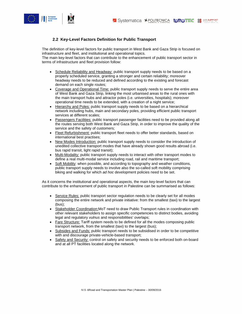
2.2 Key-Lev
efinition of keyructure and fleain key-level of infrastructu
Schedule Rproperly schheadway nedemand on Coverage aof West Banthe main traoperational Hierarchy anetwork incservices at dPassengersthe routes sservice andFleet RefurbinternationaNew Modesunedited cobus rapid traMulti-Modaldefine a reaSoft Mobilitypublic transbiking and w
oncerns the inbute to the enh
Service Rulcomposing (bus); Stakeholderother relevalegal and reFare Structutransport neSubsides anwith and disSafety and and at all PT
IV.5 -6Road
vel Factors
y-level factorseet, and institfactors that c
ure and fleet p
Reliability and heduled servieeds to be redeach single r
and Operationnk and Gaza ansport hubs time needs tond Poles: publuding hubs, mdifferent scale
s Facilities: puserving both W the safety ofbishment: pubal best practiss Introductionollective transpansit, light rapity: public tra
al multi-modaly: when possport supply nwalking for wh
nstitutional anhancement of
es: public trathe entire net
r Coordinationant stakeholdeegulatory vulnure: Tariff sysetwork, from tnd Funds: puscourage privaSecurity: conT facilities loc
and Transportation
s Definition
s for public tratutional and o
can contributeprovision follo
Headway: puce, granting aduced and deroutes; nal Time: publStrip, linking and attractor o be extendedblic transport main and seces; ublic transporWest Bank anf customers;blic transport es; : public transpport modes thpid transit); nsport supplyl service incluible, and accoeeds to involvhich ad hoc d
nd operationaf public transp
nsport sectortwork and priv
n:MoT need ters to assign
nus and respostem needs tothe smallest (tblic transport ate-vehicle-btrol on safety
cated along th
n Master Plan | Pal
for Public T
ansport in Weoperational toe to the enhanow:
ublic transporta stronger anefined accordi
lic transport sthe most urbapoles (i.e. und, with a creasupply needs
condary poles
rt passenger fnd Gaza Strip
fleet needs to
port supply nehat have alrea
y needs to inteuding road, raording to topove also the soevelopment p
al aspects, theport in Palest
r regulation nevate initiative
to draw Publicspecific comp
onsibilities’ ovo be defined ftaxi) to the laneeds to be
ased transpoy and security he network.
estine – 30/09/201
Transport
est Bank and pics.
ncement of pu
t supply needd certain reliaing to the exis
supply needs anised areas niversities, hoation of a nighs to be baseds, providing ef
facilities need, in order to im
o offer better
eeds to consiady shown go
eract with othail and maritimography and wo-called soft mpolicies need
e main key-levtine can be su
eeds to be cle: from the sm
c Transport rupetencies to d
verlaps; for all the modrgest (bus); subsidised inrt; needs to be
6
Gaza Strip is
ublic transpor
ds to be basedability; moreovsting and fore
to serve the eto the rural ospitals); more
ht service; d on a hierarcfficient public
d to be providemprove the q
standards, ba
ider the introdood results ab
her transport mme transport; weather condmobility compto be set.
vel factors thaummarised as
early set for aallest (taxi) to
ules in coordidistinct bodies
des composin
n order to be c
enforced both
s focused on
rt sector in
d on a ver ecast
entire area ones with eover
hical transport
ed along all uality of the
ased on
duction of broad (i.e.
modes to
ditions, prising
at can s follows:
all modes o the largest
nation with s, avoiding
ng public
competitive
h on-board

3
The proin the f
• •
The proexistingarea coThe actransposervicetranspoby a se
3
The dedemogmillion million)West Bcities: RGaza Cthem inThe prostructusame lin the NNablusinbounmost pand NaThese locatedgeneraconsideoutsidewhich isystemdemogto the r
1 PCBS, 2 The GoQalqiliyadensity rpeople pGoverno
3 Public
oposal for a pfollowing two
Public TransPublic Trans
oposed systeg demand, imovered by pubchievement ofort network, ine, combining dort.On this coet of maps pro
3.1 Public T
efinition of pubgraphic trends
people live b) and this valu
Bank and GazRamallah, EaCity, Rafah, anto one nationoposed publicring the entireevel of servicNorth of Wests. Five main hd and outbou
populated citieablus. five hubs are
d outside the ating minor buer only the ree the backboninclusion app
m. Public transgraphic paramresults of the
Annual Statisticovernorates of Ga, Salfit and Tubaratios that differ vper km2, while Weorates are those w
IV.5 -7Road
Transport
public transpomain aspects
sport Infrastrusport Service
em considers mproving the lblic transport f these three nvolving bothdifferent – an
oncern, the foloduced for th
Transport S
blic transport s in West Banbetween Westue is expecteza Strip is notast Jerusalemand Khan Younal urban sysc transport sye network, coce. The backbt Bank, where
hubs are locatund systematies, namely: G
e all interconnidentified bac
ut important flelations betwene to catch otears vital for sport urban p
meters, in line survey camp
s-Estimated Popaza City and He
as possess the lovery much amonest Bank’s averawith the highest
and Transportation
t Network P
ort in West Bas:
ucture Netwoe Supply.
equally Westevel of servicsupply. main objectiv urban and nod sometimes llowing parage purpose.
Spoke-Hub
network startnk and Gaza St Bank (around to increaset uniformly sp
m, Hebron, Beunis, in Gaza stem where eaystem unveilsonceived to cobone runs bete it crosses thted along the ic and occasio
Gaza City, Heb
nected each ockbone, whereows of passe
een the five mther primary uthe achievemoles and extrwith what is d
paign carried o
pulation in the Pabron are the mosowest populationg each other: Ga
age density rate snumber of urban
n Master Plan | Pal
Proposal
ank and Gaza
rk;
t Bank and Gace of existing
ves is possibleon-urban areanew for Wes
graphs provide
Network
ts from an attStrip. Accordind 2.93 million up to around
pread2, indeedethlehem, JeriStrip. An ideaach city plays said ideal linover both Wetween Rafah he most urban
backbone, aonal flow of pbron, East Je
other. Moreove other poles
engers. The pmain hubs, on urban poles ament of a souna-urban nodedone for publout simultane
alestinian Territorst populated, on
n rate. The differeaza Strip holds thstands at 468 pen centers.
estine – 30/09/201
a Strip herein
aza Strip andpublic transpo
e only throughas, and a mu
st Bank and Ge detailed info
entive analysng to the PCB
n) and Gaza Sd 13 million ind, today Palescho, Nablus a
al linear axis cs its role and hnear axis and st Bank and Gin the South onised areas bttracting and
people. Theseerusalem, Ram
er, they are aare located,
pattern of connthe contrary nd secondarynd and efficiees are identifieic transport h
eously at the b
ry Mid-Year By Gthe contrary the
ence of populatiohe third highest deople per km2. In
6
presented is
d aims at satisort, and incre
h a widesprealti-modal pub
Gaza Strip – mormation acco
sis of recent aBS currently aStrip (around 2050.1Populstinians live mand Jenin, in could be traceholds its impoturns it into aGaza Strip wiof Gaza Strip
between Hebrgenerating th
e hubs consismallah-Al Bire
also linked witattracting andnections thereit extends alo
y extra-urban nt public traned according
hubs, and accbiggest termin
Governorate, 199Governorates o
on distribution is density rate worldgeneral, the mo
described
sfying easing the
ad public lic transport
modes of ompanied
and future around 4.81 1.88 ation in
mainly in West Bank;
ed to link ortance. a backbone th the and Jenin
ron and he biggest t in the
eh-Beitunia,
th areas d efore do not ong and nodes sport to
cording also nals of
97-2006. f Jericho, confirmed by dwide, 4045 st populated

public tTranspurban p
transport in Wport Survey.Thpoles, follows
IV.5 -8Road
West Bank anhe scheme ofs.
and Transportation
d Gaza Strip.f public transp
Figure 1. Publ
n Master Plan | Pal
. For more deport backbone
lic Transport Bac
estine – 30/09/201
etail, refer to; e, with the lis
ckbone Scheme
6
¶ Annex 12. Pt of hubs and
Public primary

Identifynodes)define constitappropFor this
•
• •
These West Bmultiplebigges
• • •
The soand Gabiggesareas, mobilityThe proboostinon the isolatedThis twsupply
3The spowhich alforms of generallyvarious t
ying public tra) composing tpublic transputive element
priate public trs reason, the
Regional Copoles at anyInter-Hub CInner-Hub C
three levels oBank and Gaze hubs, whicht to the small
Hub-to-HubHub-to-UrbaUrban Prima
o-defined connaza Strip servt part of tertiawhere the wey conditions. oposed publicng economy, other hand, itd, in contact w
wofold objectivthat is illustra
oke-hub distributl traffic moves altransport, with th
y take the shortetransport hubs to
IV.5 -9Road
ansport constthe public tranort network. Ots represents ransport netwfollowing thre
onnections; liy distance and
Connections; lConnections;
of connectionza Strip, struch connectivityest):
b an Primary Poary Poles-to-E
nectivity pattevicing both urbary functions veakest social
c transport neby networkingt acts as a sowith the centrve is achievabated in the fol
tion paradigm (oong spokes to hhe only exceptio
est or fastest routo allow passenge
and Transportation
itutive elemennsport proposOn this concethe next and
work. ee levels of c
nking each ofd then linkinginking the fiveservicing urb
s compose thctured accordy is organised
oles Extra-Urban S
ern allows pubbanised areavital for econogroups live, c
etwork has twg all the majo
ocial cohesionral ones. ble only throullowing parag
r model or netwoub at the center.n of road transpote between two pers to transfer be
n Master Plan | Pal
nts (backbonesal is propaedern, defining t indispensabl
onnectivity ar
f the five hubsg urban poles e hubs to eacan and peri-u
he entire proping to the hub
d in turn into m
Secondary No
blic transport s, where the omic developcurrently in st
wo main objecor economic cn factor, puttin
ugh an attentiraph.
ork) is a system In transportationort, where spokepoints. In public tetween different l
estine – 30/09/201
e, hubs, urbadeutic but not he connectiole step toward
re determined
s to the highewith closest e
ch other, usingurban connect
posed public tb-and-spoke mmultiple scales
odes
network to exmajority of pements is locatrong need fo
ctives: on the centres of Weng the periphe
ve definition o
of connections an, the spoke-hub
e-hub model doestransport, the spoines or transport
6
n poles and esufficient per
ns between thds the definiti
d:
est number ofextra-urban ng the fastest ptions at each
transport netwmodel3, that is, namely (fro
xtend over Weople lives anated, and extrar improvemen
one hand, it aest Bank and Geral areas, cu
of public trans
arranged like a wb model is applicas not apply becaoke-hub model utation modes.
extra-urban r se to hese on of an
f urban nodes. path. hub.
work for s hinged on om the
West Bank nd the a-urban nt of their
aims at Gaza Strip; urrently
sport
wire-wheel, in able to many use drivers
utilizes

3
A multiwhere Road-b
• •
Rail-ba
•
Public and priGaza SPort). Tof all thmaritim
3
The seoperatiphasesorganizOvervi Beforeentire p
3.2 Public T
i-modal transboth road-babased service
Inter-city BuBus Rapid T
ased service c
Inter-city Ra
transport supincipal transpStrip (Y. ArafaTherefore, puhe transport sme transport,
3.3 Public T
everal serviceive at the sams.For this reaszed by phaseiew.
proceeding tproposed sys
IV.5 -10Road
Transport M
port supply issed and unpr
es can be dist
us; Transit, along
consists of:
ail.
pply connectsport infrastructat Regional (Eblic transport
sub-sectors inair transport,
Transport N
s composing me time but deson, the desc
e.For more de
to describe instem is illustra
d and Transportatio
Multi-Modal
s proposed forecedented ratinguished be
g Urban Corrid
cities, townstures located EU-MENA) Ait supply’s mulncluded in theand border c
Network Pro
the overall suevelop and ex
cription of eacetails, refer to:
details the dated in the figu
on Master Plan | Pa
Supply
r public transail-based shaetween:
dor.
and villages in West Bank
irport, New Glti-modality is
e Master Plancrossing point
oposal Deve
upply proposextend accordch shared tran: ¶III – Road a
evelopment oure reported
alestine – 30/09/201
port in West Bred services a
with major bok (New Internaza Commerfurther enhan: road transpos.
elopment b
ed for public ting to the alrensport serviceand Transpor
of public transin the followin
16
Bank and Gaare provided.
order crossingnational Airporcial Port, Gaznced by the inort, rail transp
y Phases
transport do neady introduce herein presertation Master
sport by phasng page.
za Strip,
g points rt) and za Fishing nvolvement port,
not become ed ented is r Plan
e, the

IV.5 -11Road
Figu
d and Transportatio
ure 2. Public Tran
on Master Plan | Pa
nsport Network (2
alestine – 30/09/201
2045)
16

3
Both ratranspo
• •
Inter-cproposRamalInter-cistationroutes,one hoInter-cdetails, As saidlisted inconnec
LineLLLLLLLLL
LLLLLLiLLiLLLiLLLLLLLLLLLiLi
3.3.1 Public
ail and road-bort supply con
Inter-city BuInter-city Ra
city busesopesed to carry plah-Al Bireh-Bity buses travs and once a, where majorour which maycity rail lineso, refer to: ¶IV
d above, the en the table bect hubs with b
e Number Line 1 Line 2^ Line 3 Line 4^ Line 5 Line 6 Line 7^ Line 8 Line 9
Line 10 ine 11* ine 12* ine 13*
Line 14 ine 15^
Line 16 ine 17^
Line 18 Line 19 ine 20^
Line 21 Line 22 Line 23 Line 24 Line 25 ine 26* ine 27* ine 28*
Line 29 Line 30 ine 31^ ine 32^
IV.5 -12Road
c Transport S
based shared nsists of:
uses network:ail Lines: 4 ST
erate on fixedassengers beBeitunia, Nabvel medium/lot the arrival sr mobility attray however beoperate betw
V.2 Rail Transp
entire inter-citelow. Lines inborder crossin
Ta
HuRamRamRamRamRamRamRamRamRamRamRamRamRamNabNabNabNabNabNabNabNabNabNabNabNabNabNabNabHebHebHebHeb
d and Transportatio
Supply in Pha
service are p
: 62 LINES; TATIONS;
d schedule anetween the fivlus) towns anng distances tation, with a actors are loc subjected to een Ramallahport.
ty bus networdicated with “
ng points.
ab 3. Public Tra
Road-Based
ub mallah mallah mallah mallah mallah mallah mallah mallah mallah mallah mallah mallah mallah blus blus blus blus blus blus blus blus blus blus blus blus blus blus blus bron bron bron bron
on Master Plan | Pa
ase 1 (2016 –
proposed for P
nd are organizve main hubs nd villages loc
and stop malimited numb
cated. The provariations ba
h and Nablus
rk is hub-base“^” are Inter-H
ansport Supply fo
d Public Transpo
RRa
RRama
Na
alestine – 30/09/201
– 2024)
Phase 1. Inde
zed by hub. In(Gaza City, H
cated in Westinly twice: on
ber of further soposed headwased on fluctu, servicing fou
ed and includHub Lines; lin
or Phase 1
ort
Line Ramallah-Tarq
Ramallah-HeRamallah-Beth
Ramallah-East Jeamallah-Bir Zayt
Ramallah-JerRamallah-Na
Ramallah-QalqRamallah-Tulk
Ramallah-JeRamallah-Freija
amallah-Al Jalamallah-Al Karama
Nablus-TarqNablus-He
Nablus-BethNablus-Ram
Nablus-East JeNablus-Bir Zayt
Nablus-JerNablus-QalqNablus-Tulk
Nablus-JeNablus-Sa
Nablus-TuNablus-Freija
Nablus-Al Jalamablus-Al Karama
Hebron-TarqHebron-BethHebron-Ram
Hebron-East Je
16
eed, in this ph
nter-city buseHebron, East t Bank and Gace at the depstops locatedway for inter-cuations in demur stations. F
es 62 lines thes indicate w
Name umiya-Ramallahbron-Ramallah lehem-Ramallah
erusalem-RamallUniversity-Ramaricho-Ramallah
ablus-Ramallah qiliya-Ramallah karm-Ramallah
enin-Ramallah atBCP-Ramallahmeh BCP-RamalBridge BCP-Ramumiya-Nablus bron-Nablus lehem-Nablus
mallah-Nablus erusalem-NablusUniversity-Nabluricho-Nablus qiliya-Nablus karm-Nablus
enin-Nablus alfit-Nablus
ubas-Nablus atBCP-Nablus meh BCP-NablusBridge BCP-Nabumiya-Hebron lehem-Hebron
mallah-Hebron erusalem-Hebron
hase public
es are Jerusalem, aza Strip.
parture along the city bus is
mand. For more
hat are with “*”
h
h lah allah
h lah mallah
s us
s blus
n

LLLiLLLLLLLLLLLLLLiLLLiLLLLLLLLLL
In Phas
4 Source
Line 33 Line 34 ine 35^
Line 36 Line 37 Line 38 Line 39 Line 40 Line 41 Line 42 ine 43* ine 44* ine 45*
Line 46 Line 47 Line 48 ine 49^
Line 50 Line 51 ine 52^
Line 53 Line 54 Line 55 ine 56* ine 57* ine 58*
Line 59 Line 60 ine 61* ine 62*
INTERCITY RAI
se 1, traffic vo
e: DB Bahn
IV.5 -13Road
HebHebHebHebHebHebHebHebHebHebHebHebHeb
East JeEast JeEast JeEast JeEast JeEast JeEast JeEast JeEast JeEast JeEast JeEast JeEast Je
GazaGazaGazaGaza
R
L LINES (4 STA
Figu
olume genera
d and Transportatio
bron bron bron bron bron bron bron bron bron bron bron bron bron rusalem rusalem rusalem rusalem rusalem rusalem rusalem rusalem rusalem rusalem rusalem rusalem rusalem a City a City a City a City
Rail-based Public
TIONS)
ure 3. Inter-city B
ated by public
on Master Plan | Pa
HeEast
EasEast EastEasEasEas
EasEas
EaEast
East JeEast
G
G
c Transport Supp
Ramallah-Al
Bus in Munich, G
c transport is
alestine – 30/09/201
Hebron-Bir Hebron-JerHebron-Na
Hebron-QalqHebron-Tulk
Hebron-JeHebron-D
Hebron-DahHebron-SamHebron-Ya
Hebron-FreijaHebron-Jalame
ebron-Al Karama Jerusalem-Tarq
st Jerusalem-HeJerusalem-Betht Jerusalem-Ramst Jerusalem-Bir st Jerusalem-Jerst Jerusalem-Na
st Jerusalem-Qalqst Jerusalem-Tulkast Jerusalem-JeJerusalem-Freijaerusalem-Al JalaJerusalem-Al KaGaza City-Khan
Gaza City-RaGaza City-Bayt HGaza City-Rafa
ply
Bireh-Beitunia, BNablu
Germany4
split as follow
16
Zayt-Hebron richo-Hebron
ablus-Hebron qiliya-Hebron karm-Hebron
enin-Hebron ura-Hebron hriya-Hebron mu’a-Hebron atta-Hebron atBCP-Hebron eh BCP-Hebron Bridge BCP-Hebumiya-East Jerubron-East Jerusalehem-East Jeru
mallah-East JerusZayt-East Jerus
richo-East Jerusaablus-East Jerusaqiliya-East Jeruskarm-East Jerusenin-East JerusaatBCP-East Jeruameh BCP-E. Jearama Bridge BCYounis-Gaza Cit
afah-Gaza City Hanoun-Gaza Cih BCP-Gaza City
Bir Zayt Universitus
ws:
bron usalem alem
usalem salem alem alem alem salem salem lem
usalem rusalem
CP-E.J. ty
ty y
ty, Salfit,

3
Both rotranspo
• • •
Detaile
BU
Bus RaNablusBus Raconsistmainly service
3.3.2 Public
oad-based anort supply con
Inter-city BuBus Rapid TInter-city Ra
ed information
INTERCITY B
US RAPID TRAN
INTERCITY RAI
apid Transit s, with the aimapid Transit st in enhancedon arterial ro
es because of
IV.5 -14Road
Figure
c Transport S
nd rail-based snsists of:
uses network:Transit: 2 COail Lines: 14 S
n is presented
Ta
R
BUS LINES (62 L
NSIT (2 BRT COR
R
L LINES (14 STA
systems are m of creating ssystems, also d bus service oads with freqf their followin
d and Transportatio
4. PT Modal Spl
Supply in Pha
shared servic
: 62 LINES; RRIDORS;
STATIONS;
d in the follow
ab 4. Public Tra
Road-Based Publ
LINES)
RRIDORS):
Rail-based Publi
ATIONS)
proposed forseveral new uknown as BRservicing mu
quent stops alng main chara
5
Total Road
on Master Plan | Pa
lit (Road and Rai
ase 2 (2025 –
ces are propo
wing table.
ansport Supply fo
lic Transport Sup
S
1) Ramallah2
c Transport Sup
Ramallah-Al Nablus, Ba
Qalandiya/AQaba
r the hubs of Rurban corridorRT, are bus-bltiple origin anong the routeacteristics:
95%
5%
Total BRT T
alestine – 30/09/201
il) in Phase 1 (%)
– 2031)
osed for Phase
or Phase 2
pply
See Table 3 for m
h-Al Bireh-Beitun
2) Nablus (total le
ply
Bireh-Beitunia, Bni Na’im, Bethele
Al Ram, Nablus Natiya, Jenin, and
Ramallah-Al Brs with enhanased mass trnd destinatione. BRT differ f
Total Rail
16
)
e 2. In this ph
more details
nia (total length: ength: 18 km)
Bir Zayt Universitehem, East JeruNorth, Tubas, ZaAl Jalameh BCP
Bireh-Beitunianced mobility ransit system.n pairs, whichfrom traditiona
hase public
18 km)
ty, Salfit, salem, babida,
P
a and conditions. . They h operating al local bus

• • • •
For moCase o Two nethese cCorridopropos
5 FeigenCentury,6 BRT hescale. 7 Source
Dedicated gTraffic signaDedicated laExpedited fa
ore details abof European B
etworks of BRcorridors withors that links tsed for Ramal
Figur
baum, B., Bus R, Reason Foundaeadway is to be d
e: Institute for Tra
IV.5 -15Road
guideway systal prioritizatioanes at intersare collection
out BRT systBRT”).
RT corridors o short headwthem to the cllah-Al Bireh-B
Figu
re 6. BRT Corrido
Rapid Transit andation, 2014. defined accordin
ansportation and
d and Transportatio
tem; n; sections, and;n.5
tems, refer to:
of 18 km eachway6. New railwcity centers. TBeitunia and
ure 5. Bus Rapid
ors Scheme for R
d Managed Lanes
ng to ad hoc in-de
Development Po
on Master Plan | Pa
;
: “The LINE G
h are proposeway stations
The following sfor Nablus Hu
d Transit in Quito
Ramallah-Al Bire
s: Low-Cost High
epth travel dema
olicy
alestine – 30/09/201
G in Strasbour
ed; multiple-caare included schemes illusub.
o, Ecuador7
eh-Beitunia Hub a
h-Quality Transp
and studies, to be
16
rg: A Success
ar vehicles ruin the new BR
strate the BRT
and Nablus Hub
portation Solution
e carried out at m
sful Study-
n along RT T Corridors
ns for 21st
macro-urban

IV.5 -16Roadd and Transportatio
on Master Plan | Paalestine – 30/09/20116

THE LINE G IN MAIN FEATUR Total Length: 5Patronage ServOperating TimeHeadway: everTotal travel timFleet CharacteVehicle Type: MUrban OperatinInvestment CosEquipment: 12 PROJECT TIM 2011-2012 : re2012 : public h2013 : start of wend of 2013 : e
N STRASBOURG
RES
5.2 km (80% withvice: 15,000 peoe: from 5:15 AM ry 6 mins during e: 14 mins ristics: 11 multi-cMercedes-Benz Cng Speed: 20 kmsts (excluding veStations, 1 P+R
MELINE
gulatory consultaearing works
entry into service
Line G multi-c
IV.5 -17Road
G: A SUCCESSF
h exclusive lanesople (8,000 inhabtill Midnight, 7 dapeak time; every
car vehicles withCitaro G (485,00
m/h ehicles: 4,8 Euro/, 1 Bicycle Parki
ation and launch
.
car vehicle stopp
d and Transportatio
FUL STUDY-CA
) bitants, 6,000 emays/weak y 8 mins during d
a capacity of 1200 Euro)
/Km ng, 1 Car-Sharin
of preliminary st
ping at one of 12
on Master Plan | Pa
ASE OF EUROPE
mployees, 1,500 s
day-non-peak tim
20 passengers
ng Station, 1 Bike
tudies
2 stations located
alestine – 30/09/201
EAN BRT
students)
me; every 30 mins
e-Sharing Station
d its route; source
16
s during night
n
e: Mercedes Bennz

BRIEF DESCR Line G has bepatronage of 10of tramlines. Ali.e.: priority at quick and easyLine G was con Improve public Provide better business park. Provide direct connections in Help improve a The project hapedestrian syst
THE RESULTS After only two yinauguration incustomers. Nowhow public tranwith a focus on Sources: http://www.en.strhttp://www.cts-strhttps://fr.wikipedihttp://www.mercebenz.de/content/ghttps://www.merc
RIPTION
en operating sin0,000 pax/year, lthough Line G isintersections reg
y boarding also fonceived and des
transport conneconnections to
and frequent cthe railway statio
air quality and red
as the added advtem, in line with a
S
years of planningn November 201wadays, Strasbonsport projects cn high quality and
asbourg.eu/en/tranrasbourg.eu/fr/la-cta.org/wiki/Ligne_Gedes-germany/mpc/mpc_cedes-benz.com/en
IV.5 -18Road
nce 2013, linkingLine G is part of s a road-based pgulated with traffor PRM. igned in order to
ections in and outthe CNRS rese
connections betwon/city centre seduce noise levels
vantage of proviaccessibility stan
Line G
g and one year o3. Providing a ra
ourg is a prime ecan be used as ad excellence in d
nsport-and-environmts/projets-dextensio
G_du_BHNS_de_St
_germany_websiten/mercedes-benz/v
d and Transportatio
g the cities of Stf the wider publicpublic transport sfic lights; off-boa
accomplish the
t of Cronenbourgearch and highe
ween the centractor. s through the use
ding enhanced rndards.
G exclusive lane
of construction wapid and comfor
example of how tan urban projectesign can lead to
ment/innovation-ledon/ligne-g-bus-a-hatrasbourg
e/de/home_mpc/buvehicles/buses/citar
on Master Plan | Pa
trasbourg, Schiltc transport netwoservice, it works rd fare collection
following princip
g, especially the er education ce
al railway statio
e of public transp
road layouts and
s; source: Merce
works, the 5km lortable transport cto adapt BRT to . It shows how tho successful bus
d-projects/bus-rapiaut-niveau-de-servi
s/home/consulting/ro-g-ngt-bus-rapid-t
alestine – 30/09/201
ingheim and Bisork that is operateas a tram, with w
n; stations’ layou
ple objectives:
Cité Nucléaire antre and to the
n and the secto
port rather than p
d new cycle trac
edes Benz
ng Line G has bconnection, the the context of Ehinking about BRs-based public tra
d-transit/ ice/
/bus_rapid_transit/transit-for-strasbou
16
shheim. Conceived by CTS and iwhich it shares mut designed at le
nd planned housEspace Europé
ors and offer a
private cars.
cks. It also provi
een operating subuses have beeuropean cities, wRT in a holistic aansport.
solutions/strassbururg-video/
ed for an expecs mainly compos
many of its featurvel with the bus
sing estates. éen de l'Entrepr
a greater choice
des a more sec
uccessfully sinceen well-acceptedwhile demonstratand innovative w
rg.html
cted sed res, for
rise
e of
ure
e its by ting
way,
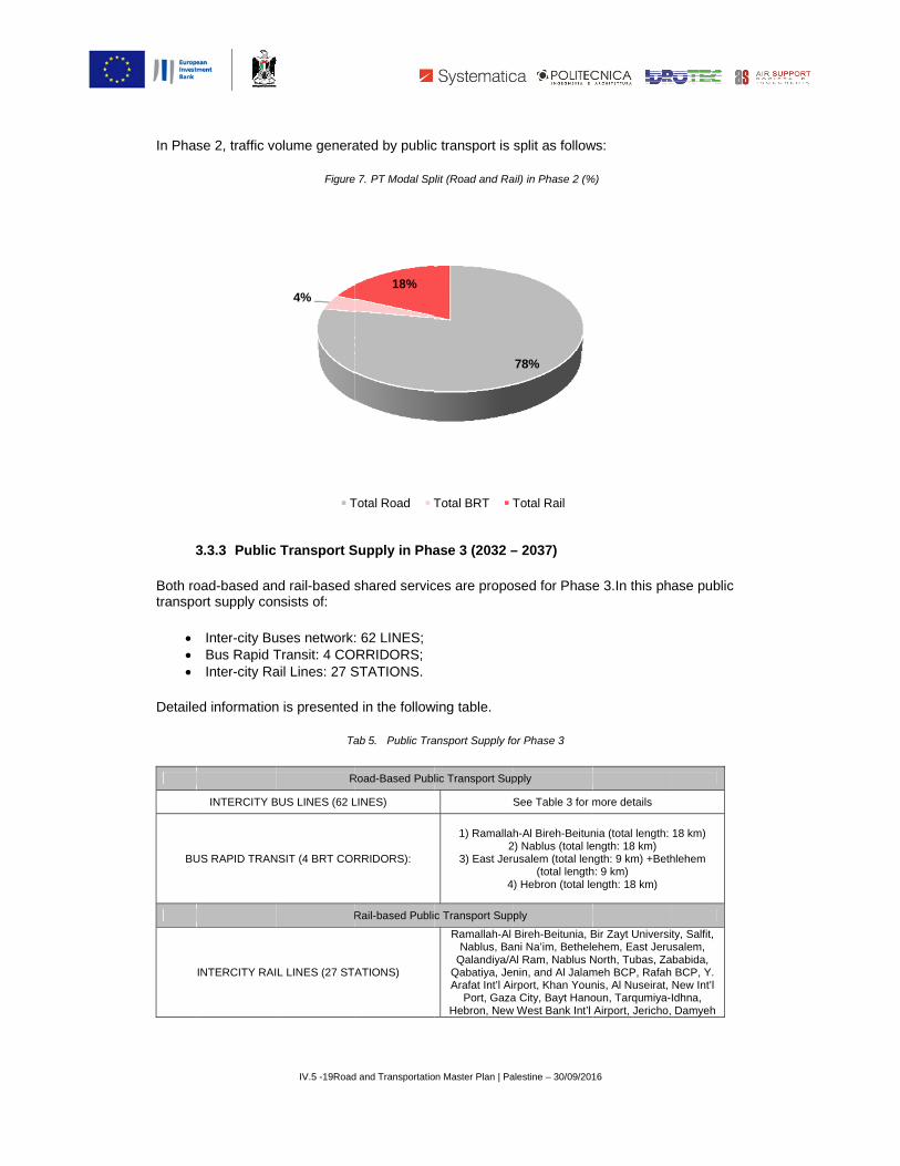
In Phas
3
Both rotranspo
• • •
Detaile
BU
se 2, traffic vo
3.3.3 Public
oad-based anort supply con
Inter-city BuBus Rapid TInter-city Ra
ed information
INTERCITY B
US RAPID TRAN
INTERCITY RAI
IV.5 -19Road
olume genera
Figure
c Transport S
nd rail-based snsists of:
uses network:Transit: 4 COail Lines: 27 S
n is presented
Ta
R
BUS LINES (62 L
NSIT (4 BRT COR
R
L LINES (27 STA
4%
T
d and Transportatio
ated by public
7. PT Modal Sp
Supply in Pha
shared servic
: 62 LINES; RRIDORS;
STATIONS.
d in the follow
ab 5. Public Tra
Road-Based Publ
LINES)
RRIDORS):
Rail-based Publi
ATIONS)
18%
Total Road T
on Master Plan | Pa
c transport is
plit (Road and Ra
ase 3 (2032 –
ces are propo
wing table.
ansport Supply fo
lic Transport Sup
S
1) Ramallah2
3) East Jeru
4
c Transport Sup
Ramallah-Al Nablus, Ba
Qalandiya/AQabatiya, JeArafat Int’l Ai
Port, GazaHebron, New
Total BRT T
alestine – 30/09/201
split as follow
ail) in Phase 2 (%
– 2037)
osed for Phase
or Phase 3
pply
See Table 3 for m
h-Al Bireh-Beitun
2) Nablus (total leusalem (total len
(total length) Hebron (total le
ply
Bireh-Beitunia, Bni Na’im, Bethele
Al Ram, Nablus Nnin, and Al Jalamrport, Khan Youn
a City, Bayt Hanow West Bank Int’l
78%
Total Rail
16
ws:
%)
e 3.In this pha
more details
nia (total length: ength: 18 km) ngth: 9 km) +Bethh: 9 km) ength: 18 km)
Bir Zayt Universitehem, East JeruNorth, Tubas, Zameh BCP, Rafah nis, Al Nuseirat, oun, Tarqumiya-IAirport, Jericho,
ase public
18 km)
hlehem
ty, Salfit, salem, babida, BCP, Y.
New Int’l Idhna, Damyeh

Two neJerusaCorridopropos
8East Je(total len
etworks of BRalem+Bethleheors that links tsed for East J
rusalem hub is hngth: 18 km) are
IV.5 -20Road
RT corridors oem8, and onethem to the cerusalem+Be
Figure 8. BRT
herein consideredproposed: one in
d and Transportatio
of 18 km eache in Hebron. Ncity centers. Tethlehem and
Corridors Schem
d as the conurban East Jerusalem
on Master Plan | Pa
Br
h are proposeNew railway sThe following s
Hebron.
me for East Jerus
ation including alsm and one in Beth
alestine – 30/09/201
ridge BCP, Tell A
ed: one in Easstations are inschemes illus
salem Hub and B
so Bethlehem. Thlehem.
16
Al Bayda BCP.
st cluded in the
strate the BRT
Bethlehem
Two different BRT
new BRT T Corridors
T Corridors

In Phasse 3, traffic vo
IV.5 -21Road
F
olume genera
Figure
4%
T
d and Transportatio
Figure 9. BRT Co
ated by public
10. PT Modal Sp
35%
Total Road T
on Master Plan | Pa
orridors Scheme
c transport is
plit (Road and Ra
Total BRT T
alestine – 30/09/201
for Hebron Hub
split as follow
ail) in Phase 3 (%
61%
Total Rail
16
ws:
%)

3
Both rotranspo
• • •
Detaile
B
Finallyschem
3.3.4 Public
oad-based anort supply con
Inter-city BuBus Rapid TInter-city Ra
ed information
INTERCITY B
US RAPID TRAN
INTERCITY RAI
, another netwe illustrates th
IV.5 -22Road
c Transport S
nd rail-based snsists in:
uses network:Transit: 5 COail Lines: 33 S
n is presented
Ta
R
BUS LINES (62 L
NSIT (5 BRT CO
R
L LINES (33 STA
work of BRT che BRT Corri
Figu
d and Transportatio
Supply in Pha
shared servic
: 62 LINES; RRIDORS;
STATIONS.
d in the follow
ab 6. Public Tra
Road-Based Publ
LINES)
ORRIDOR):
Rail-based Publi
ATIONS)
corridors of 1dors propose
ure 11. BRT Corri
on Master Plan | Pa
ase 4 (2038 –
ces are propo
wing table.
ansport Supply fo
lic Transport Sup
S
1) Ramallah2
3) East Jeru
45
c Transport Sup
Ramallah-Al Nablus, Ba
Qalandiya/AQabatiya, JeArafat Int’l Ai
Port, GazaHebron, New
Bridge BCPFaroun BCP
8 km is propoed for Gaza C
ridors Scheme fo
alestine – 30/09/201
– 2045)
osed for Phase
or Phase 4
pply
See Table 3 for m
h-Al Bireh-Beitun2) Nablus (total leusalem (total len
(total length) Hebron (total le5) Gaza (total len
ply
Bireh-Beitunia, Bni Na’im, Bethele
Al Ram, Nablus Nnin, and Al Jalamrport, Khan Youn
a City, Bayt Hanow West Bank Int’l
, Tell Al Bayda BP, Azzun, Bayt Ib
Kafr Ra
osed for GazaCity
or Gaza City Hub
16
e 4. In this ph
more details
nia (total length: ength: 18 km) gth: 9 km) + Beth
h: 9 km) ength: 18 km) ngth: 18 km)
Bir Zayt Universitehem, East JeruNorth, Tubas, Zameh BCP, Rafah nis, Al Nuseirat, oun, Tarqumiya-IAirport, Jericho,
BCP; Qalqiliya, Tba, Bal’a/ Anabtaa’l.
a City. The fo
hase public
18 km)
hlehem
ty, Salfit, salem, babida, BCP, Y.
New Int’l Idhna, Damyeh
Tulkarm/ a, Arab/
llowing

In Phas
The derelevanthe evodischa The figvolume
se 4, traffic vo
evelopment ofnt shift in modolution of rail rging road ne
gures presente and the tren
IV.5 -23Road
olume genera
Figu
f multi-modal dal split, whertransport netw
etwork (from 9
ed in the follond of rail-base
43%
T
d and Transportatio
ated by public
ure 12. PT Modal
public transpre rail-based pwork (from 5%95% in Phase
owing page shed public tran
4%
%
Total Road T
on Master Plan | Pa
c transport is
Split (Road and
port network (public transpo% in Phase 1 e 1to 53% in P
how the trendsport volume
Total BRT T
alestine – 30/09/201
split as follow
Rail) in Phase 4
road and rail-ort volume incto 43% in Ph
Phase 4).
d of road-base.
53%
Total Rail
16
ws:
4 (%)
-based) entaicreases, accohase 4), hence
ed public tran
ls a ording to e
sport

Phase
688729.6
0.0
Phase 1A
e 1Phase 2
IV.5 -24Road
Figure 1
816850
Phase 1
Phase 3
d and Transportatio
13. Road-Based P
Based PT
0.886
41295.5
Phase 2
Phase
on Master Plan | Pa
PT Traffic Volum
Traffic Volume T
69772.9
Phase 3
e 4
alestine – 30/09/201
me Trend (2015 –
Trend (2015 – 20
830708.8
149412
3 Phas
16
2045) (pax)
045) (pax)
830708
2.3
458180.4
se 4
ail-
.8
Figure 144.R

3
The prealso a relationDevelopublic tdevelolocatedTODis This foand entranspo
• • • • •
The demulti-muse deBank apractisoutcom
• • • •
•
In ordepresen
9The defTransit-Oand coremaking i
3.4 Public T
esentation of brief descriptn, along with opment, commtransportationpment typica
d in both city clocated near
orm of developnhances mobiortation syste
Ensure tranIncrease deCreate pedeMake each Manage par
evelopment ofmodal transpoevelopments, and Gaza Strie capable to
mes:
Increase “loBoost transProvide a ricGenerate reexisting resCreate a se
er to better unnted.
finition advancedOriented Develope commercial aret convenient for
IV.5 -25Road
Transport a
the proposaltion of public tits good effecmonly known n investmentslly focused wcenters and sstations to m
pment utilisesility for local c
ems, the follow
sit to supportensity around estrian-orientestation a cenrking, bus and
f the proposeort network enboth in alreadp, to be urbanallow for a so
ocation efficieit ridership anch mix of houevenue for theidents, and;
ense of place.
nderstand wha
d by architect andpment is a mixedea. TODs mix resresidents and em
d and Transportatio
and Urban D
for public tratransport’s rocts, is shown tas TOD.9In th
s and land-usithin 400m rasuburban sett
make transit cos existing infracommunities.Twing objective
t land uses; transit stationed design; ter for activityd vehicular tra
d public transnvisioned by Ndy urbanised nised. On thi
ound and effic
ncy” so peopnd minimize trusing, shoppine public and p
at TOD is, the
d planner Peter Cd-use communitysidential, retail, omployees to trave
on Master Plan | Pa
Developmen
ansport in Weole in urban dethrough a foche most basic
se practices: itadius of a trantings. onvenient forastructure, opTo integrate laes are identifi
ns;
y; and affic.
sport networkNTMP will creareas, to be eis concern, TOcient territoria
le can walk araffic; ng and transpprivate sector
e study-case
Calthorpe is typicy within an averaoffice, open spacel by transit, bicy
alestine – 30/09/201
nts.
st Bank and Gevelopment pcus on the so-c terms, TODt is a walkable
nsit station or
people and eptimises use oand use deveed:
k and, at a wideate precious expanded, anOD is herein l planning, ai
nd bike and t
portation choicrs and provide
of Almere, in
cal and conveys ge 2,000-foot wae, and public use
ycle, foot, or car”
16
Gaza Strip coplanning. This-called Transi is a strategy e mixed-use fany public bu
encourage ridof the transit nelopment with
der scale, of topportunities
nd in new zonconsidered aming at the fo
take transit;
ces; e value for ne
the Netherlan
the basic themealking distance oes in a walkable (Calthorpe 1993
omprises s mutual it Oriented to integrate
form of us network,
dership. network
h public
the entire s for land-nes of West s a best ollowing
ew and
nds, is
s of TOD: “A f a transit stop environment,
3: 56).

TRANSIT ORIE MAIN FEATUR Location: The NDate: 1976 TowLand Use: comType of TransitDistance betwePedestrian Con THE CITY OF A Almere is one oand founded thsystem and a sAlmere is centrHague, Rotterdtwo internationindispensably sCurrently, Alme ALMERE’S TR All Almere is accordance witis implemented
ENTED DEVELO
RES
Netherlands wn Foundation; 2
mmercial/employmt: Busway –Bus Reen Transit Stationnectivity: very g
ALMERE
of The Netherlanhirty-seven yearseparated bus-warally located in thdam) in the westnal airports, the strategic locationere is one of the
RANSIT-ORIENT
a transit-orienteth land-use pland in order to serv
IV.5 -26Road
OPMENT IN ALM
2010 BRT Netwoment center – ReRapid Transit on: Optimal walk
good
nds’ famous reclars ago. This neway network that a
he Randstad cont of the Netherlanport of Amsterd
n for business defastest growing c
TED DEVELOPM
ed development,ning. In 2010 a ne the city of Alme
A
d and Transportatio
MERE, THE NET
ork Implementatioesidential – Park
king distance (ran
aimed land projew land provided are deeply interwurbation, the urbnds. Being a param and a pleth
evelopment and ucities in Europe,
MENT
where bus repnew Bus Rapid Tere at local scale
lmere BRT Netw
on Master Plan | Pa
THERLANDS
on ing
nging between 2
ects lying on artifurban designers
woven throughouban region contart of the metropoora of railway aunlimited busineswith over 195,00
presents the fulcTransit starts, to e, covering all the
work Map; source
alestine – 30/09/201
00 m and 700 m
ficial islands, locs with the oppor
ut the town. ining the four ma
olitan area of Amand motorway coss opportunities.00 inhabitants an
crum of the entsubstitute the fo
e districts of Alm
e: fff.nl
16
m)
ated 25km northrtunity to build b
ajor cities (Amstesterdam, Almere
onnections. This
nd 14,500 busine
tire transport neormer and regula
mere Municipality.
heast of Amsterdboth a normal ro
erdam, Utrecht, Te is in the vicinitys makes Almere
esses.
etwork designedar bus system. B.
am oad
The y of an
d in BRT
Almere’s BRT throughout the allowed along tsignaling at all other types trafwith passengeincorporated in
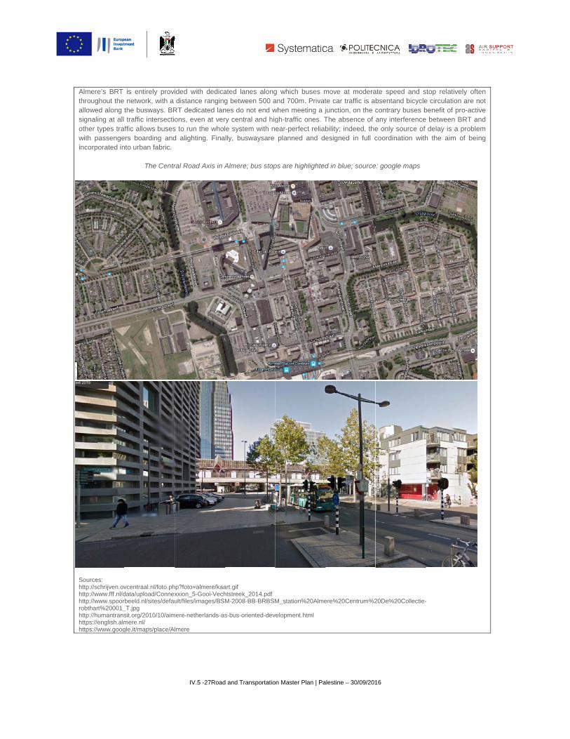
Sources: http://schrijven.ovhttp://www.fff.nl/dhttp://www.spoorrobthart%20001_http://humantranshttps://english.almhttps://www.goog
is entirely provinetwork, with a
the busways. BRtraffic intersectio
ffic allows busesers boarding andnto urban fabric.
The Centr
vcentraal.nl/foto.phdata/upload/Connexbeeld.nl/sites/defau
_T.jpg sit.org/2010/10/aimmere.nl/ gle.it/maps/place/A
IV.5 -27Road
ided with dedicadistance ranging
RT dedicated lanons, even at vers to run the whold alighting. Fina
ral Road Axis in A
hp?foto=almere/kaaxxion_5-Gooi-Vechult/files/images/BS
mere-netherlands-as
lmere
d and Transportatio
ated lanes alongg between 500 anes do not end wry central and higle system with nlly, buswaysare
Almere; bus stop
art.gif htstreek_2014.pdfM-2008-BB-BRBSM
s-bus-oriented-dev
on Master Plan | Pa
g which buses mand 700m. Privatwhen meeting a jgh-traffic ones. Tear-perfect reliaplanned and d
ps are highlighted
M_station%20Alme
velopment.html
alestine – 30/09/201
move at moderate car traffic is ajunction, on the cThe absence of bility; indeed, theesigned in full c
d in blue; source
ere%20Centrum%2
16
ate speed and sbsentand bicyclecontrary buses bany interferencee only source of coordination with
e: google maps
20De%20Collectie-
stop relatively ofe circulation arebenefit of pro-acte between BRT a
delay is a problh the aim of be
-
ften not tive and em
eing