satellite monitoring mou in the framework of the cept jean-philippe kermoal 13th international space...
TRANSCRIPT

Satellite Monitoring MoU in the framework of the CEPT Jean-Philippe Kermoal
13th International Space Radio Monitoring Meeting
Paris, 25th October 2011

Outline
• General on the MoU• MoU Objectives• Leeheim Station• Leeheim Station’s Tasks• MoU use from a CEPT perspective

General
• Satellite monitoring is expensive• Administrations have to slim down• A number of countries need to monitor satellites• The ECC or its working groups need satellite monitoring

The MoU
• Germany• France• United Kingdom• Switzerland• The Netherlands• Spain• Luxembourg

Frédéric Couturier
Chairman
Silvio Rubli
Vice-chairman
SAT MoU CONTACT
Main objectives of the MoU
• Satellite Monitoring The SAT MoU provides the possibility for any Administration of the CEPT to access and undertake satellite monitoring activities under the conditions of the MoU.
• Cooperation To create a common understanding and provide a cooperation among the signatories for getting measurement results (Leeheim Station) for their own purpose.
• Procedure Establish a procedure based on a non-profit making funding and a common management of satellite monitoring activities within the CEPT.

The management committee
• Prioritises measurements• Set station fee and hourly rates• Set administrative fee• Evaluate reports and proposals

Costs
• Annual Contribution– Administrative Fee - Amount of money for the
administration of the MoU by ECO
– European Monitoring Fund (EMF) - Amount of money at disposal for measurements in support of CEPT.
– Station Fee - Amount of money to partly cover the costs for the provision and maintenance of the Station
• Measurements – Hourly rates– Personnel– Equipments
European Monitoring Fund
• Finance mechanism– Signatories of the SAT MoU– Based on contributory units and in weighted voting
• Measurements request– Signatories can place orders in written form to ECO – CEPT Working Groups can propose orders to the ECO,
which have to be approved by the SAT MoU.– ECO forward the orders to Leeheim station
Customers of Leeheim
Units or individuals responsible for:
frequency management
spectrum engineering
etc…
who are under German jurisdiction, or, authorities who are members of the CEPT SatMoU (EMF), or, satellite operators on a comparable contractual basis.
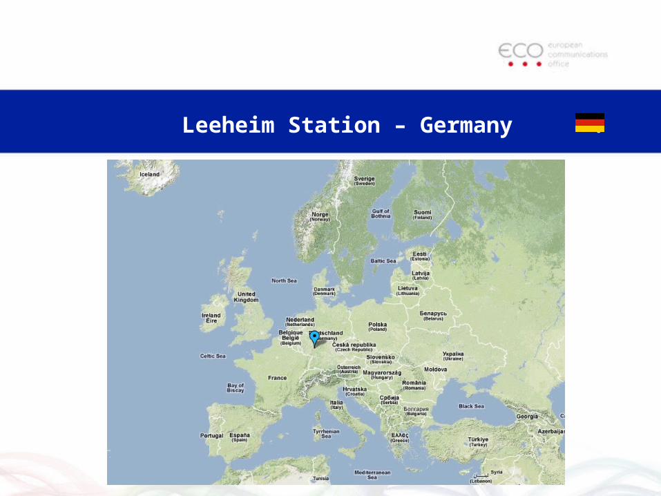
Leeheim Station – Germany .

Frequency range: 130 MHz 26.5 GHz (no gap)
1 - 26,5 GHz
3,2 - 4,2(17,7 – 22)
GHz
130 MHz - 1 GHz
1,5 -2,3 GHz4,3 - 8,5 GHz
10,7-12,75 GHz
Antenna 4 Antenna 3 Antenna 1Antenna 2

System Characteristics - Antenna 1
L / S-Band 1,5 -2,3 GHzX-Band 4,3 - 8,5 GHz
Ku-Band 10,7-12,75 GHz
Beam WaveguideCassegrain type
12mØ
44 - 61 dBi
17 - 34 dBK-1
monopulseautotracking
±1,5 dB; 10-12
full motion
computer tracking

Antenna 3
130 MHz – 1 GHz
dipole array
2,4 * 2,4 m²
10-18 dBi
computer controlled
±2dB; 10-12
full motion
Antenna 4
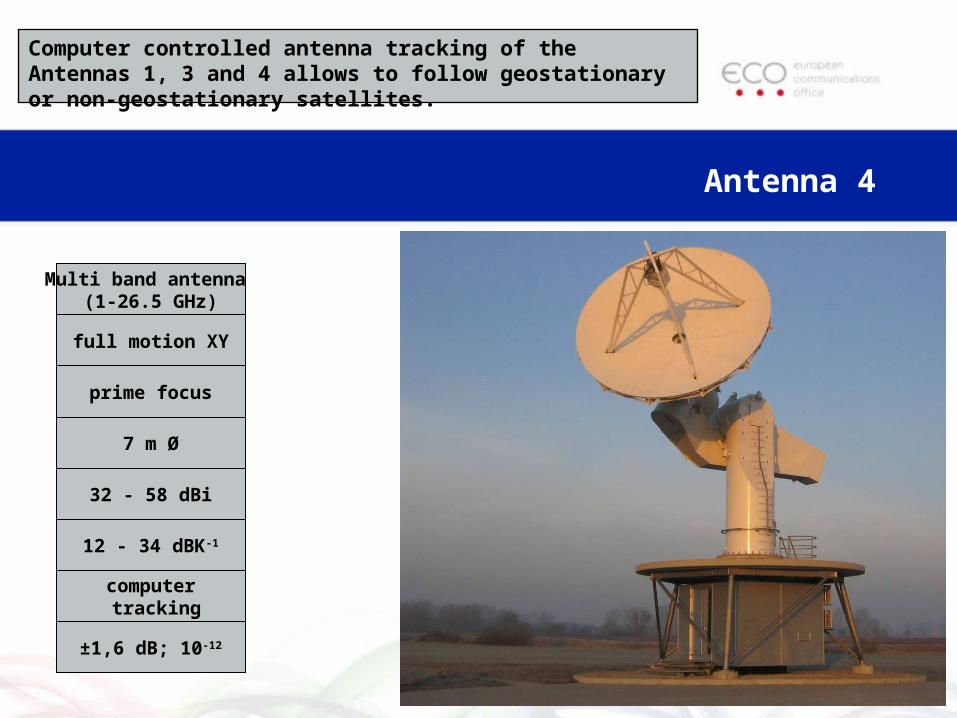
Computer controlled antenna tracking of the Antennas 1, 3 and 4 allows to follow geostationary or non-geostationary satellites.
Multi band antenna (1-26.5 GHz)
prime focus
7 m Ø
32 - 58 dBi
12 - 34 dBK-1
computer tracking
±1,6 dB; 10-12
full motion XY

Antenna 2
C-Band 3,2 - 4,2 GHz(Ka-Band 17,7 – 22 GHz,
Start 2011)
Cassegrain type
8,5 m Ø
49 dBi
28 dBK-1
computer controlled
full motion

Omnidirectional Antennas
100 – 1300 MHz
700 - 2500MHz
Observe simultaneously all emissions from the sky in a certain frequency band, e.g. of a multi-satellite system (100 - 2500 MHz)

Transmitter Location System (TLS)
• Designed to identify the location of radio transmitters on Earth.
• Triangulation using the wanted transmitter and two satellites (time and frequency measurements).
interfering transmitter
location unknown
interferedsatellite
neighbouringsatellite
MonitoringEarth Station
Leeheim
Mobile Reference Transmitter
under procurement
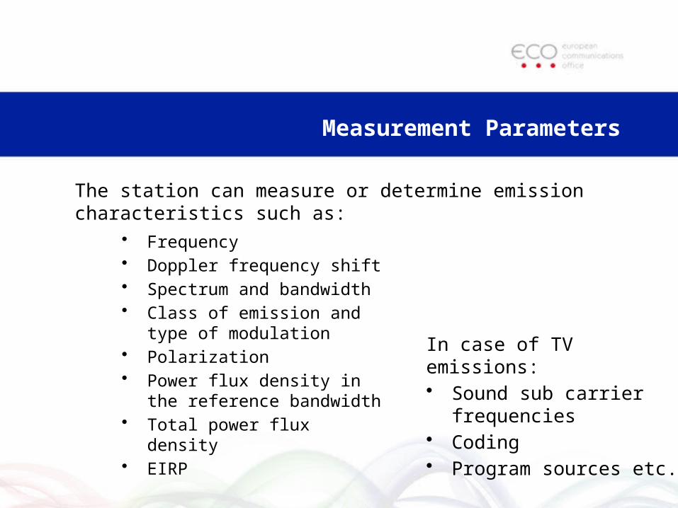
• Frequency• Doppler frequency shift• Spectrum and bandwidth• Class of emission and type of
modulation• Polarization• Power flux density in the
reference bandwidth• Total power flux density• EIRP
In case of TV emissions:• Sound sub carrier
frequencies• Coding• Program sources etc.
Measurement Parameters
The station can measure or determine emission characteristics such as:
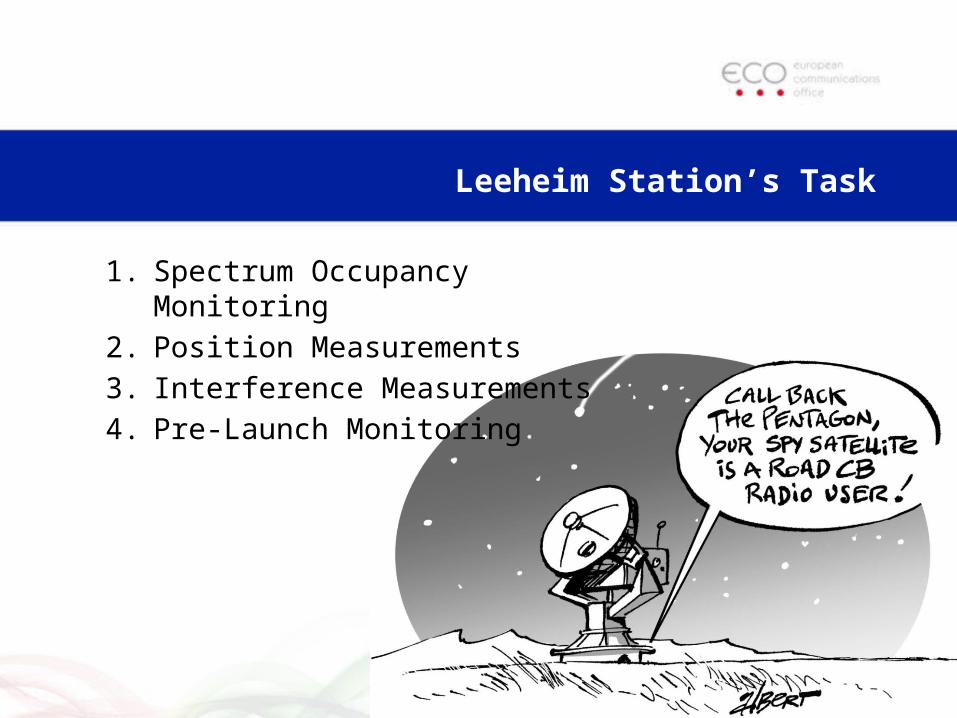
Leeheim Station’s Task
1. Spectrum Occupancy Monitoring
2. Position Measurements
3. Interference Measurements
4. Pre-Launch Monitoring

1 - Spectrum Occupancy Monitoring
• Observe the radio frequency spectrum– Identify “paper” satellites, – unknown satellites, – and for co-ordination with other authorities
• Results stored in a database and complemented with spectrum prints for each monitored emission.
• These measurements are applicable for the geostationary and the non-geostationary orbit.

2 - Position Measurements
• Where the inclination or ellipticity of a satellite orbit may cause interference to a neighbouring satellite
• The trace of the occupied position has to be measured. • This is done with monopulse-tracking over a 24 hour
period. • The trace of the occupied position is given in
geographical coordinates or in a celestial grid

3 - Interference Measurements
Interference from Earth: • It appears in the downlink of a
satellite,• transmitter location
measurements are required.
Interference from space: • Either from a known satellite (non-compliant signals) • or an unknown satellite is the source (triangulation needed).

4 - Pre-Launch Monitoring
• During the pre-phase of the launch of a satellite
• Frequencies used for telemetry, telecommand and tracking are monitored with respect to the planned orbit.
• The measurement results facilitate a safer launch and a safer positioning of the satellite.

An example of the use of Leeheim Station: Monitoring Glonass Emissions at 1.6 GHz
• CEPT requested the monitoring of GLONASS at 1.6 GHz satellites in order to assess the pfd levels radiated in the radioastronomy band by the new and old generation of GLONASS satellites, in the framework of WRC-07 AI 1.21.
• Leeheim produced a report
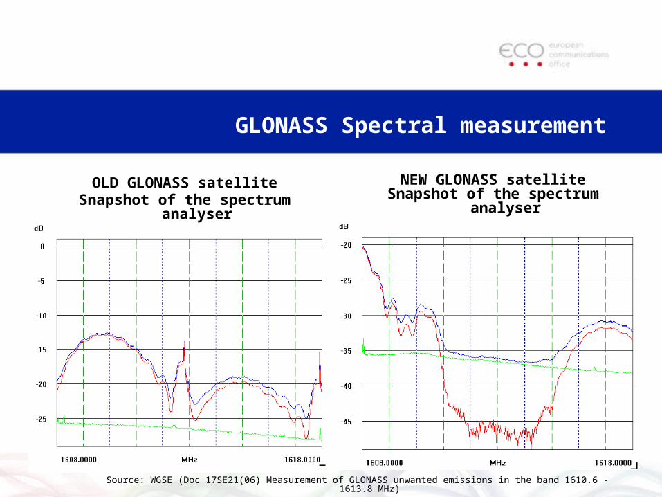
GLONASS Spectral measurement
Source: WGSE (Doc 17SE21(06) Measurement of GLONASS unwanted emissions in the band 1610.6 -1613.8 MHz)
OLD GLONASS satelliteSnapshot of the spectrum analyser
NEW GLONASS satelliteSnapshot of the spectrum analyser

Glonass measurement results
• Modulation improved between the old and new GLONASS satellites (the null spikes have disappeared)
• Filter was implemented in the band 1610-1613 MHz in order to reduce the level of unwanted emissions by up to 19 dB in the RAS band.

Its use by the CEPT
• The output of the measurement useful for the CPM Report of WRC07
• Chapter 2 on Agenda item 1.21 section 2/1.21/1.3.8 Studies of the RNSS (space-to-Earth)/RAS band pair 1 559-1 610 MHz/1 610.6-1 613.8 MHz
• Elaboration of ECC Report 171 (impact of unwanted emissions of Iridium satellites on radioastronomy operations in the band 1610.6-1613.8 MHz) (October 2011) by WGSE/SE40

Links
• Sat MoU website (http://cept.org/eco/groups/eco/sat-mou)
• Leeheim station• Station handbook• MoU text

Jean-Philippe Kermoal
Spectrum Engineer
Susanne Have
Secretary Administrative
CONTACT ECO
ECO
Nansensgade 19-3
1366 Copenhagen
Denmark
Tel: +45 33 89 63 00
Fax: +45 33 89 63 30