scioto-franklin neighborhood plan · 1950s and 1960s.nd 119 ... they can also use the bike-ways and...
TRANSCRIPT
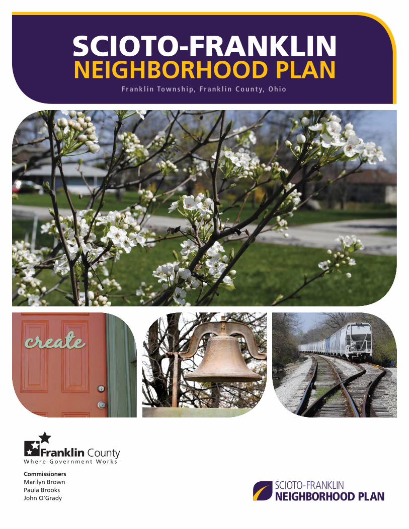
SCIOTO-FRANKLINNEIGHBORHOOD PLAN
SCIOTO-FRANKLINNEIGHBORHOOD PLAN
CommissionersMarilyn BrownPaula BrooksJohn O’Grady
F r a n k l i n To w n s h i p, F ra n k l i n C o u n t y, O h i o

8/9/11 17:04
Produced by:
James Schimmer, DirectorR. Lee Brown, Planning Administrator
150 South Front StreetFSL Suite 10Columbus, Ohio 43215
Tel. 614-525-3094Fax 614-525-7155www.franklincountyohio.gov/edp
Scioto-Franklin Neighborhood PlanProject manager Benjamin Weiner
Project teamDevin KeithleyPatrick HewittChelsea Weber
Disclaimer: We produced the maps, fi gures, tables and other information in this document only for Franklin County business purposes. While we made every effort to include complete information, the maps, fi gures, tables and other information are not guaranteed to be accurate. The content of this plan is for reference purposes only and shouldn’t be used for any survey, engineering or commercial purpose.

Franklin Township Board of TrusteesTimothy Guyton, ChairmanPaul JohnsonDonald CookLisa Morris, Fiscal Offi cer
CommissionersMarilyn BrownPaula BrooksJohn O’Grady
Franklin Township, Franklin County, OhioScioto-Franklin Neighborhood Plan
Adopted August 9, 2011

REGIONAL MAP
The planning area is shown in purple
4 SCIOTO-FRANKLIN NEIGHBORHOOD PLAN
UNIONCOUNTY
FRANKLINCOUNTY
FAIRFIELDCOUNTY
MADISONCOUNTY
DELAWARECOUNTY
PICKAWAYCOUNTY
DUBLIN
HILLIARD
GAHANNA
OBETZ
NEWALBANY
REYNOLDSBURG
LITHOPOLIS
POWELL
UPPERARLINGTON
WHITEHALL
WORTHINGTON
CANALWINCHESTER
BEXLEY
GROVEPORT
WESTERVILLE
GROVECITY
GRANDVIEWHEIGHTS
COLUMBUS
DUBLIN
HILLIARD
GAHANNA
OBETZ
NEWALBANY
REYNOLDSBURG
LITHOPOLIS
POWELL
UPPERARLINGTON
WHITEHALL
WORTHINGTON
CANALWINCHESTER
BEXLEY
GROVEPORT
WESTERVILLE
GROVECITY
GRANDVIEWHEIGHTS
COLUMBUSPlanning AreaPlanning Area
UNIONNIONIOCOUNTYYUNUN
Detail

What is a plan?
A land use plan represents a community’s desires for the future: how land is used, what new buildings look like and how people travel around and through the community.
Steps in creating a plan
A plan begins by assessing a community’s existing state—the current conditions of land use, building appearance, shopping areas and the transportation network. The second step is deciding on a vision—a view of the community at a point 10 to 20 years in the future.
The community then gives input on that vision. We then take that feedback and incorporate it into the plan.
The third step is outlining policies to achieve the agreed-upon vision. We then incorporate feedback, ensuring the plan’s recommendations refl ect the community’s desires for the future.
The recommendations
This plan contains two types of recommenda-tions: maps and development guidelines.
Maps: These indicate where new develop-ment should go, what types of new bikeways are needed and what the priorities are for new sidewalks.
Development Guidelines: These describe the desired characteristics of new development,
such as maintaining neighborhood character and promoting a pedestrian-friendly environment.
By following the recommendations outlined in the maps and development guidelines, the com-munity will be able to reach its desired future.
Step 3:Outline policiesfor achieving
the vision
Step 1:Analyze current
conditions
Step 2:Create a
vision for the future
Today Future
ABOUT THIS PLAN
INSIDECurrent Conditions ......................7
Recommendations .......................9Future Land Use ..................... 11Development Guidelines ........ 13Bikeways ................................ 15Sidewalk Priorities .................. 16
New Development Checklist .....17
5

PLANNING AREA MAP
Dry Run
Scioto River
Scioto River
Dry Run
N H
AG
UE A
VE
N H
AG
UE A
VE
VALLEYVIEW DR
NO
RTH
WES
T B
LVD
NO
RTH
STA
R A
VE
FISHER RD
FISHER RD
TRABUE RD
McKINLEY AVE
McKINLEY AVE
DU
BLIN RD
W BROAD ST
W BROAD ST
W 5TH AVE
KING AVE
N W
ILSON
RD
N W
ILSO
N R
D
PHILLIPI R
D
GR
AN
DV
IEW
AV
E
N H
AG
UE A
VE
N H
AG
UE A
VE
VALLEYVIEW DR
NO
RTH
WES
T B
LVD
NO
RTH
STA
R A
VE
FISHER RD
FISHER RD
TRABUE RD
McKINLEY AVE
McKINLEY AVE
DU
BLIN RD
W BROAD ST
W BROAD ST
W 5TH AVE
KING AVE
N W
ILSON
RD
N W
ILSO
N R
D
PHILLIPI R
D
GR
AN
DV
IEW
AV
E
6
Unincorporated areas where the plan’s recommendations apply
SCIOTO-FRANKLIN NEIGHBORHOOD PLAN

7
CURRENT CONDITIONS
One of the fi rst steps in creating a plan is fi nding out what a community is like today, also called the current conditions.
We gathered information by interviewing stake-holders and making visual assessments. Current conditions for the planning area, as shown in the map on the opposite page, are discussed below.
Generalized Current Conditions
The following characteristics are general obser-vations of the planning area as a whole.
Land Use: The majority of the planning area is residential. Industrial uses are concentrated south of Fisher Road. Mixed-use commercial corridors exist on Trabue Road, Valleyview Drive and Wilson Road.
Bikeways: There are no bicycle facilities within the planning area.
Sidewalks: Few sidewalks exist within the planning area, though most adjoining Columbus neighborhoods have sidewalks. Most main roads lack sidewalks.
Transit: Two Central Ohio Transit Authority bus lines serve the planning area. The No. 5 bus serves Trabue Road and the No. 68 bus serves Hague Avenue and Trabue Road.
Current Conditions by Neighborhood
We divided the planning area into six neigh-borhoods to better analyze specifi c conditions and characteristics, such as the presence of sidewalks or particular land uses. These neigh-borhoods are: San Margherita, Mon-E-Bak, Western Estates, Fisher Road, Westland North, and Valleyview East.
Current conditions for these individual neigh-borhoods are shown on the map on the follow-ing page.
CURRENT CONDITIONS

Dry Run
Scioto River
N H
AG
UE A
VE
VALLEYVIEW DR
FISHER RD
TRABUE RD
DU
BLIN RD
W BROAD ST
W 5TH AVE
N W
ILSON
RD
PHILLIPI R
D
N H
AG
UE A
VE
VALLEYVIEW DR
FISHER RD
TRABUE RD
DU
BLIN RD
W BROAD ST
W 5TH AVE
N W
ILSON
RD
PHILLIPI R
D
CURRENT CONDITIONS MAP
VALLEYVIEW EASTAEAAWLEYY STVAA E EVYALOlder neighborhood with er ne heig de borhlde ohgghb h wite he hwO hb ooodhog d wb weesingle-family homes and andesmmi sa s an an nh nlefew small businesses.ll b sl bbmaw swfeww sb e ess
FISHER ROADDOOADOOORORSingle-family homes alonghomes a gmilFisher Road with a mix of th a mixFishFississ industrial, commercial andercial ustuusustusustustdusustu dndoresidential uses along Hagueg d ntiaaantia aare seAvenue.Av e.
WESTLAND NORTHTWESSTIndustrial area with somemea with ssomexisting sidewalks alonggw go gnggFisher and Phillipi Roads.h i R ss asher andFi
MON-E-BAKKKKKON-E-Single-family homes onha oamilyquarter-acre lots, builtlocre louarter-acre lotarter-ar re lotcre loarter-acre atarter locre lorearter-acre lotatarter-aar- reuarua ttfrom the 1930s to 1960s.o 1o 1960ss9969196oo 960996oo 9609 0996sfrom 0
Scioto River
ioto Riv
SAN MARGHERITAHERITATAMARGGGSS SciSciSciSciOlder community founded byfound d bOlder Older by
ioto Rioto Rto RiR
Italian immigrants, with a mixh a mlian l an l an xmmigimmig xxx,ItRiverRiveriverer
of single-family homes anddmily homese-fam ly homeamily homes ae-famlee-family ndly homesf sr
small businesses. Some existingngtii tius Some ex iexisall sidewalks.a kkksalkkawa
WESTERN ESTATESESERNW N ES ESETESingle-family homes onam-faamfahalf-acre lots, built in theh lot1950s and 1960s.nd 119
8 CURRENT CONDITIONS | SCIOTO-FRANKLIN NEIGHBORHOOD PLAN
9
RECOMMENDATIONS
The recommendations on the following pages are used to achieve the community’s vision for the future. They include a series of maps and development guidelines that will shape commu-nity growth over the next 10 to 20 years.
How they were developed: The recommenda-tions in this document are based on an analysis of the current conditions as well as input from a public meeting held on March 22, 2011 at North Franklin Elementary School.
How they are used: When a development proposal is made, boards and commissions use the land use recommendations and development guidelines to ensure that the proposal fi ts the community’s vision. They can also use the bike-ways and sidewalks maps to determine where to invest capital improvement funds.
The recommendations are composed of four parts: a future land use map, development guidelines, a bikeways map, and a sidewalk priorities map.
RECOMMENDATIONS

LAND USE CATEGORY DESCRIPTIONS
Low Density Residential
Allowed land uses: Single-family homes.
Density: Maximum of 2 units per acre.
Medium Density Residential
Allowed land uses: Single-family and two-family homes.
Density: Minimum of 2 units per acre, maxi-mum of 8 units per acre.
High Density Residential
Allowed land uses: Townhomes and multi-unit buildings.
Density: Minimum of 8 units per acre, maxi-mum of 24 units per acre.
Offi ce + Residential
Allowed land uses: Offi ces, single- and multi-unit housing. Uses may mix within the same building.
Density: For buildings without offi ces, minimum residential density of 4 units per acre. For all buildings, maximum residential density of 24 units per acre.
Commercial: Limited range + Residential
Allowed land uses: Limited range of retail uses, mostly neighborhood-scale, offi ces, single- and multi-unit housing. Uses may mix within the same building.
Density: For buildings without offi ces, mini-mum residential density of 4 units per acre. For all buildings, maximum residential density of 24 units per acre.
Commercial: Full range + Multi-unit
Allowed land uses: Full range of retail and offi ce uses, plus multi-unit housing and townhomes.
Density: Maximum residential density of 24 units per acre.
Light Industrial + Offi ce
Allowed land uses: Range of uses including offi ce, industrial, storage and warehousing.
Parks/Open Space
Intended for nature or recreation with minimal buildings.
Stream buffer
Environmentally-sensitive area that includes waterways and the 100-year fl oodplain.
Prohibited land uses: construction, parking lots, and dredging or fi lling.
Allowed land uses: passive recreation and trails.
Use this page in conjunction with the Corresponding Zoning Districts on page 12
10 RECOMMENDATIONS | SCIOTO-FRANKLIN NEIGHBORHOOD PLAN

Dry Run
Scioto River
Dry Run
EL PASO DR
EL PASO DR
EL PASO DR
HARRISON RD
SAFIN
RD
DIBBLEE AVE
DOVER RD
LA VISTA DR
NEWELL DR
KA
DER
LY D
R
SURFACE RD
JANITROL RD
BROOKSIDE BLVD
PLAN
K PL
GLA
DSTO
NE A
VE
MA
CLAM
DR
TWIN CREEKS DR
PLAINVIEW DR
BENDELOW DR
GRIMES DR
BUSINESS PARK DR
INTERCHANGE RD
EDSON DR
WESTWARD AVE
ONGARO DR
CIDERMILL DR
BRITTON AVE
FARM BROOK LN
LOWELL DR
PARKWEST DR
DIS
TRIB
UTI
ON
DR
HIC
KO
RY R
UN
DR
WH
ITE
ASH
DR
HA
DLE
Y D
R
CHIPPEWA ST
CORTONA RD
KEVIN CT
ABBOTS COVE BLVD
CRISFIELD DR
NA
THA
N D
R
NIXO
N D
R
PONDEROSA DR
FOSSIL DR FURLO
NG
RD
SAN REMO
DR
CHEROKEE ST
WA
RR
EN A
VE
LOWELL DR
EL PASO DR
EL PASO DR
EL PASO DR
HARRISON RD
SAFIN
RD
DIBBLEE AVE
DOVER RD
LA VISTA DR
NEWELL DR
KA
DER
LY D
R
SURFACE RD
JANITROL RD
BROOKSIDE BLVD
PLAN
K PL
GLA
DSTO
NE A
VE
MA
CLAM
DR
TWIN CREEKS DR
PLAINVIEW DR
BENDELOW DR
GRIMES DR
BUSINESS PARK DR
INTERCHANGE RD
EDSON DR
WESTWARD AVE
ONGARO DR
CIDERMILL DR
BRITTON AVE
FARM BROOK LN
LOWELL DR
PARKWEST DR
DIS
TRIB
UTI
ON
DR
HIC
KO
RY R
UN
DR
WH
ITE
ASH
DR
HA
DLE
Y D
R
CHIPPEWA ST
CORTONA RD
KEVIN CT
ABBOTS COVE BLVD
CRISFIELD DR
NA
THA
N D
R
NIXO
N D
R
PONDEROSA DR
FOSSIL DR FURLO
NG
RD
SAN REMO
DR
CHEROKEE ST
WA
RR
EN A
VE
LOWELL DR
N H
AG
UE A
VE
N H
AG
UE A
VE
VALLEYVIEW DR
FISHER RD
FISHER RD
TRABUE RD
McKINLEY AVE
W BROAD ST
N W
ILSON
RD
N W
ILSON
RD
N W
ILSO
N R
D
PHILLIPI R
D
N H
AG
UE A
VE
N H
AG
UE A
VE
VALLEYVIEW DR
FISHER RD
FISHER RD
TRABUE RD
McKINLEY AVE
W BROAD ST
N W
ILSON
RD
N W
ILSON
RD
N W
ILSO
N R
D
PHILLIPI R
D
Low Density Residential
Medium Density Residential
High Density Residential
Office + Residential
Commercial: Limited range + Residential
Commercial: Full range + Multi-unit
Light Industrial + Office
Parks/Open Space
Stream buffer
Future land use
FUTURE LAND USE MAP Use this map in conjunction with the Land Use Category
Descriptions on page 10
Future Land Use map
What it is: This map shows where the community wants to see specifi c land uses in the future.
Why we need it: The future land use map is used when a property owner proposes a new development or redevelop-ment. If the proposal requires a rezoning, offi cials reviewing the proposal can see whether it matches the community’s vision for their future.
11RECOMMENDATIONS
verrrererere
MMMMM
EUR
EKA
AV
E
HARPER RD
ELDO
N A
VE
PRO
SPECT ST
MU
RR
AY
AV
E
EUR
EKA
AV
E
HARPER RD
ELDO
N A
VE
PRO
SPECT ST
MU
RR
AY
AV
E
VALLEYVIEW EAST
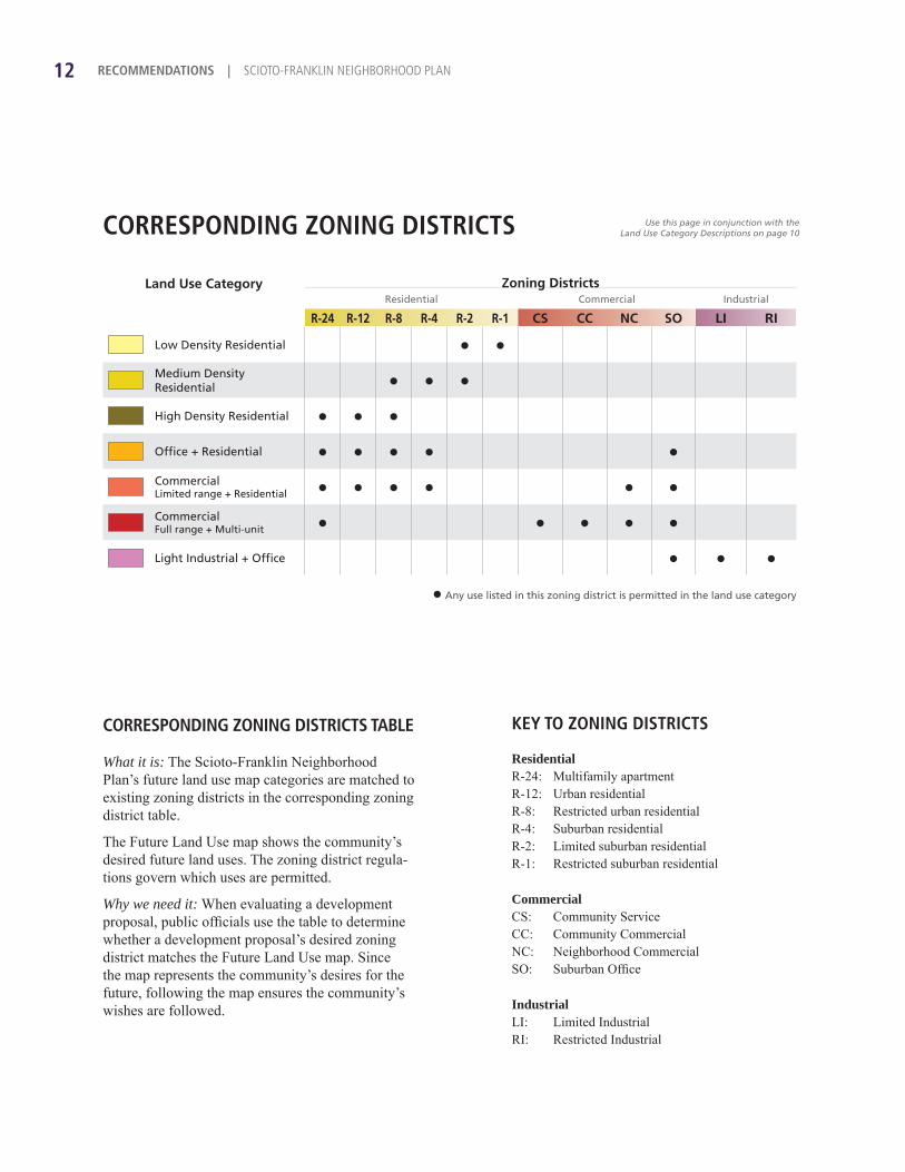
KEY TO ZONING DISTRICTS
ResidentialR-24: Multifamily apartmentR-12: Urban residentialR-8: Restricted urban residentialR-4: Suburban residentialR-2: Limited suburban residentialR-1: Restricted suburban residential
CommercialCS: Community ServiceCC: Community CommercialNC: Neighborhood CommercialSO: Suburban Offi ce
IndustrialLI: Limited IndustrialRI: Restricted Industrial
CORRESPONDING ZONING DISTRICTS
CORRESPONDING ZONING DISTRICTS TABLE
What it is: The Scioto-Franklin Neighborhood Plan’s future land use map categories are matched to existing zoning districts in the corresponding zoning district table.
The Future Land Use map shows the community’s desired future land uses. The zoning district regula-tions govern which uses are permitted.
Why we need it: When evaluating a development proposal, public offi cials use the table to determine whether a development proposal’s desired zoning district matches the Future Land Use map. Since the map represents the community’s desires for the future, following the map ensures the community’s wishes are followed.
Land Use Category Zoning DistrictsResidential Commercial Industrial
R-24 R-12 R-8 R-4 R-2 R-1 CS CC NC SO LI RI
Low Density Residential ● ●
Medium Density Residential ● ● ●
High Density Residential ● ● ●
Offi ce + Residential ● ● ● ● ●
CommercialLimited range + Residential ● ● ● ● ● ●
CommercialFull range + Multi-unit ● ● ● ● ●
Light Industrial + Offi ce ● ● ●
● Any use listed in this zoning district is permitted in the land use category
Use this page in conjunction with theLand Use Category Descriptions on page 10
12 RECOMMENDATIONS | SCIOTO-FRANKLIN NEIGHBORHOOD PLAN

What they are: These development guidelines represent the community’s desired future—how new development should look, how it accom-modates each mode of transportation and how it fi ts within the neighborhood’s character.
Why we need them: Franklin County boards, commissions and staff will evaluate develop-ment proposals based on their compliance with the development guidelines below and the Future Land Use map on page 11.
13RECOMMENDATIONS
GREAT NEIGHBORHOODS
Maintain and encourage an appropriate mix of residential and commercial uses in mixed-use commercial areas, designated on the future land use map on page 11
Maintain neighborhood character with appropriate building design and compatible land uses Protect residential neighborhoods from confl icting uses by following the future land use map
SMART BUILDING DESIGN
Orient commercial buildings toward the street Maintain compatible building heights and architectural styles in commercial areas Reduce front yard setbacks in commercial areas to create a more walkable environment
SAFE TRAVEL
Provide pedestrian and bicycle access to new commercial development by including sidewalks and bicycle parking
In mixed-use commercial areas use shared parking to reduce development costs and avoid environmental damage while providing adequate parking
Place off-street parking lots to the side or rear of buildings to provide safe and easy access for both pedestrians and automobiles
CLEAN ENVIRONMENT
Develop away from fl oodplains and waterways to protect property owners, prevent pollution and preserve natural resources
Use stormwater best management practices and green infrastructure, including on-site storm-water infi ltration, to limit the pollution entering our waterways
DEVELOPMENT GUIDELINES

TYPES OF PROPOSED BIKEWAYS
Shared Use Path
A path for bicycles and pedestrians, separate from a road. Generally 10 to 14 feet wide.
Bicycle lane
On-street, striped lane for bicycles, 4 to 6 feet wide, usually next to the outermost travel lanes.
Signed shared roadway
Paved shoulder
Standard road with a combination of traffi c calming, signage and “sharrows” (shown at right), or a high-volume road with 14-foot or wider outside lanes.
A paved area beyond outside travel lanes, 4 feet wide. Common on narrow rural roads.
14 RECOMMENDATIONS | SCIOTO-FRANKLIN NEIGHBORHOOD PLAN

BIKEWAYS MAP
Bikeways(dashed lines are proposed)
Shared use path
Signed shared roadway
Paved shoulder
Bicycle lane
Bikeways map
What it is: The bikeways map shows locations of existing and proposed bikeways. The proposals support a bikeway network for transportation and recreation.
Why we need it: Since bikeways allow people to cover wide distances, communities plan for bikeways on a regional basis. This ensures we connect destinations for people in Franklin Township and throughout central Ohio.In addition to Scioto-Franklin bikeways recommendations, the map contains information from these sources: Columbus Bicentennial Bikeways Plan and MORPC Regional Bikeways Plan.
Dry Run
Scioto River
Dry Run
EL PASO DR
EL PASO DR
EL PASO DR
HARRISON RD
SAFIN
RD
DIBBLEE AVE
DOVER RD
LA VISTA DR
NEWELL DR
KA
DER
LY D
R
SURFACE RD
JANITROL RD
BROOKSIDE BLVD
PLAN
K PL
GLA
DSTO
NE A
VE
MA
CLAM
DR
TWIN CREEKS DR
PLAINVIEW DR
BENDELOW DR
GRIMES DR
BUSINESS PARK DR
INTERCHANGE RD
EDSON DR
WESTWARD AVE
ONGARO DR
CIDERMILL DR
BRITTON AVE
FARM BROOK LN
LOWELL DR
PARKWEST DR
DIS
TRIB
UTI
ON
DR
HIC
KO
RY R
UN
DR
WH
ITE
ASH
DR
HA
DLE
Y D
R
CHIPPEWA ST
CORTONA RD
KEVIN CT
ABBOTS COVE BLVD
CRISFIELD DR
NA
THA
N D
R
NIXO
N D
R
PONDEROSA DR
FOSSIL DR FURLO
NG
RD
SAN REMO
DR
CHEROKEE ST
WA
RR
EN A
VE
LOWELL DR
EL PASO DR
EL PASO DR
EL PASO DR
HARRISON RD
SAFIN
RD
DIBBLEE AVE
DOVER RD
LA VISTA DR
NEWELL DR
KA
DER
LY D
R
SURFACE RD
JANITROL RD
BROOKSIDE BLVD
PLAN
K PL
GLA
DSTO
NE A
VE
MA
CLAM
DR
TWIN CREEKS DR
PLAINVIEW DR
BENDELOW DR
GRIMES DR
BUSINESS PARK DR
INTERCHANGE RD
EDSON DR
WESTWARD AVE
ONGARO DR
CIDERMILL DR
BRITTON AVE
FARM BROOK LN
LOWELL DR
PARKWEST DR
DIS
TRIB
UTI
ON
DR
HIC
KO
RY R
UN
DR
WH
ITE
ASH
DR
HA
DLE
Y D
R
CHIPPEWA ST
CORTONA RD
KEVIN CT
ABBOTS COVE BLVD
CRISFIELD DR
NA
THA
N D
R
NIXO
N D
R
PONDEROSA DR
FOSSIL DR FURLO
NG
RD
SAN REMO
DR
CHEROKEE ST
WA
RR
EN A
VE
LOWELL DR
N H
AG
UE A
VE
N H
AG
UE A
VE
VALLEYVIEW DR
FISHER RD
FISHER RD
TRABUE RD
McKINLEY AVE
W BROAD ST
N W
ILSON
RD
N W
ILSON
RD
N W
ILSO
N R
D
PHILLIPI R
D
N H
AG
UE A
VE
N H
AG
UE A
VE
VALLEYVIEW DR
FISHER RD
FISHER RD
TRABUE RD
McKINLEY AVE
W BROAD ST
N W
ILSON
RD
N W
ILSON
RD
N W
ILSO
N R
D
PHILLIPI R
D
15RECOMMENDATIONS
vererrrererrerer
MMMM
EUR
EKA
AV
E
HARPER RD
ELDO
N A
VE
PRO
SPECT ST
MU
RR
AY
AV
E
EUR
EKA
AV
E
HARPER RD
ELDO
N A
VE
PRO
SPECT ST
MU
RR
AY
AV
E
VALLEYVIEW EAST

Sidewalk priorities map
What it is: This map shows areas where the community would like new sidewalks.
Why we need it: Installing sidewalks costs money. Realizing that funds are limited, this map prioritize sidewalks. Primary priorities are sidewalks that should be installed fi rst. Second-ary priorities are sidewalks that should be installed after all the primary priorities are installed. All new commercial development should install sidewalks as well.
The primary and secondary priorities refl ect the community’s stated desires for new sidewalks.
Sidewalkinstallationpriorities
Secondary priority
Primary priority
SIDEWALK PRIORITIES MAP
Dry Run
Scioto River
Dry Run
EL PASO DR
EL PASO DR
EL PASO DR
HARRISON RD
SAFIN
RD
DIBBLEE AVE
DOVER RD
LA VISTA DR
NEWELL DR
KA
DER
LY D
R
SURFACE RD
JANITROL RD
BROOKSIDE BLVD
PLAN
K PL
GLA
DSTO
NE A
VE
MA
CLAM
DR
TWIN CREEKS DR
PLAINVIEW DR
BENDELOW DR
GRIMES DR
BUSINESS PARK DR
INTERCHANGE RD
EDSON DR
WESTWARD AVE
ONGARO DR
CIDERMILL DR
BRITTON AVE
FARM BROOK LN
LOWELL DR
PARKWEST DR
DIS
TRIB
UTI
ON
DR
HIC
KO
RY R
UN
DR
WH
ITE
ASH
DR
HA
DLE
Y D
R
CHIPPEWA ST
CORTONA RD
KEVIN CT
ABBOTS COVE BLVD
CRISFIELD DR
NA
THA
N D
R
NIXO
N D
R
PONDEROSA DR
FOSSIL DR FURLO
NG
RD
SAN REMO
DR
CHEROKEE ST
WA
RR
EN A
VE
LOWELL DR
EL PASO DR
EL PASO DR
EL PASO DR
HARRISON RD
SAFIN
RD
DIBBLEE AVE
DOVER RD
LA VISTA DR
NEWELL DR
KA
DER
LY D
R
SURFACE RD
JANITROL RD
BROOKSIDE BLVD
PLAN
K PL
GLA
DSTO
NE A
VE
MA
CLAM
DR
TWIN CREEKS DR
PLAINVIEW DR
BENDELOW DR
GRIMES DR
BUSINESS PARK DR
INTERCHANGE RD
EDSON DR
WESTWARD AVE
ONGARO DR
CIDERMILL DR
BRITTON AVE
FARM BROOK LN
LOWELL DR
PARKWEST DR
DIS
TRIB
UTI
ON
DR
HIC
KO
RY R
UN
DR
WH
ITE
ASH
DR
HA
DLE
Y D
R
CHIPPEWA ST
CORTONA RD
KEVIN CT
ABBOTS COVE BLVD
CRISFIELD DR
NA
THA
N D
R
NIXO
N D
R
PONDEROSA DR
FOSSIL DR FURLO
NG
RD
SAN REMO
DR
CHEROKEE ST
WA
RR
EN A
VE
LOWELL DR
N H
AG
UE A
VE
N H
AG
UE A
VE
VALLEYVIEW DR
FISHER RD
FISHER RD
TRABUE RD
McKINLEY AVE
W BROAD ST
N W
ILSON
RD
N W
ILSON
RD
N W
ILSO
N R
D
PHILLIPI R
D
N H
AG
UE A
VE
N H
AG
UE A
VE
VALLEYVIEW DR
FISHER RD
FISHER RD
TRABUE RD
McKINLEY AVE
W BROAD ST
N W
ILSON
RD
N W
ILSON
RD
N W
ILSO
N R
D
PHILLIPI R
D
16 RECOMMENDATIONS | SCIOTO-FRANKLIN NEIGHBORHOOD PLAN
vererrererere
MMMM
EUR
EKA
AV
E
HARPER RD
ELDO
N A
VE
PRO
SPECT ST
MU
RR
AY
AV
E
EUR
EKA
AV
E
HARPER RD
ELDO
N A
VE
PRO
SPECT ST
MU
RR
AY
AV
E
VALLEYVIEW EAST

ALL NEW DEVELOPMENT:
Yes No n/a Notes
Matches Future Land Use map
Is consistent with neighborhood character
Avoids environmentally sensitive areas such as fl oodplains and waterways
Uses stormwater best management practices including on-site stormwater infi ltration
Provides suffi cient right-of-way for bikeways where indicated on the Bikeways map
Includes sidewalks where indicated on the Sidewalk Priorities map
PURPOSEThis checklist helps developers and property owners comply with the plan. A completed checklist also informs appointed board members and planning staff whether a proposal complies with the Scioto-Franklin Neighborhood Plan.
DIRECTIONS 1. Fill out the fi rst section for all new developments
2. Fill out the commercial development section if applicable
3. Fill out the Project Information box and return this checklist to us with your development application
NEW DEVELOPMENT CHECKLISTSCIOTO-FRANKLIN NEIGHBORHOOD PLAN
Continued on next page
17

NEW COMMERCIAL DEVELOPMENT:
Yes No n/a Notes
Orients buildings toward the street
Is compatible in building height and architectural style with the surrounding structures
Is minimally set back from the street
Provides access to pedestrians
Includes bicycle parking
Shares parking with nearby businesses
Places off-street parking to the side or rear of the principal structure
PROJECT INFORMATION
Case No.
Project name
Address
Phone Fax
Email address
Checklist completed by:Signature
18 NEW DEVELOPMENT CHECKLIST | SCIOTO-FRANKLIN NEIGHBORHOOD PLAN

ACKNOWLEDGEMENTS
The project team thanks the following individuals and groups for input, technical advice and assistance overall with the Scioto-Franklin Neighborhood Plan:
Marc Cerana, Columbus Planning DivisionMonte Chase, Heartland BankDonald Cook, Franklin TownshipJeff Ferrelli, Minelli’s PizzaTimothy Guyton, Franklin TownshipPaul Johnson, Franklin TownshipElaine Lawless, North Franklin Elementary SchoolMichael McCann, Central Ohio Transit Authority
Tristan Osborn, Central Ohio Transit AuthorityChristine Palmer, Columbus Planning DivisionVince Papsidero, Columbus Planning DivisionSteven Renner, Franklin County Sanitary Engineer’s Offi ceJim Stevens, Franklin TownshipJim Timko, Franklin TownshipKevin Wheeler, Columbus Planning Division
19
Produced by:
Economic Development and Planning Department150 South Front StreetFSL Suite 10Columbus, Ohio 43215
Tel. 614-525-3094Fax 614-525-7155www.franklincountyohio.gov/edp