soil moisture remote sensing: state-of-the-science
TRANSCRIPT
Vadose Zone Journal | Advancing Critical Zone Science
Soil Moisture Remote Sensing: State-of-the-ScienceBinayak P. Mohanty,* Michael H. Cosh, Venkat Lakshmi, and Carsten MontzkaThis is an update to the special section “Remote Sensing for Vadose Zone Hydrology—A Synthesis from the Vantage Point” [Vadose Zone Journal 12(3)]. Satellites (e.g., Soil Moisture Active Passive [SMAP] and Soil Moisture and Ocean Salinity [SMOS]) using passive microwave techniques, in par-ticular at L-band frequency, have shown good promise for global mapping of near-surface (0–5-cm) soil moisture at a spatial resolution of 25 to 40 km and temporal resolution of 2 to 3 d. C- and X-band soil moisture records date back to 1978, making available an invaluable data set for long-term climate research. Near-surface soil moisture is further extended to the root zone (top 1 m) using process-based models and data assimilation schemes. Validation of remotely sensed soil moisture products has been ongoing using core monitoring sites, sparse monitoring networks, intensive field campaigns, as well as multi-satellite comparison studies. To transfer empirical observations across space and time scales and to develop improved retrieval algorithms at various resolutions, several efforts are underway to associate soil mois-ture variability dynamics with land surface attributes in various energy- and water-rich environments. We describe the most recent scientific and tech-nological advances in soil moisture remote sensing. We anticipate that remotely sensed soil moisture will find many applications in vadose zone hydrology in the coming decades.
Abbreviations: AMSR, Advanced Microwave Scanning Radiometer; ASCAT, Advanced Scatterometer; CRNP, cosmic ray neutron probe; RTM, radiative transfer model; SMAP, Soil Moisture Active Passive; SMOS, Soil Moisture and Ocean Salinity.
In the past two decades microwave remote sensing has proven successful for estimating dielectric properties of soil based on land surface emissivity leading to soil moisture estimation. Various low frequencies (X, C, and L bands) have typically been used to detect bare or vegetated soil surface moisture content (Calvet et al., 2011). The C and X band sensors (e.g., AMSR-E, ASCAT, RADARSAT, WindSAT) onboard various satellites have shown promise for global surface (skin) wetness measurement. Several satellite-based L-band radiometers and radars including SMOS (launched by the European Space Agency in 2009, 1.4 GHz), AQUARIUS Ocean Salinity (launched by NASA in 2011, 1.413 GHz [passive], 1.26 GHz [active]), and SMAP (launched by NASA in 2015, 1.41 GHz [passive] and 1.26GHz [active]) instruments were placed in orbit in the past several years for global monitoring of near-surface (0–5 cm) soil moisture and ocean salinity. The SMOS and SMAP passive radiometers are currently providing 35- to 60-km-resolution soil moisture data globally on 2- to 3-d intervals, while SMAP active radar (after ?3 mo of operation) and the Aquarius instrument (after 4 yr of operation) have failed and are out of service. Although coarse, SMAP and SMOS radiometer products are providing their first-of-the-kind brightness temperature and soil moisture data for various earth science applications at a global scale.
Prior to their engagement in operational decision making and applications, the soil mois-ture data were undergoing various validation protocols using intercomparison among different satellites as well as ground-based validation to evaluate their biases and uncertain-ties across the globe. Initial studies using available SMOS- and SMAP-derived (collocated) soil moisture data have shown good correspondence between the instruments during the
Core Ideas•Satellites, particularly at L-band
frequency, can globally map near-surface soil moisture.
•Near-surface moisture is extended to the root zone using models and data assimilation.
•Validation uses core monitoring sites, monitoring networks, field campaigns, and multi-satellite comparisons.
•Efforts are underway to associate soil moisture variability dynamics with land surface attributes.
B.P. Mohanty, Dep. of Biological and Agricultural Engineering, Texas A&M Univ., College Station, TX 77843; M.H. Cosh, USDA–ARS, Hydrology and Remote Sensing Lab., Beltsville, MD 20705; V. Lakshmi, Earth and Ocean Science, Univ. of South Carolina, Colum-bia, SC 29208; and C. Montzka, Institute of Bio- and Geosciences: Agrosphere (IBG-3), Forschungszentrum Jülich, 52428 Jülich, Germany. *Correspon-ding author ([email protected]).
Vadose Zone J. doi:10.2136/vzj2016.10.0105Received 25 Oct. 2016.Accepted 20 Dec. 2016.
Update
Vol. 16, Iss. 1, 2017© Soil Science Society of America. This is an open access article distributed under the CC BY-NC-ND license (http://creativecommons.org/licenses/by-nc-nd/4.0/).
Published January 26, 2017

VZJ | Advancing Critical Zone Science p. 2 of 9
past 1.5 yr, although certain differences persist in various extreme hot (dense forest) and cold (arctic) regions because of the differ-ences in instrument design and retrieval algorithms. In addition, the Sentinel-1 (since mid-June 2016) product is being evaluated against SMAP products because of their matching orbits and overpass time, which may provide gap-filling information and allow data fusion at higher resolutions to provide global cover-age. Beyond the current fleet of satellites, several new (active and passive) sensors are in the developmental phase for launch in the coming decades. Higher spatial resolution surface soil moisture on a regional scale can be provided by ALOS-2 PALSAR or Sentinel-1. However, the former has a nominal revisit time of 14 d, which makes it unsuitable for soil moisture time series analysis. It can pro-vide valuable information for analyzing spatial patterns, however. Sentinel-1 is, in general, suitable for soil moisture spatiotemporal analysis; possible methods have already been published, e.g., by Hornacek et al. (2012) and Paloscia et al. (2013), whereas first soil moisture retrievals from Sentinel-1 will be published soon. Future L-band missions such as the dedicated US and Indian NASA–Indian Space Research Organization Synthetic Aperture Radar (NISAR) and the German Tandem-L (Moreira et al., 2015) missions will be able to provide soil moisture retrievals at higher spatial resolution and will open a market for new applications. The Tandem-L mission concept is based on the use of two radar satel-lites operating in L-band. It will be a highly innovative satellite mission for the global observation of dynamic processes on the Earth’s surface, such as the vertical structure of vegetation, ice, and surface deformation. The NISAR mission will be a dual-frequency (L and S band) synthetic aperture radar for understanding natural processes of the Earth including ecosystem disturbances, ice-sheet collapse, and natural hazards such as earthquakes, tsunamis, volca-noes, and landslides. The Advanced Scatterometer (ASCAT)-SG
will be the second-generation scatterometer with various Earth sci-ence applications. Many of these existing and upcoming missions (Table 1) may be creatively adapted for monitoring soil moisture and other attributes at the surface and deeper vadose zone.
6Field Networks Supporting Satellite Soil Moisture ValidationAs remote sensing platforms are becoming more strategic for global monitoring of Earth resources, various ground-based invasive and noninvasive soil moisture measurement techniques and their monitoring networks have been utilized for their vali-dation around the globe. Bogena et al. (2015) provided a review of recent developments of various noninvasive soil moisture measurement techniques and monitoring networks. In particu-lar, cosmic ray neutron probes (CRNPs) with Cosmic-ray Soil Moisture Interaction Code (COSMIC) as well as global naviga-tion satellite system reflectometry have shown good promise to capture soil moisture with a support area of a few hundred to a few thousand square meters. In addition, several soil moisture testbeds encompassing different in situ sensors with different accuracy and precision have been developed (e.g., TERestrial ENvironmental Observatories [TERENO] in Germany, Marena Oklahoma In Situ Sensor Testbed [MOISST] in Oklahoma, and the Texas Soil Observation Network [TxSON]) to evaluate the satellite-based soil moisture products on a time-continuous basis. Furthermore, various sparse soil moisture networks (e.g., NOAA’s US Climate Reference Network and the USDA’s Soil Climate Analysis Network) as well as time-limited field campaigns (e.g., SMAPVEX) including airborne and ground-based sampling have been used for validating the satellite soil moisture products. In addition to the spatial extent of soil moisture networks with a
Table 1. Remote sensing instruments and satellite platforms (past and current) for global soil moisture observation.
Instrument Satellite Frequency Band Spatial resolution Temporal resolution Sensor type
GHz d
AMSR-2 GCOM-W1 6.9–89 S, X 25–50 km 2 passive
AMSR-E Aqua 6.9–89 C, X 25–50 km 2 passive
Aquarius Aquarius 1.26 L (active) 76–156 km 7 active/passive
1.41 L (passive)
ASAR ENVISAT 5.33 C 30–1000 m 5 active
ASCAT MetOp 5.25 C 25–50 km 2 active
MIRAS SMOS 1.4 L 35–60 km 3 passive
NISAR NISAR L and S 0.1–50 km 12–60 active
PALSAR ALOS 1.27 L 10–100 m 46 active
RADARSAT-1 & -2 5.40 C 10 m 24 active
Tandem-L Tandem-L 1.2 L 3–20 m 8 active
Sentinel-1A & -1B C 5–20 m 6–12 active
SMAP SMAP 1.41 L (passive) 40 km (passive) 2–3 active/passive
1.26 L (active) 3 km (active) 2–3
SSM/I SSM/I 19.35 K 13–69 km 0.5 passive
WindSAT Coriolis 6.8–37 C,X, and K 8–71 km 8 passive
VZJ | Advancing Critical Zone Science p. 3 of 9
global distribution, these networks need a long-term perspective to evaluate long time series such as provided by the European Space Agency Climate Change Initiative (CCI) soil moisture product (Liu et al., 2012; Dorigo et al., 2015).
The first real-time comparison of satellite soil moisture products with in situ data was achieved with the launch of the SMAP mis-sion (Entekhabi et al., 2010). The first large-scale soil moisture satellite validation program for the Advanced Microwave Scanning Radiometer (AMSR-E) on the Aqua satellite helped to establish several moderate-resolution watershed networks, resulting in a spe-cially designed suite of landscapes for validation (Jackson et al., 2010). These watershed networks provide a diversity of conditions among them, but within a watershed there is limited heteroge-neity to limit additional sources of error in the process. For the SMOS mission, a follow-up study was conducted with compari-sons of these same watershed networks with SMOS, in addition to newer networks that came online more recently (Jackson et al., 2012; Panciera et al., 2009). Other satellites had validation pro-grams along the way, including Aquarius (Bindlish et al., 2015) and ASCAT (Albergel et al., 2009). With SMAP, however, there was a regular automated ingestion of in situ data for weekly com-parisons with in situ resources. These resources included both pixel-scale watershed networks and larger sparse networks to pro-vide a spectrum of land covers and moisture conditions each week. Error estimates were able to be generated for a given site as soon as enough data points were collected to provide confidence in the statistics. These results were documented by Chan et al. (2016), who detailed meeting the success criteria of a validated 0.04 m3/m3 RMSE for the Level 2 soil moisture product. The new satellites
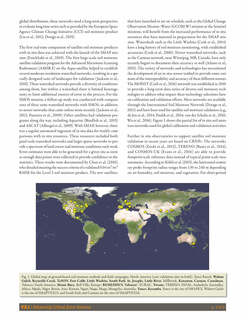
that have launched or are on schedule, such as the Global Change Observation Mission–Water (GCOM-W) mission or the Sentinel missions, will benefit from the increased performance of in situ resources that have matured in preparation for the SMAP mis-sion. Watersheds such as the Little Washita (Cosh et al., 2014) have a long history of soil moisture monitoring, with established accuracies (Cosh et al., 2006). Newer watershed networks, such as the Carman network, near Winnipeg, MB, Canada, have only recently begun to document their accuracy as well (Adams et al., 2015). The variety of networks and technologies has necessitated the development of an in situ sensor testbed to provide some esti-mate of the interoperability and accuracy of these different sensors. The MOISST (Cosh et al., 2016) network was established in 2010 to provide a long-term data series of diverse soil moisture tech-nologies to address what impact these technology selections have on calibration and validation efforts. Most networks are available through the International Soil Moisture Network (Dorigo et al., 2011) and have been used for satellite soil moisture validation (e.g., de Jeu et al., 2014; Paulik et al., 2014; van der Schalie et al., 2016; Wu et al., 2016). Figure 1 shows the partial list of in situ soil mois-ture networks used for global calibration and validation activities.
Further in situ observatories to support satellite soil moisture validation in recent years are based on CRNPs. The networks COSMOS (Zreda et al., 2012), TERENO (Baatz et al., 2014), and COSMOS-UK (Evans et al., 2016) are able to provide footprint-scale reference data instead of typical point-scale mea-surements. According to Köhli et al. (2015), the horizontal cosmic ray probe footprint radius ranges from 130 to 240 m depending on air humidity, soil moisture, and vegetation. For short-period
Fig. 1. Global map of ground-based soil moisture testbeds and field campaigns. North America (core validation sites in bold): Tonzi Ranch, Walnut Gulch, Reynolds Creek, TxSON, Fort Cobb, Little Washita, South Fork, St. Josephs, Little River, Millbrook, Kenaston, Carman, Casselman, Tabasco; South America: Monte Buey, Bell Ville; Europe: REMEDHUS, Valencia*, EURAC, Twente, TERENO, HOAL, Sodankyla, Saariselka; Africa: Mpala, Niger, Benin; Asia: Kuwait, Ngari, Naqu, Maqu, Mongolia; Australia: Yanco, Kyeamba. Yanco is the site of SMAPEX, Walnut Gulch is the site of SMAPVEX15, and South Fork and Carman are the sites of SMAPVEX16.

VZJ | Advancing Critical Zone Science p. 4 of 9
campaigns, the utilization of mobile CRNP rovers is possible (Dong et al., 2014). A first comparison of SMAP Level 3 soil mois-ture data with CRNPs in the Rur catchment, Germany (Montzka et al., 2016), is shown in Fig. 2. The two curves agree well, but SMAP follows a higher dynamic range, which can be explained by the lower penetration depth compared with CRNPs (Montzka et al., unpublished data, 2016). Further research is needed to consider the different soil volumes observed, e.g., by the data assimilation method published by Rosolem et al. (2014). Moreover, hydrogen stored in vegetation affects the counts of registered neutrons at the sensor. Therefore, a vegetation correction procedure has to be applied in regions with high vegetation dynamics (Baatz et al., 2015). More details and examples of new techniques in large-scale soil moisture monitoring were given by Ochsner et al. (2013).
6Satellite Soil Moisture Retrieval and Validation in Different HydroclimatesBesides satellite- and ground-based measurements, different land surface models using climatology and atmospheric forcing have been used for estimating soil moisture at different space and time scales. Statistical tools such as triple collocation techniques using multiple satellite products and their signal/noise ratio along with land surface model products have been used as alternative tools for validation of near-surface soil moisture (Gruber et al., 2013, 2016;
McColl et al., 2014; Pan et al., 2015). While cross-validation of different satellite data using these novel schemes has been found promising, debate continues about their accuracy and bias at differ-ent scales, heterogeneities, and hydroclimates. In addition to these statistical techniques for validation of remote sensing data, other efforts including rules for scaling up or down based on various land surface physical controls are being used to decipher soil moisture dynamics at different scales.
To accomplish this, studies are being conducted to understand the influence and sensitivity of different physical attributes (e.g., soil type, roughness, vegetation water content, and albedo) in different hydroclimates. In addition, it is necessary to determine how these attributes impact the observed brightness temperature, backscatter, and retrieved soil moisture across various space and time scales.
Recent studies have suggested that the performance of avail-able radiative transfer models (RTMs) used for satellite (e.g., SMOS and SMAP) soil moisture algorithms are not opti-mum under highly heterogeneous landscape conditions and vary with hydroclimate. Using global sensitivity analysis for parameter interaction in a zero-order radiative transfer model for data collected during field campaigns SMEX02 (Iowa) and SMAPVEX12 (Winnipeg, Canada), Neelam and Mohanty (2015) found that: (i) four parameters (soil moisture, vegetation
Fig. 2. Comparison of SMAP L3 soil moisture data with a TERENO cosmic ray station in the Rur catchment, Germany. The higher dynamic range of SMAP than cosmic ray neutron probes (CRNPs) is caused by the smaller penetration depth of L-band microwave radiometry.
VZJ | Advancing Critical Zone Science p. 5 of 9
water content [VWC], surface roughness height, and its correla-tion length in Iowa, whereas one parameter, soil moisture (SM), in Winnipeg, Canada, were sensitive to brightness temperature, (ii) attenuation of soil emissions by vegetation (VWC and vegeta-tion structure) can be significant in structured plants (e.g., corn [Zea mays L.]) and this attenuation or scattering increases with roughness and SM conditions, (iii) for similar surface roughness conditions, sensitivity to roughness parameters is higher in wet soils than dry soils, and (iv) SM derived from brightness tem-perature pixels representative of a wide range of SM conditions are more accurate than pixels representative of a narrow (and higher) range of SM conditions because SM retrieval accuracy will be compromised due to higher sensitivity to other param-eters at narrow SM ranges. Based on these findings of Neelam and Mohanty (2015), it can be inferred that a uniform RTM approach for soil moisture retrieval across the globe may have limitations and there exist opportunities to further improve soil moisture retrieval accuracy and associated soil water fluxes in the vadose zone using various current and future microwave remote sensing platforms. Specifically, because the most RTM sensitivity originates from vegetation water content and surface roughness attributes, more carefully designed high-resolution field studies are warranted to gain a deeper understanding of their magnitude and seasonality in different hydroclimates.
6Extending Near-Surface Satellite-Based Soil Moisture into the Root ZoneBesides near-surface soil moisture, root-zone (the top 1 m below the land surface) soil moisture dynamics are a key factor in management of water resources and agricultural water, rainfall–runoff processes, and ecosystem health and dynamics. Using near-surface soil moisture from satellites in conjunction with soil hydrologic models, efforts are being made to produce regional (Das and Mohanty, 2006; Das et al., 2010; Ridler et al., 2014; Dumedah et al., 2015; González-Zamora et al., 2016; De Lannoy and Reichle, 2016) and global (Muñoz-Sabater, 2015) scale root-zone soil moisture. The ASCAT root zone soil moisture products have been publicly available for several years (Wagner et al., 1999; Brocca et al., 2010), operational SMOS Level 4 root-zone prod-ucts can currently be delivered to the scientific community only (Mecklenburg et al., 2016). Besides SMAP Level 2 and 3 prod-ucts near the land surface, the SMAP Level 4 product provides top 1-m root-zone soil moisture estimates at 9-km resolution on a weekly basis by assimilating passive near-surface soil mois-ture products with a GEOS-5 catchment land surface model (Entekhabi et al., 2014). Encompassing various soil types (e.g., texture), topographic features (e.g., slope), vegetation and land cover, and climatic conditions, SMAP Level 4 data provide a perfect baseline to better understand the role of root-zone soil moisture “memory” in hydrologic, agricultural, weather, and sea-sonal climate predictions. This will lead to a closing of the water budget at the field, catchment, watershed, and regional scales.
6Remotely Sensed Soil Moisture Variability, Controls, and DownscalingWhile satellite platforms provide the coarse resolution informa-tion, most agricultural, hydrological, meteorological, and land-use and change applications need representation of small-scale spatial heterogeneity of land surface as hydrological processes manifest at scales ranging from centimeters to kilometers. Although remote sensing platforms provide large-scale soil moisture dynamics, scale discrepancy between the observation scale (e.g., approximately sev-eral kilometers for satellite observations and point scales for in situ observations) and the modeling scale (e.g., a few hundred meters to kilometers) leads to uncertainties in land surface hydrologic model performance. To improve hydrologic and other applications, satellite-based soil moisture should be downscaled to an appropri-ate level. The spatiotemporal variability of root-zone soil moisture influences runoff at the soil surface and subsurface, evapotrans-piration and atmospheric feedback, and groundwater recharge. Root-zone soil moisture content also plays a pivotal role in ecologi-cal processes at individual plant to system scales. Ongoing efforts to downscale soil moisture products at these application scales (e.g., Shin et al., 2013; Ines et al., 2013) have been undertaken using different scaling techniques as well as to improve the capability to predict root-zone soil hydraulics and associated hydrologic fluxes at different spatial and temporal scales.
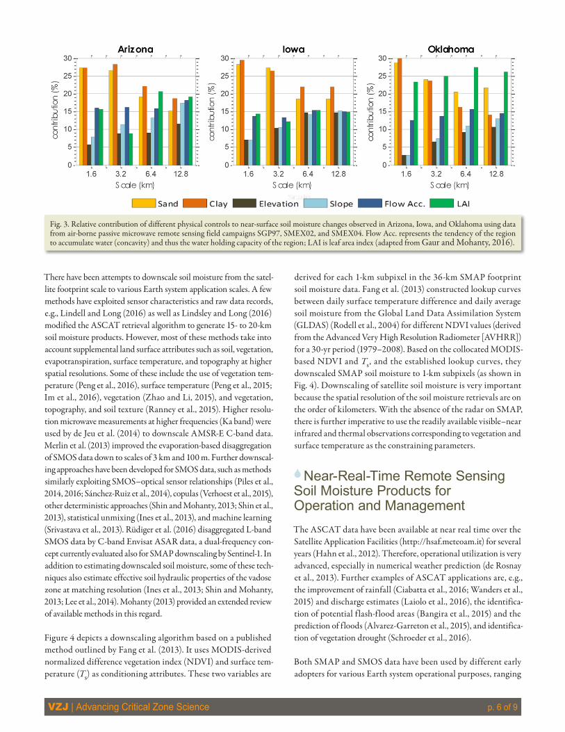
At a particular point in time, root-zone soil moisture content is influenced by (i) precipitation history, (ii) the texture of the soil, which determines the water-holding capacity, (iii) the slope of the land surface, which affects runoff and infiltration, and (iv) vegeta-tion and land cover, which influences evapotranspiration and deep percolation. Traditionally, soil moisture spatial variability stud-ies using ground-based, point-scale measurements are limited to small fields with uniform soil characteristics, topographic features, and vegetation conditions. On the other hand, satellite footprint-scale soil moisture measurements may be coarse, and errors at the local scales of field, catchment, and watershed may propagate into inaccurate regional-scale hydrologic fluxes important for water resource assessment, agriculture, and hydroclimatic predictions. To develop more efficient scaling tools for utilizing satellite soil moisture (SMAP and SMOS) products, studies investigating the scale dependence of the dominant physical controls on soil mois-ture distribution have been undertaken. The temporal and spatial distribution of soil moisture and the resultant fluxes to different hydrologic reservoirs are affected by interactions between soil, topography, vegetation, and climate (Joshi and Mohanty, 2010; Gaur and Mohanty, 2013). Differences in these dominant con-trolling mechanisms were evaluated using data from various past airborne remote sensing field campaigns (e.g., SGP97, SGP99, SMEX02, SMEX03, SMEX05, CLASIC07, and SMAPVEX12). Using wavelet analysis with various airborne remote sensing data, Gaur and Mohanty (2016) observed the dominance of various physical controls on the soil moisture status evolved in different hydroclimates (see Fig. 3).
VZJ | Advancing Critical Zone Science p. 6 of 9
There have been attempts to downscale soil moisture from the satel-lite footprint scale to various Earth system application scales. A few methods have exploited sensor characteristics and raw data records, e.g., Lindell and Long (2016) as well as Lindsley and Long (2016) modified the ASCAT retrieval algorithm to generate 15- to 20-km soil moisture products. However, most of these methods take into account supplemental land surface attributes such as soil, vegetation, evapotranspiration, surface temperature, and topography at higher spatial resolutions. Some of these include the use of vegetation tem-perature (Peng et al., 2016), surface temperature (Peng et al., 2015; Im et al., 2016), vegetation (Zhao and Li, 2015), and vegetation, topography, and soil texture (Ranney et al., 2015). Higher resolu-tion microwave measurements at higher frequencies (Ka band) were used by de Jeu et al. (2014) to downscale AMSR-E C-band data. Merlin et al. (2013) improved the evaporation-based disaggregation of SMOS data down to scales of 3 km and 100 m. Further downscal-ing approaches have been developed for SMOS data, such as methods similarly exploiting SMOS–optical sensor relationships (Piles et al., 2014, 2016; Sánchez-Ruiz et al., 2014), copulas (Verhoest et al., 2015), other deterministic approaches (Shin and Mohanty, 2013; Shin et al., 2013), statistical unmixing (Ines et al., 2013), and machine learning (Srivastava et al., 2013). Rüdiger et al. (2016) disaggregated L-band SMOS data by C-band Envisat ASAR data, a dual-frequency con-cept currently evaluated also for SMAP downscaling by Sentinel-1. In addition to estimating downscaled soil moisture, some of these tech-niques also estimate effective soil hydraulic properties of the vadose zone at matching resolution (Ines et al., 2013; Shin and Mohanty, 2013; Lee et al., 2014). Mohanty (2013) provided an extended review of available methods in this regard.
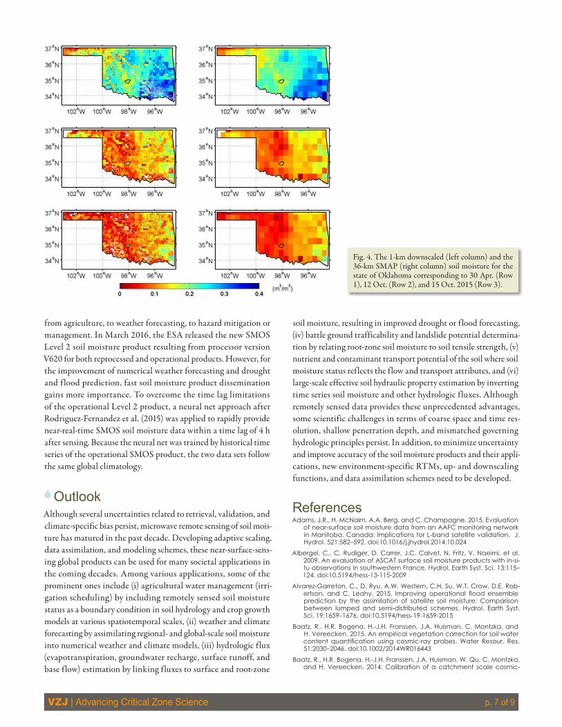
Figure 4 depicts a downscaling algorithm based on a published method outlined by Fang et al. (2013). It uses MODIS-derived normalized difference vegetation index (NDVI) and surface tem-perature (Ts) as conditioning attributes. These two variables are
derived for each 1-km subpixel in the 36-km SMAP footprint soil moisture data. Fang et al. (2013) constructed lookup curves between daily surface temperature difference and daily average soil moisture from the Global Land Data Assimilation System (GLDAS) (Rodell et al., 2004) for different NDVI values (derived from the Advanced Very High Resolution Radiometer [AVHRR]) for a 30-yr period (1979–2008). Based on the collocated MODIS-based NDVI and Ts, and the established lookup curves, they downscaled SMAP soil moisture to 1-km subpixels (as shown in Fig. 4). Downscaling of satellite soil moisture is very important because the spatial resolution of the soil moisture retrievals are on the order of kilometers. With the absence of the radar on SMAP, there is further imperative to use the readily available visible–near infrared and thermal observations corresponding to vegetation and surface temperature as the constraining parameters.
6Near-Real-Time Remote Sensing Soil Moisture Products for Operation and ManagementThe ASCAT data have been available at near real time over the Satellite Application Facilities (http://hsaf.meteoam.it) for several years (Hahn et al., 2012). Therefore, operational utilization is very advanced, especially in numerical weather prediction (de Rosnay et al., 2013). Further examples of ASCAT applications are, e.g., the improvement of rainfall (Ciabatta et al., 2016; Wanders et al., 2015) and discharge estimates (Laiolo et al., 2016), the identifica-tion of potential flash-flood areas (Bangira et al., 2015) and the prediction of floods (Alvarez-Garreton et al., 2015), and identifica-tion of vegetation drought (Schroeder et al., 2016).
Both SMAP and SMOS data have been used by different early adopters for various Earth system operational purposes, ranging
Fig. 3. Relative contribution of different physical controls to near-surface soil moisture changes observed in Arizona, Iowa, and Oklahoma using data from air-borne passive microwave remote sensing field campaigns SGP97, SMEX02, and SMEX04. Flow Acc. represents the tendency of the region to accumulate water (concavity) and thus the water holding capacity of the region; LAI is leaf area index (adapted from Gaur and Mohanty, 2016).
VZJ | Advancing Critical Zone Science p. 7 of 9
from agriculture, to weather forecasting, to hazard mitigation or management. In March 2016, the ESA released the new SMOS Level 2 soil moisture product resulting from processor version V620 for both reprocessed and operational products. However, for the improvement of numerical weather forecasting and drought and flood prediction, fast soil moisture product dissemination gains more importance. To overcome the time lag limitations of the operational Level 2 product, a neural net approach after Rodriguez-Fernandez et al. (2015) was applied to rapidly provide near-real-time SMOS soil moisture data within a time lag of 4 h after sensing. Because the neural net was trained by historical time series of the operational SMOS product, the two data sets follow the same global climatology.
6OutlookAlthough several uncertainties related to retrieval, validation, and climate-specific bias persist, microwave remote sensing of soil mois-ture has matured in the past decade. Developing adaptive scaling, data assimilation, and modeling schemes, these near-surface-sens-ing global products can be used for many societal applications in the coming decades. Among various applications, some of the prominent ones include (i) agricultural water management (irri-gation scheduling) by including remotely sensed soil moisture status as a boundary condition in soil hydrology and crop growth models at various spatiotemporal scales, (ii) weather and climate forecasting by assimilating regional- and global-scale soil moisture into numerical weather and climate models, (iii) hydrologic flux (evapotranspiration, groundwater recharge, surface runoff, and base flow) estimation by linking fluxes to surface and root-zone
soil moisture, resulting in improved drought or flood forecasting, (iv) battle ground trafficability and landslide potential determina-tion by relating root-zone soil moisture to soil tensile strength, (v) nutrient and contaminant transport potential of the soil where soil moisture status reflects the flow and transport attributes, and (vi) large-scale effective soil hydraulic property estimation by inverting time series soil moisture and other hydrologic fluxes. Although remotely sensed data provides these unprecedented advantages, some scientific challenges in terms of coarse space and time res-olution, shallow penetration depth, and mismatched governing hydrologic principles persist. In addition, to minimize uncertainty and improve accuracy of the soil moisture products and their appli-cations, new environment-specific RTMs, up- and downscaling functions, and data assimilation schemes need to be developed.
ReferencesAdams, J.R., H. McNairn, A.A. Berg, and C. Champagne. 2015. Evaluation
of near-surface soil moisture data from an AAFC monitoring network in Manitoba, Canada: Implications for L-band satellite validation. J. Hydrol. 521:582–592. doi:10.1016/j.jhydrol.2014.10.024
Albergel, C., C. Rudiger, D. Carrer, J.C. Calvet, N. Fritz, V. Naeimi, et al. 2009. An evaluation of ASCAT surface soil moisture products with in-si-tu observations in southwestern France. Hydrol. Earth Syst. Sci. 13:115–124. doi:10.5194/hess-13-115-2009
Alvarez-Garreton, C., D. Ryu, A.W. Western, C.H. Su, W.T. Crow, D.E. Rob-ertson, and C. Leahy. 2015. Improving operational flood ensemble prediction by the assimilation of satellite soil moisture: Comparison between lumped and semi-distributed schemes. Hydrol. Earth Syst. Sci. 19:1659–1676. doi:10.5194/hess-19-1659-2015
Baatz, R., H.R. Bogena, H.-J.H. Franssen, J.A. Huisman, C. Montzka, and H. Vereecken. 2015. An empirical vegetation correction for soil water content quantification using cosmic-ray probes. Water Resour. Res. 51:2030–2046. doi:10.1002/2014WR016443
Baatz, R., H.R. Bogena, H.-J.H. Franssen, J.A. Huisman, W. Qu, C. Montzka, and H. Vereecken. 2014. Calibration of a catchment scale cosmic-
Fig. 4. The 1-km downscaled (left column) and the 36-km SMAP (right column) soil moisture for the state of Oklahoma corresponding to 30 Apr. (Row 1), 12 Oct. (Row 2), and 15 Oct. 2015 (Row 3).
VZJ | Advancing Critical Zone Science p. 8 of 9
ray probe network: A comparison of three parameterization methods. J. Hydrol. 516:231–244. doi:10.1016/j.jhydrol.2014.02.026
Bangira, T., B.H.P. Maathuis, T. Dube, and T.W. Gara. 2015. Investigat-ing flash floods potential areas using ASCAT and TRMM satellites in the Western Cape Province, South Africa. Geocarto Int. 30:737–754. doi:10.1080/10106049.2014.997302
Bindlish, R., T. Jackson, M. Cosh, T. Zhao, and P. O’Neill. 2015. Global soil moisture from the Aquarius/SAC-D satellite: Description and initial assessment. IEEE Geosci. Remote Sens. Lett. 12:923–927. doi:10.1109/LGRS.2014.2364151
Bogena, H.R., J.A. Huisman, A. Güntner, C. Hübner, J. Kusche, F. Jonard, et al. 2015. Emerging methods for noninvasive sensing of soil moisture dynamics from field to catchment scale: A review. Wiley Interdiscip. Rev.: Water 2:635–647. doi:10.1002/wat2.1097
Brocca, L., F. Melone, T. Moramarco, W. Wagner, V. Naeimi, Z. Bartalis, and S. Hasenauer. 2010. Improving runoff prediction through the as-similation of the ASCAT soil moisture product. Hydrol. Earth Syst. Sci. 14:1881–1893. doi:10.5194/hess-14-1881-2010
Calvet, J.-C., J.P. Wigneron, J. Walker, F. Karbou, A. Chanzy, and C. Alber-gel. 2011. Sensitivity of passive microwave observations to soil moisture and vegetation water content: L-band to W-band. IEEE Trans. Geosci. Remote Sens. 49:1190–1199. doi:10.1109/TGRS.2010.2050488
Chan, S., R. Bindlish, P. O’Neill, E. Njoku, T.J. Jackson, A. Colliander, et al. 2016. Assessment of the SMAP Level 2 passive soil mois-ture product. IEEE Trans. Geosci. Remote Sens. 54:4994–5007. doi:10.1109/TGRS.2016.2561938
Ciabatta, L., L. Brocca, C. Massari, T. Moramarco, S. Gabellani, S. Puca, and W. Wagner. 2016. Rainfall–runoff modelling by using SM2RAIN-derived and state-of-the-art satellite rainfall products over Italy. Int. J. Appl. Earth Obs. Geoinf. 48:163–173. doi:10.1016/j.jag.2015.10.004
Cosh, M.H., T.J. Jackson, P.J. Starks, and G.C. Heathman. 2006. Temporal stability of surface soil moisture in the Little Washita River Watershed and its applications in satellite soil moisture product validation. J. Hy-drol. 323:168–177. doi:10.1016/j.jhydrol.2005.08.020
Cosh, M.H., T. Ochsner, L.G. McKee, G. Dong, J. Basara, S.R. Evett, et al. 2016. The Soil Moisture Active Passive Marena Oklahoma In Situ Sen-sor Testbed (SMAP-MOISST): Design and initial results. Vadose Zone J. 15(4). doi:10.2136/vzj2015.09.0122
Cosh, M.H., P.J. Starks, J. Guzman, and D. Moriasi. 2014. Long-term agro-hydrological research in Upper Washita River Experimental Water-sheds: Inter-annual persistence of soil water content profiles. J. Environ. Qual. 43:1328–1333. doi:10.2134/jeq2013.08.0318
Das, N.N., and B.P. Mohanty. 2006. Root zone soil moisture assessment using remote sensing and vadose zone modeling. Vadose Zone J. 5:296–307. doi:10.2136/vzj2005.0033
Das, N.N., B.P. Mohanty, and E.G. Njoku. 2010. Profile soil moisture across spatial scales under different hydroclimatic conditions. Soil Sci. 175:315–319. doi:10.1097/SS.0b013e3181e83dd3
de Jeu, R.A.M., T.R.H. Holmes, R.M. Parinussa, and M.A. Owe. 2014. Spa-tially coherent global soil moisture product with improved temporal resolution. J. Hydrol. 516:284–296. doi:10.1016/j.jhydrol.2014.02.015
De Lannoy, G.J.M., and R.H. Reichle. 2016. Global assimilation of multian-gle and multipolarization SMOS brightness temperature observations into the GEOS-5 catchment land surface model for soil moisture es-timation. J. Hydrometeorol. 17:669–691. doi:10.1175/JHM-D-15-0037.1
de Rosnay, P., M. Drusch, D. Vasiljevic, G. Balsamo, C. Albergel, and L.A. Isaksen. 2013. Simplified extended Kalman filter for the global operational soil moisture analysis at ECMWF. Q. J. R. Meteorol. Soc. 139:1199–1213. doi:10.1002/qj.2023
Dong, J.N., T.E. Ochsner, M. Zreda, M.H. Cosh, and C.B. Zou. 2014. Cali-bration and validation of the COSMOS rover for surface soil moisture measurement. Vadose Zone J. 13(4). doi:10.2136/vzj2013.08.0148
Dorigo, W.A., A. Gruber, R.A.M. De Jeu, W. Wagner, T. Stacke, A. Loew, et al. 2015. Evaluation of the ESA CCI soil moisture product using ground-based observations. Remote Sens. Environ. 162:380–395. doi:10.1016/j.rse.2014.07.023
Dorigo, W.A., W. Wagner, R. Hohensinn, S. Hahn, C. Paulik, A. Xaver, et al. 2011. The International Soil Moisture Network: A data hosting facility for global in situ soil moisture measurements. Hydrol. Earth Syst. Sci. 15:1675–1698. doi:10.5194/hess-15-1675-2011
Dumedah, G., J.P. Walker, and O. Merlin. 2015. Root-zone soil moisture estimation from assimilation of downscaled soil mois-ture and ocean salinity data. Adv. Water Resour. 84:14–22. doi:10.1016/j.advwatres.2015.07.021
Entekhabi, D., E.G. Njoku, P.E. O’Neill, K. Kellogg, W.T. Crow, J. Edelstein, et al. 2010. The Soil Moisture Active/Passive Mission (SMAP). Proc. IEEE 98:704–716. doi:10.1109/JPROC.2010.2043918
Entekhabi, D., S. Yueh, P.E. O’Neill, K. Kellogg, A. Allen, R. Bindlish, et al. 2014. SMAP handbook: Mapping soil moisture and freeze/thaw from space. Publ. JPL 400-1567. NASA, Jet Propulsion Lab., Pasadena, CA.
Evans, J.G., H.C. Ward, J.R. Blake, E.J. Hewitt, R. Morrison, M. Fry, et al. 2016. Soil water content in southern England derived from a cosmic-ray soil moisture observing system—COSMOS-UK. Hydrol. Processes 30:4987–4999. doi:10.1002/hyp.10929
Fang, B., V. Lakshmi, R. Bindlish, T. Jackson, M. Cosh, and J. Basara. 2013. Passive microwave soil moisture downscaling using vegetation index and surface temperatures. Vadose Zone J. 12(3) [erratum: 12(4)]. doi:10.2136/vzj2013.05.0089
Gaur, N., and B.P. Mohanty. 2013. Evolution of physical controls for soil moisture in humid and sub-humid watersheds. Water Resour. Res. 49:1244–1258. doi:10.1002/wrcr.20069
Gaur, N., and B.P. Mohanty. 2016. Land-surface controls on near-surface soil moisture dynamics: Traversing remote sensing footprints. Water Re-sour. Res. 52:6365–6385. doi:10.1002/2015WR018095
González-Zamora, A., N. Sánchez, J. Martínez-Fernández, and W. Wag-ner. 2016. Root-zone plant available water estimation using the SMOS-derived soil water index. Adv. Water Resour. 96:339–353. doi:10.1016/j.advwatres.2016.08.001
Gruber, A., W.A. Dorigo, S. Zwieback, A. Xaver, and W. Wagner. 2013. Characterizing coarse-scale representativeness of in situ soil moisture measurements from the International Soil Moisture Network. Vadose Zone J. 12(2).
Gruber, A., C.H. Su, S. Zwieback, W. Crowd, W. Dorigo, and W. Wagner. 2016. Recent advances in (soil moisture) triple collocation analysis. Int. J. Appl. Earth Obs. Geoinf. 45:200–211. doi:10.1016/j.jag.2015.09.002
Hahn, S., T. Melzer, and W. Wagner. 2012. Error assessment of the initial near real-time METOP ASCAT surface soil moisture product. IEEE Trans. Geosci. Remote Sens. 50:2556–2565. doi:10.1109/TGRS.2012.2183877
Hornacek, M., W. Wagner, D. Sabel, H.L. Truong, P. Snoeij, T. Hah-mann, et al. 2012. Potential for high resolution systematic global surface soil moisture retrieval via change detection using Senti-nel-1. IEEE J. Sel. Top. Appl. Earth Obs. Remote Sens. 5:1303–1311. doi:10.1109/JSTARS.2012.2190136
Im, J., S. Park, J. Rhee, J. Baik, and M. Choi. 2016. Downscaling of AMSR-E soil moisture with MODIS products using machine learning approach-es. Environ. Earth Sci. 75:1120. doi:10.1007/s12665-016-5917-6
Ines, A.V.M., B.P. Mohanty, and Y. Shin. 2013. An unmixing algorithm for remotely sensed soil moisture. Water Resour. Res. 49:408–425. doi:10.1029/2012WR012379
Jackson, T.J., R. Bindlish, M.H. Cosh, T. Zhao, P.J. Starks, D.D. Bosch, et al. 2012. Validation of Soil Moisture Ocean Salinity (SMOS) soil moisture over watershed networks in the U.S. IEEE Trans. Geosci. Remote Sens. 50:1530–1543. doi:10.1109/TGRS.2011.2168533
Jackson, T.J., M.H. Cosh, R. Bindlish, P.J. Starks, D.D. Bosch, M.S. Seyfried, et al. 2010. Validation of Advanced Microwave Scanning Radiometer soil moisture products. IEEE Trans. Geosci. Remote Sens. 48:4256–4272. doi:10.1109/TGRS.2010.2051035
Joshi, C., and B.P. Mohanty. 2010. Physical controls of near-surface soil moisture across varying spatial scales in an agricultural landscape dur-ing SMEX02. Water Resour. Res. 46:W12503. doi:10.1029/2010WR009152
Köhli, M., M. Schron, M. Zreda, U. Schmidt, P. Dietrich, and S. Zacharias. 2015. Footprint characteristics revised for field-scale soil moisture monitoring with cosmic-ray neutrons. Water Resour. Res. 51:5772–5790. doi:10.1002/2015WR017169
Laiolo, P., S. Gabellani, L. Campo, F. Silvestro, F. Delogu, R. Rudari, et al. 2016. Impact of different satellite soil moisture products on the predic-tions of a continuous distributed hydrological model. Int. J. Appl. Earth Obs. Geoinf. 48:131–145. doi:10.1016/j.jag.2015.06.002
Lee, J.H., T. Pellarin, and Y.H. Kerr. 2014. Inversion of soil hydraulic proper-ties from the DEnKF analysis of SMOS soil moisture over West Africa. Agric. For. Meteorol. 188:76–88. doi:10.1016/j.agrformet.2013.12.009
Lindell, D.B., and D.G. Long. 2016. High-resolution soil moisture re-trieval with ASCAT. IEEE Geosci. Remote Sens. Lett. 13:972–976. doi:10.1109/LGRS.2016.2557321
Lindsley, R.D., and D.G. Long. 2016. Enhanced-resolution reconstruction of ASCAT backscatter measurements. IEEE Trans. Geosci. Remote Sens. 54:2589–2601. doi:10.1109/TGRS.2015.2503762
Liu, Y.Y., W.A. Dorigo, R.M. Parinussa, R.A.M. de Jeu, W. Wagner, M.F. Mc-Cabe, et al. 2012. Trend-preserving blending of passive and active
VZJ | Advancing Critical Zone Science p. 9 of 9
microwave soil moisture retrievals. Remote Sens. Environ. 123:280–297. doi:10.1016/j.rse.2012.03.014
McColl, K.A., J. Vogelzang, A.G. Konings, D. Entekhabi, M. Piles, and A. Stoffelen. 2014. Extended triple collocation: Estimating errors and cor-relation coefficients with respect to an unknown target. Geophys. Res. Lett. 41:6229–6236. doi:10.1002/2014GL061322
Mecklenburg, S., M. Drusch, L. Kaleschke, N. Rodriguez-Fernandez, N. Reul, Y. Kerr, et al. 2016. ESA’s Soil Moisture and Ocean Salinity mis-sion: From science to operational applications. Remote Sens. Environ. 180:3–18. doi:10.1016/j.rse.2015.12.025
Merlin, O., M.J. Escorihuela, M.A. Mayoral, O. Hagolle, A. Al Bitar, and Y. Kerr. 2013. Self-calibrated evaporation-based disaggrega-tion of SMOS soil moisture: An evaluation study at 3 km and 100 m resolution in Catalunya, Spain. Remote Sens. Environ. 130:25–38. doi:10.1016/j.rse.2012.11.008
Mohanty, B.P. 2013. Soil hydraulic property estimation using remote sens-ing: A review. Vadose Zone J. 12(4). doi:10.2136/vzj2013.06.0100
Montzka, C., T. Jagdhuber, R. Horn, H. Bogena, I. Hajnsek, A. Reigber, and H. Vereecken. 2016. Investigation of SMAP fusion algorithms with air-borne active and passive L-band microwave remote sensing. IEEE Trans. Geosci. Remote Sens. 54:3878–3889. doi:10.1109/TGRS.2016.2529659
Moreira, A., G. Krieger, I. Hajnsek, K. Papathanassiou, M. Younis, P. Lopez-Dekker, et al. 2015. Tandem-L: A highly innovative bistat-ic SAR mission for global observation of dynamic processes on the Earth’s surface. IEEE Geosci. Remote Sens. Mag. 3(2):8–23. doi:10.1109/MGRS.2015.2437353
Muñoz-Sabater, J. 2015. Incorporation of passive microwave bright-ness temperatures in the ECMWF soil moisture analysis. Remote Sens. 7:5758–5784. doi:10.3390/rs70505758
Neelam, M., and B.P. Mohanty. 2015. Global sensitivity analysis of the radiative transfer model. Water Resour. Res. 51:2428–2443. doi:10.1002/2014WR016534
Ochsner, T.E., M.H. Cosh, R.H. Cuenca, W.A. Dorigo, C.S. Draper, Y. Hagi-moto, et al. 2013. State-of-the-art in large-scale soil moisture monitor-ing. Soil Sci. Soc. Am. J. 77:1888–1919. doi:10.2136/sssaj2013.03.0093
Paloscia, S., S. Pettinato, E. Santi, C. Notarnicola, L. Pasolli, and A. Rep-pucci. 2013. Soil moisture mapping using Sentinel-1 images: Algo-rithm and preliminary validation. Remote Sens. Environ. 134:234–248. doi:10.1016/j.rse.2013.02.027
Pan, M., C.K. Fisher, N.W. Chaney, W. Zhan, W.T. Crow, F. Aires, et al. 2015. Triple collocation: Beyond three estimates and separation of structural/non-structural errors. Remote Sens. Environ. 171:299–310. doi:10.1016/j.rse.2015.10.028
Panciera, R., J.P. Walker, J.D. Kalma, E.J. Kim, K. Saleh, and J.P. Wigner-on. 2009. Evaluation of the SMOS L-MEB passive microwave soil moisture retrieval algorithm. Remote Sens. Environ. 113:435–444. doi:10.1016/j.rse.2008.10.010
Paulik, C., W. Dorigo, W. Wagner, and R. Kidd. 2014. Validation of the ASCAT soil water index using in situ data from the Interna-tional Soil Moisture Network. Int. J. Appl. Earth Obs. Geoinf. 30:1–8. doi:10.1016/j.jag.2014.01.007
Peng, J., A. Loew, S. Zhang, J. Wang, and J. Niesel. 2016. Spatial down-scaling of satellite soil moisture data using vegetation tempera-ture condition index. IEEE Trans. Geosci. Remote Sens. 54:558–566. doi:10.1109/TGRS.2015.2462074
Peng, J., J. Niesel, and A. Loew. 2015. Evaluation of soil moisture downscaling using a simple thermal-based proxy: The REMDHUS network (Spain) example. Hydrol. Earth Syst. Sci. 19:4765–4782. doi:10.5194/hess-19-4765-2015
Piles, M., G.P. Petropoulos, N. Sánchez, Á. González-Zamora, and G. Ireland. 2016. Towards improved spatio-temporal resolution soil moisture retrievals from the synergy of SMOS and MSG SEVIRI spaceborne observations. Remote Sens. Environ. 180:403–417. doi:10.1016/j.rse.2016.02.048
Piles, M., N. Sanchez, M. Vall-Ilossera, A. Camps, J. Martinez-Fernandez, J. Martinez, and V. Gonzalez-Gambau. 2014. A downscaling approach for SMOS land observations: Evaluation of high-resolution soil moisture maps over the Iberian peninsula. IEEE J. Sel. Top. Appl. Earth Obs. Re-mote Sens. 7:3845–3857. doi:10.1109/JSTARS.2014.2325398
Ranney, K., J. Niemann, and B. Lehman. 2015. A method to downscale soil moisture to fine resolutions using topographic, vegetation and soil data. Adv. Water Resour. 76:81–96. doi:10.1016/j.advwatres.2014.12.003
Ridler, M.E., H. Madsen, S. Stisen, S. Bircher, and R. Fensholt. 2014. Assimila-tion of SMOS-derived soil moisture in a fully integrated hydrological and soil–vegetation–atmosphere transfer model in western Denmark. Water Resour. Res. 50:8962–8981. doi:10.1002/2014WR015392
Rodell, M., P.R. Houser, U. Jambor, J. Gottschalck, K. Mitchell, C.J. Meng, et al. 2004. The global land data assimilation system. Bull. Am. Meteo-rol. Soc. 85:381–394. doi:10.1175/BAMS-85-3-381
Rodriguez-Fernandez, N.J., F. Aires, P. Richaume, Y.H. Kerr, C. Prigent, J. Kolassa, et al. 2015. Soil moisture retrieval using neural networks: Ap-plication to SMOS. IEEE Trans. Geosci. Remote Sens. 53:5991–6007. doi:10.1109/TGRS.2015.2430845
Rosolem, R., T. Hoar, A. Arellano, J.L. Anderson, W.J. Shuttleworth, X. Zeng, and T.E. Franz. 2014. Translating above-ground cosmic-ray neutron in-tensity to high-frequency soil moisture profiles at sub-kilometer scale. Hydrol. Earth Syst. Sci. 18:4363–4379. doi:10.5194/hess-18-4363-2014
Rüdiger, C., C.-H. Su, D. Ryu, and W. Wagner. 2016. Disaggregation of low-resolution L-band radiometry using C-band radar data. IEEE Geosci. Remote Sens. Lett. 13:1425–1429. doi:10.1109/LGRS.2016.2583433
Sánchez-Ruiz, S., M. Piles, N. Sanchez, J. Martinez-Fernandez, M. Vall-Il-ossera, and A. Camps. 2014. Combining SMOS with visible and near/shortwave/thermal infrared satellite data for high resolution soil mois-ture estimates. J. Hydrol. 516:273–283. doi:10.1016/j.jhydrol.2013.12.047
Schroeder, R., K.C. McDonald, M. Azarderakhsh, and R. Zimmermann. 2016. ASCAT MetOp-A diurnal backscatter observations of recent vegetation drought patterns over the contiguous US: An assessment of spatial extent and relationship with precipitation and crop yield. Remote Sens. Environ. 177:153–159. doi:10.1016/j.rse.2016.01.008
Shin, Y., and B.P. Mohanty. 2013. Development of a deterministic down-scaling algorithm for remote sensing soil moisture footprint using soil and vegetation classifications. Water Resour. Res. 49:6208–6228. doi:10.1002/wrcr.20495
Shin, Y., B.P. Mohanty, and A.V.M. Ines. 2013. Estimating effective soil hy-draulic properties using spatially distributed soil moisture and evapo-transpiration. Vadose Zone J. 12(3). doi:10.2136/vzj2012.0094
Srivastava, P.K., D.W. Han, M.R. Ramirez, and T. Islam. 2013. Machine learning techniques for downscaling SMOS satellite soil moisture using MODIS land surface temperature for hydrological application. Water Resour. Manage. 27:3127–3144. doi:10.1007/s11269-013-0337-9
van der Schalie, R., Y.H. Kerr, J.P. Wignerond, N.J. Rodriguez-Fernandez, A. Al-Yaari, and R.A.M. de Jeu. 2016. Global SMOS soil moisture retrievals from the land parameter retrieval model. Int. J. Appl. Earth Obs. Geo-inf. 45:125–134. doi:10.1016/j.jag.2015.08.005
Verhoest, N.E.C., M.J. van den Berg, B. Martens, H. Lievens, E.F. Wood, M. Pan, et al. 2015. Copula-based downscaling of coarse-scale soil moisture observations with implicit bias correction. IEEE Trans. Geosci. Remote Sens. 53:3507–3521. doi:10.1109/TGRS.2014.2378913
Wagner, W., G. Lemoine, and H. Rott. 1999. A method for estimating soil moisture from ERS scatterometer and soil data. Remote Sens. Environ. 70:191–207. doi:10.1016/S0034-4257(99)00036-X
Wanders, N., M. Pan, and E.F. Wood. 2015. Correction of real-time satellite precipitation with multi-sensor satellite observations of land surface variables. Remote Sens. Environ. 160:206–221. doi:10.1016/j.rse.2015.01.016
Wu, Q.S., H.X. Liu, L. Wang, and C.B. Deng. 2016. Evaluation of AMSR2 soil moisture products over the contiguous United States using in situ data from the International Soil Moisture Network. Int. J. Appl. Earth Obs. Geoinf. 45:187–199. doi:10.1016/j.jag.2015.10.011
Zhao, W., and A. Li. 2015. A comparison study on empirical microwave soil moisture scaling methods based in the integration of microwave-opti-cal/IR data on the Tibetan Plateau. Int. J. Remote Sens. 36:4986–5002. doi:10.1080/01431161.2015.1041178
Zreda, M., W.J. Shuttleworth, X. Zeng, C. Zweck, D. Desilets, T. Franz, and R. Rosolem. 2012. COSMOS: The COsmic-ray Soil Moisture Observing Sys-tem. Hydrol. Earth Syst. Sci. 16:4079–4099. doi:10.5194/hess-16-4079-2012