streetsboro - houseal lavigne associates · structures containing multiple single family dwellings,...
TRANSCRIPT

5

Land use and development patterns have significant implications on the appear-
ance, character, form, and function of the community. Over the past decades,
Hudson’s built environment has been meticulously managed and the community’s
attractive and historic physical character is its most defining feature.
The Land Use and Development Plan identifies desired future land uses for all
areas within the City of Hudson and provides a framework to guide future planning
and land use policy decisions. At its core, it represents a continuation of, and not a
departure from, Hudson’s past planning efforts in 1995 and 2004. However, these
efforts have been updated and adapted in this Plan to accommodate changing
market and demographic trends and the evolving views of the community.
The Land Use & Development Plan is composed of three main parts:
— The Land Use Plan, detailing community-wide land use;
— The Residential Areas Framework Plan, detailing policies and recom-
mendations for residential areas, character areas, housing types and tenures,
and the existing Growth Management Allocation System;
— The Commercial & Employment Areas Framework Plan, detailing
policies and recommendations for the City’s major commercial and employ-
ment areas, including Downtown Hudson, commercial corridors, office areas,
business parks, and industrial areas.
Goal & RecommendationsSupport a healthy balance of land uses that can continue to make Hudson an attrac-tive place to live and work, and carefully manage new growth and investment to ensure preservation of the community’s historic character and small-town charm.
° Support the creation and maintenance of stable residential neighborhoods, ranging from medium or large lot single family homes to small lot single family detached homes, duplexes, town-homes, condominiums, and apart-ments.
° Enhance Downtown Hudson as the physical, cultural, and social heart of the community and an exciting mixed-use environment.
° Concentrate commercial corridor uses at key nodes along Route 303 and 91.
° Support the creation and maintenance of offices, industrial areas, and business parks of varying sizes that can accom-modate a diverse array of industries, support well-paying jobs, and generate new tax revenue.
° Support the creation and maintenance of an integrated network of parks and open spaces that preserve Hudson’s rural heritage, protect the natural envi-ronment and health of the community, and allow for recreational opportunities.
° Prioritize development in areas of Hudson that are already served by infra-structure and services before investing in underserved areas.
° Prevent the premature or unnecessary conversion of farmland or rural residen-tial areas.
° Support the mission of the Western Reserve Land Conservancy and the usage of conservation easements to prevent development of environmen-tally sensitive and rural areas.
° Direct new residential and non-residen-tial development to areas planned for such uses within the Land Use Plan, so that future land patterns maximize the efficiency of public services and protect and reinforce existing land uses.
° Continue to rigorously evaluate devel-opment proposals to ensure the inten-sity of any new development does not overburden existing and planned utility systems, water resources, schools, roads, and other infrastructure and taxing bodies.
° Promote the use of Best Management Practices (BMPs) and Smart Growth planning and construction techniques for new development and redevelop-ment sites.
° Continue to ensure new development reflects the scale of existing develop-ment within Hudson.
° Continue to ensure that new develop-ments utilize quality building materials and employ an architectural design that is in keeping with the existing character of the community.
° Pursue the highest and best use for the YDC site.
Land Use & Development Plan
23DRAFTFOR REVIEW
OHIO TURNPIKE
BOSTON MILLS RD.
W STREE
TSBORO
ST.
VALLEY VIEW RD.
W STREETSBORO ST.
BOSTON MILLS RD.
HINES HILL RD.
VALLEY VIEW
RD.
MIDDLETON RD. MIDDLETON RD.
INTERSTATE 480
HUDSON AU
RORA
RD.
STOW
RD.
AURO
RA ST
.
STOW
RD.
STOW
RD.
STOW
RD.
DARROW
RD.
TEREX RD.
S MAIN
ST.
TEREX RD.
TEREX RD.
BARLOW RD.HUDSO
N D
R.
BARLOW RD.
BARLOW RD.
SEASONS RD. NORTON RD.
SULLIVAN RD.
BARLOW RD.
RAVENNA ST.
RAVENNA ST.
E STREETSBORO ST.
STONE RD.
RAVEN
NA R
D.
WALT
ERS RD.
N M
AIN
ST.
DARROW
RD.
8
8
91
303
303
91
80
480
80
HudsonSprings Park
DarrowPark
MapleGrove Park
CascadePark
Doc'sWoods Park
BarlowFarm Park
HighPoint Park
ColonyPark
OakGrove Park
MacLarenWoods
BicentennialWoods
RobinsonField Park
VillageSouth
TrumbullWoods Park
DiNoviPark
Lake ForestCountry Club
EllsworthMeadows
Golf Course
HudsonCountry Club
STREETSBORO
TWINSBURGMACEDONIA
BOSTONHEIGHTS
STOW
BOSTONTownship
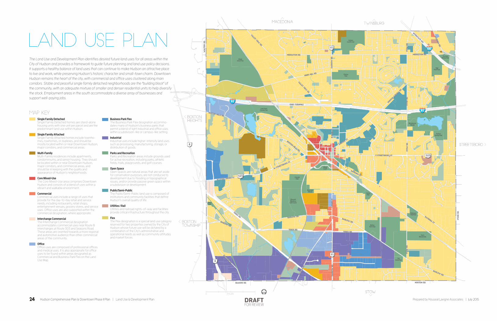
MAP KEY
0 Miles 1
Single Family DetachedSingle Family Detached homes are stand-alone housing units with one unit per parcel and are the predominant land use within Hudson.
Single Family AttachedSingle Family Attached homes include townho-mes, rowhomes, or duplexes, and should be mostly located within or near Downtown Hudson, major corridors, and commercial areas.
Multi-FamilyMulti-Family residences include apartments, condominiums, and senior housing. They should be located within or near Downtown Hudson, major corridors, and commercial areas, and should be in keeping with the quality and appearance of Hudson’s neighborhoods.
Core Mixed-UseThe Core Mixed-Use area comprises Downtown Hudson and consists of a blend of uses within a vibrant and walkable environment.
CommercialCommercial uses include a range of uses that provide for the day-to-day retail and service needs, including restaurants, retail shops, entertainment venues, grocery stores, and service uses. O�ce uses are also supported within the commercial designation, where appropriate.
Interchange CommercialThe Interchange Commercial designation accommodates commercial uses near Route 8 interchanges at Route 303 and Seasons Road. These areas are oriented towards a more regional and automotive audience than other commercial areas of the community.
O�ceO�ce uses are composed of professional o�ces and medical uses. It is also appropriate for o�ce uses to be found within areas designated as Commercial and Business Park Flex on the Land Use Map.
Business Park FlexThe Business Park Flex designation accommo-dates many of Hudson’s business parks that permit a blend of light industrial and o�ce uses within a subdivision-like or campus-like setting.
IndustrialIndustrial uses include higher-intensity land uses such as processing, manufacturing, storage, or distribution of goods.
Parks and RecreationParks and Recreation areas include grounds used for active recreation, including parks, athletic �elds, trails, playgrounds, and golf courses.
Open SpaceOpen Spaces are natural areas that are set aside for conservation purposes, are not conducive to development due to �ooding or topographical issues, and/or provide passive green space within a subdivision or development.
Public/Semi-PublicThe Public/Semi-Public land use is composed of institutions and community facilities that de�ne Hudson’s overall quality of life.
Utilities / RailUtilities and railroad rights-of-way and facilities provide critical infrastructure throughout the city.
FlexThe Flex designation is a special land use category reserved for two properties owned by the City of Hudson whose future use will be dictated by a combination of the City’s administrative and operational needs as well as community attitudes and market forces.
The Land Use and Development Plan identifies desired future land uses for all areas within the City of Hudson and provides a framework to guide future planning and land use policy decisions. It supports a healthy balance of land uses that can continue to make Hudson an attractive place to live and work, while preserving Hudson’s historic character and small-town charm. Downtown Hudson remains the heart of the city, with commercial and office uses clustered along main corridors. Stable and peaceful single family detached neighborhoods are the “building block” of the community, with an adequate mixture of smaller and denser residential units to help diversify the stock. Employment areas in the south accommodate a diverse array of businesses and support well-paying jobs.
Land Use Plan
24 Hudson Comprehensive Plan & Downtown Phase II Plan | Land Use & Development Plan Prepared by Houseal Lavigne Associates | July 2015DRAFTFOR REVIEW

Key Considerations
Future Use
The Land Use and Development Plan assigns a desired future use for each parcel within the City of Hudson to produce a “full build-out” scenario. In some cases, a future use is different from an existing use. This does not necessarily mean that the City is proactively advocating for that parcel to become that future use, or that the property will become that use during the life of this Comprehensive Plan. Development or redevelopment will be slow and incremental, and it is likely that full build-out will never be achieved. Instead, the future designations helps the City understand what the area should become, piece-by-piece, if it was to be developed or redevel-oped in the near future.
Flexibility
It should be underscored that the Land Use and Development Plan is a general guide for growth and development of Hudson and serves as a foundation for future decision making; it is not a site-specific development plan. It remains flexible enough to allow for creative approaches to land development that are consistent with the policies and guidelines included in the Comprehensive Plan.
Land Use Categories
Single Family DetachedSingle-Family Detached homes are currently, and are expected to remain, the predominant land use and housing type within Hudson. They are stand-alone housing units with one unit per parcel, typi-cally found within subdivisions. They should largely be owner-occupied. The size of single-family detached homes and the lots on which they sit varies widely within the community, from historic homes on smaller lots in the City’s core to more suburban and rural homes on larger lots in the outskirts of the community. The category also includes agricultural heritage properties, or large parcels containing a single family detached home but with active agricultural operations.
The Residential Areas Framework Plan provides more nuance and analysis on the different types of single family detached homes. Neighborhoods should be well-served by the City’s key institutions, and connected to one another and key destina-tions via sidewalks, trails, and/or pathways.
Single Family AttachedSingle Family-Attached homes consist of structures containing multiple single family dwellings, each sharing a common wall with at least one adjacent dwelling but maintaining their own separate entrance. Examples include townhomes, rowhomes, or duplexes. Generally, the size and cost of attached units makes them attractive to younger, older, or smaller households (e.g. young professionals, young families, empty nesters, and retirees). Single family attached units should mostly be located within or near Downtown Hudson, major corridors, and commercial areas; however, siting within residential subdivisions is also appropriate.
Multi-Family The multi-family land use consists of structures with multiple housing units that utilize common entrances and hallways and shared building amenities. Examples of multi-family residential developments include apartments, condominiums, and senior housing. Single family attached units should mostly be located within or near Downtown Hudson, major corridors, and commercial areas; however, siting within certain residential subdivisions is also appropriate. Multi-family structures should be tastefully designed and in keeping with the quality and appearance of Hudson’s other residential units.
Core Mixed-UseThe Core Mixed-Use area comprises Down-town Hudson and consists of a blend of uses within a vibrant and walkable envi-ronment. It includes both privately owned buildings as well as those public buildings that fall within Downtown, such as Town Hall and the Hudson Library and Historical Society. Some buildings within this desig-nation are mixed-use, typically two or three story buildings with restaurant, retail, and service uses on the ground floor and office or residential uses on upper floors. Buildings should be built to the front property line, with parking provided in the rear, to enhance the area’s character and walkability.
25July 2015 | Prepared by Houseal Lavigne Associates Land Use & Development Plan | Hudson Comprehensive Plan & Downtown Phase II PlanDRAFTFOR REVIEW
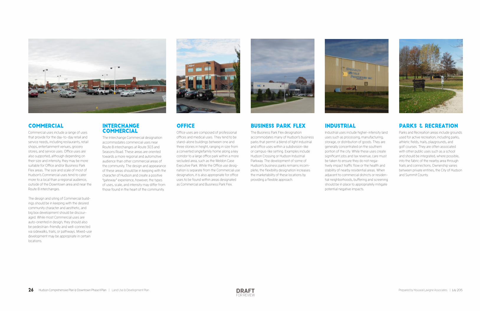
Commercial Commercial uses include a range of uses that provide for the day-to-day retail and service needs, including restaurants, retail shops, entertainment venues, grocery stores, and service uses. Office uses are also supported, although depending on their size and intensity, they may be more suitable for Office and/or Business Park Flex areas. The size and scale of most of Hudson’s Commercial uses tend to cater more to a local than a regional audience, outside of the Downtown area and near the Route 8 interchanges.
The design and siting of Commercial build-ings should be in keeping with the desired community character and aesthetic, and big box development should be discour-aged. While most Commercial uses are auto-oriented in design, they should also be pedestrian-friendly and well-connected via sidewalks, trails, or pathways. Mixed-use development may be appropriate in certain locations.
Interchange CommercialThe Interchange Commercial designation accommodates commercial uses near Route 8 interchanges at Route 303 and Seasons Road. These areas are oriented towards a more regional and automotive audience than other commercial areas of the community. The design and appearance of these areas should be in keeping with the character of Hudson and create a positive “gateway” experience, however, the types of uses, scale, and intensity may differ from those found in the heart of the community.
OfficeOffice uses are composed of professional offices and medical uses. They tend to be stand-alone buildings between one and three stories in height, ranging in size from a converted singlefamily home along a key corridor to a large office park within a more secluded area, such as the Weldon Case Executive Park. While the Office use desig-nation is separate from the Commercial use designation, it is also appropriate for office uses to be found within areas designated as Commercial and Business Park Flex.
Business Park Flex The Business Park Flex designation accommodates many of Hudson’s business parks that permit a blend of light industrial and office uses within a subdivision-like or campus-like setting. Examples include Hudson Crossing or Hudson Industrial Parkway. The development of some of Hudson’s business parks remains incom-plete; the flexibility designation increases the marketability of these locations by providing a flexible approach.
IndustrialIndustrial uses include higher-intensity land uses such as processing, manufacturing, storage, or distribution of goods. They are generally concentrated on the southern portion of the city. While these uses create significant jobs and tax revenue, care must be taken to ensure they do not nega-tively impact traffic flow or the health and stability of nearby residential areas. When adjacent to commercial districts or residen-tial neighborhoods, buffering and screening should be in place to appropriately mitigate potential negative impacts.
Parks & RecreationParks and Recreation areas include grounds used for active recreation, including parks, athletic fields, trails, playgrounds, and golf courses. They are often associated with other public uses such as a school and should be integrated, where possible, into the fabric of the nearby area through trails and connections. Ownership varies between private entities, the City of Hudson and Summit County.
26 Hudson Comprehensive Plan & Downtown Phase II Plan | Land Use & Development Plan Prepared by Houseal Lavigne Associates | July 2015DRAFTFOR REVIEW

Open Space Open Spaces are natural areas that are set aside for conservation purposes, are not conducive to development due to flooding or topographical issues, and/or provide passive green space within a subdivision or development. Open spaces are found throughout the community.
Public/Semi-PublicThe Public/Semi-Public land use is composed of institutions and commu-nity facilities that define Hudson’s overall quality of life. This use includes both public facilities, such as government facilities and public schools, as well as private facili-ties such as private schools and religious institutions. Cemeteries are also included within this designation. Public/semi-public land uses and related policies are discussed in more detail in Chapter 9: Community Facilities & Services Plan.
Utility/Rail Utilities and railroad rights-of-way provide critical infrastructure throughout the city. In addition to needed services, utility and rail rights-of-way also should also be lever-aged to improve pedestrian mobility and enhance access to parks and open space. Utilities and Rail are discussed in more detail in Chapter 7: Transportation & Mobility Plan and Chapter 9: Commu-nity Facilities & Services Plan.
FlexThe Flex designation is a special category reserved for two properties owned by the City of Hudson whose future use will be dictated by a combination of the City’s administrative and operational needs as well as community attitudes and market forces. The designation allows for the City to maintain flexibility in their future usage, provided that their future usage is appro-priate given the properties’ surrounding uses. Those properties include:
° Youth Development Center (YDC) Site
° Koberna Property
These properties are discussed in greater detail in Chapter 9: Community Facili-ties & Services Plan.
Youth Development Center (YDC) Site
Located in the northwestern part of the city, a conservation easement limits development on much of the site. Given its somewhat remote location, the develop-able portion could accommodate varied or numerous uses.
Koberna Property
Located near the prominent intersection of Route 91 and Terex Road, this property could accommodate civic, commercial, or office uses.
80
1 2
1 2
27July 2015 | Prepared by Houseal Lavigne Associates Land Use & Development Plan | Hudson Comprehensive Plan & Downtown Phase II PlanDRAFTFOR REVIEW

OHIO TURNPIKE
BOSTON MILLS RD.
W STREE
TSBORO
ST.
VALLEY VIEW RD.
W STREETSBORO ST.
BOSTON MILLS RD.
HINES HILL RD.
VALLEY VIEW
RD.
MIDDLETON RD. MIDDLETON RD.
INTERSTATE 480
HUDSON AU
RORA
RD.
STOW
RD.
AURO
RA ST
.
STOW
RD.
STOW
RD.
STOW
RD.
DARROW
RD.
TEREX RD.
S MAIN
ST.
TEREX RD.
TEREX RD.
BARLOW RD.HUDSO
N D
R.
BARLOW RD.
BARLOW RD.
SEASONS RD. NORTON RD.
SULLIVAN RD.
BARLOW RD.
RAVENNA ST.
RAVENNA ST.
E STREETSBORO ST.
STONE RD.
RAVEN
NA R
D.
WALT
ERS RD.
N M
AIN
ST.
DARROW
RD.
8
8
91
303
303
91
80
480
80
STREETSBORO
TWINSBURGMACEDONIA
BOSTONHEIGHTS
STOW
BOSTONTownship
MAP KEY
0 Miles 1
Hudson’s neighborhoods are the “building blocks” of the community, and their attractiveness, health, and character is vital to the success of the city and everyday quality of life. The Residential Areas Framework Plan provides policies and recommendations that can enhance established neighborhoods while diversifying housing options available to residents at various stages of their life, from young families and millennials to empty nesters and baby boomers. Key recommenda-tions include protecting the unique character of each type of residential area, diversifying the housing stock, regularly and consistently enforcing housing codes, preserving historic properties, abating noise in subdivisions along I-80, encouraging low impact development, and ensuring quality architectural design.
Residential AreasFrameworkPlan
Low Density Residential*Low density residential areas are predominantly de�ned by rural or agrarian character on the outer fringes of the community, away from the city core. Conversion of these areas into more intense development patterns should be prohibited, and any new development should protect the natural environment and embrace rural character.
Medium Density Residential*Hudson’s moderate density residential areas compose the majority of the city’s residential areas and are suburban in character. These areas are suitable for in�ll development within incomplete subdivisions.
High Density Residential*High density residential areas are composed of historic small lot single family detached homes, multi-family units, townhomes, and duplexes. New high density development should occur within or near Downtown Hudson, or proximate to regional trails, parks, or commercial areas.
* Code EnforcementConsistent and e�ective code enforcement should be undertaken within all residential areas.
Proposed Sites for New Higher DensityDevelopments (see page 32 for more detail)Several speci�c locations suitable for small-lot single family detached, new townhome, duplex, multi-family, condominium, or senior housing units have been identi�ed. An unmet demand for such units exists among young professionals, young families, empty nesters, and seniors.
Historic Preservation DistrictThe City should protect this historic district from incompatible development, support home owners in preserving and investing in their properties, and prevent any “demolition by neglect.” E�orts to research, document, and promote the character of the area should be encouraged. The City should also support expansion of the district to include currently unprotected homes with historic value.
Noise Abatement AreasSome neighborhoods near I-80 su�er from noise issues. Vegetation, sound walls, or berming should be implemented to improve quality of life.
Candidate Sites for Low Impact DevelopmentLow Impact Development allows developers the �exibility to cluster residential development in certain portions of a site and leave contiguous areas of stream bu�ers, wetlands, tree stands, and other assets undisturbed. Should sites that are currently undeveloped but located within residential areas develop over time, they should be candidates for such design.
Regional Trails and “Trail Oriented Development”New high density development, such as condominiums, apartments, townhomes, and duplexes, should be positioned in select locations along the proposed Veterans Trail and the existing Hike and Bike Trail to maximize recreational and transportation access for residents.
Non-Residential Areas
1
2
1 2
28 Hudson Comprehensive Plan & Downtown Phase II Plan | Land Use & Development Plan Prepared by Houseal Lavigne Associates | July 2015DRAFTFOR REVIEW

Hudson’s neighborhoods are the “building blocks” of the community, and their
attractiveness, health, and character is vital to the success of Hudson and everyday
quality of life. Throughout the public outreach process, residents expressed their
vision and concerns for the City’s residential areas. Building on this input and the
recommendations in the Land Use Plan, the Residential Areas Plan provides policies
and recommendations that can enhance established neighborhoods while diver-
sifying housing options available to residents at various stages of their life, from
young families and millennials to empty nesters and baby boomers.
Goal & RecommendationsPreserve and enhance the character of Hudson’s established neighborhoods while accommodating incremental residential development that can diversify and expand the local housing stock.
° Amend and adjust the Growth Management Residential Development Allocation System to balance continued management of new residential devel-opment with increased flexibility and responsiveness to market demands.
° Protect and preserve historic and archi-tecturally significant homes within the city core.
° Evaluate the present boundaries of the historic district and expand the district if appropriate.
° Continue to ensure that all residen-tial development utilize high-quality materials (including construction, repair, alteration, or addition) and conform to an architectural design that is keeping with the existing character of the community.
° Promote residential development and redevelopment of a variety of housing and dwelling unit types, tenures, and densities in accordance with the Land Use Plan.
° Encourage housing development that provides diverse and affordable choices.
° Support the development of “age targeted” housing units that allow Hudson’s seniors to age in place and remain in the community.
° Provide developers with the flexibility to cluster residential development in certain portions of a site, thereby leaving larger contiguous areas of stream buffers, wetlands, tree stands, and other assets undisturbed.
° Continue to preserve natural features such as mature trees and green space by integrating them into the overall design of subdivisions.
° Focus the development of higher-den-sity or multi-family units within the greater Downtown area.
° Evaluate changes to the Land Devel-opment Code that can allow greater flexibility in designing and developing higher-density homes such as duplexes and townhomes, in targeted areas.
° Preserve existing housing through regular and enhanced code enforce-ment.
° Work with the Ohio Turnpike and Infrastructure Commission to mitigate interstate noise pollution into adjacent neighborhoods.
Residential Areas Framework Plan
29July 2015 | Prepared by Houseal Lavigne Associates Land Use & Development Plan | Hudson Comprehensive Plan & Downtown Phase II PlanDRAFTFOR REVIEW
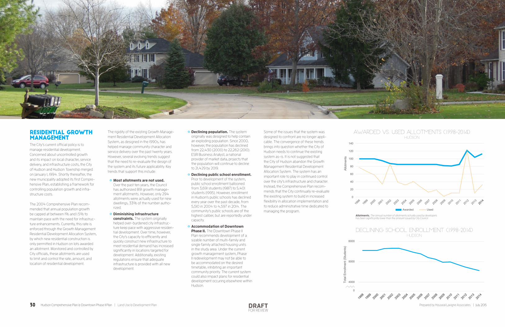
Residential Growth Management The City’s current official policy is to manage residential development. Concerned about uncontrolled growth and its impact on local character, service delivery, and infrastructure costs, the City of Hudson and Hudson Township merged on January 1, 1994. Shortly thereafter, the new municipality adopted its first Compre-hensive Plan, establishing a framework for controlling population growth and infra-structure costs.
The 2004 Comprehensive Plan recom-mended that annual population growth be capped at between 1% and 1.5% to maintain pace with the need for infrastruc-ture enhancements. Currently, this rate is enforced through the Growth Management Residential Development Allocation System, by which new residential construction is only permitted in Hudson on lots awarded an allotment. Monitored and controlled by City officials, these allotments are used to limit and control the rate, amount, and location of residential development.
The rigidity of the existing Growth Manage-ment Residential Development Allocation System, as designed in the 1990s, has helped manage community character and service delivery over the past twenty years. However, several evolving trends suggest that the need to re-evaluate the design of the system and its future applicability. Key trends that support this include:
° Most allotments are not used. Over the past ten years, the Council has authorized 891 growth manage-ment allotments. However, only 294 allotments were actually used for new dwellings, 33% of the number autho-rized.
° Diminishing infrastructure constraints. The system originally helped over-burdened city infrastruc-ture keep pace with aggressive residen-tial development. Over time, however, the City’s capacity to efficiently and quickly construct new infrastructure to meet residential demand has increased significantly in locations targeted for development. Additionally, existing regulations ensure that adequate infrastructure is provided with all new development.
° Declining population. The system originally was designed to help contain an exploding population. Since 2000, however, the population has declined from 22,430 (2000) to 22,262 (2010). ESRI Business Analyst, a national provider of market data, projects that the population will continue to decline to 21,429 by 2019.
° Declining public school enrollment. Prior to development of the system, public school enrollment ballooned from 3,691 students (1987) to 5,401 students (1995). However, enrollment in Hudson’s public schools has declined every year over the past decade, from 5,510 in 2004 to 4,597 in 2014. The community’s public schools are of the highest caliber, but are reportedly under capacity.
° Accommodation of Downtown Phase II. The Downtown Phase II Plan recommends development of a sizable number of multi-family and single family attached housing units in the study area. Under the current growth management system, Phase II redevelopment may not be able to be accommodated on the desired timetable, inhibiting an important community priority. The current system could also impact plans for residential development occuring elsewhere within Hudson.
Some of the issues that the system was designed to confront are no longer appli-cable. The convergence of these trends brings into question whether the City of Hudson needs to continue the existing system as-is. It is not suggested that the City of Hudson abandon the Growth Management Residential Development Allocation System. The system has an important role to play in continued control over the city’s infrastructure and character. Instead, the Comprehensive Plan recom-mends that the City continually re-evaluate the existing system to build in increased flexibility in allocation implementation and to reduce administrative time dedicated to managing the program.
0
4000
5000
6000
1998
1998
1999
1999
2000
2000
2001
2001
2002
2002
2003
2003
2004
2004
2005
2005
2006
2006
2007
2007
2008
2008
2009
2009
2010
2010
2011
2011
2012
2012
2013
2013
2014
2014
Declining School Enrollment (1998-2014)Hudson
Tota
l Enr
ollm
ent (
Stud
ents
)
Awarded vs. Used Allotments (1998-2014)
Allotments. The annual number of allotments actually used by developers has been significantly lower than the amount issued by City Council.
Hudson
0
20
40
60
80
100
120
140
Allo
tmen
ts
Awarded Used
2014
2014
0
4000
5000
6000
1998
1998
1999
1999
2000
2000
2001
2001
2002
2002
2003
2003
2004
2004
2005
2005
2006
2006
2007
2007
2008
2008
2009
2009
2010
2010
2011
2011
2012
2012
2013
2013
2014
2014
Declining School Enrollment (1998-2014)Hudson
Tota
l Enr
ollm
ent (
Stud
ents
)
Awarded vs. Used Allotments (1998-2014)
Allotments. The annual number of allotments actually used by developers has been significantly lower than the amount issued by City Council.
Hudson
0
20
40
60
80
100
120
140
Allo
tmen
ts
Awarded Used
2014
2014
30 Hudson Comprehensive Plan & Downtown Phase II Plan | Land Use & Development Plan Prepared by Houseal Lavigne Associates | July 2015DRAFTFOR REVIEW

Residential Character Areas The character and density of Hudson’s neighborhoods vary throughout the city. Hudson’s neighborhoods and subdivisions are categorized into three distinct cate-gories by density: low density, moderate density, and high density. It is important to note that “density” is a relative term; in the Residential Areas Plan, each term is relative to development patterns within Hudson.
Categorization helps distinguish the character, size, and scale of existing and future residential development by location, and delineates what type of residential development should occur where within the community. It also helps to identify concerns and policies that are specific to particular areas of the city.
Low Density
Low density residential areas are predomi-nantly defined by rural or agrarian character on the outer fringes of the community, away from the city core. They include farm homes sitting in the midst of pastures with rail fences and horses running freely, as well as large estates on multi-acre lots that were built in recent years. These areas harken back to Hudson’s more rural heritage, and contribute to the community’s character. Conversion of these areas into more intense development patterns should be prohibited, and any new development that does occur should protect the natural environment and embrace the community’s rural character.
Moderate Density
Hudson’s moderate density residential areas compose the majority of the city’s residential areas and are suburban in character. They are defined by subdivisions of colonial homes built on half-acre to one-acre lots situated along leafy, winding streets. Some subdivision have incorpo-rated natural features, trees, and ponds into the developments.
High Density
High density residential areas are composed of historic small lot single family detached homes, multi-family units, townhomes, and duplexes. They are located mostly within the city’s central core, however, other dense developments such as the Trails of Hudson or Laurel Lake Retirement Community are located outside of the core area. Generally, new high density development should occur within or near Downtown Hudson, or proximate to regional trails, parks, or commercial areas. It is imperative that any new development does not compromise the integrity of Hudson’s residential areas.
Code EnforcementThe enforcement of the City’s building code and property maintenance related ordinances is crucial in maintaining a quality environment for residents and businesses. The City should continue to support staff in undertaking consistent and effective code enforcement throughout all residential areas, and work with residents and neigh-borhood groups in rectifying any complaints or compliance issues within Hudson’s neighborhoods.
Additionally, as the number of rental units within the city is expected to increase based on the goals and objectives established in the Comprehensive Plan, it will be imper-ative that the City monitor rentals and ensure that landlords and tenants properly follow appropriate codes and procedures and maintain properties in keeping with Hudson’s desired community character.
Tools that the City could employ to prevent code violations and blight, and protect property values, include:
° Point of sale inspections
° Rental registrations
° Contractor registrations
° Neighborhood sweeps within problem areas to identify non-compliance
° New homeowner toolkits to educate property owners
31July 2015 | Prepared by Houseal Lavigne Associates Land Use & Development Plan | Hudson Comprehensive Plan & Downtown Phase II PlanDRAFTFOR REVIEW

Housing Stock DiversificationThe overwhelming majority of Hudson’s residential units are single family detached and owner-occupied homes. A dearth of smaller units or rental units prevents the attraction and retention of millen-nials, young professionals, lower wage employees, empty nesters, and seniors. Throughout the outreach process, the community overwhelmingly expressed a desire to see the addition of housing units that could accommodate these populations and diversify the local housing stock.
Approach
The City should encourage housing devel-opment that provides diverse choices at a variety of sizes and price points, as well as support the development of “age targeted” housing units that can allow Hudson’s seniors to age in place and remain in the community. Generally, these units should be located within the greater Downtown area and along major corridors, where tenants could enjoy proximity to trails, parks, shops, services, dining, and more. Encouraging such development near the Downtown would support retailers and restaurants in the Downtown and promote the use of non-motorized transportation options.
TRAIL ORIENTED DEVELOPMENT
“Trail Oriented Development” leverages regional trail access to create desirable higher-density residential units that can appeal to seniors, young professionals, recreation enthusiasts, and young families. New high density development such as condominiums, apartments, townhomes, and duplexes should be positioned along the proposed Veterans Trail and Hike and Bike Trail to maximize recreational and transportation access for residents.
Implementation Flexibility
It is important for the City to remain flex-ible, on a limited scale, in accommodating residential development that may not entirely be in accordance with the Land Use Map, but remains in keeping with the general spirit of the Plan and would help achieve the commu-nity’s objectives of diversifying the housing stock. For example, the City should consider the merits of projects that incorporate multi-family development along with commercial development along Route 91 or projects that incorporate multi-family or single family attached units within more traditional single-family detached subdivisions.
Regulatory Changes
Existing development regulations may need to be amended to accommodate higher density development in locations identified in the Land Use Plan and to make such projects more attractive to developers. The City should look at regulations impacting such development, including minimum lot size, setbacks, cul-de-sac dimensions, and garage orientation specifications. It is important to continue to promote quality development in keeping with Hudson’s character, however, slight alteration of existing codes may be necessary in targeted areas to achieve community objectives.
Sites
The Land Use Plan identifies several specific locations suitable for new town-home, duplex, multi-family, condominium, or senior housing units that can meet this demand. Possible locations include:
° Site #1: Downtown Phase II (pg. 28), along Morse Road and Owen Brown Street just west of the existing First and Main Area. The Downtown Phase II Plan recommends several multi-family developments with single family attached units behind these structures.
° Site #2: South Main Street (pg. 28), an undeveloped area to the west of South Main Street, behind a cluster of office uses. Access to nearby commer-cial uses, as well as the opportunity for residents to connect to Downtown via a new regional trail could make this site extremely desirable for a blend of single family attached and multifamily units.
480
80
80
8
891
303
303
91
Existing Bike/Hike Trail
Proposed Veteran’s Trail
High DensityCharacter Area
Trail Oriented Development
32 Hudson Comprehensive Plan & Downtown Phase II Plan | Land Use & Development Plan Prepared by Houseal Lavigne Associates | July 2015DRAFTFOR REVIEW
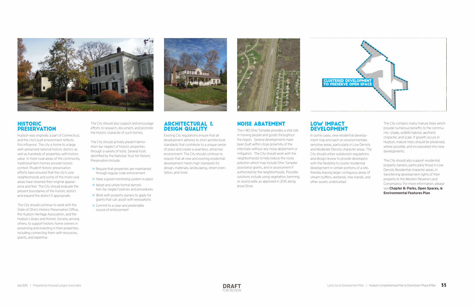
Historic PreservationHudson was originally a part of Connecticut, and the city’s built environment reflects this influence. The city is home to a large well-preserved national historic district, as well as hundreds of properties with historic value. In more rural areas of the community, traditional farm homes provide historic context. Prudent historic preservation efforts have ensured that the city’s core neighborhoods and some of the more rural areas have retained their original appear-ance and feel. The City should evaluate the present boundaries of the historic district and expand the district if appropriate.
The City should continue to work with the State of Ohio’s Historic Preservation Office, the Hudson Heritage Association, and the Hudson Library and Historic Society, among others, to support historic home owners in preserving and investing in their properties, including connecting them with resources, grants, and expertise.
The City should also support and encourage efforts to research, document, and promote the historic character of such homes.
The City should actively prevent demo-lition-by-neglect of historic properties through a variety of tools. Several tools identified by the National Trust for Historic Preservation Include:
° Require that properties are maintained through regular code enforcement
° Have a good monitoring system in place
° Adopt and utilize formal demoli-tion-by-neglect policies and procedures
° Work with property owners to apply for grants that can assist with renovations
° Commit to a clear and predictable course of enforcement
Architectural & Design QualityExisting City regulations ensure that all development adheres to strict architectural standards that contribute to a unique sense of place and create a seamless, attractive environment. The City should continue to require that all new and existing residential development meets high standards for design, materials, landscaping, street orien-tation, and more.
Noise AbatementThe I-80 Ohio Turnpike provides a vital role in moving people and goods throughout the region. Several developments have been built within close proximity of the interstate without any noise abatement or mitigation. The City should work with the neighborhoods to help reduce the noise pollution which may include Ohio Turnpike assistance grants, and or assessment if authorized by the neighborhoods. Possible solutions include using vegetation, berming, or sound walls as approved in 2015 along Jesse Drive.
Low Impact DevelopmentIn some cases, new residential develop-ment may encroach on environmentally sensitive areas, particularly in Low Density and Moderate Density character areas. The City should utilize subdivision regulations and design review to provide developers with the flexibility to cluster residential development in certain portions of a site, thereby leaving larger contiguous areas of stream buffers, wetlands, tree stands, and other assets undisturbed.
The City contains many mature trees which provide numerous benefits to the commu-nity: shade, wildlife habitat, aesthetic character, and scale. If growth occurs in Hudson, mature trees should be preserved, where possible, and incorporated into new developments.
The City should also support residential property owners, particularly those in Low Density Residential character areas, in transferring development rights of their property to the Western Reserve Land Conservancy. For more information, please see Chapter 8: Parks, Open Spaces, & Environmental Features Plan.
PROSPECT ST
RA
CHEL
WAY
Clustered Developmentto preserve open Space
33July 2015 | Prepared by Houseal Lavigne Associates Land Use & Development Plan | Hudson Comprehensive Plan & Downtown Phase II PlanDRAFTFOR REVIEW

OHIO TURNPIKE
BOSTON MILLS RD.
W STREE
TSBORO
ST.
VALLEY VIEW RD.
W STREETSBORO ST.
BOSTON MILLS RD.
HINES HILL RD.
VALLEY VIEW
RD.
MIDDLETON RD. MIDDLETON RD.
INTERSTATE 480
HUDSON AU
RORA
RD.
STOW
RD.
AURO
RA ST
.
STOW
RD.
STOW
RD.
STOW
RD.
DARROW
RD.
TEREX RD.
S MAIN
ST.
TEREX RD.
TEREX RD.
BARLOW RD.HUDSO
N D
R.
BARLOW RD.
BARLOW RD.
SEASONS RD. NORTON RD.
SULLIVAN RD.
BARLOW RD.
RAVENNA ST.
RAVENNA ST.
E STREETSBORO ST.
STONE RD.
RAVEN
NA R
D.
WALT
ERS RD.
N M
AIN
ST.
DARROW
RD.
8
8
91
303
303
91
80
480
80
STREETSBORO
TWINSBURGMACEDONIA
BOSTONHEIGHTS
STOW
BOSTONTownship
MAP KEY
0 Miles 1
Downtown Character Area*Considered the social hub and heart of the community, Downtown Hudson should o�er a range of uses within a walkable, mixed-use environment. Uni�ed streetscaping treatments can tie together di�erent components of the area.
Streetsboro Corridor Character Area*This corridor should be walkable and continue to re�ect denser development and the quality architectural styles seen within the city core. Opportunities to link it physically and visually with Downtown should be encouraged. An internal sidewalk network within Hudson Plaza Shopping Center will make it more pedestrian friendly.
South Main Corridor Character Area*Development should maintain a balance between the automobile and the pedestrian, and sidewalks should connect to the Downtown and nearby neighborhoods. The addition of multi-family and single family detached units on the western side of the corridor, behind o�ce and retail frontage, would be desirable. O�ce uses on the northern end of the corridor could provide consumers for neighboring retail.
Barlow Road Node Character Area*This node contains the site of a future hotel as well as a medical facility. This area is expected to remain a small node, hemmed in by single family detached homes and a golf course.
Darrow Road Corridor Character Area* This corridor is a “gateway” to the community and should be redeveloped over time to make a positive �rst impression. The southern portion of the corridor may be more regionally focused in nature, capitalizing on the intersection of Norton Road and Route 91, with the northern portion locally oriented.
Interchange Node Character AreaThese two interchange nodes should contain commercial uses tailored to a regional and automotive audience. Scale and appearance should be in keeping with Hudson’s character, however, commercial uses within these areas may be di�erent than those found within more core areas.
Established O�ce AreasHudson’s established o�ce areas include professional o�ces and medical uses. O�ce parks include Westpark Business Park, OMNI by the Lake, Hudson Professional O�ce Park, and OMNI Hudson. These locations are mostly built out, but could accommodate some intensi�cation.
Established Business Park Flex Areas Hudson’s established business park �ex areas accommodate a blend of light industrial and o�ce uses within a subdivision-like or campus-like setting. This includes Hudson Crossing, Georgetown Road, and parts of the Hudson Industrial Park. All three contain available land for new development.
Established Industrial AreasIndustrial areas include higher-intensity land uses such as processing, manufacturing, storage, or distribution of goods. It includes big individual sites as well as the Season Greene and Hudson Industrial Park. Both contain land for new development.
Expansion AreasThese areas are currently single family or undeveloped areas, although the Plan supports their eventual conversion to employment uses. Development within these areas should be discouraged while established o�ce, business park �ex, or industrial areas experience vacancy.
I-80An estimated 31,000 cars travel on I-80 daily, and nearby interchanges facilitate the movement of goods and people. The City should continue to work with partners to ensure that businesses have e�cient interstate access.
Re-Designation of Route 8 to I-380Re-designation of State Route 8 to I-380 would increase the attractiveness of operating a business in the area, assist in marketing and branding, and provide for additional road improvements.
Reinstate Rail to Active Status The City should work with Norfolk Southern and the Akron Metro Regional Transportation Authority to reinstate this rail line to active status to increase the marketability of industrial properties.
Hudson is an attractive place to do business, with access to a highly educated workforce, an excellent quality of life, a vibrant Downtown, and proximity to major interstates and highways. The Commercial and Employment Areas Framework Plan details policies and recommendations to maintain and enhance the City’s major commercial and employment areas. Key recommendations include strengthening Downtown as a vibrant mixed-use environment; enhancing the cohesiveness of the city’s commercial corridors and nodes; ensuring proper code enforcement; and focusing new office and industrial development within the city’s established office, industrial, and business parks as opposed to single family or greenfield conversion.
Commercial &employment areasFramework Plan
34 Hudson Comprehensive Plan & Downtown Phase II Plan | Land Use & Development Plan Prepared by Houseal Lavigne Associates | July 2015DRAFTFOR REVIEW

Hudson is an attractive place to do business, with access to a highly educated
workforce, an excellent quality of life, a vibrant Downtown, and proximity to major
interstates and highways. Many prominent national businesses are also head-
quartered in Hudson, including Jo-Ann Fabrics & Crafts Stores and Little Tikes.
Downtown Hudson is a regional draw for dining, entertainment, and culture. The
Commercial and Employment Areas Framework Plan details policies and recom-
mendations to maintain and enhance the City’s major commercial and employ-
ment areas, including Downtown Hudson, commercial corridors and nodes, office
areas, business parks, and industrial areas.
Goals & RecommendationsSupport and enhance Hudson’s retail, office, and industrial areas to provide goods and services compatible with the desired character of Hudson, well-paying employ-ment opportunities, and diversification of the tax base.
Community-wide
° Market and promote Hudson’s well-ed-ucated workforce, quality schools, ease of commuting, and high quality of life to prospective white collar employers.
° Market and promote Hudson’s interstate access, rail access, and available land to prospective industrial employers.
° Evaluate opportunities to simplify existing regulatory and permitting processes to make them more predict-able, streamlined, and business-friendly.
° Support commercial redevelopment (catering to both the local and regional population) along Darrow Road that can “make a statement” when entering Hudson from the south.
° Continue enforcing existing architecture and site design regulations that ensure attractive properties and explore regula-tions that ensure the proper installation and maintenance of landscaping.
° Where applicable, require the design of new developments to incorporate public amenities such as pocket parks, plazas, arcades, and connections to existing or proposed trails.
° Continue to ensure that all development is effectively screened and buffered from adjacent residential uses.
° Coordinate access with the intention of reducing curb cuts and promoting shared parking areas and internal cross access.
° Support the recruitment of new employers and expansion of existing businesses by establishing a close working relationship throughout all design, permitting, and construction phases.
° Host annual breakfasts or meetings that bring together city staff and members of the business community to discuss challenges, share ideas, and answer regulatory questions.
° Maintain excellent relationships with major employers such as Little Tikes and Jo-Ann Fabric and Craft Stores to support their retention and expansion in Hudson.
° Conduct exit interviews with businesses that choose to relocate from Hudson to better understand what influenced their decision.
° Prioritize completion of existing vacant industrial and office parks, or redevel-opment within existing industrial areas, before permitting green field develop-ment for industrial purposes.
° Evaluate the economic benefit of expanding utility services to currently underserved areas as a method of incentivizing economic growth.
° Maintain a centralized database of properties that are available for commercial or industrial development.
° Invest in modern infrastructure such as broadband that can support innovative and technology-based industry within Hudson.
° Work with neighboring communities, the Ohio Department of Transportation, and Ohio Turnpike and Infrastructure Commission to ensure that industrial tenants have efficient interstate access.
° Support the designation of State Route 8 to I-380.
DOWNTOWN
° Maintain Downtown Hudson as an exciting mixed-use environment and the heart of the community.
° Support the attraction and retention of a healthy mix of businesses that can contribute energy and vibrancy to Downtown Hudson.
° Continue to support the Hudson Chamber of Commerce and Destination Hudson’s efforts to market Downtown Hudson.
° Work with developers and property owners to identify sites for redevelop-ment along the western fringe of the First & Main development to better integrate the existing Downtown with the proposed Downtown Phase II area.
° Work with developers and property owners to Identify sites for infill devel-opment that could continue the Clinton Street streetwall from Main Street to Morse Road.
° Implement the North Main Streetscaping Plan.
° Establish a Downtown parking manage-ment plan that would account for the overall amount of parking needed to serve commercial uses, locations of point parking, the need for time limits, access management, and circulation.
° Evaluate opportunities for infill devel-opment within Downtown, such as the “Building 7” site and appropriate surface parking lots.
° Develop wayfinding signage that can direct visitors both to Downtown Hudson and within Downtown.
° Continue to publicize and host festivals and events that draw residents and tourists to Downtown, such as movie nights, ice cream socials, concerts, parades, food festivals, and more.
° Complete a continuous multi-pur-pose trail through Downtown to provide transportation alternatives and enhanced economic vitality.
° Implement the Downtown Phase II Plan and transform the study area into a vibrant area of office, mixed-use, and residential uses.
Commercial & Employment Areas Framework Plan
35July 2015 | Prepared by Houseal Lavigne Associates Land Use & Development Plan | Hudson Comprehensive Plan & Downtown Phase II PlanDRAFTFOR REVIEW

Commercial Areas Retail, dining, entertainment, services, and other commercial uses are concentrated within four character areas: Downtown Hudson and three commercial corridor nodes, Streetsboro Street, South Main Street, and Darrowville. While some corridors and thoroughfares may appear somewhat undeveloped relative to other communities, residents are comfortable traveling to neighboring communities to patronize malls, chains, and big box stores in order to preserve a more “small town” character. The Comprehensive Plan embraces this sentiment, but also allows for appropriate and context-sensitive commercial development and redevelop-ment within proper areas.
Downtown should serve a more regional consumer base, with niche shops and dining opportunities that draw from North-east Ohio. Commercial uses along Route 303, Route 91, and Barlow Road should be limited in size and scale, serving a more local consumer base.
Downtown Hudson
Considered the social hub and heart of the community, Downtown Hudson offers a range of civic, commercial, residential, and entertainment offerings. It is composed of three sub-areas, each playing a vital role in the Downtown fabric:
° Historic Downtown. The Historic Down-town sits along Main Street and has been the core of the community since Hudson’s founding. Most of the building stock dates from the 19th or early 20th Century, and notable historic structures include the Town Hall, Christ Church Episcopal, and Hudson Clock Tower. In the summer months, the Village Green provides outdoor space for community activities such as ice cream socials and concerts. The western side of Main Street contains mostly one- and two-story commercial structures.
° First and Main. In 2004, Downtown Hudson expanded westward with the completion of First and Main (“Downtown Phase I”). Financed via a public-private partnership, the multi-structured mixed-use develop-ment replaced an old industrial site. Varying building facades and styles create an attractive aesthetic and mimic a traditional downtown style. While some residents were initially concerned that the development would detract from Hudson’s “small town character,” it is viewed as a huge success today.
° Downtown Phase II. The Downtown Phase II area is an underutilized area that is well-positioned for a mixture of office and residential development. It should be a walkable extension of the Downtown’s mixed-use environ-ment. For more information, please see Chapter 6: Downtown Phase II Plan.
MIXED-USE ENVIRONMENT
Downtown is a mixed-use environment, with office buildings intermixing with civic uses, townhomes, quality restaurants, and niche shops. Downtown also contains several mixed-use buildings with retail on the ground floor and office space on the upper floors. This variety of different uses creates a vibrant and exciting atmosphere and unique sense of place. New develop-ment within Downtown Hudson should help contribute to this mixed-use environ-ment, with properties located at or near the sidewalk, parking in the rear, a building design that blends in with the existing fabric of the area, and continuation or establish-ment of a streetwall or edge.
480
80
80
8
891
303
303
91
225 or fewer
226-887
888-1,990
1,991-3,535
3,536 or greater
Jobs per Square Mile
36 Hudson Comprehensive Plan & Downtown Phase II Plan | Land Use & Development Plan Prepared by Houseal Lavigne Associates | July 2015DRAFTFOR REVIEW
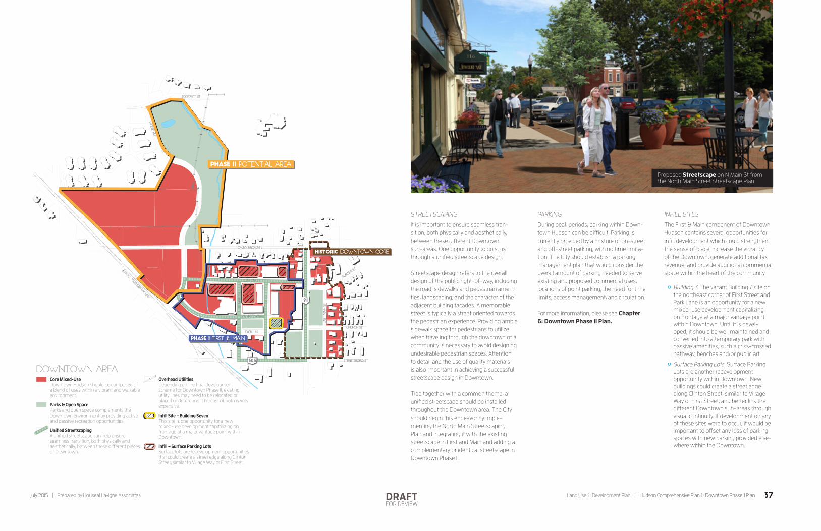
STREETSCAPING
It is important to ensure seamless tran-sition, both physically and aesthetically, between these different Downtown sub-areas. One opportunity to do so is through a unified streetscape design.
Streetscape design refers to the overall design of the public right-of-way, including the road, sidewalks and pedestrian ameni-ties, landscaping, and the character of the adjacent building facades. A memorable street is typically a street oriented towards the pedestrian experience. Providing ample sidewalk space for pedestrians to utilize when traveling through the downtown of a community is necessary to avoid designing undesirable pedestrian spaces. Attention to detail and the use of quality materials is also important in achieving a successful streetscape design in Downtown.
Tied together with a common theme, a unified streetscape should be installed throughout the Downtown area. The City should begin this endeavor by imple-menting the North Main Streetscaping Plan and integrating it with the existing streetscape in First and Main and adding a complementary or identical streetscape in Downtown Phase II.
PARKING
During peak periods, parking within Down-town Hudson can be difficult. Parking is currently provided by a mixture of on-street and off-street parking, with no time limita-tion. The City should establish a parking management plan that would consider the overall amount of parking needed to serve existing and proposed commercial uses, locations of point parking, the need for time limits, access management, and circulation.
For more information, please see Chapter 6: Downtown Phase II Plan.
INFILL SITES
The First & Main component of Downtown Hudson contains several opportunities for infill development which could strengthen the sense of place, increase the vibrancy of the Downtown, generate additional tax revenue, and provide additional commercial space within the heart of the community.
° Building 7. The vacant Building 7 site on the northeast corner of First Street and Park Lane is an opportunity for a new mixed-use development capitalizing on frontage at a major vantage point within Downtown. Until it is devel-oped, it should be well maintained and converted into a temporary park with passive amenities, such a criss-crossed pathway, benches and/or public art.
° Surface Parking Lots. Surface Parking Lots are another redevelopment opportunity within Downtown. New buildings could create a street edge along Clinton Street, similar to Village Way or First Street, and better link the different Downtown sub-areas through visual continuity. If development on any of these sites were to occur, it would be important to offset any loss of parking spaces with new parking provided else-where within the Downtown.
Streetsboro St
Clinton St
Owen Brown St
Prospect St
Village way
Norfo
lk South
erN Railw
ay
Park Ln
Church St
Main St
East
Main St
Auro
ra St
1st St
Library St
Morse Rd
303
91
Downtown areaCore Mixed-UseDowntown Hudson should be composed of a blend of uses within a vibrant and walkable environment.
Parks & Open SpaceParks and open space complements the Downtown environment by providing active and passive recreation opportunities.
Unied StreetscapingA uni�ed streetscape can help ensure seamless transition, both physically and aesthetically, between these di�erent pieces of Downtown.
Overhead UtilitiesDepending on the �nal development scheme for Downtown Phase II, existing utility lines may need to be relocated or placed underground. The cost of both is very expensive.
Inll Site – Building SevenThis site is one opportunity for a new mixed-use development capitalizing on frontage at a major vantage point within Downtown.
Inll – Surface Parking LotsSurface lots are redevelopment opportunities that could create a street edge along Clinton Street, similar to Village Way or First Street.
Phase I First & Main
Phase II Potential Area
Historic Downtown Core
Proposed Streetscape on N Main St from the North Main Street Streetscape Plan
37July 2015 | Prepared by Houseal Lavigne Associates Land Use & Development Plan | Hudson Comprehensive Plan & Downtown Phase II PlanDRAFTFOR REVIEW

CORRIDORS & NODES
Outside of Downtown, the Land Use Plan includes several commercial areas to provide for the day-to-day needs of residents. Commercial land uses have been intentionally limited to these areas to provide economies of scale as well as preservation of local character.
° Streetsboro Corridor. The Streetsboro Corridor stretches along the southern portion of Streetsboro Street from roughly Lennox Road to South College Street. While more auto-centric than neighboring Downtown Hudson, this corridor should be walkable and continue to reflect denser development and the quality architectural styles seen within the city core. Opportunities to link it physically and visually with the Down-town and Veterans Way Park should be encouraged. Frontage development and quality landscaping should remain. The addition of an internal sidewalk network within Hudson Plaza Shopping Center development could help make the area more accessible to pedestrians living nearby.
° South Main Corridor. The South Main Corridor spans South Main from roughly Stoney Hill Drive to Terex Drive. Development within this corridor should maintain a balance between the automobile and the pedestrian, and sidewalks should connect to the Downtown and nearby neighborhoods. The addition of multi-family and single family detached units on the western side of the corridor, behind office and retail frontage, could create a small commercial district capitalizing on this new residential density as well as access to the new regional trail that is slated to run along or near the rail right-of-way and link to Downtown. Office uses on the northern end of the corridor could provide consumers for neighboring retail.
° Barlow Road Node. The Barlow Road Node contains the site of a future hotel as well as a medical facility. This area is expected to remain a small node with minimal to no opportunities for retail, hemmed in by stable single family detached homes and a golf course.
° Darrow Road Corridor (Darrowville). The Darrow Road Corridor (Darrowville) acts as the southern gateway to Hudson. Commercial development should be attractive to make a positive first impression. Similar to the South Main Corridor, commercial uses should be well-connected to Downtown and neighboring residential areas, particularly the neighboring Trails of Hudson, with walkways or sidewalks. On the fringe of the community, the southern portion of the Darrow Road Corridor represents an opportunity to attract shoppers from outside of Hudson.
° Route 8 Interchange Nodes. The Route 8 Interchange Nodes are two commer-cial nodes designed to capitalize on regional highway traffic (54,000+ vehicles daily, as of 2014) on the western fringe of Hudson. Scale and appearance should be in keeping with the communtiy’s character, however, commercial uses within these areas may be different than those found within other commercial areas. Busi-nesses will be oriented more towards the automobile. Properties should be efficiently positioned to provide safe ingress/egress and to maximize highway visibility.
RIGHT-OF-WAY IMPROVEMENTS
Improvements to private property should also be complemented by public improve-ments made possible through partner-ships between the City, Ohio Department of Transportation, and others. These improvements could include the installation of missing sidewalk segments, gateway signage, parkway trees, and improved pedestrian crossings.
PROPERTY ASSEMBLY
The City should support innovative approaches to parcel assembly and comprehensive redevelopment in proper commercial areas, as long as new devel-opment is in keeping with the community’s size, scale, and character.
Industrial, Office, & Business Park AreasHudson’s industrial areas, offices, and business parks employ thousands of workers and play a critical role in broad-ening and diversifying the City’s tax base. These employers are not only important for their supply of local jobs, but because of the daytime population they attract and the support they provide to retailers and restaurants.
The following policy framework is intended to ensure the continued success of the community’s employment generators.
Prioritizing Established Areas
Prior to greenfield development in undevel-oped areas, public and private investment and development should occur within existing industrial, office, and business park areas that are already served by some level of infrastructure. This may include devel-opment on vacant areas within the parks or intensification of existing development. Many of Hudson’s business or industrial parks are currently experiencing moderate to high levels of vacancy.
° Georgetown Road, on the southern part of the city, provides for mostly office uses but could accommodate appro-priate light industrial uses. Opportunities for intensification exist on the vacant eastern portions of the subdivision.
° Hudson Crossing is a 130-acre site accommodating business park flex uses along Route 8. The majority of the park is currently undeveloped and is attractive for development relying on interstate access.
° Hudson Industrial Parkway is designed for heavier industrial uses and business park flex uses. Several properties along the main parkway remain undeveloped.
38 Hudson Comprehensive Plan & Downtown Phase II Plan | Land Use & Development Plan Prepared by Houseal Lavigne Associates | July 2015DRAFTFOR REVIEW

° Hudson Professional Office Park contains multiple professional office buildings near the intersection of Route 91 and Terex Road. Given proximity to the Akron Children’s Pediatrics and Summa Health Center, it may be the best location for new medical office uses.
° Omni by the Lake consists of four one-story office buildings. Intensifica-tion of the existing site may be possible, however, part of the site’s appeal is its beautiful natural features and access to Lake Forest.
° Omni Hudson is an office park along Route 91 designed for medical uses, given proximity to the Akron Children’s Pediatrics. The current site is built-out, but opportunities for westward expan-sion of this office cluster exist.
° Seasons Greene Eco-Industrial Park is a “green” industrial park designed for alternative and advanced energy companies on the southern part of Hudson. The site totals 136 acres but is entirely vacant. Green building practices will be encouraged, including LEED certification and natural stormwater management.
° Westpark Business Park is a business park along Boston Mills Road, home to a mixture of office tenants, including Allstate Insurance. Several properties within the site have undergone major renovations and new investment. Inten-sification may be possible.
Expansion Areas
The Land Use Plan identifies several areas for office, business park flex, and industrial expansion within Hudson. To the extent possible, any new development should be directed to established areas identified in the previous section. However, if those areas cannot adequately accommodate the needs of a prospective new business, it would be appropriate to work with them on identifying suitable greenfield or redevel-opment locations, such as along Seasons Road or Sullivan Road near the Route 8 interchange (for industrial uses) and between Hudson Drive and Terex Drive (for office uses).
Code Enforcement
The enforcement of the City’s building code and property maintenance related ordinances is crucial in maintaining a quality environment. The City should continue to support staff in undertaking consistent and effective code enforcement. Code should be enforced equally across all businesses within Hudson.
Infrastructure Provision
The City’s established and proposed office, business park flex, and industrial areas are currently served by varying levels of infrastructure: roads, power, water, sanitary sewer, stormwater sewer, and broadband. The City, in partnership with infrastructure providers, should use provision of infra-structure to steer development into priority areas and avoid development in areas that are of a lower priority. It may also be used as an incentives to attract or retain businesses.
Screening & Buffering
While Hudson’s industrial users and employers are important contributors to the local economy, it is important that their operations do not negatively impact the quality of life in Hudson’s established neighborhoods or the quality and function of neighboring commercial districts. Site screening including the use of landscaped buffers along property lines, loading area and dumpster screening, and parking lot perimeter landscaping should be used to improve the appearance of established employment areas from public rights-of-way. As new industry and employment development occurs, screening as well as landscaped buffers should also be constructed to establish horizontal separa-tion between these more intense uses and adjacent residential and commercial areas.
Re-Designation of Route 8 to I-380
Hudson’s industrial areas would greatly benefit from the re-designation of State Route 8, which runs along the western border of the community, to I-380. It would increase the attractiveness of operating a business in the area, assist in marketing and branding, and provide for additional funding opportunities for road improvements.
Rail Access
An inactive rail line currently runs in a southwesterly direction from the main Norfolk Southern line. The City should work with Norfolk Southern and the Akron Metro Regional Transportation Authority to rein-state this rail line to active status to increase the marketability of the Seasons Greene Eco-Industrial Park.
Business ClimateThe City’s perceived business climate is integral to economic growth. The City should undertake the following initiatives to ensure a positive climate and cooperation between the City and business owners:
° Host annual breakfasts or meetings that bring together city staff and members of the business community to discuss challenges, share ideas, and answer regulatory questions.
° Establish regular communication via web blasts and newsletters so that the City can identify issues impacting local businesses and be proactive in developing strategies to enhance these areas.
° Work more closely with business owners looking to invest in or improve their properties, assisting them with understanding and complying with regulations and procedures.
° Conduct exit interviews with businesses that choose to relocate from Hudson to better understand what influenced their decision.
° Employ a “customer service” focus in dealing with the community.
39July 2015 | Prepared by Houseal Lavigne Associates Land Use & Development Plan | Hudson Comprehensive Plan & Downtown Phase II PlanDRAFTFOR REVIEW