structure plan - planning
TRANSCRIPT

CARDINIA ROAD EMPLOYMENT PRECINCT STRUCTURE PLAN
(including the cardinia road employment precinct native vegetation precinct plan)
Amendment C130 to the Cardinia Planning Scheme
Incorporated Document September 2010

Prepared by Cardinia Shire Council in consultation with the Growth Areas Authority
Acknowledgements
Ark Resources
Ashton Traffic
CPG Australia Pty Ltd
Department of Sustainability and Environment
Department of Transport
Design Urban
Land Design Partnership
Melbourne Water
Stormy Water Solutions
VicRoads
WBCM
Cardinia Shire Council Henty Way, Pakenham
PO Box 7, Pakenham 3810
Phone 1300 787 624 Fax 03 5941 3784
www.cardinia.vic.gov.au

iCardinia Road Employment Precinct Structure Plan
The Cardinia Road Employment Precinct (the Precinct) represents a new model for employment delivery in growth areas. The Precinct is planned as an integrated commercial and industrial business park in a high amenity setting that is characterised by landscape wetland corridors, a diverse activity centre and quality residential area. It offers a business and operational environment superior to other locations in south-east Melbourne. To attract investment and encourage business establishment, extensive major transport infrastructure will be provided at the outset of development, numerous high-profile sites have been created and a range of goods and services will be delivered in the Precinct that is rarely available in industrial or business parks.
The Precinct is located in Cardinia Shire, in the Casey-Cardinia Growth Area south-east of Melbourne. Only 9 percent of the Shire’s 1,280 square kilometres is designated for urban development, known as the Cardinia Urban Growth Area. An extensive hinterland accesses goods and services from the Shire, expanding across Gippsland and the Dandenongs and encompassing the Shires of Bass Coast, Baw Baw, South Gippsland and Yarra Ranges.
Within the Cardinia Urban Growth Area is the Cardinia Employment Corridor and at is heart is the Precinct. Located south of the Princes Freeway, the accessibility of the Cardinia Employment Corridor to the east offers the opportunity for businesses to establish regional trade catchments, generating significant economic growth. Located adjacent to the City of Casey and with established transport links to Dandenong and the EastLink corridor, the location also offers the opportunity for businesses to serve areas to the west. These locational characteristics ensure Cardinia’s
Employment Corridor is well positioned to play a significant role in meeting both metropolitan and regional needs.
Of the five growth areas identified by the State Government in A plan for Melbourne’s growth areas (DSE 2006), Casey-Cardinia is the only area designated for urban expansion east of Melbourne. With the rate of development exceeding past growth forecasts and residential land supply becoming increasingly scarce, A plan for Melbourne’s growth areas (DSE 2006) released additional land for development: accommodating 135,000 to 170,000 new residents. As a result, the population of the Growth Area will increase by 220,000 persons from 2006 to 2031, with the total future resident population reaching ½ million.
A plan for Melbourne’s growth areas (DSE 2006) recognised the need for significant numbers of jobs to be delivered within the growth area, enabling a greater proportion of residents to access employment closer to where they live. A target to deliver between 100,000 and 140,000 jobs was set. A significant expansion to the Urban Growth Boundary (UGB) occurred in Cardinia Shire, creating the 2,500 hectare Cardinia Employment Corridor.
The release of additional land in Casey under Melbourne @ 5 Million (DPCD 2008) will further increase demand for employment, with the population anticipated to grow to over 600,000 residents. To ensure the delivery of an adequate number of jobs for the growth area, there is a need to deliver ‘more than just sheds’ of traditional industrial development, by facilitating the development of a mix of uses that are jobs-intensive and require a range of skills.
The Precinct is the catalyst for the development of the Cardinia Employment Corridor, planned to accommodate a diverse range of industry types in a business park setting. Its success in attracting investment will have a significant impact on the timing and density of development and job yields across the corridor. The Precinct’s land use mix is targeted to achieve this particular strategic outcome. The residential component underpins delivery of high-density, higher-skilled employment, providing the necessary support for goods, services and facilities that are a major ‘point of difference’ for this business park. It is within this context that the provision of residential uses within a designated employment precinct is supported.
New opportunities for major investment, economic growth and job creation will be provided in the growth area as a result of the implementation of the Cardinia Road Employment Precinct Structure Plan. The development of the Precinct will significantly enhance the quality of life of residents throughout the region, by providing an alternative choice of work destination closer to home.
Foreword

ContentsForeword i
01 Introduction 11.1 Composition of Documents 1
1.2 Role of the Precinct Structure Plan 1
1.3 Land to which the Precinct Structure Plan applies 1
1.4 Role of the Native Vegetation Precinct Plan 3
1.5 Land to which the Native Vegetation Precinct Plan applies 3
1.6 Implementation 3
1.7 Further Reference Material 3
1.8 Monitoring and Review 3
02 Local Context and Site Description 52.1 Metropolitan and Regional Context 5
2.2 Local Context 7
2.3 Precinct Features 12
03 Vision & Future Urban Structure 163.1 Vision 16
3.2 Integrated Precinct Design 18
3.3 Land Use Budget 25
3.4 Future Demographic Profile 30
04 Elements 334.1 Image and Character 33
4.2 Employment and Activity Centres 39
4.3 Housing 57
4.4 Community Facilities 64
4.5 Open Space and Natural Systems 69
4.6 Transport and Movement 90
4.7 Utilities, Energy and Sustainability 102
05 Precinct Infrastructure Plan 1075.1 Introduction 107
5.2 Infrastructure and services required 108
5.3 Project Coordination 108
5.4 Delivery and monitoring 108
06 Development Staging 1156.1 Development Staging 115
07 Other Information 1177.1 Glossary 117
7.2 Acronyms 120
7.3 Supporting Documents 121
Appendix A: Industrial Use Buffer Distances 122

Figure 1: Gateway to the Precinct: A High Amenity Commercial Core 17Figure 2: Sensitive Land Use Interfaces (Section 1 and 2) 37Figure 3: Sensitive Land Use Interfaces (Section 3 and 4) 38Figure 4: Building Typology – Commercial 46Figure 5: Building Typology – Industry 46Figure 6: Indicative Urban Design Framework - Activity Centre 55Figure 7: Indicative Subdivision Design along Western Arterial 60Figure 7a: Indicative Conventional & Medium Density Residential Typologies 62Figure 7b: Indicative High Density Residential Typologies 63Figure 8: Kaduna Park – Indicative Concept Plan 68Figure 9a: Open Space Interface 72Figure 9b: Open Space Interface 73Figure 10: Growling Grass Frog Ponds 81Figure 11: Road Cross Sections 95Figure 12: Road Cross Sections 96Figure 13: Road Cross Sections 97Figure 14: Road Cross Sections 98Figure 15: Activity Centre Main Street Section 99
Plans and FiguresPlan 1: PSP Area 2Plan 2: Metropolitan and Regional Context 6Plan 3: Local Context 8Plan 3a: PSP Areas 9Plan 4: Precinct Features 14Plan 5: Future Urban Structure 19Plan 6: Land Use Budget 27Plan 7: Image and Character Plan 34Plan 8: Employment and Activity Centres 40Plan 9: Housing 59Plan 10: Community Facilities 65Plan 11: Open Space Network 70Plan 12: Water Management 71Plan 13: Biodiversity Management 78Plan 14: Road Network 91Plan 15: Public Transport 100Plan 16: Walking and Trails 101Plan 17: Physical Services 103
Tables Key Requirements of Schedule 2 to the Urban Growth Zone
Plans Figures
Table 1: Estimated Employment Generation 20Table 2: Summary Land Use Budget 25Table 3: Property Specific Land Use Budget – Net Developable Area 28Table 4: Property Specific Land Use Budget – Employment Areas and Dwellings 29Table 5: Population Estimates by Dwelling Type 30Table 6: Employment Land Planning and Design Guidelines 42Table 7: Hierarchy of Activity Centres 47Table 8: Activity Centre Urban Design Guidelines 48Table 10: Community Facilities 64Table 11: Open Space Planning and Design Guidelines 74Table 12: Biodiversity Planning and Design Guidelines 79Table 13: Growling Grass Frog Habitat Planning and Design Guidelines 80Table 14: Road Hierarchy 94Table 15: Environmentally Sustainable Design Planning and Design Guidelines 105Table 16: Infrastructure and services required 109
Urban Design Framework: Princes Freeway Service Business Area 53Urban Design Framework: Commercial Core (including the Activity Centre) 53Site Context Report 56Construction Environmental Management Plan 76Conservation Management Plan - Growling Grass Frog 77Native Vegetation Precinct Plan 82Conditions for removal, destructive and lopping of native vegetation 87Sustainability Statement Requirements 106
NVPP Maps
NVPP Tables
Contents of Native Vegetation Precinct Plan
NVPP Table 1: Patches of native vegetation to be protected 84NVPP Table 2: Scattered trees to be protected 84NVPP Table 4: Scattered trees to be removed 87NVPP Table 5: Offset requirements for remnant vegetation 88NVPP Table 6: Offset Requirements for Scattered Trees 88
NVPP Map 1: Area to which the Native Vegetation Precinct Plan applies 83NVPP Map 2: Native vegetation to be protected and removed 85

1Cardinia Road Employment Precinct Structure Plan
1.1 Composition of DocumentsThis document comprises two incorporated documents. The Cardinia Road Employment Precinct Structure Plan (PSP) and the Cardinia Road Employment Precinct Native Vegetation Precinct Plan. (NVPP) The documents and their inter-relationship are explained below.
1.2 Role of the Precinct Structure Plan
The PSP has been prepared by Cardinia Shire Council in conjunction with the Growth Areas Authority (GAA), government agencies, service authorities and major stakeholders.
The PSP is a long-term plan for urban development. It describes how the land is expected to be developed, the infrastructure and services planned to support the new community and how they will be delivered as well as protecting and enhancing valuable natural and historic features.
The PSP:
• enables the transition of non-urban land to urban land;
• sets the vision for how land should be developed and the desired outcomes to be achieved;
• determines the overall layout of future land use and development;
• enables the assessment, protection and enhancement of biodiversity values in the context of surrounding future urban development;
• outlines projects required to ensure that future workers, residents and visitors within the Precinct can be provided with timely access to services and transport necessary to attract investment and support a quality lifestyle;
• details the design requirements for built form and conditions that must be met by future land use and development;
• informs the use and development controls that apply in the schedule to the Urban Growth Zone and what permits may be granted under the Schedule to the Zone; and
• provides developers, investors and local communities with certainty about future development.
The PSP is informed by:
• The State Planning Policy Framework set out in the Cardinia Planning Scheme, including the Growth Area Framework Plans and the Precinct Structure Planning Guidelines (GAA 2009); and
• The Local Planning Policy Framework of the Cardinia Planning Scheme and other local policies and strategies (under Clause 21 and 22).
1.3 Land to which the Precinct Structure Plan applies
The PSP applies to the land shown in Plan 1 and shown on the Cardinia Planning Scheme maps as Schedule 2 to the Urban Growth Zone (UGZ2). The PSP applies to approximately 590 hectares of land, which is generally defined by:
• Princes Freeway (including Pakenham Bypass) to the north;
• Toomuc Creek to the east;• the regional electricity transmission line easement to
the south; and• Gum Scrub Creek to the west.
01 Introduction

2 Cardinia Road Employment Precinct Structure Plan
Plan 1: PSP Area
CARD
INIA
ROAD
LECKY ROAD
HENRY ROAD
ENTERPRISE ROAD
RIX ROAD
MARY STREET
OFF
ICER
S
OU
TH
STAT
ION
STR
EET
PRINCES
HIGHWAY
GREENHILLS ROAD
PRINCES FREEWAY
KEYS LANE
Officer Rail Station
Cardinia Road Rail Station (proposed)
PATTERSON ROAD
MC
GR
EGO
R
R
OAD
Ref: 3410116UCRDate: 25 Aug 2010
Rev.: UDrawn: HW
Checked: MW
Scale: 1:12,500m @ A11:25,000m @ A3
Pla
n 1
: Pre
cinc
t Stru
ctur
e P
lan
Are
aC
ardi
nia
Roa
d E
mpl
oym
ent P
reci
nct S
truct
ure
Pla
n
planning & urban designmelbourne - tel 9869 0800
© sm urban pty ltdabn 99 124 206 819
trading as smec urban
0 125 250 375m
0 125 250 375m
LEGENDPrecinct Structure Plan Area
Urban Growth Boundary
Existing Waterways
Drainage Lines
State Freeway
State Highway
Existing Road (urban standard)
Existing Road (rural standard)
Rail Station and Line
Transmission Easement
Future Urban Area
Existing Urban Area
LEGENDPrecinct Structure Plan Area
Urban Growth Boundary
Existing Waterways
Drainage Lines
State Freeway
State Highway
Existing Road (urban standard)
Existing Road (rural standard)
Rail Station and Line
Transmission Easement
Future Urban Area
Existing Urban Area

3Cardinia Road Employment Precinct Structure Plan
1.4 Role of the Native Vegetation Precinct Plan
The NVPP has been prepared for the purposes of clause 52.16 of the Cardinia Planning Scheme. It identifies:
• native vegetation which may be removed without a planning permit
• the offsets that must be provided to remove the native vegetation which can be removed; and
• native vegetation to be protected which cannot be removed without a permit.
The NVPP has been included within the PSP document because clause 52.16 anticipates that it can be and because the NVPP is one of the planning tools that is used to facilitate development in accordance with the PSP. However, the NVPP is a separate incorporated document notwithstanding it is found within the PSP.
The statutory basis for the NVPP is clause 52.16 of the Cardinia Planning Scheme and not Schedule 2 to the Urban Growth Zone. Users of this document should note that the NVPP has a different statutory basis to the PSP.
1.5 Land to which the Native Vegetation Precinct Plan applies
The NVPP applies to the land identified in NVPP Map 1 (which in the case of the Cardinia Road Employment Precinct covers the same land as the PSP and UGZ 2).
1.6 Implementation The Cardinia Road Employment Precinct Structure Plan will be implemented by:
• development proponents who develop land generally in accordance with this PSP;
• the Victorian Government and Cardinia Shire Council by funding, delivering and managing a range of infrastructure and services to support the development of the Precinct;
• development proponents, the Victorian Government and Cardinia Shire Council in attracting investment and encouraging major businesses to establish in the Precinct; and
• non-government service providers and individuals such as volunteers who manage and deliver services.
• Amendment C130 to the Cardinia Planning Scheme will implement the PSP through:
– Schedule 2 to the Urban Growth Zone at Clause 37.07;
– the proposed Cardinia Road Employment Precinct Infrastructure Funding Agreement made under Section 173 Agreement of the Planning and Environment Act 1987;
– a Developer Contributions Plan Overlay, potentially requiring a Developer Contributions Plan to be incorporated into the Scheme at Clause 45.06 in the future;
– the Cardinia Road Employment Precinct Native Vegetation Precinct Plan incorporated in the Scheme at Clause 52.16 (Note: This document is included within and forms part of this Precinct Structure Plan); and
– other requirements of the Planning Scheme, as appropriate.
1.7 Further Reference Material A glossary and other information including details of technical studies supporting the preparation of this PSP are listed in Section 7.3 Supporting Documents.
1.8 Monitoring and Review Cardinia Shire Council and the Growth Areas Authority will jointly monitor the implementation of the PSP. Its effectiveness will be evaluated regularly, at least every five years. The PSP may be revised and updated following review, which may trigger a review of the Infrastructure Funding Agreement or Development Contributions Plan (if one is prepared in the future).

4 Cardinia Road Employment Precinct Structure Plan
This page has been left blank intentionally.

5Cardinia Road Employment Precinct Structure Plan
2.1 Metropolitan and Regional Context
Located in Cardinia Shire, the Cardinia Road Employment Precinct (the Precinct) is approximately 50 kilometres south-east of Melbourne CBD and 20 kilometres east of the Dandenong Central Activities District (CAD).
The Casey-Cardinia Growth Area has experienced high levels of population growth over the past fifteen years, with the highest proportion of new urban development in Melbourne occurring in the corridor. Areas such as Dandenong, Rowville, Scoresby, Clayton and Cheltenham have historically provided jobs for residents of the growth area, with the majority of people commuting to established employment nodes north and west of Dandenong. At the time of the 2006 Census, Cardinia Shire had a total population of 56,000 residents and Casey had a total population of 214,000 residents. The population is forecast to double over the next 15 to 20 years, generating the need to provide substantial new local employment.
Historically, the rate of job creation has not kept pace with population growth. Increasing scarcity of zoned and serviced industrial land has placed pressure on industry and the broader community. To meet future job requirements and optimise community resilience and prosperity, a significant number and diversity of jobs must be delivered within the growth area.
To deliver sufficient jobs, additional land for employment has been provided in the Cardinia Employment Corridor. Located south of the Princes Freeway, this corridor extends from Cardinia Creek to the edge of the urban growth boundary, east of Koo Wee Rup Road. Covering an area of approximately 2,500 hectares it forms the largest contiguous greenfields employment zone east of Dandenong.
The Cardinia Road Employment Precinct is the catalyst for development, planned to stimulate investment in jobs-intensive industries. Located centrally to the Cardinia Employment Corridor, the intensity of development in the Precinct will impact upon investment attraction and job densities across the balance of the corridor. The strategic planning carried out for this Precinct provides for the detailed implementation of the Casey-Cardinia Growth Area Framework Plan (DSE 2006) and outlines how the development of the Precinct will achieve the objectives of the Plan for Melbourne’s Growth Areas.
In the broader metropolitan and regional context (refer Plan 2), the development of the Precinct will be influenced by:
• established and planned employment areas such as:
– Dandenong South, an existing employment area where major corporations control greenfield sites;
– Hallam, an existing employment area located just east of Dandenong, which is fully developed;
– Cranbourne West, a new employment node located on Western Port Highway, where a 340 hectare industrial and commercial park is being developed;
– Narre Warren-Fountain Gate Business Park, located at the intersection of the Princes Highway and Princes Freeway. Designated for office development, the area is part of the Narre Warren-Fountain Gate Principal Activity Centre (PAC);
– Casey Technology Park at Berwick, where Monash University Berwick and Casey Hospital are located. The area is planned to be developed for technology-related business and research and development activities;
– C21 Business Park, a new employment node located just south of the Princes Freeway, adjacent to Cardinia Creek; and
– potential additional employment land in the City of Casey, which will be investigated as part of the Melbourne @ 5 Million Framework Plan process.
• an extensive network of State freeways, highways and major roads, such as:
– Princes Freeway (including the Pakenham Bypass) that links to metropolitan Melbourne and EastLink (via the Monash Freeway) and Gippsland to the east;
– Princes Highway that is a secondary link to metropolitan Melbourne, EastLink and Gippsland;
– an upgraded Healesville-Koo Wee Rup Road connecting the Princes Freeway to South Gippsland Highway, including a bypass of Koo Wee Rup and a longer-term freeway connection to the Princes Freeway just east of the Precinct;
– South Gippsland Highway, which connects from Dandenong South to South Gippsland, including providing links to Phillip Island and Wilsons Promontory;
– Western Port Highway (proposed to be upgraded to a freeway) that connects to the Port of Hastings and Mornington Peninsula;
– EastLink, which provides access (via the Monash Freeway) to the corridor of established employment areas from Frankston to Ringwood;
– Thompsons Road, a major arterial road that will be extended to provide east-west access from the eastern edge of the Cardinia Employment Corridor to EastLink at Carrum Downs, connecting the several major employment areas including the C21 Business Park and Cranbourne West along its alignment; and
02 Local Context and Site Description

6 Cardinia Road Employment Precinct Structure Plan
CardiniaShire
CardiniaShire
City ofCasey
City ofCasey
Cardinia C
reek
Card inia C
reek
Long Term Freeway Connection
10km
20km
5km
5km
10km
THOMPSONS
ROAD
BALLARTO
ROAD
WES
TERN
POR
T
HIG
HWAY NA
RRE
WAR
REN
- CR
ANBO
URNE
ROA
D
SOUTH
GIPPSLAND
HIGHWAY
HALL
AM
RO
AD
GLASSCOCKS
ROAD
HEATHERTON ROAD
EAST
LINK
EAST
LINK
PRINCES HIGHWAY
PRINCES HIGHWAY
PRINCES FREEWAY
KOO
WEE
RUP
RO
AD
PRINCES FREEWAY
CLYD
E RO
AD
FOUNTAIN GATE
DANDENONGCAD
SPRINGVALE
OFFICER
CRANBOURNE
PAKENHAM
ENDEAVOURHILLS
HAMPTON PARK
CASEY CENTRAL
BERWICK
UPPER BEACONSFIELD
To Drouin/Warragul
MELBOURNE - BAIRNSDALE RAILWAY
ROYAL BOTANIC GARDENS
CRANBOURNE
TO MELBOURNECBD
0 1000 2000 3000m
Plan 2: Metropolitan & Regional ContextCardinia Road Employment Precinct Structure Plan
ref.: 3410116UCRdate: 25 August 2010
rev.: Udrawn: RL
checked: MH
please note:This plan is based on preliminary information
only and may be subject to change as a result of formal Council/Authority advice, detailed site
investigations and confirmation by survey
planning & urban designmelbourne - tel 9869 0800
© smec australia pty ltdabn 47 065 475 149
trading as smec urban
Urban Growth Boundary
Rail Line
Significant Waterways
Cardinia Road Employment Precinct Structure Plan Area
Existing Employment
Proposed Employment
Urban Area
Proposed Central Activities District (CAD)
Existing & Proposed Principal Activity Centre (PAC)
Existing & Proposed Major Activity Centre (MAC)
Regional Open Space/Creek Corridors
Municipal Boundary (Cardinia Creek)
New Urban Area
Existing State Freeway
Future State Freeway
Existing State Highway
Future State Freeway (Upgrade from Highway)
Existing Arterial Road
Future / Potential Future Arterial Road
LEGEND
0 1 2 3km
Plan 2: Metropolitan and Regional Context

7Cardinia Road Employment Precinct Structure Plan
2.2 Local Context
2.2.1 History The Bunurong People had custodianship of a significant proportion of Cardinia Shire prior to European settlement. The Bunurong had spiritual obligations to maintain the country of Lohan, the dreamtime ancestor who created much of the country between the mouth of the Yarra River and Wilsons Promontory. Indigenous campsite remains are likely to be located across the entire Koo Wee Rup floodplain.
The district was settled by Europeans in the early 1900s. Within the Precinct, the European history of the area is represented by ‘Kaduna Park’ homestead, located just west of Cardinia Road. ‘Kaduna Park’ is a circa 1912 Edwardian-era weatherboard dwelling, representative of dwellings associated with early farming endeavours in the area.
2.2.2 Surrounding Neighbourhoods The future urban area in Cardinia Shire surrounds the Princes Freeway, with residential precincts north of the Freeway and employment precincts to the south (as shown in Plan 3 and 3a).
The residential precinctsThe Cardinia Road Precinct Structure Plan area is located immediately north of the Precinct. Principally a residential community, development of the area is currently underway. The Cardinia Road Precinct Structure Plan covers the Lakeside Estate, a largely established high-quality residential area. It has attracted a more diverse demographic to Pakenham due to its quality design and facilities such as the Cardinia Cultural Centre.
– Glasscocks/Grices Road, a second arterial that runs parallel with Thompsons Road, providing east west access from the Precinct to Carrum Downs.
• an expanding activity centre network that includes: – Dandenong Central Activities District, intended
to provide a ‘regional CBD’ to serve Melbourne’s south-east;
– Principal Activity Centres at Narre Warren-Fountain Gate and Cranbourne; and
– Major Activity Centres at Pakenham, Officer, Berwick, Casey-Central, Hampton Park and Endeavour Hills.
• an established rail network, encompassing: – a metropolitan railway line, which branches
into the Pakenham and Cranbourne lines at Dandenong. The railway line runs parallel to the Princes Freeway, centrally to Cardinia Shire’s future residential area; and
– a V-Line regional railway service, connecting to Gippsland from Pakenham Station.
• an extensive open space network, that includes: – Toomuc Recreation Reserve, a significant
Regional Open Space area; – waterways such as Gum Scrub Creek, Toomuc
Creek, Deep Creek and Cardinia Road Drain which form part of the Toomuc/Deep Creek Outfall Catchment and the Koo Wee Rup Flood Protection District; and
– Cardinia Creek, which defines the boundary of City of Casey and Cardinia Shire and provides a significant urban break between suburbs. It also provides a series of linked parks, known as the Cardinia Creek Parklands, which stretch over 400 hectares along 10 kilometres of Cardinia Creek.

8 Cardinia Road Employment Precinct Structure Plan
DAN
DENONG RANGES FOOTHILLS
DAND
ENONG RANGES FOOTHI LLS
Princes Freeway
Transmission Easement
Toom
uc C
reek
Officer
Pakenham
Princes Freeway
Card
inia
R
oad
Card
inia
Roa
d
Princes Highway
Race
cour
se R
oadMc
Greg
or
Road
Transmission Easement
Gas Pipeline
Melbourne - Bairnsdale Railway
Melbourne - Pakenham Railway
Beaconsfield
Cardinia Creek
(Shire Boundary)
Greenhills Road
Gum Scrub Creek
Toom
uc
Vall
ey
Road
Offic
er
Sou
th
Road
McMu
llen
Rd
Old Princes Highway
Heale
sville
- Ko
o W
ee R
up R
oad
Thompsons Road
Gas Pipeline Transmission Easement
Long Term Freeway
Connection
Deep
Cre
ek
Grices/Glasscocks Road Extension
0 400 800 1200m
Urban Growth Boundary
Railway & Transport Interchanges
Principal Public Transport Network
Significant Waterways
Existing Freeway
Future Freeway
Highway
Existing Arterial Road
Future / Potential Future Arterial Road
Main Road
Cardinia Road Employment Precinct Structure Plan Area
Existing Employment
Proposed Employment
Existing Residential
Proposed Residential
Existing Schools & Community Facilities
Proposed Schools & Community Facilities
Designated Neighbourhood Activity Centre (NAC)
Designated Major Activity Centre (MAC)
60m Contour
Open Space & Drainage Corridors
Existing and Proposed Activity Centre
Municipal Boundary
LEGEND
Plan 3: Local ContextCardinia Road Employment Precinct Structure Plan
ref.: 3410116UCRdate: 25 August 2010
rev.: Udrawn: RL
checked: MH
planning & urban designmelbourne - tel 9869 0800
© smec australia pty ltdabn 47 065 475 149
trading as smec urban0 200 400 600m
please note:This plan is based on preliminary information
only and may be subject to change as a result of formal Council/Authority advice, detailed site
investigations and confirmation by survey
Plan 3: Local Context
9Cardinia Road Employment Precinct Structure Plan
Plan 3a: PSP Areas
DA
NDENONG RANGES FOOTHILLS
DANDENONG RANGES FOOTHILLS
Princes Freeway
Transmission Easement
Toom
uc C
reek
Princes Freeway
Card
inia
R
oad
Card
inia
Roa
d
Princes Highway
Race
cour
se R
oadMc
Greg
or
Road
Transmission Easement
Gas Pipeline
Melbourne - Bairnsdale Railway
Melbourne - Pakenham Railway
Cardinia Creek
(Shire Boundary)
Greenhills Road
Gum Scrub Creek
Toom
uc
Vall
ey
Road
Offic
er
Sou
th
Road
Old Princes Highway
Heale
sville
- Ko
o W
ee R
up R
oad
Thompsons Road
Gas Pipeline Transmission EasementBeaconsfield
Officer
Pakenham
Officer PSP Area
Cardinia RoadPSP Area
C21 BusinessPark PSP Area
Clyde NorthPSP Area
Officer EmploymentPSP Area
Pakenham WestPSP Area
Cardinia RoadPSP Area 2
Pakenham SouthEmployment PSP Area
Pakenham SouthEmployment PSP Area 2
Deep
Cre
ek
Grices/Glasscocks Road Extension
Long Term Freeway
Connection
Urban Growth Boundary
Railway & Transport Interchanges
Significant Waterways
Existing Freeway
Future Freeway
Highway
Existing Arterial Road
Future / Potential Future Arterial Road
Main RoadCardinia Road Employment Precinct Structure Plan Area
60m Contour
Municipal Boundary
Existing Urban Development
LEGEND
Plan 3a: PSP AreasCardinia Road Employment Precinct Structure Plan
ref.: 3410116UCRdate: 25 August 2010
rev.: Udrawn: RL
checked: MH
planning & urban designmelbourne - tel 9869 0800
© smec australia pty ltdabn 47 065 475 149
trading as smec urban0 200 400 600m
0 400 800 1200m
please note:This plan is based on preliminary information
only and may be subject to change as a result of formal Council/Authority advice, detailed site
investigations and confirmation by survey

10 Cardinia Road Employment Precinct Structure Plan
A wide range of infrastructure and facilities will be delivered in the Cardinia Road Precinct that support the Cardinia Road Employment Precinct, including schools, active open space reserves, arterial road connections and access to public transport services via Cardinia Road Station.
Residential development has continued in the Pakenham area in recent years, with the land east of Toomuc Creek already significantly developed. Located centrally to the area is the Pakenham Major Activity Centre, which provides the widest range of goods and services in Cardinia Shire.
The preparation of Officer Precinct Structure Plan is underway, including planning of the Officer Major Activity Centre located in a new residential community of approximately 30,000 people. It will also deliver a wide range of infrastructure and facilities that will support the employment precincts.
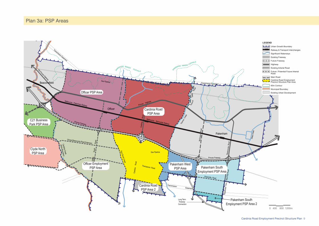
The employment precinctsThe Cardinia Employment Corridor has a total area of approximately of 2500 hectares, which has been divided into four precincts:
• Cardinia Road Employment Precinct (the Precinct);• Pakenham South Employment Precinct, located
east of McGregor Road to the eastern edge of the Urban Growth Boundary. Encompassing South East Business Park, the area is already partially zoned for industrial use. It is planned to accommodate local and regional industrial businesses in addition to a bulky goods area;
• Pakenham West Employment Precinct, located between Toomuc Creek and McGregor Road, with the future Koo Wee Rup Bypass alignment connecting to the Princes Freeway centrally to the area; and
• Officer Employment Precinct, a future major employment precinct of 1050 hectares, located west of Gum Scrub Creek and extending across to Cardinia Creek.
A precinct-based approach has been adopted to enable growth and development of the Cardinia Employment Corridor to be effectively managed, based on the following principles:
• stage the release of land to match demand;• maximise the diversity of investment and
employment through land supply;• stimulate demand by creating a critical mass of
activity and development in consolidated nodes to attract additional investment;
• ensure future planning accommodates the changing needs of industry and community, as demand for different employment land types evolves; and
• concentrate infrastructure investment in consolidated nodes to create a superior business and operational environment.
A number of employment land development opportunities exist, including:
• large format campus style office park development;• land efficient transit orientated development;• core activity centre development;• major road access; • proliferation of high-profile sites along State
Freeways and arterial roads; and• local business establishment and expansion.However, the local context also presents clear challenges for the delivery of the vision for the Precinct. The scale of the Cardinia Employment Corridor requires the release of employment land to be carefully managed, balancing supply with demand.
To establish a successful and concentrated ‘core’ of activity, demand must be directed into the Precinct, maximising its attractiveness to additional investment.
To achieve a critical mass of development in the Precinct, the release of additional land in the Cardinia Employment Corridor should be discouraged until the commercial area within the Precinct has significantly established. The dispersal of investment will otherwise impact upon land uptake rates within the Precinct, adversely affecting the timing and density of jobs.
2.2.3 Transport and Movement The Princes Freeway runs along the northern edge of the Precinct, providing the major metropolitan and regional road connection for the area. This is supported by the Princes Highway, a designated Principal Public Transport Network (PPTN) route. These two major east-west routes are accessed via Cardinia Road, which runs centrally through the Precinct.
There is no existing arterial road network within the Cardinia Road Employment Precinct. There are three existing rural roads: Cardinia Road (rural seal), Lecky and Enterprise Road (graded surfaces), which will be upgraded as the Precinct develops. Future connections to arterial roads in Casey and planned upgrades of existing north-south roads within Cardinia Shire will deliver a clear grid system within the Growth Area.
North of the Freeway, the upgrade of Cardinia Road to an urban arterial standard is underway. The planned future duplication of Cardinia Road and delivery of a second bridge over the Princes Freeway and grade separation of the railway line will significantly improve accessibility between the Cardinia Road and Cardinia Road Employment Precincts. Duplication of Cardinia Road south of the Freeway will also occur as traffic volumes increase over time.
11Cardinia Road Employment Precinct Structure Plan
Two new east-west arterial roads are planned to be constructed in the Precinct. Thompsons and Glasscocks / Grices Road will connect the arterial road networks of the City of Casey and Cardinia Shire. These will enhance access between the Pakenham and Officer Employment Precincts and the Major Activity Centres, providing alternative access to Officer South Road, McGregor Road and Koo Wee Rup/Racecourse Road.
The delivery of a freeway interchange at Officer South Road will also improve access to the Precinct from the west.
The Melbourne to Bairnsdale (Pakenham metropolitan line) railway line is located approximately 1 kilometre north of the Princes Freeway, with Cardinia Road Station being constructed east of Cardinia Road. The existing Principal Public Transport Network (PPTN) bus route serving the area connects Narre Warren-Fountain Gate to Pakenham, along the Princes Highway. The development of the Precinct and the broader Cardinia Employment Corridor requires a substantial expansion of the public transport network to meet the needs of the community, particularly to provide a viable alternative mode of transport for journey to work trips.
Melbourne 2030 identifies the need to protect the long-term options for a new general aviation airport in the south-east of Metropolitan Melbourne, by ensuring that urban development does not impinge on possible sites, possible buffer zones or flight paths. While the location and delivery of this airport has not been established, the future development of this Precinct under this PSP will not prejudice the ability of planning to achieve this policy position.
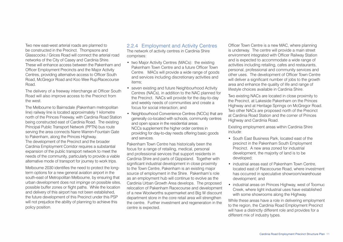
2.2.4 Employment and Activity Centres The network of activity centres in Cardinia Shire comprises:
• two Major Activity Centres (MACs): the existing Pakenham Town Centre and a future Officer Town Centre. MACs will provide a wide range of goods and services including discretionary activities and items;
• seven existing and future Neighbourhood Activity Centres (NACs), in addition to the NAC planned for the Precinct. NACs will provide for the day-to-day and weekly needs of communities and create a focus for social interaction; and
• Neighbourhood Convenience Centres (NCCs) that are generally co-located with schools, community centres and open space in the residential areas. NCCs supplement the higher order centres in providing for day-to-day needs offering basic goods and services.
Pakenham Town Centre has historically been the focus for a range of retailing, medical, personal and professional services that support residents in Cardinia Shire and parts of Gippsland. Together with significant industrial development in close proximity to the Town Centre, Pakenham is an existing major source of employment in the Shire. Pakenham’s role as an employment hub will continue to evolve as the Cardinia Urban Growth Area develops. The proposed relocation of Pakenham Racecourse and development of a new Woolworths supermarket and Big W discount department store in the core retail area will strengthen the centre. Further investment and regeneration in the centre is expected.
Officer Town Centre is a new MAC, where planning is underway. The centre will provide a main street environment integrated with Officer Railway Station and is expected to accommodate a wide range of activities including retailing, cafes and restaurants, personal, professional and community services and other uses. The development of Officer Town Centre will deliver a significant number of jobs to the growth area and enhance the quality of life and range of lifestyle choices available in Cardinia Shire.
Two existing NACs are located in close proximity to the Precinct, at Lakeside Pakenham on the Princes Highway and at Heritage Springs on McGregor Road. Two other NACs are proposed north of the Precinct at Cardinia Road Station and the corner of Princes Highway and Cardinia Road.
Existing employment areas within Cardinia Shire include:
• South East Business Park, located east of the precinct in the Pakenham South Employment Precinct. A new area zoned for industrial development, the majority of land is to be developed;
• industrial areas east of Pakenham Town Centre, located east of Racecourse Road, where investment has occurred in speculative showroom/warehouse development; and
• industrial areas on Princes Highway, west of Toomuc Creek, where light industrial uses have established with some showrooms along the Highway.
While these areas have a role in delivering employment to the region, the Cardinia Road Employment Precinct will have a distinctly different role and provides for a different mix of industry types.

12 Cardinia Road Employment Precinct Structure Plan
2.2.6 Community Facilities Extensive community infrastructure has already been delivered north of the Princes Freeway in the Lakeside Pakenham Estate including:
• Lakeside Community Centre, with a kindergarten and maternal child health centre;
• Cardinia Cultural Centre, a major regional function and entertainment facility;
• Primary and Secondary schools, including Lakeside Lutheran College and Lakeside Pakenham Primary School; and
• a regional indoor sports facility on Princes Highway.Three additional primary schools and a secondary college are planned north of the Precinct in the Cardinia Road Precinct Structure Plan area, in addition to six new community centres. Of these, two of the primary schools, the secondary school and four of the new community centres are located immediately north of the Freeway. The planned network of trails, shared paths and pedestrian bridges and underpasses support the integration of the precincts and enable the facilities to be easily accessed by residents, workers and visitors.
2.2.5 Open Space The Precinct is well integrated with the established and future open space networks of surrounding precincts. Rehabilitation of existing creeks and waterways such as Gum Scrub Creek, Toomuc Creek and Deep Creek will provide north-south links throughout Cardinia Urban Growth Area. New trail networks will be delivered as part of the development of the Precinct, integrating the passive open space network with active reserves north of the Princes Freeway.
The Precinct will have access to:
• a new district level active recreation reserve located on Gum Scrub Creek immediately north of the Precinct, via the Gum Scrub Creek trail and a pedestrian underpass that provides access under the Freeway;
• Toomuc Major Recreation Reserve, a Regional Open Space area via the Toomuc Creek trail and a pedestrian underpass that provides access under the Freeway;
• a second new district level active recreation reserve located just north of Princes Freeway between Toomuc Creek and Cardinia Road. This reserve would be accessed by the Toomuc Creek trail and the Freeway pedestrian underpass or from the bridge over the Freeway at Cardinia Road; and
• a new passive parkland with extensive wetland and drainage areas, north of Princes Highway just west of Cardinia Road.
2.3 Precinct Features
2.3.1 Heritage
Aboriginal Cultural HeritageThe Precinct is located in the former Koo Wee Rup swamp wetlands, an area known to contain sites and artefacts of Aboriginal cultural heritage value will be identified. Toomuc Creek is the eastern boundary of the Precinct, which is recognised as an area of Aboriginal cultural heritage sensitivity under the Division 3 of Part 2 of the Aboriginal Heritage Regulations 2007.
Ten registered Aboriginal sites have been identified just east of Toomuc Creek, outside the PSP area. Of the ten sites, nine are artefact scatters and one is a scarred tree.
Preparation of a voluntary Cultural Heritage Management Plan is underway, which includes all properties in the Precinct. Preliminary assessments identified areas of sensitivity along Toomuc and Gum Scrub Creeks and in southern parts of the Precinct. Sub-surface testing has not identified any significant sites within the Precinct, with two artefacts being recovered. The only artefacts found are within the transmission line easement (refer Victorian Aboriginal Heritage Register sites shown on Plan 4), which is shown as encumbered open space in the future urban structure plan (Plan 5).
Post-Contact HeritageThere is limited evidence of post-contact heritage in terms of existing buildings. A scattering of dwellings marks the landscape, however many are the result of recent development and have no heritage value, with the exception of Kaduna Park (refer Plan 4).

13Cardinia Road Employment Precinct Structure Plan
The greater Pakenham area is home to a ‘meta-population’ that represents a remnant of the former Koo Wee Rup Swamp population. The species is of national significance, listed as ‘vulnerable’ under the Environmental Protection and Biodiversity Conservation Act 1999 and ‘threatened’ under the Victorian Flora and Fauna Guarantee Act 1988.
The significance of the Growling Grass Frog and the population in the Pakenham area requires that particular measures need to be implemented to protect and enhance habitat in the Precinct.
In a limited number of places, small patches of remnant understorey vegetation have been found in the Precinct. Two Ecological Vegetation Classes (EVCs) have been identified in the Precinct: Swampy Woodland and Swamp Scrub. Swamp Scrub is found in linear localised patterns along Lecky Road, Enterprise Road and Cardinia Road. Swampy Woodland is also clustered in similar patterns along Cardinia Road.
2.3.3 Topography and Landform The Precinct has a highly modified landscape with a slight fall from north to south. There are views to the north towards the Dandenong Foothills, which provide a landscape backdrop to the Cardinia Urban Growth Area. The bridge over Princes Freeway provides views across the Precinct, looking south along Cardinia Road (refer Plan 4).
The Precinct is currently used for agricultural purposes and is dominated by pastoral species. Across the Precinct, there are numerous farm dams, including two large turkeys-nest dams, which are located adjacent to the Cardinia Road Drain at the rear of Kaduna Park homestead and just north of the transmission line easement, east of Cardinia Road.
Kaduna Park is a locally significant heritage homestead (Heritage Overlay reference - HO90). Located west of Cardinia Road it is representative of Edwardian architecture within a landscaped setting, typical of farm dwellings from the early 1900s.
In addition to Kaduna Park homestead, the trees lining the driveway and other trees surrounding the dwelling are of significance on the property.
Currently the Heritage Overlay applies to the entire farm, most of which has no heritage value. A “Heritage Overlay Focus Area Plan” has been prepared by Graeme Butler & Associates (2007), reflecting the elements of significance on the property. As part of the Amendment implementing this PSP, the extent of the Heritage Overlay will be reduced.
2.3.2 Biodiversity For much of its recent history, the Precinct has been used for farming activities including grazing and cropping. As a result, the majority of original vegetation on the land has been cleared and the land disturbed through cultivation. The Precinct is largely a modified landscape, however it does provide appropriate habitat features for a number of common species and the threatened Growling Grass Frog.
As part of the former Koo Wee Rup swamp, the Precinct has low lying land. Several creeks and drainage lines that feed into the Westernport, which is listed as an internationally-significant Ramsar wetland. The development of the Precinct creates the opportunity to enhance creeks, waterways and drainage lines, establishing habitats for fauna species and protecting and enhancing vegetation.
The Growling Grass Frog range includes the Cardinia Urban Growth Area and sightings have been recorded at several natural and man-made water bodies in the Precinct.
2.3.4 Catchments and Drainage The boundaries of the Precinct are defined by major creeks: Gum Scrub Creek to the west and Toomuc Creek to the east (refer Plan 4). The Cardinia Road Drain runs north-south through the Precinct, crossing Cardinia Road at a central point. An existing overland flow path generally extends along Cardinia Road Drain, which is covered by a Land Subject to Inundation Overlay. The Floodway Overlay covers land adjacent to Gum Scrub Creek.
The Cardinia Road Employment Precinct affects the adjacent catchments associated with the Deep Creek and Cardinia Creek waterways, with all three outfall channels running parallel south of the Urban Growth Boundary (UGB) into the Koo Wee Rup Flood Protection District and ultimately Westernport.
Development Services Schemes (DSS) (commonly known as ‘drainage schemes’) have been prepared for Cardinia Road Precinct, Officer Precinct and Pakenham South Employment Precinct. Preliminary work on the preparation of a DSS for Officer Employment Precinct is currently underway, which will clarify the requirements for Gum Scrub Creek. At present, a wetland area is planned under the draft Officer Precinct DSS just south of the Freeway, west of Gum Scrub Creek.
In the preparation of the Officer Employment Precinct DSS, consideration should be given to the potential for accommodating the wetland outside the UGB, due to the limitations it places on the future integration of Officer with the Precinct.

14 Cardinia Road Employment Precinct Structure Plan
Plan 4: Precinct Features
PRINCES FREEWAY
Scrub
Gum
Creek
Toom
uc
Cree
k
Transmission Easement
Henry Road
Views to Dandenong
Foothills
Views across the floodplains to Westernport
Bay
Views across the floodplains to Westernport
Bay
Car
dini
a
Roa
d
Lecky Road
Gas Easement
Views to Dandenong
Foothills
Enterprise Road
Mary Street
Patterson Road
24m AHD
25.5m AHD
25.5m AHD
7921-1204
7921-1205
32
31
29
2827
26
24
23
26
24
26
27
28
29
27 2727
27
2726
26
26
24
23
26
27
28
29
31
3233
34
27
28
26
2728 29
28
2424
24
23
24
26
26
27
28
27
27
19
21
22
23
24
26
23
2322
23
24
24
22
21
19
2122
212223
18
17
19
21
22
23
24
26
27
26
24
23
22
22
2224 2221
19
19
17
18
19
18
19
21 22
23
22
21
19
26
23
Pla
n 4
:Site
Fea
ture
sC
ardi
nia
Roa
d E
mpl
oym
ent P
reci
nct S
truct
ure
Pla
n
Ref: 3410116UCRDate: 25 August 2010
Rev.: UDrawn: RL
Checked: MH
Scale: 1:7,500m @ A11:15,000m @ A3
0 75 150 225m
planning & urban designmelbourne - tel 9869 0800
© smec australia pty ltdabn 47 065 475 149
trading as smec urban
LEGENDPrecinct Structure Plan Area
Urban Growth Boundary
Existing Roads
Existing State Freeway
Existing Creeks
Existing Drainage Lines
Existing Waterbodies/Dams
Contours (1m intervals)
Existing Views
High Points
Land Subject to Inundation Overlay (LSIO)
Floodway Overlay (FO)
Existing Vegetation (Approx. location)
Heritage Overlay - Kaduna Park
Existing Major Easements
Area of Aboriginal Cultural Heritage SensitivitySource: AAV (Aboriginal Heritage Regulations 2007)
Existing Urban Area
Future Urban area
Victorian Aboriginal Heritage Register(VAHR) Site and Number
0 150 300 450m
LEGENDPrecinct Structure Plan Area
Urban Growth Boundary
Existing Roads
Existing State Freeway
Existing Creeks
Existing Drainage Lines
Existing Waterbodies/Dams
Contours (1m intervals)
Existing Views
High Points
Land Subject to Inundation Overlay (LSIO)
Floodway Overlay (FO)
Existing Vegetation (Approx. location)
Heritage Overlay - Kaduna Park
Existing Major Easements
Area of Aboriginal Cultural Heritage Sensitivity. Source: AAV (Aboriginal Heritage Regulations 2007)
Existing Urban Area
Future Urban area
Victorian Aboriginal Heritage Register(VAHR) Site and Number

15Cardinia Road Employment Precinct Structure Plan
2.3.6 Existing Subdivision PatternThere are relatively few parcels of land in the Precinct, with approximately 590 hectares split into 30 titles owned by 16 landowners.
Numerous large regularised parcels of land are accessed via Cardinia Road, creating the opportunity to establish a competitive land supply market. Subject to the upgrade of Cardinia Road to urban standard (which may be delivered as works-in-lieu of developer contributions, if approved by Cardinia Shire Council), lots could be subdivided at any time.
Limited consolidation is required to facilitate development and achieve an integrated suburb design. The three existing road reserves will form part of the future suburb layout, as follows:
• Cardinia Road will be widened and upgraded to an urban arterial standard.
• Lecky and Enterprise Roads are both Government Roads, where service infrastructure may be delivered prior to development of the Precinct. Although mechanisms exist for the incorporation of the land into development parcels or diverted, it is unlikely that the timing of infrastructure delivery will enable these outcomes and the roads will need to be sealed as part of adjacent subdivisions.
A Crown Land parcel (Property 21) is located centrally to the Precinct, extending east from Cardinia Road to Toomuc Creek. At 30 metres wide, it is potentially a barrier to the integration of future subdivisions, however investigations have confirmed it is surplus to the requirements of the Public Land Manager and can be acquired for development.
2.3.5 Service InfrastructureTwo major easements traverse the Precinct, which have limited development potential and specific requirements about how they may be utilised.
• An electricity transmission line easement extends along the southern boundary of the Precinct. It contains three existing overhead transmission lines (one 66kV and two 500kV cables) within a 154 metre wide easement.
• A gas pipeline extends across the middle of the Precinct. Connecting the Longford gas plant in Gippsland to Dandenong, it generally has an east-west alignment. Within the 20 metre wide easement is a 450mm diameter pipe.
The land encumbered by the gas and electricity easements will either be utilised as open space or form part of future road easements within the Precinct.
A new fibre optic broadband cable has been installed along Enterprise and Lecky Road. The location of the cable is planned to fit within the nature strips of future road cross-sections, ensuring the services are appropriately located in the road reserve in the long-term.

16 Cardinia Road Employment Precinct Structure Plan
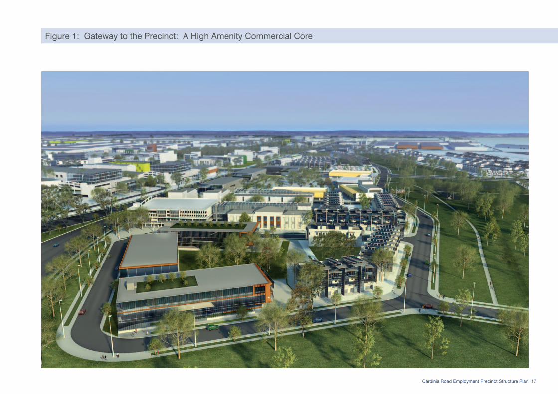
3.1 VisionThe vision is a high level statement of what is envisaged for the Cardinia Road Employment Precinct (the Precinct) and its new resident, working and business communities. The vision will be realised through the implementation of the PSP, is illustrated in Figure 1 and reflected in the Elements set out in Chapter 5.
The Cardinia Road Employment Precinct will be:
A multi-functional regional employment node that delivers a diverse mix of jobs to Casey-Cardinia, interconnected with regional transport routes and rapidly growing communities. An intensively developed commercial core and residential precinct is set amid extensive wetlands and biodiversity corridors, establishing a high amenity business park setting to attract investment.
A new hub for specialised business in south-east Melbourne, including research and development, manufacturing and production, engineering and trades-related services. The attraction of businesses across these sectors will generate a range of professional and higher-skilled employment opportunities, diversifying and expanding the employment base of Casey-Cardinia.
A higher level of self-containment within Casey-Cardinia, providing a catalyst for investment in jobs- and land-intensive uses. By facilitating the establishment of a significant critical mass of investment, the Precinct will stimulate demand for employment land and encourage higher job-densities, particularly in office development.
Greater employment self-containment within Casey-Cardinia and job diversity are delivered by the urban structure of the Precinct. Reflecting principles of environmental sustainability, high amenity, housing diversity and a strong sense of place, the Precinct will establish an amenity and service provision standard designed to attract the desired employment mix.
A high density residential area that demands neighbourhood-level retail facilities, which support the delivery of a wider range of goods and services to support residents, workers, visitors and businesses. Major creeks and landscaped wetland corridors integrate the Precinct with establishing residential areas located to the north, providing a borrowed landscape and extensive passive recreation spaces throughout the Precinct. The high standards of building design, massing and mix of uses will create a high-profile edge to the Precinct and deliver a strong ‘gateway’ to the precinct from the Cardinia Road freeway overpass.
Enhance the quality of life of residents throughout Casey-Cardinia, by enabling people to work closer to home and reducing commuting time. The success of the Precinct will generate flow-on-effects for investment in other jobs- and land-intensive uses across the Cardinia Employment Corridor, fundamentally changing the structure of the economy in Melbourne’s south-east.
03 Vision & Future Urban Structure
17Cardinia Road Employment Precinct Structure Plan
Figure 1: Gateway to the Precinct: A High Amenity Commercial Core

18 Cardinia Road Employment Precinct Structure Plan
The development of an integrated business and residential precinct will deliver the vision for the Precinct through its future urban structure. The key elements of the urban structure are described in Section 3.2, with land use budget and future demographic characteristics of the Cardinia Road Employment Precinct outlined in Sections 3.3 and 3.4 respectively.
3.2 Integrated Precinct DesignThe Future Urban Structure (refer Plan 5) shows how the Precinct will be developed over time to achieve the sustainable growth objectives of the Victorian Government and Cardinia Shire Council.
The ways in which the PSP delivers the vision for the Precinct through an integrated neighbourhood design are described in the following Sections: 3.2.1 to 3.2.7.
3.2.1 Establish a regional economic hub The Precinct is located at the heart of the Cardinia Employment Corridor, a new major regional employment area. As the ‘hub’ of the Corridor, the Precinct is planned to provide a catalyst for its development by attracting a critical mass of investment in a wide range of specialist and jobs-intensive industries.
Integration with key major transport routes enable new investment and businesses establishing in the Precinct to serve south-east Melbourne, the broader Gippsland region as well as export interstate and internationally via established road freight routes that connect to the Ports of Hastings and Melbourne.
The Precinct facilitates the diversification of industry and employment in the Corridor, by providing for a wide range of industrial and commercial development types, including:
• offices in a campus-style business park setting for uses requiring larger land areas;
• combined showroom and warehouse or workshop type uses to accommodate light industrial uses in high-visibility locations required by businesses with front-of-house customer service and display areas; and
• industrial areas with well-designed road networks that offer direct connections to arterial roads and deliver greater operational efficiency for businesses.
To encourage the development of high density commercial and office uses, the Precinct specifically provides for a range of supporting land uses that establish the pre-conditions for investment in offices.
An Activity Centre with a significant retail component is planned for the heart of the Precinct, with activities clustered around it including residential and supporting commercial uses such as cafes and restaurants, hotels and conference facilities.
The development of substantial office floorspace within the Precinct is critical to achieving regional jobs self-containment and providing ‘new economy’ employment opportunities. Delivery of high capacity fibre-optic broadband cable to provide high speed global connections will be a major requirement for business establishment and create the opportunity for technology and communications related business.
The range of employment opportunities and industry types accommodated in the Precinct will also promote community strengthening in the south-east by decreasing dependence on a handful of industry types, increasing resilience to macro-economic changes.
Estimates have been prepared for different employment categories, reflecting the land use distribution in the Precinct, the density of development (building height ratio), extent of land developed (footprint ratio) and number of jobs generated per hectare (jobs ratio) (refer Table 1). At full development, the Precinct may generate up to 18,700 jobs for the region, with over 70 percent being located in the Commercial area.

19Cardinia Road Employment Precinct Structure Plan
Plan 5: Future Urban Structure
Car
dini
a R
oad
Lecky RoadEnterprise Road
Scrub
Gum
Creek
Toom
uc
Cree
k
Thompsons Road
Transmission Easement
Gas Easement
Henry Road
Western Arterial
East
ern
Art
eria
l
PRINCES FREEWAY
0 150 300 450mplanning & urban design
melbourne - tel 9869 0800© sm urban pty ltd
abn 99 124 206 819trading as smec urban
Pla
n 5:
Fut
ure
Urb
an S
truct
ure
Car
dini
a R
oad
Em
ploy
men
t Pre
cinc
t Stru
ctur
e P
lan
Ref: 3410116UCRDate: 11 August 2010
Rev.: TDrawn: HW
Checked: MH
Scale: 1:7,500m @ A11:15,000m @ A3
Precinct Structure Plan Area
Urban Growth Boundary
Road Network
State Freeway
Arterial Road
Connector Street
Residential Connector Street (Boulevard)
Access Street - level 2
Access Street - level 1
Controlled Intersections
Residential Land
High Density Residential 2
High Density Residential 1
Medium Density Residential
Conventional Residential
Employment Land
Commercial
Activity Centre
Service Business
Industrial
Heritage and Community
Post Contact Heritage Site
Community Facility
Open Space and Environment
Unencumbered Open Space
Encumbered Open Space
Existing Creeks
Drainage Lines
Ecological Vegetation Classes (EVCs) to be Retained
Other land
Existing Major Easements
Future Urban Land
Existing Urban Land
LEGEND
Precinct Structure Plan Area Urban Growth BoundaryRoad Network State Freeway Arterial Road Connector Street Residential Connector Street (Boulevard) Access Street - level 2 Access Street - level 1 Controlled IntersectionsResidential Land High Density Residential 2 High Density Residential 1 Medium Density Residential Conventional ResidentialEmployment Land Commercial Activity Centre Service Business IndustrialHeritage and Community Post Contact Heritage Site Community FacilityOpen Space and Environment Unencumbered Open Space Encumbered Open Space Existing Creeks Drainage Lines Ecological Vegetation Classes (EVCs) to be Retained Other land Existing Major Easements Future Urban Land Existing Urban Land
LEGEND

20 Cardinia Road Employment Precinct Structure Plan
Table 1: Estimated Employment Generation
Employment Land Type Net Employment Area (Hectares)
Building Height Ratio(Storeys)
Footprint Ratio Gross Floor Area (Hectares)
Jobs Ratio (Jobs per Hectare)
Total Jobs*
Activity Centre 5.52 2 0.3 3.31 50 166
Commercial 27.08 4 0.5 54.16 250 13,540
Service Business 134.08 1 0.5 67.04 50 3,352
Industrial 186.39 1 0.5 93.20 18 1,678
Total for Precinct 353.07 n/a n/a 217.71 n/a 18,735* Full Time Equivalent
Source: Cardinia Shire Council, based on estimates by MacroPlan Australia 2008
3.2.2 Stimulate local employment and business activity The Precinct provides for a diverse range of employment opportunities to meet the needs of the growing Casey-Cardinia community. It has been designed to ensure that all industry types can be accommodated within the Precinct without compromising the amenity of future residential areas, the range of industrial types that can establish in the Precinct, or the flexibility of industrial operations. The range of uses that are planned allows for co-location of a wide variety of business types and scales, stimulating growth and delivering greater efficiency with the opportunity to establish localised supply-chains and multi-business production lines.
The future urban structure of the Precinct integrates employment and residential land uses in a framework that addresses interfaces between sensitive uses, while maximising the value of the Precinct’s biodiversity and natural landscape characteristics.
An intensively developed core Commercial area is located at the gateway to the Precinct, centred upon Cardinia Road immediately south of the Freeway.
The area is proposed for high-density office development, with greater massing, high built form standards and minimum street setbacks creating an attractive and prominent entry to the Precinct. The location of the commercial area maximises the benefits of the amenity provided by the Cardinia Road Open Space Corridor, a landscaped wetland channel that frames the area.
Service Business uses front onto the Princes Freeway, Cardinia Road south of the Commercial area and Thompsons Road, to encourage high built form standards and create a high-profile showroom edge to the Precinct. These uses benefit from the exposure offered by the road network and encourage activity along key roads. In addition, Service Business uses will provide for a transition between Residential or Commercial areas to the Industrial areas within the Precinct. Generally these uses will comprise integrated factory/warehouse clusters, small lot industrial parks and industry clusters (e.g. automotive services/repairs), combining display areas and ‘back of house’ facilities in the one location.
East of Cardinia Road is the core industrial area, with Eastern Arterial providing the major transport route through this part of the Precinct. While accommodating a wide range of industrial uses, attractive commercial frontages will create a higher amenity environment than traditional industrial precincts and generate a level of activity across the Precinct.
The specific location of employment uses in the Precinct will protect sensitive interfaces between open spaces, towards the Princes Freeway and between commercial and residential uses. Land uses with a potential for significant off-site amenity impacts are to be located in the eastern and south-eastern portion of the Precinct to ensure that significant buffers to residential, retail and commercial uses can be achieved and protected.

21Cardinia Road Employment Precinct Structure Plan
3.2.3 Provide a new employment destination, that offers better transport options and shorter journey to work tripsThe Precinct has been specifically designed to create a more sustainable urban structure for Casey-Cardinia that reduces travel distances, improves travel time efficiency and reduces carbon emissions generated by journey to work trips.
A greater proportion of jobs need be provided within the growth area to better meet the employment needs of the future population and address the historic dependency on Dandenong and areas further west for employment.
The development of the Precinct will deliver a new work destination in Casey-Cardinia, facilitating an increase in eastward journey-to-work travel and enabling more employment to be delivered locally, generating a greater proportion of shorter trips.
Travel to Work StatementThe PSP aims to reduce travel distances to work by providing:
• significant employment to reduce travel times and out-commutingThe Precinct will create new employment opportunities for the local and regional workforce whilst offering an attractive environment for national and international business. Currently, more than 60% of the workforce participants in Casey-Cardinia travel out of the Growth Area to get to work. By providing a greater range of job opportunities that reflect the needs and skills of local residents, a greater level of self containment will be fostered within Cardinia Shire, reducing travel distances, travel to work times and pressure on peak hour
capacities of east-west transport routes, particularly Princes Freeway.
• an efficient road and public transport networkServiced by the Princes Freeway, a major state freeway and freight route, the development of the arterial road network within the Precinct will deliver strong regional east-west links including Western Arterial (the Glasscocks/Grices Road extension) and Thompsons Road. Connected by the centrally-located Cardinia Road, the road network will be well integrated with developing residential neighbourhoods north of Princes Freeway, which will be enhanced by the delivery of a second bridge over the Freeway. In adjacent precincts, a number of other future north-south arterial roads intersect with the future east-west arterials, creating a broader arterial road ‘grid’ within the Cardinia Urban Growth Area (refer Plan 3). These connections will ensure the Precinct and the broader Cardinia Employment Corridor are well located to facilitate a shift in journey to work patterns across the growth area. Development of the arterial road network will enable a wider range of transport options to be provided, including bus services along Grices/Glasscocks and/or Thompsons Roads. New local services will also need to be provided, linking employees and residents to the existing rail PPTN, the PPTN along Princes Highway, the new Major Activity Centre proposed adjacent to Officer Station and the new station currently under construction at Cardinia Road (north of the Bypass).The residential area is centred upon Western Arterial, a potential future arterial road which could potentially be a regional bus route in the future. The connector street network through the residential
area will potentially provide local bus services. The arterial and collector road network and the planned dwelling density distribution will ensure that 95% of dwellings are located within 400 metres street walking distance of a potential public transport service. Higher density residential development is planned around this network to maximise the number of dwellings located along and within walking distance of a potential public transport service.
• a walkable street structure orientated to promote energy efficient lot design Co-location of residential and employment uses within the Precinct provides the opportunity to increase the proportion of residents walking and cycling to work. The urban structure provides a local street network with high levels of permeability, walkability and passive solar orientation throughout the Precinct. An east-west community spine connects from the Activity Centre to the residential park on Western Arterial, providing a focus for medium density residential development, which provides clear viewlines to the Activity Centre and will encourage non-motorised forms of travel. The finely grained road network within the commercial area also supports walking and cycling by creating a highly permeable ‘core’ that maximises ease and convenience of access by foot or bike.
• an extensive walking and cycling network linking to adjacent areas The Precinct provides dedicated bicycle and pedestrian paths (refer Plan 16), including on-road cycle lanes on all arterial roads and connector streets to provide for commuters.

22 Cardinia Road Employment Precinct Structure Plan
Shared paths are provided in addition to on-road cycle lanes as well as several other street types, recognising the different needs of different users. The delivery of a second bridge over the Freeway at Cardinia Road will also improve access to the Precinct by walking and cycling.The grid of streets links with the off-road trails network within key open space corridors, providing an integrated network of shared paths, cycle lanes and footpaths (on and off road). The north-south trails network along Gum Scrub and Toomuc Creeks provide connectivity to residential precincts to the north of the Princes Freeway, via underpasses. Bridges over these creeks provide access east and west of the Precinct along the Transmission Line Easement via the off road network.
• attractors located to promote walking to frequently used servicesAn extensive network of pedestrian paths, shared paths and dedicated on-road cycling lanes services the centrally located Activity Centre, which is a key destination for bicycle and pedestrian movement in the Precinct. These paths also provide connections to facilities in adjacent Precincts, particularly the area north of Princes Freeway.Western Arterial provides a potential future bus route connecting the Activity Centre to the future Cardinia Road Train Station and Officer Town Centre, making public transport a convenient option.
• support for the Neighbourhood Activity CentreHigher density residential development located along Western Arterial and clustered along the Cardinia Road Open Space Corridor will support the delivery of public transport services and provide sufficient catchment for the new Activity Centre.
3.2.4 Create a vibrant, mixed use activity centre at the heart of the PrecinctThe future urban structure provides for a Neighbourhood Activity Centre to be located at the heart of the Precinct. Its retail role and function is defined by its anchor store: a full-size supermarket, ensuring it provides for the weekly shopping needs of the residential area and encouraging a wide range of specialty retail goods and services to co-locate.
Importantly, the level of core retail planned for the activity centre and the frequency of visitation this attracts, will encourage a wide range of other uses to establish, including hospitality (cafes, restaurants and bars or a tavern), personal services (hairdressers, beauticians and drycleaners) and commercial services (banks, insurance and travel agencies). The employment catchment of the Activity Centre is likely to also generate demand for niche retail goods and services, such as stationery retailers and printing and photocopying services.
As a street-based centre, the diversity of uses in the activity centre will ensure it provides a focus for community interaction across a wider-range of hours.
High density residential development is provided within walking distance of the Activity Centre. The value of the Cardinia Road Open Space Corridor is maximised by lining its edges with higher density development throughout the residential area.
The Activity Centre is located immediately north of Kaduna Park, a heritage homestead that will become the focus of community life in the Precinct. Providing meeting rooms, a formal garden area and with potential for conference facilities and hospitality uses, it will become a feature of the Precinct, serving residents, employees, businesses and visitors.
Higher density residential uses are also planned south of Kaduna Park, benefiting from the character and amenity created by the existing historic dwelling and its landscaped surrounds. With key connections through the activity centre and sightlines to and from Kaduna Park, the land use configuration enables high levels of integration between the Activity Centre and the community facility, co-locating the main attractors to ensure higher levels of activity in the heart of the Precinct.
3.2.5 Establish a distinctive character, unique sense of place and community The setting and built form of the Precinct is critical to the achievement of a strong sense of place, with opportunities for community interaction provided in an environment with high levels of amenity, services and activity that underpin a strong sense of character.
A gateway into the Precinct from the north is created by multi-storey office development, which lines the Cardinia Road boulevard. The entry sets the tone of development within the Precinct, delivering a high amenity urban environment within an Australian landscape setting.
The Commercial area is clustered around a dense mixed use environment, known as the ‘commercial core’. Located west of Cardinia Road, east of the Cardinia Road Open Space Corridor, the area provides for residential, community, office and retail activities focused around the Activity Centre. Office development fronts onto Cardinia Road, Western Arterial and part of Eastern Arterial. Offering a range of activities, goods and services that are supported by a network of public spaces, the commercial core provides a series of meeting places and services that workers, residents and other visitors to the Precinct will readily identify with.

23Cardinia Road Employment Precinct Structure Plan
A highly permeable street network and built form environment will encourage pedestrian activity, with a series of key connections linking Kaduna Park, the town square, the Cardinia Road Open Space Corridor and other parks to create an attractive, interesting and active public realm environment.
Connecting the residential and employment areas by the thread of the Cardinia Road Open Space Corridor, the Activity Centre, the open space network and Kaduna Park are integral to delivering the high amenity and access outcomes necessary for investment and attracting a diversity of businesses and employment opportunities.
The Precinct has two other major open space corridors: Gum Scrub and Toomuc Creeks. These provide important ecological, drainage and buffer functions, and concurrently provide a high level of visual and recreational amenity. The multi-purpose design of these corridors maximises the efficient use of land while achieving environmental conservation, drainage, recreation and character objectives.
An Australian Landscape theme embraces the existing character of creek lines and maximises the use of indigenous native vegetation. It is reflected in boulevard plantings along Arterial Roads, as well as landscaped verges of roads throughout the Precinct. Drainage lines and surrounds will be also naturally enhanced using heath vegetation, native grasses, vegetated swales and swamp paperbark trees, establishing a clear landscape character.
3.2.6 Provide a different, higher-density housing choiceResidential development has been planned for the Precinct, principally to facilitate the establishment of a high amenity commercial core area. To create sufficient catchment for the Neighbourhood Activity Centre, including a full-sized supermarket, the Precinct provides for 2,000 dwellings.
To minimise the impact of residential development of the amount of employment land provided within the Precinct, the residential area provides significantly increased densities with reduced formal open space areas. The Open Space Corridors along drainage and creek lines provide many opportunities for passive and informal active recreation, while providing connections to formal and active recreation reserves north of the Princes Freeway via the shared path and trails network.
A range of housing options are provided within a relatively small area of the Precinct, delivering densities substantially greater than conventional residential subdivision. With a focus on providing higher-density living options, a high proportion of dwellings will be delivered as two-storey townhouses and three and four storey strata-titled apartments or flats. Multi-level residential development is encouraged on both sides of the Cardinia Road Open Space Corridor, providing an attractive built form edge and increasing residential densities around the activity centre.
Residential development plays a key role in achieving a ‘new employment community’, by supporting day and night activity. Located in the north-western portion of the Precinct, the residential area is well integrated with a network of open spaces and is surrounded by low impact light-industrial uses. Where residential abuts employment uses, higher density residential
is proposed to create a more intensively developed built form ‘edge’ to provide a buffer that protects the amenity of lower-density residential areas. The use of wider road reserves, landscaping, open space networks, and managing road access will ensure the interfaces between sensitive uses are carefully addressed, maintaining the amenity of the Precinct.
3.2.7 Achieve best-practice environmentally sustainable development
Energy and Water Efficient DesignThe Future Urban Structure reflects energy efficient design by creating a new regional employment hub to provide a greater proportion of jobs locally and reduce journey-to-work travel distances.
It provides for a greater range of travel modes through street design, accommodating buses, cyclists and pedestrians, with strong connections to areas north of the Princes Freeway and to future adjacent precincts to the east and west.
The Future Urban Structure provides a framework for subdivision design that promotes solar access, to minimise energy use of dwellings and buildings in employment areas, with a clear framework for the development of a ‘grid-based’ street network.
Third pipe recycled water is mandated in the residential area, with requirements for development in the employment area to demonstrate water and energy efficient design elements, such as rainwater harvesting or solar energy systems.
24 Cardinia Road Employment Precinct Structure Plan
Incorporate Water Sensitive Urban Design Water Sensitive Urban Design (WSUD) aims to reduce the quantity of stormwater and improve the quality of water that is either discharged or re-used on site. WSUD techniques are able to be incorporated into the Precinct as a result of the existing drainage lines and creeks. Utilising the existing drainage systems on the site reduces the requirement for piping and channelling of water and maintenance costs.
WSUD techniques may also be incorporated into the public open space network, with the network of wetlands in the Cardinia Road Open Space Corridor and along Toomuc Creek providing for stormwater filtration.
WSUD techniques that could be utilised include:
• integrating stormwater drainage systems with other uses such as road verges, parklands and walking paths which improves the aesthetic appeal;
• reducing front setbacks to reduce the amount of low functional areas that often require irrigation;
• reducing the length of driveways (and the amount of impervious services) to reduce stormwater run-off;
• the use of drought proof and salt resistant vegetation to reduce water consumption;
• reducing road widths where practical to minimise water run-off; and
• implementing a system of filtration and retention of stormwater such as the use of swales and infiltration systems to improve the quality of water before it exits the site.
Protect and Enhance Native Vegetation The proposed Australian Landscape Theme embraces the existing character of the creek lines and maximises the use of indigenous native vegetation. Heath vegetation, native grasses and vegetated swales will be provided along the drainage lines.
In addition to the retention of patches of remnant vegetation along Lecky Road at Gum Scrub Creek, the implementation of the Australian Landscape Theme will enhance the existing biodiversity characteristics of the area.
Revegetation along Cardinia Road Open Space Corridor, Gum Scrub and Toomuc Creeks will establish major north-south bio-links through the growth corridor, substantially improving current habitat links.
Protect Significant Species: The Growling Grass FrogThe nationally-significant Growling Grass Frog will be protected and its habitat enhanced through the development of the Precinct.
The delivery of the DSS will establish biodiversity corridors through the Precinct to supplement existing frog ponds to be retained, including:
• the Cardinia Road Open Space Corridor, a drainage corridor providing a series of new frog ponds and wetlands;
• revegetation and rehabilitation of Gum Scrub Creek, including new ponds;
• revegetation and rehabilitation Toomuc Creek, including new ponds and wetlands;
• establishment of an east-west habitat link and associated ponds along the Princes Freeway, west of Cardinia Road; and
• the establishment of vegetation and new ponds along the length of the transmission line easement in the south of the Precinct.
These new corridors build upon existing frog ponds and expand the Growling Grass Frog Habitat in the Precinct to over 35 ponds with connecting wetlands and vegetated channels, enabling movement within the Precinct and to and from areas north of the Freeway.

25Cardinia Road Employment Precinct Structure Plan
3.3 Land Use Budget The Cardinia Road Employment Precinct covers an area of approximately 590 hectares, with a total net developable area of approximately 440 hectares.
The Summary Land Use Budget including employment land composition and residential lot yield is outlined in Table 2. Table 3 provides a more detailed, property-specific land use budget, which shows how the net developable area (NDA) has been calculated. Property-specific employment land composition and dwelling yields are set in Table 4. Both Tables correspond with Plan 6: Land Use Budget, which illustrates the areas included in the columns of the tables.
Table 2: Summary Land Use Budget
a) Net Developable Area CalculationDescription Hectares (Ha) % of Total Precinct % Of NDATotal Precinct Area 588.40 100% n/a
Transport6 Lane Arterial Road / Widening 0.75 0.13% 0.17%4 Lane Arterial Road / Widening ^ 23.76 4.04% 5.41%Commercial Access Street (included in DCP) 0.47 0.08% 0.11%Sub-Total 24.98 4.25% 5.68%
Community FacilitiesKaduna Park 1.79 0.30% 0.41%Sub-Total 1.79 0.30% 0.41%
Open SpaceUnencumbered Land for RecreationParks 7.11 1.21% 1.62%Sub-Total 7.11 1.21% 1.62%Encumbered Land for Conservation and RecreationWaterways - Drainage Corridor 75.15 12.77% 17.10%Conservation Reserve * 2.44 0.41% 0.56%Habitat Corridors:East-West Habitat Link 6.62 1.13% 1.51%Major Easements ** 27.06 4.60% 6.16%Sub-Total 111.27 18.91% 25.32%
Total - Open Space 118.38 20.12% 26.93%
Encumbered Land for InfrastructureFor Infrastructure ^^ 3.71 0.63% 0.84%Sub-Total 3.71 0.63% 0.84%
Net Developable Area 439.54 74.70% 100%* Existing EVCs, GGF Habitat and Buffers ** Transmission Line and Gas Pipeline Easements where used for open space^Indicates VicRoads declared roads, potential future declared roads and undeclared roads.^^ Gas Pipeline Easement where development is limited
Continued overleaf...

26 Cardinia Road Employment Precinct Structure Plan
Table 2: Summary Land Use Budget
b) Land Areas by Employment TypeDescription Hectares (Ha) % Of Total Precinct % Of Nda
Activity Centre & Employment Land TypeCommercial 27.08 4.60% 6.16%Activity Centre 5.52 0.94% 1.26%Service Business 134.08 22.79% 30.50%Industrial 186.39 31.68% 42.41%
Total - Employment Area 353.07 60.01% 80.33%
c) Residential Yield EstimatesDescription Net Residential
Hectares (Ha)Dwellings Per Hectare Dwellings
Residential Area TypeActivity Centre n/a n/a 100Conventional Residential 48.17 15 723Medium Density Residential 31.95 20 639High Density Residential 1 2.70 70 189High Density Residential 2 3.65 105 383
SUB-TOTAL 86.47 n/a 2,034Average dwellings per Net Residential Hectare 23.5 n/a

27Cardinia Road Employment Precinct Structure Plan
Plan 6: Land Use Budget
1 3
711
2
4 5 6
8 9 1012 13 14
15
16 17
1819
20
21
23
22
24
25
2627
28
29
30
Car
dini
a R
oad
Lecky RoadEnterprise Road
Scrub
Gum
Creek
Toom
uc
Cree
k
Thompsons Road
Transmission Easement
Gas Easement
Henry Road
Western Arterial
PRINCES FREEWAY
Pla
n 6
: Lan
d U
se B
udge
tC
ardi
nia
Roa
d E
mpl
oym
ent P
reci
nct S
truct
ure
Pla
n
Ref: 3410116UCRDate: 25 August 2010
Rev.: UDrawn: RL
Checked: MH
Scale: 1:7,500m @ A11:15,000m @ A3
0 75 150 225m
planning & urban designmelbourne - tel 9869 0800
© smec australia pty ltdabn 47 065 475 149
trading as smec urban
Precinct Structure Plan Area
Urban Growth Boundary
Property Reference Number
Road Network
State Freeway
Arterial Road - 6 lane
Arterial Road - 4 lane
Commercial Access Street (included in DCP)
Residential Land
High Density Residential 2
High Density Residential 1
Medium Density Residential
Conventional Residential
Employment Land
Commercial
Activity Centre
Service Business
Industrial
Heritage and Community
Community Facilities - Kaduna Park
Open Space and Environment
Unencumbered Open Space
Parks
Encumbered Open Space
Waterways - drainage corridor
Conservation Reserve
East - West Habitat Link
Major Easements
Other land
Encumbered Land
For Infrastructure
Major Easements
Adjacent Areas
Future Urban Area
Existing Urban Area
LEGEND
5
0 150 300 450m
Precinct Structure Plan Area
Urban Growth Boundary
Property Reference Number
Road Network
State Freeway
Arterial Road - 6 lane
Arterial Road - 4 lane
Commercial Access Street (included in DCP)
Residential Land
High Density Residential 2
High Density Residential 1
Medium Density Residential
Conventional Residential
Employment Land
Commercial
Activity Centre
Service Business
Industrial
Heritage and Community
Community Facilities - Kaduna Park
Open Space and Environment
Unencumbered Open Space
Parks
Encumbered Open Space
Waterways - drainage corridor
Conservation Reserve
East - West Habitat Link
Major Easements
Other land
Encumbered Land
For Infrastructure
Major Easements
Adjacent Areas
Future Urban Area
Existing Urban Area
LEGEND
5
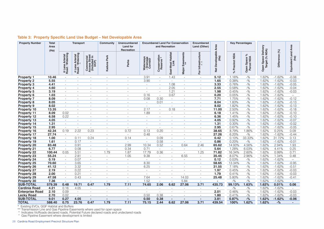
28 Cardinia Road Employment Precinct Structure Plan
Table 3: Property Specific Land Use Budget – Net Developable AreaProperty Number Total
Area(Ha)
Transport Community Unencumbered Land for
Recreation
Encumbered Land For Conservation and Recreation
Encumbered Land (Other)
Net
Dev
elo
pab
le A
rea
(Ha)
Key Percentages
Op
en S
pac
e D
eliv
ery
Targ
et (
% N
DA
)
Diff
eren
ce (
%)
Eq
uiva
lent
Lan
d A
rea
(ha)
6 La
ne A
rter
ial
Ro
ad /
Wid
enin
g
4 La
ne A
rter
ial
Ro
ad /
Wid
enin
g
^
Co
mm
erci
al
Acc
ess
Str
eet
(Inc
lud
ed In
D
CP
)
Kad
una
Par
k
Par
ks
Wat
erw
ays
- D
rain
age
Co
rrid
or
Co
nser
vatio
n R
eser
ve *
Eas
t-Wes
t H
abita
t Li
nk
Maj
or
Eas
emen
ts
**
For
Infr
astr
uctu
re
^^
% P
reci
nct
ND
A
Op
en S
pac
e %
P
arce
l ND
A
Property 1 10.46 - - - - - 3.91 - 1.43 - - 5.12 1.16% -% 1.62% -1.62% -0.08Property 2 5.55 - - - - - 3.90 - - - - 1.65 0.38% -% 1.62% -1.62% -0.03Property 3 4.41 - - - - - - - 1.08 - - 3.33 0.76% -% 1.62% -1.62% -0.05Property 4 4.60 - - - - - - - 2.05 - - 2.55 0.58% -% 1.62% -1.62% -0.04Property 5 3.19 - - - - - - - 1.21 - - 1.98 0.45% -% 1.62% -1.62% -0.03Property 6 1.03 - - - - - 0.16 - 0.67 - - 0.20 0.05% -% 1.62% -1.62% --Property 7 8.09 - - - - - 0.08 0.30 - - - 7.71 1.75% -% 1.62% -1.62% -0.12Property 8 8.05 - - - - - - 0.01 - - - 8.04 1.83% -% 1.62% -1.62% -0.13Property 9 8.02 - - - - - - - - - - 8.02 1.82% -% 1.62% -1.62% -0.13Property 10 13.35 - - - - - 2.17 - 0.18 - - 11.00 2.50% -% 1.62% -1.62% -0.18Property 11 8.09 0.02 - - - - 1.89 - - - - 6.18 1.41% -% 1.62% -1.62% -0.10Property 12 6.58 0.22 - - - - - - - - - 6.36 1.45% -% 1.62% -1.62% -0.10Property 13 4.05 - - - - - - - - - - 4.05 0.92% -% 1.62% -1.62% -0.07Property 14 1.31 - - - - - - - - - - 1.31 0.30% -% 1.62% -1.62% -0.02Property 15 2.95 - - - - - - - - - - 2.95 0.67% -% 1.62% -1.62% -0.05Property 16 42.34 0.19 2.22 0.23 - 0.72 0.13 0.20 - - - 38.65 8.79% 1.86% 1.62% 0.25% 0.09Property 17 27.74 - - - - - 0.48 - - - - 27.26 6.20% -% 1.62% -1.62% -0.44Property 18 1.00 - 0.11 0.24 - 0.14 - 0.09 - - - 0.42 0.10% 33.33% 1.62% 31.72% 0.13Property 19 1.61 - 0.17 - - - - 0.58 - - - 0.86 0.20% -% 1.62% -1.62% -0.01Property 20 83.48 - 0.91 - - 2.99 10.34 0.52 - 0.64 2.46 65.62 14.93% 4.56% 1.62% 2.94% 1.93Property 21 6.77 - 0.08 - - 0.34 0.71 - - - - 5.64 1.28% 6.03% 1.62% 4.41% 0.25Property 22 100.44 0.05 5.51 - 1.79 1.87 17.79 0.36 - - 1.25 71.82 16.34% 2.60% 1.62% 0.99% 0.71Property 23 55.24 - 2.81 - - 1.05 9.38 - - 6.55 - 35.45 8.07% 2.96% 1.62% 1.34% 0.48Property 24 0.19 - 0.07 - - - - - - - - 0.12 0.03% -% 1.62% -1.62% --Property 25 70.60 - 3.65 - - - 8.30 - - - - 58.65 13.34% -% 1.62% -1.62% -0.95Property 26 41.12 - 3.32 - - - 6.25 - - - - 31.55 7.18% -% 1.62% -1.62% -0.51Property 27 2.19 - 0.22 - - - - - - - - 1.97 0.45% -% 1.62% -1.62% -0.03Property 28 2.00 - 0.21 - - - - - - - - 1.79 0.41% -% 1.62% -1.62% -0.03Property 29 47.58 - 0.43 - - - 7.64 - - 14.03 - 25.48 5.80% -% 1.62% -1.62% -0.41Property 30 7.36 - - - - - 1.52 - - 5.84 - - -% -% 1.62% -1.62% -SUB-TOTAL 579.39 0.48 19.71 0.47 1.79 7.11 74.65 2.06 6.62 27.06 3.71 435.73 99.13% 1.63% 1.62% 0.01% 0.06Cardinia Road 4.21 0.16 4.05 - - - - - - - - - -% -% 1.62% -1.62% -Enterprise Road 2.10 0.09 - - - - - - - - - 2.01 0.46% -% 1.62% -1.62% -0.03Lecky Road 2.70 0.02 - - - - 0.50 0.38 - - - 1.80 0.41% -% 1.62% -1.62% -0.03SUB-TOTAL 9.01 0.27 4.05 - - - 0.50 0.38 - - - 3.81 0.87% -% 1.62% -1.62% -0.06TOTAL 588.40 0.75 23.76 0.47 1.79 7.11 75.15 2.44 6.62 27.06 3.71 439.54 100% 1.62% 1.62% -% -* Existing EVCs, GGF Habitat and Buffers ** Transmission Line and Gas Pipeline Easements where used for open space ^ Indicates VicRoads declared roads, Potential Future declared roads and undeclared roads ^ Gas Pipeline Easement where development is limited

29Cardinia Road Employment Precinct Structure Plan
Table 4: Property Specific Land Use Budget – Employment Areas and DwellingsProperty Number Total
Area (Ha)
Net Developable
Area (Ha)
EMPLOYMENT Net Employment
Hectares (ha)
CONVENTIONAL RESIDENTIAL:
15 Dwellings per NRHa
MEDIUM DENSITY RESIDENTIAL:
20 Dwellings per NRHa
HIGH DENSITY RESIDENTIAL 1: 70 Dwellings per
NRHa
HIGH DENSITY RESIDENTIAL 2:
105 Dwellings per NRHa
TOTAL - Designated Residential Areas
Co
mm
erci
al
Act
ivity
C
entr
e
Ser
vice
B
usin
ess
Ind
ustr
ial
NR
Ha
Dw
ellin
gs
NR
Ha
Dw
ellin
gs
NR
Ha
Dw
ellin
gs
NR
Ha
Dw
ellin
gs
NR
Ha
Dw
ellin
gs/
NR
Ha
Dw
ellin
gs
Property 1 10.46 5.12 - - 3.40 - 3.40 0.97 15 0.75 15 - 0 - 0 1.72 17.18 29.55Property 2 5.55 1.65 - - - - - 1.65 25 - 0 - 0 - 0 1.65 15.00 25Property 3 4.41 3.33 - - 3.28 - 3.28 - 0 0.05 1 - 0 - 0 0.05 20.00 1Property 4 4.60 2.55 - - 2.55 - 2.55 - 0 - 0 - 0 - 0 - - 0Property 5 3.19 1.98 - - 1.98 - 1.98 - 0 - 0 - 0 - 0 - - 0Property 6 1.03 0.20 - - 0.20 - 0.20 - 0 - 0 - 0 - 0 - - 0Property 7 8.09 7.71 - - 0.12 - 0.12 5.95 89 1.64 33 - 0 - 0 7.59 16.08 122Property 8 8.05 8.04 - - 0.71 - 0.71 3.33 50 4.00 80 - 0 - 0 7.33 17.73 130Property 9 8.02 8.02 - - 1.57 - 1.57 5.24 79 1.21 24 - 0 - 0 6.45 15.94 103Property 10 13.35 11.00 - - 3.77 - 3.77 2.14 32 4.45 89 0.64 45 - 0 7.23 22.95 166Property 11 8.09 6.18 4.70 - - - 4.70 - 0 - 0 - 0 1.48 155 1.48 105.00 155Property 12 6.58 6.36 6.11 - 0.25 - 6.36 - 0 - 0 - 0 - 0 - - 0Property 13 4.05 4.05 - - 4.05 - 4.05 - 0 - 0 - 0 - 0 - - 0Property 14 1.31 1.31 - - 1.31 - 1.31 - 0 - 0 - 0 - 0 - - 0Property 15 2.95 2.95 - - 2.95 - 2.95 - 0 - 0 - 0 - 0 - - 0Property 16 42.34 38.65 10.25 - 9.16 19.24 38.65 - 0 - 0 - 0 - 0 - - 0Property 17 27.74 27.26 - - 15.46 11.80 27.26 - 0 - 0 - 0 - 0 - - 0Property 18 1.00 0.42 0.42 - - - 0.42 - 0 - 0 - 0 - 0 - - 0Property 19 1.61 0.86 0.86 - - - 0.86 - 0 - 0 - 0 - 0 - - 0Property 20 83.48 65.62 0.66 - 5.29 59.67 65.62 - 0 - 0 - 0 - 0 - - 0Property 21 6.77 5.64 - - 0.50 5.14 5.64 - 0 - 0 - 0 - 0 - - 0Property 22 100.44 71.82 3.19 5.52 11.60 - 20.31 28.50 428 19.06 381 1.96 137 1.99 209 51.51 22.42 1,155Property 23 55.24 35.45 - - 25.25 10.20 35.45 - 0 - 0 - 0 - 0 - - 0Property 24 0.19 0.12 - - 0.12 - 0.12 - 0 - 0 - 0 - 0 - - 0Property 25 70.60 58.65 - - 14.87 43.78 58.65 - 0 - 0 - 0 - 0 - - 0Property 26 41.12 31.55 - - 14.27 17.28 31.55 - 0 - 0 - 0 - 0 - - 0Property 27 2.19 1.97 - - 1.97 - 1.97 - 0 - 0 - 0 - 0 - - 0Property 28 2.00 1.79 - - 1.79 - 1.79 - 0 - 0 - 0 - 0 - - 0Property 29 47.58 25.48 - - 6.20 19.28 25.48 - 0 - 0 - 0 - 0 - - 0Property 30 7.36 - - - - - - - 0 - 0 - 0 - 0 - - 0SUB-TOTAL 579.39 435.73 26.19 5.52 132.62 186.39 350.72 47.78 717 31.16 623 2.60 182 3.47 364 85.01 22.19 1,886Cardinia Road 4.21 - - - - - - - 0 - 0 - 0 - 0 - - 0Enterprise Road 2.10 2.01 0.55 - 1.46 - 2.01 - 0 - 0 - 0 - 0 - - 0Lecky Road 2.70 1.80 0.34 - - - 0.34 0.39 6 0.79 16 0.10 7 0.18 19 1.46 32.57 48SUB-TOTAL 9.01 3.81 0.89 - 1.46 - 2.35 0.39 6 0.79 16 0.10 7 0.18 19 1.46 32.57 48TOTAL 588.40 439.54 27.08 5.52 134.08 186.39 353.07 48.17 723 31.95 639 2.70 189 3.65 383 86.47 22.36 1,934
Dwelling target for Activity Centre + 100Total Dwelling Yield 2,034

30 Cardinia Road Employment Precinct Structure Plan
3.4 Future Demographic Profile
3.4.1 Resident Population of the PrecinctThe implementation of the Cardinia Road Employment PSP will create an alternative residential offer in Cardinia Shire, with higher density living options including two and three storey townhouses on small lots, multi-storey apartment buildings and shop-top dwellings. The delivery of these dwelling types will create a different character to the residential area and establish a major point of difference to the traditional residential neighbourhoods north of the Princes Freeway.
Reflecting the different housing mix, it is expected that a different demographic will be attracted to the Precinct than in other parts of Cardinia Shire. In particular, this specialised residential offer will attract a range of smaller households including:
• executives who would prefer to be closer to their place of employment;
• older working people looking for a lifestyle change;• couples without children (including empty-nesters
and people down-sizing); and• singles and young professionals employed in white
collar industries, given the range of employment opportunities available in the Precinct.
The likely future household type will result in a relatively low average household size (assumed to be two persons per dwelling). Given that the Precinct design allows for 2,000 dwellings, it is estimated that the future resident population of the Precinct will be approximately 4,000 to 4,500 persons as shown in Table 5.
Table 5: Population Estimates by Dwelling Type
Residential Area Type Net Residential Hectares (NRHa)
Dwellings per hectare *
Dwellings Average Household Size
Estimated Population
Activity Centre 5.52 n/a 100 1.30 130High Density Residential 2 3.65 105 383 1.30 498High Density Residential 1 2.70 70 189 1.50 284Medium Density Residential 31.95 20 639 2.00 1,278Conventional Residential 48.17 15 723 2.90 2,095TOTALS 91.99 22.11 2,034 2.11 4,285* Average Total Dwellings per Hectare is for dedicated NRHa and excludes Activity Centre dwellings
Source: Cardinia Shire Council 2009
A high percentage of households are anticipated to be childless, for example couple families without children and single person households. As a result, a very low percentage of potential future residents would be under 14 years old which would not trigger the need to provide schools and higher order community facilities within the Precinct. The location of proposed schools and other community facilities in the Cardinia Road Precinct, north of the Princes Freeway will enable these to be conveniently accessed from the Gum Scrub Creek trail network and direct connections via the road network.

31Cardinia Road Employment Precinct Structure Plan
3.4.2 Working Population of Cardinia ShireResidents in the Growth Area currently have access to a limited range of employment opportunities within the region, with a high proportion of residents employed in blue-collar industries.
At the time of the 2006 Census:
• a greater proportion of Cardinia Shire residents were employed in manufacturing than the average across the Melbourne Statistical Division (MSD) with 15.5% of Cardinia workers in manufacturing compared to 12.9% across Melbourne;
• Cardinia residents were nearly twice as dependent upon the Construction industry as the Melbourne average (12.3% compared to 7.3%); and
• in comparison to the Melbourne average, less than half the number of Cardinia Shire residents had jobs in Information Media and Telecommunications, Financial and Insurance Services, Professional, Scientific and technical Services.
Notably, the proportion of residents currently employed in retail is on par with the metropolitan average. Retail is likely to be a major expansion industry, as Cardinia Shire reaches a level of development where higher-order goods and services will begin to establish. The development of retail floorspace can provide a catalyst for the development of office and other commercial floorspace, accommodating a range of services that will grow in line with population, requiring higher-skilled workers to meet the needs of a growing and diversifying economy.
Recent key indicators of positive change to the demographics of communities in Cardinia Shire include:
• a 1.3% increase in the proportion of residents with Bachelor (or higher) degrees from 2001 to 2006;
• a 1.2% increase in the proportion of residents with Advanced Diplomas or Diplomas from 2001 to 2006;
• significant increases in the number of residents employed as Managers and Administrators, Professionals and Associate Professionals; and
• increasing affluence of the community, with higher proportions of households earning incomes that fall in the two metropolitan upper income quartiles.
As Cardinia Shire develops, the demographics of its resident population will continue to change, creating a readily accessible and increasingly diverse workforce to support business expansion and new investment, with residents of the region attracted to a better work-life balance provided by the opportunity to work closer to home.

32 Cardinia Road Employment Precinct Structure Plan
This page has been left blank intentionally.
33Cardinia Road Employment Precinct Structure Plan
The objectives and planning and design guidelines to implement the Vision and Future Urban Structure in terms of the following elements:
1. Image and Character;2. Employment and Activity Centres;3. Housing;4. Community Facilities;5. Open Space and Natural Systems;6. Transport and Movement; and7. Utilities, Energy and Sustainability.
Each element includes:
• Objectives: an objective describes the desired outcome to be achieved by development.
• Plans: the plans are the spatial expression of objectives.
• Planning and Design Guidelines: planning and design guidelines including figures and tables that:
– must be met; or – should be met.
Any planning and design guideline that:
• ‘must be met’ is a requirement that must be reflected in planning permit applications, where the responsible authority considers that the guideline is relevant to a proposal.
• ‘should be met’ is a preferred outcome for developments that should be reflected in planning permit applications. To meet the objective, an alternative may be proposed. If the responsible authority is satisfied that the alternative meets the objective, then the alternative may be considered to the satisfaction of the responsible authority.
4.1 Image and Character
4.1.1 Objectives The objectives for image and character are to:
• establish a strong gateway entry to the precinct through landmark architecture and intensively developed built form in key locations including:
– along the Princes Freeway; – at arterial road entries into the Precinct and
arterial intersections; and – throughout the commercial area and activity
centre.• create a functional, safe and attractive built
environment that promotes a strong sense of place for businesses, employees, residents and visitors;
• establish a strong sense of place through a built form that responds to the Precinct’s natural landscape attributes and its heritage sites;
• ensure interfaces between uses in the Precinct minimise adverse amenity impacts;
• preserve and enhance areas of landscape and cultural heritage significance including:
– Aboriginal and Post-Contact sites; – view corridors to and from significant landscape
features and heritage sites; – creek lines, water bodies, native vegetation and
fauna communities; and• create a strong Australian Landscape character
throughout parks, waterway corridors and streets in the Precinct.
04 Elements

34 Cardinia Road Employment Precinct Structure Plan
Plan 7: Image and Character Plan
Views to Dandenong
Foothills
Views to Dandenong
Foothills
Views across the floodplains to
Westernport Bay
Views across the floodplains to
Westernport Bay
To train station and Cardinia Road NAC
500m from Thompsons Road
- buffer to sensitive uses
Long term future development
Car
dini
a R
oad
Lecky Road
PRINCES FREEWAY
Scrub
Gum
Creek
Toom
uc
Cree
k
Thompsons Road
Transmission Easement
Gas Easement
East
ern
Art
eria
l
High Exposure
High ExposureWestern Arterial
Ref: 3410116UCRDate: 20 Sept 2010
Rev.: UDrawn: RL
Checked: MH
Scale: 1:7,500m @ A11:15,000m @ A3
0 75 150 225m
Pla
n 7:
Imag
e an
d C
hara
cter
Pla
nC
ardi
nia
Roa
d E
mpl
oym
ent P
reci
nct S
truct
ure
Pla
n
planning & urban designmelbourne - tel 9869 0800
© sm urban pty ltdabn 99 124 206 819
trading as smec urban
LEGENDPrecinct Structure Plan Area
Urban Growth Boundary
Princes Freeway
Major Road Network
Key Built Form Interface Treatment
Activity Centre Location
Major Easements
Various Industry
Commercial
Residential
Higher Densities of Residential than Conventional/Standard
Heritage Homestead - Kaduna Park
Open Space/Drainage Corridor
Interface with high exposure to the Pakenham Bypass
Existing Views
Existing Creeks
Drainage Lines
Existing Waterbodies to be Retained
Areas of Aboriginal Cultural Heritage Sensitivity (Aboriginal Heritage Register 2007)
Future Urban Land
Existing Urban Land
0 150 300 450m
LEGENDPrecinct Structure Plan Area
Urban Growth Boundary
Princes Freeway
Major Road Network
Key Built Form Interface Treatment
Activity Centre Location
Major Easements
Various Industry
Commercial
Residential
Higher Densities of Residential than Conventional/Standard
Heritage Homestead - Kaduna Park
Open Space/Drainage Corridor
Interface with high exposure to the Pakenham Bypass
Existing Views
Existing Creeks
Drainage Lines
Existing Waterbodies to be Retained
Areas of Aboriginal Cultural Heritage Sensitivity (Aboriginal Heritage Register 2007)
Future Urban Land
Existing Urban Land

35Cardinia Road Employment Precinct Structure Plan
4.1.2 Implementation The objectives for image and character are met by implementation of all of the following:
• Plan 5: Future Urban Structure;• Plan 7: Image and Character Plan;• Planning and design guidelines set out under 4.1.3
including: – Figure 2 and Figure 3: Sensitive Land Use
Interfaces; and – Table 11: Open Space.
4.1.3 Planning and Design Guidelines Urban Design The following planning and design guidelines must be met:• built form in areas adjacent to the Princes Freeway
is to create a prominent, continuous and unified built form edge to the Precinct.
• built form design on sites abutting Freeway entry and exit ramps is to reflect the geometry of the freeway interchange.
• built form on Cardinia Road is to establish an attractive and prominent entry feature to the Precinct.
• subdivision is to create landmark or gateway sites at arterial road entry points to the Precinct and at intersections along arterial roads, capable of accommodating larger buildings that provide visual markers and signature buildings at key locations.
• subdivision design is to respond to the Activity Centre location and design to create a well-integrated permeable environment through delivery of a finer-grained road network.
• subdivision and road network design is to: – create a business park environment that is highly
accessible to all modes of transport and is easy to move around in; and
– maximise the amenity of residential areas abutting employment land, discouraging use of residential streets by commercial traffic.
• a variety of land uses, public spaces and environments is to allow for a range of different experiences for people in the Precinct.
• signage must not visually dominate streetscapes or individual buildings.
• provide screens or false facades to ‘screen’ rooftop plants, air conditioning systems or other utilities from the view of the public realm.
The following planning and design guidelines should be met:
• incorporate signage, landmark features and buildings into the design of streets and spaces to increase legibility and to ensure ease of movement.
Interfaces with Sensitive UsesThe following planning and design guidelines must be met:• where residential is located adjacent to Service
Business areas, medium density housing must be provided, with a double-storey edge that acts as a buffer for the balance of the residential area.
• car park and service areas are to be provided at the side and rear of buildings across all employment land categories.
• wider road reserves are to create separation between different land uses, particularly where sensitive land uses are directly adjacent to one another. Where residential forms one edge of the street extensive landscaping is to be provided, including advanced trees to create a ‘boulevard’.
• integrate open space areas with walking and cycling path networks.
• landscape treatments within the road reserve and open space areas located to provide visual separation between uses must incorporate the Australian landscape theme.
The following planning and design guidelines should be met:• where residential uses abut employment land, an
intensively developed residential edge is to be provided (refer Sections illustrated in Figure 2 and Figure 3) with a zero lot line and attached housing typology.
• where employment land abuts residential uses, the set back is to be minimised and active frontages provided to the abutting street.
• south of the gas easement, double-fronted residential dwellings are encouraged where they abut Service Business uses, with opportunities for home based businesses to establish along the Service Business frontage.

36 Cardinia Road Employment Precinct Structure Plan
Post-Contact HeritageThe following planning and design guidelines must be met:
• new structures within the Heritage Overlay Focus Area are to be designed so as to support the integrity of the heritage homestead. This does not mean style mimicry.
• interfaces with Kaduna Park are to enhance the integration of the site with the surrounding land uses, support pedestrian permeability, minimise overshadowing and ‘grade down’ the intensity of adjacent uses towards the site.
The following planning and design guidelines should be met:
• development can occur on the balance of the Kaduna Park site, subject to the protection of elements described under the Heritage Overlay (HO90) that reflect the “Heritage Overlay Focus Area Plan” (Graeme Butler & Associates 2007).
• the following is to be protected: – the farm house exterior; – the land within the Heritage Overlay Focus Area,
particularly north and east of the homestead is not to be developed; and
– mature exotic trees (oak, Monterey pines and cypress) and pines and mature gums on the drive, within the Heritage Overlay Focus Area.
• a new building, the ‘Business and Community Hub’ is to be located adjacent to the Kaduna Park Homestead.
• significant trees covered by the Heritage Overlay are to be protected during the design and construction of Cardinia Road and roads accessing the Activity Centre.
• any perimeter fencing is not to be constructed to create an open, landscaped environment.
• additional landscaping is encouraged to provide an attractive setting complementing the existing features and creating a significant formal garden area, including use of exotic species.
Landscape Character The following planning and design guidelines must be met:
• wide road reserves are to be provided, incorporating wide nature strips that allow tree lined boulevards to be provided throughout the Precinct, particularly on Cardinia Road and Western Arterial.
• road reserves with widened nature strips must be provided between residential and industrial areas to create a landscaped buffer.
• the Australian Landscape theme is to be a focus throughout the Precinct. All development is to front onto and address its natural and vegetated landscape, vegetation and waterway features, maximising access to vistas along open space corridors from the built form.
• where front fencing is provided (for any land use) it is to be visually transparent.
The following planning and design guidelines should be met:
• planting and vegetation is to be Australian native species with a preference to local indigenous species.
• non-Indigenous vegetation is permitted as feature plantings (i.e garden beds) throughout the Precinct.
• front fencing is discouraged (for any land use) to maintain an open landscape theme.
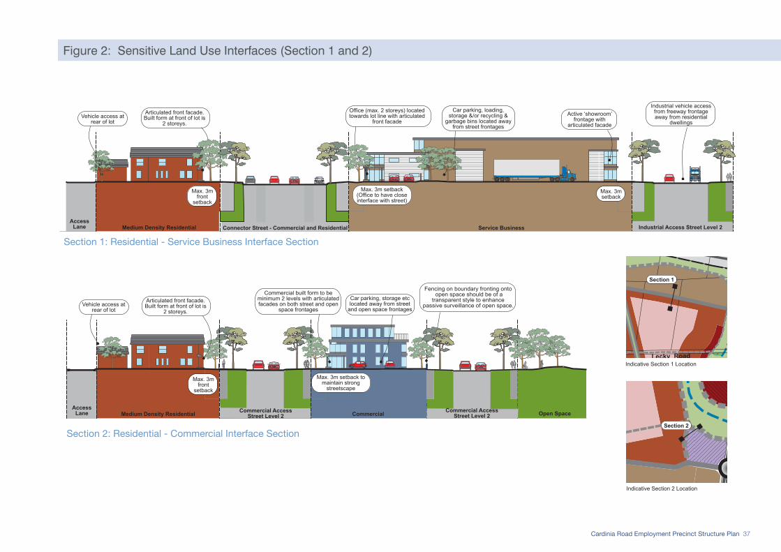
37Cardinia Road Employment Precinct Structure Plan
Figure 2: Sensitive Land Use Interfaces (Section 1 and 2)
Service BusinessMedium Density Residential Access
Lane
Max. 3m front
setback
Vehicle access at rear of lot
Articulated front facade. Built form at front of lot is
2 storeys.
Office (max. 2 storeys) located towards lot line with articulated
front facade
Max. 3m setback (Office to have close interface with street)
Car parking, loading, storage &/or recycling &
garbage bins located away from street frontages
Industrial Access Street Level 2
Active ‘showroom’ frontage with
articulated facade
Industrial vehicle access from freeway frontage away from residential
dwellings
Max. 3msetback
Connector Street - Commercial and Residential
Commercial AccessStreet Level 2Medium Density Residential
AccessLane Commercial Open Space
Max. 3m front
setback
Vehicle access at rear of lot
Articulated front facade. Built form at front of lot is
2 storeys.
Commercial built form to be minimum 2 levels with articulated facades on both street and open
space frontages
Max. 3m setback to maintain strong
streetscape
Car parking, storage etc located away from street
and open space frontages
Fencing on boundary fronting onto open space should be of a
transparent style to enhancepassive surveillance of open space.
Commercial AccessStreet Level 2
Car
dini
a R
oad
Lecky RoadEnterprise Road
Scrub
Gum
Creek
Toom
uc
Cree
k
Thompsons Road
Transmission Easement
Gas Easement
Henry Road
Western Arterial
East
ern
Art
eria
l
PRINCES FREEWAY
0 75 150 225m
planning & urban designmelbourne - tel 9869 0800
© sm urban pty ltdabn 99 124 206 819
trading as smec urban
Pla
n 5:
Fut
ure
Urb
an S
truct
ure
Car
dini
a R
oad
Em
ploy
men
t Pre
cinc
t Stru
ctur
e P
lan
Ref: 3410116UCRDate: 11 August 2010
Rev.: TDrawn: HW
Checked: MH
Scale: 1:7,500m @ A11:15,000m @ A3
0 75 150 225m
Precinct Structure Plan Area
Urban Growth Boundary
Road Network
State Freeway
Arterial Road
Connector Street
Residential Connector Street (Boulevard)
Access Street - level 2
Access Street - level 1
Controlled Intersections
Residential Land
High Density Residential 2
High Density Residential 1
Medium Density Residential
Conventional Residential
Employment Land
Commercial
Activity Centre
Service Business
Industrial
Heritage and Community
Post Contact Heritage Site
Community Facility
Open Space and Environment
Unencumbered Open Space
Encumbered Open Space
Existing Creeks
Drainage Lines
Ecological Vegetation Classes (EVCs) to be Retained
Other land
Existing Major Easements
Future Urban Land
Existing Urban Land
LEGEND
Section 2
Car
dini
a R
oad
Lecky RoadEnterprise Road
Scrub
Gum
Creek
Toom
uc
Cree
k
Thompsons Road
Transmission Easement
Gas Easement
Henry Road
Western Arterial
East
ern
Art
eria
l
PRINCES FREEWAY
0 75 150 225m
planning & urban designmelbourne - tel 9869 0800
© sm urban pty ltdabn 99 124 206 819
trading as smec urban
Pla
n 5:
Fut
ure
Urb
an S
truct
ure
Car
dini
a R
oad
Em
ploy
men
t Pre
cinc
t Stru
ctur
e P
lan
Ref: 3410116UCRDate: 11 August 2010
Rev.: TDrawn: HW
Checked: MH
Scale: 1:7,500m @ A11:15,000m @ A3
0 75 150 225m
Precinct Structure Plan Area
Urban Growth Boundary
Road Network
State Freeway
Arterial Road
Connector Street
Residential Connector Street (Boulevard)
Access Street - level 2
Access Street - level 1
Controlled Intersections
Residential Land
High Density Residential 2
High Density Residential 1
Medium Density Residential
Conventional Residential
Employment Land
Commercial
Activity Centre
Service Business
Industrial
Heritage and Community
Post Contact Heritage Site
Community Facility
Open Space and Environment
Unencumbered Open Space
Encumbered Open Space
Existing Creeks
Drainage Lines
Ecological Vegetation Classes (EVCs) to be Retained
Other land
Existing Major Easements
Future Urban Land
Existing Urban Land
LEGEND
Section 1
Indicative Section 1 Location
Indicative Section 2 Location
Sensitive Land Use Interfaces 2Cardinia Road Employment Precinct Structure Plan
ref.: 3410116UCRdate: 18 Jan 2010
rev.: Qdrawn: APB/MW/AB/BK
checked: MW
planning & urban designmelbourne - tel 9869 0800
© sm urban pty ltdabn 99 124 206 819
trading as smec urban
Scale: 1:400m @ A3
0 4 8 12m
Section 1: Residential - Service Business Interface Section
Section 2: Residential - Commercial Interface Section

38 Cardinia Road Employment Precinct Structure Plan
Figure 3: Sensitive Land Use Interfaces (Section 3 and 4)
Car parking, loading, storage &/or recycling &
garbage bins located at side & rear of building.
Service Business
Max. 3m setback (Office to have close interface with street)
Connector Street - Industrial Medium Density Residential
Minimise front setback
Vehicle access to residentialdwellings from access lane.Encourage studios above
garages on lanes
Office located towards front of lot with
articulated front facade.
Accesslane
Articulated front facade
Medium Density Residential
Articulated dwelling entry
facade
Conventional Residential
Sensitive Land Use Interfaces 2Cardinia Road Employment Precinct Structure Plan
ref.: 3410116UCRdate: 26 August 2010
rev.: Udrawn: HW
checked: MH
planning & urban designmelbourne - tel 9869 0800
© sm urban pty ltdabn 99 124 206 819
trading as smec urban
Scale: 1:400m @ A3
0 4 8 12m
Section 4: Service Business - Medium Density Residential Interface
Section 3: Service Business - Medium Density Residential - Conventional Residential Interface
Indicative Section 3 & 4 Locations
Car parking, loading, storage &/or recycling &
garbage bins located at side & rear of building.
Service Business
Max. 3m setback (Office to have close interface with street)
Industrial Access Street - Level 2
Minimise front setback
Office located towards front of lot with
articulated front facade. Articulated front facade and garage
setback from building line
Residential AccessStreet - Level 1
Dual frontage provided so dwelling addresses
both street fronts
Car
dini
a R
oad
Lecky RoadEnterprise Road
Scrub
Gum
Creek
Toom
uc
Cree
k
Thompsons Road
Transmission Easement
Gas Easement
Henry Road
Western Arterial
East
ern
Art
eria
l
PRINCES FREEWAY
0 75 150 225m
planning & urban designmelbourne - tel 9869 0800
© sm urban pty ltdabn 99 124 206 819
trading as smec urban
Pla
n 5:
Fut
ure
Urb
an S
truct
ure
Car
dini
a R
oad
Em
ploy
men
t Pre
cinc
t Stru
ctur
e P
lan
Ref: 3410116UCRDate: 11 August 2010
Rev.: TDrawn: HW
Checked: MH
Scale: 1:7,500m @ A11:15,000m @ A3
0 75 150 225m
Precinct Structure Plan Area
Urban Growth Boundary
Road Network
State Freeway
Arterial Road
Connector Street
Residential Connector Street (Boulevard)
Access Street - level 2
Access Street - level 1
Controlled Intersections
Residential Land
High Density Residential 2
High Density Residential 1
Medium Density Residential
Conventional Residential
Employment Land
Commercial
Activity Centre
Service Business
Industrial
Heritage and Community
Post Contact Heritage Site
Community Facility
Open Space and Environment
Unencumbered Open Space
Encumbered Open Space
Existing Creeks
Drainage Lines
Ecological Vegetation Classes (EVCs) to be Retained
Other land
Existing Major Easements
Future Urban Land
Existing Urban Land
LEGEND
Section 3Section 4

39Cardinia Road Employment Precinct Structure Plan
• develop an attractive street-based activity centre with a strong urban built form and an active Main Street and public realm; and
• provide a focal point for community activity and pedestrian movement.
4.2.2 Implementation • The objectives for employment and activity centres
are met by implementation of all of the following:• Plan 5: Future Urban Structure;• Plan 8: Employment and Activity Centres;• Planning and design guidelines set out under 4.2.3
including: – Table 6: Employment Land Planning and Design
Guidelines; – Table 7: Hierarchy of Activity Centres; – Table 8: Activity Centre Urban Design Guidelines; – Figure 4: Building Typology – Commercial; – Figure 5: Building Typology – Industry; and – Figure 6: Indicative Urban Design Framework -
Activity Centre.• Section 4.2.4 Urban Design Framework
Requirements; and• Section 4.2.5 Site Context Response Requirements.
4.2 Employment and Activity Centres
4.2.1 Objectives
Employment AreasThe objectives for employment are to:
• increase the supply of serviceable employment land in Melbourne’s south-east;
• strengthen the local and regional economy by creating opportunities for new business to locate in the corridor;
• support a reduction in the level of out-commuting;• improve the ratio of jobs per household in the
Casey-Cardinia Growth Area;• deliver an environment that is attractive for
investment from national and international firms, including establishment of corporate headquarters and diversified industrial activities with supporting offices; and
• facilitate the expansion of the Principal Freight Network.
The objectives for Employment Areas are to:
• diversify the range of local employment opportunities and increase the proportion of business, professional and high-skilled jobs;
• optimise the distribution of uses by: – provide the highest density of employment at the
gateway to the Precinct and along arterial roads in designated Commercial areas;
– locating high profile showroom based uses along the Princes Freeway;
– ensuring low impact commercial and light industrial uses establish adjacent to residential areas; and
– ensure uses with potential for amenity impacts are located away from sensitive uses in the eastern and southern parts of the Precinct.
• promote opportunities for establishment and growth of a range of small business types and home based business;
• facilitate the development of a range of services that support the operation of businesses and establish a high profile for the Precinct, including hotels, function venues and conference centres; and
• provide a high amenity street based activity centre as the focus for Commercial and Residential development.
Activity CentreObjectives for the Activity Centre are to:
• provide neighbourhood-level core retail facilities to create a high-amenity, well-serviced environment, encouraging the establishment of office and service employment;
• deliver a range of goods and services that provides for the diverse needs of businesses, residents, workers and visitors;
• cluster high density residential and commercial uses around the Activity Centre;
• integrate pedestrian and cycling networks with adjacent Residential and Commercial areas, providing a permeable environment with direct and effective links;
• provide strong visual connections between the Activity Centre, Commercial areas, Residential areas and adjoining open space corridors, maximising access to view sheds and vistas;

40 Cardinia Road Employment Precinct Structure Plan
Plan 8: Employment and Activity Centres
Car
dini
a R
oad
Lecky RoadEnterprise Road
Scrub
Gum
Creek
Toom
uc
Cree
k
Thompsons Road
Transmission Easement
Gas Easement
Henry Road
Western Arterial
East
ern
Art
eria
l
400m commercial area radius
PRINCES FREEWAY
Pla
n 8:
Em
ploy
men
t & A
ctiv
ity C
entre
sC
ardi
nia
Roa
d E
mpl
oym
ent P
reci
nct S
truct
ure
Pla
n
Ref: 3410116UCRDate: 17 September 2010
Rev.: UDrawn: HW
Checked: MH
Scale: 1:7,500m @ A11:15,000m @ A3
0 75 150 225m
planning & urban designmelbourne - tel 9869 0800
© smec australia pty ltdabn 47 065 475 149
trading as smec urban
Precinct Structure Plan Area
Urban Growth Boundary
Road Network
State Freeway
Arterial Road
Connector Street
Access Street
Controlled Intersections
Employment Land
Commercial
Neighbourhood Activity Centre
Service Business
Industrial
Residential
Indicative Walkable Catchment
Heritage and Community
Community Facility
Open Space and Environment
Unencumbered Open Space
Encumbered Open Space
Existing Creeks
Drainage Lines
Other land
Existing Major Easements
Future Urban Land
Existing Urban Land
LEGEND
0 150 300 450m
Precinct Structure Plan Area
Urban Growth Boundary
Road Network
State Freeway
Arterial Road
Connector Street
Access Street
Controlled Intersections
Employment Land
Commercial
Neighbourhood Activity Centre
Service Business
Industrial
Residential
Commercial Core/Walkable Catchment
Heritage and Community
Community Facility
Open Space and Environment
Unencumbered Open Space
Encumbered Open Space
Existing Creeks
Drainage Lines
Other land
Existing Major Easements
Future Urban Land
Existing Urban Land
LEGEND

41Cardinia Road Employment Precinct Structure Plan
• Home-based businesses are encouraged in the Activity Centre and in residential areas to maximise the use of high-visibility locations and protect the amenity and integrity of core residential areas. They are encouraged in residential areas where the sites:
– front onto arterial roads; – overlook open space corridors; or – abut Service Business areas.
The framework for the development of employment in the Precinct is illustrated in Plan 8. Planning and design guidelines for the development of specific types of employment land are set out in Table 6.
4.2.3 Planning and Design Guidelines
Employment AreasThe following planning and design guidelines relating to the location of uses must be met:
• Commercial development is to form the gateway to the Precinct, extending along Cardinia Road from the Princes Freeway to surround the intersection of Cardinia Road and Eastern and Western Arterial, creating a high density commercial core, principally comprised of offices.
• Service Business uses are to be located along the Princes Freeway, along Cardinia Road and key sections of Thompsons Road, to provide a high-quality built form edge to the Precinct.
• Industrial Uses are to be located where potential amenity impacts are minimised and high levels of access to arterial roads can be achieved through subdivision design.
• Commercial and Industrial development is to be well integrated through: – road network design that creates a permeable
environment between adjoining developable parcels and provides direct connections to arterial roads; and
– building design that positively contributes to the public realm with a strong visual address and active frontages to primary street frontages, delivering a high amenity outcome (for design suggestions refer to Figure 4 and Figure 5).

42 Cardinia Road Employment Precinct Structure Plan
Table 6: Employment Land Planning and Design Guidelines
Planning and design guidelines that must be met Planning and design guidelines that should be met
General • Secondary street frontages are to provide opportunities to activate building edges, including extensive glazed frontages that enable passive surveillance over the public realm.
• Adjacent to residential areas (refer Figure 2 and Figure 3):
– uses cannot operate for extensive hours (as per Environmental Protection Authority (EPA) requirements);
– uses that generate high traffic volumes and utilise large vehicles are discouraged;
– frontages must be provided to all public roads;
– buildings must present their front, rather than side or rear to residential areas; and
– large car parks must not be provided at the front of buildings.
• Adjacent to open space areas (refer Figure 2 and Figure 3):
– buildings must present their front, rather than side or rear to open space areas;
– frontages must be provided to all public roads;
– passive surveillance of open spaces must be achieved through orientating windows and doors towards the open space; and
– the amount of on-street car parking must be maximised.
• Formal garden entries provided within front setbacks of lots are not to compromise the Precinct’s Australian Landscape Theme.
• Rooftop plants, telecommunications towers etc are to be obscured from view by the built form, screens or false facades.
• Building design is to provide attractive entrances that resolve the level differences between the ground level and finished floor level requirements (refer Section 4.7.3 regarding drainage).
• High quality building design is to be achieved to enhance the public realm. High quality building materials are to be utilised, blank walls to be minimised and extensive active frontages provided.
• Large at-grade car parks are to:
– be landscaped throughout with clean-trunked canopy trees; and
– have adequate pedestrian paths to provide direct, dedicated access-ways from parking to building entrances.
• Creation of common property through subdivision is to be avoided, enabling intensification of development and site redevelopment in the longer term.
• Car parking is to be provided on site and screened from the street and public realm by the built form.
• Integrated and centralised signage is encouraged for multiple businesses and tenancies.
• Where colourbond steel is utilised, it not to exceed 30 percent of the building mass (excluding the roof) visible from any public street.
• Locations of sensitive uses are not to compromise Industrial land use buffers.

43Cardinia Road Employment Precinct Structure Plan
Planning and design guidelines that must be met Planning and design guidelines that should be met
Commercial • The dominant use is to be office, alongside supporting high employment generating activities such as conference facilities, hotels, hospitals and tertiary education facilities, which encourage investment in offices..
• Building set backs from the street are to be minimised to create a highly urbanised Commercial environment, with:
– a maximum setback of 3 metres from the lot line, where lots directly abut Cardinia Road; and
– no setback and a zero lot line where a service road or ‘loop road’ is provided parallel to Cardinia Road.
• Direct connections to open space areas and the Activity Centre are to create a highly permeable, walkable street network and urban environment.
• An ultimate built form of at least 3 to 4 storeys in height is to be provided to achieve the required job densities (refer Figure 4). Development may be staged to allow for less height if it can be demonstrated that the building height can be increased in the future.
• Greater massing and building heights are to be achieved on all corner sites with a frontage to Cardinia Road, creating an attractive entry feature with landmark statement buildings.
• Buildings fronting Cardinia Road and open space areas are to be articulated to create visual interest and diversity.
• Buildings on sites that abut the Freeway interchange are to be:
– primarily accessed (by pedestrians and vehicles) from an internal road that is parallel to the Freeway interchange; or
– built with zero setback from the Freeway interchange, with a well articulated façade that has extensive active frontages overlooking the Freeway and the interchange.
• Ground level pedestrian entrances and foyers are to be clearly visible from the street, with the primary pedestrian entrance to buildings from the highest-order road frontage.
• Buildings are to provide frontages to (existing and future) buildings of adjacent land uses to create a positive relationship between different parts of the Precinct.
• The amenity offered by view lines towards and across open space areas is to be optimised, with the windows and upper storey outdoor spaces of buildings located to maximise the use of the ‘borrowed landscape’.
• Loading bays and service areas are to be located in areas screened from public view, protecting the amenity of the public realm.
• Car parking is to be provided off-street with:
– on-street car parking principally providing for short-stays;
– centralised car parking encouraged, including multi-deck car parks; and
– minimal parking visible from the street.
• Signage is to be contained within the built form and be proportional to facades (with a building frontage to signage ratio of not more than 4:1).
• Where restricted retail uses are provided:
– offices must be provided at upper storeys, and
– an office to restricted retail floorspace ratio of no less that 2:1 is to be provided (for example 1000m2 showroom must be built in conjunction with 2000m2 of office floorspace).
• Large floor plates are encouraged for office buildings to maximise job densities and land utilisation.
• To activate street frontages, particularly along arterial roads and overlooking public open space, cafes, restaurants and convenience shops are encouraged, provided that they are a supporting use. The maximum combined leasable floor area is 500m2 for these uses on any individual lot.
• Integrated office developments to provide communal open space areas for employees, supplementing the public open space network. Open space to maximise solar access, and provide pedestrian connectivity to areas external to the development (refer Figure 4).
• A single vehicle access to be provided for integrated office developments, with shared car parking. Car parking areas can be at-grade, basement or multi-deck, and should be generally screened from the street and public spaces by the built form (refer Figure 4).

44 Cardinia Road Employment Precinct Structure Plan
Planning and design guidelines that must be met Planning and design guidelines that should be met
Service Business
• Buildings are to orientate towards the highest-order road frontage of their site, with:
– areas adjacent to the Princes Freeway fronting onto the Freeway, rather than orienting their side or rear to the Freeway;
– areas along Cardinia and Thompsons Road fronting onto the arterial road; and
– areas along Eastern Arterial fronting onto Eastern Arterial.
• Adjacent to the Princes Freeway:
– showroom, customer service areas and office components of developments are to face the Freeway;
– opportunities for exposure are to be optimised, with a higher built form and greater massing that creates the sense of a continuous high-profile glazed edge to the Precinct; and
– landscaping is to be low lowing to ensure maximum visibility and exposure.
• Where the primary frontage of buildings in the Service Business areas are oriented towards arterial roads or the Freeway, and a second frontage to adjacent land uses exists, the following is to be provided:
– active frontages of buildings to overlook open space areas and streets where they are shared with residential uses;
– windows and secondary pedestrian entrances of buildings overlooking streets in the Commercial area; or
– secondary buildings and/or glazed frontages to provide a strong visual connection where the use is adjacent to Industrial areas.
• Car park and service areas are to be screened from public view, with integrated on-site car parking areas ‘tucked behind’ buildings. Direct pedestrian paths connecting off-street car parks to the primary entrances of buildings must be provided.
• On-street car parking is to be provided in addition to the off-street parking requirements, except where a use has an interface with residential areas.
• Uses with adverse amenity potential (noise, hours of operation, fumes) are not to establish in the area.
• Lighting design is to minimise light ‘spill’ into adjoining land, particularly residential areas.
• Signage is to be provided within the built form, with a maximum building frontage to signage ratio of no more than 3:1.
• Where warehousing is provided, it must be in conjunction with an office and a floorspace ratio of now more than 4:1 is to be achieved (for example, a 400m2 warehouse must provide at least 100m2 of office)
• Where cafes, restaurants, convenience shops and convenience restaurants are provided, they are to be located:
– adjacent to open space; and
– with frontage to an arterial road or connector street; except
– where the site adjoins or forms part of a petrol station or a use listed above.
• Allotments ranging between 500m² and 2000m² are to be provided.
• A single vehicle access point to be provided for sites with a single road frontage.
• Two vehicle access points to be provided for sites with two road frontages, enabling single directional ‘loop’ for servicing and delivery.

45Cardinia Road Employment Precinct Structure Plan
Planning and design guidelines that must be met Planning and design guidelines that should be met
Industrial • Allotments up to 5 hectares are to be provided, to cater for a wide range of industry types. Larger lots can be provided where a specified use is identified.
• Uses with adverse amenity potential may be considered if it is demonstrated that the Residential, Activity Centre and Commercial land (noise, light spillage, hours of operation) is not adversely affected (subject to buffer requirements and distances illustrated in Appendix A).
• Heavier industrial uses are to locate in the southern and eastern parts of the Industrial Area.
• A grid street network is to be developed, creating a variety of lot sizes that enable flexibility in land use and development intensity over time, as demonstrated in Figure 5.
• Office components of industrial developments are to be provided along the street frontage.
• Office facades are to be articulated, providing an attractive streetscape. Landscaping should also be provided along the street frontage (refer Figure 5).
• Buildings are to provide frontages to (existing and future) buildings in adjacent land use areas to create a positive relationship between different parts of the Precinct.
• A maximum street setback of 3 metres is to be achieved, except opposite residential areas where a setback of 6 metres is required.
• At-grade parking, including loading and storage areas are to be provided at either the side or rear of the building (refer Figure 5), with direct pedestrian paths connecting off-street car parks to the primary entrances of buildings.
• Lighting design is to minimise light ‘spill’ onto adjoining land.
• Where cafes, restaurants, convenience shops and convenience restaurants are provided, they are to be located:
– adjacent to open space; and
– with frontage to an arterial road or connector street; except
– where the site adjoins or forms part of a petrol station or a use listed above.
• Warehouse, display and storage areas should be provided in conjunction with other uses eg. industry or office.
• The visual bulk of industrial buildings is to be minimised through the integration of offices and showroom/customer service areas (refer Figure 5).
• Visitor parking may be provided close to the office entry of the development, separated from the street by landscaping.
• Signage is to be provided within the built form with a maximum building to signage ratio of no more than 3:1.
• Pole signs may be provided.

46 Cardinia Road Employment Precinct Structure Plan
Figure 4: Building Typology – Commercial
OFFICE BUILDINGSINDICATIVE BUILDING MASSINGINDICATIVE BUILDING MASSING
8ha340 x 260m
4.2ha260 x 160m
2ha160 x 120m
1ha120 x 80m
0.25ha60 x 40m
0.14ha35 x 40m
Grid street network can be flexible to allow for varied industry sizes
Office components along streetfront (maximum setback 3m)
Visitor parking
Car parking, loading, storageand bins located at side orrear of building
Landscaped street frontage
STREET
STR
EE
T
Loading
STREET
Landscapedstreet frontage
Visual bulk of warehouse to bereduced through integration oflandscaping and office elements
Visitor parking located closeto office entry or on street if required
Office located towards front of lotwith articulated facades on both street frontages (if corner allotment) to provideinterest on streetscape
STREET
Define corner through built form
Car Parking
Entry from street
Communal privateopen space
Solar access to private open space
Ramps/access tobelow grade car park
Opportunities for external privatespace for office buildings
Ground Level
Entry from street
Vehicle Access
Provide buildingentry at keylocation
STREETGround floor & basementinternal parking, with accessscreened from private open space
Shared privateopen space foroffice complex
Pedestrian connection toother key land uses
STR
EET
Strong built form to anchor important street corner
Provide buildingentry at key location
Focus building entryat key corner
Provide varied buildinginterface to street
Potential for roof garden to provideadditional private open space
Variation in height ofbuildings to reducevisual bulk
STREETSTREET
Create strong visual statement on key street corner
Provide openings and connections from street to internal space within site
Not to Scale Not to ScalePLAN PLAN
FLEXIBILITY OF THE GRID
SECTION
INDUSTRIAL BUILDINGSLEGEND
Lot Boundaries
Figure 5: Building Typology – Industry
OFFICE BUILDINGSINDICATIVE BUILDING MASSINGINDICATIVE BUILDING MASSING
8ha340 x 260m
4.2ha260 x 160m
2ha160 x 120m
1ha120 x 80m
0.25ha60 x 40m
0.14ha35 x 40m
Grid street network can be flexible to allow for varied industry sizes
Office components along streetfront (maximum setback 3m)
Visitor parking
Car parking, loading, storageand bins located at side orrear of building
Landscaped street frontage
STREET
STR
EE
T
Loading
STREET
Landscapedstreet frontage
Visual bulk of warehouse to bereduced through integration oflandscaping and office elements
Visitor parking located closeto office entry or on street if required
Office located towards front of lotwith articulated facades on both street frontages (if corner allotment) to provideinterest on streetscape
STREET
Define corner through built form
Car Parking
Entry from street
Communal privateopen space
Solar access to private open space
Ramps/access tobelow grade car park
Opportunities for external privatespace for office buildings
Ground Level
Entry from street
Vehicle Access
Provide buildingentry at keylocation
STREETGround floor & basementinternal parking, with accessscreened from private open space
Shared privateopen space foroffice complex
Pedestrian connection toother key land uses
STR
EET
Strong built form to anchor important street corner
Provide buildingentry at key location
Focus building entryat key corner
Provide varied buildinginterface to street
Potential for roof garden to provideadditional private open space
Variation in height ofbuildings to reducevisual bulk
STREETSTREET
Create strong visual statement on key street corner
Provide openings and connections from street to internal space within site
Not to Scale Not to ScalePLAN PLAN
FLEXIBILITY OF THE GRID
SECTION
INDUSTRIAL BUILDINGSLEGEND
Lot Boundaries

47Cardinia Road Employment Precinct Structure Plan
Activity Centre The following planning and design guidelines must be met:
• The Activity Centre is to be located on the south-west corner of the intersection of Cardinia Road and Eastern and Western Arterial in accordance with Plan 5.
• The Activity Centre is to provide a neighbourhood-level role and function in accordance with Table 7.
The Planning and Design Guidelines outlined in Table 8 apply to the Activity Centre.
Table 7: Hierarchy of Activity Centres
Location Activity Centre Role and Function
Within the Precinct Employment Precinct Neighbourhood Activity Centre
• Retail floorspace of approximately 6,000m2.
• Office floorspace of 4,000m2 (minimum).
• Peripheral commercial areas to provide for activity diversity and provide floorspace for flexible use.
• A ’main street‘ centre anchored by a full-size supermarket (maximum 3,500m2), specialty shops and providing a wide range of personal and professional services, niche (business-related) retail and hospitality, such as cafes, restaurants and taverns/bars.
• Provision for the development of non-retail commercial uses such as office and small office/home office (SOHO) development.
• Approximately 100 dwellings, including shop-top housing and apartments.
• Located adjacent to the Cardinia Road Open Space Corridor and Kaduna Park, the Activity Centre offers the opportunity to create strong links to between these three key community spaces.
Outside the Precinct Note: These activity centres are outside the PSP area, however their role and function has been described as they are located in close proximity to the Precinct and they play a supporting role, particularly in terms of their range of goods, services and facilities and transport links. For more detail on the following activity centres refer to the Cardinia Road PSP, September 2008.
Lakeside / ToomucNeighbourhood Activity Centre
• Retail floorspace of approximately 10,000m2.
• Peripheral commercial floorspace of approximately 25,000m2.
• Neighbourhood-level core retail function with associated peripheral commercial uses, comprising a supermarket, associated shops and services.
• Possible future upgrade from NAC to MAC (Smart Growth Committee 2005).
• Regional peripheral commercial facilities and bulky goods retailing role associated with the Pakenham Homemaker Precinct.
• Regional recreation and community services function, underpinned by the Cardinia Cultural Centre, the ‘Cardinia Life’ indoor sports and aquatic centre and Police and Emergency Complex.
Cardinia Road North Neighbourhood Activity Centre
• Retail floorspace of approximately 5,000m2.
• Neighbourhood-level core retail function and associated peripheral commercial uses, comprising a supermarket, associated shops and services.
Cardinia Road South Neighbourhood Activity Centre
• Retail floorspace of approximately 10,000m2.
• Neighbourhood-level core retail function with associated peripheral commercial uses, comprising a supermarket, associated shops and services.
• Restricted retail services along Cardinia Road.
• Neighbourhood community services including primary school and community centre.
• Integrated with Cardinia Road Railway Station (under development).

48 Cardinia Road Employment Precinct Structure Plan
Table 8: Activity Centre Urban Design Guidelines
Design Issue Planning and design guidelines that must be met Planning and design guidelines that should be met
Layout and Structure • The ground level within the activity centre is to match the floor level of buildings, providing an environment that promotes seamless movement and attractive public realm.
• The road and pedestrian network of the Activity Centre is to be well integrated with (existing and planned) surrounding areas, enabling safe and accessible movement to, from and within the centre, particularly for pedestrians.
• The Activity Centre will be ‘street-based’ with an active, public Main Street lined with specialty shops.
• A finer-grained street network supporting the Main Street is to be created with internal roads or access ways. All internal roads are to be public roads.
• Key views and sight lines into and out of the Activity Centre and to Kaduna Park and open space corridors are to be considered and reflected in the layout and overall design.
• Buildings are to be developed:
– on the edge of Main Street, with frontages aligned with the lot line of the road reserve; and
– in all corners of the site, with frontages aligned to the lot line of adjacent road reserve/s and to abut internal roads or access ways.
• Subdivision of the Activity Centre site is to be minimised to ensure more intensive development can occur over time.
• Creation of common property is to be avoided.
• Limited development may occur in the unencumbered open space west of the Activity Centre, subject to no adverse impacts occurring on the waterway or Growling Grass Frog habitat.
• Create lots with roads or carriageways on all sides.
• The frontages of tenancies along Main Street will be a maximum of 10 metres in width, creating a fine-grained shopfront environment.
Built Form and Massing • Prominent locations (including in all corner of the site) must be developed to:
– provide multi-storey buildings with articulated frontages; or
– create the illusion of building height through landmark architecture.
• Upper storeys are to be provided on the majority of specialty shops in Main Street.
• Where SoHos are provided, they are to:
– be designed to enable the ground floor to be split from the upper floor to create two separate tenancies; and
– ensure entrances can be provided from the street frontage to both ground floor and upper storey tenancies.
• Buildings are to be at least two storeys high.
• Mixed use, ‘townhouse-style’ development with ground floor facades providing ‘shopfront’ or home office (SoHo) environments are encouraged adjacent to the Cardinia Road Open Space Corridor, providing opportunities for flexible use.

49Cardinia Road Employment Precinct Structure Plan
Design Issue Planning and design guidelines that must be met Planning and design guidelines that should be met
Uses – Distribution and Form
• Retail shops will dominate in the Main Street, providing for:
– a finely grained shopfront environment along its length;
– a mix of retail uses;
– small-scale offices or dwellings at upper storeys; and
– access only from Main Street except for corner shops.
• The highest-order retail anchor store in the centre will be a supermarket of no more than 3,500m².
• Stand-alone offices will be:
– multi-storey; or
– provide upper storey residential dwellings.
• Medical centres and gyms are to be located at edge locations where they are a stand-alone use or can be located at upper storeys of Main Street.
• Where childcare and other community uses are provided they are to be located adjacent to open space and/or Kaduna Park.
• Entertainment and dining premises are encouraged in Main Street and overlooking the Cardinia Road Open Space Corridor, broadening the operating hours of the centre.
• Showrooms, niche business-related retail and services are encouraged and may be located on the periphery of the centre or along secondary streets in the Activity Centre.
• A range of uses are encouraged including uses which operate across broader hours (especially at night) such as cafés, restaurants and bars.
• High density residential uses are encouraged:
– overlooking the Cardinia Road Open Space Corridor; or
– fronting onto Kaduna Park; or
– above retail and commercial uses.
• In the unencumbered open space west of the Activity Centre, restaurant or café uses are encouraged, with outdoor dining areas overlooking the Cardinia Road Open Space Corridor.
Supermarkets and other ‘large box uses’
• Supermarkets and other core retail uses of more than 1,000m2 must:
– be directly accessed only from Main Street;
– sit behind the fine-grained shopfront environment of Main Street; and
– not present long façades to the public realm with all edges ‘wrapped’ or ‘hidden from’ the public realm with other tenancies or buildings.
• Niche, business-related retailing requiring larger floor areas (eg. office supplies) may be located on secondary streets or accessways with direct access from car parks.
• The shortest edge of the building is to be oriented to higher order roads.

50 Cardinia Road Employment Precinct Structure Plan
Design Issue Planning and design guidelines that must be met Planning and design guidelines that should be met
Public Domain • A central town square is to be:
– provided in scale with the Activity Centre;
– edged with the active frontages of specialty shops and be directly accessed by shop frontages to encourage outdoor dining;
– well located in an area with high levels of pedestrian activity; and
– have good solar orientation.
• Continuous active frontages are required along Main Street, with minimal breaks in the built form, except to provide:
– a well-located town square that is integrated with and addressed by retail uses;
– access to the supermarket via a small plaza space the equivalent of no more than two specialty shops in width; or
– access to central car parking areas (pedestrian or vehicular).
• A dense concentration of shop entries and extensive clear glazed windows are to characterise Main Street, enabling a high level of pedestrian amenity and engagement.
• Façades are to be articulated to contribute to the character of the street and provide visual interest.
• Continuous awnings or verandahs are to be provided over the footpath on all streets.
• Wider footpaths are to be provided to:
– enable outdoor dining and shopfront trading;
– accommodate informal social interaction; and
– provide clear paths of movement.
• Street furniture and public art are to be provided to create a sense of place and provide informal spaces for social interaction.
• Where specialty shops have facades to both Main Street and internal car parking areas:
– separate tenancies are to be provided fronting onto Main Street and internal car parking areas; or
– where single tenancies exist, active frontages are to be provided on both sides; except
– where rear tenancies would overlook site servicing facilities of other uses.
• The visibility of blank walls is to be minimised.
• The Activity Centre (including car park areas) is to be landscaped with clean-trunked canopy trees and low-lying vegetation to maximise shade and safety.
• A materials and colour palette must be utilised to create a strong urban character that complements and is sensitive to the surrounds.
• The town square is to be at least 500m².
• Blank walls are to be no more than 10 metres in length or account for no more than 50 percent of any one side of a building (whichever is smaller).
• Non-indigenous planting may be permitted as feature plantings (e.g. garden planting and shade trees) within the Activity Centre.
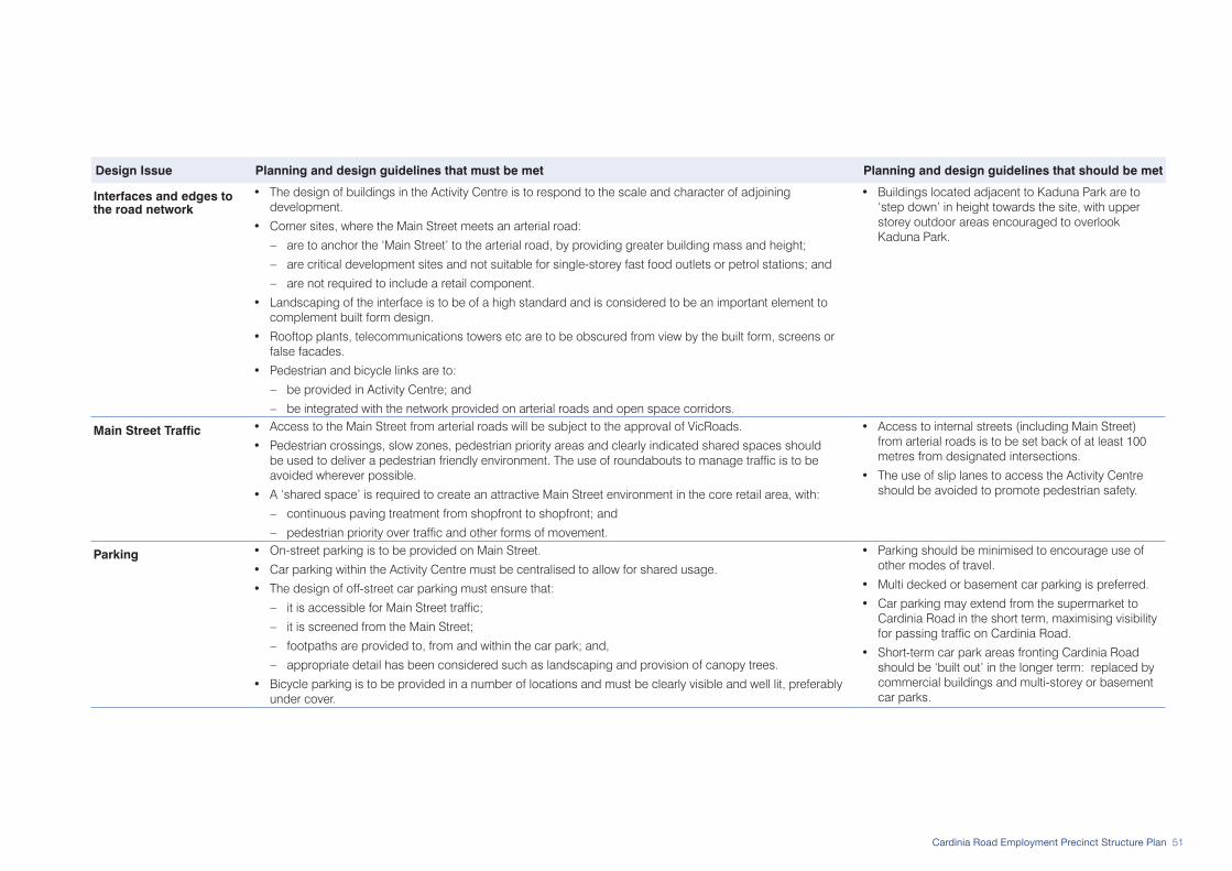
51Cardinia Road Employment Precinct Structure Plan
Design Issue Planning and design guidelines that must be met Planning and design guidelines that should be met
Interfaces and edges to the road network
• The design of buildings in the Activity Centre is to respond to the scale and character of adjoining development.
• Corner sites, where the Main Street meets an arterial road:
– are to anchor the ‘Main Street’ to the arterial road, by providing greater building mass and height;
– are critical development sites and not suitable for single-storey fast food outlets or petrol stations; and
– are not required to include a retail component.
• Landscaping of the interface is to be of a high standard and is considered to be an important element to complement built form design.
• Rooftop plants, telecommunications towers etc are to be obscured from view by the built form, screens or false facades.
• Pedestrian and bicycle links are to:
– be provided in Activity Centre; and
– be integrated with the network provided on arterial roads and open space corridors.
• Buildings located adjacent to Kaduna Park are to ‘step down’ in height towards the site, with upper storey outdoor areas encouraged to overlook Kaduna Park.
Main Street Traffic • Access to the Main Street from arterial roads will be subject to the approval of VicRoads.
• Pedestrian crossings, slow zones, pedestrian priority areas and clearly indicated shared spaces should be used to deliver a pedestrian friendly environment. The use of roundabouts to manage traffic is to be avoided wherever possible.
• A ‘shared space’ is required to create an attractive Main Street environment in the core retail area, with:
– continuous paving treatment from shopfront to shopfront; and
– pedestrian priority over traffic and other forms of movement.
• Access to internal streets (including Main Street) from arterial roads is to be set back of at least 100 metres from designated intersections.
• The use of slip lanes to access the Activity Centre should be avoided to promote pedestrian safety.
Parking • On-street parking is to be provided on Main Street.
• Car parking within the Activity Centre must be centralised to allow for shared usage.
• The design of off-street car parking must ensure that:
– it is accessible for Main Street traffic;
– it is screened from the Main Street;
– footpaths are provided to, from and within the car park; and,
– appropriate detail has been considered such as landscaping and provision of canopy trees.
• Bicycle parking is to be provided in a number of locations and must be clearly visible and well lit, preferably under cover.
• Parking should be minimised to encourage use of other modes of travel.
• Multi decked or basement car parking is preferred.
• Car parking may extend from the supermarket to Cardinia Road in the short term, maximising visibility for passing traffic on Cardinia Road.
• Short-term car park areas fronting Cardinia Road should be ‘built out’ in the longer term: replaced by commercial buildings and multi-storey or basement car parks.

52 Cardinia Road Employment Precinct Structure Plan
Design Issue Planning and design guidelines that must be met Planning and design guidelines that should be met
Public Transport • The Activity Centre design is to incorporate/respond to the proposed public transport network in consultation with the Department of Transport.
• Public transport infrastructure and facilities are to be located in commuter friendly and convenient locations.
Signage • Signage is to be integrated within the built form.
• The transparency and visual permeability of windows at ground level is not to be obscured by any form of tinting, films, paint or similar.
• The placement of advertising collateral eg. posters and banners in ground floor tenancies is to maintain a clear visual connection from buildings onto the street and not obscure sightlines at eye-level.
Site Servicing • Service areas are to be internalised wherever possible. Where internalised service areas cannot be provided, they are to be secured and screened at the rear of buildings.
• Where service areas are accessible from car parks, a well designed and secure façade must be presented to public areas.
• Loading areas should be accessed off a north-south internal street, with left-in, left-out access from Western Arterial.
• Site servicing from Main Street, the east-west road adjacent to Kaduna Park and the Activity Centre Ring Road (adjacent to the Cardinia Road Open Space Corridor) is discouraged.

53Cardinia Road Employment Precinct Structure Plan
4.2.4 Urban Design Framework RequirementsAn Urban Design Framework (UDF) is required for the following areas:
• The area shown as ‘Service Business’ in Plan 5 that abuts Princes Freeway, comprising two discrete sub-areas: – west of Cardinia Road, north of the residential
area; and – east of Cardinia Road, for the area generally north
of Enterprise Road, extending to Toomuc Creek in a band that is approximately 200 metres wide.
• The area defined as the ‘commercial core’ including the Activity Centre, which encompasses: – all land between Cardinia Road and the Cardinia
Road Open Space Corridor; and – all land east of Cardinia Road shown as
Commercial in Plan 5.
Urban Design Framework: Princes Freeway Service Business AreaThe Urban Design Framework must:
• demonstrate consistency with the ‘General’ and ‘Service Business’ guidelines in Table 6.
• set out building design guidelines including addressing the interface with streets and open space, heights, massing and articulation.
• set out guidelines for circulation and access through the Precinct, particularly for larger vehicles and trucks.
• set out guidelines for vehicle access to lots including front (Freeway-side) and rear access.
• outline guidelines for the provision of car parking, including location, design and access.
• provide guidelines for site-servicing including areas for deliveries and waste disposal, site-specific access for larger vehicles and measures to minimise the impact on the amenity of adjoining sensitive land uses.
• include an overall landscape concept.• outline guidelines to improve environmental
sustainability including integrated water management and energy conservation consistent with the minimum requirements set out in Table 20.
• set out design guidelines for the provision of advertising signs.
• set out requirements for concealment of rooftop plants etc.
Urban Design Framework: Commercial Core (including the Activity Centre)The purpose of the ‘commercial core’ UDF is facilitate the delivery of a well integrated urban form with building and subdivision design that responds to adjacent developments and features of the Precinct, ensuring a high-quality and high-amenity outcome.
The UDF must be prepared in detail for the Activity Centre site, with a broader framework being created to guide development of surrounding Commercial and High Density Residential Areas. For the commercial core area not shown as activity centre in Plan 5, the UDF should include:
• integration of access and movement paths; • visual continuity including creation and maintenance
of sightlines;• building siting and massing; and• amenity and character of the Precinct’s commercial
core.The Urban Design Framework must:
• reflect consistency with the role and function for the Activity Centre set out in Table 7.
• address the guidelines for the Activity Centre set out in Table 8.
• demonstrate consistency with the ‘General’ and ‘Commercial’ guidelines in Table 6.
• address the Activity Centre Design Guidelines (DSE 2005), Safer Design Guidelines for Victoria (DSE 2005) and Guidelines for Higher Density Residential Development (DSE 2004).
• set out guidelines for building design in the Activity Centre including interface with streets and other public spaces, heights and articulation to create a strong urban character.

54 Cardinia Road Employment Precinct Structure Plan
• set out a framework for the siting of buildings and principles for heights and massing in the commercial core area not shown as activity centre.
• demonstrate how opportunities for future expansion can be incorporated into the development of the Activity Centre, enabling more intensive development of sites (particularly at-grade carparks) over time.
• set out the building and paving materials to be used in the Activity Centre and identify key elements to be reflected in the commercial core area not shown as activity centre.
• set out guidelines for the integrated design of ‘internal’ streets in the Activity Centre, including design and width of accessways, pedestrian access and areas, car parking and where appropriate, street furniture. A framework must also be provided demonstrating how these connections should be integrated with sightlines and movement paths in the commercial core area not shown as activity centre.
• outline access arrangements from adjoining arterial roads for the Activity Centre, including intersections with streets and property access/egress points.
• provide a Transport Impact Assessment Report for the Activity Centre, prepared to the satisfaction of VicRoads and the responsible authority.
• outline guidelines for car parking in the Activity Centre including the location and design of car parking areas, as well as setting out car parking rates for proposed uses.
• demonstrate how public transport will be integrated with the commercial core and particularly the Activity Centre (to be developed in consultation with the Department of Transport).
• identify locations of public spaces within the commercial core including a town square in the Activity Centre and connections to other public spaces including open space.
• include a landscape concept for the Activity Centre and set out an overall landscaping scheme for the commercial core area not shown as activity centre.
• outline guidelines to improve environmental sustainability including integrated water management and energy conservation consistent with the minimum requirements set out in Table 15.
• provide guidelines for the provision of advertising signs in the Activity Centre.
• set out guidelines for the design of site-servicing areas in the Activity Centre, including areas for deliveries and waste disposal including access for larger vehicles and measures to minimise the impact on the amenity of the Activity Centre and other adjacent uses.
• set out requirements for concealment of rooftop plants etc throughout the commercial core.
• include a plan for the Activity Centre showing proposed ownership patterns.
Indicative Urban Design Framework - Activity CentreThe Indicative Urban Design Framework provides a design solution for the Activity Centre (refer Figure 6). Alternative approaches may be considered.
In addition to the activity centre, the UDF must provide direction to the development of adjacent commercial and higher density residential areas.

55Cardinia Road Employment Precinct Structure Plan
Figure 6: Indicative Urban Design Framework - Activity Centre
CAR PARKING
CAR PARKING
SUPER-MARKET
LOCAL PARK
CARDINIA ROADOPEN SPACECORRIDOR
LOADING
Futu
re U
rban
Stru
ctur
eC
ardi
nia
Roa
d E
mpl
oym
ent P
reci
nct S
truct
ure
Pla
n
Ref: 3410116UCRDate: 20 Sept 2010
Rev.: RDrawn: DL/HW
Checked: MH
Indi
cativ
e U
rban
Des
ign
Fram
ewor
k - A
ctiv
ity C
entre
Car
dini
a R
oad
Em
ploy
men
t Pre
cinc
t Stru
ctur
e P
lan
planning & urban designmelbourne - tel 9869 0800
© sm urban pty ltdabn 99 124 206 819
trading as smec urban
LEGENDActivity Centre Site Boundary
Core Retail
Peripheral Commercial
Office
High Density Residential
Potential Community Facilities
Car Parking
Future Development Area
Potential Locations for Significant Buildings
Controlled Intersection
Town Square
Primary Pedestrian Link
Pedestrian Bridge
Signalised Pedestrian Crossing
Principal Road Network
Main Street
Key Internal Circulation
Boulevard Plantings
Conventional Residential
Medium Density Residential
High Density Residential 1
High Density Residential 2
Commercial
Unencumbered Open Space
Encumbered Open Space
Drainage Line
Wetlands & Other Waterbodies
CAR
DIN
IA
RO
AD
WESTERN ARTERIAL
KADUNA PARK
LEGENDActivity Centre Site Boundary
Core Retail
Peripheral Commercial
Office
High Density Residential
Potential Community Facilities
Car Parking
Future Development Area
Potential Locations for Significant Buildings
Controlled Intersection
Town Square
Primary Pedestrian Link
Pedestrian Bridge
Signalised Pedestrian Crossing
Principal Road Network
Main Street
Key Internal Circulation
Boulevard Plantings
Conventional Residential
Medium Density Residential
High Density Residential 1
High Density Residential 2
Commercial
Unencumbered Open Space
Encumbered Open Space
Drainage Line
Wetlands & Other Waterbodies

56 Cardinia Road Employment Precinct Structure Plan
4.2.5 Site Context Report RequirementsA Site Context Report is required for landmark sites and prominent gateways to the Precinct, where an Urban Design Framework does not apply. It is a site-specific assessment of the merits of a proposal in terms of the urban design standards set by the development and will be required at planning permit stage.
A Site Context Report is required for the following sites:
• Cardinia Road between the Cardinia Road Open Space Corridor and Thompsons Road;
• the corners of Cardinia and Thompsons Roads, extending along Thompsons Road to the first connecting street;
• Thompsons Road adjoining Gum Scrub Creek; and• Thompsons Road adjoining Toomuc Creek.
Site Context ReportThe Site Context Report must:
• demonstrate consistency with the relevant guidelines in Table 6.
• illustrate building design principles including how interfaces with streets and open space have been addressed, how heights, massing and articulation will create a prominent ‘landmark’ on the site.
• demonstrate how the proposed building relates to existing and future adjacent buildings, illustrating how facades and active frontages:
– respond to existing adjacent buildings; and/or – provide opportunities for achieving visual
continuity and integration with future adjacent developments.
• demonstrate how circulation and access will be provided, particularly for larger vehicles and trucks.
• show how car parking will be provided and its visual dominance from the street is minimised.
• demonstrate how site-servicing facilities will be provided, minimising the impact on the amenity of any adjoining sensitive land uses.
• include an assessment of how landscaping will contribute towards an attractive public realm, while not detracting from sense of scale of the built form.
• demonstrate how rooftop plants etc will be concealed.
The Site Context Report would usually include a short report, a site plan showing key features and relationships with surrounds and where adjacent buildings exist: photographs and elevations of the streetscape/s.
57Cardinia Road Employment Precinct Structure Plan
4.3 Housing
4.3.1 Objectives The objectives for housing are to:
• facilitate the development of a residential area that accommodates sufficient population to support a full size supermarket in the Neighbourhood Activity Centre;
• provide at least 2,000 dwellings in the Precinct. • establish a high amenity setting for the residential
area, creating a distinctive neighbourhood character that embraces the natural features of Precinct;
• create a niche residential offer that provides a different housing choice in Cardinia Shire, by: – achieving significantly higher residential
densities, including smaller lot development; and – delivering a compact multi-storey residential
form. • provide a range of residential densities and housing
types;• develop higher residential densities in locations to
encourage walking to the Activity Centre and public transport; and
• optimise the amenity provided by the waterways and open space corridors.
4.3.2 Implementation The objectives for housing are met by implementation of all of the following:
• Plan 5: Future Urban Structure Plan;• Plan 9: Housing;• Planning and design guidelines set out under 4.3.3
including: – Table 9: Distribution of Densities; – Figure 2 and Figure 3: Sensitive Land Use
Interfaces; – Figure 7: Indicative Subdivision Design along
Western Arterial; – Figure 7a: Indicative Conventional & Medium
Density Residential Typologies; and – Figure 7b: Indicative High Density Residential
Typologies. • Plan 11: Open Space Network.
4.3.3 Planning and Design Guidelines GeneralThe following planning and design guidelines must be met:• A greater number of dwellings will be considered
if they are contained within the area shown for residential development in Plan 9 and consistent with the objectives for housing.
• The dwelling yield for any individual parcel (or parcels in contiguous ownership) is to be achieved (refer Table 4).
• 95% of dwellings are to be within 400 metres street walking distance of potential public transport routes to support the provision of future bus services.
• Medium density housing is to be provided where
residential adjoins Service Business uses, with: – subdivision and road design that incorporates
an appropriate interface treatment (including tree planting and use of tree outstands for carparking).
– dwellings designed to front onto the Service Business use.
• Shop-top housing and apartments are to be provided in the Activity Centre.
• Subdivision layout is to: – provide a permeable street network with a grid
layout avoiding cul-de-sacs; – maximise solar access through lot design and
orientation. Where north-south lot orientation cannot be achieved, lot width must enable solar access to north facing windows of habitable rooms; and
– maximise the number of narrow lots to increase the number of dwellings within the walkable catchment of the Activity Centre, open space and public transport routes.
• Streetscapes: – must be landscaped with vegetation reflecting
the Australian Landscape theme; and – are not to be dominated by garages and
carports.• Dwellings are to:
– have front fences of no more than 1.2 metres in height, where they are provided;
– face and provide pedestrian access from the primary street frontage; and
– maximise passive surveillance over public open space, with appropriately located windows, doors, verandas and balconies.
58 Cardinia Road Employment Precinct Structure Plan
• Rear access lanes are to: – be provided where access to the front of the lot is
limited by the road classification or lot width; – provide addresses for above garage dwellings
and home based businesses, enabling buildings to provide passive surveillance over laneways;
– be no more than 150 metres long, with no t-intersections or bends;
– be a maximum width of 6.0 metres; – be designed with no alcoves or obscured
places, ensuring garages and rear fences are constructed to the edge of the road reserve of the laneway (with zero setback); and
– not be heavily landscaped. Low-lying vegetation and climbing plants that do not obscure viewlines is encouraged.
• Home-based business is encouraged, particularly: – along the western edge of Cardinia Road Open
Space Corridor; – in streets where Service Business is the adjacent
use; – on Western Arterial; and – in studios and ‘garage-top’ buildings in rear
access lanes.The following planning and design guidelines should be met:
• The overall dwelling yield and distribution to be achieved in the Precinct is shown in Plan 9 and Table 9, generally reflecting the gradation in densities and diversity of lot sizes.
• The dwelling diversity of any individual parcel (or parcels in contiguous ownership) is to be generally consistent with Table 4.
• Housing at greater than conventional density is to be provided consistent with Plan 9:
– High Density Residential 2 is to be provided south of Kaduna Park and north of Western Arterial along the eastern edge of the Cardinia Road Open Space Corridor.
– High Density Residential 1 is to be provided along the western edge of the Cardinia Road Open Space Corridor, within walking distance of the Activity Centre.
– Medium density housing is to be provided: - along Western Arterial, east of Cardinia Road
Open Space Corridor (refer Figure 7); - along the central north-south access street
that provides a connection to the Service Business area;
- between the Activity Centre and the residential local park; and
- around the Lecky Road conservation reserve.• Conventional residential development is to be
‘tucked behind’ medium and high density residential areas and overlook Gum Scrub Creek.
• All dwellings are to be located within 400 metres street walking distance of a potential future public transport route.
• Mixed-use townhouse-style housing may be provided in the Activity Centre, with a shopfront or office-style ground floor.
• Residential buildings are to be a minimum of two storeys.
• The Australian Landscape theme is to be provided throughout the residential area.
• Non-indigenous planting may be permitted as feature plantings (e.g. garden planting) within residential developments.
• Rear access lanes are to: – provide ‘rumble strips’ across entrances to
laneways from residential local streets; – provide landscaped entrances to laneways with
canopy trees and low-lying plantings provided (in the road reserve of the residential local street);
– be approximately 100 metres in length; and – be a maximum width of 5 metres.