the allentown borough natural resource …
TRANSCRIPT

THE ALLENTOWN BOROUGH
NATURAL RESOURCE INVENTORY (NRI)
Prepared By-The Allentown Borough Council,
The Allentown Borough Environmental Commission, & The Allentown Borough Planning/Zoning Board of Adjustment
The Honorable Stuart A. Fierstein, Mayor Gregory Westfall, Environmental Commission Chair
Jeffrey McLaughlin, Chair, Planning Board 8 North Main Street, PO Box 487
Allentown, New Jersey 08501
Environmental Planning ConsultantpH Princeton Hydro, LLC
Ringoes, NJ 08551
August 2002

I
Acknowledemen ts
We would like to thank the following individuals and groups for their help with developing the Allentown Borough Natural Resource Inventory (NRI):
~ Mayor Stuart A. Fierstein ~
Members of Council Peter L. A. Pantages, President
Arthur H. West Jr. Margaret A. Armenante
Michael Schumacher David G. Strobino Daniel L. Wimer
The Allentown Borough Environmental Commission Greg Westfall, Chair Margaret Armenante
Richard Fine Robert Mayer
Michael Narozniak Elizabeth Poinsett Richard Switlik
The Allentown Borough Planning Board Jeff McLaughlin, Chair
Allentown Borough Consultants and Staff Lorene K. Wright, Municipal Clerk
Killam Associate, Borough Consulting Engineer Michael A. Thorne, GIS Specialist, Monmouth County Information Services
Plan Prepared By -
pH Princeton Hydro, LLC II 08 Old York Road Suite 1, P.O. Box 720
Ringoes, NJ 08551

- TABLE OF CONTENTS
Subject
Section I, Introduction
Allentown Borough NRI Final, August 2002
Page Number
Introduction ............................................................................................ 2 Plan Components ..................................................................................... 4 Plan Methodology ..................................................................................... 4 Overview of Findings & Recommendations ....................................................... 5
Section ll, Resource Planning & Protection Overview
Introduction .................................................... . ..................................... .12 State & Local Regulations & Policies ........................................................... .13 Allentown Borough Master Plan .................................................................. 16 Zoning Regulations, Allentown Borough ....................................................... 17 Borough Resource Protection Efforts ............................................................ 21 Historic and Cultural Resources ............................ . ..................................... 27
Section UI, The Environmental Resource Inventory
Introduction .......................................................................................... 3 3 Climate ................................................................................................ 33 Air Quality ........................................................................................... 34 Physiography (Geology, Soils, Slopes) .................... . ..................................... 38 Flora, Fauna & Significant Habitat .............................................................. .47 Surface Water & Floodplain Resources ........................................................... 55 Floodplains, Riparian Corridors & Wetlands ................................................... 62 Groundwater Resources, Quantity & Quality .................................................... 68 Contaminated Sites ................................................................................. 73
Section IV, Conclusions & Recommendations
Resource Vulnerability ............................................................................. 76 Overview of Findings .............................................................................. 77 Resource Conservation Principals ................................................................ 81 Resource Protection Recommendations ......................................................... 82
II Princeton Hydro, LLC

Subject
GIS Maps
Allentown Borough NRI Final, August 2002
Pae;e Number
Map 1, Regional Location .......................................................................... 3 Map 2, Land Classifications ....................................................................... 1 0 Map 3, Land Use ..................................................................................... 20 Map 4, Open Space, Byways, & Greenbelts ..................................................... 25 Map 4a Heritage Park .............................................................................. 26 Map 5, Historic Resources ......................................................................... 30 Map Sa, Allentown Historic District. ............................................................. 31 Map 6, Slope Percentages ........................................................................... 40 Map 7, Soil Resources ............................................................................... 44 Map 8, Septic Suitability .......................................................................... .45 Map 9, Agricultural Soils .......................................................................... .46 Map 10, Species & Habitat.. ....................................................................... 54 Map 11, Floodplains & Surface Water ........................................................... 65 Map 12, Wetland Resources ....................................................................... 67 Map 13, Groundwater Resources ................................................................. 74
A List of Figures
Cover Photo, Co nines Mill Pond (Allentown Lake) Figure 1 (Photo) The Old Mill, 42 South Main Street. .......................................... 1 Figure 2 (Photo) Recent Development, Ellisdale Road ........................................... 2 Figure 3 (Photo) Conines Mill Pond (Allentown Lake) By Old Mill.. ....................... 11 Figure 4, (Photo) Peppler Funeral Home, 114 South Main Street ............................. 16 Figure 5, (Photo) Heritage Park from Gordon Road Road .................................... 17 Figure 6, (Photo) Residential Home, North Main Street.. ..................................... 18 Figure 7, (Photo) Historic Greenbelt (Route 526) .............................................. 22 Figure 8, (Photo) Historic Greenbelt (Heritage Park) .......................................... .22 Figure 9, (Photo) Historic Greenbelt (Route 539) .............................................. 23 Figure 10, (Photo) Agricultural & Scenic Roadway, Breza Road ............................ 24 Figure 11, (Photo) Imlay Mansion, South Main Street.. ....................................... 27 Figure 12, (Photo) Fanlight Window, John Imlay House ...................................... 28 Figure 13, (Photo) Italianate Victorian Structure, South Main Street.. ...................... 29 Figure 14, (Photo) Conines Mill Pond (Allentown Lake) ..................................... 32 Figure 15, (Graph) Statewide Mean Annual Temperature .................................... 33 Figure 16, (Graph) Statewide Air Quality Trends .............................................. 34 Figure 17, (Map) Watershed Management Area #20 .......................................... 55 Figure 18, (Photo) Co nines Mill Pond (Allentown Lake) ..................................... 56 Figure 19, (Photo) Conines Mill Pond (Allentown Lake) Dam ............................... 57 Figure 20, (Photo) Doctors Creek from Breza Road ........................................... 58 Figure 21, (Photo) Storm water Basin, Ellisdale Road ......................................... 59 Figure 22, (Graph) USGS StreamFlow, Doctors Creek ....................................... 60
pH Princeton Hydro, LLC

Subject
Figures (cont.)
Allentown Borough NRI Final, August 2002
Page Number
Figure 23, (Photo) Riparian Wetland, Route :539 ............................................... 66 Figure 24, (Map) NJ Aquifer Formations ........................................................ 69 Figure 25 & 26 (Graphs) USGS Test Well Levels .............................................. 71 Figure 27, Existing Open Space and Scenic Vista, Breza Rd ................................. 75
List of Tables
Table 1, Zoning Districts and Associated lnfcJrmation ......................................... 18 Table 2, Ground Le~vel Ozone Exceedences ..................................................... 35 Table 3, Development Limitations of Soils ...................................................... .42 Table 4, Natural Heritage Index ................................................................... .47
List of References
Appendix
Surface Water Quality Standards N.J.A.C. 7:9B
pH Princeton Hydro, LLC

SECTION I~ INTRODUCTION
Figure 1, The Old Mill, 42 South Main Street
TV'Ie V~A-os.t v~Lu~bLe ~-p-pLLc~tLoll\, of (ecoLogLc~L) [11\,VeV\,torLes. Ls. tV't~t tV'Ie!j ~eterV~A-LV\,e tV'Ie bes.t Loc~Holl\,s. for L~ 11\,~ us.es..
,...., Ian McHarg, Design With Nature, 1969,....,

-1 v~..trocl.u..ctLo~A-
Allentown Borough NRI Final, August 2002
Allentown Borough is in a predominantly agricultural area located on the outskirts of the Trenton Commuter area in central New Jersey. The Borough, located on the Border of Monmouth and Mercer Counties, is the point of intersection for three County Roads, and is less than one mile from Interstate 195 (Map I). Allentown contains approximately 0.60 square miles of land area and 2,000 citizens. Despite its proximity to densely populated urban areas, and major traffic corridors, environmentally minded Borough officials and a devoted citizenry have made a concerted effort to preserve the historic ambience of, and open space around, the Borough. Despite their efforts, Allentown Borough has almost reached maximum development, and continues to experience the impacts of development from surrounding municipalities (e.g. Hamilton, Washington, and Upper Freehold Townships).
Due to the previously stated development pressure, the Allentown Borough Environmental Commission requested development of a natural resource inventory (NRI). The intent of the inventory development is to provide Allentown Borough with an additional planning tool to protect its existing natural, cultural, historical, and recreational resources. The goals of the Allentown Borough Environmental Commission NRI effort are comprised of the following:
• To locate significant remaining environmental resources throughout Allentown Borough, • To identify all cultural & historical resources in the Borough, and • To provide the Borough with an updated and comprehensive environmental planning tool to
protect remaining resources by integrating existing Borough protection efforts, recent scientific information, and the most current Geographical Information System (GIS) maps available from Federal, State, and county agencies.
Figure 2, Recent Development, Ellisdale Road, Border Allentown Borough & Upper Freehold
II Princeton Hydro, LLC 2

<I ( 0 = s ~ ! I I ia lie o • :1 ! ...
i! ! :II:
! i ~ . ,. ~
~ .. .. ~.,.
~ ·= ~ ·~:
~ ail •0 rs ~:I: liin ~0
j= 8~ "
,(\
·~ ~<So 0
<<> ~
~
D 1:!'8 ..... ll) I ~ =~
r ... ~~ r- z s• .. ! 0
~- il "'I ::::! 0
~ ~
-fl;•" '\0~-f/;
).6
-~~
-t. ,"
~~Ct> .-fl;
\ Q.A
0 .,.
NOTES: ALLENTOWN BOROUGH, NRI, 2002 Monmouth County, NewJerseyGISDepMment 1.DATAACQJRACYISLI~T8JTOTHE MAP 1; REGIONAL LOCATION
Scale 1 24 0C0 ACO$I.A.Cf ANJ SCALE OF THE ORIGINAL New JerseY, Department of Environmental Protection, GIS data DATA SOURCES.
200 0 200 400 600 800 1000 Feet Web Site DCitYnloads State Municipalities of New Jersey 2 THESE IMPS ARE PART OF A RESOURCE
.~ s Scale 1:1 OO,OCO INVENTORY CONDUCTED FOR ALLENTOWN BOROUGH 1 DRAWN av. 1 cw 1 H SCALE 1. 500 AND SHOUlD BE USED IN CONJUNGnON WITH THE ,, I I p . CQmlED TEXT ,CHECKED IY; SF,ICM
Map Plojecbon: Slate Plane c:J New Jesey, NAD 83, Feet · --- ... - ---- -- --
(.J

-t>L~II\.. C.OII'vt"I)OII\..tll\..ts-
'
Allentown Borough NRI Final, August 2002
The Allentown Borough Natural Resource Inventory (NRI) is a comprehensive compilation of text, maps, and charts that fully describe the current environmental and natural resources in the Borough. The plan contains an overview of current resource protection information, a comprehensive resource inventory, and a resource protection plan. The NRI also contains the most updated GIS mapping and database technology available through the New Jersey Department of Environmental Protection (NJDEP), the Monmouth County lnfonnation Services Division (Map 2), and other sources. All GIS data contained in this inventory may be reviewed at the Borough.
PL~II\.. MetVlDc{oLogkj -
Several information sources were used to obtain the most updated environmental resource infonnation. Infonnation sources for local planning and protection materials included the Allentown Borough Master Plan (Lim & Pushchak 1978), the Master Plan Re-evaluation (Planning Board 1997), the Zoning Regulations of the Borough of Allentown (1975 & 1978 Ordinance), the Allentown Borough Open Space Inventory, and local natura) and historical infonnation sources.
Other infonnation sources consulted for the Natural and Cultural Resource Inventory were several Federal, State and local agencies. These included the United States Environmental Protection Agency (USEPA), the United States Department of the Interior, the New Jersey Office of State Planning, and the NJDEP. Local agencies such as the Freehold Soil Conservation District and the Monmouth County Planning Board were also contacted for updated resource infonnation.
Digital mapping information (GIS) was obtained from the NJDEP GIS Data Web Site. GIS infonnation was also made available directly from Allentown Borough and from the Borough's consultants. A generalized overlay analysis was completed in order to determine the extent and the vulnerability of environmental resources within Allentown Borough. For instance, the zoning map was compared, through GIS overlay analysis, with the mapping coverage illustrating steep slopes, critical habitat, preserved historic structures, and existing greenway corridors. The Zoning Regulations were often consulted to see if sufficient resource protection regulations were currently in place to protect existing habitat.
II Princeton Hydro, LLC 4

-
Findings
Allentown Borough NRI Final, August 2002
Allentown Borough still contains a significant amount of valuable environmental and cultural resources including wildlife habitat, riparian corridors, protected open areas, and preserved historic buildings. However, more can be done to protect remaining natural and historical resources in Allentown Borough. Information on natural and historic resource fmdings include the following:
• Allentown Borough was settled circa 1706. The Borough continues to maintain a historic character. Despite the presence of one historic district and many historic structures, the Borough was placed on the ten most endangered historic sites list by Preservation New Jersey in 2001. The historic district boasts 21 styles of architecture within its boundaries.
• Allentown Borough was officially designated as a Village Center, by the New Jersey State Planning Commission, on May 15,2002.
• The climate in Allentown Borough is classified as continental. It is characterized by an average yearly temperature of 55°F, as measured at Freehold, NJ. Winter temperatures during the month of January average 29°F, while July temperatures average 74 °F.
• Annual precipitation for the area, as measured in Freehold, NJ is 38.3 inches per year and 3.8 inches per month (Rutgers 1960-1990).
• Due to expanded growth at Allentown Borough's borders, along with excessive summer traffic, the Borough is concerned about air quality. More localized air quality data is required to measure impacts.
• In 1989, citizens from Allentown Borough completed a traffic survey, under the auspices of the Allentown Environmental Commission, and more than 800 drivers were surveyed. Most responded that they travel through Allentown Borough on their way to other destinations, because it is the only route available. Approximately 9()0/o of those surveyed stated that they would utilize a by-pass if it were available.
• In 1992, the Allentown Regional Traffic Study was completed. This study recommended the building of an Easterly and/or Westerly bypass to minimize traffic through the Borough.
II Princeton Hydro, LLC 5

Allentown Borough NRI Final. August 2002
• Allentown Borough is located within the Inner Coastal Plain segment of the Atlantic Coastal Province, which is underlain primarily by sands, clays, glauconitic marl, and silts of the Cretaceous Period.
• The most significant steep slopes in Allentown Borough are located along the southeastern bank of Doctors Creek, south of the Indian Run Reservoir on the border of Allentown Borough, and along the banks ofConines Mill Pond (Allentown Lake).
• The Natural Resource Conservation Service (NRCS) Soil Survey of Monmouth County, New Jersey (USDA 1989) identifies 32 soil series in Monmouth County. Approximately 6 soil associations, and 13 soil map unit symbols, are located in Allentown Borough.
• Most of the soils found in Allentown Borough have severe septic system limitations, and several soils have severe building foundation limitations. No known properties with septic systems exist in the Borough.
• The municipality has two (2) Soils of Statewide Importance and three (3) Prime Agricultural Soils.
• There are no known threatened or endangered flora or fauna in Allentown Borough (Natural Heritage Database 2001). However, the threatened, endangered, and protected species list for Monmouth County contains 21 birds, 17 insects, and 32 plants.
• The New Jersey Division ofFish and Wildlife (Endangered and Non-game Species Program) notes that Allentown Borough contains 35 acres of critical forested wetland habitat and approximately 19 acres of critical grassland habitat.
• The New Jersey Division ofFish and Wildlife is studying the movement of anadromous fish upstream on Doctors Creek to determine whether the existing Conines Mill pond dam is an impediment.
• The Conines Mill Pond was designated a Monmouth County Unique Area in the Planning Board's 1978 Natural Resources Study.
• The Monmouth County Audubon Society reports that over three hundred and fifty (350) year round, summer, winter, and transient bird species are commonly found in Allentown Borough.
1111 Princeton Hydro, LLC 6

Allentown Borough NRI Final, August 2002
• Allentown Borough lies within the NJDEP Lower Delaware Watershed Management Region (Watershed Management Area #20). The major sub watershed and watercourses dmining the Borough are Doctors Creek and Indian Run.
• The Monmouth County Unique Areas Study (Monmouth County Environmental Council 1978) describes Doctors Creek as a unique wildlife habitat and a significant watershed/floodplain resource.
• Conines Mill Pond is one of the oldest manmade water bodies in the United States. The Pond is also included in the Monmouth County Unique Areas Study and is described as a recreational, scenic, and historic watershed, wildlife habitat, and floodplain amenity. In addition, the Conines Mill Pond site is also a State Wildlife Sanctuary.
• Both Doctors Creek and Indian Run (a tributary to Doctors Creek) are classified freshwater, non-trout production streams (FW -2) (NJAC 7:9B-1.15). Doctors Creek has been monitored periodically by State and local agencies. The 2000 State water quality inventory 305(b) report for the Doctors Creek indicates it is "non-impaired" for all parameters.
• United States Geological Survey (USGS) stream flow data (1968-2001) indicates that highest stream flows were recorded in August 1971 (1,250 cfs) and lowest flows were recorded in 1992 (100 cfs).
• Approximately 410 acres of valuable floodplain are located within the Borough, and the aerial photographs indicate the rivers, and surrounding floodplains, are currently well buffered with riparian vegetation.
• The Monmouth County Park, Recreation and Open Space Plan (Monmouth County Planning Park System 1991) includes the Doctors Creek Riparian Corridor as a proposed linear park, which would protect a high value habitat, and complement existing historic districts. Allentown Borough is currently working with five neighboring municipalities in three counties to develop a regional greenway plan to protect surface water quality, preserve stream corridors for future recreational trail access, and preserve historic vistas.
• There are approximately 43.85 acres comprised of agricultural, forested, and herbaceous wetlands in Allentown Borough (figure 14). The majority of wetlands in the Borough are ecologically categorized as palustrian wetlands.
1111 Princeton Hydro, LLC 7
- Allentown Borough NRI Final, August 2002
• Allentown Borough is located in the Atlantic Coastal Plain regional aquifer. The primary aquifers underlying Allentown Borough are the Englishtown Aquifer Formation and the Potomac-Raritan Magotny (PRM). The aquifers are included in the Federally designated Sole Source Aquifer (53 Federal Register, 23791). Allentown Borough receives its water supply from the Englishtown Aquifer which is recharged at the land surface near the boundary of Washington and West Windsor Townships, just west of Windsor village.
• Two USGS test wells are located in Allentown Borough on Gordon Street (Map 13) at the Allentown Water Department. These test wells measured water levels in the PRM aquifer which lies below the Englishtown Aquifer. USGS information for one well indicates a significant drop in water level between 1950 and 1988, while data for the second well indicates more consistent water levels.
• Water quality testing performed on one USGS groundwater well indicates that, of the parameters monitored, groundwater quality was well within the NJDEP's groundwater quality criteria (Class IIA and Practical Quantitation Levels).
• In general, within the Borough, all water quality parameters tested were below standard accepted values (Appendix). However, at one site, located on Doctors Creek in Upper Freehold, some parameters tested were above the accepted values. Particularly, there were elevated nutrient concentrations and periodically elevated fecal coliform counts.
• The contaminants mentioned throughout this document are from non-point sources (runoft) and are not from the Allentown Sewer Plant.
Recommendations
Based on the findings previously stated, guiding principles recommended by Allentown Borough, and the information collected for this resource inventory, the following recommendations are provided:
• Based on the recommendations included in the I 997 study and the information obtained for this Natural and Historical Inventory, the Borough's Master Plan should be updated as soon as feasible.
• Increased capital should be set aside and grants obtained to complete additional analysis and to revise current regulations to be more protective of valuable natural resources and encourage historic preservation, including views and vistas.
I* Princeton Hydro, LLC 8

Allentown Borough NRI Final, August 2002
• Existing zoning and land development regulations may need to be strengthened. Therefore, a thorough review of existing zoning and land development regulations should be completed in consideration of the historic and natural resources identified and mapped for this inventory.
• In order to develop an Allentown bypass, and to implement regional stream corridor protection and historic greenbelt programs, Allentown Borough should continued to plan and coordinate with neighboring municipalities.
• The Borough should implement a tree and shrub planting program to screen public and private property from sources of noise and automobile pollution, and to improve upon existing scenic vistas.
• The Borough should consider implementing an ongoing volunteer water quality monitoring program to foster stewardship and to obtain long-term water quality and water quantity data.
• The Borough should identify all existing tax parcels (within the Borough), that under current zoning, can be further subdivided for additional development. These parcels should be evaluated as to their potential for impacting critical natural (steep slopes, stream corridors) or historic resources (historic vistas).
• The Borough should seek funding from the NJDEP Green Acres Progrwn or other sources to 1) purchase development rights to protect historic vistas from encroachment 2) purchase property along the southeast side of Heritage Park to protect the stream corridor and flood plain from a major soil erosion hazard should traditional development occur, 3) purchase land adjacent to Allentown Lake to provide public access for a future perimeter trail.
• The Borough should adopt a steep slope ordinance to reduce/mitigate soil erosion during and following development.
• The Borough should work alone or in conjunction with neighboring municipalities to pennanently preserve open space in the historic greenbelt around the Borough, adjacent to Heritage Park, and all historic vistas.
I* Princeton Hydro, LLC 9

MONMOUTH COUNTY I ALLENTOWN BOROUGH*
LAND CLASSIFICATION LEGEND
[ KEY CLASSIFICATION
• SCHOOL
• PUBLIC PROPERTY
• CHARITABLE
CEMETERY
GREEN ACRES
0 RESIDENTIAL
• RESIDENTIAL
• COMMERCIAL
APARTMENTS
I
AGRICULTURAL/HISTORICAL GREENBELT PROPERTY*
D 1 acre
ELLISDALE RD •
- 1110.-ount COUNTY
NEW .JERSEY TOWNSHIP MAP • • • -- KALE 1:1,000,000
WESTERN MONMOUTH COUNTY • • • • .._ SCALE 1:1.000.000
SYMBOL KEY
c::J -H IIOUNOARY
/'.,/ lmADII
- ALLENTOWN LAKES /'../ IITIIEAMS
('\I
~(I) 0 0 ('\I
~ § ....
=ci ~ ~ 0 g
0 ~ 0 § ~
~ 11 0 ~ ~~ ~ ""'~
~ I
5~ 8 <I)~ N
0 i5 1l E--4 z 0 l c. r.a "' ::Iii
.....:l 8 10
~ N
Section II ,._ Resource Planning and Protection Overview
Figure 3, Conines Mill Pond (Allentown Lake) By the Old Mill
objecHve o ll\,e: PLaV\, for ~eveLopVVteV\,t up to, all\,~ coll\,s[stell\,t wL.tV!, exLstL.VI-0 servLce capac[Hes (water§ sewer). objecHve Two: Preserve tV!e resL~eV\,HaL, V!LstorL.caL, all\,{){ sVVtaLL towll\, cltlaracter of ALLeV\,towV\,.
objecHve TV!ree: PLat/\, for a rwsoV\,abLe VVtLX of resL.~eV\,HaL La II\,~ use t~pes. objecHve Four: PLat/\, for future opel/\, space 11\,ee~s b~ preservi.V\,g portL.oV\,s of ex[stL.V\,g vacall\,t La~ (streaVVts § woo~ Lots).
-The Allentown Borough Master Plan -

- Allentown Borough NRI Final, August 2002
Allentown Borough, Resource Planning & Protection Overview
r Vt.troducHoJI\, ~
Although Allentown Borough is largely developed, it still contains a variety of natural and historical resources. In recent years, the surrounding municipalities have experienced a significant amount of development. One concern of citizens living in Allentown Borough is that development in the surrounding municipalities may have resulted in varying degrees of impact upon the Borough's environmental and historical amenities. Usually, habitats containing a variety of native vegetation and wildlife are replaced with less diverse human habitats and a less ecologically diverse human landscape.
Development has a variety of direct and indirect impacts upon environmental resources and the ecological stability of an area. One impact is that when land is developed, existing wildlife is displaced. Another impact is the correlation between increased development, increased impervious coverage, and increased nonpoint source pollution. Surface runoff, erosion and sedimentation are natural occurrences; however they are accelerated when land is developed. For instance, when vegetated soils are replaced with impervious surfaces (e.g. roads, homes, driveways, and parking lots), stormwater runoff, erosion, and sedimentation increase.
1~ SHAI.LOW ...... TAll TION
When rain falls on undeveloped land, most of it etther infiltrates the sot/ or evaporates. When the land is covered wtth buildings and roads, most of the ram runs off over the surface, carrying pollution
and causing increased flooding. Storm water management tech-
1
niques can and should manage runoff so that it imitates the more natural conditions.
I ANJEC, Stormwater Seminar Broehure, 2001
I* Princeton Hydro, LLC 12

Allentown Borough NRI Final, August 2002
In addition, there is a correlation between land use and the type of contributed pollutants. For example, a forested area will contribute approximately two hundred and twenty pounds of soil per acre, per year, to our local streams and lakes. Adhering to the soil particles is approximately a quarter pound of phosphorus and over two pounds of nitrogen. Residential land contributes almost five-hundred pounds of soil, over a pound of phosphorus and over seven pounds of nitrogen. While our soils, wetlands, woodlands, lakes, and streams have natural pollutant filtering capabilities, their ability to mitigate pollutants is diminished as the density of development and the amount of pollution mcreases.
Allentown Borough feels it is important to identify the location of remaining natural resources and to understand their ecological significance. However, it is just as important to understand how the Borough is planning for the location, intensity, and design of new development in order to maintain the integrity and capacity of its natural resource systems. The following section addresses the planning and regulatory framework that is currently in place in order to protect Allentown Borough's environmental resources.
Many agree that New Jersey has one of the most comprehensive State level regulatory frameworks in the nation. The State also has a long tradition ofland development law, regulation, planning policy, and project procedure. The following sections address the State Planning Act, the State Development and Redevelopment Plan, the Municipal Land Use Law, and other environmental regulations directly, and indirectly, pertaining to environmental resource protection in Allentown Borough.
The New Jersey State Planning Act was adopted in 1985 and requires sound land use planning to conserve natural resources, provide housing and public services and promote economic growth. The guiding natural resource protection principle of the State Planning Act is that natural resources should be conserved because the protection of environmental qualities are .. vital to the quality oflife and economic prosperity". The New Jersey State Planning Act required that the State prepare and periodically update The State Development and Redevelopment Plan and include, among others, planning objectives addressing land use and resource conservation. The current Plan that was recently adopted, contains five planning areas ( metropolitan, suburban, fringe, rural, and environmentally sensitive), and a variety of goals and strategies addressing development intensity and resource protection. The Rural Planning Area has been assigned to Allentown Borough (NJ Planning Commission 2001 ). The State plan policies related to the Rural Planning Area include the following:
• Maintain the Environs as large contiguous areas of farmland and other lands, • Revitalize towns, • Promote a viable agricultural industry,
I* Princeton Hydro, LLC 13

• Protect the character of existing stable communities, and
Allentown Borough NRI Final, August 2002
• Confine programmed sewers and public water services to Centers.
The criteria for the development of planning centers is based upon development density, available infrastructure, population, land area, and proximity to suburban centers. Of the eight statewide goals included in the State Development and Redevelopment Plan, half of them directly address conservation of natural resources, environmental protection, preservation of cultural and open space areas, and sound planning decisions.
The New Jersey State Development and Redevelopment Plan was adopted in June 1992. The Plan is designed to help the State and local governments manage and shape new growth and development in an ecological, environmental, and economically responsible manner. In addition, another goal is to save hundreds of millions in tax dollars by directing growth towards established urban areas and compact centers. The Plan encourages development in Centers, of which there are five types: Urban Centers, Towns, Regional Centers, Villages, and Hamlets. In addition, the Plan divides the State into five planning areas, the components of which share characteristics and strategic intentions. Development and redevelopment in Centers are directed by guidelines associated with the Planning Area in which they are located. As was previously mentioned, the Rural Planning Area designation was assigned to Allentown Borough. In addition, on May 15, 2002, the New Jersey State Panning Commission officially designated Allentown Borough as a Village Center. The Criteria for Village Center Designation/Planning for the Year 2020 is:
1. Area (in square miles): < 1 2. Population: < 4,500 3. Gross Population Density (people/square miles): 5,000 4. Housing: 75 to 2,000 5. Gross Housing Density (dwelling units/acre):> 3 6. Employment: 50 to 1,000 7. Jobs: Housing Ratio: 0.5:1 to 2:1
Villages are "compact, primarily residential communities that offer basic consumer services for their residents and nearby residents" (New Jersey State Planning Commission 1999). They likely contain a small core and collection of neighborhoods offering a range of housing types, but emphasizing small- and medium-lot single-family housing, a small multi-family component, and an appropriate rental component. The Village should contain a commercial component in the "core" offering neighborhood-scale goods and services (supermarket/shopping center). The Village should also provide public facilities including schools and libraries, and small-scale commercial services such as a bank and professional offices.
Villages can be distinguished from their surrounding environs in several ways. First, they are
I* Princeton Hydro, LLC 14

Allentown Borough NRI Final, August 2002
closely integrated from a circulation standpoint; transportation routes are not limited through cui-desacs or other devices. Instea~ complete and safe circulation networks for automobiles, bicycles, and pedestrians are provided. As such, non-residential areas are accessible to tansit, and para-transit services and non-motorized transportation. Second, there is a community "core", such as an intersection, around which commercial and civic components are located. This "core" is also appropriate as a pick-up/drop-offlocation for transit services and car/van pools. The "core" is the focus of public activities and investments. Finally, Villages are effectively linked to adjacent Centers via regional bikeways and corridor transit or para-transit
The State of New Jersey is promoting Centers as the preferred vehicle for accommodating growth and development in order to minimize sprawl. The goal of promoting development in Centers "is to reverse the trend of abandoning cities and downtown areas in favor of suburban sprawl" (New Jersey Future, http://www.njfuture.org/HTMLSrc/ stateplan.html). Supports believe the Plan will help cities regain their status as vibrant areas of cultural and economic activity. Planned development in Centers, including Villages, has the potential to:
1. Stop or check urban sprawl, 2. Stop or check the trend of abandoning cities and downtown areas, 3. Offer a greater sense of community to Center residents, 4. Offer a variety of choices in housing types to Center residents, 5. Provide for a more efficient transportation system for Center residents, and 6. Preserve the charm and quiet lifestyle of rural areas.
While there is a hierarchy of five Center types, each with specific growth management strategies, municipalities are not expected to remain static and growth is not limited. Instead, each municipality can develop into a larger Center type; for instance, a Village may become a Town. Thus, careful planning is important to avoid problems associated with unchecked or uncontrolled growth and development, including those the Plan is addressing (e.g. suburban sprawl, loss of environmentally sensitive land and natural habitats, and increases in point and non-point source pollution).
The New Jersey Municipal Land Use Law, enacted in 1975, is the enabling legislation that assigns State land use regulatory authority (e.g. zoning and land development) to Allentown Borough. The purpose of the Municipal Land Use Law is to encourage land use and land development procedures that ensure public health, safety, and welfare. Enhancement and preservation of the natural, cultural, historic, and visual environments are goals included in the Municipal Land Use Law. In addition, the Allentown Borough Master Plan, Official Map, Zoning Ordinances, and all other development review procedures, are enabled by the Municipal Land Use Law.
I* Princeton Hydro, LLC 15

Allentown Borough NRI Final, August 2002
Figure 4, The Peppler Funeral Home, 114 South Main Street
T~e ALLell\,tOWV\, "BorougV! MC!$ter PLC!II\, -
The Allentown Borough Master Plan and Master Plan Reevaluation (1978 & 1997, - respectively) contain information and explicit policy statements intended to guide future
development. The Borough Master Plan contains the policy basis for the regulations in the municipal zoning ordinance and zoning map, and the programs implemented by elected and appointed officials in the Borough. The Allentown Borough Master Plan contains the following major planning objectives, and major concerns expressed by citizens (Note:* Denotes those objectives most related to natural and historical resource preservation & protection):
• Objective One- Preserve small town character*, • Objective Two- Avoid undue fiscal burdens, • Objective Three- Preserve land for future open space*, • Objective Four- Regenerate commercial viability*, • Objective Five Create a residential land use mix, and • Objective Six- Make open space accessible*.
• Concern One- Provide off-street parking in the Borough Center, • Concern Two- Aesthetically separate land uses by means of vegetation areas and
buffer zones*, • Concern Three- Create a diversity of land uses for tax stability. and • Concern Four- Ease traffic congestion by supporting the need for Borough
Bypasses (Easterly & Westerly).
II Princeton Hydro, LLC 16

Allentown Borough NRI Final, August 2002
Overall, the elements contained in the Master Plan and the Reevaluation reports are supportive of open space acquisition, natural resource protection, and preservation of historical amenities in the Borough. For instance, policies included in the conservation element stress the importance of protecting the stream channels around Doctors Creek and Indian Run. Policies in the Services Element are directed at maintaining safe water levels at the Mill Pond spillway through enforcement of runoff and water retention standards. Recreation policies address open space acquisition for recreational use as well as for greenbelt expansion. The creation of historic designation ordinances is also recommended in the Master Plan, and has since been completed.
Figure 5, Heritage Park looking toward Borough Center from Gordon Road
Zoning is a set of standards controlling the location, type, and intensity of development on site. Amendments have been made to the Zoning Regulation of Allentown Borough based upon a variety of planning analyses completed to periodically update the Master Plan. In Allentown Borough, the following Zoning Districts regulate land use; limit and restrict the use ofbuildings and structures to permitted uses; regulate lot coverage, lot size and lot dimensions; and require performance standards. The zoning districts directly influence the way land is used. The Land Use map (Map 3) indicates that the majority ofland within Allentown Borough supports single-family, medium density residential uses. However it also indicates open space.
II Princeton Hydro, LLC 17

Table l
Allentown Borough NRJ Final, August 2002
Zoning Standards & Associated Information
Zoning District ~ District Regulations & Pertinent Notes -Multi-Family District R-135- Minimum lot width 100', Minimum lot depth
135', Minimum set back 35', Maximum impervious material-40%
Residence District R-85- Minimum lot width 85', Minimum lot depth 100', Minimum set back 35', Maximum impervious material-40%
Residence District R-60- Minimum lot width 60', Minimum lot depth 1 00', Minimum set back 20', Maximum impervious material-50%
Residence District R-40- Minimum lot width 40', Minimum lot depth 95', Minimum set back 20', Maximum impervious material-500/o
Business District B-D- Minimum lot width 40', Minimum lot depth 1 00', Minimum set back 20', Maximum impervious material-65%
Figure 6, Home on 18 North Main Street, Residential R-40 Zoning District
II Princeton Hydro, LLC 18

Allentown Borough NRJ Final, August 2002
The Zoning Regulations of the Borough of Allentown contain provisions governing reviews, requirements. and actions relating site development proposals. The following environmental resource protection tools are included in the ordinance:
• Purpose statement supporting natural, historical, and visual resource protection (32·2),
• Lot dimension, lot size, and impervious material restrictions 32-4.7,
• Natural features preservation provisions including (32·4.8): o Floodplain buffer (50') o Watercourse buffer (50') o Depth to water table provisions (no structure on land with water tables 2' from
surface) o Erosion and sedimentation plan requirements o Protection of existing natural features (trees, brooks, drainage channels, and
views),
• Sign Ordinance (32-9.1),
• Fence Restrictions (32-9.3),
• Recycling Requirements (32-9.4), and
• Site Plan Submittal and Approval Requirements including (32-10.1, 32-10.3) o Landscaping, shade tree, and screening plan requirements o Earth moving plan requirements o Drainage and storrnwater requirements o Environmental and community impact statement o Traffic impact report o Environmental plan (existing resources and protection plan).
II Princeton Hydro, LLC 19

<I <D = !I ~
I i 11
I I Ill 0 r-
I ~ § m ~
o(
~
ALLENTOWN BOROUGH, NRI, 2002
200 0 200 400 600 800 1000 Feet r=-- - :::::s
SCALE 1: 500 Map Projeclion: Stete Pia~ rl New Jesey, f'Wl 83. Feet s
N 0
c;.,. .,. ~.
• ~(to ~0
<'o ~~ .,.
D -1o.
Q) (")
ca
:1 ,. "' :z:
~ i
8 :.. Ill
.. 8
0 0 D D I
II II I p I I i I ! ! I I I
~
.. !!I !'I ! ~c N .. : .. ., =~
;~ ~ ;~
0 I 0 [J q !
I J I ! ! i I I n I I i
g ~ ~ 0
~ ~ ji,
..
.. Ill
~ 0
~is: ~
• z•~ ;
I 0 I I
I I I I I I I I ~ I i
~ P::-1 0
tl ~
.. .. g~ ~I .....
I 0 I I I 0 0 I
[] '
~I H I I I I I !I il
~~ p i . i ·~ ;I I I i ) I ~ ) i i
I i
0
~ .. 0 PI~ ~8 8 Ill
~ Ill Ill ~ !~ ~ w .. 0
!!' 0
p !!' ~
.. Ill
~ w 0
:... :... • 0 0 w !:S ~ w .. w 0
..
~·"
,,~ .. ~
"'"' \ Q""
0 .,.
-~~~ .... 0~~
6"'
i ·:~:
~ c!l: •O 'c: ~~ "'n ~0 .. c: ilz p ... 1-<
Monmou1h County New Jersey GIS Department Scale 1 '24,00J New~. D~rtment of Environmental Protection, GIS data Woo Site DC7Nnloads State Municipalities of New~ Scale 1:100,000
. ,.,.),
NOTES: 1 DATA AcaJRAC'f IS LI'-'ITID TO THE AC().JAAC'f AND SCALE OF THE ORIGINAL MAP 3: LAND USE DATA SOURCES
2. THESE IMPS ARE PART OF A RESOURCE INVENTORY CONDUCfED FOR ALLENTOWN BOROUGH I DRAWN BYI I cw J AND SHOLJU) BE USED IN CONJUNCfiON WITH THE I CHECKED BY• I SF,ICIII J COMPILED TEXT.
........ --.: ... 11 pH

Allentown Borough NRI Final, August 2002
There are a variety of State regulations and programs intended to protect environmental resources. Examples include, but are not limited to, the Freshwater Wetlands Protection Act, The Flood Hazard Area Control Act, the Stormwater Management Rules, and Flood Hazard Area Control Regulations.
Many New Jersey municipalities have decided to appoint Environmental Commissions to assist elected officials and their Planning Boards with environmental decisions. The Allentown Borough Environmental Commission (AEC) was established in the early 1970's. For approximately 30 years, the AEC has worked with Allentown's elected and appointed officials on a variety of projects. Through the years, the AEC has completed environmental protection studies, traffic impact studies, water quality studies (Mill Pond), street tree & forestry master plans, and open space/recreation projects. AEC has successfully received grants (9QO/o Federal and State) to dredge Allentown Lake in 1984 and 1985. This was the only successful project in NJ under section 314 CW A. These efforts have served to augment regulations already in place, preserve a significant amount of open space, identify and protect historical features, and further strengthen the Allentown Borough Master Plan and the Land Development Ordinance. Some of these efforts are described in the following subsections.
The Heritage Park & Allentown Borough Historic Greenbelt Projects
A significant amount of open space is present in Allentown Borough (Map 4). One particular area of note is Heritage Park, a 38 acre open area located in the center of Allentown Borough. The Heritage Park property was acquired through the NJDEP Green Acres Program in 1995 in an effort to preserve open space within the Borough. Parcel boundaries were not available in any of the digital data acquired in the preparation ofthe NRI by Princeton Hydro. However, other sources of data were available through the Environmental Commission. Map ( 4a) illustrates the specific features of the park, including paths, trails and designated use areas. For this reason a more detailed map, from the Allentown Environmental Commission, has been included as Map 4a.
Since 1995, the parcel has been maintained in its natural state with some improvements. In 1999 the Borough sought funding for a Heritage Park Perimeter Walkway and Streetscape Improvement Project through the NJ Department ofTransportation's Transportation Improvement Project (Tea-21). The Borough has also sought and obtained funding for nature trail markers and interpretive brochure and information kiosks at both the Gordon Street and Main Street entrances, a landscape design and sign for the Main Street entrance, and a Gordon Street gravel parking area with split rail fence. Planned future improvements include a perimeter trail connected to the regional trail system.
II Princeton Hydro, LLC 21

Allentown Borough NRI Final, August 2002
Heritage Park is also considered the central link to the Borough's plan to create a historic and natural resource greenbelt (e.g. greenway system). A greenway system is comprised of various kinds of protected resource land (e.g. cropland, woodland habitat, roadside vistas, municipal trail networks) that eventually coalesce to form a linked open space system (Arendt 1999). Heritage Park contains woodland and trees, maintained grass area, mixed meadow, wetlands, and various trails and paths (Map 4a). The proposed paved perimeter walkway has been surveyed by Killam Associates (Killam Associates, Job# 160667). This future path is also illustrated on Map 4a. The Borough plans to purchase and preserve enough land to create a greenway system in order to provide exercise and enjoyment for citizens and to provide habitat and habitat linkages for wildlife .
..--- --- - ·-- -- - -- - . - ~ :1 ... - ~ -- -~ ...
=> Figure 8: The Heritage Park & Breza Road Parcel Serve as a Central Link in the Historic/Natural Resource Greenbelt (Gordon Street Heritage Park Entrance).
II Princeton Hydro, LLC 22
<= Figure 7: County Route 526, (left) is located in the Eastern Portion of the Historic/Natural Resource Greenbelt (site of proposed easterly Allentown Bypass)

- Allentown Borough NRl Final, August 2002
<= Figure 9: Open Areas along County Road 539, North Main Street, serve as the Northern Portion of the Historic/Natural Resource Greenhelt.
In 2001, Allentown Borough was cited by the non-profit Preservation New Jersey organization as an example of a vanishing village. Local citizens feel that the creation of a historic greenbelt provides the Borough with protection of archaeologic, Revolutionary, and Civil War historic landscapes. A loose coalition of historic and environmental professionals and interested citizens have been working towards the goal of developing a historic greenbelt. These people are affiliated with the Crosswicks Watershed Association, the Crosswicks/Doctors Creek Regional Greenway Planning Group, the Upper Freehold-Allentown Historical Society, the Allentown Environmental Commission, and others.
For instance, as many as six skirmishes during the Revolutionary War were fought in the area north of Allentown Borough along the west side of present day County Route 539 (OldY ork Road). In addition, the ruins of a significant Native American village were discovered in the 1930's in an area north of Breza Road. The historic greenbelt will be, not only a means of preserving Allentown's rural setting (e.g. Section I 06, National Historic Preservation Act), but also an area for publiclyowned active recreation (e.g. Upper Freehold Regional School District property, Byron Johnson Recreational Area, VanHise Soccer Complex), passive recreation and conservation (Heritage Park), water resource protection, and active farming.
The historic greenbelt will also play a significant role in noise reduction and the removal of air pollutants from thousands of cars and other vehicles that daily use the nearby New Jersey Turnpike and Interstate I 95. Local officials have identified the greatest threat to the integrity of the historic greenbelt is upon privately owned land that is currently used for agricultural purposes. However, opportunities exist for the Borough to acquire these areas for public use and enjoyment.
The historic greenbelt will include historic vistas within Allentown Borough. These vistas include Allentown Lake (Mill Pond), Allentown Presbyterian Church and cemetery, Imlay House, Old Mill, landscapes associated with significant historic homes including the Governor Newell home, Pepplers Funeral Home, and another Victorian structure directly opposite it on South Main
II Princeton Hydro, LLC 23

Allentown Borough NRI Final, August 2002
Street. Where these and other properties are subdividable, pro-active efforts should be made by the Borough to purchase development easements.
Scenic Roadway Program
In 1997 Monmouth County completed a scenic roadway plan. Scenic roads are roadways that are visually pleasing to drive, bike, or walk (Monmouth County 1997). It is an important designation, and many municipalities have used this designation to support scenic roadway regulations. Municipalities commonly adopt design standards and land use controls that help keep designated roadways attractive. Communities often fmd that tourism may be generated when roadways are designated as "scenic". Allentown is one of the areas listed in the County Program.
Figure 10, Agricultural Area & Scenic Roadway, Breza Road (Looking toward Heritage Park, reverse of Figure 8)
I* Princeton Hydro, LLC 24

Open Space Resources Key Deacrlptlon I Acr.._. %ofTot81
25.71
Total 7S.D1 tOO
u == :z, 1111- r::a. u~
"'"' _Ill IIIZ r-r-Ulll Clll ~ ~ a. I:
"'" .. zc -f.-IIIZ ): a.c = ~ o, z !:! •• >- I ~ •c ~~ ~~ Iiiii
D 1 acre
N
~Cl) 0 0 N
~ §
i ......
=i 8 1i co u.
0 ..,
I "' SYMBOL KEY ~ § ~
~Ea-rly llftla•• 0 I ilf ~ J!
~FutuNByp- 0 §I "lSI.~ Byp- 8 N -Byw-w• 1=0 v .. 't5
e -orlcPolnb -l!!
C Hl.tottc Dl•trtct
~ ~~
~HI-lVI- 8 "'til N
c:::J BOROUGH BOUNDARY i5
/'../ROADS ~ 1! z 0 f.
- ALLENI'OWN LAKEII
c.
~ "' :::E
/'V IIYIIEAMS ~ 25
~ 81 N

e Proposed Feature • Woodland and Trees
• Maintained Grass Area
Unimproved Mixed Meadow
Paved Roadway & Sidewalk
§ 4 Nature Trail
... _..... Mowed Path
Park Border
Fresh Water Wetlands Line
O a Sanitary Man Hole
II Fire Hydrant
__ __ _ _j
Prepared by The •
Borough of Allentown, New Jersey
EIIINT--
------:C-:HU:::R::C:H STREET
NOTE SIZE AND LOCATION OF PARK FEATURES
ARE APROXIMATE
REVISED: 03/29/99
I
I MAP 4a
o· 50• 1oo· 300' 600• ~~--~~~~~~~~~~--~~--~~--~_jl
Allentown Borough NRI Final, August 2002
According to available historical references, European settlers began moving into Allentown in the late 17th century. In 1706, when Nathan Allen built a gristmill on Doctors Creek, the village became known as Allen's Town. The mill was operational from 1743-1885. The village was a convenient stopping place for travelers in route from New York to awaiting boats on the Delaware River in Bordentown, New Jersey (Hull 1980).
Allentown changed hands several times during the American Revolution, and in particular, the battles ofT renton, Princeton and Monmouth. Troops of both sides commonly marched through Allentown in the years 1776-1778. The British encamped at The Meeting House and Cemetery on Lakeview Drive. Local tradition tells of a fort here to defend residents from Indians as well as other threats. The old mill was used as a Quarter Master Supply depot during the war and was purchased in November 1776 by Col. Joseph Height for this purpose. David Brearly was practicing law in Allentown during this time and led the early fight for democracy before resigning as Lt. Col. in the continental army to become Chief Justice of New Jersey. He also was a member of the State delegation and signer of the U.S. Constitution. Cannonballs found around town and other evidence attest to these Revolutionary War activities.
Figure 11, Imlay Mansion, South Main Street
Allentown was a successful manufacturing village from 1773-1885. During that period, chairs, barrels, hats, and harnesses were produced in Allentown, and tanning was a profitable local business. In 1790, John Imlay built is home on south Main Street, and by the early 1800's Allentown was considered a political focal point. Historical papers (Hulll980) note the fact that six Allentown residents were congressmen and one, William A. Newell, was a Washington Territory governor, governor of New Jersey (1857-1860), and father of the Life Savers Society, the predecessor of the U.S. Coast Guard. In the late 1840's Dr. Newell sponsored a bill to spend $10,000 for a series of huts along New Jersey's coast to shelter the survivors of wrecks. Six months after the shelters were
I* Princeton Hydro, LLC 27

Allentown Borough NRI Final, August 2002
complete, volunteers performed the first rescue of the U.S. Life-Saving Service. Newell, also a close confidant of Abraham Lincoln, died in 1901 and is buried in the Allentown Presbyterian Cemetery. Allentown was incorporated as a separate political entity in 1889.
Since 1995, Preservation New Jersey, Inc. has announced its annual list of the ten most endangered historic sites in New Jersey. Main criteria for selection include: historical significance, architectural integrity, critical nature of the identified threat, and the likelihood that inclusion on the list will result in protection. This year, despite the fact that the majority of the Borough, centered around the historic Mill and North and South Main Streets, are designated as Allentown Historic District and approximately 225 historic structures are on the National Register of Historic Places (Map 4), Allentown Borough was listed as a primary example of a Vanishing Village of Rural New Jersey.
Figure 12, John Imlay House, Fanlight Window Above Doorway, South Main Street
Preservation New Jersey believes that Allentown Borough is at risk oflosing visual integrity as a place due to increased trajjic and the increasing activity of zoning for ratables (Preservation NJ 2001 ). The group recognizes that loss of visual integrity frequently originates beyond the village borders, and notes that development pressure is evident in the fast growing townships within view of Allentown Borough (e.g. Washington, Hamilton, Upper Freehold). One reason for the annual list is to draw attention to endangered historic areas in an effort to protect them.
I* Princeton Hydro, LLC 28

Allentown Borough NRI Final, August 2002
Figure 13, Italianate Victorian Structure, South Main Street
In recent years, Allentown Borough has implemented an aggressive historic preservation program. As indicated in a previous section, the reevaluation study for the Allentown Borough Master Plan ( 1998) recommended the adoption of an historic designation ordinance. As Maps 5 and SA indicate, the majority of the Borough has been designated an Historic District. The central focus of the District is the Historic Mill with North Main Street and South Main Street radiating from the Mill. The District currently supports approximately 225 designated historic structures. The citizens of Allentown Borough are aware of their historic amenities and will continue to support the need to maintain the integrity of the District as well as the preservation and continued maintenance of individual structures.
The Protection of Natural and Cultural Resources
The backbone of successful cultural, natural and historical preservation programs is an updated resources inventory. To prevent loss of the sensitive areas, the inventory should be periodically updated. The following section of the Allentown Borough Environmental and Cultural Resource Inventory contains an environmental resource inventory. It is comprised of maps, pie charts, photos, diagrams, and a narrative describing the location, extent, and quality of environmental resources present in Allentown Borough.
I* Princeton Hydro, LLC 29

HISTORIC RESOURCES KEY
I Symbo l I Des :r i ption I
--•
NOTES:
D Deno-- -roxlmete bound.t•• of the Allentown llorouah Hl•torlc Dlebtct
("S.. Denotoo• the IIPPro-.ete lloundart•• of 1tte Allento ............ Hletorlc Vl•te•
--Hl•torlcel Dlebtct • ........ -.r.~y 24111oclka ... the
lllonlughof--c-ed
--Hletorlc MillNorth- llouth •- lit
D 1 acre
- MONMOUTH COUNTY
~EW .J~RSE! !~WNSHIP MAP
' WES]'ERN ,MON~Cl_UTH COUNTY IICALE 1:1,DDD,OOD
SYMBOL KEY
c::J IIDROUOHIIOUNDARY
/'.,/ RDADII
- ALLENTOWN LAKU I'/ IITREAMB
('\I
~ Cl) 0 0 ('\I
g § z ....
=i ~ i
d IJ.
g
5 Cl
§ ~ if
~ 11 0 ~ ~~ ~ ~ ~
~ I w"'
8 5'i N "'tJl
0 ~ ~ I ffi 0
c.
sl .,
~ :I!
~ 30
N

\ .. •
...
N)Ap 5 t}
BOROUGH OF ALLENTOWN
('I
,;)
•
-·-___ _!
----
EXHIBIT 11A11
. ~
~-C'oo' ~>-' ?
Municipal Code 1'302
~ ~ ~
I . I Q ....
I~ t ... t
I~ I Q.
~ ~ -~
Section III ,...., THE ENVIRONMENTAL RESOURCE
INVENTORY
Figure 14, Conines Mill Pond (Allentown Lake)
Cre~HII\..g .<;u.<;t~LII\..~bLe covvurvtuii\..LHe.<; L.<; 11\..0t .<;LvvcpLtj ~ VVL~tter of ~voLctLII\..g ~ few wetL~II\..d.<;, or .<;~VLII\..g ~ few ~ere.<; of o-pel/\.. .<;-p~ce, or -puttLII\..g LV\.. -pL~ce ~ few 11\..0I/\..-poLI/\..t -poLLuHoll\.. be.<;t VVL~II\..~geVVLell\..t -pr~ctLce.<;. RC~tt.1er, Lt [.<; ~ VVL~tter of COII\...<;LderLII\..g ecoLogLc~L LLVVLLt.<; ~11\..d
eii\..VLroii\..VVLell\..t~L LVVL-p~ct.<; LV\.. ever!j ~.<;-pect of coVVLVVLuii\..Lt!j de.<;Lgll\...
- Timothy Beatty ,....

Allentown Borough NRI Final, August 2002
THE ALLENTOWN BOROUGH ENVIRONMENTAL RESOURCE INVENTORY
Having previously described the methods by which environmental resources are protected within the context of regional and local land development regulations, the following section contains the Natural Resource Inventory (NRl). Information included in this section includes a short narrative describing the value, location and the extent of the most significant environmental resources remaining in Allentown Borough. This section also contains a color map depicting the environmental resources and their spatial distribution throughout the Borough.
Climate is an important component of a resource inventory, and temperature is one of the most important facets of climate. Temperature affects all living organisms, as it influences the chemical reactions necessary for growth. In addition, precipitation and light are facets of climate that affect vegetation growth and habitat composition. The climate in Allentown Borough is classified as continental. lt is characterized by significant differences in seasonal temperatures and considerable fluctuation in daily temperatures. These climatic characters are due to the northwesterly prevailing winds originating in Canada during winter months, and the moist tropical air masses originating in the Gulf of Mexico, which eventually converge in New Jersey. Average yearly temperatures, as measured at Freehold, NJ are 55 oF. Winter temperatures during the month of January average 29°F, while July temperatures average 74 °F.
Annual precipitation for the area, as measured in Freehold, NJ, is 38.3 inches per year and 3.8 inches per month (Rutgers 1960-1990). The length of daylight, as measured at New Brunswick is 9.5 hours in January, nearly 12 hours in March and September, and 15 hours at the summer solstice in June. The number of clear, sunny days is approximately 60% of the total days in the fall and spring and 55% in the winter months (Collins and Anderson 1994).
,.---------- ·--- --------------.
~51 :§50
"' 49 48
New Jersey Mean Annual Temperature 1895-2000
longhnn..-.: __ _ 52.1 ...
~ ~ ~ ~ ~ ~ ~ ~ ~ 2 ~ ~ ~ ~ ~ ~ ~ ~ ~ ~ ~ ~
Figure 15, Statewide Mean Annual Temperature, Source: NOAA, 2001
I* Princeton Hydro, LLC 33

-Allentown Borough NRl
Final, August 2002
The negative effects of air pollution are well-known and include odor, low atmospheric visibility, corrosive damage to buildings, damage to plant and animal life, human respiratory system damage, and major ecosystem disruption. Nationwide comparisons show that New Jersey has poor air quality due to the type and density of industry, the density of population, and the overall reliance of the population upon automobiles. In the early 1990's, every New Jersey County failed to meet national ozone standards (ground-level).
Serious human health problems are attributed to air pollution. Environmental repercussions are also common. For instance, skies clouded with smog result in a reduced amount of sunshine, which in turn, negatively effects several ecological cycles. Studies have shown damage to tree and crop growth, and many scientists feel atmospheric pollution is an increasing threat to New Jersey vegetation. As the graph below shows, Statewide air quality has been improving.
_. Princeton Hydro, LLC
so
4 0
20
10
0
Number of Unhealthy Days by Year and Pollutant
K~ll to poiiUtlnt'
• PZirticuiZit~' 0 CZ!rbon Monoxid~
• ozon~
19BB 1989 1990 1991 1992 1993 1994 1995 1996 1997
Figure 16, Statewide Air Quality Trends (NJDEP 2000)
34

-
Allentown Borough NRI Final, August 2002
The air quality in Allentown Borough was determined by accessing historical air quality monitoring data available from the NJDEP's air quality monitoring program. The air quality findings presented are based on a national system called the Air Quality Index (AQI). The AQI compares pollutant levels to national health standards, takes into account multiple pollutants, and assigns an air quality rating ranging from good to unhealthy.
The pollutants considered in the AQI include carbon monoxide, nitrogen dioxide, ground-level ozone, particulates. and sulfur dioxide. The carbon monoxide health standard is 9 parts per million, while the health standard for ozone is 0.08 parts per million. The closest air quality monitoring station for carbon monoxide is located in Camden while the closest ozone monitoring station is located in Colliers Mills, New Jersey. During the 1985-2000 monitoring period, the national health standards for carbon monoxide were exceeded once in 1986 and twice in 1989. Data for ground-level ozone exceedances were available for the 1992-2000 time period, and are indicated below.
Year Number of Exceedent:a
1992 3
1993 1
1994 I
1995 6
1996 l
1997 0
1998 3
1999 3
2000 4
Table 2, Ground Level Ozone (1-Hour) Exceedences, NJDEP
I* Princeton Hydro, LLC 35

-
Allentown Borough NRI Final, August 2002
Since the closest air quality monitoring station is located in Camden, NJ, therefore the data is not applicable to Allentown Borough. However, due to the increased traffic experienced in the area, the Borough remains concerned about air quality.
The amount of traffic is directly related to a region's air quality. Allentown Borough is located immediately downwind of the New Jersey Turnpike and Interstate Route 195. In 1989 citizens from Allentown Borough completed a traffic survey. Allentown Environmental Commission members performed the survey on the Saturday and Sunday after Labor Day. Volunteers worked with local police to survey drivers at two designated areas (Water Treatment Plant parking area and the Allentown Presbyterian Church). More than 800 drivers were surveyed.
Drivers were asked where they were coming from, their final destination, and their reasons for traveling through Allentown Borough. Travelers were also asked if they would prefer an Allentown Borough bypass if it was available. Most responded that they travel through Allentown Borough on their way to other destinations, because it is the only route available. Respondents were from 19 ofNew Jersey's 21 counties. Approximately 90% of those surveyed stated that they would utilize a bypass if it were available. Obviously, if the amount of traffic is reduced, air quality would improve. However, advocates of the bypass who live in Allentown Borough also feel that the historic structures and ambience, as well as pedestrians and cyclists would also benefit from decreased traffic.
The Allentown Region, encompassing the southwestern area of Monmouth County and eastern area of Mercer County, includes Allentown Borough, Upper Freehold Township, and Washington Township. Allentown Borough, containing the intersections of County Routes 524, 526, and 539, acts as the centroid of the Allentown Region. Routes 524, 526, and 539 previously acted as access roadways for historical Allentown. However, due to increased growth and development of the surrounding area, these Routes became thoroughfares for other destinations. Thus, problems associated with significant traffic impacts developed in Allentown Borough, and, as development continues, the problem is expected to worsen. Included in the impacts of increased traffic congestion and demand (not generated by Allentown), are threats to local historic and environmental resources. Thus, The RBA Group, in association with a Technical Committee comprised of local government and builder representatives, completed an Allentown regional transportation study. Government representatives from Monmouth and Mercer Counties, and the municipalities of Allentown, Upper Freehold, and Washington were on the Technical Committee with representatives from Hovnanian, Trafalgar, Matrix, and DKM builders.
The purpose of the Allentown regional transportation study was to address the issue of preserving the historic nature of the Allentown region while still accommodating traffic demands. The study's objective was to "identify and recommend desirable alternative routes to
II Princeton Hydro, LLC 36
Allentown Borough NRI Final, August 2002
enable automobile and truck traffic to reach destinations without traveling directly through Allentown and address regional traffic problems". The transportation study included data collection and analysis, development of a computer-based travel demand forecast model, environmental impact assessment, identification of alternative solutions, the conceptual layout of selected alternatives, calculation of cost estimates, and a cost sharing strategy. The RBA Group issued the resulting Allentown Regional Transportation Study Summary Report in October 1992.
Several long- and short-term solutions were selected and discussed in the report. An easterly or westerly bypass/connecter was recommended as the best solution to alleviate transportation problems. Furthermore, to alleviate projected traffic needs, and to mitigate adverse environmental impacts, the solution recommended as the most feasible long-term solution was development of both the easterly and westerly bypass/connectors around Allentown. The westerly bypass would connect Route 526 (at I-195 Interchange #7) with 539, bypassing Allentown on the west using Breza Road!Ellisdale-Allentown Road. The easterly bypass would include improvements on Sharron Station Road between Routes 539 and 526. In addition, if the State approves the plan, this bypass would provide direct ramp access to and from Route I-195. Finally, a connecter road between Routes 539 and 526 would be included to skirt downtown Allentown. In addition to the easterly and westerly bypass/connectors, long-term solutions included improvements to the following intersections:
1. Crosswick-Hamilton Square Road/Route 524, Hamilton Township, Mercer County, 2. West Manor Way/ Route 526, Washington Township, Mercer County, and 3. I-195 Ramp at Route 526, Washington Township, Mercer County.
Intersection improvements would include widening the roads to provide additional lanes and installation of traffic signals. The recommended short-term solution was the upgrading of Sharon Station Road between Route 539 and Route 524. This solution was believed necessary to accommodate then-current traffic congestion and provide an acceptable level of service. Building of this easterly "temporary" bypass was not to preclude the advancement of the design, right-of-way acquisition, and permitting required for the westerly bypass and the Route I-195 ramp of the easterly bypass.
Data collected as part of this study indicated that significant growth in employment, number of households, and travel demand in the region will require major roadway improvements. Thus, the development of both the easterly and westerly bypass/connector roadways was recommended to improve future local and regional travel. In addition, the development of these bypass/connector roadways was believed to provide protection of the historic and ecological resources of the Allentown region. The alignment of the two bypasses is shown on Map 4. An easterly and westerly bypass are slated to be constructed around Allentown Borough in the near future.
1ft Princeton Hydro, LLC 37
Allentown Borough NRI Final, August 2002
Physiography refers to combined surface and subsurface characteristics including geology, topography, and soils. A physiographic province is defined by the variation of the geology, soils and topography within it. Allentown Borough is located within the Inner Coastal Plain segment of the Atlantic Coastal Province. This province constitutes approximately 60 %, or 1,500 square miles of New Jersey, and is underlain primarily by sands, clays, glauconitic marl, and silts of the Cretaceous Geologic Period.
Geology
The geologic features of an area interact with the physical (e.g. temperature, relief, drainage), biological (e.g. plant and animal interactions), chemical (e.g. pH, chemical cycling), and human (e.g. development, pollution) elements in a given area With respect to vegetation and its associated wildlife, the relief, drainage, soil and underlying rock formations will affect floral and faunal succession and diversity. In relation to the human element, the geology of an area may influence the development potential or the vulnerability of an area to pollution. Sites presenting geological constraints (e.g. structural limitations) to cost-effective construction may be left alone and therefore preserved.
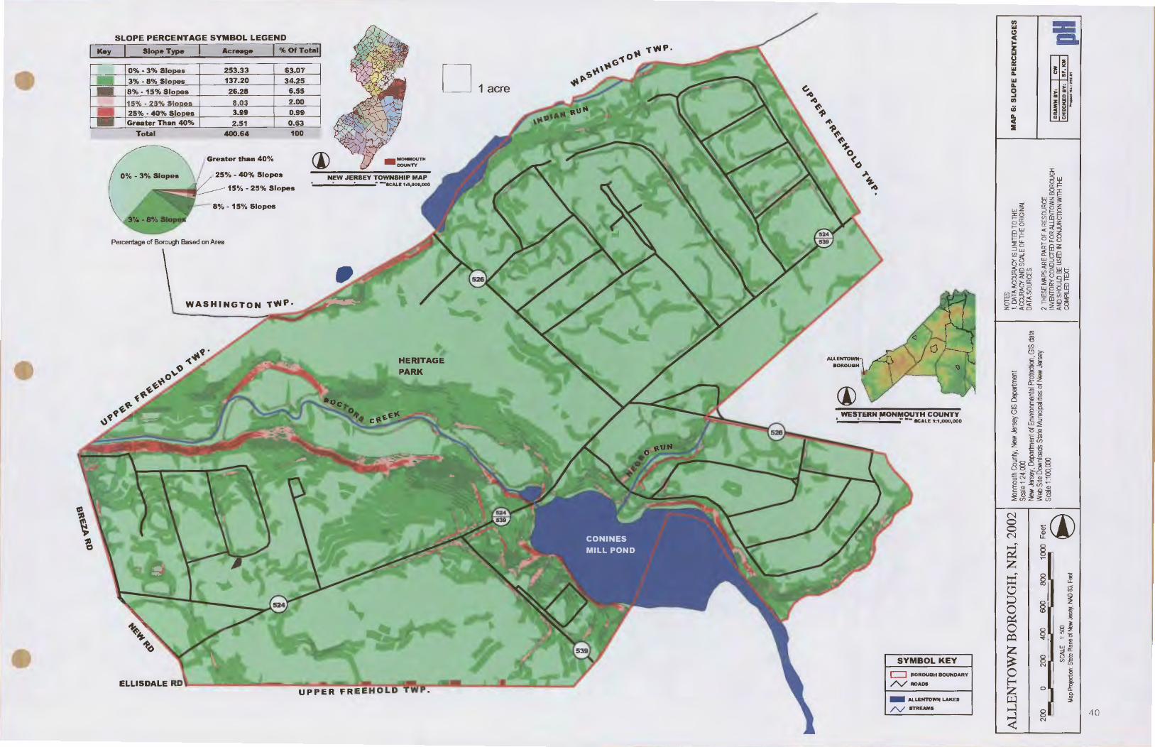
Slopes
Map 6 illustrates the degree of slope in Allentown Borough. The map illustrates that the most significant area in the Borough where steep slopes exist is along the southeastern bank of Doctors Creek, downstream of the Conines Mill Pond (Allentown Lake) dam. This steeply sloping area extends to the Allentown Borough and Upper Freehold Township border. This portion of steeply sloping land is adjacent to Heritage Park. The majority is privately owned. Additional steeply sloping land exists south of the Indian Run Reservoir on the border of Allentown Borough and Washington Township, along Doctors Creek north of Conines Mill Pond, on Lakeview Drive north of Conines Mill Pond and on the southwestern banks of Conines Mill Pond. It is recommended that Allentown Planning Board adopt a steep slope ordinance to protect the most steeply sloping areas within the Borough (usually those of 15 percent or more). It is further recommended that since the majority of these steep slope areas are located adjacent to critical wetland habitat for threatened and endangered species, stream corridors, or already publicly-owned property, these areas (approximately 15 acres) be purchased by the Borough for resource protection (soil, water and wildlife) and maintenance of publicly accessible scenic vistas.
II Princeton Hydro, LLC 38

- Allentown Borough NRI Final, August 2002
The five factors influencing soil development are parent material, climate, plant and animal life, topography, and time (USDA NRCS 1989). As noted in the geology section, Allentown Borough, Monmouth County lies within the Atlantic Coastal Plan physiographic province. The parent material of the soils is comprised of unconsolidated sediments (e.g. marine and continental origin) of the Mesozoic and Cenozoic age. The sediments are composed primarily of sand, clay, and greensand {glauconitic) and interspaced gravel beds. The Monmouth County Soil Survey notes that a thin layer of sand, clay and gravel deposits of the Quaternary age overlie the Coastal Plain sediments. The thin layer was deposited by outwash or melt water from the glacier that once covered the northern part of New Jersey.
The soils of Monmouth County were formed under forest cover (primarily hardwoods) from either residual material weathered from underlying rocks or transported material deposited by water, glacial ice, wind, or gravity. These soil formation processes, coupled with various soil qualities, such as texture (e.g. sand, silt, clay), water-holding capacity and nutrient content, are active factors in determining the resident biological community. Likewise, plants, microorganisms, soil invertebrates (e.g. earthworms), and other animal life living in, and on, soils are active factors in soil formation.
II Princeton Hydro, LLC 39
SLOPE PERCENTAGE SYMBOL LEGEND
., == Ill
~ =-~ z
D 1 acre
Ill ,.--u lr: ~ Ill B ~ ; .. Ill f- -7. s ..
=: I 9 ., a; I S .. " z c _....!!,
::IE
Greater than 40% {j) 25%-40% Slopes -~~~~~~~~~~
1
/ 15% - 25% Slopes ----
HERITAGE
WESTERN MONMOUTH COUNTY • s • --KAlE 1:1,000.000
N
~Cl) 0 0 N
~ ~ , z ~ § ~ g g
§ ~ 0 af ~ Jl 0 ~
§I ~ ~~
~ I ~~
SYMBOL KEY 8 "'~ 1'1
c::J BOROUGH BOUNDARY 0 i /"./ROADS ~ z 0 I Q.
- ALLENI'O- LAKES IJ:J "' :I!
/'\/ ln'REAMS ~ 8 I
~ 4 0
1'1

Allentown Borough NRI Final, August 2002
These dynamic processes, interacting simultaneously, largely determine the living environmental resources that persist and sustain themselves in a given locale. The interruption of this relationship, whether through excavation, development, or altering hydrologic regimes, will adversely affect the surrounding environmental resources. For instance, soil erosion, the loss of fertile agricultural soils, and nonpoint source water pollution are three closely related problems. Therefore, the implementation of judicious conservation measures, such as restricting development on hydric soils or on soils immediately up gradient and down gradient of steep slopes, and the preservation of farmland with prime agricultural soils, would serve to minimize perturbations to the surrounding environmental resources.
The United States Department of Agriculture (USDA) Soil Conservation Service's (SCS), now the Natural Resource Conservation Service (NRCS), Soil Survey of Monmouth County, New Jersey (USDA SCS, 1989) identifies 32 soil series in Monmouth County. Depending upon the USDA source used (hard copy or Internet) approximately 6 soil associations, and 13 soil map unit symbols, are located in Allentown Borough (Map 7).
Soil erosion potential, or erosion hazard, is the potential of a soil to naturally erode itself if not adequately protected. It is unrelated to historic erosional tendencies. The major factors that determine erosion potential are soil texture, organic matter content, structure, hydraulic conductivity, and to a lesser extent, slope.
Under many circumstances, erosion is more closely related to the configuration of the soil surface than to other factors, such as slope. Erosion potentials are meaningful only if the conditions of the surface and plant cover are given (USDA, 1981 ). The erosion hazards presented in many soil surveys assume full vegetative cover, such as woodland, and are, therefore, inappropriate to apply to cleared or developed land. Where applicable, soil surveys typically present an erosion hazard for those soil types that are likely to be used for purposes other than that of wood lot management (e.g. agriculture).
Depth to seasonal high water level is the distance between the surface and the highest level reached in most years by ground water or water perched over a fragipan (hard impermeable layer). Depth to bedrock is the distance between the surface of the soil and the upper surface of the bedrock layer. These characteristics, along with slope, stoniness, and permeability, largely determine the suitability of most soils for septic systems and building foundations. Most of the soils found in Allentown Borough have severe septic system limitations (e.g. for septic tank absorption fields). The following figure summarizes the most relevant factors in determining the suitability of soil types for development in Allentown Borough:
lfl Princeton Hydro, LLC 41

Soil Series M ..... .... Oceurrilllla Al'-towa ............
Evesboro EvB
Freehold FrB
FrC
Freehold Frd
FrE2
Hwnaquepts HV
Sassafras SaB
SaC
SaD
Tinton ToA
Woodstown WnB
Agricultural Soils
Table 3, Development Limitations of Soils (USDA NRCS 1987)
Dtpdate Dlpdllo Enlioa Septic s ...... ...... Po ..... s,.....
Hit'W.._ ....., LimilatioDJ Tallleefeetl
>6 5 Slight Severe
>6 5 Slight Severe
>6 5 Slight Severe
>6 5 Slight Severe
>6 5 Moderate Severe
>6 5 Slight Severe
>6 5 Slight Slight
>6 Slight Slight
>6 5 Slight Moderate
>6 5 Slight Slight
1.5 - 2.5 5 Slight Severe
Allentown Borough NRI Final, August 2002
Lialitltio• ... Buildilll .,..,......_ With Without i
Buements aa-ts Slight Slight
Slight Slight
Slight Slight
Moderate Moderate
Severe Severe
Severe Severe
Slight Slight
Slight Slight
Moderate Moderate
Slight Slight
Moderate Severe
Many farmers in the Allentown Borough vicinity, and elsewhere in New Jersey, wish to continue tilling the best soils. The importance of conserving farmland and open space was discussed in section one of this inventory. However, agricultural soils are discussed here. Allentown Borough and the surrounding municipalities are still quite rural. The agricultural soils map (Map 7) illustrates that, of the total acreage in Allentown Borough, the municipality still contains approximately 37 acres of Prime Agricultural Soils (10% of the Borough) and 93 acres (24% of the Borough) of Soils of Statewide Importance.
Soils of Statewide Importance are those prime agricultural soils suited to the production of regional crops. Soil suitability for this category includes adequate water, season, temperature, steepness, aspect, or other attributes required for regionally significant crops. Prime agricultural soils are those exhibiting adequate natural rainfall, temperatures conducive to farming, lack of excessive moisture, proper pH, adequate permeability, soils deep enough for adequate moisture storage to support root growth, and a lack of gravel, cobbles or stones.
I* Princeton Hydro, LLC 42

Allentown Borough NRI Final, August 2002
The Freehold Soil Conservation District lists fourteen (14) Soils of Statewide Importance, and twenty-two (22) Prime Farmland Soils within Monmouth County. According to the District, there are no soils of local importance in Allentown Borough or in Monmouth County. Two (2) Soils of Statewide Importance and three (3) Prime Agricultural Soils are present in Allentown Borough and include the following:
• Freehold (FrB)- Prime Agricultural Soil • Sassafras (SaB)- Prime Agricultural Soil • Sassafras (SaC)- Soil of Statewide Importance • Tinton (ToA)- Soil of Statewide Importance • Woodstown {WnB)- Prime Agricultural Soil
Additional information on the agricultural capabilities associated with each soil listed and the official series descriptions, may be obtained from the Monmouth County Soil Survey (USDA 1989) and the Freehold Soil Conservation District.
Limitations and Uncertainties of Soil Survey Data
Far more relevant than expounding the details of each soil phase in this NRI, it is important to understand the limitations of a typical USDA Soil Survey when using these data to make environmental resource management decisions. For example, although the USDA may have conducted some ground-truthing for the presence of established soil series in the Borough, the majority of the mapping data that appears on this, or any Soil Survey, have not been fieldverified.
This is because soil maps were created by hand, drawing directly onto an aerial photograph either the estimated boundaries of a ground-truthed soil series, or a best approximation of the series most likely to be present. Field logs are also kept by local USDA/ Natural Resources Conservation Service offices and Borough-specific field verification surveys.
1ft Princeton Hydro, LLC 43

~ I \~~ )~ ., m :II .,.. :II m m % 0 ,..
~ I ~
<I (0 ~ !!I ~ jiJ ~ 1: .. .. ,. jiJ al l m Iii c 0 . I 0 ,..
:1:
• ,. ~ 0 m i i:j 1:1 o( .. ..
:!!
ALLENTOWN BOROUGH, NRI, 2002
200 0 200 400 600 800 1""""'\-::1
SCALE 1:500 Map Projecbon: State Plane cl New Jtsf!JI, NAD 83, Feet
.j.>.
.p..
1000 Feet I
9
• )~I &J
:§I~ I -~ a!:
'$ ~% mn ~g J~ §-c
Q m
Monmouth County, New Jersey GIS Department Scale 1:24,000 New Jersey, Department of Environmental Protec11on. GIS data Woo Site DC7Nnloads State Municipalities of New Jersey Scale 1:1 00,000
\ \
D ~
Q) (") -4 ..., 0 ([) !
li I" ... •
... 8
0 EJ § 0 I ~ [ ~ ii
8 ::! t a ~ 0 ; ~ I ~
... ~ !I' ... w
a! w :. "' . p b p !" a! W N .. ..
~..IE)
0 D [ I If li t 1
I'!
~ ~ ~ ~
~ !I' ~ ~
~ I i i 1:1 1:1
I 1:'
~ ~
.. p ~ :
~ 0 I I ~I
~ i .,
• .;
I ., ., i1 ! 1- !:
~' g
... N ... :"~ !I ;., .. . • .. ..
I" !I' ~ • • 0 ..
~ f ,. . CJ) Q.
I r ( s
CJ) ([) ::J. ([) en CJ) '< 3 0"
~ ~ iii
... i: c N Ill
~~~ ~~
([) ::I a.
~~· 0~~ ()i\
.~.,..,
NOTES: 1. DATA ACOJRACV IS LIMTED TO THE MAP 7: SOIL RESOURCES ACCURACY AND SCALE OF THE ORIGINAL DATA SOURCES.
2 THESE MA.PS ARE PART OF A RESOURCE INVENTORY CONDUCTED FOR ALLENTOWN BOROUGH AND SHOULD BE USED IN CONJUNCTION WITH THE I DRAWN BY• I cw I pH COMPILED TEXT. I CHECKED BY: I SF, 101 J
.,...._.. MII.:2SI.11

SEPTIC SUITABILITY AREAS KEY D 1 acre
NEW .JERSEY TOWNSHIP MAP
Percentage of Borough Based on Area
WESTERN MONMOUTH COUNTY s • 11
..., .... SCALE 1:1 ,(IJO,OOO
SYMBOL KEY
c::::J BOROUGH BOUNDARY
ELLISDALE RD /'.,/ROADS
- ALLENTOWN LAKES
/'\/ STREAMS
=~ ~:I ::::.-0111 cnc lilt Ill: :I CIICII .IU en: CIID. •• Ill CIOCII D.ICII cz :.c
N 0 0 N
g z ~ 0 ::::; 0 ~ 0 j:Q
~ 0 ~
ffi .....:l
~
~Cl) ~
§ ~
§ 1l u.
:;S
§ ~ i!f II
8 §I '<I" ""~
~~ 8 "'5! N i5 1!
0 "f c. .. 2
8 N 45

<I ~ D = !!I~ s I! I I~ II 0 .. :1 z I"'
:il! • ~ ~ ~ m i:l i!i -< .. 5
ALLENTOWN BOROUGH, NRI, 2002
200 0 200 400 600 800 r=--
SCALf 1:500 Map Projection: Slate Plane ct New Jesey, NAD 83, Feet
~ m
1000 Feet 3
~
(,."" .0 ~~ ~
~~ ~-so
0( ~
-~~~ "-4
i "J: 0 z
all: ;o ~ s ,. z '" n ~ 0 ... c Sz .o -4 §-<
Monmouth County, New Jersey GIS Department Scale 1 :24,000
.... <t. .0
I z
New Jersey, ~rtment of Environmental Proteclton, GIS data Web Site OCM'nloads State Municipalities of New Jersey Scale 1:100,000
'l a I i • !1. • i ' ' r l
D 0
" i ..Jo.
D) (')
ca
z•s · ~
.... •i I ~ ~ n jio 'a z K 8 !I: :I !! .P ,. ... I 'a z
l i If G ~·
~ ali r • c [ I '"
! ;;
I I - ~ ~ !I !.
• ~
U) 0 r- = Ul ,.
! I Ill Ill i i a ~ ill E U) '< a .,.
f---I-+- 1- 2.
~ ~ .. g Ill ..
.. ,d' '1;.
~~~ .~
... Q'"'
0 ... "" ~ .,. .
~·· o<tl-~ o" . ~.,.~
NOTES: 1 DATA AOOJRACY IS Llt.tTED TO THE MAP 9: AGRICULTURAL SOILS AOOJRACY AND SCALE OF THE ORIGINAL RESOURCES DATA SOURCES.
2. THESE PMPS ARE PART OF A RESOURCE INVENTORY CONDUCTED FOR AllENTOWN BOROUGH L DRAWN BY• I cw I pH AND SHOUlD BE USED IN CONJUNCTION WITH THE I CHECKED BY• I SF, - I COMPILED TEXT.
........ .:ISI..I1

Role of Habitat in Determining Community Structure
Allentown Borough NRl Final, August 2002
The plants and animals inhabiting Allentown Borough are the aggregate of the various biotic communities occupying the different habitat types present (Robichaud and Buell 1973). These habitat types have been detennined by the geology and climate of the region. as modified by natural and human disturbance. In most cases, the greater the diversity in habitat types, the greater the diversity in the resulting biological communities.
There is also great ecological value in communities displaying qualities other than diversity. These benefits include, but are not limited to, satisfying the habitat requirements for a portion of an organism's life cycle, ameliorating the effects of erosion or flooding, or often overlooked, providing the necessary edge habitat (i.e. ecotone) for whichever community is adjacent to it.
Rare, Endangered, Threatened, and Locally Significant Flora and Fauna
According to the New Jersey Natural Heritage Database, as of August 30, 2001, there are no known protected bird, amphibian, or plant species present in Allentown Borough. However, a list of rare species and natural communities documented from Monmouth County was provided. The Data Request Specialist at the Natural Heritage Program suggested that the county list be used as a master species list for directing further inventory work in Allentown Borough. The species are listed in the following table.
Table 4, Natural Heritage Index Rare & Endangered Vertebrates, Invertebrates, and Plant Species
ScientifiC Na101 .:---1 I NMII Federal State Regional Status Status StJtu_!l
Accipiter cooperii Coopers Hawk NA TIT NA
Ammodramus savannarum Grasshopper Sparrow NA T/S NA
Bartramia longicauda Upland Sandpiper NA E NA
CharadrlUS melodus Piping Plover LT E NA
Clemmys insculpda Wood Turtle NA T NA
Clemmys muhlenbergii Bog Turtle LT E NA
Crotalus horridus horridus Timber Rattlesnake NA E NA
Dolichonyx oryzivorus Bobolink NA TIT NA
Ha/iaeetus leucocepha/us Bald Eagle LT E NA
II Princeton Hydro, LLC 47

_. Princeton Hydro, LLC 48
Allentown Borough NRI Final, August 2002

i. &eientifie Name 1r COJDJDOalilil.e
Calamagrostis pickeringii Pickering's Reedgrass
Calamavilfa brevipilis Pine Barren Reedgrass
Carex barrattii Barratt's Sedge
Carex cumulata Clustered Sedge
Carex plymorpha Variable Sedge
Cratagus ca/podendron Pear Hawthorn
Cratagus succulenta Fleshy Hawthorn
Cyperus lancastriensis Lancaster Flatsedge
Cyperus po/ystachyos Coast Flatsedge
Desmodium humifusum Trailing Tick-Trefoil
Diodia virginiana Larger Buttonweed
Dirca pa/ustris Leatherwood
Eriocaulon parkeri Parkers Pipewort
Fraxinus profUnda Pumpkin Ash
Gentiana autumna/is Pine Barren Gentian
G/aux maritima Sea-Beach Milwort
He/onia bul/ata Swamp-Pink
Hydrocotyle vertic illata Whorled Pennywort
Juncus caesariensis New Jersey Rush
Liatris scariosa var novae-angliae Northern Blazing Star
Limose/la subulata Mudweed
Linum intercursum Sandplain Flax
Listera australis Southern Twayblade
Luzula acuminata Hairy Woodrush
Fecla'al 1 Status
NA
NA
NA
NA
NA
NA
NA
NA
NA
NA
NA
NA
NA
NA
NA
NA
LT
LT
NA
NA
NA
NA
NA
NA
Allentown Borough NRI Final, August 2002
rstate1 Reg~ Status Status E NA
NA LP
NA LP
E NA
E E
E NA
E NA
E NA
E NA
E NA
E NA
NA NA
NA NA
E NA
E LP
E NA
E LP
E NA
E LP
E NA
E NA
E NA
NA LP
E LP
• Notes: "NA " denotes a category that is not applicable to the listed vertebrates, invertebrates, and plants. Federal status codes noted include LT- Taxa formally listed as threatened State status codes include £-Endangered species are those whose prospects for survival within the state are in immediate danger due to loss of habitat, over exploitation, predation, competition, and disease & T- Threatened species that may become endangered if conditions surrounding the species begin to or continue to deteriorate. Regional status codes include LP- locally protected-species.
II Princeton Hydro, LLC 49

Locally Significant Habitat
Allentown Borough NRI Final, August 2002
The New Jersey Natural Heritage Database also notes that rare ecosystems and habitats are present in Monmouth County including coastal dune woodlands, floodplain forests, maritime forests, and a migratory shorebird concentration site.
The Natural Heritage Database also indicates generalized locations for rare and endangered elements of natural diversity. Known as Natural Heritage Index Maps, these areas are depicted as the shaded rectangle on the habitat map (Map 10). The Natural Heritage Index Maps indicate that documented suitable habitat for protected species tends to be located at the western end of Allentown Borough.
Landscape Level & Critical Area Mapping Information
In 1994, the New Jersey Division of Fish and Wildlife (Endangered and Non-game Species Program) adopted a landscape level approach to the protection of rare species. The program goal is to protect biological diversity and functioning ecosystems. The philosophy of the program is that protection of threatened, endangered and rare species can only be accomplished if the habitat supporting the species is protected. Priority species include all State and Federally listed wildlife. In some cases, selected non-listed, area-sensitive species are included (e.g. neotropical migrant land birds) but assigned less priority.
The "landscape level perspective" is based upon large areas called landscape regions that support ecologically similar plant and animal communities. New Jersey's landscape regions include: the Delaware Bay, the Pine lands, the Piedmont Plains, the Sky lands, and the Atlantic Coastal areas. Allentown Borough falls within the Piedmont Plains Region. The Piedmont region is dominated by cultivated grassland (approximately 157, 000 acres) followed by upland forests and wetlands (approximately 94,000 and 92,000 acres).
The New Jersey Landscape Program personnel also created GIS mapping for the forest, wetland and grassland habitats. The GIS coverages, included on the significant flora, fauna and habitat map (Map 1 0), locate areas of critical habitat for rare species within each landscape region. The information "provides a highly accurate, reliable and scientifically sound bases for habitat protection within each landscape" (NJ ENSP 2001 ). Each critical area classification (e.g. wetland, grassland, and forest) contains five (5) priority ratings ranging from "lower priority" to "higher priority". The habitat mapping for Allentown Borough indicates that there are several critical wetland and grassland habitats throughout the Municipality. They are listed below and illustrated on Map 10.
II Princeton Hydro, LLC 50
Allentown Borough NRI Final, August 2002
• Critical Wetland Habitat- Approximately 35 acres of critical forested wetland habitat are located in Allentown Borough. They are located along Doctors Creek from the Mill Pond to the area just north of Sandburg Drive, in proximity to Allentown Lake south of Lakeview Drive, and along the Mercer & Monmouth County border along Indian Run.
• Critical Grassland Habitat- Allentown Borough also contains approximately 19 acres of critical grassland habitat. The grassland habitat is located on Allentown's' southern and eastern borders with Upper Freehold Township.
Other Important Habitat, Fauna and Flora
The Allentown Mill Pond was designated a Monmouth County Unique Area in a 1978 Natural Resources Study completed by the Monmouth County Planning Board. In addition, habitats present in Allentown Borough also support numerous non-threatened wildlife species. The New Jersey Division of Fish and Wildlife reports that species such as Whitetailed deer (Odocoileus virginianus), woodchuck (Marmota monax), Eastern Gray Squirrel (Sciurus carolinensis), Eastern Cottontail (Sylvilagus jloridanus), Eastern Chipmunk (Tamias striatus), Raccoon (Procyon lotor), and Striped Skunk (Mephitis mephitis) are commonly sighted in the area. According to the New Jersey Division of Wildlife, white-tailed deer populations continue to grow in the region. Deer are often spotted in residential areas feasting on landscape plants, in soybean and corn farm fields, and along well-traveled roadways.
The Monmouth County Audubon Society was also contacted to provide information on common birds in Allentown Borough. The Society reported that over three hundred and fifty (350) birds are included on the Birds of Monmouth County, NJ Checklist and Field Card (Monmouth Audubon Society 1991). A large majority of these year round, summer, winter, and transient bird species are commonly found in Allentown Borough as the municipality is in proximity to the Atlantic Fly-Way. Raptors, such as red hawks, kestrels and several species of owls also inhabit the area The Audubon Society as well as the USDA NRCS noted that year-round Canada Geese populations are growing and are problematic. Farmers often complain about crop damage, and local residents often complain that geese contribute to bacterial problems present in water bodies.
Canada geese (Branta canadensis) are major contributors of fecal coliform and negatively impact the overall aesthetics of a lake by leaving large amounts of droppings on beaches and grassed areas. These droppings and associated micro-organisms are directly transported to receiving waterbodies during storm events as surface runoff.
-' Princeton Hydro, LLC 51
Allentown Borough NRI Final, August 2002
Another impact Canada geese have on the aesthetics of a lake ecosystem includes the decimation of shoreline and littoral vegetation that, in turn, contributes toward shoreline erosion. Canada geese can also be extremely aggressive toward other animals and people while they are nesting and raising their young. Thus, Canada geese exert a negative impact on shoreline aesthetics and visiting stakeholders, as well as the water quality of a lake.
There are many methods currently in use that attempt to lower the population of Canada geese. They range from the very simple and inexpensive to the very costly and complicated. At best, most are only moderately successful.
a. The most common goose control technique is the use of fencing around the recreational shoreline areas. This method does not remove the geese from the lake, but attempts to prevent them accessing the swimming areas. This method is relatively inexpensive but, unfortunately, is only applicable along shoreline areas that do not need access for recreational areas. Costs depend on the type of fencing purchased and the length of shoreline that needs to be fenced. In practice, this method is moderately successful but tends to be very successful if used on a temporary basis to prevent geese from feeding on newly planted shoreline I wetland vegetation.
b. Another option that is commonly used is the constant harassment of geese by either people or dogs. This is usually done by local residents I staff or an independent company. In addition to simply chasing geese from an area, personnel may also use "thunder flash" types of fireworks. These firework devices explode with a very loud sound and intense flash of light. These methods are very expensive considering that they are relatively labor intensive. The success of this method is limited by the size of waterbodies and its designed use. The larger the lake, the more difficult to control the geese, since they can easily move to non-treated sections. In addition, the use of firework devices and dogs is severely limited at lakes that are primarily used for recreation.
c. Many places that have goose problems apply a variety of chemicals onto the grass or field areas that geese use to feed. The chemicals are not toxic to the geese but tend to make the grass and other vegetation unpalatable. One such product is Rejex-If, a derivative of grape flavoring. Unfortunately for most areas, this method is cost prohibitive. The chemicals alone are very expensive. For example, a gallon ofRejex-ItR costs approximately $50.00. Additional costs include the application to the entire feeding area. Depending on the brand of chemical used, some may need to be reapplied after rainfall or the mowing of the grass. In conjunction with this practice, visitors must not be allowed to feed the geese, thereby eliminating a supplemental food source.
-' Princeton Hydro, LLC 52

-d.
e.
f
Allentown Borough NRI Final, August 2002
A method that is not generally used is the live trapping and removal of geese from an identified area. Such efforts are both very time consuming and expensive. Geese are netted by throwing or firing a rocket propelled net over the flock of geese while they feed in a field. Personnel then capture the geese and put them in boxes for transport to a new area where they are released. This process usually needs to be repeated several times to capture the whole flock and becomes less effective with every attempt as the geese learn to spot and avoid such traps.
Another method is a tightly regulated hunt. The park may be closed for a day or two and potential hunters may be screened through a lottery process. Such hunts could be limited to the fall. While this method may effectively eliminate the goose population problem it is not without drawbacks. Hunts, especially within a State Park, will most likely draw criticism from certain interest groups. Another potential problem may be the acquisition of special permits and/or the cooperation of the New Jersey Division ofFish and Game.
Finally, Federal permits can be obtained from U.S. Fish and Wildlife Service that allow the applicant to addle the eggs of nesting geese. Addling the eggs destroys the embryo inside the egg. The female goose will continue to sit on the eggs and not produce another clutch. Although this will not eliminate the entire goose population, it will keep the population from increasing. In addition, it has been demonstrated that the implementation of a consistent addling program over a number of years can result in a measurable reduction in the resident goose population.
There are a variety of techniques that can be used to reduce or control a resident population of Canada geese, however, the effectiveness of each technique depends on the specific on-site conditions.
_. Princeton Hydro, LLC 53

c .,. .,. m ::a
"" ::a m m % 0 I"' ICJ ... :1 .,. .
<I ~ D = ~I II ~ i I z ...
~ § ~ jll IE o( .. ~
~
ALLENTOWN BOROUGH, NRI, 2002
200 0 200 400 600 800 l""""''!j
SCALE 1:500 Map Projecbon: state Plane r1 New .ilSP!f, WID 83, Feet
(J1 ~
1000 Feet
~
~ -
(,~ ~.,. ~
.,.~
~'So 0<
-~~~ ·; z
"I:
i •I: ro ~~ '"n
ii §-c
~
Monmouth County, New J!lsef GIS Depa1ment Scale 1 ·24,!XXl
. i" I a. 0 :I
~ £' a ~ • g [! a o o!i ::1. :T ~
~ 'i
~ ~ 1:1 ~ jg 8 • i c:
~~ ~ !t Ill" .0 :
~z
•! = Ill
New Jersey, ~rtment of Environmental ProtectiOn, GIS data Wl!b Site DC7Nnla!ds State Mu~libes of New J!lsef Scale 1 ·100,<XX!
I £' i £'
~· :r ~· ! [! ! 'I lf 0
! "' ::1. ~ ~I ..
i' [ 1 p ~
-I ,. fl)
::1:
D -z a
- ~~ ... 0 """"" z Ill · ~
(") :IE co c. .m n:
~ ... 0
r= • J 'I Jl.. ~ Jl: ~~
I !c;, !; ~=
ii :I A.
~·· .. ~
~ I
!
i
UJ ..
I I ~ .. io .. .. L_L_j J....-1
t. ,., ~ ...
"'"' 0 .,.
~~~
•r ir ;tf Cl 2'
t! l!. .. E Ill. l-I i ID = • !1: io~ .I""
1~ -· Cl :I • A. I"" i' .e
,._o+~ C)
. ~.,.~
NOTES: MAP 10: THREATENED, 1. DATAACOJRA~IS Llt.tTEDTO THE ENDANGERED AcaJAA~ MD SCALE OF THE ORIGINAL SPECIES AND HABITAT DATA SOURCES. RESOURCES
2. THESE IMPS ARE PART OF A RESOURCE INVENTORY CONDUCTED FOR AU..ENTOWN BOROUGH I DIIAWII .y, I cw I AND SHOI.lD BE USED IN CONJUNCTION WITH THE I cHECKED .y, I SF, lOIII I pH COMPILED TEXT p..,_. ... , .....

Allentown Borough NRI Final, August 2002
Allentown Borough lies within the Lower Delaware Watershed Management Re~io~, which contains four watershed management areas (WMA #17- #20). Allentown Borough ISm
WMA #20, which contains the Assitunk, Crosswicks, and Doctors Creek Watersheds.
Figure 17, Watershed Management Area #20, NJDEP
The major subwatershed and watercourses draining the Borough are Doctors Creek and Indian Run. Doctors Creek bisects the Borough, while Indian Run is located on the Washington Township and Allentown Borough border (Map 11 ). The Monmouth County Unique Areas Study (Monmouth County Environmental Council 1978) describes Doctors Creek as a unique wildlife habitat and a significant watershed/floodplain resource. The area, along with Conines Mill Pond and Imlaystown Lake (Upper Freehold Township), comprises a watershed and floodplain region rich in both flora and fauna, and should be preserved in as natural a state as possible.
II Princeton Hydro, LLC 55

Allentown Borough NRI Final, August 2002
The Borough also contains a large lake. Conines Mill Pond, locally referred to as Allentown Lake, is located just upstream of the Old Mill on Doctors Creek. Conines Mill Pond is one of the oldest manmade water bodies in the United States. The Pond is also included in the Monmouth County Unique Areas Study and is described as a recreational, scenic, historic, watershed, wildlife habitat, and floodplain amenity. In addition, the Conines Mill Pond site is also a State Wildlife Sanctuary.
Figure18, Conines Mill Pond (Allentown Lake) Increased Turbidity following a Storm Event
As mentioned in the previous section, Conines Mill Pond was the subject of an intensive Lake Survey (1978 NJDEP). The study states that, under optimum conditions, Mill Pond would offer recreational opportunities to the public. However, water quality sampling data indicated the lake was suffering from accelerated eutrophication and was in a deteriorated state. The management plan associated with the study recommended that restorative actions should be taken to reduce nutrient inputs to the lake and to eliminate the nutrient reserves in the lake. Another recommendation was to increase in-lake depth to maximize potential recreational benefits and to help reduce lake productivity.
In the early 1970's, interested citizens began researching all available funding to begin restoring Conines Mill Pond. At that point in time, the pond had an average depth of 1.5- 2 feet. The main channel was slightly deeper. It took many years to secure government funding, and to raise local money to match grant funding for the project. In 1984 and in the spring of 1985, the Pond was fmally dredged. Approximately 180,000 cubic yards of unconsolidated sediment were removed and placed at a permitted spoil site. Unfortunately, continued sedimentation of the lake
II Princeton Hydro, LLC 56

Allentown Borough NRI Final, August 2002
is still occurring following major storm events. In fact, citizens within the vicinity feel that there is a need to establish a publicly owned stream corridor buffer upstream of the lake. These buffers would not only provide enhanced protection of the lake from further sedimentation, but would also help to establish a regional recreational trail system. An effort is currently underway.
A second major surface water body in the Borough, Indian Run Reservoir, is located immediately upstream (Indian Run) of the Allentown Water Treatment Plant on Church Street. Both Conines Mill Pond and Indian Run Reservoir contain dams that have been classified as "unsafe" under the Dam Safety Law.
The law requires that unsafe dams be rebuilt to existing engineering standards or be breached. Monmouth County, as part of its planned reconstruction of the Main Street Bridge, will be rebuilding the Conines Mill Pond dam. There are no known current plans to rebuild the Church Street Dam on Indian Run. The Army Corps of Engineers determined this dam to be a high hazard dam.
Finally, concerns have been raised regarding development upstream of the Borough compromising the Borough water and sewage treatment plant. The July 5, 1989 flood rendered the water treatment plant inoperable for 4-6 weeks; however, during this time period water pressure was maintained through a fire hose connection to Washington Township.
Figure 19, Conines Mill Pond (Allentown Lake) Dam
Surface Water Quality Standards
Assessing the health of surface water resources involves an understanding of the various types of environmental data used to determine water quality. Some of these data are obtained by
1t1 Princeton Hydro, LLC 57

Allentown Borough NRI Final, August 2002
assessing physical features (e.g. stream depth, stream flow), chemically testing water samples (e.g. dissolved oxygen, temperature. pH, nutrients). and obtaining biological data (e.g. macroinvertebrates, fish, bacteria). Once the data are obtained and analyzed, information on potential pollution sources may be sunnised and regulatory and non-regulatory management options chosen.
Figure 20, Doctors Creek From Breza Road
The New Jersey Surface Water Quality Standards (Appendix) are intended to improve degraded streams and lakes, and to protect and maintain the quality of healthy surface water resources. The regulations classify every surface water body and establish standards for each classified stream in the state. Primary regulatory goals include maintaining and protecting exceptional waterways, and improving degraded waterways through pollution discharge limitations. Permits are required for any discharge of pollutants (e.g. treated sewage effluent, stormwater) into rivers, creeks, and lakes. The goal of the permit program (NPDES) is to disallow activities that degrade water quality. Degradation limits are based upon the State classification assigned to the rivers and streams. Both Doctors Creek and Indian Run (a tributary to Doctors Creek) are classified freshwater, non-trout production streams (FW-2) (Appendix). Category two waters shall be maintained within a range of quality standards. Standards for point source discharges are set to ensure that the present quality is maintained or improved.
Surface Water Quantity
A major thunderstorm on July 5, 1989 resulted in severe flood damages in Allentown Borough. Particularly hard hit was the Borough Water Treatment Plant on Church Street along Indian Run. Floodwater inundated Main Street at the Conines Mill Pond Dam. During the July 5, 1989 flood, when the Allentown Water Treatment Plant was inoperable, the water pressure was maintained through a fire hose connection to Washington Township. A permanent interconnection to the Consumers New Jersey water system in Washington Township is planned.
II Princeton Hydro, LLC 58

- Allentown Borough NRI Final, August 2002
The Borough is awaiting DEP permits, in order to make the final hook up. Flooding, due to development in neighboring municipalities, remains a primary concern along both Doctors Creek and Indian Run.
Many developments now have on-site stormwater detention facilities, however, these basins are not planned, nor designed, to reduce flood peaks or to treat water quality. Unfortunately, current zoning in Upper Freehold and Washington Townships permits industrial and commercial development with areas with higher imperviousness within the Indian Run watershed.
Figure 21, Stormwater Basin, Ellisdale Road, Upper Freehold Township
Surface water quality and quantity data for the Borough's streams were compiled from the United States Geological Survey (USGS) station located on Doctors Creek (Map 11 ). The contributing drainage area to this point is 17.4 square miles and the gauge is located 50.98 feet above sea level. Stream flow data has been collected at this gage since 1968. The stream flow graph below indicates that highest stream flows were recorded in August 1971 (1,250 cfs) and lowest flows were recorded in 1992 (100 cfs).
If! Princeton Hydro, LLC 59

1588
"C! c 0 u ., " L. ., a.1888 ..., ll II
'"" u ·o!
i u c ~
•o!
~ ~
:1 0
""" '"" li ll
!s en
8
~
~
~
~
~
1978
USGS 81464515 DOCTORS CREEK RT RLLENTONN NJ
~
Allentown Borough NRI Final, August 2002
197~ 1980 1985 1998 1995
DUES: 86/13/1968 to 8911811995
Figure 22, USGS Stream flow Graph, (USGS 2001)
Surface Water Quality
Allentown Borough lies in the NJDEP Lower Delaware Water Management Region (WMA 20). Doctors Creek is one of the major sub watersheds draining the Borough. Both Doctor's Creek and Indian Run (a tributary to Doctor's Creek) are classified as FW2-NT. This means that they are non-trout producing freshwater.
The New Jersey Water Quality Inventory Reports describe the status and trends in water quality. Attainment of designated uses, including aquatic life, recreation, industrial, agricultural, fish and shellfish consumption are also described in the reports. Locally, the information is useful as it describes the status and trends of local water bodies and their progress toward meeting water resources goals. Fourteen reports have been completed since 1975. However, not all streams were monitored since program inception. In Allentown Borough, Doctors Creek has been monitored periodically. Monitoring parameters have included dissolved oxygen, temperature, total phosphorus, total nitrogen, total suspended solids, fecal coliform bacteria, heavy metals, and pH.
If! Princeton Hydro, LLC 60

Allentown Borough NRI Final, August 2002
Both the 1988 and 1990 State Water Quality Inventory Reports, reporting data from 1983-1987, state that Doctors Creek contains fair water quality. The data was collected at Station 01464505, 0.8 miles downstream from Conines Mil1 Pond, and reported that water quality problems were due to high fecal coliform, inorganic Nitrogen and Total Phosphorus (TP) concentration. The creek experiences reduced water quality conditions between May and July.
The 1993 USGS Water-Data Report, states that the total Nitrite and Nitrate at the Doctors Creek Station, ranges between 0.49 and 1.65 mg/L. When above I mg/L, the potential for algal blooms increase. In the same study, TP ranges between 0.07 and 0.31 mg/L. The NJAC 7:9B regulations state that TP shall not exceed 0.1 mg/L in any stream.
The US EPA website has data, updated in 1998, listing the 303d Impaired Waters. Conines Mill Pond, is classified as impaired due to algal growth and excess chlorophyll a. Both Doctors Creek and Negro Run are also on the 303d list due to their biology being moderately impaired.
The 2000 State Water Quality Inventory 305(b) Report for the Doctors Creek indicates it is "non-impaired" for all tested parameters.
Conines Mill Pond (Allentown Lake) water quality monitoring information is also available, because a lake study was completed in 1977 and periodic lake monitoring has been completed by local agencies. The 1977 study indicated accelerated eutrophication as a result of nutrient loading. Therefore, high levels of total suspended solids, total phosphorus, and total nitrogen readings, lead to subsequent algae blooms. Within the water quality monitoring program of the Monmouth County Planning Board, Conines Mill Pond was sampled in March and October 1995. It was only tested for Nitrate (N03
), Nitrate load (lbslft\ Phosphorus (P), and Phosphorus load (lbslft\ This data produced low values of all parameters tested.
The Monmouth County Health Department has a water pollution control program focusing upon surface water, groundwater, and potable water supply. The Department conducts monitoring, surveillance, and enforcement programs designed to meet the requirements of several Federal and State environmental regulations.
Although there are no ambient water quality monitoring sites within the Borough, there is one site located on Doctors Creek in Upper Freehold (Ambient Site #3, Route 529). At that site, fecal coliform, pH, and total suspended solids are monitored quarterly and ammonia and total phosphorus are monitored two times each year. Water quality data was available for the February 4, 1998 to December 4, 2001 monitoring period. The data indicated that there is generally an elevated nutrient concentration, especially phosphorus. There is also a periodically elevated fecal colifonn count. The pH is within the optimal range of aquatic life (except for one
If! Princeton Hydro, LLC 61
Allentown Borough NRI Final, August 2002
odd measurement of 4.54), and the Total Suspended Solids (TSS) are consistently low, with values well below the standard level of 25. It's important to note, the contaminants mentioned throughout this document are from non-point sources (runoff) and are not from the Allentown Sewer Plant.
The Monmouth County Health Department has also initiated a Rapid Bioassessment Program (EPA Protocol II) designed to measure the diversity of in-stream macroinvertebrates and habitat health. One monitoring station is within Allentown Borough and is located on Negro Run at Sharon Station Road (Site #122). Two assessments were completed in 1999 and 2000. The data indicates that the stream habitat is optimal and contains a healthy diversity of taxa.
The Monmouth County Planning Board program, mentioned above, has been measuring water quality since the 1990's. The parameters tested include temperature, pH, dissolved oxygen, Nitrate (NO\ Nitrate load (lbslft\ Phosphorus (P) and Phosphorus load (lbslft\
In Doctors Creek, during the data collection period between November 1993 and August 1996, the median and average water quality data all of the parameters are within standard accepted values.
Negro Run also has one testing site. The results between November 1993 and August 1996 indicated low nitrate and phosphorus concentrations, which is good. All other concentrations were also below standard values.
There was no volunteer monitoring information for Indian Run, although a data collection site exists.
Floodplains
Floodplain areas are transitional regions comprised of both aquatic and terrestrial habitats and individual species. This environmental resource provides ecological, aesthetic, recreational, and economic benefits. One important function is to accept floodwaters during storm events. They absorb water, recharge aquifers, trap sediments, and help stabilize stream banks. Preserved floodplain areas offer travel corridors for wildlife and recreational opportunities for Borough residents. Allentown Borough floodplain areas are illustrated on Map 11 and indicate approximately 410 acres of valuable floodplain areas are located within the borough.
If! Princeton Hydro, LLC 62

Riparian Corridors
Allentown Borough NRI Final, August 2002
The riparian zone of a river, stream, or other body of water is the land adjacent to that body of water, that is, at least periodically, influenced by flooding (Mitch & Gosselink 1986). The riparian buffer zone is the area of trees and other herbaceous vegetation growing along the course of a river, creek, or stream and within the riparian zone. An adequate vegetative buffer zone is important for a variety of reasons. First, a vegetated buffer zone reduces the impact of periodic flooding, because the vegetation reduces the amount of run off reaching the channel and the soil as vegetation acts as a storage area for flood waters. Second, the trees within the riparian corridor provide shade, thereby maintaining cooler water temperatures for aquatic life. Third, vegetative zones provide food and habitat for stream organisms via the introduction of leaves, twigs, nuts, etc. to the stream. A fourth benefit is the vegetation in buffer zones forms a physical barrier that holds soil and prevents it from washing away during storms. The buffer also reduces the velocity of surface water (stormwater) runoff. As the velocity of stormwater is reduced, sediments and "pollutants" (e.g. pesticides and nutrients) settle out of the stormwater before it enters the stream. Therefore, a vegetated riparian corridor enhances the water quality of the stream. Finally, vegetated riparian zones provide important nesting and feeding habitat for wildlife and provide a travel corridor for wildlife movement. Recreational trails are also a possibility in stream buffer areas, especially if the buffer areas join other buffered corridors.
The forward included in the Monmouth County Park, Recreation and Open Space Plan asks the reader to imagine a trail near your home where you can walk for leisure or exercise, or where your child can ride a bike saftly to school (Monmouth County Planning Park System, 1991). The plan includes an inventory of existing and proposed open space parcels as well as a map illustrating proposed greenway trails. The Doctors Creek Riparian Corridor is included on the map as a proposed linear park. Key assets noted are that the Doctors Creek Linear Park would link the municipal park at Conines Mill Pond with Imlaystown Lake at Clayton Park. The plan also notes that the linear park would complement the historic districts at Allentown and Imlaystown. The Open Space and Park Plan also indicates that the park would protect a creek having high habitat value and that protecting the stream valley would be consistent with plans of neighboring counties (Park, Recreation, and Open Space Plan Map 1998). A regional greenways planning group is currently pursuing grant funding for stream corridor recreational access and historic vista protection.
In keeping with regional open space protection goals, Allentown Borough has preserved significant portions of its stream corridors and has made them publicly accessible. Three of its four public parks (Heritage Park, Lakeview Park, and Sensi Park) have protected portions ofland fronting on Allentown Lake, Doctors Creek, and Indian Run. Opportunities exist for further protection of stream corridors and lake frontage in Allentown. These opportunities occur as part of the discussion and negotiation that takes place at the time of application for development and redevelopment. Often easements and outright donations of land may occur. If these opportunities
II Princeton Hydro, LLC 63

Allentown Bor-ough NRI Final, August 2002
are not used by Allentown and its neighboring communities, it may be difficult, if not impossible to have a connected recreational trail system. Allentown is currently working with neighboring municipalities to develop a regional plan for stream corridor protection, for the purpose of surface water quality protection and preserving the opportunity to develop recreational trails for biking, hiking and walking that will connect the Allentown vicinity to other locations. The opportunity even exists to develop a perimeter trail around Allentown Lake. As the Borough and its adjoining municipalities become increasingly urbanized, recreational trails will become more valuable. More importantly, Allentown Borough notes that recreational trails will provide a connection between people and their natural environment.
If! Princeton Hydro, LLC 64

<I ( 0 = ~ J'! :II 1!1 1: ... 2Im ; "' Iii 0 1 a ...
I ! :~~~: E i ~ • s
¢ll9 ~-oll .
.!1~ "iii I
"!I
~ •!I •O rc
§-t ,.:z: "'n ~0 .:-c 8z .!'-t §-<
ALLENTOWN BOROUGH, NRI, 2002 Monmouttl Counly New Jersey GIS Department
200 '
(Jl CJI
0 200 400 600 800
SCALE 1:500 Map f'rntecbon: Stele Plane cl New Jesey NAD 83, Feel
---
Scale 1 24,txXl New Jersey, D~rtment of Environmental Protection, GIS data
1000 Feet Wf'i:J Site DONnloads State Municipalities of New Jfr3ey Scale 1 :100,CXXl s
t ... ' 0 0 • 0 .
D ~ . ~ :::s I
~ [ ....llo & .;· f D) • w N "'
fn t !- .. 2 n 0 t
CiJ
I I I f 3 ( 1: I I
I I • .. l ID I :1 I .. ,.
1 fn ~ :I
I 2' :z: • A. .! '<
! ::1111: ID '<
11n1 1111e
~)C~ .. ~ I
f---~
,. ,. ,. ; ; ;
= . . =
~ • • !1. !1. !1. .. !I .. Cl - Cl Cl
i ~ i ~ ~ I !. • !I .. - ...
~ il' 0 z n S' il 5 0 .. Q,
! i 5' l
~ ; 1~ 1~ li --it=
~
ililil&l~ll; ~
-to 'Vd'
\ Q""
0 .,.
~~~ <I;~
"" ~ ., .
"'1'1
'" a: ,. "'1'1 0 0 A. , iii' ;· en '< 3 .,. 2. r-ID ca CD :I A.
~-~;" o+~
6#1\
. ~.,.~
NOTES. 1 DATA AOOJRACY IS Llt.tTBJ TO THE MAP 11: SURFACE WATER ACCURACY AND SCA.LE OF THE ORIGINAl AND FI.OODPLAIN DATA SOURCES RESOURCES
2 THESE MI\PS ARE PART OF A RESOURCE INVENTORY CONDUCTED FOR AllENTOWN BOROUGH
pH : I DIIIAWN .,., I cw I
AND SHOUlD BE USED IN CONJUNGnON WITH Tf£ lcHECKED .,., I sF, KM I COMPILED TEXT
............ :252.11

Wetlands
Allentown Borough NRI Final, August 2002
Wetlands are among the most important ecosystems. Wetlands are sometimes described as the "kidneys of the landscape" for the pollutant filtering functions they perform (Mitch & Gosselink 1986). Wetlands prevent floods, protect shorelines, provide habitat for a wide variety of plants and animals, recharge groundwater aquifers, and cleanse polluted waters. There are approximately 31.64 acres of agricultural, forested, and herbaceous wetlands in Allentown Borough (Mapl2). As indicated in the previous section, the riparian zone is the land adjacent to Allentown's streams and creeks. The majority of wetlands in the Borough are ecologically categorized as "riparian", because they are located next to the Borough's streams and creeks (Mitch & Gosselink 1986).
Palustrine wetlands are distinguished by their unique and valuable combination of high species diversity, high species densities, and high productivity. This characterization is due to the abundance of water, periodic flooding, and rich alluvial soils. As a result, there are frequent ecological and physical interactions between the open water, riparian, and upland terrestrial species.
Allentown Borough contains approximately 33 acres of agricultural, deciduous wooded, and herbaceous wetlands (Map 12). The majority of wetlands are deciduous wooded wetlands associated with Doctors Creek, Conines Mill Pond, and Indian Run.
Figure 23, Riparian Wetlands, Route 539, Allentown Borough
1M Princeton Hydro, LLC 66

~I ( 0 = !IJ!! i!B i: iillft ,.ir ID !l: I i i o I I z ,.
~ I ~ ill I -< . = oC
ALLENTOWN BOROUGH, NRI, 2002
200 0 200 400 600 800 ~
SCALE 1:500 Map Prnjection: Stete ~ane cl New Jes"f, NAO 83, Feet
Q:l -...l
1000 Feet I s
c.. .. .. ~~ ~
~~ ~~
0
.!IS •-t
i •• i
•!I ro §~ "'n ~o
ji i=
<'~
Monmouth County, Nsw Jersey GIS Dep!rtment Scale 1 :24,CXXJ
~
~ ..
New Jersey, ~rtment of Environroontal Proi9CIIon GIS data Woo Site DOoYnlceds Slate Municipalities of Nsw Jersey Scale 1 :100,CXXJ
D ~
Q) 0 ca
.• I
I
.. ... ~
i G I ~ I ~
.. ...
I; ,. Ill t
----j 'I
m IS i Ill
\ Q""
0 .,. -' ~ .,. .
~ .. -At :::s a. ., CD --· :::s
m .. -· 0 :::s
!I 3 g -
~ .. !; ,...o+~
~~~ .. ~
NOTES: 1.04TAACQJRACI'ISLit.rnD TOTHE ACCURACI' AHJ S~E OF TI-E ORIGINAL DATA SOURCES.
2 THESE I'MPS ARE PART OF A RESOURCE
).6
-~~
INVENTORY CONDUCTED FOR Al.lENTOWN BOROUGH AND SHOULD BE USBJ IN CONJUNGnON WITH TI-E C<M'ILBJTEXT
MAP 12: WETlAND RESOURCES
I DIIAWN BTr I CW I
pH ~ I CHECKED BYr T IF,IOIIIl ....... -.~. 212.11

Allentown Borough NRl Final, August 2002
An aquifor is a geologic formation capable of supplying water through wells. Aquifers serve as storage reservoirs and as transmission conduits. They hold groundwater in storage, and they transmit it toward points of discharge in response to hydraulic gradients (Jablonski 1968). Allentown Borough is located in the Atlantic Coastal Plain regional aquifer (Figure 24). The water stored in aquifers is referred to as groundwater. For areas reliant upon groundwater for drinking, a sustainable, clean groundwater supply is imperative.
Groundwater Formations
A geology discussion and associated map were included in earlier portions of this NRI, However, geologic formations also play an important role in the physical location and the yield of groundwater aquifers, thus they are being addressed separately. Allentown Borough is located within the Atlantic Coastal Plain Province, which contains primarily sand, silt, and clay deposits from the Cretaceous period, and is underlain primarily by sandstones of the Brunswick formation.
II Princeton Hydro, LLC 68
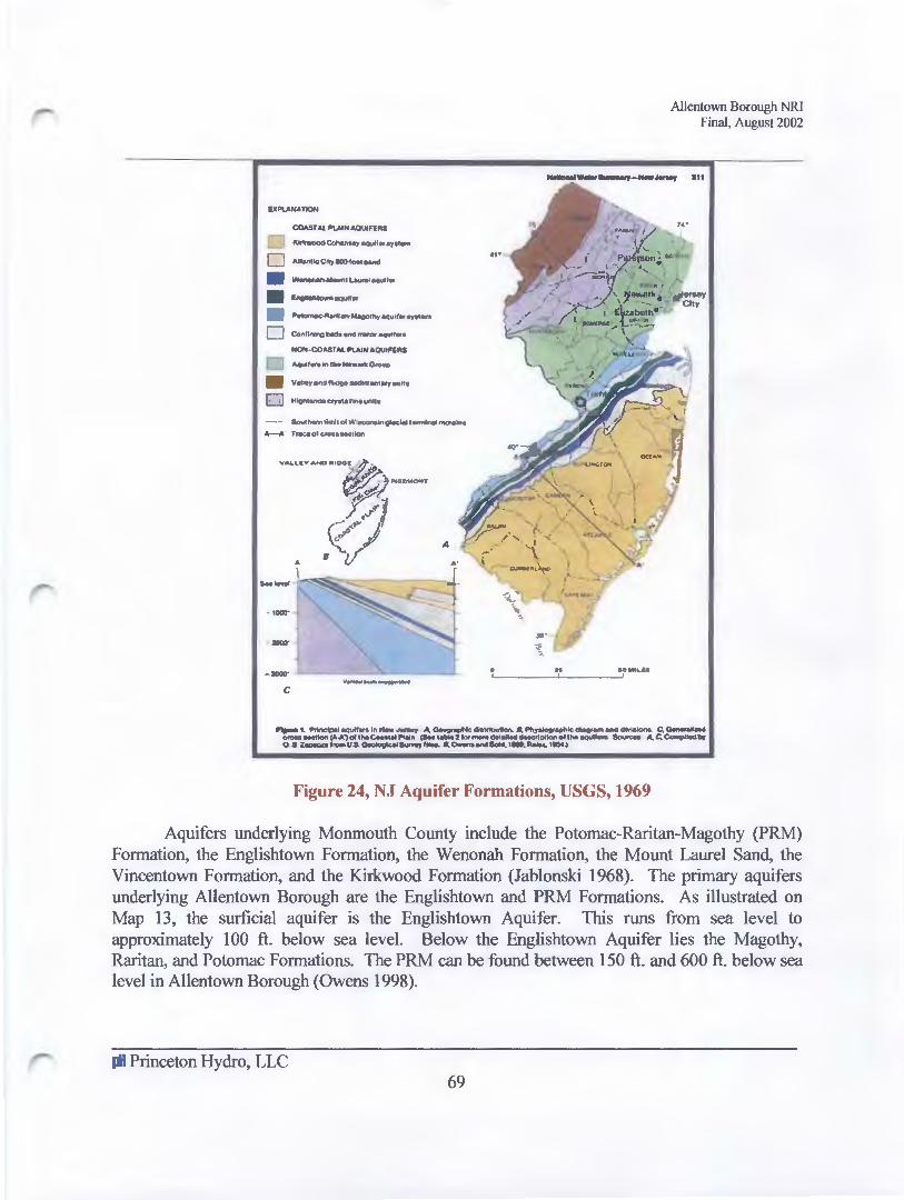
IXI'IAHA110N
COASTAl II'IJ>IOt .. OUIFfM
~-·---0 AtlantiC Cttp 80I).foot MIMI
• w....,.....-..,..LIUialeeu~t•
·~--• ~taN-oofb,-aqu)r.,.,.,.,. 0 C:O..IIlllng ____ ""
-·COAST .. l II'U>IH .. OUII'llll
Aqulf.,.lntMNewartrO....
• YolterenGIWio-OfYtMIIII
0 H......,.c,...lf-.uftl•
--- ---loiW-Qioc'-1_.., __ .. _.,_ol __ ....,
--· -- ---c
Allentown Borough NRI Final, August 2002
__ __, __ __, 11t
...
HMIL.II
Figure 24, NJ Aquifer Formations, USGS, 1969
Aquifers underlying Monmouth County include the Potomac-Raritan-Magothy (PRM) Formation, the Englishtown Formation, the Wenonah Formation, the Mount Laurel Sand, the Vincentown Formation, and the Kirkwood Formation (Jablonski 1968). The primary aquifers underlying Allentown Borough are the Englishtown and PRM Formations. As illustrated on Map 13, the surficial aquifer is the Englishtown Aquifer. This runs from sea level to approximately 100 ft. below sea level. Below the Englishtown Aquifer lies the Magothy, Raritan, and Potomac Formations. The PRM can be found between 150 ft. and 600 ft. below sea level in Allentown Borough (Owens 1998).
Iii Princeton Hydro, LLC 69

Allentown Borough NRJ Final, August 2002
Water-bearing properties are associated with each geologic formation subdivision. The Englishtown Formation has an average yield of25 gpm (gallons per minute). The maximum yield reported for this formation is 640 gpm. The average yield to large-capacity wells is 410 gpm. The Englishtown Formation has a lower ability to transmit water than the PRM Formation, but it yields sufficient water to be considered an important, high-yielding aquifer. Geologic studies completed for the area indicate that surface water and groundwater developments in Monmouth County have been adequate to meet the water demands of the area. However, they also state that if recent population trends continue to increase and greater demands for groundwater withdrawals are made, problems of over development of groundwater supplies may occur (Jablonski 1968). The PRM aquifer is the main source of water for Allentown Borough.
Sole Source Aquifers
The aquifers beneath Allentown Borough are included in the Federally designated (Safe Drinking Water Act, Section 1424 e) NJ Coastal Plain Sole Source Aquifer (53 Federal Register, 23791). Sole Source Aquifers (SSA) are those aquifers contributing more than fifty percent (500/o) of the drinking water to a specific area. The designation is given to protect drinking water supplies in areas with few, or no, alternative sources of groundwater. Therefore, if groundwater contamination were to occur, using an alternative source would be extremely difficult and prohibitively expensive. Most ofthe southern half of New Jersey is included in this aquifer.
The SSA designation requires the United States Environmental Protection Agency (USEPA, Region 2) review all Federally funded projects in areas that could impact the SSA. The review includes projects that could affect areas contributing to aquifer recharge (recharge zone), as well as impacts to areas upstream that therefore contribute to aquifer recharge (stream flow source zone).
Groundwater Quantity
In addition to average well yield, information regarding long-term groundwater well quantity is available through the United States Geological Survey (USGS) and the NJDEP. Two USGS test wells are located in Allentown Borough on Gordon Street (Map 13) near the Allentown Water Department. One well, illustrated as Well A on the map, is 273 feet below land surface and below the Englishtown Aquifer within the Old Bridge Sand Member of the Magothy formation. The second test well (Well B) is 262 feet below land surface within the PRM aquifer system. Three water level recordings were available for the wells, and are presented in the graphs below. USGS well information for Well A indicates a significant drop in water level between 1950 and 1988, while Well B data indicates more consistent water levels, with a similar drop in levels in the mid-to-late 1980's.
1M Princeton Hydro, LLC 70
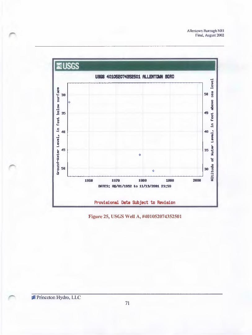
~USGS
~ """ .! 35
t; II)
Coo
c •ool 40 .. """ II)
~ ... L. 45 II) ~ Ill ::z I ., c ~ 50 IJ
Iii Princeton Hydro, LLC
UB&S 401052074852501 fLLENT~N BDRD
1960 1978 1980 1990
DRTES: 08/81/1952 to 11113/2081 23!59
Provisional Data Subject to Revision
Figure 25, USGS Well A, #401052074352501
71
Allentown Borough NRI Final, August 2002
""" II) :. II)
""" 50 ~
~
II) :. c .c Ill
45~ II) II)
Coo
c •ool
40 .. ~ ~ ... ~
35 ~ Ill ::z
Coo c II)
30] ~ •ool ~
""" 2000 a:

:iUSGS USGS 4010470748&2701 ALL!NTDWN WD 2
II !II 48
Coo c.. :I If) 45 2 0 Q
""" Jl 58 ~ II II
Coo 55 c .... ~ 68 II ,. II ..1 65 c.. II ~ Ill f 78 "'CC c :I e 75 (:I
1975 1988 1985 1998 1995
DATES: 11/18/1975 to 11/13/2881 23:59
Provisional Data Subject to Revision
Figure 26, USGS Well B, #401047074352701
Groundwater Quality
Allentown Borough NRI Final, August 2002
""" 48 II ,. II
""" 35
Ill
= II ,.
38] Ill
~
25 ti Coo
c .... 28 ..
""" !! 15 ~
c.. II ~
18 :I: Coo c
5 -8 :I ~ ....
8 ~
""" 2888 a:
Groundwater quality is a concern in densely populated regions of New Jersey. In areas with concentrated development, domestic drinking water may be negatively affected by the presence of nonpoint source pollution (e.g. failing septic systems, leaking storage tanks), in aquifer recharge areas, and by the presence of toxic substances (e.g. polychlorinated biphenyls), trace elements, pathogens, and natural radioactivity. Groundwater well quality information for Well A is available through the United States Geologic Survey (USGS).
Groundwater quality parameters include the following: dissolved oxygen, pH, specific conductivity, temperature, alkalinity, calcium, magnesium, potassium, sodium, fluoride, sulfate, nitrogen, phosphorus, total dissolved solids, arsenic, barium, beryllium, boron, cadmium,
Iii Princeton Hydro, LLC 72
- Allentown Borough NRI Final, August 2002
chromium, copper, iron, lead, lithium, manganese, molybdenum, nickel, selenium, silver, strontium, and natura] uranium. Of the parameters monitored, groundwater quality was wel1 within the NJDEP's specific groundwater quality criteria (Class IIA and Practical Quantitation Levels).
Previous sections (Part I & II) provide a broad overview of resource protection measures currently in place in Allentown Borough. Part III provides an updated overview of the location and extent of natural resources present in the Borough. The following section (Part IV) provides information on land use trends, as well as other resource vulnerability indicators.
There are on1y two sites with on-site sources of contamination in Allentown Borough. The first, Allentown William Penn Incorporated, is located at 148 South Main St. The William Penn Inc. site is no longer actively used as a gas station. The other is called Mobil Service Station Allentown Borough, and is located at North Main and Walker Streets. These were both active sites as of August 21, 1991 and September 9, 1997, respectively. In Upper Freehold, at Route 539 and Wainford Road, there is a site called Gulf Service Station Upper Freehold Township. Leaking underground storage tanks were discovered here in 1991 during a tank removal project. Petroleum products have contaminated the groundwater and onsite potable well. In 1995, NJDEP installed a Point ofEntry Treatment (POET) water filtration system on the potable well. A year later, they removed three leaking underground storage tanks and 277 tons of contaminated soil and installed ground water monitor wells to evaluate water quality. It has been determined that the groundwater onsite is contaminated but that it is not expected to move offsite. All future work will be conducted under DEP supervision.
-' Princeton Hydro, LLC 73

<I ( 0 = ~I! s• ~ ill :;; .. I II l a i a 0 • I z r-
• ~ j; g m ~ ~ -< • = -c
ALLENTOWN BOROUGH, NRI, 2002
200 0 200 400 600 800 ~
SCALE 1:500 Map Projection: Slate Aane rt New Jesey, NAD 83, Feet
-..l .j:>.
1000 Feet s s
~;I~ i ·~
i .~
'§ ~z "'n ii i=
Monmouth County, New Jersey GIS Department Scale 1·24,rol New Jersey, [)q)artment of Environmental Protect1011, GIS data Woo Site D<7Nnloads State Municipalities of New JErsey Scale 1 :100,rol
D ...II.
I» 0 ro
I ,. til ::1:
• •
~ ~ i i ~ ~ e e e I ~ ..
z•s ·;
~ Ill I ~ ~ 8 I jo :; i
I~ ~
c en i a en [ a
a :II: c • :I 'C .:a.
~ .. I CD .. z
i c::
I .. f --ell
-8
f r I
"' "• ~ io
Q""
0 .,.
~"'I)~
"o+~ 6
~~(\ .. ~ . ~-~-""
NOTES: MAP13:GROUNDWATER 1 DATA ACOJRAcY' IS Ll tJITED TO THE ACa.JRAcY' AND SCM.E OF THE ORIGINAL RESOURCES DATA SOURCES.
2 THESE W.PS ARE PART OF A RESOURCE INVENTORY CONDUCTED FOR AlLENTOWN BOROUGH (oRA-BY: T cw I pH AND SHOULD BE USED IN CONJUNCTION WITH THE I CHECKED BYI I SF, 1011 I COMPILED TEXT ,..._,.._,Ja.IH
- I

Section IV~ Conclusions & Recommendations
Figure 27, Existing Open Space and Scenic Vista, Breza Road looking toward the Heritage Park Gordon Street Entrance (See Figure 8)
Ma~ll'vta~l!'v large, ~ll'vtact patcltles of l!'vaHve vegetati.ol!'v al!'vfJ prevell'vt fragVI!tell'vtatLol!'v rJue to rJevelopVlitell'vt. Establt.sltl al!'vfJ IV~itpleVlitell'vt Pri.or~tLes For spect.es all'vfJ Protect~oll'v. Protect Rare EleVlitell'vts all'vfJ yur..rJe DevelopVlitell'vt TowarrJ Areas wl.tltl COVlitVlitOII'v Features.
MC!LII'vta~l!'v COII'vl!'vtctl.ol!'vs AVI!tOII'v0 1-tabl.tat b~ ProtectLII'vg Corrl.rJors For MOVeVlitell'vt. Ma~l!'vtal.ll'v sl.gl!'vl.fLcall'vt Ecologl.cal Processes Lll'v ProtecterJ Areas. Coll'vtrl.bute to tne Regl.oll'vC!l PersL.stel!'vCe of Rare spect.es b~ ProtectLII'vg Tl-lel.r 1-tabl.tat Locall~.
"B.alal!'vce tne opportul!'vl.t~ for Recreatl.oll'v b~ tltle Publl.c wl.tltl Habitat NeerJs of wl.lrJlL.fe.
-The Seven Biological Principles For Natural Resource Protection, The American Planning Association, 1997-

-
Allentown Borough NRI Final, August 2002
There are many factors that present a risk to the natural and historical resources that are important to the citizens of Allentown Borough. One of the most important factors is population growth. Population data indicates unprecedented, exponential growth in the worldwide population between 1900 and 1960. Similar trends have taken place in the northeastern United States and within the municipalities in Monmouth County. In the past several decades, the region has witnessed severe negative impacts on natural and historic resources due to exponential population growth, and associated land development trends.
New Jersey is one of the most densely populated states in the nation. An obvious consequence is that extreme pressure is placed on limited natural resources. In addition, zoning and land development policies in the region, as well as personal preferences regarding development, have favored single-family residential development on large lots. Additional stressors include the separation of residential areas from commercial and industrial areas (e.g. zoning districts), an increased reliance upon automobiles, and extensive transportation networks linking our neighborhoods to shopping, manufacturing, and office centers.
This development vision has transformed distinctive, compact, village-centered communities, once surrounded by open space, into typically disconnected subdivisions, shopping centers, and office parks with limited open space. This development pattern is what some professional planners have called "planned sprawl" (Arendt 1994). It is also a development pattern that often results in loss of habitat, intensive use of finite resources (e.g. water, energy), and increased point and non-point source pollution.
There are a myriad of potential negative impacts resulting from increases in population, loss of habitat, altered landscapes, and point source and non-point source pollutants. Negative impacts upon fisheries, water supply, recreational amenities, historic buildings, wetlands, surface water resources, and habitats are well documented. It is important to note that these are potential, but not always inescapable, sources of pollution. Local regulations and educational outreach efforts may help foster proper construction, operation, management, and restoration of land to better preserve significant historic and cultural resources.
The methods by which valuable natural resources are protected are numerous and depend much upon land development law, environmental protection regulations, regional and local planning codes, local philosophy and funding opportunities. Usually, municipal officials, land developers, local businesses, environmental organizations, and local residents have philosophical differences regarding whether land should be preserved, conserved, or entirely developed.
Iii Princeton Hydro, LLC 76

-
Allentown Borough NRI Final, August 2002
Preservation of resources usually means that land is purchased outright and set aside indefinitely with a bare minimum of maintenance. Only a century ago, the idea of preventing development of a useless "wilderness" area was widely regarded as completely irrational. It is no longer considered irrational by some. Essentially, preservationists feel that land should be set aside, human intervention should be restricted, and the natural systems present on land should be left untouched in order to evolve naturally. Some preservationists feel that life on earth is imperiled by the destruction of nature wrought by human intervention (Blowers 1999) and that all development should stop.
Conservationists feel that the most valuable resources should be protected, but managed for and maintained for multiple uses (e.g. passive recreation, hunting, farming, forestry). Land is usually purchased and managed by government entities, hunting groups, foresters, farmers and other organizations for a specific use. The land is then managed for the particular use. For instance, land set aside for recreation usually requires the building of a trail system, bathrooms, and other recreational amenities.
There are also those that feel land ownership and the Fifth Amendment to the constitution protects landowner rights. Therefore, once land is purchased, many feel that the landowner should be able to develop property based on his/her wishes, and that any reduction of economic return due to development restrictions should be viewed as a "taking". Most municipal officials are aware that the takings clause has provided a fruitful ground for litigation. Therefore, municipalities usually try diligently to balance the need for development with the need to protect the health and welfare of its citizens. The following section provides an overview of findings and a broad overview of preservation, conservation, and management goals for Borough consideration.
Despite the fact that Allentown Borough is a small community, and the majority ofland in the Borough has been developed, the historical buildings are well preserved and a variety of significant natural features remain. The following list is intended to provide an overview of historic and cultural resource findings:
• Allentown Borough was settled circa 1706. The Borough continues to maintain a historic ambiance. Despite the presence of one historic district and many historic structures, the Borough was placed on the ten most endangered historic sites list by Preservation New Jersey in 2001. The historic district boasts 21 styles of architecture within its boundaries.
• Allentown Borough was officially designated as a Village Center, by the New Jersey State Planning Commission, on May 15,2002.
II Princeton Hydro, LLC
77

-
Allentown Borough NRI Final, August 2002
• The climate in Allentown Borough is classified as continental. It is characterized by an average yearly temperature of 55°F, as measured at Freehold, NJ. Winter temperatures during the month of January average 29°F, while July temperatures average 74 °F.
• Annual precipitation for the area, asmeasuredinFreehold, NJ is 38.3 inches peryearand3.8 inches per month (Rutgers 1960-1990).
• Due to expanded growth at Allentown Borough's borders, along with excessive summer traffic, the Borough is concerned about air quality. More localized air quality data is required to measure impacts.
• In 1989, citizens from Allentown Borough completed a traffic survey, under the auspices of the Allentown Environmental Commission, and more than 800 drivers were surveyed. Most responded that they travel through Allentown Borough on their way to other destinations, because it is the only route available. Approximately 90% of those surveyed stated that they would utilize a by-pass if it were available.
• In 1992, the Allentown Regional Traffic Study was completed. This study recommended the building of an Easterly and/or Westerly bypass to minimize traffic through the Borough.
• Allentown Borough is located within the Inner Coastal Plain segment oftheAtlantic Coastal Province, which is underlain primarily by sands, clays, glauconitic marl, and silts of the Cretaceous Period.
• The most significant steep slopes in Allentown Borough are located along the southeastern bank of Doctors Creek, south of the Indian Run Reservoir on the border of Allentown Borough, and along the banks ofConines Mill Pond (Allentown Lake).
• The Natural Resource Conservation Service (NRCS) Soil Survey of Monmouth County, New Jersey (USDA 1989) identifies 32 soil series in Monmouth County. Approximately 6 soil associations, and 13 soil map unit symbols, are located in Allentown Borough.
• Most of the soils found in Allentown Borough have severe septic system limitations, and several soils have severe building foundation limitations. No known properties with septic systems exist in the Borough.
• The municipality has two (2) Soils of Statewide Importance and three (3) Prime Agricultural Soils.
- Princeton Hydro, LLC 78

Allentown Borough NRI Final, August 2002
• There are no known threatened or endangered flora or fauna in Allentown Borough (Natural Heritage Database, 2001 ). However, the threatened, endangered, and protected species list for Monmouth County contains 21 birds, 17 insects, and 32 plants.
• The New Jersey Division ofFish and Wildlife (Endangered and Non-game Species Program) notes that Allentown Borough contains 35 acres of critical forested wetland habitat and approximately 19 acres of critical grassland habitat.
• The New Jersey Division ofFish and Wildlife is studying the movement of anadromous fish on Doctors Creek to determine whether the existing Conines Mill Pond dam is an impediment.
• The Conines Mill Pond was designated a Monmouth County Unique Area in the Planning Board's 1978 Natural Resources Study.
• The Monmouth County Audubon Society reports that over three hundred and fifty (3 50) year round, summer, winter, and transient bird species are commonly found in Allentown Borough.
• Allentown Borough lies within the NJDEP Lower Delaware Watershed Management Region (Watershed Management Area #20). The major sub watershed and watercourses draining the Borough are Doctors Creek and Indian Run.
• The Monmouth County Unique Areas Study (Monmouth County Environmental Council 1978) describes Doctors Creek as a unique wildlife habitat and a significant watershed/floodplain resource.
• Conines Mill Pond is one of the oldest manmade water bodies in the United States. The Pond is also included in the Monmouth County Unique Areas Study and is described as a recreational, scenic and historic, watershed, wildlife habitat, and floodplain amenity. In addition, the Conines Mill Pond site is also a State Wildlife Sanctuary.
• Both Doctors Creek and Indian Run (a tributary to Doctors Creek) are classified freshwater, non-trout production streams (FW -2) (NJ AC 7 :9B-l.l5). Doctors Creek has been monitored periodically by State and local agencies. The 2000 State water quality inventory 305(b) report for the Doctors Creek indicates it is "non-impaired" for all parameters.
- Princeton Hydro, LLC 79

-
Allentown Borough NRI Final, August 2002
• United States Geological Survey (USGS) stream flow data (1968-200 1) indicates that highest stream flows were recorded in August 1971 (1, 250 cfs) and lowest flows were recorded in 1992 (1 00 cfs ).
• Approximately 410 acres of valuable floodplain are located within the Borough, and the aerial photographs indicate the rivers, and surrounding floodplains, are currently well buffered with riparian vegetation.
• The Monmouth County Park, Recreation and Open Space Plan (Monmouth County Planning Park System 1991) includes the Doctors Creek Riparian Corridor as a proposed linear park, which would protect a high value habitat, and complement existing historic districts.
• Allentown Borough is currently working with neighboring municipalities to develop a regional greenway plan along the stream corridors.
• There are approximately 43.85 acres comprised of agricultural, forested, and herbaceous wetlands in Allentown Borough (figure 14). The majority of wetlands in the Borough are ecologically categorized as palustrian wetlands.
• Allentown Borough is located in the Atlantic Coastal Plain regional aquifer. The primary aquifers underlying Allentown Borough are the Englishtown Aquifer and the PRM Formations. The aquifers are Federally designated NJ Coastal Plain Sole Source Aquifor (53 Federal Register, 23791). Allentown Borough receives its water supply mainly from the PRM Aquifer.
• Two USGS test wells are located in Allentown Borough on Gordon Street (Map 13) at the Allentown Water Department. These test wells measured water levels in the PRM aquifer, which lies below the Englishtown Aquifer. These test wells measured water levels in the PRM Aquifer which lies below the Englishtown Aquifer. USGS information for one well indicates a significant drop in water level between 1950 and 1988, while data for the second well indicates more consistent water levels.
• Water quality testing performed on one USGS groundwater well indicates that, of the parameters monitored, groundwater quality was well within the NJDEP's specific groundwater quality criteria (Class IIA and Practical Quantitation Levels).
- Princeton Hydro, LLC 80

Allentown Borough NR1 Final, August 2002
• In general, within the Borough, all water quality parameters tested were below standard accepted values (Appendix). However, at one site, located on Doctors Creek in Upper Freehold, some parameters tested were above the accepted values. Particularly, there were elevated nutrient concentrations and periodically elevated fecal coliform counts.
• The contaminants mentioned throughout this document are from non-point sources (runoff) and are not from the Allentown Sewer Plant.
• There are numerous historic vistas (potentially developable but currently undeveloped) in the Borough adjacent to historic structures including the two Victorian homes (including Pepplers Funeral Home) on South Main Street, the Governor Newell home at the comer of High and South Main Street, Allentown Lake (vistas both within and outside the Borough), and various significant historic structures.
• There are numerous historic vistas (potentially developable, both within and outside the Borough) in the historic greenbelt including approximately 10 acres adjacent to Heritage Park between Breza Road and Heritage Park, approximately 3 acres adjacent to properties along the north side of Probasco Drive, and approximately 12 acres along the southeast side of Doctors Creek overlooking Heritage Park in the Borough.
N~tur~L Resource CoV'vserv~t~OV'v Pr~V'vC~-pLes ~
Based on a review of the Borough's existing planning, zoning, and land development ordinances, it is clear that the Borough has attempted to balance land owners rights and to protect the amenities that initially attracted people to Allentown. However, interviews with local citizens and elected officials of Allentown Borough indicate that there is a growing concern about land development trends in surrounding municipalities. Citizens are particularly concerned with the negative impacts resulting from high-density land development upon the historic, natural, and social amenities in Allentown Borough. Those concerned with negative environmental and cultural impacts have expressed support for the following natural resource protection principles (AP A 1997):
• Maintain large, intact patches of native vegetation and prevent fragmentation due to development.
• Inventory all public lands for the presence of rare threatened and endangered species.
• Establish and implement priorities for species and protection.
• Protect rare elements and guide development toward areas with common features.
- Princeton Hydro, LLC 81
Allentown Borough NRI Final, August 2002
• Maintain connections among habitat by protecting corridors for movement.
• Maintain significant ecological processes in protected areas.
• Contribute to the regional persistence of rare species by protecting their habitats locally.
• Balance the opportunity for recreation by the public with the habitat needs of wildlife.
• Consider habitat restoration activities on existing recreational land in the Borough.
• Implement a habitat conservation education program linking farmers with habitat restoration funding programs.
• Develop riparian corridor greenways fostering conservation of riparian buffers and passive recreation and implementing programs recommended by the Crosswicks/Doctors Creek Greenways Regional Planning Group.
Recommendation: Update Allentown Borough Master Plan
The Master Plan Reevaluation for the Borough of Allentown was completed in 1997 and was intended to provide recommendations for an update to the municipality's 1978 Master Plan (Lim and Pushcak 1978). Based on the recommendations included in the 1997 study and the information obtained for this Natural and Historical Inventory, the Borough's Master Plan should be updated as soon as feasible. All recreation, conservation, and historic preservation recommendations included in the 1997 study, and further supported by this NRI, should be incorporated in the updated Master Plan with greater emphasis for border protection and historic preservation.
Recommendation: Strengthen Existing Zoning and Land Development Ordinances
It is apparent that the Borough contains valuable natural and historic resources including: Soils ofStatewide Importance, Prime Agricultural Soils, significant flora and fauna, unique wildlife habitat, non-impaired streams, one of the oldest man-made lakes in New Jersey, valuable floodplain areas, continuous riparian corridors, scenic roadways, historic greenbelts, a historic district, and a variety of 226 historic structures with diverse architectural styles.
- Princeton Hydro, LLC 82

-
Allentown Borough NRI Final, August 2002
It is also clear that the Borough's natural and historic amenities have experienced negative impacts, or may be vulnerable to future impacts, due to increases in population, the extent and type ofland development taking place in surrounding municipalities, and other negative trends associated with increases in population. The following resources and resource constraints are of particular concern to the Borough: steep slopes, historic vistas within the Borough, historic vistas outside the Borough within the Historic Greenbelt, lake water quality, stormwater quantity and quality management within the Borough, stormwater quantity and quality management in watersheds draining through the Borough, stream corridors and lake frontage, and threatened and endangered species.
The scope for this Natural and Historical Resource Inventory did not include a thorough review of the Allentown Borough Zoning Ordinance or the Borough's land development regulations. In addition, the scope did not include a thorough review of similar land use regulations for adjoining
municipalities. Therefore, it is recommended that, in the future, the Borough complete a thorough review of their zoning and land use regulations to determine if the following protective measures may be needed:
• Steep slope, floodplain, erosion and sedimentation, wetland buffer, stormwater treatment, open space, and other resource protective regulations.
• Environmental impact assessment (EIA) and environmental impact study (EIS) requirements for all land development proposals, particularly for those proposals located in the sensitive areas noted in this inventory.
• Restrictions on the amount and location of impervious surfaces. • Best management practice requirements for all development proposals, including stormwater
quality treatment, increased stormwater recharge, and the elimination of in-stream stormwater discharge.
• Water quantity and quality study requirements for water intensive land development proposals (e.g. golf courses).
• Increased capital should be set aside, and grants obtained, to complete additional analysis to revise current regulations that will be more protective of valuable natural resources.
Recommendation: Implement Educational and Other Non-Regulatory Programs
Many communities have successfully protected natural and historical resources through the implementation of voluntary conservation programs. The following recommendations may help Allentown conserve significant resources identified in this natural resource inventory.
• Proactively initiate the outright acquisition, donation, or voluntary purchase of development rights for historic vistas associated with historic structures within the Borough.
- Princeton Hydro, LLC 83
Allentown Borough NRI Final, August 2002
• Continue to proactively acquire through outright acquisition, donation, or voluntary purchase development rights for steep slope and other riparian areas adjacent to Doctors Creek, Allentown Lake, and Indian Run to protect scenic vistas, critical forested wetland habitat, surface water quality, and other amenities in existing publicly-owned parks.
• Proactively initiate the outright acquisition, donation, or voluntary purchase of development rights for open space within the Borough adjacent to and in the historic greenbelt.
• Continue to proactively work with neighboring municipalities to develop and implement a plan to preserve greenways to protect stream water quality, to provide public access via recreational trails, and to protect historic vistas within the historic greenbelt outside of the Borough.
• Develop a transfer of development rights program for transfer of development rights from the historic greenbelt within and outside of the Borough boundary to currently underdeveloped areas within the Borough Center.
• Proactively work with State, County and neighboring municipalities for the earliest possible implementation of the planned easterly and westerly bypasses. Work to have limited access along the bypasses to prevent sprawl and to protect the historic greenbelt.
• Implement a tree and shrub planting program to screen public and private property from sources of noise pollution and to improve upon existing scenic vistas with emphasis at Borough entrances and adjacent to Borough facilities including the water treatment facility and the sewage treatment facility.
• Implement the Community Forest Management Plan, as developed by the Shade Tree Committee, with particular emphasis on developing a comprehensive shade tree inventory showing the species, age, size, health and other characteristics of Borough shade trees along Borough and County Roadways and on Borough property, including parks.
R~ommendation: Complete Additional Study
• Develop a digitized map showing all blocks and lots within the Borough so that this can be used as a base map in a geographic information system (GIS) for overlaying critical resource data layers such as steep slopes, historic vistas in association with historic structures and environmental resources, critical wetland habitat, etc.
• Analyze existing zoning, particularly those lots that could be subdivided, vis a vis sensitive natural resources, steep slopes, historic vistas, stream corridors.
• Complete a Geographic Information System (GIS) Overlay Study to determine the most critical resources in the Borough and develop recommendations for critical area protection ordinances based on overlay districts.
• Implement a volunteer water quality monitoring program to foster stewardship and to obtain long-term water quality and quantity data.
- Princeton Hydro, LLC 84

-
Allentown Borough NRI Final, August 2002
• Complete a diagnostic feasibility study for Conines Mill Pond (Allentown Lake) in order to restore and enhance recreational, ecological, and historical amenities.
• Conduct a threatened and endangered species study for all Borough-owned property to determine the presence or absence of threatened and endangered flora and fauna and, if present, steps necessary to protect these.
• Conduct a study of existing undeveloped acreage to determine, under current zoning, what the buildout condition would mean in terms of soil erosion due to steep slopes, increased stormwater runoff and nonpoint source pollution, destruction of historic vistas, threatened and endangered species habitat destruction, and other concerns.
• Conduct a study, with Upper Freehold and Millstone Townships, of sediment sources to Allentown Lake from the Doctors Creek watershed.
• Conduct a study, with Upper Freehold and Millstone Townships, to determine the impact of buildout, under their current zoning, on flooding, nonpoint pollution including sediments, and other concerns to Doctors Creek watershed and ultimately to Allentown Lake.
• Conduct a study, with Upper Freehold and Washington Townships, to determine the impact ofbuildout, under their current zoning, on flooding, nonpoint pollution, and other concerns in the Indian Run watershed and ultimately to Borough property owners and the Borough water treatment plant.
II Princeton Hydro, LLC 85

L~st of Referev-vces
Allentown Borough NRI Final, August 2002
Allentown Borough Environmental Committee, Allentown Traffic Survey, 1989.
American Planning Association 1997. Habitat Protection Planning. PAS # 4 70. AP A: Chicago, IL.
American Planning Association 1997. Nonpoint Source Pollution: A Handbook for Local Governments, PAS# 476. APA: Chicago, IL.
American Planning Association 1996. A Planners Guide to Sustainable Development, Nonpoint PAS# 467. APA: Chicago, IL.
Arendt, Randall 1999. Growing Greener: Putting Conservation Into Local Plans & Ordinances. Natural Lands Trust & Island Press: Washington, DC.
Arendt, Randall 1994. Rural By Design: Maintaining Small Town Character. AP A Planners Press: Chicago, IL.
Barbour, Michael G & Burk, Pitts 1987. Terrestrial Plant Ecology. Benjamin/Cummings Publishing Company: Menlo Park, CA.
Batie, Sandra S 1984. Soil Erosion: Crisis For America? The Conservation Foundation: Washington, DC.
Birdsall Engineering, Inc., Survey of Property in the Borough of Allentown Monmouth County, New Jersey (map), 1981.
Boyd, John Taylor, The Monograph Series Recording the Architecture of the American Colonies and the Early Republic, Number 3, Volume XV, 1929.
Brown, Kenneth, 2000. Urban Stream Restoration Practices: An Initial Assessment. Center for Watershed Protection, Ellicott City, MD.
Bureau of Allentown Code, Zoning Regulations of the Borough of Allentown, 1975.
Center For Watershed Protection, 1996. Urban Watershed Best Management Practices, A Workshop on Innovative Watershed Restoration & Protection Techniques. Baltimore, MD.
Clark, Edwin H., Haverkamp, & Chapman. 1985. Eroding Soils: The Off-Farm Impacts. The Conservation Foundation: Washington, DC.
1111 Princeton Hydro, LLC

-
Allentown Borough NRI Final, August 2002
Donahue, Roy L, Miller and Shickluna. 1983. Soils: An Introduction to Soils and Plant Growth, Prentice Hill: Englewood, NJ.
Findley, Roger W. & Daniel A. Farber. 1990. Environmental Law. West Publishing Company: St. Paul,MN.
Hall, Charles, Cutler Cleveland & Robert Kaufmann, 1986. Energy and Resource Quality: The Ecology of the Economic Process. John Wiley & Sons: New York, NY.
Hylton, Thomas 1995. Save Our Land and Save Our Towns. RB Books: Harrisburg, PA.
EPA, Designated Sole Source Aquifers in EPA Region 2, Available URL: www.epa.gov/OGWDW/swp/ssa/reg2.html [12 November 2001].
Hull, Ellis, A Brief History of Old Allentown Monmouth County New Jersey.
Jablonski, Leo, Groundwater Resources of Monmouth County, New Jersey, Special Report No. 23, 1968.
Killam Associates Consulting Engineers, Proposed Nature Trail and Entrance to Heritage Park (map), 2001.
Ibid., Borough of Allentown Monmouth County New Jersey Zoning Map, 1997.
Ibid., Allentown Heritage Park Perimeter Walkway and Historic Streetscape Project, 1999.
Lim, Gill Chin and Ronald Pushchak, Master Plan Allentown, New Jersey, 1978.
Ibid., Revised Historic Preservation Element Allentown Master Plan, 1989.
Monmouth County Audubon Society, The Monmouth County Audubon Society Check-list and Field Card, 1991.
Morain, Stan ED 1999. GIS Solutions in Natural Resource Management: Balancing the TechincalPolitical Equation. Onward Press: Santa Fe, NM ..
Monmouth County Environmental Council, Monmouth County Unique Areas Study, 1978.
Ibid., Natural Features Study for Monmouth County, 1975.
1111 Princeton Hydro, LLC

Allentown Borough NRI Final, August 2002
Monmouth County GIS Management Office, Allentown Borough Mod IV Classes 1999 Data,
1999.
Monmouth County Park System, Monmouth County Park, Recreation & Open Space Plan Map,
1998.
Ibid., Monmouth County Park, Recreation & Open Space Plan, 1991.
Ibid., Amendment to the Monmouth County Park, Recreation & Open Space Plan, 1998.
Monmouth County Planning Board, 1997 Master Plan Reevaluation for the Borough of Allentown, Monmouth County, New Jersey, 1997.
Ibid., Introduction to the Monmouth County Scenic Road Study, 1996.
Ibid., Scenic Roads Making Your Community a Vibrant Place to Live, 1997.
Ibid., Scenic Roads Official Map and Guide Monmouth County New Jersey, 1996.
N.J. Department of Environmental Protection, Monmouth County Rare Species and Natural Communities presently recorded in the New Jersey Natural Heritage Database, 2001.
Ibid., Lower Delaware Water Region, Available URL: www.state.nj. us/dep/watershedmgt/lowerdelaware.htm#wma20 [ 12 October 2001].
Ibid., 1986 New Jersey Wetlands (Freshwater and Tidal) By County, 1986.
Ibid., 305(b) Water Quality Report, 1988.
Ibid., 305(b) Water Quality Report, 1990.
Ibid., Surface Water Quality Standards NJ.A.C. 7:9B-1.14(c), 1998.
N.J. Department of Environmental Protection & Monmouth County Planning Commission, Allentown Boro, New Jersey Showing Growth in Developed Use Areas from 1986 to 1995197, 1986, 1995, 1997.
N.J. Department of Air Monitoring, Historical Data: Ground-level Ozone, 1-hour Exceedances, Available URL: www.state.nj.us/dep/airmon/ozltbl.htm [28 September 2001].
N.J. Division ofFish & Wildlife, The Landscape Project a mode/for rare species, 1994.
1111 Princeton Hydro, LLC

Allentown Borough NRI Final, August 2002
N.J. Geological Survey, Bedrock Geologic Maps of New Jersey, Available URL: www.state.nj.us/dep/njgs/enviroedlgeolmap.htm [29 Aprii200I].
Ibid., Surficial Geology of Hunterdon County, New Jersey. Available URL: www.state.nj.us/dep/njgs/geodata/dgs99-3.htm [29 April2001].
Ibid., Bedrock Geologic Map of Central and Southern New Jersey. Miscellaneous Investigations Series. Map 1-2540-B.
New Jersey State Planning Commission, The New Jersey State Development and Redevelopment Plan: Interim Plan, March 3I, 1999.
Office of Natural Lands Management, Generalized Natural Heritage Index Map, I998.
Ibid., Special Plants of New Jersey, I992.
Ibid., Special Animals of New Jersey, I992.
Preservation New Jersey, Inc., 10 Most Endangered Historic Sites in New Jersey 2001, Seventh Edition, 200 I.
RBA Group, Allentown Regional Transportation Study Summary Report, October, 1992.
Robichaud, B. and M.F. Buell. I973. Vegetation of New Jersey, A Study of Landscape Diversity. Rutgers University Press, New Brunswick, NJ.
Robinson, William L. & Eric Bolen. I989. Wildlife Ecology and Management. Macmillan Publishing Company: New York, NY.
Rutgers University, New Jersey Maximum Temperature Normals, Available URL: http://climate.rutgers.edu/stateclim/norms/max.html [28 September 200 I].
Rutgers University School of Law, Mt. Olive Decision, 2001.
Ibid., New Jersey Minimum Temperature Normals, Available URL: http://climate.rutgers.edu/stateclim/norms/min.html [28 September 200 I].
Ibid., New Jersey Precipiation Normals, Available URL: http://climate.rutgers.edu/stateclim/norms/precip.html [28 September 200 I].
1111 Princeton Hydro, LLC

Allentown Borough NRl Final, August 2002
Smith, R.L. 1986. Elements of Ecology, Second Edition. Harper & Row, New York.
U.S. Census Bureau, Census 2000, Profile of General Demographic Characteristics: 2000 Allentown Borough, New Jersey, 2000.
United States Department of the Interior, National Park Service, National Register of Historic Places Inventory Nomination, 1974.
USGS, Peak Streamflow for New Jersey Doctors Creek at Allentown NJ, Available URL: http://water.usgs.gov/nj/nwis/peak?site no=Ol464515 [28 September 2001 ].
USGS, Water Resources Data New Jersey Water Year I993, V.I. Report NJ-93-1.
Ibid., Water Quality Samples for New Jersey, USGS OI464515, Available URL: http://water.usgs.gov/nj .. ./gwdata?site no=Ol464515 [28 September 2001].
Ibid., Water Quality Sample Data, Available URL: http://water.usgs.g .. ./?site no=Ol464515 [28 September 2001].
Wagner, Kenneth, Intensive Lake Survey of Allentown Lake Allentown, New Jersey, 1978.
1111 Princeton Hydro, LLC

APPENDIX

.:'
.~
-
Surface Water Quality Standards
N. J . A. C. 7:98
NEW JERSEY DEPARTMENT OF ENVIRONMENTAL PROTECTION
Office Of Environmental Planning April1998

·>e
STATE OF NEW JERSEY Christine Todd Whitman, Governor
DEPARTMENT OF ENVIRONMENTAL PROTECTION Robert Shinn, Commissioner
ENVIRONMENTAL PLANNING AND SCIENCE Bob Tudor, Assistant Commissioner
SURFACE WATER QUALITY STANDARDS
Authority N.J.S.A. 13:10-1 et seq., 58:10A-1 et seq.,and 58:11A-1 et seq.
Effective Date effective date of readoption April 17, 1998
effective date of amendments May 18, 1998
Executive Order No. 66(1978) Expiration Date Chapter 98, Surface Water Quality Standards, expires on April18, 2003
A copy of this document can be obtained by calling 609-633-7020 or by sending a written request to:
Office of Environmental Planning Department of Environmental Protection
P.O. Box418 Trenton, NJ 08625
2

Substance
1. Bacterial quality (Counts/1 00 ml)
7:98-1.14( c) Surface Water Quality Criteria for FW2, SE and SC Waters
(Expressed as maximum concentrations unless otherwise noted)
I.
Criteria
Bacterial Indicators shall not exceed, in all shellfish waters, the standard for approved shellfish waters as established by the National Shellfish Sanitation Program as set forth in its current manual of operations.
ii. Fecal Coliforms:
( 1) Fecal coliform levels shall not exceed a geometric average of 50/100 mi.
• (2) Fecal coliform levels shall not exceed a geometric average of 200/1 00 ml nor should more than 10 percent of the total samples taken during any 30day period exceed 400/100 mi.
(3) Fecal coliform levels shall not exceed a geometric average of 770/1 00 mi.
(4) Fecal coliform levels shall not exceed a geometric average of 1500/1 OOml.
29
Classifications
Shellfish Waters
Within 1500 feet of shoreline in SC waters .
FW2 , SE1, and SC 1500 feet to 3 miles from the shoreline.
SE2
SE3

)
Substance
2.
7:98-1. 14(c) Surface Water Quality Criteria for FW2, SE and SC Waters
(Expressed as maximum concentrations unless otherwise noted)
Dissolved oxygen (mg/L)
Criteria
IU. Enterococci:
w.
i.
ii.
(1) Enterococci levels shall not exceed a geometric mean of 33/100 ml, nor shall any single sample exceed 61/100 mi.
(2) Enterococci levels shall not exceed a geometric mean of 35/100 ml, nor shall any single sample exceed 1 04/1 00 mi.
Sa~pies shall be obtained at sufficient fre~uencies and at locations during periods which will permit valid interpretation of laboratory analyses. As a guideline and for the purpose of these regulations, a minimum of frve samples as equally spaced over a 30day period, as feasible, should be collected; however, the number of samples, frequencies and locations will be determined by the Department or other appropriate agency in any particular case.
Not less than 7.0 at any time;
24 hour average not less than 6.0. Not less than 5.0 at any time (see paragraph viii below);
30
Classifications
FW2
SE1 and SC
Ail Classifications
FW2-TP
FW2-TM
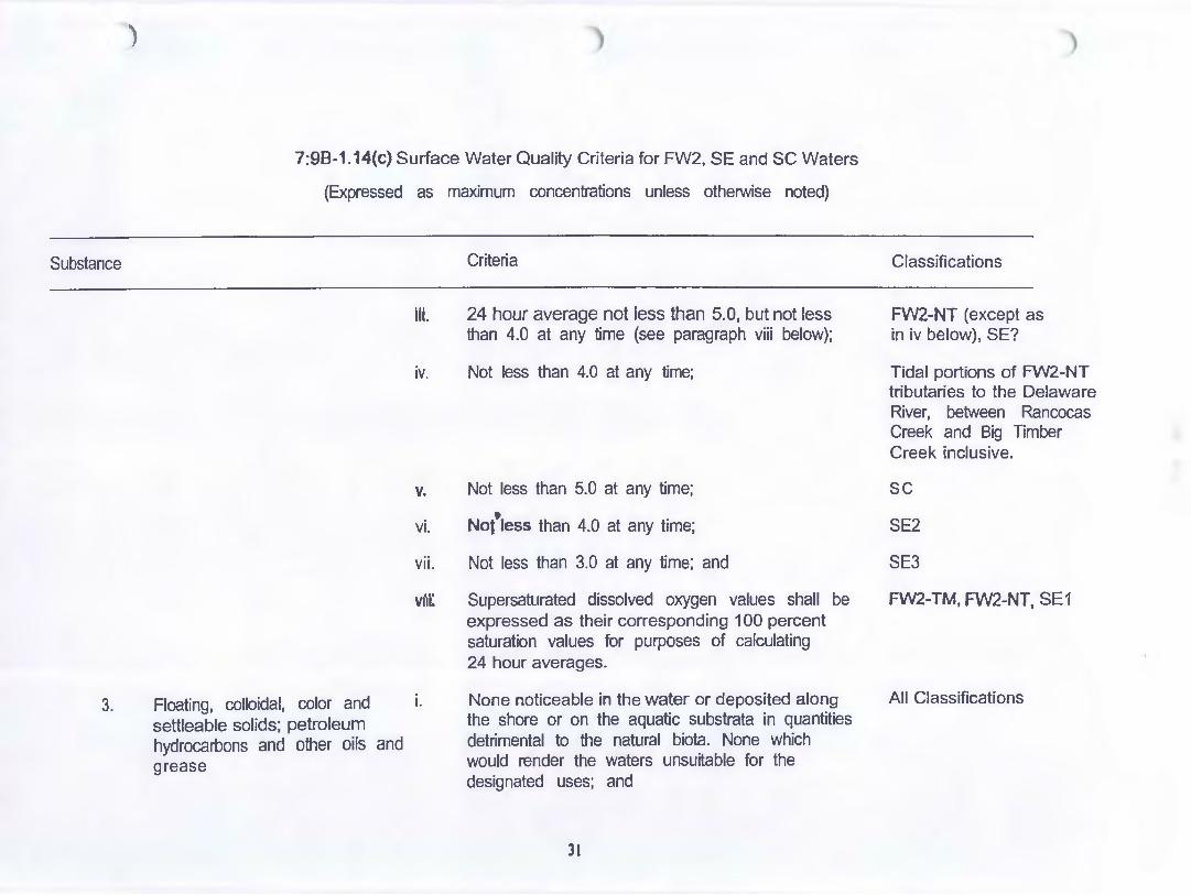
)
7:98-1.14(c) Surface Water Quality Criteria for FW2, SE and SC Waters
(Expressed as maximum concentrations unless otherwise noted)
Substance Criteria
3.
Ill. 24 hour average not less than 5.0, but not less than 4.0 at any time (see paragraph viii below);
iv. Not less than 4.0 at any time;
v. Not less than 5.0 at any time;
vi. Not'tess than 4.0 at any time;
vii. Not less than 3.0 at any time; and
viti: Supersaturated dissolved oxygen values shall be expressed as their corresponding 1 00 percent saturation values for purposes of calculating 24 hour averages.
Floating, colloidal, color and i. None noticeable in the water or deposited along the shore or on the aquatic substrata in quantities detrimental to the natural biota. None which would render the waters unsuitable for the designated uses; and
settleable solids; petroleum hydrocarbons and other oils and grease
31
Classifications
FW2-NT (except as in iv below), SE?
Tidal portions of FW2-NT tributaries to the Delaware River, between Rancocas Creek and Big Timber Creek inclusive.
sc
SE2
SE3
FW2-TM, FW2-NT, SE 1
All Classifications

)
Substance
4.
5.
7:98-1 .14(c) Surface Water Quality Criteria for FW2, SE and SC Waters
(Expressed as maximum concentrations unless otherwise noted)
ii.
pH (Standard Units) i.
It
Phosphorus, Total (mg/L) i.
ii.
Criteria
For "Petroleum Hydrocarbons" the goal is none detectable utilizing the Federal EPA Environmental Monitoring and Support Laboratory Method (Freon Extractable • Silica Gel Adsorption • Infrared Measurement); the present criteria, however, are those of paragraph i above.
6.5-8.5
Natural pH conditions shall prevail.
lakes: Phosphorus as total P shall not exceed 6.05 in any lake, pond or reservoir, or in a tributary at the point where it enters such bodies of water, except where site-specific criteria are developed pursuant to N.J.A.C. 7:98-1 .5(g)3.
Streams: Except as necessary to satisfy the more stringent criteria in paragraph i above or where site-specific criteria are developed pursuant to N.J.A.C 7:98-1 .5(g)3, phosphorus as total P shall not exceed 0.1 in any stream, unless it can be demonstrated that total P is not a limiting nutrient and will not otherwise render the waters unsuitable for the designated uses.
32
Classifications
All Classifications
FW2,AIISE
sc FW2
FW2

)
Substance
6.
7.
8.
7:9B-1.14(c) Surface Water Quality Criteria for FW2, SE and SC Waters
(Expressed as maximum concentrations unless otherwise noted)
Radioactivity
Solids, Suspended (mg/L) (Non-filterable residue)
i.
i. ii.
fll.
Solids, Total Dissolved (mg/L) i. (Filterable Residue)
Criteria
Prevailing regulations including all amendments and future supplements thereto adopted by the U.S. Environmental Protection Agency pursuant to Sections 1412, 1445, and 1450 of the Public Health Services Act, as amended by the Safe Drinking Water Act (PL 93-523)
25.0 40.0
Nofle which would render the waters unsuitable for· the designated uses.
No increase in background which may adversely affect the survival, growth or propagation of the aquatic biota. (Increases up to 133 percent of background are deemed to be in compliance with the narrative criterion above. Increases above 133 percent of background may be granted where the discharger demonstrates, to the satisfaction of the Department, that the proposed increase will not adversely affect the aquatic biota.)
ll
Classifications
All Classifications
FW2-TP, FW2-TM FW2-NT
All SE, SC
FW2
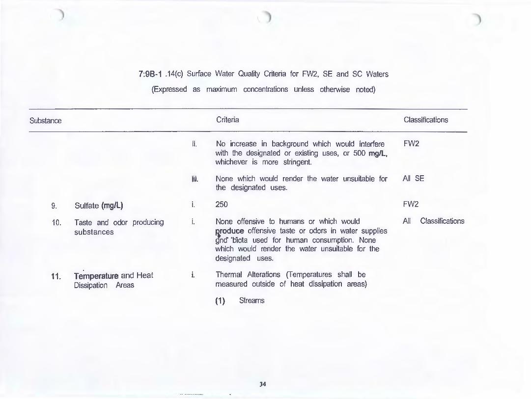
7:98-1 .14{c) Surface Water Quality Criteria for FW2, SE and SC Waters
{Expressed as maximum concentrations unless otherwise noted)
Substance
9. Sulfate (mg/L)
10. Taste and odor producing substances
11. Temperature and Heat Dissipation Areas
ii.
til.
i.
i.
i.
Criteria
No increase in background which would interfere with the designated or existing uses, or 500 mg/L, whichever is more stringent.
None which would render the water unsuitable for the designated uses.
250
None offensive to humans or which would flfoduce offensive taste or odors in water supplies gncf ·biota used for human consumption. None which would render the water unsuitable for the designated uses.
Thermal Alterations {Temperatures shall be measured outside of heat dissipation areas)
(1) Streams
34
Classifications
FW2
AD SE
FW2
All Classifications

)
Substance
7:9B-1.14(c) Surface Water Quality Criteria for FW2, SE and SC Waters
{Expressed as maximum concentrations unless otherwise noted)
Criteria
(i) No thermal alterations which would cause changes in ambient temperatures except where properly treated wastewater effluents are discharged. Where such discharges occur, temperatures shall not deviate more than o.aoc (10f) from ambient temperature.
(ii) No thermal alterations which would , cause temperatures to exceed ambient
by more than 1.1% (2°F) at any time or which would cause temperatures in excess of 2ooc (680f).
(iii) No thermal deviations which would cause temperatures to deviate more than 2.aoc (SoF) at any time from ambient temperatures. No heat may be added which would cause temperatures to exceed 27.8% (82°F) for small mouth bass or yellow perch waters, or 3QoC (860f) for'other nontrout waters.
3S
Classifications
FW2-TP
FW2-TM
FW2-NT

)
Substance
7:98-1. 14{c) Surface Water Quality Criteria for FW2, SE and SC Waters
(Expressed as maximum concentrations unless otherwise noted)
Criteria
(iv) No thermal alterations which would cause temperatures to deviate from ambient by more than 2.2oc (40f), from September through May, nor more than 0.8% (1.50f) from June through August, nor cause temperatures to exceed 29.4% (85°F).
(2) Lakes, Ponds or Reservoirs
• (i) No thermal alterations except where it can be shown to be beneficial to the designated and existing uses.
Classifications
All SE
FW2-TM, FW2-TP
(ii) No thermal alterations of more than FW2-NT 1. 70C (3°F) in the epilimnion of lakes and other standing waters. No discharges of heated effluent into the hypolimnion nor pumping of water from the hypolimnion (for disdlarge back into the same water body) shall be permitted unless it is demonstrated, to the satisfaction of the Department, that such practices will be beneficial to the existing and designated uses.
36

)
Substance
7:98-1 .14(c) Surface Water Quality Criteria for FW2, SE and SC Waters
(Expressed as maximum concentrations unless otherwise noted)
Criteria Classifications
(3) Saline Bays - No thermal alterations which All SE would cause temperatures to deviate from ambient by more than 2.2% (40F), from September through May, nor more than 0.8% (3 .5oF) from June through August, nor cause temperatures to exceed 29.4% (85°F).
(4) Coastal Waters • No direct heat additions S C within 1500 feet of the shoreline. No thermal alterations which would cause temperatures
tto deviate from ambient temperatures by • more than 2.2oc (4DF) from September
through May, nor more than 0.8% (1.5DF) from June through August, nor which would cause temperatures to exceed 26.7% (8QOf).
ii. Heat Dissipation Areas
(1) Streams
(i) Not more than one-quarter (1/4) of the cross section and/or volume of the water body at any time; ·
37
FW2-TM, FW2-NT, All SE

Substance
7:9B-1.14(c) Surface Water Quality Criteria for FW2, SE and SC Waters
(Expressed as maximum concentrations unless otherwise noted)
Criteria
(ii) Not more than two-thirds (2/3) of the surface from shore to shore at any time; and
(iii) These limits may be exceeded by special permission, on a case-by-case basis, when a discharger can demonstrate that a larger heat dissipation area meets the tests for a waiver under Section 316 of the
, Federal Clean Water Act.
(2) Lakes, Ponds, Reservoirs, Bays or Coastal Waters: Heat dissipation areas will be developed on a case-by-case basis.
12. Toxic Substances (general) i. None, either alone or in combination with other substances, in such concentrations as to affect humans or be detrimental to the natural aquatic biota, produce undesirable aquatic life, or which would render the waters unsuitable for the designated uses.
ii. None which would cause standards for drinking water to be exceeded after appropriate treatment.
38
Classifications
All Classifications
All Classifications
FW2
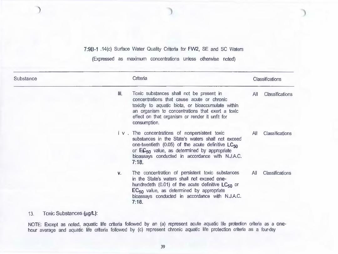
)
Substance
7:98-1 .14(c) Surface Water Quality Criteria for FW2, SE and SC Waters
(Expressed as maximum concentrations unless otherwise noted)
Criteria
Ill. Toxic substances shall not be present in concentrations that cause acute or chronic toxicity to aquatic biota, or bioaccumulate within an organism to concentrations that exert a toxic effect on that organism or render it unfit for consumption.
i v The concentrations of nonpersistent toxic substances in the State's waters shall not exceed one-twentieth (0.05) of the acute definitive LC50 or E~5o value, as determined by appropriate bioassays conducted in accordance with N.J.A.C. 7:18.
v. The concentration of persistent toxic substances in the State's waters shall not exceed onehundredeth (0.01) of the acute definitive LC50 or ECso value, as determined by appropriate bioassays conducted in accordance with N.JA.C. 7:18.
13. Toxic Substances (J.lg/L):
Classifications
All Classifications
All Classifications
All Classifications
NOTE: Except as noted, aquatic life criteria followed by an (a) represent acute aquatic life protection criteria as a onehour average and aquatic life criteria followed by (c) represent chronic aquatic life protection criteria as a four-day
39

)
Substance
7:98-1. 14(c) Surface Water Quality Criteria for FW2, SE and SC Waters
(Expressed as maximum concentrations unless otherwise noted)
Criteria Classifications
average. No exceedance of aquatic life criteria shall be permitted at or above the design flows specified in section N.J.A.C. 7:98-1.5(c)2. Criteria followed by an (h) are noncarcinogenic effect-based human health criteria as a 30-day average with no frequency of exceedance at or above the design flows specified in section N.J.A.C. 7:98-1 .5(c)2. Criteria followed by an (he) are carcinogenic effect-based human health criteria as a 70-year average with no frequency of exceedance at or above the design flows specified in section N. J.A.C. 7:98-1 .5(c)2 and are based on a risk level of onein-one-million. Criteria followed by an (hcc) are for toxic substances considered to be possible human carcinogens as a 70-year average with no frequency of exceedance at or above the design flows specified in section N.J.AC. 7:98-1.5(c)2 and are based on a risk level of one-in-one hundred thousand. Criteria followed by an (OL) are organoleptic effect-based criteria and are maximum concentrations. .
i. Acenaphthylene
ii. Acrolein (1) (2)
iii. Acrylonitrile (1) (2)
iv. Aldrin (1) (2)
v. Aluminum (Total recoverable)
vi. Ammonia, un-ionized (1) (24-hour average) (2)
(3)
Reserved.
• 320(h) 780(h)
0.0591(hc) 0.665(hc)
3.0(a); 0.000135(hc) 1.3(a); 0.000144(hc)
Reserved.
20(c) 50( c) 0.1 of acute definitive LC50 or ECso(c)
40
All FW2 All SE, SC
AIIFW2 All SE, SC
All FW2 All SE, SC
FW2-TP, FW2-TM FW2-NJ All SE, SC
................... -- -...

)
Substance
vii.
VIi'!.
ix.
X.
xi.
xii.
xlil.
xiv.
XV.
7:98-1.14(c) Surface Water Quality Criteria for FW2, SE and SC Waters
(Expressed as maximum concentrations unless otherwise noted)
Criteria
Anthracene (1) 9,570(h) (2) 108,000(h)
Antimony (Total recoverable) (1) 12.2(h) (2) 4,300(h)
Arsenic (Total recoverable) (1) 0.0170(hc) (2) Q.136( he)
Asbestos (1) 7 million fibers/L (h) (fibers longer than 10 micrometers)
Barium (Total recoverable) (1) 2,000(h)
Benz(a)anthracene (1) 0.0028(hc) (2) 0.031(hc)
Benzene (1) 0.150(hc) (2) 71(hc)
Benzidine (1) 0.000118(hc) (2) 0.000535(hc)
3,4-Benzofluoranthene (1) 0.0028(hc) (Benzo(b)fluoranthene) (2) 0.031(hc)
41
Classifications
All FW2 All SE, SC
All FW2 All SE, SC
All FW2 All SE, SC
All FW2
All FW2
All FW2 All SE, SC
All FW2 All SE, SC
All FW2 All SE, SC
All FW2 All SE, SC
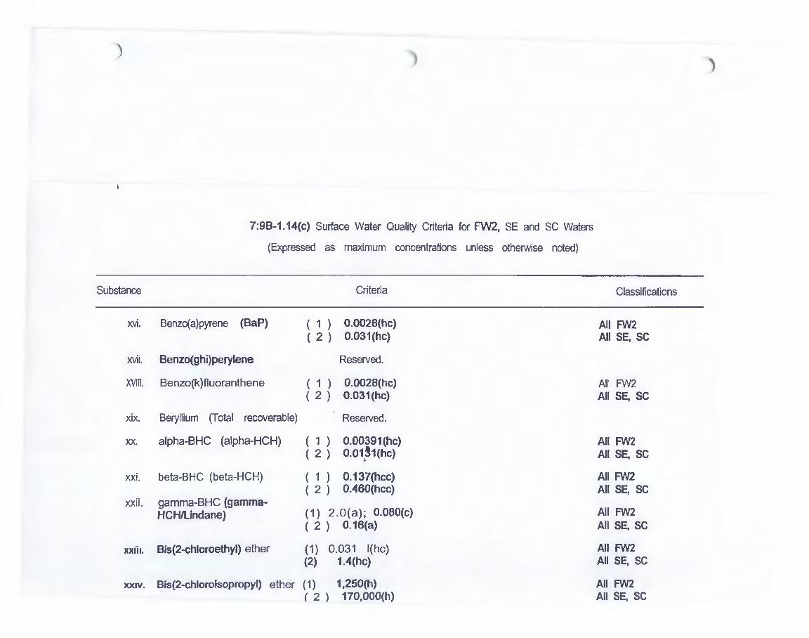
)
Substance
xvi.
xvii.
XVIII.
xix.
XX.
xxi.
xxii.
xxii1.
XXIV.
7:98-1.14(c) Surface Water Quality Criteria for FW2, SE and SC Waters
(Expressed as maximum concentrations unless otherwise noted)
Criteria
Benzo( a)pyrene (SaP) ( 1 ) 0.002B(hc) ( 2 ) 0.031(hc)
Benzo(ghi)perylene Reserved.
Benzo(k)fluoranthene ( 1 ) 0.0028(hc) ( 2 ) 0.031(hc)
Beryllium (Total recoverable) Reserved.
alpha-BHC (alpha-HCH) ( 1 ) 0.00391(hc) ( 2 ) 0.01~1(hc)
beta-BHC (beta-HCH) ( 1 ) 0.137(hcc) ( 2 ) 0.460(hcc)
gamma-BHC (gamma-HCH/Undane) ( 1) 2.0(a); O.OBO(c)
( 2 ) 0.16(a)
Bis(2-chloroethyl) ether (1) 0.031 l{hc) (2) 1.4(hc)
Bis(2-chloroisopropyl) ether (1) 1,250(h) ( 2 ) 170,000(h)
)
Classifications
All FW2 All SE, SC
All FW2 All SE, SC
All FW2 All SE, SC
All FW2 All SE, SC
All FW2 All SE, SC
All FW2 All SE, SC
All FW2 All SE, SC
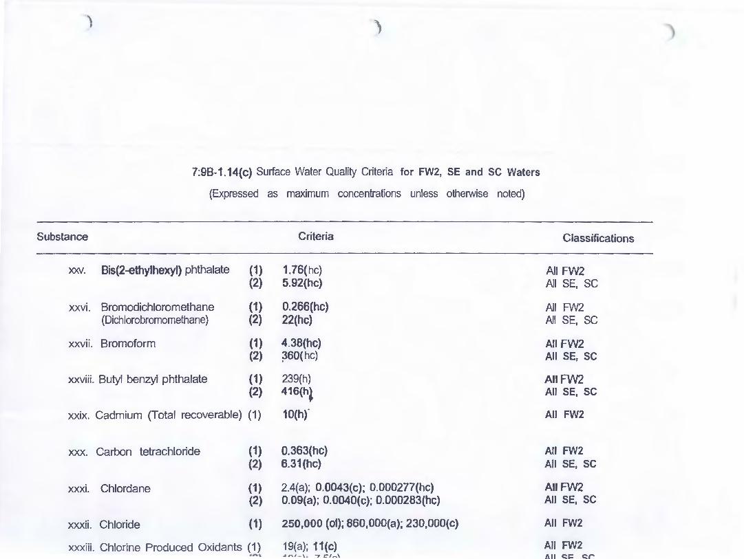
) )
7:9B-1.14(c) Surface Water Quality Criteria for FW2, SE and sc Waters
(Expressed as maximum concentrations unless otherwise noted)
Substance Criteria
"X:JW. Bis(2-ethylhexyl) phthalate (1) 1.76(hc} (2) 5.92(hc)
xxvi. Bromoclichloromethane (1) 0.266(hc) (Dichlorobromomethane) (2) 22(hc)
xxvii. Bromoform (1) 4.38(hc) (2) ~60(hc)
xxviii. Butyl benzyl phthalate (1) 239{h) (2) 416(h~
xxix. Cadmium (Total recoverable) (1) 10(hf
xxx. Carbon tetrachloride (1) 0.363(hc) (2) 6.31(hc)
xxxi. Chlordane (1) 2.4(a); 0.0043(c); 0.000277(hc) (2) 0.09(a); 0.0040(c); 0.000283(hc)
xxxii. Chloride (1) 250,000 (ol); 860,000(a); 230,000(c)
xxxiii. Chlorine Produced Oxidants (1) 19(a); 11(c) ..... "'"''-\ .. -, ct,...\
Classifications
All FW2 All SE, SC
All FW2 All SE, SC
All FW2 All SE, SC
All FW2 All SE, SC
All FW2
All FW2 All SE, SC
All FW2 All SE, SC
All FW2
All FW2 All SE. SC

Substance
xxxiv. Chlorobenrene
xxxv. Chloroform
xxxvi. 2-Chlorophenol
xxxvii. Chlorpyrifos
7:98-1.14(c) Surface Water Quality Criteria for FW2, SE and SC Waters
(Expressed as maximum concentrations unless otherwise noted)
Criteria
(1) 22.0(h) (2) 21,000(h)
(1) 5.67(hc) (2) 470(hc)
(1) 122(h) (2) 402(h)
(1) 0.083(a); 0.041(c) (2) 0.011 'a}; 0.0056(c)
xxxviii. Chromium (Total recoverable) (1) (2)
160{h) 3,230(h)
xxxix. ChrYsene (1) 0.0028(hc) (2) 0.031(hc)
x1. Copper (Dissolved) (1) Resewed. (2) Reserved. (3) 7.9(a); 5.6(c)
Classifications
All FW2 All SE, SC
All FW2 All SE, SC
AIIF'N2 All SE, SC
All FW2 All SE, SC
All FW2 All SE, SC
AIIFW2 All SE, SC
New York/New Jersey Harbor Estuary'
• Waters which Include Newark Bay, the New Jersey portions of Raritan Bay, Upper New YOit Bay, Arthur Kll~ Kiii Van Kull, saUne portions of the Passaic, Hackenaak, and Hudson Rivers and llllne portions of tributaries to all of these waters.
44

) )
7:98-1 .14(c) Surface Water Quality Criteria for FW2, SE and SC Waters
(Expressed as maximum concentrations unless otherwise noted)
Substance Criteria Classifications
xli. Cyanide (1) 22(a); 5.2(c); 768(h) All FW2 (2) 1.0(a); 1.0(c); 220,000(h) All SE, SC
xlii. 4,4'-DDD (p,p'-TOE) (1) 0.000832(hc) All FW2 (2) 0.000837(hc) All SE, SC
xliii. 4,4'-DDE (1) 0.000588(hc) All FW2 (2) Q.000591 (he) All SE, SC
xliv. 4,4'-DDT (1) 1.1(a); 0.0010(c); 0.000588(hc} All FW2 (2) 0.13(~; 0.001 O(c); 0.000591 (he) All SE, SC
XIV. Demeton (1) 0.1(c) All FW2, SE, and SC
xlvi. Dibenz(a,h)anthracene (1) 0.0028(hc) AIIFW2 (2) 0.031(hc) All SE, SC
xlvii. Dibromochloromethane (Chlorodibromomethane) (1) 72.6(h) All FW2
xlviii. Di-n-butyl phthalate (1) 3,530(h) AJJFW2 (2) 15,700(h) All SE, SC
xlix. 1,2-0ichlorobenzene (1) 2,520(h) All FW2 (2) 16,500(h) All SE, SC
45

)
Substance
I.
li.
Iii.
iiii.
liv.
lv.
M.
Mi.
Mii.
7:98-1. 14(c) Surface Water Quality Criteria for FW2, SE and SC Waters
(Expressed as maximum concentrations unless otherwise noted)
Criteria
1,3-Dichlorobenzene (1) 2,620(h) (2) 22,200(h)
1,4-Dichlorobenzene (1) 343(h) (2) 3,159(h)
3,3'-Dichlorobenzidine (1) 0.0386(hc) (2) p.0767(hc)
1 ,2-Dichloroethane (1) 0.291 (he) (2) 99(hc~
1 , 1-Dichloroethylene (1) 4.81(h)
trans-1 ,2-Dichloroethylene (1) 592(h)
2,4-Dichlorophenor (1) 92.7(h) (2) 794(h)
1,3-Dichloropropene (1) 0.193(hc) (2) 1,700(h)
Dieldrin (1) 2. S(a); 0.0019(c);0.000135(hc) (2) 9. 7l(a); 0.0019(c);0.000144(hc)
46
Classifications

)
Substance
lix.
lx.
lxi.
lxii.
lxiii.
lxiv.
lxv.
lxvi.
lxvii.
7:98-1 .14(c) Surface Water Quality Criteria for FW2, SE and SC Waters
{Expressed as maximum concentrations unless otherwise noted)
Criteria
Diethyl phthalate ( 1 ) 21,200(h) ( 2 ) 111,000(h)
Dimethyl phthalate · ( 1 ) 313,000(h) (2) 2,900,000(h)
4,6-Dinitro-o-cresol (1) 13.4(h) (2) 765{h) .
2,4 -Dinitrophenol (1) 69. 7(h) {2) 14,00~)
2,4-Dinitrotoluene { 1 ) o.11(hc) ( 2 ) 9.1(hc)
1,2-Diphenylhydrazine ( 1 ) 0.0405(hc) ( 2 ) 0.541(hc)
Endosulfans (alpha and beta) (1) 0.22(a); 0.056(c); 0.932(h) (2) 0.034(a); 0.0087(c); 1.99(h)
Endosulfan sulfate (1) 0.93(h) (2} 2.0(h)
Endrin (1) 0.18(a); 0.0023(c); 0.629(h) (2) 0.037(a); 0.0023(c); 0.678(h)
47
Classifications
All FW2 All SE, SC
AllFW2 All SE, SC
All FW2 All SE, SC
All FW2 All SE, SC
AIIFW2 All SE, SC
All FW2 All SE, SC
All FW2 All SE, SC
All FW2 All SE, SC
All FW2 All SE, SC

)
7:98-1 .14(c) Surface Water Quality Criteria for FW2, SE and SC Waters
(Expressed as maximum concentrations unless otherwise noted)
Substance Criteria
lxviii. Endrin aldehyde (1) 0.76(h) (2) 0.81(h)
b<ix. Ethyl benzene (1) 3,030(h) (2) 27,900(h)
lxx. Fluoranthene (1) 310(h) (2) ;l93(h)
lxxi. Fluorene (1) 1,340(h)
lxxii. Guthion (1) 0.01 (~ . lxxiii. Heptachlor (1) 0.52(a); 0.0038(c); 0.000208(hc)
(2) 0.053(a); 0.0036(c); 0.000214(hc)
lxxiv. Heptachlor epoxide (1) 0.52(a); 0.0038(c); 0.000103(hc) (2) 0.053(a); 0.0036(c); 0.000106(hc)
lxxv. Hexachlorobenzene (1) 0.000748(hc) (2) 0.000775(hc)
lxxvi. Hexachlorobutadiene (1) 6.94(h)
lxxvii. Hexachlorocyclopentadiene (1) 245(h) (2) 17,000(h)
48
Classifications
All FW2 All SE, SC
All FW2 All SE, SC
All FW2 All SE, SC
AIIFW2
All FW2, SE and SC
All FW2 All SE, SC
All FW2 All SE, SC
All FW2 All SE, SC
All FW2
AIIFW2 All SE, SC

)
7:98-1.14(c) Surface Water Quality Criteria for FW2, SE and SC Waters
(Expressed as maximum concentrations unless otherwise noted)
Substance Criteria
lxxviii. Hexachloroethane (1) (2)
lxxix. lndeno( 1,2,3-cd)pyrene (1) (2)
lxxx. Iron (Total recoverable)
lxxxi. lsophorone (1)
lxxxii. Lead (Total recoverable) (1)
lxxxiii. Malathion (1)
lxxxiv. Manganese (Total (1) recoverable}
bo<XV. Mercury (Total recoverable) (1) (2)
lxxxvi. Methoxychlor (1) (2)
lxxxvii. Methyl bromide (1) 48.4(h) (Bromomethane) (2) 4,000(h;
49
)
Classifications
All FW2 All SE, SC
All FW2 All SE, SC
All FW2
AIIFW2
All FW2, SE and SC
All SE, SC
All FW2 All SE, SC
All FW2 All SE, SC
All FW2 All SE, SC

7:98-1.14(c) Surface Water Quality Criteria for FW2, SE and SC Waters
(Expressed as maximum concentrations unless otherwise noted)
Substance Criteria
lxxxviii.Methyl chloride Reserved. (Chloromethane)
lxxxix. Methylene chloride (1) 2.49(hc) (2) 1,600(hc)
XC. Mirex (1) 0.001 (c)
xci. Nickel (Total recoverable) (1) 516(h) (2) 3,900(h)
xcii. Nitrate (as N) (1) 10,0.~0(h)
xciii. Nitrobenzene (1) 16.0(h) (2) 1,900(h)
xciv. N-Nitrosodi-n-butylamine (1) 0.00641 (he)
XCV. N-Nitrosodiethylamine (1) 0.000233(hc)
xcvi. N-Nitrosodimethylamine (1) 0.000686(hc) (2) 8.1 (he)
xcvii. N-Nitrosodiphenylamine (1) 4.95(hc) (2) 16.2(hc)
so --··--·· -···· .-r--w----
Classifications
All FW2 All SE, SC
All FW2, SE and SC
All FW2 All SE, SC
All FW2
All FW2 All SE, SC
All FW2
AIIFW2
AIIFW2 All SE, SC
All FW2 All SE, SC
I ..

Substance
xcviii.
xcix.
c.
ci.
cii.
CHI.
civ.
cv.
cvi.
7:98-1 .14( c) Surface Water Quality Criteria for FW2, SE and sc Waters
(Expressed as maximum concentrations unless otherwise noted)
Criteria
N-Nitrosopyrrolidine (1) 0.0167(hc)
Parathion (1) 0.065(a); 0.013(c)
Pentachlorobenzene (1) 3.67(h) (2) 4.21(h)
Pentachlorophenol (1) e(1.005(pH)-4.830)(a);
e(1.005(pH)-5.290)(c);
(2) 0.282(h~ 13(a); 7~ {c); 8.2{hc)
Phenanthrene Reserved.
Phenol (1) 20,900(h) (2) 4,600,000(h)
Phosphorous (yellow) (1) 0.1(c)
Polychlorinated biphenyls (1) 0.014(c); 0.000244(hc) (PCBs-1242, 1254, 1221, (2} 0.030(c); 0.000247(hc} 1232, 1248, 1260, and 1016)
Pyrene (1) 797(h) (2) 8,970(h)
)
Classifications
All FW2
All FW2
All FW2 All SE, SC
All FW2
All SE, SC
All FW2 All SE, SC
All SE, SC
All FW2 All SE, SC
All FW2 All SE, SC

)
Substance
cvii.
CViil.
cix.
ex.
cxi.
cxii.
cxilt
cxiv.
cxv.
cxvi.
- --a • -
)
7:98-1. 14(c) Surface Water Quality Criteria for FW2, SE and SC Waters
(Expressed as maximum concentrations unless othervvise noted)
Criteria
Selenium (Total recoverable) ( 1) 10(h)
Silver (Total recoverable) (1) 164(h)
Sulfide-hydrogen sulfide (1) 2(c) (undissociated)
1,2,4,5-Tetrachlorobenzene (1) 2.56(h) (2) 3.25(h)
2,3,7,8-Tetrachlorodibenzo-p- (1) 0.000000013(hc) dioxin (TCDD) (2) o.oooeooo 14(hc)
1,1,2,2-Tetrachloroethane (1) 1.72(hcc)
Tet~chloroethylene (1) 0.388(hc) (2) 4.29(hc)
Thallium (Total recoverable) ( 1) 1.70(h)
Classifications
AIIFW2
AIIFW2
All FW2, SE and SC
AIIFW2 All SE, SC
All FW2 All SE, SC
AIIFW2
AIIFW2 All SE, SC
AIIFW2 (2) 6.22(h) 'All SE, SC
Toluene (1) 7,440(h) AIIFW2 (2) 200,000(h) All SE, SC
Toxaphene (1) 0.73(a); 0.0002(c); 0.000730(hc) All FW2 (2) 0.21(a); 0.0002(c); 0.000747(hc) All SE, SC
S2

)
Substance
cxvii.
cxviii.
cxix.
cxx.
cxxi.
cxxii.
cxxiii.
7:9B-1.14(c) Surface Water Quality Criteria for FW2, SE and SC Waters
(Expressed as maximum concentrations unless otherwise noted)
Criteria
1 ,2,4-Trichlorobenzene (1) 30.6{h) (2) 113{h)
1, 1 ,1-Trichloroethane (1) 127{h)
1,1 ,2-Trichloroethane (1) 13.5(h)
Trichloroethylene (1) 1.09(hc) (2) 81(hc)
2,4,5-Trichlorophenol (1) 2,580(h) (2) 9,790(hl'
2,4,6-Trichlorophenol (1) 2.14(hc) (2) 6.53(hc)
Vinyl chloride (1) 0.0830(hc) (2) 525(hc)
cxxiv. Zinc (Total recoverable) Reserved.
SJ
Classifications
All PN2 All SE, SC
All FW2
All PN2
All PN2 All SE, SC
All PN2 All SE, SC
AIIFW2 All SE, SC
All PN2 All SE, SC

Substance
7:98-1.14( c) Surface Water Quality Criteria for FW2, SE and SC Waters
(Expressed as maximum concentrations unless otherwise noted)
Criteria Classifications
14. Turbidity (Nephelometric i. Maximum 30-day average of 15 NTU, a maximum FW2, SE3 Turbidity Unft-NTU) of 50 NTU at any time.
ii. Maximum 30-day average of 10 NTU, a maximum SE 1, SE2 of 30 NTU at any time.
11'1. Levels shall not exceed 10.0 NTU. SC