the archaeology of the battle of the boyne at oldbridge...
TRANSCRIPT

The Archaeology of the Battle of the Boyne at Oldbridge, Co. MeathAuthor(s): Gabriel Cooney, Emmet Byrnes, Conor Brady and Aidan O'SullivanSource: Archaeology Ireland, Vol. 16, No. 4 (Winter, 2002), pp. 8-12Published by: Wordwell Ltd.Stable URL: http://www.jstor.org/stable/20562623 .
Accessed: 03/04/2013 12:49
Your use of the JSTOR archive indicates your acceptance of the Terms & Conditions of Use, available at .http://www.jstor.org/page/info/about/policies/terms.jsp
.JSTOR is a not-for-profit service that helps scholars, researchers, and students discover, use, and build upon a wide range ofcontent in a trusted digital archive. We use information technology and tools to increase productivity and facilitate new formsof scholarship. For more information about JSTOR, please contact [email protected].
.
Wordwell Ltd. is collaborating with JSTOR to digitize, preserve and extend access to Archaeology Ireland.
http://www.jstor.org
This content downloaded from 193.1.234.19 on Wed, 3 Apr 2013 12:49:44 PMAll use subject to JSTOR Terms and Conditions
The archaeology
of the Battle of the
The Oldbridge estate on the
southern bank of the River
Boyne, a core part of the
battlefield of the Battle of the
Boyne, was acquired by the
state in 2000. To provide
baseline data for the
management and presentation
of the site, Duchas The
Heritage Sen/ice commissioned
a team from the Department
of Archaeology, UCD, to
undertake a pilot survey of the
estate with a particular focus
on the archaeology of the
battle. Here Gabriel Cooney,
Emmet Byrnes, Conor Brady
?^T^aV Dundalk ,nst?tute
M^3ffi?^ was usec' 'n t'ne
8
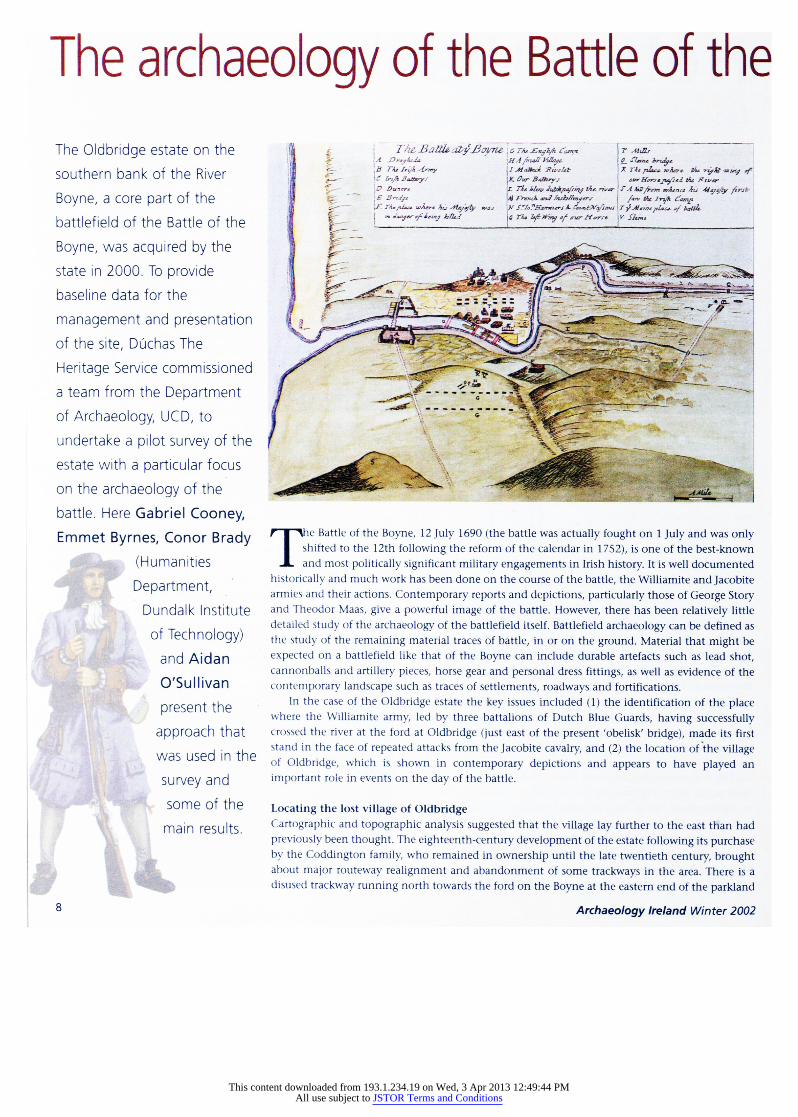
The Battle of the Boyne, 12 July 1690 (the battle was actually fought on 1 July and was only shifted to the 12th following the reform of the calendar in 1752), is one of the best-known and most politically significant military engagements in Irish history. It is well documented
historically and much work has been done on the course of the battle, the Williamite and Jacobite armies and their actions. Contemporary reports and depictions, particularly those of George Story and Theodor Maas, give a powerful image of the battle. However, there has been relatively little
detailed study of the archaeology of the battlefield itself. Battlefield archaeology can be defined as the study of the remaining material traces of battle, in or on the ground. Material that might be
expected on a battlefield like that of the Boyne can include durable artefacts such as lead shot, cannonballs and artillery pieces, horse gear and personal dress fittings, as well as evidence of the
contemporary landscape such as traces of settlements, roadways and fortifications.
In the case of the Oldbridge estate the key issues included (1) the identification of the place where the Williamite army, led by three battalions of Dutch Blue Guards, having successfully crossed the river at the ford at Oldbridge (just east of the present 'obelisk' bridge), made its first stand in the face of repeated attacks from the Jacobite cavalry, and (2) the location of the village of Oldbridge, which is shown in contemporary depictions and appears to have played an
important role in events on the day of the battle.
Locating the lost village of Oldbridge Cartographic and topographic analysis suggested that the village lay further to the east tHan had
previously been thought. The eighteenth-century development of the estate following its purchase by the Coddington family, who remained in ownership until the late twentieth century, brought about major routeway realignment and abandonment of some trackways in the area. There is a
disused trackway running north towards the ford on the Boyne at the eastern end of the parkland
Archaeology Ireland Winter 2002
This content downloaded from 193.1.234.19 on Wed, 3 Apr 2013 12:49:44 PMAll use subject to JSTOR Terms and Conditions

Battle of the Boyn e
Boyne at
Oldbridge, Co. Meath
in front of Oldbridge House. Close examination of the topography showed that there is a second trackway running to the west of this
known track and south of the modern estate farmyard. This and the
low linear earthworks adjacent to the east-west trackway suggested that this was an area that could be tested as being the location of the
village.
One of the primary aims of a programme of magnetic
gradiometry survey carried out by GeoArc was to locate evidence for
9_02_0.4 kilometres
the village. Patterns of enhanced magnetism in the soil can indicate a range of archaeological features of which there may be no surface
expression. Two panels were placed in the area discussed above and
there was good evidence to suggest that this was indeed the location of the village. In a panel located to the north of the modern estate avenue and west of the farmyard there was a high concentration of
magnetic anomalies, some of which appear to represent small
rectangular enclosures. In a panel further east, south of the avenue, the nature and form of the anomalies suggest the presence of ditches,
trackways, possible hearths and structural foundations. It is probable that the features found represent a significant part of the lost village of Oldbridge. At least four probable houses can be detected, integrated into a somewhat irregular system of boundaries.
Phosphate survey indicated enhanced levels of phosphate in the putative village area.
A battlefield focus The field to the east of the parkland is known as the Potato Field. It has been suggested that this was the site of the first, fierce encounters south of the river between the Williamite infantry and the Jacobite cavalry. Here the magnetic anomalies were much more subtle and
ephemeral. One pattern of anomalies indicated a curvilinear feature of approximately 50m which probably correlates with a known crop
mark enclosure site. Some of the dipolar anomalies are produced
Archaeology Ireland Winter 2002
from point sources such as iron objects or features with a strong
magnetic signature and could be related to battle activity. However, that the Potato Field was indeed a key location in the battle was
demonstrated most clearly by systematic field-walking. As Conor Brady illustrated in the last issue of Archaeology Ireland,
this technique has great significance for informing us about earlier
prehistoric settlement in the Boyne Valley. But it is also useful for the
study of material from later periods which is likely to survive in the ploughsoil. Seven ploughed fields, including the Potato Field, were examined to assess the range of evidence for past human activity in
the ploughsoil. Several hundred pieces of struck and worked flint and other stone dated from the Neolithic/early Bronze Age (4000-2000 BC). There was a general spread of this material, with a few notable
concentrations representing definite activity areas. Material dating from the medieval and modern periods was also recovered.
But perhaps most intriguing was the material that can be directly related to the battle. Most of this came from the Potato Field,
including five musket balls, a gun flint and an iron buckle or harness
fitting. Remembering that this is only a very small sample of what is in the ploughsoil, the patterning of the musket balls and the gun flint
presents dramatic evidence for prolonged musket-firing. There are two possible explanations for this. It could be where Jacobite infantry
Across left: Reconstruction of the Battle f the Boyne based on Story's 1693 map (From Newgrange and the bend of the Boyne by G?raldine
Stout, (see review page 42). Above left: Interpretation of the results of the geophysical survey indicating the location and form of the Oldbridge village.
Above: The areas surveyed on the Oldbridge estate. Fields that were
systematically field-walked indicated by yellow outline. Areas where
magnetometry, metal-detecting and phosphate survey were carried out indicated in red (by kind permission of Ordnance Survey of Ireland
Permit No. MP 012202 ? Ordnance Survey of Ireland and Government of Ireland).
9
This content downloaded from 193.1.234.19 on Wed, 3 Apr 2013 12:49:44 PMAll use subject to JSTOR Terms and Conditions
Battle of the Boyne
lined up to resist the first attempts of the Dutch Blue Guards to
secure the southern bank of the river. Alternatively, what we could
be seeing is the action of the Dutch Blue Guards, having secured the
southern bank and the village, drawing up in battle formation to
fend off the repeated Jacobite cavalry charges led by Tyrconnell and
Berwick.
One evocative find from a tilled field at the south-east end of the
estate where the ground rises towards Donore Hill was a silver half
?cu of Louis XIV, minted in 1659. This is most likely to have been in the possession of a French soldier in the Jacobite army, lost in an
area where much of the Jacobite cavalry mustered and where the
Jacobite camp extended on the day before the battle. It may have
been lost then or during the course of the battle.
Down to the river
Given the significance of the river as a crucial feature in the battle,
crossed at five different points by the Williamite army, it was
important to have information on the character of the riverbed and
its profile along the river frontage of the estate. This work was
carried out by Management for Archaeology Underwater (MAU) with the assistance of the Centre for Maritime Archaeology (CMA),
University of Ulster at Coleraine. It involved magnetometry and
side-scan sonar survey of the river along with cartographic,
historical and field research. This work identified those zones which
could be the subject of more detailed survey work. For example, the
side-scan sonar, which in effect provides a tonal map of the
riverbed, identified a number of underwater pools that act as
natural sediment and deposition traps in the river and hence are the
most likely locations where battle-related artefacts might be found.
These are concentrated around the islands east of the obelisk bridge, the area that was the focus of four of the crossings. In the same area
cartographic research indicates that since the late seventeenth
century through depositional activity and change in the river
regime the islands have changed shape and that a small island now
extends over what would have been the main fording-point at the
time.
Metal-detecting as an archaeological technique In the past a significant amount of material has been recovered
from the battlefield through illegal metal-detecting activity. Much
of the fine locational detail that is necessary to make such material
useful in understanding the archaeology of the Battle of the Boyne is sadly lacking. It is this approach to metal-detecting that has given it a bad reputation as a prospection technique. However, the value
of systematic metal-detecting has been shown on battlefield sites
such as that of the Little Bighorn in Montana, where it was used to
assist in the location, plotting and recovery of finds relating to the
battle in 1876, including Custer's last stand.
At Oldbridge a systematic metal-detecting survey was carried out
under licence as required by the National Monuments Act. The
same survey grid was used as for the geophysics and the phosphate
survey. The intention was to delineate the area of the village and to
identify scatters of material that might be associated with the battle.
The metal-detector used allowed a dual discrimination survey
approach. Ail occurrences of metal were recorded and then larger ferrous (iron) and non-ferrous objects with a high conductivity were
10
identified. So by systematic recording of the 'hits' registered by the
detector we can establish patterns of density and also those likely to
signal larger iron or non-ferrous objects. In the areas where the metal
detecting survey was carried out there was a very good correlation
with the results of the geophysical and phosphate survey. These
suggest a high concentration of activity in the area identified as that of Oldbridge village and in the Potato Field. Much of the latter could
be material relating to the battle.
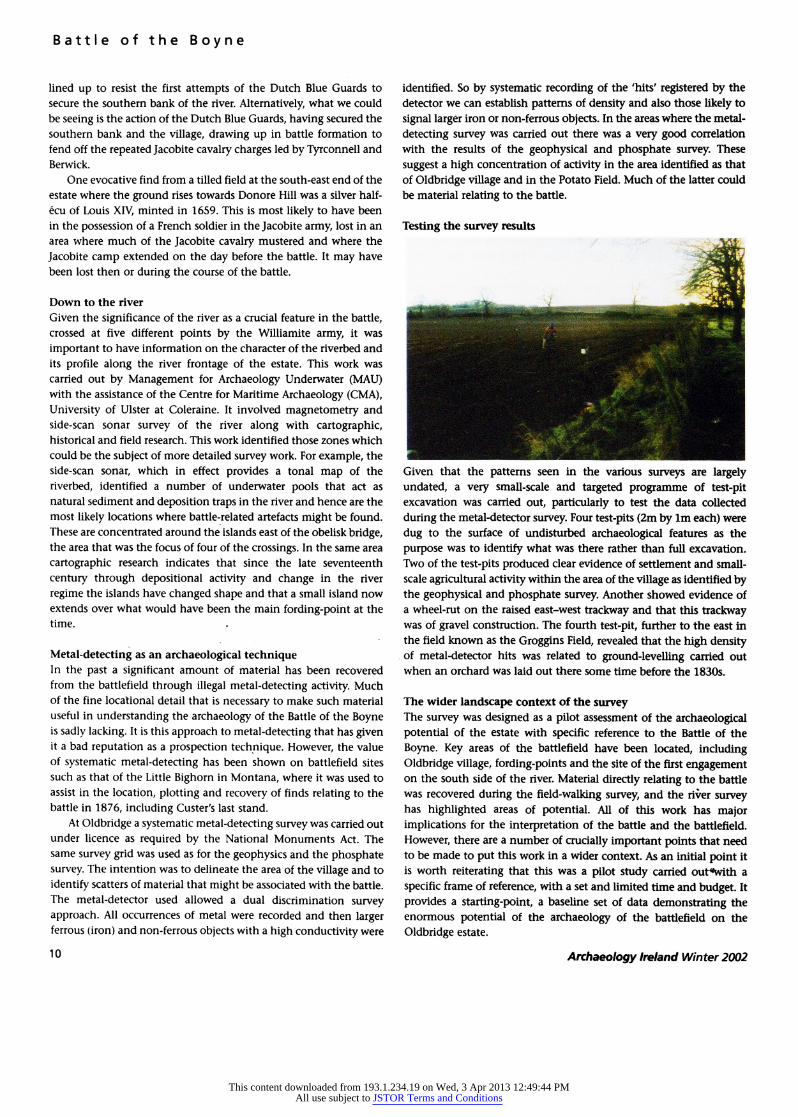
Given that the patterns seen in the various surveys are largely
undated, a very small-scale and targeted programme of test-pit
excavation was carried out, particularly to test the data collected
during the metal-detector survey. Four test-pits (2m by lm each) were
dug to the surface of undisturbed archaeological features as the
purpose was to identify what was there rather than full excavation.
Two of the test-pits produced clear evidence of settlement and small
scale agricultural activity within the area of the village as identified by the geophysical and phosphate survey. Another showed evidence of
a wheel-rut on the raised east-west trackway and that this trackway was of gravel construction. The fourth test-pit, further to the east in
the field known as the Groggins Field, revealed that the high density of metal-detector hits was related to ground-levelling carried out
when an orchard was laid out there some time before the 1830s.
The wider landscape context of the survey
The survey was designed as a pilot assessment of the archaeological
potential of the estate with specific reference to the Battle of the
Boyne. Key areas of the battlefield have been located, including Oldbridge village, fording-points and the site of the first engagement on the south side of the river. Material directly relating to the battle
was recovered during the field-walking survey, and the river survey has highlighted areas of potential. All of this work has major implications for the interpretation of the battle and the battlefield.
However, there are a number of crucially important points that need
to be made to put this work in a wider context. As an initial point it
is worth reiterating that this was a pilot study carried out*with a
specific frame of reference, with a set and limited time and budget. It
provides a starting-point, a baseline set of data demonstrating the
enormous potential of the archaeology of the battlefield on the
Oldbridge estate.
Archaeology Ireland Winter 2002
This content downloaded from 193.1.234.19 on Wed, 3 Apr 2013 12:49:44 PMAll use subject to JSTOR Terms and Conditions

The events surrounding the Battle of the Boyne cannot be
divorced from the longer-term history of the area of the estate. To
take one example, the village of Oldbridge must have been in
existence for a considerable period before the battle, and indeed was
a focus of settlement in the medieval and early modern periods. The
combination of the location of ridge-and-furrow cultivation and the
plough pebbles and medieval pottery sherds recovered in the field
walking provides the basis for a study of medieval agriculture in the
northern part of the estate. Going back further in time, the survey
provided the data for an overview of human activity in the Oldbridge area since prehistoric times. It was a focus of settlement and other
activity in prehistory, a period when the archaeological focus has
been very firmly placed on Br? na Boinne, just to the west.
The changing course of the river in the Oldbridge area marks the
eastern end of the famous bend in the Boyne and the location of a
major fording-point there must have long-term significance. One
interesting counterpoint to the Br? na Boinne area is the clear
evidence of Bronze Age activity at Oldbridge. The standing stones and
two cists discovered in the nineteenth century can now be set
alongside what appears to be a ring-barrow cemetery on the flat top of a rise overlooking the estate parkland. This was revealed on the
Ordnance Survey vertical aerial photographic coverage of the area
and by the geophysical survey.
In relation to the Battle of the Boyne itself, the Oldbridge estate is
only part of the wider landscape of the battle. A number of key areas
can be identified, including the area north of the Boyne to the east
Archaeology Ireland Winter 2002
and west of King William's Glen and up to the Tullyallen ridge. This was the main Williamite position before the battle. In the glen the so
called 'Williamite Encampment' needs to be fully recorded and
assessed. It is clear that the actual encampment was in the vicinity of
the present village of
Tullyallen. Donore Hill was a focus of the
Jacobite encampment prior to the battle. It is likely that the flat area
in the vicinity of the medieval church was a focus of settlement and
the military encampment. These and other key areas have the
potential to reveal new information through archaeological
Across left: Magnetometer survey in progress. Tne eastern side of the
north-south trackway is viSl^|e at the right-hand edge of the
photograph (photograph Dv Conor Brady). Left: East-west raised gravelled trackway in the parkland with
Oldbridge House in the background (photograph by Conor Brady).
Above top: The half-?cu i-ou?s XIV coin dated to 1659 found ?n
the course of the systematic field-walking survey. Above: Musket balls from the Battle of the Boyne recovered
in the course of the systematic field-walk'ng survey.
This content downloaded from 193.1.234.19 on Wed, 3 Apr 2013 12:49:44 PMAll use subject to JSTOR Terms and Conditions

Battle of the Boyne
investigation. The wider battlefield of the Battle of the Boyne should
be seen as a landscape within which there are key areas requiring
appropriate conservation and presentation.
Coming back to the Oldbridge estate itself, it is also crucial that
the significance of the demesne landscape is recognised. This
landscape is both the creation and reflection of eighteenth- and
nineteenth-century ideas about estate design, and much of the fine
detail of this?from the house, other buildings and field boundaries
to details of features and fittings?survives intact. This is of
significant historical importance in its own right but also has a
significance in the context of the battle. This was the place in which
much of the remembrance of the battle was created.
To take one small example, between the village and the Potato
Field there is a low hummock with an inscribed stone marked
'1690'. Local tradition says that this is where the Williamite
commander, the duke of Schomberg, was temporarily buried after
the battle before being interred in St Patrick's Cathedral in Dublin.
But it is more likely to mark a spot where human remains may have
been interred, or re-interred after disturbance, some time after the
battle. The geophysical survey around the hummock indicated
burning or buried metal, and there were high levels of phosphate.
However, the style of script on the stone is the same as that on a
plaque on the north wall of the estate gatelodge which also reads
'1690'. It is very likely that these memorial stones were placed at the
same time in the late eighteenth or early nineteenth century. Is it
coincidental that this was the time when commemoration of the
battle gained a central place in Orange celebrations, having been
overshadowed for much of the eighteenth century by King
William's birthday in November?
It might be useful to conclude by thinking of the
archaeological evidence for both the Battle of the Boyne and the
longer-term settlement history of the area from two perspectives.
Firstly, it has an applied value in the interpretation of events, such
as the battle, and processes, such as the evolution of the landscape
from prehistoric times onward. Secondly, because of its
importance as the direct, material remains of such events, it has
the ability to bring the past into the present in a very real way.
Our thanks to Martina McCarthy and joe Fenwick (GeoArc), Donal Boland
and Rory McNeary (MAU), Donal O'Carroll and Harman Murtagh (Military
History Sodety of Ireland), Eamonn P. Kelly (National Museum of Ireland),
Robert Heslip (Ulster Museum), G?raldine Stout (Duchas), Breeda Turte for
assistance and information and Barbara Leon for help with the illustrations.
Discover Ireland's
architectural heritage Are you aware of the architectural treasures in your county?
As part of the National Inventory of Architectural Heritage, Duchas The Heritage Service of the Department of the Environment and Local Government is publishing lavishly illustrated books, which will open your eyes to some of Ireland's architectural gems county by county.
This survey contains everything from the grand to the
simple - churches, courthouses, domestic houses and
farm buildings. Books on some counties are already available including free searchable CD ROMs with descriptive text, photographs and maps.
Available at all good bookshops, www.wordwellbooks.com or Tel: 01-2765221
For information on your county contact [email protected]
An Roinn Comhshaoil agus Rialtais ?iti?il The Department of the Environment and Local Government
Duchas The Heritage Service
12 Archaeology Ireland Winter 2002
This content downloaded from 193.1.234.19 on Wed, 3 Apr 2013 12:49:44 PMAll use subject to JSTOR Terms and Conditions