the challenges of integrating disaster risk management
TRANSCRIPT
THE CHALLENGES OF INTEGRATING DISASTER RISK MANAGEMENT (DRM),
INTEGRATED WATER RESOURCES MANAGEMENT (IWRM) AND AUTONOMOUS
STRATEGIES IN LOW-INCOME URBAN AREAS: A CASE STUDY OF DOUALA,
CAMEROON
A thesis submitted to The University of Manchester for the degree of
Doctor of Philosophy
In the Faculty of Humanities
Jessica Roccard
2014
School of Environment, Education and Development
2
Contents
List of Appendices ........................................................................................................................................ 6
List of Boxes .................................................................................................................................................. 6
List of Figures ................................................................................................................................................ 6
List of Images ................................................................................................................................................ 7
List of Maps ................................................................................................................................................... 8
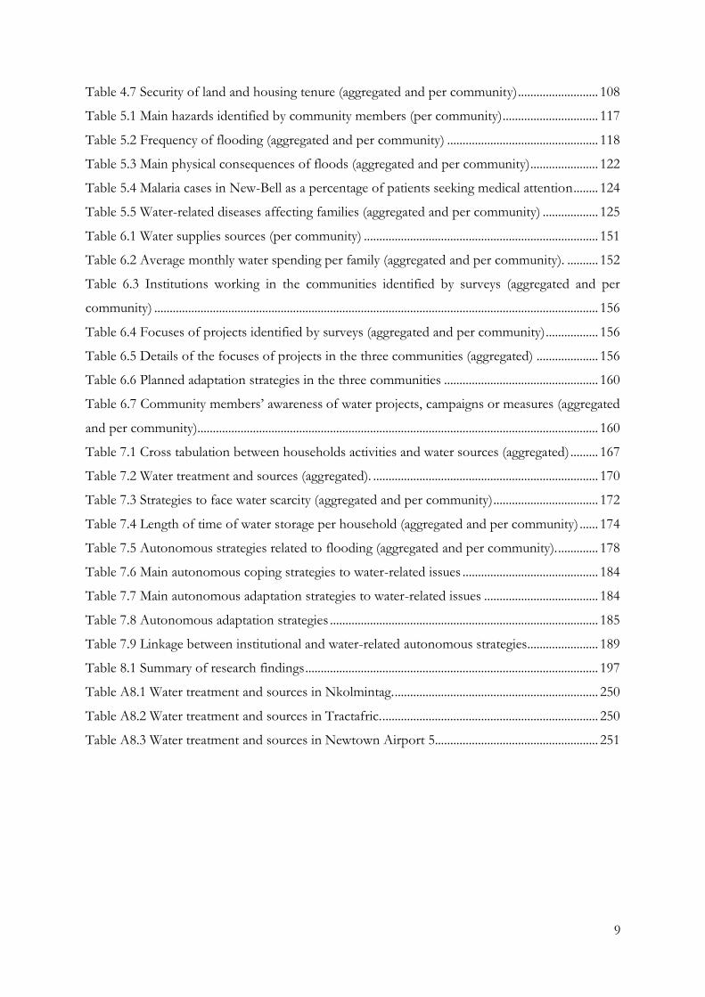
List of Tables ................................................................................................................................................. 8
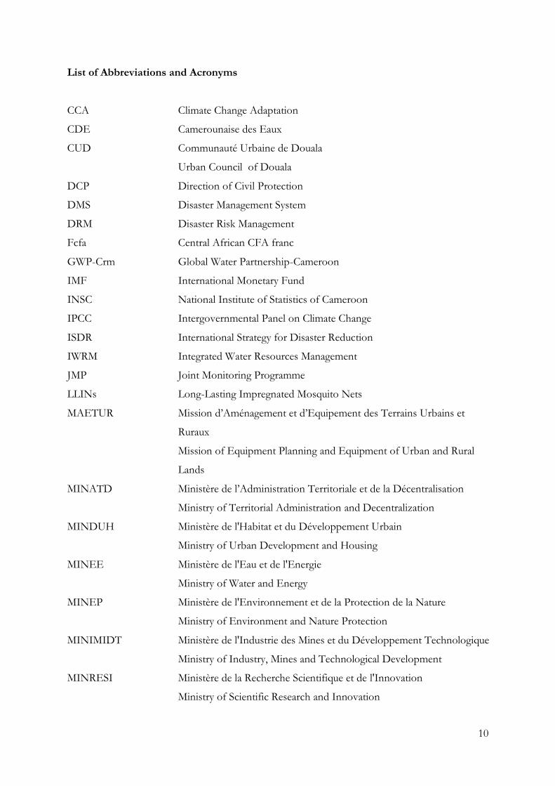
List of Abbreviations and Acronyms ...................................................................................................... 10
Abstract........................................................................................................................................................ 12
Declaration ................................................................................................................................................. 13
Copyright Statement ............................................................................................................................... 14
Acknowledgements ................................................................................................................................. 15
Chapter 1: Introduction ........................................................................................................................ 17
1.1. Problem definition ..................................................................................................................... 17
1.2. Aim of the research ................................................................................................................... 19
1.3. Research hypothesis, questions and objectives ..................................................................... 20
1.4. Geographical focus and target group of the research .......................................................... 21
1.5. Methodological approach ......................................................................................................... 23
1.6. Structure of the thesis ................................................................................................................ 24
Chapter 2: Water risk and climate change in low-income urban communities .......................... 27
2.1. Water-related vulnerabilities of the urban poor .................................................................... 28
2.1.1. Defining vulnerability to climate change ....................................................................... 28
2.1.2. Factors of water-related vulnerability of the urban poor ............................................ 31
2.1.3. Climate change impacts on water-related vulnerabilities of the urban poor ........... 34
2.2. International and national responses to climate change in urban areas............................ 36
2.2.1. Prevailing response: Disaster Risk Management (DRM) ............................................ 36
2.2.2. Alternative response: Climate Change Adaptation (CCA) ......................................... 38
2.2.3. A tool for CCA: Integrated Water Resource Management framework (IWRM) ... 40
2.2.4. Linking DRM and CCA trough IWRM ......................................................................... 42
2.3. Autonomous adaptation to climate change impacts on water ........................................... 45
3
2.3.1. Defining autonomous adaptation ................................................................................... 46
2.3.2. Differences between autonomous adaptation and coping strategies........................ 47
2.3.3. Water-related autonomous strategies of the urban poor ............................................ 49
2.4. Conclusion: linking DRM, CCA and adaptation strategies of the urban poor ............... 52
Chapter 3: Research methodology ...................................................................................................... 55
3.1 Methodological approach ......................................................................................................... 55
3.1.1 Theoretical approach ........................................................................................................ 55
3.1.2 Mixed methods strategy in a case study design ............................................................ 57
3.1.1 Mixed methods paradigm challenges ............................................................................. 58
3.2 Case study approach and research design .............................................................................. 60
3.2.1 Aim and objectives of fieldwork ..................................................................................... 60
3.2.2 Regional, national and city selection ............................................................................... 60
3.2.3 Douala’s low-income settlements selection .................................................................. 62
3.2.4 Delimitation of low-income settlements ....................................................................... 67
3.2.5 Ethical issues ...................................................................................................................... 68
3.3 Methods of data collection ....................................................................................................... 69
3.3.1 Transect walks and field observations ........................................................................... 69
3.3.2 Survey and sampling methods ......................................................................................... 72
3.3.3 Completion of the questionnaire .................................................................................... 72
3.3.4 Semi-structured interviews ............................................................................................... 75
3.3.5 Document analysis............................................................................................................. 76
3.4 Summary of data collection and data analysis ....................................................................... 77
3.4.1 Positionality of the researcher, reliability and validity of results................................ 77
3.4.2 Preliminary results of the fieldwork research strategies .............................................. 81
3.5 Conclusion ................................................................................................................................... 84
Chapter 4: Douala: a city profile ......................................................................................................... 86
4.1. The city’s history and current economic characteristics ...................................................... 86
4.2. Climate variables ........................................................................................................................ 89
4
4.2.1. Temperature variability ..................................................................................................... 89
4.2.2. Rainfall pattern ................................................................................................................... 90
4.3. Douala’s water resources and population in a context of climate change ....................... 92
4.3.1. Douala’s water resources and climate change impacts ................................................ 92
4.3.2. Douala’s population and climate change impacts on water ....................................... 94
4.4. Institutional arrangements influencing climate change policies, programmes and
measures ................................................................................................................................................... 97
4.5. Community profile: the district of New-Bell, Douala ......................................................... 98
4.5.1 Three poor urban communities in New-Bell .............................................................. 100
4.5.2 Number of persons per family and types of housing ................................................ 102
4.5.3 Education .......................................................................................................................... 103
4.5.4 Monthly spending and employment ............................................................................. 105
4.5.5 Land and housing tenure status .................................................................................... 107
4.6. Conclusion ................................................................................................................................. 109
Chapter 5: Hazards and Disaster Risk Management in Douala .................................................. 111
5.1 DRM framework and national institutional arrangements ............................................... 111
5.2 DRM and local institutional arrangements .......................................................................... 113
5.3 Hazards in Doula’s low-income communities .................................................................... 115
5.3.1 Frequency, causes and consequences of flooding ...................................................... 118
5.3.2 Water-related epidemics and its consequences ........................................................... 123
5.3.3 Water-borne diseases: lack of sanitation system and water contamination ........... 129
5.4 Institutional responses to two main hazards impacts affecting Douala ......................... 132
5.4.1 Institutions involved in flood management ................................................................ 132
5.4.2 Institutions involved in managing biological hazards ............................................... 134
5.5 Conclusion ................................................................................................................................. 136
Chapter 6: IWRM, water access and institutional water-related strategies in Douala ............. 138
6.1 Water management policies .................................................................................................... 138
6.1.1 Public-private partnership in the water sector in Douala ......................................... 139
5
6.1.2 Institutions involved in the sanitation sector in Douala ........................................... 143
6.1.3 Implementation of the IWRM in Cameroon .............................................................. 144
6.1.4 Challenges in the implementation of the IWRM ....................................................... 147
6.2 Water in the low-income communities in Douala .............................................................. 149
6.2.1 Water access, usage and costs in low-income communities ..................................... 149
6.2.2 Contamination of water sources ................................................................................... 153
6.3 Institutional water-related strategies in low-income communities .................................. 155
6.3.1 Institutional strategies identified by members of the communities ........................ 155
6.3.2 Institutional projects and climate change responses ................................................. 158
6.4 Conclusion ................................................................................................................................. 160
Chapter 7: Autonomous adaptation strategies to climate change ............................................... 163
7.1 Adaptation strategies of the urban poor .............................................................................. 163
7.1.1 Autonomous strategies concerned with water quality and quantity ....................... 168
7.1.2 Autonomous strategies concerned with flooding ...................................................... 177
7.1.3 Limits and benefits of the different actions taken by the inhabitants of the
communities ...................................................................................................................................... 180
7.2 Linking autonomous strategies to DRM and IWRM ........................................................ 182
7.2.1 Coping and adaptation strategies .................................................................................. 182
7.2.2 Reactive and anticipatory strategies .............................................................................. 185
7.2.3 Effectiveness of the autonomous strategies................................................................ 186
7.2.4 Impact of institutional strategies on autonomous strategies .................................... 187
7.3 Conclusion ................................................................................................................................. 189
Chapter 8: Conclusion: the challenge of integrating DRM, IWRM and autonomous strategies
in low-income urban areas ....................................................................................................................... 192
8.1 Linking DRM, IWRM and the autonomous strategies of the urban poor .................... 192
8.1.1 Water-related vulnerability in urban poor communities ........................................... 193
8.1.2 Impacts of the DRM and IWRM frameworks on water-related vulnerability in
urban poor communities ................................................................................................................. 194
6
8.1.3 Relationships between DRM and IWRM institutional frameworks, and their link to
autonomous strategies of the urban poor .................................................................................... 195
8.2 Contributions to theoretical debates on Climate Change Adaptation and Disaster Risk
Management and autonomous adaptation ....................................................................................... 198
8.3 Methodological limitations ..................................................................................................... 199
8.4 Opportunities of autonomous-based adaptation measures and policies ........................ 200
8.5 Future research and conclusion ............................................................................................. 202
References .................................................................................................................................................. 205
Appendices ................................................................................................................................................. 224
Word count: 60,120
List of Appendices
Appendix 1 Glossary ................................................................................................................................ 225
Appendix 2 Map of Nkolmintag used for sampling purpose............................................................ 229
Appendix 3 Semi-structured interviews with policy makers.............................................................. 230
Appendix 4 Semi-structured interview with community leaders ...................................................... 234
Appendix 5 Survey questionnaire ........................................................................................................... 238
Appendix 6 Transport system in the Douala economic area ............................................................ 245
Appendix 7 Correspondence analysis of water usages and water sources per community.......... 247
Appendix 8 Water treatment and sources per community ................................................................ 250
Appendix 9 Autonomous strategies depending on the water sources used per community ....... 252
List of Boxes
Box 2.1 IWRM principles .......................................................................................................................... 40
Box 6.1 IWRM implementation phases and stages ............................................................................. 146
List of Figures
Figure 2.1 Linking DRM, IWRM and adaptation strategies of the urban poor ............................... 54
Figure 3.1 Research process ...................................................................................................................... 80
Figure 3.2 Age range of the respondents (aggregated and per community) ..................................... 81
Figure 3.3 Population structure according to gender and age group of interviewees. ................... 83
Figure 3.4 Head of family and non-head of the family aggregated and per community ................ 83
7
Figure 4.1 Monthly temperatures in Douala .......................................................................................... 90
Figure 4.2 Douala’s mean annual temperature....................................................................................... 90
Figure 4.3 Average monthly rainfall in Douala ...................................................................................... 91
Figure 4.4 Douala’s mean annual rainfall ................................................................................................ 91
Figure 4.5 Douala’s population growth between 1915 and 2020 ....................................................... 95
Figure 4.6 Families monthly spending rank (aggregated and per community)............................... 106
Figure 5.1 Hazards identified by community members (aggregated)............................................... 117
Figure 5.2 Malaria cases in New-Bell as a percentage of patients seeking medical attention ...... 124
Figure 5.3 Individuals recently affected by one or several water-related diseases in the house
(aggregated and per community) ............................................................................................................ 128
Figure 5.4 Type of latrines built on the plot in Tractafric ................................................................. 130
Figure 5.5 Contamination cycle .............................................................................................................. 136
Figure 6.1 Water management system in urban areas of Cameroon................................................ 142
Figure 6.2 Water supply sources in the three neighbourhoods (aggregated) .................................. 150
Figure 7.1 Correspondence analysis of households activities and water sources (aggregated). ... 166
Figure 7.2 Methods of water purification used aggregated and per community............................ 168
Figure 7.3 Percentage of households storing water (aggregated and per community). ................ 173
Figure 7.4 Type of water containers to store water (aggregated and per community). ................ 173
Figure 7.5 Autonomous strategies depending on the water sources used (aggregated) ............... 176
Figure A7.1 Correspondence analysis of households activities and water sources in Nkolmintag
...................................................................................................................................................................... 247
Figure A7.2 Correspondence analysis of households activities and water sources in Tractafric 248
Figure A7.3 Correspondence analysis of households activities and water sources in Newtown
Airport 5 ..................................................................................................................................................... 249
Figure A9.4 Autonomous strategies depending on the water sources used in Nkolmintag ........ 252
Figure A9.5 Autonomous strategies depending on the water sources used in Tractafric ............ 253
Figure A9.6 Autonomous strategies depending on the water sources used in Newtown Airport 5
...................................................................................................................................................................... 254
List of Images
Image 5.1 Collapsed building caused by the rain in Tractafric.......................................................... 122
Image 5.2 Children playing in a natural drain in Tractafric. .............................................................. 126
Image 5.3 Simple latrine built over a stream at the back of a house in Newtown Airport 5 ....... 130
Image 7.1 Public borehole filter in Newtown Airport 5 .................................................................... 169
8
Image 7.2 Low wall in Tractafric........................................................................................................... 178
Image 7.3 Household members in front of their raised house in Nkolmintag .............................. 178
Image 7.4 Individual drain in Newtown Airport 5 .............................................................................. 179
Image 7.5 Handmade street drain in Nkolmintag ............................................................................... 179
Image 7.6 Drain maintenance by community members in Nkolmintag ......................................... 179
List of Maps
Map 3.1 The Republic of Cameroon ....................................................................................................... 62
Map 3.2 Delineated map of Nkolmintag drawn by a community leader .......................................... 67
Map 3.3 Areas where transect walks were carried out .......................................................................... 71
Map 4.1 Administrative districts of Douala............................................................................................ 99
Map 4.2 Location of the settlements selected in the districts of Douala II .................................... 101
Map 5.1 Natural hazards and flooding risk areas in Douala .............................................................. 116
Map 5.2 Areas of Douala prone to flooding ........................................................................................ 119
List of Tables
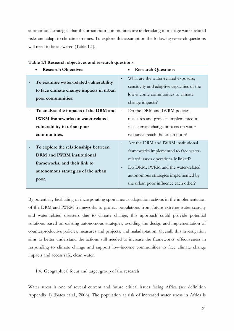
Table 1.1 Research objectives and research questions ......................................................................... 21
Table 3.1 Slum characteristics and indicators of UN-Habitat ............................................................. 64
Table 3.2: New criteria established to identify low-income communities of interest for this
research ......................................................................................................................................................... 65
Table 3.3 Weighting and ranking of Douala’s sub-districts. ................................................................ 66
Table 3.4 Methods selected to answer the research questions ............................................................ 69
Table 3.5 Interviews with institutions and organisations ..................................................................... 76
Table 3.6 Average age of interviewees (aggregated and per community). ........................................ 81
Table 3.7 Gender of interviewees (aggregated and per community) ................................................. 82
Table 3.8 Head of household (aggregated and per community) ......................................................... 84
Table 3.9 Average length of residence in community (aggregated and per community). .............. 84
Table 4.1 Average number of individuals per family (aggregated and per community). .............. 102
Table 4.2 Average number of individuals per house (aggregated and per community). .............. 103
Table 4.3 Education level of individuals interviewed (aggregated and per community) .............. 104
Table 4.4 Average monthly spending per family (aggregated and per community). ..................... 106
Table 4.5 Average number of persons working per household (aggregated and per community)
...................................................................................................................................................................... 106
Table 4.6 Types of employment in the three neighbourhoods ......................................................... 107
9
Table 4.7 Security of land and housing tenure (aggregated and per community) .......................... 108
Table 5.1 Main hazards identified by community members (per community)............................... 117
Table 5.2 Frequency of flooding (aggregated and per community) ................................................. 118
Table 5.3 Main physical consequences of floods (aggregated and per community)...................... 122
Table 5.4 Malaria cases in New-Bell as a percentage of patients seeking medical attention ........ 124
Table 5.5 Water-related diseases affecting families (aggregated and per community) .................. 125
Table 6.1 Water supplies sources (per community) ............................................................................ 151
Table 6.2 Average monthly water spending per family (aggregated and per community). .......... 152
Table 6.3 Institutions working in the communities identified by surveys (aggregated and per
community) ................................................................................................................................................ 156
Table 6.4 Focuses of projects identified by surveys (aggregated and per community) ................. 156
Table 6.5 Details of the focuses of projects in the three communities (aggregated) .................... 156
Table 6.6 Planned adaptation strategies in the three communities .................................................. 160
Table 6.7 Community members’ awareness of water projects, campaigns or measures (aggregated
and per community).................................................................................................................................. 160
Table 7.1 Cross tabulation between households activities and water sources (aggregated) ......... 167
Table 7.2 Water treatment and sources (aggregated). ......................................................................... 170
Table 7.3 Strategies to face water scarcity (aggregated and per community) .................................. 172
Table 7.4 Length of time of water storage per household (aggregated and per community) ...... 174
Table 7.5 Autonomous strategies related to flooding (aggregated and per community). ............. 178
Table 7.6 Main autonomous coping strategies to water-related issues ............................................ 184
Table 7.7 Main autonomous adaptation strategies to water-related issues ..................................... 184
Table 7.8 Autonomous adaptation strategies ....................................................................................... 185
Table 7.9 Linkage between institutional and water-related autonomous strategies....................... 189
Table 8.1 Summary of research findings ............................................................................................... 197
Table A8.1 Water treatment and sources in Nkolmintag. .................................................................. 250
Table A8.2 Water treatment and sources in Tractafric. ...................................................................... 250
Table A8.3 Water treatment and sources in Newtown Airport 5..................................................... 251
10
List of Abbreviations and Acronyms
CCA Climate Change Adaptation
CDE Camerounaise des Eaux
CUD Communauté Urbaine de Douala
Urban Council of Douala
DCP Direction of Civil Protection
DMS Disaster Management System
DRM Disaster Risk Management
Fcfa Central African CFA franc
GWP-Crm Global Water Partnership-Cameroon
IMF International Monetary Fund
INSC National Institute of Statistics of Cameroon
IPCC Intergovernmental Panel on Climate Change
ISDR International Strategy for Disaster Reduction
IWRM Integrated Water Resources Management
JMP Joint Monitoring Programme
LLINs Long-Lasting Impregnated Mosquito Nets
MAETUR Mission d’Aménagement et d’Equipement des Terrains Urbains et
Ruraux
Mission of Equipment Planning and Equipment of Urban and Rural
Lands
MINATD Ministère de l’Administration Territoriale et de la Décentralisation
Ministry of Territorial Administration and Decentralization
MINDUH Ministère de l'Habitat et du Développement Urbain
Ministry of Urban Development and Housing
MINEE Ministère de l'Eau et de l'Energie
Ministry of Water and Energy
MINEP Ministère de l'Environnement et de la Protection de la Nature
Ministry of Environment and Nature Protection
MINIMIDT Ministère de l'Industrie des Mines et du Développement Technologique
Ministry of Industry, Mines and Technological Development
MINRESI Ministère de la Recherche Scientifique et de l'Innovation
Ministry of Scientific Research and Innovation
11
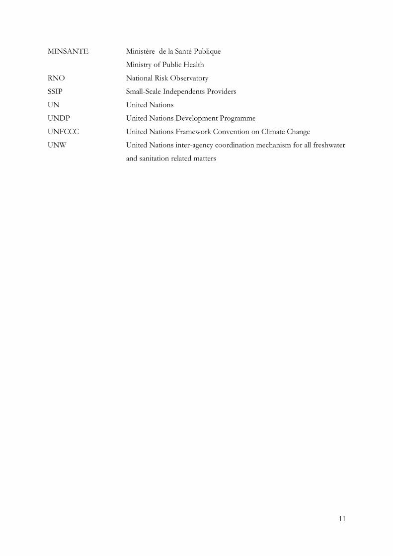
MINSANTE Ministère de la Santé Publique
Ministry of Public Health
RNO National Risk Observatory
SSIP Small-Scale Independents Providers
UN United Nations
UNDP United Nations Development Programme
UNFCCC United Nations Framework Convention on Climate Change
UNW United Nations inter-agency coordination mechanism for all freshwater
and sanitation related matters
12
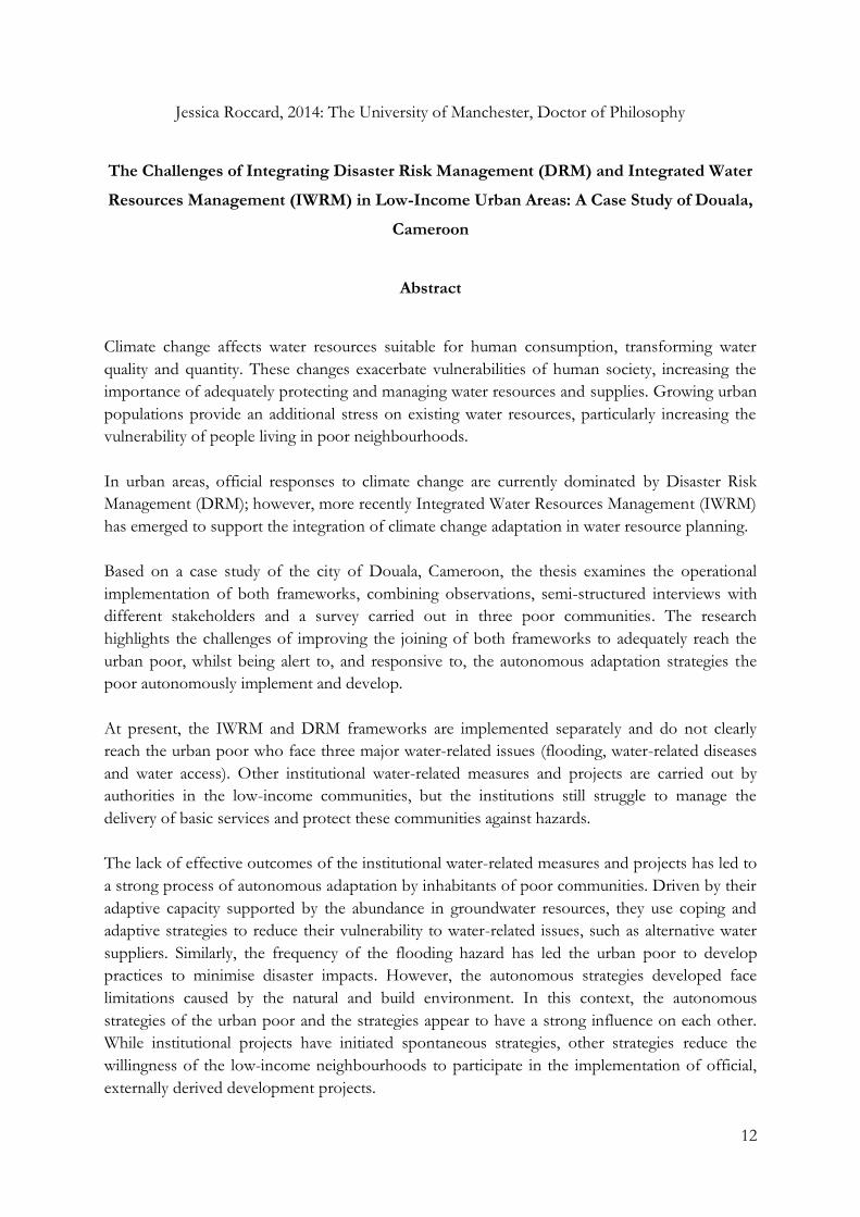
Jessica Roccard, 2014: The University of Manchester, Doctor of Philosophy
The Challenges of Integrating Disaster Risk Management (DRM) and Integrated Water
Resources Management (IWRM) in Low-Income Urban Areas: A Case Study of Douala,
Cameroon
Abstract
Climate change affects water resources suitable for human consumption, transforming water
quality and quantity. These changes exacerbate vulnerabilities of human society, increasing the
importance of adequately protecting and managing water resources and supplies. Growing urban
populations provide an additional stress on existing water resources, particularly increasing the
vulnerability of people living in poor neighbourhoods.
In urban areas, official responses to climate change are currently dominated by Disaster Risk
Management (DRM); however, more recently Integrated Water Resources Management (IWRM)
has emerged to support the integration of climate change adaptation in water resource planning.
Based on a case study of the city of Douala, Cameroon, the thesis examines the operational
implementation of both frameworks, combining observations, semi-structured interviews with
different stakeholders and a survey carried out in three poor communities. The research
highlights the challenges of improving the joining of both frameworks to adequately reach the
urban poor, whilst being alert to, and responsive to, the autonomous adaptation strategies the
poor autonomously implement and develop.
At present, the IWRM and DRM frameworks are implemented separately and do not clearly
reach the urban poor who face three major water-related issues (flooding, water-related diseases
and water access). Other institutional water-related measures and projects are carried out by
authorities in the low-income communities, but the institutions still struggle to manage the
delivery of basic services and protect these communities against hazards.
The lack of effective outcomes of the institutional water-related measures and projects has led to
a strong process of autonomous adaptation by inhabitants of poor communities. Driven by their
adaptive capacity supported by the abundance in groundwater resources, they use coping and
adaptive strategies to reduce their vulnerability to water-related issues, such as alternative water
suppliers. Similarly, the frequency of the flooding hazard has led the urban poor to develop
practices to minimise disaster impacts. However, the autonomous strategies developed face
limitations caused by the natural and build environment. In this context, the autonomous
strategies of the urban poor and the strategies appear to have a strong influence on each other.
While institutional projects have initiated spontaneous strategies, other strategies reduce the
willingness of the low-income neighbourhoods to participate in the implementation of official,
externally derived development projects.
13
Declaration
No portion of the work referred to in this thesis has been submitted in support of an application
for another degree or qualification for another degree or qualification of this or any other
university or other institute of learning.
14
Copyright Statement
I. The author of this thesis (including any appendices and/or schedules to this thesis) owns
certain copyright or related rights in it (the “Copyright”) and s/he has given The
University of Manchester certain rights to use such Copyright, including for
administrative purposes.
II. Copies of this thesis, either in full or in extracts and whether in hard or electronic copy,
may be made only in accordance with the Copyright, Designs and Patents Act 1988 (as
amended) and regulations issued under it or, where appropriate, in accordance with
licensing agreements which the University has from time to time. This page must form
part of any such copies made.
III. The ownership of certain Copyright, patents, designs, trademarks and other intellectual
property (the “Intellectual Property”) and any reproductions of copyright works in the
thesis, for example graphs and tables (“Reproductions”), which may be described in this
thesis, may not be owned by the author and may be owned by third parties. Such
Intellectual Property and Reproductions cannot and must not be made available for use
without the prior written permission of the owner(s) of the relevant Intellectual Property
and/or Reproductions.
IV. Further information on the conditions under which disclosure, publication and
commercialisation of this thesis, the Copyright and any Intellectual Property and/or
Reproductions described in it may take place is available in the University IP Policy (see
http://documents.manchester.ac.uk/DocuInfo.aspx?DocID=487), in any relevant
Thesis restriction declarations deposited in the University Library, The University
Library’s regulations (see http://www.manchester.ac.uk/library/aboutus/regulations)
and in The University’s policy on Presentation of Theses.
15
Acknowledgements
I would like to thank my supervisor, Dr Alfredo Stein, for his support, advice and incredible
patience. I would also like to thank my co-supervisors, Prof Caroline Moser, Dr Ian White and
Prof Graham Haughton. Their guidance throughout the PhD, support and critical advice have
been integral to shaping and refining my ideas, research, and writing.
I would also like to thank my family, Michel and Martine Roccard, for their financial and moral
support, their patience and trust in every project I have undertaken; and my brother, Thibault
Roccard, who had to improvise jokes to cheer me up during the difficult times of this process.
I would like to thank my research assistants Jerry Koua Koua and Leopold Mboa, who
welcomed me in Douala and significantly supported my work. I would like also to thank Ms
Koua Koua, and Mr and Ms Moukouri for their warm welcome, smile, and kindness. Moreover,
I am very grateful to Prof Meeva’a Abomo and his students, Rodrigue, Zoue, Blandine, Jihanne,
Cesaire and Wilfrid for their precious help during fieldwork. I am also grateful to the Pan
African Institute for Development, particularly to Mr Eyambe Ekalle, and the students for their
help in supporting me carrying out surveys in Tractafric. Moreover, I would like to thank the
inhabitants of the communities of Nkolmintag, Newtown Airport 5 and Tractafric and the
institutional actors in Cameroon who received me, shared their thoughts and experiences with
me even amidst their challenging life and work. I hope that even on the smallest-level my work
will contribute to face the ongoing struggle of the city.
I am also grateful to Ligia Yvette Gomez and her team, Tania, Karla, Rolando and Francisco in
Nitlapan in Nicaragua, who showed me how amazing research and social sciences are.
I am also very grateful to my many friends for their support and kindness. I name: Jaime, Esther,
Eleni, Abby, Aurelie, Sarah, Ana Sofia, Claire, Alban, Mathaios, Elina, Gemma, Marcela, Feras,
Anthony, Vianney, Sarah and Adrien. Among those, I would like to particularly thank Alice
Raingeard, who told me off when I complained too much.
Finally, but not least, I would like to thank Dr Jairo Quiros Tortos, who has been sharing my life
during these 4 years. You have been an incredible and amazing support and work example for
this PhD. This is just the start of our life together.
16
To the women’s example of my life, my mother,
Martine Roccard, and grand-mother, Jane Page;
and to my brother, Thibault Roccard, father,
Michel Roccard and my future husband, Jairo
Quiros Tortos, who respect the woman I aim to
be.
17
Chapter 1: Introduction
1.1. Problem definition
Water is crucial for life and ecosystems, and is also fundamental for people’s livelihoods, well-
being and development. However, water resources are currently under serious threat as they have
been heavily exploited by human activities, leading to significant modifications in quality and
quantity. For instance, groundwater levels of many aquifers around the world have decreased
over the last few decades due to extraction exceeding recharge rates (Bates et al., 2008).
Moreover, scientists have established that climate change is affecting surface and groundwater
systems with change in annual run-off (Milly et al., 2005). Freshwater ecosystems have also
shown changes in species composition, organism abundance, productivity and phenological
shifts. The frequency and intensity of floods and droughts have changed, generating further
stress to existing water resources and their impacts are already experienced in many regions of
our planet (Bates et al., 2008).
In this context, urban areas in developing countries are of particular interest because climate
change impacts are predicted to be more severe in nations with limited capacity to cope (IPCC,
2007a). Cities within these nations have proven to be particularly vulnerable to these impacts and
this population growth is predicted to increase during the next decades, increasing demand for
water (Martine, 2007; IPCC, 2007a). Moreover, these urban areas also include concentration of
the people most vulnerable to climate change due to the fragility of their physical, financial,
social and human assets (IPCC, 2007a; Feiden, 2011; Moser and Satterthwaite, 2008). The water-
related vulnerability of these populations lead them to experience a variety of direct and indirect
impacts: direct impacts such as more frequent and more hazardous floods; less direct impacts
such as reduced availability of freshwater supplies that may reduce supplies available to poorer
groups; and indirect impacts such as the increase of water-related diseases (Dodman and
Satterthwaite, 2008).
Worldwide, responses to climate change in urban areas have been dominated by the Disaster
Risk Management (DRM) approach. This approach is being implemented to help vulnerable
communities face natural disasters, aiming to decrease vulnerability by supporting the inclusion
18
of risk assessment, sustainable projects and initiatives implementing preventive, mitigation1 and
preparedness measures (ISDR, 2009).
More recently, the Integrated Water Resources Management (IWRM) framework, which is
presented as a powerful tool for Climate Change Adaptation (CCA) approach, has been
implemented (Cap-Net, 2009). The IWRM framework aims to support the integration of CCA in
water-resource planning (Agnew and Woodhouse, 2010; Wilk and Wittgren, 2009; Slootweg,
2009) by increasing the sustainability of water-resource management (Cap-Net, 2009). It includes
in its approach, technical, economic and environmental aspects in specific social, cultural and
institutional contexts (Agnew and Woodhouse, 2010). The framework also aims to promote a
holistic approach to water and a balance between top-down and bottom-up management,
strengthening community-based organisations, associations of water users and other stakeholders
to enable them to take a greater role in management decisions (Xie, 2006).
Although both DRM and IWRM focus on reducing vulnerability while increasing resilience to
the potential adverse impacts of climate extremes (IPCC, 2012), when it comes to climate change
these approaches were developed and implemented separately (Sperling and Szekely, 2005).
Their divergence include real or perceived differences in knowledge production, time and spatial
scales, and the actors involved, as well as the proposed policy strategies (Biesbroek et al., 2009).
Nevertheless, they share a common set of stakeholders, goals and actions (Kirby and Edgar,
2009), and their joint development would improve their efficiency to face climate change
(Sperling and Szekely, 2005). Likewise, at the institutional level, uncoordinated mainstreaming of
adaptive and mitigation strategies in existing and new sectorial policies accentuate their
differences (Biesbroek et al., 2009), although both approaches to climate change appear to be
interdependent measures (Sperling and Szekely, 2005) and should be implemented in an
integrated way within urban settlements to face climate change impacts (Kirby and Edgar, 2009;
IPCC, 2012).
The difficulties of implementing and linking both DRM and IWRM approaches are exacerbated
by the accumulation of vulnerabilities within low-income communities. Living in settlements
located in physically hazardous environments with little or no protection against extreme weather
events, these settlements are exposed to climate change and their vulnerabilities exacerbate
1 Mitigation defined in the context of this thesis as “the lessening of the potential adverse impacts of physical hazards (including those that are human-induced) through actions that reduce hazard, exposure, and vulnerability” (IPCC, 2012, p. 561).
19
insecure land tenure, the lack of building regulations and the poor quality of housing (Feiden,
2011; Moser and Satterthwaite, 2008). These conditions challenge the successful implementation
of both strategies at community level. The accumulation of vulnerabilities and lack of efficient
responses by national and local government, also leads the urban poor to implement
autonomous strategies to minimize the risks to climate extremes and water scarcity (Budds and
McGranahan, 2003; Conan and Paniagua, 2003; Garcia-Bolivar, 2006).
The involvement of governments in autonomous adaptation strategies is discussed in the
literature. For instance, Malik (2010) argues that considering autonomous adaptation as the
optimal adaptation solution to climate change without any government involvement is unrealistic
because the information and resources that governments manage can play a very important role.
Moreover, the relationship between development and adaptation emphasises the importance of
governments’ actions. While adaptation can contribute to development “with the specific goal of
ensuring survival of livelihoods, lives and cultures during environmental change, and can thereby
be seen to aid progress in development by enhancing resilience to environmental fluctuations”
(Schipper, 2007, p. 7), development can also lead to better adaptation (IPCC, 2007a). Finally, the
literature shows that “insufficient attention is paid to autonomous adaptation and the supportive,
facilitating role of government (as opposed to government itself as the implementer of
adaptation) in the process” (Malik et al., 2010, p. 18).
1.2. Aim of the research
As previously stated, DRM and IWRM strategies focus on reducing vulnerability while increasing
resilience and adapting capacities to the potential adverse impacts of climate extremes (IPCC,
2012). However, the accumulation of vulnerabilities within low-income communities,
underpinned by factors such as inadequate water management, land use changes, unplanned
urban growth, and under-investment in, or even lack of, drainage infrastructure (Feiden, 2011),
challenges the possibility of implementing both strategies in these communities.
In this context, the dual impact of water makes it a suitable instrument to critically understand
the issues involved in DRM and IWRM. Vulnerability increases while water demand grows, and
more assets and lives are affected by flooding, but both can be reduced through enhanced water
resources and water-related hazard management, and improved ability of communities to recover
from extreme events. However, the lack of understanding of what urban poor communities are
20
already doing to minimize risk and increase their adaptive capacity to climate extremes can
hamper the possibility of integrating both strategies at the local level. Therefore, the overall aim
of this research is to explore the autonomous strategies that urban poor communities are
developing in jointly implementing both DRM and IWRM frameworks.
This thesis aims to contribute to two main debates. First, the dichotomy of the DRM and IWRM
as a tool for CCA is addressed as the theoretical relationship between the two approaches needs
further exploration to identify the possible ways of linking both to the autonomous strategies of
the urban poor at a local level (IPCC, 2012). The IPCC (2012, p. 11) argues that “closer
integration of disaster risk management and climate change adaptation, along with the
incorporation of both into local, sub-national, national, and international development policies
and practices, could provide benefits at all scales”. This suggests the potential significance of
linking both approaches. Secondly, the thesis attempts to contribute to the autonomous
adaptation debate (Smit et al., 2000; IPCC, 2001; Malik et al., 2010) with a focus on water access
and water-related disasters. In this context, recent research on the urban poor’s vulnerabilities in
sanitation and water supply argues that “the real service delivery routes that poor people use […]
have not historically been well documented, understood or embedded in policy” (Evans, 2007, p.
13). By identifying the actions taken by the urban poor to face climate change impacts on water,
the thesis explores the relationship between DRM and IWRM policies, projects and measures
and autonomous strategies, and also attempts to address the need for more research into
alternative water supplies (Carmichael et al., 2013).
1.3. Research hypothesis, questions and objectives
This thesis was initially based on the assumption that the DRM framework is not a sufficient
response to climate change regarding water management, and that the joint development of the
IWRM and DRM frameworks would improve the response to climate change impacts on water
resources. However, the reproductive logic used in this thesis enabled an opening to revision,
and accepted theories may be rejected in favour of more convincing alternatives (further
explained in Chapter 3) (Sayer, 2002 cited in McEvoy and Richards, 2006). As a result, the thesis
assumption has been modified, and is finally based on the hypothesis that both formal
institutional responses, such as DRM and IWRM, and local autonomous strategies have a role to
playing reducing water-related vulnerability of the urban poor. The thesis, thus, explores how the
goal of integrating both approaches to increase resilience at the local level is affected by the
21
autonomous strategies that the urban poor communities are undertaking to manage water-related
risks and adapt to climate extremes. To explore this assumption the following research questions
will need to be answered (Table 1.1).
Table 1.1 Research objectives and research questions
Research Objectives Research Questions
- To examine water-related vulnerability
to face climate change impacts in urban
poor communities.
- What are the water-related exposure,
sensitivity and adaptive capacities of the
low-income communities to climate
change impacts?
- To analyse the impacts of the DRM and
IWRM frameworks on water-related
vulnerability in urban poor
communities.
- Do the DRM and IWRM policies,
measures and projects implemented to
face climate change impacts on water
resources reach the urban poor?
- To explore the relationships between
DRM and IWRM institutional
frameworks, and their link to
autonomous strategies of the urban
poor.
- Are the DRM and IWRM institutional
frameworks implemented to face water-
related issues operationally linked?
- Do DRM, IWRM and the water-related
autonomous strategies implemented by
the urban poor influence each other?
By potentially facilitating or incorporating spontaneous adaptation actions in the implementation
of the DRM and IWRM frameworks to protect populations from future extreme water scarcity
and water-related disasters due to climate change, this approach could provide potential
solutions based on existing autonomous strategies, avoiding the design and implementation of
counterproductive policies, measures and projects, and maladaptation. Overall, this investigation
aims to better understand the actions still needed to increase the frameworks’ effectiveness in
responding to climate change and support low-income communities to face climate change
impacts and access safe, clean water.
1.4. Geographical focus and target group of the research
Water stress is one of several current and future critical issues facing Africa (see definition
Appendix 1) (Bates et al., 2008). The population at risk of increased water stress in Africa is
22
estimated to be 75 to 250 million by the 2020s, rising to 350 to 600 million by the 2050s (Arnell,
2004). Water supplies from rivers, lakes and rainfall are already characterised by their unequal
natural geographical distribution and accessibility, and unsustainable water use that is severely
impacting water availability (ibid). Moreover, climate models project a modification in runoff in
eastern Africa and parts of sub-Saharan Africa, the region that contains the highest concentration
of poor people with close to half the population living on less than $1.25 a day (Arnell, 2004;
World Bank, 2013).
Among sub-Saharan countries, the Republic of Cameroon possesses one of the largest quantities
of available water (Xu and Usher, 2006). However, the resource is not uniformly distributed due
to variations in topography, rainfall patterns and climatic changes: the south of the country is
mostly supplied by surface water, while more of the north’s supply is from groundwater coming
from permeable sedimentary rocks (Molua and Lambi, 2006).
Although Cameroon has changed dramatically in recent years and information on trends is very
limited, poverty in Cameroon’s urban areas has significantly increased since the mid-1980s
(World Bank, 2011a). The incidence of urban poverty rose particularly quickly in the country’s
two main cities of Yaoundé and Douala, rising from less than 1% of households classed as below
the official World Bank poverty line in 1983 to more than 25% in 1993 (ibid). These cities have
also witnessed very heavy population growth (Ako Ako et al., 2009), pressures that add to the
current challenges the country faces with regard to climate change impacts on water.
In Cameroon, the city of Douala appeared to be an appropriate case-study to investigate the aim
and objectives of the research. The city is built on swamps on the coast of the Gulf of Guinea.
Made up of five districts, it is the main economical city of the country (INSC, 2010). Douala also
faces severe urban planning problems (Barbier and Granjux, 2009) and its population growth is
estimated to be between 5% and 8% per annum (Asangwe, 2006). The constant expansion of
numerous poor settlements on physically hazardous land adds to the already critical conditions
experienced by many in the city.
More importantly, Douala possesses abundant water resources and the urban water supply
network is said to be satisfactory throughout the city (IMF, 2010). However, the World Bank
(2010) estimated that only 25% of households in Doula had direct connections to the network,
thus revealing a paradoxical situation and showing the need for greater institutional and
23
organisational action to speed up the current rate of individual connections. Finally, the city is
also prone to disasters due to natural and anthropogenic characteristics such as its location and
climate (Tchangang, 2011). Amongst the numerous natural hazards occurring in the city,
flooding takes place regularly and is increasing in frequency and magnitude.
To respond to increasing disaster risks and drinking water stress/scarcity issues as a result of
climate change, the DRM and IWRM frameworks are both currently being implemented in
Cameroon. While the DRM has been implemented to face natural disasters, including mass
movements, earthquakes, volcanoes, gas emissions, drought, violent winds, heat waves, cold
snaps, desertification and floods (Bhavnani et al., 2008), the IWRM has more recently been
introduced in fulfilment of the 1996 laws on environment and water (Ako Ako et al., 2009).
Within the city of Douala, three low-income communities within the Douala II district, also
called New-Bell, were chosen for investigation. The first community, Nkolmintag, is located at
the north of the airport and was developed during the 1950s. The second community, Tractafric,
formed in the 1960s and is located at the northern edge of Nkolmintag. The third community,
Newtown Airport 5, started being settled in 1985. It is located at the peripheral area of Douala
between the airport and one of the main motorways of the city. The method of selecting the
three communities is further explained in Chapter 3 where maps of their locations are also
shown.
1.5. Methodological approach
To test the research hypothesis and answer the research questions, a mixed methods approach
was selected. This methodology combines qualitative and quantitative methods, allowing the
triangulation and complementation of the data (Bryman, 2008). This choice improved the
validity of the outcomes of the research, and allowed the verification and validation of data
collected by different methods (Brannen, 2005; Bryman, 2008). Applied in the case study, the
mixed methods permitted investigation of the concrete implementation and possible impacts of
the DRM and IWRM frameworks, examining their effectiveness in a low-income urban context
and their reciprocal interactions.
Due to their crucial role in defining the conceptual basis of this research, and building on
relevant critical appraisals of previous research, the DRM and IWRM approaches, benefits and

24
criticisms are examined. During fieldwork, theoretical and empirical identification and analysis of
the policies emanating from the DRM and IWRM frameworks and water management policies,
measures and projects from key organisations and institutions were analysed through 34 semi-
structured interviews with institutional and organisational actors. During these interviews,
institutional documents related to those policies, measures and projects were collected. The
methodology also used 15 transect walks in 13 sub-districts and 609 surveys carried out in the
three low-income communities, complemented by direct observations to understand the
characteristics of the communities. These methods aimed at building up the profile of the
communities with regard to water-related issues, and identifying the inhabitants’ autonomous
strategies concerning water access and water-related hazards. The quantitative data collected
from 609 questionnaires allowed understanding the everyday activities and household and
community organisation surrounding water and to identify the impact of the policies, measures
and projects carried out by formal institutions and organisations on the inhabitants’ autonomous
strategies.
Working with institutional and organisational actors, and poor urban communities was a
complex and sensitive process that raised many ethical issues. In order to facilitate different
perspectives on familiar situations, and to enable participants to draw valuable conclusions that
have positive impacts on those involved, the research techniques adhered to the principles of
anonymity and confidentiality. Thus, personal data such as the names and addresses of the
individuals who participated in this study are not disclosed (Miller and Brewer, 2003). The wish
of participants to decline from answering the questionnaire, or parts of it, was respected; and if
participants provided evidence that could be considered possibly damaging to them or to others
if disclosed, it was carefully used in such a way that it could not connect to the source.
1.6. Structure of the thesis
The remainder of this thesis is structured as follows:
Chapter 2 presents a review of the literature in which the research is embedded. The purpose of
this chapter is to explore the different debates in the policy and academic literature to which the
research contributes. The chapter starts by examining the debates on the water-related
vulnerability of the urban poor in cities of the global South and the impact of climate change on
this vulnerability. The chapter also provides a critical examination of the discussion about

25
prevailing current climate change responses, Disaster Risk Management (DRM) and climate
change adaptation (CCA), and especially through the tool used for its implementation: Integrated
Water Resources Management (IWRM). An overview of the debates on the linkages between
these approaches follows. Finally, the chapter discusses the autonomous adaptation strategies
and adaptive capacities of low-income urban communities in confronting water both as a hazard
and as a resource at risk in the context of the debates on climate change, DRM and IWRM.
Chapter 3 presents the methodology used to answer the research questions and test the research
hypothesis: the DRM and IWRM approaches have different interpretations, methods, strategies
and institutional frameworks for addressing the vulnerabilities associated with climate change,
and largely continue to follow independent paths without reciprocally influencing and
strengthening each other. In this context, the autonomous strategies of the urban poor to
manage water-related risks and adapt to climate also have an influence on the implementation of
both frameworks. Thus, several variables are considered: vulnerability, water resources, water-
related hazards, urban poverty, DRM and IWRM. Each of these variables requires a particular
way to understand both theoretically and empirically.
Chapter 4 introduces the key features of the city of Douala. It first provides an overall
description of the climate variables of the Republic of Cameroon and Douala that are
contributing to increased exposure to climate stresses. Next, it examines the vulnerability of
Douala’s water resources and population to the impacts of climate change. The chapter also
focuses on the institutional arrangements that influence the climate change policies, programmes
and measures affecting the city. Finally, it explores the dynamics influencing the three low-
income communities of the city of Douala selected for this research – Nkolmintag, Tractafric
and Newtown Airport 5 – and investigates the urban poor profile in relation to the city.
Chapter 5 identifies and examines the national and local policies, measures and projects related
to DRM implemented to face water-related hazards and disasters. Their effectiveness in dealing
with these challenges is investigated by examining the causes and impacts of the disasters and
hazards that affect these communities. This chapter is divided into five sections. Section 5.1
introduces the way the Disaster Risk Management framework for natural disasters is
implemented in Cameroon. The next section analyses the most common hazards identified by
the inhabitants of the low-income communities. Then follows a discussion of the causes of these
26
most commonly identified hazards. Finally, the chapter examines the institutional arrangements
and actions put in place to cope with water-related hazards.
Chapter 6 focuses on the context and implementation of the Integrated Water Resource
Management framework (IWRM) and the alternative water resources used by the low-income
communities in the city of Douala. Focusing first on the current legal framework in which water
and sanitation management is embedded, it then describes the institutions involved. This section
also provides an analysis of the current implementation of the IWRM framework. The second
section presents how the poor access water, and the costs implied for low-income communities
of Douala, as well as the problems associated with the use of these water resources. Finally, the
last section examines other institutional water-related adaptation strategies, already implemented
or being implemented, in the poor neighbourhoods outside the IWRM framework.
Chapter 7 discusses the implementation of water-related autonomous adaptation strategies in the
three low-income communities of Douala. First, it looks at the way these communities access
drinking water and water for other daily activities. It then describes their strategies for coping
and adapting with flooding, providing an analysis of the benefits and limitations of the
autonomous adaptation strategies. In section 7.2, the difference between coping, adaptive,
reactive and anticipatory approaches is examined, and the effectiveness of the urban poor
strategies is then discussed. Further analysis of the water-related issues faced by the urban poor
demonstrates that the autonomous and planned actions have a strong influence on each other.
The concluding chapter summarises the key findings of the thesis. First, the chapter reviews the
findings in relation to the research objectives. It also describes the dimensions of water-related
vulnerability of urban poor communities to face climate change impacts on water identified in
this research. Then, the impacts of water-related national and local policies, measures and
projects implemented to face climate change on the urban poor communities, the relationships
between DRM and CCA institutional strategies, and the link between autonomous strategies and
institutional strategies are presented. Finally, the chapter examines the possible theoretical and
policy implications of the findings, the limits of the study and indicates future research
opportunities.
27
Chapter 2: Water risk and climate change in low-income urban communities
The purpose of this chapter is to explore the main debates in the policy and academic literature
to which the research contributes. The chapter starts by examining debates on the water-related
vulnerability of the urban poor in the cities of the global South and the impact of climate change
on this vulnerability. The chapter also provides a critical examination of the discussion about
prevailing current climate change responses, Disaster Risk Management (DRM) and climate
change adaptation (CCA), through its tool used for implementation: Integrated Water Resources
Management (IWRM). An overview of the debates on the linkages between these approaches
follows. Finally, the chapter discusses the autonomous adaptation strategies and adaptive
capacities of low-income urban communities in confronting water, both as a hazard and as a
resource at risk, in the context of the debates on climate change, DRM and IWRM.
Climate change impacts on water have become a development and environmental concern. As
climate models and socio-economic information demonstrate, the frequency and intensity of
floods and droughts are modified, generating further stress to existing water resources and their
impacts are already experienced in many regions of our planet (Bates et al., 2008). As a result,
current water stress and/or scarcity experienced by a large proportion of the world’s population
is increasing in many regions (Vörösmarty et al., 2000; Alavian et al., 2009), while the
consequences of increasing flooding and drought will cause a supplementary range of health
impacts and risks (Bates et al., 2008).
In this context, urban areas in developing countries raise a particular interest because “cities by
their very nature concentrate people and their homes, impermeable surfaces, physical capital,
industries and wastes” (Bicknel et al., 2009, p. 19), as well as infrastructure, economic activity and
wealth (Loftus, 2011). In addition, these cities experienced a global rapid growth of the urban
population during the twentieth century, which is predicted to increase on an unprecedented
scale over the next decades (Martine, 2007). They also tend to be home to a significant
proportion of those who are the most vulnerable to the impacts of climate change, i.e.,
households and individuals excluded from accessing formal services and located in urban areas
that are characterised by poor or absent planning, high density or poor quality housing, lack of
tenure and limited access to basic urban services (Evans, 2007; Bates et al., 2008).
28
To face climate change impacts and address water stress, two approaches are being promoted by
the international community: DRM and IWRM. On the one hand, the DRM grew from localised
and specific response measures to include broader preventive measures that aimed to address the
various underlying environmental and socio-economic aspects of vulnerability to disasters
(World Bank, 2011b). On the other hand, the IWRM occurs in a context where, at national and
international levels, private-sector participation was strongly promoted to face vulnerability in the
water and sanitation sector during the 1990s (Allouche and Finger, 2002 cited in McGranahan
and Satterthwaitte, 2006). The view that privatisation is the way forward for water management
in poorer countries has been particularly promoted by the World Bank (Haughton, 2002). As a
result of the different focuses of the IRWM and DRM frameworks, the two strategies have
tended to place emphasis on different aspects and scales of the problem, as well as on particular
populations (Universitas 21, 2011), and, so far, water issues have often tended to be considered
and managed as a risk (in the DRM approach) or as a resource (in the IWRM approach).
However, addressing current water issues has been recognised as a crosscutting theme as water
resources affect a wide range of human and non-human features at different scales (Vörösmarty
et al., 2000).
2.1. Water-related vulnerabilities of the urban poor
In order to understand the water-related disasters and water scarcity issues experienced by the
urban poor, it is necessary to begin by defining the key concepts of vulnerability and adaptive
capacity in the current context of water management approach (see definition in Appendix 1),
and these are presented in the following section.
2.1.1. Defining vulnerability to climate change
A number of traditions and disciplines, from economics and anthropology to psychology and
engineering, use the term vulnerability. It is only in the area of human–environment relationships
that vulnerability has common, though contested, meaning (Adger, 2006), although it is a
concept in which analysis of the risks arising from climate change to low-income urban
households and communities is grounded (Moser and Satterthwaite, 2008).
According to Wamsler (2007, p. 58) vulnerability is the “degree to which systems are susceptible
to loss, damage, suffering and death in the event of a ‘natural’ hazard/disaster”, while the IPCC
29
(2007a, p. 883) defined vulnerability as “the degree to which a system is susceptible to, and
unable to cope with, adverse effects of climate change, including climate variability and extremes.
Vulnerability is a function of the character, magnitude, and rate of climate change and variation
to which a system is exposed, its sensitivity, and its adaptive capacity”. In both definitions,
perturbations or external stresses are stated; however, the IPCC (2007a) defines components of
vulnerability. In a context of policies, measures and programmes implemented in international,
national and local communities, these features allow a more concrete understanding of the
degree to which a system is more likely to be impacted by climate change to formulate and
design responses to climate change. More recently, the IPCC (2012, p. 564) defines vulnerability
in the context of climate change as “the propensity or predisposition to be adversely affected”,
where the negative impact of climate change is emphasised similarly to the previous definition.
Nonetheless, it also introduces the pre-existing inclination or the tendency of “the vulnerable” to
suffer from a particular condition, hold a particular attitude, or act in a particular way.
Research has also highlighted generic features of vulnerability. These are the resources available
to cope with exposure, the distribution of these resources (both social and natural) across the
system, and the institutions that mediate resource use and coping strategies (Adger, 2006). Where
institutions fail to plan for hazards or for changing social conditions and risks (see definition in
Appendix 1), system vulnerability can be exacerbated. Therefore, a comprehensive definition of
vulnerability needs also to account for a range of risks, thresholds and institutional responses and
resources, given that vulnerability will manifest itself differently at different scales (ibid).
The diversity of these factors is encountered in the definition of vulnerability by Moser and
Satterhwaite (2008). They argue that it represents “multidimensional aspects of changing
socioeconomic wellbeing" (Moser and Satterthwaite, 2008, p. 6), including environmental and
social factors, and determined by physical, social, economic, environmental, organisational and
institutional factors that are the result of human conduct (Wamsler, 2007; Jabeen, 2012). As a
result, vulnerability is understood in this research as multidimensional aspects of changing
socioeconomic wellbeing in which a system is susceptible to, and unable to cope with, adverse
effects of climate change, depending on its adaptive capacity in specific institutional and natural
condition and setting. The different aspects of vulnerability are defined by criteria such as the
exposure, sensitivity, and adaptive capacity, measurable by factors of physical hazards, social
relations, and individuals.
30
Among the three parameters defining vulnerability, exposure is defined as “people, property,
systems, or other elements present in hazard zones that are thereby subject to potential losses”
(ISDR, 2009, p. 15). It is the nature and degree to which a system experiences environmental or
socio-political stress (Adger, 2006, p. 270). The second parameter, sensitivity, is the degree to
which a system is affected, either adversely or beneficially, by climate-related stimuli. The effect
may be direct (e.g., a change in crop yield in response to a change in the mean, range, or
variability of temperature) or indirect (e.g., damages caused by an increase in the frequency of
coastal flooding due to sea-level rise) (IPCC, 2007a). These definitions, although they might also
be debated, will be used as such in this thesis.
The last characteristic, adaptive capacity in relation to climate change impacts, is defined by the
Intergovernmental Panel on Climate Change (IPCC) (2007a, p. 869) as “the ability of a system to
adjust to climate change (including climate variability and extremes) to moderate potential
damages, to take advantage of opportunities, or to cope with the consequences”. Thus, practical
initiatives that adequately address and improve societal adaptive capacity can help reduce
vulnerability (Kelly and Adger, 2000; Smit and Wandel, 2006). However, adaptive capacity is also
defined by Brooks and Adger (2005, p. 248) as: “the property of a system to adjust its
characteristics or behaviour, in order to expand its coping range under existing climate variability,
or future climate conditions”. Adaptive capacity thus refers to the actions that may be taken to
reduce vulnerability to climate hazards that can lead to adaptation, improve a system’s coping
capacity, and increase its coping range (ibid).
In an urban context, adaptive capacity has also been defined as “the inherent capacity of a
system (e.g. a city government), population (e.g. low-income community in a city) or
individual/household to undertake actions that can help avoid loss and speed recovery from any
impact of climate change” (Satterthwaite et al., 2007, p. 5). Accordingly, adaptive capacity is
characterised as a condition for individuals and communities to organise and modify their
behaviour and practices to transform climate change impacts into opportunities to improve their
wellbeing and/or economic power. Therefore, drawing on the different definitions, adaptive
capacity is understood as the intrinsic capacity of a system expressed through actions based on a
set of national or local resources and knowledge. Adaptive capacity decreases the vulnerability of
the system by reducing both the likelihood and the magnitude of harmful outcomes resulting
from climate change. It allows a system to adapt to, cope with, recover or develop from any
impact of climate change.
31
2.1.2. Factors of water-related vulnerability of the urban poor
Several dimensions of the urban poor’s water access vulnerability have been identified by Mason
(2009), who emphasises the responsibility of a lack of financial resources. He argues that water
utilities face the unwillingness of the well-off to pay, leading to reliance on subsidies from
government and few funds for extending coverage and finally worsening levels of service for
existing users, thereby decreasing the unwillingness of the non-poor to pay still more. This first
cycle intensifies the reliance of the urban poor on expensive alternative providers. This then
generates higher water costs, leading to reduced productivity and continuing poverty. As a result,
the poor cannot afford the fees for connection to the network, increasing reliance on expensive
alternative providers and creating a second cycle.
However, this approach ignores the problems the water utilities have in reaching poor urban
areas, often leading to additional financial burdens for the utilities investing in these
neighbourhoods (Evans, 2007). Moreover, this model considers water utilities to be fully
working utilities, which is not always the case. Indeed, Evans (2007) argues that, in addition to
the often poor data access and quality of services, these populations may live far from trunk
infrastructure, making the unit costs of both wholesale and retail services unattractive to the
utility/city service provider, or in areas which are technically difficult to serve, often prone to
flooding or on steep hillsides. She also states that these populations may experience constraints
on self-provisioning in the absence of trunk infrastructure, and often face legal barriers to access
tenure, failure or inability to meet building regulation requirements, and/or reside in areas which
are targeted to be used for purposes other than residential. They may also be priced out of
accessing formal services, usually due to high and unclear connection fees and excessively
bureaucratic processes for gaining an official connection (ibid).
In both approaches, it can be noted that the reliance of the urban poor on alternative providers
is not only caused by their inability to afford connection fees but by their reluctance to subscribe
to the formal network owing to its deficiencies, contradicting the traditional views of the poor
only not being able to pay. Moreover, both approaches also attribute the reduction of
productivity and continuing poverty to the theoretical greater cost of water, although it has also
been shown that the alternative water providers are sources of employment for members of the
poor community, and may often provide a greater quantity of water than the formal network
(McGranahan and Satterthwaitte, 2006).
32
To overcome these vulnerabilities, at national and international level, private-sector participation
was strongly promoted to face vulnerability in the water and sanitation sector during the 1990s
(Allouche and Finger, 2002 cited in McGranahan and Satterthwaitte, 2006). Indeed, a general
agreement that public utilities have been too slow in extending access to services, and that they
can be inefficient and corrupt, led to the promotion of private-sector involvement to address
these problems (Budds and McGranahan, 2003). Based on a broad economic critique of public-
sector enterprises, this collaboration would have actually benefited populations living in poverty
(McGranahan and Satterthwaitte, 2006).
Although “this opening-up of water systems to private involvement is not a uniform process:
rather these pressures have been interpreted in different ways in different countries, each
developing its own model for the regulation and management of water services” (Haughton,
2002, p. 798), debates about the public-private partnership in the water and sanitation sector
moved from whether the role of the private sector should be expanded or suppressed to focus
on what changing the share of the urban water and sanitation market supplied by private
operators means in practice (McGranahan and Satterthwaitte, 2006). Nevertheless, controversies
over private-sector involvement has focused attention on the large piped-water networks,
although a large part of those without adequate water and sanitation will probably be unable to
access these infrastructures for the foreseeable future (ibid). Progress in achieving the
internationally-agreed on targets on water and sanitation could be furthered through more
understanding of how private enterprises active in the sector can be made to become more
responsive to the needs of households (ibid).
Sanitation policies and strategies for the urban poor rarely analyse the diverse heterogeneity of
the urban poor: “who they are; where and how they live – as illegal, quasi-legal or, in rarer
instances, as legal residents of the city; and what they perceive, need and mostly lack as sanitation”
(Joshi et al., 2011, p. 91). Hence, although the private sector in water provision has been
recognised not only to refer to multinational companies but also encompasses local domestic
companies, small scale vendors, user associations and community-based organizations, the gap
between sanitation targets and the wider social, cultural and political conditions and settings
create lags. “In the absence of inclusive urban policies, the proposed approach to “promoting a
demand for toilets” grossly simplifies the complex social–environmental issue that makes for
appropriate sanitation” (Joshi et al., 2011, p. 109). As a result, effective private sector
participation can only succeed in serving the poor if the necessary regulatory capacity and a pro-
33
poor governance framework is in place, taking into account the heterogeneity of the urban poor
communities. Therefore, the importance of a bottom-up vulnerability approach for an adequate
implementation of sanitation systems is emphasised.
Regarding the vulnerability of the low-income communities to water-related disasters, most often
identified as vulnerability to flooding, it is most often described in the literature through physical,
environmental and financial vulnerability factors. Indeed, in cities of the global South, growing
urbanisation is subject to little control or rational planning (Evans, 2007), resulting in the
creation of settlements, frequently located at the periphery of the city or in risk areas such as
coasts, steep slopes and floodplains. Thus low-income communities develop on dangerous sites
because housing on safer sites is too expensive for them, they lack risk-reducing infrastructure
such as functioning storm drains and are more exposed to the impact of climate (Satterthwaite,
2013). Moreover, slum areas are associated by definition with a high number of substandard
housing structures, often built with non-permanent materials unsuitable for housing given local
conditions of climate and location (ibid). Thus, houses in these settlements are also often poorly
built, and more liable to collapse when hit by storms or floods (ibid). It is also very uncommon
for people living in these neighbourhoods to have insurance for their homes, health or
possessions, and no business will insure someone who faces very high risks and has very limited
capacities to pay (ibid).
Few (2003) claims that the capacity to cope with flooding is increasingly seen as a key
component of a household’s or community’s level of vulnerability and the literature on hazards
and disasters has increasingly paid attention to such attributes. Hence, households and
communities bring differential resources to face this environmental hazard. In their framework
for analysing vulnerability and capacities, Anderson and Woodrow (1998) identify three factors:
physical and material resources; social and organisational structures; and motivational and
attitudinal factors. Morrow (1999) sees the risk as socially constructed. Therefore, starting with
economic and material resources, the argument is extended to include human and social asset.
The same year, Adger (1999) emphasised access to and rights to resources. Lastly, Pelling (1999)
employs similar thinking of rights to resources and the consequent ‘ownership’ of assets,
analysing the processes that create vulnerability to flooding in an approach that includes the
understanding of power and social relations.
34
To face these issues, the Disaster Risk Management (DRM) framework was developed and
implemented to avoid, lessen or transfer the adverse effects of hazards through activities and
measures for prevention, mitigation 2 and preparedness (ISDR, 2009) and will be further
explained in 2.2.1. In the literature on Disaster Risk, the terms Disaster Risk Management and
Disaster Risk Reduction (DRR) are often used to indicate similar actions, processes or
frameworks, and “considerable confusion remains as to the exact difference between these terms”
(Mork, 2009, p. 8). Nevertheless, definitions of the two approaches show differences. While
DRM describes a process, DRR defines actions. “In other words, a DRM programme will focus
on research, preparation and planning for DRR interventions, while a DRR organisation will
actively intervene and create projects to reduce disaster risk” (ibid, p 8). As this research
investigates the impacts of disaster approaches on water-related vulnerability in urban poor
communities, as well as the components of this vulnerability, it seemed necessary to understand
how these concepts were translated into a disaster risk approach, and how the approach was
designed and translated into an institutional framework. Therefore, this thesis uses the term
Disaster Risk Management.
2.1.3. Climate change impacts on water-related vulnerabilities of the urban poor
Parallel to the existing water-related vulnerabilities of the urban poor, evidence is mounting that
climate change is occurring and that it is further altering the water cycle (see definition in
Appendix 1) (Alavian et al., 2009). When simulated by climate models, these modifications
indicate an acceleration and intensification of the hydrological cycle, shown by an increase in
precipitation and evaporation, albeit with considerable spatial and temporal variations (UNDP,
2006). More specifically, scientists have established that it affects runoff and river discharge,
groundwater, water quality and floods and drought (IPCC, 2007a; Bates et al., 2008; Alavian et al.,
2009).
In the large cities of low latitude countries, it is common for much of the low-income population
to live in areas at risk from flooding (Hardoy et al., 2001), which is most likely to also be affected
by climate change impacts (IPCC, 2007a). In this context, flooding caused by rainwater and
environmental conditions is aggravated by anthropogenic factors that have shifted the definition
of flooding events from a natural hazard to a socio-natural hazard (see definition in Appendix 1),
2 Mitigation defined in this context is as “the lessening or limitations of the adverse impacts of hazards and related disasters” (ISDR, 2009, p. 19).
35
of which their consequences will intensify in a context of climate change. Hence, although
climate change is driven largely by modernisation and development, all human activities
contribute to environmental change (Douglas et al., 2008). Flooding in urban areas is not just
related to heavy rainfall and extreme climatic events; it is also the consequences of modifications
in the built-up areas themselves. Urbanisation prevents the full discharge of rainwater by
covering large parts of the ground with roofs, roads and pavements, and obstructing natural
channels and by building drains (ibid).
The stress caused by climate change on the global water system also imposes an overall stress on
water and can lead to poorer water quality and quantity (Bates et al., 2008), which will be added
to already existing considerable pressures on water resources. Further threatening water
availability, it will make water security even more difficult and costly to achieve. It may also
reintroduce water security challenges (see definitions in Appendix 1) in countries that have had
reliable water supplies for a century (Bates et al., 2008).
In this context, the multi-dimensional vulnerability of the urban poor is exacerbated. Feiden
(2011) identifies three aspects to the vulnerability of the low-income communities to climate
change impacts. The first aspect of vulnerability is due to ineffective or non-existent planning,
and underinvestment in water and sanitation infrastructure. As many low-income settlements in
coastal cities are in low-lying areas or on steep slopes, as seen in the previous section, the areas
are more subject to the effects of increased storm activity in the immediate term. In the longer
term, these areas will be more affected by sea level rise, storm events and a decrease in quality of
water resources with the anticipated rise in extreme weather. Moreover, as spontaneous
settlements often lack appropriate infrastructure, during flooding, mobility is reduced, shelter is
put at greater risk and, during both flooding and water scarcity, public health impacts are
amplified. The second aspect of vulnerability is similar to the existing vulnerability presented in
section 2.1.2. It is based on low quality housing with poor disaster resistance. Indeed, much low-
income housing is of poor quality, resulting from inappropriate design, materials, and
construction methods to face increasing exposure to extreme weather and flooding. Finally, the
third aspect of vulnerability is based on low-income and insufficient financial and legal resource.
Ideally, the growing threat from climate change should decrease the cost of vulnerable housing
and increase the construction of more appropriate affordable housing in safer areas but it is
often not the case.
36
In his approach, Feiden (2011) also argues that low-income residents often have sparse
information on climate change impacts and that poor urban residents usually lack the resources
to effectively respond in a crisis, creating greater dependency on the poorly funded public and
non-profit sectors. Nevertheless, the necessity of some of these infrastructure elements, such as
roads, drainage, water, and sewerage, encouraged the creation of alternative strategies as different
studies show (McGranahan and Satterthwaitte, 2006; Jabeen, 2012). Moreover, others have
shown that a strong awareness exists of the already occurring changes in weather. From their
research carried out in Estelí and Mombasa, Moser et al. (2010a, p. 55) state: “people in local
communities — despite their urban location — know about weather, perceive variations in
weather patterns and have reasonable knowledge as to how it is affects assets and well-being (at
the household, community and business levels)”. Hence, even if not directly expressed as
“climate change impacts”, low-income communities’ members perceive the incremental changes
and take action to face those changes: “small business and community groups were resourceful
at developing a range of resilience measures” (Moser et al., 2010a, p. 17). Hence, while Feiden
(2011) approached the sensitivity and exposure of the urban poor, their adaptive capacity plays a
strong role in their vulnerability associated with climate change. This shows that more attention
must be paid to the strategies implemented in these areas.
2.2. International and national responses to climate change in urban areas
2.2.1. Prevailing response: Disaster Risk Management (DRM)
Typical responses to climate change in urban areas have been dominated by Disaster Risk
Management (DRM), which originated in humanitarian relief efforts and the accumulated
experiences of exposure to disasters (see definition in Appendix 1), and has increasingly
incorporated scientific advances (Sperling and Szekely, 2005). As seen previously, it grew from
localised and specific response measures to include broader preventive measures that aimed to
address the various underlying environmental and socio-economic aspects of vulnerability
(World Bank, 2011b). DRM involves many actors and stakeholders, such as public authorities,
research bodies and businesses, non-governmental organisations and the wider general public
(UNISDR, 2004; Wamsler, 2007).
The definitions of DRM illustrate how it has developed through the gradual integration of many
new parameters with the realisation that disasters are generated not only by the hazards
37
themselves, but are also influenced by many underlying factor, and where anthropogenic
activities, cultures, values and beliefs all play a crucial role in the mitigation of those disasters. In
2011, DRM was defined by the World Bank (2011b) as a “process aiming to decrease
vulnerability by supporting the inclusion of risk analysis, sustainable projects and initiatives
implementing prevention and mitigation measures”. However, in their approach, Garatwa and
Bollin (2002) emphasise the concepts of disaster and mitigation with little consideration of the
various underlying environmental and socio-economic aspects of vulnerability. More recently,
the IPCC (2012, p. 34) defined DRM as
the processes for designing, implementing, and evaluating strategies, policies, and measures
to improve the understanding of disaster risk, foster disaster risk reduction and transfer,
and promote continuous improvement in disaster preparedness, response, and recovery
practices, with the explicit purpose of increasing human security, well-being, quality of life,
and sustainable development.
Hence DRM, which initially appeared to focus on disasters associated with extreme events, has
been recognised to also incorporate the concept of anticipated interventions in the overall and
diverse patterns, scales, and levels of interaction of hazard (see definition in Appendix 1) and
vulnerability (IPCC, 2012).
DRM strategies for confronting water-related impacts of climate change have emerged around
mitigation measures (Agnew and Woodhouse, 2010). Indeed, the DRM framework has tended to
focus on the mitigation of the hazards themselves (ibid), and on the increase in magnitude and
frequency of short-term extreme weather, as short-term extreme weather has become an
international perception of climate change of global importance (Moser et al., 2010b). As a result,
DRM responses mainly concentrate on disaster relief rather than on building resilience (Moser et
al., 2010a), and on the human settlements’ physical vulnerabilities (Sperling and Szekely, 2005).
Embedded in a top-down disaster resilience process during or post extreme climatic events in
numerous urban areas of low-income countries, the framework mostly addresses related
scientific and structural aspects and solutions, considering water as a luxury and not as a resource
that must be adequately managed (Sperling and Szekely, 2005). Indeed, numerous authors claim
that, as a response to the impacts of climate change, DRM does not appropriately address water-
resource analysis, management and policy formulation (UNDP, 2006). For instance, recent
38
works have come to associate disasters with lesser-scale physical phenomena (IPCC, 2012). This
approach implies addressing the underlying social, economic and environmental vulnerabilities to
reduce the probability of a disaster occurring (Sperling and Szekely, 2005) and would compel the
involvement of all actors, including bottom-up businesses. However, a slow-developing
phenomenon engenders less local concern in many places (Feiden, 2011). Indeed, considering
climate change as an invidious and sometimes imperceptibly slow incremental change in long-
term trends of increasing extreme weather frequency, also including its indirect consequences, is
more challenging (Moser et al., 2010a). Hence the recent shift towards lesser-scale physical
phenomena, associated with concepts such as exposure, vulnerability and adaptive capacity,
shows that supporting water security involves the sustainable use and protection of water
resources and protection against water-related hazards (floods and droughts) (Schultz and
Uhlenbrook, 2007). Therefore, to fully understand the vulnerability of water resources to climate
change and to develop a successful water management strategy, it is essential to take into account
numerous interactions between climate change and climate variability, land surface and
groundwater hydrology (see definition in Appendix 1), water engineering and human systems,
including societal adaptations that DRM does not fully consider (Vörösmarty et al., 2000).
2.2.2. Alternative response: Climate Change Adaptation (CCA)
As seen in the previous section, understanding adaptation beyond the common DRM approach
is crucial. In this context, the climate change adaptation (CCA) approach, which prioritises the
building of long-term resilience over planning for dramatic climate shocks (Van Aalst et al.,
2006), has been developed. This approach is argued to significantly improve the capacity of
communities, governments or regions to deal with current climate vulnerabilities and with future
climatic changes (Sperling and Szekely, 2005).
CCA is defined by the IPCC (2007b, p. 76) as the set of “initiatives and measures to reduce the
vulnerability of natural and human systems against actual or expected climate change effects”.
However, the focus on the reduction of climate change vulnerability is later redefined by the
IPCC (2007a) who introduce the notions of benefit and opportunities in its definition. These
latter concepts also appear in the CCA definition of the United Nations Development
Programme (UNDP), described as: “a process by which strategies to moderate, cope with and
take advantage of the consequences of climatic events are enhanced, developed and implemented”
(Lim, B. and al. , 2005 cited in Levina and Tirpak, 2006, p. 7). The actions carried out to face
39
climate extremes are argued to be going beyond the “survival” strategy and to improve people’s
well-being or/and economic power. More recently, the IPCC (2012, p. 556) includes the term
“expected” about climate and its effects which stresses the importance of the prediction of
climate change impacts. In spite of these differences in the definitions, Smit et al. (2000) suggest
that there is general agreement in the interpretations of adaptation which includes adjustments in
a system in response to actual or expected climatic stimuli. The differences are mainly
encountered when the definitions connect adaptation to who or what to adapt, and how the
phenomenon occurs (Ayers, 2010). Thus, while there is a seemingly broad consensus that
adaptation to climate change should reduce vulnerability to climate change risks, assumptions
around “adaptation to what?” differ widely and depend on “how vulnerability” is understood
(ibid).
Amongst the different features to adapt to climate change, the water is sector critical. Currently
planned adaptation initiatives concerning water are often not undertaken as stand-alone
measures but are embedded in broader sectoral initiatives, such as water-resource planning,
coastal defence and disaster management planning (Kristensen et al., 2009). In this context, while
addressing these issues in the urban poor areas, the CCA strategies have mainly focused on
vulnerability by analysing the role that adaptation plays in enhancing people’s capacity to
anticipate, cope with and recover from the impacts of climate change (FAO, 2007) along with
major investment for the successful introduction of adaptation measure into water management
strategies (Kristensen et al., 2009).
The IPCC (2008, p. 61) claim “adaptation to changes in water availability and quality will have to
be made, not only by water management agencies but also by individual users of the water
environment”. Hence, water management in CCA involves actors at many different levels, from
industry and agriculture down to households and individuals. Nevertheless, this approach is still
unable to demonstrate how water management can be adapted at the bottom level in these
particular urban areas (Moser and Satterthwaite, 2008). This argument is supported by
Kristensen et al. (2009), who state that, in fact, adaptation does not necessarily require the
development of new measures or technologies but can consist of the appropriate application of
existing instruments, taking into account the right parameters and characteristics. Hence more
investigation at a grassroots level is necessary to further understand how adaptation should be
operationalised without the need for major funding, as well as the ways organisations and
individuals will be able to adapt to the impacts of climate change.
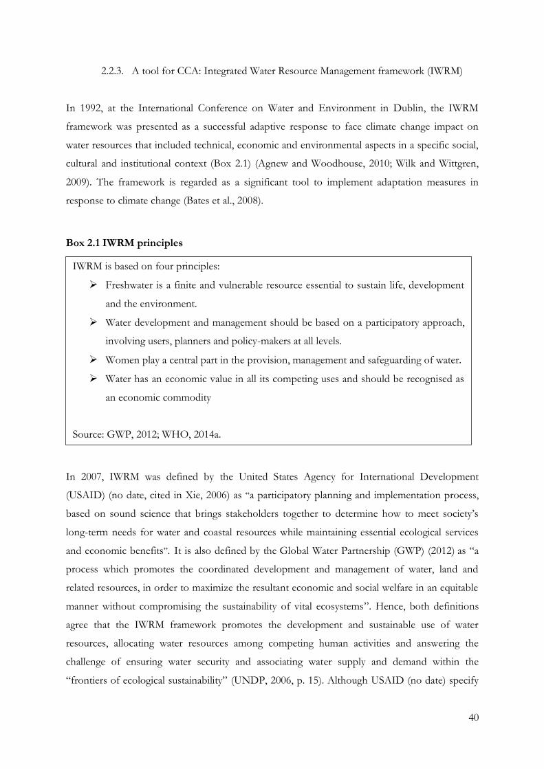
40
2.2.3. A tool for CCA: Integrated Water Resource Management framework (IWRM)
In 1992, at the International Conference on Water and Environment in Dublin, the IWRM
framework was presented as a successful adaptive response to face climate change impact on
water resources that included technical, economic and environmental aspects in a specific social,
cultural and institutional context (Box 2.1) (Agnew and Woodhouse, 2010; Wilk and Wittgren,
2009). The framework is regarded as a significant tool to implement adaptation measures in
response to climate change (Bates et al., 2008).
Box 2.1 IWRM principles
In 2007, IWRM was defined by the United States Agency for International Development
(USAID) (no date, cited in Xie, 2006) as “a participatory planning and implementation process,
based on sound science that brings stakeholders together to determine how to meet society’s
long-term needs for water and coastal resources while maintaining essential ecological services
and economic benefits”. It is also defined by the Global Water Partnership (GWP) (2012) as “a
process which promotes the coordinated development and management of water, land and
related resources, in order to maximize the resultant economic and social welfare in an equitable
manner without compromising the sustainability of vital ecosystems”. Hence, both definitions
agree that the IWRM framework promotes the development and sustainable use of water
resources, allocating water resources among competing human activities and answering the
challenge of ensuring water security and associating water supply and demand within the
“frontiers of ecological sustainability” (UNDP, 2006, p. 15). Although USAID (no date) specify
IWRM is based on four principles:
Freshwater is a finite and vulnerable resource essential to sustain life, development
and the environment.
Water development and management should be based on a participatory approach,
involving users, planners and policy-makers at all levels.
Women play a central part in the provision, management and safeguarding of water.
Water has an economic value in all its competing uses and should be recognised as
an economic commodity
Source: GWP, 2012; WHO, 2014a.
41
a participatory planning and implementation process, both definitions involve complex situations
of decision-making and cautious planning and analysis to support such decisions (Slootweg,
2009).
Despite IWRM being introduced as a crucial strategy in supporting the integration of the climate
change adaptation approach to water resources by planning coordinated and targeted measures
(Slootweg, 2009), critiques of the IWRM approach have emerged, focusing primarily on the
usefulness of a generic management approach to water resource management, the complexity of
the proposed approach and the feasibility of its implementation, and whether the models being
implemented reflect the original concept (Muller, 2010). Nevertheless, even before addressing
the implementation of the IWRM, the first question is: integrated to what? Funke et al. (2007, p.
1238) answer: “the integration of both natural and human systems amongst themselves and with
each other, in a way that allows a balance to be attained between resource use and resource
protection”. In a context where water and sanitation already face serious backlogs in urban poor
communities, the balance between resource use and resource protection will, therefore, have to
overcome the many barriers mentioned in 2.1.2. This, combined with the claims that IWRM is
hard to implement (Muller, 2009), and lacks a of criteria for assessment (Biswas, 2008), create
serious uncertainty in the feasibility of its implementation in urban poor areas.
Many have also commented that the framework has a narrow perspective. Merrey et al. (2005)
argue that IWRM does not emphasise livelihoods of people, nor approaches ‘natural resources’
as a holistic system. These two aspects render “IWRM counter-productive as an analytical
framework from the perspective of poor people” (ibid, p. 2). Nonetheless, there is no coherent
analysis of the relationship between poverty and water access and use, and an analysis based on
an IWRM framework can allow equity considerations to be given a higher level of attention than
has usually been the case.
The IWRM allow considerations to go beyond drinking water and sanitation service
provision. Issues relating to the degradation of soils, forests, biodiversity, and water
quantity and quality have been analysed in relation to environmental costs and protection
measures, but the interactions between these phenomena and livelihood systems based
primarily on the natural environment have been insufficiently noticed (GWP, 2003, p. 13).
42
Although Lautze et al. (2011) argue that incorporating water governance within the IWRM
paradigm might also dilute the conceptual clarity of water governance, undermining its value,
confusing practitioners and closing development options, it can also be included in broader
initiatives concerned with poverty alleviation. Indeed, the IWRM framework also allows the
formulation of specific strategies which would allow addressing the issues of at-risk and
vulnerable groups, especially those living in marginal, drought- or flood-prone environments,
and those already suffering from exclusion, such as indigenous groups and those in dwelling
settlements (GWP, 2003).
In spite of these challenges, Funke et al. (2007, p. 1238) also argue that “it seems unfair to label
the process as ‘‘unrealisable’’, since this implicitly advocates a return to the situation where the
different water-related sectors work independently of each other”. Indeed, the lack of effective
integration has had negative impact on previous water resource management practices, which
actually encouraged the adoption of the IWRM as an alternative. Furthermore, since water
poverty (see definition in Appendix 1) is generally an important component of poverty, and the
lack of access to water resources and adequate services is integral to the disadvantaged situation
of the vast majority of the poor, a concerted effort should be made to promote a paradigm shift
in thinking about poverty (ibid). If the parameters of the role of water in poverty were extended
beyond drinking water supplies and sanitation, the case for IWRM as part of poverty reduction
would become self-evident (ibid).
2.2.4. Linking DRM and CCA trough IWRM
As seen previously, the reality of global warming was first primarily perceived as an
environmental problem. Later, political and mass media attention shifted from discussing the
reality of climate change to its impacts and the measures needed to mitigate or adapt to them
(Grundmann, 2007). This modification of the way climate change is perceived increased in
importance within the political agendas (Biesbroek et al., 2009), and mitigative strategies have
resulted in various measures, methods and approaches beyond the single measure of the
reduction of the emission of greenhouse gases towards mitigating the long-term impacts of
climate change (Yohe, 2006). The DRM framework was, thus, remodelled and the production of
knowledge on climate change shifted away from a strategy with emphasis on the natural sciences
towards a trans-disciplinary research strategy involving natural and social scientists, policy-
43
makers, and society to support political decisions in the context of sustainable development
(ibid).
Similarly, the more recent adaptation strategies have been recognised as trans-disciplinary
because of the diversity of actors involved in adaptation processes at varying scales (Biesbroek et
al., 2009). These strategies are also recognised to be positioned in a broader context of socio-
economic processes which require carefully designed policy strategies in regard to their context
of application, the integration of adaptive strategies with other climate-sensitive policy domains
and coordination with non-climatic drivers for sustainable development (ibid).
Drawing from the evolution of the emphasis within DRM and CCA more recent approaches, a
close relationship between both approaches was recognised. A multi-disciplinary approach to
climate change impact on water is established (Few et al., 2006) and a stronger acknowledgment
of climate change concerns in DRM is promoted (ISDR, 2007). Indeed, both DRM and CCA
attempt to understand and mitigate anthropogenic risk created by physical and biological systems,
and both seek appropriate allocations of risk reduction, risk transfer, and disaster management
efforts by focusing on reducing exposure and vulnerability while increasing resilience to the
potential adverse impacts of climate extremes (IPCC, 2012). The resulting frameworks also share
a common set of stakeholders, goals and actions (Kirby and Edgar, 2009), and their features
often overlap, providing important insights into the state of the knowledge base and its gaps,
creating interfaces that complement each other (IPCC, 2012). In theory at least, the
complementary strategies used by adaptation and disaster risk management can support
mitigation of the risks of climate extremes and disasters, of which reinforcement helps increase
resilience to future changing risks (ibid).
Moreover, water also requires consideration of many parameters to be understood and managed.
It must include the numerous interactions between climate change and variability, land surface
and groundwater hydrology, water engineering and human systems, including societal
adaptations. Hence, the efficacy of both approaches to reduce, transfer and respond to current
levels of disaster and water risk could be vastly increased by exploiting the potential synergies
between the DRM and CCA literatures (IPCC, 2012).
However, DRM and CCA were developed and implemented as separate approaches (Sperling
and Szekely, 2005) and differences, including real or perceived dissimilarities in knowledge
44
production, time and spatial scales, and the actors involved, have appeared. Furthermore, the
proposed policy strategies (Biesbroek et al., 2009) use different viewpoints, vocabularies,
approaches, and goals for different communities (IPCC, 2012). Indeed, mitigation strategies have
been formulated using information from a limited number of mainly technological and economic
scientific disciplines, and embedded in sectoral policy domains (Biesbroek et al., 2009).
Subsequently, for instance, DRM and CCA do not show signs of convergence when considering
the traditional focus on vulnerability and physical exposure or community-based processes.
Besides the fact that there are differences of how mitigation and adaptation approaches are
produced and used, their differences are strengthened while being framed by policy-makers
(Biesbroek et al., 2009). At the institutional level, uncoordinated mainstreaming of adaptive and
mitigation strategies in existing and new sectorial policies also strengthen the dichotomy. There
are at least three factors that strengthen the adaptation–mitigation dichotomy: differences in time,
space and the stakeholders involved (ibid), although both approaches to climate change appear
to favour interdependent measures (Sperling and Szekely, 2005) and should be implemented in
an integrated way within urban settlements facing climate change impacts (Kirby and Edgar,
2009; IPCC, 2012). Moreover, mitigation has been shown to have predominantly been managed
by international and national policy agendas, and has focused on a few energy intensive sectors
(UNRISD, 2010). By contrast, adaptation has typically been more locally focused, involving a
wider range of sectors and actors, operating across a range of timescales from emergency disaster
relief to long term investment decisions (McEvoy et al., 2006).
Vocabularies, approaches, and goals by both communities must therefore be harmonised for
inclusion in an overall climate change water approach to reach water risks and water resources,
due to their reciprocity and very close influence on each other. Sperling and Szerkely (2005, p. 31)
claim: “such enhanced cooperation will help to ensure the sustainability of efforts aimed at the
alleviation of poverty and human suffering”. DRM can help practitioners of climate change
adaptation learn from studying current impacts, and reciprocally, CCA can encourage DRM
actors to give greater weight to future conditions (IPCC, 2012). However, the need to
understand and recognise the instruments that can be put into motion to achieve disaster risk
reduction is an essential prerequisite (ibid). Hence, the linkage of both approaches cannot be
carried out without previously examining the mechanisms of the programmes, measures and
policies of both the DRM and CCA trough the IWRM framework.
45
The inclusion of technical preventive measures and aspects of socio-economic development
designed to reduce human vulnerability to hazards and the reduction of human vulnerability
under changing levels of risk must also be considered (Few et al., 2006). This inclusion would
allow for the homogenisation of the frameworks and clarification of the interface between DRM
and integrated water resource planning or programming. It would also allow both specific water
issues and integrated water management to be addressed, which are, for the most part, currently
not applied within an urban context (Tearfund, 2005). It would fill the gap of how the water
sector could, in concrete and practical terms, reduce disaster risk and achieve a sustainable
process of integrating DRM.
These considerations are even more necessary in the context in which the urban poor live.
Indeed, the current linking of DRM and IWRM impacts is further challenged by the
accumulation of vulnerabilities in low-income communities. Underpinned by factors such as
inadequate water management, land use changes, unplanned urban growth and under-investment
in, or even lack of, drainage infrastructure, and often relying on parallel water system accesses,
these vulnerabilities create additional difficulties to the possibility of implementing both
strategies at the local level. Moreover, autonomously implemented strategies to minimise risk and
increase their adaptive capacity to climate extremes and water scarcity might counterproductively
interact with the national and local policies, measures and projects.
2.3. Autonomous adaptation to climate change impacts on water
As seen in the previous sections, DRM and IWRM are closely linked. However, urban poor
practices also appear to play an important role in facing climate change impacts on water. In this
context, these actions, also referred as autonomous adaptation strategies or coping strategies in
the climate change literature, have been identified as a category of climate change adaptation.
As adaptation to climate change and variability has been subjected to more intensive
inquiry, analysts have seen the need to distinguish types, to characterize attributes, and to
specify applications of adaptation. For example, adaptation refers to natural or socio-
economic systems and be targeted at different climatic variables and weather events. Based
on their timing, adaptation can be reactive or anticipatory; and depending on the degree of
spontaneity, they can be autonomous or planned (Smit et al., 2000, p. 224).
46
Accordingly, adaptation to climate change can be anticipatory adaptation that takes place before
impacts of climate change are observed (IPCC, 2007a, p. 869), or reactive adaptation takes place
after impacts of climate change have been observed (IPCC, 2007a). Moreover, adaptation to
climate change can also be autonomous (also referred to as spontaneous) or planned. Planned
adaptation is the result of a deliberate policy decision, based on an awareness that conditions
have changed or are about to change and that action is required to return to, maintain, or achieve
a desired state (IPCC, 2007a, p. 869). The importance of autonomous adaptation, seen as a
normative aim or as a process of policy modifications or concrete actions, is growing with the
international development agenda (Nelson et al., 2008). These definitions, although they might
also be debated, will be used as such in this thesis.
The following section defines autonomous adaptation to climate change and its related concepts.
It develops an understanding of the role of the phenomenon in minimising climate change
impacts in relation to water in low-income communities, and how this in turn affects the
implementation of the formal institutional frameworks.
2.3.1. Defining autonomous adaptation
Autonomous adaptation is defined by the IPCC as “adaptation that does not constitute a
conscious response to climatic stimuli but is triggered by ecological changes in natural systems
and by market or welfare changes in human systems” (IPCC, 2007a, p. 869). However, “not
constituting a conscious response” is questionable as it refers more adequately to a natural
system than to a human system, which would be aware of the actions it undertakes to confront a
particular issue, shaped by its natural and non-natural environments. Therefore, autonomous
adaptation to climate change in this work is understood, in a human system, as the processes or
actions people implement autonomously through which they reduce their vulnerability to the
impacts of climatic stimuli on their well-being and take advantage of the opportunities that they
might provide depending on their adaptive capacities.
In this context, constraints with respect to information, resources, etc., generate the potential
need for the involvement of governmental and non-governmental institutions and organisations
(see definitions in Annexes 1) in autonomous adaptation (IPCC, 2007a). Indeed, autonomous
adaptation is argued to be effective when the population has the knowledge, resources and skills
to implement successful adaptive strategies. Accordingly, the governmental role is to provide “a
47
conductive environment” for adaptation, and its actions are a guarantee of the successful
implementation of adaptation strategies (Fankhauser et al., 1999 cited in Malik et al., 2010, p. 5).
Collecting and providing scientific information such as meteorological data would also be the
responsibility of government in its role of supporting autonomous strategies (ibid).
In another approach, two institutional methods to be involved autonomous adaptation, building
adaptive capacity or delivering adaptation actions are distinguished:
“building adaptive capacity involves creating the information and conditions (regulatory,
institutional, managerial) that are needed before adaptation actions can be taken;
‘delivering adaptation actions’ involves taking actions that will help to reduce vulnerability
to climate risks, or to exploit opportunities” (UKCIP, 2005 cited in Malik et al., 2010, p. 6).
In other words, government support for autonomous adaptation is closely linked to the relations
between government, the private sector and the population, the legal context, and the
effectiveness of state institutions, national wealth, economic autonomy, and other factors that
might challenge the implementation of such approaches. Autonomous adaptation is therefore
also a process built on adaptive capacity and is driven by the way in which environmental scarcity
and climate change impact on livelihoods (Forsyth and Evans, 2013).
Government, policy-makers and the private sector have a strong influence on autonomous
adaptation, which is strongly shaped by people’s education, access to information, and financial,
natural, and social assets. Consequently, planned forms of adaptation should acknowledge the
relationships between environmental change, livelihood risk, and how socio-economic barriers
limit both livelihoods and adaptive responses. Building adaptation policy on the nature of
physical risks alone might fail to acknowledge these linkages to livelihoods, and could even
restrict autonomous adaptation if the actions of planned adaptation inhibit livelihood
diversification (Forsyth and Evans, 2013).
2.3.2. Differences between autonomous adaptation and coping strategies
In defining and identifying autonomous adaptation approaches, a distinction between coping and
adaptation strategy must be made. Clarifying the difference is crucial because without clearly
distinguishing the differences and similarities between the concepts, “it is difficult to fully
48
understand a wide range of related issues, including those concerned with the coping range,
adaptive capacity, and the role of institutional learning in promoting robust adaptation to climate
change” (IPCC, 2012, p. 51), but also because these responses are argued to be an effective start
to facing climate change and extreme weathers in a context of implementation of planned
adaptation strategies.
An immediate distinctive characteristic is the efficient period of the action undertaken (Davies,
2009). “The difference between coping strategies and adaptation strategies is that the latter
implies activities with longer-term implications, more likely to involve more fundamental
changes in the type of livelihood activity or location” (Nelson et al., 2008, p. 3). According to
IPCC (2012), coping strategies also present a shorter-term vision and often precede adaptation
strategies:
Overall, coping focuses on the moment, constraint, and survival; adapting (in terms of
human responses) focuses on the future, where learning and reinvention are key features
and short-term survival is less in question (although it remains inclusive of changes
inspired by already-modified environmental conditions) (IPCC, 2012, p. 51).
Another difference is that coping strategies tend to be based on the assumption that an event
will follow a familiar pattern and that previous coping actions are a reasonable guide for similar
events (Wisner et al., 2004). However, their recurrence shows their lack of sustainability. “Too
much coping implies that livelihoods are not sustainable; and short term responses can ultimately
lead to depletion of assets, which can lead to increased vulnerability to hazards” (Schipper and
Burton, 2009 cited in Jabeen, 2012, p. 36 ). As a result, adaptation strategies are described as
being more proactive than coping strategies, more emergency-oriented and less structured.
Adaptation strategies have a longer-term vision and may also create new opportunities for the
population undertaking them.
Relationships between coping and adaptation strategies are also stated. Shipper (no date) argues
that “the practical difference between coping and adapting is that coping strategies of today are
likely to undermine opportunities for adaptation in the future, through unplanned and
unstrategic use of resources, including social networks” (Shipper, no date cited in IRIN, 2013),
while Jabeen (2012) states that coping strategies can be considered as precursors for adaptation
strategies. Even if the link between the two types of strategies is controverted, this show that
49
further investigation is necessary to understand the part that each of these strategies play in the
water related-vulnerability of the urban poor.
2.3.3. Water-related autonomous strategies of the urban poor
Although the water-related spontaneous strategies of the urban poor have not been approached
as autonomous adaptation strategies to climate change, the actions implemented by those
communities have been studied in the context of water and sanitation and coping strategies to
hazards.
As stated previously, in urban poor communities, the formal water supply and sanitation
provisioning of urban settlements in low- and middle-income countries already witness poorly
functioning systems and low population coverage (Kjellen and McGranahan, 2006). This has
forced poor populations to rely on parallel systems, allowing small-scale private water providers
to flourish (Conan and Paniagua, 2003). These alternative water supplies have been studied and
their suitability discussed, even though their efficacy is incontestable as 95 per cent of the urban
poor worldwide is estimated to use such parallel supplies (Budds and McGranahan, 2003). The
“typical” type of private initiative appears to be “direct” vendors or resellers who sell water to
consumers from standpipes or household connections, and distributing vendors who deliver
water to people’s homes (Kjellen and McGranahan, 2006). These small enterprises are often very
competitive (McGranahan and Satterthwaitte, 2006).
Mason (2009) argues that these strategies are inadequate as the unserved poor rely on local
private providers who supply water by tanker, cart or bucket and charge highly for it, qualifying
this process as “a vicious circle of lack of affordability for the unserved poor”. He states that the
unregulated nature of parallel supply chains leads to a more expensive water litre. He adds that
non-regulation also often results in low-quality water, which impacts on communities’ health,
while there is a cost to convenience as more time has to be spent on accessing water. These
factors, therefore, increase the vulnerability of the urban poor to water poverty, and prevent
them from accessing the health, dignity and increased productivity that clean water brings (ibid),
following the common stereotype of water vendors as exploiters of the poor by providing over-
priced, low-quality access to a natural resource (Albu and Njiru, 2002). These vendors are also
commonly accused of damaging mains systems, of coming into conflict with the main water
50
utilities and public health authorities, and of serving as a barrier for the urban poor to access
clean water (ibid).
However, the failure of water system privatisation (McGranahan and Satterthwaitte, 2006;
Bakker, 2008), promoted to achieve a greater efficiency and expansion in the water and
sanitation sector, actually revived interest in small-scale private entrepreneurs (Budds and
McGranahan, 2003), who can also be considered as a way of reaching the urban poor and
providing drinking water (McGranahan and Satterthwaitte, 2006). Meanwhile, there are many
innovative and inspiring examples of locally driven initiatives that improve water and sanitation
provision in deprived urban areas, including some that have reached considerable scale (IIED,
no date). Hence this practice might also be seen as providing a more suitable water supply than
the main water utilities, and collaboration with small-scale independent water providers may
actually be positive, even if requiring regulatory arrangements (Albu and Njiru, 2002). Albu and
Njiru argue (2002, p. 16) that “partnership between providers and the public sector may ensure a
degree of control while avoiding full-scale regulation that might undermine the sustainability of
existing [small-scale independents providers (SSIP)] practices”. This partnership would also
reduce the technical and business inefficiencies that currently exist and support poverty-
reduction projects by helping the SSIP to provide a more efficient service (ibid).
Regarding water related hazards, which can be various, flooding is acknowledged to be the most
common threat for the urban poor (Douglas et al., 2008; Satterthwaite, 2013). In this context,
some strategies autonomously implemented to face flooding by the affected population have
already been identified. The urban poor are claimed to use blocks, stones and furniture to create
high places upon which to put their most critical valuables (Lula da Silva et al., 2003); to put
goods on top of wardrobes and in the small spaces between ceilings and roofs; they shared such
high places with others who had no similar “safe” sites; to temporarily move away from the area
to stay with friends and family; and bail water out of houses to prevent damage to belongings
(Douglas et al., 2008). They were also identified as placing the children initially on tables and later
removing them to nearby unaffected dwellings; to dig trenches around houses before and during
floods; to construct temporary dykes or trenches to divert water away from the house; securing
the structures with waterproof recycled materials; to relocate to the highest parts of the dwelling
that residents think are secure; and to use sandbags to prevent the ingress of water (Satterthwaite,
2013; Douglas et al., 2008).
51
Some residents of urban poor communities might undertake collective work to open up drainage
channels; some permanent residents temporarily moved to lodges and public places such as
mosques and churches until the water levels receded; many residents constructed barriers against
water entry at doorsteps; and some created outlets at the rear of their houses so that any water
entering their homes flowed out quickly (Satterthwaite, 2013; Douglas et al., 2008). However,
although people build temporary plank bridges between houses across the wetlands to be able to
move about during flooding, efforts at the community level appear limited due to a lack of
coordination and the significant backflow of water from the direction that the floodwater would
naturally take (Douglas and Alam, 2006; Douglas et al., 2008).
Literature on flooding and the urban poor seem to agree on the necessary actions to undertake
to reduce its impacts.
Flood warning systems are necessary for people living on floodplains; that human
settlements should be planned to avoid flooding as far as possible; and that adequate
evacuation procedures should be in place to assist flood victims. Integrated river basin
planning, incorporating flood storage into reservoirs, is recommended for most large
African river basins (Douglas et al., 2008, p. 201).
They also argue that flash floods would require a specific vulnerability approach as their impacts
can be very high (ibid). However, these actions show that there is little or inadequate response to
water-related hazards in urban poor communities and that further efforts are necessary to
adequately address these issues.
As a result, many strategies have been identified in urban low-income communities to face
water-related challenges. As people may engage in defensive behaviour when hazards are
perceptible, such behaviour might change the effects of certain hazards that need to be taken
into account when designing policies (IPCC, 2012). Thus, the accumulated vulnerability of the
urban poor has generated the design, development and implementation of parallel strategies to
access water and face hazards, which may drastically modify the expected outcomes of many
policies, measures, programmes and projects related to climate change, such as the current
implementation of both DRM and IWRM frameworks. Therefore, the importance of the
autonomous strategies carried out by the urban poor in the implementation of the frameworks is
highlighted, although it still remains true that “insufficient attention is paid to autonomous
52
adaptation and the supportive, facilitating role of government (as opposed to government itself
as the implementer of adaptation) in the process” (Malik et al., 2010, p. 18).
The close relationship between the different natural water resources (rainwater, groundwater,
water streams and sea water) emphasises the need to analyse the underlying causes of water
scarcity and water-related hazards. Those actions must be identified and analysed to create a
sustainable and holistic water approach, plan or scheme to implement the policies, projects and
measures to confront water-related disasters and water scarcity. The identification and analysis of
the autonomous strategies of the most vulnerable coping with climate change are crucial in
facilitating and coordinating the strategies for building long-term resilience.
2.4. Conclusion: linking DRM, CCA and adaptation strategies of the urban poor
As seen in this chapter, human activities and climate change are severely impacting on the
hydrological cycle. In this context, cities in developing countries are experiencing increasing
numbers of people settling in areas with greater risk of exposure to hazards, which are only
poorly, if at all, served by basic services, and experience an intensification of demand for water.
As a result, the changing availability of water, and the increasing need for it, accentuate water
stresses, challenge current water management strategies and deepen the risks of exposure of
urban low-income communities to water scarcity and water-related hazards.
Overall, to face climate change impacts including water hazards, the DRM framework was
introduced as a response based on climate change mitigation. Likewise the IWRM framework
has been presented as a powerful tool for CCA and water resource management (IPCC, 2007a).
Both frameworks have been developed with the aim of facing climate change impacts and are
being implemented in numerous cities worldwide. Both frameworks are also recognised to share
a common set of stakeholders, goals, actions (Kirby and Edgar, 2009), and to have overlapping
features (IPCC, 2012). Thus, both approaches appear to be interdependent measures that should
be developed and implemented in an integrated way within urban settlements coping with
climate change impacts (Kirby and Edgar, 2009) to provide important insights into the state of
the knowledge base and its gaps, creating interfaces that complement each other (Bates et al.,
2008). This linkage is further supported by the fact that water hazards and water resources have a
strong influence on each other.
53
However, policy responses concerned with climate change mitigation and adaptation are argued
to have been developed along different tracks, and the gap between the two is clearly shown in
their approach to water management (Sperling and Szekely, 2005). In the urban poor areas, the
current implementation of both the DRM and IWRM frameworks is also challenged by the
autonomous adaptation strategies implemented by the low-income communities’ members.
Indeed, people may engage in defensive behaviour when hazards are perceptible, in itself
changing the effects of certain hazards, or may implement strategies for accessing water,
changing the water supply approach. As a result, these actions might interfere or
counterproductively work with the frameworks, and, when designing the projects, programmes
and policies for the implementation of the frameworks, these autonomous strategies must be
taken into consideration (IPCC, 2012).
Drawing from these debates, this research has been schematised as shown in Figure 2.1. In this
research, the autonomous adaptation strategies of the urban poor and the DRM and IRWM
frameworks are examined to understand their reciprocal influence and highlight the linkages of
the three around water based on the methodology explained in the following chapter.
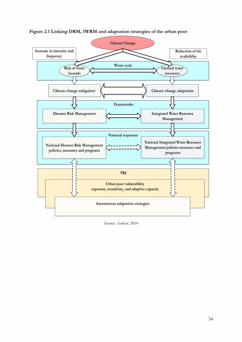
54
Figure 2.1 Linking DRM, IWRM and adaptation strategies of the urban poor
City
Frameworks
Water cycle
Climate Change
Risk of water
hazards
Limited water
resources
Urban poor vulnerability
exposure, sensitivity, and adaptive capacity
Autonomous adaptation strategies
Disaster Risk Management Integrated Water Resource
Management
Climate change mitigation* Climate change adaptation
Reduction of the
availability
Increase in intensity and
frequency
National responses
National Disaster Risk Management
policies, measures and programs
National Integrated Water Resource
Management policies measures and
programs
Source: Author, 2014
55
Chapter 3: Research methodology
The first section of the chapter presents the theoretical approach, as well as the combination of
quantitative and qualitative methodologies used during the different phases of the research. The
second section examines the aims and objectives of the fieldwork, the process for selecting the
poor communities, and the ethical issues involved in study. Next, the chapter describes the
research methods for collecting the data applied in Douala, the positionality of the researcher,
and reliability and validity of the data. Finally, some preliminary results are presented.
3.1 Methodological approach
3.1.1 Theoretical approach
Historically, the two main ontological approaches that have influenced social science research
have been positivism and interpretivism. While positivism holds that the way to produce
knowledge is simply to describe the measurable and observable phenomena that we experience
from the methods and practices of natural sciences (Trochim, 2006), interpretevism is a term
that usually denotes an alternative to positivist orthodoxy that has held sway for decades
(Bryman, 2008). From the positivism perception of research, different post-positivist approaches
have been developed (Trochim, 2006). Rejecting the central tenets of positivism, one of them is
a philosophy called critical realism, to which this study is committed.
The ontological assumptions of critical realism derive from the belief that research is based on
the presence of a social and natural world independent of our knowledge of it (Grix, 2004;
Baabereyir, 2009). In other words, we can only see it through concepts and discourses, and we
accept that there is a reality independent of our thinking that science can study (Trochim, 2006).
It adopts a critical position towards what can or cannot be known (Grix, 2004). Therefore, the
information collected by researchers is subjective, depending on their perception of the world
(Miller and Brewer, 2003). Hence, this approach recognises that observations are fallible,
emphasises the importance of context, mechanisms and evolution, and supports the position
that the social world can only be understood by understanding the structures that generate such
unobservable events and that unobservable events cause observable events (Wamsler, 2007).
56
The logic of inquiry that underpins critical realism is called retroduction (McEvoy and Richards,
2006). Retroductive reasoning is “a mode of analysis through which events are studied with
respect to what may have, must have, or could have caused them” (ibid, p. 71) because, in reality,
the logical processes of generating and eliminating hypothetical explanations never goes as easily
as diagrams and research texts describe (Miller and Brewer, 2003). As a result, explanations are
potentially open to revision and accepted theories may be rejected in favour of more convincing
alternatives that are better able to explain a phenomenon. This involves moving from the level of
observations and lived experience to postulate about the underlying structures and mechanisms
that account for the phenomena (Sayer, 2002 cited in McEvoy and Richards, 2006). In this
research, retroduction allowed exposure of the significant role that autonomous strategy play in
the implementation of the DRM and IWRM frameworks. During fieldwork, data collected
showed the difficulties the DRM and IWRM have in reaching the urban poor, with the selected
low-income communities appearing to experience limited impacts from them in respect of water-
related issues. Their coping and adaptation strategies, therefore, were further investigated to
understand their significance.
Within the framework of this research, mitigation and adaptation to climate change by the urban
poor are both development and environmental problems. This has become more evident since
the environment has become considered as a critical parameter in development. Therefore, a
critical realist approach appears to be the most appropriate to understand the correlation
between the policy-makers’ approach and the urban poor community’s perception and actions
when facing climate change. On the one hand, analysing the roles of the national, regional and
local institutions and organisations involved in climate change mitigation and adaptation, and
understanding their priorities concerning water resource protection, generates an understanding
of the mechanism and context of the implementation of both frameworks. On the other hand,
this approach also allows the investigation of the deeper structures and relations that are not
directly observable but lie behind the surface of social reality, such as the influence of urban poor
autonomous strategies and their impacts on the IWRM and DRM frameworks. Following this
philosophical approach, this research seeks to provide a better understanding of the linkages and
influences between the DRM and IWRM frameworks and autonomous adaptation strategies
facing the external driver of climate change, rather than an extensive assessment of the benefits
of the framework.
57
3.1.2 Mixed methods strategy in a case study design
The methodological approach followed in this research project is closely related to the
ontological and epistemological assumptions we have about reality (Grix, 2004). As noted
previously, the critical realist approach questions our ability to know reality with certainty
(Trochim, 2006). Because all measurement is fallible, the critical-realist emphasises the
importance of multiple measures and observations, each of which may possess different types of
error, and the need to use triangulation across these multiple sources to try to better understand
reality (ibid). In this context, critical realists argue that the choice of methods should be dictated
by the nature of the research problem (Campbell and Fiske, 1959), and that the most effective
approach is to use a combination of quantitative and qualitative methods or techniques (Olsen,
2004). Consequently, in addressing the research questions, the “general orientation to the
conduct of social research” (Bryman, 2001, p. 20) has been defined as a mixed method
subsumed within a case study design, combining the same observations in different settings
(Hammersley, 2005 cited in Brannen, 2005) under the logic of triangulation (Denzin, 1989), was
selected as a research strategy. Thus, the association of both methodologies provides the
opportunity to obtain in-depth information from the different categories of participants,
avoiding the loss of some data (Baabereyir, 2009).
Mixed-methods research is defined as the combination of quantitative and qualitative methods at
all stages of data collection and analysis for stronger monitoring and evaluation, or the adoption
of a research strategy employing more than one type of research method (World Bank, 2007
cited in Brannen, 2005). It is often referred to as multi-strategy research, implying the application
of a number of different research strategies related to a complex range of research questions and
complex research design (Bryman, 2001). Capturing the different features of the research, this
methodology also allows the verification and validation of data collected by different methods
(Brannen, 2005).
Furthermore, the multi-layered approach to investigating allows a layered case study approach
(Patton, 2002). “This gradual analysis of the cases’ broader surrounding environment at global,
national, municipal and household levels allowed a holistic multi-perspective analysis that
included the voice and perspective of the various stakeholders, as well as the interaction between
them” (Wamsler, 2007, p. 41). Hence, this approach addresses the different levels of analysis
implied by the research objectives and questions in a case study. The case-study approach was
58
also a useful instrument for making a study from different perspectives (Feagin et al., 1991), in
this context, the national, regional and local institutional and urban poor views. This argument is
also supported by Moser and Stein (2010, p. 7) who argue that a case-study approach recognises
the importance of listening to “the voices of poor people” and helps to identify the reasons for
the emergence of autonomous strategies to face climate change. This approach also allows a
better understanding of the causes of a social phenomenon within a concrete context, as well as
for providing insight into the setting of related problems (Yin, 2003). The social phenomenon –
the autonomous adaptation strategies of the urban poor, their causes and mechanisms – was
consequently effectively identified and analysed. Thus, this approach allows identifying the
characteristics and regularities of the entire issue, by establishing “the world both holistically and
realistically” (Lamnek, 2005 cited in Wamsler, 2007, p. 42).
Within the framework of this research, the unit of analysis or case to be studied are the policies,
programmes or measures that target urban low-income communities settled and integrated in the
implementation of the DRM and the IWRM frameworks. The selection of policies, programmes
or measures as the case is in accord with the proposed research design, and is a recognised
instrument for project evaluation (Patton, 2002; Yin, 2003). Therefore, the main constituents of
the case to be investigated are: (1) the selected programmes and programme measures; (2) their
beneficiaries; (3) the implementing organisation (ibid).
3.1.1 Mixed methods paradigm challenges
One issue with choosing a mixed methods approach involves concerns that the ontological
dichotomy creates epistemological distinctions between quantitative and qualitative research
approaches (Olsen, 2004). Some authors, such as Sarantakos (1993), argue that there is a
significant difference between these methodologies and that they are incompatible, often taught
and written about separately (Alvesson and Skoldberg, 2000; Dey, 1993; Holstein and Gubrium,
1995 cited in Olsen, 2004). Bryman (2008) also points out that it is important in the field of
social sciences to be careful of the difference in the epistemologies and ontologies of both
approaches and to avoid incoherencies. Moreover, Guba and Lincoln (1985) disapprove of the
combination of the two research strategies in a single project research because the use of any
data collection technique is not only an issue of collecting data but is also a commitment to
either positivism or interpretivism; hence, quantitative and qualitative studies rest upon two
incompatible epistemological principles. Finally, they also claim that the use of any data
59
collection method involves commitment to the approach with which it is usually associated; this
makes method combination inappropriate as it fails to distinguish between a paradigm and a
method.
However, in social science, the idea of “multiple operationism” is not a new concept. It was first
developed by Campbell and Fiskel in 1959, who argued that one method should be used in the
validation process to ensure that any divergence reflected that of the trait and not of the method.
The use of complementary methods leads to more valid results, and the use of multiple measures
may uncover unique arguments that otherwise may have been neglected by single methods (Jick,
1979), thereby capturing a more complete and contextual representation of the community
studied (ibid). Moreover, according to Bryman (2001), the combination of different
methodologies generally tend to involve a leading strategy when starting out the research and a
follow-up strategy for rounding out and widening the enquiry. Olsen (2004) also supports the
combination of qualitative and quantitative methods, observing that empiricism, realism and
constructionism can each provide a philosophical starting point and can each offer an edge of a
triangular viewpoint.
Therefore, the methods themselves should be considered as tools for gathering data, “serving
each other”, instead of being automatically committed to epistemological and ontological
approaches (Olsen, 2004). “Qualitative and quantitative methods should be viewed as
complementary rather than as rival camps” (Jick, 1979, p. 602). Mixing of these different
approaches improves the quality of the data collected and reduces the chance of biased results.
Bryman (2004) states that “combining different methodologies in a single study enhances the
researcher’s claim for the validity of his or her conclusions if they can be shown to provide
mutual confirmation” (Bryman, 2004, p. 131). Moreover, according to Grix (2004, p. 84) “as
long as you are aware of how you are employing a specific method, and what this method is
pointing you towards, and how this relates to the ways you employ other methods, there should
be no problem”. Consequently, quantitative and qualitative approaches can also be considered as
complementary to each other in a single study of social phenomena (Grix, 2004; Bryman, 2008).
60
3.2 Case study approach and research design
3.2.1 Aim and objectives of fieldwork
In this research, the case study aims to explore the autonomous strategies that urban poor
communities are developing in implementing jointly both water-related DRM and IWRM
frameworks. As the DRM and IWRM theoretically involve a large range of institutional and non-
institutional actors, the collection of the different viewpoints and identification of the levels and
mechanism of implementation are crucial. Furthermore, the frameworks studied are intended to
be implemented in poor urban communities, therefore it was also deemed necessary to examine
the organisation and practices of poor communities to gain a deeper understanding of the links
between DRM, IWRM and the urban poor autonomous adaptation strategies regarding water
provision and water-related disasters. Examining the mechanisms of the poor around water and
water-related disasters allows the assessment of the frameworks’ impacts, if any. This
information permits the proposal of concrete solutions or strategies to improve the effectiveness
of both frameworks if needed.
3.2.2 Regional, national and city selection
In order to select the case study, it seemed most appropriate to base the research within a region
where water stress/scarcity and urban poverty affects large portions of its population. Africa is
the second driest continent in the world after Australia, and millions of people living in this
continent suffer from water shortages. In 2002, approximately 51 per cent (300 million people)
of sub-Saharan countries were estimated to lack access to a supply of safe water (Newby, 2002).
Given the research aimed to understand the efficiency and effectiveness of the IWRM and DRM
frameworks in a low-income urban context, Africa appeared to be the most suitable continent to
carry out the study. Furthermore, a third of Africa's one billion inhabitants currently live in urban
areas, and by 2030 that proportion will have risen to half a billion (Maseland and Kayani, 2010),
and 61.7% of the inhabitants of African cities are estimated to be slum-dwellers (UN-Habitat,
2010).
In sub-Saharan Africa, water resources appear to have a particularly crucial role and degree of
importance, in view of the fact that, by 2025, at least 50 per cent of Africa’s predicted population
of 1.45 billion people will face some type of water stress or scarcity (Newby, 2002). Moreover,
61
abundant water resources are a powerful natural capital in the region because African economies
depend greatly on a reliable and adequate supply of water and on achieving water security to
support growth and build climate resilience (Dankova et al., 2010). If adequately protected and
managed, water resources can create a substantial asset for a country. As a result, the selection
process for this case study turned towards a country in Africa where water is an abundant
resource. Among the sub-Saharan African countries, the Democratic Republic of Congo (DRC)
is the one that possesses the most abundant water resources (Mafany and Fantong, 2006 cited in
Ako Ako et al., 2009; FAO, 2013). However, when selecting the area of study, the DRC was
experiencing increasing security issues, and British and French Ministries of Foreign Affairs
recommended against travel there. Consequently, the Republic of Cameroon, which possesses
the second largest water quantity of the African continent (ibid), was selected as the country to
undertake research.
Cameroon is located in the central African sub-region between 2° and 13°N, extending for a
distance of about 1,200km from the Gulf of Guinea to Lake Chad, and between 8° and 16°E,
extending for a distance of 800km at its widest point (between West and Central Africa at the
extreme north-eastern end of the Gulf of Guinea) (Map 3.1) (Ako Ako et al., 2009). The surface
area of Cameroon is 475,650 km2, with a mainland area of 466,050 km2 and a maritime area of
9,600 km2 (National Institute of Statistics, 2001).
The Republic of Cameroon has two major cities: Douala, the economic capital, and Yaoundé,
the political capital. Comparing both cities, Douala has experienced the most rapid expansion in
the country with a population annual growth rate between 5% and 8% per annum (Asangwe,
2006). The consequences of this rapid urban growth included, among others, a wide spatial
expansion, the development of numerous slums and wetland transformation, leading to
observable environmental damage such as contamination of surface water and groundwater
sources, public health hazards, subsidence and flooding (SOGREAH and ECTA-BTP, 2004).
Furthermore, Douala is defined by Asangwe (2006, p. 2) “as a disaster zone”. The recurrence of
water-related disasters is also increasing the urgent requirement for more institutional and
organisational responses to shift the current situation towards more sustainable urban
development. Benefiting from abundant local water resources in a region threatened by water
scarcity, the city’s rapid expansion and extensive vulnerable settlements have created an
environment where water is a crucial asset that needs to be carefully managed. Vulnerability to
water-related disasters, rapid population growth, and increasing demands on water resources
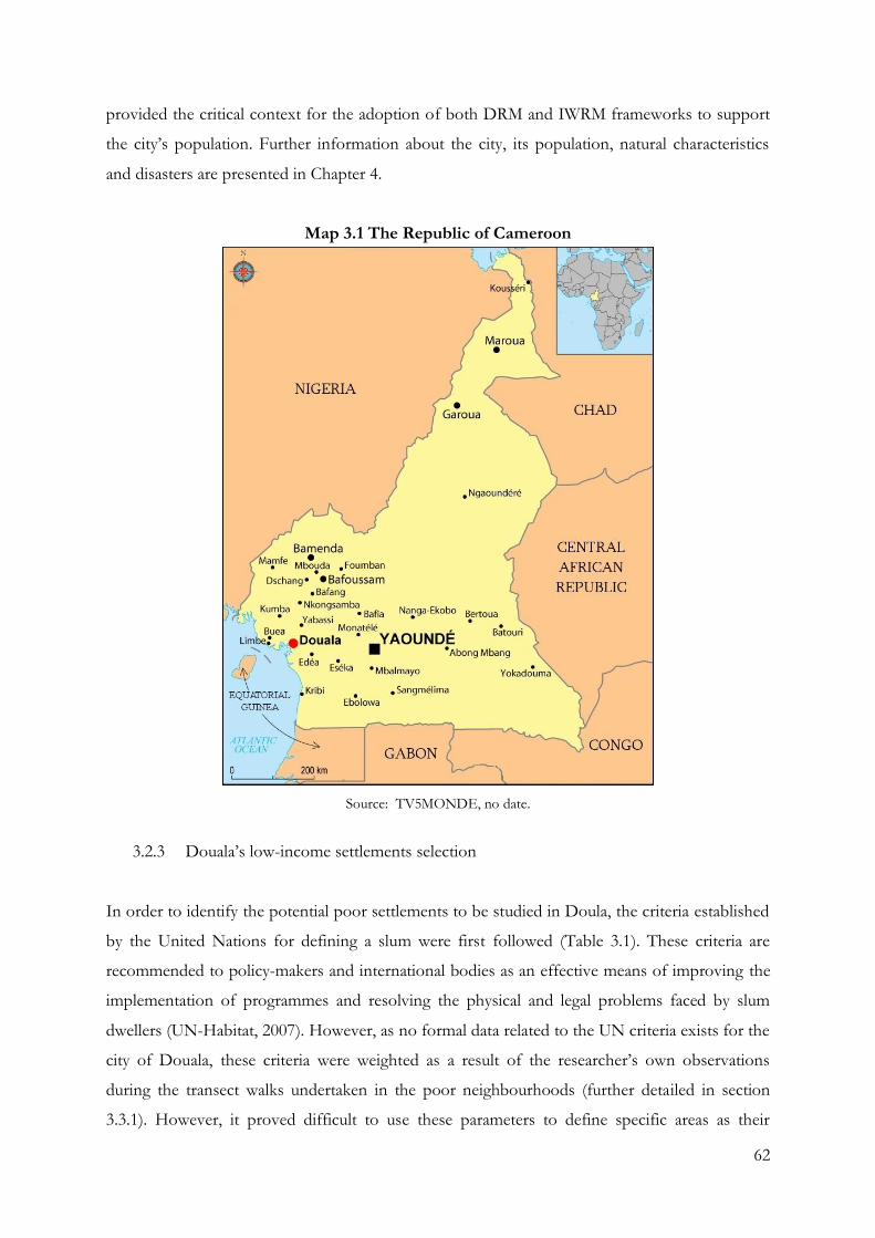
62
provided the critical context for the adoption of both DRM and IWRM frameworks to support
the city’s population. Further information about the city, its population, natural characteristics
and disasters are presented in Chapter 4.
Map 3.1 The Republic of Cameroon
Source: TV5MONDE, no date.
3.2.3 Douala’s low-income settlements selection
In order to identify the potential poor settlements to be studied in Doula, the criteria established
by the United Nations for defining a slum were first followed (Table 3.1). These criteria are
recommended to policy-makers and international bodies as an effective means of improving the
implementation of programmes and resolving the physical and legal problems faced by slum
dwellers (UN-Habitat, 2007). However, as no formal data related to the UN criteria exists for the
city of Douala, these criteria were weighted as a result of the researcher’s own observations
during the transect walks undertaken in the poor neighbourhoods (further detailed in section
3.3.1). However, it proved difficult to use these parameters to define specific areas as their
63
breadth led to the selection of too many zones in the city. In order to overcome this problem,
five new criteria, outlined in Table 3.2, were created. These criteria were defined according to the
research topic, and were developed based on discussions carried out with local contacts and the
coordinator and employees from the NGO, DUCA. As no formal data was available for these
criteria either, they were also weighted according to the researcher’s own observations during the
transect walks, as well as dialogue with local inhabitants of the communities and local contacts.
The additional criteria helped reducing the number of settlements under consideration. These
numbers were further decreased after discussions and the completion of the first semi-structured
interviews with a representative of local government, an academic, two NGOs employees, and
local contacts. The low-income communities of Douala identified were located in the sub-
districts of: Bependa (Douala 1), New-bell (Douala 2) and Village (Douala 3). In order to
triangulate this information, 15 transects walks were carried out (further explained in section
3.3.1). This method led to the elimination of four communities from the selection process, due
to the evident presence of better infrastructure quality and better housing quality. As a result,
eleven communities were preselected.
Qualitative information collected during the transect walks, observations and discussions with
local residents was transformed into quantitative data that was ranked on a scale from 0 to 10 (0-
inappropriate; 10-appropriate) by the researcher (Table 3.3). The lowest scores determined which
communities were the most the most appropriate for the purposes of the research. Thus,
according to Table 3.3, the districts of Douala 2 and Douala 3 were highlighted. However, only
one district of the city was selected, so as not to exceed the number of semi-structured
interviews which had to be carried out and increase the validity and reliability of the data, as
explained in section 3.4.1.
Visits to both districts’ city halls and the local government in charge of the community (further
explained in Chapter 4) suggested that it would prove more problematic to gain physical and
personal access to the city hall of Douala 3 due to the local political and physical context. On the
contrary, the actors of the city hall of Douala 2 were interested in discussing the issues addressed
in this research. Moreover, the particular history (explained in chapter 4), and the fact that two of
the three communities with the lowest scores were located in the district, led the researcher to
choose Douala 2. As a result, the communities selected were Nkolmintag, Newtown Airport 5,
and Tractafric.
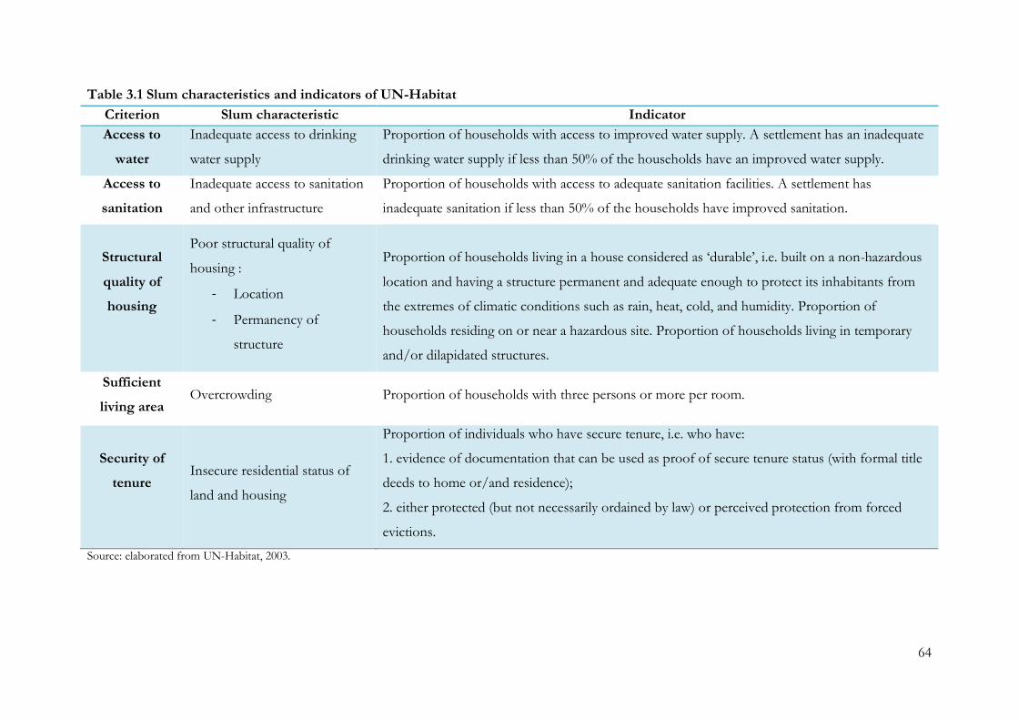
64
Table 3.1 Slum characteristics and indicators of UN-Habitat
Criterion Slum characteristic Indicator
Access to
water
Inadequate access to drinking
water supply
Proportion of households with access to improved water supply. A settlement has an inadequate
drinking water supply if less than 50% of the households have an improved water supply.
Access to
sanitation
Inadequate access to sanitation
and other infrastructure
Proportion of households with access to adequate sanitation facilities. A settlement has
inadequate sanitation if less than 50% of the households have improved sanitation.
Structural
quality of
housing
Poor structural quality of
housing :
- Location
- Permanency of
structure
Proportion of households living in a house considered as ‘durable’, i.e. built on a non-hazardous
location and having a structure permanent and adequate enough to protect its inhabitants from
the extremes of climatic conditions such as rain, heat, cold, and humidity. Proportion of
households residing on or near a hazardous site. Proportion of households living in temporary
and/or dilapidated structures.
Sufficient
living area Overcrowding Proportion of households with three persons or more per room.
Security of
tenure
Insecure residential status of
land and housing
Proportion of individuals who have secure tenure, i.e. who have:
1. evidence of documentation that can be used as proof of secure tenure status (with formal title
deeds to home or/and residence);
2. either protected (but not necessarily ordained by law) or perceived protection from forced
evictions.
Source: elaborated from UN-Habitat, 2003.
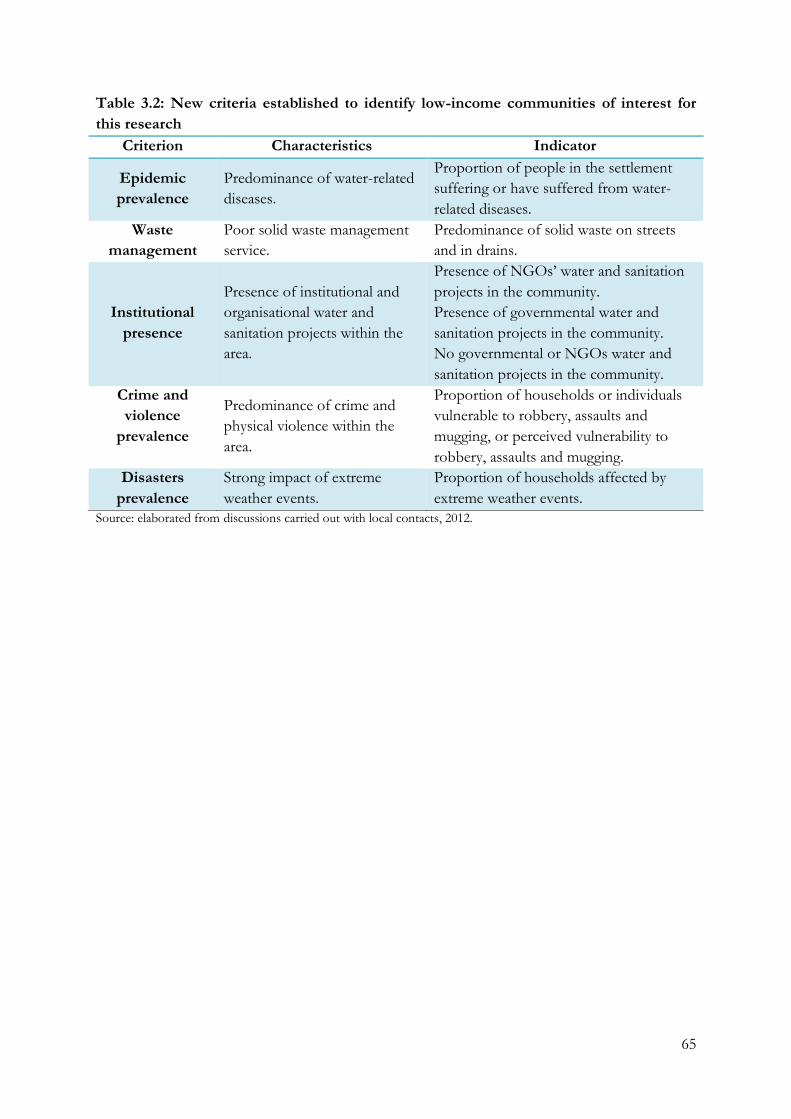
65
Table 3.2: New criteria established to identify low-income communities of interest for
this research
Criterion Characteristics Indicator
Epidemic
prevalence
Predominance of water-related
diseases.
Proportion of people in the settlement
suffering or have suffered from water-
related diseases.
Waste
management
Poor solid waste management
service.
Predominance of solid waste on streets
and in drains.
Institutional
presence
Presence of institutional and
organisational water and
sanitation projects within the
area.
Presence of NGOs’ water and sanitation
projects in the community.
Presence of governmental water and
sanitation projects in the community.
No governmental or NGOs water and
sanitation projects in the community.
Crime and
violence
prevalence
Predominance of crime and
physical violence within the
area.
Proportion of households or individuals
vulnerable to robbery, assaults and
mugging, or perceived vulnerability to
robbery, assaults and mugging.
Disasters
prevalence
Strong impact of extreme
weather events.
Proportion of households affected by
extreme weather events.
Source: elaborated from discussions carried out with local contacts, 2012.
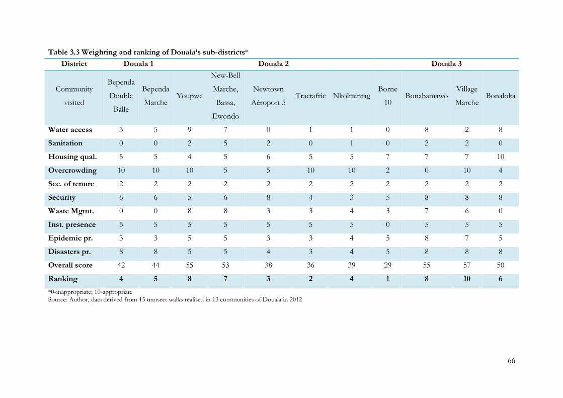
66
Table 3.3 Weighting and ranking of Douala’s sub-districts*
District Douala 1 Douala 2 Douala 3
Community
visited
Bependa
Double
Balle
Bependa
Marche Youpwe
New-Bell
Marche,
Bassa,
Ewondo
Newtown
Aéroport 5 Tractafric Nkolmintag
Borne
10 Bonabamawo
Village
Marche Bonaloka
Water access 3 5 9 7 0 1 1 0 8 2 8
Sanitation 0 0 2 5 2 0 1 0 2 2 0
Housing qual. 5 5 4 5 6 5 5 7 7 7 10
Overcrowding 10 10 10 5 5 10 10 2 0 10 4
Sec. of tenure 2 2 2 2 2 2 2 2 2 2 2
Security 6 6 5 6 8 4 3 5 8 8 8
Waste Mgmt. 0 0 8 8 3 3 4 3 7 6 0
Inst. presence 5 5 5 5 5 5 5 0 5 5 5
Epidemic pr. 3 3 5 5 3 3 4 5 8 7 5
Disasters pr. 8 8 5 5 4 3 4 5 8 8 8
Overall score 42 44 55 53 38 36 39 29 55 57 50
Ranking 4 5 8 7 3 2 4 1 8 10 6
*0-inappropriate; 10-appropriate Source: Author, data derived from 15 transect walks realised in 13 communities of Douala in 2012
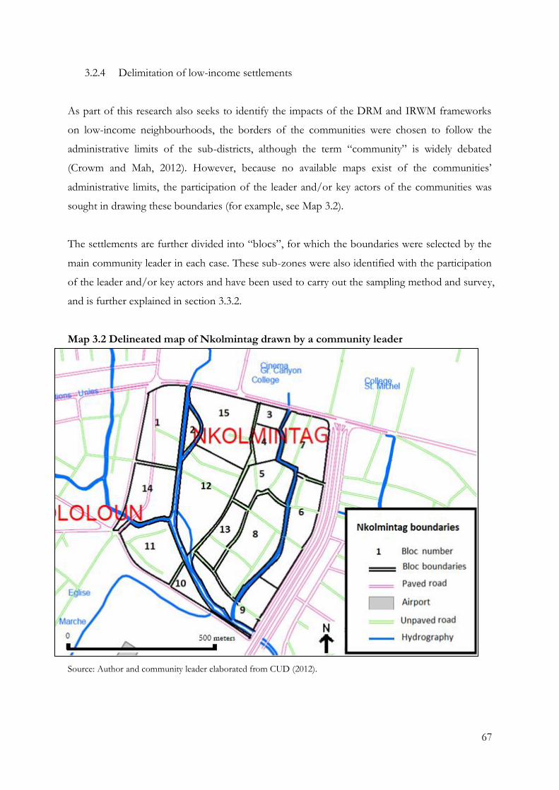
67
3.2.4 Delimitation of low-income settlements
As part of this research also seeks to identify the impacts of the DRM and IRWM frameworks
on low-income neighbourhoods, the borders of the communities were chosen to follow the
administrative limits of the sub-districts, although the term “community” is widely debated
(Crowm and Mah, 2012). However, because no available maps exist of the communities’
administrative limits, the participation of the leader and/or key actors of the communities was
sought in drawing these boundaries (for example, see Map 3.2).
The settlements are further divided into “blocs”, for which the boundaries were selected by the
main community leader in each case. These sub-zones were also identified with the participation
of the leader and/or key actors and have been used to carry out the sampling method and survey,
and is further explained in section 3.3.2.
Map 3.2 Delineated map of Nkolmintag drawn by a community leader
Source: Author and community leader elaborated from CUD (2012).
68
In order to be authorised to work in a sub-district, the researcher first asked the approval of the
main community leader. This was done during the semi-structured interview, which took place at
a time appointed by the leader, in his office called a “chefferie”, located in the community. This
provided an opportunity to delineate the general characteristics of the area, validating and
completing the information the researcher had already collected during the transect walks
through observations and discussions with local inhabitants.
3.2.5 Ethical issues
The research was designed, reviewed and undertaken to ensure the integrity of the communities
and individuals involved. Following Robson (2002), as well as the ethical guidelines of The
University of Manchester, the investigator informed all participants of the objectives of the
research and all aspects that might reasonably be expected to influence their willingness to
participate, and to answer their questions concerning other aspects of the study.
Working with vulnerable communities of marginalised status is a complex and sensitive process.
Miller and Brewer (2003, p. 95) argue that “adhering to the principles of anonymity and
confidentiality are therefore imperative ethical considerations when undertaking any social
research”. For this purpose, the confidentiality of information supplied and the anonymity of all
respondents is respected. Personal data such as names and addresses of the individuals who
participated in the study are not revealed. Moreover, if participants provided evidence that could
be considered potentially damaging to themselves, or others, if disclosed, care was taken to
ensure the information was used in such a way that it could not be connected to the source.
With regards to consent, research participants were asked to participate in a voluntary manner,
free from coercion. Miller and Brewer (2003, p. 95) state that “voluntary consent is considered
by many as the central norm governing the relationship between the researcher and the
participant”. Moreover, obtaining the authorisation to undertake the research implies access and
acceptance (Bell, 2005), allowing the researcher into a given physical space (Homan, 2001). For
this reason, consent forms were completed during the semi-structured interviews. Oral consent
was also asked during the completion of the questionnaire and the respondents had the choice
not to answer questions if they did not want to.
69
3.3 Methods of data collection
In this research, the qualitative methods of field observations and semi-structured interviews,
and quantitative method of questionnaire, were selected to answer the research questions, as
presented in Table 3.4 and further explained below.
Table 3.4 Methods selected to answer the research questions
Research Questions Methodology Methods Selected
What are the water-related exposure,
sensitivity and adaptive capacities of the low-
income communities to climate change
impacts?
Qualitative
Field observations
Quantitative 609 questionnaires
Do the DRM and IWRM policies, measures
and projects implemented to face climate
change impacts on water resources reach the
urban poor?
Qualitative
Field observations
33 semi-structured interviews
Document analysis
Quantitative 609 questionnaires
Are the DRM and IWRM institutional
frameworks implemented to face water-
related issues operationally linked?
Qualitative
33 semi-structured interviews
Do DRM, IWRM and the water-related
autonomous strategies implemented by the
urban poor influence each other?
Qualitative
Field observations
33 semi-structured interviews
Document analysis
Quantitative 609 questionnaires
Source: Author, 2012.
3.3.1 Transect walks and field observations
Transect walked are defined by World Bank (2012a, p. 1) as “a tool for describing and showing
the location and distribution of resources, features, landscape, main land uses along a given
transect”. Transect walks have also been defined by USAID (2009, p. 2) as “a path along which
one observes and records environmental attributes of interest”. This tool is argued to be
appropriate for a pragmatic approach for both preliminary and extensive fieldwork that bridges
human and physical geography. It supports the investigation of the cause and effect relationships
among topography, soils, natural vegetation, cultivation, and other production activities and
70
human settlement patterns (World Bank, 2012a). Moreover, it allows identifying major problems
and possibilities perceived by different groups of local analysts in relation to features or areas,
and learning about local technology and practices (ibid).
As explained previously, the transect walks undertaken in the sub-district of Douala aimed to
help in the selection of the low-income communities and to triangulate data collected through
the other methods. The 15 transect walks were carried out between 10.00 am and 4.00 pm over a
period of a month, along with observations and discussions with residents of the settlements.
Each lasted between 3 and 5 hours depending on the size of area (Map 3.3).
Field observation is considered a powerful tool for research as it involves verbal behaviour and
allows the researcher to directly observe the phenomenon studied. This “form of evidence”
(Baabereyir, 2009, p. 128) has been categorised into different types by Miller and Brewer (2003).
Among these types, “unobtrusive observation” and “participant observation” are based on the
degree of participation by the researcher. In this research, observations are “unobtrusive
observation”, presumed to avoid the problems caused by the researcher presence (Lee, 2000). In
this purpose, the PhD researcher did not take part in events occurring in the urban poor
communities. Moreover, she did not intervene when observing meetings between agencies, local
authorities and community members. Public accesses to water, water-related impacts on houses
and infrastructures, sanitation infrastructures, and the criteria described in Table 3.1 and Table
3.2, were the researcher’s main observations during the transect walks.
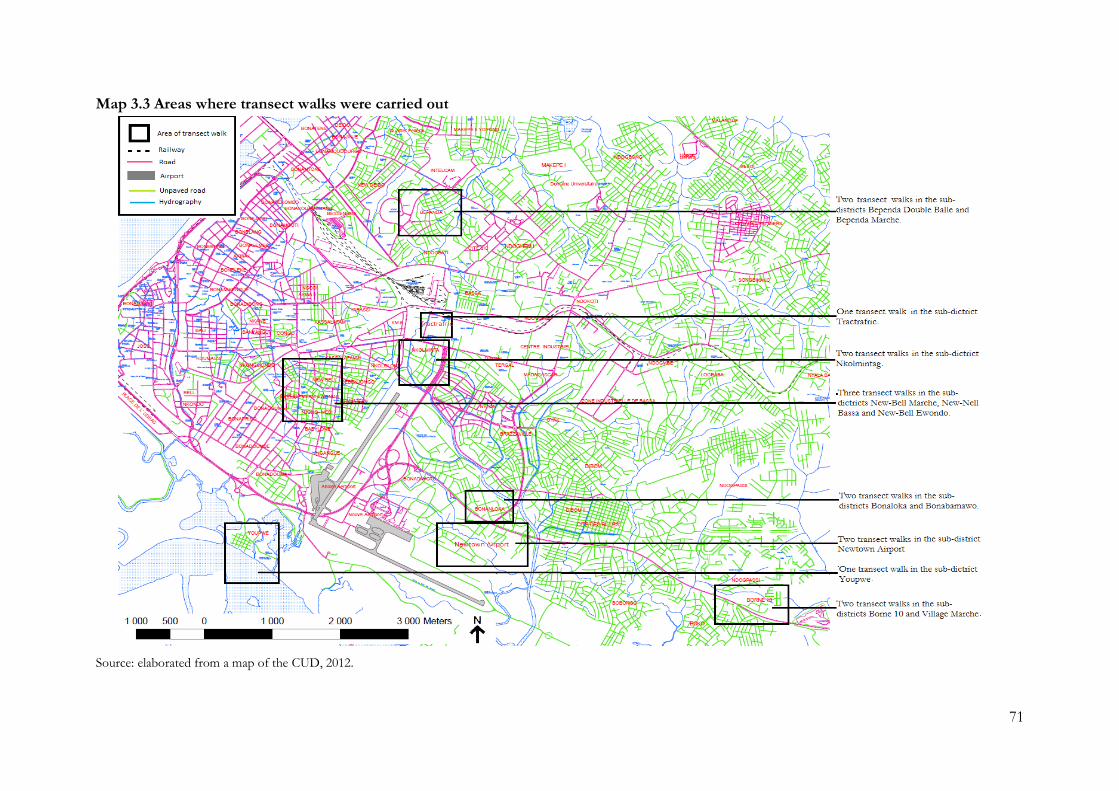
71
Map 3.3 Areas where transect walks were carried out
Source: elaborated from a map of the CUD, 2012.
72
3.3.2 Survey and sampling methods
Surveys can use qualitative or quantitative measures. There are two basic types of survey: cross-
sectional surveys and longitudinal surveys (Babbie, 1973). This research, investigating the
relationship between the implementation of the two frameworks, used cross-sectional surveys,
meaning that the information gathered on a population is reflects a single point in time (Trochim,
2006). Furthermore, surveys can be divided into two broad categories: questionnaires and
interviews. Questionnaires are often associated with paper-sheets to be completed, while
interviews are completed by the interviewer based on the interviewee’s answers (ibid).
On the one hand, questionnaires allow the collection of qualitative and quantitative data. This
method of data collection is one of the most commonly used techniques in social surveys (Miller
and Brewer, 2003). The use of questionnaires offers numerous advantages: the ease of collecting
a large amount of data in a small time period, the high reliability of the data collected and the
minimisation of possible bias by the researcher (ibid). As the characteristics of the information
are similar, a questionnaire allows systematic coding for quantitative analysis. The questionnaire,
therefore, appeared to be an appropriate tool to collect primary data about people and their
perceptions, approaches, views, actions and consciousness of specific issues (Baabereyir, 2009).
3.3.3 Completion of the questionnaire
The questionnaire allowed the researcher to collect quantitative data about the participants’
perceptions of water accesses, as well as the inhabitants’ water resources, practices and actions
with regard to its management at household and family level. A total of 200 questionnaires were
undertaken in each community, in part reflecting the time and financial limits of the PhD
researcher.
The sampling method was based on systematic sampling, which is a random method of sampling
that applies a constant interval to choosing a sample of elements from the sampling frame (Cox,
2008). Using systematic sampling also aimed to reach statistical significance, the
low probability that an observed effect would have occurred due to chance (Coolidge, 2013).
To implement this technique the following steps were taken. First, due to the lack of a city
census, the number of houses in each community was estimated using a .pdf file of a Google
73
Earth© air cover picture from 2003 collected at the urban council of Douala. The settlement
area was located on the map and then zoomed-in on to obtain a clear visualisation of the build
environment. The number of building N was then counted for the whole area and per bloc (see
map in Appendix 2). The percentage of building a bloc represents to the whole area was
calculated. For instance, a population of size N=1539 and N2=45 (randomly chosen for this
example) was identified. The percentage of housing of the whole area N2 represents is identified:
x = N2
N∗ 100
In this example:
x =45
1539∗ 100 ≈ 2.92%
Then, the number of questionnaires n2 to be carried out per bloc was established. For instance, a
sample of size n is desired (in our case n=200 questionnaires per community) from the
population of size N:
n ∗ x = n2
In this example:
200 ∗2.92
100= 5.84
As a result, 5.8 questionnaires (approximated to 6 questionnaires) have to be carried out in bloc 2.
At that point, the sampling interval k was calculated by dividing the number of buildings
estimated by the amount of questionnaires desired. For instance, a sample of size n is desired (in
our case 200 questionnaires per community) from a population of size N. Following the previous
example, the sampling interval k is then calculated:
k =N
n
In this example:
k =1539
200= 7.695
Thus, one questionnaire had to be carried out every 7.75 houses (after approximation every 8
houses), randomly choosing the first house to survey. Therefore, 6 questionnaires were carried
out in bloc 2 every 8 houses.
Five pilot questionnaires were carried out in Nkolmintag. These pilots raised three issues. First,
some questions were unclear and confusing, or local residents were unable to answer them. For
example, the initial questionnaire suggested water access to be single access, however the
inhabitants generally differentiate between the water they drink and the water they use for
everyday activities. Secondly, asking about formal or informal tenure was confusing. Due to the
74
law legalising settlers if occupation of the land took place before 1974, the year of major land-law
reform in Cameroon, the families who had settled more than 40 years ago hold the right to ask
for formal tenure (Alden Willy, 2011). However, the complicated process through which the
regularisation of their status can be achieved prevented many households from embarking on
this procedure. Therefore, these questions were modified to include the different water accesses
identified during the completion of the pilots and land tenure was considered based on the
perception of the interviewees.
The last issue concerned the alteration of answers by interviewees during the pilot questionnaires
due to the researcher’s different ethnicity and being an outsider. Local residents tended to
modify, for example, their monthly spending, their names or/and the ownership of their land.
Consequently, for the completion of the overall questionnaire, five students from the University
of Douala were chosen, from among 20 volunteers, to support the researcher in carrying out the
survey in the first two poor communities. The number of students was chosen in order for the
researcher to be able to monitor more easily the completion of the questionnaire and minimise
security risks. Six days were spent in Nkolmintag and Newtown Airport 5, where a goal of 12
questionnaires was decided to be undertaken by the group of students per day. In Tractafric, the
PhD researcher benefited from the help of 20 students from the Pan-African Institute of
Development. It proved necessary to recruit this number of students so that the survey could be
carried out rapidly before the onset of the rainy season made it difficult to gain access to the
community. This amount of students enabled the full amount of questionnaires to be conducted
in one day. One research assistant supported the researcher to monitor the completion of the
questionnaires by the students.
While working with 5 and 20 students, the same process of training and security was applied. In
order to minimise the possibility of bias in completing the questionnaires, and to train the
students, the research topic, methodology, objectives, and their significance were explained
during an initial meeting. Questionnaires and sampling method were detailed, and an exercise
where students administered the survey to each other in groups of two or three was carried out.
This preparation helped to clarify and standardise the understanding of each student about the
questions. The questionnaires were carried out in the communities from 10:00 am to 4:00 pm on
weekdays and during weekends. During the implementation of the survey, the students were
divided into pairs, staying in the same bloc, in order to minimise security issues. The researcher
monitored the implementation of the methods by joining each group of students for thirty to
75
forty-five minutes. Finally, a debriefing was held to list and discuss the difficulties and advantages
of the questionnaires, as well as the answers collected.
The data collected were then transposed and analysed in Windows Excel and Statbox6. Row data
collected from physical questionnaires were copied into an excel sheet. From this sheet, basic
percentages of each category of responses were calculated and to create the figures overall and
per community. Statbox6 was employed to undertake cross-tabulation and correspondence
analysis.
3.3.4 Semi-structured interviews
Interviews are an introspective form of collecting data that allow the respondents to expose their
perceptions, beliefs, practices, interactions and concerns regarding the topic being discussed
(Freebody, 2003). Moreover, interviews facilitate communication between the researcher and the
community; most people are more disposed to talk in an interview than to write or fill out a
questionnaire (Miller and Brewer, 2003). More particularly, the semi-structured interview
technique is associated with a number of advantages over questionnaires (summarised by
Trochim, 2006), collecting complementary data. Moreover, they allow the interviewee to further
understand the researcher’s area of study and to ask for clarification when the question is unclear.
They also allow the researcher to ask for more clarification on an answer (Baabereyir, 2009). An
interview also guarantees that all the questions are answered (or are attempted to be answered)
with a high response rate and allows verification of the reliability of the semi-structured interview
if the question is repeated later during the exercise (Freebody, 2003).
Semi-structured interviews allowed the PhD researcher to collect the interviewees’ perceptions,
beliefs, practices, interactions, and concerns regarding the topic discussed, from the
implementation of the frameworks to the community’s history. The semi-structured interviews
were performed with key actors from the institutions and organisations involved in the
implementation of the IWRM and DRM frameworks under study. They used predetermined
questions, but were modified when the researcher wished to deepen investigation of a particular
topic. Explanations were given; questions that seem to be inappropriate for particular
interviewees were not asked and additional ones were included (Robson, 2002). This technique
elicited understanding of the mechanisms used by the institutions to implement the frameworks,
together with their priorities, focuses, and knowledge of the frameworks studied. During the five

76
months of fieldwork, 33 semi-structured interviews were carried out, taking place in the key
informants’ offices and lasting from 25 minutes to 1 hour and 30 minutes.
Snowball sampling was then applied (Trochim, 2006). Snowball sampling is a nonprobability
sampling technique that can be applied in survey contexts which involve studying mutual
relationships among population members, helping to identify members of the rare population
(Given, 2008). This technique involves identifying one or more members of a rare population
and asking them to name other members of the same population. The two first interviewees
were chosen from the analysis of recent grey literature on the implementation of the frameworks
in Douala and according to their responsibility and role in the implementation of the DRM and
IWRM. The snowballing process continued until an adequate sample size had been obtained,
and an appropriate number of institutions and organisations involved in the implementation of
the frameworks in Douala had been included. When applying the snowball sampling, one refusal
was faced, argued to be due to his inappropriateness to answer the questions. He then referred
us to other actors from the same organisation who agreed to be interviewed and, as a result,
findings were not affected. Among the 33 semi-structured interviews, one interviewee was
informally met before the interview. Table 3.5 sums up the interviews conducted with
institutions and organisations.
Table 3.5 Interviews with institutions and organisations
Institutions or Organisations No of interviews Interviewees index*
Academics 4 From IA1 to IA3.
Local government 12 From ILG1 to ILG12.
Ministries delegations 6 From ILM1 to ILM6.
National institutions and ministries 4 From IM1 to IM4.
Local emergency agency 1 ILEA
Local NGOs 3 From INGO1 to INGO3
Infrastructure provider 3 From IIS1 to IIS3
* Interviewees have been indexed according to the type of institutions or organization they depend on. In order to differentiate the interviewees from the same type of institutions or organisations, they have also been randomly attributed a number. Source: Author, 2012.
3.3.5 Document analysis
Focusing on the documentation of the policies, programmes and measures resulting from the
DRM and IWRM approaches, local institutional reports provided a useful complement to the
77
primary information gathered through surveys. These grey literature sources can help researchers
to determine both facts and interpretations, capturing key aspects of data about the phenomenon
studied (Yin, 1994). Document analysis also permits the confirmation and strengthening of the
information gathered using other tools, as well as shortening the period of the study (Robson,
1993). Finally, Creswell (2003) argues that document analysis has the advantage of giving the
researcher the opportunity to extend their understanding of “the language” of the actors of the
phenomenon, leading to a deeper understanding of the situation. During fieldwork interviews
with the different institutions, internal or external reports and additional relevant documentation
were collected, when available.
3.4 Summary of data collection and data analysis
3.4.1 Positionality of the researcher, reliability and validity of results
The positionality of the qualitative researcher vis à vis the topic studied and the informants is
influenced by their identity, background and experience, impacting on the data gathered and
therefore affecting the results of the study (Burgress, 1984). Coteerill and Letherby (1994) state
that the participants’ perception of the researcher significantly influences the information they
provide. Some authors argue that being familiar with the research environment might enhance
the outcomes of the research (ibid). However, the researcher’s knowledge of the field is subject
to debate. Burgress (1984) argues that there is a predisposition for a researcher who is familiar
with the research context to affect the research negatively, failing to subject known behaviours
and issues to in-depth investigation. The researcher’s background and experience have a serious
influence on the research topic, and for this reason many authors argue that it is preferable for
the researcher to be unfamiliar with the research context.
During fieldwork, the researcher was aware that being a white woman of a European country
created a specific dynamics between the interviewer and interviewees during the completion of
both semi-structured interviews and questionnaires. Being a French national in a former French
colonial country facilitated access to institutions and organisations. However, it also had an
influence on the reliability of the data. Therefore, in order to maximise the relevance and
consistence of the data, the researcher always presented herself as a PhD student, to associate
her with an unthreatening, but serious, status, having “nothing to offer”. However, during these
interviews, to also create an environment of seriousness, business cards, politeness and
78
professional behaviour were significant factors contributing to the quality of this method. The
same process was applied during the interview with communities’ leaders. In the urban poor
communities, potential power imbalances associated with the researcher’s position was further
minimised by the collaboration of local students with the PhD researcher, as explained in section
3.3.3.
Gender dynamics also influenced the application of the methods. Being a white western female
certainly facilitated further access to institutions and organisations, due to the perception of the
researcher as non-threating, and the curiosity of respondents to the non-usual presence.
However, it sometimes also created ambiguous gender dynamics, which was avoided by the
presence of a male researcher during some semi-structured interviews.
The reliability of data is defined by Bryman (2008, p. 700) as a “concern with the question of
whether the results of a study are repeatable. It refers to the consistency of measure of a
concept”, while he defines the validity of the results as “a concern with integrity of the
conclusions that are generated from a piece of research”. In their definition, Miller and Brewer
(2003) identify three type of validation.
Checking one’s interpretations by their power to predict member’s future behaviour; trying
out one’s interpretations by engaging in behaviour that passes as a member of the setting;
and directly asking members to judge the adequacy of one’s interpretations, either by
evaluation of the final report, or getting them to comment on the interpretations (Miller
and Brewer, 2003, p. 163).
To ensure an adequate validity, Miller and Brewer (2003) advise corroborating the verbal reports
of respondents with other sources to validate the outcomes of the study. However, as Moser and
Stein (2010, p. 7) point out, “the process of results validation depends on the level of
commitment by different social actors”.
To ensure the best data reliability, several sets of questions in semi-structured interviews were
defined: information on the institution or organisation in which the interviewee worked; IWRM
policies, measures and projects regarding water and sanitation; DRM policies, measures and
projects regarding water-related hazards and disasters (see Appendix 2). These were then
modified after the completion of the first pilot semi-structured interview. In the case of the semi-
79
structured interview with the community leaders, the questions were further modified and a new
questionnaire was created due to the lack of awareness of the leaders about the policies and
measures and their extensive knowledge about the community. Thus, the community leaders
were asked about the community’s history, water access, sanitation, water related hazards and
disasters (Appendix 3). Finally, the external validity of the semi-structured questionnaire was
maximised with the selection of the snowball sampling.
During the completion of these interviews, vocabulary was carefully chosen to avoid creating
gaps and build trust between the researcher and the interviewees. Moreover, the researcher
carried them out alone or accompanied by only one research assistant to avoid pressure on the
key actors. The research assistant also attended the semi-structured interviews with the
community leaders for safety reasons. To create an environment of respect and trust, a
presentation about the PhD researcher and the research were carried out first. Moreover, contact
details were handed to the interviewee for them to be able to contact the researcher in case they
would like to have more details about the research or withdraw their participation from the study.
These actions also eased the snowball sampling. The future interviewees were easily identified
and chosen among the different individuals depending on the institutions they work for and their
involvement in the frameworks.
Likewise, the surveys’ questions followed the variables addressed in this research. The sets of
questions included: general information about the house and household, water-related diseases,
water consumption and water access, hazards and impacts, institutions and organisation working
in the community (see Appendix 4). During the completion of the pilot questionnaires, although
carried out after the introduction of the PhD researcher to the community by the community
leader, an evident lack of trust appeared and answers were distorted by the respondents as
explained previously. However, working in collaboration with local students helped to overcome
this lack of reliability. The pilot questionnaires also helped to re-define the questions when
lacking or using inadequate vocabulary. The system of sampling chosen helped to ensure a
maximum external validity.
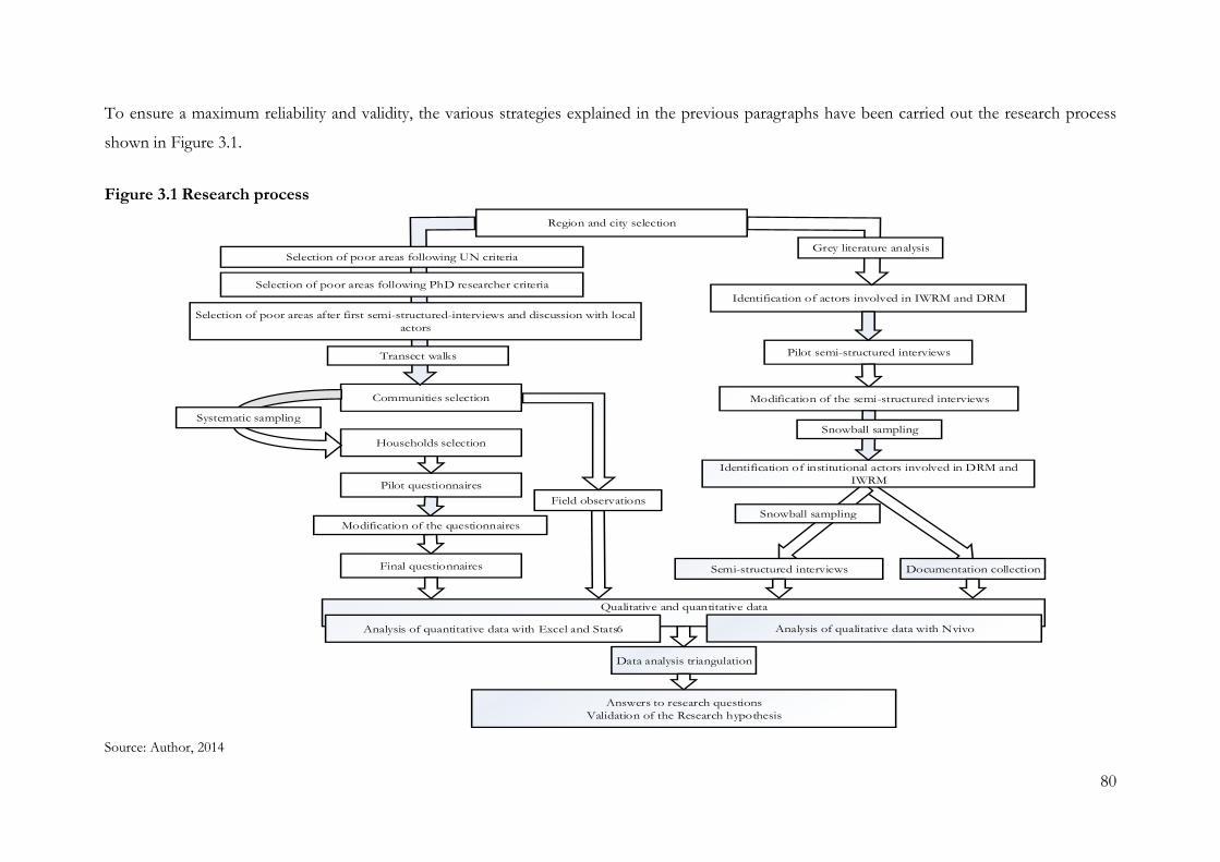
80
To ensure a maximum reliability and validity, the various strategies explained in the previous paragraphs have been carried out the research process
shown in Figure 3.1.
Figure 3.1 Research process
Region and city selection
Qualitative and quantitative data
Data analysis triangulation
Pilot questionnaires
Modification of the questionnaires
Pilot semi-structured interviews
Field observations
Communities selection
Identification of institutional actors involved in DRM and
IWRM
Households selection
Identification of actors involved in IWRM and DRM
Selection of poor areas following UN criteria
Selection of poor areas following PhD researcher criteria
Selection of poor areas after first semi-structured-interviews and discussion with local
actors
Grey literature analysis
Transect walks
Final questionnaires
Systematic sampling
Modification of the semi-structured interviews
Snowball sampling
Analysis of qualitative data with NvivoAnalysis of quantitative data with Excel and Stats6
Answers to research questions
Validation of the Research hypothesis
Semi-structured interviews Documentation collection
Snowball sampling
Source: Author, 2014
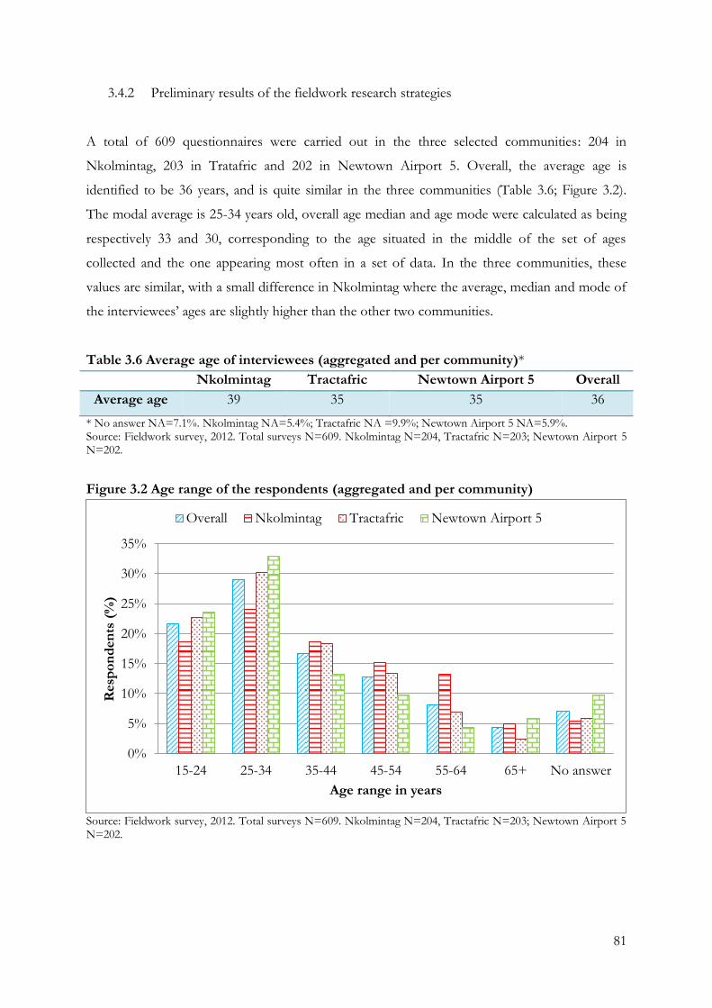
81
3.4.2 Preliminary results of the fieldwork research strategies
A total of 609 questionnaires were carried out in the three selected communities: 204 in
Nkolmintag, 203 in Tratafric and 202 in Newtown Airport 5. Overall, the average age is
identified to be 36 years, and is quite similar in the three communities (Table 3.6; Figure 3.2).
The modal average is 25-34 years old, overall age median and age mode were calculated as being
respectively 33 and 30, corresponding to the age situated in the middle of the set of ages
collected and the one appearing most often in a set of data. In the three communities, these
values are similar, with a small difference in Nkolmintag where the average, median and mode of
the interviewees’ ages are slightly higher than the other two communities.
Table 3.6 Average age of interviewees (aggregated and per community)*
Nkolmintag Tractafric Newtown Airport 5 Overall
Average age 39 35 35 36
* No answer NA=7.1%. Nkolmintag NA=5.4%; Tractafric NA =9.9%; Newtown Airport 5 NA=5.9%. Source: Fieldwork survey, 2012. Total surveys N=609. Nkolmintag N=204, Tractafric N=203; Newtown Airport 5 N=202.
Figure 3.2 Age range of the respondents (aggregated and per community)
Source: Fieldwork survey, 2012. Total surveys N=609. Nkolmintag N=204, Tractafric N=203; Newtown Airport 5 N=202.
0%
5%
10%
15%
20%
25%
30%
35%
15-24 25-34 35-44 45-54 55-64 65+ No answer
Resp
on
den
ts (
%)
Age range in years
Overall Nkolmintag Tractafric Newtown Airport 5
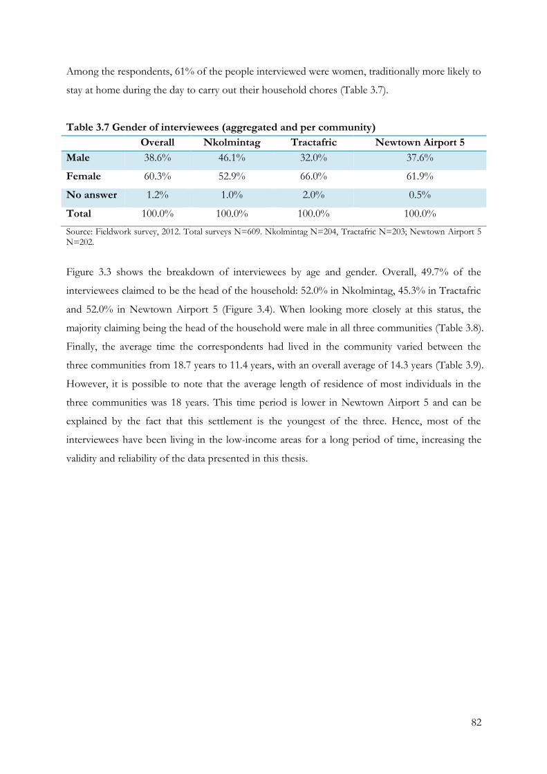
82
Among the respondents, 61% of the people interviewed were women, traditionally more likely to
stay at home during the day to carry out their household chores (Table 3.7).
Table 3.7 Gender of interviewees (aggregated and per community)
Overall Nkolmintag Tractafric Newtown Airport 5
Male 38.6% 46.1% 32.0% 37.6%
Female 60.3% 52.9% 66.0% 61.9%
No answer 1.2% 1.0% 2.0% 0.5%
Total 100.0% 100.0% 100.0% 100.0%
Source: Fieldwork survey, 2012. Total surveys N=609. Nkolmintag N=204, Tractafric N=203; Newtown Airport 5 N=202.
Figure 3.3 shows the breakdown of interviewees by age and gender. Overall, 49.7% of the
interviewees claimed to be the head of the household: 52.0% in Nkolmintag, 45.3% in Tractafric
and 52.0% in Newtown Airport 5 (Figure 3.4). When looking more closely at this status, the
majority claiming being the head of the household were male in all three communities (Table 3.8).
Finally, the average time the correspondents had lived in the community varied between the
three communities from 18.7 years to 11.4 years, with an overall average of 14.3 years (Table 3.9).
However, it is possible to note that the average length of residence of most individuals in the
three communities was 18 years. This time period is lower in Newtown Airport 5 and can be
explained by the fact that this settlement is the youngest of the three. Hence, most of the
interviewees have been living in the low-income areas for a long period of time, increasing the
validity and reliability of the data presented in this thesis.
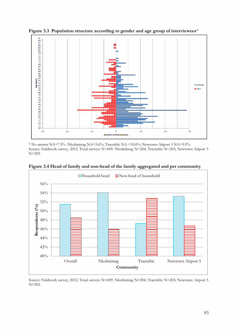
83
Figure 3.3 Population structure according to gender and age group of interviewees*
* No answer NA=7.5%. Nkolmintag NA=5.6%; Tractafric NA =10.0%; Newtown Airport 5 NA=5.9%. Source: Fieldwork survey, 2012. Total surveys N=609. Nkolmintag N=204, Tractafric N=203; Newtown Airport 5 N=202.
Figure 3.4 Head of family and non-head of the family aggregated and per community
Source: Fieldwork survey, 2012. Total surveys N=609. Nkolmintag N=204, Tractafric N=203; Newtown Airport 5 N=202.
40%
42%
44%
46%
48%
50%
52%
54%
56%
Overall Nkolmintag Tractafric Newtown Airport 5
Resp
on
den
ts (
%)
Community
Household head Non-head of household
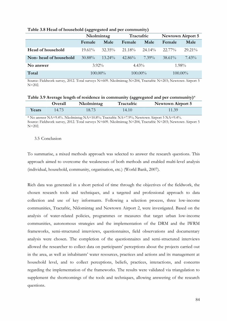
84
Table 3.8 Head of household (aggregated and per community)
Nkolmintag Tractafric Newtown Airport 5
Female Male Female Male Female Male
Head of household 19.61% 32.35% 21.18% 24.14% 22.77% 29.21%
Non- head of household 30.88% 13.24% 42.86% 7.39% 38.61% 7.43%
No answer 3.92% 4.43% 1.98%
Total 100.00% 100.00% 100.00%
Source: Fieldwork survey, 2012. Total surveys N=609. Nkolmintag N=204, Tractafric N=203; Newtown Airport 5 N=202.
Table 3.9 Average length of residence in community (aggregated and per community)*
Overall Nkolmintag Tractafric Newtown Airport 5
Years 14.73 18.73 14.10 11.39
* No answer NA=9.4%. Nkolmintag NA=10.8%; Tractafric NA=7.9%; Newtown Airport 5 NA=9.4%. Source: Fieldwork survey, 2012. Total surveys N=609. Nkolmintag N=204, Tractafric N=203; Newtown Airport 5 N=202.
3.5 Conclusion
To summarise, a mixed methods approach was selected to answer the research questions. This
approach aimed to overcome the weaknesses of both methods and enabled multi-level analysis
(individual, household, community, organisation, etc.) (World Bank, 2007).
Rich data was generated in a short period of time through the objectives of the fieldwork, the
chosen research tools and techniques, and a targeted and professional approach to data
collection and use of key informants. Following a selection process, three low-income
communities, Tractafric, Nklomintag and Newtown Airport 2, were investigated. Based on the
analysis of water-related policies, programmes or measures that target urban low-income
communities, autonomous strategies and the implementation of the DRM and the IWRM
frameworks, semi-structured interviews, questionnaires, field observations and documentary
analysis were chosen. The completion of the questionnaires and semi-structured interviews
allowed the researcher to collect data on participants’ perceptions about the projects carried out
in the area, as well as inhabitants’ water resources, practices and actions and its management at
household level, and to collect perceptions, beliefs, practices, interactions, and concerns
regarding the implementation of the frameworks. The results were validated via triangulation to
supplement the shortcomings of the tools and techniques, allowing answering of the research
questions.
85
The research strategy, research approaches and techniques discussed in this chapter guided the
empirical work, and the main findings from the data analysis are discussed in chapters four, five,
six, seven and eight. The following chapter, Chapter 4, reviews Cameroon and Douala’s climate
patterns, the city’s water resources, and provides a summary of the main institutional
arrangements of the city and the profile of the urban poor in the three specific settlements.
86
Chapter 4: Douala: a city profile
This chapter provides an examination of the context to support the rationale for the first
objective of this research: to examine the water-related vulnerability to face climate change
impacts of urban poor communities. First, it describes the climate variables of the Republic of
Cameroon and Douala. Next, it examines the vulnerability of Douala’s water resources as well as
its population. The chapter also focuses on the institutional arrangements that influence the
climate change policies, programmes and measures affecting the city. Finally, it explores the
urban poor profile in relation to the city through the main characteristics of the three low-
income communities of the city of Douala selected for this research – Nkolmintag, Tractafric
and Newtown Airport 5.
As seen in the Chapter 2, the autonomous adaptation strategies of the urban poor influence the
relationship between water-related issues and national frameworks. Guiding these strategies,
exposure, sensitivity and adaptive capacity have been recognised as key factors that must be
closely investigated to gain a better understanding of how this works. Hence, an examination of
climate-induced stresses and climate-related extremes, identified through observed trends and
projections derived from climate models and regional downscaling, is required. Moreover, the
susceptibility of being exposed to risks through the general characteristics of a city – for example,
geographical location, water resources, development, population, and poverty characteristics –
must also be considered (Rosenzweig et al., 2011; Jabeen, 2012).
Among these three factors, the assessment of institutional elements and actors is significant
because an efficient implementation of regulatory and legal frameworks concerning the water
sector, like that of any other, depends heavily on the strength and organisation of its institutions
(Ferragina et al., 2002). Moreover, institutional arrangements and the formal and informal
context within which actors operate can provide an enabling environment, either blocking or
facilitating the implementation of adaptation strategies of the urban poor (Malik et al., 2010).
4.1. The city’s history and current economic characteristics
No documentary evidence exists about the pre-colonial time, and the history of Douala has been
narrated orally (Gouellain, 1975). From this oral tradition, population in South-Cameroon is
considered as relatively recent. The city of Douala was first a settlement of the Duala tribe before
87
the interactions with the Europeans. Its site was used as a location for exchanges between the
costal tribes of Duala and Basa, and tribes located inside the Cameroonian territories such as Beti.
From this period, three eras must then be distinguished. The first era, from Antiquity to the end
of the Middle-Ages, is characterised by the emergence of urban commercial bourgeoisie of
Europe. The second era, from the 15th century to the beginning of the 19th century, is
characterised by the geographical discoveries and inventions improving the manufactured
products, their circulation and commercialisation, and the improvement of navigation technics
and ships construction. The last epoch began with the wish of the Duala tribe for the protection
and help of a foreign power (Gouellain, 1975).
The western “discovery” of the Cameroonian coast occurred in 1472, although a first description
of the coast was only given at the beginning of the 16th century by Joao de Lisboa (Gouellain,
1975). Douala was at this stage used as an international trade site, first by the Portuguese and the
Spanish, then by the rest of European colonialist countries. The relations between the European
nations and the local tribes were intensified by the Atlantic slave trade (Schler, 2008). These
exchanges were operated by the Duala and Bassa tribes, acting as intermediary between the
Europeans and other tribes inside the territory (ibid). The trade continued increasing, even after
the prohibition of slave trades, due to the growth of industrial sites in the area (Gouellain, 1975).
However, the city site was not “properly occupied” by the European nations carrying out
commerce, rarely leaving their ships, with no European settlements existing until 1800 (ibid).
Because of the intensive trade carried out in the Douala’s estuary, the Duala tribe faced social
and political difficulties and sought the protection of a foreign power to conserve their position
of privileged intermediary (Gouellain, 1975). Therefore, in 1884, a colonial annexation treaty was
created between the Dualas’ leaders and the Germans. This agreement expressed the transfer of
sovereignty from the Duala to the Germans, although the implicit consequences of the treaty,
such as the loss of the internal dynamism and intervention in the development process, were not
immediately considered by the local tribe (ibid). Once established, the German administration
chose the city as a colonial headquarters and planned Douala’s extensive development. They
initiated the creation of a proper urban area, although Douala was only slowly transformed from
a Duala village to a city because of the delay generated by the contestation of the Duala and
Bassa (Schler, 2008).
88
German occupation ended after World War I and the city was divided into six quarters: Joss, Bali,
Akwa, Deido, Bonaberi and New-Bell (Gouellain, 1975). In 1919, after the signature of the
Treaty of Versailles, Douala became part of the French Cameroons, handing over the territory of
Cameroon to the French nation, who attempted to continue the work of the German colonialists
(Nguéhan, 2007). Following this, the then first economic city of the country grew with the
development of plantations, mostly palm plantation, forestry development, harbour activities and
industrialization and fishing (ibid). The city experienced a period of prosperity until World War
II, when a period of economic hardship ensued (Schler, 2003).
The economic growth of the city developed along with demographic growth. In 1935, the first
spontaneous settlements were recorded (Gouellain, 1975), and, by 1947, Douala was composed
of 100,000 inhabitants, attracted by the economic opportunities the city offered, but also
requesting a new administrative organisation from the one carried out since the beginning of the
French mandate (ibid). The first plan after the war proposed several urban schemes for
simplifying and remodelling the existing settlements but soon proved to be inadequate due to the
rapid population growth (ibid). The final plan included improved water access and sanitation
systems but neither programme was fully implemented due to the complicated legal situation that
the colonialists were facing regarding ownership rights (ibid).
In 1955, French Cameroon became a French trust territory and on the 1st of January 1960, the
country gained its full independence (Droz, 2006). The country became the Republic of
Cameroon, immediately recognized by the United States and the Soviet Union and elected
Ahmadou Ahidjo as president of the Republic. Cameroon established a constitution which
provided a pluralistic multiparty system, later re-established as a one-party system in 1966 (ibid).
Ahmadou Ahidjo remained as president of the country until November 1982, when he resigned
and was replaced by former Prime Minister, Paul Biya, who is still president (Pigeaud, 2011; BBC,
2014).
Today, the economic area of Douala is connected by of an important maritime port, an
international airport, a railway and two international roads towards West and East, which
converge and extend towards Northern Cameroon, Chad and Central African Republic (Barbier
and Granjux, 2008). Therefore, although the performance of its port and land transport system is
low, the city retains its status as an exclusive gateway (see transports of Douala’s economic area
in Appendix 6).
89
4.2. Climate variables
Cameroon comprises three main climatic zones: the humid equatorial climate zone; the
equatorial transition climate zone; and the tropical climate zone (Ako Ako et al., 2009).
According to climate models of global warming, the mean annual temperature for Cameroon is
projected to rise by 1.0 to 2.9oC by the 2060s. Projections of mean annual rainfall averaged over
the country from different models present wide ranging changes in precipitation for Cameroon
(from +12 mm to +20 mm per month by the 2090s) (UNDP, 2011). Until now, climate models
concerned with climate change are broadly consistent in indicating increases in the amount of
heavy rainfall events (ibid).
The city of Douala, is located in the humid equatorial climate region with a particularly abundant
single, long rain season (Ndjama et al., 2008, p. 423). The dry season in the city extends from
December to February, and the rainy season from March to August, with maximum precipitation
occurring between the months of July and September (Ndjama et al., 2008, p. 423). In the
following section a review is made of the general data on temperature and rainfall pattern for
Cameroon and Douala from different research and national data sources. The available climate
data so far experienced by the city of Douala makes it possible to track the slow and incremental
change in the weather conditions faced by the local population.
4.2.1. Temperature variability
Temperatures in the southern regions reach heights of 20o to 25oC, with little seasonal variation.
However, since 1960, the mean annual temperature in Cameroon has increased at an average rate
of 0.15.oC per decade (0.7oC overall from 1960 to 2008), in spite of the lack of day-to-day data
from which to infer changes in daily extremes of temperature. The increased rate has been more
rapid in March, April and May, at 0.19oC per decade (McSweeney et al., 2012).
In Douala, the average temperature is 26.4°C a year, and temperatures range from 22°C to 39°C
(Figure 4.1) (Moudi Igri et al., 2011, p. 720). Data provided by the Cameroon Meteorological
Department and reported in two studies (Guevart et al., 2006; Roger et al., 2011), record a
general increase in temperature over the past six decades (Figure 4.2).
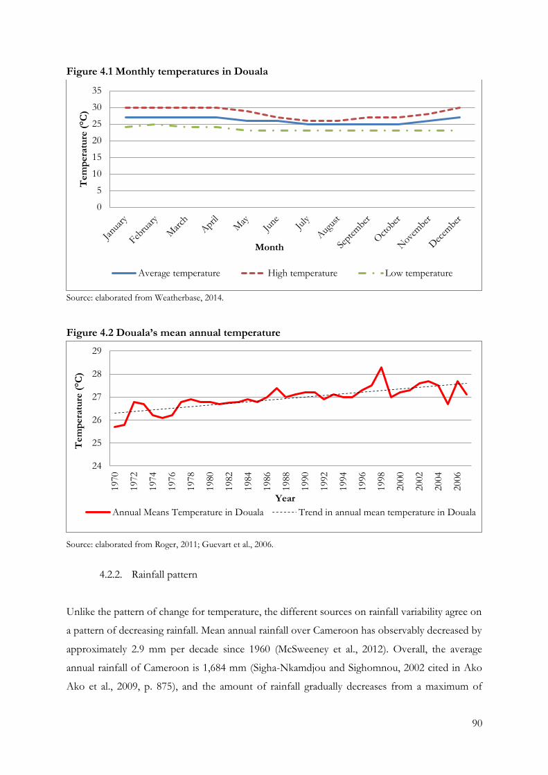
90
Figure 4.1 Monthly temperatures in Douala
Source: elaborated from Weatherbase, 2014.
Figure 4.2 Douala’s mean annual temperature
Source: elaborated from Roger, 2011; Guevart et al., 2006.
4.2.2. Rainfall pattern
Unlike the pattern of change for temperature, the different sources on rainfall variability agree on
a pattern of decreasing rainfall. Mean annual rainfall over Cameroon has observably decreased by
approximately 2.9 mm per decade since 1960 (McSweeney et al., 2012). Overall, the average
annual rainfall of Cameroon is 1,684 mm (Sigha-Nkamdjou and Sighomnou, 2002 cited in Ako
Ako et al., 2009, p. 875), and the amount of rainfall gradually decreases from a maximum of
0
5
10
15
20
25
30
35T
em
pera
ture
(°C
)
Month
Average temperature High temperature Low temperature
24
25
26
27
28
29
1970
1972
1974
1976
1978
1980
1982
1984
1986
1988
1990
1992
1994
1996
1998
2000
2002
2004
2006
Tem
pera
ture
(°C
)
Year
Annual Means Temperature in Douala Trend in annual mean temperature in Douala
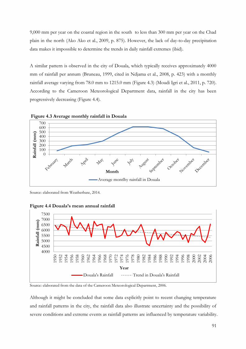
91
9,000 mm per year on the coastal region in the south to less than 300 mm per year on the Chad
plain in the north (Ako Ako et al., 2009, p. 875). However, the lack of day-to-day precipitation
data makes it impossible to determine the trends in daily rainfall extremes (ibid).
A similar pattern is observed in the city of Douala, which typically receives approximately 4000
mm of rainfall per annum (Bruneau, 1999, cited in Ndjama et al., 2008, p. 423) with a monthly
rainfall average varying from 78.0 mm to 1215.0 mm (Figure 4.3) (Moudi Igri et al., 2011, p. 720).
According to the Cameroon Meteorological Department data, rainfall in the city has been
progressively decreasing (Figure 4.4).
Figure 4.3 Average monthly rainfall in Douala
Source: elaborated from Weatherbase, 2014.
Figure 4.4 Douala’s mean annual rainfall
Source: elaborated from the data of the Cameroon Meteorological Department, 2006.
Although it might be concluded that some data explicitly point to recent changing temperature
and rainfall patterns in the city, the rainfall data also illustrate uncertainty and the possibility of
severe conditions and extreme events as rainfall patterns are influenced by temperature variability.
0100200300400500600700
Rain
fall
(m
m)
Month
Average montlhy rainfall in Douala
4000
4500
5000
5500
6000
6500
7000
7500
1950
1952
1954
1956
1958
1960
1962
1964
1966
1968
1970
1972
1974
1976
1978
1980
1982
1984
1986
1988
1990
1992
1994
1996
1998
2000
2002
2004
2006
Rain
fall
(m
m)
Year
Douala's Rainfall Trend in Douala's Rainfall
92
The combined effect of temperature and rainfall variability determines the overall seasonal cycle
of the city. In addition, the findings indicate the limitations of comprehensive local data for all
the climate variables in predicting local variants for Douala city. However, those changes are very
likely to impact the city, and can be dependent on factors such as vulnerability, exposure and
adaptive capacities. The sensitivity of the city and its water resource are examined in the
following sections.
4.3. Douala’s water resources and population in a context of climate change
4.3.1. Douala’s water resources and climate change impacts
In the context of these changing weather patterns, the topography and location of Cameroon,
and Douala within it, make the city affected by water-related hazards. Indeed, it has been noted
that the central African sub-region where the country is located, is the region most likely to
experience the strongest climate change impacts when considering the key vulnerable sectors
identified by IPCC (2007a) including agriculture, food and water (Osman-Elasha, 2009).
In addition, Douala is also vulnerable to sea-level rise. The city is located in the coastal lagoon of
the southern lowlands of the country, 30 km from the Gulf of Guinea, influenced by the River
Wouri and its tributaries, which contribute to the high level of surface water in the city (Asangwe,
2006, p. 4). Although the city’s continued spatial growth has already altered the hydro-
geomorphic attributes of the area, as a result of the increase in residential housing structures and
infrastructure development of highways, industries and wetlands conversion, the hydrology of
the area is still dense (Ako Ako et al., 2009). Intersected as it is by numerous rivers, Douala is
colonised by mangrove swamps. Wetlands and mudflats along the lagoon’s marginal depressions,
creeks and tidal inlets make it vulnerable to climate change impacts on water (Asangwe, 2006).
The city also possesses an important network of groundwater, present at several levels, of which
both deep groundwater and superficial aquifers are widely used by the population and industries
(IA1, March 2012). The lack of available data on the overall water resources prevents greater
precision regarding the exact quantity and quality of Douala’s water and predictions of its
exposure to climate change impacts, in spite of its intensive use by the urban communities. “We
don’t even have the map of the groundwater. [To manage water resources] we must have this
map, but we don’t have it” (IA2, June 2012). Although the presence of the oil industry and
93
numerous other exporting industries, all using groundwater resources, creates a strong suspicion
from the PhD researcher that such information exists, it is extremely difficult to gain access to
any documentation or even to obtain confirmation of its existence.
In spite of this lack of data, it is clear that any modification to one water resource will impact on
the others. Indeed, the water network created by surface water, groundwater and tides is closely
linked through the soil constitution of the area:
“The natural streams and rivers are connected to the groundwater because Douala has
complicated subsoil. There are at least three superimpositions of groundwater. There are
the alluvial groundwaters, which are really close to the surface and are directly connected
to the water of the rivers, thus, once this water is contaminated, it directly contaminates
the groundwater. […] Because we are in a sand basin dating from the end of the Tertiary
[…], these sands have a very bad structure and are not completely consolidated. Water
infiltrates rapidly […]. And at the level of the port, there are other uses of the water, but
this water is also connected to the water inside the city because we are in an estuary, and
when the tides are high, it influences the level of the water in the ground and also impacts
on superficial aquifer” (IA1, March 2012).
In this context, the future scenario for the hydrological processes in Cameroon, including
Douala, suggests that the country and the city are vulnerable to climate change impact on water
and water-related hazards. The quantity of water available will decrease significantly because of
the shifting of drier climatic belts southward, with associated increasing variability in the rainfall
pattern. Hence, climate change will further impact the quantity of water available, as well as the
timing of when it is available for use (Molua and Lambi, 2006). The decrease in the mean annual
rainfall over this highland will lead to a corresponding decrease in the discharge of the Sanaga
(ibid). This could affect economic activity, hydro-electric power, urban development and
manufacturing in the industrial zones of Douala (ibid). This impact is especially significant
because Douala is today the economically most important in Cameroon, accounting for 31.2% of
the national gross domestic product (GDP) (Barbier and Granjux, 2009, p. 10).
94
4.3.2. Douala’s population and climate change impacts on water
Climate change impacts on water explained in the previous section are exacerbated also by the
rapid growth of Cameroon’s urban population and poverty. In the country, the urban population
was estimated to be only 52.7% in 2012 and is predicted to rise by an average of 3.2% a year
from 2010 to 2015 (UNSD, 2014a). Along with the increase in population, in 2001, 6.2 million
people out of a total population of 15.5 million were considered poor, in both rural and urban
areas. By 2007, the population of the country had risen to an estimated 17.9 million, with 7.1
million being considered poor, corresponding to a poverty rate of 39.9% (IMF, 2010, p. 38). In
2007, only 12.2% of those living in urban areas were deemed poor, while more than half the
population living in rural areas were poor (ibid). Nevertheless, the main sources for assessing
poverty in Cameroon are the Cameroon Household Surveys (ECAM1, ECAM2, and ECAM3)
conducted by the National Institute of Statistics of Cameroon respectively in 1996, 2001, and
2007. The main purpose of these surveys was to create an updated poverty profile and various
indicators of living conditions of Cameroonian households, identifying certain aspects of poverty
and assessing the impact of major policies and programmes implemented in the framework of
the fight against poverty (Granjux, 2008). Thus, the irregularity of their completion, their
national focus, the time gap between surveys, and the more global debate about the choice of the
indicators to measure poverty (Maxwell, 1999; Satterthwaite, 2003), permit questioning the
reliability of the poverty data in Douala.
In 2005, Douala’s population was officially estimated to be approximately 2 million inhabitants
(UNSD, 2014a). However, recent figures for the city's population are not considered reliable, as
they have been modified to serve political purposes.
These are numbers we don’t really know about for certain because they are political
numbers; we must reduce or increase the numbers because the people who carry out the
census sometimes state these numbers according to their political view and agreement with
the political party currently in charge. […]. Otherwise the population almost doubled, if
not tripled (LLM6, March 2012).
Consequently, the city’s population has most likely been underestimated: “more concretely, if
you look at the current population of Douala in the 1980s, the estimated rate is approximately 1
million inhabitants. And today, we are close to 3.5 million inhabitants” (LLM6, March 2012).
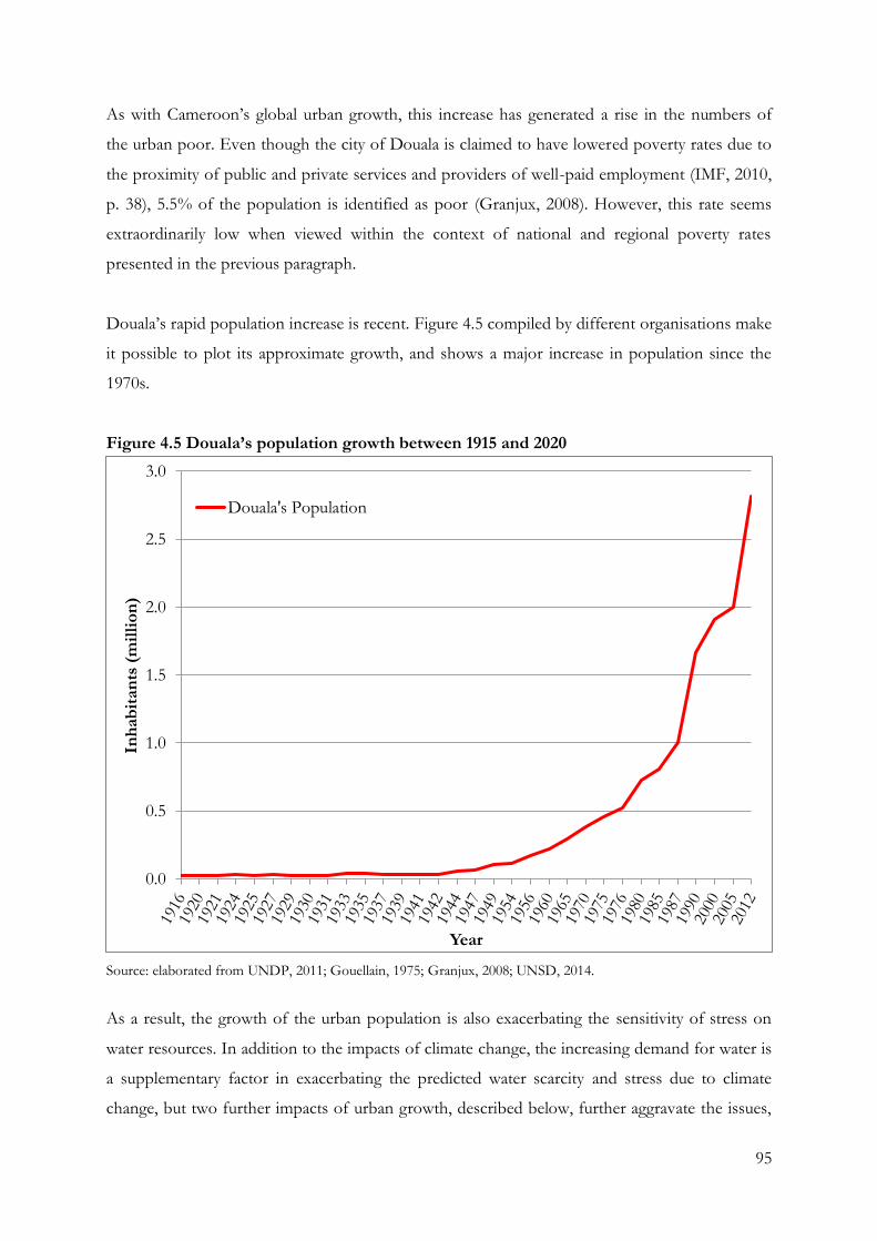
95
As with Cameroon’s global urban growth, this increase has generated a rise in the numbers of
the urban poor. Even though the city of Douala is claimed to have lowered poverty rates due to
the proximity of public and private services and providers of well-paid employment (IMF, 2010,
p. 38), 5.5% of the population is identified as poor (Granjux, 2008). However, this rate seems
extraordinarily low when viewed within the context of national and regional poverty rates
presented in the previous paragraph.
Douala’s rapid population increase is recent. Figure 4.5 compiled by different organisations make
it possible to plot its approximate growth, and shows a major increase in population since the
1970s.
Figure 4.5 Douala’s population growth between 1915 and 2020
Source: elaborated from UNDP, 2011; Gouellain, 1975; Granjux, 2008; UNSD, 2014.
As a result, the growth of the urban population is also exacerbating the sensitivity of stress on
water resources. In addition to the impacts of climate change, the increasing demand for water is
a supplementary factor in exacerbating the predicted water scarcity and stress due to climate
change, but two further impacts of urban growth, described below, further aggravate the issues,
0.0
0.5
1.0
1.5
2.0
2.5
3.0
Inh
ab
itan
ts (
mil
lio
n)
Year
Douala's Population
96
increasing the city’s sensitivity to climate change impacts on water resources and worsening the
vulnerability of the urban poor.
Local institutions draw attention to the way the rapid growth of the city has impacted
infrastructures, habitat and basic services. Transport infrastructure issues are highlighted as
current institutional priorities. “From an infrastructural point of view, when you have a look at a
map [of the city of Douala], the road infrastructure is divided into squares in the residential areas,
and in the spontaneously built neighbourhoods, there are no roads, there are paths” (ILM6, March
2012). Because of the city’s important role in the national economy, the lack of an urban plan is a
major concern.
The city of Douala, being the main economic city of Cameroon and not having a road
infrastructure allowing easy mobility is highly prejudicial not only for the development of
the city, but also for the development of the country. It is the reason why the upgrading
and the development of roads are the second priority of the urban council of Douala with
[…] an emphasis on the creation of urban planning documents and sustainable
development such as a new urban master plan, which did not exist in the city of Douala
for forty years, a local agenda 21 complying with the recommendations of Rio as well as an
urban migration plan (ILM6, March 2012).
Likewise, settlement pattern and urban services and utilities are serious issues stemming from the
development of numerous additional spontaneous settlements.
Currently, due to the crisis Cameroon experienced, which impacted on the state’s capacity
for intervention, and which happened unfortunately when urban growth was high, the city
is confronted with a double issue; first the issue of upgrading the infrastructure and
services and also the issue of adapting the rhythm of development of these infrastructures
to that of the city’s demographic and spatial development, which remains of concern. To
summarize, to make up for accumulated delays and face increasing demand, the projects
being carried out are focusing on what might be called the primary infrastructure, to adopt
a hierarchical approach […] (ILG3, June 2012).
The city authorities of Douala have, therefore, been struggling to cope with the exponential
growth of the urban population and the accumulated delays in developing and implementing an
97
urban plan for improving the water and sanitation system of the city. Moreover, governmental
authorities, faced with the impossibility of demanding or providing decent housing, have
renounced attempts to intervene in the scheduling of construction. However, to further
understand how strategies are implemented the institutional arrangements that influence climate
change policies, the programmes and measures must first be examined and explained.
4.4. Institutional arrangements influencing climate change policies, programmes and
measures
The 1960 constitution approved after the independence of France divides Cameroon into 10
regions, each under the administration of an elected regional council. However, the Constitution
came later and in 1984, the country’s name and the line of succession to the presidency were
changed, but more importantly, the lines of the provinces were redrawn (Rosenzweig et al., 2011).
Each region is headed by a governor, appointed by the country’s president. These governors are
responsible for implementing the “will of the president”, reporting on the “general mood and
conditions of the regions”, administering the civil service, “keeping the peace”, and overseeing
the heads of the smaller administrative units, and also have broad powers, including to order
propaganda in their area and call in the army, gendarmes, and police (Ferragina et al., 2002). All
local government officials are employees of the central government’s Ministry of Territorial
Administration, from which local governments also get most of their budgets. The regions are
then divided into 58 departments. These are headed by presidentially appointed divisional
officers (prefects), who perform the governors' duties on a smaller scale. These regions are
further divided into “arrondissements”, headed by assistant divisional officers (sub-prefects)
(Rosenzweig et al., 2011).
In the context of administrative division, Douala is an urban council, a decentralized public body
and a key governmental authority (CUD, 2008). Under the supervision of the state, it manages
local economic, social and cultural development of its population. More specifically it is in charge
of urban planning, provision of equipment and infrastructure, the maintenance of main roads,
public lighting, water supply, traffic, and transport. The urban council is also responsible for
public parks and parking lots, markets, the implementation of land policies, granting state and
private building permits, and health and safety.
98
The city is divided into five urban districts, numbered from 1 to 5 (see Map 4.1), and one rural
district. Each district is managed by a city hall (ibid). Although the city halls have their own
prerogatives, they are held responsible for budgetary allocations, the preparation and execution
of the budget, and the generation of a plan for public works and sanitation. They are also in
charge of the allocation, management, and maintenance of public property, and street
maintenance (ibid).
4.5. Community profile: the district of New-Bell, Douala
The district of Douala 2eme, also called New-Bell, is of particular interest for the purpose of
understanding climate change and its relation to urban planning in the context of this research.
New-Bell was an area imposed on the local population, which was originally cleared for
settlement by German colonialists in 1913, who levelled it and built roads, ramps, and wells.
After Cameroon became a French protectorate, French urban planners restructured the city
“within certain limits, so New-Bell could develop outside colonial scrutiny. French policy
sanctioned this status when in 1925 the formal borders of the city were established, excluding
New Bell from Douala” (Schler, 2003, p. 56). As a result, the area developed without technical
assistance or administrative control from national and local governments until 1974, when the
population of New-Bell reached 150,000 inhabitants and the Cameroonian government declared
the area to be in the public domain (Mainet, 1986, cited in Nguéhan, 2007; Schler, 2008).
However, the area’s long exclusion from formal urban planning had serious consequences: it not
only had a higher population density but also was disease-ridden. Indeed, because of the lack of
infrastructures, “New-Bell’s issues” became a commonplace (ibid). Nowadays, New-Bell is a
central area due to Doula’s continuous spatial expansion. Divided into 33 sub-districts, New-Bell
suffers from a negative reputation; TV news and newspapers constantly carry stories of crimes or
natural disasters in the area.
This New-Bell district concentrates numerous poor sub-districts associated with low-income
communities, among which are the three cases of this research (shown by numbers on the Map
4.1, Nkolmintag (2), Tractafric (1) and Newtown Airport 5 (3)). Each sub-district is managed by
a community leader. The prefects, responsible to the Ministry of Territorial Administration and
Decentralisation, appoint and manage the community leaders. Their appointments are usually
carried out with the agreement of the local inhabitants and they hold the position until they die,
continuing rural traditions (fieldwork notes, 2012).
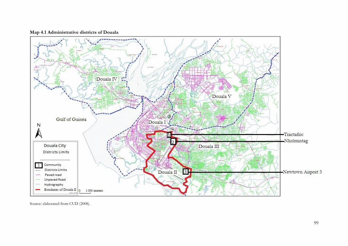
99
Map 4.1 Administrative districts of Douala
Source: elaborated from CUD (2008).
100
4.5.1 Three poor urban communities in New-Bell
Three urban communities from among the 33 sub-districts of New-Bell – Nkolmintag, Tractafric
and Newtown Airport 5 – were selected for this study. These settlements are located centrally
and at the borders of the city (Map 4.1; Map 4.2). During the transect walks, they were identified
to experience confused residential status of land and housing, overcrowding, poor structural
quality of housing, inadequate access to drinking water supply and sanitation. They were also
acknowledged to suffer from water-related diseases, lack of waste management, high level of
insecurity, and impacted by extreme weather events (explained in 3.2.3).
Nkolmintag is the oldest of the settlements. Located at the north of the airport, it developed
during the 1950s (ILG11, March 2012). Tractafric was initially built in the 1960s close to the
railway (ILG9, June 2012). The third community, Newtown Airport 5, started to develop in 1985
at the peripheral area of Douala, between the airport and the river Wouri. It began as a military
area and was later sold to civilians. Migrants began to move in large numbers into this area in the
1990s. All three areas are built on swamplands reclaimed by the population to expand the living
area, a practice still carried out in Newtown Airport 5 (ILG7 May 2012).
A very high population density is found in these communities. In 2011, the population density of
Cameroon as a whole was 42.1 inhabitants/km2 (UNSD, 2014a). In Douala, the density of
population was 11,000 inhabitants per km2 (Jacobsen et al., 2012). More specifically, the
estimated population density of the three communities is 37,594/km2 in Tractafric; 34,743/km2
in Nkolmintag and 29,240/km2 in Newtown Airport 5., densities calculated according to the
number of inhabitants data collected during fieldwork and an approximation of the size of the
areas estimated with Google maps. In other words, these poor communities contain more than
three times the mean city density.
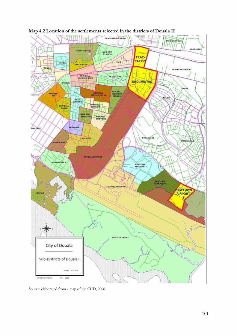
101
Map 4.2 Location of the settlements selected in the districts of Douala II
Source: elaborated from a map of the CUD, 2006
102
Densely populated urban areas are particularly vulnerable to the effects of climate change
(Dodman, 2009). Where there are dense concentrations of households and economic activities,
the effects of climate change can affect large numbers of people and have a major impact on
urban economies (ibid). In the context of Douala, this vulnerability is exacerbated by the
predicted global sea-level rise. As the global population becomes increasingly coastally
concentrated, it is important to assess the implications that will arise from increasingly dense
populations in an increasingly vulnerable physical environment (ibid). Moreover, the dense
concentration of urban populations increases sensitivity to the disasters that are predicted to
become more frequent and more intense as a result of climate change. Thus, economies,
livelihoods, physical infrastructure and social structures are all important components of urban
systems and are vulnerable to disasters and climate risk in different ways (ibid). Finally, climate
change might also generate public health issues, which are accentuated in densely populated
urban areas (ibid). This is of particular concern in low-income communities of Douala, which
already experience a high burden of water-related diseases.
4.5.2 Number of persons per family and types of housing
The high density described in the previous section is often argued to be due to the prevalence of
large families. For example, Granjux (2008) argues that Douala’s poor households are composed
of at least six members compared to rich households that are composed of three members. He
also states that the average family size was composed of 4 persons in 2008, against 4.4 at national
level and 5.2 in 1996 (ibid). However, throughout the three communities, families appear to be
composed of 2.5 persons (Table 4.1) although an average of 6 individuals are found to live in the
same house with this average being constant in all three communities (Table 4.2).
Table 4.1 Average number of individuals per family (aggregated and per community)*
* No answer NA=0.5%. Nkolmintag NA=0.0%; Tractafric NA=0.5%; Newtown Airport 5 NA=1.0%. Source: Fieldwork survey, 2012. Total surveys N=609. Nkolmintag N=204, Tractafric N=203; Newtown Airport 5
N=202.
Overall Nkolmintag Tractafric Newtown Airport 5
Average number of
individuals per family 2.54 2.54 2.55 2.54
103
Table 4.2 Average number of individuals per house (aggregated and per community)*
Overall Nkolmintag Tractafric Newtown Airport 5
Average number of
individuals living in the
same house
6.18 6.56 5.95 6.03
* No answer NA=0.2%. Nkolmintag NA=0.0%, Tractafric NA=0.0%, Newtown Airport 5 NA=0.5%. Source: Fieldwork survey, 2012. Total surveys N=609. Nkolmintag N=204, Tractafric N=203; Newtown Airport 5 N=202.
The small family size identified in the communities contradicts the common idea of large
families in urban poor communities. However, it corresponds to the indicator of social change in
Douala and the official decrease in the average size of families that has already been observed
(Granjux, 2008). Indeed, the proportion of family comprising only one-person in Douala was
20.2% in 2007 compared with only 9.8% in 1996 (ibid). Nonetheless, housing units are normally
composed of 1 to 6 rooms and are shared by two to three families. These percentages explain the
large number of individuals living under the same roof. This higher average confirms the high
density established in the previous section.
4.5.3 Education
The education system in French speaking Cameroon, such as in the city of Douala, is based on
three main levels: primary, secondary and tertiary. The primary level of education covers six years
of instruction (from 1 to 6 years of schooling). Then, the first cycle of secondary school is made
up of four years (from 6 to 10 years of schooling) and the second cycle is made up of three years
(from 11 to 13 years of schooling). Three certificates are awarded: the BEPC at the end of the
first cycle, the Probatoire at the end of the Première Class (year 6) and the Baccalauréat at the
end of the second cycle. The tertiary level corresponds to higher education, such as University
(more than 13 years of schooling) (Echu, 2003).
The education level in these areas contradicts the commonly portrayed image of poorly educated
low-income communities. Indeed, in Douala, children have guaranteed access to school,
including those from poor households. Overall, 88.2% of people interviewed attended school
(Table 4.3) and dropped out during or after secondary school (corresponding to 5 to 9 years of
schooling. These percentages are approximately the same in the three communities, except in
Newtown Airport 5 where only 4.0% did not receive any education at all and 52.5% attended
secondary school.
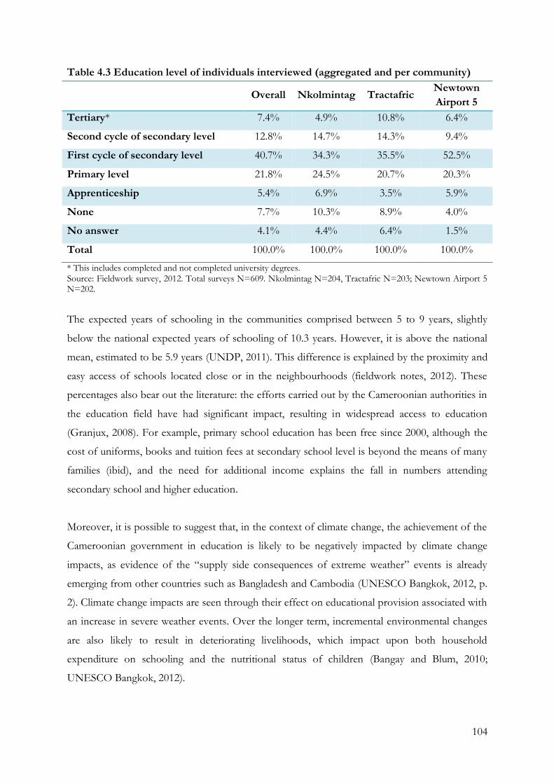
104
Table 4.3 Education level of individuals interviewed (aggregated and per community)
Overall Nkolmintag Tractafric Newtown
Airport 5
Tertiary* 7.4% 4.9% 10.8% 6.4%
Second cycle of secondary level 12.8% 14.7% 14.3% 9.4%
First cycle of secondary level 40.7% 34.3% 35.5% 52.5%
Primary level 21.8% 24.5% 20.7% 20.3%
Apprenticeship 5.4% 6.9% 3.5% 5.9%
None 7.7% 10.3% 8.9% 4.0%
No answer 4.1% 4.4% 6.4% 1.5%
Total 100.0% 100.0% 100.0% 100.0%
* This includes completed and not completed university degrees. Source: Fieldwork survey, 2012. Total surveys N=609. Nkolmintag N=204, Tractafric N=203; Newtown Airport 5 N=202.
The expected years of schooling in the communities comprised between 5 to 9 years, slightly
below the national expected years of schooling of 10.3 years. However, it is above the national
mean, estimated to be 5.9 years (UNDP, 2011). This difference is explained by the proximity and
easy access of schools located close or in the neighbourhoods (fieldwork notes, 2012). These
percentages also bear out the literature: the efforts carried out by the Cameroonian authorities in
the education field have had significant impact, resulting in widespread access to education
(Granjux, 2008). For example, primary school education has been free since 2000, although the
cost of uniforms, books and tuition fees at secondary school level is beyond the means of many
families (ibid), and the need for additional income explains the fall in numbers attending
secondary school and higher education.
Moreover, it is possible to suggest that, in the context of climate change, the achievement of the
Cameroonian government in education is likely to be negatively impacted by climate change
impacts, as evidence of the “supply side consequences of extreme weather” events is already
emerging from other countries such as Bangladesh and Cambodia (UNESCO Bangkok, 2012, p.
2). Climate change impacts are seen through their effect on educational provision associated with
an increase in severe weather events. Over the longer term, incremental environmental changes
are also likely to result in deteriorating livelihoods, which impact upon both household
expenditure on schooling and the nutritional status of children (Bangay and Blum, 2010;
UNESCO Bangkok, 2012).
105
4.5.4 Monthly spending and employment
In 2007 in Douala, the poverty monetary threshold, corresponding to the minimum required to
meet basic needs, was evaluated at 269,443 CFA franc (Fcfa)3 per adult per year, or 22,454 Fcfa
per month (Granjux, 2008, p. 68). Because of its leading economic role as an important wealth
producer in the country, Douala has a high cost of living (INSC, 2010). The average consumer
spending of households in Douala is estimated to be 216,000 Fcfa per month (2.6 million Fcfa
per year), against a national average of 150,000 Fcfa per month (1.8 million Fcfa per year) (ibid).
In the low-income communities in this study, monthly spending per family is estimated to be an
average of 87,055 Fcfa per month (1.0 million Fcfa per year), considerably less than Douala’s
average living standard (Table 4.4). It can also be noted that a majority of families spend between
30,000 Fcfa and 150,000 Fcfa, except for Newtown Airport 5, where family spending is between
60,000 Fcfa and 150,000 Fcfa (Figure 4.6).
According to official data, the unemployment rate in Douala is 16.3% (Granjux, 2008). Because
of the years of economic hardship and the difficulties of finding employment in the formal
sector, and in some cases its decline, the role of the informal sector in generating sources of
household revenue has increased (ibid). In the absence of a true "economic engine", the
population have adapted and developed an important informal sector. However, the informal
sector is characterised by low salaries and is often the primary source of income for Douala’s
households. Average incomes in the informal sector vary from 8,000 Fcfa per month in the
industrial sector to between 14,000 Fcfa and 20,000 Fcfa per month in the trade and services
sector (Granjux, 2008).
In Douala, the informal sector is thought to employ 73.8% of the city’s population, representing
the main source of employment, although the city’s formal sector dominates economic activity
and represents 63% of the national wealth produced (Granjux, 2008). “The region of Douala is
an industrial area. Including the technological sector and the mines, the industrial sector is the
main activity as Douala is where 70.0% of Cameroonian industries are located. Therefore, a lot
of activities are focused on the industrial sector” (ILM5, April 2012). Consequently, the city’s
formal employment accounts for approximately 10.0% of jobs at national level, and, in the city
itself, the formal sector employs 26.2% of the working population.
3 CFA franc is the national currency used in Cameroon, and £1 corresponded to 761.6 Fcfa the 1st of March 2012
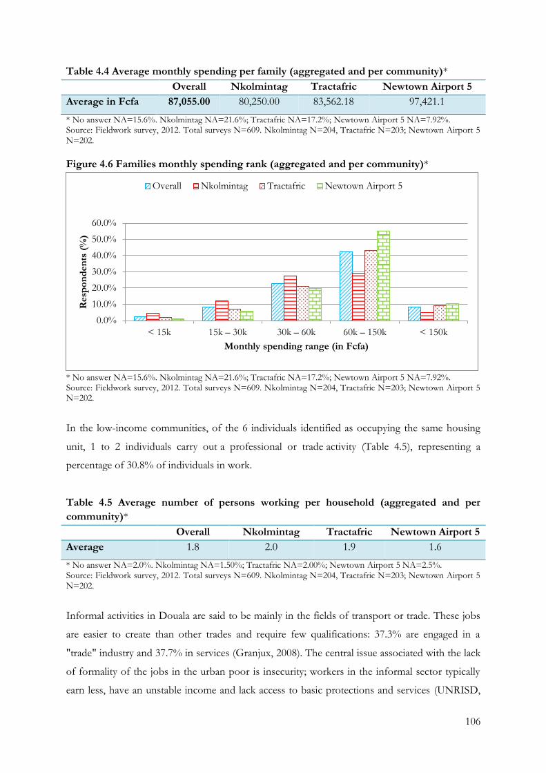
106
Table 4.4 Average monthly spending per family (aggregated and per community)*
Overall Nkolmintag Tractafric Newtown Airport 5
Average in Fcfa 87,055.00 80,250.00 83,562.18 97,421.1
* No answer NA=15.6%. Nkolmintag NA=21.6%; Tractafric NA=17.2%; Newtown Airport 5 NA=7.92%. Source: Fieldwork survey, 2012. Total surveys N=609. Nkolmintag N=204, Tractafric N=203; Newtown Airport 5 N=202.
Figure 4.6 Families monthly spending rank (aggregated and per community)*
* No answer NA=15.6%. Nkolmintag NA=21.6%; Tractafric NA=17.2%; Newtown Airport 5 NA=7.92%. Source: Fieldwork survey, 2012. Total surveys N=609. Nkolmintag N=204, Tractafric N=203; Newtown Airport 5 N=202.
In the low-income communities, of the 6 individuals identified as occupying the same housing
unit, 1 to 2 individuals carry out a professional or trade activity (Table 4.5), representing a
percentage of 30.8% of individuals in work.
Table 4.5 Average number of persons working per household (aggregated and per
community)*
Overall Nkolmintag Tractafric Newtown Airport 5
Average 1.8 2.0 1.9 1.6
* No answer NA=2.0%. Nkolmintag NA=1.50%; Tractafric NA=2.00%; Newtown Airport 5 NA=2.5%. Source: Fieldwork survey, 2012. Total surveys N=609. Nkolmintag N=204, Tractafric N=203; Newtown Airport 5 N=202.
Informal activities in Douala are said to be mainly in the fields of transport or trade. These jobs
are easier to create than other trades and require few qualifications: 37.3% are engaged in a
"trade" industry and 37.7% in services (Granjux, 2008). The central issue associated with the lack
of formality of the jobs in the urban poor is insecurity; workers in the informal sector typically
earn less, have an unstable income and lack access to basic protections and services (UNRISD,
0.0%
10.0%
20.0%
30.0%
40.0%
50.0%
60.0%
< 15k 15k – 30k 30k – 60k 60k – 150k < 150k
Resp
on
den
ts (
%)
Monthly spending range (in Fcfa)
Overall Nkolmintag Tractafric Newtown Airport 5
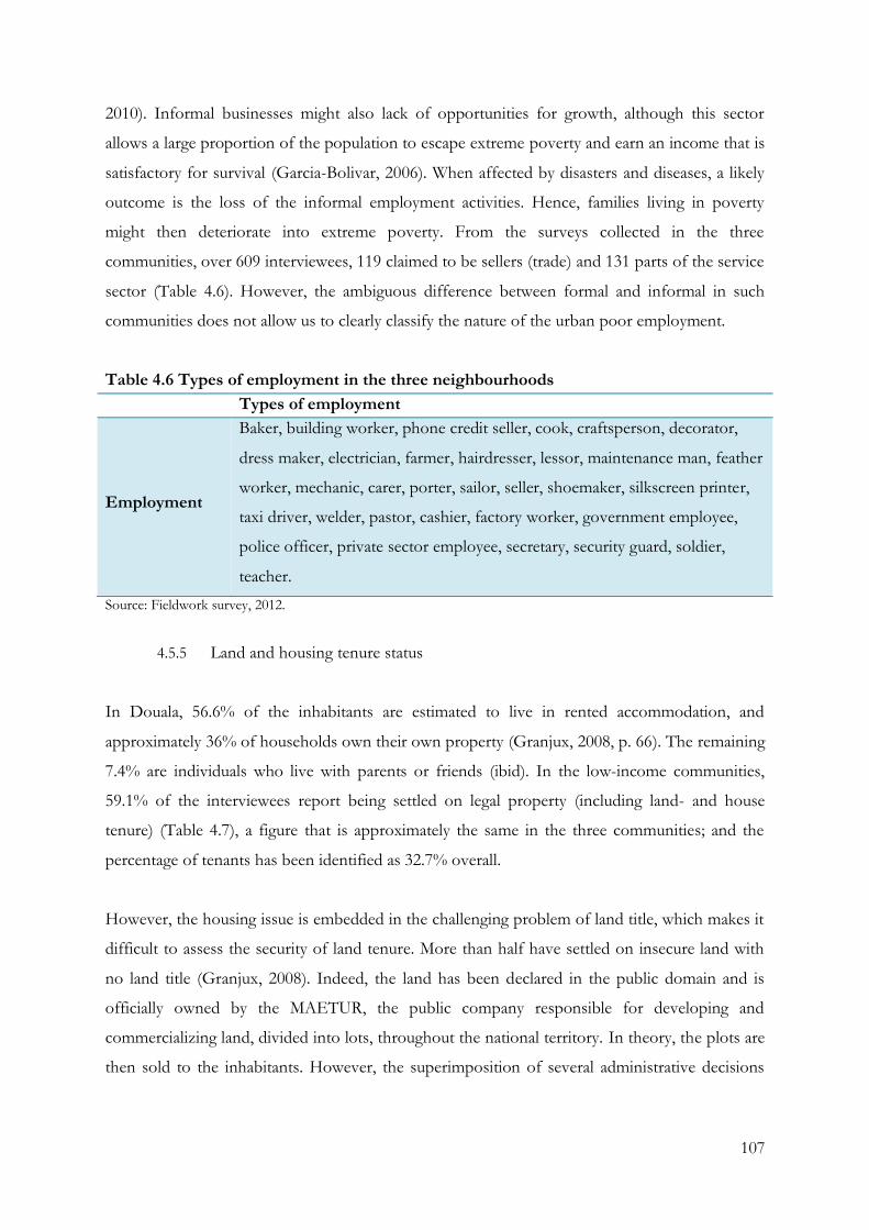
107
2010). Informal businesses might also lack of opportunities for growth, although this sector
allows a large proportion of the population to escape extreme poverty and earn an income that is
satisfactory for survival (Garcia-Bolivar, 2006). When affected by disasters and diseases, a likely
outcome is the loss of the informal employment activities. Hence, families living in poverty
might then deteriorate into extreme poverty. From the surveys collected in the three
communities, over 609 interviewees, 119 claimed to be sellers (trade) and 131 parts of the service
sector (Table 4.6). However, the ambiguous difference between formal and informal in such
communities does not allow us to clearly classify the nature of the urban poor employment.
Table 4.6 Types of employment in the three neighbourhoods
Types of employment
Employment
Baker, building worker, phone credit seller, cook, craftsperson, decorator,
dress maker, electrician, farmer, hairdresser, lessor, maintenance man, feather
worker, mechanic, carer, porter, sailor, seller, shoemaker, silkscreen printer,
taxi driver, welder, pastor, cashier, factory worker, government employee,
police officer, private sector employee, secretary, security guard, soldier,
teacher.
Source: Fieldwork survey, 2012.
4.5.5 Land and housing tenure status
In Douala, 56.6% of the inhabitants are estimated to live in rented accommodation, and
approximately 36% of households own their own property (Granjux, 2008, p. 66). The remaining
7.4% are individuals who live with parents or friends (ibid). In the low-income communities,
59.1% of the interviewees report being settled on legal property (including land- and house
tenure) (Table 4.7), a figure that is approximately the same in the three communities; and the
percentage of tenants has been identified as 32.7% overall.
However, the housing issue is embedded in the challenging problem of land title, which makes it
difficult to assess the security of land tenure. More than half have settled on insecure land with
no land title (Granjux, 2008). Indeed, the land has been declared in the public domain and is
officially owned by the MAETUR, the public company responsible for developing and
commercializing land, divided into lots, throughout the national territory. In theory, the plots are
then sold to the inhabitants. However, the superimposition of several administrative decisions
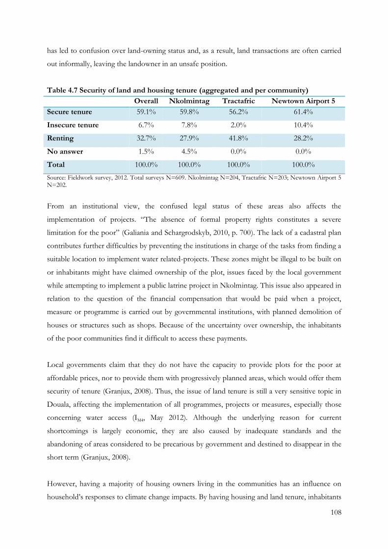
108
has led to confusion over land-owning status and, as a result, land transactions are often carried
out informally, leaving the landowner in an unsafe position.
Table 4.7 Security of land and housing tenure (aggregated and per community)
Overall Nkolmintag Tractafric Newtown Airport 5
Secure tenure 59.1% 59.8% 56.2% 61.4%
Insecure tenure 6.7% 7.8% 2.0% 10.4%
Renting 32.7% 27.9% 41.8% 28.2%
No answer 1.5% 4.5% 0.0% 0.0%
Total 100.0% 100.0% 100.0% 100.0%
Source: Fieldwork survey, 2012. Total surveys N=609. Nkolmintag N=204, Tractafric N=203; Newtown Airport 5 N=202.
From an institutional view, the confused legal status of these areas also affects the
implementation of projects. “The absence of formal property rights constitutes a severe
limitation for the poor” (Galiania and Schargrodskyb, 2010, p. 700). The lack of a cadastral plan
contributes further difficulties by preventing the institutions in charge of the tasks from finding a
suitable location to implement water related-projects. These zones might be illegal to be built on
or inhabitants might have claimed ownership of the plot, issues faced by the local government
while attempting to implement a public latrine project in Nkolmintag. This issue also appeared in
relation to the question of the financial compensation that would be paid when a project,
measure or programme is carried out by governmental institutions, with planned demolition of
houses or structures such as shops. Because of the uncertainty over ownership, the inhabitants
of the poor communities find it difficult to access these payments.
Local governments claim that they do not have the capacity to provide plots for the poor at
affordable prices, nor to provide them with progressively planned areas, which would offer them
security of tenure (Granjux, 2008). Thus, the issue of land tenure is still a very sensitive topic in
Douala, affecting the implementation of all programmes, projects or measures, especially those
concerning water access (IM4, May 2012). Although the underlying reason for current
shortcomings is largely economic, they are also caused by inadequate standards and the
abandoning of areas considered to be precarious by government and destined to disappear in the
short term (Granjux, 2008).
However, having a majority of housing owners living in the communities has an influence on
household’s responses to climate change impacts. By having housing and land tenure, inhabitants
109
would have more concern, will and power to adapt to protect their assets (Mycoo, 2014),
although much low-income housing is of poor quality and it would require major investment for
the urban poor to build housing resistant to the increase of extreme weather. Moreover, even if
adaptive capacity seems to be improved by housing and land tenure, design, materials, and
construction methods might also be inappropriate given the increasing exposure and sensitivity
to extreme weather (Feiden, 2011). Thus, land-tenure seems to have an influence on adaptive
capacity, however, their exposure to climate change impacts still prevents further reduction of
the vulnerability of the urban poor.
4.6. Conclusion
This chapter provided basic information about the context of the study area where the research
was undertaken to support the rationale for the first objective of this research. While recognizing
the challenges in which the DRM and IWRM frameworks are implemented, it has been also
necessary to describe institutional arrangements in the city to understand that the
implementation of frameworks and autonomous adaptation to climate change do not occur in a
vacuum. Moreover, the examination of the consequences of the city’s rapid development that
contribute to the vulnerability of poor urban households help provide a contextual
understanding of the autonomous adaptation strategies employed by individuals and households
to transform their problems into opportunities.
The chapter showed that Douala is a post-colonial city that, as the main economic city of
Cameroon, has a highly strategic role in the country. It has abundant water resources. Situated on
a lagoon system influenced by plentiful surface water, it possesses an important network of
groundwater, present in several soil layers. However, these resources are severely threatened by
climate change and by anthropogenic exploitation leading to the urgent need for sustainable
water management responses facing climate change.
The need for improved water management also takes place in areas where intensive development
processes are occurring. The district Douala 2eme, where the three poor communities studied are
located, developed without urban planning and, as a result, is bogged down in land tenure and
titling problems that impact on the provision of basic services and infrastructures. The
superimposition of several administrative decisions has led to confusion in terms of land-owning
status, hindering the provision of road access, water and sanitation, while delays accumulated
110
over past decades challenge the implementation of projects and programmes by governmental
and non-governmental national and local institutions and organisations.
This chapter also provided the socio-economic characteristics of the communities that are
composed of small households living under the same roof. The majority of inhabitants attended
school until secondary level, with many going on to high school. However, in spite of being
educated, the level of unemployment is very high. Although monthly spending per family is
higher than the lowest poverty rates in the country, it is considerably less than the amount
considered as the average household living standard. These characteristics diminished the state’s
capacity for intervention. As a consequence, more people rely on parallel water systems outside
formal institutional arrangements.

111
Chapter 5: Hazards and Disaster Risk Management in Douala
The key objective of this research is to understand national and local policies, measures and
projects relating to water-related hazards and climate change, and how they impact on poor
urban communities. This chapter identifies and examines the national and local frameworks,
policies, measures and projects put in place to face climate change impacts on water resources.
Their effectiveness in dealing with these challenges is investigated by examining the causes and
impacts of the disasters and hazards that affect these communities. This chapter is divided into
six sections. The first section introduces the way the Disaster Risk Management framework has
been implemented in Cameroon. The next section analyses the most common hazards identified
by the inhabitants of the three low-income communities. Then a discussion of the causes of
these most commonly identified hazards follows. Finally, the chapter examines the institutional
arrangements and actions put in place to cope with water-related hazards, and concludes.
5.1 DRM framework and national institutional arrangements
In order to reduce the impact of hazards and to manage disasters, Cameroon has implemented a
Disaster Management System (DMS). Since it was first introduced in 1986, the DMS has been
modified several times: relating to Law No. 86-16 of 6 December 1986 that calls to reorganise
civil protection; Law No. 98-15 of 14 July 1998, relating to establishments classified as dangerous,
unhealthy, or obnoxious; Decree No. 98-31 of 9 March 1998, to determine the organisation of
emergency and relief plans; Decree No.96/054 of 12 March 1996, to determine the composition
and duties of the National Council for Civil Protection; and Decree No. 2004/99 of 26 April
2004, to reorganise the Ministry of Territorial Administration and Decentralisation (Ayanji, 2004).
The DMS has been implemented to face natural disasters, including mass movements (landslides,
rock slides, subsidence, and mudflows), earthquakes, volcanoes and gas emissions, drought,
violent winds (gales, storms, and tornadoes), heat waves, cold snaps, desertification and floods
(Bhavnani et al., 2008). The DMS national strategy is based on three complementary actions:
before, during, and after disasters (ibid). A large range of institutions are theoretically involved in
the implementation of the DRM framework: the Ministry of Defence, the Ministry of Public
Health (MINSANTE), the Ministry of Town Planning and Housing (MINDUH), the Ministry of
Transport, the Ministry of Social Affairs, the Ministry of Scientific and Technical Research and
its research institutions and others, but responsibility mainly belongs to the Direction of Civil

112
Protection (DCP) in the Ministry of Territorial Administration and Decentralisation (MINATD),
created specifically for this purpose in 2004 (Ayanji, 2004) .
The body with overall responsibility for the decentralisation process, MINADT is also
responsible for the development, implementation, and evaluation of the government's policy on
land administration (ILM1, June 2012). Its other activities include the organisation and functioning
of the administrative districts and local territorial administration, the preparation and
implementation of laws and regulations, the organisation and monitoring of traditional
leadership, the monitoring of charity activities, political movements, organisations and NGOs,
the maintenance of public order, the development, monitoring, and implementation of the
regulations concerning the organisation and operation of regional and local authorities, and
regular evaluation of the decentralisation process (ILM1, June 2012). Therefore, the role of the
MINADT is critical in the governance of Cameroon. It is responsible for key functions in the
urban communities such as the nomination of the community leader, therefore, having a strong
influence on one of the lowest levels of governance of the cities. Also in charge of the
decentralisation process regulations concerning the organisation and operation of regional and
local authorities, it is able to formulate pro-poor policies and measures, as well as empower local
government, which has already been shown in studies to have a significant role in climate change
adaptation and mitigation responses (Moser and Satterthwaite, 2008).
With regard to the DRM, MINADT is in charge of developing and implementing the regulations
and standards for preventing and managing risks and natural disasters in collaboration with the
other authorities concerned, and it coordinates the institutional response to facing national and
international disaster (IM4, June 2012). The ministry is divided into three departments, each of
which has responsibility for a specific area, of which the Directorate of Civil Protection (DCP) is
specifically in charge of implementing the framework (IM4, June 2012).
The DCP’s main office is located in Yaoundé, and responsibility for the framework’s
implementation in Douala is delegated to the regional representatives of MINATD as part of the
Cameroonian decentralisation reforms (IM2, April 2012). The MINATD regional delegation is
consequently the main institution in charge of the DRM strategy in Douala, although no specific
team has been allocated to the task within the delegation. The DCP was created to implement
the measures and projects of the DRM framework, with a three-prong strategy, and its main
mission is to ensure the permanent protection of people, assets, and the environment from
113
serious accidents, risks, disasters. Under the coordination of MINATD, the DCP is organised
into four units: research and prevention, the sub-direction, the permanent secretariat, and the
National Risk Observatory (RNO). Although the DCP benefits from its own intervention team
in Yaoundé, in Douala, the DCP is supported by the fire services.
The RNO aims to collect, manage, and disperse information about natural, technological,
industrial, and anthropogenic risks, as well as rationalising the lasting prevention of major risks
and promoting understanding of risks, accidents, and disasters (IM1, April 2012). It is responsible
for the national implementation of a monitoring network for sites and high-risk plants, as well as
a network for collecting and distributing data and information concerning risks (IM1, April 2012).
It is also in charge of creating a database and setting up awareness information campaigns. It has
a coordinating function between the authorities and the national, international, public, and
private organisations involved in preventive risk management (IM1, April 2012). It is tasked by
MINATD with setting up a system linking the central headquarters with several regional
observations and monitoring centres. At the moment, there is no national database of disasters,
and producing one is the main priority of this institution (IM1, April 2012).
5.2 DRM and local institutional arrangements
As noted previously, a large number of institutions should be involved in implementing the
Disaster Risk Management framework under the responsibility of the MINATD. However, the
framework falls within the scope of the decentralisation reforms set in motion by the
Cameroonian government after 1996. Thus, institutions at provincial, departmental, district and
city level are involved in the implementation of the DRM. Among the list of actors, institutions
and organisations that should be involved in Disaster Risk Management in Douala, six were
identified as playing a major role in the majority of water-related disasters affecting the city: the
delegation of MINATD, the departmental delegation of the MINDUH, Douala’s fire service and
MINSANTE, CUD and city hall. At the time this research, the institutions and organisations
specifically in charge of the DRM framework, such as the DCP, were not identified. Hence, the
responsibility of the framework is thereby attributed to be the divisional officer. The DRM
framework appears to be implemented with a top-down approach, although local institutions
and organisations appear to have a key role in the implementation of the mitigation measures.
114
Although the role of local authorities is not explicitly stated in the legislation, they are also
heavily involved in water-related emergency prevention and small-scale mitigation measures in
the city, such as the disinfection of public water accesses and its shut down when considered as a
high public health risk, or the cleaning out of drains. They play a key role in disaster prevention
and management, often acting together (ILG5, March 2012). A typical measure adopted by Douala
Urban Council for fighting cholera is to disinfect wells (definition see Appendix 1) and ensure
the affected communities have the knowledge and equipment to continue the disinfection
programme themselves (ILG2, April 2012). Small drains are cleaned out regularly by the city hall
services, and tools can be borrowed from the city hall of Douala II to help the inhabitants of
inaccessible areas carry on the fight against cholera and malaria and also against flooding (ILG1,
April 2012). Hygiene awareness campaigns are also carried out, with the city hall distributing
pamphlets to explain how to build permeable latrines (ILG2, April 2012). Other awareness
campaigns also give advice on the action to take in case of flooding (ILG2, April 2012). However,
as local authorities do not manage large amount of resources, their impact on communities is
limited, and the inhabitants may also not be able to follow their advice (ILG2, April 2012).
The fire service is the crucial arm of the DRM in Douala (ILM1, June 2012). Indeed, this
institutional body is one of the primary physical structures, technical facilities and systems that
are socially, economically, or operationally essential to the functioning of a society or community,
both in routine circumstances and in the extreme circumstances of an emergency. The fire
service in Douala is a military section attached to the Ministry of Defence (ILEA, April 2012).
Although commanded by the general in charge of the ministry, it is employed by MINATD and
answers emergency calls from the public from car accidents to flooding (ILEA, April 2012). Whilst
possessing equipment to face water-related disasters, its main activity is to deal with fire
emergencies (ILEA, April 2012). In Douala, it is the first response unit of the city and can be called
upon in all cases of disaster or emergency, including flooding, though the lack of road access to
the city’s low-income communities and of a water discharge system seriously reduces their
capacity to fight such disasters (ILEA, April 2012). Moreover, the frequent occurrence of floods
generates a feeling of “normality” and the settlements, in the main, do not call upon the fire
service for help at such times (fieldwork notes, 2012).
In Douala, the DRM framework concentrates on the increase in magnitude and frequency of
short-term extreme weather and accidents through the intervention of the fire brigade prepared
to answer emergency calls from the population (ILM1, June 2012). As a result of this focus,
115
bottom-up strategies implemented by low-income communities and local governments are rarely
integrated within the implementation of the framework. While addressing pre and post disaster
actions, the framework mostly addresses related structural and expensive solutions. However,
financial resources for implementing the system in the city are also an issue as national funding is
often delayed and might not be accessed locally (ILM1, June 2012). The mobilisation of
complementary resources from other partners to implement the national disaster management
system is challenging, especially in carrying out prevention and mitigation measures and
programmes, in spite of the regular occurrence of disasters. ILM1 (June 2012) states: “I would ask
for a vehicle to facilitate our work on the field, and communication means, and a functioning
budget”. This deficiency is acknowledged as a major obstacle in the effective implementation of
the DRM at a local level, despite the cooperation of local intervention actors such as the fire
service.
5.3 Hazards in Doula’s low-income communities
Tchangang’s (2011) map of the natural hazards that occur in the city of Douala shows that they
are not restricted to a particular district but affect the entire city, among which flooding appears
to be the main and not a new issue. Indeed, Tchangang (2011) also reminds us that eight major
floods have been recorded since 1990, growing in frequency and intensity (Map 5.1). However,
the city of Douala is exposed to both natural and industrial hazards, among which surface water
and groundwater contamination, water-related public health hazards, and flooding are recognised
as the most threatening. Illustrating this problem, the Head of Planning at the city hall of Douala
2 also states: “In these areas, when it rains, there is very widespead flooding. […] And there is no
drainage system in these areas. You know, Douala is located on a plain. The city is flat so water
does not drain easily away. When water stagnates somewhere, you need sun and time for it to
drain off” (ILG6, May 2012).
More particularly in the three low-income neighbourhoods of this study, the inhabitants of
Nkolmintag, Tractafric and Newtown Airport 5, are subject to several natural hazards, including
flooding, storms, drought and heat waves (Figure 5.1, Table 5.1). Of these, flooding was
identified as the main hazard by 69.6% of interviewees, varying from 90.6% in Nkolmintag to 42%
in Tractafric.
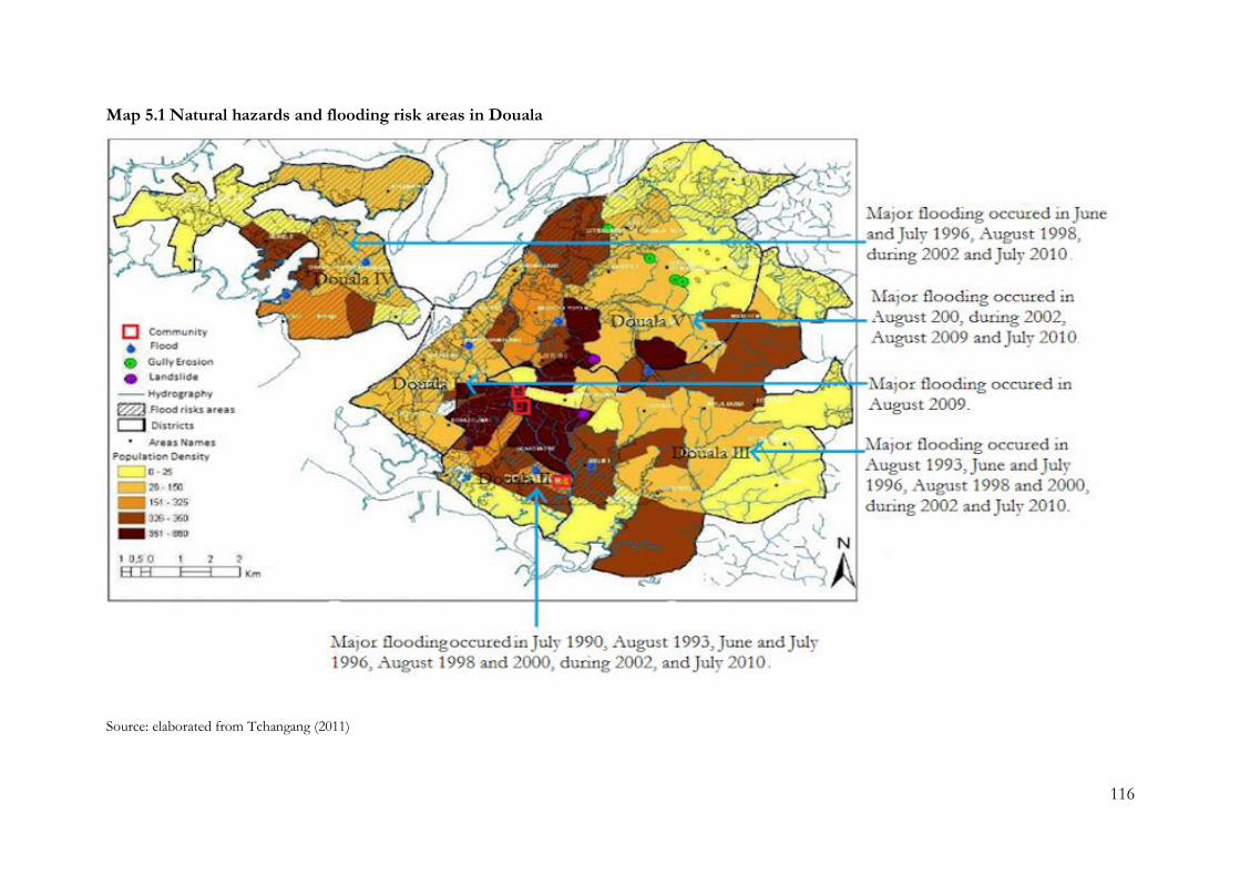
116
Map 5.1 Natural hazards and flooding risk areas in Douala
Source: elaborated from Tchangang (2011)
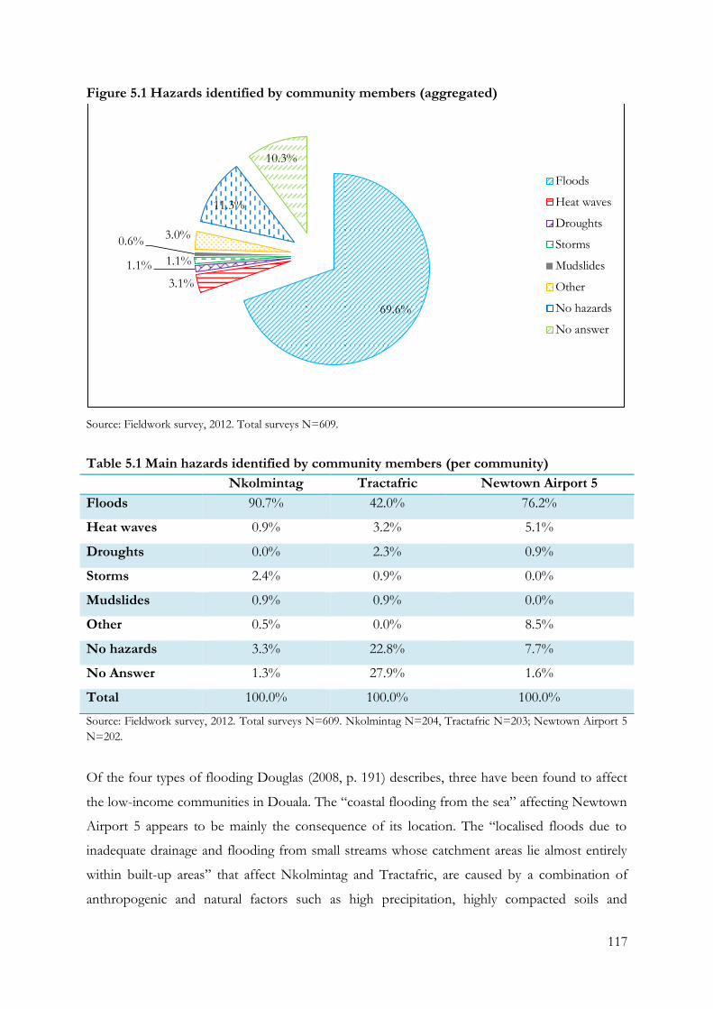
117
Figure 5.1 Hazards identified by community members (aggregated)
Source: Fieldwork survey, 2012. Total surveys N=609.
Table 5.1 Main hazards identified by community members (per community)
Nkolmintag Tractafric Newtown Airport 5
Floods 90.7% 42.0% 76.2%
Heat waves 0.9% 3.2% 5.1%
Droughts 0.0% 2.3% 0.9%
Storms 2.4% 0.9% 0.0%
Mudslides 0.9% 0.9% 0.0%
Other 0.5% 0.0% 8.5%
No hazards 3.3% 22.8% 7.7%
No Answer 1.3% 27.9% 1.6%
Total 100.0% 100.0% 100.0%
Source: Fieldwork survey, 2012. Total surveys N=609. Nkolmintag N=204, Tractafric N=203; Newtown Airport 5
N=202.
Of the four types of flooding Douglas (2008, p. 191) describes, three have been found to affect
the low-income communities in Douala. The “coastal flooding from the sea” affecting Newtown
Airport 5 appears to be mainly the consequence of its location. The “localised floods due to
inadequate drainage and flooding from small streams whose catchment areas lie almost entirely
within built-up areas” that affect Nkolmintag and Tractafric, are caused by a combination of
anthropogenic and natural factors such as high precipitation, highly compacted soils and
69.6%
3.1%
1.1% 1.1%
0.6% 3.0%
11.3%
10.3%
Floods
Heat waves
Droughts
Storms
Mudslides
Other
No hazards
No answer
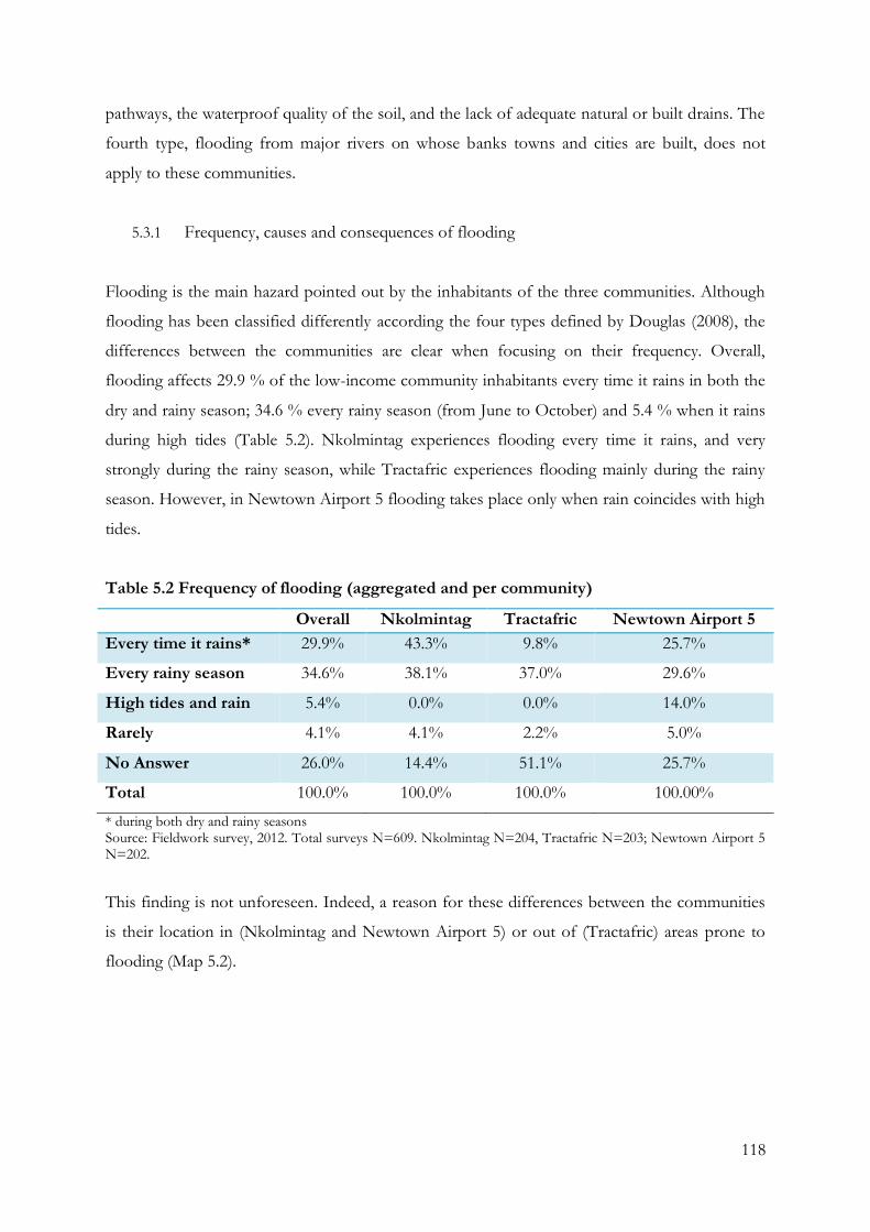
118
pathways, the waterproof quality of the soil, and the lack of adequate natural or built drains. The
fourth type, flooding from major rivers on whose banks towns and cities are built, does not
apply to these communities.
5.3.1 Frequency, causes and consequences of flooding
Flooding is the main hazard pointed out by the inhabitants of the three communities. Although
flooding has been classified differently according the four types defined by Douglas (2008), the
differences between the communities are clear when focusing on their frequency. Overall,
flooding affects 29.9 % of the low-income community inhabitants every time it rains in both the
dry and rainy season; 34.6 % every rainy season (from June to October) and 5.4 % when it rains
during high tides (Table 5.2). Nkolmintag experiences flooding every time it rains, and very
strongly during the rainy season, while Tractafric experiences flooding mainly during the rainy
season. However, in Newtown Airport 5 flooding takes place only when rain coincides with high
tides.
Table 5.2 Frequency of flooding (aggregated and per community)
Overall Nkolmintag Tractafric Newtown Airport 5
Every time it rains* 29.9% 43.3% 9.8% 25.7%
Every rainy season 34.6% 38.1% 37.0% 29.6%
High tides and rain 5.4% 0.0% 0.0% 14.0%
Rarely 4.1% 4.1% 2.2% 5.0%
No Answer 26.0% 14.4% 51.1% 25.7%
Total 100.0% 100.0% 100.0% 100.00%
* during both dry and rainy seasons Source: Fieldwork survey, 2012. Total surveys N=609. Nkolmintag N=204, Tractafric N=203; Newtown Airport 5 N=202.
This finding is not unforeseen. Indeed, a reason for these differences between the communities
is their location in (Nkolmintag and Newtown Airport 5) or out of (Tractafric) areas prone to
flooding (Map 5.2).
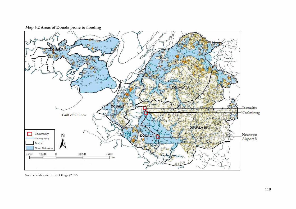
119
Map 5.2 Areas of Douala prone to flooding
Source: elaborated from Olinga (2012).
120
As noted in Chapter 4, the city’s coastal location in terms of alluvial soils, rainfall intensity, and
geographical localisation at the interface of continental and maritime hazards influences the
dynamics of flooding. Moreover, the broad embayment opening into the Gulf of Guinea
amplifies tidal movements into Douala’s urban area, which is consequently at high risk of
flooding.
At an ecological level, there are natural factors such as rainfall, which averages 4100 mm
per year. This intensive rain is already a factor [of flooding] in itself and we note that in the
second period of the year, the monsoon reaches us and it rains continuously for 2 to 3
days. […] The city is built on a swamp, which has been occupied. Soil has been used to fill
the swamp but the substrate is not solid, therefore there is a high risk of flooding (IA1,
March 2012).
The geography of the city thus creates an environment naturally prone to flooding, added to
which the uncontrolled urbanisation of Douala, has led to the development of poor settlements
on former swampland or in dwellings built on stilts in tidewater areas such as Newtown Airport
5. This also explains the fact that when high tides occur, or when they coincide with heavy rain,
flooding occurs, affecting as many as 14 % of the households as seen earlier in Table 5.2.
Although Newtown Airport 5 is also located in the area most at risk of flooding, Nkolmintag
appears to be the area most affected by floods. Recent drainage projects carried out in the
neighbouring sub-district, which empty their rainwater and water waste into the drains crossing
Nkolmintag, have exacerbated the existing issue of water discharge and led to an observable
increase in the amount of floodwater (ILG11, March 2012). Moreover, built and natural dams are
often blocked by solid waste, sediment or vegetation. Indeed, the stream channels contain a
significant amount of urban waste, reducing flow efficiency, in spite of regular dredging of the
main streams and drains. As a result, streams rise rapidly after rainfall and regularly overflow in
spite of the preventive measures taken by local authorities.
Moreover, even when a drainage system exists, it is not extensive enough to allow the full
discharge of rainwater, as seen in Nkolmintag. Many streams were diverted into underground
pipes during the post-colonial period without consideration for the future growth of the city.
Building construction has reduced the amount of permeable land and added a large amount of
121
wastewater to the original streams. As a result, the water discharge system is unable to cope with
the increased volume of water needing to be evacuated.
Water does not infiltrate normally any more due to the spatial demographic expansion and
the expansion of built areas on these impermeable soils; and flooding occurs. Moreover,
constructions have minimised the possibility of water infiltration as streams were
transformed in the 60s without taking into account the expansion of the city. Numerous
water streams have been buried, or diverted into gutters without taking into account their
flow increase (IA1, March 2012).
However, this factor is not fully addressed by the DRM framework. MINDUH has responsibility
for dealing with the issue, but finding a workable solution requires a large amount of financial
investment as well as scientific data that the local authorities do not possess. The delays
accumulated over past decades challenge the implementation of projects and programmes by
governmental and non-governmental national, and local institutions and organisations noted in
chapter 4 exacerbate the problem.
Flooding has serious consequences for low-income communities, as listed in Table 5.3. Some
29.1% of interviewees had lost their household furniture as the result of flooding, and 16.1% had
damage to their buildings – to the point that houses might collapse and become uninhabitable
(see Image 5.1). However, it is striking that although all three communities are impacted,
Newtown Airport 5, which is the most vulnerable to flooding in terms of location, appears to be
the least affected in terms of material damage.
During flooding, as one community inhabitant commented: “everything is swimming”
(Community Member, fieldwork notes, April 2012). Nevertheless, their housing conditions
typically remain functional and residents rarely migrate to other areas – often an impossibility
due to the neighbourhoods’ low incomes and the lack of other places to settle (ibid). In “other”
in Table 5.3, electricity outages and the destruction of roads, paths and bridges were the
predominant answers. However, Table 5.3 also shows that 24.1% of the interviewees claimed to
be unaffected by the flooding. Water inundates the streets and paths, but does not reach their
houses. Hence, these impacts do not directly affect the house, but have an influence on carrying
out everyday activities. This percentage prompts two observations: first, as floods occur so
frequently, community inhabitants perceive them to be normal events, an argument that is also

122
supported by the high number of “no hazards” answers at first (11.2%) (see Figure 5.1); second,
they lead local inhabitants to put in place autonomous strategies to minimise their impacts,
similar to other observations in other African cities (Adelekan, 2010). This will be further
explained in Chapter 7.
Table 5.3 Main physical consequences of floods (aggregated and per community)
Overall Nkolmintag Tractafric Newtown Airport 5
Loss of the entire house 7.6% 9.0% 11.5% 3.7%
House partially inhabitable 6.4% 5.3% 11.5% 5.0%
Damages to house walls 16.1% 14.6% 16.8% 17.6%
Loss of furniture 29.1% 35.6% 27.5% 21.8%
Not affected 24.1% 17.6% 16.8% 36.4%
Other* 12.7% 13.3% 9.9% 13.4%
No Answer 4.0% 4.7% 6.1% 2.1%
Total 100.0% 100.0% 100.0% 100.0%
* In “other” were mainly identified electricity outages and the destruction of roads, paths and bridges. Source: Fieldwork survey, 2012. Total surveys N=609. Nkolmintag N=204, Tractafric N=203; Newtown Airport 5 N=202.
Image 5.1 Collapsed building caused by the rain in Tractafric
Source: Author, 2012
123
5.3.2 Water-related epidemics and its consequences
Douala’s environment also generates suitable conditions for the spreading of water-related
diseases. These biological hazards are recurrent events among the poor communities.
“Epidemics are a major problem. [During the completion of the IWRM framework reports], we
assessed the major issues […] and we found out that epidemiological risks are one of the main
problems of the five [water] basins. […]” (IA2, June 2012). Amongst the water-related diseases,
malaria and cholera were chosen as focuses for this research4. Epidemics and endemics of both
diseases pose a serious public health problem in Douala during both the dry and rainy season,
and there is available data about the preventive action currently being undertaken by institutions
and organisations at national and local level. Both diseases are widespread, with high death rates,
especially amongst the poorest communities (ILM3, June 2012).
Cholera is also not a new disease in Cameroon. The first recorded epidemic of cholera in
Cameroon peaked in 1970. Since then, significant cholera cases were reported in 1971, 1991,
1996, 1998, 2004 (strongly affecting Douala) and 2009 (MSF, 2012). More than 2,000 cases were
reported in 1971 with a high case fatality rate (CFR) of 15% (WHO, 2012). Today, this rate is
significantly reduced, showing an improvement in the institutional responses to the epidemics.
However, recurrent outbreaks of the disease show that deeper causes are involved, and even if
epidemics have been seen to decrease in incidence during the last decades (MSF, 2012), the
eradication of the disease is still a major challenge (ILM5, June 2012). “[In Douala], cholera is
endemic with epidemiological outbreaks. Epidemics mean that it is permanent, and we often
have epidemiologic upsurges, which indicate that the water factor is crucial. Although several
ministries intervene in the water issue, but we don’t know who intervenes in what” (IA2, June
2012).
Malaria is also a major public health concern throughout the whole city of Douala. Although
malaria occurs regularly in urban areas, only a limited number of studies have addressed the
epidemiology of this vector-borne disease in these settings. Indeed, Douala, the largest city in
Cameroon, has, paradoxically, received the least attention (Antonio-Nkondjio et al., 2012).
4 Although both diseases are linked to water, they have different causes. Malaria is an endemic vector-borne disease, transmitted by mosquitoes breeding in stagnant water and water discharge. Cholera is an epidemic waterborne disease, caused by pathogenic microorganisms most commonly transmitted in sewage-contaminated freshwater (WHO, 2014a; WHO, 2014b).
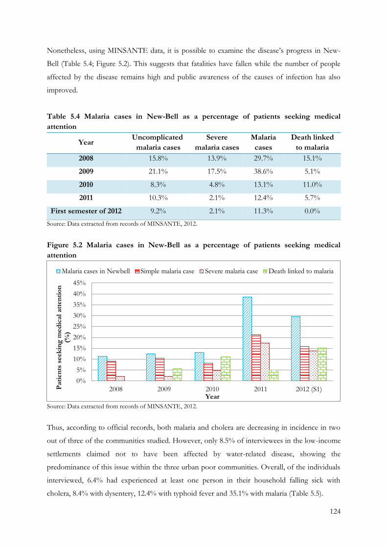
124
Nonetheless, using MINSANTE data, it is possible to examine the disease’s progress in New-
Bell (Table 5.4; Figure 5.2). This suggests that fatalities have fallen while the number of people
affected by the disease remains high and public awareness of the causes of infection has also
improved.
Table 5.4 Malaria cases in New-Bell as a percentage of patients seeking medical
attention
Year Uncomplicated
malaria cases
Severe
malaria cases
Malaria
cases
Death linked
to malaria
2008 15.8% 13.9% 29.7% 15.1%
2009 21.1% 17.5% 38.6% 5.1%
2010 8.3% 4.8% 13.1% 11.0%
2011 10.3% 2.1% 12.4% 5.7%
First semester of 2012 9.2% 2.1% 11.3% 0.0%
Source: Data extracted from records of MINSANTE, 2012.
Figure 5.2 Malaria cases in New-Bell as a percentage of patients seeking medical
attention
Source: Data extracted from records of MINSANTE, 2012.
Thus, according to official records, both malaria and cholera are decreasing in incidence in two
out of three of the communities studied. However, only 8.5% of interviewees in the low-income
settlements claimed not to have been affected by water-related disease, showing the
predominance of this issue within the three urban poor communities. Overall, of the individuals
interviewed, 6.4% had experienced at least one person in their household falling sick with
cholera, 8.4% with dysentery, 12.4% with typhoid fever and 35.1% with malaria (Table 5.5).
0%
5%
10%
15%
20%
25%
30%
35%
40%
45%
2008 2009 2010 2011 2012 (S1)Pati
en
ts s
eek
ing
med
ical
att
en
tio
n
(%)
Year
Malaria cases in Newbell Simple malaria case Severe malaria case Death linked to malaria
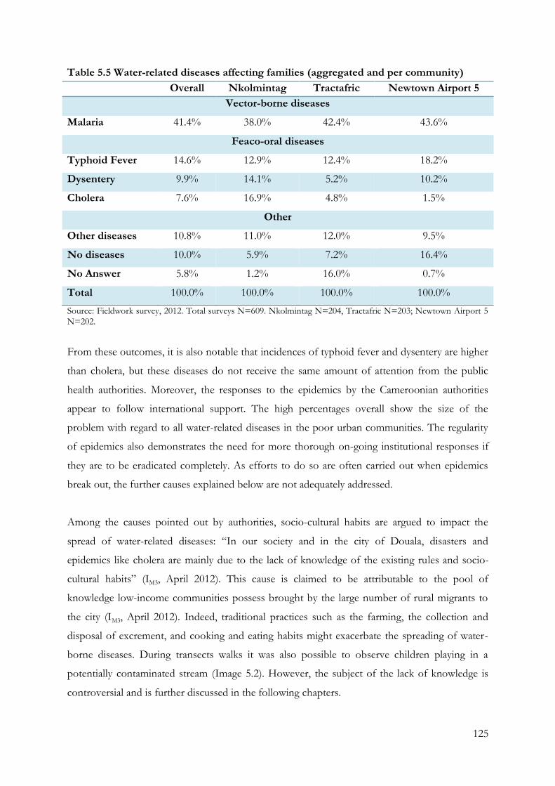
125
Table 5.5 Water-related diseases affecting families (aggregated and per community)
Overall Nkolmintag Tractafric Newtown Airport 5
Vector-borne diseases
Malaria 41.4% 38.0% 42.4% 43.6%
Feaco-oral diseases
Typhoid Fever 14.6% 12.9% 12.4% 18.2%
Dysentery 9.9% 14.1% 5.2% 10.2%
Cholera 7.6% 16.9% 4.8% 1.5%
Other
Other diseases 10.8% 11.0% 12.0% 9.5%
No diseases 10.0% 5.9% 7.2% 16.4%
No Answer 5.8% 1.2% 16.0% 0.7%
Total 100.0% 100.0% 100.0% 100.0%
Source: Fieldwork survey, 2012. Total surveys N=609. Nkolmintag N=204, Tractafric N=203; Newtown Airport 5 N=202.
From these outcomes, it is also notable that incidences of typhoid fever and dysentery are higher
than cholera, but these diseases do not receive the same amount of attention from the public
health authorities. Moreover, the responses to the epidemics by the Cameroonian authorities
appear to follow international support. The high percentages overall show the size of the
problem with regard to all water-related diseases in the poor urban communities. The regularity
of epidemics also demonstrates the need for more thorough on-going institutional responses if
they are to be eradicated completely. As efforts to do so are often carried out when epidemics
break out, the further causes explained below are not adequately addressed.
Among the causes pointed out by authorities, socio-cultural habits are argued to impact the
spread of water-related diseases: “In our society and in the city of Douala, disasters and
epidemics like cholera are mainly due to the lack of knowledge of the existing rules and socio-
cultural habits” (IM3, April 2012). This cause is claimed to be attributable to the pool of
knowledge low-income communities possess brought by the large number of rural migrants to
the city (IM3, April 2012). Indeed, traditional practices such as the farming, the collection and
disposal of excrement, and cooking and eating habits might exacerbate the spreading of water-
borne diseases. During transects walks it was also possible to observe children playing in a
potentially contaminated stream (Image 5.2). However, the subject of the lack of knowledge is
controversial and is further discussed in the following chapters.
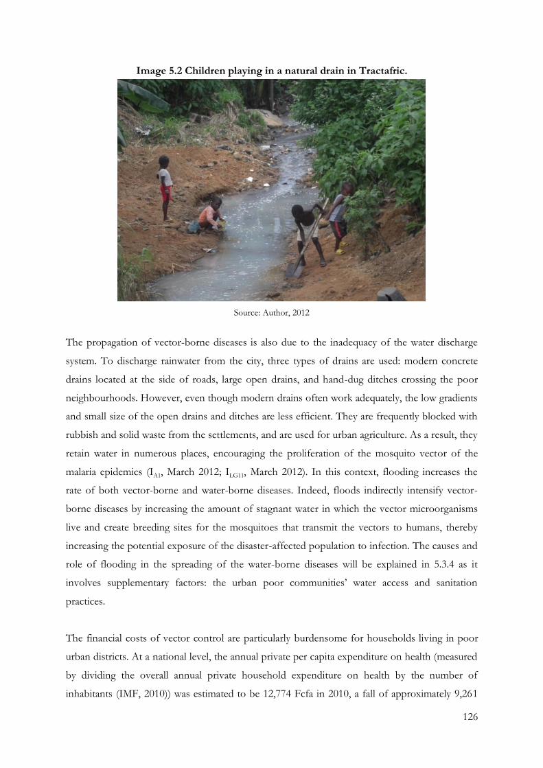
126
Image 5.2 Children playing in a natural drain in Tractafric.
Source: Author, 2012
The propagation of vector-borne diseases is also due to the inadequacy of the water discharge
system. To discharge rainwater from the city, three types of drains are used: modern concrete
drains located at the side of roads, large open drains, and hand-dug ditches crossing the poor
neighbourhoods. However, even though modern drains often work adequately, the low gradients
and small size of the open drains and ditches are less efficient. They are frequently blocked with
rubbish and solid waste from the settlements, and are used for urban agriculture. As a result, they
retain water in numerous places, encouraging the proliferation of the mosquito vector of the
malaria epidemics (IA1, March 2012; ILG11, March 2012). In this context, flooding increases the
rate of both vector-borne and water-borne diseases. Indeed, floods indirectly intensify vector-
borne diseases by increasing the amount of stagnant water in which the vector microorganisms
live and create breeding sites for the mosquitoes that transmit the vectors to humans, thereby
increasing the potential exposure of the disaster-affected population to infection. The causes and
role of flooding in the spreading of the water-borne diseases will be explained in 5.3.4 as it
involves supplementary factors: the urban poor communities’ water access and sanitation
practices.
The financial costs of vector control are particularly burdensome for households living in poor
urban districts. At a national level, the annual private per capita expenditure on health (measured
by dividing the overall annual private household expenditure on health by the number of
inhabitants (IMF, 2010)) was estimated to be 12,774 Fcfa in 2010, a fall of approximately 9,261
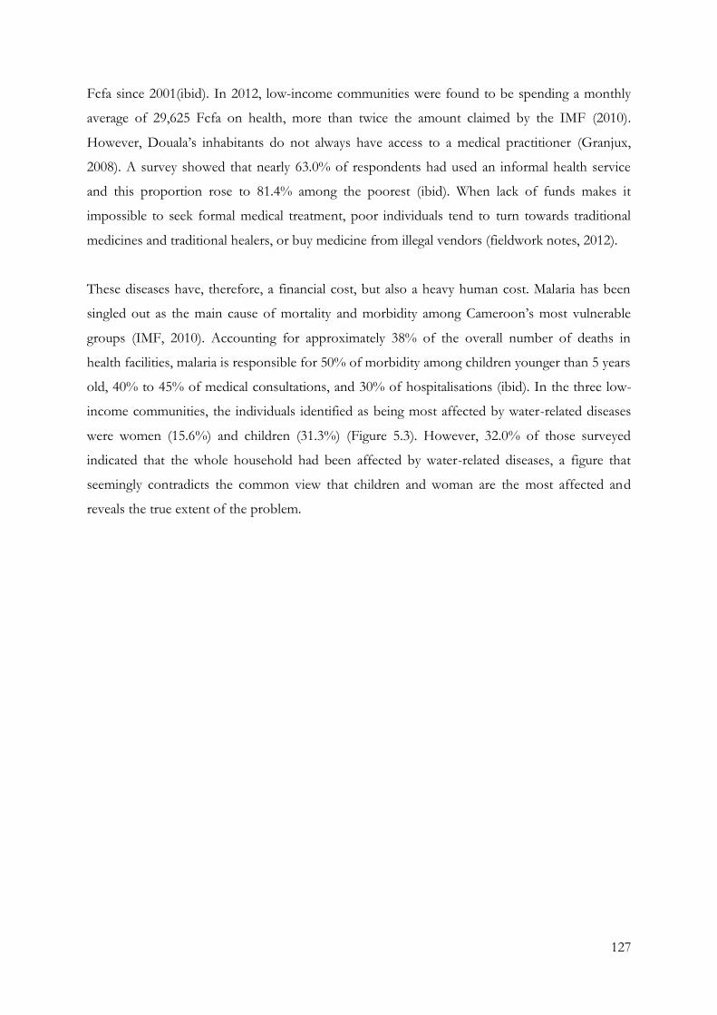
127
Fcfa since 2001(ibid). In 2012, low-income communities were found to be spending a monthly
average of 29,625 Fcfa on health, more than twice the amount claimed by the IMF (2010).
However, Douala’s inhabitants do not always have access to a medical practitioner (Granjux,
2008). A survey showed that nearly 63.0% of respondents had used an informal health service
and this proportion rose to 81.4% among the poorest (ibid). When lack of funds makes it
impossible to seek formal medical treatment, poor individuals tend to turn towards traditional
medicines and traditional healers, or buy medicine from illegal vendors (fieldwork notes, 2012).
These diseases have, therefore, a financial cost, but also a heavy human cost. Malaria has been
singled out as the main cause of mortality and morbidity among Cameroon’s most vulnerable
groups (IMF, 2010). Accounting for approximately 38% of the overall number of deaths in
health facilities, malaria is responsible for 50% of morbidity among children younger than 5 years
old, 40% to 45% of medical consultations, and 30% of hospitalisations (ibid). In the three low-
income communities, the individuals identified as being most affected by water-related diseases
were women (15.6%) and children (31.3%) (Figure 5.3). However, 32.0% of those surveyed
indicated that the whole household had been affected by water-related diseases, a figure that
seemingly contradicts the common view that children and woman are the most affected and
reveals the true extent of the problem.
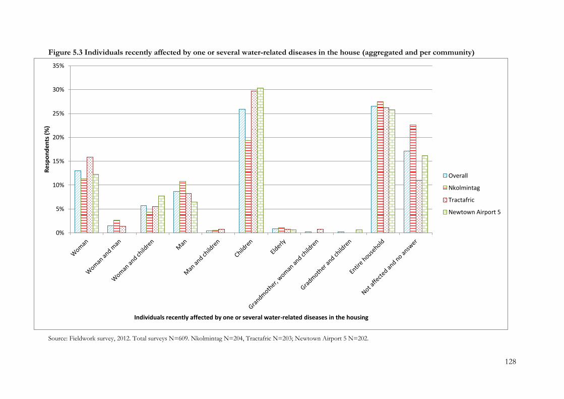
128
Figure 5.3 Individuals recently affected by one or several water-related diseases in the house (aggregated and per community)
Source: Fieldwork survey, 2012. Total surveys N=609. Nkolmintag N=204, Tractafric N=203; Newtown Airport 5 N=202.
0%
5%
10%
15%
20%
25%
30%
35%
Res
po
nd
ents
(%
)
Individuals recently affected by one or several water-related diseases in the housing
Overall
Nkolmintag
Tractafric
Newtown Airport 5
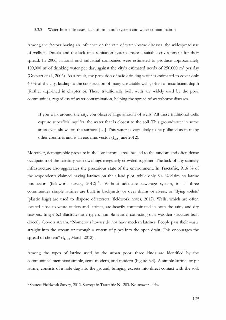
129
5.3.3 Water-borne diseases: lack of sanitation system and water contamination
Among the factors having an influence on the rate of water-borne diseases, the widespread use
of wells in Douala and the lack of a sanitation system create a suitable environment for their
spread. In 2006, national and industrial companies were estimated to produce approximately
100,000 m3 of drinking water per day, against the city’s estimated needs of 250,000 m3 per day
(Guevart et al., 2006). As a result, the provision of safe drinking water is estimated to cover only
40 % of the city, leading to the construction of many unsuitable wells, often of insufficient depth
(further explained in chapter 6). These traditionally built wells are widely used by the poor
communities, regardless of water contamination, helping the spread of waterborne diseases.
If you walk around the city, you observe large amount of wells. All these traditional wells
capture superficial aquifer, the water that is closest to the soil. This groundwater in some
areas even shows on the surface. […] This water is very likely to be polluted as in many
other countries and is an endemic vector (IA2, June 2012).
Moreover, demographic pressure in the low-income areas has led to the random and often dense
occupation of the territory with dwellings irregularly crowded together. The lack of any sanitary
infrastructure also aggravates the precarious state of the environment. In Tractafric, 91.6 % of
the respondents claimed having latrines on their land plot, while only 8.4 % claim no latrine
possession (fieldwork survey, 2012) 5 . Without adequate sewerage system, in all three
communities simple latrines are built in backyards, or over drains or rivers, or ‘flying toilets’
(plastic bags) are used to dispose of excreta (fieldwork notes, 2012). Wells, which are often
located close to waste outlets and latrines, are heavily contaminated in both the rainy and dry
seasons. Image 5.3 illustrates one type of simple latrine, consisting of a wooden structure built
directly above a stream. “Numerous houses do not have modern latrines. People pass their waste
straight into the stream or through a system of pipes into the open drain. This encourages the
spread of cholera” (ILG11 March 2012).
Among the types of latrine used by the urban poor, three kinds are identified by the
communities’ members: simple, semi-modern, and modern (Figure 5.4). A simple latrine, or pit
latrine, consists of a hole dug into the ground, bringing excreta into direct contact with the soil.
5 Source: Fieldwork Survey, 2012. Surveys in Tractafric N=203. No answer =0%.
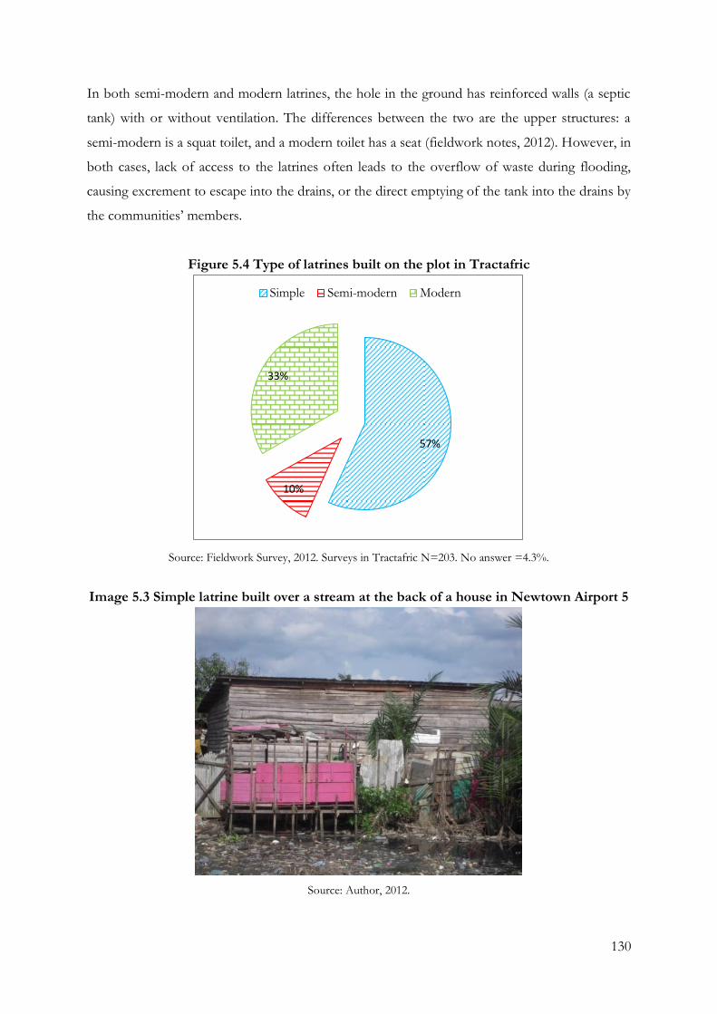
130
In both semi-modern and modern latrines, the hole in the ground has reinforced walls (a septic
tank) with or without ventilation. The differences between the two are the upper structures: a
semi-modern is a squat toilet, and a modern toilet has a seat (fieldwork notes, 2012). However, in
both cases, lack of access to the latrines often leads to the overflow of waste during flooding,
causing excrement to escape into the drains, or the direct emptying of the tank into the drains by
the communities’ members.
Figure 5.4 Type of latrines built on the plot in Tractafric
Source: Fieldwork Survey, 2012. Surveys in Tractafric N=203. No answer =4.3%.
Image 5.3 Simple latrine built over a stream at the back of a house in Newtown Airport 5
Source: Author, 2012.
57%
10%
33%
Simple Semi-modern Modern
131
Of similar significance is the fact that floods also exacerbate the low quality of local water by
mixing contaminated water and freshwater resources. Inhabitants have more difficulty in
accessing clean drinking water and the conditions allowing water-borne diseases to develop are
increased, a point stressed by a city hall official:
To attain adequate provision of water, flooding must be controlled. Whatever project we
carry out, if flooding is not managed, the project fails because most of the population still
obtain their water from wells, which are just below the level of the floodwater. Once the
latrines are flooded, everything mixes together, aggravated by the sandy soil of Douala
(ILG1, April 2012).
Floodwater is also used to discharge water waste by community members, increasing the
concentration of contaminating agents into the environment (fieldwork notes, 2012). Indeed, the
lack of sewage system and roads, limiting truck access, constrains the poor population to
discharge the latrines directly into the nearest drain or in the running water during flooding to
ensure the disposal of waste and avoid paying disposal services (Community member, fieldwork
notes, 2012).
The link between water availability, the lack of basic services and infrastructure in poor areas and
the incidence of diseases has long been recognised, and health is shown as a significant indicator
of quality and quantity of water (Hardoy, Satterthwaite and Mitlin, 2001; Thompson et al., 2000;
Stephens 1996, cited in Mitlin, 2002). Alcazar, Xu and Zuluaga (2000) state that, “…waterborne
and water-related diseases are a major cause of morbidity and mortality especially in the poorer
neighbourhoods […]. The medical costs and lost wages from such diseases were a high part of
household income for the poor […]” (Alcazar, Xu and Zuluaga, 2000, cited in Mitlin, 2002). The
level of water-related diseases encountered in the low-income communities of Douala support
this argument. Whilst the abundance of water resources potentially could lead to the reduction of
such diseases, the lack of proper sanitation and the prevalence of contamination of the water
resources impact the exposure and sensitivity of the urban poor communities to water-borne
diseases (ILM4, June 2012).
As a result, these unsanitary conditions expose the urban poor to a higher risk of infections by
both vector-borne and waterborne diseases, including malaria and cholera. Because of the
predicted increase of flooding, which have already been observed in other parts of Africa
132
(Douglas and Alam, 2006), and its resulting growth in mixing of waste water and clean water and
permanence of stagnant water, a rise of the water-related diseases would be expected.
5.4 Institutional responses to two main hazards impacts affecting Douala
As stated previously, the low-income communities in Douala are severely impacted by two main
hazards: flooding and weather-related epidemics. The measures and projects implemented by the
national and local authorities to minimise their impacts in these neighbourhoods are presented
below.
5.4.1 Institutions involved in flood management
At a national level, the Directorate of Civil Protection (DCP), part of the Ministry of Territorial
Administration and Decentralisation (MINTAD), addresses flooding through the
implementation of a sanitation master plan. This includes: projects to address emergency
rainwater drainage through the study of landscape design; the implementation of a monitoring
system; the building of water channels; the construction and maintenance of paths and access
ramps; underground construction; the cleaning out and renovation of parts of the drainage
system; and, the building of footbridges. The administrative authorities also aim to increase
awareness of the urban planning and settlements pattern norms. As a result, the authorities have
focused on corrective and preventive action.
In Douala, flood management is dealt by the Ministry of Urban Development and Housing
(MINDUH), under the responsibility of the MINTAD. Among its priorities are urban
regeneration, the renovation of road and canal networks and the electrical supply system, and the
improvement of public health care. The ministry is involved in several major drain construction
projects in the city of Douala, aimed at solving the problem of flooding (ILM6, March 2012).
Nevertheless, the scale of the work to be done is immense and is under continuous challenge
from the expansion of spontaneous settlements, irrespective of building construction regulations
inside and at the periphery of the city (ILM6, March 2012).
The local institutional actors, the city hall of Douala 2 and CUD, are also involved in managing
flooding. In 2011, a new plan for the city was designed and presented by the CUD, identifying
the city’s options for expansion until 2025. In this plan, two main objectives of development
133
were defined: the creation of a central business district and a logistics area close to the port,
airport and city centre, and the planning of infrastructure and equipment. However, the
implementation of these programmes and projects is threatened by the city’s pressing problems,
of which the taking over of non-building zones for spontaneous settlements by slum dwellers
and new migrants appears to be of a great concern for institutional actors (ILG4, May 2012). The
city hall also acknowledges that urban development has taken place with little respect for the
ecological dynamics, and that the construction of dams modifying river flows has changed the
use of land and introduced modifications upstream while offering protection to the city itself.
However, their impact is extremely limited. In this sense, ILG1 (April 2012) stated:
The city [Douala] is built on swamps, the population and the urban area are constantly
growing, people are coming but there is no space and freedom to settle everywhere. It can
be flooded or swampy, they don’t mind. As long as it is in an empty place, they will settle
there. […] However, life has rules. We say that nobody should ignore the laws even on
infrastructure; there is a minimum to respect. It is impossible to know that a place is
flooded and settle there. It is for your own good, not for mine. These are the issues we
encounter. In these areas, drains have to be cleaned out frequently because we encounter
difficulties in building them with concrete.
As a result, administrative authorities propose to reduce the vulnerability of the poor
neighbourhoods by relocating the population and rehabilitating the flooded areas, or by requiring
the sanitation departments to clean the drains. Nevertheless, evictions from high-risk areas to
minimise the impact of flooding are particularly unpopular and rarely possible due to the lack of
new land to give to the evicted and the large number of families settled in those areas. The lack
of alternative land and housing and basic infrastructure to offer to uprooted population, coupled
with the city’s on-going problem of land-titles, rules out any offer of compensation to the evicted
families.
From these discussions, it is possible to assume that the issue of flooding in Douala is not
integrated within a holistic framework and is mainly dealt with on its own. Moreover, they
support the argument that “the state allows such risks to exist as part of the politicised nature of
urban planning and control” (Douglas et al., 2008, p. 204) and that there is an urgent need to
increase the adaptive capacities of the urban poor to face these problems.
134
They need help at the local community level to improve their options for emergency
action and evacuation. They need help at the municipal level to improve drainage, to
regulate developments upstream and elsewhere that increase flooding in their communities,
and to give them greater security of tenure so that they can invest in making their homes
more flood resistant. They need help at the national level – particularly to ensure that their
needs are included in national disaster reduction plans and that these and other impacts of
climate change are included in poverty reduction strategies. They also need international
help to see that funding for adaptation to climate change is directed towards their
problems (ibid, p. 204).
5.4.2 Institutions involved in managing biological hazards
At a national level, the DCP also identifies recurrent water-related epidemics as disasters. The
main objectives of its public policies are to identify the ecological and environmental factors that
influence the spread of transmissible diseases and to implement measures to prevent and deal
with them (IM2, April 2012). In this context, the monitoring of water access and hygienic
conditions, air and water pollution, and control of food quality are primary concerns for
developing and coordinating measures to cope with epidemics. Other aims are the distribution of
information about endemic water-related diseases and methods of preventing them, and the
organisation of technical assistance through the pooling of knowledge and experience to allow
communities to take action themselves (IM2, April 2012). Multidisciplinary research into ways of
reducing the effects of tropical diseases locally is being intensified and expanded. This should
make it possible to base preventive action on epidemiology data and evaluate the efficiency of
other options. Similarly, investigation of local sanitary arrangements is currently being supported
and encouraged to determine the influence of cultural, behavioural and social factors on
preventive action (IM2, April 2012).
The severity of water-related epidemics in Douala’s poor neighbourhoods has also generated
responses from a number of institutions. At national and local level, epidemics are chiefly dealt
with by the Ministry of Public Health (MINSANTE) which is responsible for public health
services in the country (ILM3, June 2012). MINSANTE aims to promote the social and mental
health of the population. In Douala, MINSANTE focuses on monitoring and managing disease,
and undertakes numerous actions to attempt to minimise the epidemics (ILM3, June 2012).
Among the actions currently being undertaken by the ministry in collaboration with WHO,
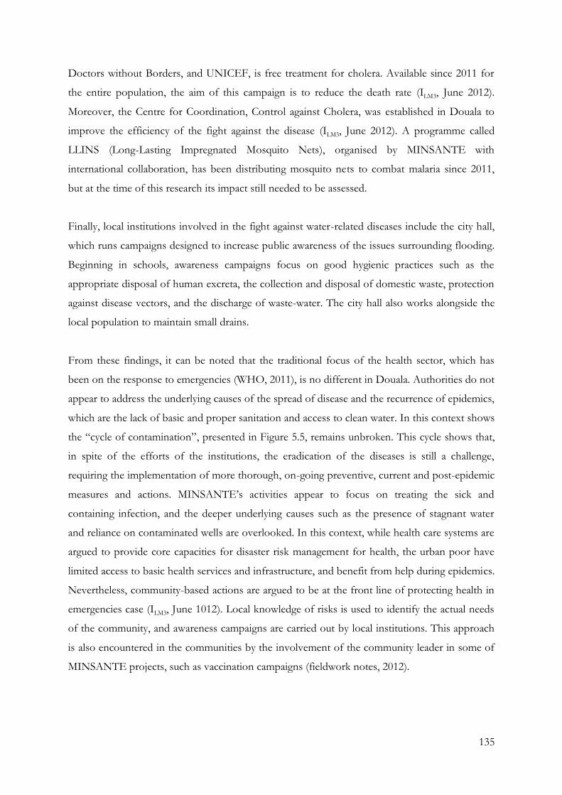
135
Doctors without Borders, and UNICEF, is free treatment for cholera. Available since 2011 for
the entire population, the aim of this campaign is to reduce the death rate (ILM3, June 2012).
Moreover, the Centre for Coordination, Control against Cholera, was established in Douala to
improve the efficiency of the fight against the disease (ILM3, June 2012). A programme called
LLINS (Long-Lasting Impregnated Mosquito Nets), organised by MINSANTE with
international collaboration, has been distributing mosquito nets to combat malaria since 2011,
but at the time of this research its impact still needed to be assessed.
Finally, local institutions involved in the fight against water-related diseases include the city hall,
which runs campaigns designed to increase public awareness of the issues surrounding flooding.
Beginning in schools, awareness campaigns focus on good hygienic practices such as the
appropriate disposal of human excreta, the collection and disposal of domestic waste, protection
against disease vectors, and the discharge of waste-water. The city hall also works alongside the
local population to maintain small drains.
From these findings, it can be noted that the traditional focus of the health sector, which has
been on the response to emergencies (WHO, 2011), is no different in Douala. Authorities do not
appear to address the underlying causes of the spread of disease and the recurrence of epidemics,
which are the lack of basic and proper sanitation and access to clean water. In this context shows
the “cycle of contamination”, presented in Figure 5.5, remains unbroken. This cycle shows that,
in spite of the efforts of the institutions, the eradication of the diseases is still a challenge,
requiring the implementation of more thorough, on-going preventive, current and post-epidemic
measures and actions. MINSANTE’s activities appear to focus on treating the sick and
containing infection, and the deeper underlying causes such as the presence of stagnant water
and reliance on contaminated wells are overlooked. In this context, while health care systems are
argued to provide core capacities for disaster risk management for health, the urban poor have
limited access to basic health services and infrastructure, and benefit from help during epidemics.
Nevertheless, community-based actions are argued to be at the front line of protecting health in
emergencies case (ILM3, June 1012). Local knowledge of risks is used to identify the actual needs
of the community, and awareness campaigns are carried out by local institutions. This approach
is also encountered in the communities by the involvement of the community leader in some of
MINSANTE projects, such as vaccination campaigns (fieldwork notes, 2012).
136
Figure 5.5 Contamination cycle
Endemic vector-borne diseases
Epidemic water-borne diseases
Flood water
Water for cooking, domestic
use, washing and bathing
Diseased person
Groundwater wells
Rainwater
Stagnant water
Development of water-related
diseases vector and/or
contamination of water by bacteria
Human waste in modern
and/or traditional
latrines
Flooding
Source: Author elaborated from Meva’a Abomo (2010) and analysis of fieldwork data, 2014.
5.5 Conclusion
As seen in this study, the poor urban neighbourhoods in Douala are exposed to hazards,
regularly leading to disasters. Predominant among them are flooding and water-related epidemics.
The causes of both hazards are closely linked and associated with the city’s natural features such
as location, soil and climate, added to which are anthropogenic factors including inappropriate or
inadequately maintained infrastructure, lack of access to adequate basic services, and high
population density in the poor settlements. As both natural and anthropogenic factors are
connected, making the low-income communities more vulnerable to flooding, this allows us to
define the phenomenon as a socio-natural water-related hazard. As a result, the inhabitants suffer
damage to houses, loss of furniture, electricity cuts and isolation from the rest of the city due to
the destruction of bridges, roads and paths, and water contamination, although the recurrence of
these hazards generates a feeling of normality so the poor settlements do not call upon the
official intervention teams when faced with flooding.
137
In this context, the DRM framework is designed and implemented to also face water-related
disasters. However, the framework appears to be a top-down system, hardly taking into account
the bottom-up strategies implemented locally, and focused on post-disaster responses. Hence, in
attempting to minimise the impacts of different hazards, the institutions in charge of dealing with
them appear to focus on emergency situations and so the underlying causes of the flooding and
the spread of water-related epidemics such as the lack of sanitation and access to clean water are
not addressed. This generates a supplementary difficulty in the implementation of mitigation and
prevention measures and projects at a local level. The reorganisation of the DCP and the
creation of the RNO to monitor the risks and impacts of disasters were beset by delays and
therefore records are poor, information is often incomplete, and there is a problem in defining
the priorities of the institutions and implementing specific sustainable solutions to local disasters.
This, along with the lack of a specific role for the local institutions, intensifies the challenges of
sustainably implementing the framework. Finally, even if these water issues are acknowledged by
authorities, the emergency actions taken in collaboration with the fire service do not reach the
poor communities due to the lack of road access and of a water discharge system.
The features preventing the DRM from having a good efficacy, typical of poor neighbourhoods,
increase the challenge of building long-term resilience. However, these findings also show the
gap between water-related hazards and water-access measures, projects and programmes. Indeed,
the intrinsic linkage between water disasters is often ignored. The failure to coordinate measures,
and the focus on a single water-related issue, leads to a series of temporary fixes that reduce the
effectiveness of the projects and programmes. Finally, the findings of limited impact on the
hazards and the lack of efficiency of DRM strengthen the link between the theoretical debates
discussed in chapter two with autonomous adaptation in urban poor communities.
138
Chapter 6: IWRM, water access and institutional water-related strategies in Douala
Chapter 6 focuses on the context and implementation of the Integrated Water Resources
Management framework (IWRM) and the water resources used by the low-income communities
in the city of Douala. Focusing first on the current legal framework in which water and sanitation
management is embedded, it then describes the institutions that should be involved. This section
also analyses the current implementation of the IWRM framework. The second section presents
the water access and costs for the low-income communities of Douala, as well as the issues
associated with the use of these water resources. Finally, the last section examines the
institutional water-related adaptation strategies already implemented or being implemented in the
poor neighbourhoods outside the IWRM and DRM framework.
The city of Douala is no exception to Cameroon’s drinking water and sanitation issues. As
already seen in Chapter 5, its population and institutions are facing major water-related problems
leading to significant health risks that may arise from consumption of water contaminated with
infectious agents and toxic chemicals. Although Cameroon transferred the water distribution
system from public services to a semi-private system, following the strongly promoted private-
sector participation of the 1990s, the challenges accumulated due to its population growth have
generated great difficulties in upgrading and managing the water and sanitation system in Douala.
In 2009, these issues were proclaimed by the institutions of the city as a priority in the agenda for
the development of the urban area of Douala (ILG4, May 2012). Nevertheless, in spite of their
attempts to improve the system, access to drinking water and proper sanitation still remains
difficult in the low-income communities.
6.1 Water management policies
In Cameroon, water policy is based on the law of 1998 which is still in effect today. “The 1996
law on the environment and the 1998 law on water are the cornerstones of the current legislation
on water”(Ako Ako et al., 2009, pp. 877-878). This policy framework makes provision for the
protection and conservation of water resources by creating participative management and
emphasising the economic value of water. Although Cameroon appears to have completed the
implementation of a sustainable water policy, the outcomes relating to the institutional
framework are “still below the average of its peer-group countries”, composed of the Sub-
Saharan countries (De Waal, 2010, p. 16).
139
The law is, indeed, very vague, and to correctly manage water, a framework is essential, a
law, but you also must have precise legislation and an effective implementation. However,
in Cameroon, legislations are not precise enough, they are copied from France, and the
implementation is lax. For example, everything regarding water catchment governance is
very lax. The security perimeter around the boreholes and public tap water are not
respected. These legislation and regulatory frameworks need to be developed (IM4, May
2012).
Regarding sanitation, the need for institutional strengthening of the legal framework for Douala
region’s sanitation system is also stressed because the existing policies only concern collective
urban sanitation and are generally not enforced (ILM2, April 2012). Indeed, in spite of the
institutional efforts carried out, analysis of the current legal policies concludes that there is a lack
of a specific corpus of laws regarding the regulation of liquid waste. This waste, which has
suffered from little interest from government and donors until recently, is not specified in the
existing policies, and rainwater drainage and wastewater are often not distinguished (ILM2, April
2012). Moreover, the objectives in the field of liquid waste are not appropriately specified and are
not defined according to the different environments (urban, rural). Finally, responsibilities are
often overlapping and not properly defined, and capacities of the different actors are not always
adapted to their mandates.
Similar to the DRM framework, water supply and sanitation regulations are also subjected to
decentralisation reforms. As a result, local institutional actors such as Douala Urban Council and
the city-halls are also involved in the implementation of the policies, programmes and projects
regarding water supply and sanitation access. However, their responsibilities in term of projects
undertaken are not properly defined.
6.1.1 Public-private partnership in the water sector in Douala
The water management system in Cameroon implemented a public-private partnership in the
water and sanitation sector, as promoted by World Bank Group and the International Monetary
Fund (Haughton, 2002; Budds and McGranahan, 2003). The institutional context of Cameroon’s
water sector is characterised by the central role played by the Ministry of Water and Energy
(MINEE) (ILM2, April 2012). The MINEE is responsible for the implementation of projects on
140
managing and controlling pollution, water supply, and sanitation in both urban and rural areas.
More specifically, the MINEE undertakes supervision of Camwater’s area of concession, and
thus that of the operator, Camerounaise des Eaux (ILM2, April 2012).
The management organisation between Cameroon Water Utilities Corporation (Camwater) and
Camerounaise des Eaux (CDE) is quite recent as the Cameroonian water management reform
took place in 2003. “The organisation of the water supply and sanitation subsector, its targets,
resources, and strategies, are essentially determined by the terms of the contract between the
state and Camwater, and by the terms of the lease contract between Camwater and CDE” (De
Waal, 2010, p. 14). A national company that was formed in 1967, called “Société Nationale des
Eaux du Cameroun” (SNEC), was privatised in 2008 with the establishment of a leasing contract
for the management and operation of urban facilities (IIF2, May 2012). This shift took place in
2005 with the creation of the parastatal company “Cameroon Water Utilities Corporation” and a
private company “Camerounaise des Eaux”.
In this context, CDE, born of the reform of the water sector undertaken by the Government of
Cameroon in 2005, was incorporated under Cameroonian law in December 2007 (IIF1, May 2012).
The CDE effectively started its activities in May 2008 with responsibility to provide drinking
water services to 110 urban and suburban centres during the lease period of ten years. The
company operates within the framework of a public-private partnership in tight collaboration
with other major national actors such as the MINEE and the Camwater (IIF1, May 2012). The
CDE aims to provide a public utility within the concept of sustainable development, aiming to
ensure continuity of drinking water supply, whilst improving the quality of the drinking water
services to customers and the efficiency of production, transport and distribution. The firm also
aims to increase the level of access to drinking water (IIF1, May 2012).
Camwater is a semi-public company with public legal responsibility and financial autonomy (IIF2,
May 2012). Under the technical supervision of the Ministry of Water and financial supervision of
the Ministry of Finance, Camwater manages water resources and property rights on behalf of the
State (IIF2, May 2012). The company is responsible for the planning, studies, research and
management of funding for all infrastructure and facilities, the production, transportation and
storage, the distribution and quality control of drinking water. The company is also in charge of
the construction, maintenance and management of the production infrastructure of drinking
141
water, as well as its storage and transportation. Camwater must inform the population about
drinking water and liquid sanitation in urban and suburban areas (IIF2, May 2012).
Thus the State appears to still strongly monitor and manage Cameroon’s water resources
management. The water management system between the CDE, Camwater and MINEE is
schematised as in Figure 6.1. While the private sector has a direct relationship with customers
and is contractually responsible for installing new connections, the public asset-holding company
is responsible for financing investment, carries infrastructure assets and decides when and where
to expand the network. In this context, Camwater appears to have a higher influence on design
and implement of pro-poor projects in the water and sanitation sector. Nevertheless, incentives
for the private operator to expand access are stronger because the operator does not invest its
own money in system expansion, so “it has every interest in pushing for more coverage” (Marin
et al., 2010, p. 2).
Between 2003 and 2008, the water management mechanism has been focusing on the sharing of
responsibilities (IIF2, May 2012). In 2008, the last agreements between the government and CDE
were signed, officially starting the new management mechanism. Water management of the
urban area of Douala was finally entrusted to the two companies - Camwater and the CDE -
under the supervision of the Minister of Water and Energy. However, by focusing on creating
favourable conditions for privatisation and private investments, the CDE has not been able to be
fully operational during the implementation of this partnership, and the backlogs already faced
by the previous public company have been accumulated (IIF2, May 2012). In 2012, Camwater was
still providing only approximately 35 % of the water supply from rivers and groundwater
resources to households living in the city (IIF2, May 2012). Moreover, this focus might also
continue as Camwater have to look for private investments for the implementation of projects.
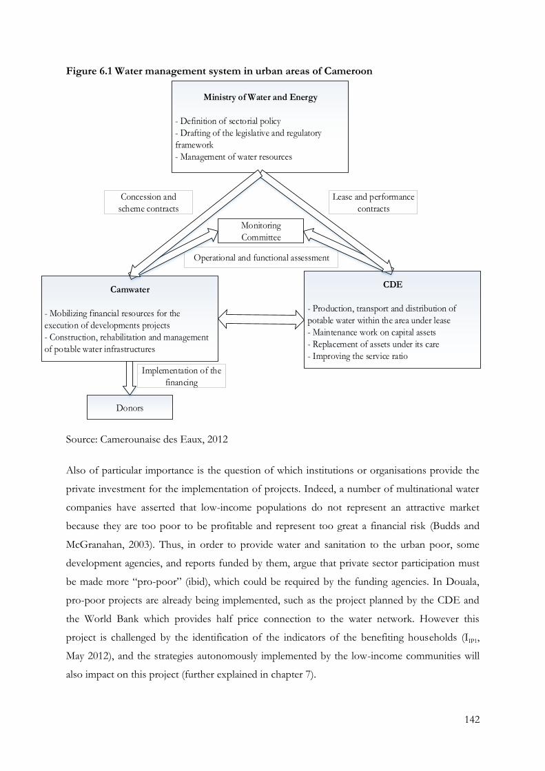
142
Figure 6.1 Water management system in urban areas of Cameroon
Implementation of the
financing
Operational and functional assessment
Ministry of Water and Energy
- Definition of sectorial policy
- Drafting of the legislative and regulatory
framework
- Management of water resources
Camwater
- Mobilizing financial resources for the
execution of developments projects
- Construction, rehabilitation and management
of potable water infrastructures
CDE
- Production, transport and distribution of
potable water within the area under lease
- Maintenance work on capital assets
- Replacement of assets under its care
- Improving the service ratio
Monitoring
Committee
Donors
Lease and performance
contracts
Concession and
scheme contracts
Source: Camerounaise des Eaux, 2012
Also of particular importance is the question of which institutions or organisations provide the
private investment for the implementation of projects. Indeed, a number of multinational water
companies have asserted that low-income populations do not represent an attractive market
because they are too poor to be profitable and represent too great a financial risk (Budds and
McGranahan, 2003). Thus, in order to provide water and sanitation to the urban poor, some
development agencies, and reports funded by them, argue that private sector participation must
be made more “pro-poor” (ibid), which could be required by the funding agencies. In Douala,
pro-poor projects are already being implemented, such as the project planned by the CDE and
the World Bank which provides half price connection to the water network. However this
project is challenged by the identification of the indicators of the benefiting households (IIP1,
May 2012), and the strategies autonomously implemented by the low-income communities will
also impact on this project (further explained in chapter 7).
143
6.1.2 Institutions involved in the sanitation sector in Douala
According to the existing sanitation policies, the responsibility of project management and
project investments appear to overlap between the MINDUH and the MINEE (MINEE, 2011).
The MINDUH aims to improve the urban development sector, working in collaboration with
decentralised regional communities and other actors from civil society. In Douala, it is involved
in numerous attempts to solve the issues of water discharge through the construction of a series
of major drain systems. While the term “sanitation” is present in the texts allocating
responsibilities to the MINDUH, potentially generating a conflict of responsibilities, the MINEE
appears to concentrate on water access (ILM2, April 2012).
Camwater, as well as CDE, are also entrusted with the operation of wastewater sewerage systems
and rainwater drainage (IIF2, May 2012). The lease contract specifies several norms and standards
pertaining to service provision, and there is a joint investment plan shared between the operator
and the asset-holding company that defines the use of the lease fee. However, the current
contractual requirements are still not being entirely respected, particularly concerning the
investment programme and sanitation activities (IIF2, May 2012). Indeed, the two entities are not
active in the sanitation area, and they have neither carried out an inventory of existing facilities
nor monitored the access rate as they wait for a more favourable context regarding the financing
of projects, national policy and operational strategy (IIF2, May 2012). Due to the delays already
accumulated in the distribution of the water resources, sanitation systems are not currently the
institutions’ priories (IIF2, April 2012).
Douala's Urban Council and City-Halls are also involved in the sanitation system management.
However, they face the same time constraints as the central departments: imperfect definition of
responsibilities, insufficient skills in sewerage, lack of qualified staff and lack of resources.
Moreover, the capacities in the field of communication, education and training have largely still
to be strengthened (MINEE, 2011). As a result, sanitation in urban areas remains largely
managed by the communities and the private sector without technical or financial assistance, and
with consequent low sustainability of actions. The work of NGOs in the areas around
promotion and appropriate technology recognises these issues and has to be taken into account
in the future.
144
The limited number of stakeholders involved in the sector, and their lack of coordination,
generates isolated actions by the ministries, which is already absorbed in the implementation of
the national investment programmes, regardless of where the funds for these come from the
national budget or elsewhere (De Waal, 2010). Despite the first concrete steps required for the
institutional framework of the sector already being in place, there is still no operational
programmatic approach (IIF2, May 2012). Such an approach is urgently necessary as it would lead
to a more refined assessment of needs being conducted, and would make possible a plan based
on priority criteria. Such a programme would also generate better organisation and use of the
finances. An urban sanitation policy, which is currently being prepared, should resolve this issue
and is awaited by the governmental delegates and coordinators of local institutions.
6.1.3 Implementation of the IWRM in Cameroon
As seen previously, the IWRM framework is regarded as an important strategy to reduce poverty
and to achieve the Millennium Development Goals in Cameroon (De Waal, 2010). In spite of
the abundant freshwater resources that Cameroon has, the country faces slow progress and
severe water challenges as a result of management, legal and institutional deficiencies and the
important fragmentation of the water sector. Hence, the IWRM framework appears in a context
where urgent actions are needed. It is intended that the IWRM framework is implemented within
the existing water policy framework. Although no policies are directly linked to the IWRM
framework, water legislation in Cameroon already follows some of the IWRM principles such as
the consideration that water is a finite asset (Ako Ako et al., 2009).
The national IWRM planning process was divided into three phases further distributed into 14
stages (Box 6.1) (GWP-Cmr, 2010, p. 4). So far, Cameroon has completed the first two phases
of the country’s IWRM planning process (IM3, April 2012). The first phase started with
implementing the IWRM framework in June 2005, with the setting up of the Global Water
Partnership Cameroon (IM3, April 2012). This entity was created in order to provide a neutral
platform aiming to facilitate the planning process and bring together all water sector actors of the
whole country (IM3, April 2012). During the implementation of this phase, the GWP-Cmr
focused on capitalisation and coordination with the existing initiatives and projects was carried
out. In 2007, planning for IWRM was included as an activity in the public investment budget for
the ministry in charge of water (IM3, April 2012). This illustrated the government’s agreement to
proceed with the IWRM approach and was further supported by the creation of management
145
structures for the planning process by the MINEE and its incorporation as a strategic activity in
the Economic, Financial, Social and Cultural Programme of Cameroon for the year 2010 (GWP-
Cmr, 2010, p. 1). Also, it instigated further training about IWRM to water sector stakeholders,
ensuring that the main water actors could effectively participate in the national IWRM planning
process. Overall, it is estimated that over 311 people from about 126 partner institutions were
trained in 2010 (GWP-Cmr, 2010).
Phase two, conducting the inventory and situation analysis of the water sector, was divided into
four themes as follows:
1. Knowledge and use of water resources: an evaluation of the current situation of water
resources in terms of quantity and quality, and the use of water resources.
2. Water and environment: a diagnosis of the water sector with respect to environmental
challenges.
3. Economic, financial and social framework of the water sector: an inventory of the
current economic, financial and social framework of the water sector in Cameroon.
4. Legislative, institutional and human resources framework of the water sector: an in-depth
analysis of the water sector management framework (GWP-Cmr, 2010).
As a result of the first two phases, the foundation for the elaboration of an IWRM Strategy and
Action Plan has been recognised. Strategic options were also identified by the GWP-Cmr,
currently organising the third phase of the IWRM implementation (IM3, April 2012). These
strategic actions consisted of the consolidation of the thematic reports, which coincided with the
end of the project through the organisation of regional and national participative workshops to
improve and validate the analysis of the studies of the water sector (GWP-Cmr, 2010). Now the
plan needs to be approved by the GWP-Cmr partners (IM3, April 2012). This phase is argued to
have lasted approximately eighteen months due to difficulties in obtaining data and information
on the fourth report theme presented above (GWP-Cmr, 2010). The following activities are
identified for the continuation of IWRM: the creation of the national IWRM action plan; the
carrying out of regional participative workshops to improve the plan and a national workshop to
validate it; the adoption of the plan by the Government and by the institutions financing the
national IWRM action plan (ibid); and finally, the implementation the national IWRM action
plan. Therefore, from these findings, it can be seen that the concrete implementation of the
IWRM is still at a very early stage.
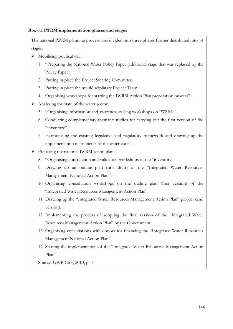
146
Box 6.1 IWRM implementation phases and stages
The national IWRM planning process was divided into three phases further distributed into 14
stages:
Mobilising political will;
1. “Preparing the National Water Policy Paper (additional stage that was replaced by the
Policy Paper).
2. Putting in place the Project Steering Committee.
3. Putting in place the multidisciplinary Project Team.
4. Organising workshops for starting the IWRM Action Plan preparation process”.
Analysing the state of the water sector:
5. “Organising information and awareness-raising workshops on IWRM.
6. Conducting complementary thematic studies for carrying out the first version of the
“inventory”.
7. Harmonising the existing legislative and regulatory framework and drawing up the
implementation instruments of the water code”.
Preparing the national IWRM action plan:
8. “Organising consultation and validation workshops of the “inventory”.
9. Drawing up an outline plan (first draft) of the “Integrated Water Resources
Management National Action Plan”.
10. Organising consultation workshops on the outline plan (first version) of the
“Integrated Water Resources Management Action Plan”.
11. Drawing up the “Integrated Water Resources Management Action Plan” project (2nd
version).
12. Implementing the process of adopting the final version of the “Integrated Water
Resources Management Action Plan” by the Government.
13. Organising consultations with donors for financing the “Integrated Water Resources
Management National Action Plan”.
14. Starting the implementation of the “Integrated Water Resources Management Action
Plan”
Source: GWP-Cmr, 2010, p. 4
147
6.1.4 Challenges in the implementation of the IWRM
While collecting data to create the GWP reports, challenges in the implementation of the IWRM
were identified by the GWP-Cmr actors (IA3, May 2012). In the economic, financial and social
framework of the water sector, identified issues are the limited access to water and sanitation, the
low funding of the water sector and limited access to investment funds (GWP-Cmr, 2009a). This
lack of funding is due to the divergence between the budget cycle and the cycle of projects (ILM3,
April 2012). This deficiency is then intensified by the non-operational state of the trust fund, set
up to finance sustainable development projects in the water and sanitation sector (GWP-Cmr,
2009a).
Along with the poor communication between institutions, another limitation identified by the
GWP-Cmr (2009b) is the inefficiency of the water sector reform in urban areas, which has
already been delaying the implementation the IWRM Strategy and Action Plan. Indeed, a real
necessity for water legislation reform is shown by lack of formal national water policies, the weak
and uncoordinated institutional framework and the shortcomings of legislative and regulatory
framework, the absence of a legal status of the river basin and water point, and the absence of
laws in some sub-sectors (GWP-Cmr, 2009b). Similarly to the adaptive strategies which have
been studied in Europe, South Africa, rural India and East Africa to minimize water scarcity and
insecurity (Wilk and Wittgren, 2009), the measures within the IWRM framework are not
intended to be undertaken as stand-alone, but are embedded in the current water regulation.
Hence the IWRM is being implemented in challenging conditions and settings, and as the GWP-
Cmr in charge of the framework has been created as neutral platform aiming to facilitate the
planning process, its power for action in relation to this concern is limited.
The reduction in stream discharge and change in hydrologic regime are also presented as national
challenges in the GWP-Cmr reports (2009d), but the city of Douala first faces an insufficient
monitoring and evaluating of water resources (IA2, June 2012). This insufficiency becomes even
more significant as the water resources in the Douala are strongly impacted by the various
physical, chemical, biological and organic contaminations caused by human activity, which stem
from an increase of waste water from households, industries and transport generally being
discharged in rivers without any treatment (ILM5, April 2012). This limitation is attributed to the
poor financing, monitoring and evaluation of the activities, the lack of human resources, and an
inappropriate organisational structure (GWP-Cmr, 2009c). In Douala, the financing factor is
148
argued to be the main reason for the inability to carry out hydrogeological studies (IA2, June
2012). As a result, scientific information at a local level must first be well developed enough to
be able to implement the framework’s action plan. It is very likely that IWRM strategies
implemented might be ineffective or counter-productive if this data is missing (Comprehensive
Assessment of Water Management in Agriculture, 2007 cited in Muller, 2009).
Finally, although the IWRM is internationally presented as a tool for CCA (Bates et al., 2008),
both approaches are dealt with by different Ministries. While the IWRM is managed by the
MINEE, the responsibility of implementing CCA has been given to the Ministry of
Environment and Nature Protection (MINEP). In 2012, a first draft of a vulnerability and
climate change adaptation report was established by the MINEP, of which the overall objective
was to conduct a vulnerability assessment of all agro-ecological zones of Cameroon and all
development sectors dependent on climate and proposed solutions to adapt to climate change
impacts. The eutrophication of water bodies with the development of colonies of macrophytes
has been also identified and is currently also the main concern of the Ministry of Environment
of Cameroon in Douala’s region (ILM4, June 2012). Therefore, the challenges concerned with
CCA are understood and translated as an environmental issue by Cameroonian authorities, and a
gap between the two approaches is noted.
Due to the early stage of the framework, the strategies to enhance urban poor well-being are still
unable to demonstrate how water management can be adapted at the grassroots level in urban
areas as was argued by Moser and Satterthwaite (2008). Nevertheless,
in the absence of clear methodology supported by more detailed information, it remains
difficult to determine whether the adoption of IWRM approaches has contributed to
environmental sustainability or whether it has helped or undermined the resilience of
livelihoods in the community concerned (Lenton and Muller, 2009, p. 206).
Thus, careful indicators and strategies will have to be selected to assess the framework in the
future.
149
6.2 Water in the low-income communities in Douala
6.2.1 Water access, usage and costs in low-income communities
The Joint Monitoring Programme for Water Supply and Sanitation (JMP) (2010) estimated that,
in Cameroon, “92 per cent of the urban population had access to an improved water source in
2008, compared to 77 per cent in 1990” (JMP, 2010 cited in De Waal, 2010, p. 22). The IMF
(2010) estimated that 50 per cent of households had access to safe drinking water. They also
argue that the network of urban water supply built in Douala is argued to be satisfactorily
covering the agglomeration, in spite of the CED employees’ statements presented earlier.
Moreover, there is a very low rate of individual connections, estimated by the World Bank to be
25% for Douala (UN, 2010; De Waal, 2010), insufficient production capacity, and major
difficulties seem to persist. “If we define management, you must know before managing. In
Douala, there is water distribution but no water management” (IA2, June 2012).
The low-income communities experience a general lack of adequate drinking water, clearly
contrasting to the high percentages presented by the JMP (2010). Direct tap water accesses reach
only 8.8% of the interviewees’ housing (Figure 6.2; Table 6.1). From this water supply, water
might be sold to neighbouring households, representing 8.2% of the urban poor's access to
water. The low rate of tap water use by the urban poor in Douala can be explained, first, by the
lack of water pipes reaching the communities and, when reaching them, the pipes are typically
located at the edge of the settlement. Secondly, the frequent water shortages reduce the
population's willingness to connect their property to the water network. Moreover, the water
provided by tap is often coloured red due to the oxidation of the pipes that serve the city, having
strong repercussions on the perception of the community regarding the purity of the water and
often causing confusion regarding the purity of the well water. Many community members turn
therefore to boreholes (definition see Appendix 1) for drinking water, used by 28.6% of the
respondents as water supply sources. However, the limited opening times of the industrial
boreholes, the frequent water cut-off and the price of the water compel the inhabitants of the
community to heavily rely on wells. Water wells are widely built and extensively used in the
settlements, although wells are built without technical specifications and most of them provide
contaminated water from the superficial aquifer (31.9%).
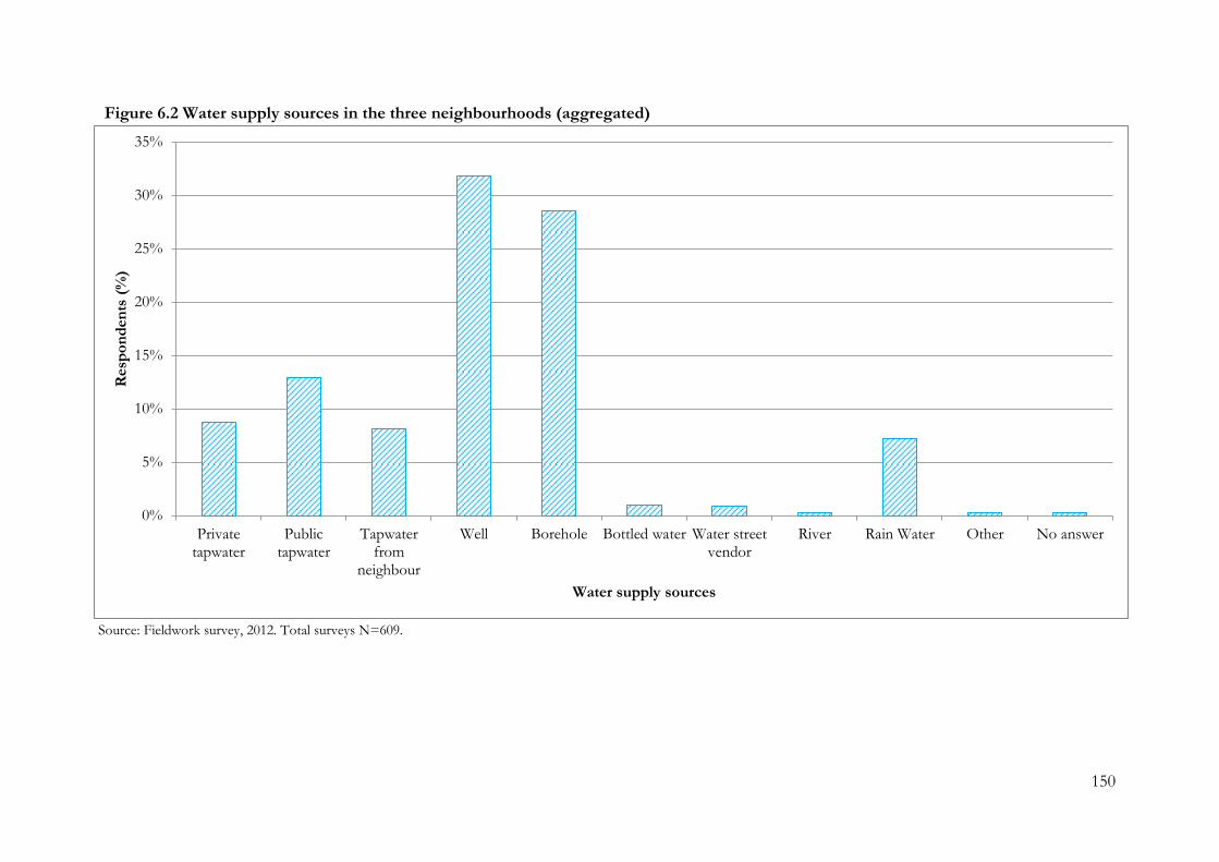
150
Figure 6.2 Water supply sources in the three neighbourhoods (aggregated)
Source: Fieldwork survey, 2012. Total surveys N=609.
0%
5%
10%
15%
20%
25%
30%
35%
Privatetapwater
Publictapwater
Tapwaterfrom
neighbour
Well Borehole Bottled water Water streetvendor
River Rain Water Other No answer
Resp
on
den
ts (
%)
Water supply sources
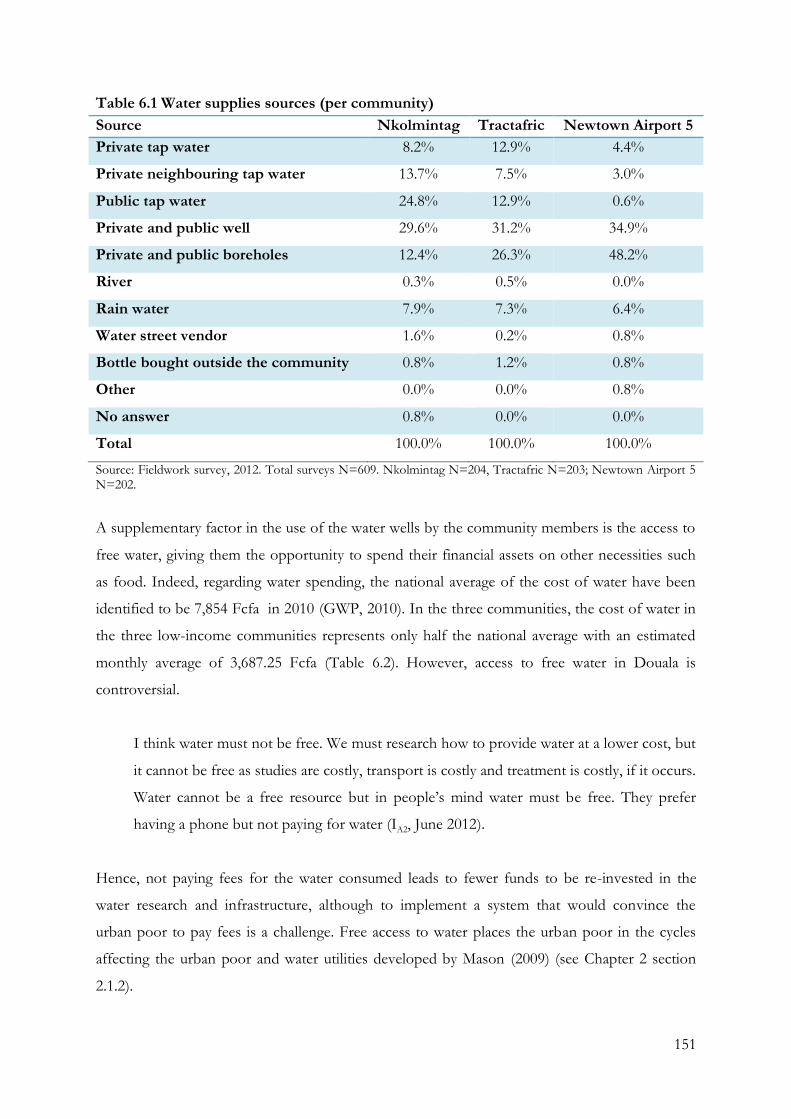
151
Table 6.1 Water supplies sources (per community)
Source Nkolmintag Tractafric Newtown Airport 5
Private tap water 8.2% 12.9% 4.4%
Private neighbouring tap water 13.7% 7.5% 3.0%
Public tap water 24.8% 12.9% 0.6%
Private and public well 29.6% 31.2% 34.9%
Private and public boreholes 12.4% 26.3% 48.2%
River 0.3% 0.5% 0.0%
Rain water 7.9% 7.3% 6.4%
Water street vendor 1.6% 0.2% 0.8%
Bottle bought outside the community 0.8% 1.2% 0.8%
Other 0.0% 0.0% 0.8%
No answer 0.8% 0.0% 0.0%
Total 100.0% 100.0% 100.0%
Source: Fieldwork survey, 2012. Total surveys N=609. Nkolmintag N=204, Tractafric N=203; Newtown Airport 5 N=202.
A supplementary factor in the use of the water wells by the community members is the access to
free water, giving them the opportunity to spend their financial assets on other necessities such
as food. Indeed, regarding water spending, the national average of the cost of water have been
identified to be 7,854 Fcfa in 2010 (GWP, 2010). In the three communities, the cost of water in
the three low-income communities represents only half the national average with an estimated
monthly average of 3,687.25 Fcfa (Table 6.2). However, access to free water in Douala is
controversial.
I think water must not be free. We must research how to provide water at a lower cost, but
it cannot be free as studies are costly, transport is costly and treatment is costly, if it occurs.
Water cannot be a free resource but in people’s mind water must be free. They prefer
having a phone but not paying for water (IA2, June 2012).
Hence, not paying fees for the water consumed leads to fewer funds to be re-invested in the
water research and infrastructure, although to implement a system that would convince the
urban poor to pay fees is a challenge. Free access to water places the urban poor in the cycles
affecting the urban poor and water utilities developed by Mason (2009) (see Chapter 2 section
2.1.2).
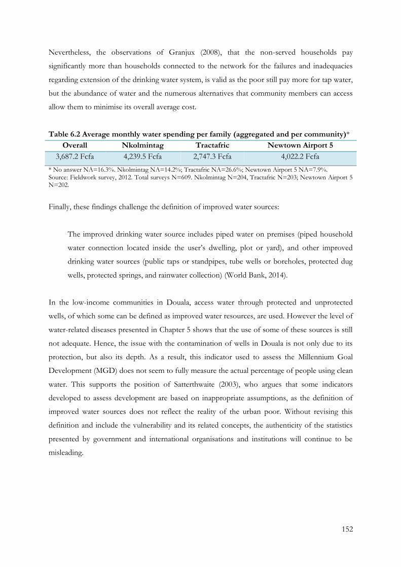
152
Nevertheless, the observations of Granjux (2008), that the non-served households pay
significantly more than households connected to the network for the failures and inadequacies
regarding extension of the drinking water system, is valid as the poor still pay more for tap water,
but the abundance of water and the numerous alternatives that community members can access
allow them to minimise its overall average cost.
Table 6.2 Average monthly water spending per family (aggregated and per community)*
Overall Nkolmintag Tractafric Newtown Airport 5
3,687.2 Fcfa 4,239.5 Fcfa 2,747.3 Fcfa 4,022.2 Fcfa
* No answer NA=16.3%. Nkolmintag NA=14.2%; Tractafric NA=26.6%; Newtown Airport 5 NA=7.9%. Source: Fieldwork survey, 2012. Total surveys N=609. Nkolmintag N=204, Tractafric N=203; Newtown Airport 5 N=202.
Finally, these findings challenge the definition of improved water sources:
The improved drinking water source includes piped water on premises (piped household
water connection located inside the user’s dwelling, plot or yard), and other improved
drinking water sources (public taps or standpipes, tube wells or boreholes, protected dug
wells, protected springs, and rainwater collection) (World Bank, 2014).
In the low-income communities in Douala, access water through protected and unprotected
wells, of which some can be defined as improved water resources, are used. However the level of
water-related diseases presented in Chapter 5 shows that the use of some of these sources is still
not adequate. Hence, the issue with the contamination of wells in Douala is not only due to its
protection, but also its depth. As a result, this indicator used to assess the Millennium Goal
Development (MGD) does not seem to fully measure the actual percentage of people using clean
water. This supports the position of Satterthwaite (2003), who argues that some indicators
developed to assess development are based on inappropriate assumptions, as the definition of
improved water sources does not reflect the reality of the urban poor. Without revising this
definition and include the vulnerability and its related concepts, the authenticity of the statistics
presented by government and international organisations and institutions will continue to be
misleading.
153
6.2.2 Contamination of water sources
The issue of water resource contamination in Douala is significant. Moreover, Douala has to face
particular environmental issues which differ from the other Cameroonian regions. The high
concentration of industries in the city adds to the challenge of water management. Indeed, the
Littoral region groups constitute 85% of the industrial activities of Cameroon (ILM4, June 2012).
In this context, the recent environmental legislation and institutional efforts have been
developed with a focus on industrial wastes, and the development of tools such as impact studies,
audits and environmental management plans (ILM4, June 2012). The decree which regulates,
controls and monitors industrial waste was implemented in 2005, requiring the achievement of
environmental impact studies or environmental audits within a period of three years for every
industry (ILM4, June 2012). As a result, a calendar of waste treatment actions, particularly focusing
on waste water, was agreed and implemented by many industries with the help of the MINEP
(ILM4, June 2012). Efforts have to be carried out by industries and the city to move towards an
appropriate regulation of liquid waste. However, not all industries conformed during the period
required, due to the financial burden the new regulation generated (ILM4, June 2012). Moreover,
the legislation is limited and needs to be improved. Environmental impact studies of many large
industries have indeed been performed; however, the regulation only focuses on a certain
category of firm. Thus, it neglects the smaller enterprises, such as garages, which are not part of a
regulated category and are free to discharge wastes, such as waste oil, in the gutters and drains.
These small enterprises are still not included in the decree and strongly contaminate the
surrounding watersheds, drains and rivers of the city (ILM4, June 2012).
Household waste water is also pointed out as a major source of contamination. “Regarding water
contamination, we also observe a large contamination from the households” (ILM4, June 2012).
Associated with the expansion of Douala’s urbanised area, this source is argued to cause a
contamination due to their high volumes and lack of channel system (IA2, June 2012). Indeed, the
sewage system is not suitable in relation to the size of the city, as shown by the recurrence of
cholera epidemics that the city regularly experiences. It is composed of two “types” of public
sanitation. The former network of the city centre was originally composed of 5 km of pipes and
is discharging through a single outlet in the Wouri, supported later by networks built by the
Mission of Equipment Planning and Equipment of Urban and Rural Lands (MAETUR) and the
Cameroon Real Estate Corporation (SIC) (MINEE, 2011, p. 17). Since their creation, the
sanitation networks have undergone major restructuring with additional new concrete pipes of
154
wider diameters (ibid). However, the network is still subjected to permeability problems
generating a poor effluent collection and problems of excessive dilution by runoffs, due to the
lack of buffers (ibid). In addition, obstructions are also experienced because of the low flow
velocity, the presence of bulk solid waste and lack of maintenance (ibid). Overall, this network
was qualified as “largely non-functional” by the MINEE. As a result, the majority of the
population rely on traditional latrines with stabs, unimproved latrines or, in some cases, a septic
tank, contaminating the groundwater resources used by the low-income communities, as seen in
5.3.3 (ILM4, June 2012).
Closely linked to the issue of contamination explained in the previous paragraphs, water
management in Douala is also challenged by the existing link between the different water sources.
Indeed, the alluvial groundwater is very close to the surface and is directly connected to the
water of the rivers (IA1, March 2012). Thus, if any of these resources are polluted, the whole
water network is very likely to be contaminated. This phenomenon has already occurred and,
nowadays, “to have drinking water in Douala, you must dig at least 65 meters” (IM4, May 2012).
Indeed, when mixed into the surface water, where liquid wastes are discharged, the city’s
groundwater has become inappropriate for human consumption (IM4, May 2012).
Finally, the flooding identified in Chapter 5 exacerbates the contamination of groundwater.
During the floods, the infiltration of waste water into clean water is intensified, contaminating
the natural resources (IA1, March 2012). When water rain penetrates the soil, it carries and
spreads further polluting agents to water accesses such as wells, boreholes and rivers already
threatened by the lack of sewage system, the high density of population of the poor areas and the
short distance between latrines and wells. As seen in 5.3.3, flood water is also used to discharge
water waste by community members, increasing the concentration of contaminating agents into
the environment (fieldwork notes, 2012).
Superficially, Douala appears to be a city blessed with abundant water resources. Benefiting from
vast surface water and groundwater resource, and a coastal location, the city’s communities have
a large choice of water supplies for the different needs of its population. However, a substantive
of these resources are heavily contaminated, reducing, quite significantly, the range of
possibilities for drinking water supply. In fact, in spite of the apparent abundance of water and
the efforts of the water company to supply water to the majority of people, Douala’s urban poor
have a limited choice clean water accesses. “I call Douala a humid desert. We are surrounded by
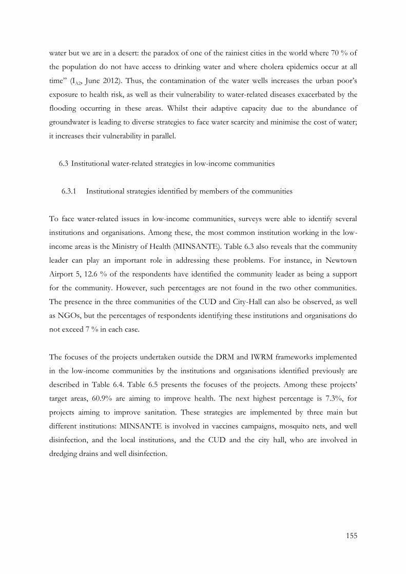
155
water but we are in a desert: the paradox of one of the rainiest cities in the world where 70 % of
the population do not have access to drinking water and where cholera epidemics occur at all
time” (IA2, June 2012). Thus, the contamination of the water wells increases the urban poor’s
exposure to health risk, as well as their vulnerability to water-related diseases exacerbated by the
flooding occurring in these areas. Whilst their adaptive capacity due to the abundance of
groundwater is leading to diverse strategies to face water scarcity and minimise the cost of water;
it increases their vulnerability in parallel.
6.3 Institutional water-related strategies in low-income communities
6.3.1 Institutional strategies identified by members of the communities
To face water-related issues in low-income communities, surveys were able to identify several
institutions and organisations. Among these, the most common institution working in the low-
income areas is the Ministry of Health (MINSANTE). Table 6.3 also reveals that the community
leader can play an important role in addressing these problems. For instance, in Newtown
Airport 5, 12.6 % of the respondents have identified the community leader as being a support
for the community. However, such percentages are not found in the two other communities.
The presence in the three communities of the CUD and City-Hall can also be observed, as well
as NGOs, but the percentages of respondents identifying these institutions and organisations do
not exceed 7 % in each case.
The focuses of the projects undertaken outside the DRM and IWRM frameworks implemented
in the low-income communities by the institutions and organisations identified previously are
described in Table 6.4. Table 6.5 presents the focuses of the projects. Among these projects’
target areas, 60.9% are aiming to improve health. The next highest percentage is 7.3%, for
projects aiming to improve sanitation. These strategies are implemented by three main but
different institutions: MINSANTE is involved in vaccines campaigns, mosquito nets, and well
disinfection, and the local institutions, and the CUD and the city hall, who are involved in
dredging drains and well disinfection.
156
Table 6.3 Institutions working in the communities identified by surveys (aggregated and
per community)
Overall Nkolmintag Tractafric Newtown Airport 5
MINSANTE 53.9% 31.6% 55.3% 53.9%
CUD 7.6% 7.0% 6.4% 3.9%
City hall 3.1% 3.2% 2.3% 1.5%
Community Leader 4.8% 0.2% 2.3% 12.6%
MINTRANS 0.3% 0.5% 0.0% 0.0%
Fire Brigade 0.3% 0.5% 0.0% 0.0%
ONG 2.4% 0.7% 5.0% 1.0%
None 9.7% 4.6% 7.3% 14.6%
Local Organisation 1.3% 1.7% 0.9% 0.0%
MINEP 0.3% 0.5% 0.0% 0.0%
No answer 16.4% 49.5% 20.6% 12.6%
Total 100.0% 100.0% 100.0% 100.0%
Source: Fieldwork survey, 2012. Total surveys N=609. Nkolmintag N=204, Tractafric N=203; Newtown Airport 5 N=202.
Table 6.4 Focuses of projects identified by surveys (aggregated and per community)
Overall Nkolmintag Tractafric Newtown Airport 5
Health 60.9% 60.9% 56.5% 66.4% Water source and supply 5.6% 6.6% 5.3% 4.8%
Sanitation 7.3% 6.2% 11.0% 4.0%
Other 1.6% 3.1% 1.0% 0.8%
No answer 24.6% 23.3% 26.2% 24.0%
Total 100.0% 100.0% 100.0% 100.0%
Source: Fieldwork survey, 2012. Total surveys N=609. Nkolmintag N=204, Tractafric N=203; Newtown Airport 5 N=202.
Table 6.5 Details of the focuses of projects in the three communities (aggregated)
Health Water source and supply Sanitation
MILDA, vaccines campaigns,
hygiene awareness campaigns,
house disinfection, free cholera
treatment
Water awareness campaign,
well digging, well
disinfection, water
disinfection
Drain digging, latrines
disinfection, sanitation
awareness campaign
collection of solid waste
Source: Fieldwork survey, 2012.
157
The predominance of the MINSANTE in the surveys is due to the MILDA project: the
distribution of mosquito nets to fight against malaria epidemics in the communities (fieldwork
notes, 2012). The vast popularity it enjoys is due to the recent achievement of the Long-Lasting
Impregnated Mosquito Nets (LLIMN) project carried out in 2011, along with the regular
campaigns of vaccinations and cholera awareness carried out in the sub-districts. For the former
purpose, the country received a financial support from the Global Fund and the European
Union for the distribution of Long-Lasting Impregnated Mosquito Nets (LLINs) in order to
increase the use of LLINs by the entire population, particularly among children under five years
and pregnant women. Despite initial difficulties facing corruption, the re-selling of mosquito nets
or distribution discrimination, the LLINS project was successfully carried out and most of the
inhabitants of the poor neighbourhoods had access to mosquito nets (fieldwork notes, 2012).
The second institutional measure encountered in the communities was identified as being
conducted by the district city hall and Douala Urban Council and consists of dredging drains and
the disinfection of wells. However, these actions were seen as very irregular and the disinfection
of wells was mostly carried out when a cholera epidemic had occurred.
The transect walks also demonstrated that the three communities benefit from other projects
from different organisations. In Tractafric, transects walks showed development agencies are
involved in the settlement. For example, public latrines and water access projects were carried
out by the European Union and the French Agency for Development. Nevertheless, the
structures built by these organisations were abandoned following the breakage of water pumps
and the filling of latrines (fieldwork notes, 2012). In Newtown Airport 5, the community does
not seem to currently receive extra support from institutions apart from the MINSANTE’s
projects. Finally, Nkolmintag is currently the pilot area for the Urban and Water Development
Support Project (UWDSP), a governmental project in partnership with the World Bank that
follows a bottom up approach supported by the IWRM. This project is considered as a first step
towards an integrated water resources management system. “The development objective of the
Urban and Water Development Support Project for Cameroon is to increase access for the
urban population, particularly those living in low-income settlements, to basic infrastructure and
services, including water” (World Bank, 2012b).
Applying a community based approach, this project has the objective of facilitating those living
in low-income settlements to access basic infrastructure and services, including water supply.
158
Therefore, the inhabitants of this pilot area are currently collaborating with the city hall and the
urban council to identify and work on improvements to their settlements.
These findings show the importance of the local government and the community leader in the
implementation of projects in urban poor communities, and their importance to strengthening
their capacities for IWRM and DRM.
Pro-poor local governments can support low-income groups to obtain safe, legal land sites
for housing, can improve access to justice for poorer groups, and can ensure that
marginalised and disadvantaged groups are able to access and influence local political and
bureaucratic systems – all of which have important implications for improving the
resilience of the urban poor. They can also embrace a more systematic consideration of
whose voices should be heard, and how different opinions should be included in the
process of governance (Dodman and Satterthwaite, 2008, p. 70).
Moreover, effective urban authorities and other local institutions have been shown to be key to
providing the context in which individuals, households and communities are able to make their
own adaptations to a variety of issues, including socioeconomic risks, disaster risks and climate
change risks (ibid). In Douala, although local institutional actors in the city hall were trained by
NGOs or national GWP on IWRM, the community leaders are not involved in these processes.
A lack of financial, human and physical capacities prevent their actions from being regularly
carried out, resulting in difficult conditions in which to implement the future IWRM Action
Plans.
6.3.2 Institutional projects and climate change responses
When relating the projects to the IWRM and DRM frameworks and the definition of adaptation
strategies explained in 2.3, analysis of the fieldwork data shows that most of the measures are
anticipatory, and most of them impact on water-related epidemics (Table 6.6). On the other hand,
when considering these strategies in the context of the DRM approach, drain construction and
maintenance, MILDA, vaccines campaigns, infrastructures construction and awareness
campaigns can be considered as “pre-disaster” actions, with the free cholera treatment and the
diverse disinfections as “during disasters” measures. “Post-disaster” classification, however,
remains ambiguous. Indeed, some pre-disaster projects, such as MILDA, are implemented to
159
prevent malaria epidemics, but can also be associated with reactive and post-disasters projects as
they also represent responses to existing risks. However, these projects are officially presented as
preventive measures in the city of Douala and are, therefore, appointed here as anticipatory and
pre-disaster measures.
Among the three factors noted by Biesbroek et al. (2009) that strengthen the adaptation-
mitigation dichotomy in the low income communities – differences in time, space, and the
stakeholders involved – differences between the planned strategies in time and stakeholders are
encountered. Nonetheless, in spite of the ambiguity explained earlier around the post-disaster
response, a correlation can be made between anticipatory strategies and pre-disaster strategies, as
well as reactive and during-disaster strategies. Additionally, the reciprocal influence on the
effectiveness of their outcomes shows that the strategies are linked. The close linkage between
water resources, water flooding and water-related diseases strengthens this argument. Integration
of these actions in a linked DRM and IWRM appear, therefore, possible and necessary, and
enhanced coordination between the actions would enable reaching improved effectiveness in
these particular urban settlements facing climate change impacts. For instance, the coordination
of the improvement of drainage and building water wells would also improve water access and
help to reduce socio-natural and biological hazards. In this context, the local institutional
responses would need to be associated with national actions and reinforce the participation
approach promoted by both DRM and IWRM frameworks.
Overall, only 8.2% of the community members took part or are aware of their participation in
water-related projects, programmes campaigns or measures implemented in the neighbourhoods
(Table 6.7). This low percentage also illustrates that their participation in water-related projects is
not clear and the strategies should be further designed to improve the implementation of
community bottom-up approach.
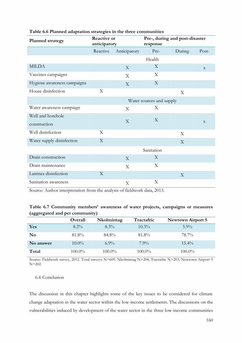
160
Table 6.6 Planned adaptation strategies in the three communities
Planned strategy Reactive or anticipatory
Pre-, during and post-disaster response
Reactive Anticipatory Pre- During Post-
Health
MILDA X X x
Vaccines campaigns X X
Hygiene awareness campaigns X X
House disinfection X X
Water sources and supply
Water awareness campaign X X
Well and borehole
construction X X x
Well disinfection X X
Water supply disinfection X X
Sanitation
Drain construction X X
Drain maintenance X X
Latrines disinfection X X
Sanitation awareness X X
Source: Author interpretation from the analysis of fieldwork data, 2013.
Table 6.7 Community members’ awareness of water projects, campaigns or measures
(aggregated and per community)
Overall Nkolmintag Tractafric Newtown Airport 5
Yes 8.2% 8.3% 10.3% 5.9%
No 81.8% 84.8% 81.8% 78.7%
No answer 10.0% 6.9% 7.9% 15.4%
Total 100.0% 100.0% 100.0% 100.0%
Source: Fieldwork survey, 2012. Total surveys N=609. Nkolmintag N=204, Tractafric N=203; Newtown Airport 5 N=202.
6.4 Conclusion
The discussion in this chapter highlights some of the key issues to be considered for climate
change adaptation in the water sector within the low-income settlements. The discussions on the
vulnerabilities induced by development of the water sector in the three low-income communities
161
emphasise the significance of considering the alternative water access strategies of the urban
poor. Indeed, water legislation in Cameroon is based on the law of 1998 which is still applied
today. However, there is a lack of a specific body of laws regarding the regulation of liquid waste
in the application and implementation of the water policies. Added to difficulties in water
management due to the modifications generated by previous water policy reforms, there are also
challenges in the expansion and improvement of water distribution and addressing the poor and
insufficient network state of the sanitation system. Moreover, the alternative water sources are
strongly contaminated and flooding exacerbates the issue of water access in the poor settlements.
In this context, the IWRM framework is being implemented through the Ministry of Water and
Energy, and is based on existing national water policies. Currently undertaking the third phase of
its implementation and consisting of preparing an IWRM national action plan, the framework
has been spread among the city’s water actors. Nevertheless, its implementation faces additional
challenges to those already in existence and no action plan has yet been implemented.
However, projects and programmes exist to face the water-related issues in these areas, and
could be considered as part or precursors of recognised mitigation and/or adaptation actions.
The integration of those projects into a linked DRM and IWRM framework could benefit the
actions by generating additional funding, collaboration and coordination from the different water
actors of the city. Nevertheless, in spite of the projects and programmes, the low-income
communities have been shown to continue to experience the impacts of water-related disasters
and water access issues, which are most likely to intensify due to climate change.
In this context, vulnerabilities evaluated through the water accesses used and the cost of water
reveal the urban poor’s dependency on groundwater resources. As a result of a lack of formal
water supplies, the urban poor do not benefit from regular and adequate water access supplied
by the national water company and alternative water supplies are used. Indeed, in the low-
income communities, direct tap water access only reaches a few per cent of the interviewees’
properties and water is often re-sold to the neighbouring household. Thus, inhabitants of the
community strongly rely on wells and industrial boreholes, minimising the cost of water, but that
are often heavily contaminated.
The issue of water access must be addressed in parallel with water-related hazards. By focusing
on only one phenomenon, responses to water issues have had a limited efficiency and no
162
sustainability. The close link between the different water-related issues shows the necessity of
developing an integrated approach to water management, including both mitigation and
adaptation measures. The need to limit the adverse impacts of hazards and related disasters
cannot be addressed over the long term unless all factors are considered. This includes the
consideration of water access and flooding to eradicate water-related epidemics, while flooding
and epidemics must also be considered to address access to clean water.
163
Chapter 7: Autonomous adaptation strategies to climate change
Chapter 7 discusses the implementation of water-related autonomous adaptation strategies in the
three low-income communities of Douala and explore the relationships between DRM and
IWRM institutional frameworks, and their link to autonomous strategies of the urban poor. First,
it looks at the way these communities access water for drinking and for other daily activities. It
then describes the communities’ strategies for coping and adapting with flooding, providing an
analysis of the benefits and limitations of autonomous adaptation strategies. In section 7.2, the
difference between coping, adaptive, reactive and anticipatory, and the effectiveness of the urban
poor strategies, is discussed. Further analysis of the water-related issues faced by the urban poor
demonstrates that the autonomous and planned actions have a strong influence on each other.
While the role of national and local governments in the adaptation processes has been widely
discussed in the literature, existing efforts to evaluate adaptation seem to emphasise programmes
and activities by international organisations and national governments (Malik et al., 2010).
Moreover, they often do not address medium- and long-term policies for providing an enabling
environment and not enough attention is given to autonomous adaptation and the supportive,
facilitating role of government in the process (ibid). As a consequence of this focus, little is
known about the water-related autonomous adaptation strategies implemented by urban
populations in poor settlements. Greater understanding of these autonomous strategies could
contribute to the implementation of both DRM and IWRM frameworks. This knowledge could
support the establishment of adaptation priorities, including explicit explanation of the difference
between planned and autonomous adaptation, as well as the creation of appropriate policy
instruments for addressing the different types of adaptation challenges.
7.1 Adaptation strategies of the urban poor
Previously, Figure 6.2 showed that wells play an important role in the provision of water. They
are often the result of traditional knowledge brought from rural areas of “digging until you reach
water” (Community member, fieldwork notes, April 2012). Community members build wells
widely due to the lack of a formal water network that reaches the communities, the abundance of
groundwater resources, and the authorities’ tolerance towards these structures and their
insufficient resources to supervise and control their construction (ILG1, March 2012). Overall,

164
23.6% of households in all three communities benefit from a well built on their property, usually
shared with the neighbouring households (fieldwork survey, 2012)6.
Nonetheless, strong differences appeared between the communities regarding the public, private
tap water and boreholes (Table 6.1). This difference is also found in the rate of well ownership
between the three neighbourhoods. Nkolmintag has the lowest rate of well owners, 13.7%, with
19.8% and 37.4% in Tractafric and Newtown Airport 5 respectively (fieldwork survey, 2012). In
part, this difference is explained by the presence of a formal water system reaching the
communities, and is also illustrated in the different percentages of private and public tap water
used. The communities’ members are forced to rely more on wells and boreholes when not
benefiting from the formal supply (fieldwork notes, 2012). For instance, in Nkolmintag, public
tap water is set up in the communities’ public spaces. The action of local authorities also impacts
on this use. Indeed, local authorities regularly seal some of these wells, occurring predominantly
when water-related diseases epidemics spread (fieldwork notes, 2012). On the contrary,
Newtown Airport 5, which is also located in a high risk flooding area, has the widest rate of wells
due to the confused legal status of this area which prevented actions of the local authorities in
the neighbourhood, and the lack of main pipelines reaching the community.
When analysing the different supply sources, a strong difference between drinking water and
water used for daily activities is observed. While water from wells and rainwater are widely used
for baths and showers, toilets and washing clothes, 94.8% of the urban poor’s drinking water is
from boreholes and taps (Table 7.1). This is clearly visible in the correspondence analysis7 based
on data from the overall respondents. In Figure 7.1, the red diamonds represent households
activities that require water (drinking, cooking, washing clothes, bath, toilets, cleaning, and dish
washing), and the blue dots correspond to the different sources of water supply (private tap
water, public tap water, wells, bottled water, street water vendor, tap water from neighbour, river,
rain water, and boreholes). By measuring the distance between the red diamonds and the blue
dots, it is possible to determine what source of water is predominantly used for what type of
activity. The closer a dot is located to a diamond, the likelihood of that particular water supply
6 Source: Fieldwork survey, 2012. Total surveys N=609. Nkolmintag N=204, Tractafric N=203; Newtown Airport 5 N=202. No answer NA=6.1%; Nkolmintag NA=7.4%; Tractafric NA=7.9%; Newtown Airport 5 NA=3.0%. 7 Correspondence analysis is a statistical technique for visualising the associations between the levels of a two-way contingency table that provides a graphical representation of cross tabulations (Yelland, 2010 359). In this study, the cross tabulations are between uses of water and source water supply in the three neighborhoods and for each community.
165
being used for the specific activity increases. For example, communities’ members tend to mostly
use tap water and water from borehole for cooking and drinking, while water for showers,
washing clothes, dish washing, toilets and general cleaning mainly comes from wells and
rainwater. Drinking water and cooking water are predominantly provided by public and private
tap water (directly accessed in the house or from a neighbouring house).
A comparison between the correspondence analyses of water-related activities and water supply
for all three communities shows a similar pattern for the use of different water supplies sources
(see Figure A7.1; Figure A7.2 and Figure A7.3 in Appendix 7). In Nkolmintag, the diamonds
representing washing clothes, bath, shower, toilets, cleaning, and dish washing are positioned
close to the dots representing wells and rainwater, meaning that these supplies are favoured to
carry out these particular activities. The drinking water diamond is positioned close to boreholes
and street water vendor dots, and cooking diamond is located close to water coming from tap
dot. This means that drinking water mainly comes from boreholes and street water vendors in
this community. In Tractafric, the same configuration is observed, except for bottled water
which is more used as a supply for drinking water. Finally, in Newtown Airport 5, drinking water
also comes predominately from tap and boreholes. It can be noticed that, across these three
cases, river water is rarely used.
The practice of shifting sources depending on water use reveals the communities’ awareness of
the contamination issues. Several factors have an influence on this awareness. First, public
information campaigns carried out by the authorities have increased understanding of the
adverse health effects of using unsafe water, and on the households’ choice of improved water
sources in Cameroon, although little research has been carried out on the impact of these
awareness campaigns (Totouom Fotuè, 2013). Secondly, local knowledge also plays a significant
role. A lack of trust in the water quality of wells is noted. The interviews revealed that this water
is often malodorous and discoloured and people have more confidence in tap water, although it
may also be discoloured due to oxidation of the water pipes as explained in 6.2.1. This is
reinforced by the impact of school education in the low-income communities: “we learnt at
school that water has to be clear and odourless” (Community member, fieldwork notes, June
2012). In this sense, formal and informal education plays a key role in the choice of the water
resource (PIDE, 2010; Totouom Fotuè, 2013).
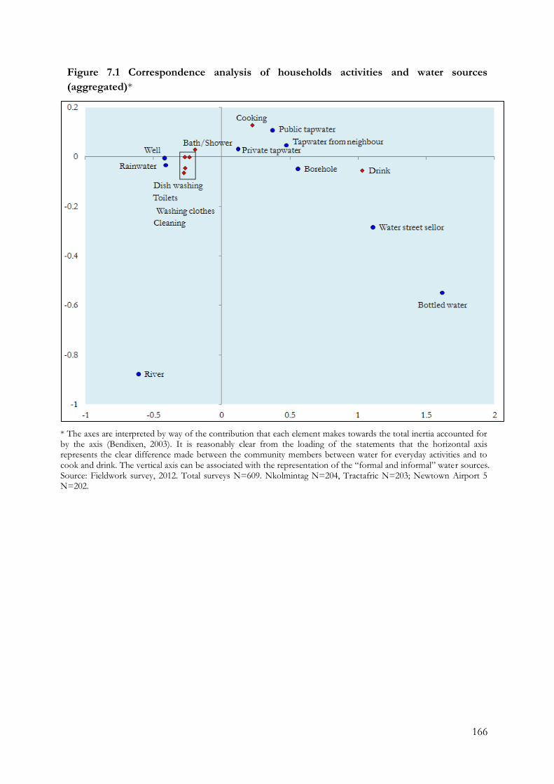
166
Figure 7.1 Correspondence analysis of households activities and water sources
(aggregated)*
* The axes are interpreted by way of the contribution that each element makes towards the total inertia accounted for by the axis (Bendixen, 2003). It is reasonably clear from the loading of the statements that the horizontal axis represents the clear difference made between the community members between water for everyday activities and to cook and drink. The vertical axis can be associated with the representation of the “formal and informal” water sources. Source: Fieldwork survey, 2012. Total surveys N=609. Nkolmintag N=204, Tractafric N=203; Newtown Airport 5 N=202.
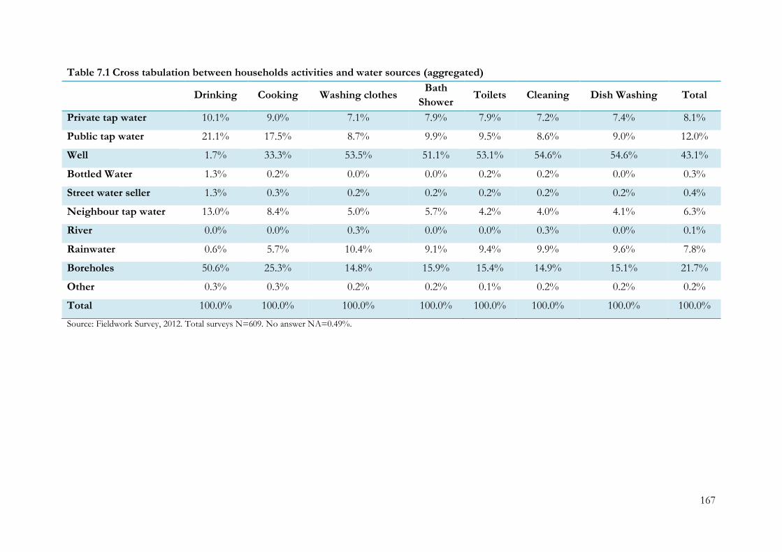
167
Table 7.1 Cross tabulation between households activities and water sources (aggregated)
Drinking Cooking Washing clothes
Bath
Shower Toilets Cleaning Dish Washing Total
Private tap water 10.1% 9.0% 7.1% 7.9% 7.9% 7.2% 7.4% 8.1%
Public tap water 21.1% 17.5% 8.7% 9.9% 9.5% 8.6% 9.0% 12.0%
Well 1.7% 33.3% 53.5% 51.1% 53.1% 54.6% 54.6% 43.1%
Bottled Water 1.3% 0.2% 0.0% 0.0% 0.2% 0.2% 0.0% 0.3%
Street water seller 1.3% 0.3% 0.2% 0.2% 0.2% 0.2% 0.2% 0.4%
Neighbour tap water 13.0% 8.4% 5.0% 5.7% 4.2% 4.0% 4.1% 6.3%
River 0.0% 0.0% 0.3% 0.0% 0.0% 0.3% 0.0% 0.1%
Rainwater 0.6% 5.7% 10.4% 9.1% 9.4% 9.9% 9.6% 7.8%
Boreholes 50.6% 25.3% 14.8% 15.9% 15.4% 14.9% 15.1% 21.7%
Other 0.3% 0.3% 0.2% 0.2% 0.1% 0.2% 0.2% 0.2%
Total 100.0% 100.0% 100.0% 100.0% 100.0% 100.0% 100.0% 100.0%
Source: Fieldwork Survey, 2012. Total surveys N=609. No answer NA=0.49%.
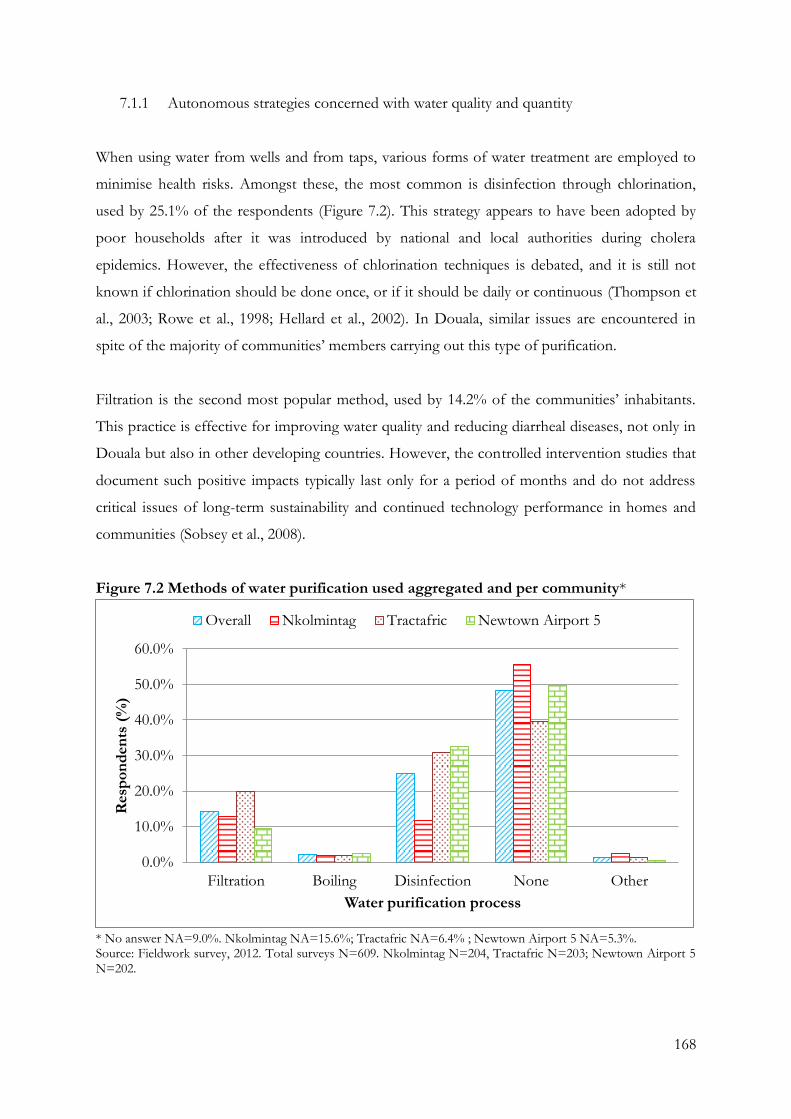
168
7.1.1 Autonomous strategies concerned with water quality and quantity
When using water from wells and from taps, various forms of water treatment are employed to
minimise health risks. Amongst these, the most common is disinfection through chlorination,
used by 25.1% of the respondents (Figure 7.2). This strategy appears to have been adopted by
poor households after it was introduced by national and local authorities during cholera
epidemics. However, the effectiveness of chlorination techniques is debated, and it is still not
known if chlorination should be done once, or if it should be daily or continuous (Thompson et
al., 2003; Rowe et al., 1998; Hellard et al., 2002). In Douala, similar issues are encountered in
spite of the majority of communities’ members carrying out this type of purification.
Filtration is the second most popular method, used by 14.2% of the communities’ inhabitants.
This practice is effective for improving water quality and reducing diarrheal diseases, not only in
Douala but also in other developing countries. However, the controlled intervention studies that
document such positive impacts typically last only for a period of months and do not address
critical issues of long-term sustainability and continued technology performance in homes and
communities (Sobsey et al., 2008).
Figure 7.2 Methods of water purification used aggregated and per community*
* No answer NA=9.0%. Nkolmintag NA=15.6%; Tractafric NA=6.4% ; Newtown Airport 5 NA=5.3%. Source: Fieldwork survey, 2012. Total surveys N=609. Nkolmintag N=204, Tractafric N=203; Newtown Airport 5 N=202.
0.0%
10.0%
20.0%
30.0%
40.0%
50.0%
60.0%
Filtration Boiling Disinfection None Other
Resp
on
den
ts (
%)
Water purification process
Overall Nkolmintag Tractafric Newtown Airport 5
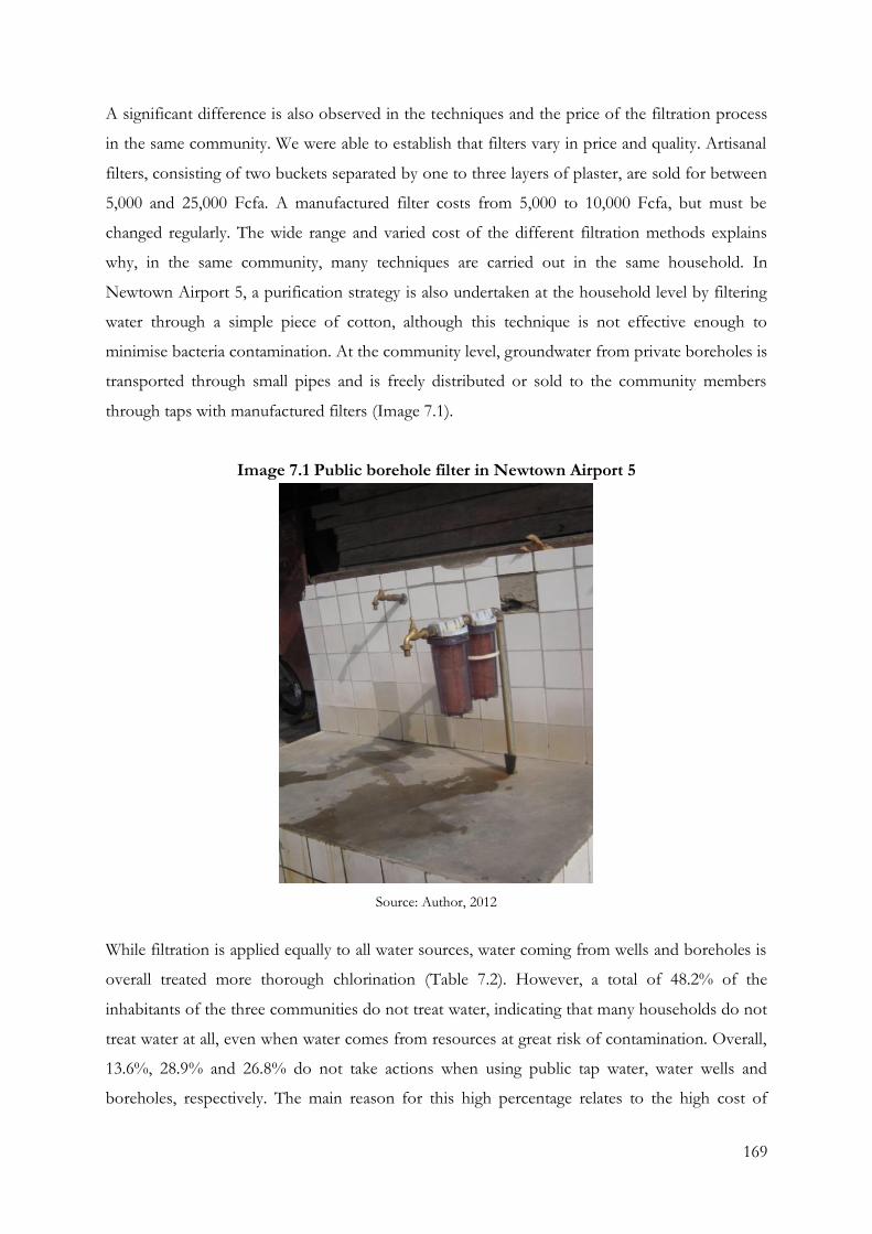
169
A significant difference is also observed in the techniques and the price of the filtration process
in the same community. We were able to establish that filters vary in price and quality. Artisanal
filters, consisting of two buckets separated by one to three layers of plaster, are sold for between
5,000 and 25,000 Fcfa. A manufactured filter costs from 5,000 to 10,000 Fcfa, but must be
changed regularly. The wide range and varied cost of the different filtration methods explains
why, in the same community, many techniques are carried out in the same household. In
Newtown Airport 5, a purification strategy is also undertaken at the household level by filtering
water through a simple piece of cotton, although this technique is not effective enough to
minimise bacteria contamination. At the community level, groundwater from private boreholes is
transported through small pipes and is freely distributed or sold to the community members
through taps with manufactured filters (Image 7.1).
Image 7.1 Public borehole filter in Newtown Airport 5
Source: Author, 2012
While filtration is applied equally to all water sources, water coming from wells and boreholes is
overall treated more thorough chlorination (Table 7.2). However, a total of 48.2% of the
inhabitants of the three communities do not treat water, indicating that many households do not
treat water at all, even when water comes from resources at great risk of contamination. Overall,
13.6%, 28.9% and 26.8% do not take actions when using public tap water, water wells and
boreholes, respectively. The main reason for this high percentage relates to the high cost of
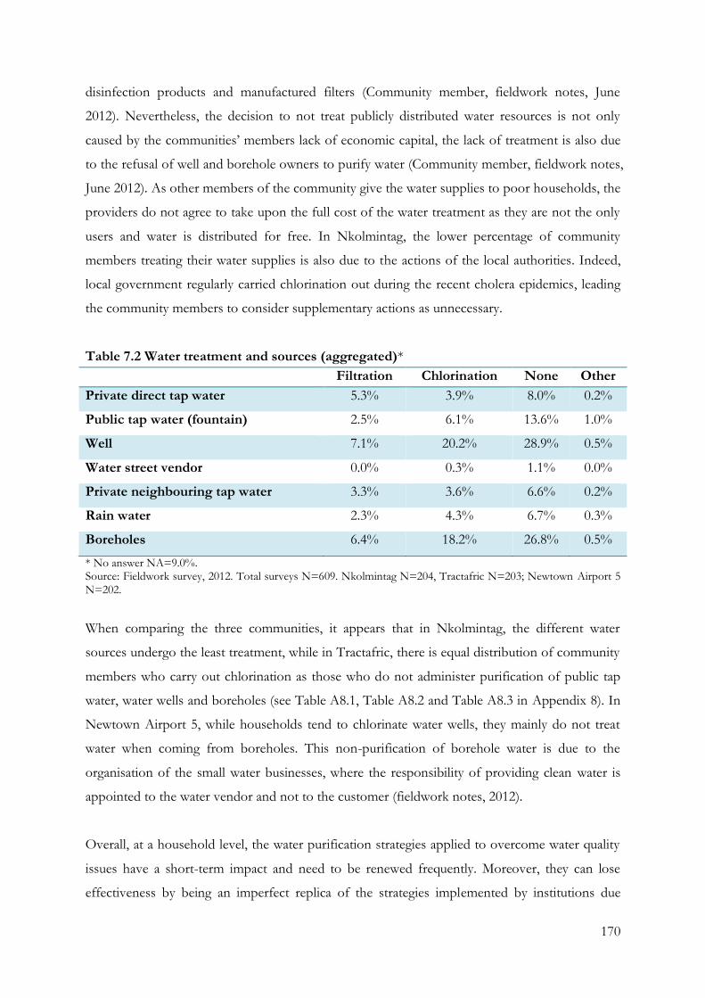
170
disinfection products and manufactured filters (Community member, fieldwork notes, June
2012). Nevertheless, the decision to not treat publicly distributed water resources is not only
caused by the communities’ members lack of economic capital, the lack of treatment is also due
to the refusal of well and borehole owners to purify water (Community member, fieldwork notes,
June 2012). As other members of the community give the water supplies to poor households, the
providers do not agree to take upon the full cost of the water treatment as they are not the only
users and water is distributed for free. In Nkolmintag, the lower percentage of community
members treating their water supplies is also due to the actions of the local authorities. Indeed,
local government regularly carried chlorination out during the recent cholera epidemics, leading
the community members to consider supplementary actions as unnecessary.
Table 7.2 Water treatment and sources (aggregated)*
Filtration Chlorination None Other
Private direct tap water 5.3% 3.9% 8.0% 0.2%
Public tap water (fountain) 2.5% 6.1% 13.6% 1.0%
Well 7.1% 20.2% 28.9% 0.5%
Water street vendor 0.0% 0.3% 1.1% 0.0%
Private neighbouring tap water 3.3% 3.6% 6.6% 0.2%
Rain water 2.3% 4.3% 6.7% 0.3%
Boreholes 6.4% 18.2% 26.8% 0.5%
* No answer NA=9.0%. Source: Fieldwork survey, 2012. Total surveys N=609. Nkolmintag N=204, Tractafric N=203; Newtown Airport 5 N=202.
When comparing the three communities, it appears that in Nkolmintag, the different water
sources undergo the least treatment, while in Tractafric, there is equal distribution of community
members who carry out chlorination as those who do not administer purification of public tap
water, water wells and boreholes (see Table A8.1, Table A8.2 and Table A8.3 in Appendix 8). In
Newtown Airport 5, while households tend to chlorinate water wells, they mainly do not treat
water when coming from boreholes. This non-purification of borehole water is due to the
organisation of the small water businesses, where the responsibility of providing clean water is
appointed to the water vendor and not to the customer (fieldwork notes, 2012).
Overall, at a household level, the water purification strategies applied to overcome water quality
issues have a short-term impact and need to be renewed frequently. Moreover, they can lose
effectiveness by being an imperfect replica of the strategies implemented by institutions due

171
community members’ unwillingness and lack of financial resources. Prices, in fact, depend on the
quality and quantity of chloric powder sold, varying from 100 FCfa for 15 to 25 grams for a
manufactured product, and from 25 to 1,000 FCfa for half a kilogramme for artisanal product.
Chloric water costs 1,200 Fcfa for a litre but is sold with an average quantity of 200 millilitres per
bag. Thus, even if disinfection and filtration are promoted as efficient strategies, and the regular
awareness campaigns have the desired impact on local knowledge, there are still significant
limitations in them as methods regarding their level of effectiveness at a community and
household level that prevent them being regularly undertaken.
Another problem with water, apart from its quality, is the irregularity of its availability. Indeed,
we found that the three low-income communities face water shortages, or partial water scarcity,
on an almost daily basis. This relates to the daily drying of wells, shortage of tap water, electricity
cuts and closure hours of the industrial boreholes (fieldwork notes, 2012). To avoid a complete
lack of water, households have provision strategies (Table 7.3): reducing the water quantity used
for one or all domestic activities, buying small quantities of water for drinking, and shifting to
free or non-free water supplies. Waiting for the end of the tap water cut or well dryness, driven
by the local knowledge of groundwater abundance, is also a widespread short-term practice.
Among these strategies, the reduction of water quantity for different domestic activities, buying
water bags and water bottled outside the neighbourhood also appear to be short-term strategies.
Changing water provider implies both a short-term and long-term vision at a household level,
depending on the type of the water sources used. Indeed, the abundance of groundwater
resources generates an extensive choice for the selection of water suppliers with very different
prices, and shifting from one well to another when a well dries up is a common practice
undertaken to carry out domestic activities in Nklomintag and Tractafric. With a similar shorter
term implication, moving water provider for drinking water supplies occurs when industrial
boreholes or tap water become unavailable. In this case, poor households turn to water well, or
buy water bags and water bottled outside the neighbourhood. However, in Newtown Airport 5,
shifting water provider has a longer term implication for community members. To overcome
water scarcity, Newtown Airport 5 community members created small water businesses similar
to the national system of water distribution, transforming private boreholes into a major source
of income. One household builds the structure in its backyard, and then connects the
neighbouring houses to the borehole. The neighbours then pay a subscription fee to the provider,
who installs water meters, thereby considerably increasing the providers’ financial resources.
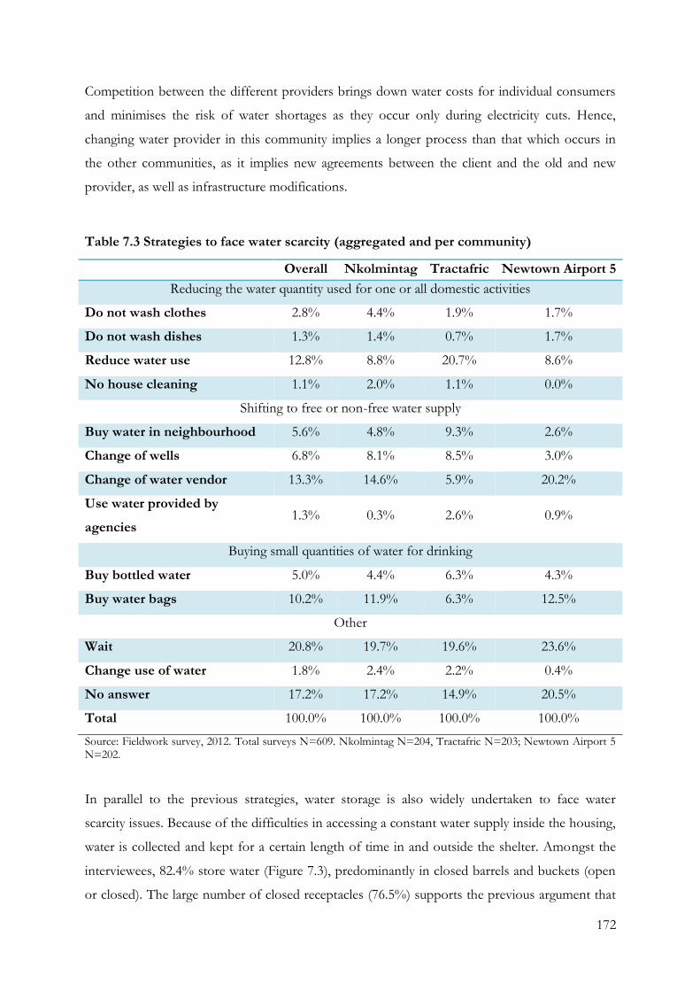
172
Competition between the different providers brings down water costs for individual consumers
and minimises the risk of water shortages as they occur only during electricity cuts. Hence,
changing water provider in this community implies a longer process than that which occurs in
the other communities, as it implies new agreements between the client and the old and new
provider, as well as infrastructure modifications.
Table 7.3 Strategies to face water scarcity (aggregated and per community)
Overall Nkolmintag Tractafric Newtown Airport 5
Reducing the water quantity used for one or all domestic activities
Do not wash clothes 2.8% 4.4% 1.9% 1.7%
Do not wash dishes 1.3% 1.4% 0.7% 1.7%
Reduce water use 12.8% 8.8% 20.7% 8.6%
No house cleaning 1.1% 2.0% 1.1% 0.0%
Shifting to free or non-free water supply
Buy water in neighbourhood 5.6% 4.8% 9.3% 2.6%
Change of wells 6.8% 8.1% 8.5% 3.0%
Change of water vendor 13.3% 14.6% 5.9% 20.2%
Use water provided by
agencies 1.3% 0.3% 2.6% 0.9%
Buying small quantities of water for drinking
Buy bottled water 5.0% 4.4% 6.3% 4.3%
Buy water bags 10.2% 11.9% 6.3% 12.5%
Other
Wait 20.8% 19.7% 19.6% 23.6%
Change use of water 1.8% 2.4% 2.2% 0.4%
No answer 17.2% 17.2% 14.9% 20.5%
Total 100.0% 100.0% 100.0% 100.0%
Source: Fieldwork survey, 2012. Total surveys N=609. Nkolmintag N=204, Tractafric N=203; Newtown Airport 5 N=202.
In parallel to the previous strategies, water storage is also widely undertaken to face water
scarcity issues. Because of the difficulties in accessing a constant water supply inside the housing,
water is collected and kept for a certain length of time in and outside the shelter. Amongst the
interviewees, 82.4% store water (Figure 7.3), predominantly in closed barrels and buckets (open
or closed). The large number of closed receptacles (76.5%) supports the previous argument that
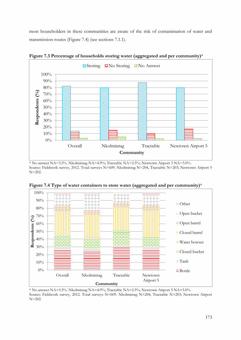
173
most householders in these communities are aware of the risk of contamination of water and
transmission routes (Figure 7.4) (see sections 7.1.1).
Figure 7.3 Percentage of households storing water (aggregated and per community)*
* No answer NA=3.5%. Nkolmintag NA=4.9%; Tractafric NA=2.5%; Newtown Airport 5 NA=3.0%. Source: Fieldwork survey, 2012. Total surveys N=609. Nkolmintag N=204, Tractafric N=203; Newtown Airport 5 N=202.
Figure 7.4 Type of water containers to store water (aggregated and per community)*
* No answer NA=3.5%. Nkolmintag NA=4.9%; Tractafric NA=2.5%; Newtown Airport 5 NA=3.0%. Source: Fieldwork survey, 2012. Total surveys N=609. Nkolmintag N=204, Tractafric N=203; Newtown Airport N=202.
0%
10%
20%
30%
40%
50%
60%
70%
80%
90%
100%
Overall Nkolmintag Tractafric Newtown Airport 5
Resp
on
den
ts (
%)
Community
Storing No Storing No Answer
0%
10%
20%
30%
40%
50%
60%
70%
80%
90%
100%
Overall Nkolmintag Tractafric NewtownAirport 5
Resp
on
den
ts (
%)
Community
Other
Open bucket
Open barrel
Closed barrel
Water bowser
Closed bucket
Tank
Bottle
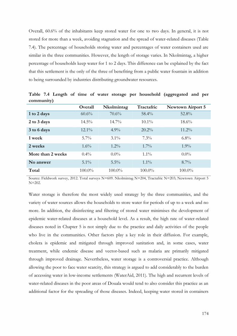
174
Overall, 60.6% of the inhabitants keep stored water for one to two days. In general, it is not
stored for more than a week, avoiding stagnation and the spread of water-related diseases (Table
7.4). The percentage of households storing water and percentages of water containers used are
similar in the three communities. However, the length of storage varies. In Nkolmintag, a higher
percentage of households keep water for 1 to 2 days. This difference can be explained by the fact
that this settlement is the only of the three of benefiting from a public water fountain in addition
to being surrounded by industries distributing groundwater resources.
Table 7.4 Length of time of water storage per household (aggregated and per
community)
Overall Nkolmintag Tractafric Newtown Airport 5
1 to 2 days 60.6% 70.6% 58.4% 52.8%
2 to 3 days 14.5% 14.7% 10.1% 18.6%
3 to 6 days 12.1% 4.9% 20.2% 11.2%
1 week 5.7% 3.1% 7.3% 6.8%
2 weeks 1.6% 1.2% 1.7% 1.9%
More than 2 weeks 0.4% 0.0% 1.1% 0.0%
No answer 5.1% 5.5% 1.1% 8.7%
Total 100.0% 100.0% 100.0% 100.0%
Source: Fieldwork survey, 2012. Total surveys N=609. Nkolmintag N=204, Tractafric N=203; Newtown Airport 5 N=202.
Water storage is therefore the most widely used strategy by the three communities, and the
variety of water sources allows the households to store water for periods of up to a week and no
more. In addition, the disinfecting and filtering of stored water minimises the development of
epidemic water-related diseases at a household level. As a result, the high rate of water-related
diseases noted in Chapter 5 is not simply due to the practice and daily activities of the people
who live in the communities. Other factors play a key role in their diffusion. For example,
cholera is epidemic and mitigated through improved sanitation and, in some cases, water
treatment, while endemic disease and vector-based such as malaria are primarily mitigated
through improved drainage. Nevertheless, water storage is a controversial practice. Although
allowing the poor to face water scarcity, this strategy is argued to add considerably to the burden
of accessing water in low-income settlements (WaterAid, 2011). The high and recurrent levels of
water-related diseases in the poor areas of Douala would tend to also consider this practice as an
additional factor for the spreading of those diseases. Indeed, keeping water stored in containers
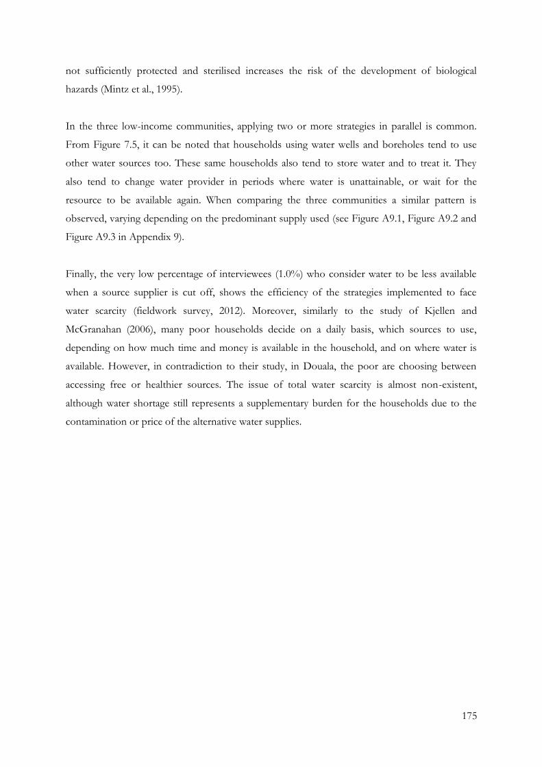
175
not sufficiently protected and sterilised increases the risk of the development of biological
hazards (Mintz et al., 1995).
In the three low-income communities, applying two or more strategies in parallel is common.
From Figure 7.5, it can be noted that households using water wells and boreholes tend to use
other water sources too. These same households also tend to store water and to treat it. They
also tend to change water provider in periods where water is unattainable, or wait for the
resource to be available again. When comparing the three communities a similar pattern is
observed, varying depending on the predominant supply used (see Figure A9.1, Figure A9.2 and
Figure A9.3 in Appendix 9).
Finally, the very low percentage of interviewees (1.0%) who consider water to be less available
when a source supplier is cut off, shows the efficiency of the strategies implemented to face
water scarcity (fieldwork survey, 2012). Moreover, similarly to the study of Kjellen and
McGranahan (2006), many poor households decide on a daily basis, which sources to use,
depending on how much time and money is available in the household, and on where water is
available. However, in contradiction to their study, in Douala, the poor are choosing between
accessing free or healthier sources. The issue of total water scarcity is almost non-existent,
although water shortage still represents a supplementary burden for the households due to the
contamination or price of the alternative water supplies.
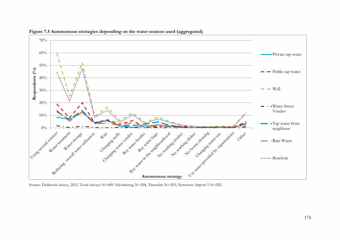
176
Figure 7.5 Autonomous strategies depending on the water sources used (aggregated)
Source: Fieldwork survey, 2012. Total surveys N=609. Nkolmintag N=204, Tractafric N=203; Newtown Airport 5 N=202.
0%
10%
20%
30%
40%
50%
60%
70%
Resp
on
den
ts (
%)
Autonomous strategy
Private tap water
Public tap water
Well
Water StreetVendor
Tap water fromneighbour
Rain Water
Borehole
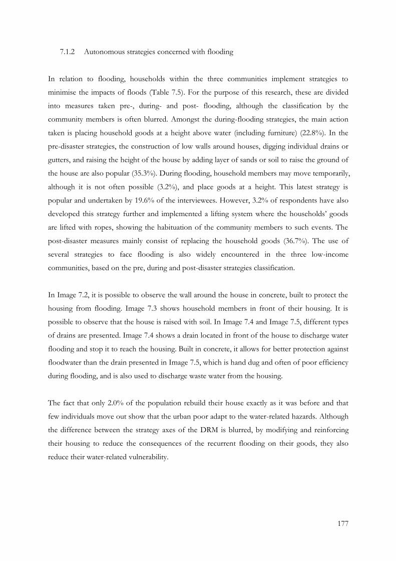
177
7.1.2 Autonomous strategies concerned with flooding
In relation to flooding, households within the three communities implement strategies to
minimise the impacts of floods (Table 7.5). For the purpose of this research, these are divided
into measures taken pre-, during- and post- flooding, although the classification by the
community members is often blurred. Amongst the during-flooding strategies, the main action
taken is placing household goods at a height above water (including furniture) (22.8%). In the
pre-disaster strategies, the construction of low walls around houses, digging individual drains or
gutters, and raising the height of the house by adding layer of sands or soil to raise the ground of
the house are also popular (35.3%). During flooding, household members may move temporarily,
although it is not often possible (3.2%), and place goods at a height. This latest strategy is
popular and undertaken by 19.6% of the interviewees. However, 3.2% of respondents have also
developed this strategy further and implemented a lifting system where the households’ goods
are lifted with ropes, showing the habituation of the community members to such events. The
post-disaster measures mainly consist of replacing the household goods (36.7%). The use of
several strategies to face flooding is also widely encountered in the three low-income
communities, based on the pre, during and post-disaster strategies classification.
In Image 7.2, it is possible to observe the wall around the house in concrete, built to protect the
housing from flooding. Image 7.3 shows household members in front of their housing. It is
possible to observe that the house is raised with soil. In Image 7.4 and Image 7.5, different types
of drains are presented. Image 7.4 shows a drain located in front of the house to discharge water
flooding and stop it to reach the housing. Built in concrete, it allows for better protection against
floodwater than the drain presented in Image 7.5, which is hand dug and often of poor efficiency
during flooding, and is also used to discharge waste water from the housing.
The fact that only 2.0% of the population rebuild their house exactly as it was before and that
few individuals move out show that the urban poor adapt to the water-related hazards. Although
the difference between the strategy axes of the DRM is blurred, by modifying and reinforcing
their housing to reduce the consequences of the recurrent flooding on their goods, they also
reduce their water-related vulnerability.
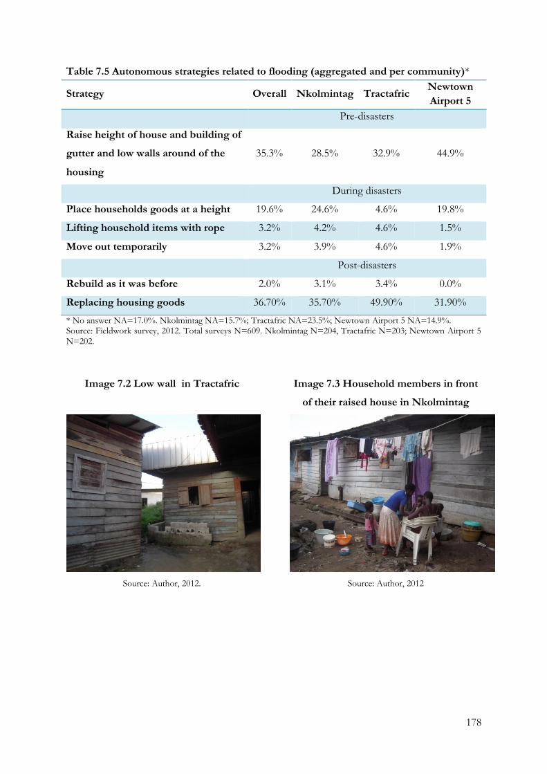
178
Table 7.5 Autonomous strategies related to flooding (aggregated and per community)*
Strategy Overall Nkolmintag Tractafric Newtown
Airport 5
Pre-disasters
Raise height of house and building of
gutter and low walls around of the
housing
35.3% 28.5% 32.9% 44.9%
During disasters
Place households goods at a height 19.6% 24.6% 4.6% 19.8%
Lifting household items with rope 3.2% 4.2% 4.6% 1.5%
Move out temporarily 3.2% 3.9% 4.6% 1.9%
Post-disasters
Rebuild as it was before 2.0% 3.1% 3.4% 0.0%
Replacing housing goods 36.70% 35.70% 49.90% 31.90%
* No answer NA=17.0%. Nkolmintag NA=15.7%; Tractafric NA=23.5%; Newtown Airport 5 NA=14.9%. Source: Fieldwork survey, 2012. Total surveys N=609. Nkolmintag N=204, Tractafric N=203; Newtown Airport 5 N=202.
Image 7.2 Low wall in Tractafric
Source: Author, 2012.
Image 7.3 Household members in front
of their raised house in Nkolmintag
Source: Author, 2012
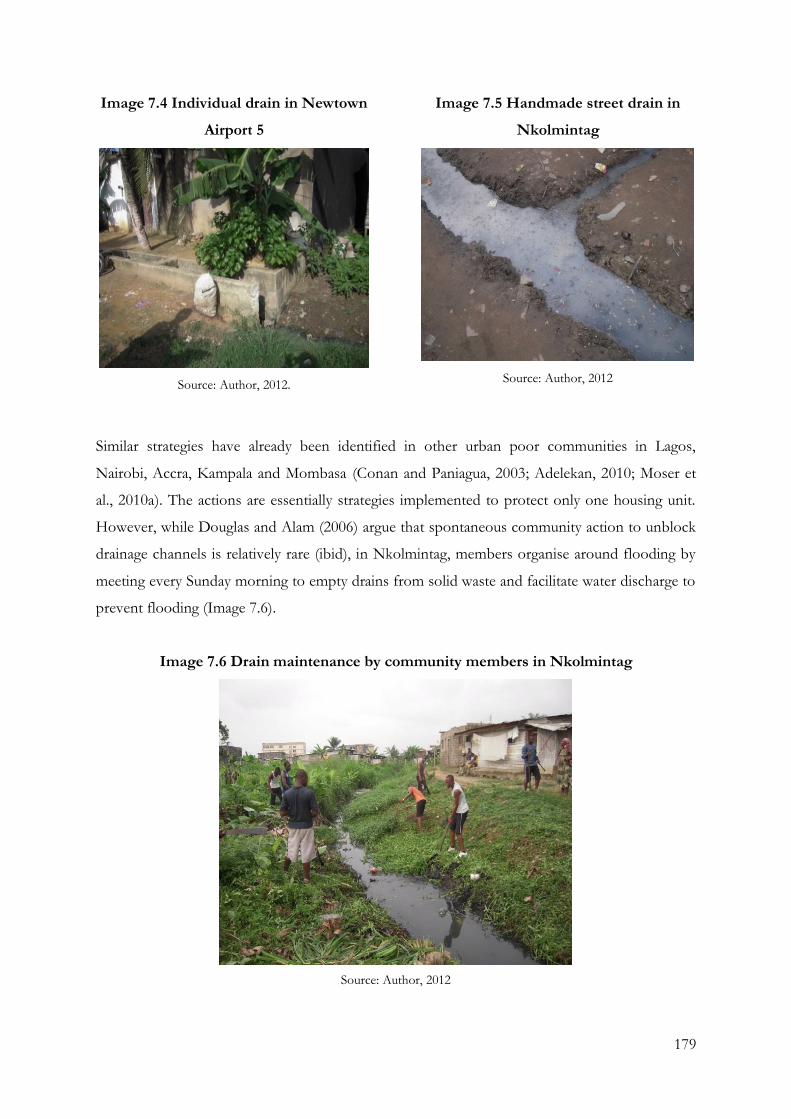
179
Image 7.4 Individual drain in Newtown
Airport 5
Source: Author, 2012.
Image 7.5 Handmade street drain in
Nkolmintag
Source: Author, 2012
Similar strategies have already been identified in other urban poor communities in Lagos,
Nairobi, Accra, Kampala and Mombasa (Conan and Paniagua, 2003; Adelekan, 2010; Moser et
al., 2010a). The actions are essentially strategies implemented to protect only one housing unit.
However, while Douglas and Alam (2006) argue that spontaneous community action to unblock
drainage channels is relatively rare (ibid), in Nkolmintag, members organise around flooding by
meeting every Sunday morning to empty drains from solid waste and facilitate water discharge to
prevent flooding (Image 7.6).
Image 7.6 Drain maintenance by community members in Nkolmintag
Source: Author, 2012
180
7.1.3 Limits and benefits of the different actions taken by the inhabitants of the
communities
Autonomous adaptation strategies to water-related issues take many forms in the low-income
communities studied. Some actions, such as the maintenance of the main drain, take place at the
community level while others, such as the raising of a house, occur at the household level.
However, while these diverse strategies ease people’s access to water and reduce the impacts of
water-related disasters, it also presents drawbacks. Depending on the particular issue the
communities are attempting to deal with, the strategies require a vast range of material and
financial resources that are not always available, leading to the slowing down or desisting in
implementing these measures. Interviewees stressed that these limitations are due to three main
factors: a lack of financial resources, a lack of proper infrastructure and a lack of hydrogeological
knowledge.
Low-income is one of the major reasons why houses are not connected to the national water
network, as the cost of a basic connection to the network is approximately 150,000 Fcfa, and is a
major obstacle to accessing drinking water (IIF1, May 2012). This price increases according to the
length of the pipes needed to connect the house to the main pipelines. As pipelines mainly
follow paved roads located around the settlements, a house located at the centre of the
neighbourhood will have to pay more for connection to the network. Few houses are connected
to the water network and the system reaches those that are usually positioned at the edge of the
community (ILG11, March 2012).
Another factor expressed by the community members, agency workers and the authorities is the
technical feasibility of introducing the network within the community (ILG6, May 2012). Major
action is required to address the lack of urban planning, non-availability of large pipes, instability
of the ground, and the extensive and rapid growth of the settlements, enmeshed as they are in
land titling complexities. All these factors escalate the cost of the projects and further multiply
the legal, social and engineering complexities (ILG6, May 2012). Moreover, taking action at
household level is often problematic as the status of the tenant does not give the occupier the
sufficient authority and legitimacy to take positive steps to protect their homes (ILG6, May 2012).
Thus, in spite of experiencing major difficulties, to take individual actions to minimise the
disasters’ impacts increases in complexity.
181
Additionally, the autonomous strategies of low-income communities are rendered unsustainable
by their failure to coordinate their actions. “When my neighbour raised the height of his house
and built the small drain in front of his house, the water flooded my house, and I had to save
money to raise my house too” (fieldwork notes, 2012). Thus, although the strategies of raising
houses and constructing small drains in front of the housing effectively reduce the impact of
flooding, the failure to coordinate these measures renders them unsustainable.
Actually, this is what the population does: you raise your house height, and when it is
higher, mine is down and I have to stay in the hole. The neighbour fills in, and you, who
do not have the resources to raise yours, you stay in the floodwater. If you dig into my
ground here you will see at least three layers of cement. All the money of inhabitants of
Nkolmintag is invested in embanking the house. During the dry season, everyone looks for
small truckloads of soil to raise his house. Whoever does not have the resources is left in
the floodwater, and so it goes on. And when he too has enough resources, your neighbour
raise his home higher and the water comes back to flood yours. It's like that. It is like a
shell game going on (ILG1, April 2012).
Thus, the housing newly equipped with these small infrastructures passes on the water flood to
the less well prepared or more precariously equipped neighbouring house. Although these
strategies might actually solve some of the problems the inhabitants encounter, they are
temporary solutions and have to be renewed regularly due to the poor quality of the construction
material used in many cases, and the lack of tools.
In this context, the current proximity of wells and boreholes to human activities and sources of
contaminated water such as drains and latrines is not perceived as a major issue, or else is
justified by the non-existence of other alternatives. Indeed, as seen in chapter 4, the
overcrowding of built areas leads to a very short distance between wells, boreholes and latrines,
with little consultation with surrounding households. As a result, pit latrines are located close to
the groundwater sources, despite Douala’s existing digging norms of a 20-metre security zone
around a well that prohibits such human activities (ILG1, March 2012). The transfer of
contaminating agents from the latrines to water well is, therefore, higher than in areas where this
rule is respected.
182
The water contamination, added to the lack of clear hydrogeological and technical information,
creates a critical situation. The absence of this knowledge by the community members and
national and local institutions has led to an unmonitored use of groundwater and an unawareness
of its impact. Although they are aware of water contamination, the digging of wells and
boreholes cannot be not properly controlled by the authorities without this information, and it is
common to find abandoned boreholes that have run dry. Besides, boreholes are often confused
with wells and are dug only 4 to 15 metres deep, leading to an imprecise use of these small
structures, further increasing the risk of contamination. The impact of this confusion is also
shown by the water-related diseases rates in the three low-income communities.
This limitation is, however, not new. It has already been reported in many studies. In relation to
on-site sanitation, the factors controlling transport of microbial and chemical contaminants in
the subsurface have been the subject of several reviews (WHO, 2006), and there is extensive
literature that more broadly quantifies contaminant transport processes in groundwater (Schijven
and Hassanizadeh, 2000). Soil/rock type, natural and human-altered groundwater flow rates and
paths, and the biogeochemical environment of the subsurface all govern contaminant travel
distances and rates. The potential for widespread groundwater contamination from pit latrines is
also affected by social factors, such as latrine use, latrine densities, maintenance, and
groundwater pumping. Latrine type, design, materials, and construction quality also influence
contaminant containment and leaching from pit latrines. Thus, to effectively evaluate the safety
of pit latrine and groundwater source proximity, both environmental and anthropogenic factors
must be considered (Graham and Polizzotto, 2013).
7.2 Linking autonomous strategies to DRM and IWRM
7.2.1 Coping and adaptation strategies
For the purposes of this research, the strategies implemented within the low-income
communities for dealing with water-related disasters and scarcities are classified according to the
division and definitions given by the ICPP (2007a) (see 2.3.2). The distinction between coping
strategies and adaptation strategies is analysed, in which the difference is based on the period of
effectiveness of the strategy and whether the strategy is repeated at least once a year. In the three
communities studied in Douala, more adaptation strategies than coping strategies are identified
(Table 7.6, Table 7.7). While, autonomous coping strategies for water scarcity and water-related
183
disasters were identified, such as changing clothes at the entrance or exit to the community when
raining, pumping out water from houses (fieldwork notes, 2012), or storing water in case of
water shortage, informal infrastructural constructions are mostly classified as adaptation
strategies.
When analysing both above Tables 7.6 and 7.7, a significant difference is observed in term of
effectiveness period between both types of strategies. Most of the coping strategies need a more
frequent renewing than the adaptation strategies or do attempt not address the deeper causes of
the water issue being addressed. For example, coping strategies include: changing clothes,
pumping out water out, water storage, reducing the amount of water that will be carried out
every time the water issue occurs. Differently, low-walls, well and borehole construction, and
water well disinfection will be carried out less regularly as these strategies’ outcomes last longer
than the “immediate responses” to which the coping strategies can be assimilated. However, the
difference between coping and adapting strategies is not always straightforward. For instance, the
difference between the treatment of the small water supplies of the households and treatment of
public water supplies is difficult to distinguish, although their impact level and complexity of
implementation are discernible.
Data analysis also shows that adaptation strategies involve a larger amount of community
members than coping strategies. For instance, changing clothes, pumping out water, water
storage, lifting or replacing households’ goods, reducing the amount of water and purification of
household water supply and water storage all involve the participation of one individual to the
household. However, building a low-wall, well and borehole construction, water well disinfection,
and changing water supplier involve the participation of the household to the neighbouring
houses. The outcomes of adaptation strategies are, therefore, quantitatively wider than coping
strategies, although adaptation strategies also appear to require a stronger adaptation capacity as
they require more material and tools.
In the context of integrating the bottom-up strategies in the institutional frameworks, the
existing water contamination, which is likely to be exacerbated by climate change impacts, lead to
an inadequate sustainability of the autonomous adaptation strategies. Nevertheless, coping
strategies are presented in the literature as a precursor of adaptation strategies, which is
supported by the findings here. Indeed, there is a noticeable link between adaptation strategies at
a community level and coping strategies at a household level. For instance, the disinfection and
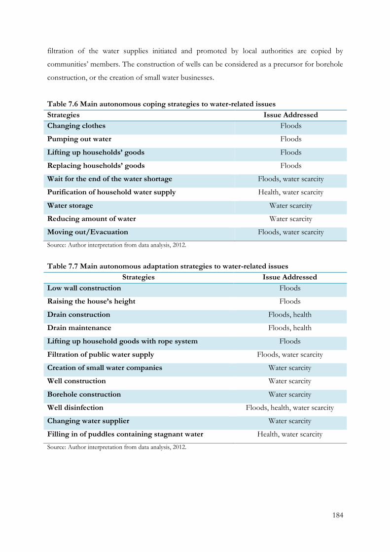
184
filtration of the water supplies initiated and promoted by local authorities are copied by
communities’ members. The construction of wells can be considered as a precursor for borehole
construction, or the creation of small water businesses.
Table 7.6 Main autonomous coping strategies to water-related issues
Strategies Issue Addressed
Changing clothes Floods
Pumping out water Floods
Lifting up households’ goods Floods
Replacing households’ goods Floods
Wait for the end of the water shortage Floods, water scarcity
Purification of household water supply Health, water scarcity
Water storage Water scarcity
Reducing amount of water Water scarcity
Moving out/Evacuation Floods, water scarcity
Source: Author interpretation from data analysis, 2012.
Table 7.7 Main autonomous adaptation strategies to water-related issues
Strategies Issue Addressed
Low wall construction Floods
Raising the house’s height Floods
Drain construction Floods, health
Drain maintenance Floods, health
Lifting up household goods with rope system Floods
Filtration of public water supply Floods, water scarcity
Creation of small water companies Water scarcity
Well construction Water scarcity
Borehole construction Water scarcity
Well disinfection Floods, health, water scarcity
Changing water supplier Water scarcity
Filling in of puddles containing stagnant water Health, water scarcity
Source: Author interpretation from data analysis, 2012.
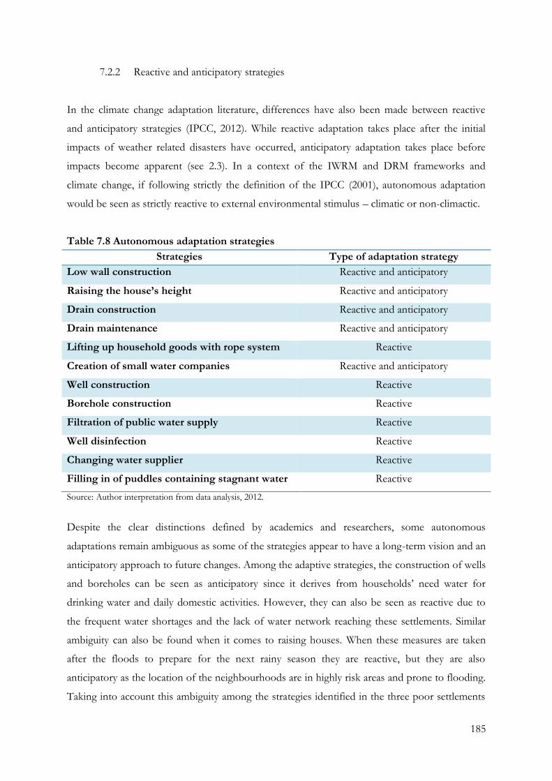
185
7.2.2 Reactive and anticipatory strategies
In the climate change adaptation literature, differences have also been made between reactive
and anticipatory strategies (IPCC, 2012). While reactive adaptation takes place after the initial
impacts of weather related disasters have occurred, anticipatory adaptation takes place before
impacts become apparent (see 2.3). In a context of the IWRM and DRM frameworks and
climate change, if following strictly the definition of the IPCC (2001), autonomous adaptation
would be seen as strictly reactive to external environmental stimulus – climatic or non-climactic.
Table 7.8 Autonomous adaptation strategies
Strategies Type of adaptation strategy
Low wall construction Reactive and anticipatory
Raising the house’s height Reactive and anticipatory
Drain construction Reactive and anticipatory
Drain maintenance Reactive and anticipatory
Lifting up household goods with rope system Reactive
Creation of small water companies Reactive and anticipatory
Well construction Reactive
Borehole construction Reactive
Filtration of public water supply Reactive
Well disinfection Reactive
Changing water supplier Reactive
Filling in of puddles containing stagnant water Reactive
Source: Author interpretation from data analysis, 2012.
Despite the clear distinctions defined by academics and researchers, some autonomous
adaptations remain ambiguous as some of the strategies appear to have a long-term vision and an
anticipatory approach to future changes. Among the adaptive strategies, the construction of wells
and boreholes can be seen as anticipatory since it derives from households’ need water for
drinking water and daily domestic activities. However, they can also be seen as reactive due to
the frequent water shortages and the lack of water network reaching these settlements. Similar
ambiguity can also be found when it comes to raising houses. When these measures are taken
after the floods to prepare for the next rainy season they are reactive, but they are also
anticipatory as the location of the neighbourhoods are in highly risk areas and prone to flooding.
Taking into account this ambiguity among the strategies identified in the three poor settlements
186
of Douala, the analysis of data fieldwork led to the identification of the strategies as being mostly
reactive, although both reactive and anticipatory are also identified as these are implemented with
the purpose of responding to flooding and water scarcity but anticipating the next event (Table
7.8).
7.2.3 Effectiveness of the autonomous strategies
In general, an approach to estimate both the costs of implementing a measure and the potential
benefits from doing so is needed. Benefits can be thought of as climate change impacts avoided
or positive effects taken advantage of (Feenstra et al., 1998). However, adaptation, whether
analysed for purposes of assessment or practice, is intimately associated with the concepts of
vulnerability and adaptive capacity (Smit and Wandel, 2006). In this sense, Schipper (2007)
argues that the “vulnerability reduction approach” to development is more desirable than the
“adaptation approach”. For the purpose of this research, a strategy is, therefore, considered
effective if it reduces sensitivity and exposure, and increases adaptive capacities, as it appears to
address more adequately the fundamental reasons for vulnerability, many of which are about
broader development. This argument is supported by the fact that many of the strategies
examined are implemented by the urban poor, making the estimation of both the costs of
implementing a measure and the potential benefits not fully appropriate.
Drawing from this discussion, the strategies related to the built environment implemented by the
communities’ members to face flooding are effective. Indeed, as seen in chapter 5, floods occur
so frequently community inhabitants perceive them to be standard events, an argument that is
also supported by the high number of “no hazards” answers given. Most autonomous adaptation
strategies to deal with flooding are carried out by community members, showing the diversity of
actions undertaken to minimise direct flooding impacts. However, the adaptive capacity of the
household themselves is limited due to the lack of financial resources. Communities’ members
claim that most of their income is spent on the purchase of building materials (sand) to raise the
housing height and to build the low walls. The adaptive capacity of other actions such as drain
maintenance is said to be limited by the lack of tools such as shovels and rakes.
With regard to autonomous adaptive water access strategies, the measures taken generally lead to
the exploitation of groundwater. For instance, the creation of small water businesses is an
interesting evolution from the creation and treatment of groundwater selling. These strategies,
187
only present in Newtown Airport 5, benefit from the legal confusion around local governance
and the legality of titling of the land. The adaptive capacity of the communities to the supply of
water is shown to be resilient due to the numerous alternative water sources they can fall back on
and the actions they undertake to access this vital resource. As a result, the adaptive capacity is
important due to the abundance of resources. Money earned by selling the groundwater is
invested later in managing this same resource (buying disinfectants, for example). The limitation
of the adaptive capacity is the lack of scientific information and data about groundwater. Indeed,
the emergence of profitable water distribution businesses generated an increase of this type of
enterprise in the community, with the result that boreholes were built without proper knowledge,
leading to the unforeseen consequences such as extraction, distribution, and management of
contaminated water.
Although a particular strategy may be implemented specifically to cope with one of the three
major issues, flooding, water-related epidemics and water scarcity, encountered in the low-
income communities, it can indirectly impact on one of the others. For instance, the
construction and maintenance of drains was implemented to cope with flooding, however it also
have an influence on malaria rate. Moreover, the diversity of strategies shows the strength of
their adaptation capacity, although the strategies are generally focused on only one hazard/issue.
The amount of strategies the communities use to cope with water scarcity reflects the larger
choice of resources available to them. The strategies used to tackle flooding are mostly structural
but face major difficulties due to lack of financial resources and coordinated action. This
situation is well known to local officials and arises from the fact that a large number of the
community members are tenants, restricting the opportunity for legal action.
7.2.4 Impact of institutional strategies on autonomous strategies
“Institutions are the rules of the game in a society or, more formally, are the humanly devised
constraints that shape human interactions, and they consist of both informal and formal
constraints” (North, 1990, p. 5). Autonomous adaptation refers to adaptive actions by
individuals and communities without deliberative government planning or intervention, but they
do not act in isolation from the existing social, political, cultural and market institutions.
Therefore, the role of institutions is touched upon in many studies on climate change adaptation
(Eakin, 2005).
188
Diverse institutional measures and programmes are implemented to deal with the three major
issues - flooding, water-related epidemics and water scarcity - experienced by the low-income
communities in Douala. As climate change impacts on water are likely to occur more intensively
and frequently, this increases the importance of these strategies. Identified planned strategies
such as well disinfection and the construction and maintenance of drains may be replicated by
the community members. For instance, Douala Urban Council and Douala II City Hall intervene
by disinfecting wells during cholera epidemics. Low-income communities were then expected to
repeat these measures, monitored by the chief of the community in his role as intermediary in
the implementation of this policy. Disinfectants, offered at no cost by the city hall for a limited
period, were regularly poured into the wells. Once distribution of the products ceased, a number
of people continued disinfecting wells themselves. In Newtown Airport 5, the creation of water
businesses with a similar mechanism as the formal water company, CDE, which metered and
charged for groundwater brought by pipe to the taps of neighbouring houses, led to regular
treatment of the water supply. This careful management was carried out to avoid discussions and
disagreements with local customers and also to deal with local competition.
Fankhauser et al. (1999) discussed the linkage between planned and autonomous adaptation as
either a substitute for or complementary to each other. If autonomous adaptation increases the
marginal benefit of planned adaptation and vice versa, they are considered complementary. On
the other hand, if autonomous adaptation reduces the need for planned adaptation and vice
versa, then they are substitutes. In Douala, the urban poor strategies often replace the
inefficiency of planned adaptation, substituting institutional programmes, measures and projects
in order to answer to the demand for basic services (Table 7.9). By finding alternative solutions,
communities are reactive to the environmental changes but also reactive to the lack of
institutional projects’ efficiency.
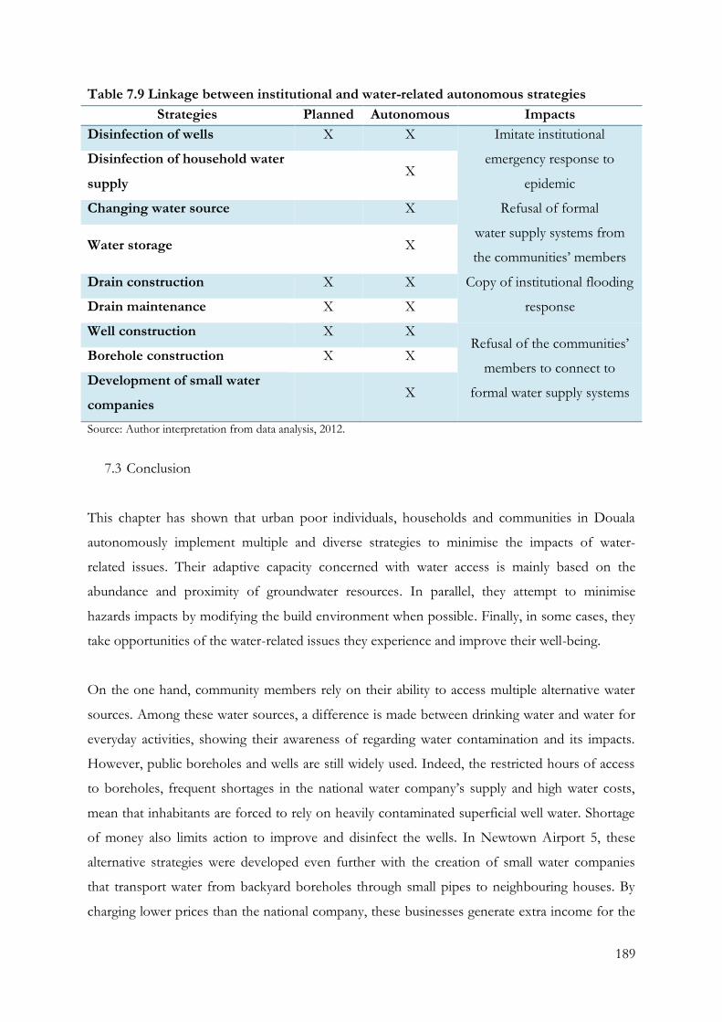
189
Table 7.9 Linkage between institutional and water-related autonomous strategies
Strategies Planned Autonomous Impacts
Disinfection of wells X X Imitate institutional
emergency response to
epidemic
Disinfection of household water
supply X
Changing water source
X Refusal of formal
water supply systems from
the communities’ members Water storage
X
Drain construction X X Copy of institutional flooding
response Drain maintenance X X
Well construction X X Refusal of the communities’
members to connect to
formal water supply systems
Borehole construction X X
Development of small water
companies X
Source: Author interpretation from data analysis, 2012.
7.3 Conclusion
This chapter has shown that urban poor individuals, households and communities in Douala
autonomously implement multiple and diverse strategies to minimise the impacts of water-
related issues. Their adaptive capacity concerned with water access is mainly based on the
abundance and proximity of groundwater resources. In parallel, they attempt to minimise
hazards impacts by modifying the build environment when possible. Finally, in some cases, they
take opportunities of the water-related issues they experience and improve their well-being.
On the one hand, community members rely on their ability to access multiple alternative water
sources. Among these water sources, a difference is made between drinking water and water for
everyday activities, showing their awareness of regarding water contamination and its impacts.
However, public boreholes and wells are still widely used. Indeed, the restricted hours of access
to boreholes, frequent shortages in the national water company’s supply and high water costs,
mean that inhabitants are forced to rely on heavily contaminated superficial well water. Shortage
of money also limits action to improve and disinfect the wells. In Newtown Airport 5, these
alternative strategies were developed even further with the creation of small water companies
that transport water from backyard boreholes through small pipes to neighbouring houses. By
charging lower prices than the national company, these businesses generate extra income for the
190
household, and their success has been emulated by others in the community, repeating and
expanding this trend to other households.
On the other hand, concerning flooding, the communities’ strategies for anticipating and
minimising the impacts of flooding are mostly building informal infrastructures. They are limited
by financial and infrastructural constraints, combined with lack of knowledge. The first major
limitation, lack of financial resources, is also one of the main reasons why their housing is not
connected to the national water network. The second major limitation is the lack of
infrastructure and unfeasibility of construction. Indeed, they lack effective drainage system, the
soil constitution, and the complex land tenure conditions make the construction of
supplementary drains challenging.
As a result, autonomous actions reduce the vulnerability of the urban poor. The effectiveness of
these strategies concerned with flooding, water-related diseases and access to water supply is,
however, limited by many factors. Many of these limitations could be overcome if community
efforts are better supported by authorities through enhanced responses and investments in
appropriate infrastructure at the city level. For example, the building of new drains could support
the communities channel localised flood water. Hence, the role and actions of the institutions are
also of a great importance in the reduction of the vulnerability of the urban poor.
In the literature, autonomous strategies are classified into copying/adaptation and
reactive/anticipatory approaches (IPCC, 2007a; Davies, 2009; IPCC, 2012). Although a strong
difference is observed in terms of period of efficiency between both types of strategies, the
distinction between coping and adapting strategies is not straightforward. Coping strategies have
a shorter time period of efficiency than adaptation strategies, are individual, and appear to be an
immediate response to the water- related issue. Adaptation strategies, however, reach a larger
amount of households than coping strategies and imply more complex processes of
implementation that require a broader adapting capacity. Likewise, the classification of the
strategies between reactive and anticipatory is ambiguous. If strictly following the definition of
the IPCC (2001), autonomous adaptation would be exclusively reactive. However, as seen, the
vulnerabilities of the urban poor are embedded within deeper external environmental stimulus –
climatic or non-climactic. Therefore, they might be implemented to anticipate water discharge
but also in reaction to flooding.
191
Finally, the adaptation processes and policies are shown to be necessary and demonstrate a
requirement to move further towards risk reduction and adaptation activities in advance of flood
events (Few et al., 2004) and water-related epidemics. The improvement and better monitoring
of infrastructure and services will play a major role in reducing the specific risk from water-
related issues and, therefore, seem indispensable to facing climate change impact. Although the
lack of urban planning adversely impacts on flood risk, and consequently water access and
epidemics for the urban poor, the analysis of the autonomous adaptation process taking place in
the communities shows it should be investigated with adaptation policies, as they are shown to
have a strong influence on each other. More effort is needed to identify and communicate best
practice in flood risk measurement, water access, and health risk response, and a deeper global
commitment to implement these best practices is required.
192
Chapter 8: Conclusion: the challenge of integrating DRM, IWRM and autonomous
strategies in low-income urban areas
This concluding chapter summarises the key findings of the thesis. First, the chapter returns to
review the findings against the objectives of the research. It also describes the dimensions of
water-related vulnerability of urban poor communities to face climate change impacts on water
in Douala. Furthermore, the impacts and the relationships between DRM and IWRM
institutional strategies, and the link between autonomous strategies and institutional strategies are
presented. The chapter finally examines the possible theoretical and policy implications of the
findings, as well as the limitations of the study and indicates future research opportunities.
The research explored the linkages between DRM, IWRM and autonomous adaptation in urban
poor communities. It identified the operational implementation of the DRM and IWRM
frameworks in Douala, Cameroon. Moreover, the study has examined the strategies implemented
within the poor neighbourhood facing water-related issues and their linkages with institutional
projects, programmes and measures carried out in the city.
8.1 Linking DRM, IWRM and the autonomous strategies of the urban poor
The study sought to validate the following hypothesis. The thesis was based on the hypothesis
that both formal institutional responses, such as DRM and IWRM, and local autonomous
strategies have a role to playing reducing water-related vulnerability of the urban poor.
Integrating both frameworks to increase effectiveness of approaches to climate change at the
local level requires an appropriate conceptual and operational understanding of the autonomous
strategies that urban poor communities are undertaking to manage, sometimes simultaneously,
water-related risks and to adapt to climate extremes. To validate the hypothesis, there were three
key objectives to examine: a) To examine water-related vulnerability to face climate change
impacts in urban poor communities. b) To analyse the impacts of the DRM and IWRM
frameworks on water-related vulnerability in urban poor communities. c) To explore the
relationships between DRM and IWRM institutional frameworks, and their link to autonomous
strategies of the urban poor.
193
8.1.1 Water-related vulnerability in urban poor communities
Overall, the low-income communities of the city of Douala face three main challenges regarding
water: major flooding, water-related epidemics, and limited access to drinking water. These
findings are foreseen. Flooding has already been identified among the most common causes of
disasters in cities (Satterthwaite, 2013). Moreover, drinking water scarcity has already been
stressed and appears in the Millennium Goal Development developed by the United Nations
(UN, 2012). Finally, during both flooding and water scarcity, the intensification of public health
impacts has also been recognised (Feiden, 2011). While these three issues strongly affect the city
of Douala, their consequences have greater impact in poor communities.
In order to face water stress and scarcity issues, the Ministry of Water and Energy, the city’s
industrial concerns and the inhabitants themselves are extensively building boreholes and wells,
making groundwater the main source of water supply in the low-income communities of Douala.
However, water wells and private boreholes are often heavily contaminated and flooding water is
not well discharged. The impact is made clear by the recurrence of water-related diseases Douala
suffers. Outbreaks of cholera and malaria occur regularly and increase during the rainy season.
Every year the city experiences numerous deaths attributed to these diseases, mainly prevalent in
poor communities. Even though little data on the rate of disease is available, discussion with
community members and agency workers confirmed that the lives of the city’s poorer
inhabitants are profoundly threatened by water-related diseases. Thus, flooding, epidemics, and
water scarcity are closely linked, and the close relationship between water-related disasters and
water resource management has crucial consequences that are detrimental to peoples’ health and
well-being.
In spite of this adverse context, the impacts of water-related hazards appear surprisingly limited
when considering their frequency and intensity. As explained in Chapter 5, when impacts occur
outside the house unit, many households are not directly affected. Similarly, water scarcity does
not appear to be a major issue in the three communities, and these limited impacts can be
explained by the autonomous strategies already implemented by the urban poor to face water
scarcity and water-related disasters. As seen in Chapter 7, these strategies take many forms both
at community and household levels, showing the extent of the adaptation capacities of the urban
poor.
194
The low-income communities’ members rely substantially on alternative water sources. Among
the options for accessing water, buying formal supplies from houses with direct tap water at the
periphery of the communities is commonly presented in the literature (Kjellen and McGranahan,
2006). However, in the poor communities of Douala, this is limited to a few houses. Instead, the
main autonomous strategies for accessing water focus on the exploitation of groundwater by the
low-income communities, present in abundance and easily reachable. Although common wells
are often shared with neighbouring housing for free, in some cases the water exploited through
private boreholes is re-sold to neighbouring house and a supplementary income is generated,
which is then reinvested into tools and materials. For instance, the financial assets accumulated
by selling the groundwater are then invested into managing this same resource and improving
the quality of the water distributed (buying disinfectants, for example). This action, along with
the important differentiation the community members make between drinking water and water
for everyday activities, shows their awareness regarding the issues associated with water
contamination. Hence, these findings supports the argument of Moser et al. (2010a) of the
reasonable knowledge of the urban poor. Although they focused on the variation in weather
pattern, this research showed that the low-income communities’ members are aware of the
overall water-related issues in their area and how it affects assets and well-being.
8.1.2 Impacts of the DRM and IWRM frameworks on water-related vulnerability in urban
poor communities
In cities of the global South, responses to climate change impacts have been dominated by the
Disaster Risk Management framework, which is based on three complementary types of action:
pre-disaster, during disaster, and after disaster (Bhavnani et al., 2008), similarly to the strategy
identified in in the Republic of Cameroon. When focusing on Douala, the leading institutions
involved are: Ministry of Territorial Administration and Decentralisation, Directorate of Civil
Defence, Emergency services and local authorities. However, the top-down hierarchical structure
of the framework has been shown to put more emphasis on emergency response to flooding,
although the causes of flooding require more specific and joint pre- and post- disaster strategies.
This finding supports the argument of Agnew and Woodhouse (2010): the DRM has tended to
focus on the mitigation of the hazards themselves, and on the increase in magnitude and
frequency of short-term extreme weather. Moreover, the role of local governments is not well
defined despite their substantial knowledge of difficulties at grass-roots level. Douala’s struggle
to implement the DRM framework in a sustainable manner is made worse by the absence of a
195
locally based civil protection team. When having to carry out emergency responses in the low-
income communities, the lack of urban planning and improvement of infrastructures in the
settlements hampers intervention measures during and after emergencies, and support rarely
reach the urban poor communities.
In addition, the IWRM, presented as a powerful tool for climate change adaptation, is seen by
the Cameroon government as an important strategy to reduce poverty and achieve the
Millennium Development Goals (De Waal, 2010). The framework’s implementation occurs in a
context where the water framework of Cameroon has been recently reformed to create a public-
private partnership, while facing slow development and severe water challenges as a result of
mismanagement, legal and institutional deficiencies and significant fragmentation of the water
sector. However, the IWRM does not directly impact the water policies of the country and the
MINEE stays in charge of the design of possible national and local water governance; and the
framework is still at an early stage of its implementation; and its action plan will define if the
process is counter-productive as an analytical framework from the perspective of poor people
(Merrey et al., 2005, p. 2).
8.1.3 Relationships between DRM and IWRM institutional frameworks, and their link to
autonomous strategies of the urban poor
The Disaster Risk Management and Integrated Water Resources Management frameworks are
hypothetically linked. Adaptation to climate change is a necessary and complementary aspect of
the mitigation approach supported by the DRM framework (IPCC, 2012). Moreover, as seen in
this study, flooding water-related diseases, and water scarcity experienced by the low-income
communities are closely linked, and water-related disasters and water-resource management have
significant consequences on people’s health and well-being.
Despite these linkages, no strategies have clearly been implemented at an operational level to
connect both frameworks, and none fully reach the urban poor in Douala. However, other
water-related measures and projects concerned with water-related issues are already implemented
in the low-income communities. These strategies are not officially recognised as adaptation
strategies or mitigation strategies and they are implemented by different ministries. All the
strategies are then supported by smaller-scale projects and measures undertaken by the city hall
and urban council. Little coordination is encountered between the institutions, although the
196
association of national and local institutional responses to national actions could reinforce the
effectiveness and the participation approach promoted by both DRM and IWRM frameworks.
The research also showed that the planned institutional strategies and the autonomous
adaptation strategies of the urban poor influence each other in a number of ways. For example,
as presented in section 7.2.4, households have been found to replicate some of the planned
measures and projects such as the disinfection of the water sources and supplies. On the other
hand, where there is extensive implementation of autonomous strategies such as the setting up
of private businesses selling borehole water, bringing private tap water accesses may be rejected.
Hence, when considering water-related issues, careful attention must be paid to autonomous
adaptation strategies. They strongly influence the institutional measures and programmes taken
to address those issues and can be presented as precursors of adaptation programmes. In this
context, the role of the government in providing the two institutional adaptation methods -
building adaptive capacity or delivering adaptation actions (UKCIP, 2005 cited in Malik et al.,
2010, p. 6) - appears crucial. In building adaptive capacity, they can support the actions of the
urban poor by providing an adequate water governance framework and water quality and
quantity data. In delivering adaptation actions, government can coordinate supplementary
actions in drain construction to further minimise flooding impacts.
The research findings are summarised in Table 8.1.
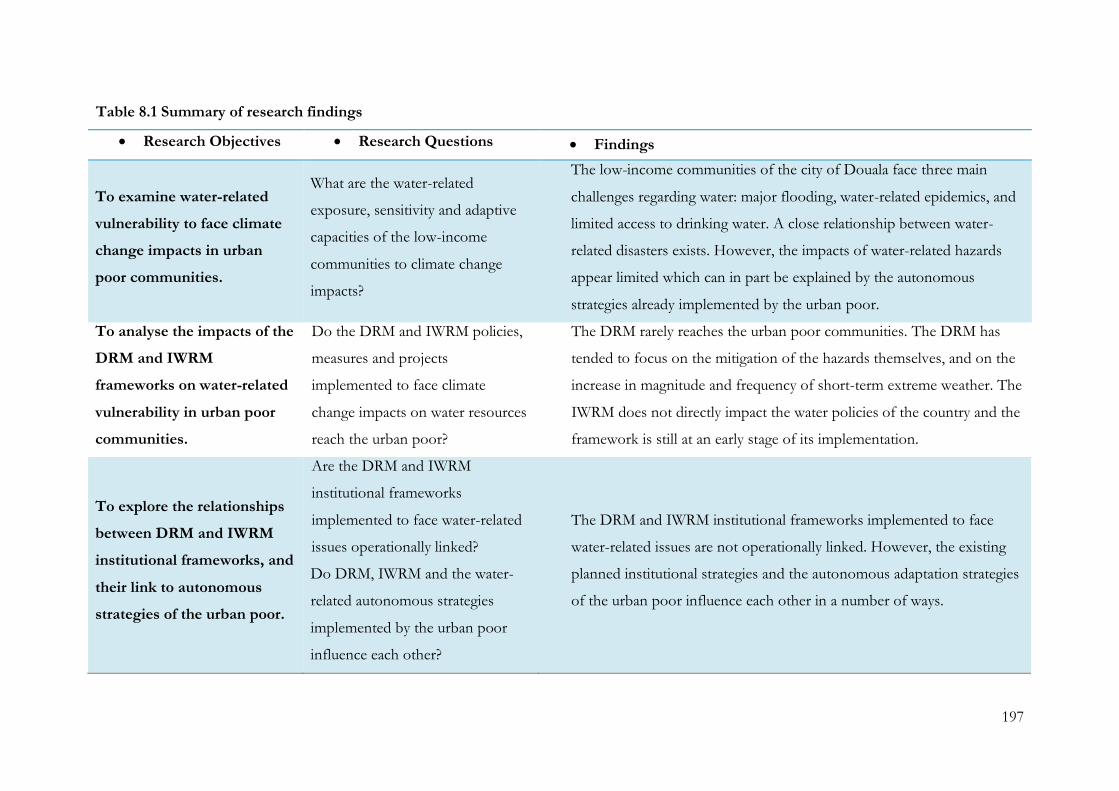
197
Table 8.1 Summary of research findings
Research Objectives Research Questions Findings
To examine water-related
vulnerability to face climate
change impacts in urban
poor communities.
What are the water-related
exposure, sensitivity and adaptive
capacities of the low-income
communities to climate change
impacts?
The low-income communities of the city of Douala face three main
challenges regarding water: major flooding, water-related epidemics, and
limited access to drinking water. A close relationship between water-
related disasters exists. However, the impacts of water-related hazards
appear limited which can in part be explained by the autonomous
strategies already implemented by the urban poor.
To analyse the impacts of the
DRM and IWRM
frameworks on water-related
vulnerability in urban poor
communities.
Do the DRM and IWRM policies,
measures and projects
implemented to face climate
change impacts on water resources
reach the urban poor?
The DRM rarely reaches the urban poor communities. The DRM has
tended to focus on the mitigation of the hazards themselves, and on the
increase in magnitude and frequency of short-term extreme weather. The
IWRM does not directly impact the water policies of the country and the
framework is still at an early stage of its implementation.
To explore the relationships
between DRM and IWRM
institutional frameworks, and
their link to autonomous
strategies of the urban poor.
Are the DRM and IWRM
institutional frameworks
implemented to face water-related
issues operationally linked?
Do DRM, IWRM and the water-
related autonomous strategies
implemented by the urban poor
influence each other?
The DRM and IWRM institutional frameworks implemented to face
water-related issues are not operationally linked. However, the existing
planned institutional strategies and the autonomous adaptation strategies
of the urban poor influence each other in a number of ways.

198
8.2 Contributions to theoretical debates on Climate Change Adaptation and Disaster Risk
Management and autonomous adaptation
The findings of this thesis contribute directly to the theoretical debates on the linkage between
Disaster Risk Management and Climate Change Adaptation (Few et al., 2006; IPCC, 2012)
through its tool, the Integrated Water Resources Management. While most discussions on DRM
and CCA emphasise the issues of linkages between the frameworks (Sperling and Szekely, 2005;
Biesbroek et al., 2009; IPCC, 2012), this thesis incorporates the urban poor autonomous
strategies related to water access and water-related disasters into the discussion. The thesis also
formulates arguments from the findings that autonomous adaptation strategies driven by the
adaptive capacity of the urban poor must be factored into the implementation of the climate
change approaches. Building a bridge between the two climate change approaches, DRM and
CCA, through the IWRM framework can be achieved by promoting bottom up approaches in
urban poor communities.
Focusing on climate extreme impacts highlights two facts. First, in urban areas, water resources
and poor households’ access to water are exposed to and impacted by climate extremes. Poor
households are able to make spontaneous adjustments to reduce risks and vulnerability in
response to observed and expected changes. Thus, the empirical work highlights the significance
of access to formal or informal safe water infrastructures (McGranahan and Satterthwaitte, 2006)
to enhance the potential of an individual or a household to adjust their strategies to face climate
extremes. Second, emphasis on the link between extreme weather and the water resources used
by the urban poor consequently also contributes to the arguments for an integrated system in
cities that advocates addressing the socioeconomic well-being of urban poor households
alongside climate vulnerabilities (Vörösmarty et al., 2000). Since DRM and IWRM emphasise
urban poor vulnerabilities, in terms of water and sanitation, the approaches imply the need to
assess water and sanitation access, the management and maintenance of overall infrastructures,
and a consideration of the processes for accessing these infrastructures by the urban poor.
This thesis also showed that there are differences between autonomous adaptation strategies and
coping strategies (IPCC, 2012). While the division into reactive and anticipatory strategies (Smit
et al., 2000) might be ambiguous, differences between their period of efficiency (Nelson et al.,
2008; Davies, 2009) were identified. Similarly to the argument of the IPCC (2012), coping actions
were also found to have a shorter-term vision and often precede adaptation actions. Finally, this
199
work also revealed that adaptation strategies involve a larger amount of community members
than coping strategies. Therefore, by analysing both types of strategies with a quantitative
approach, a supplementary distinction was made.
8.3 Methodological limitations
This research used a mixed methods approach, with the use of quantitative methods permitting
statistical analysis which understands the frequency of problems across space, and qualitative
methods offering insight and critical detail on why these patterns may be occurring. Semi-
structured interviews enabled understanding of the national design and implementation
processes which were carried out to respond to international agreements which sought to
address climate change and water impacts. The questionnaire permitted exploration of the range
of behavioural approaches to water access and water-hazards at the local scale. Following the
logic of triangulation, the methodological approach was able to make sense of the relationships
between different scales of water risk management.
During the implementation of this methodological strategy, three main challenges were faced.
Firstly, as the researcher is of Western European ethnicity and an outsider of the communities, it
created a power dynamic which generated difficulties in access to the settlements, and potentially
reduced the reliability of data collected in the low-income communities. However, working with
local students helped to overcome this and limit the constraints it placed on the validity of data.
Secondly, little data about the communities was available for the researcher to examine and gain
a contextual understanding prior to working in those neighbourhoods. To overcome this issue,
semi-structured interviews were carried out first with the community leader, where collaborative
mapping of the areas helped to gain a better understanding of the institutional mechanisms and
structures. On this basis, a systematic sampling could be formed. Thirdly, from a more
theoretical view, working with the UN criterion proved challenging. Although these criterions
define a slum, they are – by their necessary applicability to a range of spatial contexts – quite
abstract, and proved very vague when applied to a real case city. As a result, in future studies it
may be helpful for additional criteria to be developed according to the specific focus of the
research, project and programmes of research.
200
8.4 Opportunities of autonomous-based adaptation measures and policies
The changes in hydrology as a result of climate change clearly require more immediate and
determined efforts. In Cameroon, current policies are top-down and focus on the optimum
exploitation of available water resources, or else express themselves as vague needs that have to
be adjusted and strengthened to meet the current principle that views fresh water as a limited
resource. Governments also urgently need to find and implement alternative and adaptive forms
of urban planning to face the increasing probability of extreme weather events and their related
impacts. To implement such policies, a legal and institutional framework needs to be in place
that will allow all stakeholders to become part of the process and manage the resources
according to agreed rights, powers and obligations.
As adaptation solutions for the water sector have experienced climatic conditions in the past, and
these conditions are now expected to become commonplace elsewhere, they should be a driving
principle of adaptation planning (Björklund, 2009). Moreover, adapting to climate change
impacts and integrating climate issues into policies does not involve many entirely new processes
or techniques (Kristensen et al., 2009). Indeed, policies such as the water law in Cameroon allow
the implementation of community-based projects and the application of the IWRM principles.
Based on the broad aims and principles of IWRM, the policies should integrate the autonomous
adaptation strategies of all users and create resilient solutions to the expected impacts of climate
change and population growth that are already transforming land-use and livelihoods.
By taking into account communities’ autonomous actions and current strategies to mitigate
water-related risk, city, regional and national initiatives can be more effective. Indeed, developing
joint adaptation procedures and disasters risk-management practices for the water sector,
including autonomous adaptation strategies, would permit the management measures to reduce
the situations of water stress in low-income urban areas. This approach would allow to improve
water pricing, seasonal water rationing during times of shortage, increased capture and storage of
surface run-off, reuse or recycling of waste water after treatment, and a better use of
groundwater resources (Cap-Net, 2009). In a situation of water-quality risks, the measures could
include improvements to drainage systems, the upgrading or standardising of water treatment,
better monitoring and emergency measures during high-precipitation seasons (ibid), and could
significantly improve water access for the poorest of society, and support autonomous actions
carried out in the low-income communities, helping the development of such areas.
201
In different socioeconomic and environmental contexts, these technological, structural and
management instruments, methods and measures implemented to face climate change impacts
on water may vary. However, with an adequate analysis, these proposed actions might be
introduced at different speeds and implemented at different scales. Moreover, by integrating
communities’ autonomous actions, current strategies to mitigate water-related risk, these
measures would be adapted to the needs and socio-cultural habits of the low-income
communities and increase in effectiveness. For example, reservoirs are pinpointed as providing
the most robust, resilient and reliable mechanism for managing water access under a variety of
conditions (Cap-Net, 2009). Therefore, if adequately supported by national and local authorities,
the storage strategies available to communities at the household level could be transformed into
an efficient and sustainable response to the issue of water contamination and cholera by
facilitating access to water treatment assets. Finally, to face local water-related issues, adaptation
intervention can be included through the IWRM and DRM frameworks at the household level to
increase water availability, in a situation of water stress, and in a situation of water-quality risks.
This distinction highlights the issues that might be undertaken under framework projects,
measures or programmes.
Although the development of joint planned and autonomous strategies may improve their
implementation, the lack of basic “scientific” data also plays a key role in their effectiveness.
Indeed, this lack prevents the water-related frameworks and autonomous strategies to be fully
effective. For instance, the lack of hydrogeological information impacts on the development of
water access projects and measures by preventing their sustainability. Similarly, the lack of
topographical and infrastructures maps impacts on water discharge and sanitation actions. Hence,
the importance of making available simple “scientific” data is stressed and would improve
planning capabilities.
Based on the basic “scientific” data, at the household level, projects or measures to increase
water availability could be divided into two lines of action: the reduction of water waste, and
saving water in domestic use (Cap-Net, 2009). These measures would support the actions carried
out to eradicate the epidemics of cholera that the cities regularly face. In a situation of water
stress, measures such as water pricing, water rationing during times of shortage, adaptation of
industrial production to reduce water wastage, increased capture and storage of surface run-off,
reuse or recycling of waste water after treatment, and the better use of groundwater resources,
could be introduced. In a situation of water-quality risks, the actions of adaptation which might
202
be supported are: improvements to drainage systems, upgrading or standardising of water
treatment, better monitoring, and special measures during high-precipitation seasons.
At a community level, or even at a river-basin level, the possibilities of intervention for IWRM
and DRM are: water allocation, strengthening of pollution control, close monitoring, basin
planning, economic and financial management per river basin, strengthening of information and
communication management, the organisation of stakeholder participation, and a strengthening
of flood management (Cap-Net, 2009). These projects and measures, already carried out at a
national level, might greatly benefit from implementation at a community or river-basin level.
They would thus be adapted to the environment, and human activities carried out locally, and the
development of the spontaneous settlements, would be facilitated. The process of the LLINs
project could be followed as it has been proven to reach most of the urban poor in the three
communities.
Finally, the research showed the need to define indicators to measure the “success” of
institutional frameworks such as DRM and IWRM and their impact on vulnerable
communities. From the research findings, a quantitative approach is proposed. The assessment
of the amount of individuals and/or households reducing water-related risks and improving their
well-being could be a method of measuring the effectiveness of the institutional frameworks.
However, great care must be taken while defining these indicators as they might be misleading as
it has been shown by World Bank indicators top assess improved water access. Therefore,
metrics should be based on the water-related issues identified in the low-income communities.
8.5 Future research and conclusion
Cities in developing countries contain many of those most vulnerable to climate change.
Moreover, their rapid population growth leads to the increase in importance of their sustainable
development to minimise current water-related issues and their predicted intensification caused
by climate change. In this context, the urban poor are already suffering from a lack of assets, and
are the section of the population most likely to suffer from climate change impacts. Therefore,
focusing on low-income communities becomes crucial to the sustainable development of cities.
Autonomous adaptation is a key point of the implementation of adaptation frameworks.
Initiating and supporting the strategies implemented and carried out by the communities’
203
members would facilitate the sustainable development of spontaneous settlements. The
monitoring of the actions first initiated by the national and local governments show the extent of
the impact of such projects and measures. Adaptation policies, measures and projects have been
shown to have a better efficiency in the fight against climate change impacts. The adaptive
measures, adequately implemented, would significantly support the urban poor development and
improve the well-being of low-income communities. The current adaptation projects are already
attempting to improve the life of the population, but the difficulties faced by the national and
local governments are delaying the impacts of the measures taken, shown by the perception
among the low-income communities that they have been overlooked.
Future research could focus on the further investigation of the consequences of the IWRM and
of the future adaptation policies, measures and projects implemented to face climate change
impacts. On the one hand, the research could be further extended to other urban areas. A
comparison study with cities in other developing countries would allow the further
understanding of adaptation worldwide. On the other hand, further gender studies would allow
the understanding of the role of women in water access in urban areas and would facilitate the
implementation of the policies, measures and projects concerning the IWRM principle 3:
““Gender”: The approach emphasises the important synergy that exists between gender
equity and sustainable water management. Worldwide, women play a key role in the
collection of water for domestic – and often agricultural – use, but in many societies,
women are excluded from water management decisions. IWRM includes an emphasis on
empowering women in its focus on participatory management and capacity building” (Xie,
2006).
Therefore, several studies could be undertaken to improve knowledge concerning the IWRM
and the implementation of adaptation measure to sustainably build long-term resilience and
protect water resources.
In spite of what is often reported about DRM and IWRM frameworks in theoretical and policy
debates, in practice they have only offered potential solutions to the prevailing and persistent
poor household vulnerability. The more recent debates about their linkage have been argued to
increase the frameworks’ effectiveness, however, the concrete implementation of their linkages
around water have been shown to be very challenging. The case study of Douala demonstrates
204
the already existing challenges to implement both frameworks both separately and in
coordination in low-income communities.
In this context, autonomous and planned adaptation strategies regarding water have been shown
to be a strong factor hampering the frameworks’ joint implementation. The projects,
programmes and measures implemented in those areas are copied by the communities’ members
and reproduced with limited scientific knowledge about the water resources they utilise.
Therefore, integrating communities’ adaptation strategies into the frameworks concerned with
climate change can be beneficial for both community and institutions. By doing so, the adaptive
capacities of the urban poor would be increased, while their exposure and sensitivity would be
decreased, and, as a consequence, the frameworks would become more efficient.
205
References
Adelekan, I. O. (2010). Vulnerability of poor urban coastal communities to flooding in Lagos, Nigeria, Environment and Urbanization, 22(2), pp. 433-450.
Adger, N. W. (1999). Social vulnerability to climate change and extremes in coastal Vietnam, Annals of the Association of American Geographers, 90(4), pp. 738-758.
Adger, N. W. (2006). Vulnerability, Global Environmental Change, 16(3), pp. 268-281.
Agnew, C. and Woodhouse, P. (2010). Water Resources and Development. London and New York: Routledge.
Ako Ako, A., Eneke Takem Eyong, G. and Elambo Nkeng, G. (2009). Water Resources Management and Integrated Water Resources Management (IWRM) in Cameroon, Water Resources Management, 24(5), pp. 871-888.
Alavian, V., Qaddumi, H. M., Dickson, E., Diez, S. M., Danilenko, A. V., Hirji, R. F., Puz, G., Pizarro, C., Jacobsen, M. and Blankespoor, B. (2009). Water and Climate Change: Understanding the Risks and Making Climate-Smart Investment Decisions. Washington, D.C.: World Bank.
Albu, M. and Njiru, C. (2002). The role of small-scale independent water providers in urban areas, Waterlines, 20(3), pp. 14-16.
Alcázar, L., Xu, L. C. and Ana Maria Zuluaga, A. M. (2000). Institutions, Politics, and Contracts: The Attempt to Privatize the Water and Sanitation Utilities of Lima, Peru. Washington, D.C.: World Bank.
Alden Willy, L. (2011). À qui appartient cette terre? Le statut de la propriété foncière coutumière au Cameroun. Yaoundé, Brussels, London: Centre pour l’Environnement et le Développement, FERN, The Rainforest Foundation.
Allouche, J. and Finger, M. (2002). Water Privatisation: Transnational Corporations and the Re-regulation of the Global Water Industry. London: Taylor and Francis.
Alvesson, M. and Skoldberg, K. (2000). Reflexive Methodology: New Vistas for Qualitative Research. London: Sage.
Anderson, M. B. and Woodrow, P. J. (1998). Rising from the ashes: development strategies in times of disaster. London: Intermediate Technology Publications.
Antonio-Nkondjio, C., Defo-Talom, B., Tagne-Fotso, R., Tene-Fossog, B., Ndo, C., Lehman, L. G., Tchuinkam, T., Kengne, P. and Awono-Ambene, P. (2012). High mosquito burden and malaria transmission in a district of the city of Douala, Cameroon, BMC Infectious Diseases, 12(275), pp. 1-8.
206
Arnell, N. W. (2004). Climate change and global water resources: SRES emissions and socio-economic scenarios, Global Environmental Change, 14(1), pp. 31-52.
Asangwe, C. K. (2006). The Douala Coastal Lagoon Complex, Cameroon: Environmental Issues, Administering Marine Spaces: International Issues, 36, pp. 134-147.
Ayanji, E. N. (2004). A Critical Assessment of the Natural Disaster Risk Management Framework in Cameroon. Postgraduate Diploma. Institute for Housing and Urban Development Studies, Erasmus University Rotterdam.
Ayers, J. (2010). Understanding the Adaptation Paradox: Can Global Climate Change Adaptation Policy be Locally Inclusive? PhD. The London School of Economics and Political Science.
Baabereyir, A. (2009). Urban Environmental Problems in Ghana: a Case Study of Social and Environmental Injustice in Solid Wasta Management in Accra and Sekondi-Takoradi. PhD. University of Nottingham.
Babbie, E. (1973). Survey Research Methods. Belmont: Wadsworth Publishing Company.
Bakker, K. (2008). The Ambiguity of Community: Debating Alternatives to private-Sector Provision of Urban Water Supply, Water Alternatives, 1(2), pp. 236 - 252.
Bangay, C. and Blum, N. (2010). Education responses to climate change and quality: Two parts of the same agenda?, International Journal of Educational Development, 30(4), pp. 359-368.
Barbier, J. and Granjux, J. (2008). La Position et l'Espace Economique de Douala. Lausanne: Urbaplan Lausanne.
Barbier, J. and Granjux, J. (2009). Urban Development and Poverty Reduction Strategy: City of Douala and its Greater Urban Area. Lausanne, Fribourg, Geneve, Neuchatel: Agence Française de Développement, World Bank.
Bates, B. C., Kundzewicz, Z. W., Wu, S. and Palutikof, J. P. (2008). Climate Change and Water.Technical Paper of the Intergovernmental Panel on Climate Change. Geneva: Intergovernmental Panel on Climate Change.
BBC (2014). Cameroon profile. Available at: http://www.bbc.co.uk/news/world-africa-13146029, (Accessed: 03/09/2014).
Bell, J. (2005). Doing Your Research Project: A Guide for First-Time Researchers in Education, Health and Social Science (Open Up Study Skills). 4th edn. Maidenhead: Open University Press.
Bendixen, M. (2003). A Practical Guide to the Use of Correspondence Analysis in Marketing Research, Marketing Bulletin, 14(2), pp. 1-15.
207
Bhavnani, R., Vordzorgbe, S., Owor, M. and Bousquet, F. (2008). Report on the Status of Disaster Risk Reduction in the Sub-Saharan Africa (SSA) Region. Nairobi, Washington, D.C.: World Bank.
Bicknel, J., Dodman, D. and Satterthwaite, D. (2009). Adapting cities to Climate Change. London: Earthscan.
Biesbroek, G. R., Swart, R. J. and van der Knaap, W. G. M. (2009). The mitigation–adaptation dichotomy and the role of spatial planning, Habitat International, 33(3), pp. 230-237.
Biswas, A. K. (2008). Integrated Water Resources Management: Is It Working?, Water Resources Development, 24(1), pp. 5-22.
Björklund, G. (2009). Freshwater in Climate Adaptation Planning and Climate Adaptation in Freshwater Planning: A UNDP Side publication to WWDR3. Stockholm: United Nations Development Programme Water Governance Facility.
Brannen, J. (2005). Mixed Methods Research: A discussion paper, NCRM Methods Review Papers [Online], (NCRM/005). Available at: http://eprints.ncrm.ac.uk/89/1/MethodsReviewPaperNCRM-005.pdf (Accessed: 05/05/2011).
Brooks, N. and Adger, W. N. (eds.) (2005). Assessing and enhancing adaptive capacity. Cambridge: Cambridge University Press.
Bruneau, J. C. (1999). Le Cameroun, une Afrique en Miniature in: Vicat, J. C. and Bilong, P. (eds.) Géologie et environnement au Cameroun. Yaoundé: University of Yaoundé.
Bryman, A. (2001). Social Research Methods. 1st edn. Oxford: Oxford University Press.
Bryman, A. (2004). Social Research Methods. 2nd edn. Oxford: Oxford University Press.
Bryman, A. (2008). Social Research Methods. 3rd edn. Oxford: Oxford University Press.
Budds, J. and McGranahan, G. (2003). Are the debates on water privatization missing the point? Experiences from Africa, Asia and Latin America, Environment and Urbanization, 15(2), pp. 87-114.
Burgress, R. G. (1984). In the Field: An Introduction to Field Research. London: Routlegde.
Burton, I. (1992). Adapt and Thrive. Downsview: Canadian Climate Center.
Camerounaise des Eaux (2012). Acteurs du Secteur de l'eau. Available at: http://www.la-cde.com/secteurs-acteurs.html, (Accessed: 05/06/20122012).
208
Campbell, D. T. and Fiske, D. W. (1959). Convergent and discriminant validation by the multitrait-mutimethod matrix, Psychological Bulletin, (56), pp. 81-105.
Cap-Net (2009). IWRM as a Tool for Adaptation to Climate Change. Pretoria: United Nations Development Programme.
Carmichael, C., Odams, S., Murray, V., Sellick, M. and Colbourne, J. (2013). Water shortages and extreme events: a call for research, Journal of Water and Health, 11(3), pp. 377-381.
Chanson, H. (2007). Hydraulic engineering in the 21st century: Where to?, Journal of Hydraulic Research, 45(3), pp. 291-301.
Comprehensive Assessment of Water Management in Agriculture (2007a). Developing and Managing River Basin: The Need for Adaptive, Multilevel, Collaborative Institutional Arrangments. Colombo: Comprehensive Assessment Secretariat.
Comprehensive Assessment of Water Management in Agriculture (eds.) (2007b). Water for Food, Water for Life: A Comprehensive Assessment of Water Management in Agriculture. London: Earthscan, Colombo: International Water Management Institute.
Conan, H. and Paniagua, M. (2003). The Role of Small Scale Private Water Providers in Serving the Poor. Manila: Asian Development Bank.
Coolidge, F. L. (2013). Statistics: A Gentle Introduction. 3rd edn. Thousand Oaks, CA: SAGE Publications, Inc. [Online] Available at: http://www.sagepub.com/books/Book235514, (Accessed: 01/01/2013).
Coteerill, P. and Letherby, G. (1994). The ‘Person’ in the Researcher in: Burgress, R. G. (eds.) Issues in Qualitative research. Vol. 4. Greenwich, CT.: JAI Press, pp. 107-136.
Cox, B. G. (2008). Systematic sampling in: Lavrakas, P. J. (ed.) Encyclopedia of Survey Research Methods. Thousand Oaks, CA: Sage Plublications Inc.
Creswell, J. W. (2003). Research Design: Qualitative, Quantitative and Mixed Methods Approaches. 2nd edn. Thousand Oaks, London and New Delhi: Sage Publications.
Crowm, G. and Mah, A. (2012). Conceptualisations and meanings of “community”: the theory and operationalisation of a contested concept. Swindon: Art & Humanities Research Council.
CUD (2006). Cartes d'Arrondissements. Available at: http://www.douala-city.org/fr/?SessionID=G8NU4VGB8TKRZ2UYKGF6GKFCHD8VJF&e1_url=&e2=17&e1=15&mid=17&bnid=17, (Accessed: 19/11/2011).
CUD (2008). Communauté Urbaine de Douala. Available at: http://www.douala-city.org/fr/?SessionID=R2UY5PRH2RVBQ1ZEUJE4PHCCRU2QGU&e1=3&bnid=3, (Accessed: 13/12/2012).
209
Dankova, R., Ueda, S., Subramanian, A., Yu, W. and Mody, J. (2010). Water Resources: A Common Interest in: Foster, V. and Briceño-Garmendia, C. (eds.) Africa’s Infrastructure: A Time for Transformation. Washington, D.C.: The International Bank for Reconstruction and Development, The World Bank.
Davies, S. (2009). Are coping strategies a cop out?, IDS Bulletin, 24(4), pp. 60-72.
De Waal, D. (2010). Water Supply and Sanitation in Cameroon: Turning Finance into Services for 2015 and Beyond. Washington, D.C.: World Bank.
Denzin, N. K. (1989). The Research Act. A Theoretical Introduction to Sociological Methods. 3rd edn. New Jersey: Prentice Hall.
Dey, I. (1993). Qualitative data Analisys: A User Friendly Guide for Social Scientists. London: Routledge.
Dinse, K. (2011). Climate Variability and Climate Change: What is the difference? Available at: http://www.miseagrant.umich.edu/downloads/climate/11-703-Climate-Variability-and-Climate-Change.pdf (Accessed: 01/01/2014).
Dodman, D. (2009). Urban Density and Climate Change. New York: United Nations Population Fund.
Dodman, D. and Satterthwaite, D. (2008). Institutional Capacity, Climate Change Adaptation and the Urban Poor. Brighton: Institute of Development Studies.
Douglas, I. and Alam, K. (2006). Climate change, urban flooding and the rights of the urban poor in Africa Key findings from six African cities. London: ActionAid International.
Douglas, I., Alam, K., Maghenda, M., Mcdonnel, Y., Mclean, L. and Campbell, J. (2008). Unjust waters: climate change, flooding and the urban poor in Africa, Environment and Urbanization, 20(1), pp. 187-205.
Droz, B. (2006). Histoire de la décolonisation: Au XXe siècle. Paris: Point.
Eakin, H. (2005). Institutional Change, Climate Risk, and Rural Vulnerability: Cases from Central Mexico, World Development, 33(11), pp. 1923-1938.
Echu, G. (2003). The Immersion Experience in Anglophone Primary Schools in Cameroon, 4th International Symposium on Bilingualism, Arizona State University, Phoenix. 2003. Cascadilla Press, pp. 643-655.
EEA (no date). Water stress. Available at: http://www.eea.europa.eu/themes/water/wise-help-centre/glossary-definitions/water-stress, (Accessed: 05/05/2014).
ESSP (2005). The Global Water System Project: Science Framework and Implementation Activities. Bonn: Earth System Science Partnership.
210
Evans, B. (2007). Understanding the Urban Poor's Vulnerability in Sanitation and Water Supply. New York: Center for Sustainable Urban Development.
Fankhauser, S., Smith, J. B. and R.S.J., T. (1999). Weathering climate change: some simple rules to guide adaptation decisions, Ecological Economics, 30(1), pp. 67-78.
FAO (2007). Building adaptive capacity to climate change: Policies to sustain livelihoods and fisheries. Rome: Food and Agriculture Organization of The United Nations, Department for International Development
FAO (2013). Aquastat. Available at: http://www.fao.org/nr/water/aquastat/main/index.stm, (Accessed: 11/12/2013).
Feagin, J., Orum, A. and Sjorberg, G. (eds.) (1991). A case for case study. Chapel Hill, NC: University of North Carolina Press.
Feenstra, J. F., Burton, I., Smith, J. B. and Tol, R. S. J. (1998). Handbook on Methods for Climate Change Impact Assessment and Adaptation Strategies. Nairobi, Amsterdam: United Nations Environment Programme, vrije Universiteit amsterdam Institute for Environmental Studies.
Feiden, P. (2011). Adapting to Climate Change: Cities and the Urban Poor. Washington, D.C.: International Housing Coalition.
Ferragina, E., Marra, M. and Quagliarotti, D. A. L. (2002). The role of formal and informal institutions in the water sector: What are the challenges for development? Sophia Antipolis: Plan Bleu Regional Activity Center.
Few, R. (2003). Flooding, vulnerability and coping strategies: local responses to a global threat, Progress in Development Studies, 3(1), pp. 43-58.
Few, R., Ahern, M., Matthies, F. and Kovats, S. (2004). Floods, health and climate change: a strategic review. Norwich: University of East Anglia.
Few, R., Osbahr, H., Bouwer, L. M., Viner, D. and Sperling, F. (2006). Linking Climate Change Adaptation and Disaster Risk Managment for Sustainable Poverty Reduction. Washington, D.C.: Vulnerability and Adaptation Resource Group.
Forsyth, T. and Evans, N. (2013). What is Autonomous Adaption? Resource Scarcity and Smallholder Agency in Thailand, World Development, 43, pp. 46-56.
Freebody, P. (2003). Qualitative Research in Education: Interaction and Practice. London: Sage Press.
Funke, N., Oelofse, S. H. H., Hattingh, J., Ashton, P. J. and Turton, A. R. (2007). IWRM in developing countries: Lessons from the Mhlatuze Catchment in South Africa, Physics and Chemistry of the Earth, 32, pp. 1237-1245.
211
FWR (2010). Hydrological Cycle. Available at: http://www.euwfd.com/html/hydrological_cycle.html, (Accessed: 16/09/2014).
Galiania, S. and Schargrodskyb, E. (2010). Property rights for the poor: Effects of land titling, Journal of Public Economics, 94(9-10), pp. 700-729.
Garatwa, W. and Bollin, C. (2002). Disaster Risk Management Working Concept. Eschborn: Gesellschaft für Technische Zusammenarbeit.
Garcia-Bolivar, O. E. (2006). Informal economy: is it a problem, a solution, or both? The perspective of the informal business. Berkeley: Northwestern University School of Law.
Gey, D. and Sadoff, W. C. (2007). Sink or Swim? Water security for growth and development, Water Policy, 9, pp. 545-571.
Given, L. M. (2008). Snowball sampling in: Lavrakas, P. J. (ed.) The SAGE Encyclopedia of Qualitative Research Methods. Thousand Oaks, CA: SAGE Publications Inc. .
Gouellain, R. (1975). Douala Ville et Histoire. Paris: Centre National de la Recherche Scientifique.
Graham, J. P. and Polizzotto, M. L. (2013). Pit Latrines and Their Impacts on Groundwater Quality: A Systematic Review, Environmnetal Health Perspectives, 5(121), pp. 521-530.
Granjux, J. (2008). Economie Informelle et Pauvrete de Menages. Lausanne: Urbaplan Lausanne.
Grix, J. (2004). The Foundations of Research. Houndmills: Palgrave Macmillan
Grundmann, R. (2007). Climate Change and Knowledge Politics, Environmental Politics, 16(3), pp. 414-432.
Guba, E. G. and Lincoln, Y. S. (1985). Naturalistic inquiry. New York: Sage.
Guevart, E., Noeske, J., Solle, J., Essomba, J. M., Edjenguele, M., Bita, A., Mouangue, A. and Manga, B. (2006). Factors Contributing to Endemic Cholera in Douala, Cameroon, Médecine Tropicale, 66, pp. 283-291.
GWP-Cmr (2009a). Etat des Lieux du Secteur: Cadre Financier, Economique et Social. Yaoundé: Global Water Partnership.
GWP-Cmr (2009b). Etat des Lieux du Secteur: Cadre Legislatif, Reglementaire, Institutionnel et resources Humaines. Yaoundé: Global Water Partnership.
GWP-Cmr (2009c). Etat des Lieux du Secteur: Connaissances et Usages de la Ressource. Yaoundé: Global Water Partnership.
212
GWP-Cmr (2009d). Etat des Lieux du Secteur: Eau et Environnement. Yaoundé: Global Water Partnership.
GWP-Cmr (2010). Planning for Integrated Water Resources Management and Development in Cameroon. Yaoundé: Global Water Partnership.
GWP (2003). Poverty Reduction and IWRM. Stockholm: Global Water Partnership.
GWP (2010). Synthèse Rapport Cameroun sur le financement du secteur de l’eau. Yaoundé: Global Water Partnership Central Africa.
GWP (2012). What is IWRM? Available at: http://www.gwp.org/The-Challenge/What-is-IWRM/, (Accessed: 02/01/2014).
Hammersley, M. (2005). Troubles with Triangulation. Mixed Methods Workshop. Manchester: Research Methods Programme.
Hardoy, J., Mitlin, D. and Satterthwaite, D. (2001). Environmental Problems in Third World Cities. London: Earthscan Publications Ltd.
Haughton, G. (2002). Market making: internationalisation and global water markets, Environment and Planning A, 34, pp. 791-807.
Heath, R. C. (1983). Basic ground-water hydrology: U.S . Geological Survey Water-Supply. Denver: North Carolina Department of Natural Resources and Community Development.
Hellard, M. E., Sinclair, M. I., Dharmage, S. C., Bailey, M. J. and Fairley, C. K. (2002). The rate of gastroenteritis in a large city before and after chlorination, International Journal of Environmental Health Research, 12, pp. 355-360.
Hodgson, G. (2006). What Are Institutions?, Journal of Economics issues, 40(1-25).
Holstein, J. A. and Gubrium, J. F. (1995). The active interview. Thousand Oaks: Sage.
Homan, R. (2001). The Principle of Informed Consent: The Ethics of Gatekeeping, Journal of Philosophy of Education, 35(3), pp. 329-343.
IGI (2008). Explaining Groundwater and Water Wells. Dublin: The Institute of Geologists of Ireland.
IIED (2007). Water governance literature assessment. London: International Institute for Environment and Development.
IIED (no date). Water and Sanitation. Available at: http://www.iied.org/water-sanitation-0, (Accessed: 09/09/2014).
213
IMF (2010). Cameroon: Poverty Reduction Strategy Paper. Washington, D.C.: International Monetary Fund.
INSC (2010). Etude préliminaire sur l’économie locale de la ville de Douala. Available at: http://www.statistics-cameroon.org/news.php?id=100, (Accessed: 14/01/2013).
IPCC (2001). Climate Change 2001: Synthesis Report. Cambridge: Intergovernmental Panel on Climate Change.
IPCC (2007a). Climate Change 2007: impacts, adaptation and vulnerability : contribution of Working Group II to the fourth assessment report of the Intergovernmental Panel on Climate Change. Cambridge: Intergovernmental Panel on Climate Change.
IPCC (2007b). Climate Change 2007: Synthesis Report. Cambridge: Intergovernmental Panel on Climate Change.
IPCC (2012). Managing the Risks of Extreme Events and Disasters to Advance Climate Change Adaptation. Cambridge and New York: Intergovernmental Panel on Climate Change.
IRIN (2013). Climate Change: Coping versus adapting. Available at: http://www.irinnews.org/in-depth/95224/73/photodetail.aspx?ImageId=200911030903220545, (Accessed: 01/06/2013).
ISDR (2007). Hyogo Framework for Action 2005-2015: Building the resilience of nations and communities to disasters. Geneva: International Strategy for Disaster Reduction.
ISDR (2009). Terminology on Disaster Risk Reduction. Geneva: United Nations.
Jabeen, H. (2012). The Built Environment and Gender Dynamics for Asset-Based Adaptation in Urban Poor Households in Dhaka, Bangladesh. PhD. The University of Manchester.
Jacobsen, M., Webster, M. and Vairavamoorthy, K. (2012). African Cities Diagnostic in: opendata.31cities.v2 (ed.). Washington, D.C.: World Bank.
Jick, T. D. (1979). Mixing Qualitative and Quantitative Methods: Triangulation in Action, Administrative Science Quarterly [Online], 24(4), pp 602-611. Available at: http://www.tim.ethz.ch/education/courses/courses_fs_2010/course_docsem_fs_2010/Literature/22_Jick_Mixing_qualitative_and_quantitative_methods.pdf (Accessed: 05/05/2011).
JMP (2010). Progress on Sanitation and Drinking-water: 2010 Upda. Geneva, New York: WHO/UNICEF Joint Monitoring Programme for Water Supply and Sanitation.
Joshi, D., Fawcett, B. and Mannan, F. (2011). Health, hygiene and appropriate sanitation: experiences and perceptions of the urban poor, Environment and Urbanization, 23(1), pp. 91-111.
214
Kelly, P. M. and Adger, N. W. (2000). Theory and practice in assessing vulnerability to climate change and facilitating adaptation, Climatic Change, 47(4), pp. 325-352.
Kirby, A. and Edgar, C. (2009). Guidance on Water and Adaptation to Climate Change. New York, Geneva: United Nations Economic Commission for Europe.
Kjellen, M. and McGranahan, G. (2006). Informal Vendors and the Urban Poor. London: International Institute for Environment and Development.
Kristensen, P., Laaser, C., Leipprand, A., de Roo, C. and Vidaurre, R. (2009). Report on good practice measures for climate change adaptation in river basin management plans. Berlin, Brussel, Vienna, Washington, D.C.: Ecologic Institute.
Lamnek, S. (2005). Qualitative Sozialforschung. Weinheim: Beltz Verlag.
Lautze, J., de Silva, S., Giordano, M. and Sanford, L. (2011). Putting the cart before the horse: Water governance and IWRM, Natural Resources Forum, 35, pp. 1-8.
Lee, R. M. (2000). Unobtrusive methods in social research in: Bryman, A. (ed.) Understanding Social Research. Buckingham: Open University Press.
Lenton, R. and Muller, M. (eds.) (2009). Integrated Water Resources Management in Practice Better water management for developement. London: Earthscan.
Levina, E. and Tirpak, D. (2006). Adaptation to Climate Change: Key Terms. Paris: Organisation for Economic Co-Operation and Development.
Lim, B., Spanger-Siegfried, E., Burton, I., Malone, E. and Huq, S. (eds.) (2005). Adaptation Policy Framework for Climate Change: Developing Strategies, Policies and Measures. Cambridge: Cambridge University Press.
Loftus, A. C. (2011). A handbook for decision makers at the local level. Freiburg: ICLEI European Secretariat GmbH.
Lula da Silva, L. I., de Castro, C. R., de Fátima Machado, S., de Orato Santos, A. O., Teixeira Ferreira, L. T., Teixeira, P., Suplicy, M. and Dutra, O. (2003). The Programme for Land Tenure Legalization on Public Land in São Paulo, Brazil, Environment and Urbanization, 15(2), pp. 191-200.
Mafany, G. T. and Fantong, W. Y. (2006). Groundwater quality in Cameroon and its vulnerability to pollution in: Xu, Y. and Usher, B. (eds.) Groundwater Pollution in Africa. Rotterdam: Taylor and Francis Group.
Mainet, G. (1986). Douala: Croissance et Servitudes. Paris: L'Harmattan.
215
Malik, A., Qin, X. and Smith, S., C. (2010). Autonomous Adaptation to Climate Change: A Literature Review. Washington, D.C.: Elliott School of International Affairs, George Washington University.
Marin, P., Loening, E. and Drozdz, J. (2010). Subsidizing Water Connections in Cameroon: How to Apply Ouput-Based Aid to an Affermage. Washington, D.C.: Global Partnership on Output-Based Aid, .
Martine, G. (2007). The State of World Population 2007. New York: United Nations Population Fund.
Maseland, J. and Kayani, L. (2010). The State of African Cities 2010 Governance, Inequality and Urban Land Markets. Available at: http://www.unhabitat.org/pmss/listItemDetails.aspx?publicationID=3034 (Accessed: 25/05/2011).
Mason, N. (2009). Tariffs and subsidies for urban water supply. London: WaterAid.
Maxwell, S. (1999). The Meaning and Measurement of Poverty, ODI Poverty Briefing [Online]. Available at: http://www.odi.org/sites/odi.org.uk/files/odi-assets/publications-opinion-files/3095.pdf (Accessed: 12/09/2014).
McEvoy, D., Lindley, S. and Handley, J. (2006). Adaptation and mitigation in urban areas: synergies and conflicts, Proceedings of the ICE - Municipal Engineer, 159(4), pp. 185-191.
McEvoy, P. and Richards, D. (2006). A critical realist rationale for using a combination of quantitative and qualitative methods, Journal of Research in Nursing, 11(1), pp. 65-78.
McGranahan, G. and Satterthwaitte, D. (2006). Governance and Getting the Private Sector to Provide Better Water and Sanitation Services to the Urban Poor. London: International Institute for Environment and Development.
McSweeney, C., New, M. and Lizcano, G. (2012). Cameroon. Oxford: School of Geography and the Environment, University of Oxford.
Merrey, D. J., Drechsel, P., Penning de Vries, F. W. T. and Sally, H. (2005). Integrating "livelihoods" into Integrated Resources Management: taking the integration paradigm to its logical next step for developing countries, Regional Environmental Change, 5(4), pp. 197-204.
Meva'a Abomo, D., Fouda, M., Chofor Zoum, B. and Kamwo, M. Spatial analysis of flood risk in Mbanya drainage basin of Douala, economic capital of Cameroon. Novatech 2010 - 7th International Conference on Sustainable Techniques and Strategies for Urban Water Management, 2010 Lyon. pp. 1-10.
Miller, R. L. and Brewer, J. D. (2003). The A-Z of Social Research. London, Thousand Oaks, New Delhi: Sage Publications Ltd.
216
Milly, P. C. D., Dunne, K., A. and Vecchia A., V. (2005). Global pattern of trends in streamflow and water availability in a changing climate, Nature, 438, pp. 347-350.
MINEE (2011). Rapport diagnostic: Aspect institutionnel, technique et financier de la Stratégie Nationale d’Assainissement liquide au Cameroun. Yaoundé: Ministère de l'Eau et de l'Energie.
Mintz, E. D., Reiff, F. M. and Tauxe, R. V. (1995). Safe Water Treatment and Storage in the Home: A Practical New Strategy to Prevent Waterborne Disease, Jama The Journal of the American Medical Association, 273(12), pp. 948-953.
Mitlin, D. (2002). Competition, Regulation and the Urban Poor: A case study of water, Working Paper [Online]. Available at: http://ageconsearch.umn.edu/bitstream/30606/1/cr020037.pdf (Accessed: 05/05/2011).
Molua, E. L. and Lambi, C. (2006). Climate, Hydrology and Water Resources in Cameroon. Buea: Center for Environmental Economics and Policy in Africa.
Mork, N. P. (2009). Learning for Livelihoods Series 1. Maynooth: Trócaire, the Irish Catholic Agency for World Development.
Morrow, B. H. (1999). Identifying and mapping community vulnerability, Disasters, 23(1), pp. 1-18.
Moser, C., Norton, A., Stein, A. and Georgieva, S. (2010a). Pro-Poor Adaptation to Climate Change in Urban Centers: Case Studies of Vulnerability and Resilience in Kenya and Nicaragua, The World Bank Sustainable Development Network Social Development Department
[Online]. Available at: http://siteresources.worldbank.org/ (Accessed: 20/01/2011).
Moser, C. and Satterthwaite, D. (2008). Towards pro-poor adaptation to climate change in the urban centres of low- and middle-income countries, Human Settlements Discussion Paper Series [Online]. Available at: http://pubs.iied.org/10564IIED.html (Accessed: 05/05/2011).
Moser, C. and Stein, A. (2010). Implementing Urban Participatory Climate Change Adaptation Appraisals: A Methodological Guideline, Working Paper [Online]. Available at: http://www.sed.manchester.ac.uk/ (Accessed: 17/12/2010).
Moser, C., Stein, A. and Sou, G. (2010b). Briefing Paper: Climate Change and Assets. Manchester: University of Manchester.
Moudi Igri, P., Vondou, D. A. and Mkankam Kamga, F. (2011). Case Study of Pollutants Concentration Sensitivity to Meteorological Fields and Land Use Parameters over Douala (Cameroon) Using AERMOD Dispersion Model, atmosphere, 2(4), pp. 715-741.
MSF (2012). Every Year, Nearly 2 million People die of Malaria. Available at: http://doctorswithoutborders.org/news/issue.cfm?id=2395, (Accessed: 13/12/2012).

217
Muller, M. (2009). Integrated Water Resource Management – is it working? 12th International Riversymposium. Brisbane: Global Water Partnership Technical Committee.
Muller, M. (2010). Fit for purpose: taking integrated water resource management back to basics, Irrigation and Drainage Systems, 24(3-4), pp. 161-174.
Mycoo, M. A. (2014). Autonomous household responses and urban governance capacity building for climate change adaptation: Georgetown, Guyana, Urban Climate, 9, pp. 134-154.
National Institute of Statistics (2001). Cameroon statistical yearbook 2000. Yaounde: National Institute of Statistics.
Ndjama, J., Kamgang Kabeyene Beyala, V., Sigha Nkamdjou, L., Ekodeck, G. and A., T. M. (2008). Water supply, sanitation and health risks in Douala, Cameroon, African Journal of Environmental Science and Technology [Online], 2, pp 422-429. Available at: http://www.academicjournals.org/ajest/PDF/pdf%202008/Dec/Ndjama%20et%20al.pdf (Accessed: 06/05/2011).
Nelson, V., Lamboll, R. and Arendse, A. Climate Change Adaptation, Adaptive Capacity and Development Discussion Paper. DSA-DFID Policy Forum, 2008 Maritime Greenwich Campus, University of Greenwich. University of Greenwich pp. 1-10.
Newby, J. (2002). The facts on Water in Africa. Available at: assets.panda.org/downloads/waterinafricaeng.pdf, (Accessed: 04/09/20122012).
Nguéhan, S. B. (2007). Environnement social précaire, décrochage scolaire et stratégies de réussite : une étude exploratoire du phénomène au quartier New-Bell de Douala. Master II. Université de Douala.
North, D. (1990). Institutions, Institutional Change and Economic Performance. Cambridge: Cambridge University Press.
Olinga, J. (2011). Répartition des zones inondables dans la ville de Douala (2011). n.i.: Institut numérique.
Olsen, W. (2004). Triangulation in Social Research: Qualitative and Quantitatvie Methods Can Really Be Mixed, Development in Sociology [Online]. Available at: http://www.ccsr.ac.uk/staff/Triangulation.pdf (Accessed: 05/05/2011).
Osman-Elasha, B. (2009). Adapting to Climate Change. Rome: Food and Agriculture Organization of the United Nations.
Patton, M. Q. (2002). Qualitative research and evaluation methods. 3rd edn. London: Sage.
Pelling, M. (1999). The political ecology of flood hazard in urban Guyana, Geoforum, 30(3), pp. 249-261.
PIDE (2010). Factors Determining Public Demand for Safe Drinking Water (A Case Study of District Peshawar). Islamabad: Pakistan Institute of Development Economics
218
Pigeaud, F. (2011). Au Cameroun de Paul Biya. Paris: Karthala.
Ramade, F. (1998). Gestion de l'eau in: Ramade, F. (ed.) Dictionnaire Encyclopedique des Sciences de l'Eau. Paris: Ediscience International.
Robson, C. (1993). Real World Research. A Resource for Social Scientists and Practitioner-Researchers. 1st edn. Oxford: Blackwell Publishers.
Robson, C. (2002). Real world research: a resource for social scientists and practitioner-researchers. 2nd edn. Berlin, Melbourne, Oxford, Malden: Blackwell Publishing.
Roger, F., Ngounou Ngatcha, B., Tabue Youmbi, J. G. and Ekodeck, G. E. (2011). Relationship between Climate and Groundwater Recharge in the Besseke Watershed (Douala-Cameroon), Journal of Water Resource and Protection, 3, pp. 607-619.
Rogers, P. and Hall, A. W. (2005). Effective Water Governance. Stockholm: Global Water Partnership Technical Committee.
Rosenzweig, C., Hammer, S. A., Solecki, W. D. and Mehrotra, S. (2011). Climate Change and Cities First Assessment Report of the Urban Climate Change Research Network. New York: Urban Climate Change Research Network Center for Climate Systems Research Earth Institute, Columbia University.
Rowe, A. K., Angulo, F. J., Roberts, L. and Tauxe, R. (1998). Chlorinating well water with liquid bleach was not an effective water disinfection strategy in Guinea- Bissau, International Journal of Environmental Health Research, 8, pp. 339-40.
Sarantakos, S. (1993). Social Research. Basingstoke: Macmillan.
Satterthwaite, D. (2003). The Millennium Development Goals and urban poverty reduction: great expectations and nonsense statistics, Environment and Urbanization, 15(2), pp. 181-190.
Satterthwaite, D. (2013). How does a changing climate impact on urban poverty? Available at: http://www.iied.org/how-does-changing-climate-impact-urban-poverty, (Accessed: 25/03/2014).
Satterthwaite, D., Huq, S., Pelling, M., Reid, H. and Romero Lankao, P. (2007). Adapting to Climate Change in Urban Areas The possibilities and constraints in low- and middle-income nations. London: International Institute for Environment and Development.
Sayer, A. (2002). Realism and Social Science. London: Sage.
Schijven, J. F. and Hassanizadeh, S. M. (2000). Removal of viruses by soil passage: overview of modeling, processes and parameters, Critical Reviews in Environmental Science and Technology, 1(30), pp. 49-127.
219
Schipper, E. L. F. (2007). Climate Change Adaptation and Development: Exploring the Linkages. Norwich: Tyndall Centre for Climate Change Research, School of Environmental Sciences, University of East Anglia
Schipper, L. (no date). RE: Climate Change: Coping versus adapting. Type to IRIN.
Schipper, L. and Burton, I. (eds.) (2009). Understanding adaptation: Origins, concepts, practice and policy. London: The Earthscan Reader on Adaptation to Climate Change.
Schler, L. (2003). Ambigous Spaces: The struggle over African Identities and Urban Communities in Colonial Douala, 1914-45, Journal of African History, 44(1), pp. 51-72.
Schler, L. (2008). The Strangers of New-Bell. Pretoria: Unisa Press, University of South Africa.
Schulte, P. (2014). Defining Water Scarcity, Water Stress, and Water Risk: It’s Not Just Semantics. Available at: http://pacinst.org/water-definitions/, (Accessed: 24/09/20142014).
Schultz, B. and Uhlenbrook, S. (2007). ‘Water Security’: What Does It Mean, What May It Imply? Available at: http://isites.harvard.edu/fs/docs/icb.topic1239113.files/WaterSecurityWhatDoesitMean.pdf (Accessed: 21/03/2011).
Sigha-Nkamdjou, L., Sighomnou, D. and Lienou, G. (2002). Vers une approche globale de la gestion de la resource comme solution aux crises d’eau des dernières décennies au Cameroun, 4th international FRIEND conference, Cape Town. 2002. International Association of Hydrological Sciences, pp. 337-343.
Sigha-Nkamdjou, L., Sighomnou, D., Lienou, G., Ayissi, G., Bedimo, J. P. and Naah, E. (1998). Variabilité des regimes hydrologiques des cours d’eau de bande méridionale du plateau sud-camerounais, Abidjan’98 conference, Abidjan. 1998. International Association of Hydrological Sciences, pp. 215-222.
Slootweg, R. (2009). Perspectives on water and climate change adaptation Integrated Water Resources Management and Strategic Environmental Assessment joining forces for climate proofing. Oegstgeest: Co-operative Programme on Water and Climate, the Netherlands Commission for Environmental Assessment.
Smit, B., Burton, I., Klien, R. J. T. and Wandel, J. (2000). An Anatomy of Adaptation to Climate Change and Variability, Climate Change, 45, pp. 223-251.
Smit, B. and Wandel, J. (2006). Adaptation, adaptive capacity and vulnerability, Global Environmental Change, 16, pp. 282-292.
Sobsey, M. D., Stauber, C. E., Casanova, L. M., Brown, J. M. and Elliott, M. A. (2008). Point of Use Household Drinking Water Filtration: A Practical, Effective Solution for Providing Sustained Access to Safe Drinking Water in the Developing World, Environmental Sciences and Technology, 42(12), pp. 4261-4267.

220
SOGREAH and ECTA-BTP (2004). Rapport Definitif Phase 1. La Plaine Saint-Denis: République du Cameroun, Communauté Urbaine de Douala.
Sperling, F. and Szekely, F. (2005). Disaster Risk Management in a Changing Climate Discussion Paper. Washington, D.C.
Tchangang, R. (2011). Urban Participatory Climate Change Adaptation Appraisal Methodology, Social Vulnerability, Institutions and Governance. CLUVA Workshop. Leipzig: CLUVA.
Tearfund (2005). Mainstreaming disaster risk reduction: a tool for development organisations. Teddington: Tearfund.
Thompson, T., Sobsey, M. D. and Bartram, J. (2003). Providing clean water, keeping water clean : an integrated approach, International Journal of Environmental Health Research, 13(1), pp. 89-94.
Totouom Fotuè, L. A. (2013). Awareness and the Demand for Improved Drinking Water Source in Cameroon, International Journal of Economic Practices and Theories, 3(1), pp. 50-59.
Trochim, W. M. K. (2006). Research Methods Knowledge Base. Available at: http://www.socialresearchmethods.net/kb/index.php, (Accessed: 05/05/2011).
TV5MONDE (no date). Cameroun. Available at: http://www.tv5.org/TV5Site/info/geofiche-41-cameroun.htm, (Accessed: 02/02/20142014).
UKCIP (2005). Measuring Progress: Preparing for Climate Change Through the UK Climate Impacts Program. Oxford: United Kingdom Climate Impacts Programme.
UN-Habitat (2007). What are slums? Nairobi: United Nations Habitat.
UN-Habitat (2010). State of the World's Cities 2010/2011: Bridging the Urban Divide. Nairobi: United Nations Human Settlements Programme.
UN-Habitat. (2003). Guide to Monitoring Target 11: Improving the lives of 100 million slum dwellers. Nairobi: Global Urban Observatory.
UN (2010). United Nations General Assembly. New York: United Nations.
UN (2012). We can end poverty: Millenium Development Goals and beyond 2015. Available at: http://www.un.org/millenniumgoals/environ.shtml, (Accessed: 09/092014).
UNDP (2006). Human Development Report 2006, beyond scarcity: Power, poverty and the global water crisis. New York: United Nations Development Programme.
UNDP (2011). Cameroon - Country Profile: Human Development Indicators. Available at: http://hdrstats.undp.org/en/countries/profiles/CMR.html, (Accessed: 14/12/2012).
221
UNESCO Bangkok (2012). Education Sector Responses to Climate Change: Background Paper with International Examples. Bangkok: United Nations Organization for Education, Science and Culture.
UNISDR (2004). Living with Risk A global review of disaster reduction. Geneva: International Strategy for Disaster Reduction.
Universitas 21 (2011). Theme 7: Urban Water Governance. Water Governance Workshop. Lund University.
UNRISD (2010). From Chapter 4 – Gender Inequalities at Home and in the Market. Geneva: United Nations Research Institute for Social Development.
UNSD (2014a). Cameroon. Available at: http://data.un.org/CountryProfile.aspx?crName=Cameroon, (Accessed: 7/04/2014).
UNSD (2014b). City population by sex, city and city type. Available at: http://data.un.org/Data.aspx?d=POP&f=tableCode%3a240, (Accessed: 05/06/2014).
USAID (2009). Field exercise: Transect Walk. Pretoria: USAID.
USAID (no date). Integrated Water and Coastal Resources Management IQC II, UNSAID from the American People [Online]. Available at: http://water-mendezengland.com/Home.htm.
Van Aalst, M. K., Cannon, T. and Burton, I. (2006). Community level adaptation to climate change: The potential role of participatory community risk assessment, Global Environmental Change, 18(1), pp. 165-179.
Vörösmarty, C., Green, P., Salisbury, J. and Lammers, R. (2000). Global Water resources: Vulnerability from Climate Change and Population Growth, Science, 289(5477), pp. 284-288.
Wamsler, C. (2007). Managing Urban Disaster Risk Analysis and Adaptation Frameworks for Integrated Settlement Development Programming for the Urban Poor. PhD Housing Development & Management. Lund University.
WaterAid (2011). Urban Framework. London: WaterAid.
Weatherbase (2014). Douala, Cameroon. Available at: http://www.weatherbase.com/weather/weather.php3?s=1946, (Accessed: 12/09/2014).
WHO (2006). Protecting Groundwater for Health: Managing the Quality of Drinking-water Sources. Geneva: World Health Organisation.
WHO (2011). Disaster Risk Management for Health. Geneva: World Health Organization.
222
WHO (2012). Cameroon. Geneva: World Health Organisation.
WHO (2014a). Cholera. Available at: http://www.who.int/mediacentre/factsheets/fs107/en/, (Accessed: 12/09/2014).
WHO (2014b). Malaria. Available at: http://www.who.int/mediacentre/factsheets/fs094/en/, (Accessed: 12/09/2014).
WHO/UNICEF (2008). Coverage estimates: improved sanitation, Cameroon. Joint monitoring programme for water supply and sanitation. Available at: http://www.wssinfo.org/, (Accessed: 11/01/2014).
Wilk, J. and Wittgren, H. B. (2009). Adapting Water Management to Climate Change Sweden: Swedish Water House.
Wisner, B., Blaikie, P., Cannon, T. and Davis, I. (2004). At Risk: natural hazards, people’s vulnerability and disasters Oxford, New York: Routledge.
World Bank (2007). Monitoring and Evaluation for Results Mixed-Methods. Washington, D.C.: World Bank.
World Bank (2011a). Cameroon: Diversity, Growth and Poverty Reduction. Available at: http://web.worldbank.org/WBSITE/EXTERNAL/TOPICS/EXTPOVERTY/EXTPA/0,,contentMDK:20204277~menuPK:435735~pagePK:148956~piPK:216618~theSitePK:430367~isCURL:Y,00.html, (Accessed: 19/13/2013).
World Bank (2011b). Disaster Risk Management Available at: http://web.worldbank.org/WBSITE/EXTERNAL/COUNTRIES/EASTASIAPACIFICEXT/EXTEAPREGTOPRISKMGMT/0,,menuPK:4078483~pagePK:51065911~piPK:64171006~theSitePK:4077908,00.html, (Accessed: 05/05/2011).
World Bank (2012a). Tool Name: Transect walk. Available at: http://web.worldbank.org/WBSITE/EXTERNAL/TOPICS/EXTSOCIALDEVELOPMENT/EXTTOPPSISOU/0,,contentMDK:20591538~menuPK:1443922~pagePK:64168445~piPK:64168309~theSitePK:1424003,00.html, (Accessed: 19/06/2014).
World Bank (2012b). Urban and Water Development Support Project Additional Financing. Available at: http://www.worldbank.org/projects/P121027/urban-water-development-support-project-additional-financing?lang=en, (Accessed: 07/11/2012).
World Bank (2013). Poverty and Equity. Available at: http://povertydata.worldbank.org/poverty/country/CMR, (Accessed: 06/12/2013).
World Bank (2014). Improved water source (% of population with access). Available at: http://data.worldbank.org/indicator/SH.H2O.SAFE.ZS, (Accessed: 05/06/2014).
223
Xie, M. Integrated Water Resources Management (IWRM) – Introduction to Principles and Practices. Africa Regional Workshop on IWRM, 2006 Nairobi. World Bank Institute, pp. 1-15.
Xu, Y. and Usher, B. (2006). Groundwater Pollution in Africa. Leiden: Taylor & Francis/Balkema.
Yelland, P. M. (2010). An Introduction to Correspondence Analysis, The Mathematical Journal [Online], 12, pp 2-23. Available at: http://www.mathematica-journal.com/2010/09/an-introduction-to-correspondence-analysis/.
Yin, R. K. (eds.) (1994). Case Study Research: Design and Methods. 2nd edn. Thousand Oaks, London and New Delhi: Sage Publications.
Yin, R. K. (2003). Case study Research: Design and Methods. 3rd edn. Vol. 5. London: Sage.
Yohe, G. (2006). Representing dynamic uncertainty in climate policy deliberations, Ambio, 35(2), pp. 89-91.

224
Appendices
225
Appendix 1 Glossary
The following definitions are drawn from different sources. However, some have been adapted
or newly elaborated by the author of this thesis to reflect related research outcomes and to
represent the practices of the target group.
Borehole is a particular type of well - a narrow hole in the ground constructed by a drilling
machine in order to gain access to the groundwater system. Boreholes are usually narrow.
Modern drilling machines use compressed air to drive a rotating hammer that smashes up the
rock (IGI, 2008). In the case of Douala, boreholes are also associated with the use of a pump to
extract deeper groundwater.
Climate variability is defined as the way climate fluctuates yearly above or below a long-term
average value (Dinse, 2011, p. 1).
Disaster is understood in this thesis as severe alterations in the functioning of a community or a
society triggered by a hazard leading to adverse human, material, economic, or environmental
effects. A disaster occurs when a hazards interacts with vulnerable social conditions in exposed
and sensitive areas where inhabitants have little adaptive capacity to overcome the disaster
impacts (elaborated from Wamsler, 2007; IPCC, 2009, ISDR. 2012).
Exposure is defined as people, property, systems, or other elements present in hazard zones that
are thereby subject to potential losses (ISDR, 2009, p. 15).
Global water system is defined as the suite of physical, chemical, biological, and human
components of the global water cycle and their interactions (ESSP, 2005, p. 9).
Groundwater hydrology is understood as a subdivion of the sciences of hydrology which deals
with the occurrence, circulation, distribution, and properties of any liquid water residing beneath
the surface of the Earth’s surface. It is interdisciplinary in scope in that it involves the application
of physical, biological and mathematical sciences (Heath, 1983, p. 1).
Hazard is defined as an event, substance, human activity or condition that may cause loss of life,
injury or other health impacts, property damage, loss of livelihoods and services, social and
226
economic disruption, or environmental damage. A hazard may also cause a disaster (of both
small and large scale) (elaborated from Wamsler, 2007; IPCC, 2009, ISDR. 2012).
Improved water source is an access to an improved water source refers to the percentage of
the population using an improved drinking water source. The improved drinking water source
includes piped water on premises (piped household water connection located inside the user’s
dwelling, plot or yard), and other improved drinking water sources (public taps or standpipes,
tube wells or boreholes, protected dug wells, protected springs, and rainwater collection)”
(World Bank, 2014).
Institution is a system of established and embedded social rules that structure social interactions
(Hodgson, 2006, p. 18). In this work it is understood in this work as a governmental agency or
structure that advises, manages, monitors and controls the practices of a set of individuals within
a given community.
Mitigation in the disaster literature is defined as the lessening or limitation of the adverse
impacts of hazards and related disasters (ISDR, 2009, p. 19), and is keep as such in this work.
Organisation is a special institution that involve (a) criteria to establish their boundaries and to
distinguish their members from non-members, (b) principles of sovereignty concerning who is in
charge, and (c) chains of command delineating responsibilities within the organization (Hodgson,
2006, p. 18).
Risk is the combination of the probability of an event and its negative consequences (ISDR,
2009, p. 25).
Sensitivity is the degree to which a system is affected, either adversely or beneficially, by
climate-related stimuli. The effect may be direct (e.g., a change in crop yield in response to a
change in the mean, range, or variability of temperature) or indirect (e.g., damages caused by an
increase in the frequency of coastal flooding due to sea-level rise) (IPCC, 2007a, p. 993).
Socio-natural hazard is defined as the increased occurrence of certain geophysical and hydro-
meteorological hazard events such as landslides, flooding, subsidence, and drought that arise
from the interaction of natural hazards with overexploited or degraded land and environmental
227
resources. The term is used to describe situations where human activity is increasing the
occurrence of certain hazards beyond their natural probabilities (ISDR, 2009, pp. 27-28).
Water cycle is the total amount of water on the earth and in its atmosphere does not change but
the earth’s water is always in movement. Oceans, rivers, clouds and rain, all of which contain
water, are in a frequent state of change and the motion of rain and flowing rivers transfers water
in a never-ending cycle. This circulation and conservation of earth’s water as it circulates from
the land to the sky and back again (FWR, 2010).
Water engineering or hydraulic engineering is branch of science of water in motion, and the
interaction between the flowing fluid and the surrounding environment, also concerned with the
design, building, and use of engines, machines, and structures which specialise in water-based
projects (Chanson, 2007, p. 291).
Water governance relates to the range of political, social, economic and administrative systems
that are in place to develop and manage water resources and the delivery of water services at
different levels of society (Rogers and Hall, 2005). In other words, water governance is the set of
systems that control decision-making with regard to water resource development and
management (IIED, 2007, p. 5).
Water management is the set of political, socioeconomic, administrative and technical actions
defined by water policies and regulations that are concerned with the use of water resources.
Water management involves the control and monitoring of water quantity (including flooding)
and quality (including water contamination) (elaborated from Ramade, 1998).
Water poverty is defined as the condition caused by water stress or water scarcity of not having
simple access to sufficient water quality or water of an adequate quality to meet basic needs.
Water risk refers to the probability of an entity experiencing a deleterious water-related event.
Water risk is felt differently by every sector of society and the organizations within them and
thus is defined and interpreted differently (even when they experience the same degree of water
scarcity or water stress). That notwithstanding, many water-related conditions, such as water
scarcity, pollution, poor governance, inadequate infrastructure, climate change, and others, create
risk for many different sectors and organizations simultaneously (Schulte, 2014).
228
Water scarcity is the lack of sufficient available water resources to meet the demands of water
usage within a region. On the one hand, economic scarcity is argued to be caused by a lack of
investment or a lack of human capacity to reach water demand (Comprehensive Assessment of
Water Management in Agriculture, 2007b). On the other hand, physical scarcity “occurs when
there is not enough water to meet all demands, including environmental flows” (Comprehensive
Assessment of Water Management in Agriculture, 2007b, p. 11). This type of water scarcity is
generally associated with arid regions; however, when water resources are overcommitted to
various users due to overdevelopment of hydraulic infrastructure, both human demands and
environmental flow needs are not reached and physical water scarcity also occurs (ibid).
Water security is defined as the reliable availability of an acceptable quantity and quality of
water for health, livelihoods and production, coupled with an acceptable level of water-related
risks (Gey and Sadoff, 2007, p. 545), over a long-time period.
Water stress occurs when the demand for water exceeds the available amount during a certain
period of time or when poor quality restricts its use (EEA, no date).
Well is a man-made excavation, constructed for the purpose of drawing water from the
groundwater system. Wells are often dug by hand and relatively shallow, the depth being limited
by the ability of the diggers to pump or lift water out of the hole as they deepened it - it was not
possible to dig by hand under water (elaborated from IGI, 2008).
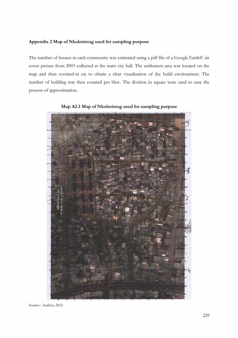
229
Appendix 2 Map of Nkolmintag used for sampling purpose
The number of houses in each community was estimated using a pdf file of a Google Earth© air
cover picture from 2003 collected at the main city hall. The settlement area was located on the
map and then zoomed-in on to obtain a clear visualisation of the build environment. The
number of building was then counted per bloc. The division in square were used to ease the
process of approximation.
Map A2.1 Map of Nkolmintag used for sampling purpose
Source : Author, 2012
230
Appendix 3 Semi-structured interviews with policy makers
Interview semi-structurée avec les acteurs institutionnels
Information basique concernant l’informateur
1. Pourriez-vous m’indiquer votre nom et votre position au sein de l’institution ?
2. Quelles sont vos responsabilités et votre domaine d’expertise ?
3. Depuis combien de temps travaillez-vous pour cette institutions ?
Informations générales concernant l’institution/l’organisation
4. Quel est le nom de l’institution pour laquelle vous travaillez ?
5. De quelles autres institutions dépend-elle?
6. Est-ce une institution gouvernementale ?
7. Quel sont les priorités de cette institution ?
8. Quels sont les projets de l’institution?
9. Quand ont–ils été débuté ?
10. Comment sont-ils concrètement mis en application ?
11. Comment ces projets sont-ils financés ?
12. Quels sont les résultats attendus de ces projets ?
Mesures, programmes et projets de l’institution concernant l’eau et les catastrophes
13. L’institution est-elle impliquée dans des projets concernant l’eau ou les catastrophes?
14. Qui est à l’initiative des projets ?
15. Qui est en charge des projets ?
16. Comment ces projets sont-ils financés ?
17. Quels sont les résultats espérés de ces projets ?
18. Quelles sont les personnes qui bénéficient des projets ?
19. L’institution est-elle impliquée dans un projet relatif à la Gestion des Risques et Catastrophes?
20. Quels sont ces projets ? Pouvez-vous me décrire le projet ?
231
21. Qui est à l’initiative des projets ?
22. Qui est en charge des projets ?
23. Comment ces projets sont-ils financés ?
24. Quels sont les résultats espérés de ces projets ?
25. Quelles sont les personnes qui bénéficient des projets ?
26. Comment sont-ils concrètement mis en application ?
27. L’institution est-elle impliquée dans un projet relatif à la Gestion Intégrée de l’Eau ?
28. Quels sont ces projets ? Pouvez-vous me décrire le projet ?
29. Qui est à l’initiative des projets ?
30. Qui est en charge des projets ?
31. Comment ces projets sont-ils financés ?
32. Quels sont les résultats espérés de ces projets ?
33. Quelles sont les personnes qui bénéficient des projets ?
34. Comment sont-ils concrètement mis en application ?
35. Mettez-vous en place des stratégies afin de développer jointement ces deux approches ?
36. Quelle sont ces stratégies ?
37. Comment sont-elles concrètement mises en application ?
38. Afin de mettre en place ce projet, bénéficiez-vous de la coopération d’autres
institution(s)/organisation(s) ?
39. Travaillez-vous en collaboration avec les communautés/quartiers bénéficiant des projets ?
40. Quelles sont ces communautés/quartiers ?
41. Pouvez-vous nommer quelles sont ces institutions et les personnes avec lesquelles vous
coopérez ?
42. Pouvez-vous décrire la manière dont ce fait concrètement cette collaboration ?
43. Avez-vous remarqué des changements dans les priorités de ces institutions concernant ces
sujets ?
44. Quel sont ces changements ?
45. Quel est votre opinion personnelle concernant ces projets ?
232
Semi-structure interview interviews with policy makers
Basic information about the informant
1. Could you tell me your name and position within the institution?
2. What are your responsibilities and field of expertise?
3. For how long have you been working for this institution?
General information on the institution / organisation
4. What is the name of the institution you work for?
5 Does it depend on another institution?
6. Is this a governmental institution?
7. What are the priorities of this institution?
8. What are the projects of the institution?
9. When did they start?
10. How were they implemented?
11. How are these projects funded?
12. What are the expected results of these projects?
Measures, programmes and projects of the institution on water and disasters
13. Is the institution involved in water-related or disaster-related projects?
14. Who initiated the projects?
15. Who is responsible for the projects?
16. How are these projects funded?
17. What are the expected results of these projects?
18. Who are the people who benefit from these projects?
19. Is the institution involved in DRM?
20. What are these projects, programmes or measures? Can you describe them?
21. Who initiated these projects?
22. Who is in charge of the projects?
23. How are these projects funded?
233
24. What are the expected results of these projects?
25. Who benefit from these projects?
26. How are they implemented?
27. Is the institution involved in IWRM?
28. What are these projects, programmes or measures? Can you describe them?
21. Who initiated these projects?
22. Who is in charge of the projects?
23. How are these projects funded?
24. What are the expected results of these projects?
25. Who benefit from these projects?
26. How are they implemented?
38. Do you cooperate with other institution (s)/organization(s)?
39. Are you working in collaboration with communities benefiting from projects?
40. Which communities / neighbourhoods?
41. Can you name what the institutions and the people you work with?
42. Could you describe how is concretely applied this collaboration?
43. Have you noticed any changes in the priorities of these institutions on these issues?
44. What are these changes?
45. What is your personal opinion on these projects?
234
Appendix 4 Semi-structured interview with community leaders
Question Chef de Quartier
Chefs
1. Pourriez-vous m’indiquer votre nom et votre position au sein du quartier ?
2. Quelle est l’institution dont vous dépendez?
3. Comment avez-vous accédé à cette position?
4. Depuis combien de temps?
5. Quelles sont vos responsabilités et votre domaine d’expertise ?
6. Avec quelles institutions ou organisations travaillez-vous le plus fréquemment ?
Quartier
7. Comment définiriez-vous votre quartier ? Pourquoi ?
8. Quelles sont les communautés les plus aisées et les plus défavorisées ?
9. Localisez sur la carte ?
10. Pourriez-vous délimiter les sous-quartiers de votre quartier sur la carte ?
11. Quels changements avez-vous observé durant ces 10 dernières années ?
Catastrophes
12. Quelles sont les catastrophes qui touchent votre quartier (inondations, glissement de
terrain, etc..) ?
13. Depuis combien de temps ?
14. Quelle sont les stratégies des communautés afin de faire face à ces catastrophes ?
15. Que font-ils avant, pendant et après les catastrophes ?
16. Quelles sont les intuitions ou organisation présentes dans le quartier travaillant sur les
catastrophes?
17. Quelles sont les aides qu’elles apportent avant, pendant et après les catastrophes ?
18. Depuis combien de temps ?
19. Quelles sont les difficultés rencontrées ?
20. Quelles sont les facilitées rencontrées ?
21. Existe-t-il des campagnes de sensibilisation aux catastrophes ?
22. Par quelles institutions ?
23. Avez-vous observé des changements durant ces 10 dernières années concernant les
catastrophes?
235
24. Connaissez-vous le programme de la GRC ?
Accès à l’eau
25. L’eau de la SNEC arrive-t-elle dans toutes les maisons ?
26. Quel pourcentage de la population de votre quartier à accès à l’eau dans les maisons ?
Quel pourcentage utilise les robinets communs ? Les châteaux d’eau? Les forages privés?
les forages publics?
27. Combien y a-t-il de forage, puits et robinets communs?
28. Quel pourcentage sont autorisées/contrôlées par les institutions? Quelles sont leurs rôles?
29. Pourriez-vous localiser les forages et robinets communs sur la carte?
30. Quelles sont les intuitions ou organisation présentes dans le quartier travaillant avec
l’accès à l’eau?
31. Depuis combien de temps ?
32. Avec quelles communautés travaillent-elles?
33. Depuis combien de temps ?
34. Quelles sont les difficultés rencontrées ?
35. Quelles sont les facilitées rencontrées ?
36. Existe-t-il des campagnes de sensibilisation à la protection des ressources en eau?
37. Par quelles institutions ?
38. Avez-vous observé des changements durant ces 10 dernières années concernant le rôle
des institutions quant à l’accès à l’eau?
39. Quelles institutions travaillent avec les communautés?
40. Quels sont généralement les prix de l’eau, y a-t’ il beaucoup d’eau gratuite?
41. Existe-t-il des stratégies de protection des ressources en eau par les communautés?
42. Existe-t-il des stratégies de protection des ressources en eau par les institutions ?
43. Avez-vous observé des changements durant ces 10 dernières années concernant l’accès a
l’eau de la population?
44. Le rôle de la femme dans la gestion de l’eau occupe-t-il une place particulière, est-elle
mise en valeur quant à l’accès à l’eau?
45. Avez-vous observé des changements durant ces 10 dernières années concernant ce rôle?
46. Connaissez-vous le programme de la GIRE?
236
Semi-structures interviews community leader
Leader
1. Can you tell me your name and position within the community?
2. Do you depend on an institution?
3. How have you attain this position?
4. For how long have you been leader of the community?
5. What are your responsibilities?
6. Institutions or organizations with which you work the most?
Neighbourhood
7. How would you describe your neighbourhood? Why?
8. What are the most advantaged and disadvantaged communities?
9. Can you locate them on the map?
10. Could you delimit the sub-districts in your neighbourhood on the map?
11. What changes have you noticed over the last 10 years?
Disasters
12. What disasters affect your neighbourhood (floods, landslides, etc. ..)?
13. For how long has this phenomenon occured?
14. What are the strategies of communities to cope with disasters?
15. What do they do before, during and after disasters?
16. Which intuitions or organization present in the area working on disasters?
17. What kind of support do they provide before, during and after disasters?
18. For how long?
19. What are the difficulties?
20. What are the solutions?
21. Do you benefit from awareness campaigns regarding disaster?
22. Through what institutions?
23. Have you noticed any changes in the last 10 years for disasters?
24. You know the DRM?
Access to water
25. Does the formal water network reach every house?
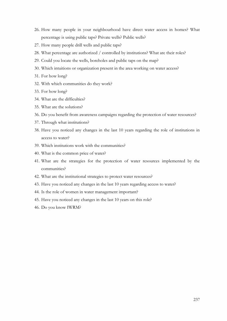
237
26. How many people in your neighbourhood have direct water access in homes? What
percentage is using public taps? Private wells? Public wells?
27. How many people drill wells and public taps?
28. What percentage are authorized / controlled by institutions? What are their roles?
29. Could you locate the wells, boreholes and public taps on the map?
30. Which intuitions or organization present in the area working on water access?
31. For how long?
32. With which communities do they work?
33. For how long?
34. What are the difficulties?
35. What are the solutions?
36. Do you benefit from awareness campaigns regarding the protection of water resources?
37. Through what institutions?
38. Have you noticed any changes in the last 10 years regarding the role of institutions in
access to water?
39. Which institutions work with the communities?
40. What is the common price of water?
41. What are the strategies for the protection of water resources implemented by the
communities?
42. What are the institutional strategies to protect water resources?
43. Have you noticed any changes in the last 10 years regarding access to water?
44. Is the role of women in water management important?
45. Have you noticed any changes in the last 10 years on this role?
46. Do you know IWRM?
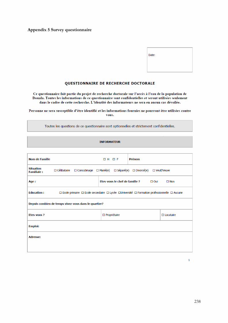
238
Appendix 5 Survey questionnaire
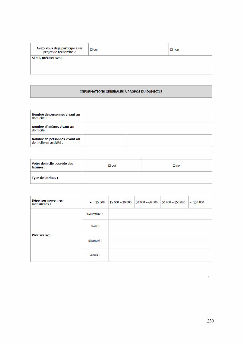
239

240
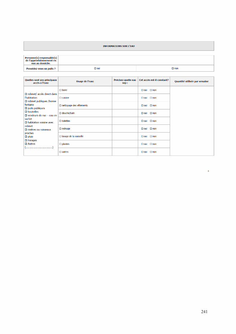
241
242
243
244
245
Appendix 6 Transport system in the Douala economic area
Douala possesses different type of transports supporting its economic area:
Maritime Port of Douala
The Autonomous Port of Douala (APD) covers an area of 1000 hectares, of which only half is
currently in operation. It is connected to the sea by an access of 50km long divided into two
sections; an external channel 25 km and 250 m wide, and a 25 km internal channel, which needs
to be continuously dredged to maintain its 7 meters depth (Barbier and Granjux, 2008). This
constraint excludes vessels carrying more than 20,000 to 25,000 tonnes from entering during the
periods of dredging, and often also excludes vessels of 14000 to 17000 tonnes due to the non-
continuity of this activity (ibid). This issue leads increases the cost of maritime freight because
the APD directly supports the maintenance of the canals (ibid). Often vessels leave a part of
their cargo in the deepest port of the region and enter partially loaded in Douala’s channel (ibid).
International Airport
Located on a plot of 250 hectares, Douala International Airport (DIA) is able to receive all types
of commercial aircraft (Barbier and Granjux, 2008). Its traffic, after a period of difficulties, has
increased since 2005, reaching 17,452 aircraft movements in 2007 and 633,000 passengers (ibid).
This trend is particularly strong regarding international flights and regional lines with other
CEMAC countries (ibid). However, national traffic has significantly declined due to the
difficulties and the cessation of activity Cameroon Airlines. In addition, air freight traffic is
approximately 15,000 tons per year (ibid).
Railway
Two railway lines serve the hinterland of Douala (Barbier and Granjux, 2008). The main railway
connects the station of Bességué to Yaoundé then to Ngaoundéré. The traffic between Douala
and Yaounde is exclusively assigned to freight, which was built between 1914 and 1928,
underwent a major modernisation as part of a realignment operation conducted at the end of
70’s (ibid). As part of its investment programme for the next 12 years, CAMRAIL plans to
rehabilitate degraded tracks, which have an average life of 30 years, and to restore a commercial
246
speed compatible with the requirements of this link between the two metropolises of Cameroon
(ibid).
Road Infrastructure
Products coming from the port of Douala are largely carried out by road (Barbier and Granjux,
2008). The road network, apart from the urban area itself, is composed of two main roads: the
eastern road (linking the cities of Douala-Yaounde-Ngaoundere) and the western road (linking
the cities of Douala-Bafoussam-Banyo Ngaoundéré). The central axis starts with a motorway
going to Yaoundé, and then continues via Bertoua and Garoua Boulaï towards the northern
Cameroon network and its neighbouring countries. The distance between Douala and
Ngaoundere is 925 km which also serves Central African Republic and Chad. The east and north
of this axis are being improved with the support of international cooperation (ibid). The West
axis is much shorter with approximatly 200 km but less well equipped. The road is well made
until Bafoussam and Foumban, but the part Douala-Bonabéri is difficult due to the high density
traffic (ibid).
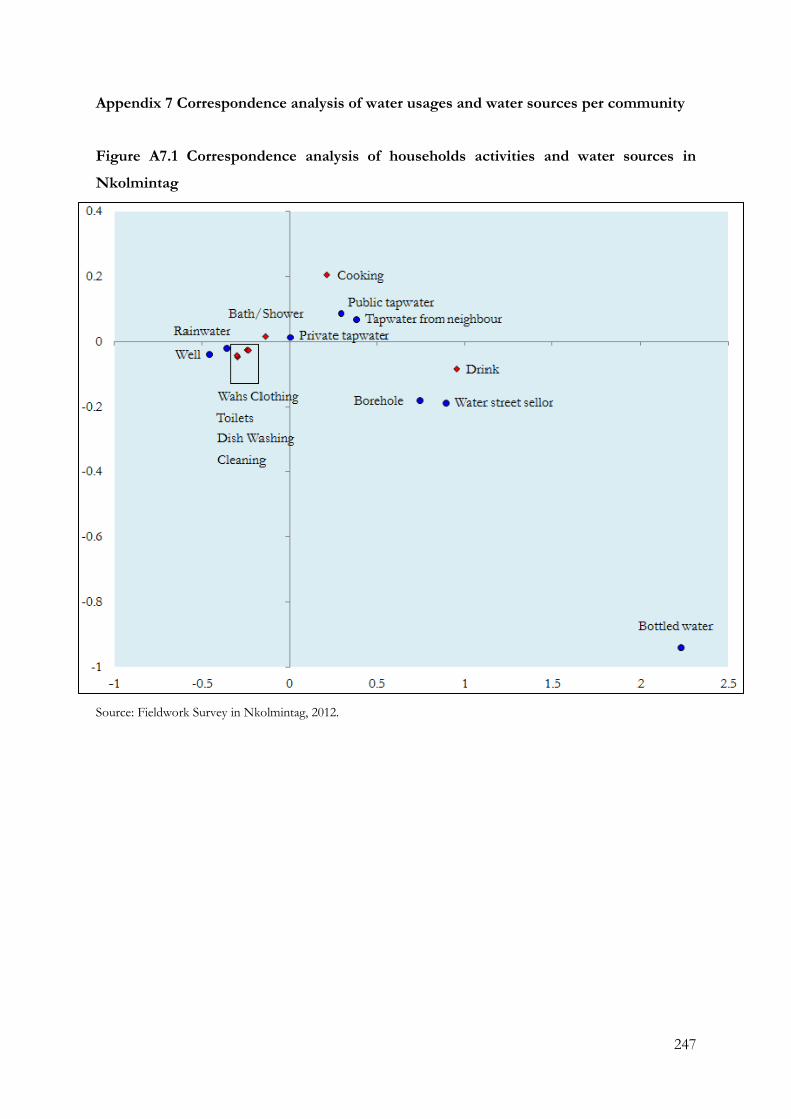
247
Appendix 7 Correspondence analysis of water usages and water sources per community
Figure A7.1 Correspondence analysis of households activities and water sources in
Nkolmintag
Source: Fieldwork Survey in Nkolmintag, 2012.
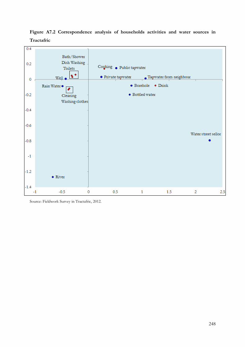
248
Figure A7.2 Correspondence analysis of households activities and water sources in
Tractafric
Source: Fieldwork Survey in Tractafric, 2012.
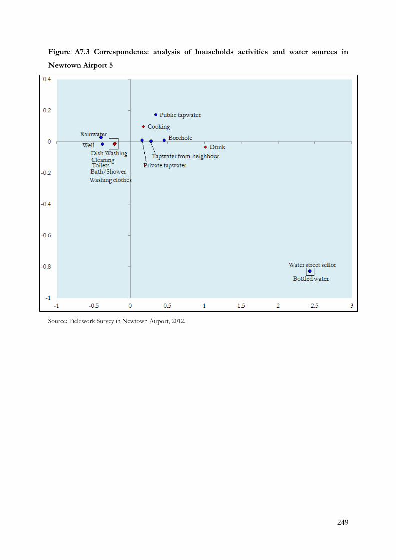
249
Figure A7.3 Correspondence analysis of households activities and water sources in
Newtown Airport 5
Source: Fieldwork Survey in Newtown Airport, 2012.
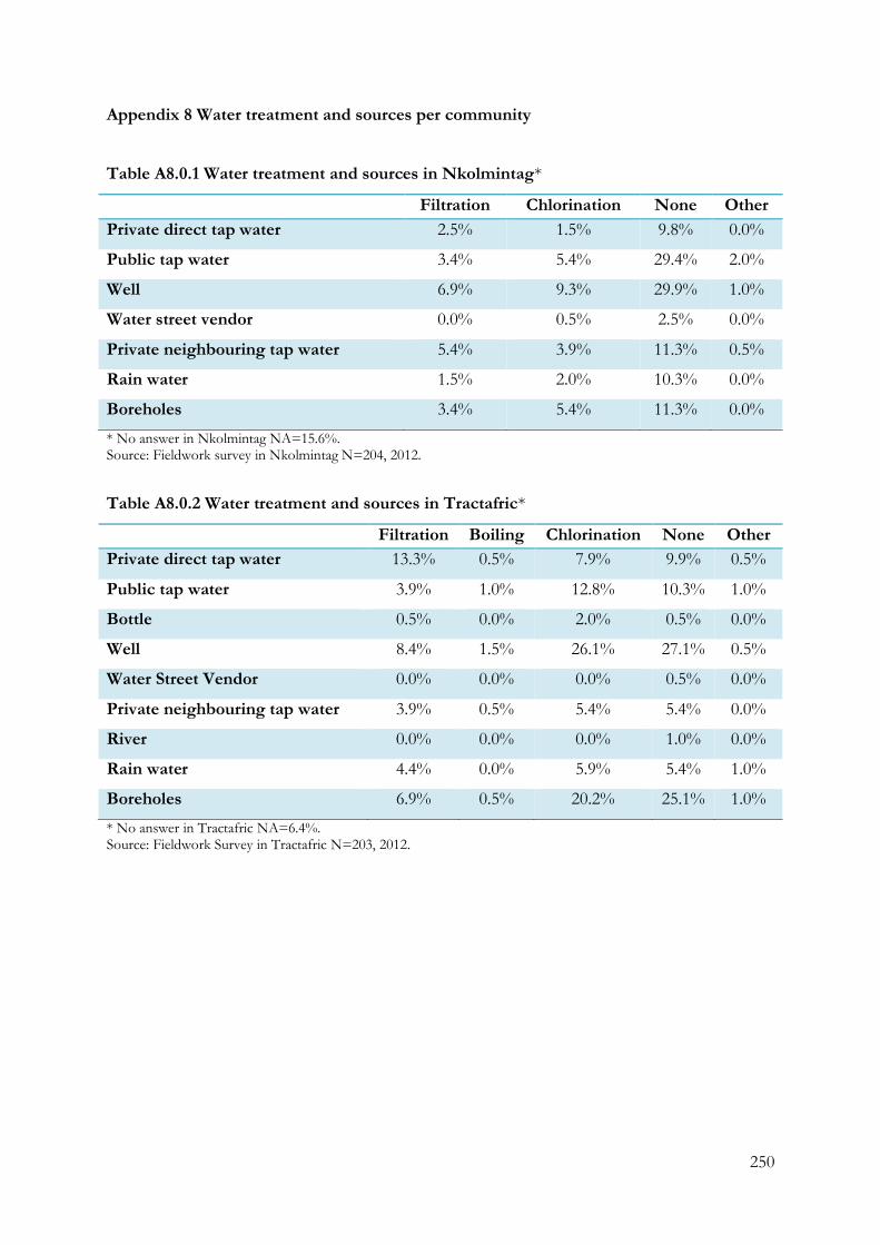
250
Appendix 8 Water treatment and sources per community
Table A8.0.1 Water treatment and sources in Nkolmintag*
Filtration Chlorination None Other
Private direct tap water 2.5% 1.5% 9.8% 0.0%
Public tap water 3.4% 5.4% 29.4% 2.0%
Well 6.9% 9.3% 29.9% 1.0%
Water street vendor 0.0% 0.5% 2.5% 0.0%
Private neighbouring tap water 5.4% 3.9% 11.3% 0.5%
Rain water 1.5% 2.0% 10.3% 0.0%
Boreholes 3.4% 5.4% 11.3% 0.0%
* No answer in Nkolmintag NA=15.6%. Source: Fieldwork survey in Nkolmintag N=204, 2012.
Table A8.0.2 Water treatment and sources in Tractafric*
Filtration Boiling Chlorination None Other
Private direct tap water 13.3% 0.5% 7.9% 9.9% 0.5%
Public tap water 3.9% 1.0% 12.8% 10.3% 1.0%
Bottle 0.5% 0.0% 2.0% 0.5% 0.0%
Well 8.4% 1.5% 26.1% 27.1% 0.5%
Water Street Vendor 0.0% 0.0% 0.0% 0.5% 0.0%
Private neighbouring tap water 3.9% 0.5% 5.4% 5.4% 0.0%
River 0.0% 0.0% 0.0% 1.0% 0.0%
Rain water 4.4% 0.0% 5.9% 5.4% 1.0%
Boreholes 6.9% 0.5% 20.2% 25.1% 1.0%
* No answer in Tractafric NA=6.4%. Source: Fieldwork Survey in Tractafric N=203, 2012.
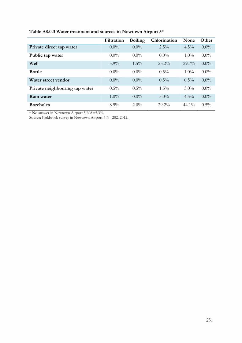
251
Table A8.0.3 Water treatment and sources in Newtown Airport 5*
Filtration Boiling Chlorination None Other
Private direct tap water 0.0% 0.0% 2.5% 4.5% 0.0%
Public tap water 0.0% 0.0% 0.0% 1.0% 0.0%
Well 5.9% 1.5% 25.2% 29.7% 0.0%
Bottle 0.0% 0.0% 0.5% 1.0% 0.0%
Water street vendor 0.0% 0.0% 0.5% 0.5% 0.0%
Private neighbouring tap water 0.5% 0.5% 1.5% 3.0% 0.0%
Rain water 1.0% 0.0% 5.0% 4.5% 0.0%
Boreholes 8.9% 2.0% 29.2% 44.1% 0.5%
* No answer in Newtown Airport 5 NA=5.3%. Source: Fieldwork survey in Newtown Airport 5 N=202, 2012.
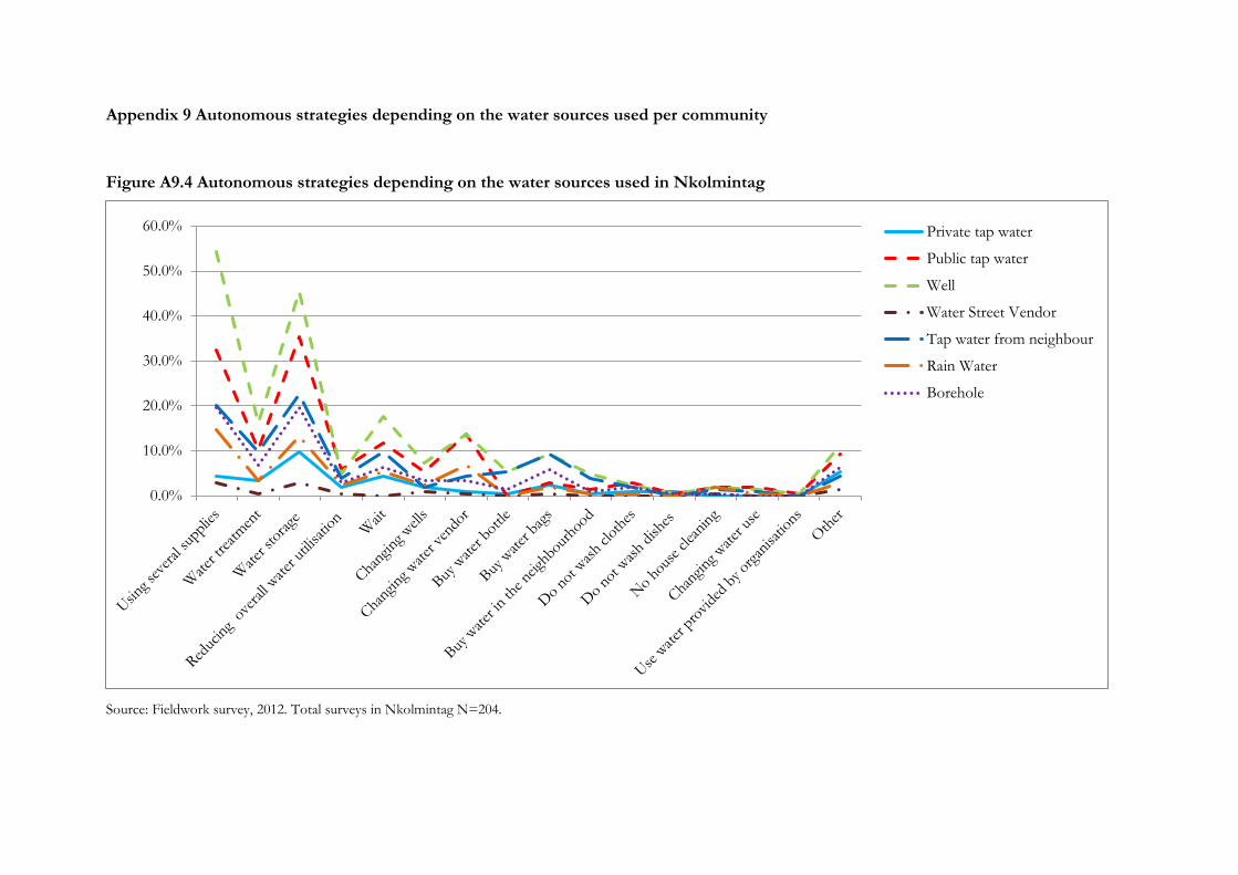
Appendix 9 Autonomous strategies depending on the water sources used per community
Figure A9.4 Autonomous strategies depending on the water sources used in Nkolmintag
Source: Fieldwork survey, 2012. Total surveys in Nkolmintag N=204.
0.0%
10.0%
20.0%
30.0%
40.0%
50.0%
60.0% Private tap water
Public tap water
Well
Water Street Vendor
Tap water from neighbour
Rain Water
Borehole
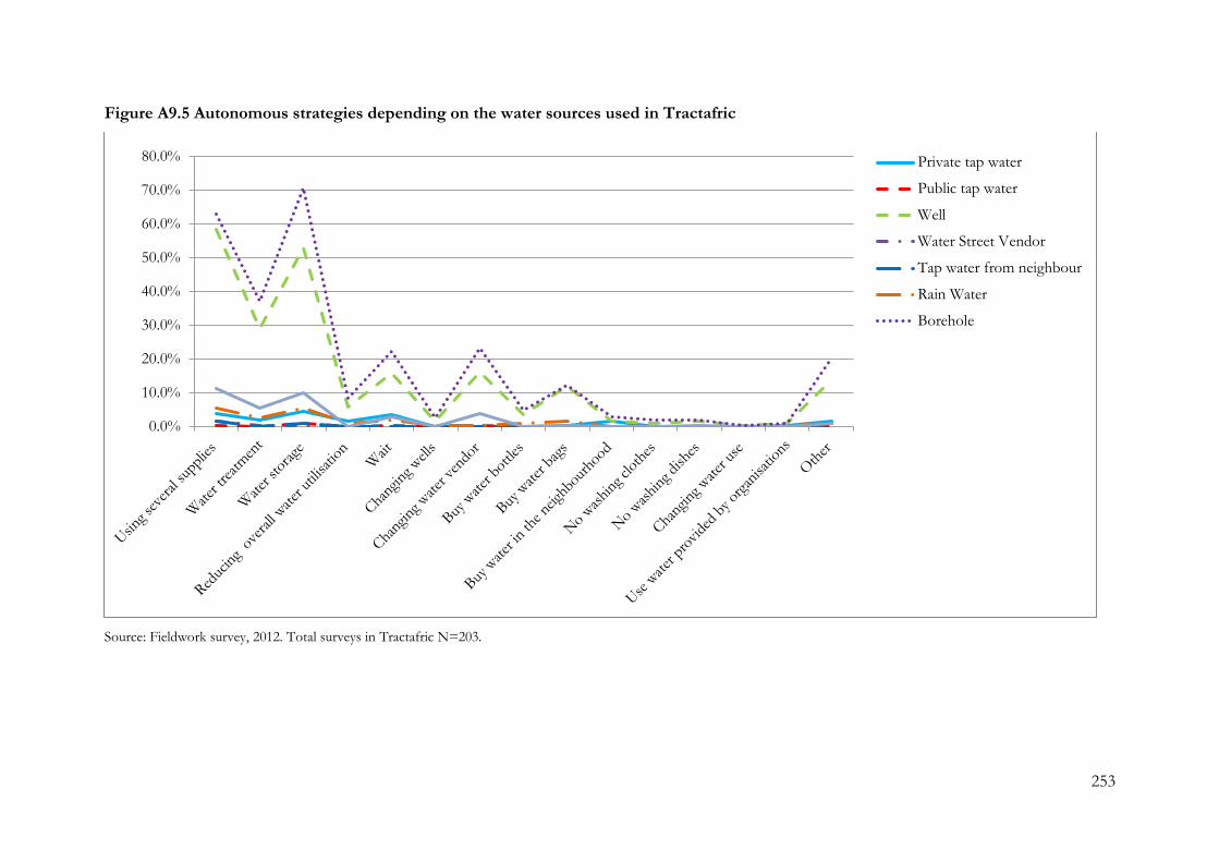
253
Figure A9.5 Autonomous strategies depending on the water sources used in Tractafric
Source: Fieldwork survey, 2012. Total surveys in Tractafric N=203.
0.0%
10.0%
20.0%
30.0%
40.0%
50.0%
60.0%
70.0%
80.0% Private tap water
Public tap water
Well
Water Street Vendor
Tap water from neighbour
Rain Water
Borehole
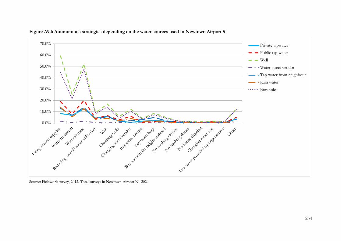
254
Figure A9.6 Autonomous strategies depending on the water sources used in Newtown Airport 5
Source: Fieldwork survey, 2012. Total surveys in Newtown Airport N=202.
0.0%
10.0%
20.0%
30.0%
40.0%
50.0%
60.0%
70.0% Private tapwater
Public tap water
Well
Water street vendor
Tap water from neighbour
Rain water
Borehole