the organization of intra-regional and long - scholarspace
TRANSCRIPT

The Organization of Intra-Regional and Long-Distance Trade in Prehispanic Philippine
Complex Societies
LAURA LEE JUNKER
THE EARLY TO MID-SECOND MILLENNIUM of our era has been viewed as a time of rapid cultural transition and change in indigenous sociopolitical systems in the Philippines in association with developing trade relations with the Asian mainland. The beginnings of intensive long-distance trade with the highly developed state of China and with Southeast Asian state-level polities as early as the Sung Period (A.D. 950-1279) is well attested in the massive quantities of imported porcelains and other mainland trade commodities that have been recovered from numerous large lowland burial and/or habitation sites on many of the major islands of the Philippines (Beyer 1947; Burton 1977; Fernandez and Rogel 1968; Fox 1959; Fox and Legaspi 1977; Hutterer 1973a; Janse 1944; Legaspi 1974; Locsin and Locsin 1967; Spoehr 1973; Tenazas 1968). Although none of these immediately prehispanic sites has been extensively excavated, the limited archaeological data suggest that a number of them represent extensive coastal settlements, with evidence for specialized craft production areas and wealth differentials in burials, indicating the presence of organizationally complex and perhaps socially stratified communities. This interpretation of the archaeological data accords well with Spanish documentation for the immediately postcontact period, which describes European encounters with hereditary "chiefs," regionally influential political leaders standing at the apex of a developed social hierarchy and associated with administrative and commercial centers functioning as important nodes in networks of internal and external trade. Pointing to the seeming absence of comparable archaeological evidence for developing complexity in the preceding prehistoric periods and the apparent temporal correspondence between the appearance of Asiatic porcelains and the growth of nucleated coastal communities, many scholars have viewed these sociopolitical transformations as sudden and dramatic. They see the changes as being causally linked to Chinese attempts to ex-
Laura Lee Junker is an assistant professor in the Department of Anthropology, Vanderbilt University, Nashville, TN 37235.
Asian Perspectives, Vol. 29, no. 2. © 1990 by University of Hawaii Press. All rights reserved.

168 Asian Perspectives, XXIX (2), 1990
pand and intensify trade interactions with the Philippines and other areas of island Southeast Asia, beginning around the tenth century of our era (Beyer and de Veyra 1947; Fox 1967; Fox and Legaspi 1977; Hutterer 1973b, 1974, but see 1977; Jocano 1975; Tenazas 1977).
By focusing on these "external" influences as catalysts to the development of complex society in the Philippines, archaeological and ethnohistorical analyses have been essentially restricted to documenting Philippine trade patterns in the centuries after A.D. 1000, and the sociopolitical matrix in which they operated, in terms of Chinese initiatives, rather than in relation to sociopolitical developments in each of the participating societies that both created a demand for foreign prestige goods and provided the necessary organizational matrix for administering and controlling large-scale systems of exchange. A number of archaeological studies of geographically extensive, high volume systems of primarily "prestige good" trade carried out elsewhere in the world (e.g., Flannery 1968; Frankenstein and Rowlands 1978; Renfrew 1982; Wheatley 1975) have shown that such exchange systems generally emerge in the context of already developed sociopolitical complexity in which foreign sumptuary goods are incorporated into an already existing material symbolic system for "elite" status validation. As noted by Binford (1969: 163), an increased demand for exotic goods and the geographic expansion of long-distance "prestige good" trade systems generally occur "in the context of institutionalized changes through which new statuses appear." Maintaining these increasingly differentiated forms of social stratification demands the creation of new symbolic frameworks for expression and new channels for obtaining potent material status symbols.
In the present paper, ethnohistoric and archaeological evidence are combined in an attempt to demonstrate that the numerous complex nons tate societies or "chiefdoms" described by the Spanish as dotting the Philippine coastline at the time of European contact, rather than representing a late-developing and largely externally derivative phenomenon, instead have a relatively lengthy history of indigenous development. The initiation of foreign trade contacts with the Chinese and developed mainland Asian polities beginning around the tenth century, it is argued, represented the expansion of already well-developed internal networks of "prestige goods" exchange embedded in a sociopolitical matrix of developed social stratification and regionally integrated political systems. These external trade systems were in turn linked with intra-regional systems of exchange and resource mobilization, involving specialized production and upland/lowland exchange of both staple and "luxury good" resources between complex lowland agriculturalist groups, interior swidden-cultivating tribal groups, and upland hunter-gatherer bands-exchange systems that were to some degree centrally administered by regionally powerful chiefs based at strategically located coastal ports.
Very little ethnohistoric work on prehistoric lowland political systems and social organization has been carried out in the Philippines that would allow us to compare the structure of Philippine "chiefdoms" with that of other nons tate complex societies elsewhere in the world. For this reason, the first half of this paper is devoted to developing such a model of late first-millennium to early second-millennium Philippine societies, combining Spanish and Chinese historical documentation with ethnographic sources and archaeological evidence. This discussion of chiefly political authority and the structure of lowland political systems provides the basis for more detailed consideration of the central role of "chiefly" political leaders in co-

JUNKER: TRADE IN THE PHILIPPINES 169
ordinating and controlling basic subsistence and craft production activities, mobilizing regional resources, and administering intra-regional, intermediate-distance (i. e., inter-island) and long-distance trade as various components of a centrally integrated economic system for amassing the resources to finance the political activities of a sociopolitical elite.
In the second half of the paper, archaeological settlement data from a region of the Philippines where one such coastal-centered "chiefdom" is presumed to have existed at the time of European contact-the Bais Region of Negros Oriental-is analyzed in the context of this ethnohistorically derived model of regional exchange systems. Specifically, archaeological evidence for the spatial organization of settlement and for the regional distribution of both "prestige goods" and centrally produced household wares is used to examine changes in the regional organization of exchange for the period spanning the mid-first millennium to the time of Spanish contact. Analysis of the archaeological data from the Bais Region is used to suggest the presence of regionally integrated coastal-focused polities with centrally administered internal exchange networks in the Philippines before A.D. 1000. Based on the organizational similarity of pre-Chinese trade and later settlement and exchange patterns in the region, it is argued that, contrary to the traditional view, the initiation of foreign trade contacts did not result in the profound societal restructuring expected to mark the initial transition from noncomplex to complex societies. Instead, it is suggested, expansion of trade interactions beyond the bounds of adjacent coastal chiefdoms may have provided one of a number of mechanisms for further growth and differentiation of these political systems, resulting in the emergence of several larger scale inter-regionally powerful political entities observed by the Spanish at the time of European contact.
ETHNOHISTORIC AND ARCHAEOLOGICAL EVIDENCE OF
PREHISPANIC COMPLEX SOCIETIES
In examining the relationship between long-distance trade and the evolution of sociopolitical complexity in Philippine lowland societies, a necessary first step is the development of a model of sociopolitical organization for late first-millennium to early second-millennium coastal Philippine polities. Such a model could be examined with the archaeological evidence from the Bais Region. Fortunately, the earliest Spanish colonists and considerably earlier Chinese merchants and travelers (the latter at least as early as the tenth century) produced substantial written records of their impressions of Philippine societies. While these documents frequently focused on pragmatic issues of economic exploitation, many texts nevertheless provide significant information on indigenous social organization; political leadership roles; political ideology as reflected in ritual and myth, warfare, and political alliance; and the organization of internal and inter-regional systems of exchange. Unlike regions where complex societies developed indigenously and where substantial bodies of European colonial documents have been subject to exhaustive anthropological interpretation by researchers trained in ethnohistoric methodology (e.g., Polynesia and parts of Mesoamerica and South America), the Philippines has been the subject of surprisingly little work of this kind (see J ocano 1975; Keesing 1962; Scott 1980, 1981, 1982, 1984, as notable exceptions). Almost no attempt has been made to integrate historical, ethnographic, and archaeological sources into a cohe-
170 Asian Perspectives, XXIX (2), 1990
rent and comprehensive picture of prehispanic Philippine sociopolitical structures and to compare the organization of Philippine complex societies with similarly complex prestate societies elsewhere in the world. The present paper takes a preliminary step in this direction, beginning with an anthropological synthesis of these varied sources on prehispanic Philippine sociopolitical structures.
Social Stratification
Spanish documents of the early phases of European colonization were consistent in reporting the presence of a well-developed system of social stratification in sixteenth-century lowland societies inhabiting most of the major islands of the archipelago (e.g., Alcina 1688; Loarca 1582:147-149; Morga 1609:296; Plasencia 1589: 173-175; San Buenaventura 1613). At the apex of the social hierarchy, according to the Spanish chroniclers, were hereditary "chiefs" (referred to in both Tagalog and Visayan languages as datus), surrounded by a small core of cognatically related kin serving as chiefly retainers, and together forming a distinct birthright aristocracy or "elite" stratum. Members of the chiefly class functioned as the primary political authorities, war leaders, legal adjudicators, the de facto owners of agricultural products and sea resources within a district, the primary supporters of attached craft specialists, the overseers of intra-district and external trade, and the pivotal centers of regional resource mobilization systems. In return for his leadership in warfare, judicial skills, and ability to create wealth for his followers through skillful control of trade, the chief or datu had the right to exact regular tribute (in the form of agricultural products or craft goods) and to request services, such as seasonal agricultural labor, participation in raiding expeditions, and "elite" household construction, from all the households under his control, with the exception of members of the non-chiefly "nobility." This non-chiefly "elite" was referred to as timaguas in the sixteenth-century Boxer manuscript (inJocano 1975: 188-235), as "the third rank of nobility" (nobleza) by Alcina (1688), as maharlika (great, noble) by Plasencia (1589), and as maginoo (principal in lineage or parentage) by San Buenaventura (1613). They shared to some extent the chief's high-status genealogy and served as the "personal vassals" (Scott 1980: 164) of the datu, aiding him in military campaigns, organizing datu-sponsored feasts, participating in datu-controlled maritime trading and raiding expeditions, and enforcing chiefly ritual taboos (e.g., Chirino 1604:307-308; Loarca 1582: 94; Plasencia 1589: 173-176).
The second tier in the sixteenth-century Philippine social hierarchy consisted of "nonelite" or "commoners"-on Luzon, Plasencia's (Tagalog) aliping namamahay (1589: 109) and Morga's timawas (1609: 296), and in the Visayas, Loarca's (1582), Alcina's (1688), and the Boxer manuscript's (in Jocano 1975: 188-235) oripun. The salient characteristics of this social rank were the interdiction against intermarriage with the elite class, and the obligation to provide subsistence for the latter through agricultural tribute and to contribute (mandatorily) their services in elite-sponsored maritime raiding or trading expeditions (Plasencia 1589: 109-11 0). Plasencia (1589: 109-112) and Morga (1609: 296-299) explicitly distinguish members of this social rank from the group whose designation has been consistently translated as "slave," with the former allowed at least usufruct rights over land and houses that can be inherited over several generations; individual ownership of gold and other wealth (which may be bequeathed, however, only at the datu's discretion); indepen-

JUNKER: TRADE IN THE PHILIPPINES 171
dent participation in external economic activities, such as trade; the ability to gain exemption from agricultural duties through skills in craft production or prowess in warfare; and at least nominal rights to attach himself in a vertical alliance with a more benevolent datu. At the lower end of the social scale, the commoner class graded into the third tier in the status hierarchy, generally translated by the Spanish as "slaves." This class consisted of the lowest subclass of oripun (i.e., commoners) known as ayuey in Visayan (literally, commoners transformed into domestics or field chattels through debt-bondage, capture in raiding, or voluntarily due to dire economic circumstances) and what Alcina (1688) refers to as "true" slaves (secondgeneration slaves, descended from purchased or hereditary slaves) (Scott 1983). This lowest social stratum is consistent, as the Spanish describe it, with concepts of slavery in other parts of Southeast Asia-i. e., a class of individuals who are "owned" by another in a legal sense, and who can be legally purchased, rented, mortgaged, bequeathed, or otherwise alienated like private property (Reid 1983). Scott (1983), however, emphasizes the relative ease of manumission and hence the considerable fluidity between commoner and slave ranks.
The early Spanish documents make explicit reference to overt expressions of these distinctions in social rank through differences in bodily ornamentation (e.g., Artieda 1569:200; Colin 1660:160-163; Morga 1609:270-271; Pigafetta 1521:50-51; Rodriguez 1565:126; sixteenth-century Boxer manuscript, inJocano 1975:196-197,217); varying house forms (e.g., Morga 1609:295; Pigafetta 1521 :58-59); and variation in burial practices (e.g., Chirino 1604:133-135; Colin 1660:173-175; Loarca 1582: 88-89; Plasencia 1589: 122; sixteenth-century Boxer manuscript, in Jocano 1975:208-210, 215-216, 223). Prehistorians are only beginning to trace the material manifestations of these in the archaeological record. Although no formal mortuary analyses have been published using prehispanic burial data from the Philippines, Spanish reports of chiefly boat burials with grave accompaniments of gold and slaves (Blair and Robertson 1903-1909, 3: 199; Chirino 1604: 134; Colin 1660: 174; Plasencia 1589: 122) have received archaeological confirmation in the excavation of several such burials by the Philippine National Museum at Butuan (Mindanao), tentatively dated to the Sung Period (ca. tenth-thirteenth centuries) (Burton 1977; Solheim 1982). Informal comparisons of prehistoric cemeteries dated to both the so-called Philippine "Iron Age" (ca. 500 B.C.-A.D. 1000) (e.g., Fox and Evangelista 1957; Hutterer 1974; Kurjack and Sheldon 1970; Maceda 1964, 1965; Solheim 1964, 1968; Tenazas 1974; Tuggle and Hutterer 1972) and "Porcelain Period" (ca. A.D. 1000-1600)(e.g., Fox 1959; Fox and Legaspi 1977; Locsin and Locsin 1967; Legaspi 1974) indicate the kind of mortuary variability associated with hereditary ranking systems described by the contact-period Spanish. Gold ornaments, glass beads, decorated earthenwares, Chinese porcelains (after the tenth century), and other exotic and/or rare commodities can be interpreted as serving as elite status markers. Access to these goods is restricted in burial populations in distributional patterns that appear to cross-cut categories of age and sex. Virtually no comparable archaeological investigation of the internal organization of prehistoric lowland settlements-aimed at recovering information such as status-related differences in house form and household access to prestige goods-has been undertaken in the Philippines before the Bais Region research discussed below. However, excavations of post-sixteenth-century datus' house-compounds by Alexander Spoehr (1973) in southwestern Mindanao have shown that historically and ethnographically de-

172 Asian Perspectives, XXIX (2), 1990
scribed features of chiefly residences can be readily documented archaeologically. These features include significantly larger size and internal complexity in comparison to "commoner" houses, frequent use of fortification, and associated greater household "wealth" (e.g., Blair and Robertson 1903-1909, 3:97, 102-103; Cole 1913:66-67; Ileto 1971 :37-38; Morga 1609:295; Pigafetta 1521 :58). Finally, although regional settlement studies are poorly developed in the Philippines, the interisland distribution of certain highly standardized elaborately decorated earthenwares dated to the late first millennium B.C. and the early first millennium of our era (described in Solheim 1964 and known as "Kalanay" ceramics) suggests the operation of an extensive trade network moving what could have been socially restricted high-status goods even before the period of Chinese trade (Hutterer 1977). This would indicate considerable time depth to hereditary ranking systems.
Chiefly Political Authority and Lowland Philippine Political Structures
Ethnographic and historical sources also provide a considerable amount of information on the degree to which elite economic privilege and elevated social status translated into, and emanated from, chiefly political power. Indigenous Philippine lowland polities, as known from the ethnographic and historic literature, share certain structural features characteristic of insular Southeast Asian chiefdoms and states in general, such as a relatively decentralized and highly segmentary structure. These contrast with the more centralized and vertically integrated structure of Polynesian chiefdoms (Brown 1976; Gullick 1958). This relatively weakly centralized structure of Philippine chiefdoms and the highly unstable nature of regional political integration in comparison to Polynesian chiefdoms appear to be related to the differing ways in which politically functioning groups are constituted. While in Polynesia the core of the local political unit comprised a well-defined descent group with a relatively fixed territorial base, in the Philippines the primary unit of collective political action appears to have been an organizationally more fluid "alliance group," comprising individuals whose recruitment into the group involved a variety of both kinship-based and non-kinship-based relations (including principles of cognatic descent, as well as forms of ritual friendship). These alliance units, made up of perpetually shifting leader-focused factions, represented extension of chiefly power over individuals and groups through various alliance-building strategies, but not over geographically distinct districts or territories. In terms of larger scale regional political integration, these chiefdoms may be described as having a relatively decentralized or segmentary structure, in which political authority is vested at various levels in the leader's personal ability to maintain a core ofloyal followers through a complex system of patronage and alliance, resulting in both unstable horizontal coherence and weak vertical integration.
While these elements of political structure are exemplified in numerous ethnographic and historical sources on indigenous lowland societies of Luzon, the Visayas, and Mindanao, the most coherent picture of the internal social and political dynamics of Philippine complex societies comes from the excellent ethnographic descriptions and historical documentation of the Sulu polity, which, absorbing elements of Islamic religious ideology, became the well-known Sulu sultanate sometime around the fourteenth century (Kiefer 1971, 1972a, 1972b; Maju11965, 1973; Mednick 1957; Warren 1977, 1982). According to the ethnographic and historical evidence, political

JUNKER: TRADE IN THE PHILIPPINES 173
organization outside the Sulu sultan's court, both within and outside the Sulu polity center at Jolo, revolved around the power and authority of local datus or chiefs. These local chiefs' power base was never linked to territorial units except in an incidental sense, but rather involved control over individuals and groups established through the construction and maintenance of alliance networks, which fluctuated in size and composition over time according to the chief's ability to pull individuals and groups into his sphere of influence (Kiefer 1971, 1972a, 1972b).
The explanation for the relatively weak centralization of the Sulu polity lies in the fact that, while political leadership followed an explicitly symbolized hierarchy of rank-from village headmen to more powerful multivillage district chieftains, to even more powerful paramount chiefs with regional control, to the sultan himselfthis leadership hierarchy did not constitute an institutionalized chain of command from center to periphery. Political allegiance was given only to the leader immediately above an individual with whom a kin group had personal ties of economic reciprocity and loyalty. The ability of a geographically and structurally remote regional chieftain located at the polity center to command obeisance at the local level depended on a series of tenuous intermediate vertical links without stable recognition at anyone level of a leader's right to enforce decisions by physical coercion or ritual sanction. Kiefer (1972a) sees structural parallels with the "segmentary" or "pyramidal" African states described by Southall (1965) and Nicholas (1966), in which component units of the political structure consist of functionally and structurally equivalent segments integrated only loosely by a centralized authority dependent on the consensual delegation of power upwards through the system. The primary difference between Sulu polity structure and that of the segmentary African states, according to Kiefer (1972a), is that alliance units are formed out of perpetually shifting leader-focused factions whose members are recruited by a variety of both kinship and nonkinship principles, rather than the unilineal descent groups with relatively fixed size and composition that are at the core of African alliance units.
Both Chinese and Spanish historical records and more recent ethnographic descriptions suggest that the segmentary structure of the Sulu polity was characteristic of numerous smaller scale complex societies of the Philippine lowlands before the sixteenth century. The Spanish chroniclers consistently paint a picture of lowland Philippine society that contrasts a developed system of social stratification and institutionalized positions of chieftainship encompassing considerable local political power and authority, with a general "slipperiness" of structure when one moves from the local to the regional level-hierarchically superordinate "paramount" chiefs appearing to wield highly ephemeral regional political power (e.g., Alcina 1668:61; Colin 1660:82; Legaspi 1565:204,212; Morga 1609:119; Loarca 1582: 175-177; see also Scott 1984 for discussion of Chinese sources). That there was some degree of hierarchical ranking of political authority and that some of the smaller scale political entities recorded by the Spanish may actually have been lower level units integrated into a larger political system is suggested by explicit Spanish references to "paramount" or "principal" chieftains in the sixteenth century at Manila, Pangasinan, Cebu, and Bohol, and at Butuan, Cotabato, and other points along the Mindanao coast (e. g., Alcina 1668: 261; Blair and Robertson 1903-1909, 2: 119-124, 131-154,208-209,3:92-98; Loarca 1582:65; Pigafetta 1521 :54-65). Detailed historical and ethnographic accounts of the Magindanao chiefdoms of the Pulangi River basin of southwestern Mindanao-one of which survived with minimal Spanish

174 Asian Perspectives, XXIX (2), 1990
interference until American colonization in the late nineteenth century-also indicate that a large number of small-scale chiefly domains were regionally integrated into two large-scale chiefdoms controlled by high-ranking paramount chiefs (Beckett 1982; Heto 1971; MajuI1966).
The Spanish documentation suggests that the glue that held together the disparate political units and promoted some degree of political cohesion at the regional level was the same type of linked alliance networks that characterized the loosely centralized Sulu state, providing some degree of horizontal and vertical integration. Horizontal alliances between local chiefs were established and maintained through a variety of mechanisms, including an institutionalized system of reciprocal gift exchange (e.g., Chirino 1604: 145; Loarca 1582: 93), intermarriage between elite members of different alliance groups (e.g., Chirino 1604: 294-295; see also Heto 1971 :34-35 and Keesing 1962:151-152), and mutual participation in ritual oath taking as a symbolic expression of political solidarity (e. g., Legaspi 1565: 201; Loarca 1582:160-163; Pigafetta 1521:56, 77, 79; Seuilla 1566:225; the sixteenth-century Boxer manuscript, in J ocano 1975: 233). Of particular significance in terms of the present analysis are the Spanish reports of regular exchange of prestige goods between allied political leaders in the contexts of chieftain-sponsored life-crisis ceremonies and calendrical ritual events (e.g., Chirino 1604: 145; Loarca 1582:93); as a prelude to the initiation of trade interactions (Pigafetta 1521, inJocano 1975: 56-59); and as a climax to negotiated settlement of hostilities or potential hostilities between alliance groups (e.g., Blair and Robertson 1903-1909,2: 136,3:98,4:241,245-246, 293), resulting in the movement of trade-obtained or locally manufactured prestige goods between major coastal centers controlled by paramount chiefs and between secondary centers occupied by local or district chieftains.
The earlier Chinese documentary sources provide very little information that would allow us to extend these specific aspects of Philippine political structure (i. e., weakly centralized, alliance group-based rather than descent-based political units) into periods earlier than the sixteenth century; still, they do suggest the presence of some type of organizationally complex, regionally integrated polity in the Philippines at least by the end of the first millennium. A polity known as P'u-tuan (identified by historians as Butuan, the traditional name for the area surrounding the mouth of the Agusan River along the northern coast of Mindanao) is described in the "Sung History" (Sung Shih) as a substantial "island country" whose successive rulers sent a number of trade missions to the Sung emperor at the beginning of the eleventh century (Scott 1984: 66-67; Hall 1985: 334; Wolters 1983: 58). Chinese travel descriptions of the Sung Period (A.D. 960-1279) (the best known of which is Chao Ju-kua's Chu Fan Chih or "Account of the Various Barbarians," written in 1225) make reference not only to P'u-tuan but also to a maritime trade-oriented polity known as Ma'i (identified as a region on the northern coast of Mindoro) , centered on a coastal port and with more than one thousand inhabitants, which was the source of numerous large-scale trade shipments into ports along the southern Chinese K wangtung coast beginning as early as the tenth century (Chen 1966; Scott 1984; Wu 1959).
By the Yuan Period (A.D. 1278-1368) and early Ming (A.D. 1379-early fifteenth century), Sulu (the precursor of the sixteenth-nineteenth century Sulu polity described above), Mintolang (identified as the precursor to the sixteenth-century Magindanao chiefdom at the mouth of the Pulangi River in Cotabato, Mindanao)

JUNKER: TRADE IN THE PHILIPPINES 175
and Ma-li-lu (identified as somewhere in the vicinity of Manila) are added to Chinese lists of politically and economically significant Philippine polities. They are described as having heavily populated coastal "centers" that served as important trade foci controlled by militarily powerful and wealthy chieftains (Chen 1966: 273; Hall 1985:226-227; Maju11966:147-148; Scott 1984:66-78). In addition to these largescale polities, both the Sung Period Chu Fan Chih and the Yuan Period account of Chinese explorer Wang Ta-Yuan, Tao I Chih Lueh ("Summary Notices of the Barbarians of the Isles," written in 1349) suggest the presence of numerous smallscale, less developed chiefdoms dotting the coastlines of the major central Philippine islands (those of the Visayas are referred to as Pi-she-ya or "painted ones," due to the Visayan practice of tattooing), whose political complexity and role in the regional Southeast Asian economy was equated with that of maritime raiding/trading chiefdoms peripheral to indigenous Southeast Asian states such as Champa and Java (Chen 1966:268-271; Craig 1914:4; Laufer 1907:253-255; Scott 1984:74). By the later Ming Period (ca. mid-fifteenth-sixteenth centuries), the Chinese textual evidence corroborates sixteenth-century European documentary sources in describing a Philippine political configuration in which several territorially extensive and highly developed trade-oriented lowland chiefdoms were represented by primary coastal trading centers at Manila, Pangasinan, northern Mindoro, Cebu, Jolo (the Sulu polity) and Cotabato (the Magindanao polity), surrounded by numerous smaller scale lowland complex societies in the Visayas, along the northern and western Mindanao coast, and along the western littoral of Luzon (e.g., Alcina 1668:61; Blair and Robertson 1903-1909,2:119-122,131-154; Colin 1660:82; Legaspi 1565:208-209; Loarca 1582: 65; Morga 1609: 119; Pigafetta 1521: 54-65; see also Keesing 1962).
THE REGIONAL ECONOMY AND THE ORGANIZATION OF
EXCHANGE
The early Spanish and Chinese historical records, as well as ethnographic data from the less acculturated, stratified Philippine societies of the nineteenth and twentieth centuries, emphasize the central role of the chiefly political leader in coordinating and controlling craft production activities; mobilizing and redistributing regional resources; and administering intra-regional, intermediate-distance (i. e., interisland), and long-distance trade. These various types of trade were components of a complex, centrally administered economic system for amassing the resources necessary to finance the political activities of an agriculturally nonproductive sociopolitical elite (e.g., Blair and Robertson 1903-1909, 3: 84,95; Colin 1660: 183-186; Loarca 1582: 93-94, 145; Morga 1609: 296; Pigafetta 1521: 55; Plasencia 1589: 109-133, 175; see Scott 1984 for discussion of Chinese sources; see Cole 1913, 1956; Biernatzki 1985 for discussion of recent Bagabo and Bukidnon). Some elements of internal resource mobilization parallel that of Polynesian chiefdoms: a well-developed tribute structure, support of attached craft specialists, and recycling of agricultural surplus into the chiefs alliance network at community-wide ritual events. Other elements are unique to the Philippines (or more broadly, Island Southeast Asia) case and are related to the decentralized political structure, the need for economic integration of ethnically distinct upland populations into the lowland chiefdom, and the emphasis on participation in long-distance maritime trade. The present discussion will focus on these latter aspects of the chiefly economy.

176 Asian Perspectives, XXIX (2), 1990
Intra-Regional Mobilization of Resources: Tribute and Trade Systems
Similar to other maritime trading polities of Island Southeast Asia such as Srivijaya (Hall 1976:64-74; Van Leur 1967: 104-105; however, see Wolters 1971), while the coastal trading port was not divorced from its hinterland agricultural base, control of agricultural production outside the immediate coastal center dominated by a chief or state ruler was tenuously effected through a highly unstable network of alliances and exchange networks that loosely integrated hinterland and coastal populations and moved agricultural resources from periphery to core. Notable for its absence is substantial evidence in the contact-period Spanish records of centralized investment in technology for agricultural intensification (i. e., chiefly financed and administered irrigation works and swamp drainage systems), even in the highly developed Sulu, Magindanao, and Manila polities. However, the historical documentation on the economic necessities of massive slave raiding in the later Sulu and Magindanao sultanates (Warren 1977, 1982; Reid 1983) and Spanish references to generally low population densities (see Loarca 1582 for island-by-island population estimates; also see Keesing 1962), coupled with reports of still extensive lowland primary tropical forest areas in the sixteenth century (Wernstedt and Spencer 1967), suggest that land and capital resources were not the limiting factors in agricultural productivity; rather, labor was the scarce commodity.
Thus, a chief's control over agricultural production was established not through direct ownership of the resources of a geographic territory, but rather through (1) his manipulation of a series of shifting vertical alliances with individuals and kin groups, which granted him the right to collect agricultural tribute from political subordinates (e.g., Colin 1660: 183-186; Loarca 1582: 143-153; Morga 1609:296; Plasencia 1589: 109-113; see also Beckett 1982; Biernatzki 1985; Claver 1985; Cole 1913; Heto 1971; and Manuel 1973 for ethnographic data); (2) his maintenance of a network of horizontal alliances with interior political leaders, which facilitated exchange of interior resources (including subsistence goods) for coastal maritime resources -and manufactured goods (see below); and (3) his direct control of slave labor for cultivation of land under his own tenancy or for harvesting marine resources from chieftain-owned fisheries (Warren 1977; Scott 1981, 1983). These resource procurement strategies, or chiefly "mobilization" systems, appear to have been decentralized in the sense that they operated primarily at the local level. Regional chiefs (even the Manila paramount chief and the Sulu sultan), rather than directly administering regional agricultural production, relied on a combination of their own locally controlled production, tribute moving up the political hierarchy through unstable vertical alliances with local chiefs, and their greater involvement in foreign trade to provide the economic support for their political activities.
An important problem faced by the Philippine lowland chief was the establishment and maintenance of political and economic dominance from a coastal core over an ecologically distinct and geographically remote periphery inhabited by an ethnically heterogeneous population with varying sociopolitical configurations and economic orientations. From the Spanish documents and early ethnographic reports, we know that the interior upland areas of the Philippines were inhabited by an amalgam of ethnically and linguistically distinct groups ranging from small bands of hunter-gatherers to tribally organized swidden agriculturalists and emergent ranked societies practicing intensive agriculture. These groups formed extensive interactive
JUNKER: TRADE IN THE PHILIPPINES 177
networks and were generally loosely integrated into the political, social and economic structure of adjacent lowland chiefdoms (see Hutterer 1974, 1976 for a general discussion). The coastal trade-oriented polity could limit its direct subsistence dependence on interior agriculturalists through intensive cultivation of lands directly adjacent to the coastal port and through importation of rice and other staples as part of its maritime trade. Still, the sixteenth-century Spanish sources make it clear that lowland chiefs and other elite were dependent on upland forest products and raw materials directly controlled by these populations for the manufacture of prestige goods (particularly gold and iron ore, wax, and forest hardwoods) and as export commodities for foreign trade with the Chinese and other mainland Asians (e.g., nutmeg, pepper and other spices, beeswax, honey, hardwoods, gums and resins, birds' nests, and gold) (Artieda 1569:202; Colin 1660: 151, Loarca 1582: 115-121; Sande 1576: 68-69). Ethnohistoric reconstructions and more recent ethnographic observations of these symbiotic economic relations between upland and lowland populations indicate that the upland groups were in turn critically dependent on the coastal populations for iron tools and weapons, salt, earthenware pottery, lowland livestock, and marine resources (e.g., Conklin 1957:153; Fox 1954; Keesing 1962:121,135,139; Schlegel 1979:105-109; Scott 1982:118,190,209; C. Warren 1977:233,240; see also Artieda 1569:202; Loarca 1582:115; Morga 1609:275,284-285).
A number of studies of analogous coastal trading polities of the early second millennium in various regions ofIsland Southeast Asia have suggested that, while a tightly controlled tribute system ensuring a steady flow of chiefly revenues is feasible in the core area of a paramount ruler's political power (i.e., the lowland areas in close proximity to the coastal chiefly center), even the most highly developed of the Island Southeast Asian lowland trading polities, such as Srivijaya, Palembang, Aceh, Malacca, and Johor, had neither the administrative infrastructure nor the military capacity to implement and enforce a far-reaching tributary system and direct political sovereignty over adjacent upland populations (Andaya 1975: 189, 195; Gullick 1965:125-127; Hall 1985:1-20; Micsic 1984:241; Wolters 1967:252, 341-342). Instead, movement of subsistence goods and other products between the upland and lowland generally involved the selective activation of political alliance-structured reciprocal exchange relations with local political leaders controlling critical resources. The coastward flow of these interior resources (e. g., forest products needed for external trade, surplus rice needed to meet an agricultural shortfall, and even military support in situations of external threat) was counterbalanced by the movement of lowland-produced manufactured goods, including in some cases tradeobtained prestige goods and officially sanctioned titles, which rewarded the economic cooperation of upland political leaders with ideological legitimacy within the lowland political system.
That a similar system of alliance-structured exchange relations between upland and lowland groups, rather than direct political and economic subjugation by the latter, was characteristic of the contact-period Philippine lowland chiefdoms is suggested by ethnographic and historic accounts of the relationship between the lowland Magindanao datus and the adjacent Tiruray upland swidden cultivators of the Pulangi River basin of southwestern Mindanao. Individual Tiruray chiefs received honorific titles and prestige symbols from elite lowland Magindanao trade partners, facilitating the coastward flow of forest products and inland movement of both

178 Asian Perspectives, XXIX (2), 1990
critical domestic goods (e.g., iron tools, salt, textiles, and ceramics) and highly prized status items (e.g., brass gongs and Chinese porcelain) (Ileto 1971 :24-25; Schlegel 1979: 105-109). Similar upland-lowland alliances are ethnographically reported for the south-central Mindanao Manuvu and the upper valley Magindanao (Manuel 1973: 218-219, 343-344); for the Tagbunuwa shifting cultivators of Palawan and the coastal "Mora" populations (c. Warren 1977: 233-240; see also Fox 1954 and Conklin 1949); and for the Tinguian and Apayao with coastal Hocos Sur and Hocos Norte populations (see Keesing 1962:121,135,139). This type ofsymbiotic economic relationship between coastal chieftains and adjacent upland political leaders seems to have some time depth, as suggested by sixteenth-century Spanish references to ethnically distinct interior populations participating in the lowland's "system of policy or government" (Colin 1660: '115) through institutionalized trade partnerships sealed by blood oaths and formal peace pacts (e.g., Artieda 1569:202; Loarca 1582: 115, 160-163; Sande 1576: 68-69; Seuilla 1566: 225; sixteenth-century Boxer manuscript, in Jocano 1975: 233). In addition, detailed Chinese descriptions of what they considered to be comparatively "barbaric" interior Philippine populations as early as the thirteenth century (Scott 1984: 68-70) indicate that these groups must have been in regular contact through trade interactions with lowland populations at Chinese-frequented coastal ports, since it is unlikely that any Chinese maritime merchants of this period ventured directly into the interior.
The Organization of Long-Distance Maritime Trade
In addition to administering and controlling these alliance-structured trade interactions between the coast and the interior, the lowland chief played a pivotal role in the regulation of long-distance maritime trade interactions, ensuring eliterestricted access to the prestige goods entering the coastal port under his political jurisdiction. The presence of a few porcelains from the Tang and Five Dynasties period (A.D. 618-960) at several archaeological sit.es along the western littoral of the Philippines (Beyer 1947; Fox 1967) indicates some pre-second-millennium commerce between the Philippines and developed Asian states. However, it is not until the Sung Period (A.D. 960-1279) that we begin to encounter substantial Chinese documentary sources, and firmly dated archaeological evidence, for regular Chinese-Philippine trade (see Scott 1984; Wang 1958; Wu 1959, 1962 for reviews of the Chinese historical documents; see Beyer 1947, 1964; Fox 1964, 1967; Hutterer 1973b; Locsin and Locsin 1968; Solheim 1982 for summaries of the archaeological evidence). It is beyond the scope of this paper to examine the details of what was a complex international trade system in the early second millennium of our era, which linked the Moluccas (Spice Islands) and the Philippines in the east with the powerful island kingdoms of Borneo and Java, Sumatran Srivijaya and the states of the Malay Peninsula to the west, and the Chinese empire and Siamese and Annamese states to the north (see Hall 1985; Hall and Whitmore 1976; Wheatley 1959 for good summaries). Thus, the present discussion will focus on aspects of this trade relevant to the competition between lowland Philippine chieftains for control over the distribution of these status-symbolizing Chinese commodities.
The Chinese records indicate that the Chinese merchants were primarily interested in obtaining interior forest products, metal ores, and marine products at Philippine lowland ports. These included beeswax, hardwoods, spices, abaca, betel

JUNKER: TRADE IN THE PHILIPPINES 179
nuts, birds' nests, pearls, tortoise shell, and gold-commodities the local chief generally did not control directly but had to amass through internal exchange networks described in the preceding section. In exchange, the Chinese merchants offered the coveted porcelains, iron weapons, silk textiles, lacquer boxes, and other luxury commodities (Scott 1984; Wu 1959). This was a high-volume trade, with an average of 12-15 large Chinese junks per year docking at the port of Manila in the sixteenth century (Maldonado 1575: 299; see also Bernal 1966: 43 and J. Warren 1977:50-51) and possibly only a slightly smaller number at sixteenth-century ports located atJolo (the center of the Sulu polity), Butuan (in northern Mindanao), Cebu, Mindoro, and other coastal areas (e.g., Alvarado 1548:68-69; Blair and Robertson 1903-1909, 2:68-69, 3:75-76; Enriquez 1574:226; Legaspi 1567:238, Morga 1609: 301; Sande 1576: 74; Seuilla 1566: 225). In the thirteenth-century Chinese text by historian Chao Ju-kua (Chu Fan Chih, "An Account of the Various Barbarians"), the Chinese trading ships are described as customarily paying "port fees" and providing "gifts" of valuable prestige goods to the port-administering chief who controlled the apportionment of the remaining import goods for transport by intermediary local traders to more distant interior and coastal settlements, with the Chinese merchants frequently waiting in port for several months while the local ruler mobilized the resources necessary for repayment (see translation in Scott 1984: 68-70). This system for monopolizing access to foreign-manufactured prestige goods is echoed in later Spanish accounts of the requests of paramount chiefs at ports such as Manila and Cebu for tribute or gifts of valuable cargo from in-coming trading vessels, and the presence of chieftain-controlled storehouses (either part of, or adjacent to, the chief's residence) where the most valuable of the import goods were stored, presumably for elite consumption (Blair and Robertson 1903-1909, 3: 102-103; Pigafetta 1521 :55-60). It is likely that the coastal Visayan and Luzon chiefs practiced a strategy similar to that recorded for the better documented Sulu polity, in which powerful datus extracted as much wealth as possible from port fees and obligatory credit (the latter was in reality rarely repaid, accounting for up to 50 percent of the cargo in the Sulu case), then maintained a monopoly on trade for the remaining commodities through strict control over the movement of both goods and merchants at the coastal port (J. Warren 1978, 1982). Despite Chinese complaints about the exorbitance of these chiefly exactions (Blair and Robertson 1903-1909,3:84,89,95;]. Warren 1977:52-54), Warren (1977) suggests that the Philippine trade remained lucrative for the Chinese due to the considerable value of Philippine gold, pearls, spices, and forest products in Chinese home markets, with Chinese merchants frequently making a hundredfold profit on their original investment in generally poor-quality mass-produced export porcelains and textiles.
Substantial competition between Philippine polities for control over this maritime trade in exotic luxury goods is suggested by historical evidence for attempts by local chieftains to obtain official Chinese sanction as a favored trade partner through "tributary missions" to the Chinese court. As early as the eleventh century a Philippine polity known as P'u-tuan (identified as Butuan on the northern Mindanao coast) launched a series of tributary missions to China requesting official recognition as a trade partner, with status commensurate with that of the powerful Southeast Asian state of Champa-a political maneuver that may have represented an attempt both to bypass Champa middlemen and to eliminate competing Philippine polities in the already flourishing Moluccan spice trade (Scott 1984). By the late fourteenth and

180 Asian Perspectives, XXIX (2), 1990
early fifteenth centuries, polities centered in the Sulu area, at Manila and Pangasinan on Luzon, and on Mindoro had all sent numerous trade missions to the Chinese court (Scott 1984; Wu 1959), offering samples of prospective export goodsphrased in terms of tributary offerings-and competing for preferential trade status in the officially sanctioned Ming period trade.
Several facts indicate that large-scale inter-regional warfare and raiding were integral elements of inter-polity competition for labor and resources. These include: (1) the frequent mention of warfare and raiding in Spanish accounts of the immediately postcontact period (e. g., Artieda 1569: 197-198; Chirino 1604: 305-308; Colin 1660: 176, 179; Lavezaris 1569: 287; Legaspi 1567: 55; Loarca 1582: 151; Morga 1609: 82; Pigafetta 1521: 68-70); (2) descriptions of relatively sophisticated weaponry (including Chinese-inspired but locally produced cannonry) (e.g., Artieda 1569:200-201; Blair and Robertson 1903-1909, 3: 102-103, 144, 148, 160; Sande 1577: 106); (3) an observed emphasis on defensive strategies in lowland settlement (including fortification of some of the larger coastal settlements) (e.g., Blair and
.Robertson 1903-1909,3:78-79,83-84,94-97,141-144); and (4) the recorded existence of what may have been a functionally specialized "warrior" subclass among the Tagalogs (Plasencia 1589: 174-175; see also discussion in Scott 1980: 152-153). Institutionalized maritime raiding not only provided a legitimate alternative source of wealth procurement to inter-island trade, but also served as a means of effecting considerable economic disruption of adjacent competing coastal trade centers as the attacked population fled inland and village resources were destroyed. Coastal trading centers administered by chiefs who were effective maritime raiders against adjacent trading polities, and who controlled smoothly operating alliance-structured systems for the intra-regional mobilization of forest and marine resources desired by the Chinese and mainland Southeast Asian traders, would be expected to enjoy a competitive edge in this economically lucrative long-distance trade.
A Modelfor Intra-Regional Settlement Patterns and the Spatial Patterning of Exchange
I have painted an ethnohistorically constructed picture of numerous lowlandbased chiefdoms, competing with one another to attract long-distance traders into their coastal ports and simultaneously controlling well-organized internal networks of exchange linking coastal chiefdoms with interior hunter-gatherers and swidden agriculturalists having direct access to valuable upland forest products and other essential interior resources. The question remains, however, how these complex exchange systems would be represented in terms of archaeologically observable settlement patterns. Bennet Bronson (1977), in a discussion of similar economic patterns in late first-millennium Sumatran maritime trading polities, developed a hypothetical settlement model to "fit" these historically inferred exchange systems and to guide previously failed attempts at archaeological inquiry. In his model, Bronson makes several assumptions: (1) that the region occupied by the coastalbased state or chiefdom does not include enough concentrated agricultural land for the development of a true agricultural peasantry; (2) that the polity is therefore at least partially dependent on the mobilization of resources through both intraregional and extra-regional trade; and (3) that interior trade networks involve interactions between sociopolitically, economically, and frequently ethnically and

JUNKER: TRADE IN THE PHILIPPINES
A "I\. /\ /\/\ 1\ /\ /\ 1\ 1\ /\ 1\ 1\ 1\ /\ 1\ /\ /\ 1\ /\ A /\ AJ\I\ mountains /\ /\ /\ /\ 1\ /\ /\ /\ /\ mountains 1\ /\ /\ 0A /\/\I\I\/\/\/\/\/\/\AAi\
/\1\/\ /\/\ /'\ l\ 1\/\ /\5/\ i\§/\ /\~/\ /\ ii1 /\ /\/\ (\/\ (\/\ /\/\ /\/\ /\./\ f\(\
-F
181
Fig. 1. Hypothetical settlement system for a coastal-centered, maritime-trade-oriented Philippine chiefdom. (Adapted from Bronson 1977)
linguistically, distinct interior and coastal populations. He further assumes that the inter-fluvial areas of the drainage basin occupied by these chiefdoms or states are sufficiently marshy, forested, and/or mountainous that intra-regional movement of resources is largely confined to river routes. Population is concentrated on the coast at the mouth of the region's major river-a strategic locale for the control of both internal transport of goods and external maritime trade-with a single hyper-large coastal settlement dominating the regional settlement system and functioning as a center for economic, political, and ritual activities administered by chiefs.
An abstract illustration of such a settlement system, adapted from Bronson (1977), is presented in Figure 1. In this model, the points A and At represent the coastal centers of two competing Philippine lowland-based chiefdoms occupying adjacent drainage basins and both participating in intensive long-distance maritime trade interactions with foreign chiefdom and/or state-level polities signified by X. (In the Philippine case, these external trade partners are known to have included Philippine polities on islands distant from A, such as those centered at Jolo, Cebu, and Manila; developed island and mainland Southeast Asian states, such as Champa, Sukhothai, Malacca, Majapahit, and Brunei; and the economically and politically dominant Chinese state.) Points Band C are second-order and third-order lowland settlements located upstream from the primary coastal center at strategic locales for

182 Asian Perspectives, XXIX (2), 1990
the control of the interior movement of resources (usually at the confluence of several river branches). Point D represents relatively distant upriver settlements that serve as the initial concentration points for products originating in the more remote lowland areas of the drainage basin and in adjacent upland areas occupied by ethnically distinct, tribally organized, swidden-cultivating populations and mobile huntergatherers. These groups, represented by the settlements E and F, are the ultimate producers and controllers of most of the valuable forest and upland raw material resources desired by the chiefly elite at settlement A for their own consumption and for exchange with external traders such as the Chinese.
As outlined above, the chiefly rulers at A maintain the flow of goods towards the coastal center through direct coercion of the adjacent lowland populations centered at Band C (and more distant settlements D under the latter's control), practicing a strategy of tribute mobilization through a combination of oath-sealed alliances with local leaders, ritual sanctions, and military threats. Due to considerable geographic distance to, and frequently considerable mobility of, the more remote upland tribal societies represented by E and F, direct military enforcement of economic cooperation is generally not feasible, and the lowland polity centered at A relies more heavilyon alliance pacts with local political leaders in which prestige goods and statusconferring titles are the frequently desired interior-moving commodities. The chiefly ruler centered at A, in dominating the flow of trade goods from interior to coast, must develop strong enough mechanisms of economic control over interior populations to prevent any attempts by X to circumvent the coastal center at A and trade directly with the interior sources. By developing well-functioning internal networks of resource procurement, the coastal-centered chiefs can also gain competitive superiority in attracting foreign traders to the port at A rather than the alternative port of At. the center of an adjacent coastal trading polity. A complementary competitive strategy would involve periodic maritime raids on At, intended to disrupt At's internal and external trade networks as much as possible and to cause X to abandon trade at At temporarily, if not permanently, due to the increased danger from raids and At's inability to provide a consistent supply of desired trade goods.
AN OVERVIEW OF ARCHAEOLOGICAL RESEARCH IN THE BAIS
REGION, NEGROS ORIENTAL
Turning from this abstract discussion of the spatial organization of one of these maritime-trade-oriented coastal chiefdoms, we will now examine this model in terms of archaeological settlement data from one region of the Philippines in which this type of polity is historically known to have emerged some time before the sixteenth century. The archaeological research discussed here is only part of a longterm program of archaeological and ethnographic investigations that have been carried out in the Bais Region ofNegros Oriental since 1979 (see Hutterer and Macdonald 1979, 1982; Hutterer 1981; Junker n.d., 1986; Macdonald 1982). The Bais Region, as shown in Figures 2 and 3 is a 315 km2 region centered on a coastal alluvial plain 3-7 km wide, dominated by the navigable Tanjay River, surrounded on three sides by rugged upland plateau and on the fourth side by the narrow Tanon Straits separating the island of Negros from the island ofCebu. Sixteenth-century Spanish documents indicate the presence of a substantial coastal settlement at the mouth of

11°
~Pin~ \) ~~
!) ~JD))
u7iQ PANAY GULF
10°
o 50km go 1-1 _4-_L----l ___ -'-_...J1
TANON STRAIT
BAIS ~ PROJECT N AREA
Fig. 2. Location of the Bais Region, Negros Oriental Philippines. (Adapted from Hutterer and Macdonald 1982)

t
! o
Contour interval = 100 m
Fig. 3. The 315 km2 Bais Region, showing the location of excavated sites.

JUNKER: TRADE IN THE PHILIPPINES 185
the Tanjay River at the time of initial Spanish contact (Martinez Cuesta 1974), and later research by ethnographers (e.g., Oracion 1954, 1964, 1967; Rahmann and Maceda 1955; Reynolds 1975) suggests that in the sixteenth century the area of Negros Oriental, including the Bais Region, was inhabited by at least three ethnically and linguistically distinct but economically interacting groups. These groups included "Ata" hunter-gatherers using the primary forest of the upland interior; "Magahat" or "Bukidnon" swidden cultivators of the hilly transition zone between upland and lowland; and "Visayan" sedentary agriculturalists constituting the presumed complex societies of the coastal alluvial plain. Thus, the Bais Region is an ecologically and culturally well-bounded research area and possesses some documentary support for the prehispanic existence of a complex lowland society in interaction with less complex upland groups and involved in external maritime trade contacts with other complex societies.
Two field seasons of regional archaeological surface survey have been carried out in the Bais Region, using a multistage probability-based sampling design. These surveys have covered roughly 50.75 km2 (or 16.1 percent) of the research region and have yielded a total of 285 prehistoric sites. Seven sites have been excavated, as summarized in Table 1, including the Spanish-documented regional center at the mouth of the Tanjay River underlying the contemporary town of Tanjay. Earthenware ceramic sequences at the excavated sites have been used to establish a regional cultural sequence consisting of six phases spanning the period from the mid-second millennium B. c. to the present (Junker n. d., 1986), as shown in Table 2. The first phase of regional survey in the Bais Region used a simple stratified randomsampling strategy to obtain preliminary information on the nature and density of sites in the then archaeologically unknown region. This initial survey revealed several differences between upland and lowland sites. These involved artifact assemblages (upland sites had higher densities of lithics, while lowland sites had ceramicdominated assemblages); the size of the settlements (upland sites were generally small and ephemeral, while lowland sites were typically large and clearly permanent settlements); and the tendency for site clustering (upland sites were relatively randomly dispersed, while lowland sites tended to cluster near major river arteries). This variation in site patterning was initially interpreted in terms of the differing settlement strategies of mobile upland hunter-gatherers and swidden cultivators, and sedentary lowland intensive agriculturalists dependent on a set of geographically fixed subsistence resources (Hutterer and Macdonald 1979). With reference to the issue of regional exchange systems, Macdonald (1982) noted an increasing density of sites in the lowland zone over time and a tendency to locate sites in close proximity to major streams or the coast, possibly to facilitate centralized distribution of both locally manufactured and long-distance trade commodities.
More recent excavations conducted by the author at the large coastal settlement of Tanjay indicated a central role for the site in these regional exchange systems, a role that appears to date back to before the period of intensified mainland Asian trade contacts (Junker 1986). The excavated portion of the settlement at Tanjay yielded evidence for occupation during at least the final four phases of settlement in the Bais Region (the Aguilar, Santiago, Osmena, and Historic phases). During that time the site increased in size from an estimated 5 ha in the Aguilar phase (ca. A.D. 500-1000) to 10-15 ha in the Santiago phase (ca. A.D. 1100-1400), and to a substantial 30 ha in the Osmena phase (ca. A.D. 1400-1600). For the Santiago and Osmena phases (span-

186 Asian Perspectives, XXIX (2), 1990
TABLE 1. SUMMARY OF SITES EXCAVATED IN THE BAIS REGION, NEGROS ORIENTAL,
PHILIPPINES, AS PART OF THE BAIS ANTHROPOLOGICAL PROJECT
SITE
Tanjay
SITE DESCRIPTION
Multicomponent settlement and burial site, with distinct elite and nonelite habitation areas and burial areas, evidence for metal and ceramic production, located at the mouth of the Tanjay River on the coast (10m elevation)
Aguilar Multicomponent multihousehold habitation site located adjacent to the Tanjay River about 2 km from the coast « 100 m elevation)
Edjek Multicomponent multihousehold habitation site located adjacent to Tanjay River about 1.5 km from the coast « 100 m elevation)
Lobendina Multicomponent multihousehold habitation site located adjacent to Tanjay River about 2 km from the coast « 100 m elevation)
Sycip Single-component isolated homestead located about 1 km from the coast adjacent to the Amlan River (10 m elevation)
Turco Multicomponent isolated homestead or base camp, with an artifact assemblage dominated by lithics, located about 15 km inland from the coast (> 300 m elevation)
Solamillo Multicomponent settlement and burial site located about 30 km south of the Bais Region, about 7 km from the coast (200-300 m elevation)
ESTIMATED
SITE SIZE
(HA)
30
3
3
2
<1
<1
>5
PERIODS OF
OCCUPATION
A.D. 500-present
A.D. 500-1000, A.D. 1400-1600
2000-1500 B.C.,
A.D. 1100-1400
A.D. 500-1000, A.D. 1400-1600
A.D. 1500-?
A.D. 1600-?
A.D.0-500, A.D. 1200-1600
ning the period of long-distance trade with China), comparison of the layout of domestic structures and the nature of artifact assemblages in two spatially distinct areas of the site suggested that the settlement may have been differentiated into elite and nonelite residential areas in these periods, with elite domestic structures surrounded by what may have been defensive ditches and yielding significantly higher percentages of exotic trade goods and higher quality locally produced goods (e. g., Chinese, Annamese, and Siamese porcelains; elaborately decorated and slipped earthenwares; bronze and iron implements; carved bone objects; and glass beads) Ounker 1986).
These presumed differences of social status in residential architecture and domestic access to prestige goods are echoed in mortuary differentiation in 39 Santiago period and Osmena period burials excavated beneath the habitation structures at the site. Despite disturbance by overlying habitation deposits, there is some evidence for

PERIOD
DESIGNATION
A.D. 1900 Historic
1600 Osmena Phase
1400 Santiago Phase
1000 Aguilar Phase
500 Solamillo Phase
(hiatus) B.C. 1500 Edjek Phase 2000
TABLE 2. REGIONAL CULTURAL SEQUENCE FOR THE BAIS REGION OF NEGROS ORIENTAL, PHILIPPINES
SITE
TANJAY EDJEK AGUILAR LOBENDINA SYCIP TURCO SOLAMILLO DIAGNOSTIC CERAMICS
phase I phase I phase I phase I phases phases phase I European porcelains I and II I and II
phase II phase II phase II phase III phase III Late Ming porcelains 370±90B.P. 430 ± 120 B.P. Tanjay Red Ware 380±90B.P.
phase III phase II phase II Sung/Yuan/Early Ming porcelains 640 ± 100 B.P. 595 ±80B.P. 590 ± 140 B.P. Tanjay Fine Red Ware 800 ± 180 B.P.
phase IV phase III phase III Aguilar Spotted Buff Ware
phase III Bacong Coarse Ware 1820 ± 270 B.P.
phase III 3475 ± 235 B.P. Edjek White Ware

188 Asian Perspectives, XXIX (2), 1990
variation in mortuary practices that cross-cut categories of age and sex, with Chinese porcelain, decorated earthenware, and metal objects again appearing to function as ascribed status markers (Junker 1986). In addition, the recovery of abundant quantities of iron slag in levels dating to these early to mid-second-millennium phases of occupation, as well as what may be a spatially distinct pottery production area in the Santiago phase, suggest that some of these presumed prestige goods were being manufactured by craft specialists at the coastal center. Excavations of cultural deposits dated to the earlier Aguilar phase (late first millennium) yielded habitation features that were too incomplete and spatially restricted for inter-areal comparisons of domestic structures and yielded no mortuary remains. However, the comparatively large size of the site and the abundance of rare decorated earthenware and iron implements in this phase suggests that Tanjay may have functioned as an important regional center even in this period before intensive mainland Asian trade. These aspects of internal settlement organization and mortuary differentiation suggest that the kind of socially stratified, politically centralized, maritime-trade-oriented complex society described by the sixteenth-century Spanish chroniclers and alluded to in Chinese texts as early as the twelfth century was present in the Bais Region lowland by the early second millennium and probably earlier.
While excavations at the historically documented coastal settlement of Tanjay provided important information on the internal organization of a presumed chiefly center, very little was yet known about the regional settlement system within which Tanjay functioned. The initial phase of regional surface survey was geographically limited and primarily oriented towards preliminary assessment of overall site densities and gross functional interpretations of observed differences in site content and size. A second phase of regional survey in the Bais Region, aimed at a more detailed examination of the development of regional political structures and the regional organization of exchange, has been carried out more recently in the Bais Region and is the primary focus of the present analysis. This survey combined further stratified random sampling of the Bais Region with a strategy involving between 50 percent and 100 percent coverage of a transect 4 km wide and 12 km long traversing the lowland alluvial plain from north to south, as shown in Figure 4. This survey strategy resulted in the identification of 113 ceramic-yielding sites and 68 primarily lithic-yielding sites, with an overall site density of 5.21 sites/km2 . Again, the ceramic sequence established in the excavations at Tanjay and at the previously excavated sites ofEdjek, Aguilar, Lobendina, Turco, Sycip, and Solamillo (Junker n.d., 1982) served to date the surface remains and allowed us to make preliminary estimates of settlement size in different periods at multicomponent sites. Since the two earliest regionally defined cultural phases (the second-millennium B.C. Edjek phase and the Solamillo phase of the early first millennium of our era) were poorly represented in the surface-collected sites, analysis of regional patterns of exchange focuses on the three later prehistoric phases-the Aguilar, Santiago, and Osmena phases. We will now turn to a more specific consideration of these regional survey data.
THE REGIONAL ORGANIZATION OF EXCHANGE:
ARCHAEOLOGICAL EVIDENCE FROM THE BAIS REGION
The combined probability-based survey sample and the intensive transect sampling of the Bais Region lowlands yielded a total of 181 sites (many multicompo-

~ !..------------transect N
o 2 km t Fig. 4. The distribution of 500 x 500 m sampling units selected for regional surface survey in the Bais Region, Negros Oriental, Philippines.
• 5-7 hectares • 3-<5 • 1-<3 • <1
findspot
o 2km
CONTOUR INTERVAL = 100 m
Fig.S. Aguilar Phase (ca. A.D. 500-1000) sites recorded in the 1982 surface survey of the Bais Region.
N
t

JUNKER: TRADE IN THE PHILIPPINES 191
SITE SIZE 100 100 in hectares Historic Phase Osmena Phase LOG SCALE AD 1400-1600
eTANJAY TANJAY
10 10 ... . . . .. . .. •• -"e:! ... 10 100 10 100
SITE RANK LOG SCALE
100 100 Santiago Phase Aguilar Phase AD 1100 -1400 AD 500-1000
TANJAY
10 10
eTANJAY
.. . . . . • I I 10 100 10 100
Fig. 6. Rank-size plot of sites for the four major cultural phases in the Bais Region, Negros Oriental, Philippines.
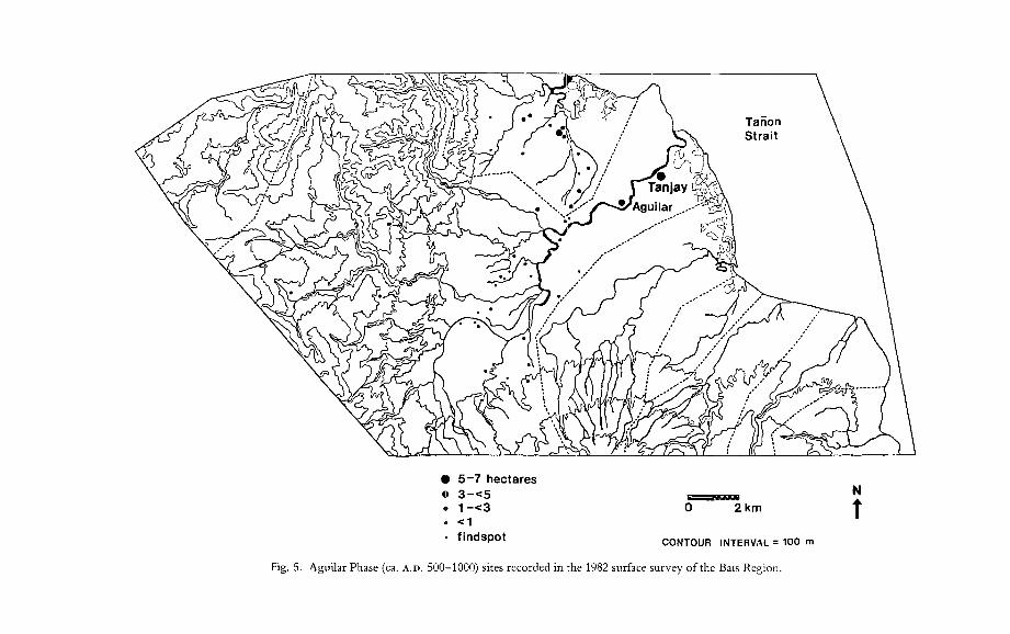
nent) , 39 of which are dated to the Aguilar phase (ca. A.D. 500-1000), 27 to the Santiago phase (ca. A.D. 1100-1400), 101 to the Osmena phase (ca. A.D. 1400-1600), and 77 to the Historic phase (ca. seventeenth-nineteenth centuries), with 68 primarily lithic-yielding sites of unknown date. As shown in Figures 5 and 6, there is a nonuniform site size distribution with indications for a developing two-level settlement hierarchy already in the Aguilar phase. While the coastal site ofTanjay and the upriver Aguilar site fall within the 3-5 hasize range, the majority of Bais Region sites of this period occupy areas of one hectare or less, with almost 50 percent of the sites falling below 1000 m 2 in size and probably representing isolated homesteads. As illustrated in Figure 5, the distribution of sites in the Tanjay River drainage in the Aguilar period closely resembles that predicted by the Bronson (1977) settlement model: a single regionally dominant settlement located on a well-harbored coast at the mouth of a navigable river flowing from the interior, a strategic position with regard to control of both maritime trade and intra-regional river-transported trade. Secondary centers (the Aguilar site being the most prominent) are located some distance upriver or along the coast at strategic points for the transshipment of interior products to the regionally dominant primary center, while smaller hamlets and special activity sites are dispersed a somewhat greater distance from the river,

• 10-15 hectares
• 5-7 N
• 3-<5 0 2km t • 1 -<3
<1 CONTOUR INTERVAL = 100 m
findspot
Fig. 7. Santiago phase (ca. A.D. 1100-1400) sites recorded in the 1982 surface survey of the Bais Region, Negros Oriental, Philippines.

JUNKER: TRADE IN THE PHILIPPINES 193
TABLE 3. MEAN SITE SIZE (FOR SITES 1 HA OR GREATER) AND MEAN SITE DENSITY FOR THE 3 PREHISPANIC CULTURAL PHASES IN THE BAIS REGION
PERIOD
Aguilar phase (ca. A.D. 500-1000)
Santiago phase (ca. A.D. 1100-1400)
Osmena phase (ca. A.D. 1400-1600)
MEAN SITE SIZE
(HA)
1.38 (0.66)a
2.17* (1.57)
3.44*
MEAN SITES/SAMPLING UNIT
0.76 sites per 0.25 km2
(2.61)
0.63 (2.07)
3.27*
Note: Asterisk (*) indicates a statistically significant change from the preceding period using a Student's t test at the. 05 level of significance. a Numbers in parentheses are standard deviations.
presumably in close proximity to agricultural fields and forested hunting areas. Not surprisingly, the upland sites dated to this period (and to the later phases) are uniformly small (typically less than 1000 m 2 in area), are frequently ephemeral (having relatively low artifact densities), and generally have a higher ratio oflithics to ceramics than lowland sites. This is consistent with the archaeological expectations of isolated and impermanently occupied homesteads of shifting cultivators or the base camps of mobile hunter-gatherers, both of whom, historical records suggest, were present in the region at the time of European contact.
As shown in Figures 6 and 7, by the Santiago phase the regional settlement system had evolved into a more distinctly hierarchical one, with Tanjay emerging as a clearly dominant primary center at an estimated 15 ha (more than three times the size of the next largest site) and a well-demarcated set of three secondary centers (2-5 ha) located along the Tanjay River and the adjacent Panamangan River, frequently at the confluence of major river branches. The remaining lowland sites cluster in the same size range of one hectare or less noted for the preceding period, yielding similar spatially concentrated domestic debris (earthenware, lithics, shell, and animal bone) and suggesting an interpretation as isolated homesteads or small hamlets. As shown in Table 3, while there is a statistically significant increase in the mean site size for settlements greater than one hectare in this period, the overall density of sites actually decreases slightly, indicating that there may have been a trend towards increased concentration of the lowland population at the primary center and secondary centers rather than any overall regional population growth in this period.
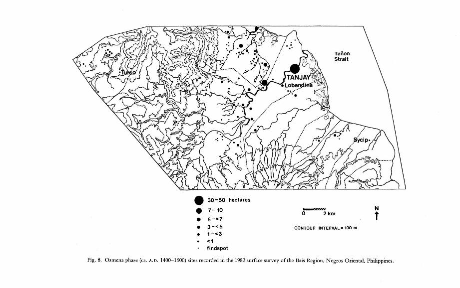
As illustrated in Figures 6 and 8, by the Osmena phase the geographic extent of the coastal center at Tanjay has increased twofold to its historically known size of about 30-50 ha, while two of the earlier secondary centers have disappeared, one has grown from 5 ha to 7 ha, and four new secondary centers have emerged that fall in the 4-7 ha size range and are located at strategic points upstream from Tanjay and northward along the coast. During this immediately prehispanic phase, therefore, the regional settlement system continues a developmental trajectory begun before the twelfth century, in which a single hyper-large settlement (Tanjay) emerges as regionally dominant in a settlement hierarchy increasingly exhibiting the "primate" patterning suggested by Bronson's (1977) model. Again, in this cultural phase, as in
• 30-50 hectares
• 7-10 N 0 2km t • 5-<7
• 3-<5 CONTOUR INTERVAL = 100 m
• 1-<3 <1 findspot
Fig. 8. Osmena phase (ca. A.D. 1400-1600) sites recorded in the 1982 surface survey of the Bais Region, Negros Oriental, Philippines.

JUNKER: TRADE IN THE PHILIPPINES 195
the earlier Aguilar and Santiago phases, settlement patterns in the Bais Region lowlands are consistent with Bronson's settlement model for maritime-trade-oriented coastal states and chiefdoms in Southeast Asia, in which ecological and geographic features favoring the channeling of inter-group exchange interactions along waterway routes mean that single well-placed centers can effectively control vast dendritic networks of interaction. During the Osmena phase, unlike the preceding Santiago phase, there is a statistically significant increase in both the mean settlement size and the overall density of sites, indicating substantial overall regional population expanSIon.
Thus, a two-tiered settlement hierarchy in the Bais lowlands, centered around the large coastal site ofTanjay, appears to have developed before the initiation of intensive trade contacts with the Asian mainland around the tenth century. This settlement pattern is consistent with the later historically observed and ethnographically recorded settlement systems of coastal chiefdoms in the Philippines in the sixteenthnineteenth centuries and with the generallocational model of Bronson (1977). In the early to mid-second millennium, there appears to be a significant increase in both the overall density of sites and mean site size, along with the development of a more distinctly hierarchical settlement system (i. e., the emergence of a more distinct tier of secondary centers and the growth of Tanjay into a hyper-large primary center). This development corresponds chronologically to the appearance of Chinese trade and perhaps indicates the growth of more efficient lowland networks of resource mobilization in response to the new demands and opportunities of this expanded long-distance trade. However, an examination of the spatial patterning of settlement spanning this period indicates no major shifts in the organization of regional settlement systems in terms of the general location of permanent habitation sites and their relative degree of clustering. Locational analyses focused on a number of variables that were seen as relevant to the issue of efficiency in transporting goods manufactured at the coastal center of Tanjay (and/or imported from external sources into Tanjay) and distributing them to the interior in exchange for agricultural and forest products. These variables, recorded for each of the surveyed sites, included (1) the elevation zone into which a site falls, (2) the river drainage system in which the site was found, (3) the distance to the nearest river, (4) the distance (by river) to the coast, and (5) the distance to Tanjay (as the primary focal point of the regional exchange system). It was hypothesized that a change towards a more regionally centralized economy, focused on the prominent coastal settlement of Tanjay with its accompanying increased emphasis on lowland-upland trade interactions, would be reflected in a region-wide shift in settlement to a relatively greater proportion of sites along navigable rivers (as major avenues for interior movement) and closer proximity to the primary sources of locally manufactured and exotic trade goods (i. e., the lowland zone, specifically along the coast and even more specifically near the coastal center of Tan jay).
Turning first to a comparison of the relative density of sites in the lowland and upland elevation zones for the three cultural phases of interest, Table 4 suggests that the ratio of sites below 100 m elevation to sites above 100 m elevation is relatively constant from one phase to the next, with a chi-square test indicating no statistically significant shift towards increased lowland settlement relative to upland settlement over time. Second, a comparison was made of the relative numbers of sites in two of the drainage systems most heavily sampled in the regional survey-the Tanjay

196 Asian Perspectives, XXIX (2), 1990
TABLE 4. DISTRmUTION OF SITES BY ELEVATION ZONE IN THE 3 PREHISPANIC CULTURAL
PHASES IN THE BAIS REGION, NEGROS ORIENTAL, PHILIPPINES (NUMBER AND PERCENT)
Aguilar phase (ca. A.D. 500-1000)
Santiago phase (ca. A.D. 1100-1400)
Osmena phase (ca. A.D. 1400-1600)
LOWLAND « 100 m)
30 (77%)
22 (82%)
73 (72%)
ELEVATION ZONE
Note: The chi-square test of independence is not significant at the. 05 level.
UPLAND (> = 100 m)
9 (23%)
5 (18%)
28 (28%)
TABLE 5. DISTRIBUTION OF SITES BY DRAINAGE SYSTEM (TANJAY RIVER AND PANAMANGAN
RIVER ONLY) FOR THE 3 PREHISPANIC PHASES IN THE BAIS REGION, NEGROS ORIENTAL,
PHILIPPINES (NUMBER AND PERCENT)
Aguilar phase (ca. A.D. 500-1000)
Santiago phase (ca. A.D. 1100-1400)
Osmena phase (ca. A.D. 1400-1600)
TANJAY RIVER
25 (71%)
16 (67%)
59 (70%)
DRAINAGE SYSTEM
PANAMANGAN RIVER
10 (29%)
8 (33%)
24 (30%)
Note: The chi-square test of independence is not significant at the. 05 level.
drainage system, dominated by the large and navigable Tanjay River at the mouth of which is the coastal center of Tanjay, and the adjacent Panamangan drainage system traversed by the narrow and mostly unnavigable Panamangan River (Table 5). An examination of the ratio of Tanjay basin sites to Panamangan basin sites indicates that the Tanjay basin, throughout the settlement history represented in our archaeological survey, supported about twice as many settlements as the adjacent Panamangan basin; there is no significant shift in settlement towards the Tanjay drainage basin over time. Since distance to the nearest river, 'distance to the coast, and distance to the regional center at Tanjay were all quantitative measures (with no assumption ofa normal distribution), we used the nonparametric Mann-Whitney U Test to examine whether any significant shifts in settlement placement with respect to these locational variables could be observed between the three cultural phases. As shown in Tables 6, 7, and 8, no statistically significant differences in the average distance to the nearest river, to the coast, and to the regional center at Tanjay were apparent in comparisons of the three cultural phases.
Locational analyses of settlement patterns on the Bais lowland alluvial plain indicate that the absolute number of sites increased over the three prehispanic settlement
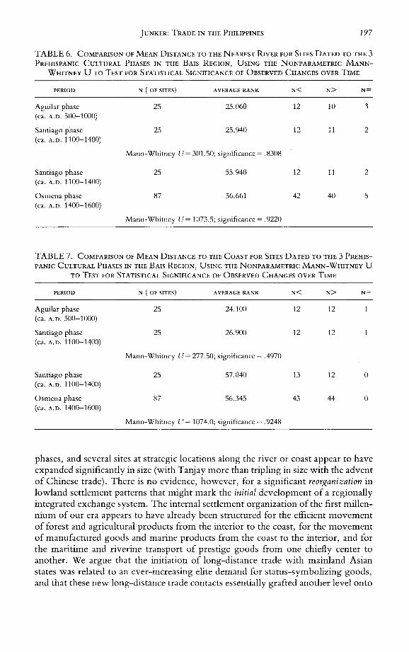
JUNKER: TRADE IN THE PHILIPPINES 197
TABLE 6. COMPARISON OF MEAN DISTANCE TO THE NEAREST RIVER FOR SITES DATED TO THE 3 PREHISPANIC CULTURAL PHASES IN THE BAIS REGION, USING THE NONPARAMETRIC MANN
WHITNEY U TO TEST FOR STATISTICAL SIGNIFICANCE OF OBSERVED CHANGES OVER TIME
PERIOD N (OF SITES) AVERAGE RANK N< N> N=
Aguilar phase 25 25.060 12 10 3 (ca. A.D. 500-1000)
Santiago phase 25 25.940 12 11 2 (ca. A.D. 1100-1400)
Mann-Whitney U = 301. 50; significance = .8308
Santiago phase 25 55.940 12 11 2 (ca. A.D. 1100-1400)
Osmena phase 87 56.661 42 40 5 (ca. A.D. 1400-1600)
Mann-Whitney U= 1073.5; significance = .9220
TABLE 7. COMPARISON OF MEAN DISTANCE TO THE COAST FOR SITES DATED TO THE 3 PREHIS
PANIC CULTURAL PHASES IN THE BAIS REGION, USING THE NONPARAMETRIC MANN-WHITNEY U
TO TEST FOR STATISTICAL SIGNIFICANCE OF OBSERVED CHANGES OVER TIME
PERIOD N (OF SITES) AVERAGE RANK N< N> N=
Aguilar phase 25 24.100 12 12 (ca. A.D. 500-1000)
Santiago phase 25 26.900 12 12 (ca. A.D. 1100-1400)
Mann-Whitney U = 277.50; significance = .4970
Santiago phase 25 57.040 13 12 0 (ca. A.D. 1100-1400)
Osmena phase 87 56.345 43 44 0 (ca. A.D. 1400-1600)
Mann-Whitney U = 1074.0; significance = .9248
phases, and several sites at strategic locations along the river or coast appear to have expanded significantly in size (with Tanjay more than tripling in size with the advent of Chinese trade). There is no evidence, however, for a significant reorganization in lowland settlement patterns that might mark the initial development of a regionally integrated exchange system. The internal settlement organization of the first millennium of our era appears to have already been structured for the efficient movement of forest and agricultural products from the interior to the coast, for the movement of manufactured goods and marine products from the coast to the interior, and for the maritime and riverine transport of prestige goods from one chiefly center to another. We argue that the initiation of long-distance trade with mainland Asian states was related to an ever-increasing elite demand for status-symbolizing goods, and that these new long-distance trade contacts essentially grafted another level onto

198 Asian Perspectives, XXIX (2), 1990
TABLE 8. COMPARISON OF MEAN DISTANCE TO THE REGIONAL CENTER OF TANJAY FOR
SITES DATED TO THE 3 PREHISPANIC CULTURAL PHASES IN THE BAIS REGION, USING THE
NONPARAMETRIC MANN-WHITNEY U TO TEST FOR STATISTICAL SIGNIFICANCE OF
OBSERVED CHANGES OVER TIME
PERIOD N (OF SITES) AVERAGE RANK N< N>
Aguilar phase 25 24.360 12 13 (ca. A.D. 500-toOO)
Santiago phase 25 26.640 13 12 (ca. A.D. 1100-1400)
Mann-Whitney U = 284.0; significance = .5802
Santiago phase 25 54.980 13 12 (ca. A.D. 1100-1400)
Osrnena phase 87 56.937 43 44 (ca. A.D. 1400-1600)
Mann-Whitney U= 1049.5; significance = .7906
N=
0
0
0
0
an already well-developed and complex regional system of exchange focused on, and largely controlled by, the chiefly elite at the strategically located coastal center at Tanjay and at similar coastal centers.
Still missing from this discussion of regional political organization and exchange, however, is the archaeological evidence for the actual movement of both exotic goods and manufactured domestic goods in the region for the periods of interest, and an examination of whether the patterning of these commodities supports the assertion that a centrally controlled prestige goods economy was operating in the region even before Chinese trade. Excavations at the coastal center of Tanjay, as briefly described in the preceding section, indicated that in addition to Chinese porcelain, elaborately decorated and slipped earthenwares and iron implements exhibit a pattern of distribution in both residential and burial contexts suggestive of restricted access by only certain segments of the population, presumably those of the elite stratum. At the regional level, we would expect these presumed prestige goods to appear primarily at the regional center of Tanjay and at secondary centers located at strategic points upriver and along the coast, as the Tanjay elite apportioned out both foreign and locally manufactured status-symbolizing goods to allied local political leaders at these more distant centers through the type of region-wide, chieftainsponsored feasts described in the historic and ethnographic accounts (see above) and/or through regular trade interactions (a form of exchange termed "central place redistribution" by Renfrew [1982]). These types of alliance-structured regional interactive networks would facilitate the movement of more mundane commodities between the interior and the coast, with lowland-manufactured domestic pottery and resources flowing inland and agricultural and forest products moving coastward-as suggested by the historic and ethnographic references to uplandlowland interaction cited above. This intra-regional exchange of ordinary household commodities, although primarily involving perishable subsistence goods, would be seen archaeologically in the presence of lowland-manufactured ceramics at interior lowland and upland sites, with the spatial distribution of the ceramics exhibiting the

JUNKER: TRADE IN THE PHILIPPINES 199
"monotonic drop-off" pattern described by Renfrew (1982) for "down-the-line" exchange from a single production center. While multiple localized pottery production centers would complicate a simple monotonic drop-off curve, European texts of the sixteenth-seventeenth centuries suggest that regional production frequently involved single-village craft specialization in weaving, metal-production, and carpentry (e.g., Dampier 1697:227; Morga 1609:292-293; sixteenth-century Boxer manuscript, in J ocano 1975: 197, 229). The presence of a single highly standardized ware dominating the ceramic assemblages for each of the three prehispanic settlement phases in the Bais Region suggests pottery manufacture was a regionally centralized rather than localized industry.
The most widely used quantitative technique for describing these distinct spatial distributions has been regression analysis (e.g., Hodder and Orton 1976:98-197; Renfrew, Dixon, and Cann 1968; Renfrew 1977). In comparing the regional distribution of what are likely to have been prestige goods (i.e., decorated earthenwares, iron implements, and, in the later two phases, Asian mainland porcelains) with that of plain earthenware for the three prehispanic periods, we employed a statistical model known as "stepwise logistic regression" or "stepwise pro bit analysis" (see Finney 1971; Fox and Guire 1982; McCullagh 1980). This statistical procedure operates similarly to ordinary stepwise regression, in which a series of variables (in this case, site location and size) are examined to determine which is the best "predictor" of another variable (in this case, the incidence of porcelain and other prestige goods), except that the predicted variable is a dichotomous (present/absent) variable instead of a continuous one. The reason for focusing on presence/absence of prestige goods rather than their absolute or relative quantities is that prestige goods in all periods were generally extremely rare: they were found only at a small percentage of sites and always in small quantities. Thus, even small-scale variability in surface visibility and collection techniques in the regional survey would have significant impact on quantitative comparisons between sites. The logistic regression procedure selected the best predictor of the presence of a particular prestige good from the following variables: site size, distance from the regional center at Tanjay, and distance to the nearest river. The procedure then removed that variable from the regression equation, calculating its chi-square value as a measure of statistical significance. Table 9 presents a summary of the results of the logistic regression analysis for the three periods, listing the locational or size variable that was selected as the best single predictor of the presence of each type of commodity (with plain earthenware as the presumed nonprestige good for comparison), the chi-square value for that association, and whether the association is statistically significant at the .05 and .01 levels.
As shown in Table 9, in the latest (Osmena) phase, the best predictor of the presence of presumed prestige goods was site size (although for metal, the resulting chi-square value was not statistically significant). This indicates that such commodities were generally not distributed to small sites, even if such sites were close to the assumed source at Tanjay, instead moving to more distant but larger sites. In contrast, the presence of the plain earthenware that dominated the Tanjay site ceramic assemblage in this period (known as Tanjay Red Ware) at other Bais Region sites appears to be a function of distance from Tanjay rather than site size. Since plain earthenware was found in considerable abundance at all sites and thus was assumed to be less affected by survey sampling errors than the rarer prestige goods, a. regular stepwise regression, using the "percentage contribution of Tanjay Red Ware to the
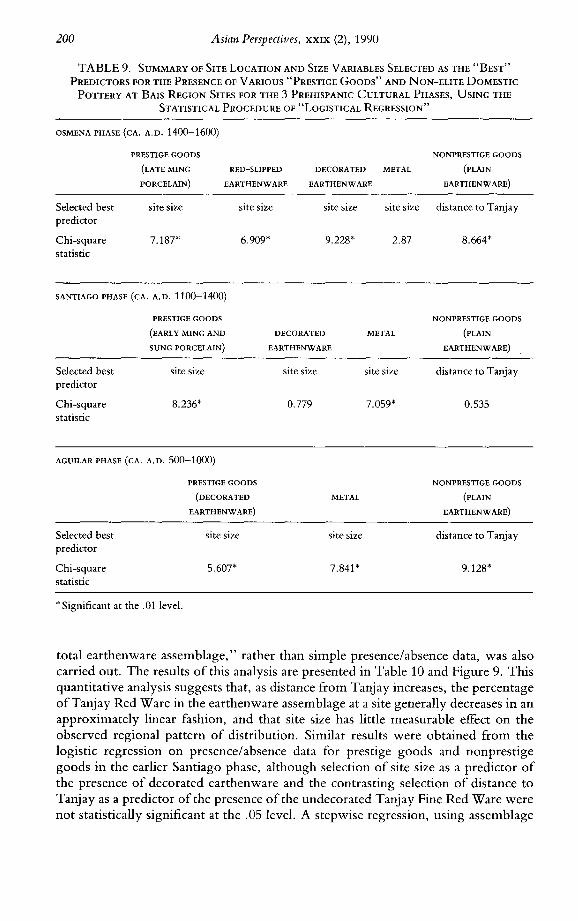
200 Asian Perspectives, XXIX (2), 1990
TABLE 9. SUMMARY OF SITE LOCATION AND SIZE VARIABLES SELECTED AS THE "BEST"
PREDICTORS FOR THE PRESENCE OF VARIOUS "PRESTIGE GOODS" AND NON-ELITE DOMESTIC
POTTERY AT BAIS REGION SITES FOR THE 3 PREHISPANIC CULTURAL PHASES, USING THE
STATISTICAL PROCEDURE OF "LOGISTICAL REGRESSION"
OSMENA PHASE (CA. A.D. 1400-1600)
PRESTIGE GOODS
(LATE MING
PORCELAIN)
RED-SLIPPED
EARTHENWARE
DECORATED METAL
Selected best predictor
Chi-square statistic
site size
7.187*
SANTIAGO PHASE (CA. A.D. 1100-1400)
site size
6.909*
EARTHENWARE
site size site size
9.228* 2.87
DECORATED METAL
PRESTIGE GOODS
(EARLY MING AND
SUNG PORCELAIN) EARTHENWARE
Selected best predictor
Chi-square statistic
site size
8.236*
AGUILAR PHASE (CA. A.D. 500-1000)
Selected best predictor
Chi-square statistic
* Significant at the .01 level.
PRESTIGE GOODS
(DECORATED
EARTHENWARE)
site size
5.607*
site size site size
0.779 7.059'
METAL
site size
7.841 *
NONPRESTIGE GOODS
(PLAIN
EARTHENWARE)
distance to Tanjay
8.664*
NONPRESTIGE GOODS
(PLAIN
EARTHENWARE)
distance to Tanjay
0.535
NONPRESTIGE GOODS
(PLAIN
EARTHENWARE)
distance to Tanjay
9.128*
total earthenware assemblage," rather than simple presence/absence data, was also carried out. The results of this analysis are presented in Table 10 and Figure 9. This quantitative analysis suggests that, as distance from Tanjay increases, the percentage ofTanjay Red Ware in the earthenware assemblage at a site generally decreases in an approximately linear fashion, and that site size has little measurable effect on the observed regional pattern of distribution. Similar results were obtained from the logistic regression on presence/absence data for prestige goods and nonprestige goods in the earlier Santiago phase, although selection of site size as a predictor of the presence of decorated earthenware and the contrasting selection of distance to Tanjay as a predictor of the presence of the undecorated Tanjay Fine Red Ware were not statistically significant at the .05 level. A stepwise regression, using assemblage

JUNKER: TRADE IN THE PHILIPPINES
TABLE 10. STEPWISE REGRESSION INDICATING THE BEST SINGLE PREDICTOR FOR THE
PERCENTAGE CONTRIBUTION OF TANJAY RED WARE TO THE TOTAL CERAMIC
ASSEMBLAGE FOR OSMENA PHASE SITES
201
SOURCE D.F. SUM OF SQUARES MEAN SQUARE F-STA TISTIC SIGNIFICANCE
Regression Residual
1 53
11035.0 41935.0
11035.00 791.23
13.947 .0005
Multiple R = .45643 R-Square = .20833 Standard error = 28.129 N = 55 out of 57
VARIABLE PARTIAL COEFFICIENT STANDARD ERROR T-STATISTIC SIGNIFICANCE
Constant 51.2740 6.9661 7.3605 .0000 Distance to Tanjay -.45643 -0.0015 0.0004 -3.7346 .0005
REMAINING VARIABLES PARTIAL SIGNIFICANCE
Site size -.07156 .6071 Distance to coast .40903 .0021 Distance to river -.21972 .1104
percentages of the undecorated Tanjay Fine Red Ware and attempting to obtain a single best predictor, failed to yield any statistically significant locational or size variable in the equation.
If the sociopolitical entities present in the Bais Region before the initiation of Chinese trade interactions around the twelfth century lacked the type of distributional patterns associated with elite participation in a system of prestige good exchange, we would expect to find all lowland-manufactured commodities exhibiting a similar distance-dependent distribution out of production centers such as Tanjay. As shown in Table 9, this does not appear to be the case, since hypothesized prestige goods from the earliest phase (decorated earthenware and iron implements), like those of the later cultural phases, are distributed primarily to large sites, while the plain earthenware dominating the assemblage of coastal Bais Region sites like Tanjay (known as Aguilar Spotted Buff Ware) has a clear distance-dependent distribution. Stepwise regression of the percentage of Aguilar Spotted Buff Ware in earthenware assemblages at Bais Region sites as a function of these locational variables, however, failed to produce a single statistically significant predictor. The results of regression analyses, therefore, generally support the conclusion that there is a relatively consistent pattern in the regional distribution of lowland-manufactured and externally imported commodities over time, with relatively valuable, rare, and/or exotic goods associated only with large regional centers presumably under the control of a sociopolitical elite, contrasted with the primarily distance-dependent distribution of plain domestic earthenware produced at lowland centers like Tanjay.
This suggests that the establishment of trade relations with Chinese merchants or with middlemen peddling mainland Asian wares simply created a new material medium for elite status symbolizing and for internal alliance-building exchanges, with no fundamental restructuring of already well-developed internal exchange networks that were geared towards the cycling of prestige goods among a sociopolitical elite at different centers, while simultaneously moving lowland-manufactured pro-

202 Asian Perspectives, XXIX (2), 1990
%
100 •• •
• • 80 • • w ••• u.~ • O~ 60 •
we • • <.!lw •• ~a: 40 • • z> we:( U, a: "7'
w< a. .... 20
0 ." 5 10 15 20 25 30 35km
DISTANCE TO TANJAY
Fig. 9. Regression line for the relationship between the percentage contribution of Tanjay Red Ware to the total ceramic assemblage and distance of Bais Region settlements from the regional center at Tanjay in the Osmena phase (A.D. 1400-1600).
ducts (e.g., domestic earthenwares) towards the interior against a coastward flow of upland forest and agricultural commodities. One hypothesized change associated with increased lowland Philippine involvement in long-distance trade, however, is the development of intensified and more centrally controlled lowland-upland interaction. To obtain the highly valued Chinese porcelains, lowland elites at competing coastal trade ports had to ensure a steady and secure return flow of commodities desired by the Chinese. The most desired export products consisted not of lowland Philippine manufactured goods, but rather of upland raw materials and forest products that could be used by the Chinese in the manufacture of their own prestige goods. These products included hardwoods for making finely carved wooden furniture and boxes, gold ore for manufacturing ornaments, and honey, spices, and birds' nests as ingredients in culinary delicacies. While the lowland inhabitants of the Bais Region apparently rarely traded their prized porcelain and other high-status commodities into the upland zone, there is an observed increase in the incidence of Chinese porcelain at upland sites in the most recent (Osmena) phase, corresponding with increased penetration of the highly standardized lowland-manufactured domestic wares into even the most distant upland sites. This may indicate an even greater focus oflowland chiefs on lowland-upland trade alliances, with ceramic production at the regional center specifically oriented towards this internal trade.
SUMMARY AND CONCLUSIONS
Traditionally, the Philippines has been viewed as largely peripheral to mainland Asia not only geographically, but also in terms of technological, economic, and sociopolitical developments. Sophisticated systems of agricultural production, advanced craft production techniques, well-developed social stratification, and centralized political systems were viewed as very late developments that occurred primarily

JUNKER: TRADE IN THE PHILIPPINES 203
in the context of trade contacts with the more advanced civilization of China after A.D. 1000. Both a cause and effect of this sino centric view has been the relative lack of anthropologically informed attempts to integrate the rich historical documentation on Philippine complex societies at the time of Chinese and European contact with the nineteenth- and twentieth-century ethnographic literature on extant chief-doms, and to develop a model of the organization and functioning of these societies that can be put into a processual framework with archaeological data. In this paper, I have made a preliminary attempt to construct such a model through ethnohistoric analyses of Philippine lowland societies examining systems of social stratification, the nature of chiefly authority and regionally integrating political structures, and chiefly control over the regional economy, in the early to mid-second millennium. Focusing specifically on the central role of the chiefly political leader in coordinating and controlling both intra-regional and inter-regional systems of resource mobilization and exchange, I examined archaeologically testable predictions about the development of these economic systems, using data on regional settlement and artifact distribution patterns from one region of prehistoric complex society development in the Philippines.
These recent archaeological investigations in the Bais Region of Negros Oriental produced evidence for the existence of regional settlement hierarchies, differential access to prestige goods in both household and burial contexts, and centrally administered systems of intra-regional exchange before the period of intensified foreign trade contacts-indicating a trend towards increasing complexity that has indigenous roots extending well into the prehistoric period. If this is the case, then the question of why expanded trade contacts with China and other developed Asian states began around the tenth century becomes more intelligible in terms of organizational features of both of the participating societies. It can be argued that developing status hierarchies in Philippine lowland societies, in which chiefly personages and other elite, required a continual flow of sumptuary items to validate and maintain their positions of status and authority, created the conditions for an everincreasing demand for exotic prestige goods. This growing demand was initially met through more localized production and exchange of status goods, but eventually expanded to encompass trade with distant polities such as China. This demand meshed well with the Chinese desire for raw materials from which their own highly valued prestige goods could be manufactured for distribution in their own status networks. Large lowland settlements located along maritime trade routes, already serving as major foci for regional political and commercial activities, would present ideal locations for the development of long-distance trade centers or entrepots. Already established, centrally controlled networks of intra-regional and interregional exchange would facilitate both the distribution of porcelains and other Chinese imports to trade partners (presumably allied political leaders) in more remote interior areas and the amassment of raw materials and forest products from these areas for export to China.
REFERENCES
ALCINA, FRANCISCO IGNACIO
1688 Historia de las Islas e Indios de las Bisayas, in The Munoz Text of Alcina's History of the Bisayan [196?] Islands (1668), 4 vols., ed. Paul Lietz. Philippine Studies Program, University of Chicago.
204 Asian Perspectives, XXIX (2), 1990
ALVARADO, GARCIA
1548 Expedition of Villalobos, in The Philippines, 1493-1898, Vol. 2:67-73, trans. E. Blair and]. [1903- Robertson. Cleveland: Arthur H. Clark Co. 1909]
ANDAYA, LEONARD
1975 The structure of power in 17th century Johor, in Pre-Colonial State Systems in Southeast Asia: 1-11, ed. A. Reid and 1. Castles. Monographs of the Malaysian Branch of the Royal Asiatic;. Society No.6.
ARTIEDA, DIEGO DE
1569 Relation of the Western Island, in The Philippines, 1493-1898, Vol. 3: 190-208, trans. E. Blair [1903- and]. Robertson. Cleveland: Arthur H. Clark Co. 1909]
BECKETT, JEREMY
1982 The defiant and the compliant: The Datus of Magindanao under colonial rule, in Philippine Social History: 391-414, ed. A. W. McCoy and C. De Jesus. Asian Studies Association of Australia Monograph No.7. Quezon City: Ateneo de Manila University Press.
BERNAL, RAFAEL
1966 The Chinese colony in Manila, 1570-1770, in The Chinese in the Philippines, 1570-1770: 40-66, ed. A. Felix. Manila: Solidaridad Press.
BEYER, H. OTLEY
1947 Outline review of Philippine archaeology by islands and provinces. Philippine Journal of Science 77:205-374.
1964 Philippine prehistoric contacts with foreigners, in Chinese Participation in Philippine Culture and Economy: 2-18, ed. S. Liao. Manila.
BEYER, H. OTLEY, AND]. C. DE VEYRA
1947 Philippine Saga: A Pictorial History of the Archipelago Since Time Began. Manila: The Evening News.
BIERNATZKI, WILLIAM E.
1985 Bukidnon Datuship in the Upper Pulangi River Valley, in Bukidnon Politics and Religion: 15-49, ed. A. Guzman and E. Pacheco. Cebu City: University of San Carlos Press.
BINFORD, LEWIS R.
1969 Comment on "Trade and Culture Process in European Prehistory." CA 10: 162-163.
BLAIR, EMMA H., AND]. A. ROBERTSON
1903- The Philippines, 1493-1898. 55 vols. Cleveland: Arthur H. Clark Co. 1909
BRONSON, BENNET
1977 Exchange at the upstream and downstream ends: Notes towards a functional model of the coastal state in Southeast Asia, in Economic Exchange and Social Interaction in Southeast Asia: 39-52, ed. K. L. Hutterer. Michigan Papers on South and Southeast Asia, No. 13. Ann Arbor.
BROWN, D. E.
1976 Principles of Social Structure: Southeast Asia. London: Westview.
BURTON, LINDA
1977 Settlement and burial sites in Butuan Ciy: A preliminary report. Philippine Studies 25: 95-112.
CHEN, LIU TI
1966 An approach to the study of early Sino-Philippine relations, in The Chinese in the Philippines: 252-285, ed. A. Felix. Manila: Solidaridad Press.
CHIRINO, PEDRO
1604 Relacion de las Islas Filipinas, in The Philippines, 1493-1898, Vol. 12: 169-321, trans. E. Blair [1903- and]. Robertson. Cleveland: Arthur H. Clark Co. 1909]
CLAVER, FRANCISCO
1985 Dinawit Ogil: High Datu of Namnam, in Bukidnon Politics and Religion: 51-114, ed. A. Guzman and E. Pacheco. Cebu City: University of San Carlos Press.

JUNKER: TRADE IN THE PHILIPPINES 205
COLE, FAY COOPER
1913 Wild Tribes of the Davao District. Field Museum of Natural History Anthropology Series Monography No. 12. Chicago.
1956 The Bukidnon of Mindanao. Chicago: Chicago Natural History Museum Press.
COLIN, FRANCISCO
1660 Native races and their customs, in The Philippines, 1493-1898, Vol. 40: 37-98, trans. E. Blair [1903- and). Robertson. Cleveland: Arthur H. Clark Co. 1909]
CONKLIN, HAROLD
1949 Preliminary report on fieldwork on the islands of Mindoro and Palawan, Philippines. AA 51(2) :268-273.
1957 Hanunoo Agriculture. Rome: Food and Agricultural Organization of the United Nations.
CRAIG, AUSTIN
1914 A Thousand Years oJPhilippine History Bifore the Coming of the Spaniards. Manila.
DAMPIER, WILLIAM
1697 A New Voyage Round the World. Sir Albert Gray (ed.). London: Argonaut Press. [1927]
ENRIQUEZ, MARTIN
1574 Letter from the Viceroy of New Spain to Felipe II, in The Philippines, 1493-1898, Vol. 3:209-[1903- 219, trans. E. Blair and). Robertson. Cleveland: Arthur H. Clark Co. 1909]
FERNANDEZ, JULITA, AND AMELIA O. ROGEL
1968 Digging in the past. Esso Silangan 13: 6-1l.
FINNEY, D. ).
1971 Probit Analysis, 3rd ed. London: Cambridge University Press.
FLANNERY, KENT V. 1968 The Olmec and the Valley of Oaxaca: A model for interregional interaction in formative
times, in Dumbarton Oaks Conference on the Olmec: 79-110, ed. E. P. Benson. Washington, D.C.: Dumbarton Oaks.
Fox, DANIEL)', AND KENNETH GUIRE
1982 PROBIT command, in Documentationfor MIDAS: 130, ed. D. Fox and K. Guire. Ann Arbor: Statistical Research Laboratory, University of Michigan.
Fox, ROBERT
1954 Religion and society among the Tagbunuwa ofPalawan Island, Philippines. Ph.D. diss., University of Chicago.
1959 The Calatagan excavations: Two fifteenth century burial sites in Batangas, Philippines. Philippine Studies 7:325-390.
1964 Chinese pottery in the Philippines, in Chinese Participation in Philippine Culture and Economy: 96-115, ed. S. Liao. Manila.
1967 The archaeological record of Chinese influences in the Philippines. Philippine Studies 15(1) :41-62.
Fox, ROBERT, AND ALFREDO EVANGELISTA
1957 The cave archaeology of Cagrayray Island, Albay Province. Journal oj East Asiatic Studies 6(1): 57-68.
Fox, ROBERT, AND AVELINO LEGASPI
1977 Excavations at Santa Ana. Manila: National Museum Publications.
FRANKENSTEIN, S., AND M.). ROWLANDS
1978 The internal structure and regional context of early Iron Age society in south-western Germany. Bulletin of the Institute of Archaeology, University oj London 15: 73-112.
GULLICK,). M.
1965 Indigenous Political Systems of Western Malaya. London: Athlone Press.
HALL, KENNETH
1976 State and statecraft in early Srivijaya, in Explorations in Early Southeast Asian History: The Origins of Southeast Asian Statecraft: 61-105, ed. K. Hall and). Whitmore. Center for South and Southeast Asian Studies, University of Michigan, Paper No. 11.

206 Asian Perspectives, XXIX (2), 1990
1985 Maritime Trade and State Development in Early Southeast Asia. Honolulu: University of Hawaii Press.
HALL, KENNETH, AND JOHN WHITMORE, EDS.
1976 Explorations in Early Southeast Asian History: The Origins of Southeast Asian Statecraft. Center for South and Southeast Asian Studies, University of Michigan, Paper No. 11.
HODDER, IAN, AND CLIVE ORTON
1976 Spatial Analyses in Archaeology. Cambridge: Cambridge University Press.
HUTTERER, KARL L. 1973a An Archaeological Picture of a Pre-Spanish Cehuano Community. Cebu City: University of San
Carlos Press. 1973h Basey archaeology: Prehistoric trade and social evolution in the Philippines. Ph.D. diss., Uni
1974 1976 1977
1981
versity of Hawaii. The evolution ofPhiiippine lowland societies. Mankind 9(4) :287-299. An evolutionary approach to the Southeast Asian cultural sequence. CA 17: 221-242. Prehistoric trade and the evolution of Philippine societies: A reconsideration, in Economic Exchange and Social Interaction in Southeast Asia: 177-196, ed. K. L. Hutterer. Michigan Papers on South and Southeast Asia, No. 13. Ann Arbor. Bais Anthropological Project, Phase II: A first report. Philippine Quarterly of Culture and Society 9(4) :333-341.
HUTTERER, KARL L., AND WILLIAM K. MACDONALD
1979 The Bais Anthropological Survey: A first preliminary report. Philippine Quarterly of Culture and Society 7: 115-140.
1982 Houses Built on Scattered Poles: Prehistory and Ecology in Negros Oriental, Philippines. Cebu City: University of San Carlos Press.
ILETO, REYNALDO
1971 Magindanao, 1860-1888: The Career of Datu Uto of Buayan. Cornell University Southeast Asia Paper No. 32.
JANSE,OWV
1944 Notes on Chinese influences in the Philippines in pre-Spanish times. Harvard Journal of Asiatic Studies 8(1): 34-62.
JOCANO, F. LANDA
1975 The Philippines at the Spanish Contact. Quezon City, Philippines: Garcia.
JUNKER, LAURA
n.d. Cultural chronology, site function, and prehistoric exchange networks in the Bais region, [1985] Negros Oriental, Philippines: An examination of the earthenware pottery evidence. Unpub
lished manuscript. 1982 An analysis of an earthenware sample from southeastern Negros, in Houses Built on Scattered
Poles: Prehistory and Ecology in Negros Oriental, Philippines: 265-302, ed. K. L. Hutterer and W. K. Macdonald. Cebu City, Philippines: University of San Carlos Press.
1986 A preliminary report on the archaeological investigations at Tanjay, Negros Oriental, Philippines: 1985-1986. Report submitted to the National Museum of the Philippines.
KEESING, FELIX
1962 The Ethnohistory of Northern Luzon. Stanford, Calif.: Stanford University Press.
KIEFER, THOMAS
1971 Institutionalized friendship and warfare among the Tausug ofJolo. Ethnology 7: 225-224. 1972a The Tausug: Violence and Law in a Philippine Muslim Society. New York: Holt, Rinehart and
Winston. 1972h The Tausug polity and the Sultanate of Sulu: A segmentary state in the southern Philippines,
in Sulu Studies, Vol. 1: 19-64, ed. G. Rixhon. Jolo, Sulu: Notre Dame ofJolo College Press.
KUR]ACK, E. B., AND C. T. SHELDON
1970 The urn burial caves of southern Cotabato, Mindanao, Philippines. Silliman Journal 18: 127-153.
LAUFER, BERTHOLD
1907 The Relations of the Chinese to the Philippine Island. Washington, D. C.
LA VEZARIS, GUIDO DE
1569 Letter to Felipe II, in The Philippines, 1493-1898, Vol. 3:29-32, trans. E. Blair and]. Robert-[1903- son. Cleveland: Arthur H. Clark Co. 1909]

JUNKER: TRADE IN THE PHILIPPINES 207
LEGASPI, A VELINO
1974 Bolinao: A 14th-15th Century Burial Site. National Museum of the Philippines Publ. No.7. Manila.
LEGASPI, MIGUEL LOPEZ
1565 Relation of the voyage to the Philippines, in The Philippines, 1493-1898, Vol. 2: 196-216, [1903- trans. E. Blair and]. Robertson. Cleveland: Arthur H. Clark Co. 1909] 1567 Letter to Felipe II of Spain, in The Philippines, 1493-1898, Vol. 2:232-243, trans. E. Blair and [1903- ]. Robertson. Cleveland: Arthur H. Clark Co. 1909]
LOARCA, MIGUEL DE
1582 Relacion de las Islas Filipinas, in The Philippines, 1493-1898, Vol. 5: 34-187, trans. E. Blair [1903- and]. Robertson. Cleveland: Arthur H. Clark Co. 1909]
LOCSIN, LEANDRO, AND CECILIA LOCSIN
1967 Oriental Ceramics Discoverd in the Philippines. Tokyo: Rutland Press. 1968 Some thoughts on the pre-Ming trade potteries found in the Philippines, in A Report on the
Archaeology of the Locsin-University of San Carlos Excavations in Pila-Laguna, ed. Rosa Tenazas. Manila.
MACDONALD, WILLIAM K. 1982 The Bais Anthropological Project, Phase III: A preliminary report with some initial observa
tions. Philippine Quarterly of Culture and Society 10: 197-210.
MACEDA, M. N.
1964 Preliminary report on ethnographic and archaeological fieldwork in the Kulaman Plateau (Cotabato), Island of Mindanao, Philippines. Anthropos 59: 75-82.
1965 Second preliminary report on the archaeological excavation in the Kulaman Plateau (Cotabato), Island of Mindanao, Philippines. Anthropos 60:237-240.
MAJUL, CESAR
1965 Political and historical notes on the Sulu sultanate. Philippine Historical Review 1: 229-251. 1966 Chinese relationship with the sultanate of Sulu, in The Chinese in the Philippines 1550-1770:
143-159, ed. A. Felix. Manila: Solidaridad. 1973 Muslims in the Philippines. Quezon City, Philippines: University of the Philippines Press.
MALDONADO, JUAN PACHECO
1575 Letter from Juan Pacheco Maldonado to Felipe II, in The Philippines, 1493-1898, Vol. 3:295-[1903- 303, trans. E. Blair and]. Robertson. Cleveland: Arthur H. Clark Co. 1909]
MANUEL, E. ARSENIO
1973 Manuvu Social Organization. Quezon City, Philippines: University of the Philippines Press.
MARTINEZ CUESTA, ANGEL
1974 Historia de la Isla de Negros, Filipinas, 1565-1898. Rome: Pontificia Universitas Gregoriana.
MCCULLAGH, P.
1980 Regression models for ordinal data. Journal of the Royal Statistical Society-Series B 42:413-418.
MEDNICK, MELVIN
1957 Some problems of Moro history and social organization. Philippine Sociological Review 5: 39-51.
MICSIC, JOHN
1984 A comparison between some long-distance trading institutions of the Malacca Straits area and of the western Pacific, in Southeast Asian Archaeology at the 15th Pacific Science Congress: 235-253, ed. Donn Bayard. University of Otago Studies in Prehistoric Archaeology, Vol. 16.
MORGA, ANTONIO
1609 Sucesos de las Islas Filipinas, in The Philippines, 1493-1898, Vol. 16:25-209, trans. E. Blair [1903- and]. Robertson. Cleveland: Arthur H. Clark Co. 1909]
NICHOLAS, RALPH
1966 Segmentary factional political systems, in Political Anthropology, ed. Marc]. Swartz, Victor W. Turner, and Arthur Tuden. Chicago: Aldine.

208 Asian Perspectives, XXIX (2), 1990
ORACION, TIMOTHY
1954 An introduction to the culture of the Magahats of the upper Tayabanan River Valley, Tolong, Negros Oriental, Philippines. Silliman Journal 7:201-218.
1964 Kaingin agriculture among the Bukidnons of southeastern Negros, Central Philippines, in Social Foundations of Community Development: 233-249, ed. S. Espiritu and C. Hunt. Manila: R. M. Garcia.
1967 A preliminary report on some aspects of the Bukidnons on southern Negros Island, Philippines. Unitas 40(1): i56-18L
PIGAFETTA, ANTONIO
1521 First voyage around the world, in The Philippines at the Spanish Contact: 44-80, ed. F. Landa [1975] Jocano. Quezon City, Philippines: Garcia.
PLASENCIA, JUAN DE
1589 Las costumbres de los Indios Tagalogs de Filipinas, m The Philippines, 1493-1898, Vol. [1903- 7: 173-196, trans. E. Blair and). Robertson. Cleveland: Arthur H. Clark Co. 1909]
RAHMANN, R., AND M. N. MACEDA
1955 Notes on the Negritos of northern Negros. Anthropos 50:810-836.
REID, ANTHONY, ED.
1983 Slavery, Bondage and Dependency in Southeast Asia. New York: St. Martin's Press.
RENFREW, COLIN
1977 Alternative models for exchange and spatial distribution, in Exchange Systems in Prehistory: 71-90, ed. T. K. Earle and). Ericson. New York: Academic Press.
1982 Socio-economic change in ranked societies, in Ranking, Resources and Exchange: 67-72, ed. C. Renfrew and S. Shennan. Cambridge:'Cambridge University Press.
RENFREW, COLIN,). E. DIXON, AND). R. CANN
1968 Further analysis of Near Eastern obsidians. Proceedings of the Prehistoric Society 34:319-331.
REYNOLDS, HUBERT
1975 The mountain Negritos of northern Negros. Philippine Quarterly of Culture and Society 4:227-230.
RODRIGUEZ, ESTEV AN
1565 Relation of expedition of Miguel Lopez de Legaspi, in The Philippines, 1493-1898, Vol. [1903- 2: 124-129, trans. E. Blair and). Robertson. Cleveland: Arthur H. Clark Co. 1909]
SAN BUENAVENTURA, P. DE
1613 Vocabulario de Lengua Tagala el Romance Castellano Presta Primera.
SANDE, FRANCISCO
1576 Relation of the Filipinas Islands, in The Philippines, 1493-1898, Vol. 4:21-97, trans. E. Blair [1903- and). Robertson. Cleveland: Arthur H. Clark Co. 1909]
SCHLEGEL, STUART
1979 Tiruray Subsistence. Quezon City, Philippines: Ateneo de Manila University Press.
SCOTT, WILLIAM HENRY
1980 Class structure in the unhispanicized Philippines. Philippine Studies 27: 132-155. 1981 Filipino class structure in the sixteenth century. Philippine Studies 28: 142-175. 1982 The Discovery of the Igorots: Spanish Contacts with the Pagans of Northern Luzon. Quezon City,
Philippines: New Day. 1983 Oripun and Alipin in the sixteenth century Philippines, in Slavery, Bondage and Dependency in
Southeast Asia: 138-155, ed. A. Reid. New York: St. Martin's Press. 1984 Prehispanic Source Materialsfor the Study of Philippine History. Quezon City, Philippines: New
Day.
SEUILLA, ANTONIO
1566 Copia de una Carte Venida de Seuilla a Miguel Salvador de Valencia, in The Philippines, [1903- 1493-1898, Vol. 2:220-231, trans. E. Blair and). Robertson. Cleveland: Arthur H. Clark 1909] Co.
SOLHEIM, WILHELM G., II 1964 The Archaeology of the Central Philippines: A Study of the Iron Age and its Relationships. Manila:
Bureau of Printing.

JUNKER: TRADE IN THE PHILIPPINES 209
1968 The Batungan cave sites, Masbate, Philippines, in Anthropology at the Eighth Pacific Science Congress: 21-62, ed. W. Solheim. Asian and Pacific Archaeology Series No.2. Honolulu: University of Hawaii Press.
1982 Philippine prehistory, in The People and Art of the Philippines: 17-84, G. Casal, R. Jose, E. Casino, G. Ellis and W. Solheim. Los Angeles: University of California Press.
SOUTHALL, A.
1965 1A~ critique of the typology of states and political systems, in Political Systems and the Distribution of Power: 113-140, ed. M. Banton. London: Tavistock.
SPOEHR, ALEXANDER
1973 Zamboanga and Sulu: An Archaeological Approach to Ethnic Diversity. Ethnology Monograph No.1, University of Pittsburgh, Dept. of Anthropology.
TENAZAS, ROSA
1968 A Report on the Archaeology of the Locsin-University of San Carlos Excavations in Pila, Laguna. Manila.
1974 A progress report on the Magsuhot Excavations in Bacong, Negros Oriental, summer 1974. Philippine Quarterly of Culture and Society 2: 133-155.
1977 A comparative study of settlement patterns and socio-religious structures in three prehistoric Iron Age Communities in the Philippines. Ph.D. diss., University of San Carlos, Cebu City, Philippines.
TUGGLE, DAVID, AND KARL HUTTERER, EDS.
1972 Archaeology of the Sohoton Area, Southwestern Samar, Philippines. Leyte-Samar Studies Vol. 6.
VAN LEUR, J. C. 1967 Indonesian Sociey and Trade. The Hague: Nijhoff.
WANG, GUNG-WU
1958 The Nanhai trade.JMBRAS 31(2), No. 182.
WARREN, CHARLES
1977 Palawan, in Insular Southeast Asia: Ethnographic Studies, Section 4: The Philippines: 229-290, ed. F. Lebar. HRAF.
WARREN, JAMES
1977 Sino-Sulu trade in the late eighteenth and nineteenth century. Philippine Studies 25:50-79. 1982 Slavery and the impact of external trade: The Sulu sultanate in the 19th century, in Philippine
Social History: 415-444, ed. A. W. McCoy and C. De Jesus. Asian Studies Association of Australia Monograph No.7. Quezon City: Ateneo de Manila University.
WERNSTEDT, FREDERICK, AND JOSEPH SPENCER
1967 The Philippine Island World: A Physical, Cultural and Regional Geography. Los Angeles: University of California Press.
WHEATLEY, PAUL
1959 Commodities involved in the Sung maritime trade.JMBRAS 32:7-143. 1975 Satyanrta in Suvart:'advlpa: From reciprocity to redistribution in ancient Southeast Asia, in
Ancient Civilizations and Trade: 227-238, ed. J. A. Sabloff and C. C. Lamberg-Karlovsky. Albuquerque: University of New Mexico Press.
WOLTERS, O. W.
1967 Early Indonesian Commerce. Ithaca, New York: Cornell University Press. 1971 The Fall of Srivijaya in Malay History. Ithaca, New York: Cornell University Press. 1983 A few miscellaneous Pi-Chi jottings on early Indonesia. Indonesia 36: 49-64.
Wu, CHING-HONG
1959 A study of references of the Philippines in Chinese sources from earliest times to the Ming Dynasty. Philippine Social Sciences and Humanities Review 24(1-2): 1-182.
1962 The rise and decline of Ch'uan-chou's international trade and its relation to the Philippine Islands, in Second Biennial Conference, Proceedings of the International Association of Historians of Asia: 469-483.