the world of kaipara - ikhmg kāinga home · introduction!!! 1! the world of kaipara information...
TRANSCRIPT

Introduction
1
THE WORLD OF KAIPARA
INFORMATION REVIEW AND GAP ANALYSIS
Phase One
Prepared by: Leane Makey Project Coordinator
Input provided by: Juliane Chetham, Dr Shaun Awatere, Dr Mark Morrison, Craig Pratt, Alison Stillwell, Dr Mark Bellingham, Celina Garcia, Jane Sherard

Introduction
2
© 2010, Integrated Kaipara Harbour Management Group.
This book is copyright. Except for the purpose of fair review, no part may be stored or transmitted in any form or by any means, electronic or mechanical, including recording or storage in any information retrieval system, without permission in writing from the publishers. No reproduction may be made, whether by photocopying or by any other means, unless a licence has been obtained from the publisher or its agent.
Citation: IKHMG (2010). The World of Kaipara. Information Review and Gap Analysis. Prepared by Leane Makey. Supporting edits provided by Juliane Chetham, Dr Shaun Awatere, Dr Mark Morrison, Craig Pratt, Alison Stillwell, Dr Mark Bellingham, Celina Garcia, Jane Sherard. Integrated Kaipara Harbour Management Group. 592 pp.
ISBN: 978-0-473-17404-0 (Online) ISBN: 978-0-473-17403-3 (Print)
This document is available on the Integrated Kaipara Harbour Management Group website: www.kaiparaharbour.net.nz
Introduction
3
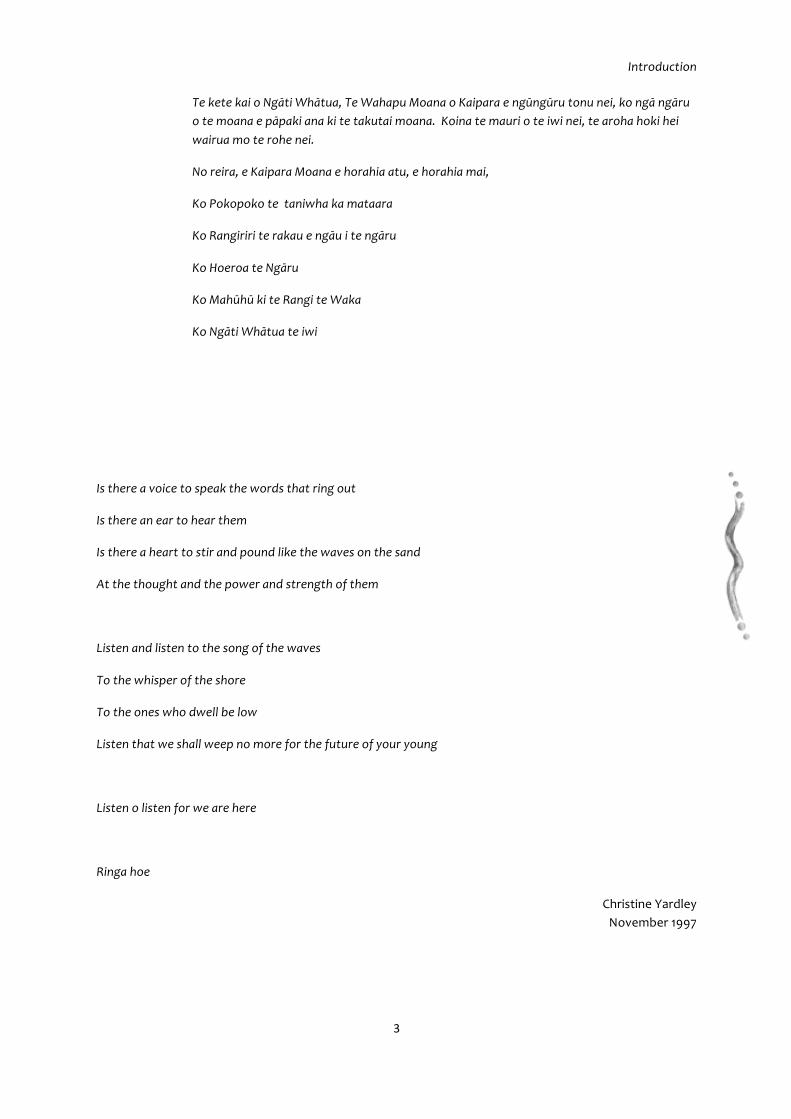
Te kete kai o Ngāti Whātua, Te Wahapu Moana o Kaipara e ngūngūru tonu nei, ko ngā ngāru o te moana e pāpaki ana ki te takutai moana. Koina te mauri o te iwi nei, te aroha hoki hei wairua mo te rohe nei.
No reira, e Kaipara Moana e horahia atu, e horahia mai,
Ko Pokopoko te taniwha ka mataara
Ko Rangiriri te rakau e ngāu i te ngāru
Ko Hoeroa te Ngāru
Ko Mahūhū ki te Rangi te Waka
Ko Ngāti Whātua te iwi
Is there a voice to speak the words that ring out
Is there an ear to hear them
Is there a heart to stir and pound like the waves on the sand
At the thought and the power and strength of them
Listen and listen to the song of the waves
To the whisper of the shore
To the ones who dwell be low
Listen that we shall weep no more for the future of your young
Listen o listen for we are here
Ringa hoe
Christine Yardley November 1997

Introduction
4
1 ACKNOWLEDGEMENTS
Thanks go out to the people, managers, kaitiaki, kaumatua, kuia and users of the Kaipara whom I met and interviewed about the issues and future of the Kaipara. They are: Dr Mark Bellingham (Royal Forest & Bird Society), Clive Monds (ECO), lan Happy (Winstone Aggregates), Suzi Phillips (Royal Forest & Bird Society Kaipara Branch), Dominic McCarthy (ARC), Alison Stilwell (ARC), Kim Morresey (ARC) Cassie Smith (ARC), Craig Pratt (RDC), Max Smitheram (RDC), Shane Kelly (Coast to Catchment Consulting), Venessa Anich (KDC), Jack Mckercher (KDC), Christine, Peter and Dylan Yardley (Kaipara Harbour Sustainable Fisheries Management Study Group), Glen Mortimer (NRC), Ben Lee (NRC), Tim Brandenburg (DoC), Clinton Duffy (DoC), Dan Breen (DoC), Piet Nieuwland (DoC), Richard Fanselow (MFish), Sarah Ombundson (MFish), Celina Garcia (MFish), Dr Chris Phillips (Landcare Research), Willie Wright (Te Uri o Hau), Ross Walker (Te Uri o Hau), Hally Toia (Te Runanga o Ngati Whatua), Deborah Harding (Te Uri o Hau Settlement Trust), Shereen Worthington (Environs Holdings, Te Uri o Hau Settlement Trust), Mihi Watene (Te Uri o Hau), Esther Gray (Te Uri o Hau), Delwyn Hewson (Te Puni Kokiri), Wayne and Tony Walden (Guardians of the Kaipara, Oneriri Station), Jane Sherard (Ngāti Whātua Ngā Rima o Kaipara Trust), Waata Richards (Ngāti Whātua Ngā Rima o Kaipara Trust), Tracy Davis (Ngāti Whātua Ngā Rima o Kaipara Trust), Raewyn Peart (Environmental Defenders Society), Betty Gee (Kauri Museum), Bill Worsfold (Urban Design Consultant), Dicky Hollenberg, Stephen King (Millennium Kauri Trust), Ray Scott (Kaipara Harbour Sustainable Fisheries Management Study Group), Dr Roger Grace, Jan and Wade Doak, Nick Matich (QEII Kaipara), Ngā Kaitikai Tai Ao o Kaipara, Dr Bruce Hartill (NIWA), Dr Mark Morrison (NIWA), Taoho Putawa (NIWA), Greg Smith (South Kaipara Landcare), Dr Terry Hume (NIWA), Dr John Dymond (Landcare Research), Amy Taylor (ARC), Vincent Lane (NRC), Diane Bell (Dargaville Intermediate & Royal Teacher Fellow).
Spatial information: Thanks to Northern Regional Council (Marie Slako, Carol Cottom), Kaipara District Council (Stewart Marwick), Auckland Regional Council GIS Team, Department of Conservation Northland Conservancy (Lorraine Wells, Terry Conaghan), Department of Conservation Auckland Conservancy (Chris Wild), Department of Conservation (Dr Dan Breen, Richard Earle, Dave West), Royal Forest & Bird Society (Dr Mark Bellingham), Auckland University of Technology (Dr Barbara Breen), Crown Forestry Rental Trust, QEII, Rodney District Council (GIS Team), New Zealand Archaeological Association, Ministry of Fisheries (NABIS Team), World Wildlife Fund-New Zealand, GNS Science, Manaaki Whenua Landcare Research and National Institute of Water and Atmospheric Research (NIWA).
Input on draft chapters were provided by Juliane Chetham, Dr Shaun Awatere and, Dr Mark Morrison.
Introduction
5
2 CONTENTS 1 Acknowledgements ........................................................................................................ 4 2 Contents .......................................................................................................................... 5 3 List Of Figures for Chapter 1 to 8 ............................................................................... 10 4 List Of Tables for Chapter 1 to 8 ................................................................................. 10
5 Purpose ......................................................................................................................... 11
5.1 Structure Of The Information Review & Gap Analysis ............................................ 12
6 Common Vision ............................................................................................................ 15
6.1 The IKHMG Tohu .................................................................................................... 22
7 Introduction .................................................................................................................. 23
7.1 The Lands With All Woods And Waters .................................................................. 23 7.2 Ngāti Whatua – Kaitiaki o Te Kaipara ..................................................................... 29
7.2.1 The Journey ......................................................................................................... 30 7.2.2 Relationship of Ngāti Whatua Ki Kaipara To The Sea And The Land ................. 33
7.3 European Settlement .............................................................................................. 35
8 Methodology ................................................................................................................. 39
8.1 Literature Review .................................................................................................... 39 8.2 Datasets .................................................................................................................. 40 8.3 Local, Corporate, & Cultural Knowledge ................................................................. 41 8.4 Outputs & Analysis .................................................................................................. 42
8.4.1 Gap Analysis ....................................................................................................... 42 8.4.2 Outputs ................................................................................................................ 43 8.4.3 Organisation of Chapters For This Report ........................................................... 43
8.5 Bibliography ............................................................................................................ 44
9 Restoring And Protecting Native Biodiversity .......................................................... 47
9.1 Table Of Contents ................................................................................................... 48 9.2 List Of Tables .......................................................................................................... 49 9.3 List Of Figures ......................................................................................................... 50 9.4 Introduction .............................................................................................................. 54 9.5 Mātauranga Māori And Biodiversity ......................................................................... 55
9.5.1 Mātauranga Māori & Kaipara Biodiversity ........................................................ 57 9.5.2 Science & Research ......................................................................................... 59 9.5.3 Kaitiakitanga ..................................................................................................... 60
9.6 Biogeophysical Information ..................................................................................... 61 9.6.1 Catchment – Physical Characteristics .............................................................. 61 9.6.2 Harbour ............................................................................................................. 65 9.6.3 Geodiversity: Geological Features And Soils ................................................... 68 9.6.4 Kaipara Catchment Soils .................................................................................. 84
9.7 Ecosystem Characteristics ...................................................................................... 89

Introduction
6
9.7.2 Summary Of Terrestrial Ecosystem Information ............................................. 124 9.7.3 Freshwater Ecosystems ................................................................................. 126 9.7.4 Dune-Sandfield Ecosystems .......................................................................... 160 9.7.5 Estuarine, Coastal & Marine Ecosystems ...................................................... 174
9.8 Ecological Processes ............................................................................................ 181 9.9 Stressors To Kaipara Ecosystems And Values ..................................................... 188 9.10 Socio−Economic Linkages With Biodiversity ......................................................... 210
9.10.1 Environmental Care Groups ........................................................................... 214 9.11 Gaps & Opportunities To Restore & Protect Native Biodiversity ........................... 217
9.11.1 Priority Gaps & Opportunities ......................................................................... 217 9.11.2 Other Gaps & Opportunities ........................................................................... 221
9.12 Bibliography ........................................................................................................... 225 10 RESTORING SUSTAINABLE USE OF FISH & INVERTEBRATE STOCKS ........... 237 10.1 Table Of Contents ................................................................................................. 238 10.2 List Of Figures ....................................................................................................... 239 10.3 List Of Tables ........................................................................................................ 239 10.4 Introduction ............................................................................................................ 240 10.5 Historical Background On Kaipara Fisheries ......................................................... 241
10.5.1 Development Of Kaipara Fisheries ................................................................. 250 10.6 Current Management Regime ............................................................................... 258 10.7 Mātauranga Māori ................................................................................................. 264
10.7.1 Status Of Information ...................................................................................... 265 10.7.2 Mana Whenua & Mana Moana ....................................................................... 265
10.8 Status Of Information ............................................................................................. 275 10.8.1 Fish & Shellfish ............................................................................................... 275 10.8.2 Socio-Economic Information ........................................................................... 284
10.9 Issues .................................................................................................................... 287 10.9.1 Direct Fishing Impacts .................................................................................... 287 10.9.2 Unhealthy Mauri ............................................................................................. 288 10.9.3 Effects Of Landuse Activites ........................................................................... 289 10.9.4 Climate Change .............................................................................................. 289 10.9.5 Declining Biodiversity ..................................................................................... 290 10.9.6 Lack Of Local Management & Kaitiakitanga ................................................... 292
10.10 Local & Integrated Management Initiatives: Past & Current .................................. 293 10.11 Monitoring .............................................................................................................. 295 10.12 Current & Proposed Research .............................................................................. 296 10.13 Gaps & Opportunities For Restoring Sustainable Use Of Fish & Shellfish ............ 298
10.13.1 Priority Gaps & Opportunities ......................................................................... 298 10.13.2 Other Gaps & Opportunities Identified ............................................................ 302
10.14 Bibliography ........................................................................................................... 309 11 Protecting & Restoring The Mauri Of The Kaipara ............................................... 315 11.1 Table Of Contents ................................................................................................. 316 11.2 List Of Figures ....................................................................................................... 317 11.3 List Of Tables ........................................................................................................ 317 11.4 Introduction ............................................................................................................ 318 11.5 Origins Of Kaipara Māori ....................................................................................... 319 11.6 The Natural World Of Kaipara Māori ..................................................................... 322
11.6.1 A Holistic Concept .......................................................................................... 324 11.6.2 Tino Rangātiratanga ....................................................................................... 324 11.6.3 Whakapapa – Māori Identity ........................................................................... 324 11.6.4 The Erosion Of Property Rights ...................................................................... 325
11.7 Ability To Adequately Practice Kaitiakitanga ......................................................... 330

Introduction
7
11.7.1 Status Of Kaitiaki O Te Kaipara ...................................................................... 333 11.8 Evidence That Describes The Status Of Mauri ..................................................... 334 11.9 Assessment Models For Cultural Health ............................................................... 336
11.9.1 Case Study 1: Cultural Health Index For Streams And Waterways ............... 338 11.9.2 Case Study 2: State Of The Takiwā – Ngāi Tahu ........................................... 339 11.9.3 Case Study 3: Māori Environmental Indicators & Outcomes: Mauri Of
Waterways Kete ............................................................................................. 342 11.9.4 Case Study 4: Stream Health Monitoring & Assessment (SHMAK) Kit
For Māori ........................................................................................................ 346 11.9.5 Case Study 5: Marine Health Index ................................................................ 346 11.9.6 Case Study 6: Iwi Estuarine Monitoring Tool Kit (Nga Waihotanga Iho) ........ 347 11.9.7 Case Study 7: Ngāti Kere Methods & Indicators For Marine Protection ......... 347 11.9.8 Case Study 8: Te Roroa Iwi Cultural Indicators & Monitoring Framework ..... 348
11.10 Conclusions ........................................................................................................... 349 11.11 Gaps & Opportunities To Restore The Mauri ........................................................ 352
11.11.1 Priority Gaps & Opportunities ......................................................................... 353 11.11.2 Other Gaps & Opportunities Identified ............................................................ 357
11.12 Bibliography ........................................................................................................... 358
12 Understanding Climate Change Impacts ............................................................... 361 12.1 Table Of Contents ................................................................................................. 362 12.2 List Of Figures ....................................................................................................... 363 12.3 List Of Tables ........................................................................................................ 363 12.4 Introduction ............................................................................................................ 364 12.5 New Zealand’s Greenhouse Gas Emissions ......................................................... 365 12.6 Climate Change Impacts On New Zealand ........................................................... 367 12.7 Adaptation Measures ............................................................................................. 372
12.7.1 Government Policy To Control Emissions ...................................................... 372 12.7.2 Support Low-Carbon Technology Creation, Use & Education ....................... 378
12.8 Potential Consequences For The World Of Kaipara ............................................. 382 12.9 Current & Proposed Climate Solutions .................................................................. 390
12.9.1 Some Climate Solutions That The New Zealand Government Is Promoting ....................................................................................................... 390
12.9.2 Other Solutions That Organisations And Community Groups Are Promoting ....................................................................................................... 390
12.10 Gaps In Understanding The Impacts Of Climate Change ..................................... 393 12.10.1 Top Priority Gaps & Opportunities .................................................................. 394
12.11 Bibliography ........................................................................................................... 397
13 Understanding Socio-Economic Opportunities .................................................... 399 13.1 Table of Contents .................................................................................................. 400 13.2 List of Tables ......................................................................................................... 401 13.3 List of Figures ........................................................................................................ 401 13.4 Introduction ............................................................................................................ 402 13.5 Historical Setting .................................................................................................... 403 13.6 Status of Current Information ................................................................................ 408
13.6.1 The ‘Rural’ Landscape .................................................................................... 408 13.6.2 Community Profile .......................................................................................... 411 13.6.3 Industry Sector Profile .................................................................................... 425
Introduction
8
13.6.4 Infrastructure .................................................................................................. 432 13.6.5 Research, Development & Innovation ............................................................ 432 13.6.6 Ecosystem Services ....................................................................................... 432
13.7 Sustainable Socio-Economic Opportunities .......................................................... 435 13.8 Gaps & Opportunities To Understand Socio-Economic Opportunities .................. 440
13.8.1 Priority Gaps & Opportunities ......................................................................... 441 13.9 Bibliography ........................................................................................................... 444
14 INTEGRATED & CO-OPERATIVE MANAGEMENT OF KAIPARA ECOSYSTEMS, CATCHMENT AND HARBOUR .............................................................................. 448
14.1 Table Of Contents ................................................................................................. 449 14.2 List Of Figures ....................................................................................................... 450 14.3 List Of Tables ........................................................................................................ 451 14.4 Introduction ............................................................................................................ 452
14.4.1 Issues ............................................................................................................. 452 14.5 Current Statutory Framework ................................................................................ 453
14.5.1 The Rules: Coast And Land ........................................................................... 453 14.5.2 Relationship Between Current Statutory Framework And Integrated, Co-
Management ................................................................................................... 465 14.6 The Role Of Mātauranga Māori And Co-Operative Management ......................... 471
14.6.1 Māori Worldview In Environmental Management Of The Kaipara .................. 471 14.6.2 The Erosion Of Property Rights ...................................................................... 475 14.6.3 Co-Management With Iwi/Hapū ...................................................................... 478
14.7 Biodiversity Management – Easy As We Go, Or Quick Smart? ............................ 480 14.7.1 Identification Of Protected Areas For Biodiversity Persistence ...................... 491
14.8 Sustainable Management ...................................................................................... 498 14.8.1 Fisheries ......................................................................................................... 498 14.8.2 Resource Use & Development ....................................................................... 499 14.8.3 Water Quality & Sedimentation ...................................................................... 501
14.9 Current & Proposed Initiatives ............................................................................... 506 14.10 Gaps & Opportunities For Integrated Co-Management Of Kaipara Harbour,
Catchment & Ecosystems ..................................................................................... 510 14.10.1 Top Priority Gaps & Opportunities .................................................................. 511 14.10.2 Other Gaps & Opportunities Identified ............................................................ 515
14.11 Bibliography ........................................................................................................... 517
15 Discussion ................................................................................................................ 521
16 Appendix ............................................................................................................. 525 16.1 Table Of Contents ................................................................................................. 526 16.2 Appendix 1. Land Environment New Zealand (LENZ) Level 1 & Level 2
Characteristics For Ecological Districts Found In The Kaipara Catchment ........... 527 16.3 Appendix 2. Criteria For Assessing Habitat Significance For The Protected
Natural Area Program. ........................................................................................... 532 16.4 Appendix 3. Soil Types Represented In Protected Areas Of The Kaipara
Catchment ............................................................................................................. 534

Introduction
9
16.5 Appendix 4. List Of Flora & Fauna Species From Kaipara Catchment ................ 539 16.6 Appendix 5. Customary Management Tools Provided For Under New Zealand
Fisheries Legislation .............................................................................................. 569 16.7 Appendix 6. Management/Governance Structures In Place For Kaipara
Iwi/Hapū ................................................................................................................. 570 16.8 Appendix 7. Emission Trading Scheme Bill Risk Assessment .............................. 572 16.9 Appendix 8. Summary Of Biodiversity Objectives Stated In Current Legislation,
Policy Tools And Mechanisms. .............................................................................. 574 16.10 Appendix 9. Resource Management Act (1991) Provisions For Maori ................. 584 16.11 Appendix 10. Legislation Recognising Kaitiakitanga ............................................ 586
17. Glossary ................................................................................................................ 588

Introduction
10
3 LIST OF FIGURES FOR CHAPTER 1 TO 8
Figure 1. Kaipara harbour and catchment. ........................................................................... 13
Figure 2. Approach to management of the Kaipara Harbour. .............................................. 17
Figure 3. Interactions between elements of the Integrated Kaipara Management Project is crucial to the success of the study. ........................................................................................ 21
Figure 4. Modeled potential vegetation at 500AD for the Kaipara catchment (Source: Crown Forestry Rental Trust). ........................................................................................................... 28
Figure 5. The major Kaipara hapū rohe and location of significant battle sites prior to 1840. (Source: Waitangi Tribunal 2006). ......................................................................................... 29
Figure 6. Graph of the number of ships cleared at Port Kaipara. (Source: Ryburn 1999) ... 37
4 LIST OF TABLES FOR CHAPTER 1 TO 8
Table 1. Comparison between traditional/current resource management and ecosystem management. (Adapted from Cortner & Moote 1999 to describe the ‘paradigm shift’). ........ 17
Table 2. A staged approach has been adopted for the project, with each stage having a different focus and a set of objectives. .................................................................................. 20
Table 3. Comparison of the size and area of various New Zealand harbour’s with the Kaipara. (Source: Heath (1976), Hicks & Hume 1996, Hay & Grant (2004)). ....................... 24
Table 4. Format of the metadata recorded in the database. ................................................ 40

Introduction
11
5 PURPOSE
The purpose of this information review and gap analysis is to outline gaps in biogeophysical, Mātauranga Māori (traditional Māori knowledge), and socio-economic knowledge-bases, which will assist with achieving the vision, principles and long-term objectives of the Integrated Kaipara Harbour Management Project (IKHMP). The long-term objectives are used to confine the scope of this report. They are broad but have been identified by the Integrated Kaipara Harbour Management Group (IKHMG) as vital to achieving the vision of a healthy and productive Kaipara harbour, and are based around the eight key issues affecting the health and productivity of the Kaipara, which are:
Eight key issues for the Kaipara Harbour
• Declining fish stocks
• Declining biodiversity
• Increasing sedimentation and declining water quality
• Increasing resource use and development pressure
• Limited socio-economic opportunities
• Limited opportunities to practice kaitiakitanga
• Climate change impacts
• Lack of integrated management and coordination of action
Based on these issues, the following key management objectives have been identified:
1. Protecting and restoring native biodiversity
2. Restoring sustainable use of fish and invertebrate stocks
3. Protecting and restoring Mauri of the Kaipara
4. Responding to climate change impacts
5. Promoting socio-economic opportunities
6. Integrated and co-management of the Kaipara ecosystems, catchment and harbour.
This report describes and integrates information and knowledge that currently exists on the Kaipara Harbour and the issues that it faces: including sources directly relating to the Kaipara; and where relevant, wider New Zealand and international sources which provide content currently missing for the Kaipara Harbour. This is a comprehensive and weighty report due to the integrated holistic nature of the analysis across three knowledge bases –

Introduction
12
biogeophysical, Mātauranga Māori and socio-economic. A strong focus has also been directed at undertaking a gap analysis. A gap is sometimes spoken of as "the space between where we are and where we want to be". This report aims to explicitly identify what needs to be done to close that gap, including targeted research and management initiatives.
Key Actions of this report are to:
1. Scope and document the extent of all three knowledge bases.
2. Analyse gaps in knowledge, and implications of these gaps, on the ability to effectively achieve Objectives 1–6 above.
3. Make recommendations for the short- and long-term, regarding priority gaps and approaches to fill gaps.
5.1 STRUCTURE OF THE INFORMATION REVIEW & GAP ANALYSIS
The World of Kaipara, or the area of interest for this analysis, is regarded as the Harbour, coast, estuaries, ecosystems, rivers, tributaries, and catchment (Figure 1). This also includes indigenous and non-indigenous fauna and flora residing within the ecosystems of the harbour and catchment. To a lesser extent, the report does make note of externalities operating outside the World of Kaipara, such as: developments and uses occurring outside the harbour entrance (e.g. trawling, offshore mining); and large-scale biological and physical processes (e.g. wave movement, migratory corridors, spawning pathways).

Introduction
13
Figure 1. Kaipara harbour and catchment.

Introduction
14
Chapters’ five to ten address the six key objectives derived from the eight broad issues affecting the health and productivity of the Kaipara.
Chapter 9 Biodiversity establishes and describes the natural phenomenon that is the Kaipara. The Chapter describes existing knowledge on the three types of biodiversity – ecosystem, species and genetic biodiversity. The Chapter also highlights the physical and geological processes that drive and create Kaipara biodiversity. The Chapter concludes with the identification of knowledge gaps, which, if addressed, would assist to achieve the long-term objective of restoring and protecting the indigenous biodiversity of the Kaipara.
Chapter 10 Fisheries builds on Chapter 5 (biodiversity), and focuses on fisheries. Existing knowledge of the fisheries of the Harbour and adjacent coastal beaches is reviewed. This includes commercial and recreational fishing activities, as well as customary fisheries. The Chapter concludes with the identification of knowledge gaps that would assist with achieving the longterm objective of sustainable fisheries.
Chapter 11 Mauri scopes and reviews the status of mauri of the Kaipara Harbour. The Chapter explores Māori cosmology, and begins to explain the Māori worldview of the Kaipara Harbour.
Chapter 12 Climate change reviews information regarding the global climate change issue, and New Zealand’s response and the consequences of climate change in the Kaipara Harbour.
Chapter 13 Socio-economic reviews the socio-economic issues for the Kaipara Harbour and discusses the status of communities within the Kaipara catchment. The Chapter reviews socio-economic trends, compares the well-being of Māori and non-Māori populations and identifies sustainable development opportunities that exist. The Chapter concludes with identifying what gaps require further investigation to achieve the long-term objective of understanding and responding to environmental socio-economic opportunities.
Chapter 14 Co-operative Integrated Management reviews current modern and traditional management methods operating in the world of Kaipara. The Chapter provides background on the current legislative and policy mechanisms used to manage the Kaipara environment. Reviewing all knowledge-bases – biogeophysical, Mātauranga Māori, socio-economic – the Chapter concludes with an analysis of gaps that require further investigation and could provide opportunities to achieve the long-term objective of integrated management of the Kaipara Harbour.
Chapter 15 Summary Discussion is a concluding summary of the information and gaps identified in the six chapters to effectively address the vision, principles and long-term objectives of the IKHM project.
Introduction
15
6 COMMON VISION
Ngā Kaitiaki Tai Ao o Kaipara, the joint roopu between hapū, marae o Ngāti Whatua, Te Uri o Hau and Ngāti Whatua Ngā Rima o Kaipara, have a vision:
‘Ka mau tonu nga taonga tapu o nga matua tupuna Koinei nga taonga i tuku iko, na te Atua’
‘Hold fast to the treasures of the ancestors for they are the treasures that have been handed down to us by God’
The Kaipara is a sacred taonga and Kaitiaki are responsible for protecting it for the benefit of all people. Their vision is focused on ‘the realisation of rights as Te Uri o Hau’ and Ngāti Whatua Ngā Rima o Kaipara and ‘a natural environment that is rich in diversity and life-supporting capacity’.
The role of Ngā Kaitiaki Tai Ao o Kaipara is to provide leadership to coordinate the various resource management agencies and stakeholders in working towards a united vision for the management of the Kaipara catchment and Harbour. This assists them in meeting their responsibilities under the Te Uri o Hau (Treaty of Waitangi) Settlement Act 2002 and is consistent with a number of Memoranda of Understanding and Protocols established between tangata whenua and key stakeholders.
The Integrated Kaipara Harbour Management Project was initiated in 2005. Te Uri o Hau/Ngāti Whatua, with the assistance of Landcare Research and a Foundation for Research Science & Technology seeding grant, organised two hui with stakeholders of the Kaipara. Outcomes from the hui were encapsulated in the following four areas of agreement.
a) The Harbour is in environmental decline.
b) The shared vision is for the creation of “A healthy and productive Harbour”.
c) The vehicle for achieving this vision is a Sustainable Kaipara Catchment Plan.
d) An Integrated Kaipara Harbour Management Group (IKHMG) was formed to undertake a six month program, appoint a Project Coordinator and oversee research and co-ordination with the aim of scoping an agreed approach to achieve a Sustainable Kaipara Catchment Plan. The first report back to the wider group was in March 2006 and a second in June 2007.
Features of the project include:
o Multiple territorial authority partners: two local councils, two regional councils, four government departments, four iwi/hapū;
o No single issue: many kaupapa, including fisheries, biodiversity, kaitiakitanga, co-operative management, sedimentation and water quality, resource use and development, socio-economic opportunities and climate change;
o Integrated, holistic and catchment scale: assessment of information and gap analysis, which will form the basis for a sustainable catchment management plan. The integrated

Introduction
16
and holistic nature of the project began with an assessment of Mātauranga Māori (Māori Knowledge), biogeophysical, and socio-economic information.
o Integrated Kaipara Harbour Management Group (IKHMG)1 providing support and simultaneous development of projects.
Holistic, Integrated Catchment Scale
This review and analysis was conducted over a large geographic scale that transcended a number of boundaries including: local/regional council and iwi/hapū. The review and analysis incorporated the Kaipara Harbour or estuary, the adjacent coastal and marine environment, and catchment ecosystems. The catchment scale was necessary for an effective linking of natural processes and development of consistent management strategies. Utilising a catchment scale provides an appropriate framework for scientific investigations, research synergies and a move towards an ecosystem-based approach to management.
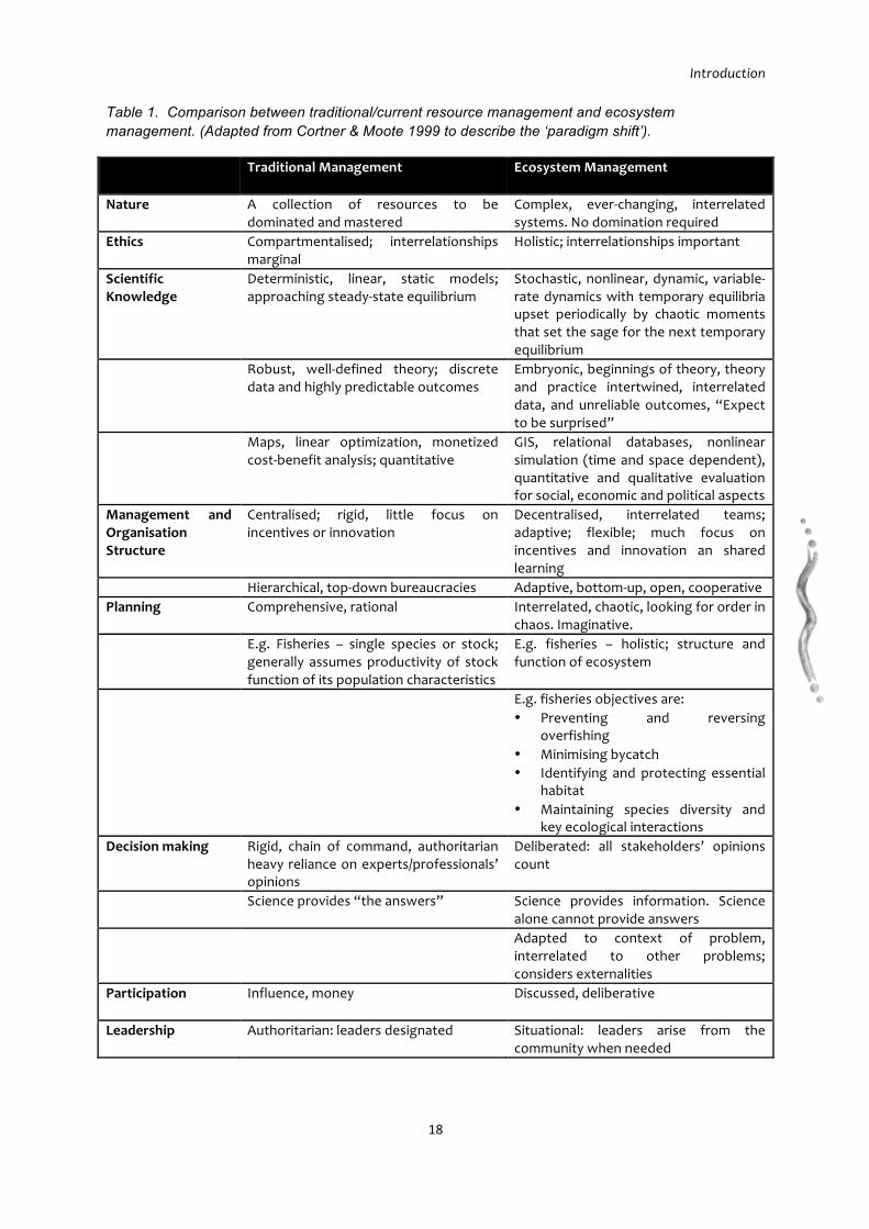
This approach was taken because the key objective is to manage human interactions with ecosystems and all associated organisms, rather than just individual species. As the term ecosystem-based management shows, it is management based on the properties of the relevant ecosystem(s), rather than a single species (Table 1) (Christensen et al. 1996, Ward et al. 2002, McLeod et al. 2005). This approach is consistent with kaitiakitanga. Figure 2 shows where the IKHM Project combines two approaches to management of the Kaipara; one indigenous and the other derived from western knowledge.
1 IKHMG collaborators are: Rodney District Council, Kaipara District Council, Northland Regional Council, Department of Conservation, Royal Forest & Bird Society, Kaipara Harbour Sustainable Fisheries Group, Auckland Regional Council, Ministry of Fisheries, National Institute of Water and Atmospheric Research (NIWA), Te Puni Kokiri and Manaaki Whenua Landcare Research.

Introduction
17
Figure 2. Approaches to management of the Kaipara Harbour.
Mātauranga Māori acknowledges a natural order to the universe, built around the living and non-living, and the central belief is that all parts of the environment, be they physical or meta-physical entities, are interrelated or interdependent.
Māori ontology (a branch of philosophy concerned with the nature and relations of being) recognises small shifts in the mauri (life force) of any part of the environment, for example through use or misuse, would cause shifts in the mauri of immediately related components, which could eventually affect the whole system. The management of this complex system of mauri is carried out by kaitiaki. Most activities within the natural environment carried out by iwi/hapū are guided by the philosophy of kaitiakitanga (Kawharu 2000).
The philosophy of kaitiakitanga aims to regulate and sustain the well-being of people, communities and natural resources. Kaitiaki and kaitiakitanga cannot be understood without reference to the values inherent in the belief system including for example: tapu, mauri, rahui, mana, noa and wairua (Minhinnick 1989, Crengle 1993).
As leaders of this project, Ngā Kaitiaki Tai Ao o Kaipara stress the importance of utilising Mātauranga Māori, especially tikanga rooted in the philosophy of kaitiakitanga, in the management of the Kaipara. This approach challenges their Treaty partners to think beyond processes that merely co-opt Mātauranga Māori into current planning processes. Together iwi/hapū and local/regional government are entering new territory, in making a genuine effort to develop a process/management framework that explores the interface between Mātauranga Māori and western knowledge.
Kaitiakitanga
“Nature & people inseparable”
Eco-‐system based management
“Holistic integrated management”
IKHM project
Introduction
18
Table 1. Comparison between traditional/current resource management and ecosystem management. (Adapted from Cortner & Moote 1999 to describe the ‘paradigm shift’).
Traditional Management Ecosystem Management
Nature A collection of resources to be dominated and mastered
Complex, ever-‐changing, interrelated systems. No domination required
Ethics Compartmentalised; interrelationships marginal
Holistic; interrelationships important
Scientific Knowledge
Deterministic, linear, static models; approaching steady-‐state equilibrium
Stochastic, nonlinear, dynamic, variable-‐rate dynamics with temporary equilibria upset periodically by chaotic moments that set the sage for the next temporary equilibrium
Robust, well-‐defined theory; discrete data and highly predictable outcomes
Embryonic, beginnings of theory, theory and practice intertwined, interrelated data, and unreliable outcomes, “Expect to be surprised”
Maps, linear optimization, monetized cost-‐benefit analysis; quantitative
GIS, relational databases, nonlinear simulation (time and space dependent), quantitative and qualitative evaluation for social, economic and political aspects
Management and Organisation Structure
Centralised; rigid, little focus on incentives or innovation
Decentralised, interrelated teams; adaptive; flexible; much focus on incentives and innovation an shared learning
Hierarchical, top-‐down bureaucracies Adaptive, bottom-‐up, open, cooperative Planning Comprehensive, rational Interrelated, chaotic, looking for order in
chaos. Imaginative. E.g. Fisheries – single species or stock;
generally assumes productivity of stock function of its population characteristics
E.g. fisheries – holistic; structure and function of ecosystem
E.g. fisheries objectives are: • Preventing and reversing
overfishing • Minimising bycatch • Identifying and protecting essential
habitat • Maintaining species diversity and
key ecological interactions Decision making Rigid, chain of command, authoritarian
heavy reliance on experts/professionals’ opinions
Deliberated: all stakeholders’ opinions count
Science provides “the answers” Science provides information. Science alone cannot provide answers
Adapted to context of problem, interrelated to other problems; considers externalities
Participation Influence, money Discussed, deliberative
Leadership Authoritarian: leaders designated Situational: leaders arise from the community when needed

Introduction
19
Staged Approach A simultaneous and staged approach has been taken with the project (Table 2, Figure 3). Each stage has had a different scope and set of objectives. Stage 1 focused on background studies, information review and gap analysis, scoping of scientific research tasks. Stage 1 outputs included a literature database, GIS database, and an information review and gap analysis report. Stakeholder feedback and participation has been sought simultaneously during production and also at hui or workshop situations.
Stage 2 is designed to focus on pilot research and community projects on the rivers and catchment with emphasis on non-point source pollution remedies. Thus, the non-point pollution sources of sediments, nutrients and other pollutants will be investigated and remedies set in action. This stage will concentrate on the development of a management plan for the Kaipara and development of a freshwater monitoring program. Project and research results will be evaluated, and if required, re-assessed.
Stage 3 will focus on the estuarine and coastal ecosystems of the Kaipara and implement any research or management action addressed in the gap analysis.
Overlap may occur between stages if new information or community requirements arise.

Introduction
20
Table 2. A staged approach has been adopted for the project, with each stage having a different focus and a set of objectives.
2005-‐2009
2009-‐2012 2012-‐2015
Stage one Stage two Stage three
Science & Understanding
Information Review & Gap Analysis
Rivers & catchment focus Restoration Wananga Pilot Studies Design of freshwater monitoring program Non-‐Point source
Marine & estuaries Ongoing research Ongoing freshwater monitoring Design of estuarine & marine monitoring program Point source
Management – iwi/hapū, territorial authorities & government
IKHMG formation & Terms of Reference
Information Review & Gap Analysis Shared vision, principles, long term objectives & Long-‐term Action Plan
Management Plan Draft to Final Communications Strategy
Management Plan Implementation
Community & Stakeholder Partnerships
Wider stakeholder Report Back Hui
IKHMG Web portal development
Wider stakeholder Report Back Hui Wananga Web-‐based Kaipara Atlas developed Partnerships Scoped
Wider stakeholder Report Back Hui Wananga

Introduction
21
Figure 3. Interactions between elements of the Integrated Kaipara Management Project is crucial to the success of the study.
What is a conceptual model?
Conceptual models depict the major environmental features and the community-based environmental features. Conceptual models attempt to encapsulate the most current understanding of a particular ecosystem or location.
As more information is obtained and interpreted, and community-derived environmental values are refined and changed, the conceptual model evolves to encapsulate this new understanding and perspective.
Conceptual models can be used to:
o Communicate the key inputs and processes, impacts and biotic features
o Prioritise future strategy, research and monitoring efforts, and
o Synthesise divergent results into a single depiction.
Community & Stakeholder Partnerships
Scientific Studies & Evaluation
Integrated, Ecosystem-‐based
Kaipara Management Plan
Introduction
22
6.1 THE IKHMG TOHU
The IKHMG tohu or symbol was designed to represent a "taura" (rope) tying all the rivers and streams together as they run into the Kaipara Harbour. The metaphor also extends to the relationships between people and their environment, for example, the ties that bind people and communities together, and people and communities to their environment. The tohu of the rope was considered too represent the "integrated" aspect of catchment management the group is focusing on, along with the various strands of well-being interwoven together (eg. cultural, spiritual, social, and economic).

Introduction
23
7 INTRODUCTION
When we landed we saw the high sandhills on the western shore of New Zealand, the apparent distance eighteen to twenty miles…
Samuel Marsden, 1820, describes the sand dunes as he ventures towards the Kaipara (Elder 1932).
The banks of the Wairoa….are covered with a thick forest of timber-trees of all descriptions, but especially the kauri-pine, which is always in the greatest profusion in hilly situations. I am not acquainted with any place in New Zealand where these trees are more plentiful, of greater height and diameter, and of easier access….
Dieffenbach (1843) describes the Kauri along the Wairoa River.
Was covered with what is termed light bush….Two or three miles back from the river…the heavy bush begins. This is the primeval forest: endless miles of enormous timber trees, girthing ten feet, twenty feet, thirty feet, forty feet, and even more, and of startling height…The timber is slowly encroached upon to feed the sawmills.
Hay (1882), his property eastern Te Pahi River.
The following sections provide an historical overview and paint a picture of the natural world of the Kaipara, pre-human and post-human settlement; Ngāti Whatua relationship with the natural world, and post-European activities that have come and gone over time. This chapter begins the portrayal of the social, cultural and biogeophysical complexity of the Kaipara. The physical complexity is basically that imposed by the huge expanse of the harbour, which has resulted in complex governance structures where the Kaipara is bisected by land management agency boundaries both on land and sea. The intention is to provide a context for the more detailed discussion in the later chapters of this report.
7.1 THE LANDS WITH ALL WOODS AND WATERS
Long before human settlement, the Kaipara was a mosaic of landscapes and seascapes which included: the sand dune and foreshore areas of the west coast; the small lakes found in the sand dunes; manuka and fern shrublands; high, densely forested country; riverine and estuarine swamp forests abounding in kahikatea as well as flax and raupo; and the intertidal flats, supported by mangroves and salt marshes of the protected harbour (Murton unpublished). In many places it was incredibly “patchy” landscape, a landscape in which there were many “edges”, boundaries between different ecosystems, among the richest of which were those along rivers, around estuaries, dune lakes, lagoons and inlets.
The tributary rivers – Wairoa to the north; Arapaoa, Ōtamatea, Ōruawharo, Hoteo and Tauhoa to the east; Makarau, Kaukapakapa and Kaipara to the south, and many smaller streams – all flow into one extensive estuary, which has only one sand-clogged outlet. The prominent features of the Kaipara include the two massive sand dune peninsula systems to the west, known as the North and South Heads – that enclose the harbour. Along the coast of the Tasman Sea, the sands are loose, and drifting, but to the east they become older, more compacted, and fertile. They are home to extensive areas of sandflats, dunes, impounded wetlands and dune lakes.
Introduction
24
“Nga-Uruora The Groves of Life” (Park 1995) describes this type of ecosystem as New Zealand’s “crucial life support system”. Park (1995) argues that estuaries created the conditions of light, water temperature, nutrients, spawning grounds, stable stream beds, and protective cover that sustained freshwater fish as they migrated from the sea into the upper reaches of streams. Swamps supported cabbage trees, flax and eels, and was dominated by kahikatea, the fruit basket of the forest; mature trees supplied berries for birds, Kiore, reptiles and humans. Inanga in vast numbers, short fin eels, and giant kokopu migrated into these areas. The great fisheries harvests were derived from the vast area of lowland swamp forest. Kahikatea, matai, maire tawake, hinau, porokaiwhiri, totara, rimu and puriri provided a year round supply of berries for pigeons (kereru) and parrots (kaka, kakariki). These lowland forests supported extensive bird populations during winter where they fed and remained to rest through winter. Forest floors were rich in insects and invertebrates providing an endless food basket for birds, reptiles and fish. This same richness was utilised in the successful agriculture of the area.
The Kaipara Harbour is believed to be the second largest Harbour in the world (Haggitt et al. 2008) and the largest in New Zealand (Table 3). Its estuarine system is a massive 94,700 ha, 43% of which is exposed at low tide; 900 kilometres of shoreline with an enormous catchment area of 641,600 ha. The Harbour mouth is approximately 8km across at its widest.
Table 3. Comparison of the size and area of various New Zealand harbour’s with the Kaipara. (Source: Heath (1976), Hicks & Hume 1996, Hay & Grant (2004)).
Harbour Harbour Type Harbour Area (km2)
Catchment Area (km2)
Manukau Drowned Valley 357 897
Hokianga Drowned valley 115 1589
Kaipara Drowned Valley 947 6400
Rangaunu Drowned valley 98 550
Raglan Drowned valley 36.2 523
Kawhia Drowned valley 66 487
Whangarei Drowned valley 87 325
Parengarenga Drowned valley 63 201
The Kaipara catchment is an old river system that was drowned by rising sea levels over 10,000 years ago, leaving only tops of the ridges visible. Is it believed that considerable changes took place in the tidal flows; climatic change and fluctuating sea levels have made the northern and southern peninsulas of the Kaipara Harbour extremely dynamic, geomorphological environments over the past two million years and especially over the last 18,000 years. Cameron et al. (1997) describe the Kaipara sand dune formation where they were once dune lakes and swamps, and old growth forests over the well-established older dunes. Both peninsulas consist of older former dunes, which have been overlapped by latter dune advances. Each set of dunes was subsequently partly buried by later dune advances, which killed and buried the forests, which contained large amounts of kauri.

Introduction
25
Stallworthy (1916) describes the situation:
…buried in the soil, often to the depth of several feet are great kauri trees. Many of these trees were in such a state of soundness that they have been used for buildings and fences. Around many of them charcoal and other traces of fire are found, showing that fire had something to do with the destruction of the forests. But, in other instances, the tree trunks are so perfect, the leaves even being found about them, that they cannot be said that fire was the means by which the giants were laid low….
Stallworthy (1916) continues to speculate on how the forests were felled:
It is possible that earthquakes may have had something to do with the leveling of the forests, also that heavy rainfalls may have been instrumental in placing the great trunks where they are now found. Most of the buried trees are discovered on the strip of land lying between the coast and the river, and over most of this area large deposits of kauri gum, which must have been produced by forests of these trees, are also found. The gum has been found in large quantities, scattered over nearly the whole of this peninsula, which proves that the forest of kauri must at one time covered the same area. Even the stumps of the trees have now disappeared from the surface, and it is stated by men who have lived in the district for over half a century, that kauri stumps will not decay by ordinary processes of wear for one or two centuries.
Historically, the Kaipara, like most of New Zealand, has observed and experienced physical changes since the breaking up of continental Gondwanaland (80 to 60mya). Due to New Zealand’s isolation, it has preserved a variety of ancient forms of life, and has permitted the evolution of numerous others, which are endemic. Fossil evidence suggests that there have been successive periods of forest establishment and disappearance. Kauri gum fossils have been retrieved dating back 43 million years ago. Northlands land mass was much greater than today, with land extending further west, and east beyond the islands. During at least the early Pliocene (~7mya) the Manukau harbour was a “strait”, separating Northland from the rest of the North Island.
Reports of early settlers, explorers, naturalists, and missionaries (Dieffenbach 1843, Colenso 1844, Hay 1882, Elder 1932, Polack 1974, Jackson 1997, Byrne 2002) give many examples of the vastness and denseness of the forest and wetland ecosystems on their arrival to the Kaipara. As William Hay (1882) explains the Kaipara:
“…no one walks to his township, or rides to see a neighbour, he jumps into this boat and rows or sails wherever he wants to go….Mile after mile it is the same, the dense evergreen forest stretching away over the ranges as far as one can see….the real primeval [two or three thousand years old] forest….One great feature of the Kaipara tidal estuary is the quantity of mangroves. Immense tracts are covered with water at high tide, and are left bare at low tide….mud banks are covered with mangroves in many places, forming great stretches of uniform thicket. The mangrove is here a tree growing to a height of twenty or thirty feet….bearing a dark, luxuriant foliage.”
Hay (1882) continues to describe the Kaipara:
“It seems absurd to call this bush, what we see the most, “light”. But we can see that it is so by comparison with the primeval forest, where the tree trunks run from ten to forty feet in girth.”

Introduction
26
Polack in the early 1830s very aptly described the large areas of swamp forests of the Kaihu valley. He notes “high jungles of flax bushes” bordered by forests, plains covered with ferns, another flax filled swamp, followed by another plain “on which the flax leaves were so high as to render it almost impenetrable”. Travelling down the Kaihu, Polack notes that “the banks on either side presented solely flax bushes, whose tall waving leaves rose to the height of 12ft”. He also describes the Mangakahia valley as “furnished with flax”.
But the largest of these flood plain ecosystems was the Tokatoka swamp which covered nearly 40, 000 acres across the Ruawai plains to Te Kowhai. This swamp contained large areas of raupo and flax, and extensive stands of Kahikatea forest of which 4,500 acres of the best was “excluded from drainage operations so that it could be logged”. Such forest systems yielded to Māori a sustained harvest of berries and birds, timber, cordage, matting, clothing, materials for house building, weapons, utensils, canoe construction, medicines, cosmetics and torches (Park 1995).
Kahikatea swamps were found on both sides of the Wairoa river sweeping up from the swamp at Tatarariki around through Aratapu and Aoroa to the lower reaches of the Awakino river and the Hoanga flats and Manganui River (Figure 4). As were the Turiwiri Flats on the Horehore block.
Kauri forests were the most extensive along all the tributaries of the Kaipara, especially the Otamatea and up through the hills behind Maungaturoto and Matakohe. Only one to two pockets (approx. 2 acres) of this most spectacular tree exist in this area today (e.g. Kauri Bushmans Reserve).
Today the catchment extends north far along the Wairoa River into the Wairua River and Mangakahia River, up eastwards into the Hikurangi Swamp, located north of Whangarei, finally resting at the toe of the Russell Forest, Kaiikanui Forest, Papanui-Umuwhawha Forest, Hansens Hill Forest (Whangaruru ecological district). The catchment includes the Tutamoe Ranges in the North and the once Kahikatea and flax forest dominated Kaihu River valley. In the east, the catchment extends 48km along the Hoteo River which stretches the catchment just short of the east coast by 20km. In the south, the Kaipara River extends the catchment across low lying swamp plains to the northern toe of the Waitakere Ranges, near the township of Taupaki. These tributary rivers provided the main access routes and portages throughout the Kaipara Harbour and ecosystems (Waitangi Tribunal 2006).
The Kaipara has national and international ecological significance. It is an internationally significant place for birds with tens of thousands of migratory birds coming from as far as Siberia and Alaska to feed in the harbour each year. Beautiful and rare coastal plants and plant communities grow around the Kaipara Harbour. It is also significant for its commercial, recreational and customary fisheries, as a nursery ground for a number of large shark species (Great white, Bronze whaler), and for the presence of dolphins, particularly the critically endangered Maui dolphin.
The mosaic of landscapes and seascapes of the Kaipara was home to an abundance of fish and shellfish and the many streams and swamps provided eel and wild fowl (Waitangi Tribunal 2006). The Kaipara was fittingly named after such abundance and richness, Kai (food) and Para (an edible fern). More birds and plant foods were to be found in the forests, and pockets of well-drained fertile flats could be cultivated (kumara grew particularly well in

Introduction
27
the Red Hill sandy loam soils and humid, temperate climate). The substantial areas of friable sandy loam soils that were found across the old dune systems on both south and north Kaipara peninsulas were well suited for traditional Māori kumara cultivation. Based on recorded distribution of archaeological sites including storage pits, these areas of sandy soils were intensively occupied and cultivated (Irwin 1985, Spring-Rice 1996). In contrast, the distribution of archaeological sites on the eastern side of the Kaipara is much more narrowly concentrated along the coastline and navigable tributaries.
The natural resources of the Kaipara were sufficient to support very large numbers of Māori inhabitants – Ngāti Whatua. The number of recorded pa sites indicates that the district was long occupied and frequently fought over. Not all Pa were occupied, but the many sites around the harbour on cliff tops and ridges indicate extensive settlement in past centuries.

Introduction
28
Figure 4. Modeled potential vegetation at 500AD for the Kaipara catchment (Source: Crown Forestry Rental Trust).

Introduction
29
7.2 NGĀTI WHATUA – KAITIAKI O TE KAIPARA
Numerous but were nearly exterminated in a war at Te Ika Ranginui.
Hay (1882)
The iwi of Ngāti Whatua claim a long traditional relationship with the Kaipara Harbour and the many catchments of the rivers that enter the Kaipara. Ngāti Whatua has held mana over both land and water taonga through numerous generations of occupation following their conquest of Ngāti Awa.
The hapū of Ngāti Whatua identify themselves through whakapapa, bloodlines, and tikanga particular to Ngāti Whatua, such as certain aspects of marae protocol, which differ from that of other iwi. As an iwi, Ngāti Whatua is made up of hapū, and then whānau. The hapū of Ngāti Whatua are defined by a founding ancestor, and are made up by the descendants of that tupuna. The main tupuna for the iwi are Haumoewaarangi and Waihekeao.
Waihekeao, Haumoewaarangi’s second wife, was the daughter of Tutaki, the notable Ngāti Whatua chief. Haumoewaarangi, born around 1620, a great warrior and chief of Ngāti Whatua, married Waihekeao and lived in the northern parts of the Kaipara.
The major hapū of the Kaipara Harbour and its catchment are Te Roroa (the tall ones) which have occupied the hinterland and rich valleys between the Kaipara and Hokianga harbours, particularly the Kaihu valley, Waipoua, Tunatahi (Dargaville) and Maunganui Bluff areas of the catchment (Figure 5). On the northern side of the Kaipara harbour and Pouto peninsula was Te Uri o Hau. The southern Kaipara is made of several hapū namely Ngāti Whatua Tuturu, Te Taou and Ngāti Rongo whom extend
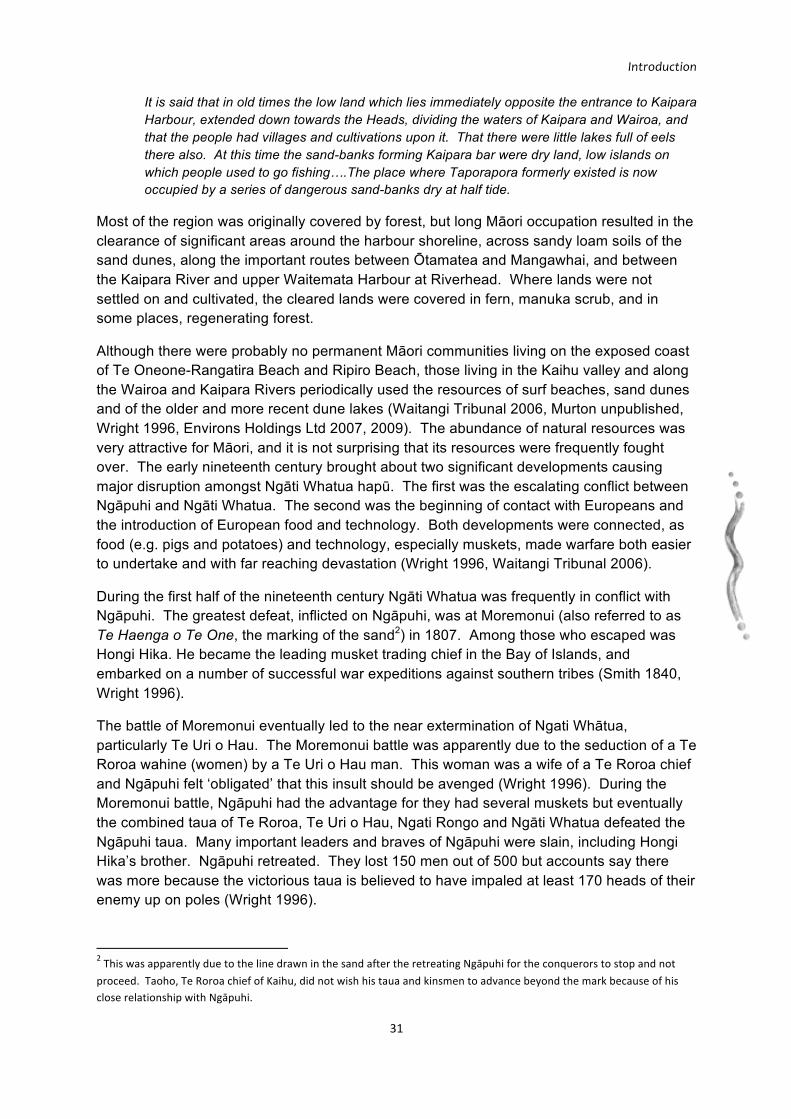
Figure 5. The major Kaipara hapū rohe and location of significant battle sites prior to 1840. (Source: Waitangi Tribunal 2006).
Introduction
30
their tribal area to Taupaki. The area roughly between Whāngārei and Dargaville was a borderland, a zone of conflict, between the broad tribes of Ngāpuhi and Ngāti Whatua. There are strong connections between the Ngāti Whatua of the Kaipara and the Ngāti Whatua of Tamaki makaru rau, which were well established in the nineteenth century and have continued since.
Almost all the written accounts of the Kaipara are European. There is a paucity of Māori descriptions of the environment within the written historical record. The primary purpose of the following exploration is to not argue historical grievances and the fate of the Kaitiaki o Te Kaipara and their whenua, but to only provide a picture of the extensive past of Ngāti Whatua and their relationship with the Kaipara. This is also not trying to write a tribal history of Ngāti Whatua and its hapū. Ngāti Whatua in this report, will be used to refer collectively to several hapū of the Kaipara, principally, Te Roroa, Te Uri o Hau, southern hapū Ngati Whatua Tuturu, Te Taou, and Ngāti Rongo.
7.2.1 THE JOURNEY
Based on whakapapa, it appears that the first arrival of humans to Aōteoroa was made in 925 A.D. and these people gradually made their way North. In 1150 A.D., the Toi arrived and landed in Taranaki. These people made their way over to the Kaipara and settled on an island just inside the Kaipara entrance. They lived there undisturbed for five generations (Bradley 1982). Around the early 1300s the Mahuhu canoe arrived possibly from the northwest Pacific and entered the Kaipara then left to Doubtless Bay (Graham 1939). Graham (1939) recorded in 1887 to 1889 at North Kaipara Heads that the Mahuhu travelled down the West Coast past Ripiro Beach, to the Kaipara Harbour. Graham (1939) recorded:
“Taporapora, an island which then existed inside the Kaipara Heads, where Rongomai himself finished his voyage.”
As time passed others arrived and named the island Taporapora. Rongomai settled here with “the descendants of Toi, Toko-o-te-rangi, son of Te Kauea” who had (before the arrival of the Mahuhu) come from the Whakatane region on a war invasion through the Waikato, Tamaki and the Kaipara and into Muriwhenua. Toko-o-te-rangi is believed to have settled at Taporapora with an Ngāti Awa chieftainess and it was from these people that Rongomai took his wife and they settled in the area of Manukapua and Ōkahukura (Wright 1996). A large temple (whare) was believed to be built by the Mahuhu people and was to become a place where many chiefs from many districts would recite ancient knowledge, karakia and Whakapapa. Sheffield (1995) described the settlement:
“The newcomers installed their sacred relics from Hawaiiki in a newly built meeting house and named the settlement Taporapora after a remembered place in the homeland.”
The time of the exact disappearance of Taporapora island is not known but it is thought to be in the 15th Century following the death of the chief Mahuhu, the ancestral waka of Te Uri o Hau, (Bradley 1982, Graham 1939, Wright 1996, Parnell 2004). It is believed that a great storm devastated a place called Taporapora which lay just inside the heads. Smith (1898), writing about Taporapora states that:
Introduction
31
It is said that in old times the low land which lies immediately opposite the entrance to Kaipara Harbour, extended down towards the Heads, dividing the waters of Kaipara and Wairoa, and that the people had villages and cultivations upon it. That there were little lakes full of eels there also. At this time the sand-banks forming Kaipara bar were dry land, low islands on which people used to go fishing….The place where Taporapora formerly existed is now occupied by a series of dangerous sand-banks dry at half tide.
Most of the region was originally covered by forest, but long Māori occupation resulted in the clearance of significant areas around the harbour shoreline, across sandy loam soils of the sand dunes, along the important routes between Ōtamatea and Mangawhai, and between the Kaipara River and upper Waitemata Harbour at Riverhead. Where lands were not settled on and cultivated, the cleared lands were covered in fern, manuka scrub, and in some places, regenerating forest.
Although there were probably no permanent Māori communities living on the exposed coast of Te Oneone-Rangatira Beach and Ripiro Beach, those living in the Kaihu valley and along the Wairoa and Kaipara Rivers periodically used the resources of surf beaches, sand dunes and of the older and more recent dune lakes (Waitangi Tribunal 2006, Murton unpublished, Wright 1996, Environs Holdings Ltd 2007, 2009). The abundance of natural resources was very attractive for Māori, and it is not surprising that its resources were frequently fought over. The early nineteenth century brought about two significant developments causing major disruption amongst Ngāti Whatua hapū. The first was the escalating conflict between Ngāpuhi and Ngāti Whatua. The second was the beginning of contact with Europeans and the introduction of European food and technology. Both developments were connected, as food (e.g. pigs and potatoes) and technology, especially muskets, made warfare both easier to undertake and with far reaching devastation (Wright 1996, Waitangi Tribunal 2006).
During the first half of the nineteenth century Ngāti Whatua was frequently in conflict with Ngāpuhi. The greatest defeat, inflicted on Ngāpuhi, was at Moremonui (also referred to as Te Haenga o Te One, the marking of the sand2) in 1807. Among those who escaped was Hongi Hika. He became the leading musket trading chief in the Bay of Islands, and embarked on a number of successful war expeditions against southern tribes (Smith 1840, Wright 1996).
The battle of Moremonui eventually led to the near extermination of Ngati Whātua, particularly Te Uri o Hau. The Moremonui battle was apparently due to the seduction of a Te Roroa wahine (women) by a Te Uri o Hau man. This woman was a wife of a Te Roroa chief and Ngāpuhi felt ‘obligated’ that this insult should be avenged (Wright 1996). During the Moremonui battle, Ngāpuhi had the advantage for they had several muskets but eventually the combined taua of Te Roroa, Te Uri o Hau, Ngati Rongo and Ngāti Whatua defeated the Ngāpuhi taua. Many important leaders and braves of Ngāpuhi were slain, including Hongi Hika’s brother. Ngāpuhi retreated. They lost 150 men out of 500 but accounts say there was more because the victorious taua is believed to have impaled at least 170 heads of their enemy up on poles (Wright 1996).
2 This was apparently due to the line drawn in the sand after the retreating Ngāpuhi for the conquerors to stop and not proceed. Taoho, Te Roroa chief of Kaihu, did not wish his taua and kinsmen to advance beyond the mark because of his close relationship with Ngāpuhi.
Introduction
32
Following defeat, Ngāpuhi under the leadership of Hongi Hika sought revenge (utu). Hongi set out to England to acquire larger amounts of muskets.
In 1825, Ngāpuhi finally got revenge for their defeat at Moremonui two decades earlier at Te Ika A Ranganui. Hongi initially intended to attack Te Roroa, but peace terms were negotiated with the chief Parōre Te Āwha. Hongi’s Ngāpuhi taua, which included some of Te Parawhau, a tribe that occupied land around Whangarei and had connections with Ngāti Whatua and Ngāpuhi, travelled by waka to Mangawhai. Waka were dragged inland, over the portage, toward Kaipara (Waitangi Tribunal 2006).
The thousand or so warriors of the combined alliance of Te Uri o Hau, Te Roroa, Ngāti Whatua and other related whanau had only two muskets to defend with (Wright 1996). The two forces engaged at Te Ika A Ranganui and initially the defenders managed to repel the northern invaders. However, given the superior technological advantage of Ngāpuhi, the defenders suffered numerous casualties. The surviving combatants of the massacre fled Te Ika A Ranganui leaving their kindred behind. Stephenson Percy Smith (1840) described the impact of Te Ika A Ranganui on Kaipara Māori:
“The Ngāti Whatua tribe scattered in small parties, Ngāti Whatua proper to the ranges near Waitakere, and eventually to Waikato; Te Uri o Hau to the fastnesses of the Tangihua mountains; Ngati Rongo, to their relatives at Whangarei and to the wilds of the forests. The fear of Ngā Puhi prevented them from occupying their old homes for many years afterwards, indeed not until Auckland was founded did they feel safe….The old men have often described to me the state of fear and alarm they lived in during their wild life in the mountains of Tangihua, Mareretu, and the forests of Waikiekie; they rarely approached rivers or paths, but confined themselves to the wild bush, living on eels, birds and the produce of a few hidden cultivations”.
For the next decade, both Kaipara and Tamaki were largely unoccupied, their peoples dispersed to the north and south. Many sought shelter in the Waikato, but they were still subject to Ngāpuhi attacks, and many more Ngāti Whatua were killed3. Some Kaipara people also remained on their land, although living in fear of Ngāpuhi. The concept of raupatu, or assertion of ownership rights by settlement after battle, did not take place in Kaipara (Waitangi Tribunal 2006). Ngāti Whatua ki Kaipara still maintained mana whenua over the Kaipara despite claims by Ngāpuhi chiefs Te Tirarau and Parore seeking, at least for a period, to enforce ‘raupatu’ (Wright 1996).
Similar refuge was offered by Ngāti Hine Rangatira Kawiti, who was related to Ngāti Whatua. Kawiti had taken them hostage in order to protect them. He safely returned them to Kaipara with an escort party sometime during the 1830s. He also sent Mate Kairangatire of Ngāti Hine to live with Ngāti Whatua in Kaipara, where Mate married an Ngāti Whatua woman. The relationship between the two groups was further cemented by the gifting of land to Ngāti Hine by Ngāti Whatua. This was the origin of the Puatahi-based Ngāti Hine hapū of Ngāti Whatua (Waitangi Tribunal 2006).
Polack (1838) noted that most villages along the Kaihu River were deserted, leaving only ‘a few rotten sticks and decayed rushes, and, in various spots, pieces of old canoes standing 3 See Stone, R C J. 2001. From Tāmaki-‐makau-‐rau to Auckland (Auckland: Auckland University Press) for more detail on the fate of the southern Kaipara and Auckland people in this period.

Introduction
33
solitary’. One area that remained occupied was under the Ngāpuhi paramount chief Te Tirarau and his Te Parawhau people, in the upper Wairoa district. Te Tirarau, was cousin to Te Uri o Hau chief Paikea Te Hekeua, and he allowed Te Uri o Hau people that had not been taken prisoner to live with him under his protection. Te Tirarau was considered to be the driving force in the northern Wairoa by the Pākehā, who began arriving in the region in the 1830s.
The concept of trading, rather than battle, was supported by the paramount Te Uri o Hau Chief, Paikea, whom had maintained Ahi Kaa (keep the home fires burning for Te Uri o Hau) and the Te Parawhau people chief, Tirarau. Under this umbrella, and with the signing of the Treaty of Waitangi, establishment of the colonial capital at Tāmaki makau-rau, Ngāti Whatua, Te Roroa and Te Uri o Hau returned to the Kaipara, sporadically over the late 1830s (Murton unpublished). When others began to return, particularly from the Waikato, one of the first areas re-occupied was around Rewiti (Ongarahu-Ruarungihaerere), where Te Taou returned under Matinini Murupaenga.
7.2.2 RELATIONSHIP OF NGĀTI WHATUA KI KAIPARA TO THE SEA AND THE LAND
Kaipara hapū, like other Māori, placed the resources of the land, sea and air on a level higher than man himself (Murton unpublished), or more rightly, part of nature; a cosmology quite different to Christianity, which establishes a man:nature dichotomy, where nature serves man (Roberts et al. 1995). Māori have been observing and interacting with their environment for centuries (Chetham 1998, Murton unpublished). The traditional Māori worldview acknowledged a natural order to the universe, built around the living and non-living, and the central belief was that all parts of the environment were interrelated or interdependent through the domains of Atua or departmental gods (Mardsen 1975).
Traditionally, Māori believed that small shifts in the mauri or life force of any part of the environment, for example through use or misuse, would cause shifts in the mauri of immediately related components, which could eventually affect the whole system. All activities and relationships with the environment were governed by mythology, religion, and Māori values (Mardsen 1975, 1992).
Within this framework spiritual qualities guided resource use through an elaborate system of ritenga or rules or values, with goals to regulate and sustain the wellbeing of people, communities and natural resources. Guiding values and concepts included kaitiakitanga, tapu, mauri, rahui, mana, noa and wairua.
Te Ripo o Te Awa, kei runga o Kaipara, e tohu aroha mo nga tupuna
The ripples on the rivers of the Kaipara show the love of our ancestors
Environs Holdings Ltd 2007
The depth of Ngāti Whatua relationship with the Kaipara can be seen through the naming of water systems and land features. The Kaipara Harbour, its tributaries and the ranges and peaks that surround the Harbour have names chosen by the resident hapū in pepeha (whakapapa); as they were by their tupuna and, as the current generation intends, they will be referred to by their mokopuna into the future. Tribal whakatauki provide rich descriptions

Introduction
34
of the relationship of these people with this place and their historical ties to all resources within the area.
There are many stories of dolphins in the Oruawharo River. At Atiu Creek (Mullet Creek), dolphins were seen in historical and recent times rounding up the mullets. Owekatapu is a wahi tapu, it is the burial ground of dolphins. The Tupuna Horomoana Te Arai was the Rangatira in that area. Kuia spoke of special dolphins coming up the Otamatea River when certain Rangatira died. To nga tupuna dolphins were Ariki that visit occasionally bringing a tohu of an important event/messengers. Individual dolphins were known and named.
Environs Holdings Ltd 2007
There are many more stories or whakatauki Ngāti Whatua ki Kaipara have regarding their relationship with the Kaipara resources and landscapes. Some have been written and are in the public domain (Waitangi Tribunal 2006, 2002; Environs Holdings Ltd 2007) and some are not. The resources of the Wairoa region have always been valued by Te Uri o Hau and their ancestors (Wright 1996). This is not meant to mean in economic value but as in a metaphysical intrinsic value – ‘richness, wholesome, plenty and beneficial’ and life-supporting. The intertidal and subtidal, or offshore coastal areas, sand dunes and dune lakes were all significantly important to the Kaipara Māori (Murton unpublished), not only for utilitarian benefits such as cultivations, fishing and ceremonies, but also for spiritual well-being (Marsden & Henare 1992).
The practice of kaitiakitanga was part and parcel of the everyday lives of the iwi/hapū of the Kaipara. The relationship of kaitiaki with the natural resources of the Kaipara is seen to be more of a responsibility to ensure the sustainability of the resource rather than a right to use it - “a duty they are bound by both culture and tradition to maintain” (Envrions Holdings Ltd 2007). Kaitiakitanga, prior to the Treaty of Waitangi in 1840, was the resource management system for controlling the effects of people on the environment (Wright 1996, Environs Holdings Ltd 2007, Marsden & Henare 1992). With the introduction of the Tohunga Suppression Act 1907 the practice of kaitiakitanga was deemed an act of witchcraft or devil worship. The Act had an enormous effect on the practice (tikanga) and transference of knowledge (Mātauranga) to future generations (J. Chetham, Environs Holdings Ltd, pers. comm., May 2009).
According to Wright (1996), kaitiakitanga was applied by Kaipara hapū in many different ways. One example is the shifting around of whanau/hapū from valley to valley or from Pa to Pa so that they could seek better growing conditions, so gardens could be grown to sustain an entire iwi or hapū. In order to conserve resources and ensure their replenishment and sustenance, Māori introduced the tikanga or custom of rahui. Rahui was a temporary prohibition or ban instituted to conserve resources. A certain tribal territory or area would be placed under rahui and posted as being out of bounds to hunters, fishers, harvesters while other areas would remain open for use. This was a form of rotation farming. Normally the decision to rahui an area was the prerogative of the tohunga, the expert in the management of certain ecological species. Tohunga were experts in reading the signs that indicated a resource was under stress. Tohunga would consult with those who had the authority to enact the rähui (usually a Rangitira and/or tribal elders) and a decision and action was approved (Wright 1996).

Introduction
35
Ngā iwi me ngā haū o te Kaipara interacted with many resources from the forest to the fisheries of the harbour (Murton unpublished). What came into their diet were birds of the bush and water, fish, both freshwater and saltwater, and shellfish. They also utilised medicinal plants, a customary use founded on a complex recipe. Bond (1997) describes the use as:
“Efficacy depended on an intimate knowledge of a forest ecosystem, on purity of river systems, vitality of plant growth, long-term observation of the properties of particular plant communities, and association with ancestors.”
Some plants were also used for the weaving of baskets and whāriki, and tukukuku panels (e.g. Pingao, Spinifex sericeus). The extensive intertidal areas of the Kaipara Harbour and the access to open coast beaches allowed Kaipara hapū to have a rich shellfish diet. This included tuatua (Paphies subtriangulata), surf clams (purimu) (Spisula acquilatera), trough shell (Mactra discors) (Kuhakuha), and the biscuit shell (Dosinia aries). The most popular shellfish that supported the diet of iwi/hapū was toheroa (Paphies ventricora). Toheroa are larger and thinner skinned than tuatua, and were steamed and dried. Cockles (tuangi), wedge shells, mud whelks (kawari), rock and mud oysters, pipi were also collected from the intertidal flats of the Kaipara. Scallops (Pecten novaezelandiae) (Tipa) and horse mussels (Atrina zelandica) (Hururoa) were found at depths of 5-7 metres. Freshwater mussels from the dune lakes also formed part of their diet together with dogs (kuri), which were kept for food; marine mammals particularly dolphins, fur seals and sea lions; moa were also captured and contributed to their diet during the early period of settlement prior to their extinction (Irwin 1985, Spring-Rice 1996).
The subtidal coastal waters were rich in fish life including; snapper (tamure) (Chrysophrys auratus) which fed on the shellfish, kahawai (Arripis trutta), patiki (flounder species), and kanae or grey mullet (Mughil cephalus) (Murton unpublished), one of the key species for iwi/hapū on the north Kaipara beaches (Barlow 1888). “Schnapper” (snapper), which could be:
“…caught line-fishing…at the rate of sixty or seventy an hour per line of two hooks, and of average weight of about 9 Ibs each.”
7.3 EUROPEAN SETTLEMENT
Europeans, just like Māori before them, were attracted to estuaries and river mouths, “ecologically diverse and rich in resources…prime sites for human habitation” (Park 1995). These areas, the pockets of fertile, flat, coastal country were considered in 1840 the best land. Their “forests” and “fisheries” were among the taonga whose well-being the rangatira assembled at Waitangi in February 1840 wanted spelled out in the Treaty.
Initially, Pākehā settlements were established mainly in the northern Kaipara where large scale land clearing, for timber resources occurred, particularly kauri. Between the early 1830s and 1860s, the main European population in the Kaipara centred almost entirely in the Wairoa River area, with very small number of Europeans in the Ōtamatea and Kaukapakapa areas (Waitangi Tribunal 2006). James Busby carried out the first census of

Introduction
36
the Kaipara in 1836. He listed 7 Europeans in the Wairoa River area: one missionary (James Wallis at Tangiteroria; wife was not listed, as females were not counted), one trader (George Stephenson), four sawyers, and one carpenter (Byrne 2002). It was believed that between 700 and 800 Māori resided in the Kaipara district in 1839 (Byrne 2002). In 1836, the Wesleyan missionary James Wallis negotiated with the chiefs Paikea of Te Uri o Hau and Tirarau of Te Parawhau for a site for a mission station at Tangiteroria. Also, in1836, George Stephenson acquired land downstream, closer to Dargaville. The other pre-treaty land purchase was that of James Honey at Whakatiwai on the Kaukapakapa River (Waitangi Tribunal 2006).
By 1845, Pākehā settlers were not numerous and the Kaipara remained relatively remote and inaccessible, and due to the uncharted nature of the Harbour, received very little ship traffic. The grounding of the New Zealand Company ship Tory in February 1840, followed by the loss of the Aurora in April and the Sophia Pate in August 1841 (with considerable loss of life), did not encourage ship captains to navigate the Kaipara entrance.
During 1845 to 1855, the emergence of small towns occurred around the Methodist Mission Station at Tangiteroria; one around the store at Mangawhare; and after 1855 another around the Pilot Station and Customs House at Tokatoka (Murton Unpublished). There seems to have been polite cooperation between Māori and Pāhekā as Pākehā located close to Māori for trade and conversion, and Māori also shifted their kainga to facilitate the production of timber, flax and food. For example, the Te Roroa chief Parore seems to have moved down the Kaihu valley to be closer to the trading hub at Mangawhare during the 1840s ad 1850s (Murton published). This shift in Māori kainga towards Pākehā settlements and trade areas rapidly escalated during 1860 and 1920 (Murton unpublished). Initially, Pākehā settlements proliferated around the harbour or on tidal water with many serving the major extractive timber industry. Some settlements still remain (e.g. Dargaville, Helensville, and Wellsford) but most died away when the industry did.
The Kaipara was described to be abound with marine food, more resources than any other part of New Zealand (Ryburn 1999, Byrne 2002). Timber, gum, coal, cement, fish, canneries, fruit and the land itself surpassed the Waikato and Taranaki (Ryburn 1999). Between 1850 and 1920, with Pākehā settlements situated mainly along the northern Wairoa River (e.g. Te Kopuru to Dargaville), thousands of men were employed in the kauri timber and gum industries and it is fair to say that more wealth was produced in the North than any part of New Zealand (Bradley 1982). The missionary William Wade visited the Kaipara region in 1838 and described the rich kauri forests of northern Kaipara, where they grew “in grand masses, claiming sole possession of large portions of country” (Wade 1842).
Between 1880 and 1910, the Kaipara Harbour had been the largest single timber export port in New Zealand (Figure 6).
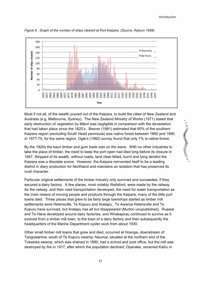
Introduction
37
Most if not all, of the wealth poured out of the Kaipara, to build the cities of New Zealand and Australia (e.g. Melbourne, Sydney). The New Zealand Ministry of Works (1971) stated that early destruction of vegetation by Māori was negligible in comparison with the devastation that had taken place since the 1820’s. Beever (1981) estimated that 60% of the southern Kaipara region (excluding South Head peninsula) was native forest between 1860 and 1890. In 1977-79, for the same region, Ogle’s (1982) survey found that only 7% is native forest.
By the 1920s the kauri timber and gum trade was on the wane. With no other industries to take the place of timber, the need to keep the port open had died long before its closure in 1947. Stripped of its wealth, without roads, land clear-felled, burnt and lying derelict the Kaipara was a desolate scene. However, the Kaipara reinvented itself to be a leading district in diary production for Northland and maintains an isolation that has preserved its rural character.
Particular original settlements of the timber industry only survived and succeeded, if they secured a dairy factory. A few places, most notably Wellsford, were made by the railway. As the railway, and then road transportation developed, the need for water transportation as the main means of moving people and products through the Kaipara, many of the little port towns died. Three places that grew to be fairly large townships started as timber mill settlements were Helensville, Te Kopuru and Aratapu. Te Awaroa Helensville and Te Kopuru have survived, but Aratapu has all but disappeared (Murton unupublished). Ruawai and Te Hana developed around dairy factories, and Whakapirau continued to survive as it evolved from a timber mill town, to the town of a dairy factory and then subsequently the headquarters of the Marine Department oyster work from about 1930.
Other small timber mill towns that grew and died, occurred at Hoanga, downstream of Tangowahine; south of Te Kopuru swamp; Naumai, situated at the northern end of the Tokatoka swamp, which was drained in 1890, had a school and post office, but the mill was destroyed by fire in 1917, after which the population declined; Opanake, renamed Kaihu in
Figure 6. Graph of the number of ships cleared at Port Kaipara. (Source: Ryburn 1999)

Introduction
38
1896, was a timber mill town growing around the railway, but the settlement declined once the mill closed in 1915 and received successive floods.
Dargaville and Wellsford became the two major service-trade centres in the Kaipara (Murton unpublished). Both townships grew into substantial, multi-function centres founded on servicing timber mills, dairy factories and agriculture.
This significant change in settlement pattern serves as an indicator of economic change since European settlement in the Kaipara. The settlement process emerged based on natural resource processing, timber mills, then dairy factories, transportation access and trade-service centres. After 1865 land could be purchased directly from Māori or through the government system of free grants. The result of both these sets of land purchasing processes was a pattern of dispersed settlement which intensified after the 1890s in areas suited to dairying and lamb production (Murton unpublished). This settlement and resource use patterns constrained Māori access and use, with a number of kainga consolidated on the few areas of remaining land.
Throughout the period between 1860 and 1960, Māori did survive the impact of colonization (Murton unpublished), despite the loss of most of their land, the destruction and depletion of their natural world, their loss of access to other natural resources, and loss of control over the management of what they were permitted to use and not use.
The Harbour has created significant pockets of isolated settlements, especially Pouto, at North Head, on a no exit road, with its nearest settlement, Te Kopuru, 50 km away. There are extreme variations in accessibility, where some towns have ready access to main highways (e.g. Helensville, Maungaturoto, Dargaville) and others are highly marginalised (e.g. South Head, Tinopai, Pouto, Taporapora). The 21st century product reflects quite extreme variations in its social and economic conditions. The Kaipara Harbour itself was historically both a major food resource and transport artery, but both functions have withered in recent decades.
Conclusion Evidence from written historical records of early European visitors and archaeological records indicates that the “edges” of the Kaipara were ecologically rich with natural resources that were important for the survival of the local inhabitants. This evidence strongly supports the view that most iwi/hapū of the Kaipara lived in close proximity to areas with easy access to resource zones, for example around river mouths, estuaries, dune lakes, sandy loam soils across the sand dunes, and along river banks.
Methodology
39
8 METHODOLOGY
The approach used to document, review and identify gaps in the three knowledge bases (Biogeophysical, Mātauranga Māori, Socioeconomic) can be divided into three main areas for each:
• Literature review
• Datasets
• Local, corporate and cultural knowledge.
Reminder:
This information review and gap analysis does not review marine biogeophysical information. This was carried out by Auckland Regional Council and Northland Regional Council (Haggitt et al. 2008). However, this report does review the Mātauranga Māori and socioeconomic knowledge base for the marine environment.
8.1 LITERATURE REVIEW
Written material came from two main sources, consisting of the “primary” published literature (such as scientific papers in science journals) and “grey literature” (research, reviews and other material) which exists in formats not considered to have been formally published, such as internal and client reports, and personal accounts and summaries. All relevant material located was compiled and reviewed for incorporation into the final report.
A number of sources were utilised to compile reports, articles and grey literature. Key databases included Scopus, Web of Science, Google Scholar, Aquatic Sciences and Fisheries Abstracts, NZ Science, Early New Zealand Books, New Zealand Fisheries Management Research Database, Environmental Science and Pollution Management were searched. Library catalogues of New Zealand universities, such as, University of Auckland, Auckland University of Technology, University of Waikato, University of Otago, and Victoria University of Wellington were searched.
Public library catalogues, such as, Te Puna New Zealand National Bibliographic Database, Māori Land Court Minute Books Index, and the New Zealand Electronic Text Centre.
Online searches of a number of websites of government, industry, recreational, conservation and research organisations included:
• Central government departments; Department of Conservation, Te Puni Kokiri, Ministry of Fisheries, Ministry for Environment and Statistics New Zealand
• Regional and local councils of the Kaipara; Rodney District Council, Kaipara District Council, Auckland Regional Council, and Northland Regional Council.
Methodology
40
• The website of a number of research organisations; NIWA, Royal Society of New Zealand, Landcare Research, and the Cawthron Institute.
• Scirus search engine for sciences, Brookers Online, and New Zealand Legislation for New Zealand legal information.
• Australian and New Zealand Digital Thesis website
• Australian/New Zealand Reference Centre (EBSCO)
• Kiwi Research Information Centre
• Websites of community and industry groups; Royal Forest & Bird Society, RMA Link, Sea Net, New Zealand Planning, Seafood Industry Council New Zealand.
• Websites of Kaipara iwi/hapū; Ngāti Whatua Ngā Rima o Kaipara, Ngāti Whatua o Kaipara, Te Uri o Hau, and Te Roroa
In addition to the above, maps, photos, spatial information, cultural history (including Waitangi Tribunal documents) and socio-economic characteristics were also collated and studied.
8.2 DATASETS
Virtually all of the data involved for this review has a strong spatial component. Therefore an explicitly spatial approach was taken in capturing and storing all data-sets of relevance. A Geographic Information System (GIS) database (using ArcInfo-ArcMap software) was established to store and organise all spatial information acquired. Associated with this, a Microsoft Excel database was developed to store and organise the associated metadata (“data about the data”, such who owns it, how it was collected, and what the different attributes and variables mean) (Table 4).
Table 4. Format of the metadata recorded in the database.
Dataset/Layer Spatially geo-referenced data that captures the location of important features. Preference will be given to digital data.
Description Brief description of the dataset/layer Geometry Geometry type (point, line, polygon) Provider/Custodian Data provider or custodian or reference Extent Geographical/spatial extent of dataset. Terms used were: Kaipara harbour,
Kaipara catchment, national Key Fields/Attributes
Descriptive information stored with the spatial data.
Comments Additional information that may be important to correctly interpret/process the data. Location of metadata

Methodology
41
Data recorded in the database mostly had a consistent spatial extent across the Kaipara planning area, being the Harbour and the catchment. Data with only a partial coverage was recorded where it could be used to extrapolate biological and/or social patterns across the entire planning region (e.g. southern Kaipara benthic habitat data (Hewitt & Funnell 2005)). The Kaipara Atlas (Figure 7) therefore, is composed of three knowledge-bases each containing spatial, literature and temporal/occurrence databases.
Figure 7. The composition of the Kaipara Atlas, an integrated database.
8.3 LOCAL, CORPORATE, & CULTURAL KNOWLEDGE
In addition to reviewing literature, the project involved consultation and kōrero with:
• Representatives of organisations undertaking research specifically in the Kaipara and generally with reference to the six long-term objectives; this included ecologists, botanists, and earth scientists.
• IKHMG members.
• Kaipara iwi/hapū organisations/authorities and marae representatives.
• Government departments: Department of Conservation, Te Puni Kokiri, Ministry of Fisheries, Statistics New Zealand, Ministry of Environment, Office of Treaty Settlements, Waitangi Tribunal.
• Local and Regional Councils; Rodney District Council, Kaipara District Council; Auckland Regional Council, and Northland Regional Council.
Methodology
42
• Stakeholder organisations: Winstone Aggregates, Matakohe Kauri Museum, McCallum Bros, Royal Forest & Bird Society, Crown Forestry Rental Trust, Kaipara Harbour Sustainable Fisheries Management Group, NZ Landcare Trust, and QEII Trust.
• Stakeholders; landowners, archaeologists, commercial and recreational fishers, tourism operators, marine farmers, and landscape designers.
• Community spokespeople with a close association with the Kaipara
The main points gained from these discussions are incorporated into the final report.
This consultation focused on acquiring knowledge of past and present environmental characteristics and direct uses (i.e. consumptive and non-consumptive) of the Kaipara. Indirect values (e.g. source of resource or resource protection, such as shoreline protection, biodiversity, spawning area) and existence values (or intrinsic value, such as aesthetic, heritage and culture) were also discussed. The consultation also sought proposals of action to achieve the long-term objectives and shared vision for a healthy and productive Kaipara.
8.4 OUTPUTS & ANALYSIS
8.4.1 GAP ANALYSIS
An explicitly spatial framework was used to identify gaps, due to the scale and the integrated, ecosystem-based management approach utilised by the project. This technique worked particularly well for biogeophysical information alone and with biogeophysical with socioeconomic information such as resource consent information on discharges. The limited current information regarding Mātauranga Māori stressed the importance of configuring data layers to incorporate into any ongoing gap analysis, and direct policy development, research and planning.
A spatial gap analysis was conducted where adequate information existed, for example, for protected areas, ecosystems, landcover, and geodiversity. Percentage estimates of remaining ecosystems were calculated to allow for some descriptive analysis of gaps in biodiversity protection within the catchment. For the marine environment, there are no current protected areas for biodiversity purposes.
Recent protected natural area surveys for Tutamoe, Tangihua, Tokatoka, Kaipara, Ōtamatea, Waipu, Rodney, Whāngārei and Whangaruru Ecological Districts have identified areas at the ecosystem level, rather than the community level. The data from the surveys was used to understand the quantity of remaining healthy and functioning ecosystems. Significant natural areas were identified using specific criteria relevant to ecosystem structure and function (e.g. ecological connectivity). Gaps will be identified, with the implications of those gaps and recommendations described.
Methodology
43
8.4.2 OUTPUTS
There are three overall outputs of the project.
1. Executive Summary.
2. Information Review and Gap Analysis Report.
This output scopes and documents the extent of research and knowledge that exists for the Kaipara Harbour and its catchment; identifies knowledge gaps and the implications of those gaps on the ability to effectively achieve long-term objectives 1–6; and makes short- and long-term recommendations regarding priority gaps to address through targeted research and management.
3. The Kaipara Atlas.
A meta-database of references, spatial data and temporal data; and links to ongoing projects in the Kaipara, all of which will be made available through the web portal.
8.4.3 ORGANISATION OF CHAPTERS FOR THIS REPORT
There are six main chapters, each reviewing current information and identifying gaps for one of the six long-term objectives. The objectives are:
1. Restoring and protecting native biodiversity
2. Restoring sustainable use of fish and invertebrate stocks
3. Restoring and protecting the mauri of the Kaipara
4. Understanding of socio-economic opportunities
5. Co-operative management of Kaipara ecosystems, catchment and harbour
6. Reducing climate change impacts
Information acquired on the three knowledge bases were integrated into a response for each objective. For some chapters, such as “Restoring Mauri…” the response was based on only one knowledge base – Mātauranga Māori. Some chapters also lacked any specific knowledge for the Kaipara, such as climate change. Here the response utilised credible, well-researched and applicable national and international literature (e.g. Stern Report on the economic implications of climate change). Over 900 references were entered into the reference management program ENDNOTE. This included published, unpublished/grey literature, maps, DVDs, CDROMs, theses, and court hearing transcripts.

44
8.5 BIBLIOGRAPHY
Barlow, P. W. (1888). Kaipara, or, Experiences of a settler in north New Zealand. London, S. Low Marston.
Beever, J. (1981). "A map of the pre-European vegetation of Lower Northland, New Zealand." New Zealand Journal of Botany 19(1): 105-110.
Bond, W. (1997). The Land With All Woods And Water. Rangahaua Whanui National Theme U. Rangahaua Whanui Series. Rangahaua Whanui Series.Waitangi Tribunal. 154.
Bradley, E. K. (1982). The great Northern Wairoa. [Kamo], [Bradley family].
Byrne, T. B. (2002). The unknown Kaipara: five aspects of its history 1250-1875. Auckland, T.B. Byrne.
Cameron, E., Hayward, B. & Murdock, G. (1997). A Field Guide to Auckland. Exploring the Region's Natural and Historic Heritage. Auckland, Godwit Publishing.
Chetham, J. (1998). Kaitiakitanga and the Resource Manangement Act: Tangata Whenua, Participation, and Morality. Department of Geography. Auckland, NZ, University of Auckland. MSc: 122.
Christensen, N. L., Bartuska, A. M., Brown, J. H., Carpenter, S., D'Antonio, C., Francis, R., Franklin, J. F., MacMahon, J. A., Noss, R. F., Parsons, D. J., Peterson, C. H., Turner, M. G. & Woodmansee, R. B. (1996). "The report of the Ecological Society of America Committee on the Scientific Basis for Ecosystem Management." Ecological Applications 6(3): 665-691.
Colenso, W. (1844). Excursion in the Northern Island of New Zealand: in the summer of 1841-42. Launceston, Land.
Cortner & Moote (1999). Politics of Ecosystem-based Management. Washington, D.C, Island Press.
Crengle, D. (1993). Taking into account the Principles of the Treaty of Waitangi: Ideas for the implementation of Section 8, Resource Management Act 1991. Wellington: Ministry for the Environment. .
Dieffenbach, E. (1843). Travels in New Zealand, with contributions to the geography, geology, botany and natural history of that country. Vol 1. London, Murray.
Elder, J. R., Ed. (1932). The letters and journals of Samuel Marsden, 1765-1838. Dunedin, Coulls Somerville Wilkie Ltd, A H Reed, Otago University Council,.
Envrions Holdings Ltd (2007). Te Uri o Hau effects Assessment Report of a Proposal by CREST Energy Ltd to Construct and Operate a Tidal Powerstation in the Kaipara Harbour. Environs Holdings Ltd. 64.
Graham, G. (1939). "Mahuhu. The ancestral canoe of Ngati Whatua (Kaipara)." Journal of the Polynesian Society 48: 186-191.
Haggitt, T., Mead, S. & Bellingham, M. (2008). Review of environmental information on the Kaipara Harbour marine environment. Prepared for Auckland Regional Council by ASR Ltd and Coastal & Aquatic Systems Ltd. 200.
Hay, B. & Grant, C. (2004). Marine resources in Tai Tokerau. AquaBio Consultants Ltd. The James Henare Māori Research Centre. 87.
Hay, W. D. (1882). Brighter Britain! or Settler and Māori in Northern New Zealand. London, Bentley.
Heath, R. A. (1976). "A broad classification of New Zealand coastal inlets with particular emphasis on their residence times." Proceedings of the New Zealand Ecological Society 23: 116-117.

45
Hewitt, J. E. & Funnell, G. A. (2005). Benthic marine habitats and communities of the southern Kaipara. Hamilton, Auckland Regional Council: 74 p.
Irwin, G. (1985). Land, pa„ and polity: a study based on the Māori fortifications of Pouto. Auckland, New Zealand Archaeological Association
Jackson, M. A. (1997). Pouto Peninsula: An Archaeological Perspective. The evidence of Moria Annettee Jackson. Amended 10th April 1997. In the Matter of the Treaty of Waitangi Act 1975 and in teh matter of the Statement of Claim by Te Uri O Hau O Te Wahapu O Kaipara (Wai 271, A13). Waitangi Tribunal.
Kawharu, M. (2000). "Kaitiakitanga: A Māori anthropological perspective of the Māori socio-environmental ethic of resource management." Journal of the Polynesian Society 109(4): 349-370.
Mardsen, R. M. (1975). God, Man & Universe: A Māori View. Te Ao Hurihuri: The World Moves On. M. King. Wellington, Hicks Smith & Sons.
Marsden, M. & Henare, T. A. (1992). Kaitiakitanga: a definitive introduction to the holistic world view of the Māori. Wellington, NZ, Ministry for the Environment.
Marsden, M. & Henare, T. A. (1992). Kaitiakitanga: A Definitive Introduction to the Holistic World View of the Māori. Unpublished manuscript. 21p.
McLeod, K. L., Lubchenco, J., Palumbi, S. R. & Rosenberg, A. A. (2005). Scientific Consensus Statement on Marine Ecosystem-Based Management. Signed by 221 academic scientists and policy experts with relevant expertise. Published by the Communication Partnership for Science and the Sea 21.
Minhinnick, N. (1989). Establishing Kaitiaki: A paper. Auckland: Nganeko Kaihau Minhinnick.
Ministry of Works (1971). National Resources Survey Part 1: Northland Region. M. o. W. Town and Country Planning Division, Government Printers.
Murton, B. (unpublished). Kaipara Harbour Report (Draft). Chapters I-VII.
Ogle, C. C. (1982). Wildlife and wildlife values of Northland. Fauna Survey Unit report / New Zealand Wildlife Service No. 30.272.
Park, G. (1995). Nga Uruora. The Groves of Life. Wellington, Victoria University Press.
Parnell, K. E. (2004). Integrating indigenous history, historical records and geomorphic evidence of coastal change: Kaipara Harbour, New Zealand. Coast to coast '04: Australia's National Coastal Conference : Hotel Grand Chancellor, Hobart, Tasmania, 19-23 April 2004 : conference proceedings. [Hobart], The Conference Secretariat].
Polack, J. S. (1974). New Zealand: being a narrative of travels and adventures during a residence in that country between the years 1831 and 1837. Christchurch, Capper Press.
Roberts, M., Norman, W., Minhinnick, N., Wihongi, D. & Kirkwood, C. (1995). "Kaitiakitanga. Māori perspectives on conservation." Pacific Conservation Biology 2(1): 7-20.
Ryburn, W. R. (1999). Tall spars, steamers & gum: a history of the Kaipara from early European settlement, 1854-1947. Auckland, Kaipara Publications.
Smith, S. P. (1840). Māori wars of the nineteenth century : the struggle of the northern against the southern Māori tribes prior to the colonisation of New Zealand in 1840. Christchurch, New Zealand, Cadsonbury Publications.
Smith, S. P. (1898). The peopling of the North: notes on the ancient Māori history of the northern peninsula and sketches of the history of the Ngati-Whatua tribe of the Kaipara, New Zealand. Wellington, Whitcombe & Tombs.
46
Spring-Rice, W. (1996). Māori settlement on South Kaipara Peninsula, University of Auckland: 525.
Stallworthy, J. (1916). Early Northern Wairoa. Wairoa, Dargaville (N.Z.), Wairoa Bell and Northern Advocate.
Wade, W. R. (1842). A journey in the northern island of New Zealand, interspersed with various information relative to the country and people. Rolwegan, Hobart, George Pratt and George Rolwegan.
Waitangi Tribunal (2006). The Kaipara Report. Wai 674. Waitangi Tribunal. 420.
Ward, T., Tarte, D., Hegerl, E. & Short, K. (2002). Policy Proposals and Operational Guidance for Ecosystem-Based Management of Marine Capture Fisheries, WWF.
Wright, W. (1996). Manawhenua Report, Te Uri O Hau O Te Whahapu O Kaipara. The evidence of Wiremu Wright. Unpublished statement of evidence.: 114.