wilsons prom management planm.parkweb.vic.gov.au/__data/assets/pdf_file/0006/313458/...cover:...
TRANSCRIPT
This Management Plan for Wilsons Promontory National Park is approved for implementation. Its purpose is todirect all aspects of management in the park until the plan is reviewed. A Draft Management Plan for the parkwas published in December 2000. Forty-one submissions were received and have been considered in developingthis approved Management Plan.
This plan may be downloaded from the Parks Victoria website 'www.parkweb.vic.gov.au'. Copies of the planmay be purchased for $8.80 (including GST) from:
Parks Victoria Information CentreLevel 10, 535 Bourke StreetMELBOURNE 3000 VIC
NRE Information Centre8 Nicholson StreetEAST MELBOURNE VIC 3002
Foster OfficeParks VictoriaPO Box 91FOSTER VIC 3960
Tidal River OfficeWilsons Promontory National ParkTIDAL RIVER via FOSTER VIC 3960
For further information on this plan, please contact:
Graeme DavisChief RangerFoster OfficeParks VictoriaPO Box 91FOSTER VIC 3960
03 5682 2133
Disclaimers
This plan is prepared without prejudice to any negotiated or litigated outcome of any native title determinationapplications covering land or waters within the plan’s area. It is acknowledged that any future outcomes ofnative title determination applications may necessitate amendment of this plan; and the implementation of thisplan may require further notifications under the procedures in Division 3 of Part 2 of the Native Title Act 1993(Cwlth).
The plan is also prepared without prejudice to any future negotiated outcomes between the Government/s andVictorian Aboriginal communities. It is acknowledged that such negotiated outcomes may necessitateamendment of this plan.
Every effort has been made to ensure that the information in this report is accurate. Parks Victoria does notguarantee that the publication is without flaw of any kind and therefore disclaims all liability for any error, lossor other consequence which may arise from your reliance on any information in the publication.
WILSONS PROMONTORY NATIONAL PARK
MANAGEMENT PLAN
MARCH 2002
ii Wilsons Promontory National Park
Published in March 2002 by Parks VictoriaLevel 10, 535 Bourke Street Melbourne, Victoria 3000.
National Library of AustraliaCataloguing-in-Publication entry
Parks Victoria.Wilsons Promontory National Park management plan.
Bibliography.ISBN 0 7311 8315 0
1. National parks and reserves - Victoria - WilsonsPromontory - Management. 2. Conservation of naturalresources - Victoria - Wilsons Promontory. 3. WilsonsPromontory National Park (Vic.) - Management. I. Title.
333.783099456
Cover: Wilsons Promontory National Park, looking south towards Rodondo Island (Photo: David Tatnall)
Printed on recycled paper to help save our natural environment
Wilsons Promontory National Park iii
FOREWORD
Wilsons Promontory National Park is one ofthe most significant national parks inVictoria. Indeed, the Prom is the best-lovednational park for many Victorians. It hasoutstanding conservation, recreation andwilderness values, and has been designatedby UNESCO as a Biosphere Reserve.
The diverse and essentially unspoiltcharacter of the park and its outstandingscenery attract those wanting to experiencea unique part of Victoria, particularlythrough camping, bushwalking and naturestudy.
The long-term management frameworkestablished in the plan will protect theoutstanding natural and cultural values ofthe park today and for future generations.
Publication of the plan honours the BracksGovernment’s election commitment todevelop a new integrated management planfor Wilsons Promontory National Park. The
plan implements the Government’scommitments to prevent further commercialdevelopment in the park and ensure that thefocus of management is on natureconservation.
The planning area includes WilsonsPromontory Lightstation Reserve area, inaccordance with the Government’scommitment to add the reserve to the park,and the Citadel Island Lightstation area,which is also proposed to be added. Theplan also incorporates a proposal for aRemote and Natural Area to protect thelargely undisturbed and significant southernsection of the park.
I thank those individuals and organisationswho made submissions on the draft plan,and I look forward to the community’songoing support for the management of thisvery special national park.
Sherryl Garbutt MPMinister for Environmentand Conservation
iv Wilsons Promontory National Park
APPROVED MANAGEMENT PLAN
This Approved Management Plan preparedunder section 17 of the National Parks Act1975 (Vic.) is approved for implementation.
The Plan provides the basis and direction forthe future management of WilsonsPromontory National Park.
It was finalised following careful considerationof the forty-one submissions received on thedraft plan released in December 2000.
Chloe MunroSecretary to theDepartment of Natural Resourcesand Environment
Mark StoneChief ExecutiveParks Victoria
Wilsons Promontory National Park v
SUMMARY
Wilsons Promontory National Park(50 460 ha)1 is the oldest existing national parkin Victoria. Mostly temporarily reserved in1898 and permanently reserved since 1905, itis today a significant component of the State’spark system.
The park has outstanding natural values. It isimportant for its range of plants and animals,including many threatened species. It isrenowned for its spectacular coastal sceneryand the opportunity to enjoy its splendidnatural setting in a variety of ways, includingwalking, camping, sightseeing, viewingwildlife, fishing, boating and other activities.There are outstanding opportunities for bothday and overnight walks. A largecampground, a range of servicedaccommodation and other facilities areavailable at Tidal River2, which has long beena favourite holiday destination, particularly forfamily groups.
The park receives about 380 000 visit-days3
per year comprising 120 000 visits and over260 000 overnight stays.
Major management directions are summarisedbelow.
• Adoption of a more systematic approach toecological management throughmanagement of fire, programs for theprotection of threatened species, andrestoration of the park’s heathlands andgrassy woodlands.
1 Includes area between mean high and low water mark;excludes area of Citadel Island and Wilsons PromontoryLightstation Reserves.2 In this document the term ‘Tidal River’ means the Tidal Rivercampground comprising campground, cabins, lodges and othervisitor facilities. The term ‘Tidal River stream’ is used toindicate the waterway of Tidal River.3 A ‘visit-day’ is defined as the number of day visitors (peopleentering the Park for the first time on any given day and stayingone day or less) plus the number of overnight stays.
• Incorporation of the Wilsons Promontoryand Citadel Island Lightstation Reservesinto the Wilsons Promontory National Park.
• Development of new nature trails and basicvisitor facilities, and upgrading standards ofexisting tracks.
• Improvement of visitor services andfacilities including upgrading the qualityand arrangement of facilities at Tidal River,while applying high standards ofenvironmental management.
• Establishment of a ‘Centre of Excellencefor Park Management’ program forresearch, monitoring and the teaching ofpark management.
• Continued implementation of a majorinformation, interpretation and educationprogram.
• Investigate world heritage listing forWilsons Promontory National Park.
• Designation of a new Southern WilsonsPromontory Remote and Natural Area andincorporation of Citadel Island LightstationReserve area into the Wilsons PromontoryIslands Remote and Natural Area.
vi Wilsons Promontory National Park
CONTENTS
FOREWORD iii
SUMMARY V
1 INTRODUCTION 1
1.1 Location and planning area 11.2 Creation of the park 11.3 Developing the management plan 1
2 BASIS 2
2.1 Regional context 22.2 Park values and significance 22.3 Past land use 32.4 The park visitor 42.5 Legislation, LCC recommendations and guidelines 4
3 STRATEGIC DIRECTIONS 7
3.1 Park vision 73.2 Zoning 73.3 Management directions 8
4 STRATEGIES FOR CONSERVATION 13
4.1 Geological and landform features 134.2 Rivers and catchments 134.3 Vegetation 154.4 Fauna 164.5 Landscape 184.6 Fire management 194.7 Pest plants and animals, and diseases 204.8 Soil conservation 224.9 Aboriginal cultural heritage 224.10 Post-settlement cultural heritage 24
5 STRATEGIES FOR VISITORS 26
5.1 Information, interpretation and education 265.2 Access 285.3 Amenity 335.4 Day visitor activities 355.5 Overnight accommodation 365.6 Bushwalking 375.7 Camping outside the Recreation Zone 405.8 Boating 415.9 Fishing 425.10 Rock climbing and abseiling 435.11 Commercial services 435.12 Public safety 44
Wilsons Promontory National Park vii
6 COMMUNITY AWARENESS AND INVOLVEMENT 45
6.1 Community partnerships 45
7 OTHER ISSUES 46
7.1 Centre of Excellence for Park Management program 467.2 Management and support services infrastructure 477.3 Management access 497.4 Authorised uses 497.5 Boundaries and adjacent uses 50
8 IMPLEMENTATION 51
REFERENCES 52
APPENDICES
1 Threatened flora 542 Threatened fauna 57
TABLES
1 Management zones and overlays 102 Tidal River precincts 113 Summary of recreation activities 124 Management of roads and walking tracks 305 Overnight accommodation at Tidal River and the Wilsons Promontory Lightstation 376 Existing and proposed visitor facilities 39
FIGURES
1 Location End of plan2 Land tenure "3 Management zones and overlays "4 Recreation zone boundaries "5A Tidal River recreation zone–existing conditions "5B Tidal River recreation zone–proposed precincts "6 Visitor access and facilities "7 Proposed walking tracks "

viii Wilsons Promontory National Park

Wilsons Promontory National Park 1
1 INTRODUCTION
1.1 Location and planning areaWilsons Promontory National Park is in SouthGippsland, about 200 km southeast ofMelbourne (figure 1).
This planning area covers the WilsonsPromontory National Park (50 460 ha) andWilsons Promontory Lightstation Reserve(33.6 ha) and Citadel Island LightstationReserve (18.7 ha).
The existing park includes:
• Wilsons Promontory Wilderness Zone(21 800 ha);
• Reference Areas at Anser Island(80 ha), Entrance Point (750 ha) andVereker Creek (2650 ha);
• Mount Vereker Creek Natural CatchmentArea (2560 ha);
• Wilsons Promontory Islands Remote andNatural Area (470 ha)—eleven of theoffshore islands included in WilsonsPromontory National Park.
The Wilsons Promontory and Citadel IslandLightstation Reserves are included in theplanning area, consistent with the intention toadd the reserve areas to the park.
1.2 Creation of the parkOn 8 July 1898, an area of 36 826 ha atWilsons Promontory was temporarily reservedunder the Land Act 1890 (Vic.) as a site for anational park. This was followed by the
permanent reservation of 30 351 ha in 1905(which excluded the half-mile coastal strip,most of which was added in 1908). Furtherareas were reserved in 1909—eight islands(295 ha), 1918 and 1928—areas at Seaforthtownship (2 ha and 58 ha respectively),1965—area between high and low watermarks, and 1969—Yanakie Isthmus, severalislands and a small area at Refuge Cove (7485ha). Since 1975 the park has been included onSchedule Two of the National Parks Act 1975(Vic.).
On 1 December 1995, the Commonwealth’sLightstations on South East Point and CitadelIsland passed to the State Government andwere temporarily reserved under the CrownLand (Reserves) Act 1978 (Vic.). ParksVictoria manages the reserves as a Committeeof Management. It is intended to incorporatethese areas into the national park.
1.3 Developing the managementplan
In accordance with Government policy, thisManagement Plan has been prepared through aprocess of review and integration of theWilsons Promontory National ParkManagement Plan (Parks Victoria 1997) andthe Tidal River Master Plan (Parks Victoria1997). Forty-one submissions received on theDraft Management Plan, which was publishedin December 2000 for public comment, havebeen considered in developing thisManagement Plan.
2 Wilsons Promontory National Park
2 BASIS
2.1 Regional contextA range of natural attractions in the regioncomplements Wilsons Promontory NationalPark. The Corner Inlet and Shallow InletMarine and Coastal Parks, Cape LiptrapCoastal Park, and the camping areas andaccommodation facilities at Walkerville andSandy Point provide complementary coastalsettings.
The marine and coastal parks that almostsurround the national park (figure 1) arepopular areas for recreational and commercialboating. A number of boats also visit thenational park.
The coastal attractions contrast with thepopular rainforests and Mountain Ash ofTarra-Bulga National Park in the StrzeleckiRanges north of Yarram.
Wilsons Promontory National Park is in thePhillip Island and Gippsland DiscoveryTourism Region. The Victoria RegionalTravel and Tourism Survey 1995 (TourismVictoria 1996) indicates that the regionreceives 5 per cent of all tourist nights inVictoria, comprising Victorian (91%),interstate (7%) and international visitors (2%).The Regional Tourism Development Plan forthe Phillip Island and Gippsland DiscoveryTourism Region (Tourism Victoria 1997a)examines regional visit trends anddevelopment directions in detail.
2.2 Park values and significanceWilsons Promontory National Park makes avaluable contribution to Victoria’s parksystem, which aims to protect viable,representative samples of the State’s naturalenvironments. Parks also enable visitors toenjoy and appreciate natural and culturalvalues, and many parks make importantcontributions to tourism.
The park is assigned the International Unionfor the Conservation of Nature (IUCN)Category II (National Parks) of the UnitedNations’ List of National Parks and ProtectedAreas. Category II areas are managedprimarily for ecosystem conservation andappropriate recreation.
In 1982 the park was designated a BiosphereReserve under UNESCO’s Man and theBiosphere Program.
There are 12 Biosphere Reserves in Australia,of which three are in Victoria.
Wilsons Promontory National Park, WilsonsPromontory Lightstation, Citadel Island, twoindigenous places (at Tidal River and Yanakie)and three shipwrecks are listed on the Registerof the National Estate in recognition of thesefeatures’ outstanding values and theirimportance as a part of our heritage. TheWilsons Promontory Lightstation buildings areincluded on the Victorian Heritage Registerand classified by the National Trust ofAustralia (Victoria).
The area of park between high water and lowwater in Corner Inlet, and the islands of CornerInlet, are also covered by the Ramsar‘Convention on Wetlands of InternationalImportance’. The Convention is an inter-governmental treaty that provides forinternational cooperation in the conservation ofwetlands. A draft strategic management planfor the Corner Inlet Ramsar site was releasedfor public comment in February 2001 (ParksVictoria 2001).
The park is the oldest existing national park inVictoria. Much of it was temporarily reservedin 1898 and permanently reserved in 1905.
The park is South Gippsland’s major touristdestination and Victoria’s most popularnational park for camping. Many visitorschoose to stay at Tidal River, whereaccommodation, a large campground, aninformation centre and other facilities areavailable. A network of walking tracksleading from Tidal River caters for both daywalks and overnight hikes.
The park is a major employer in the regionand, with the seasonal influx of visitors,contributes significantly to the local economy.
Significant features of the park and reservesinclude:
Natural values• Entire promontory of national geological
and geomorphological significance,
Basis
Wilsons Promontory National Park 3
containing a number of sites of State andregional significance.
• Diverse vegetation communities, includingwarm temperate and cool temperaterainforest, tall open forests, woodlands,heathlands, and swamp and coastalcommunities.
• The occurrence of 21 per cent of Victoria’sknown vascular flora.
• Several biogeographically significantspecies, including a number of plantspecies and communities which haveassociations with other parts of Australiaor are threatened or at the limits of theirdistribution.
• Unmodified rivers and streams with nointroduced fish species.
• Several threatened fauna species, includingthe New Holland Mouse, Long-nosedPotoroo, Ground Parrot, White-belliedSea-Eagle, Swamp Skink, and theDamselfly Hemiphlebia mirabilis.
• Half of Victoria’s bird species.
• Intertidal mudflats, which are aninternationally important habitat formigratory wading birds.
• The largest coastal wilderness area inVictoria.
Cultural values• Numerous middens and other significant
Aboriginal sites.
• Remains of sites of several small Europeansettlements and past uses including timbermilling, mining and grazing.
• A number of shipwrecks in the watersaround Wilsons Promontory whichdemonstrate the hazards of coastalshipping.
• The heritage buildings of WilsonsPromontory Lightstation.
Tourism and recreational values• Outstanding natural landscapes including
spectacular and diverse coastal scenery.
• The attraction of being the southernmostpart of the Australian mainland.
• Excellent opportunities for sightseeing,viewing wildlife, camping and other formsof recreation in natural settings.
• Outstanding opportunities for day andovernight walks.
• Opportunities for other activities includingrock climbing, diving, fishing, seakayaking and surfing.
• Campsites for boat-based campers at TinMine Cove and Refuge Cove.
• Opportunities for those outside the park toenjoy the unspoilt natural landscapes fromthe sea by boat or from nearby coastalvantage points.
• A large campground, a range of servicedaccommodation in huts, cabins and lodges,a general store, other commercial servicesand an Information and Visitor Centre atTidal River.
• Visitor accommodation at thesouthernmost residence on mainlandAustralia, in a spectacular setting at theWilsons Promontory Lightstation.
2.3 Past land useWilsons Promontory National Park has anearly history of Aboriginal occupation datingback at least 6500 years.
The park has a long history of resource use andcommerce dating back to the early 19thcentury, including sealing and whaling, timberharvesting, grazing, tin and gold mining, pilotstation, a post office, hotel and the DarbyChalet.
A lightstation constructed from locallyquarried granite was established at South EastPoint in 1853 to provide a safe passage forships through Bass Strait.
In 1941 the park was closed to the public andthe No. 7 Infantry Training Centre, Australia’sfirst Commando Training centre, was stationedin and around Darby River and Tidal River.
Cattle were grazed in parts of the park from the1850s until 1992. Lime was quarried on theYanakie Isthmus for road-making until 1995.The park is still used for honey production.
Basis
4 Wilsons Promontory National Park
2.4 The park visitorWilsons Promontory National Park has beenthe prime destination for visitors to nationalparks in Victoria since the Second World War.This has been due in part to the establishmentof the most popular national park campgroundin Victoria at Tidal River, and to the pastrelatively undeveloped condition of manyother parks in the State.
Tidal River, located some 30 km from the parkentrance, is the main destination for most dayand overnight visitors, and has traditionallyprovided a base from which visitors exploreand enjoy the surrounding park.
With the declaration and development of newparks in the region and in other parts of theState, it is appropriate that the park’s role inthe statewide system of parks and reservesshould be reassessed.
The park is one of Victoria’s most importanttourist destinations and South Gippsland’sbiggest tourist drawcard. It makes a majorcontribution to the regional economy.
The park will continue to be a majordestination for visitors. However, there ismuch scope for people visiting the region toinclude Phillip Island, Tarra-Bulga NationalPark, Cape Liptrap Coastal Park and othernearby marine and coastal parks in theiritineraries. It is practical for visitors to stayoutside Wilsons Promontory National Park incommercial accommodation and make dayvisits.
The park will continue to be integrated intoregional tourism information services inaccordance with the Regional TourismDevelopment Plan (Tourism Victoria 1997a).
Park visitsWilsons Promontory National Park attractslarge numbers of both day and overnightvisitors. The majority of visitors are fromMelbourne, and from other parts of Gippsland.
Visitors represent a highly variable factor inrelation to providing services and managingimpacts. Visit peaks have the potential tooverload the capacity of facilities and servicesin the park, particularly at Tidal River. Amaximum of 800 visitor vehicles is permittedinto the park on any one day.
In 2000–2001, the park attracted about120 000 visits and 260 000 overnight stays, atotal of 380 000 visit-days. Over the pastdecade, annual visitor numbers have fluctuatedsubstantially, but there has not been any long-term trend.
LodgingThe demand for roofed accommodation inTidal River is high throughout the year. Theannual occupancy rate for Tidal River’s roofedaccommodation is 85 per cent, a very high ratefor tourist accommodation anywhere inAustralia. The summer occupancy rate is inthe order of 95 per cent.
The demand for campsites at Tidal River ishigh in summer and during the Easter holidayperiod but much lower from May to October.In the peak Christmas–January period, demandfor campsites still greatly exceeds supply,although for a much shorter period than wasthe case in the 1980s due to changes in theVictorian school terms.
Demand for campsites away from Tidal Riveris also high, particularly on weekends, andoften exceeds the capacity set during summermonths and long weekends.
Communication with visitorsThe document ‘Exploring WilsonsPromontory: a Guide to Visitor Services,Interpretation and Education’ (CNR 1995a)will guide staff in developing, maintaining andevaluating visitor services, interpretation andeducation in the park.
2.5 Legislation, LCCrecommendations andguidelines
Wilsons Promontory National Park is reservedand managed under the provisions of theNational Parks Act. The Act requires theSecretary to the Department of NaturalResources and Environment to preserve andprotect the natural condition of the park and itsnatural and other features, and subject to this toprovide for the use of the park by the publicfor enjoyment, recreation and education. TheAct also provides for appropriate research.
Parks Victoria, as the Committee ofManagement, manages Wilsons Promontoryand Citadel Island Lightstation Reserves underthe Crown Land (Reserves) Act. Control of
Basis
Wilsons Promontory National Park 5
the lightstations passed from theCommonwealth to the State Government on 1December 1995. It is proposed to incorporatethe Lightstations into the National Park.
The objects and provisions of the NationalParks Act and the Crown Land (Reserves) Actset the overall framework for the managementof Wilsons Promontory National Park and theLightstation Reserves respectively. Specificlegislation and LCC recommendations governthe management of particular areas of the park,as described below.
In 1982 the Land Conservation Council (LCC)recommended that a Sealers Creek ReferenceArea be declared. Subsequent investigationsidentified a more appropriate location to be theVereker Creek catchment to the north.
Reference Areas at Anser Island (80 ha),Entrance Point (750 ha), and Vereker Creek(approximately 2650 ha) have been proclaimedunder the Reference Areas Act 1978 (Vic.).These will be managed in accordance withministerial directives. Within these areas,natural processes will be allowed to continueundisturbed to form a reference forcomparative study purposes.
As a result of the LCC Wilderness SpecialInvestigation (LCC 1991a) and the NationalParks (Wilderness) Act 1992 (Vic.), theWilsons Promontory Wilderness Zone wasproclaimed on 30 June 1992 and included inSchedule Five of the National Parks Act. TheAct requires the Secretary to protect andenhance the area as a wilderness and provideopportunities for solitude and appropriate self-reliant recreation. The Act prohibits certaindevelopments and activities except in specifiedcircumstances.
The LCC (1991a), in addition to its generalrecommendations, made specificrecommendations in relation to the WilsonsPromontory Wilderness Zone. The LCCrecommended that the undisturbed coastline beprotected from the impacts of coastalengineering works elsewhere; that no newwalking tracks be constructed; that attention begiven to the visual impact of the Five MileRoad; and that the navigation beacon atLighthouse Point be retained while required.The LCC noted that there was scope to reducethe number of vehicle tracks, and that theremay be a need to control visitor numbers at themore popular campsites.
At the same time, and through the same LCCand legislative processes, 11 of the islandsaround Wilsons Promontory were proclaimedas a Remote and Natural Area under ScheduleSix of the National Parks Act (Shellback,Norman, Great Glennie, Dannevig, McHugh,Anser, Kanowna, Cleft, Wattle and RabbitIslands, and Rabbit Rock). The Remote andNatural Area is managed according to theprovisions of the National Parks Act and LCCFinal Recommendations (LCC 1991a) toprotect its remote and natural attributes.
The LCC (1991a) also noted that the southernand south-eastern sectors of WilsonsPromontory, while not within therecommended Wilderness Zone, were alsolittle disturbed with few vehicle tracks orstructures, and that it was important that theseattributes be recognised and protected by parkmanagement. To give appropriate long-termprotection and recognition to these values, aRemote and Natural Area covering 14 420 hais proposed in the southern section of the park(figure 3). Pending its inclusion on ScheduleSix to the National Parks Act, the area will bemanaged in accordance with the managementprinciples applying to remote and naturalareas.
Following recommendations from the LCCRivers and Streams Special Investigation (LCC1991b), the Mount Vereker Creek NaturalCatchment Area of 2720 ha is now protectedand managed under the provisions of theHeritage Rivers Act 1992 (Vic.). This Actprovides for the protection of particular partsof rivers that have significant values andundisturbed catchment areas. Draftmanagement plans for all Heritage Rivers andNatural Catchments have been prepared (NRE1997) and are currently being finalised. Keymanagement issues affecting WilsonsPromontory have been included in this Plan.
The management of Wilsons PromontoryNational Park will take into consideration theprovisions of the Environment Protection andBiodiversity Conservation Act 1999 (Cwlth)with respect to actions that have, will have orare likely to have a significant impact onmatters of national environmental significance.
Issues relating to native title will be dealt within accordance with the Native Title Act 1993(Cwlth).
Basis
6 Wilsons Promontory National Park
Consistent with the legislation and LCCrecommendations, the aims for the park are asfollows.
Conservation:
• Preserve and protect the naturalenvironment.
• Maintain, and where possible, enhancewilderness values.
• Allow natural environmental processes tocontinue with the minimum ofinterference, except where habitatmanipulation is shown to be desirable.
• Maintain biodiversity.
• Conserve features of archaeological,historical and cultural significance.
• Protect water catchments and streams.
• Ensure that appropriate and sufficientmeasures are taken to protect the park frominjury by fire.
• Eradicate, or otherwise control, introducedplants, animals and diseases.
The park and reserves visit:
• Provide opportunities for appropriaterecreation and tourism.
• Promote and encourage an appreciation,understanding and enjoyment of the park’snatural and cultural values and itsrecreational opportunities.
• Encourage appropriate park use and visitorbehaviour, and foster a conservation ethicin visitors.
• Take reasonable steps to ensure the safetyof visitors.
Other:
• Provide for and encourage scientificresearch, surveys and monitoring that willcontribute to a better understanding andmanagement of the park.
• Co-operate with local, state and interstategovernment authorities, the communityand other interested organisations to assistin the management of the park.
The park and reserves are also managed inaccordance with Parks Victoria operationalpolicies, and other plans including:
• Code of Practice for Fire Management onPublic Land (CNR 1995b);
• Gippsland Fire Protection Plan (NRE1999);
• Conservation Plan for the WilsonsPromontory Lightstation 1993 and theaddendum to the Plan adopted by HeritageVictoria in 1999 (Australia ConstructionServices 1993).
In August 2000, the EnvironmentConservation Council (ECC) released the‘Marine Coastal and Estuarine InvestigationFinal Report’ recommending the establishmentof a representative system of marine nationalparks in Victoria. The Government hasresponded to the recommendations, and twomarine national parks are proposed to beestablished adjacent to Wilsons PromontoryNational Park (Govt Vic. 2001). Theseproposals would change existing use (inparticular, fishing) of parts of the existingnational park and marine parks and reserves.
Wilsons Promontory National Park 7
3 STRATEGIC DIRECTIONS
3.1 Park visionA future visitor to Wilsons PromontoryNational Park finds an outstanding nationalpark of international status. It is renowned forits conservation significance and naturallandscapes and for the opportunities forrecreation in a superb natural setting. It is alsohighly regarded for its high standard ofenvironmental management and visitorservices.
The ecological values of the park are carefullyconserved, and Aboriginal and post-settlementcultural values are preserved and protected.Intrusions into the magnificent landscape ofthe park are minimised by the sensitive sitingand construction of visitor facilities.
The park retains its remote and largelyundeveloped nature. The Wilderness Zone hasfew intrusions to detract from its substantiallynatural condition. Twelve islands includingCitadel Island, and the southern section of thepark, are managed as Remote and NaturalAreas.
The park is a much-loved holiday destinationfor day visitors and for visitors either campingor staying in accommodation. It is recognisedthat the amenity of visitors and protection ofthe park require that visitor numbers must notexceed carrying capacity, and that on occasionvisitor numbers will be limited in an equitablemanner.
The experience of staying in the park isenhanced by a first-class information service.Outstanding opportunities for vibrantinterpretive and educational experiences areprovided, based on the range of habitats withinthe park and adjacent marine and coastal parksand reserves. Comprehensive programs inenvironmental and cultural interpretation, andtours of the national park and nearby marineparks, are popular.
There are opportunities to enjoy and appreciatethe park, particularly day walks and overnightwalks, with minimal impact. These activitiesremain among the most popular for visitors. Arange of walking experiences is available, andthe Wilderness Zone offers a more challengingexperience for the more self-reliant walker.
Visitors to Tidal River enjoy its unique relaxedatmosphere and use it as a base to explore theremainder of the park. Its well-designedcampground and other facilities blend with thenatural environment. Modest accommodationis provided at the Wilsons PromontoryLightstation.
Increasingly, park visitors enjoy spending timeexploring the South Gippsland Region as wellas the park. Peak season use of the parkremains relatively constant, but more peoplevisit the park during the cooler months.
Comprehensive programs are in place forecological research, monitoring and training ofnatural-area managers. Links with otherBiosphere Reserves worldwide allow for aninterchange of information and experience.
Close consultation on management of the parkis maintained with the Aboriginal communityand other community groups for whom thepark has special significance or interest.
The park retains its place as one of Victoria’sspecial and arguably best-loved national parks.
3.2 ZoningA park management zoning scheme has beendeveloped to:
• provide a geographic framework withwhich to manage the park;
• indicate which management directionshave priority in different parts of the park;
• indicate the types and levels of useappropriate throughout the park;
• assist in minimising existing and potentialconflicts between uses and activities, orbetween those and the protection of parkvalues;
• provide a basis for assessing the suitabilityof future activities and developmentproposals.
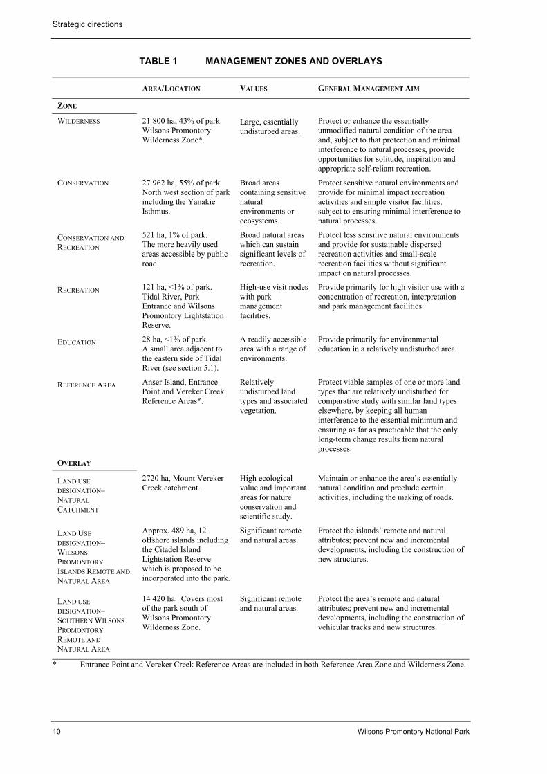
Six management zones apply to the park —Recreation, Conservation and Recreation,Conservation, Education, Wilderness, andReference Area.
Three overlays are used to summariserequirements additional to those of the
Strategic directions
8 Wilsons Promontory National Park
underlying primary management zones. OneLand Use Designation–Natural Catchment andtwo Land Use Designation–Remote andNatural Area overlays apply (one of whichcovers the Remote and Natural Area proposedfor the southern section of the park). Until thelegislative amendments are made, themanagement of this proposed Remote andNatural Area will be managed with the LCC’sobjectives and management principles relatingto Remote and Natural Areas on Schedule Sixof the National Parks Act.
Zone and overlay characteristics are given intable 1. Boundaries of the Recreation Zone aregiven in figure 4.
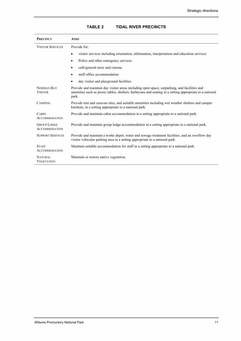
For the Tidal River Recreation Zone, a schemaof precincts has been prepared to provide abasic framework for guiding the resolution ofmanagement issues relating to the largeconcentration of interrelated visitor andmanagement activities. Existing arrangementsare shown in figure 5A and the proposedschema of precincts is shown in table 2 andfigure 5B. The schema of precincts is basedon a geographic separation of functions andresponds to the various natural, cultural,functional and operational imperatives formanagement.
3.3 Management directionsMajor management directions for the park areoutlined below.
Resource conservation• A detailed Environmental Action Plan
(EAP) for the park will be completed toaddress management of the park as a totalecological system.
• The EAP will include a program for theprotection and enhancement of the park’snatural values through the management ofcurrent and potential risks, including fireand pest plants and animals.
• The EAP will include the use of ecologicalprinciples in the management of fire in thepark for both resource conservation andpark protection purposes.
• The viability of the park’s heathland anddiversity of the grassy woodlands will berestored.
• A comprehensive program of pest plant andanimal control will continue to beimplemented to minimise impacts on nativeflora and fauna.
• Sites of significance to the Aboriginalcommunity will be identified and mappedto assist in minimising disturbance to thesesites.
• Significant historic places such as theWilsons Promontory Lightstation will beconserved and interpreted to help visitorsappreciate and protect the culturalsignificance of the park.
• Apiculture will be phased out in the park.
• Unnecessary vehicle tracks will berehabilitated to minimise soil erosion andvisual impacts.
• Wilsons Promontory National Park is beinginvestigated for possible World Heritagelisting.
• All visitors will be encouraged to adoptminimal impact behaviour and to adhere tocodes of conduct appropriate to theiractivities.
The park visit• The park will be promoted as one of a
number of the Phillip Island and GippslandDiscovery Tourism Region’s places to visitand stay, and managed to ensure a qualityvisitor experience in a national park.
• Opportunities will be provided for visitorsto experience the park’s special qualities atthe same time as its remote and largelyundeveloped nature are retained.
• Facilities at the entrance to the park will beredesigned and upgraded to provide anappropriate Park Entrance and an enhanced‘sense of arrival’ and improved visitororientation.
• The amenity of the Tidal River RecreationZone will be improved and the Zonemanaged consistent with its profile as thekey visitor destination within the park.
• Passive recreation activities will beencouraged around the Wilsons PromontoryLightstation, consistent with its remotesetting.
Strategic directions
Wilsons Promontory National Park 9
• Long-distance walking opportunities willbe provided on the existing trail network.Enhanced management of the WildernessZone, including rehabilitation ofunnecessary vehicle tracks, removal ofsome facilities and sensitive firemanagement, will provide a more remoteand challenging experience for visitors.
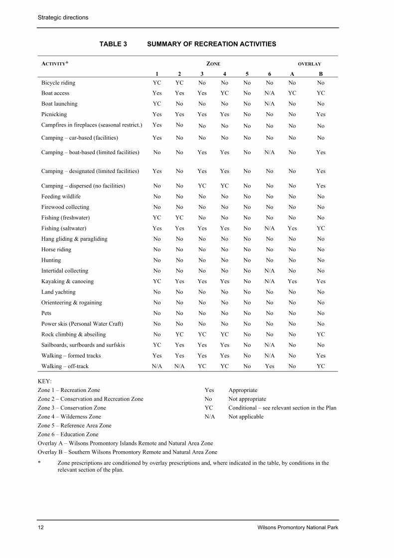
• Recreation activities will be permitted asshown in table 3.
• Licensed tour operators will continue to beencouraged to offer a range of minimal-impact recreational activities consistentwith aims for the park.
Community awareness and involvement• An Interpretation and Education strategy
will be implemented in the park.
• A cultural heritage program for the parkwill be developed in conjunction with theAboriginal community including thetraditional owners.
• Input to regional tourism strategies will beprovided to encourage additional products,services and accommodation in the region,to lessen the pressure on park facilities and
give visitors to the region a wider range ofexperiences.
• Current market surveys on visitor profiles,patterns of behaviour, expectations andpreferences will be applied to assist in parkmanagement.
Other• A Centre of Excellence for Park
Management program for research,monitoring and teaching park managementwill be established, building on the park’sdesignation as a UNESCO BiosphereReserve and focusing on the park and itssurrounding marine and coastal parks andreserves.
• The Centre of Excellence for ParkManagement program will be based on theexisting Education Centre, BotanyLaboratory and Yanakie Research Station.
• Support services and infrastructure formanaging the park will be concentratedwithin the Tidal River Recreation Zone.
• A study of the social and economic benefitsof the park to the State and region will beundertaken.
Strategic directions
10 Wilsons Promontory National Park
TABLE 1 MANAGEMENT ZONES AND OVERLAYS
AREA/LOCATION VALUES GENERAL MANAGEMENT AIM
ZONE
WILDERNESS 21 800 ha, 43% of park.Wilsons PromontoryWilderness Zone*.
Large, essentiallyundisturbed areas.
Protect or enhance the essentiallyunmodified natural condition of the areaand, subject to that protection and minimalinterference to natural processes, provideopportunities for solitude, inspiration andappropriate self-reliant recreation.
CONSERVATION 27 962 ha, 55% of park.North west section of parkincluding the YanakieIsthmus.
Broad areascontaining sensitivenaturalenvironments orecosystems.
Protect sensitive natural environments andprovide for minimal impact recreationactivities and simple visitor facilities,subject to ensuring minimal interference tonatural processes.
CONSERVATION ANDRECREATION
521 ha, 1% of park.The more heavily usedareas accessible by publicroad.
Broad natural areaswhich can sustainsignificant levels ofrecreation.
Protect less sensitive natural environmentsand provide for sustainable dispersedrecreation activities and small-scalerecreation facilities without significantimpact on natural processes.
RECREATION 121 ha, <1% of park.Tidal River, ParkEntrance and WilsonsPromontory LightstationReserve.
High-use visit nodeswith parkmanagementfacilities.
Provide primarily for high visitor use with aconcentration of recreation, interpretationand park management facilities.
EDUCATION 28 ha, <1% of park.A small area adjacent tothe eastern side of TidalRiver (see section 5.1).
A readily accessiblearea with a range ofenvironments.
Provide primarily for environmentaleducation in a relatively undisturbed area.
REFERENCE AREA Anser Island, EntrancePoint and Vereker CreekReference Areas*.
Relativelyundisturbed landtypes and associatedvegetation.
Protect viable samples of one or more landtypes that are relatively undisturbed forcomparative study with similar land typeselsewhere, by keeping all humaninterference to the essential minimum andensuring as far as practicable that the onlylong-term change results from naturalprocesses.
OVERLAY
LAND USEDESIGNATION–NATURALCATCHMENT
2720 ha, Mount VerekerCreek catchment.
High ecologicalvalue and importantareas for natureconservation andscientific study.
Maintain or enhance the area’s essentiallynatural condition and preclude certainactivities, including the making of roads.
LAND USEDESIGNATION–WILSONSPROMONTORYISLANDS REMOTE ANDNATURAL AREA
Approx. 489 ha, 12offshore islands includingthe Citadel IslandLightstation Reservewhich is proposed to beincorporated into the park.
Significant remoteand natural areas.
Protect the islands’ remote and naturalattributes; prevent new and incrementaldevelopments, including the construction ofnew structures.
LAND USEDESIGNATION–SOUTHERN WILSONSPROMONTORYREMOTE ANDNATURAL AREA
14 420 ha. Covers mostof the park south ofWilsons PromontoryWilderness Zone.
Significant remoteand natural areas.
Protect the area’s remote and naturalattributes; prevent new and incrementaldevelopments, including the construction ofvehicular tracks and new structures.
* Entrance Point and Vereker Creek Reference Areas are included in both Reference Area Zone and Wilderness Zone.
Strategic directions
Wilsons Promontory National Park 11
TABLE 2 TIDAL RIVER PRECINCTS
PRECINCT AIMS
VISITOR SERVICES Provide for:
• visitor services including orientation, information, interpretation and education services
• Police and other emergency services
• café/general store and cinema
• staff office accommodation
• day visitor and playground facilities.
NORMAN BAYVISITOR
Provide and maintain day visitor areas including open space, carparking, and facilities andamenities such as picnic tables, shelters, barbecues and seating in a setting appropriate to a nationalpark.
CAMPING Provide tent and caravan sites, and suitable amenities including wet weather shelters and camperkitchens, in a setting appropriate to a national park.
CABINACCOMMODATION
Provide and maintain cabin accommodation in a setting appropriate to a national park.
GROUP LODGEACCOMMODATION
Provide and maintain group lodge accommodation in a setting appropriate to a national park.
SUPPORT SERVICES Provide and maintain a works depot, water and sewage treatment facilities, and an overflow dayvisitor vehicular parking area in a setting appropriate to a national park.
STAFFACCOMMODATION
Maintain suitable accommodation for staff in a setting appropriate to a national park.
NATURALVEGETATION
Maintain or restore native vegetation.
Strategic directions
12 Wilsons Promontory National Park
TABLE 3 SUMMARY OF RECREATION ACTIVITIES
ACTIVITY* ZONE OVERLAY
1 2 3 4 5 6 A BBicycle riding YC YC No No No No No No
Boat access Yes Yes Yes YC No N/A YC YC
Boat launching YC No No No No N/A No No
Picnicking Yes Yes Yes Yes No No No Yes
Campfires in fireplaces (seasonal restrict.) Yes No No No No No No No
Camping – car-based (facilities) Yes No No No No No No No
Camping – boat-based (limited facilities) No No Yes Yes No N/A No Yes
Camping – designated (limited facilities) Yes No Yes Yes No No No Yes
Camping – dispersed (no facilities) No No YC YC No No No Yes
Feeding wildlife No No No No No No No No
Firewood collecting No No No No No No No No
Fishing (freshwater) YC YC No No No No No No
Fishing (saltwater) Yes Yes Yes Yes No N/A Yes YC
Hang gliding & paragliding No No No No No No No No
Horse riding No No No No No No No No
Hunting No No No No No No No No
Intertidal collecting No No No No No N/A No No
Kayaking & canoeing YC Yes Yes Yes No N/A Yes Yes
Land yachting No No No No No No No No
Orienteering & rogaining No No No No No No No No
Pets No No No No No No No No
Power skis (Personal Water Craft) No No No No No No No No
Rock climbing & abseiling No YC YC YC No No No YC
Sailboards, surfboards and surfskis YC Yes Yes Yes No N/A No No
Walking – formed tracks Yes Yes Yes Yes No N/A No Yes
Walking – off-track N/A N/A YC YC No Yes No YC
KEY:Zone 1 – Recreation Zone Yes AppropriateZone 2 – Conservation and Recreation Zone No Not appropriateZone 3 – Conservation Zone YC Conditional – see relevant section in the PlanZone 4 – Wilderness Zone N/A Not applicableZone 5 – Reference Area ZoneZone 6 – Education ZoneOverlay A – Wilsons Promontory Islands Remote and Natural Area ZoneOverlay B – Southern Wilsons Promontory Remote and Natural Area Zone
* Zone prescriptions are conditioned by overlay prescriptions and, where indicated in the table, by conditions in therelevant section of the plan.
Wilsons Promontory National Park 13
4 STRATEGIES FOR CONSERVATION
4.1 Geological and landformfeatures
Wilsons Promontory has a variety ofgeological and landform features of nationalgeological and geomorphological significance.There are nine individual sites within the parkof State or regional significance, includingDarby, Squeaky and Five Mile Beaches, GreatGlennie and Cleft Islands, and ChinamanCreek Delta (Buckley n.d.).
The promontory represents the northern end ofa large granite mass which extends tonortheastern Tasmania (Wallis 1980). Erosionof the granitic massif has produced thespectacularly rugged landscape seen today.The Yanakie Isthmus, connecting the graniticpromontory to the mainland, consists of marineand non-marine sediments and dune deposits(LCC 1980).
Coastal features include expansive intertidalmudflats, sandy beaches and sheltered covesinterrupted by prominent headlands andplunging granite cliffs in the south, backed bycoastal dunes and swamps.
The dune system at Entrance Point is asignificant and undisturbed example of dunesuccession and has been proclaimed aReference Area (LCC 1982). Access to thisarea is prohibited except in accordance withMinisterial directives for the management ofreference areas.
In the intertidal zone adjoining Corner Inlet,large areas of highly productive tidal mudflatare exposed at low tide. Corner Inlet containsinternationally important habitat for migratorywading birds (NRE 1996a).
The soils of Wilsons Promontory have higherosion potential. This must be considered inday-to-day management and planning of futuredevelopments (section 4.8).
Aims• Provide for the preservation, protection
and study of features of geological andgeomorphological interest.
• Provide for the maintenance of naturalsystems and processes in their undisturbedstate where possible, and minimise impacts
by management and visitors on significantgeological and landform features.
• Educate visitors about geological andlandform features, and interpret thephysical environment to improve visitors’appreciation.
Management strategies• Manage the Reference Areas in
accordance with Ministerial directives forthe management of reference areas.
• Maintain and update records of sites ofgeological and landform significance asnew information becomes available.
• Provide interpretive and educationalmaterials which promote the appreciationby visitors of significant geological andlandform features and which foster theirprotection.
• Monitor the condition of, and manage,sites of geological and landformsignificance so that human-inducedimpacts are minimised.
4.2 Rivers and catchmentsWilsons Promontory is significant because it isone of the few areas in Victoria where therivers and streams are largely unmodified bydrainage and engineering works and free ofintroduced fish and aquatic weed species. Therivers and streams are of high scientificimportance. About half of the 40 knownspecies of native freshwater fish in Victoriaoccur at Wilsons Promontory (Jackson &Davies 1983).
Located within the Wilderness Zone is theMount Vereker Creek Natural CatchmentArea. The provisions of the Heritage RiversAct prohibit certain resource uses, and most ofthe catchment is also protected in the VerekerCreek Reference Area Zone.
Tidal River stream provides all the water forthe settlement at Tidal River. Water isextracted from a weir upstream of thePromontory Road bridge. The aquatic habitatvalues of the Tidal River stream are very highdue to minimal disturbance of the catchmentand stream environment.
Strategies for conservation
14 Wilsons Promontory National Park
A fish ladder installed in the water supply weiron Tidal River stream facilitates the movementof fish along the river.
Part of the water supply to the Lightstation andthe campsites away from Tidal River is takendirectly from nearby streams. It is vital thatthe water quality of these sources ismaintained.
The effluent pond at Tidal River is located inan area of permeable soils and seepage hasbeen detected. Recent groundwaterinvestigations around the effluent pondsindicate that the seepage generally travelssouthwest toward Norman Bay. The quality ofgroundwater sampled at this location isconsistent with contamination of groundwaterby wastewater (Golder 1998).
Recreational fishing is addressed in section5.9.
Aims• Maintain the integrity and good condition
of the park’s catchments, rivers andstreams, including the absence ofintroduced fish and aquatic flora species.
• Maintain the entire Mount Vereker CreekNatural Catchment Area in an essentiallynatural condition.
• Minimise the effects of developments,management and visitors’ activities onwater quality.
• Protect and maintain the quality of thepark’s rivers, streams and catchments usedfor water supply.
Management strategies• Design, construct and maintain roads,
tracks, structures or facilities withconsideration of the potential effects oncatchment and habitat quality such asincreased siltation and turbidity, and toavoid compromising sites of specialconservation significance.
• Monitor the quality and condition of riversand streams within the park. Ensure thatthe rivers and streams of the park remainfree from introduced fish and aquatic floraspecies.
Mt Vereker Creek Natural Catchment:
• Manage the Mount Vereker Creek NaturalCatchment Area in accordance with amanagement plan prepared under theHeritage Rivers Act.
• Prepare and implement baseline datacollection and monitoring programs forthe Mount Vereker Creek NaturalCatchment Area. Monitor stream ecologyand water quality.
• Include the Mount Vereker Creek NaturalCatchment Area in flora and faunamonitoring programs within the park.
• Use least-disturbance fire suppressionstrategies such as fireline constructionusing hand crews, and air attack, whereverpracticable in the Mount Vereker CreekNatural Catchment.
• Assess introduced plant and animalproblems in the Mount Vereker CreekNatural Catchment and undertake controlin the context of broader parkmanagement. Ensure control methods donot impact on the catchment.
• Monitor for the presence of Myrtle Wilt inthe Mount Vereker Creek NaturalCatchment and take appropriate action.
• Ensure strict hygiene requirements areimplemented for anyone entering theMount Vereker Creek Natural Catchmentto prevent the transport of non-indigenousplant propagules or pathogens.
Tidal River catchment:
• Manage the Tidal River catchment toensure that environmental and essentialwater supply values are not compromised.
• Maintain existing flow regime and waterquality in the Tidal River stream andprovide for fish movement both upstreamand downstream.
• Install stream gauges and investigate therequirement for the provision ofenvironmental flows in the Tidal Riverstream.
• Finalise and implement the wastewatermanagement strategy developed inconsultation with the EPA, includingconstruction of appropriate waste-watertreatment and discharge facilities.
Strategies for conservation
Wilsons Promontory National Park 15
4.3 VegetationWilsons Promontory National Park has adiverse range of vegetation and is extremelyrich in terrestrial flora, with more than 740native vascular plant species present (LCC1980). More than 100 threatened species havebeen recorded in the park. A list of threatenedflora species recorded for the park and theirstatus is shown in appendix 1.
Significant vegetation communities include:
• southernmost examples of warm temperaterainforests of Lilly Pilly and Blackwood atlow altitude, and Sassafras replacing LillyPilly above 300 m;
• cool temperate rainforest dominated byMyrtle Beech with ferny understorey inmoist sheltered gullies;
• open forest containing stands of MountainAsh, Messmate, Brown and YellowStringybarks and Shining Peppermint,which frequently hybridise, producinginteresting variations in growthcharacteristics;
• stands of White Mangrove, which are thesouthernmost occurrence of mangroves inthe world;
• an example of coastal succession showingsuccessional stages from bare dunes towoodland in the Entrance Point ReferenceArea;
• heathlands that are floristically rich andprovide habitat for a variety of fauna,including threatened species;
• occurrence of coastal grassy woodlands onthe Yanakie Isthmus and Entrance Point,and at Oberon Bay.
Extensive areas of heath occur to the north ofthe Five Mile Road, at Darby Swamp and onthe lower slopes of Mt Leonard. Thecomposition and structure of thesecommunities are influenced to a large degreeby the frequency and intensity of fire.European practices of fire prevention andsuppression have significantly altered the fireregimes with which heath species haveevolved and to which they have adapted. Fire-sensitive species such as White Kunzea andCoast Tea-tree have invaded heathcommunities at a range of locations, includingWhisky and Squeaky Beaches, as a result of
the altered fire regimes. Extensive areas ofheath within the park are long unburnt andovermature.
Research indicates that implementation ofappropriate fire regimes can improve thevigour and viability of these communities andtheir associated fauna, and reduce theincidence of woody weed invasion.
Coastal grassy woodlands occur within thepark at Oberon Bay, Entrance Point and on theYanakie Isthmus. Significant changes haveoccurred to the floristics, structure and healthof these communities due to changes to thegrazing and burning regimes, in particular aprogressive increase in grazing pressure since1850 and the exclusion of fire from the early1970s after a history of regular burning.Today, large areas of this community atOberon Bay, Entrance Point and on theYanakie Isthmus are characterised by densestands of Coast Tea-tree shrubs. On theYanakie Isthmus only the slashed interdunecorridors and some of the higher dunes retainthe floristics and/or structure of the community(University of Ballarat 1999).
Grazing pressure from rabbits, kangaroos, andwombats has had an impact on the condition ofgrassy woodlands on the Yanakie Isthmus.This has resulted in a decline in the cover andabundance of some native grass species andreduced flowering and seeding. Some controlof the numbers of grazing animals may berequired.
An area around the airstrip has beenmaintained as an artificial grassland by grazingand browsing rather than being allowed toreturn to the grassy woodland which existedbefore clearing for the airstrip in 1938. Cattleagistment ceased in 1992 and this has allowedthe regeneration of shrubs, particularly CoastWattle. The closed scrub that will developwithout intervention will reduce the habitatavailable for the resident population of EasternGrey Kangaroos.
It is desirable to maintain an area for the publicto view wildlife in the airstrip area and to re-establish the grassy woodland before theemerging shrubland makes achievement ofthese objectives too difficult.
Other threats to the vegetation communities ofthe park include weed invasion, over-grazingby native and non-native herbivores,
Strategies for conservation
16 Wilsons Promontory National Park
inappropriate fire regimes and the spread ofpathogens.
An Environmental Action Plan is beingdeveloped for the park. Much of thebackground information for this plan comesfrom the draft Conservation Strategy(Chesterfield & Whelan 1995a; 1995b). Thiswas developed to introduce ecologicalprinciples to be used in the management offire, and to set out prescriptions for theconservation of native flora and fauna and themanagement of pest plants and animals.
Aims• Manage ecosystems to ensure the
preservation and protection of indigenousflora and vegetation communities,particularly significant species andcommunities.
• Provide for scientific investigation thatrelates to the conservation of, and involvesminimal disturbance to, the naturalenvironment.
• Interpret the natural environment and itsmanagement to increase visitors’appreciation and support for theseprograms.
Management strategies• Complete and implement a comprehensive
Environmental Action Plan for the park.
• Maintain or restore the structure anddiversity of vegetation communities andspecies in accordance with the proposedEnvironmental Action Plan.
• Prepare and implement a prescribedburning plan based on appropriate fireregimes for maintaining the vigour anddiversity of the park’s biota, and consistentwith Parks Victoria operational policies.
• Investigate management options for therestoration of the grassy woodlands on theYanakie Isthmus.
• Encourage surveys of, and research into,significant flora (including threatenedspecies) and vegetation communities in thepark to improve knowledge of theirmanagement requirements.
• Manage species listed in the Flora andFauna Guarantee Act 1988 (Vic.) listed
flora species and vegetation communitiesin accordance with approved actionstatements (appendix 1).
• Use indigenous species of localprovenance in all rehabilitation works.
• Revegetate disturbed areas within theTidal River Recreation Zone withindigenous plant species, and regeneratecampground vegetation in line with fireprotection requirements.
4.4 FaunaThe park contains a wide range of habitat typeswhich support more than 296 species of fauna,including over 40 threatened species. Thereare several sites of zoological significance. Alist of threatened fauna species recorded for thepark and their status is shown in appendix 2.
Significant features include:
• one of the most significant sites for theNew Holland Mouse in Victoria;
• the presence of populations of the Long-nosed Potoroo, Swamp Antechinus, White-footed Dunnart, Broad-toothed Rat, NewHolland Mouse, Feathertail Glider andEastern Pygmy-possum;
• about half of the known Victorian speciesof native freshwater fish (section 4.2);
• records of over 30 species of nativemammals — one-third of all Victorianspecies.
A number of species of whale are regularlysighted in waters adjoining the park or foundwashed up on beaches.
The avifauna recorded for Wilsons Promontoryincludes around half of all Victorian birdspecies. Significant species of migratorywading birds feed on the tidal mudflats ofCorner Inlet within and adjoining the park.The offshore islands have breeding androosting sites for sea birds, including a largenumber of Short-tailed Shearwaters.
Reptiles and amphibians so far recorded in thepark comprise 13 lizard, 3 snake and 10 frogspecies. Of these, the most significant are theSwamp Skink, Spencer’s Skink and LaceMonitor.
Populations of the vulnerable DamselflyHemiphlebia mirabilis, a ‘living fossil’, are
Strategies for conservation
Wilsons Promontory National Park 17
found around freshwater swamps and lagoonswithin the park.
In certain areas, populations of commongrazing species such as Eastern GreyKangaroos and Common Wombats are veryhigh, leading to severe grazing pressures.Populations will need to be monitored andsome control may be required.
The airstrip area is popular for viewingwildlife, particularly Eastern Grey Kangaroos,Common Wombats and Emus.
The draft Conservation Strategy (Chesterfield& Whelan 1995a; 1995b) makes a number ofrecommendations on fauna management whichwill be incorporated into the EnvironmentalAction Plan currently under development forthe park.
Fauna surveys have failed to establish theexistence of a number of animals that historicalrecords indicate were originally part of thepark’s ecosystems. These include the Spot-tailed Quoll, Eastern Quoll, TasmanianPademelon, Dingo and Platypus.
Their demise may be the result of habitatchanges, inappropriate fire regimes,displacement by feral animals or hunting. Ifthese conditions can be corrected, re-introduction may be possible.
Offshore islands protect important habitat,including breeding sites for a number of sea-bird species and fur seals. Public access to allislands, except for beach areas on Doughboy,Bennison, Rabbit and Great Glennie Islands, isprohibited for this reason.
Artificial feeding of native wildlife has anadverse effect on the animals and can bedangerous to visitors.
A considerable number of animals are killedby motor vehicles on the Wilsons PromontoryRoad. In addition to the loss and suffering ofwildlife, the level of road kill detractssignificantly from visitors’ experience intransit through the park. The ability to easilyview wildlife should be promoted as a majorvalue of the park, and management measuresshould be investigated to establish a balancebetween protecting animals and facilitatingaccess for their viewing.
Recreational fishing and monitoring of fishpopulations are addressed in section 5.9.
Aims• Ensure the preservation and protection of
indigenous fauna, including intertidalorganisms and native fish.
• Manage ecosystems to provide for the long-term protection and preservation ofsignificant communities, habitats, andspecies.
• Provide for scientific investigation relatingto the conservation of fauna and theirhabitat.
• Educate visitors and the general public andinterpret the natural environment toimprove people’s appreciation of it and itsconservation.
Management strategies• Implement biological management actions
and relevant results of research for theprotection and preservation of fauna,particularly significant species and theirhabitats.
• Manage Flora and Fauna Guarantee Actlisted fauna species in accordance withapproved action statements (appendix 2).
• Assess the impact of grazing by native andintroduced herbivores (particularlyEastern Grey Kangaroos) on park values.Manage the population where required tomeet environmental managementobjectives for the park.
• Investigate the accuracy of historic faunarecords and consider the desirability /feasibility of re-introducing any locallyextinct indigenous species.
• Continue to prohibit public access to allislands, except for beach areas onDoughboy, Bennison, Rabbit and GreatGlennie Islands.
• Discourage the feeding of wildlife byeducation of visitors.
• Consider the introduction of further speedrestrictions in specific areas, or at specifictimes, when animals are most vulnerableand road kill rates are high.
• Manage a portion of the airstrip area ashabitat for Eastern Grey Kangaroos,Common Wombats and Emus specificallyto allow viewing opportunities for visitors.
Strategies for conservation
18 Wilsons Promontory National Park
Provide safe observation areas witheducation and interpretation informationto manage visitors' access and encourageappropriate behaviour.
• Manage bird habitat in the sewerage areaof the Tidal River Recreation Zone toprovide viewing opportunities.
4.5 LandscapeThe natural splendour of the WilsonsPromontory landscape is a major attraction forvisitors both to the park and to SouthGippsland. Spectacular views of a range ofland and seascapes are available from manyvantage points within the park, and also fromland and sea outside the park. The naturalsetting of Tidal River is a major part of itsappeal to visitors.
Visual intrusions into the naturalness of thepark’s landscape include the Five Mile Road(section 7.3) and the navigational beacon atLighthouse Point in the Wilderness Zone(section 7.4), the airstrip area (sections 4.3 and4.4), disused gravel extraction pits (section4.8) and the telecommunications tower onMount Oberon (section 7.4).
The existing developments within the TidalRiver Recreation Zone are visible from keyviewing points such as Mt Oberon and TidalOverlook but negative impacts have generallybeen minimised by retaining and plantingvegetation. Several specific elements, such asstreetlight stanchions and some individualbuildings, are visually intrusive.
Intensive summer camping has impacted onthe quality of vegetation in the camping area.The development of appropriate and consistentlandscape styles and materials will assist increating a unified character for the site.
Aims• Protect the natural landscapes of the park.
• Minimise visual impacts on the naturallandscape, especially from major viewingpoints.
• Where possible rehabilitate, remove orameliorate undesirable visual intrusions.
• Minimise the visual intrusion ofinfrastructure at Tidal River.
Management strategies• Formalise and maintain the existing scenic
viewing points along the WilsonsPromontory Road.
• Rehabilitate disused gravel extraction pitsalong the Wilsons Promontory Road, andcomplete work on rehabilitation of theMount Oberon Road quarry site. Subjectto resolution of fire management issues,reduce visual impact of the Five MileRoad.
Tidal River Recreation Zone:
• Redesign Norman Bay carpark to softenthe visual impact from Mt Oberon andenhance landscape elements. The newdesign should include linkages withpedestrian open space, and improvedvisitor amenities such as picnic tables,shelters, barbecues and seating.
• Prepare detailed planting schemes for thevarious precincts within Tidal River whichreinforce naturally occurring species, inline with activities and uses of the site.
• With the exception of lawn areas, utiliselocally collected seed and cuttings forrevegetation works within Tidal River.
• Improve natural drainage patterns of thesite through creation of drainage swales.
• Regrade campsites where appropriate, andestablish lawn grasses that do not have thepotential to become environmental weeds.
• Supplement existing tree growth incampgrounds to improve definition of sitesand visual amenity.
• Ensure that all hard landscape elementsare designed to comply with contemporarydesign standards including Australianstandards and codes regarding access,safety, design, durability andenvironmental impact as outlined in ParksVictoria’s Facility Design Manual.
• Ensure that design of hard landscapeelements is simple and that the naturalcharacter of vegetation and site ispreserved.
• Progressively remove existingstreetlighting and replace with lessobtrusive lighting.
Strategies for conservation
Wilsons Promontory National Park 19
• Treat existing buildings and infrastructurewhere possible to reduce the visual impactfrom the Lilly Pilly Link Track, Mt Bishop,Mt Oberon and Tidal Overlook.
• Restrict infrastructure works to existingcleared and disturbed areas wherepossible.
• Prevent pedestrian traffic access throughremnant vegetation.
4.6 Fire managementThe frequency and intensity of fires influencethe composition and structure of vegetationcommunities to a large degree. Appropriatefire regimes can promote the long-termviability of vegetation communities and theirassociated fauna, and reduce the incidence ofinvasive species. There is an increasing bodyof research on flora and fauna responses to fireand appropriate ecological fire regimes tosustain natural ecosystems.
The fire history of the park indicates a moreextensive and intense fire regime sinceEuropean settlement. There were major firesin 1908, 1913, 1939 and 1951. Frequent firesin the open forests, grassy woodlands andheaths of the northern part of the park were afeature of cattle agistment up to 1969. Afterthe fire of 1951, which burnt 75% of the park,burning on the isthmus was discouraged. Firewas largely absent from the park between 1951and 1972, when a program of fuel reductionburning based around the Five Mile Roadcommenced. Burning for ecological purposescommenced on the Yanakie Isthmus in 1987and has since been extended to the heathlandsof the park.
The aggressive wildfire suppression operationsand infrequent fuel reduction burning from1951 to 1987 have significantly altered thenatural fire regimes of the park, leading to afuel build-up and vegetation communitychanges which are of concern. The next largewildfire is likely to be intense and difficult tocontrol.
The Department of Natural Resources andEnvironment is required to undertake properand sufficient fire prevention and suppressionworks in national parks under the Forests Act1958 (Vic.) and prevent injury by fire to thepark under the National Parks Act.
Parks Victoria’s operational policy for firemanagement in parks and reserves requiresthat fire be managed in accordance with theGippsland Fire Protection Plan (NRE 1999),the Code of Practice for Fire Management onPublic Land (CNR 1995b) and local fire plans.
The Code of Practice for Fire Management onPublic Land requires that fire managementactivities follow a balanced approach to ensurethat assets and values are protected andenvironmental values, including the vigour anddiversity of the State’s indigenous flora, areprotected, as far as is practicable, from thedeleterious effects of wildfire andinappropriate fire regimes.
The Gippsland Region Fire Protection Planclassifies the majority of the park as FuelManagement Zone (FMZ) 4 – Flora and FaunaManagement. There are also smaller areasclassified FMZ 3 — Broad Area Fuel ReducedMosaic and FMZ 5 – Not Planned to be burnt(which includes two reference areas). As aconsequence of the fuel management zoning,most of the prescribed burning in the park isconducted primarily for ecological reasonsrather than for fuel reduction purposes.
The challenge in managing fire lies inachieving a balance between protection ofecological values and biodiversity, andprotection of people and built assets. Toachieve objectives for natural values, it isessential to match fire regimes to the vitalattributes of the key species in each EcologicalVegetation Class, in accordance with ParksVictoria’s operational policies and the InterimGuidelines and Procedures for EcologicalBurning on Public Land in Victoria (NRE1999). Burning for ecological purposes canalso provide some asset protection.
General operational procedures for respondingto wildfire are outlined in the GippslandReadiness and Response Plan, updated eachyear, and more specific information iscontained in the Yarram District FireSuppression Plan (NRE 2000). Operationalprocedures for responding to wildfire in thepark are detailed in the Gippsland FireProtection Plan (NRE 1999) and the DraftWilsons Promontory National Park FireSuppression Plan (CNR 1996).
Fire management in the Wilderness Zonerequires balancing suppression objectives withmaintaining wilderness values.
Strategies for conservation
20 Wilsons Promontory National Park
There are large areas of the park where it is notfeasible to construct mineral earth fire controllines mechanically because of the steep terrain,or not appropriate because of the damagecaused to natural values.
Because of generally low fuel levels, thefacilities at Tidal River are unlikely to sustainan intense wildfire originating from within theaccommodation area. However, visitorstravelling to and from the campground couldbe at risk from wildfire.
Helipads are used for fire control and searchand rescue operations. These helipads will bemaintained as necessary for fire protection andvisitor safety.
Aims• Protect life and property and park values
from injury by fire.
• Suppress wildfires in a manner appropriateto seasonal conditions, with the objective ofminimising impacts on park values.
• Lessen the possibility of an extensive andintense fire in the park.
• Sustain the vigour, diversity andsuccessional development of the park’splant and animal communities by ecologicalburning on the basis of current and futureresearch findings.
Management strategies• Ensure that ecological burning and
burning for fire protection reflectappropriate fire regimes and meetecological objectives.
• Reduce fuel levels in areas of the park tothe north of Tidal River, north of MtWilson and south of Five Mile Road, basedon sound ecological principles.
• Undertake prescribed burning ofheathland communities in the park tomaintain ecological diversity.
• Reduce slashing programs for fireprotection as the prescribed burningprogram increases.
• Allow wildfires to burn out to natural fireboundaries where this meets ecologicalobjectives and where the fire-controllerdeems the forecast weather conditions tobe suitable.
• Monitor naturally occurring fires onislands, and where appropriate permitthem to run their natural course.
• Maintain low fuel levels through slashingand burning in and around Tidal River asprotection against severe wildfire.
• Ensure that park staff and fire crews areadequately trained in coastal wildernessfire management and suppression.
• Evaluate the effectiveness of the responseand the impact on park values followingfire incidents.
• Prepare and implement rehabilitationplans as appropriate followingsuppression activities.
4.7 Pest plants and animals, anddiseases
Control strategies for pest plants and animalsand diseases identified in the EnvironmentalAction Plan currently under development willinform management of pest species and plantdiseases in the park. Control methods thathave minimal impact on park values will beused in the control of pest species. Prioritywill be given to controlling pest species thatpose significant threats to native flora andfauna.
Ragwort, Fleabane, Sea Spurge and thistles arethe weeds in the park of most concern. Effortswill be directed at containing and controllingthese widespread species where suitablecontrol methods are available. Othersignificant introduced weeds that are presentwithin the park include Twiggy Mullein,Oxeye Daisy, Hemlock, Arum Lily,Blackberry and Dolichos Pea. Efforts will bedirected at eliminating these species from thepark.
The Keith Turnbull Research Institute hasmade trial releases of the Plume Moth, CrownBoring Moth, Cinnabar Moth and Flea Beetlesin the park to attempt biological control ofRagwort. Biological control agents generallydo not eradicate weeds but can reduce thespread and density of infestations, perhaps insome cases to levels where no additionalcontrol is necessary.
Weed infestations are mainly in areasdisturbed by past grazing or soil disturbanceassociated with road and track construction.
Strategies for conservation
Wilsons Promontory National Park 21
Infrastructure development at Tidal River hasresulted in the establishment of a substantialnumber of environmental weeds.
Foxes are present throughout the park,although they occur in low numbers due to theintensive baiting program undertaken since1993.
The distribution and number of rabbits withinthe park varies over time. Currently, rabbitnumbers are highest along the park boundarywith freehold land. Rabbit numbers on theYanakie Isthmus appear to be trendingdownwards. The decline in numbers is theresult of an integrated program involvingwarren ripping, baiting and trapping as well asrecurring outbreaks of myxomatosis. Rabbitsare also present in low numbers at Tidal River,Waterloo Bay and the Wilsons PromontoryLighthouse. Introduction of the RabbitCalicivirus has had little impact on rabbitpopulations in the park, and continuedapplication of conventional control methodswill be necessary.
Detailed programs have been developed andimplemented for the control of foxes (Keenan,Hoskins & Thomas 2000) and rabbits (Keenan2001). These programs have been successful,although there is considerable movement ofanimals across the park boundaries withadjacent freehold land.
The introduced Hog Deer is a protectedwildlife species under the provisions of theWildlife Act 1975 (Vic.), but its presence isincompatible with management principles,given that it is a non-indigenous species.Under Section 17 (2)(a)(iii) of the NationalParks Act the Secretary to the Department ofNatural Resources and Environment isrequired, insofar as is practicable andappropriate, to (among other things) eradicateor control non-indigenous fauna.
Colonies of feral European Honey Bees andEuropean Wasps are present in the park. Theypose a threat to visitors’ safety and may havean adverse impact on the ecology of the park.Apiculture is addressed in section 7.4.
Other introduced fauna known to occur in thepark include the Feral Cat, Feral Dog, BlackRat, House Mouse, Blackbird, House Sparrow,Spotted Turtle-done, Starling, Garden Snailand Sand Dune Snail. The extent of their
effects on the flora and fauna of WilsonsPromontory has not been quantified.
Cinnamon Fungus has been recorded at anumber of sites within the park. This pathogencan greatly reduce the viability of a range ofnative species and cause the death ofsusceptible species. The disease spreadsnaturally downhill with the movement of waterand soil. Spread of the disease has beenaccelerated by transportation of infected soiland gravel in track construction andinadvertently by bushwalkers and animals.
No practical and effective means are currentlyavailable to control the disease itself.Research has been undertaken into the use ofphosphonate to control spread of the disease.Current management aims to reduce the spreadof the pathogen by human activities.
A widespread decline of Coast Banksia on theYanakie Isthmus first became apparent in early1980; It progressed throughout the 1980s toaffect 1250 ha of the species area on theIsthmus by 1992 (Bennett 1993). Researchinto the cause of significant Coast Banksiadieback on the Yanakie Isthmus has beeninconclusive to date.
Aims• Eradicate or control pest plant and animal
species using methods which minimisedisturbance to natural systems and effectson park values.
• Restore native vegetation to areas whereweeds have been removed.
• Prevent the movement of pest plants andanimals across the park boundary.
Management strategies• Prepare and implement an integrated
program of monitoring and control forpest plant and animal species andpathogens. The priority will be to controlpest species that pose significant threats tonative flora and fauna.
• Continue to implement and monitor thesuccess of the rabbit and fox control plans.
• Consider construction of a vermin-prooffence along the park’s boundary withfreehold land.
Strategies for conservation
22 Wilsons Promontory National Park
• Eliminate concentrations of EuropeanWasps and feral Honey Bees.
• Evaluate the impact of Hog Deer on thepark. Implement appropriate controlstrategies to reduce or eliminate anydetrimental impacts.
• Assess the cultural significance ofdomestic plants within the WilsonsPromontory Lightstation area. Allow anyculturally significant plants to remain onlywhere there is no practical risk toenvironmental values.
• Rehabilitate areas that have beendisturbed by pest control and otheractivities, and minimise factors thatfacilitate invasion by pest species.
• Establish and implement quarantine andhygiene procedures for CinnammonFungus. Control off-track walking toreduce artificial spread of the pathogen.
• Map the current distribution ofCinnammon Fungus within the park.Monitor all known infestations todetermine the spread of the disease.
• Monitor Coast Banksia dieback, andsupport research into its cause.
• Continue to work with researchers onlong-term pest plant and animal controlmeasures.
• Control the invasion of weeds into theremnant vegetation and revegetation areaswithin the Tidal River Recreation Zone.
4.8 Soil conservationSignificant soil erosion and soil compactionhave occurred within areas of the park. Themost vulnerable areas tend to be along roadsand tracks, walking tracks, camping areas,coastal dunes and abandoned quarries.
These processes may occur in these areas forany of the following reasons: inadequatedesign, siting or construction of roads, tracks,and camping areas to cope with use;inappropriate visitor activities; lack of suitablerehabilitation (e.g. for gravel extraction areas);or natural causes (e.g. along the coastline).
Erosion can have long-term deleterious effectson stream quality through increasedsedimentation, and associated adverse impacts
on flora and fauna. Soil compaction can retardplant growth and cause increased runoff anderosion. Earthworks can facilitate the spreadof weeds and disease.
Aims• Prevent and control soil degradation caused
by visitor and management activities.
• Rehabilitate sites where soil degradationhas occurred.
Management strategies• Complete rehabilitation of the Mount
Oberon Road quarry site.
• Manage public access to beaches toprevent degradation of sand dunes, andrehabilitate sites where degradation hasoccurred. Give priority to the unstableareas where human impacts are mostsevere.
• Design and manage camping areas andaccess roads and tracks to prevent orreduce soil degradation.
• Consider potential environmental impactsduring planning for development,construction and maintenance works, andday-to-day management.
• Liaise with VicRoads on options formaintenance of roads and roadsides, andstabilisation and rehabilitation of landslips along the Wilsons Promontory Road.
• Monitor soil degradation andrehabilitation works to determine thesuccess of control measures.
• Investigate the likely pre-Europeancondition of vegetation within thedisturbed area at the park boundaryshared with the Wilsons PromontoryLightstation Reserve, and whereappropriate, revegetate.
4.9 Aboriginal cultural heritageWilsons Promontory National Park has anearly history of Aboriginal occupation datingback at least 6500 years. The area is highlysignificant to the Gunai–Kurnai and theBoonerwrung Clans and has strong spiritualconnections to both groups, who called itYiruk and Wamoon respectively. Descendantsof both groups have a strong affinity with the
Strategies for conservation
Wilsons Promontory National Park 23
place and are active in cultural heritagesurveys and site protection works.
There is significant evidence of Aboriginaloccupation along Cotters and Darby Beaches,in Picnic, Norman, Oberon and Miranda Bays,in the area between Johnny Souey Cove andThree Mile Beach, along the coastline betweenChinaman Long Beach and Entrance Point,and on offshore islands. The most commonsites are shell middens and artefact scatters.
Degradation by erosion and pillaging ofartefacts are major threats to the integrity ofcultural sites. Some sites will require activemanagement to ensure their protection. Manyother sites are rarely visited and, because oftheir location, site protection is not likely tobecome an issue.
All Aboriginal sites are protected under theArchaeological and Aboriginal RelicsPreservation Act 1972 (Vic.) and theAboriginal and Torres Strait Islander HeritageProtection Act 1984 (Cwlth). Issues relating tothe protection of such sites and theinvolvement of local Aboriginal communitiesare approached in accordance with thelegislation.
The Central Gippsland Aboriginal Health andHousing Co-operative Ltd has a key role in theprotection of Wilsons Promontory, inaccordance with Part 11A of the Aboriginaland Torres Strait Islander Heritage ProtectionAct.
Issues relating to Native Title are dealt with inaccordance with the Native Title Act 1993(Cwlth). An application for a Native Titledetermination, covering Wilsons PromontoryNational Park and the Wilsons PromontoryLightstation Reserves among other areas, wasregistered with the Native Title Tribunal on 17March 1997. Implementation of thismanagement plan will take into account theexistence of this and any subsequent nativetitle applications.
Aims• Protect, conserve and promote the park’s
cultural heritage. Protect features andplaces of archaeological significance, andAboriginal cultural or spiritual significancein consultation with the Aboriginalcommunity.
• Provide opportunities for people to learnabout and understand the cultural andspiritual significance of the park to theAboriginal community and traditionalowners.
Management strategies• Manage and protect Aboriginal cultural
sites in accordance with the provisions ofthe Archaeological and Aboriginal RelicsPreservation Act and Aboriginal andTorres Strait Islander Heritage ProtectionAct.
• Ensure that all management actions are inaccordance with the Native Title Act.
• Develop a cultural heritage program forthe park jointly with the Aboriginalcommunity and the traditional owners.
• Formalise a consultative process with theAboriginal community and the traditionalowners.
• Involve Aboriginal people in the deliveryof interpretive and education programs,particularly those involving Aboriginalculture, customs and history.
• Continue to support Aboriginal culturalactivities in the park.
• Identify and map features and places ofarchaeological significance to minimisedisturbance to these sites.
• Liaise with Aboriginal Affairs Victoria andco-operate with the Aboriginal communityand the traditional owners in theidentification, management and care ofsites of significance to their community.
• Protect recorded shell midden sites fromdevelopment and visitors’ impact, andmanage them in consultation with theAboriginal community and the traditionalowners.
• Discuss with various interest groupsoptions for relocating existing huts andcampsites from the midden site in the TidalRiver Recreation Zone.
• Record details of all Aboriginal culturalsites and, in consultation with AboriginalAffairs Victoria, remove evidence of non-Aboriginal modifications to sites which arehaving an adverse impact on the natural
Strategies for conservation
24 Wilsons Promontory National Park
environment and are not significant.Rehabilitate sites as necessary.
• Increase visitors’ awareness andunderstanding of the Aboriginal culturaland spiritual significance of the parkthrough appropriate signage andinterpretive material developed inconsultation with the Aboriginalcommunity.
4.10 Post-settlement cultural heritageWilsons Promontory has a long history ofcommercial resource and recreational usedating back to the early 1800s. As a result,many historic and cultural features ofsignificance to the non-Aboriginal communityare present in the park and adjoining waters.
The first recorded European sighting ofWilsons Promontory was by George Bass in1798, who named the area ‘WilsonsPromontory’ in honour of Thomas Wilson, aLondon friend of Matthew Flinders.
Commencing in 1803, sealers and whalersworked along the coast, exterminating two sealpopulations in the surrounding waters within30 years. Timber milling occurred at SealersCove during the 1850s and 1860s, and goldwas mined at Mount Singapore for a briefperiod during the 1860s.
The Wilsons Promontory Lightstation, locatedat South East Point, was established to providea safe passsage for ships through Bass Strait.Built between 1953–1859, it is one of theearliest lightstations constructed on theVictorian coast. The Lightstation comprises ofa granite light tower, four keepers’ residencesand a series of outbuildings. A telegraph linewas constructed in 1873 to allowcommunication between the lighthouse andPort Albert. It fell into disrepair in the early1970s.
Much of the park was held under grazinglicence (sheep and cattle) from the 1850s, withthe Yanakie Isthmus being the most productivearea. The stockyards associated with themustering of cattle, and several graves whichdate from the 1870s, are of historicalsignificance.
Despite the initial reservation of WilsonsPromontory as a National Park in 1898,commercial utilisation of its resourcescontinued. Timber milling recommenced at
Sealers Cove in 1903 and continued until1906. Tin was mined in the Mount Hunterarea between 1920 and 1925. Quarrying ofcalcareous dunes for road-making occurred onthe Yanakie Isthmus from 1960s until 1993.Seasonal grazing of the area north of the DarbyRiver continued until 1992.
During World War II the park was closed tothe public and the No.7 Infantry TrainingCentre for army commandos was established atTidal River. Section 29 of the National ParksAct requires that the cairn at Tidal Rivercommemorating wartime commando trainingbe maintained.
The Darby River Ranger’s House, which datesfrom 1915, is important as it is one of the fewearly structures still surviving from the park’searly history. It has been home to a number ofrangers and their families at Darby River andin its current location at Tidal River. Althoughits external appearance has changed, the houseis significant due to its association with parkmanagement history in Victoria.
Many relics or sites illustrating the history ofpast land use in the park remain, including thefoundations of the post office, Darby Chalet,pilot station and hotel, the sites of former tinand gold mining operations, various hut sites,piers of the Sealers Cove jetty, whaling stationremains and a number of shipwrecks inadjacent waters. These features and sites havebeen identified and recorded in conjunctionwith the Heritage Victoria Division of theDepartment of Infrastructure.
Historic and cultural places will be managed inaccordance with the Heritage Act 1995 (Vic.)and the ICOMOS Charter for Conservation ofPlaces of Cultural Significance (Burra Charter)(ICOMOS 1999), and shipwrecks inaccordance with the provisions of the HeritageAct and the Historic Shipwrecks Act 1976(Cwlth).
The Wilsons Promontory Lightstation is listedon the Register of the National Estate and theVictorian Heritage Register (HR No.1843),and is classified by the National Trust ofAustralia (Victoria).
The Wilsons Promontory LightstationConservation Plan (Australia ConstructionServices 1993) recognises the historical andcultural values of the site and provides thebasis for managing the Lightstation. An
Strategies for conservation
Wilsons Promontory National Park 25
addendum to the plan was prepared in 1999 toprovide sufficient detail to allow its acceptanceby Heritage Victoria and to clarify theconditions for maintenance and refurbishmentof facilities at the Lightstation.
Aims• Preserve and protect features of post-
settlement cultural heritage.
• Provide opportunities for people to learnabout and understand the significance of thehistorical and cultural values of the park.
Management strategies• Manage sites of cultural significance in
accordance with the Burra Charter andthe provisions of the Heritage Act.
• Maintain the historic graveyards near thepark entrance.
• Maintain the Wilsons PromontoryLightstation in accordance with theConservation Plan.
• Maintain the Commando Cairn inaccordance with Section 29 of the NationalParks Act.
• Collect and record information relating tosites of cultural and historicalsignificance.
• Liaise with Heritage Victoria to identifyand assess historical sites, and prepare aplan for the management of all significantcultural and historical sites within thepark.
• Prepare a Heritage Action Statement forthe Darby River Ranger’s House.Evaluate reinstating the building’soriginal external appearance and possiblefuture uses for the house.
26 Wilsons Promontory National Park
5 STRATEGIES FOR VISITORS
5.1 Information, interpretation andeducation
The services developed for visitors to WilsonsPromontory National Park must take accountof the management direction to provideopportunities for visitors to experience thepark’s special qualities while retaining itsremote and largely undeveloped nature.
Pre-visit informationDevelopment of a comprehensive regionaltourism strategy will be of benefit to both thepark and the region. Such a strategy shouldpromote other parks and locations in the regionas places to visit and encourage a wider rangeof accommodation as an alternative to stayingat Tidal River. This would present a widerrange of experiences and recreationalopportunities for visitors to the region, andhelp limit visitor pressure on the park.
A successful regional approach to tourism willrequire liaison with local, regional andstatewide tourism authorities, localgovernment bodies, commercial tour operatorsand the local community. The principles andrecommendations outlined in the StrategicBusiness Plan 1997–2001 (Tourism Victoria1997b) and Nature Based Tourism Strategy(Tourism Victoria 2000) are relevant.
OrientationThe provision of high-quality informationfacilitates visitors’ orientation and assists themto appreciate and enjoy the park.
The visitor orientation and park informationservices provided at the Entrance Station arebasic. There is scope to expand and improvethese services and establish an enhanced senseof arrival to the park.
The major facility for contact between staffand visitors, and the main site for distributionof orientation and park information, is theVisitor Centre at Tidal River.
The promotion of minimal impact techniquesand safe practices is important in ensuring thelong-term sustainability of recreational use ofthe park, as well as the enjoyment of visitors.Education programs directed at encouraging
conservation awareness and behaviouramongst visitors are necessary.
InterpretationThe park’s range of natural, cultural andhistorical values presents excellentopportunities for interpreting the naturalenvironment, and educating and informing thepublic about conservation, park values, parkmanagement and the role of Parks Victoria.
Interpretive displays, audiovisual presentationsand interpretive literature are provided at theVisitor Centre at Tidal River together withinformation services and sales. The VisitorCentre and displays have been refurbishedalthough the display is regarded as a temporaryone. There is scope for development ofadditional appropriate publications to supportinterpretive and educational programs for thepark.
Interpretation programs are provided fromTidal River. A variety of ranger-led activitiesare run during peak visitor periods. Theseactivities are very popular. There areopportunities for additional services to beprovided by private operators (section 5.11).
The setting, history and location of thelightstation at the southern limit of theAustralian continent provide broad scope forinterpretation and education about thehistorical, cultural and natural values of thesite and surrounding marine areas.
The park’s coastal location, together with theexisting marine parks and reserves aroundWilsons Promontory and the proposed creationof marine national parks there (Government ofVictoria 2000), highlight the area’s potential asa site for interpretation of the marineenvironment.
The document ‘Exploring WilsonsPromontory: a Guide to Visitor Services,Interpretation and Education’ (CNR 1995a)recommends key themes for incorporation intothe interpretive services. This documentshould be revised in line with developmentsover the past six years.
Strategies for visitors
Wilsons Promontory National Park 27
Schools educationSince 1990 a Schools Education Officer hasbeen appointed to the park to develop andpresent programs to school students. TheSchools Education Officer also liaises withenvironmental education groups to promoteconservation outside the park. A professionaldevelopment program for teachers is alsoprovided.
An area adjacent to Tidal River RecreationZone is proposed for declaration as anEducation Zone to be managed in accordancewith the relevant park regulations applying toeducation zones. The Zone will facilitateinterpretation and environmental educationprograms, highlighting management issues andpractices in a diverse range of habitats,particularly for specialist groups, within arelatively small area readily accessible fromTidal River. The Zone will provide for certainactivities such as supervised sampling andmarking of plots that would not otherwise beallowed without a permit.
Aims• Provide appropriate motivational and tour
planning information to visitors before theyundertake their park visit.
• Establish the Park Entrance 4 as a keylocation for visitor orientation andinformation.
• Orient visitors in relation to park features.
• Inform visitors of appropriate behaviourduring their park visit.
• Provide high-quality interpretation andeducation opportunities to promoteunderstanding and appreciation of thevalues and proper use and conservation ofthe park.
• Operate a high-quality education service tomeet the needs of schools visiting the park.
4 In this document the term ‘Park Entrance’ means the localitycomprising the Recreation Zone at the northern boundary of thepark identified in table 1 and figure 3, including the entrancestation, staff housing, works area, and Stockyard campground.
Management strategiesPre-visit information:
• Promote Wilsons Promontory as only oneof a range of places to visit and stay in thePhilip Island and Gippsland DiscoveryTourism Region.
• Encourage the development of an overalltourism strategy for the Region thatrecognises the need to retain the remoteand largely undeveloped nature of thepark.
Orientation:
• Implement the key thrusts of ‘ExploringWilsons Promontory: a Guide to VisitorServices, Interpretation and Education’(CNR 1995a) relating to orientation andthe delivery of park information to visitorsincluding:
improvement of information andorientation services at the Park Entrance,Wilsons Promontory Lightstation andDarby River;
increased liaison and informationservices to visitors entering the park byboat;
improvement of information boards andinterpretive signs throughout the park(except in the Wilderness Zone) topromote visitor opportunities and conveymanagement messages;
provision of comprehensive staff trainingto ensure accurate pre-visit informationand delivery of visitor services.
• Prepare a detailed plan for theestablishment of visitor orientationfacilities at the Park Entrance (section5.3).
• Redesign and upgrade the entrancefacilities to provide improved orientationand park information services thatcomplement the Tidal River Visitor Centre(section 5.3).
• Provide high-quality visitor orientation,for both Wilsons Promontory NationalPark and other parks in South Gippsland,at the Park Entrance and Tidal RiverVisitor Centre.
Strategies for visitors
28 Wilsons Promontory National Park
• Provide information on the park at localboat ramps to advise recreational boatingvisitors to the park of appropriatebehaviour.
• Promote a ‘reduce-reuse-recycle’education program for visitors to reducewaste disposal requirements.
• Continue to implement a comprehensivevisitor information/education program,highlighting the sensitive nature of theimmediate environment and the need forwater conservation, waste minimisationand appropriate waste disposal.
Interpretation:
• Implement the key thrusts of ‘ExploringWilsons Promontory: a Guide to VisitorServices, Interpretation and Education’(CNR 1995a) relating to interpretation,including incorporation and focus on thefollowing key themes:
the park’s Aboriginal and post-settlementhistory;
landforms, flora and fauna, zoology andbotany;
links with the park’s role as a BiosphereReserve;
working with the Aboriginal communityto manage and conserve the park;
providing recreational opportunities forthe public; and
the management of the park’s natural andcultural values and issues related tothese.
• Continue and extend the principle of‘enjoyment with understanding’ throughinterpretive signage and literatureinforming visitors about sustainablepractices and park values in the immediatearea of Tidal River.
• Develop an interpretation/education planfor the lightstation precinct that includesdisplays and interpretation relating to thelightstation and its relationship to the parkand adjacent marine reserves.
• Incorporate the findings of research andmonitoring of the marine environment intointerpretive displays at the lightstation andthe Tidal River Visitor Centre.
• Provide interpretive and educationalmaterials that improve visitors’appreciation of cultural and historicalsites of significance.
• Encourage and support the development ofpublications to support interpretiveprograms and communicate managementand conservation strategies.
• Provide interpretation on pest plant andanimal, fire, and flora and faunamanagement programs within the park toincrease visitor’s understanding andsupport for these activities.
• Provide appropriate interpretation ofhistoric graveyards near the ParkEntrance.
• Establish and implement monitoring andmaintenance schedules for all interpretivefacilities.
• Undertake regular evaluation ofinformation and interpretation programsrelated to the park.
Schools education:
• Continue to provide a high-standardeducation program from Tidal River.
• Seek declaration of the Education Zonenear Tidal River under Section 22 of theNational Parks Act and manage it inaccordance with the park regulationsapplying to education zones.
• Encourage students to take part in datacollection and observation.
• Continue to develop close liaison betweenpark management and the Aboriginalcommunity with respect to culturaleducation.
5.2 AccessMost visitors travel to the park by privatevehicle or as part of a commercial tour.
The Meeniyan–Promontory Road, which leadsfrom Fish Creek to the Park Entrance, is theonly road access to the park. Pedestrian accessis also permitted via Hourigans Camp Lane.
Within the park, Wilsons Promontory Roadallows vehicular access to carparks at FiveMile Road, Cotters Lake, Darby River, WhiskyBay, Picnic Bay, Squeaky Beach, Lilly Pilly
Strategies for visitors
Wilsons Promontory National Park 29
Gully, Telegraph Saddle (Mt Oberon) andNorman Bay, and to the gate on Cotters LakeSouth Track (table 4).
Within the Tidal River Recreation Zone, thereis a network of public roads, most of which areheavily used by motor vehicles, bicycles andpedestrians. Cyclists are also permitted onNorman Bay Beach.
A clear access and circulation strategy isneeded to mediate between the needs of cars,pedestrians and cyclists. Management issuesrequiring resolution, particularly during peakperiods, relate to traffic circulation andcongestion, car and bus parking at beaches andday walks, pedestrian safety and access forvisitors with disabilities.
Public transport services to and from the parkare poorly developed. An external provideroperates an ‘on demand’ public transportservice between Foster and Tidal River.
A shuttle bus service is provided betweenTidal River and the Telegraph Saddle at peakperiods when congestion at the TelegraphSaddle carpark and the Mount Oberon Road islikely. When the shuttle bus is operating, theroad to Telegraph Saddle is usually closed topublic vehicle access.
Visitor access to the Wilsons PromontoryLightstation is on foot through the park, or byboat (section 5.8).
The shoreline of the park is commonlyaccessed from the ports and boat ramps inCorner Inlet or across the beach at NormanBay (section 5.8).
Aims• Encourage improved public transport to the
park.
• Reduce traffic congestion in the park whilemaintaining appropriate public access.
• Maintain public access to the WilsonsPromontory Lightstation.
Management strategies• Encourage the establishment of public
road transport services to the park.
• Manage roads and tracks in accordancewith table 4, figure 7 and Parks Victoria’soperational policies.
• Continue to permit use of WilsonsPromontory Road; spur roads or tracksleading to carparks at Five Mile Road,Cotters Lake, Darby River, Whisky Bay,Picnic Bay, Squeaky Beach, TelegraphSaddle and Norman Bay; and other publicroads within the Tidal River RecreationZone.
• Redesign the facilities at the ParkEntrance to improve traffic flow (sections5.2 and 7.2).
• Prepare a traffic management strategy forthe park, with particular attention to TidalRiver.
• Consider establishing a shuttle bus systemto service Tidal River, the Park Entranceand carparks to reduce traffic congestion.
• Monitor vehicle congestion, and ifnecessary restrict private vehicle access toparticular carparks in peak periods.
• Only allow access for cyclists to roadsopen to public vehicles and the NormanBay Beach.
Tidal River Recreation Zone:
• Re-align the main vehicular access withinTidal River based on a two-way trafficring road around the area giving access tofacilities, camping areas, accommodationand recreation areas.
• Provide opportunities to redirect orterminate the traffic flow to cater forfluctuating visit numbers and managementrequirements during the year.
• Ensure that new road and path alignmentsalleviate existing conflict points betweenpedestrians and cars.
• Provide clearer and safer vehicular andpedestrian access points to campsitesthrough the creation of the proposed ringroad and rationalisation of internal roads.
• Create a path network to link the variousprecincts and amenities, separate fromvehicular traffic.
• Improve bus access where required.
• Increase carpark capacity by developingoverflow carparking in the proposed newworks area to reduce vehicular congestionduring the peak season.
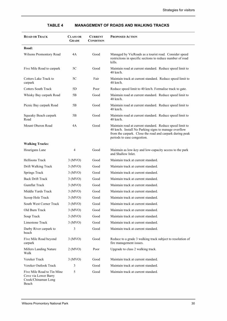
Strategies for visitors
Wilsons Promontory National Park 30
TABLE 4 MANAGEMENT OF ROADS AND WALKING TRACKS
ROAD OR TRACK CLASS ORGRADE
CURRENTCONDITION
PROPOSED ACTION
Road:
Wilsons Promontory Road 4A Good Managed by VicRoads as a tourist road. Consider speedrestrictions in specific sections to reduce number of roadkills.
Five Mile Road to carpark 5C Good Maintain road at current standard. Reduce speed limit to40 km/h.
Cotters Lake Track tocarpark
5C Fair Maintain track at current standard. Reduce speed limit to40 km/h.
Cotters South Track 5D Poor Reduce speed limit to 40 km/h. Formalise track to gate.
Whisky Bay carpark Road 5B Good Maintain road at current standard. Reduce speed limit to40 km/h.
Picnic Bay carpark Road 5B Good Maintain road at current standard. Reduce speed limit to40 km/h.
Squeaky Beach carparkRoad
5B Good Maintain road at current standard. Reduce speed limit to40 km/h.
Mount Oberon Road 4A Good Maintain road at current standard. Reduce speed limit to40 km/h. Install No Parking signs to manage overflowfrom the carpark. Close the road and carpark during peakperiods to ease congestion.
Walking Tracks:
Hourigans Lane 4 Good Maintain as low-key and low-capacity access to the parkand Shallow Inlet.
Hellisons Track 3 (MVO) Good Maintain track at current standard.
Drift Walking Track 3 (MVO) Good Maintain track at current standard.
Springs Track 3 (MVO) Good Maintain track at current standard.
Back Drift Track 3 (MVO) Good Maintain track at current standard.
Gumflat Track 3 (MVO) Good Maintain track at current standard.
Middle Yards Track 3 (MVO) Good Maintain track at current standard.
Scoop Hole Track 3 (MVO) Good Maintain track at current standard.
South West Corner Track 3 (MVO) Good Maintain track at current standard.
Old Burn Track 3 (MVO) Good Maintain track at current standard.
Soup Track 3 (MVO) Good Maintain track at current standard.
Limestone Track 3 (MVO) Good Maintain track at current standard.
Darby River carpark tobeach
3 Good Maintain track at current standard.
Five Mile Road beyondcarpark
3 (MVO) Good Reduce to a grade 3 walking track subject to resolution offire management issues.
Millers Landing NatureWalk
2 (MVO) Poor Upgrade to class 2 walking track.
Vereker Track 3 (MVO) Good Maintain track at current standard.
Vereker Outlook Track 3 Good Maintain track at current standard.
Five Mile Road to Tin MineCove via Lower BarryCreek/Chinaman LongBeach
5 Good Maintain track at current standard.
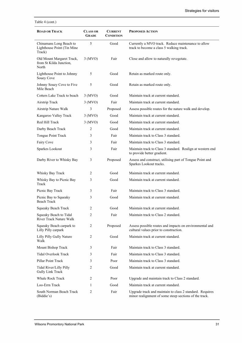
Strategies for visitors
Wilsons Promontory National Park 31
Table 4 (cont.)
ROAD OR TRACK CLASS ORGRADE
CURRENTCONDITION
PROPOSED ACTION
Chinamans Long Beach toLighthouse Point (Tin MineTrack)
5 Good Currently a MVO track. Reduce maintenance to allowtrack to become a class 5 walking track.
Old Mount Margaret Track,from St Kilda Junction,North
3 (MVO) Fair Close and allow to naturally revegetate.
Lighthouse Point to JohnnySouey Cove
5 Good Retain as marked route only.
Johnny Souey Cove to FiveMile Beach
5 Good Retain as marked route only.
Cotters Lake Track to beach 3 (MVO) Good Maintain track at current standard.
Airstrip Track 3 (MVO) Fair Maintain track at current standard.
Airstrip Nature Walk 3 Proposed Assess possible routes for the nature walk and develop.
Kangaroo Valley Track 3 (MVO) Good Maintain track at current standard.
Red Hill Track 3 (MVO) Good Maintain track at current standard.
Darby Beach Track 2 Good Maintain track at current standard.
Tongue Point Track 3 Fair Maintain track to Class 3 standard.
Fairy Cove 3 Fair Maintain track to Class 3 standard.
Sparkes Lookout 3 Fair Maintain track to Class 3 standard. Realign at western endto provide better gradient.
Darby River to Whisky Bay 3 Proposed Assess and construct, utilising part of Tongue Point andSparkes Lookout tracks.
Whisky Bay Track 2 Good Maintain track at current standard.
Whisky Bay to Picnic BayTrack
3 Good Maintain track at current standard.
Picnic Bay Track 3 Fair Maintain track to Class 3 standard.
Picnic Bay to SqueakyBeach Track
3 Good Maintain track at current standard.
Squeaky Beach Track 2 Good Maintain track at current standard.
Squeaky Beach to TidalRiver Track Nature Walk
2 Fair Maintain track to Class 2 standard.
Squeaky Beach carpark toLilly Pilly carpark
2 Proposed Assess possible routes and impacts on environmental andcultural values prior to construction.
Lilly Pilly Gully NatureWalk
2 Good Maintain track at current standard.
Mount Bishop Track 3 Fair Maintain track to Class 3 standard.
Tidal Overlook Track 3 Fair Maintain track to Class 3 standard.
Pillar Point Track 3 Poor Maintain track to Class 3 standard.
Tidal River/Lilly PillyGully Link Track
2 Good Maintain track at current standard.
Whale Rock Track 2 Poor Upgrade and maintain track to Class 2 standard.
Loo-Errn Track 1 Good Maintain track at current standard.
South Norman Beach Track(Biddie’s)
2 Fair Upgrade track and maintain to class 2 standard. Requiresminor realignment of some steep sections of the track.
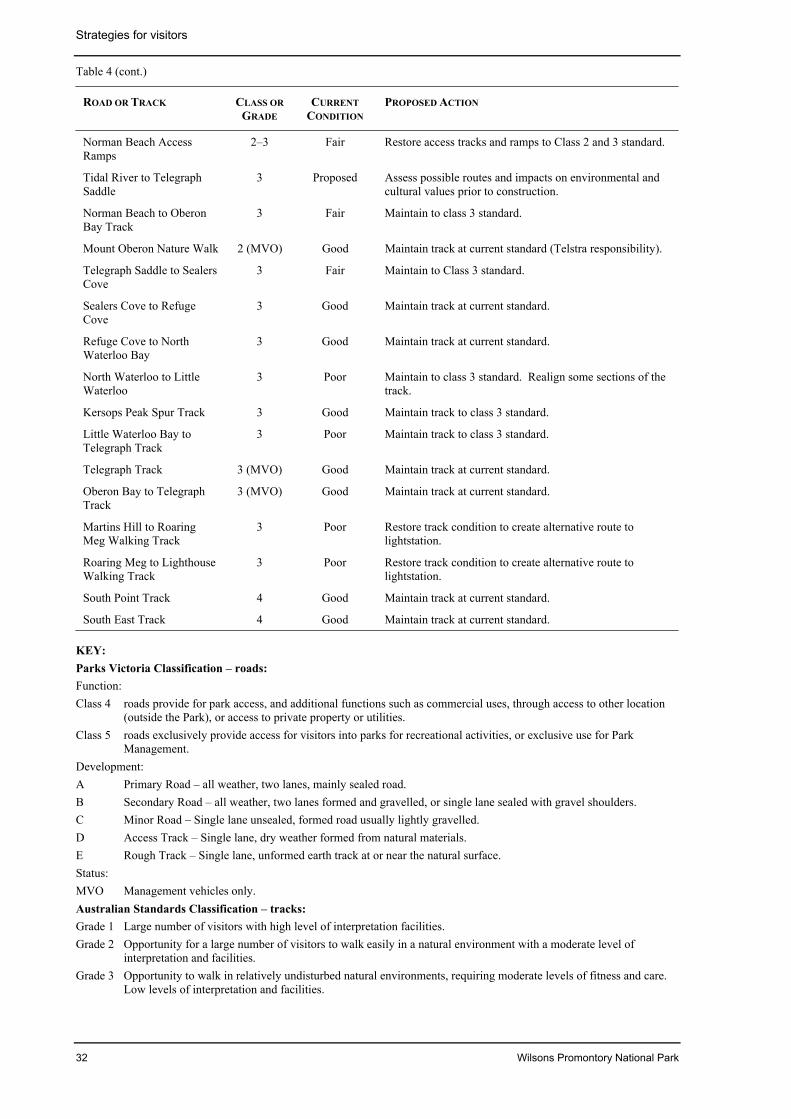
Strategies for visitors
32 Wilsons Promontory National Park
Table 4 (cont.)
ROAD OR TRACK CLASS ORGRADE
CURRENTCONDITION
PROPOSED ACTION
Norman Beach AccessRamps
2–3 Fair Restore access tracks and ramps to Class 2 and 3 standard.
Tidal River to TelegraphSaddle
3 Proposed Assess possible routes and impacts on environmental andcultural values prior to construction.
Norman Beach to OberonBay Track
3 Fair Maintain to class 3 standard.
Mount Oberon Nature Walk 2 (MVO) Good Maintain track at current standard (Telstra responsibility).
Telegraph Saddle to SealersCove
3 Fair Maintain to Class 3 standard.
Sealers Cove to RefugeCove
3 Good Maintain track at current standard.
Refuge Cove to NorthWaterloo Bay
3 Good Maintain track at current standard.
North Waterloo to LittleWaterloo
3 Poor Maintain to class 3 standard. Realign some sections of thetrack.
Kersops Peak Spur Track 3 Good Maintain track to class 3 standard.
Little Waterloo Bay toTelegraph Track
3 Poor Maintain track to class 3 standard.
Telegraph Track 3 (MVO) Good Maintain track at current standard.
Oberon Bay to TelegraphTrack
3 (MVO) Good Maintain track at current standard.
Martins Hill to RoaringMeg Walking Track
3 Poor Restore track condition to create alternative route tolightstation.
Roaring Meg to LighthouseWalking Track
3 Poor Restore track condition to create alternative route tolightstation.
South Point Track 4 Good Maintain track at current standard.
South East Track 4 Good Maintain track at current standard.
KEY:Parks Victoria Classification – roads:Function:Class 4 roads provide for park access, and additional functions such as commercial uses, through access to other location
(outside the Park), or access to private property or utilities.Class 5 roads exclusively provide access for visitors into parks for recreational activities, or exclusive use for Park
Management.Development:A Primary Road – all weather, two lanes, mainly sealed road.B Secondary Road – all weather, two lanes formed and gravelled, or single lane sealed with gravel shoulders.C Minor Road – Single lane unsealed, formed road usually lightly gravelled.D Access Track – Single lane, dry weather formed from natural materials.E Rough Track – Single lane, unformed earth track at or near the natural surface.Status:MVO Management vehicles only.Australian Standards Classification – tracks:Grade 1 Large number of visitors with high level of interpretation facilities.Grade 2 Opportunity for a large number of visitors to walk easily in a natural environment with a moderate level of
interpretation and facilities.Grade 3 Opportunity to walk in relatively undisturbed natural environments, requiring moderate levels of fitness and care.
Low levels of interpretation and facilities.
Strategies for visitors
Wilsons Promontory National Park 33
KEY (cont.)Grade 4 Opportunity for visitors to explore and discover natural environments along distinct tracks with minimal if any
facilities.Grade 5 Opportunity for those with advanced outdoor knowledge and skills to find their own way along often-indistinct
trails to more remote locations.Grade 6 Opportunity for highly experienced walkers to explore remote and potentially hazardous natural areas without
reliance on managed tracks.Note: MVO (Management Vehicle Only) tracks are available to walkers and park management vehicles.
• Ensure that day-visitor carparking isflexible as to size and type of vehicleaccommodated, i.e. buses, cars withtrailers, caravans and campervans andmotorcycles.
• Provide for a maximum of two carspaceson each campsite, with the exception ofany designated ‘walk in’ campsites forovernight hikers.
• Provide bike racks at the café/generalstore, Visitor Centre and beach accesspoints.
• Develop and maintain facilities inaccordance with table 4 and figure 7.
Lightstation Recreation Zone:
• Investigate the provision of infrastructureto support enhanced boat-based access tothe lightstation.
5.3 AmenityA major challenge for management is toprovide opportunities for visitors to experiencethe park’s special qualities while retaining itsremote and largely undeveloped nature.
Development proposals for the park,particularly in the Recreation Zones at TidalRiver and the lightstation, must take account ofthe inherent ecological constraints. Theprotection and enhancement of visitor amenityis critically dependent both on protection ofpark values and on sustainable provision ofservices such as water, energy and wastemanagement.
The peak levels of demand for visits, and forlodgings throughout the year, remain high.
The limit of 800 day-visitor vehicles (2500 to3000 visitors) was exceeded in the late 1980sand has approached this level on a number ofdays over the past two summers. Visitnumbers exceeding these levels have apotential to degrade environmental values and
to threaten the visitors’ experience byoverloading visitor services and facilities. Forthese reasons, day visitor vehicle numbershave been limited to 800. It is consideredneither desirable nor feasible to increase thelimit.
Recreation ZoneAlmost all visitors pass through the EntranceStation. However, the presentation of thebuildings, setting, services and facilities doesnot create an appropriate sense of entry to thisoutstanding park.
Tidal River Recreation Zone is the maindestination for almost all visitors and thelargest accommodation centre in any Victoriannational park.
Within Tidal River Recreation Zone thelandscape has been substantially modified anddegraded. Ecological values vary from low inthe highly disturbed areas to very high in theundisturbed river and dune areas.
The extensive range of visitor facilities andservices includes a Visitor Centre providingorientation, park information and interpretationservices. A café and general store, open aircinema, playground, Education Centre,Medical Centre and ablution blocks are locatednearby. Emergency, medical and policeservices are available during peak season.
At present the facilities are disconnected,creating parking, circulation and pedestrianaccess issues, and require refurbishment toupgrade the level and type of service offered tovisitors.
During peak periods, the concentration ofvisitor activities results in high use of existingfacilities.
Intensive use of campsites over many years hascaused widespread degradation of soils andvegetation and substantially reduced theamenity of many campsites.
Strategies for visitors
34 Wilsons Promontory National Park
Any increase in the capacity of builtaccommodation at Tidal River wouldunacceptably impact on the ecological values,both directly and through development ofadditional capacity of the infrastructure, andalso on the amenity of the area.
Careful and consistent site planning will berequired to develop the appropriate level ofamenity for visitors to the Recreation Zone ofa park of international standing, and at thesame time protect natural values and enhancethe natural environment.
The Lightstation Recreation Zone is relativelydifficult to access (section 5.2). Most visitorswalk 19 km from the Telegraph Saddlecarpark. There are currently 24 beds availablefor visitors.
Vegetation in the Wilsons PromontoryLightstation Reserve has been considerablydisturbed by past uses, and protection andrestoration works are proposed (section 4.3).
Infrastructure for waste management does notcomply with current standards (section 7.2)and alternative measures are being considered.
Any developments must take account ofheritage constraints detailed in the LightstationConservation Plan.
Aims• Manage the Recreation Zones in an
effective, resource-efficient andenvironmentally sustainable manner inharmony with the national park setting.
• Enhance the visitor’s ‘sense of arrival’ tothe park.
• Base the visitor experience on exploration,enjoyment and appreciation of the naturalvalues of the park.
• Design and develop unified and efficientvisitor facilities and amenities within TidalRiver Recreation Zone, in harmony with thenatural setting and environment.
• Provide a level of service and quality ofvisitor facilities consistent with TidalRiver’s profile as the major overnightvisitor destination in the Victorian nationalparks system.
• Keep operational support facilities in theTidal River Recreation Zone to a minimum.
• Retain and reuse existing infrastructure inthe Tidal River Recreation Zone, whereverpossible.
Management strategies• Maintain the 800 day-visitor vehicle per
day limit for the park.
• Liaise with the local tourism industry inthe development of a ‘park full’ strategy toencourage use of other destinations.
• Support the ‘park full’ strategy with publicinformation services such as pre-visitinformation/booking service, tourist radioand traffic signs to advise visitors en route.
• Monitor the impact of visitor andoperational activities on the RecreationZone at Tidal River.
Park Entrance Recreation Zone:
• Redesign and upgrade the entrancefacilities to provide an enhanced ‘sense ofarrival’ (sections 5.1 and 7.2).
• Ensure that the physical layout and designof the Park Entrance is unified and issympathetic with the natural setting andenvironment.
• Protect and maintain the natural setting ofthe Park Entrance.
Tidal River Recreation Zone:
• Progressively manage Tidal Riverconsistent with the functional schemagiven in table 2 and figure 5B.
• Prepare detailed designs and drawingsencompassing architectural style,materials, signs, furniture, paving andlighting appropriate to particularprecincts before undertaking majorconstruction works.
• Investigate the development of acontinuous, open space, landscaped,pedestrian precinct, free of vehiculartraffic, to link visitor facilities in theGeneral Services and Norman Bay Visitorprecincts.
• Ensure that facilities are provided only asnecessary to service visitors and supportfunctions.
• As part of stage 2 of the refurbishment ofthe Tidal River Visitor Centre, extend the
Strategies for visitors
Wilsons Promontory National Park 35
building to accommodate a newinterpretive display and resource centre.(section 7.2).
• Enhance the integration of the precinctcontaining the Visitor Centre andcafé/general store buildings, and improveits amenity and orientation for visitors, byimproving access, signage andlandscaping around the buildings.
• Provide for enhanced food services andoutdoor dining.
• Include new public toilet facilities withinthe extended Visitor Centre building toreplace toilets to be removed with thedemolition of the Terrace ablution block(section 4.2).
• Retain the open air cinema in its currentlocation and provide path links tolandscaped open space.
• Design and construct an appropriatelythemed playground facility. Include thefacility within any new open spacepedestrian precinct.
• Retain and refurbish the Education Centreand Botany Laboratory building to createflexibility in education and researchprogram delivery.
• Limit the overall capacity of camping andaccommodation facilities to 4000 visitors(as outlined in table 5), maintaining therelative proportions of camping androofed accommodation.
Lightstation Recreation Zone:
• Prepare a Design and Landscape Plan forthe lightstation. Ensure that the overallvision is consistent with the ConservationPlan and takes account of the variousnatural, cultural, recreational, functionaland operational factors.
• Continue to provide accommodationservices within the Wilsons PromontoryLightstation for walkers and boat visitors.
5.4 Day visitor activitiesAlmost all day visitors spend much of theirtime in and about the Tidal River RecreationZone.
Tidal River provides for numerous recreationalactivities, including opportunities within the
campground itself, along the adjacent streamand Norman Bay beach, and in nearby areasand beaches linked by walking tracks.
Tidal River is a staging point for many walkersundertaking the major overnight walkingcircuit, which takes in Sealers Cove, RefugeCove, Waterloo Bay, Wilsons PromontoryLightstation and Oberon Bay.
Most of the day visitor facilities are located atTidal River. Picnic and barbecue facilities areavailable for day and overnight visitors,including tour groups.
Visitor surveys have identified that the numberand type of day visitor facilities, particularlythose at Tidal River, are inadequate. On dayswhen visit numbers reach 2500, existing dayvisitor facilities throughout the park are fullyutilised. Additional facilities such as increasedaccess for those with limited mobility, tour busparking, shelters and barbecues are needed.There is scope to substantially improve theexisting facilities.
Provision of additional facilities at locationsoutside the Tidal River Recreation Zone,particularly in the northwestern part of thepark, would enhance visitors’ park experience,and ease congestion in Tidal River.
The Lightstation area has capacity for low-keynature-based recreational activities. It is animportant fire refuge area for visitors and staffin this area of the park.
Aim• Provide day visitor facilities that enhance
visitors’ enjoyment of the park and areconsistent with protecting park values.
Management strategies• Provide low-key additional day visitor
facilities in the north-western part of thepark between Darby River and the ParkEntrance, including nature trails, daywalks and interpretation of the park’sfeatures (table 5 and figure 7).
• Develop a nature walk in the airstriplocality.
• Incorporate quality day visitor facilitiesinto the redesign of visitor service areas inTidal River Recreation Zone.
Strategies for visitors
36 Wilsons Promontory National Park
• Provide improved visitor amenities such aspicnic tables, shelters, barbecues andseating in the Norman Bay VisitorPrecinct, and pedestrian links between thefacilities and any new pedestrian precinct(sections 4.5 and 5.3).
• Develop a link track between Tidal Riverand Telegraph Saddle (figure 7).
• Provide for passive land and water-basedrecreational activities and opportunities atthe Wilsons Promontory Lightstation.
5.5 Overnight accommodationTidal River currently provides a strong senseof place and community for a maximum of4000 overnight visitors. During peak periods,the high concentrations of visitors result in ahigh demand and competition for the use ofservices and facilities.
Table 5 provides a summary of existingovernight accommodation within the TidalRiver and the Lightstation recreation zones.
A total of 484 campsites providesapproximately 94 per cent of the overnightvisit capacity. Camping is the most popularactivity at Tidal River during the peak summerperiod, with maximum campsite occupancyfrom Christmas to the end of January. Outsidethis period, occupancy levels are much lower.
Restoring and regenerating the campsites isessential to support environmental and visitorservice objectives.
A range of cabins, huts, units and lodgesprovides about 4 per cent of overnight visitcapacity. These buildings contain 236 bedsand can accommodate groups of up to 30.
The standard of roofed accommodation needsto be improved to meet requirements under theHealth Act 1958 (Vic.) and to minimise theimpacts on environmental and cultural valueswithin the site. Any increase in the capacity ofbuilt accommodation would place pressures oninfrastructure and environmental amenity.
Accommodation is currently available at theWilsons Promontory Lightstation for up to 24visitors and two staff in former keepers’residences.
A small overnight camping ground ismaintained for walkers and volunteers at thePark Entrance (Stockyard Camp).
Section 7.2 covers the management andsupport services infrastructure issuesassociated with Tidal River.
Aims• Provide a range of accommodation for
visitors to the park.
• Manage Tidal River Recreation Zoneprimarily as a day visitor destination, and asan overnight accommodation destination,principally for camping. Maintain currentarea of, and access to, campsites at TidalRiver and ensure they are managed in anenvironmentally sensitive manner.
Management strategies• Maintain current number and
apportioning of campsites subject to soundenvironmental management, withavailability throughout the year subject toregeneration works and seasonal weatherconditions.
• Within this capacity, develop campsites on32nd Avenue as smaller, car-free ‘walk in’sites as a means of reducing pressure onvegetation and soils.
• Decommission the 11 campsites located onor near Aboriginal midden sites andprovide alternative sites in the CampingPrecinct.
• Rest and regenerate sites on a cyclicalbasis to support long-term environmentalmanagement objectives of minimisingerosion, soil compaction and drainageproblems.
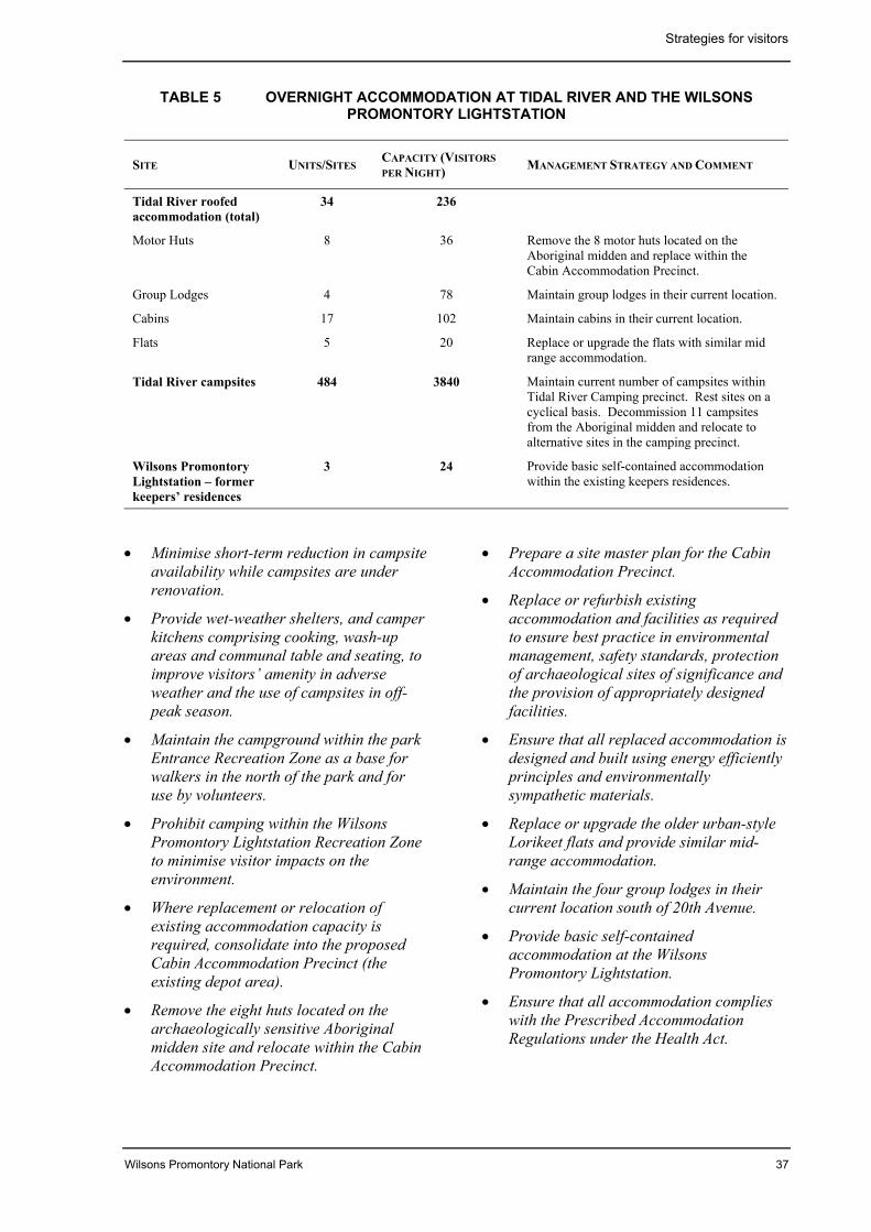
Strategies for visitors
Wilsons Promontory National Park 37
TABLE 5 OVERNIGHT ACCOMMODATION AT TIDAL RIVER AND THE WILSONSPROMONTORY LIGHTSTATION
SITE UNITS/SITESCAPACITY (VISITORSPER NIGHT) MANAGEMENT STRATEGY AND COMMENT
Tidal River roofedaccommodation (total)
34 236
Motor Huts 8 36 Remove the 8 motor huts located on theAboriginal midden and replace within theCabin Accommodation Precinct.
Group Lodges 4 78 Maintain group lodges in their current location.
Cabins 17 102 Maintain cabins in their current location.
Flats 5 20 Replace or upgrade the flats with similar midrange accommodation.
Tidal River campsites 484 3840 Maintain current number of campsites withinTidal River Camping precinct. Rest sites on acyclical basis. Decommission 11 campsitesfrom the Aboriginal midden and relocate toalternative sites in the camping precinct.
Wilsons PromontoryLightstation – formerkeepers’ residences
3 24 Provide basic self-contained accommodationwithin the existing keepers residences.
• Minimise short-term reduction in campsiteavailability while campsites are underrenovation.
• Provide wet-weather shelters, and camperkitchens comprising cooking, wash-upareas and communal table and seating, toimprove visitors’ amenity in adverseweather and the use of campsites in off-peak season.
• Maintain the campground within the parkEntrance Recreation Zone as a base forwalkers in the north of the park and foruse by volunteers.
• Prohibit camping within the WilsonsPromontory Lightstation Recreation Zoneto minimise visitor impacts on theenvironment.
• Where replacement or relocation ofexisting accommodation capacity isrequired, consolidate into the proposedCabin Accommodation Precinct (theexisting depot area).
• Remove the eight huts located on thearchaeologically sensitive Aboriginalmidden site and relocate within the CabinAccommodation Precinct.
• Prepare a site master plan for the CabinAccommodation Precinct.
• Replace or refurbish existingaccommodation and facilities as requiredto ensure best practice in environmentalmanagement, safety standards, protectionof archaeological sites of significance andthe provision of appropriately designedfacilities.
• Ensure that all replaced accommodation isdesigned and built using energy efficientlyprinciples and environmentallysympathetic materials.
• Replace or upgrade the older urban-styleLorikeet flats and provide similar mid-range accommodation.
• Maintain the four group lodges in theircurrent location south of 20th Avenue.
• Provide basic self-containedaccommodation at the WilsonsPromontory Lightstation.
• Ensure that all accommodation complieswith the Prescribed AccommodationRegulations under the Health Act.
Strategies for visitors
38 Wilsons Promontory National Park
5.6 BushwalkingThe park has one of the best networks ofwalking tracks in the State. It has variousgrades of track for day walks, easy overnightwalks and more challenging bushwalking(table 4).
Although a permit system limits the numbersof overnight walkers, high use levels of themore popular walking routes and campsites inthe southern part of the park have necessitatedcontinual maintenance work on the tracks.Some campsites in particular are subject tohigh use. Periodic resting of campsites may beneeded to limit environmental deterioration(section 5.7).
A popular short walk has developed betweenTidal River and Squeaky Beach and along themain tourist road to the Lilly Pilly Link Track.The walk along the road can be hazardousbecause there is no provision for pedestrianuse.
Visitors leaving walking tracks have developedother tracks which need to be formalised andmanaged, or closed and revegetated.
New walking tracks linking Tongue Point withWhisky Bay networks and Tidal River to themain overnight walking departure point atTelegraph Saddle will improve round tripoptions for day and overnight hikers.
The routes of all new tracks will be determinedon a basis of detailed investigations of theenvironmental and cultural impacts and likelymaintenance requirements.
A popular long-distance walking circuit existsin the southern section of the park. The tracknetwork links popular destinations includingOberon Bay, South Point, Wilsons PromontoryLightstation, Waterloo Bay, Refuge Cove andSealers Cove. Sections of the walk can beundertaken either as long day walks orovernight in sections, taking up to 5 days.Camping areas are provided for hikers atOberon Bay, Waterloo Bay, Refuge Cove,Sealers Cove, Roaring Meg and Halfway Hut.
The Wilderness Zone provides opportunitiesfor self-reliant bushwalking. Informalcamping areas are situated at Barry Creek,Lower Barry Creek, Tin Mine Cove, JohnnySouey Cove and Five Mile Beach. As sometracks are maintained as marked routes only,hikers need to be experienced and well
equipped before attempting a walk in thewilderness zone.
Off-track walking can impact on soils andvegetation through the development ofunoffical tracks. This activity is currentlymanaged through a permit system.
Visitors to all areas of the park are encouragedto practise minimal impact camping andbushwalking techniques during their stay.
Aims• Provide a variety of bushwalking
experiences on tracks maintained toappropriate standards depending on thesetting, at the same time minimisingimpacts on park values.
• Provide a variety of long-distance walkingexperiences for independent and guidedwalkers.
Management strategies• Manage and permit use of tracks in
accordance with table 4 and ParksVictoria’s operational policies.
• Maintain and restore existing walkingtracks in accordance with table 4.
• Develop new walking tracks from TonguePoint to Whisky Bay, and Tidal River toTelegraph Saddle. Re-align some sectionsof the walking track between LittleWaterloo Bay and Refuge Cove.
• Assess unofficial tracks near TonguePoint, and off the Squeaky Beach to PicnicBay track, for closure or formalising.
• Develop a class 2 walking track along theshoulder of the road between SqueakyBeach carpark and Lilly Pilly carpark.
• Create a common intersection for theOberon Bay Track, Telegraph Track andWaterloo Bay Track by sensitiverealignment of 200 metres of the existingWaterloo Bay Track.
• Continue to manage overnight walkingthrough the camping permit system(section 5.7).
• Manage off-track walking through apermit system, taking into accountmeasures to prevent the spread ofCinnammon Fungus (section 4.7).
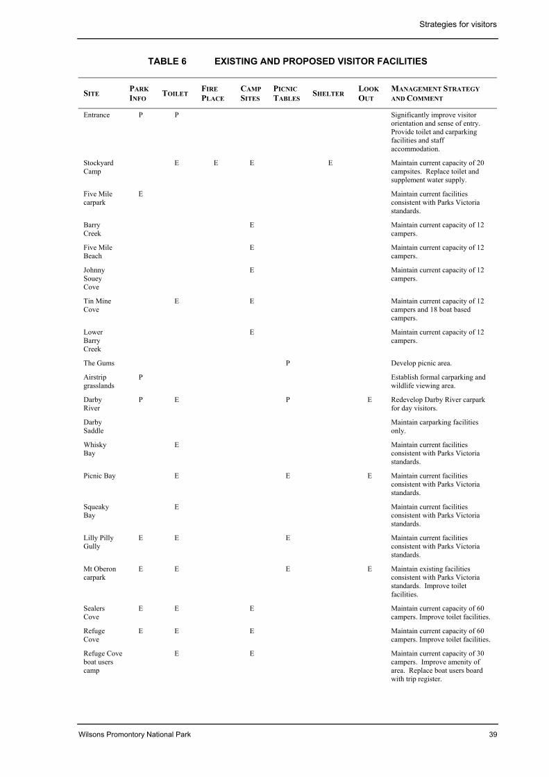
Strategies for visitors
Wilsons Promontory National Park 39
TABLE 6 EXISTING AND PROPOSED VISITOR FACILITIES
SITEPARKINFO
TOILETFIREPLACE
CAMPSITES
PICNICTABLES
SHELTERLOOKOUT
MANAGEMENT STRATEGYAND COMMENT
Entrance P P Significantly improve visitororientation and sense of entry.Provide toilet and carparkingfacilities and staffaccommodation.
StockyardCamp
E E E E Maintain current capacity of 20campsites. Replace toilet andsupplement water supply.
Five Milecarpark
E Maintain current facilitiesconsistent with Parks Victoriastandards.
BarryCreek
E Maintain current capacity of 12campers.
Five MileBeach
E Maintain current capacity of 12campers.
JohnnySoueyCove
E Maintain current capacity of 12campers.
Tin MineCove
E E Maintain current capacity of 12campers and 18 boat basedcampers.
LowerBarryCreek
E Maintain current capacity of 12campers.
The Gums P Develop picnic area.
Airstripgrasslands
P Establish formal carparking andwildlife viewing area.
DarbyRiver
P E P E Redevelop Darby River carparkfor day visitors.
DarbySaddle
Maintain carparking facilitiesonly.
WhiskyBay
E Maintain current facilitiesconsistent with Parks Victoriastandards.
Picnic Bay E E E Maintain current facilitiesconsistent with Parks Victoriastandards.
SqueakyBay
E Maintain current facilitiesconsistent with Parks Victoriastandards.
Lilly PillyGully
E E E Maintain current facilitiesconsistent with Parks Victoriastandards.
Mt Oberoncarpark
E E E E Maintain existing facilitiesconsistent with Parks Victoriastandards. Improve toiletfacilities.
SealersCove
E E E Maintain current capacity of 60campers. Improve toilet facilities.
RefugeCove
E E E Maintain current capacity of 60campers. Improve toilet facilities.
Refuge Coveboat userscamp
E E Maintain current capacity of 30campers. Improve amenity ofarea. Replace boat users boardwith trip register.
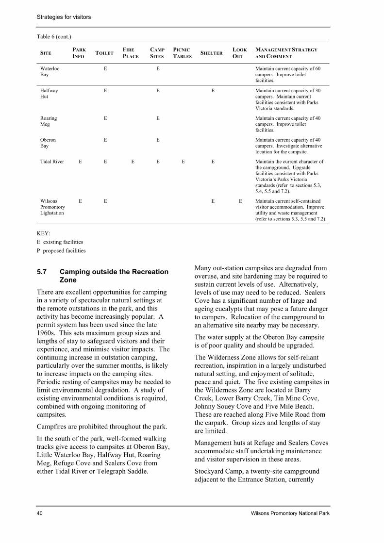
Strategies for visitors
40 Wilsons Promontory National Park
Table 6 (cont.)
SITEPARKINFO
TOILETFIREPLACE
CAMPSITES
PICNICTABLES
SHELTERLOOKOUT
MANAGEMENT STRATEGYAND COMMENT
WaterlooBay
E E Maintain current capacity of 60campers. Improve toiletfacilities.
HalfwayHut
E E E Maintain current capacity of 30campers. Maintain currentfacilities consistent with ParksVictoria standards.
RoaringMeg
E E Maintain current capacity of 40campers. Improve toiletfacilities.
OberonBay
E E Maintain current capacity of 40campers. Investigate alternativelocation for the campsite.
Tidal River E E E E E E Maintain the current character ofthe campground. Upgradefacilities consistent with ParksVictoria’s Parks Victoriastandards (refer to sections 5.3,5.4, 5.5 and 7.2).
WilsonsPromontoryLighstation
E E E E Maintain current self-containedvisitor accommodation. Improveutility and waste management(refer to sections 5.3, 5.5 and 7.2)
KEY:E existing facilitiesP proposed facilities
5.7 Camping outside the RecreationZone
There are excellent opportunities for campingin a variety of spectacular natural settings atthe remote outstations in the park, and thisactivity has become increasingly popular. Apermit system has been used since the late1960s. This sets maximum group sizes andlengths of stay to safeguard visitors and theirexperience, and minimise visitor impacts. Thecontinuing increase in outstation camping,particularly over the summer months, is likelyto increase impacts on the camping sites.Periodic resting of campsites may be needed tolimit environmental degradation. A study ofexisting environmental conditions is required,combined with ongoing monitoring ofcampsites.
Campfires are prohibited throughout the park.
In the south of the park, well-formed walkingtracks give access to campsites at Oberon Bay,Little Waterloo Bay, Halfway Hut, RoaringMeg, Refuge Cove and Sealers Cove fromeither Tidal River or Telegraph Saddle.
Many out-station campsites are degraded fromoveruse, and site hardening may be required tosustain current levels of use. Alternatively,levels of use may need to be reduced. SealersCove has a significant number of large andageing eucalypts that may pose a future dangerto campers. Relocation of the campground toan alternative site nearby may be necessary.
The water supply at the Oberon Bay campsiteis of poor quality and should be upgraded.
The Wilderness Zone allows for self-reliantrecreation, inspiration in a largely undisturbednatural setting, and enjoyment of solitude,peace and quiet. The five existing campsites inthe Wilderness Zone are located at BarryCreek, Lower Barry Creek, Tin Mine Cove,Johnny Souey Cove and Five Mile Beach.These are reached along Five Mile Road fromthe carpark. Group sizes and lengths of stayare limited.
Management huts at Refuge and Sealers Covesaccommodate staff undertaking maintenanceand visitor supervision in these areas.
Stockyard Camp, a twenty-site campgroundadjacent to the Entrance Station, currently
Strategies for visitors
Wilsons Promontory National Park 41
provides for camping by overnight walkersusing tracks in the northern part of the park,researchers and volunteers, and for emergencyaccommodation. The ablution facilities are inpoor condition.
Boat-based camping is popular at Tin MineCove and Refuge Cove. Boat-based users tendto seek a different park experience from hikers,and separate camping areas are provided. AtTin Mine Cove a campsite has beenconstructed, allowing 18 boat-based campersto stay two nights with a maximum group sizeof six, and at Refuge Cove 30 boat-basedcampers are permitted to stay two nights with amaximum group size of 12.
Although permits are required, records of theactual number of boat-based campers using thepark are not accurate. The permit systemneeds to be more flexible so that boat operatorscan obtain a permit at short notice.
Increasing use is being made of sea kayaks toexplore the park’s coastline. Because of thedistances involved, the rugged nature of mostof the coast and often severe weatherconditions, parties sometimes need to takeshelter and camp in places other than theestablished outstation camps.
Boating is further addressed in section 5.8.
Aims• Provide opportunities for a range of
outstation camping experiences to enhancevisitor freedom, at the same timeminimising impacts on park values.
Management strategies• Develop and maintain facilities in
accordance with table 6 and figure 7.
• Maintain a permit system controlling theuse of established campsites,incorporating an appropriate system forregulation of boat-based campers and off-track hikers using other locations.
• Conduct a study of the existingenvironmental condition of the outstationcampsites, continue to monitor theircondition and rehabilitate where required.
• Site-harden all outstation campsites whererequired to protect the environment whilstmaintaining existing site capacity.
• Close campsites for rehabilitation if visitorimpact causes unacceptable levels ofenvironmental damage.
• Investigate relocation of the Sealers Covecampsite to the former site on the northside of the river mouth.
• In the Wilderness Zone, undertakecampsite maintenance and monitoring byboat or helicopter, or on foot.
• Replace existing outstation toilets withmore environmentally sensitive facilitiese.g. composting toilets.
• Ameliorate soil degradation at JohnnySouey and Tin Mine coves, and revegetatedestabilised dunes.
• Permit camping by sea kayak parties atdesignated locations using the ‘off-track’hiker-permit system.
• Seasonally permit campfires only atdesignated fireplaces at Tidal River andStockyard Camp (where firewood issupplied). Prohibit firewood collectionthroughout the park.
• Maintain Stockyard Camp as a low-keycamper accommodation for use by walkersand volunteers, and in emergencysituations (section 5.6).
• Replace ablution facilities at StockyardCamp.
• Encourage and promote the use of low-impact bushwalking and campingtechniques.
5.8 BoatingBoating is a popular activity at WilsonsPromontory. The major associated activitiesare fishing, diving, sightseeing, picnicking andcamping. Sites most often visited includeTidal River, Refuge Cove, Tin Mine Cove, andbeaches in Corner Inlet and on the islands.Refuge Cove in particular is a popular stopoverpoint for yachts, and is a recognised safe havenin bad weather.
Sea kayaking is an increasingly popularactivity, parties leaving from Port Welshpool,Tidal River and Darby River. The longdistances involved and frequent bad weathermay require parties to camp at remote sitesaround the coastline (section 5.7).
Strategies for visitors
42 Wilsons Promontory National Park
The launching area at Tidal River is used byboat owners mainly to gain access to theadjacent marine park and reserve and to watersbeyond their boundaries.
Launching boats at the northern end ofNorman Bay depends on weather, seaconditions and the tide, and is not alwayspossible. In the interests of public safety, andas a means of monitoring use and impacts, boatlaunching is controlled by a permit system.Boat launching and car and boat-trailer parkingtake up a desirable portion of the riverbank,detract from the special nature of the area andcan come into conflict with other beach users.
Many of the Wilsons Promontory islands arebreeding sites for seabirds and Fur Seals,which require special protection. Public accessto all islands, except for beach areas onDoughboy, Bennison, Rabbit and GreatGlennie Islands, will be by permit for scientificpurposes only (section 4.4).
In the interests of public safety, power skiing,water skiing and sand yachting will continue tobe prohibited in the park, and motorised craftwill not be permitted in freshwater or estuaries.Surfboards, surfskis, sailboards, kayaks andcanoes are permitted at all beaches except forthe area north of Fifth Ramp on Norman Bayduring peak season.
The waters surrounding the promontoryprovide for spectacular diving, although thenearest facility for filling SCUBA tanks is atInverloch.
Aim• Provide opportunities for boating, at the
same time minimising the environmentalimpact of the activity on park values andconflict with other visitors.
Management strategies• Educate boat-based visitors in the
appreciation and appropriate use of thepark, including the Wilderness Zone, andthe adjoining marine and coastal parksand reserves, by providing informationand interpretive materials at key locations.
• Continue to prohibit power skiing andwater skiing in the park, and the use ofmotorised craft in freshwater or estuaries.
• Permit the use of surfboards, surfskis,sailboards, kayaks and canoes at allbeaches, except for the area north of FifthRamp at Norman Bay during peak season.
• Continue to allow boat launching in asection of the north end of Norman Beachat Tidal River, subject to beach conditionsrequiring the slow travel of vehicles.Maintain a staff presence during busylaunching periods, and if necessary limitthe hours of launching to reduce conflictswith other beach users.
• Continue to restrict boat access to WilsonsPromontory islands to beach areas onBennison, Doughboy, Rabbit and GreatGlennie Islands only.
• Investigate provision of a SCUBA tankfilling facility at Tidal River.
5.9 FishingRecreational fishing is a popular activity atsome locations in the park and the existing,adjoining marine parks. Visitors fish in theestuarine reaches of Darby River and TidalRiver stream and in the sea from the rocks andbeaches.
In order to protect the national park’s nativefreshwater fish, no fishing is permitted infreshwater streams or estuaries other than theestuarine reaches of Darby River and TidalRiver stream. Regular surveys of fishpopulations in these rivers have shown noevidence of over-exploitation of fish stocks.However, anglers using the banks of TidalRiver stream are contributing significantly tocompaction, erosion and slumping of thebanks.
Since July 1999, a Recreational FishingLicence has been required for all forms ofrecreational fishing in all Victorian marine,estuarine and fresh waters.
Recreational line fishing is currently permittedbetween high and low water marks in thenational park except for the area between southNorman Bay around the southern coastline toRefuge Cove and around the southern islands(Glennie and Anser groups and Wattle Island).Recreational fishing in the adjoining marineparks and reserves is controlled separately.
Implementation of the Government’s responseto the ECC’s Marine, Coastal and Estuarine
Strategies for visitors
Wilsons Promontory National Park 43
Investigation Final Report (Govt Vic. 2001)will result in some changes to thesearrangements.
Aim• Provide opportunity for recreational fishing,
at the same time minimising impacts onnative fish populations and habitats.
Management strategies• Permit recreational fishing in Darby River
downstream of the road bridge.
• Permit recreational fishing in Tidal Riverstream downstream of the road bridge.Restrict fishing along the shore of TidalRiver stream to the Loo-Errn boardwalkand sandy banks.
• Continue to prohibit bait collection infresh and estuarine waters and in theintertidal zone.
• Permit recreational line fishing on thecoast between high and low water marks,except between south Norman Bay aroundthe southern coastline to Refuge Cove andaround the southern islands.
• Provide information at key locations aboutthe regulations and opportunitiesapplicable to the adjoining marine parks.
• Continue to monitor fish populations in thepark.
5.10 Rock climbing and abseilingRock climbing is a minor activity in the parkbut use is increasing at the few sites whereclimbs are accessible. An informal log ofclimbing activity is kept.
A permit system monitors levels of use andimpact, and is also intended to enhanceclimbers’ safety. Additional sites for climbingmay be permitted under the permit system. Toreduce site impact, only ‘clean climbing’(those techniques which do not damage ordeface the rock) will be permitted. There maybe a need to define access tracks to prevent theformation of multiple tracks to the top andbase of climbs.
Aim• Provide opportunities for recreational uses
while minimising the impacts on parkvalues.
Management strategies• Permit rock climbing using ‘clean
climbing’ techniques at Little Oberon,Mount Bishop, Mount Oberon, SqueakyBeach Boulders, Turtle Rock and otherappropriate sites. Define access tracks asnecessary.
• Delineate the limit of developed climbingsites and prohibit the development of newclimbing areas in the park.
• Monitor the effect of rock climbing andabseiling activities on the environment andthe experience of other park users.
5.11 Commercial servicesThere are currently two leases and 34concessions licensed to operate in the park,offering visitor services and recreationalopportunities. These include a store/café,cinema, and tour operators offering charterboat tours, surf education, sea kayaking, rockclimbing and guided walking tours (section7.4). There is potential for the provision ofadditional services such as specialist guidedtours, interpretation and education by privateoperators. The aim is to improve the qualityand range of services available to the public.
Aims• Encourage the provision of appropriate
visitor services to improve the quality andrange of recreational experiences in thepark.
• Establish an appropriate balance betweengeneral public and commercial operator useof the park.
Management strategies• Provide for, and extend the range of,
guided activities available to visitors, e.g.boat tours and guided walks.
• Ensure that all private tourism operatorsare licensed in accordance with theNational Parks Act, and that they providehigh-quality services that do not impact
Strategies for visitors
44 Wilsons Promontory National Park
adversely on the park’s environmentalvalues.
• Require commercial permit holders torecord and present sufficient informationabout their operations to allow monitoringof the activity.
• Ensure that independent visitors retain themajority of opportunities to access walkingtracks and camping areas and sites, andthat licensed tour operators do not haveexclusive use of such facilities.
• Encourage tour operators to use nearbynatural attractions and private facilitiesoutside the park, as well as the park itself.
5.12 Public safetyThere are inherent dangers associated withsome activities in the park such as off-trackwalking and exploring remote areas of thepark.
The exposed coastal areas pose significanthazards in strong sea conditions.
During the Fire Danger Period there are highrisks of bushfire, with some danger to visitors,particularly walkers on remote tracks. Visitoraccess to the park or parts of the park duringperiods of extreme fire danger may beprohibited.
There is an extensive network of vehicle tracksand helipads in the park used for search andrescue as well as other management activities(section 7.3).
European Wasps and feral European HoneyBees occur within the park and pose a threat tovisitor safety (section 4.7).
An emergency management plan was preparedfor Wilsons Promontory National Park andTidal River in 1997. The plan outlinesresponse and operating procedures andmanagement arrangements for emergencysituations.
Aim• Provide infrastructure to ensure adequate
visitor safety consistent with the setting.Use operational techniques in emergencysituations giving due weight to theprotection and maintenance of park values.
Management strategies• Liaise with relevant authorities to develop
appropriate Visitor Safety Plans for thepark, giving due consideration to theprotection and maintenance of park andwilderness values
• Maintain a Visitor Evacuation Plan forTidal River, the outstations and key visitorareas for implementation in an emergency.
• Continue to provide first response and asupport role in search and rescueoperations.
• Undertake regular ranger patrols tomonitor public safety and enjoyment.
• Ensure that park staff have adequate levelsof training in first aid, search and rescue,and firefighting techniques.
• Inform visitors of potential dangers, andthe roles and responsibilities of individualsand group leaders in maintaining publicsafety.
Wilsons Promontory National Park 45
6 COMMUNITY AWARENESS AND INVOLVEMENT
6.1 Community partnershipsVolunteers such as the Friends of the Prommake a significant contribution tomaintenance, conservation, protection andother management activities in the park.Volunteer groups have helped completeprojects that otherwise may not haveprogressed. Valuable projects have beenundertaken by Friends of the Prom, FieldNaturalists Club of Victoria, Birds Australia,the Conservation Volunteers of Australia,Operation Raleigh, tertiary students and workexperience students.
Encouragement will be given to a broaderrange of community participation and thedevelopment of a number of opportunities forvolunteer groups that seek involvement in parkmanagement activities.
Parks Victoria’s Research Partners Programbrings scientists and students together withpark managers to conduct research to addressemerging issues in park management.Through this program, Parks Victoria providessupport to research institutions to fill some ofthe gaps in our knowledge including a betterunderstanding of how flora and fauna aredistributed, the ecological processesinfluencing these distributions, factorsaffecting their survival and their response toactive management. The program providesopportunities to involve tertiary students in avariety of studies that are mutually beneficial(sections 4.4 and 7.1).
Established in 2000, the Wilsons PromontoryNational Park Advisory Group (WPAG)provides an opportunity for direct communityinput into the park’s management.
Aim• Encourage, assist and support volunteer
groups in undertaking appropriatemanagement tasks within the park.
Management strategies• Continue to encourage and support the
Friends of the Prom.
• Develop and evaluate a long-termvolunteer strategy that incorporates theskills and interests of volunteer groups inpark management activities.
• Assist volunteer groups to pursue sourcesof funding for park projects.
• Maintain liaison with the co-ordinators ofvolunteer groups.
• Apply, and encourage the application of,the Good Neighbour Policy tomanagement issues on or near theboundary of the park.
Wilsons Promontory National Park 46
7 OTHER ISSUES
7.1 Centre of Excellence for ParkManagement program
It is proposed to stimulate the application ofthe highest practicable standards ofmanagement in the park by establishing a‘Centre of Excellence for Park Management’program.
The ‘Centre of Excellence for ParkManagement’ program incorporates three keyelements – environmental management(research and monitoring), interpretation andeducation, and staff development and training.
The major new program will ensurecoordination, support and direction forresearch and monitoring programs, trainingprograms, and a sophisticated informationdatabase for the park and its surrounds.
Research and monitoring plays a fundamentalrole in enhancing the understanding ofecological processes. This in turn leads tomore effective park management.
An important component of the Centre ofExcellence for Park Management is theestablishment of a Scientific LiaisonCommittee, made up of scientists with anintimate knowledge of the park, to provideadvice on the most appropriate research andmonitoring techniques. This will, amongothers things, promote and focus a morecomprehensive program of ecological researchand environmental monitoring, help establishlinks to major research institutions, and allowaccess to resources and expertise not normallyavailable for park management.
Another important element is the developmentof co-operative programs with otherconservation reserves, both nationally andinternationally.
A substantial body of research work on thepark by tertiary and scientific institutions hasbeen completed.
The proposed establishment of marine nationalparks (Govt Vic. 2001) highlights the area’spotential to increase its role as a research andmonitoring base for the marine environment.
Training programs for park managers will bean integral part of the program. Ongoing
research will be incorporated intointerpretation programs for the public.
Monitoring may help to determine whetherchange results from natural processes or isinduced by human activity. The informationgained can be used in the review andimprovement of management techniques. Anefficient, effective and ongoing monitoringprogram is needed to provide baseline data,and for subsequent periodic assessments andevaluations.
The concept of the Centre of Excellence forPark Management will be further developed todetermine detailed management objectives andthe level of resources and infrastructure neededto achieve those objectives. Negotiations willbe undertaken with research institutions,organisations and individuals to seek supportfor and involvement in the operation of theprogram.
Aims• Establish the park as a model for park
management.
• Establish the highest practicable standardsof ecological management andenvironmental monitoring.
• Investigate opportunities to increase theresearch and monitoring role of the parkand adjacent marine environment.
Management strategies• Establish the park as a Centre of
Excellence for Park Managementprograms.
• Within the existing infrastructurefootprints, establish modest facilities forresearchers and for training parkmanagers from Victoria, interstate andoverseas.
• Establish a Scientific Liaison Committee toprovide advice on appropriate researchand monitoring techniques.
• Establish formal links with otherBiosphere Reserves, both in Australia andoverseas, and develop co-operativeprograms with other agencies. Through
Other issues
Wilsons Promontory National Park 47
the UNESCO’s Man and the Biosphere(MAB) program establish links with majorresearch institutions and national andinternational programs.
• Design and implement an ongoingmonitoring program to obtain adequatedata on resource conservation, parkprotection, visitor use and other issues asappropriate, to direct future management.
• Develop and implement a GIS-basedquality baseline data collection andenvironmental monitoring program.
• Investigate opportunities to increaseresearch and monitoring of the marineenvironment.
7.2 Management and supportservices infrastructure
The Park Entrance Recreation Zone includesthe Entrance Station building, a small worksarea, some staff accommodation and somevisitor services and facilities.
Park administration has recently been relocatedfrom the Entrance Station to Tidal River tomaximise access for visitors to rangerassistance relating to the entire park.
Limited expansion of the existing services andfacilities at the Park Entrance withoutunacceptable impact on the ecological andrecreational values of the area is possible,although upgrading of water supplies andsewerage would be necessary.
The management infrastructure at the TidalRiver Recreation Zone is self-contained andoccupies a significant part of the developedarea within the Tidal River Recreation Zone(figure 4). The main works depot and somestaff accommodation are located north of theaccess road. Most staff accommodation islocated south of the access road.
The layout of the works depot is inefficient,does not meet contemporary workplacestandards and poses an unacceptableenvironmental risk. Its location createspotential conflicts with visitor activities.
The support services infrastructure within theTidal River Recreation Zone, being relativelyremote from regional and state servicenetworks, is self-contained. Much of theinfrastructure has developed incrementallyover several decades, is inefficient to operate,
has an adverse impact on the environment andin some respects fails to support essentialservices satisfactorily.
Despite recent upgrades of the potable watersupply, waste disposal, sewerage systems, andfire protection services, further works arenecessary. The main sewage pumping stationat Tidal River will require modification to copewith full sewerage loading. The buildinghousing the controls for the main pump stationhas deteriorated to a point where it requiresdemolition or refurbishment.
Following construction of the waste watertreatment plant and discharge facility, some 70existing septic tanks can be removed.
Increased demand for power to supply thewater treatment plant, additional seweragepumps and proposed sewage treatment plantwill lead to increased reliance on the back-updiesel power generator to support the morecost-efficient LPG generator.
During works at Tidal River Recreation Zone,a number of sites were identified as havingpossible contamination with hydrocarbons,indicating fuel leakage or spillage.Investigation is required to determine theextent of contamination and any requiredremedial actions.
The Wilsons Promontory Lightstation wastemanagement infrastructure reflects historicalattitudes to waste disposal in remote locationsand does not comply with accepted standards.Upgrading will be essential.
Aims• Maintain the main management and support
services infrastructure for the park in TidalRiver.
• Establish and maintain suitableaccommodation for staff at Tidal River andthe Park Entrance.
• Operate and service the management andsupport services infrastructure in aneffective, resource-efficient andenvironmentally sustainable manner.
• Ensure that all infrastructure management isconsistent with strategies to protect parkvalues and enhance visitors’ access,amenity and recreation opportunities.
Other issues
48 Wilsons Promontory National Park
• Ensure that infrastructure management inthe Lightstation Recreation Zone is inaccordance with the Wilsons PromontoryLightstation Conservation Plan.
Management strategiesPark Entrance Recreation Zone:
• Upgrade water supply and sewerage toadequately service public facilities,domestic use and fire fighting purposeswithin the Park Entrance Recreation Zone.
• Replace toilet facilities in the Stockyardcampground (section 5.5).
Tidal River Recreation Zone:
• Complete Stage 2 of the Tidal River VisitorCentre to consolidate emergency services.
• Design and build a new, efficient workscentre for the park to contemporaryworkplace safety standards on an existingcleared location within the proposedSupport Services Precinct.
• Consolidate all park works depot activitieswithin the new works centre.
• Remove the existing depot from theproposed Cabin Accommodation andCamping Precinct.
• Maintain accommodation for staffrequired to stay at Tidal River, includingstaff relocated from the proposed CabinAccommodation Precinct.
• Remove staff accommodation north of theTidal River road.
• Demolish Blackwood lodge and revegetatethe site.
• Remove Terrace ablution block (section5.3) and replace Tidal and Beach ablutionblocks with new facilities.
• Upgrade remaining ablution blocks toimprove standards and introduce waterconservation measures.
• Completely upgrade and renew thesewerage system and install a sewagetreatment plant.
• Demolish the existing building housing themain sewage pump and construct a newbelow-ground pump station consolidatingvalves and control mechanisms.
• Remove decommissioned septic tanks andrehabilitate the sites.
• Review the energy audit to determine theeconomic benefits of replacing anotherdiesel generator with an LPG unit.
• Improve fire detection and alarm systemsthroughout the site to ensure compliancewith the current Building Code ofAustralia (BCA) provisions.
• Prepare and implement a solid wastemanagement and recycling strategy.Establish rubbish collection/recyclingstations in the campgrounds.
• Introduce energy and water savingmeasures in all new buildings, andupgrade existing buildings where possible.
• Investigate a new location for the supply ofbowser fuel to the public.
• Undertake investigations to determine theextent of soil contamination by hydro-carbons, and undertake remedial works.
• Use best practice technology to preventcontaminants entering the wetland andestuary.
• Record and monitor maintenance on allinfrastructure and develop a schedule ofongoing cyclic maintenance andreplacement.
• Implement and continually review therecommendations of the energy audit(Ecopower 1996) to minimise the use andcost of providing energy to Tidal River.
Lightstation Recreation Zone:
• Service the Wilsons PromontoryLightstation by air or sea wheneverpracticable.
• Remove hazardous materials (asbestos),improve waste management and utilitiesinfrastructure, and refurbish thelightstation residences.
• Ensure that any refurbishment of buildingsand infrastructure at the lightstationincludes best-practice technology in theprovision and management of utilities andwaste management.
• Ensure continuous caretaking presence atthe lightstation to manage visitor access,
Other issues
Wilsons Promontory National Park 49
impacts, and protection of buildings,structures, natural and cultural values.
• Construct a new waste water treatmentsystem at the lightstation to meet EPArequirements.
7.3 Management accessThere is a substantial network of managementvehicle tracks and helipads in the park, whichare used to support management activities.Some tracks are no longer required formanagement.
The Telegraph Track provides 2WD dryweather vehicular access for park managementpurposes, including servicing the WilsonsPromontory Lightstation several times permonth. The Lighthouse Walking Track linksthe end of this road to the lightstation. TheTrack is also a popular route for walkerstravelling to the lightstation (section 5.6).Management use of this track impacts on theremote and natural attributes of the area andthe experience of walkers.
The Five Mile Road within the WildernessZone is currently maintained as a fire controlline and for other management purposes suchas search and rescue. This road and itsassociated firebreaks have a major impact onthe wilderness values of the area. Retention ofthe Five Mile Road in its current form isinconsistent with wilderness managementprinciples.
A number of other management-only vehicletracks exist within the Wilsons PromontoryWilderness Zone. The goal for the WildernessZone is that all vehicle tracks within the zonewill be closed and rehabilitated.
A helipad is maintained at Tidal River foremergency and park management purposes,including servicing the lightstation. Otherhelipads for fire management purposes aresituated throughout the park. An emergencyairstrip is maintained near Darby River for firemanagement and search and rescue.
Aims• Rationalise the vehicular track and helipad
networks.
• Minimise the intrusion of managementvehicles.
Management strategies• Retain only those Management Vehicle
Only tracks (refer to table 4) and helipadsthat are essential for management, andrehabilitate those that are not required.
• Investigate the further rehabilitation of theFive Mile Road and firebreaks east of thecarpark to Management Vehicle Only andwalking track status, maintainedpreferably by slashing rather than mineralearth. This would require resolution offire management issues (section 4.6). Inthe interim, continue to restrict access tovehicles for essential managementpurposes only.
• Allow the Mt Margaret and Tin Minetracks to grow over, but retain as anidentified route for emergency access.
• Remove all other vehicle tracks in theWilderness Zone, subject to resolution ofissues relating to fire management.
• Restrict vehicular use of the TelegraphTrack to essential management purposesonly.
• Investigate the provision of infrastructureto support enhanced boat-based access tothe lightstation for servicing and for visitoraccess (sections 5.8 and 7.2).
• Maintain the airstrip and helipads foremergency or park management use only.
7.4 Authorised usesCommercial services provided at Tidal Riverinclude the store and café, cinema, medicalcentre and public telephones.
Several privately operated licensed tourbusinesses operate within the park (section5.10).
There are radio telecommunications sites atMount Oberon and Tidal River.
The lightstation continues to function as afunctional navigational aid and a Bureau ofMeteorology Automatic weather station. It isalso a designated climate change monitoringstation.
The National Parks Act provides for certainstructures in the Wilderness Zone. Theseinclude the navigational beacon at LighthousePoint and two first-order triangulation stations
Other issues
50 Wilsons Promontory National Park
located on Mount Latrobe and Mount Hunter,which are currently considered essential forgeodetic survey purposes. These will beretained unless advances in technology makethem obsolete.
Navigational beacons are also located atRefuge Cove, Sealers Cove and WaterlooPoint.
Minor geodetic survey markers in the park aremostly overgrown by vegetation andunnoticeable, and do not require management.
Apiculture is currently restricted to five sites inthe northern part of the park. Colonies of feralEuropean Honey Bees are a widespreadproblem.
Aims• Manage authorised uses in accordance with
the National Parks Act, and minimise theirimpact on park values.
• Maintain caretaking role and fulfilobligations under existing leases relating tonavigation and meteorological operations.
Management strategies• Continue to permit authorised uses and
services through leases and otherarrangements. Impose appropriateconditions and liaise with lessees,licensees and other occupants to ensurethat maintenance of services and activitieshas minimal impact on park values.
• Phase out apiculture in the park.
• Remove telecommunications facilities onMount Oberon and trigonometric stationsthroughout the park as they becomeobsolete, and rehabilitate the sites.
• Construct a short track from the boatlanding to the navigation beacon atLighthouse Point to allow boat access toreplace vehicle access for maintenance. Ifthe light becomes obsolete, remove it andrehabilitate the site.
• Provide appropriate access to the WilsonsPromontory Lightstation for the lessees(Australian Maritime Safety Authority andthe Bureau of Meteorology).
7.5 Boundaries and adjacent usesThe park on its seaward boundary (low watermark) adjoins Corner Inlet and Shallow InletMarine and Coastal Parks, Wilsons PromontoryMarine Park and Wilsons Promontory MarineReserve. Parts of these areas and the nationalpark are proposed for inclusion in two marinenational parks (Govt Vic. 2001).
The coastal boundary of the park at low watermark is difficult to define, particularly at CornerInlet. This presents some managementdifficulties.
Private land adjoining the park is mostlycleared for grazing and dairy production.There is potential for conflicts betweenmaintenance of park values and surroundingland uses.
Any significant increase in the frequency oflow-flying aircraft may be an intrusion anddetract from visitors’ enjoyment of the park.No controls are in place at present.
Aim• Minimise conflicts between maintenance of
park values and surrounding land uses.
Management strategies• Prepare large-scale maps showing the
precise location of the park boundaryabutting Corner Inlet.
• Liaise with the managers of land abuttingthe park, and the South Gippsland ShireCouncil, with the aim of minimisingadverse effects of private landdevelopments on park values.
• Should aircraft intrusion become aproblem, negotiate a ‘Fly Neighbourly’agreement through Air Services Australiawith local operators.
Wilsons Promontory National Park 51
8 IMPLEMENTATION
This plan provides the strategic framework thatgoverns the development and delivery of allmanagement programs and actions affectingthe Wilsons Promontory National Park and theWilsons Promontory and Citadel IslandLightstation Reserves.
The management program for the park andreserves is prepared annually, in accordancewith Parks Victoria’s Corporate Plan and as apart of statewide prioritised programs.
The performance of the plan’s implementationwill be measured by monitoring and recordingthe number of strategies implemented to Juneeach year.
Amendments may be made to this Plan fromtime to time, consistent with an authorisedapproval process. A partial or completereview of the Plan will be considered in theperiod from five to ten years after itspublication.
52 Wilsons Promontory National Park
REFERENCES
Australia Construction Services 1993, WilsonsPromontory Lightstation, Victoria,Conservation Plan, Report for theAustralian Maritime Safety Authority.
Bennett, L. T. 1993, The Decline of Banksiaintegrifolia on the Yanakie Isthmus,Wilsons Promontory National Park, PhDThesis, School of Botany, MelbourneUniversity.
Buckley, R. W. n.d., Sites of Geological andGeomorphological Significance along theVictorian Coast, Geological Survey ofVictoria, 1993/94 Report (unpubl.).
Chesterfield, E. A. & Whelan, J. 1995a,Conservation Strategy: WilsonsPromontory National Park: NorthernManagement Area, Internal Report,Department of Conservation and NaturalResources, Melbourne (unpubl.).
Chesterfield, E. A. & Whelan, J. 1995b,Conservation Strategy: WilsonsPromontory National Park: NorthernManagement Area: Background Document,Internal Report, Department ofConservation and Natural Resources,Melbourne (unpubl.).
CNR 1995a, Exploring Wilsons Promontory: aGuide to Visitor Services, Interpretationand Education, Department of Conservationand Natural Resources, Melbourne.
CNR 1995b, Code of Practice for FireManagement on Public Land, Departmentof Conservation and Natural Resources,Melbourne.
CNR n.d., Wilsons Promontory National Park:Fox Control Plan & Work Schedule,Internal Report, Department ofConservation and Natural Resources(unpubl.).
ECC 2000, Marine Coastal and EstuarineInvestigation, Final Report: EnvironmentConservation Council, Melbourne.
Ecopower 1996, Tidal River Energy AuditReport, Ecopower Pty Ltd, Melbourne.
FFG 1989, Flora and Fauna Guarantee Policyand Procedures Manual, Department ofConservation, Forests and Lands,Melbourne.
Golder 1998, Report on GroundwaterInvestigation Grey Water Recycling TidalRiver, Wilsons Promontory, GolderAssociates Pty Ltd, Melbourne.
Govt Vic. 2001, Government Response to theEnvironment Conservation Council’sMarine, Coastal and Estuarine InvestigationFinal Recommendations.
ICOMOS 1999, Charter for the Conservationof Places of Cultural Significance (theBurra Charter), revised, The AustralianInternational Council of Monuments andSites (unpubl.).
Jackson, P. D. & Davies, J. N. 1983, TheFreshwater and Estuarine Fishes ofWilsons Promontory, Fisheries and WildlifeDivision, Department of Conservation,Forests and Lands, Melbourne.
Keenan, S., Hoskins, M. & Thomas, E. 2000,Wilsons Promontory National Park FoxManagement Plan 2000 – 2003, ParksVictoria (unpubl).
Keenan, S. M. 2001, Wilsons PromontoryNational Park Rabbit Control Action Plan,Parks Victoria (unpubl.).
LCC 1980, Report on the South GippslandStudy Area District 2, Land ConservationCouncil, Melbourne.
LCC 1982, South Gippsland Area District 2:Final Recommendations, LandConservation Council, Melbourne.
LCC 1991a, Wilderness Special Investigation:Final Recommendations, LandConservation Council, Melbourne.
LCC 1991b, Rivers and Streams SpecialInvestigation: Final Recommendations,Land Conservation Council, Melbourne.
Mueck, S. G., Delaney, R. & McGuckin, J.1996, Inventory of the Flora and FaunaValues of the Tidal River Resort and anAssessment of the Potential Impacts of
References
Wilsons Promontory National Park 53
Proposed Developments, Biosis ResearchPty. Ltd., Melbourne.
NRE 1996a, Corner Inlet and NooramungaMarine and Coastal Park DraftManagement Plan, Department of NaturalResources and Environment, Victoria.
NRE 1996b, Wilsons Promontory NationalPark Draft Fire Suppression Plan 1996–97Fire Season, Department of Conservationand Natural Resources, Yarram, Victoria.
NRE 1997, Heritage Rivers and NaturalCatchment Areas Draft Management Plan,Vol 3, Department of Natural Resourcesand Environment, Melbourne.
NRE 1999, Gippsland Fire Protection Plan,Department of Natural Resources andEnvironment, Melbourne.
NRE 2000, Yarram District Fire SuppressionPlan, Department of Natural Resources andEnvironment, Yarram.
NRE (database) 2001a, Flora InformationSystem, Department of Natural Resourcesand Environment, Melbourne.
NRE (database) 2001b, Atlas of VictorianWildlife, Department of Natural Resourcesand Environment, Melbourne.
Parks Victoria 1993, Conservation PlanWilsons Promontory Lightstation, ParksVictoria, Melbourne.
Parks Victoria 2001, Corner Inlet Ramsar Site:Draft Strategic Management Plan, ParksVictoria, Melbourne.
Tourism Victoria 1996, Victorian RegionalTravel and Tourism Survey 1995, TourismVictoria, Melbourne.
Tourism Victoria 1997a, Phillip Island andGippsland Discovery Regional TourismDevelopment Plan, Tourism Victoria,Melbourne.
Tourism Victoria 1997b, Strategic BusinessPlan 1997–2001, Tourism Victoria,Melbourne.
Tourism Victoria 2000, Nature Based Tourism– Directions and opportunities for Victoria2000 – 2003, Tourism Victoria, Melbourne.
University of Ballarat 1999, Assessment of thecondition of vegetation on the YanakieIsthmus, Wilsons Promontory NationalPark, internal report commissioned byParks Victoria (unpubl.).
Wallis, G.L. 1980, ‘Wilsons Promontory: anintroduction to its geology’, Vic Naturalist97(5): 194-9.
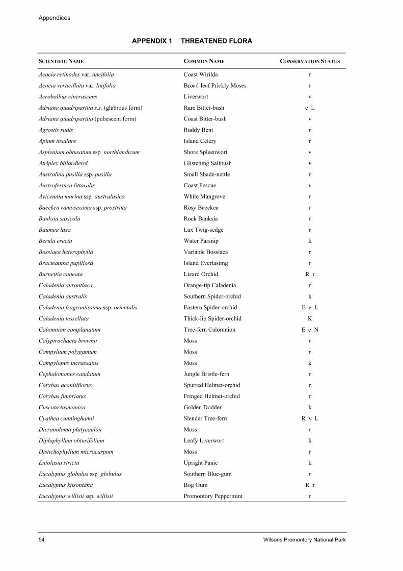
Appendices
54 Wilsons Promontory National Park
APPENDIX 1 THREATENED FLORA
SCIENTIFIC NAME COMMON NAME CONSERVATION STATUS
Acacia retinodes var. uncifolia Coast Wirilda r
Acacia verticillata var. latifolia Broad-leaf Prickly Moses r
Acrobolbus cinerascens Liverwort v
Adriana quadripartita s.s. (glabrous form) Rare Bitter-bush e L
Adriana quadripartita (pubescent form) Coast Bitter-bush v
Agrostis rudis Ruddy Bent r
Apium insulare Island Celery r
Asplenium obtusatum ssp. northlandicum Shore Spleenwort v
Atriplex billardierei Glistening Saltbush v
Australina pusilla ssp. pusilla Small Shade-nettle r
Austrofestuca littoralis Coast Fescue v
Avicennia marina ssp. australasica White Mangrove r
Baeckea ramosissima ssp. prostrata Rosy Baeckea r
Banksia saxicola Rock Banksia r
Baumea laxa Lax Twig-sedge r
Berula erecta Water Parsnip k
Bossiaea heterophylla Variable Bossiaea r
Bracteantha papillosa Island Everlasting r
Burnettia cuneata Lizard Orchid R r
Caladenia aurantiaca Orange-tip Caladenia r
Caladenia australis Southern Spider-orchid k
Caladenia fragrantissima ssp. orientalis Eastern Spider-orchid E e L
Caladenia tessellata Thick-lip Spider-orchid K
Calomnion complanatum Tree-fern Calomnion E e N
Calyptrochaeta brownii Moss r
Campylium polygamum Moss r
Campylopus incrassatus Moss k
Cephalomanes caudatum Jungle Bristle-fern r
Corybas aconitiflorus Spurred Helmet-orchid r
Corybas fimbriatus Fringed Helmet-orchid r
Cuscuta tasmanica Golden Dodder k
Cyathea cunninghamii Slender Tree-fern R v L
Dicranoloma platycaulon Moss r
Diplophyllum obtusifolium Leafy Liverwort k
Distichophyllum microcarpum Moss r
Entolasia stricta Upright Panic k
Eucalyptus globulus ssp. globulus Southern Blue-gum r
Eucalyptus kitsoniana Bog Gum R r
Eucalyptus willisii ssp. willisii Promontory Peppermint r
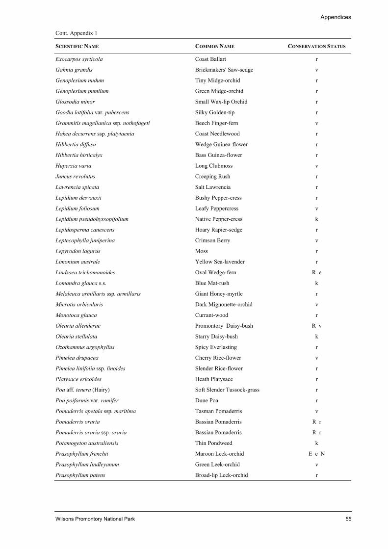
Appendices
Wilsons Promontory National Park 55
Cont. Appendix 1
SCIENTIFIC NAME COMMON NAME CONSERVATION STATUS
Exocarpos syrticola Coast Ballart r
Gahnia grandis Brickmakers' Saw-sedge v
Genoplesium nudum Tiny Midge-orchid r
Genoplesium pumilum Green Midge-orchid r
Glossodia minor Small Wax-lip Orchid r
Goodia lotifolia var. pubescens Silky Golden-tip r
Grammitis magellanica ssp. nothofageti Beech Finger-fern v
Hakea decurrens ssp. platytaenia Coast Needlewood r
Hibbertia diffusa Wedge Guinea-flower r
Hibbertia hirticalyx Bass Guinea-flower r
Huperzia varia Long Clubmoss v
Juncus revolutus Creeping Rush r
Lawrencia spicata Salt Lawrencia r
Lepidium desvauxii Bushy Pepper-cress r
Lepidium foliosum Leafy Peppercress v
Lepidium pseudohyssopifolium Native Pepper-cress k
Lepidosperma canescens Hoary Rapier-sedge r
Leptecophylla juniperina Crimson Berry v
Lepyrodon lagurus Moss r
Limonium australe Yellow Sea-lavender r
Lindsaea trichomanoides Oval Wedge-fern R e
Lomandra glauca s.s. Blue Mat-rush k
Melaleuca armillaris ssp. armillaris Giant Honey-myrtle r
Microtis orbicularis Dark Mignonette-orchid v
Monotoca glauca Currant-wood r
Olearia allenderae Promontory Daisy-bush R v
Olearia stellulata Starry Daisy-bush k
Ozothamnus argophyllus Spicy Everlasting r
Pimelea drupacea Cherry Rice-flower v
Pimelea linifolia ssp. linoides Slender Rice-flower r
Platysace ericoides Heath Platysace r
Poa aff. tenera (Hairy) Soft Slender Tussock-grass r
Poa poiformis var. ramifer Dune Poa r
Pomaderris apetala ssp. maritima Tasman Pomaderris v
Pomaderris oraria Bassian Pomaderris R r
Pomaderris oraria ssp. oraria Bassian Pomaderris R r
Potamogeton australiensis Thin Pondweed k
Prasophyllum frenchii Maroon Leek-orchid E e N
Prasophyllum lindleyanum Green Leek-orchid v
Prasophyllum patens Broad-lip Leek-orchid r

Appendices
56 Wilsons Promontory National Park
Cont. Appendix 1
SCIENTIFIC NAME COMMON NAME CONSERVATION STATUS
Pterostylis alveata Gippsland Greenhood v
Pterostylis cucullata Leafy Greenhood V v L
Pterostylis pedoglossa Prawn Greenhood v
Pterostylis tenuissima Swamp Greenhood V v
Pterostylis tunstallii Granite Greenhood v
Schoenus carsei Wiry Bog-sedge r
Sowerbaea juncea Rush Lily r
Spiranthes sinensis Austral Ladies’ Tresses v
Thelymitra benthamiana Blotched Sun-orchid r
Thelymitra mucida Plum Orchid v
Thomasia petalocalyx Paper Flower r
Tmesipteris elongata ssp. elongata Slender Fork-fern v
Tmesipteris ovata Oval Fork-fern r
Triglochin minutissimum Tiny Arrowgrass r
Uncinia nemoralis River Hook-sedge r
Xanthosia leiophylla Parsley Xanthosia r
Xanthosia tasmanica Southern Xanthosia r
Source: NRE (database) 2001aConservation StatusE endangered in AustraliaV vulnerable in AustraliaR rare in Australiae endangered in Victoriav vulnerable in Victoriar rare in Victoriak poor known in VictoriaL listed under the Flora and Fauna Guarantee Act 1988 (Vic.)N nominated under the Flora and Fauna Guarantee Act 1988 (Vic.)
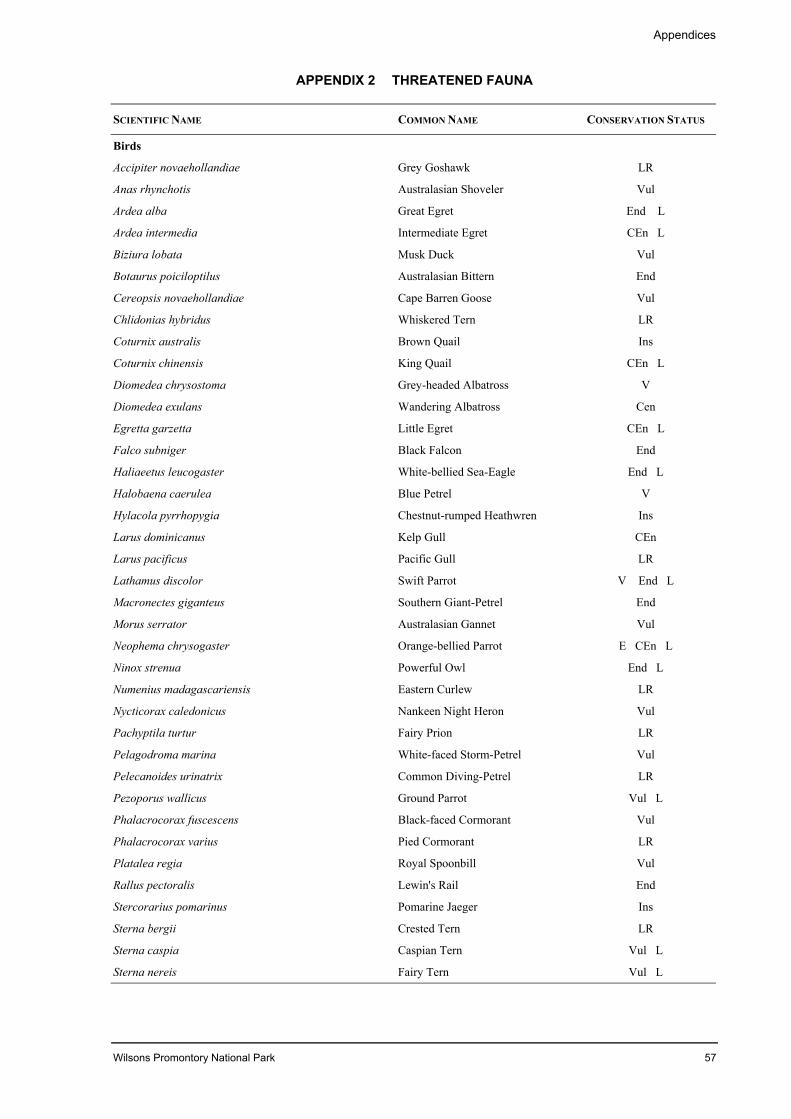
Appendices
Wilsons Promontory National Park 57
APPENDIX 2 THREATENED FAUNA
SCIENTIFIC NAME COMMON NAME CONSERVATION STATUS
Birds
Accipiter novaehollandiae Grey Goshawk LR
Anas rhynchotis Australasian Shoveler Vul
Ardea alba Great Egret End L
Ardea intermedia Intermediate Egret CEn L
Biziura lobata Musk Duck Vul
Botaurus poiciloptilus Australasian Bittern End
Cereopsis novaehollandiae Cape Barren Goose Vul
Chlidonias hybridus Whiskered Tern LR
Coturnix australis Brown Quail Ins
Coturnix chinensis King Quail CEn L
Diomedea chrysostoma Grey-headed Albatross V
Diomedea exulans Wandering Albatross Cen
Egretta garzetta Little Egret CEn L
Falco subniger Black Falcon End
Haliaeetus leucogaster White-bellied Sea-Eagle End L
Halobaena caerulea Blue Petrel V
Hylacola pyrrhopygia Chestnut-rumped Heathwren Ins
Larus dominicanus Kelp Gull CEn
Larus pacificus Pacific Gull LR
Lathamus discolor Swift Parrot V End L
Macronectes giganteus Southern Giant-Petrel End
Morus serrator Australasian Gannet Vul
Neophema chrysogaster Orange-bellied Parrot E CEn L
Ninox strenua Powerful Owl End L
Numenius madagascariensis Eastern Curlew LR
Nycticorax caledonicus Nankeen Night Heron Vul
Pachyptila turtur Fairy Prion LR
Pelagodroma marina White-faced Storm-Petrel Vul
Pelecanoides urinatrix Common Diving-Petrel LR
Pezoporus wallicus Ground Parrot Vul L
Phalacrocorax fuscescens Black-faced Cormorant Vul
Phalacrocorax varius Pied Cormorant LR
Platalea regia Royal Spoonbill Vul
Rallus pectoralis Lewin's Rail End
Stercorarius pomarinus Pomarine Jaeger Ins
Sterna bergii Crested Tern LR
Sterna caspia Caspian Tern Vul L
Sterna nereis Fairy Tern Vul L
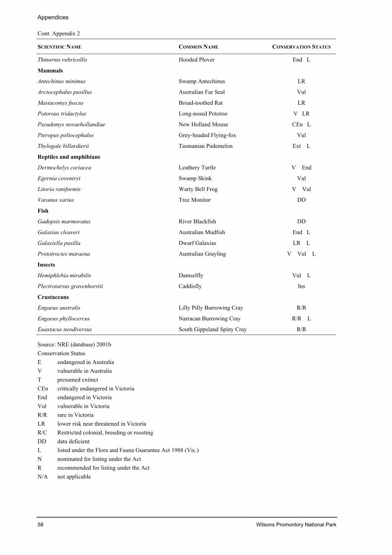
Appendices
58 Wilsons Promontory National Park
Cont. Appendix 2
SCIENTIFIC NAME COMMON NAME CONSERVATION STATUS
Thinornis rubricollis Hooded Plover End L
Mammals
Antechinus minimus Swamp Antechinus LR
Arctocephalus pusillus Australian Fur Seal Vul
Mastacomys fuscus Broad-toothed Rat LR
Potorous tridactylus Long-nosed Potoroo V LR
Pseudomys novaehollandiae New Holland Mouse CEn L
Pteropus poliocephalus Grey-headed Flying-fox Vul
Thylogale billardierii Tasmanian Pademelon Ext L
Reptiles and amphibians
Dermochelys coriacea Leathery Turtle V End
Egernia coventryi Swamp Skink Vul
Litoria raniformis Warty Bell Frog V Vul
Varanus varius Tree Monitor DD
Fish
Gadopsis marmoratus River Blackfish DD
Galaxias cleaveri Australian Mudfish End L
Galaxiella pusilla Dwarf Galaxias LR L
Prototroctes maraena Australian Grayling V Vul L
Insects
Hemiphlebia mirabilis Damselfly Vul L
Plectrotarsus gravenhorstii Caddisfly Ins
Crustaceans
Engaeus australis Lilly Pilly Burrowing Cray R/R
Engaeus phyllocercus Narracan Burrowing Cray R/R L
Euastacus neodiversus South Gippsland Spiny Cray R/R
Source: NRE (database) 2001bConservation StatusE endangered in AustraliaV vulnerable in AustraliaT presumed extinctCEn critically endangered in VictoriaEnd endangered in VictoriaVul vulnerable in VictoriaR/R rare in VictoriaLR lower risk near threatened in VictoriaR/C Restricted colonial, breeding or roostingDD data deficientL listed under the Flora and Fauna Guarantee Act 1988 (Vic.)N nominated for listing under the ActR recommended for listing under the ActN/A not applicable
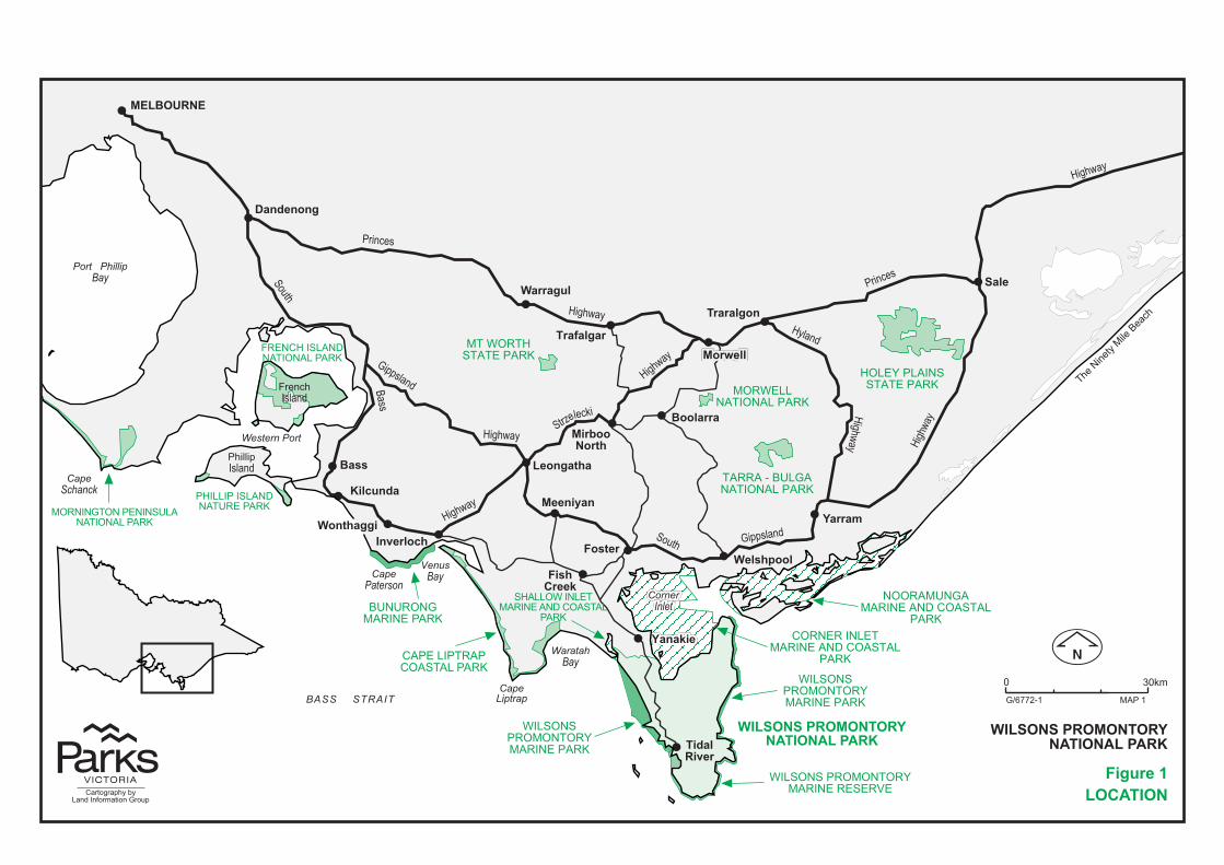
�
�
�
�
�
�
�
��
�
�
��
�
�
�
�
��
�
�
���������
�������
��������
��������
���
��������
������
���������
����� ����� �����
��������
�����
���������
����������
���� ���
����!�����!�����!�
������"�
��#��
����$�!
%�"���&�
'��&���
����
�������
����
����
����
����
�����
� ����
����
�������
����
��
��
���������
���������
����
���
�
�����
����
�����
����������� ��
����������
����������
������
������������
�������������
������ ���������
�����������
������������������������������
���� �����
������� ���
������ � �������
�%�����()�� �������*�%��*�()*�'
�����(+��$*�%��� ����� ����
� ��������� ����������
� �� �
�!"##$%& '��&
(��)*�)��+**��*+,'+��-�+-)-+.-
(��)*�)�+**��*+,'+��-��'+/
)0'��*(����-�'+��-�'�1��*')�'�
�'+/
�*+�-+����-�'+��-�'�1��*')�'�
�'+/
�**+'2��''+��-�'�1��*')�'�
�'+/
�%�����()�� �������*�%��*�()*�'
0*�-,���'��))�'�-��'+/*+(-��
�'��*�'���'+/
�'++'�%��2��'�'��*�'���'+/
��(*+�0)�'�-��'+/
(��)*�)�+**��*+,'+��-��'+/
�2�2+*��'+��-��'+/
�'�-�����+'��*')�'���'+/
�0�������)�'�1�'�2+-��'+/
�+-��0��)�'�1�'��*�'���'+/
*+�����*���-���)2�'�'��*�'���'+/
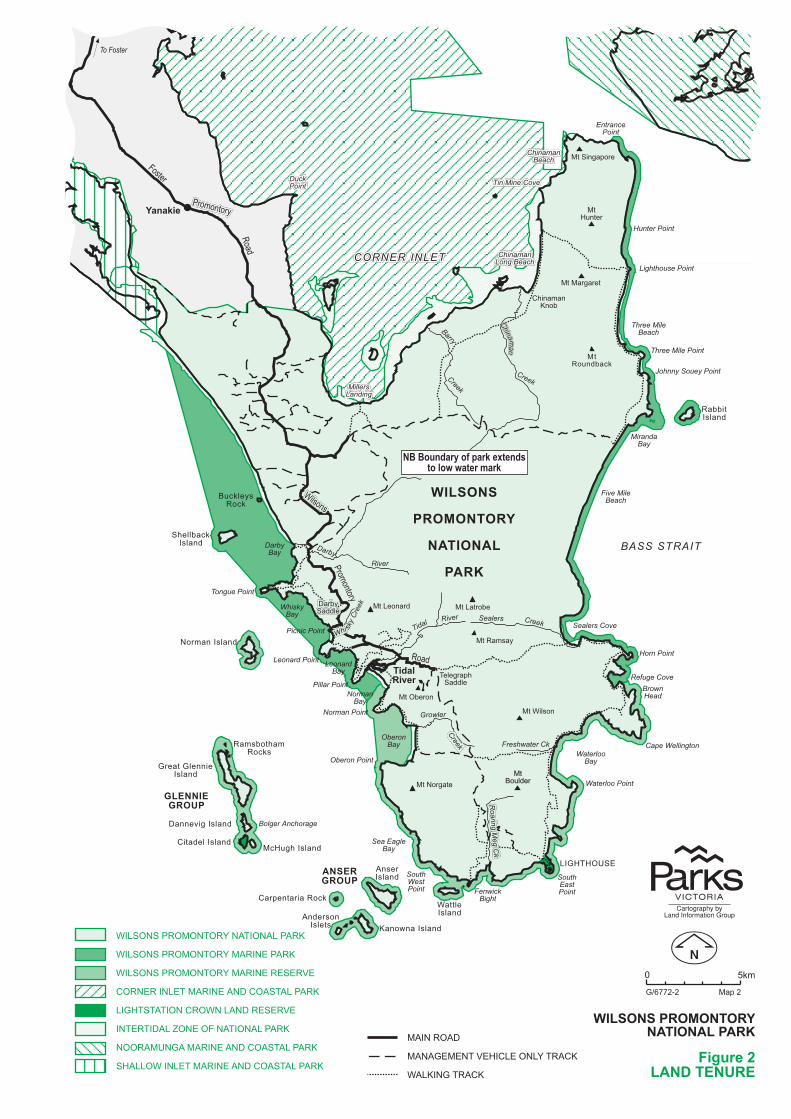
�����
����
����
���� ������� ������� ���
���� ���
����� ������ ������ �
��������������� ���� ����
������������
��� ��������
��� �� ���������� �������
������ ��
� ��� ����
���������� �����
��� ��� � ���
���������
��� ��� ����
� ��� � ���
� �� ������
��������
!������� ����
���� �����
������� ���
����"������"������"��� ���� ���� ���
��� ����� ����� ��!�����!�����!�����
����� ���� ����� ���� ����� ����
����"������"������"��!����� ���!����� ���!����� ���
#��$#��$#��$���������
���$����
%��"�����
������ �����
%��"������
���� ��&�������
'( ������
'( �������
� ������ ���
��������
���$����
����� ����
�������
! ��������� ! ��������
#��(����
��������
���$
��������
���$
��������
���$
� ����� ���$
����
����
����
�����
)���� �
#��(�
��
��
��
�� � � �� ��
�&������&*�
�'�%���*%!���'�%���*%!���'�%���*%!��
�� $
�� $
"��
"��
"��
�� $�� $�� $
�� $���
�
�$���� $
�� �
�������
��������
�������������
����������
�����������
�������������
�������������
�����������������
�����������������������
����������������
�������
��������� !���"�������
#���������
������
��������
��������
���
��������
$��%�&'�(
����������
�����������
������ ������ ������ ������
���$������
��������
����������
���$������
%��������������
���������������������������������
�����������
�����������
��������!���
��������
������������
���#����
���&�����
#$�&���)�&�&�%&�*�� %&� $�) �!
#$�&���)�&�&�%&�*�� ��(�) �!
#$�&���)�&�&�%&�*�� ��(��(�(�+(
�&��(���$(%�� ��(� ����& �% $�) �!
$��%�% %&����&#��$ ����(�(�+(
�%(�%� $�,&�(�&-�� %&� $�) �!
�&&� �'�� �� ��(� ����& �% $�) �!
�� $$&#��$(%�� ��(� ����& �% $�) �!
� ���& �
� � �(�(�%�+(��$(�&�$*�%� �!
# $!���%� �!
��������������� ����������������������
���������������������������
������������������
������������� �� �������� �����
. /��
�0122343 ����3
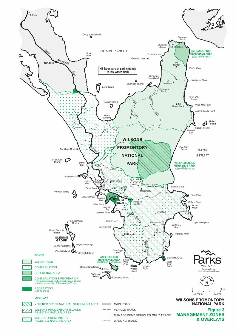
�����
����
����
���� ������� ������� ���
���� ���
����� ������ ������ �
��������������� ���� ����
������������
��� ��������
��� �� ���������� �������
������ ��
� ��� ����
���������� �����
��� ��� � ���
���������
��� ��� ����
� ��� � ���
� �� ������
��������
!������� ����
���� �����
������� ���
����"��� ���
��� ��!�����
����� ����
����"��!����� ���
#��$���
���$����
%��"�����
������ �����
%��"������
���� ��&�������
'( �������
'( �������
� ������ ���
��������
���$����
����� ����
�������
! ��������� ! ��������
#��(����
��������
���$
��������
���$
��������
���$
� ����� ���$
����
����
����
�����
)���� �
#��(�
��
��
��
�� � � �� ��
�&��
���&*�
�'�%���*%!��
�� $
�� $
"��
"��
"��
�� $�� $�� $
�� $���
�
�$���� $
�� �
�������
��������
�������������
�����������
�����������
�������������
�������������
�����������������
�����������������������
����������������
������� ���������� �
��������� !���"�������
#���������
�������
��������
� ���� �
� �
�������
$��%�&'�(
����������
�����������
������������������ � )����#�������*
������ �����
��� ����������������� � )����#�������*
������������
�����������$��������
�����������
�������������
���������������������
������ ������ ������ ������
��$������
��&�����
��������
����������
���$������
%��������������
���������������������������������
����������
� � ������������
��������!���
��������
������������
���#����
� ���& �
+(��$(�%� �!
� � �(�(�%�+(��$(��&�$,�%� �!
# $!���%� �!
��������������� ����������������������
����������������� ���� ��� �
��� ���!� � �������"����
#����� ��
��������������$�����-��������������
. /��
�0122345 � 65
#$�(��(��
�&��(�+ %&�
�(7(�(��(� �(
�&��(�+ %&��8��(��( %&�
�(��( %&�)���-������1*
"����
)%��������������������������������������������������������8������������9���*
���� �
+(�(!(����((!�� %'� $�� %���(�%� �(
#$�&���6�&�&�%&�,��$ ����(�&%(�8�� %'� $� �(
#$�&���6�&�&�%&�,�(�&%(�8�� %'� $� �(
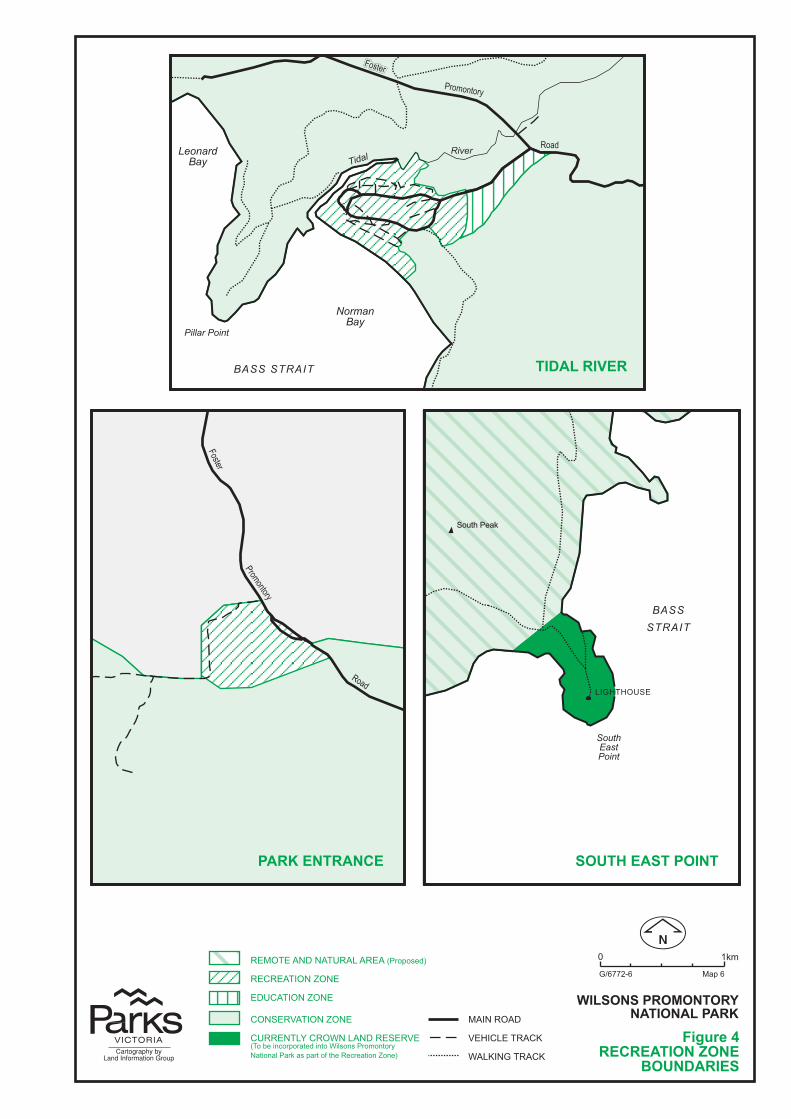
����
��������
�����
�� ��
��������
�� ���� ���� ��
���������
�������
����������
��� ���� ��
����
������
�����������
��������
���������
��� �������� �������� �����
���������
�����������
�������������
���������������� ���� ��� �
����������� ���������
����� ��������������
�� �� �������� �����
� ���
�� !!"# ��$�
��� �����
������� ��������� ����� ���
���������������������%�&$'�()
���������*��
���������*��
������������*��
�������+����������������%��,��-./&$&���(�-.���-0'.'��&�.�&1���-.�0���&���'�$�&��2�� ����/&���-.�*.�)
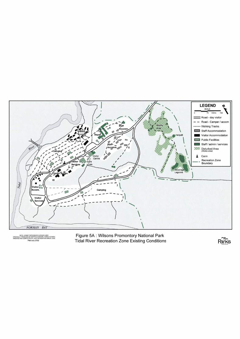
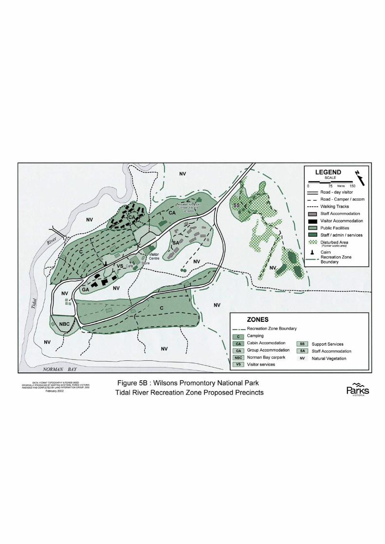
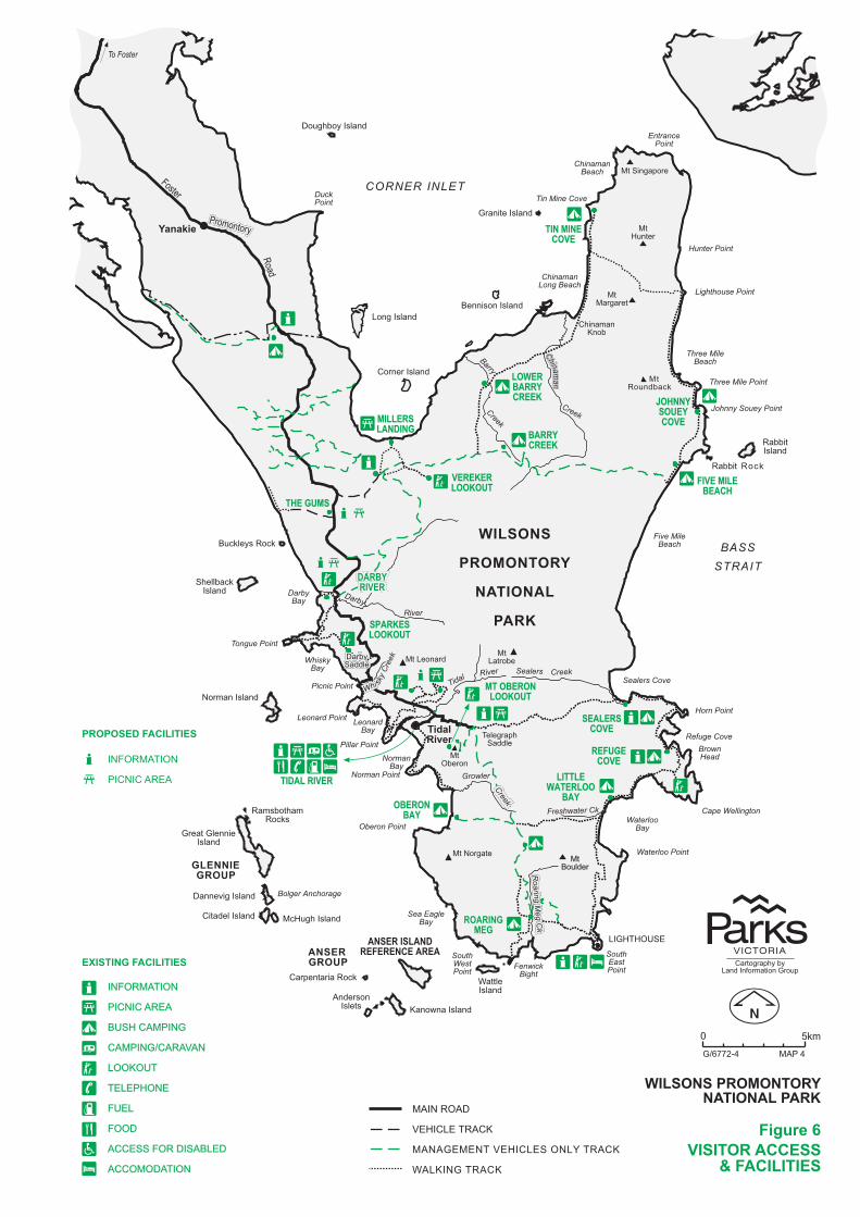
�����
����
���� ������� ������� ���
��������������� ���� ����
������������
��� ��������
��� �� ���������� �������
������ ��
� ��� ����
���������� �����
��� ��� � ���
��� ��� ����
� ��� � ���
� �� ������
��������
!������� ����
���� �����
������� ���
����"��� ���
����� ����
����"��!����� ���
#��$���
���$����
%��"�����
������ �����
%��"������
���� ��&�������
'( �������
� ������ ���
��������
���$����
����� ����
�������
! ��������� ! ��������
#��(����
��������
���$
��������
���$
��������
���$
� ����� ���$
�����
)���� �
#��(�
��
��
��
�� � � �� ��
�&��
���&*�
�'�%���*%!��
�� $
�� $
�"��
�"��
�"��
�� $�� $�� $
�� $���
�
�$���� $
�� �
���
���
���
�������
��������
�������������
�����������
�����������
�������������
�������������
�����������������
������������ �����������
����������������
������� ���������� �
��������� !���"�������
#���������
�������
��������
� ���� �
� �
�������
$��%�&'�(
����������
�����������
������ �����
������������
�����������$��������
�����������
�������������
������ ������ ������ ������
��$������
��&�����
����������
���$������
%��������������
���������������������������������
����������
� � ������������
��������!���
��������
������������
� ���& �
)(��$(�%� �!
� � �(�(�%�)(��$(��&�$*�%� �!
# $!���%� �!
����������������� ���� ��� �
������� �������� ��������
��������������$�����+��������������
��������� ��������
�,&�� %&��,&�� %&��,&�� %&�
-���� �( -���� �( -���� �(
'���� �-�� '���� �-�� '���� �-��
� �-��.� � ) �� �-��.� � ) �� �-��.� � ) �
$&&!&'%$&&!&'%$&&!&'%
%($(-�&�(%($(-�&�(%($(-�&�(
,'($,'($,'($
,&&�,&&�,&&�
��(���,&���� $(� ��(���,&���� $(� ��(���,&���� $(�
��&�&� %&� ��&�&� %&� ��&�&� %&�
/ 0��
�.122345
�� !���"
�#�������� ��������
�,&�� %&�
-���� �(
� -�5
����������
������������������������
�� �� ��
������������������������������
������������������������������
���������������������������������������
���������������������������
������������������������������������
���������������������������������
���������������� ���� ���� ���������������
���� ���� ���� ���������������
���������������������������������������
����� ����� ����� ���� ���� ���� ������������
���������������������������������
�������������������� �� ��
���� ���� ���� ���������������
���������������������
������������������������������������
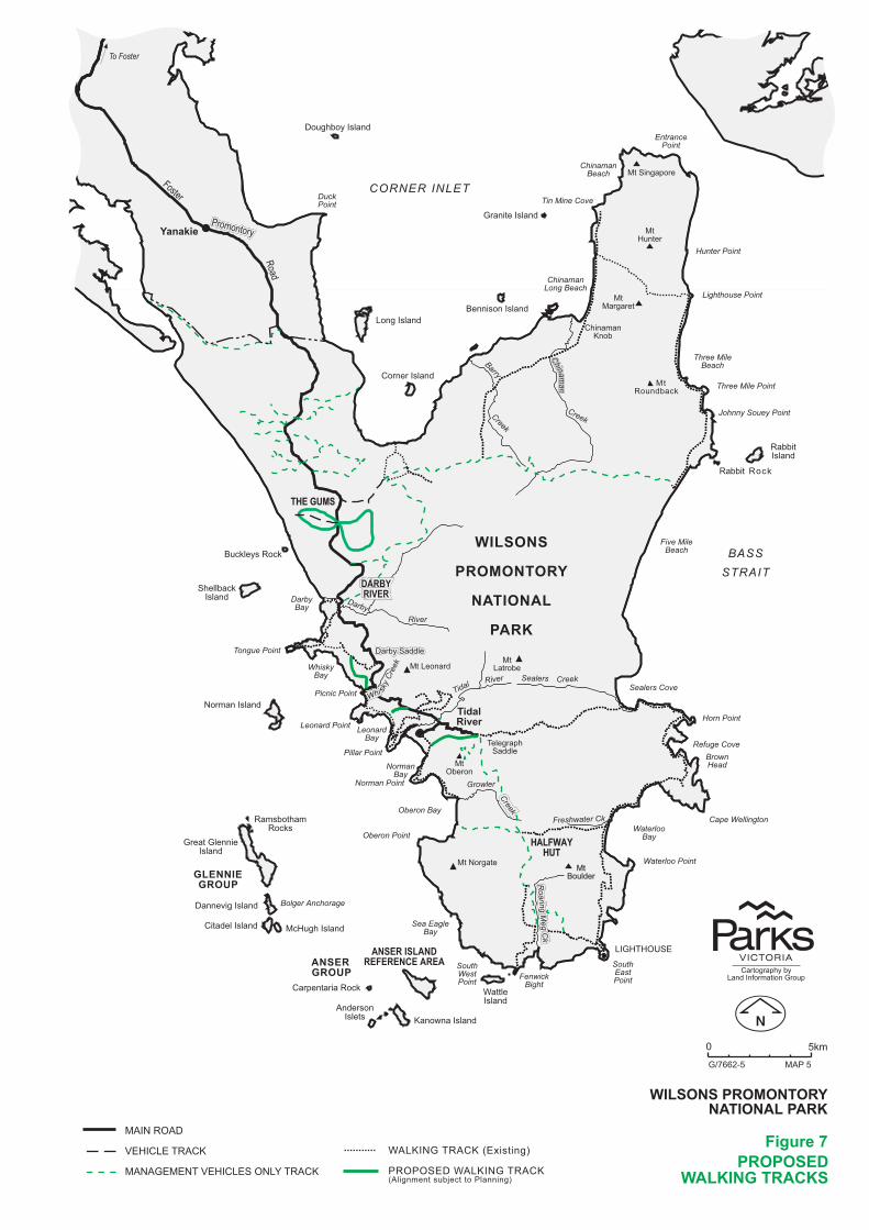
�����
����
���� ������� ������� ���
��������������� ���� ����
������������
��� ��������
��� �� ���������� �������
������ ��
� ��� ����
���������� �����
��� ��� � ���
��� ��� ����
� ��� � ���
� �� ������
��������
!������� ����
���� �����
������� ���
����"��� ���
����� ����
����"��!����� ���
#��$���
���$����
%��"�����
������ �����
%��"������
���� ��&�������
'( �������
� ������ ���
��������
���$����
����� ����
�������
! ��������� ! ��������
#��(����
��������
���$
��������
���$
��������
���$
� ����� ���$
�����
)���� �
#��(�
��
��
��
�� � � �� ��
�&��
���&*�
�'�%���*%!��
�� $
�� $
�"��
�"��
�"��
�� $�� $�� $
�� $���
�
�$���� $
�� �
���
���
���
'( �������
�������
��������
�������������
�����������
�����������
�������������
�������������
�����������������
������������ �����������
����������������
������� ���������� �
��������� !���"�������
#���������
�������
��������
� ���� �
� �
�������
$��%�&'�(
����������
�����������
������ �����
������������
�����������$��������
�����������
�������������
������ ������ ������ ������
��$������
��&�����
����������
���$������
%��������������
������������������������������������
����������
� � ������������
��������!���
��������
������������
� ���& �
)(��$(�%� �!
� � �(�(�%�)(��$(��&�$*�%� �!
����������������� ���� ��� �
�������� ������� ���
��������������$�����+��������������
, -��
�./0012-
�������
� 3�-
# $!���%� �!�4(5�����6
3�&3&�(��# $!���%� �!4 �����������7�������3�������6
������������������������������
���������� �� �� �
������������������������