wilsons promontory marine national park - parks...
TRANSCRIPT
Wilsons Promontory Marine National Park
The Prom’s underwater wonders Wilsons Promontory Marine National Park is the largest marine national park in Victoria, covering almost 16,000 hectares. It is a rare global example of adjoining marine and land parks with protected landscapes from the top of the mountains to the bottom of the sea.
Wilsons Promontory Marine National Park protects a diverse range of habitats including rocky reefs, sandy sea floors, kelp forests, sponge gardens, seagrass meadows and open sea.
Its variety of marine life is impressive, including a wide range of reef and pelagic fish, invertebrates and marine mammals. Rays and harmless sharks cruise above the sandy seabed and giant Maori Octopuses venture out at night. Molluscs such as limpets and snails, anemones, brittlestars and seastars are also common in the intertidal reefs.
Some of Victoria’s most magnificent underwater seascapes are found in numerous dive sites around the Prom. Smooth-walled granite cliffs, boulders and caves harbor colourful ‘gardens’ of huge sponges, fan-shaped Gorgonian corals, sea-lace colonies, sea-tulips and sea whips. Brilliantly coloured fish can be seen, including Red Velvetfish, Wrasse, Eastern Blue Groper, and schools of Berber, Magpie and Butterfly Perch.
There are over 45 shipwrecks in the waters surrounding Wilsons Promontory – a lasting record of our maritime history.
A number of offshore islands support colonies of Australian Fur Seals, as well as sea birds such as White-bellied Sea Eagles, Little Penguins, Short-Tailed Shearwaters, Fairy Prions and Pacific Gulls. Access to the islands is prohibited except for beach areas of Great Glennie and Rabbit Islands.
Exploring the coast You don’t need to be on or under the water to enjoy the park’s diverse marine environment. There are many wonderful coastal settings for bird watching, rock pooling or just walking and relaxing on the beach with friends or family.
The threatened Hooded Plover nests in very exposed beach locations, including Wilsons Promontory. Please take care not to disturb the birds or step on their eggs by walking close to the water’s edge, especially between August and April.
Sea Country Through their cultural traditions, Aboriginal people maintain their connections to their ancestral lands and waters. Parks Victoria recognises this connection and acknowledges the Boon Wurrung, Bunurong and Gunai Kurnai people, Traditional Owners of Yiruk Wamoon (Wilsons Promontory Marine and National Parks).
Protecting our marine environment Over 90% of the plants and animals living in Victoria’s southern waters are found nowhere else in the world.
Wilsons Promontory Marine National Park is part of a system of 13 marine national parks and 11 marine sanctuaries in Victoria. By keeping these areas in a natural state we will protect this unique marine environment into the future.
For more information on Victoria’s marine national parks and marine sanctuaries, contact the Parks Victoria Information Centre on 13 1963 or visit www.parks.vic.gov.au
Help reduce marine pests Marine pests are non-native animals that cause significant damage to the health of native marine ecosystems. Marine pests can wipe out native species by preying upon or out-competing them.
Visitors can help prevent the spread of marine pests. Upon entry and exit to any watercourse wash in fresh water and dry all boating, fishing, surfing and swimming equipment, wetsuits, swimwear, towels, footwear and water toys.
Report any suspected marine pests to the Department of Environment and Primary Industries on 13 6186. For more information on marine pests, visit www.depi.vic.gov.au
Victoria’s blue wilderness Wilsons Promontory’s striking granite headlands, boulders and islands continue underwater,
forming sheer walls, caves and pinnacles — a unique wilderness beneath the waves.

For further information Parks Victoria
Information Centre Call 13 1963
or visit our website www.parks.vic.gov.au
Tidal River Visitor Centre (03) 5680 9555
7 days, 8.30am – 4pm EST 8.30am - 4.30pm EDST
Nearby Marine Parks & Reserves
Wilsons Promontory Marine Park The coast and nearby waters east
and west of the Prom are designated as Marine Park.
Fishing is permitted within the marine park, subject to fishers
conforming to the Fisheries Act. Diving, wildlife viewing and beach walking are also popular activities.
Corner Inlet Marine National Park With the granite peaks of the Prom
as a dramatic backdrop, this park protects a variety of sheltered
habitats, including intertidal mudflats, channels and seagrass
meadows. Refer to Corner Inlet Marine National Park – Park Note.
Corner Inlet and Nooramunga Marine & Coastal Parks
Protected from the pounding surf of Bass Strait by barrier islands; an
intricate network of shallow marine waters, isolated granite islands,
intertidal mudflats and over 40 sand barrier islands. Refer to Corner Inlet
and Nooramunga Marine and Coastal Parks – Park Note.
Shallow Inlet Marine & Coastal Park
Nestled between Waratah Bay and the majestic peaks of Wilsons
Promontory, the park offers a secluded and peaceful setting for a range of water based activities.
Boating, fishing, bird watching and picnicking are popular. Refer to
the Shallow Inlet Marine and Coastal Park – Park Note.
Valid as of June 2014
Please don’t throw this park note
away. Keep it, return it for others
to use, or recycle it.
What can I do?
For the protection of the marine environment, a number of activities are prohibited within the boundaries of Victoria’s Marine National Parks and Marine Sanctuaries. Rangers and Fisheries Officers regularly patrol these areas and enforce regulations.
Please be aware of the Wilsons Promontory Marine National Park boundaries, which start at the high water mark except where it borders the Marine Reserve surrounding the Glennie Group of Islands.
Access
The marine national park is accessed by land or via boat. The nearest launching points are in Tidal River (key and deposit required), Sandy Point or for larger vessels from Port Welshpool. Restrictions
You may carry fin-fish on board your boat within marine national park boundaries if you caught the fish outside the park, and you may also carry (but not use) a fishing rod. Spear guns are not
permitted within any of Victoria’s marine protected areas, either in a boat or elsewhere.
You may also have abalone or rock lobster and associated equipment (securely stowed) on board the boat provided you are travelling straight through the park by the shortest practicable route.
There are strong penalties under the National Parks Act for fishing in marine national parks and marine sanctuaries. To report a fishing offence call the Department of Environment and Primary Industries on 13 FISH (13 3474).
Caring for the marine environment The intertidal zone in Victoria is protected –
inside and outside marine protected areas. Bottles and other glass vessels are not permitted
on beaches within marine protected areas. Discarded equipment and rubbish harms birds
and marine animals – take your rubbish home. Look and don’t touch when snorkelling and
diving, so future generations can do the same. Always replace any organisms or rocks you
may have disturbed. Shipwrecks and artefacts are protected by law. If boating, anchor away from fragile areas
such as seagrass meadows and reefs. Keep boat noise and wake low in sensitive
areas along the shore and near islands to avoid disturbing wildlife.
Avoid spilling and never pump petrol, oil or other pollutants on land or in the water.
Maintain safe distances around marine mammals. For more information, visit www.depi.vic.gov.au.
Personal safety Call 000 for Police, Fire or Ambulance Services. For park related emergencies only (fire,
accident/injury, injured wildlife, significant campground disturbance or critical maintenance issues), visitors can contact the Duty Ranger (24 hours) on 1300 247 594.
Mobile phone coverage cannot be relied upon in the marine environment. Carry a registered distress beacon for safer boating.
Check the marine weather report. Beware of sudden changes in weather, especially when boating on open water. Practice safe boating, and follow all signs and markers correctly.
Wear shoes that grip well when walking on rock platforms. Stay away from cliff edges and bases and beware of large unexpected waves when walking on shore and on rock platforms.
Never put your hands where you cannot see your fingertips (under seaweed or rocks) to avoid potentially dangerous creatures.
Be aware of strong currents and undertows when swimming and snorkelling.
Diving in these waters should only be undertaken by experienced and qualified divers.
Recreational activities Is it allowed? Nature observation and sight seeing Yes
Snorkelling and scuba diving Yes
Swimming Yes
Surfing, windsurfing, sailing, sea kayaking, boating
Yes1
Filming and photography Yes
Jet skiing No
Education and research
Educational excursions Yes Scientific research (permit required) Yes
Recreational fishing and harvesting All forms of fishing – line, spear, netting, traps and shellfish collection (including abalone and rock lobster)
No
Bait collection No Catch and release fishing No
Commercial fishing and aquaculture
Abalone and rock lobster fishing No
Netting, line fishing and trapping No
Marine aquaculture No
Other uses
Licensed tour operators (permit required) Yes
Commercial filming and photography (permit required)
Yes
Removal or disturbance of plants/animals No
Removal or disturbance of shipwreck artefacts
No
Dredging and soil dispersal No
Activities that disturb the seafloor No
Waste and ballast discharge No 1 Restrictions apply. Contact the Tidal River Visitor Centre on (03) 5680 9555 for up-to-date information.
3.9 nautical miles(7.3km)
7.45
nau
tica
l mile
s
(13.
8km
)
1.8 nautical miles
(3.3km)
3.0 nautical miles
(5.6km)
4.78 nautical miles
(8.8km)
Waterloo Bay
W I L S O N S P R O M O N T O R Y
M A R I N E N A T I O N A L P A R K
T A S M A N
S E A
B A S S
S T R A I T
South East Point
Little Waterloo Bay
South Point
Wattle Island
Kanowna Island
Anser IslandCarpentaria Rock
Anderson Islets
Ramsbotham Rocks
Fenwick Bight
Oberon Bay
Norman Point
McHugh Island
Dannevig Island
Great Glennie Island
GlennieGroup
Norman Island
Picnic Bay
Squeaky Beach
Norman Bay
Smith Cove
Horn Point
Hobbs Head
Refuge Cove
Brown Cove
Bare Back Cove
Waterloo Point
Sea Eagle Bay
Oberon Point
Leonard Point
Pillar Point
AnserGroup
Sealers Cove
39°10.86’S146°24.97’E
39°11.17’S146°22.67’E
Cape Wellington39°04.00’S146°28.79’E
Cleft Island39°09.47’S
146°17.66’E
Citadel Island Beacon39°06.90’S
146°14.20’E
39°04.25’S146°13.39’E
39°02.46’S146°19.63’E
T I D A L R I V E R
Roaring Meg
Halfway Hut
Little Waterloo Bay
Telegraph Junction
Oberon Bay
Telegraph Saddle
Sealers Cove
Refuge Cove
High Water Mark
Hig
h W
ater
Mar
k
High Water M
ark
-43
-52
-44
-17
-35
-40
-44
-51
-42
-66
-73
-47
-58
-85
-95
-16
-57
-28
-73
-72
B OU
L DE R R
AN
GE
W I L S O N R A N G E
Mt WilsonKersop Peak
Mt BoulderMt Norgate
Mt Ramsay
Mt Oberon
Mt McAlister
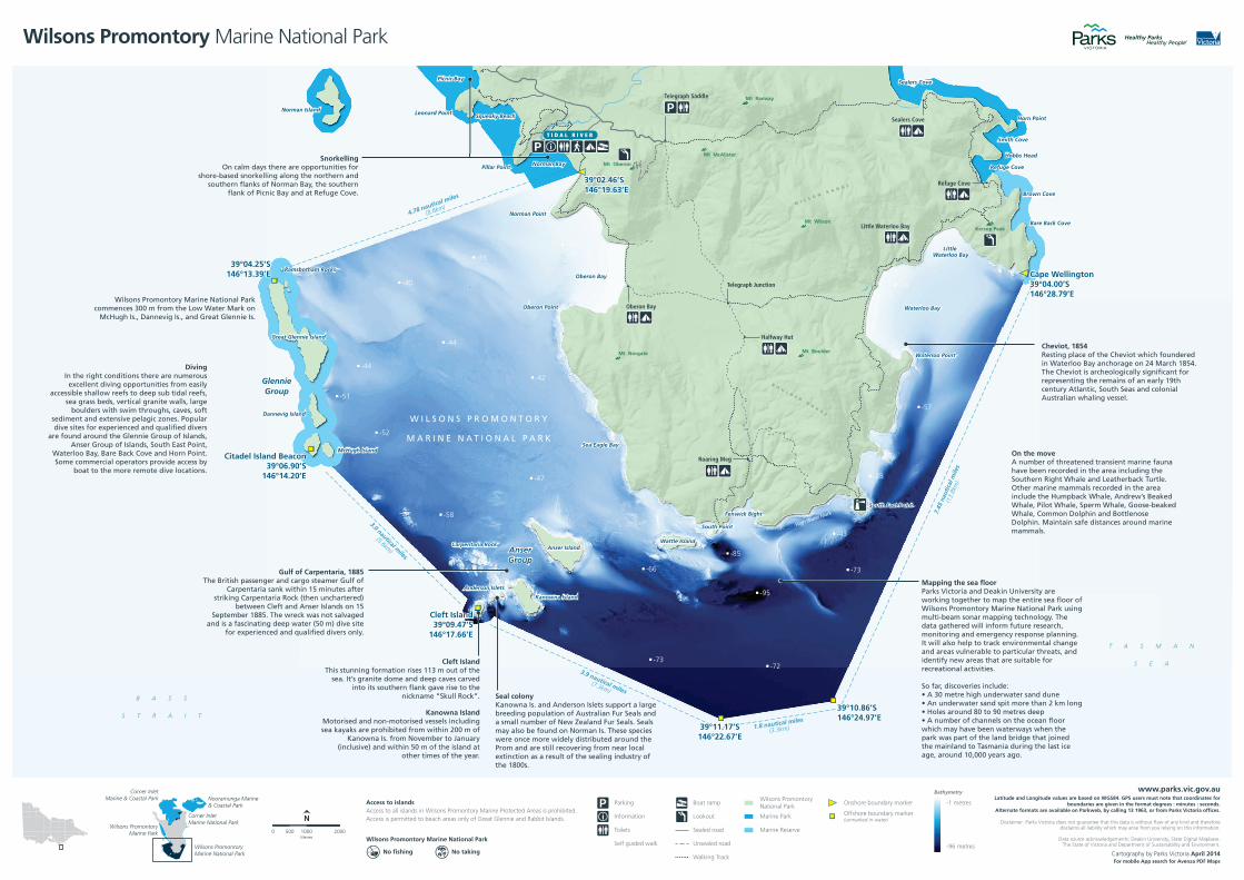
Cheviot, 1854Resting place of the Cheviot which foundered in Waterloo Bay anchorage on 24 March 1854. The Cheviot is archeologically significant for representing the remains of an early 19th century Atlantic, South Seas and colonial Australian whaling vessel.
On the moveA number of threatened transient marine fauna have been recorded in the area including the Southern Right Whale and Leatherback Turtle. Other marine mammals recorded in the area include the Humpback Whale, Andrew’s Beaked Whale, Pilot Whale, Sperm Whale, Goose-beaked Whale, Common Dolphin and Bottlenose Dolphin. Maintain safe distances around marine mammals.
Mapping the sea floorParks Victoria and Deakin University are working together to map the entire sea floor of Wilsons Promontory Marine National Park using multi-beam sonar mapping technology. The data gathered will inform future research, monitoring and emergency response planning. It will also help to track environmental change and areas vulnerable to particular threats, and identify new areas that are suitable for recreational activities.
So far, discoveries include:
which may have been waterways when the park was part of the land bridge that joined the mainland to Tasmania during the last ice
Gulf of Carpentaria, 1885The British passenger and cargo steamer Gulf of
Carpentaria sank within 15 minutes after striking Carpentaria Rock (then unchartered)
between Cleft and Anser Islands on 15 September 1885. The wreck was not salvaged
for experienced and qualified divers only.
DivingIn the right conditions there are numerous excellent diving opportunities from easily
accessible shallow reefs to deep sub tidal reefs, sea grass beds, vertical granite walls, large
boulders with swim throughs, caves, soft sediment and extensive pelagic zones. Popular dive sites for experienced and qualified divers
are found around the Glennie Group of Islands, Anser Group of Islands, South East Point,
Waterloo Bay, Bare Back Cove and Horn Point. Some commercial operators provide access by
boat to the more remote dive locations.
Wilsons Promontory Marine National Park
McHugh Is., Dannevig Is., and Great Glennie Is.
SnorkellingOn calm days there are opportunities for
shore-based snorkelling along the northern and southern flanks of Norman Bay, the southern
flank of Picnic Bay and at Refuge Cove.
Seal colonyKanowna Is. and Anderson Islets support a large breeding population of Australian Fur Seals and a small number of New Zealand Fur Seals. Seals may also be found on Norman Is. These species were once more widely distributed around the Prom and are still recovering from near local extinction as a result of the sealing industry of
Kanowna IslandMotorised and non-motorised vessels including
Kanowna Is. from November to January
other times of the year.
Cleft Island
sea. It’s granite dome and deep caves carved into its southern flank gave rise to the
nickname “Skull Rock”.
Cartography by Parks Victoria April 2014For mobile App search for Avenza PDF Maps
www.parks.vic.gov.auLatitude and Longitude values are based on WGS84. GPS users must note that coordinates for
boundaries are given in the format degrees : minutes : seconds. Alternate formats are available on Parkweb, by calling 13 1963, or from Parks Victoria offices.
Disclaimer: Parks Victoria does not guarantee that this data is without flaw of any kind and therefore disclaims all liability which may arise from you relying on this information.
Data source acknowledgements: Deakin University, State Digital Mapbase. The State of Victoria and Department of Sustainability and Environment.
1000500Metres
0 2000
N
Access to islandsAccess to all islands in Wilsons Promontory Marine Protected Areas is prohibited. Access is permitted to beach areas only of Great Glennie and Rabbit Islands.
No fishing No taking
Wilsons Promontory Marine National Park
Parking
Information
Toilets
Self guided walk
Sealed road
Unsealed road
Boat ramp
Walking Track
Lookout
Wilsons PromontoryNational Park
Marine Park
Marine Reserve
Onshore boundary marker
Offshore boundary marker(unmarked in water)
-1 metres
-96 metres
Bathymetry
Wilsons Promontory Marine National Park
Nooramunga Marine& Coastal Park
Corner InletMarine National Park
Wilsons PromontoryMarine Park
Wilsons PromontoryMarine National Park
Corner InletMarine & Coastal Park