5.8 hydrology and water quality - agua caliente eis/e5_8_hydro_110514.pdf · 5.8 hydrology and...
TRANSCRIPT
Meridian Consultants 5.8-1 Section 24 Specific Plan Project 044-001-13 November 2014
5.8 HYDROLOGY AND WATER QUALITY
This Section of the Draft EIS evaluates the potential for the Project to impact hydrology and water
quality conditions on a local and regional context. More specifically, this Section evaluates impacts
associated with the Project that may potentially affect the regional and local water quality, surface
water hydrology, and groundwater hydrology. Various federal, State, regional, Tribal, and local programs
and regulations related to anticipated hydrology and water quality impacts are also discussed in this
Section. Please see Section 9.0 for a glossary of terms, definitions, and acronyms used in this Draft EIS.
A. ENVIRONMENTAL SETTING
1. Existing Conditions
Hydrologic Conditions
Watershed
The Project Site is located within the boundaries of the Coachella Valley Planning Area of the Colorado
River Basin (Region 7). Region 7 covers approximately 13,000,000 acres (20,000 square miles) in the
southeastern portion of California, and includes all of Imperial County and portions of San Bernardino,
Riverside, and San Diego Counties. It is bounded on the east by the Colorado River; to the south by
Mexico; to the west by the Laguna, San Jacinto, and San Bernardino Mountains; and to the north by the
New York, Providence, Granite, Old Dad, Bristol, Rodman, and Ord Mountain Ranges.1
The Coachella Valley Planning Area consists of the Whitewater River Watershed and East Salton Sea
Watershed, with the Project Site located within the Whitewater River Watershed. The Whitewater River
Watershed covers 1,920 square miles in the west central portion of Region 7 and includes the majority
of Riverside County and a small portion of southern San Bernardino County2. The watershed consists
mainly of sparsely populated mountains, desert, and agricultural lands. The watershed is bounded on
the south by the San Jacinto and Santa Rosa Mountains, on the west by the Santa Ana Watershed, on
the east by the Salton Sea, the Hexie and Cottonwood Mountains, and Southern Mojave Watershed, and
on the north east by the little San Bernardino Mountains and Southern Mojave Watershed. The highest
elevation (upper reaches) of the watershed occur in the San Jacinto Mountains at 10,000 feet above
1 State Water Resources Control Board, California Regional Water Quality Control Board, Water Quality Control Plan: Colorado River Basin—Region 7, (June 2006) 1-6.
2 Colorado River Basin Regional Water Quality Control Board (CRB RWQCB), (2006) 1-11.
5.8 Hydrology and Water Quality
Meridian Consultants 5.8-2 Section 24 Specific Plan Project 044-001-13 November 2014
mean sea level, while the Salton Sea at 230 feet below mean sea level forms the lowest elevation of the
watershed.3
Regional Drainage
The Whitewater River, a channelized river, is the major surface drainage watercourse in the Coachella
Valley. The Whitewater River also has a constructed downstream extension known as the Coachella
Valley Stormwater Channel, which serves as a drainage way for irrigation return flows, treated
community wastewater, and storm runoff.4 The stormwater facilities operated and maintained by
Coachella Valley Water District (CVWD) include the Whitewater River Stormwater Channel, Coachella
Valley Stormwater Channel, West and East side dike systems, fifteen Cove Community channels from
Rancho Mirage to La Quinta, Cove Community basins, Lower Valley stormwater channels in the
agricultural areas, and detention channels that drain water impounded behind the dikes.5 The
Whitewater River is typically a desert dry wash, flowing only in periods of intense rain.
The CVWD is the local jurisdiction, which operates and maintains multiple stormwater protection
facilities in the region with a combined length of 135 miles.6 CVWD delivers irrigation and domestic
(drinking) water, collects and recycles wastewater, provides regional stormwater protection, replenishes
the groundwater basin and promotes water conservation. Additionally, CVWD is involved with regional
stormwater and flood protection, including planning, maintenance and construction of drainage
improvements for regional flood control facilities, as well as watershed and watercourse protection
related to these facilities.
The CVWD has conducted master studies to determine potential flooding hazards within their service
boundaries. The master plan studies for the North Cathedral City and Thousand Palms areas indicate
existing flood hazards from the sources in the Morongo Was Watershed, which consists of Morongo
Wash, Long Canyon, East and West Wide Canyon and Willow Hole.7 Floodwaters from these watersheds
coalesce along the valley bottom and flow southeast along the Interstate 10 (I-10) corridor.
The regional stormwater facilities that have been built in the area, and further southeast, consist of the
flood channels or “greenbelts” built in the Classic Club Golf Course, Sun City Palm Desert, and Sun City
3 CRWQCB, (2006) 1-7. 4 CRWQCB, 2006. 5 Coachella Valley Water District (CVWD), “About CVWD and Stormwater Protection and Flood Control,”
www.cvwd.org/about/stormwater.php. Accessed May 27, 2014. 6 CVWD, “About CVWD and Stormwater Protection and Flood Control,” www.cvwd.org/about/stormwater.php. Accessed
May 27, 2014. 7 CVWD, North Cathedral City and Thousand Palms Stormwater Management Plan, Morongo Wash Watershed Hydrology
and Hydraulics, April 25, 2014.

5.8 Hydrology and Water Quality
Meridian Consultants 5.8-3 Section 24 Specific Plan Project 044-001-13 November 2014
Shadow Hills. CVWD is currently undertaking several projects to connect the existing regional facilities.
One project will design flood conveyance channels in North Indio that would connect the Sun City Palm
Desert facilities to the Sun City Shadow Hills ones and then to the Coachella Valley Stormwater Channel.
Another project would complete of the design of the Thousand Palms Flood Control Project that was
originally developed by the US Army Corps of Engineers (USACE). The Thousand Palms Flood Control
Project would collect stormwater from the Thousand Palms Watershed by intercepting flood flows with
a series of levees on the fans uphill from community of Thousand Palms and conveying them through
the Classic Club Golf Course and a new channel to Sun City Palm Desert.
CVWD is planning facilities to manage floodwaters from the Morongo Wash Watershed and the riverine
flows under the assumption that the other regional projects are in place or complete. These facilities
would likely either convey the riverine flows to the Whitewater River Stormwater Channel near Palms
Springs or to the Coachella Valley Stormwater Channel through the regional facilities that are in the
process of being designed, as described in the preceding paragraph.8
Local Drainage
The Whitewater River is located approximately 2.9 miles southwest of the Project Site. Water flows
northwest to southeast through the City of Rancho Mirage (“City”) and eventually empties into the
Salton Sea. The Whitewater River has an intricate drainage network of several intermittent, north-
flowing streams that drain the Santa Rosa Mountains and empty into the Whitewater River. The two
largest tributaries of the Whitewater River are Bradley and Magnesia Spring Canyon streams. Several
unnamed smaller streams and drainages also feed these two streams. In the urbanized parts of the area,
streams have been modified and are now mostly confined to open channels, culverts, and storm drains;
however, for most of their length, they remain natural and unmodified.
According to the Master Drainage Plan for the City, there are three local watershed zones (1, 2, and 3)
within a 5.4 square mile area of the City. The Project Site is located within Zone 2 (1,645 acres) of the
City’s Master Drainage Plan. This Zone has the greatest amount of undeveloped land and is divided by
the Palm Springs Ridge Line. In general, the area north of the ridgeline drains toward I-10 and the area
south of the Palm Springs Ridge Line drains towards the Whitewater River. System deficiencies include
the need to implement several regional drainage improvements to collect runoff in this zone (e.g., the
proposed Mid-Valley Channel and a new culvert through the new Monterey Drive Interchange
embankment at the Union Pacific Railroad (UPRR/I-10 crossing).
8 CVWD, North Cathedral City and Thousand Palms Stormwater Management Plan, Morongo Wash Watershed Hydrology and Hydraulics, (April 25, 2014) 1.
5.8 Hydrology and Water Quality
Meridian Consultants 5.8-4 Section 24 Specific Plan Project 044-001-13 November 2014
Project Site
Topographically, the Project Site generally slopes downward to the northeast and southwest. Surface
elevations range from approximately 350 feet to 250 feet above mean sea level, with the highest points
located in the south- and west-central portions of the Project Site. Based on surface topography,
drainage across the Project Site is generally from the center of the Project Site to the north towards
Ramon Road and to the south towards Dinah Shore Drive via sheet flow flowing natural drainage
courses. The runoff drains into the local storm drain system along Bob Hope Drive and Dinah Shore
Drive.
According to the Federal Emergency Management Agency (FEMA) Flood Insurance Rate Map (FIRM)
Map Number’s 06065C1585G and 06065C1595G, effective since August 28, 2008, the Project Site is not
in a designated 100-year flood hazard area.9 The nearest 100-year flood zone is located approximately
0.5 miles north of the I-10, and is designated as AO (100-year risk of flooding one to two feet deep).
A small portion of the northeast portion of the Project Site is within the floodplain limits of the Morongo
Wash Watershed, as shown in Figure 5.8-1, Existing 100-Year Flood Hazard Areas.
Water Resources
The principal water sources of the Coachella Valley are local groundwater, recycled water, and imported
water either through the State Water Project (SWP) or from the Colorado River via the Coachella Canal,
a branch of the All-American Canal.10 Although Colorado River water and SWP water are percolated into
the groundwater supply, and are ultimately used through groundwater pumping, they are considered
separate sources of water for CVWD. Local surface water is also present in the Coachella Valley in the
form of streams; however, CVWD does not derive any of its direct supply from surface water.
Additionally, average precipitation in this arid region is only 3 to 6 inches per year and does not directly
provide significant additional water supplies because most of the precipitation evaporates or is
consumed by the native vegetation. However, the aquifers are recharged by precipitation and runoff
from the local mountains.
CVWD currently has approximately 106,000 domestic water connections and has a groundwater production capacity of 240 million gallons per day. Areas served with domestic water by CVWD include a portion of lands near Desert Hot Springs, the Indio Hills area, and a portion of Cathedral City. CVWD serves all of Rancho Mirage, Thousand Palms, Palm Desert, Indian Wells, La Quinta, and a portion
9 Federal Emergency Management Agency, Flood Insurance Rate Map, Riverside County California, Panel 1585 of 3805, Map Number 06065C1585G and 06065C1595G, August 28, 2008.
10 CVWD, 2014. http://www.cvwd.org/about/wherewater.php.
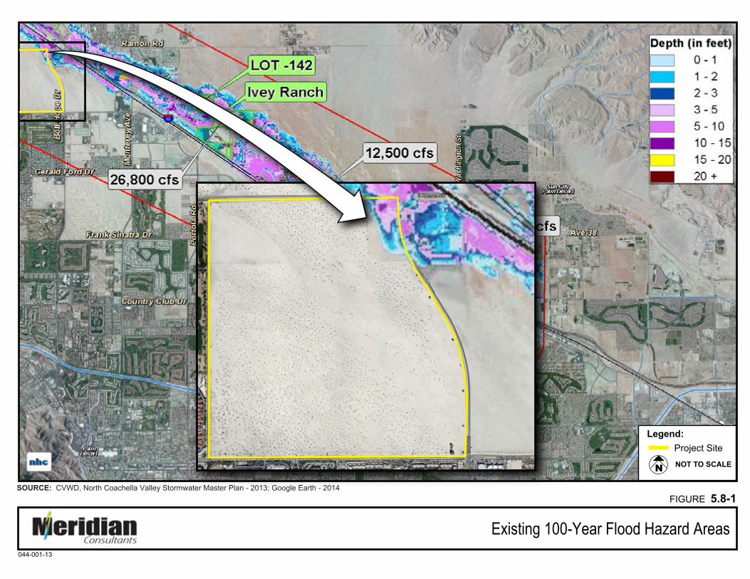
Existing 100-Year Flood Hazard Areas
FIGURE 5.8-1SOURCE: CVWD, North Coachella Valley Stormwater Master Plan - 2013; Google Earth - 2014
044-001-13
NOT TO SCALEN
Legend: Project Site
5.8 Hydrology and Water Quality
Meridian Consultants 5.8-6 Section 24 Specific Plan Project 044-001-13 November 2014
of Indio and Coachella. CVWD also serves other rural communities, including Thermal, Mecca, Oasis, Desert Shores, Salton Sea Beach, Salton City, North Shore, Bombay Beach, and Hot Mineral Springs, and other portions of unincorporated Riverside County.
Groundwater
Groundwater Supplies
Development throughout the Coachella Valley has been dependent on groundwater as a source of
supply. The demand for groundwater has annually exceeded the limited natural recharge of the
groundwater basin. Therefore, imported water is used to recharge the aquifer and reduce groundwater
overdraft. Department of Water Resources (DWR) Bulletin 108 is the most current bulletin published by
DWR that characterizes the condition of the aquifer as a whole.11 In Bulletin 108, DWR notes that the
amount of usable supply in the over-drafted aquifer is decreasing. The annual overdraft for the
Coachella Valley is estimated to be approximately 62,500 acre-feet per year, with a cumulative overdraft
of 5.1 million acre-feet from 1964 through 2006.12 The average rise in water levels observed in
monitored wells in the West Whitewater River Subbasin Area of Benefit from 2012 to 2013 was 1.1
feet.13
Please refer to the discussion under Public Water Supply, in Section 5.15.1, Utilities and Service
Systems: Water Service, of this EIS for additional information on groundwater supply and overdraft
mitigation efforts.
Groundwater Quality
Groundwater is the main source of domestic water supply for residents and businesses within CVWD’s
service area. Water quality and the character of groundwater are determined by a number of factors
including: mineral content of sediments, recharge and drainage patterns, stormwater infiltration,
historic land use practices, and casing screening intervals and depths of wells sampled.
As required by the California Safe Drinking Water Act, public water suppliers are required to provide
annual Water Quality Reports to its customers (also known as Consumer Confidence Reports). This
mandate is governed by the US Environmental Protection Agency (USEPA) and the California
Department of Health Services to inform customers of their drinking water quality. In accordance with
11 California Department of Water Resources, Coachella Valley Investigation; Bulletin 108, (July 1964). 12 Engineer's Reports on Water Supply and Replenishment Assessment 2014/2015, prepared by the Coachella Valley Water
District, (April 2014). 13 Coachella Valley Water District, Engineer’s Report on Water Supply and Replenishment Assessment, West Whitewater
River Subbasin Area of Benefit 2040-2015. Coachella, California. (April 2014). 14.
5.8 Hydrology and Water Quality
Meridian Consultants 5.8-7 Section 24 Specific Plan Project 044-001-13 November 2014
the Safe Drinking Water Act, the public water supplier monitors regulated and unregulated compounds
in its water supply. CVWD analyzes more than 22,000 water samples annually to ensure that domestic
water meets State and federal standards. Every year, CVWD is required to analyze a select number of
these samples for more than 100 regulated and unregulated substances.14
Surface Water Quality
As previously stated, the Project Site is within Region 7. Regional drainage of this area is via the
Whitewater River, which flows northwest to southeast and passes approximately three miles south of
the Project Site. The Project would indirectly discharge into these receiving waters. The beneficial uses
of the downstream receiving waters (Whitewater River, Coachella Valley Storm Water Channel, and
Salton Sea) of the Project include but are not limited to agriculture supply, water-contact recreation,
and warm fresh water habitat.
The Colorado River Basin Regional Water Quality Control Board (Colorado River Basin RWQCB) is
charged by the Porter-Cologne Water Quality Control Act with the protection of water quality for waters
within the region. Colorado River Basin RWQCB is also responsible for implementing provisions and
pollution control requirements that the federal Clean Water Act specifies for surface waters of the
United States. The Colorado River Basin RWQCB Water Quality Control Plan identifies all waters in the
region and establishes water quality standards (WQSs) for those waters. WQSs consist of limits or levels
of water quality constituents or characteristics that are established for the reasonable protection of the
beneficial uses of a water body.15
The Coachella Valley Storm Water Channel is listed as an impaired water body for pathogens (bacteria
and viruses). The sources of the pollutants/stressors for the Coachella Valley Storm Water Channel are
unknown. The Salon Sea is also listed as an impaired water body for nutrients, salinity, and selenium.
The sources of pollutants/stressors for the Salton Sea include major industrial point source, agricultural
return flows, out-of-state source, and point source.16
In 2010, the Colorado River Basin RWQCB prepared and amended the Basin Plan for bacteria indicators
of the Coachella Valley Stormwater Channel. The plan was subsequently sent to the State Water
Resources Control Board (SWRCB) for review and approval in 2011.17
14 CVWD, Annual Review and Water Quality Report, 2014. 15 Colorado River Basin RWQCB, 2009. 16 RQWCB, 2007. 17 State Water Resources Control Board, Resolution No. 2011-0060, December 2011.
5.8 Hydrology and Water Quality
Meridian Consultants 5.8-8 Section 24 Specific Plan Project 044-001-13 November 2014
2. Regulatory Setting
Federal
Clean Water Act
The federal Clean Water Act (CWA)18 is intended to restore and maintain the cleanliness of the nation’s
bodies of water in order to achieve a level of water quality that provides for recreation in and on the
water and for the propagation of fish and wildlife. Section 208 of the CWA and the requirements of the
Code of Federal Regulations require local water management plans. Preparation of these water
management plans is delegated to individual states by the USEPA, which is charged with implementing
the CWA.
Pursuant to Section 404 of the CWA, the United States Army Corps of Engineers (USACE) regulates
discharges of dredged and/or fill material into waters of the United States.19 “Waters of the United
States” are defined in USACE regulations such that navigable waters of the United States are those that
are navigable in the traditional sense.20 “Waters of the United States” is a broader term than “navigable
waters of the United States” and includes adjacent wetlands and tributaries to navigable waters of the
United States and other waters, the degradation or destruction of which could affect interstate or
foreign commerce.
The CWA requires all states to conduct water quality assessments of their water resources to identify
water bodies that do not meet water quality standards. The water bodies that do not meet water quality
standards are placed on a list of impaired waters pursuant to the requirements of Section 303(d) of the
CWA.
National Pollutant Discharge Elimination System
The National Pollutant Discharge Elimination System (NPDES) is a program created to implement the
Clean Water Act. In November 1990, the USEPA published final regulations that establish requirements
for specific categories of industries, including construction projects that encompass greater than or
equal to 5 acres of land. The Phase II Rule became final in December 1999, expanding regulated
construction sites to those greater than or equal to 1 acre. The regulations require that stormwater and
non-stormwater runoff associated with construction activity that discharges either directly to surface
waters or indirectly through municipal separate storm sewer systems (MS4), must be regulated by an
NPDES permit.
18 U.S. Code, Title 33, sec. 1251–1387. 19 U.S. Code, Title 33, sec. 1344. 20 U.S. Code, Title 33, Part 328.3, “Definitions.”
5.8 Hydrology and Water Quality
Meridian Consultants 5.8-9 Section 24 Specific Plan Project 044-001-13 November 2014
The USEPA has delegated management of California’s NPDES program to the SWRCB and the nine
regional board offices that grant permits to regulate point source discharges of industrial and municipal
wastewater into the waters of the United States. The NPDES program was established in 1972 to
regulate the quality of effluent discharged from easily detected point sources of pollution such as
wastewater treatment plants and industrial discharges. The 1987 amendments to the CWA21 recognized
the need to address non-point-source stormwater runoff pollution and expanded the NPDES program to
operators of MS4s, construction projects, and industrial facilities.
The State of California is required by Section 303(d) of the CWA22 to provide the USEPA with a list of
water bodies considered by the State to be impaired (i.e., not meeting water quality standards and not
supporting their beneficial uses). The list also identifies the pollutant or stressor causing impairment,
and establishes a schedule for developing a control plan to address the impairment, typically a total
maximum daily load (TMDL). The TMDL specifies the amount of the target pollutant that the water body
can sustain on a daily or annual basis and is established by amending the water quality control plan.
TMDLs are prepared by the RWQCBs and result in amendments to the Water Quality Control Plan
(WQCP), which must be approved by the USEPA. The 303(d) list is used by the USEPA to prepare the
biennial federal CWA Section 305(b) Report on Water Quality.
The Project Site is located within the 13-million-acre Colorado River Basin, which is governed by the
Colorado River Basin RWQCB, also known as Region 7. The SWRCB administers the NPDES permit
program regulating stormwater from construction activities for projects greater than 1 acre in size. This
is known as the General Permit for Storm Water Discharges Associated with Construction Activities,
Order No. 2009-0009-DWQ, as amended by Order No. 2012-0006-DWQ, NPDES No. CAS000002. The
main compliance requirement of NPDES permits is the development and implementation of a
Stormwater Pollution Prevention Plan (SWPPP). The purpose of a SWPPP is to identify potential on-site
pollutants and identify and implement appropriate stormwater pollution prevention measures to reduce
or eliminate discharge of pollutants to surface water from stormwater and non-stormwater discharges.
Stormwater Best Management Practices (BMPs) to be implemented during construction and grading, as
well as post-construction BMPs will be outlined in the SWPPP prepared for the proposed Project
consistent with the Agua Caliente Band of Cahuilla Indians (“Tribe”) Ordinance controlling pollutant
discharges into the waters of the Agua Caliente Indian Reservation (“Reservation”).
21 US Code of Regulations, Title 33, Section 402(p), Clean Water Act, National Pollution Discharge Elimination System, Municipal and Industrial Stormwater Discharges, (2008).
22 US Code, Title 33, Section 303(d), Clean Water Act, Water Quality Standard and Implementation Plans, (1972).

5.8 Hydrology and Water Quality
Meridian Consultants 5.8-10 Section 24 Specific Plan Project 044-001-13 November 2014
In 2011, the Tribe received an exemption from NPDES Permit requirements from the USEPA because
those portions of the Reservation under Tribal jurisdiction (i.e. areas outside of the Land Use
Agreements) do not qualify for maintaining permit coverage.
USEPA Toxics Rule
The USEPA has developed water quality criteria for priority toxic pollutants and other provisions for
water quality standards to be applied to inland surface waters, enclosed bays, and estuaries in the State
of California.23 The rule includes ambient aquatic life criteria for 23 priority toxic pollutants, ambient
human health criteria for 57 priority toxics, and a compliance schedule.
State
California Porter-Cologne Act
The California Porter-Cologne Act of 197024 is largely responsible for creating the State’s extensive
regulatory program for water pollution control. As discussed previously, preparation of water quality
control plans has been delegated to the individual states by the USEPA. Pursuant to the Porter-Cologne
Act, the responsibility for protection of water quality in California rests with the SWRCB. In turn, the
SWRCB has delegated the regulation of the hydrologic basin to nine RWQCBs to regulate the nine
hydrologic basins in the State. The Porter-Cologne Act gives the SWRCB and RWQCB broad powers to
protect water quality by regulating waste discharges to water and land and by requiring cleanup of
hazardous conditions.
California Water Quality Control Board
The SWRCB administers the NPDES General Permit for Discharges of Stormwater Runoff Associated with
Construction Activity (General Construction Permit Order 2009-0009-DWQ).25 Construction activity
subject to this permit includes clearing, grading, and disturbances to the ground such as stockpiling, or
excavation, but does not include regular maintenance activities performed to restore the original line,
grade, or capacity of the facility. The General Construction Permit requires the development and
implementation of a Stormwater Pollution Prevention Plan (SWPPP). The SWPPP should contain a site
map which shows the construction site perimeter, existing and proposed buildings, lots, roadways,
stormwater collection and discharge points, general topography both before and after construction, and
23 US Environmental Protection Agency, Water Quality Standards, Establishment of Numeric Criteria for Priority Toxic Pollutants for the State of California, May 18, 2008. http://www.epa.gov/fedrgstr/EPA-WATER/2000/May/ Day-18/w11106.htm
24 California Water Code, Cobey-Alquist Flood Plain Management Act, sec. 13000-14958. 25 California Environmental Protection Agency, State Water Resources Control Board, General Construction Permit Order
2009-0009-DWQ.
5.8 Hydrology and Water Quality
Meridian Consultants 5.8-11 Section 24 Specific Plan Project 044-001-13 November 2014
drainage patterns across the project. The SWPPP must list Best Management Practices (BMPs) the
discharger will use to protect stormwater runoff and the placement of those BMPs. Additionally, the
SWPPP must contain a visual monitoring program; a chemical monitoring program for “non-visible”
pollutants to be implemented if there is a failure of BMPs; and a sediment monitoring plan if the site
discharges directly to a water body listed on the 303(d) list for sediment.
Colorado River Regional Water Quality Control Board
The Project Site is located within the 13-million-acre Colorado River Basin, which is governed by the
Colorado River Basin Regional Water Quality Control Board (RWQCB), also known as Region 7. The
Colorado River Basin RWQCB has adopted a Water Quality Control Plan26 (Basin Plan) in accordance
with criteria contained in the CWA, California Porter-Cologne Water Quality Control Act, and other
pertinent State and federal rules and regulations. The intent of the Basin Plan is to provide definitive
guidelines and give direction to the scope of Colorado River Basin RWQCB activities that will optimize
the beneficial uses of the State waters within the Colorado River Basin by preserving and protecting the
quality of these waters. The intended beneficial use of water determines the water quality objectives.
For example, drinking water must be of higher quality than the water used to irrigate pastures. Both of
these are beneficial water uses, but the quality requirements for irrigation water are different from
those for drinking water.
The SWRCB administers the NPDES permit program regulating stormwater from construction activities
for projects greater than 1 acre in size. This is known as the General Permit for Storm Water Discharges
Associated with Construction Activities, Order No. 99-08-DWQ, NPDES No. CAS000002. The main
compliance requirement of NPDES permits is the development and implementation of a Stormwater
Pollution Prevention Plan (SWPPP). The purpose of a SWPPP is to identify potential on-site pollutants
and identify and implement appropriate stormwater pollution prevention measures to reduce or
eliminate discharge of pollutants to surface water from stormwater and non-stormwater discharges.
Stormwater Best Management Practices (BMPs) to be implemented during construction and grading, as
well as post-construction BMPs, will be outlined in the SWPPP prepared for the proposed Project.
The Colorado River Basin RWQCB implements the Basin Plan by issuing and enforcing waste discharge
requirements for appropriate persons and groups; these can include individuals, communities, or
businesses whose waste discharges may affect water quality. These requirements can be either State
Waste Discharge Requirements for discharge to land, or federally delegated NPDES permits for
26 Colorado River Basin Regional Water Quality Control Board, Water Quality Control Plan, June 2006.
5.8 Hydrology and Water Quality
Meridian Consultants 5.8-12 Section 24 Specific Plan Project 044-001-13 November 2014
discharges to surface water. Dischargers are required to meet water quality objectives and, thus, protect
beneficial uses.
Senate Bill 1557
Senate Bill (SB) 155727 was signed into law on September 29, 2006, and became effective January 1,
2007. The bill prohibits the use of potable water for non-potable purposes when non-potable water is
available within the jurisdictional boundaries of the CVWD. The intent of the legislation is to preserve
potable water within the Coachella Valley because potable water is supplied primarily by groundwater
from the Coachella Valley groundwater basin, which is currently in a state of overdraft.
Cobey-Alquist Flood Control Act
The Cobey-Alquist Flood Control Act28 states that a large portion of land resources of the State of
California is subject to recurrent flooding. The public interest necessitates sound development of land
use, as land is a limited, valuable, and irreplaceable resource, and the floodplains of the State are a land
resource to be developed in a manner that, in conjunction with economically justified structural
measures for flood control, will prevent loss of life and economic loss caused by excessive flooding. The
primary responsibility for planning, adoption, and enforcement of land use regulations to accomplish
floodplain management rests with local levels of government. It is State of California policy to encourage
local levels of government to plan land use regulations to accomplish floodplain management and to
provide State assistance and guidance.
California Drainage Law
California Drainage Law is essentially case law. As such, it is complex, but the courts have established the
following general principles, which apply in general to development projects:
• The downstream property owner is obligated to accept and make provision for those waters that are the natural flow from the land above.
• The upstream property owner shall not concentrate water where it was not concentrated before without making proper provision for its disposal without damage to the downstream property owner.
• The upstream property owner may reasonably increase drainage runoff by paving or construction of other impervious surfaces, including buildings without liability. The upstream property owner may not further increase drainage runoff by diversion of water that previously drained to another area. Reasonableness is often based on prevailing standards of practice in the community or region.
27 Government Code Section 65041.1, Senate Bill No. 1557 28 California Water Code, Cobey-Alquist Flood Plain Management Act, (1965 as amended), Sec. 8400-8401.
5.8 Hydrology and Water Quality
Meridian Consultants 5.8-13 Section 24 Specific Plan Project 044-001-13 November 2014
• No property owner shall block, or permit to be blocked, any drainage channel, ditch, or pipe. No property owner shall divert drainage water without properly providing for its disposal.
Urban Water Management Planning Act
The Urban Water Management Planning Act29 (UWMPA) requires urban water suppliers that provide
water for municipal purposes to more than 3,000 customers, or more than 3,000 acre-feet per year of
water, to prepare an Urban Water Management Plan (UWMP). The intent of the UWMP is to assist
water supply agencies in water resource planning given their existing and anticipated future demands.
The UWMP must include a water supply and demand assessment comparing total water supply available
to the water supplier with the total projected water use over a 20-year period. It is also mandatory that
the management plans be updated every five years.
Government Code 65302
Government Code Section 65302(a) requires cities and counties located within the State to review the
Land Use, Conservation, And Safety elements of the general plan “for the consideration of flood hazards,
flooding, and floodplains” to address flood risks.30 Any amendment to the Land Use, Conservation, Or
Safety elements requires a review of other general plan elements for internal consistency, including the
Housing Element.
The code also requires cities and counties in the State to annually review the land use element within
“those areas covered by the plan that are subject to flooding identified by floodplain mapping prepared
by the Federal Emergency Management Agency (FEMA) or the Department of Water Resources.”
FEMA’s floodplain mapping includes:
• Flood Insurance Rate Maps (FIRM)
• Digital Flood Insurance Rate Maps (DFIRM)
DWR’s floodplain mapping includes:
• Awareness Floodplain Maps
• Best Available Mapping (BAM)
• Levee Flood Protection Zones (LFPZ) Maps
• Central Valley Floodplain Evaluation and Delineation (CVFED) Maps
29 Department of Water Resources, Urban Water Management Planning Act, Water Code Sec. 10610–10656. 30 California Government Code, Sec. 65300-65303.4, Authority and Scope of General Plans.
5.8 Hydrology and Water Quality
Meridian Consultants 5.8-14 Section 24 Specific Plan Project 044-001-13 November 2014
Additionally, the location and designation of land uses in a general plan Conservation Element now
“need to consider the identification of land and natural resources” that are used “for purposes of
groundwater recharge and stormwater management.”
Regional and Local
Riverside County Municipal Code
Stormwater Drainage System Protection Regulations includes a series of regulations intended to protect
and enhance the water quality of county water courses, water bodies, groundwater, and wetlands in a
manner pursuant to and consistent with applicable requirements contained in the CWA, California
Porter-Cologne Act, and any associated State or federal regulations, administrative orders or permits.31
Tentative Tract Maps require that the proposed method of control of stormwater, including data on the
amount of runoff and the approximate grade and dimension of the proposed facilities, be included on a
proposed tentative tract map.32
Tract Drainage includes several regulations pertaining to flood control facilities within new development
projects. These regulations require that proposed drainage facilities be designed to convey flows
associated with a 100-year storm event.33
Riverside County NPDES Permit
Riverside County has been issued NPDES Permit No. CAS 618033 for stormwater runoff by the Colorado
River Basin RWQCB. Riverside County and the Riverside County Flood Control and Water Conservation
District are principal permittees and the CVWD along with 10 nearby cities are listed as co-permittees.
On June 7, 2013, the renewal of Board Order No. R8-2013-0024 and NPDES No. CAS 618033 was
certified by the Executive Officer of the Colorado River Basin RWQCB to supersede Order No. R8-2010-
0033.34
Whitewater River Region Stormwater Management Plan
The County of Riverside; the CVWD; the Cities of Banning, Cathedral City, Coachella, Desert Hot Springs,
Indian Wells, Indio, La Quinta, Palm Desert, Palm Springs, and Rancho Mirage; and the Riverside County
Flood Control and Water Conservation District (permittees) developed the White Water River Region
31 Riverside County, Municipal Code, Sec. 13.12, “Stormwater Drainage System Protection Regulations.” 32 Ibid., Sec. 16.12.060 (B)(1), “Tentative Tract Maps.” 33 Ibid., Sec. 16.36.100, “Tract Drainage.” 34 California Regional Water Quality Control Board—Colorado River Basin Region, Order No. R8-2010-0033 and NPDES No.
CAS 618033, 2013.

5.8 Hydrology and Water Quality
Meridian Consultants 5.8-15 Section 24 Specific Plan Project 044-001-13 November 2014
Stormwater Management Plan (SWMP) to address stormwater pollution from new development and
redevelopment by the private sector with the region. The SWMP describes those activities and programs
implemented by the permittees to manage urban runoff to comply with the requirements of the NPDES
MS4 permit (Order No. R7-2013-0011) for the Whitewater River Region. One of the major elements of
the SWMP is a Storm Water/Urban Runoff Management and Discharge Control Ordinance. Some of the
permittees with land use authority, including the City, have adopted such an ordinance as well as
ordinances addressing grading and erosion control (collectively, the “Stormwater Ordinance”). The
purpose of each Stormwater Ordinance is to prohibit pollutant discharges in the MS4 and to regulate
Illicit Connections and Illegal Discharges and non-stormwater discharges to the MS4. The SWMP also
contains a list of the minimum required BMPs that must be used for a designated project. Private
developers and public agencies must then include these SWMP requirements in their project plans,
which are reviewed and approved as part of the development approval process prior to issuing building
and grading permits.
Coachella Valley Water District
Water Management Plan
CVWD updated its Coachella Valley Water Management Plan (2010 CVWMP Update) in January 2012
to continue to address the overdraft conditions in the Coachella Valley groundwater basin, and to
ensure that CVWD and other water agencies in the Coachella Valley can reliably meet current and future
water demands. The CVWD recognizes the need to update the Plan periodically to respond to
changing external and internal conditions.
The 2010 Water Management Plan Update is a 35-year blueprint for wise water management and the
basis for all of the water district’s efforts to preserve the valley’s groundwater source, and calls for a
multifaceted approach including:
• increased water conservation by all types of water users;
• increasing the imported water supply from the Coachella Canal and State Water Project;
• increasing the use of the imported supply and recycled water, instead of groundwater, for irrigation; and
• expanding groundwater replenishment efforts, especially in the east valley.
The 2010 CVWMP Update identifies several water conservation measures with the overall goal to
reduce urban water consumption by 20 percent by 2020, and the overall goal to maintain this level of
reduction through 2045. These measures include water efficient landscaping and irrigation controls,
water efficient plumbing, tiered or seasonal water pricing, public information and education programs,
5.8 Hydrology and Water Quality
Meridian Consultants 5.8-16 Section 24 Specific Plan Project 044-001-13 November 2014
alternative water supplies, water restrictive municipal development policies, appointing a CVWD
conservation coordinator and refining the maximum water allowance budget for landscaped and
recreational areas. The 2010 CVWMP Update reduces reliance on groundwater sources by fully utilizing
Colorado River water, SWP water and recycled water supplies and implementing more conservation
over the long term.
Urban Water Management Plan
CVWD completed an update of the Urban Water Management Plan (2010 UWMP) in July 2011, as
required under California Water Code, Division 6, Part 2.6. Much of the data used in the 2010 UWMP
was based on information in the 2005 CVWMP. However, domestic water demand projections and
SWP purchases and reliability were updated in the 2010 UWMP to reflect changes since 2005. It is
important to note that projected water demand and supply data, and water conservation programs in
the 2010 UWMP, apply only to the CVWD service area, as opposed to the entire Whitewater River
Subbasin (WWRSB).
Coachella Valley Water District Ordinance No. 1302.1
CVWD mandates efficiency in newly installed landscape irrigation systems via Ordinance 1302, Valley-
wide Water Efficient Landscaping Model Ordinance.35 The purpose of this ordinance is to establish
effective water-efficient landscape requirements for newly installed and rehabilitated landscapes. It is
also the intent of this ordinance to implement the requirements of the State of California Water
Conservation in Landscaping Act.36 The requirements can be found in the General Landscape Guidelines
and Irrigation System Design Criteria book.
Tribal Ordinance Controlling Pollutant Discharges into the Waters of the Reservation
The purpose of this Tribal Ordinance is to regulate and control all pollutant discharges into the waters of
the Reservation.37 Per this Ordinance, no pollutant discharges are allowed into the waters of the
Reservation unless there is prior consultation with the Federal, Tribal, or State agency with jurisdiction
under the Clean Water Act and/or the Safe Drinking Water Act, and if required, appropriate permit(s)
are obtained.
35 Coachella Valley Water District, Ordinance 1302.1, Valley-wide Water Efficient Landscaping Model Ordinance, October 1, 2007.
36 State of California Water Conservation in Landscaping Act, Statutes of 1990, Chapter 1145 (AB 235). 37 Agua Caliente Band of Cahuilla Indians, “Tribal Ordinance Controlling Pollutant Discharges into the Waters of the Agua
Caliente Indian Reservation,” http://www.aguacaliente.org/downloads/Ordinance 24.pdf

5.8 Hydrology and Water Quality
Meridian Consultants 5.8-17 Section 24 Specific Plan Project 044-001-13 November 2014
Tribal Land Use Ordinance
The purpose of the Agua Caliente Band of Cahuilla Indians Land Use Ordinance (“Tribal Land Use
Ordinance”) is to provide standards and regulations to control land uses on Indian Reservation Lands,
maintain and protect the Reservation’s unique natural and cultural resources, and to preserve the
natural environment. Article VII, Landscaping Standards, of the Tribe’s Land Use Ordinance promotes
the use of native, desert, and other drought tolerant plants to reduce water demand on the Reservation.
The landscape management practices identified in this article of the Tribal Land Use Ordinance ensure
maximum water efficiency, comprehensive landscaping plans, irrigation plans, plant materials,
decorative water features, and limitations on turf material.
Tribal Ordinance for Floodplain Management
The purpose of the Floodplain Management Ordinance is to promote the public health, safety, general
welfare, and to minimize the public and private losses due to flood conditions in specific areas. The
Floodplain Management Ordinance was modeled after the ordinance prepared by the California
Department of Water Resources, Division of Flood Management. In order to accomplish the primarily
purpose of the Ordinance, the following methods and provisions are included to reduce flood losses:
• Minimize damage to public facilities and utilities such as water and gas mains, electric, telephone
and sewer lines, and streets and bridges located in areas of special flood hazard;
• Restrict or prohibit uses which are dangerous to health, safety, and property due to water or erosion
hazards, or which result in damaging increases in erosion or flood heights or velocities.
• Require that uses vulnerable to floods, including facilities which serve such uses, be protected
against flood damage at the time of initial construction.
• Control the alteration of natural floodplains, stream channels, and natural protective barriers, which
help accommodate or channel flood waters.
• Control filling, grading, dredging, and other development which may increase flood damage.
• Prevent or regulate the construction of flood barriers which will unnaturally divert flood waters or
which may increase flood hazards in other areas.
City of Rancho Mirage Safety Element
The City of Rancho Mirage Safety Element addresses natural and manmade environmental hazards that
might occur in the City and surrounding areas. It provides information, as well as goals, policies, and
5.8 Hydrology and Water Quality
Meridian Consultants 5.8-18 Section 24 Specific Plan Project 044-001-13 November 2014
programs to protect the general health, safety, and welfare of the community from seismic, geological,
flooding and hydrology, and hazardous and toxic materials hazards. The assessment of and planning for
these hazards or constraints is the primary purpose of the Safety Element.
City of Rancho Mirage Municipal Code
The City of Rancho Mirage Municipal Code identifies land use categories, development standards, and
other general provisions that ensure consistency between the City’s General Plan and proposed
development projects. The following provisions from the City’s Municipal Code related to drainage
facilities are relevant to the Project: Title 3, Chapter 3.29 (License Tax on New Construction), Title 7,
Chapter 7.03 (Stormwater Management and Discharge Control), and Title 13, Chapter 13.05 (Required
on-site Retention).
B. ENVIRONMENTAL IMPACTS
1. Thresholds of Significance
In order to assist in determining whether a project would have a significant effect on the environment,
the Tribe finds a project may be deemed to have a significant hydrology and water quality impact if it
would:
Threshold 5.8-1: Violate any water quality or waste discharge requirements.
Threshold 5.8-2: Substantially deplete groundwater supplies or interfere substantially with
groundwater recharge such that there would a net deficit in aquifer volume or
a lowering of the local groundwater table level (e.g., the production rate of
pre-existing nearby wells would drop to a level which would not support
existing land uses or planned uses for which permits have been granted.
Threshold 5.8-3: Substantially alter the existing drainage pattern of the site or area, including
through the alteration of the course of a stream or river, in a manner which
would result in a substantial erosion or siltation on- or off-site.
Threshold 5.8-4: Substantially alter the existing drainage pattern of the site or area, including
through the alteration of the course of a stream or river, or substantially
increase the rate or amount of surface runoff in a manner which would result
in flooding on- or off-site.
5.8 Hydrology and Water Quality
Meridian Consultants 5.8-19 Section 24 Specific Plan Project 044-001-13 November 2014
Threshold 5.8-5: Create or contribute runoff water which would exceed the capacity of existing
or planned storm water drainage systems or provide substantial additional
sources of polluted runoff.
Threshold 5.8-6: Otherwise substantially degrade water quality.
Threshold 5.8-7: Place housing within a 100-year flood hazard area as mapped on a federal
Flood Hazard Boundary or Flood Insurance Rate Map or other flood hazard
delineation map.
Threshold 5.8-8: Place within a 100-year flood hazard area structures which would impede or
redirect flood flows.
Threshold 5.8-9: Expose people or structures to a significant risk of loss, injury or death
involving flooding, including flooding as a result of the failure of a levee or
dam.
Threshold 5.8-10: Be subject to inundation by seiche, tsunami, or mudflow
2. Methodology
Regional off-site analyses of pre- and post-project drainage conditions was included in the evaluation of
potential flood hazards associated with flows originating in the Santa Rosa Mountains that flow along
the Morango Wash and along the I-10 to the southeast. Additionally, pre- and post-Project drainage
analyses were prepared to address local on-site and off-site drainage flood conditions. The following
impact analysis related to flooding is based on information from Tribal, Riverside County, and CVWD
flood control requirements. Water quality impacts are evaluated based on proposed stormwater
filtration techniques and requirements under the Tribal Ordinance Controlling Pollutant Discharges into
the Waters of the Reservation. Impacts to groundwater recharge were evaluated using information
contained in the 2010 CVWMP Update and retention basins proposed as part of the Project.
3. Project Design Features
The following Project Design Features (PDFs) incorporated into the Project would reduce the potential
hydrology and water quality impacts of the Project. These features were taken into account in the
analysis of potential impacts.
5.8 Hydrology and Water Quality
Meridian Consultants 5.8-20 Section 24 Specific Plan Project 044-001-13 November 2014
Water Conservation
PDF 5.15.1-1 Application of Low Impact Design (LID) standards to all interior and exterior plumbing
features, including low flow toilets, low gallons per minute plumbing fixtures, and
tankless water heaters.
PDF 5.15.1-2 Utilization of xeriscape planting principles and use of native, drought-tolerant plant
materials that require little or no irrigation. Plants with similar water requirements
should be grouped together, a technique known as hydro zoning. Decorative water
features are to be designed to minimize water consumption and evaporation.
PDF 5.15.1-3 Automated, high-efficiency irrigation systems (such as bubbler irrigation and low-angle,
low-flow spray heads) shall be installed to reduce water demand and use. Moisture
sensors and other similar irrigation technology shall be utilized to ensure that
landscaping is watered only as needed.
PDF 5.15.1-4 Minimize use of turf except within active outdoor recreation uses.
PDF 5.15.1-5 Grey and recycled water infrastructure should be integrated in the landscape design so
that grey water, recycled water and/or collected rainwater can be used wherever
feasible for landscape irrigation.
PDF 5.15.1-6 Reduced width streets (32 feet) that reduce impervious surfaces that generate run-off.
PDF 5.15.1-7 Retain and treat all stormwater on-site from up to a 100-year storm event.
Stormwater Management
PDF 5.15.2-4 Development within the Project Site shall use linear bioswales, landscaped with native
or drought-tolerant grasses, and smaller scale bio-retention cells in surface or
subsurface storage areas where feasible.
PDF 5.15.2-5 Development within the Project Site shall use tree box filters as “mini-retention areas,”
where feasible.
PDF 5.15.2-6 Development within the Project Site shall use permeable interlocking concrete pavers in
parking courts, where feasible.
PDF 5.15.2-7 Development within the Project Site shall use pervious concrete and asphalt for other
paved areas, where proper maintenance can be achieved.

5.8 Hydrology and Water Quality
Meridian Consultants 5.8-21 Section 24 Specific Plan Project 044-001-13 November 2014
4. Project Impacts
Violate any water quality or waste discharge requirements
Water quality standards are attained when designated beneficial uses are achieved and water quality
objectives are being met. Beneficial uses include drinking, swimming, industrial, and agricultural water
supply, and the support of fresh and saline aquatic habitats. The regulatory program of the Colorado
River Basin RWQCB is designed to minimize and control discharges to surface and groundwater within
the region, largely through permitting, such that water quality standards are effectively attained.
Pollutants of concern (POC) that are anticipated from the Project implementation include
sediment/turbidity, nutrients, organic compounds, oxygen-demanding substances, and bacteria and
viruses. Best Management Practices (BMPs) have been designed to address the POCs and will reduce the
impacts on water quality to less than significant levels.
Potential negative impacts from Project Site development include an increase of impervious surfaces
which will increase the amount of surface runoff generated from the Project Site. Paved areas and
streets will collect dust, soil, and other impurities that will then be assimilated into surface runoff during
rainfall events. Pollutants such as trash and debris, oil and grease, metals, sediment, pathogens, organic
compounds, nutrients, pesticides and oxygen-demanding substances can be expected to be present in
surface water runoff once Project development occurs. Without appropriate Project Design Features or
Mitigation Measures incorporated into the Project, significant adverse impacts to water quality
objectives may be expected to occur.
The Colorado River Basin RWQCB sets water quality standards for all ground and surface waters within
its jurisdiction. Water quality standards are defined under the Clean Water Act to include both the
beneficial uses of specific water bodies and the levels of water quality that must be met and maintained
to protect those uses (water quality objectives). Per the Tribe Ordinance Controlling Pollutant
Discharges into the Waters of the Reservation, no pollutant discharges are allowed into the waters of
the Reservation unless there is prior consultation with the Federal, Tribal, or State agency with
jurisdiction under the Clean Water Act and/or the Safe Drinking Water Act, and if required, appropriate
permit(s) are obtained.
Construction—Active Adult Community and Tribal Planning Areas
The development of the Project would involve construction activities on the Project Site over the
duration of Project development (approximately 20 years). Proposed grading and construction activities
would involve earth movement and the use of heavy equipment. Surface elevations range from
approximately 350 feet to 250 feet above mean sea level, with the highest points located in the south-
5.8 Hydrology and Water Quality
Meridian Consultants 5.8-22 Section 24 Specific Plan Project 044-001-13 November 2014
and west-central portions of the Project Site. Peak stormwater runoff could result in short-term sheet
erosion within areas of exposed or stockpiled soils. Additionally, the compaction of soils by heavy
equipment may reduce the infiltration capacity of soils and increase runoff and erosion potential. Given
the above, pollutants such as soil, sediments, and other substances associated with construction
activities (e.g., oil, gasoline, grease, and surface litter) could enter the Coachella Valley Stormwater
Channel during Project construction.
In 2011, the Tribe received an exemption from NPDES Permit requirements from the USEPA because
those portions of the Reservation under Tribal jurisdiction (i.e. areas outside of the Land Use
Agreements) do not qualify for maintaining permit coverage. Since the Tribe received an exemption
from NPDES Permit requirements, implementation of Mitigation Measure MM 5.8-1 requires each
individual project proponent to prepare a project-specific water quality management plan.
In order to reduce the discharge of POCs into receiving waters during construction of the proposed
development, the Project proponent will be required to prepare a site-specific SWPPP in accordance
with the NPDES Program Individual or General permits authorized under the Clean Water Act for
Construction Activities, as identified in PDF 5.5-1 in Section 5.5, Geology and Soils. The General Permit
requires a development and implementation of a site-specific SWPPP to identify an effective
combination of erosion control and sediment control BMPs to minimize or eliminate the discharge of
pollutants into receiving waters. In addition, BMPs for managing sources of non-stormwater discharges
and waste are required to be identified in the SWPPP. Examples of construction BMPs include silt
fencing, gravel bag berms, fiber rolls, and street sweeping. In addition, the SWPPP is required to identify
post-construction BMPs, which are permanent features maintained in perpetuity by the owner,
developer, or the building occupant. Furthermore, the City also requires stormwater management and
discharge control as identified in Title 7, Chapter 7.03 (Stormwater Management and Discharge Control)
and Title 13, Chapter 13.05 (Required on-site Retention).
Through compliance with the SWRCB and USEPA permits, and SWPPP requirements along with
adherence to the Project grading concept plan, as shown on Figure 3.0-17, Conceptual Mass Grading
Plan, potential impacts to water quality within the Coachella Valley Stormwater Channel during Project
construction would be less than significant.
Operation—Active Adult Community and Tribal Planning Areas
The development of the Project would increase the amount of impervious surfaces on the Project Site,
which would potentially increase runoff within the Project Site. As shown in Figure 3.0-12, Conceptual
Drainage Plan, up to 15 retention basins would be needed in the Active Adult Community and up to 11
retention basins would be developed in the Tribal Planning Areas. The design capacity of the retention
5.8 Hydrology and Water Quality
Meridian Consultants 5.8-23 Section 24 Specific Plan Project 044-001-13 November 2014
basins would retain the 100-year controlling storm event. Based on preliminary calculations, the
proposed on-site retention basins would be designed for the 6-hour storm prior to percolation and the
1-hour storm with percolation. Precipitation, nuisance water, or storm-drain flows that fall onto streets
south of the center of the Active Adult Community would flow to the low points on the southern end,
while flows north of the center of Active Adult Community would flow to the low points in the northern
end of the Planning Area. Flows within the Tribal Planning Areas would flow to the northern and eastern
ends of each Planning Area. Stormwater runoff from the half-streets abutting the Project Site would be
conveyed and retained on-site within the retention basins.
The on-site storm drain improvements would convey runoff to the proposed on-site retention basins. In
addition to the retention basins and measures, the Project would implement other Project Design
Features that would help remove anticipated pollutants of concern from on-site runoff. Project Design
Features PDF 5.15.1-6 and PDF 5.15.1-8 require reduced street widths to minimize surface water runoff
and on-site stormwater facilities which retain and treat 100-year storm events. In order to ensure that
the on-site flood control facilities are clear of debris, Mitigation Measure MM 5.8-3 and MM 5.8-4
require that each individual project proponent provide a detailed operation and maintenance plan, and
that each homeowner’s associations conduct periodic inspections of the flood control facilities.
Overall, the PDFs and BMPs would address the anticipated and expected pollutants of concern from
operation of the Project. Degradation of water quality from the Project would be managed in
accordance with all applicable federal, State, Tribal, and local water quality rules and regulations in
order to effectively minimize the Project’s impact on water quality. Accordingly, impacts would be less
than significant.
Substantially deplete groundwater supplies or interfere substantially with groundwater recharge such that there would a net deficit in aquifer volume or a lowering of the local groundwater table level (e.g., the production rate of pre-existing nearby wells would drop to a level which would not support existing land uses or planned uses for which permits have been granted)
Active Adult Community and Tribal Planning Areas
The historical depletion of groundwater in the Coachella Valley has led to a condition known as
overdraft, in which the demand for groundwater exceeds the amount of recharge into the groundwater
basin over a period of time. Overdraft conditions can result in significant adverse social, environmental
and economic impacts, including an increased potential for land subsidence which can result in ground
fissuring and damage to buildings and their foundations, sidewalks, and subsurface pipelines.
5.8 Hydrology and Water Quality
Meridian Consultants 5.8-24 Section 24 Specific Plan Project 044-001-13 November 2014
The 2010 UWMP projects that water demand by all uses in the CVWD service area, except agriculture,
will increase to 596,000 acre-feet per year by 2015, and 689,400 acre-feet per year by 2035.38 The total
water demand from all users by the 2010 CVWMP Update, including agriculture, was estimated to be
668,000 acre-feet per year in 1999, is projected to increase to 719,100 acre-feet per year by 2020, and
may reach 885,400 acre-feet per year by 2045.39
The historic declining water table in the Palm Springs and Thousand Palms Subareas and the west
portion of the Thermal Subarea led to a determination by CVWD and DWA that a management program
is required to stabilize water levels and prevent other adverse effects such as water quality degradation
and land subsidence within the west portion of the Whitewater River Subbasin. CVWD’s West
Whitewater River Subbasin Groundwater Replenishment Program is reducing declining water levels in
this subbasin.
Groundwater and surface water are not found to be present on the Project Site recently or historically.
According to the Geotechnical Study prepared for the Project Site, investigation of a well located on the
west of the Project Site indicated that groundwater depth may be between 160 and 175 below ground
surface (bgs). Groundwater at this depth does not pose a constraint to development. Water conditions
may vary depending on rainfall and irrigation conditions and surface runoff from elevated portion of the
Project Site should be expected.
From 1973 through 2013, CVWD and DWA have replenished the Whitewater River and Mission Creek
Subbasins with approximately 2,630,572 acre-feet (2,493,239 acre-feet to Whitewater River Subbasin
and 137,333 acre-feet to Mission Creek Subbasin) of exchange deliveries (Colorado River water
exchanged for State Water Project water).40 A recharge program is currently operating in the West
Whitewater River Subbasin Area of Benefit. The West Valley Whitewater Recharge Facility has a
recharge capacity in excess of 300,000 acre-feet per year. Currently, the SWP Exchange supply is
expected to provide about 78,000 acre-feet per year for the Whitewater facility on average. Under
future conditions, it is possible that average recharge at Whitewater could be limited to the available
future supply of about 61,400 acre-feet per year of SWP Exchange, unless it is augmented with other
supplies. To reach the 100,000 acre-feet per year recharge goal for the Whitewater facility, CVWD and
DWA would need to acquire additional SWP Table A Amounts or other imported water sources. DWA
has requested its maximum 2014 Table A State Water Project water allocation (formerly known as
38 Coachella Valley Water District, 2010 Urban Water Management Plan (July, 2011). 39 Coachella Valley Water District, Coachella Valley Water Management Plan 2010 Update (January, 2012). 40 Desert Water Agency, Engineer’s Report: Groundwater Replenishment and Assessment Program for the Whitewater River
Subbasin 2014/2015, (April, 2014).
5.8 Hydrology and Water Quality
Meridian Consultants 5.8-25 Section 24 Specific Plan Project 044-001-13 November 2014
"entitlement") of 55,750 acre-feet pursuant to its State Water Project Contract for the purpose of
groundwater replenishment. CVWD plans to do the same with its maximum 2014 Table A water
allocation, which was increased in quantity to 138,350 acre-feet in 2010.41 Total basic Table A amount
for CVWD and DWA is currently 71,000 acre-feet per year.42
The Project provides over 234 acres of open space and recreational amenities. These areas represent
approximately 40 percent of the Project Site and will provide for groundwater recharge. Retention
Basins proposed within the Active Adult Community and the Tribal Planning Areas would serve as multi-
functional facilities and may include groundwater recharge.
The Project would begin construction in 2016. Total water demand of the Project is estimated to be
1,780 acre-feet per year, which represents approximately 0.06 percent of the UWMP total demand in
2015 and 0.7 percent of the total anticipated 2010 CVWMP Update’s urban demand in the Coachella
Valley through 2035, as discussed in Section 5.15.1. As the remaining development of the higher-density
mix of retail, entertainment, office, hotel and residential land uses will begin construction at a later date
following the completion of the Active Adult Community component and occur over a longer period of
time, the 20-year demand forecasts are considered conservative. Therefore, the Project water demand
is within the 2010 CVWMP Update groundwater supply projections.
The 2010 CVWMP Update assumes continued growth in demand and sets forth how that growth will be
served. The Project includes Project Design Features which are consistent with the goals of the 2010
CVWMP Update by incorporating the water conservation measures identified in PDF 5.15.1-1 through
5.15.1-5.
Based on the above, the Project would not substantially deplete groundwater supplies and would have a
minimal impact on groundwater supplies. The Project would not interfere substantially with
groundwater recharge such that there would be a net deficit in aquifer volume or a lowering of the local
groundwater table level as it would contribute to local recharge through use of the retention basins and
the amount of dedicated open space within the Project Site. Accordingly, impacts would be less than
significant.
41 Desert Water Agency, Engineer’s Report: Groundwater Replenishment and Assessment Program for the Mission Creek Subbasin 2014/2015, (April, 2014).
42 Coachella Valley Water District, Engineer’s Report on Water Supply and Replenishment Assessment, West Whitewater River Subbasin Area of Benefit 2014-2015. Coachella, California. (April 2014).
5.8 Hydrology and Water Quality
Meridian Consultants 5.8-26 Section 24 Specific Plan Project 044-001-13 November 2014
Substantially alter the existing drainage pattern of the site or area, including through the alteration of the course of a stream or river, in a manner which would result in a substantial erosion or siltation on- or off-site
Construction—Active Adult Community and Tribal Planning Areas
One of the hydrological concerns during construction of the Project Site would be potential erosion and
sedimentation impacts during site clearing and grading. Erosion and sedimentation caused by
construction activities are dependent on climatic and site conditions, as well as the degree of soil
disturbance during construction. Site clearing and grading operations, in particular, would have the
greatest potential for discharging sediment downstream during storm events.
Grading of the Project Site will be conducted during construction to create residential and commercial
pads, roads, basins, etc. Implementation of the Project will result in alteration of the Project Site’s
surface and contours as well as introducing additional asphalt, concrete, and other impervious surfaces
that do not currently exist on the Project Site. This will result in an alteration of the existing drainage
patterns on site.
In its undeveloped condition, no drainage features are present on the Project Site. An on-site drainage
system is required to accommodate stormwater flows generated on site and those generated off site
that flow onto the Project Site, such as those from tributary areas of the Morongo Watershed.
Development of the Project will result in an increase of impervious surfaces within the Project Site,
which could generate increased stormwater flows from the Project Site. For this reason, drainage
facilities will be constructed as part of the Project.
As illustrated in Figure 3.0-12 (see Section 3.0, Project Description), the conceptual plan utilizes streets,
underground storm drains, open channels, and retention basins to collect the on-site and off-site
stormwater from the streets adjacent to the Project Site, and convey it through the Project Site and into
the retention basins. Project Design Feature PDF 5.15.1-8 will require retention facilities to
accommodate the governing 100-year storm event (1 hour event with percolation) and runoff through
the Project Site. The retention basins would be a maximum of 5-feet deep with maximum slopes of 5 to
1 unless erosion control methods are implemented. The top of the basin’s elevation would have one
foot of freeboard and would be one floor below the lowest building pad. The backbone drainage plan
facilities are designed to protect habitable dwelling units from flooding.
As described above, the SWRCB administers the NPDES General Construction Permit, which applies to all projects disturbing areas of 1 acre or more during construction. For those areas of the Project under Tribal Jurisdiction that are exempt from the USEPA Construction General Permit the Project Design
5.8 Hydrology and Water Quality
Meridian Consultants 5.8-27 Section 24 Specific Plan Project 044-001-13 November 2014
Features will ensure that appropriate BMPs are implemented during construction. As the Project is constructed over approximately 20 years, each construction contractor would be required to file a notice of intent under these permits.
Through compliance with the Project Design Features which are consistent with SWRCB, USEPA permits,
and SWPPP requirements along with adherence to the Project grading concept plan, potential erosion
and siltation impacts would be less than significant.
Operation—Active Adult Community and Tribal Planning Areas
The operation phase of the Project would contain a number of features to reduce the amount of runoff
that would occur within the Project Site, and to limit the amount and rate of surface water flow
downstream of the Project Site. The Project would include open space and landscaped areas, pervious
concrete and asphalt paving, and the Project-related water quality design features (e.g. retention
basins).
The Project would implement other site design features that would help reduce erosion and siltation
impacts. PDFs 5.15.2-4 through PDF 5.12.2-7, PDF 5.5-3, and PDF 5.5-4 include the use of bioswales,
particularly with native or drought-tolerant grasses, to collect and filter water runoff; the use of
stormwater retention/infiltration basins; the use of wind-resistant non vegetative groundcover to allow
for sand filtration; and the requirements to stabilize the sand and soil to minimize blowsand prior to and
during site construction. Therefore, impacts are considered to be less than significant.
Substantially alter the existing drainage pattern of the site or area, including through the alteration of the course of a stream or river, or substantially increase the rate or amount of surface runoff in a manner which would result in flooding on- or off-site
Active Adult Community and Tribal Planning Areas
As discussed previously, drainage across the Project Site is generally from the northeast and southwest
following natural drainage courses. The runoff continues to drain into the local storm drain system along
Bob Hope Drive and Dinah Shore Drive. No storm drain exists within the undeveloped portion of the
Project Site and no natural water bodies or mapped drainage courses are present.
A preliminary Synthetic Unit Hydrograph was used to determine the retention volume needed to accept
100 percent of the stormwater runoff of the 100-year flood level event. The 1-hour event would
produce 1.35 inches of rain and is considered the governing 100-year flood level event. The Active Adult
Community would produce 40.98 acre-feet of stormwater run-off and the Tribal Planning Areas would
5.8 Hydrology and Water Quality
Meridian Consultants 5.8-28 Section 24 Specific Plan Project 044-001-13 November 2014
produce 51.18 acre-feet of stormwater run-off that would need to be retained. The overall Project Site
would generate 92.16 acre-feet of stormwater runoff during the 100-year flood level event that would
need to be retained.
As discussed in Section 3.0, Project Description, the Active Adult Community will be designed with 15
retention basins and the Tribal Planning Areas will be designed with 11 retention basins within the
Planning Areas. The retention basins would be a maximum of 5-feet deep with maximum slopes of 5 to 1
unless erosion control methods are implemented. The top of the basin’s elevation would have one foot
of freeboard and would be one floor below the lowest building pad. The retention basin system will be
designed to accommodate the 100-year stormwater runoff event during the 100-year flood event. Since
the preliminary analyses indicate that the stormwater drainage plan would not result in on-site or off-
site flooding, impacts would be less than significant.
Create or contribute runoff water which would exceed the capacity of existing or planned storm water drainage systems or provide substantial additional sources of polluted runoff
Initial analyses indicate that the proposed on-site stormwater conveyance system would not result in
on-site flooding because the system incorporates existing drainage characteristics and would comply
with Tribal, City, CVWD, and/or Riverside and County requirements for management of 100-year storm
flows. As the preliminary analyses indicate that the stormwater drainage plan would not result in on-site
flooding and more detailed studies will be required as the proposed Project is built out, impacts would
be less than significant. As described under impact discussion above, the Project would not provide
substantial sources of polluted runoff. Consequently, impacts related to water quality would be less
than significant.
Otherwise substantially degrade water quality
Please refer to the impact analysis under “violate water discharge requirements” above, for a discussion
of water quality impacts.
In order to reduce the discharge of expected pollutants, such as sediment into receiving waters during
construction of the proposed development, the project proponent will be required to prepare a site-
specific SWPPP consistent with Tribal requirements and the SWRCB General Permit for Construction
Activities as identified in PDF 5.5-3. The PDF requires development and implementation of a site-specific
SWPPP to identify an effective combination of erosion control and sediment control BMPs to minimize
or eliminate the discharge of pollutants into receiving waters. In addition, BMPs for managing sources of
non-stormwater discharges and waste are required to be identified in the SWPPP.
5.8 Hydrology and Water Quality
Meridian Consultants 5.8-29 Section 24 Specific Plan Project 044-001-13 November 2014
In order to reduce the discharge of expected pollutants related to post-construction development of this
type (such as oil, grease, and trash) into receiving waters following development, individual project
proponents located within the Project Site will be required to be in compliance with the Tribe’s
Ordinance for discharges into receiving waters of the Reservation. Project design would comply with all
NPDES permit requirements. Consequently, impacts to water quality are considered less than significant.
Place housing within a 100-year flood hazard area as mapped on a Federal Flood Hazard Boundary or Flood Insurance Rate Map or other flood hazard delineation map
Active Adult Community and Tribal Planning Areas
According to the FEMA FIRM maps No. 06065C1585G and No. 06065C1595G, effective since August 28,
2008, the Project Site is not in a designated 100-year flood hazard area.43 The nearest 100-year flood
zone is located approximately 0.5 miles north of the I-10, and is designated as AO (100-year risk of
flooding one to two feet deep). However, a small portion of the northeast portion of the Project Site is
within the floodplain limits of the Morongo Wash, as shown in Figure 5.8-1. Further discussion related
to the placement of structures within this floodplain is discussed below. As shown in Figure 3.0-3
Conceptual Land Use Plan, proposed residential dwelling units would be located in the central, western,
and southern portions of the Project Site. The locations of these units would be located outside of the
100-year floodplain identified by the CVWD. Therefore, the Project would not place housing within a
100-year flood hazard area and, as such, impacts would be considered less than significant.
Place within a 100-year flood hazard area structures, which would impede or redirect flood flows
Active Adult Community
According the FEMA FIRM maps and Figure 5.8-1, which was developed by CVWD, the Active Adult
Community is located outside of an identified existing 100-year flood hazard area. Therefore, structures
within the Active Adult Community would not impede or redirect 100-year flood flows. Accordingly,
impacts would be less than significant.
Tribal Planning Areas
Planning Area 3 is located within the northeast portion of the Project Site and will be developed with
community retail uses. According to the FEMA FIRM maps, which include the Project Site, the Tribal
43 Federal Emergency Management Agency, Flood Insurance Rate Map, Riverside County California, Panel 1585 of 3805, Map Number 06065C1585G and 06065C1595G, August 28, 2008.
5.8 Hydrology and Water Quality
Meridian Consultants 5.8-30 Section 24 Specific Plan Project 044-001-13 November 2014
Planning Areas would be located outside of a 100-year flood hazard area. However, CVWD has
developed more localized flood models which indicate that the northeast portion of the Project Site is
located within a 100-year flood hazard area, as shown in Figure 5.8-1. The existing flood flows are
projected to travel southeasterly along the I-10 with a floodplain width ranging from 100 to 1,500 feet.
The projected depth of flow is approximately 0 to 10 feet at the northeasterly portion of the Project
Site.
However, the Project includes a drainage master plan designed to convey flows without substantial
modification to existing off- and on-site drainage conditions. Off-site flows from the half streets adjacent
to the Project Site would be collected at natural concentration points along the northeastern boundary
of the Project Site and within the southern portion of the site and conveyed via engineered channels
that follow existing drainage patterns and CVWD facilities, as required by Mitigation Measure MM 5.8-2.
The proposed drainage system is also designed to adequately detain and convey 100-year storm flows in
accordance with Tribal, City, CVWD, and/or Riverside County requirements. As stormwater would be
conveyed within the proposed drainage system to the Coachella Valley Storm Water Canal and would
prevent on- and off-site flooding, proposed structures would not impede or redirect flood flows.
Accordingly, impacts would be less than significant.
Expose people or structures to a significant risk of loss, injury or death involving flooding, including flooding as a result of the failure of a levee or dam
Active Adult Community and Tribal Planning Areas
According to the FEMA FIRM maps No. 06065C1585G and No. 06065C1595G, effective since August 28,
2008, the Project Site is not in a designated 100-year flood hazard area.
According to the Riverside County General Plan, the Project Site is not located within a levee or dam
inundation zone.44 Therefore, the Project would not expose people or structures to a significant risk of
loss, injury, or death involving flooding as a result of the failure of a levee or dam. Accordingly, impacts
would be less than significant.
Be subject to inundation by seiche, tsunami, or mudflow
Active Adult Community and Tribal Planning Areas
The San Andreas Fault system is located approximately 5 miles north of the Project Site. Due to the
proximity to the San Andreas Fault, the area is seismically active. The nearest large body of water that
44 Riverside County Integrated Project, Figure S-10, “Dam Failure Inundation Zones” (2003).
5.8 Hydrology and Water Quality
Meridian Consultants 5.8-31 Section 24 Specific Plan Project 044-001-13 November 2014
would generate a seiche is Lake Cahuilla approximately 15 miles southeast of the Project Site. While it is
possible that a large earthquake could result in a seiche at Lake Cahuilla, the likelihood of such an event
is very low. Therefore, the risk that the Project Site would be inundated by a seiche, is deemed less than
significant.
The Project Site is not in a coastal area, and as such, the Project Site would not be inundated by a
tsunami. The Project Site is located within the central portion of the Coachella Valley floor. The
topographically surrounding the Project Site is generally level with elevation changes less than one
percent. Therefore, the likelihood that a mudflow would inundate the Project Site is very low.
Accordingly, no significant impacts to the Project from inundation by seiche, tsunami, or mudflow would
occur.
5. Cumulative Impacts
The cumulative impact analysis in this Draft EIS considers related development projects in the area. In
summary, the related projects include, but are not limited to, the construction of the Pelagic Residential
project, the Rancho Mirage Rehab Hospital, development of Section 13 to the north, and Section 19 to
the east.
The Colorado River Basin RWQCB has issued a MS4 permit for stormwater discharges. The County,
CVWD and other co-permittees have prepared a stormwater management program addressing
requirements for meeting this MS4 permit. The County reviews all plans and developments for
compliance with existing ordinances (e.g., grading ordinance) and stormwater management program
requirements. The Tribal Ordinance Controlling Pollutant Discharges into the Waters of the Reservation
regulates and controls all pollutant discharges into waters of the Reservation. Per this Ordinance, no
pollutant discharges are allowed into the waters of the Reservation unless there is prior consultation
with the Federal, Tribal, or State agency with jurisdiction under the Clean Water Act and/or the Safe
Drinking Water Act, and if required, appropriate permit(s) are obtained.
With regard to water quality, the related projects would be required to comply with the NPDES General
Construction Permit, including the implementation of a site-specific SWPPP, to prevent polluted runoff
from entering local stormwater drainage systems during construction activities. Additionally, each
related project would be subject to NPDES requirements after buildout and applicable municipal code
requirements such as Stormwater Drainage System Protection Regulations, of the Riverside County
Municipal Code.45 Related projects located on Reservation land, for areas outside of Land Use
45 Riverside County, Municipal Code, Section 13.12, Stormwater Drainage System Protection Regulations.
5.8 Hydrology and Water Quality
Meridian Consultants 5.8-32 Section 24 Specific Plan Project 044-001-13 November 2014
Agreements, would not be subject to NPDES permit requirements as the Tribe received an exemption
from the USEPA in 2011. However, these related projects would be subject to the Tribes Ordinance
Controlling Pollutant Discharges into Waters of the Reservation which does not permit pollutant
discharges from construction activities to enter into receiving waters. As each related project would be
required to comply with NPDES requirements and local regulations designed to prevent polluted runoff
from entering local storm drain systems and receiving water bodies during construction and after
buildout, the cumulative impact to water quality would be less than significant. Further, as compliance
with NPDES, local municipal code requirements, and Tribe requirements would prevent substantial
erosion and siltation, the cumulative impact related to erosion and siltation would also be less than
significant.
With regard to flooding and storm drain capacity, the related projects would be required to adequately
convey stormwater runoff such that flooding does not occur. Projects within Riverside County are
subject to the Riverside County Municipal Code, which includes several regulations pertaining to flood
control facilities within new development projects.46 These regulations require that proposed drainage
facilities be designed to convey flows associated with a 100-year storm event. Similarly, the Project is
designed to convey flows associated with a 100-year event. Compliance by the related projects with
applicable municipal code requirements, Tribe Building and Safety Code, CVWD regulations, and
California Drainage Law would result in less than significant cumulative impacts.
Section 5.15.1 includes a detailed analysis of the water demand associated with the related projects and
the effect on groundwater supply and recharge. As discussed, the project would not substantially
deplete groundwater supplies or interfere substantially with groundwater recharge such that there
would be a net deficit in aquifer volume or a lowering of the local groundwater table level.
Groundwater supply and aquifer overdraft are currently being assessed and management plans
implemented by CVWD to minimize impacts with increased development on groundwater supplies. Over
the next 20 years, groundwater extraction is expected to decrease slightly as groundwater basin
management activities are executed and sustainable levels of pumping are achieved. Increased future
demands are expected to be met with imported water from the Colorado River and State Water Project,
and groundwater management activities are expected to maintain groundwater levels and safe yields.
These groundwater management activities will ensure that groundwater supplies are not depleted or
degraded. Therefore, the cumulative impacts would be less than significant.
46 Riverside County, Municipal Code, Section 16.36.100, Tract Drainage.
5.8 Hydrology and Water Quality
Meridian Consultants 5.8-33 Section 24 Specific Plan Project 044-001-13 November 2014
Development projects, including commercial, industrial, and residential, individually and cumulatively
will create more impervious surfaces thus reducing the total groundwater recharge area. However,
projects located within the local watershed also have the possibility of adding to the Indio groundwater
subbasin through the addition of imported and/or recycled water. The water used for irrigation could
offset the difference in the reduction of groundwater recharge area to rainfall-related recharge that
occurs today.
As discussed above, while it is possible that a large earthquake could result in a seiche at Lake Cahuilla,
the likelihood of such an event is very low. Cumulative impacts related to tsunamis, seiches, and
mudflows would be less than significant.
With regard to the failure of a levee or a dam, none of the related projects is proposed within an
inundation zone. According to the Riverside County General Plan, none of the related project sites
within Riverside County is located within a levee or dam inundation zone.47 Accordingly, the cumulative
impact would be less than significant.
C. MITIGATION MEASURES
In addition to the PDFs identified in Section B.3 above, the following Mitigation Measures would reduce
hydrology and water quality impacts:
Construction
MM 5.8-1 Prior to issuance of a final grading permit for each individual project proponent, a
project-specific water quality management plan (WQMP) shall be submitted to the
appropriate jurisdiction for review and approval.
MM 5.8-2 Prior to the issuance of grading permits for development within Tribal Planning Area 3; a
detailed hydrology study shall be prepared and submitted to the Tribal Engineer and/or
CVWD for review and approval. This study shall evaluate the potential flows from the
Morongo Watershed and will identify facilities to be constructed to collect, route and
discharge flows in a manner compatible with pre-project/existing conditions across the
Project Site. At the completion of construction of the flood control facilities, submit “as-
built” topography, construction drawings and engineering analysis for CVWD review to
verify that the design capacity is adequate to meet a performance standard requiring
the maintenance of pre-project condition flows exiting the Project Site.
47 Riverside County Integrated Project, Figure S-10, “Dam Failure Inundation Zones,” (2003).

5.8 Hydrology and Water Quality
Meridian Consultants 5.8-34 Section 24 Specific Plan Project 044-001-13 November 2014
Operation
MM 5.8-3 Prior to final grading, individual project proponents shall submit a detailed operation
and maintenance plan to the appropriate jurisdiction and CVWD for review and
approval of the as-built project conditions that satisfies the required performance
standard set forth in MM 5.8-2.
MM 5.8-4 Periodic inspection of the conditions of the open channels, retention basins, and storm
drains will need to be performed year round, and after significant precipitation events
will be required to be performed by each homeowner association (HOA). Annual
inspection reports shall be prepared by each HOA, and submitted to and filed with the
Tribe, City and/or CVWD by June 30th each year calendar year.
D. LEVEL OF SIGNIFICANCE AFTER MITIGATION
Project Design Features PDF 5.5-3 through PDF 5.5-5 in Section 5.5, Geology and Soils; PDF 5.15.1
through PDF 5.15.1-7 in Section 5.15.1, Utilities and Service Systems: Water Service; PDF 5.15.2-4
through PDF 5.15.2-7 in Section 5.15.2 Utilities and Service Systems: Sewer; and Mitigation Measures
MM 5.8-1 through MM 5.8-4 would ensure that Project-level impacts on surface water, hydrology, and
water quality would be less than significant. Also, compliance with existing regulations and standard
conditions of approval identified above would reduce potential impacts associated with hydrology and
water quality to a less than significant level. Therefore, no significant unavoidable adverse impacts
relating to hydrology and water quality would result on a Project-specific or cumulative basis.