an observed 20-year time series of agulhas leakage · 602 d. le bars et al.: an observed time...
TRANSCRIPT
Ocean Sci., 10, 601–609, 2014www.ocean-sci.net/10/601/2014/doi:10.5194/os-10-601-2014© Author(s) 2014. CC Attribution 3.0 License.
An observed 20-year time series of Agulhas leakage
D. Le Bars1, J. V. Durgadoo2, H. A. Dijkstra 1, A. Biastoch2, and W. P. M. De Ruijter1
1IMAU, Utrecht University, P.O. Box 80.005, 3508 TA Utrecht, The Netherlands2GEOMAR Helmholtz Centre for Ocean Research Kiel, Germany
Correspondence to:D. Le Bars ([email protected])
Received: 2 December 2013 – Published in Ocean Sci. Discuss.: 15 January 2014Revised: 9 May 2014 – Accepted: 12 May 2014 – Published: 3 July 2014
Abstract. We provide a time series of Agulhas leakageanomalies over the last 20-years from satellite altimetry.Until now, measuring the interannual variability of Indo-Atlantic exchange has been the major barrier in the investiga-tion of the dynamics and large scale impact of Agulhas leak-age. We compute the difference of transport between the Ag-ulhas Current and Agulhas Return Current, which allows usto deduce Agulhas leakage. The main difficulty is to separatethe Agulhas Return Current from the southern limb of thesubtropical “supergyre” south of Africa. For this purpose, analgorithm that uses absolute dynamic topography data is de-veloped. The algorithm is applied to a state-of-the-art oceanmodel. The comparison with a Lagrangian method to mea-sure the leakage allows us to validate the new method. Animportant result is that it is possible to measure Agulhas leak-age in this model using the velocity field along a section thatcrosses both the Agulhas Current and the Agulhas ReturnCurrent. In the model a good correlation is found betweenmeasuring leakage using the full depth velocities and usingonly the surface geostrophic velocities. This allows us to ex-tend the method to along-track absolute dynamic topographyfrom satellites. It is shown that the accuracy of the mean dy-namic topography does not allow us to determine the meanleakage but that leakage anomalies can be accurately com-puted.
1 Introduction
Agulhas leakage is the volume transport of Indian Ocean wa-ter that enters the South Atlantic south of Africa (Gordon,1986). Because of its potential impact on the Atlantic Merid-ional Overturning Circulation (AMOC) (Weijer et al., 2002;Rühs et al., 2013) and hence global climate (Beal et al.,
2011), measuring and monitoring this quantity is highly rel-evant. Unfortunately, continuous measurements of the leak-age have never been realized until now. The reason is thatthere is no method to do so. Contrary to the AMOC thatcan be measured across a fixed section, the whole AtlanticBasin, as done by the RAPID array (Srokosz et al., 2012), itis difficult to define a proper array to measure the Agulhasleakage. The ideal approach would be to measure continu-ously the total transport along, for example, the Good Hopesection (Ansorge et al., 2005). It would then be necessaryto differentiate the origin of the water and to isolate watersfrom the Indian Ocean. Because of large mixing in the CapeBasin (Boebel et al., 2003), using temperature and salinity todelineate the volume of leakage exported proves to be chal-lenging, even in ocean models (van Sebille et al., 2010). Itis also not possible to release specific passive tracers in theIndian Ocean and measure its concentration along the GoodHope section, as can be done in ocean models (Le Bars et al.,2012).
To solve this issue,Richardson(2007) measured leak-age using a Lagrangian technique. Using the proportion ofdrifters and floats observed to have traveled from the AgulhasCurrent (AC) to the South Atlantic (9 out of 36) he approxi-mated the leakage to be about 14.5 Sv with a “fairly large un-certainty”. While this method provides an idea of the meanleakage, there are not enough floats and drifters released inthe ocean to build a time series of the leakage. For compar-ison, it is necessary to release an order of magnitude of 106
floats every year in ocean models to measure the leakage ac-curately (Doglioli et al., 2006; Biastoch et al., 2008; Van Se-bille et al., 2009a).
Another technique developed bySouza et al.(2011) isto combine eddy detection with satellite altimetry and Argofloats to evaluate the volume transport of each Agulhas ring.
Published by Copernicus Publications on behalf of the European Geosciences Union.

602 D. Le Bars et al.: An observed time series of Agulhas leakage
This method is limited by the fact that these eddies quicklydecay (Schouten et al., 2000), so it is difficult to evaluateprecisely the amount of water that they remove from the AC.Also, considering anticyclonic eddies by definition ignoresother forms of leakage. Cyclones could also carry some In-dian Ocean water (Penven et al., 2001; Lutjeharms et al.,2003) and could filaments peel off the AC (Lutjeharms andCooper, 1996). Also, water is advected through the GoodHope Jet (Bang and Andrews, 1974; Lutjeharms et al., 2007).
Given the observational challenge measuring leakage, sev-eral indicators were developed to measure it indirectly.VanSebille et al.(2009b) found an anti-correlation between theAC transport and the Agulhas leakage in an ocean model, andproposed to use this relationship in the real ocean. Unfortu-nately, the dynamical relation between Agulhas Current andleakage was shown to be more complex than expected. In asimilar model it is possible to increase the leakage throughan increase of the westerlies that does not affect the AC(Durgadoo et al., 2013). It was also shown that, depending onthe origin of the AC water (Indian Ocean or Pacific throughthe Indonesian Throughflow), the dynamics of the retroflec-tion is different (Le Bars et al., 2013). Idealized models alsoshow no reason to expect a linear relationship between ACand leakage (De Ruijter et al., 1999; Dijkstra and de Ruijter,2001; Le Bars et al., 2012). Regardless of these results of thedecorrelation between AC and leakage, it is not obvious thatthe AC transport could be measured accurately from an arrayof moorings. Because of the large local recirculation of wa-ter, it is difficult to differentiate the part of the water that istruly flowing south from that returning northward a few kilo-meters further offshore. Another indicator for the leakage isthe position of the retroflection. It was used byVan Sebilleet al. (2009a) to measure a time series of leakage from al-timetry data with small variability and large uncertainty. Thismethod has to assume a linear relationship between retroflec-tion position and leakage and that this relation, as diagnosedin an ocean model, persists in the real ocean. It also neglectsthe possibility that the retroflection could be topographically“locked” (Matano, 1996; Franzese et al., 2009; Dencausseet al., 2010).
To avoid the difficult region of the Agulhas retroflectionand the subsequent eddy formation region, the new methodwe propose here is based on measuring the leakage from thetransport difference between the AC and the Agulhas ReturnCurrent (ARC). This simplified method is used because if weneglect the exchanges between the retroflection area and theSouth Atlantic Current extension then, in a steady state, thetransport difference between the AC and the ARC should beexactly the Agulhas leakage. This includes anticyclonic ed-dies and all other forms of leakage. In the real ocean some lagwill appear between AC, ARC and leakage in the South At-lantic. Therefore the signal that is observed along the satellitetracks should only be used for the evaluation of interannualvariability of the leakage.
The transport is computed along several Topex/Poseidonsatellite tracks. An algorithm is developed in Sect. 3 to locatethe separation between the ARC and the southern limb ofthe subtropical “supergyre” (De Ruijter, 1982; Ridgway andDunn, 2007) using either the absolute dynamic topography(ADT) from satellite or the sea surface height (SSH) frommodel data. The method is first validated in an ocean modelin Sect. 4 before its application to altimetry data in Sect. 5.A comparison between the model leakage and the altimetryderived leakage is presented in Sect. 6 and we conclude inSect. 7.
2 Data and model
2.1 Satellite altimetry
We use satellite altimeter data produced by Ssalto/Duacs anddistributed by AVISO (Archiving Validation and Interpreta-tion of Satellite Data in Oceanography), with support fromCNES1 (National Centre for Space Studies). Two differentdata sets are used for this work. An along-track ADT thatcombines the Topex/Poseidon, Jason-1 and Jason-2 missions.Data were used between October 1992 and December 2012,with a time resolution of approximately 10 days and a hori-zontal resolution of 6 km in the region studied. Due to somemissing data, we choose to decrease the time resolution from10 days to 1 month. In this way each monthly ADT profilecombines three or four cycles.
A mapped data set of ADT is also used over the same pe-riod. This is provided on a 1/3◦ × 1/3◦ grid. The delayedtime reference series was chosen as it provides a homo-geneous data set based on two satellites (Jason-2/Envisator Jason-1/Envisat or Topex/Poseidon/ERS) with a constantsampling in time. These two products of ADT make use ofthe MDT_CNES-CLS09 mean dynamic topography (MDT;Rio et al., 2011) that was produced by CLS (Collecte Lo-calisation Satellites) Space Oceanography Division and dis-tributed by AVISO, with support from CNES2. This data setwas averaged monthly to match the along-track data.
2.2 Model
In order to test our method, we employ the full 3-dimensionalvelocity as well as the SSH fields from the INALT01 model(Durgadoo et al., 2013). The INALT01 configuration is basedon the NEMO (Nucleus for European Modelling of theOcean v3.1.1;Madec(2008)) code, and is a high-resolutiontenth-degree model of the greater Agulhas region, nestedwithin a half-degree global ocean model. In the vertical, IN-ALT01 has 46z levels: 10 levels in the top 100 m and amaximum of 250 m resolution at depth. Bottom cells are par-tially filled. For the analysis, 60 years (1948–2007) of data
1seehttp://www.aviso.oceanobs.com/duacs/2seehttp://www.aviso.oceanobs.com/
Ocean Sci., 10, 601–609, 2014 www.ocean-sci.net/10/601/2014/

D. Le Bars et al.: An observed time series of Agulhas leakage 603
122 198 20
122 198 20
a
b
Good Hope section
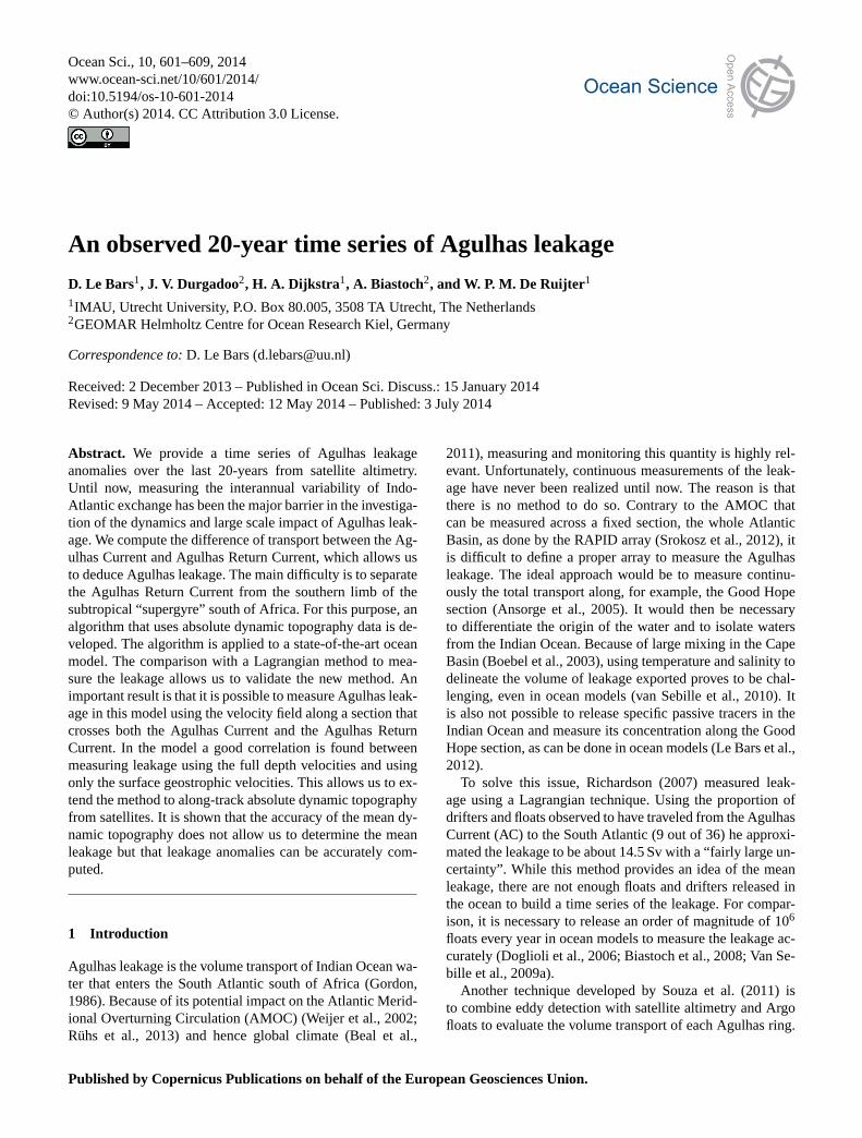
Figure 1. Mean values of absolute dynamic topography (contours)and its standard deviation (color, in cm2) with the Topex/Poseidonsatellite tracks used for this work.(a) Mapped satellite altimetryproduct and(b) INALT01 model.
from a hindcast experiment are used. The forcing for the ex-periment is derived from the CORE2b data set (Large andYeager, 2009).
The ARIANE Lagrangian package3 (Blanke et al., 1999)was used to measure Agulhas leakage within INALT01. Wa-ter parcels with an associated maximum transport of 0.1 Sv in5 days (4.32×10¹⁰ m3) were released along the satellite track20 (see Fig.1b) over the full depth. Parcels were releasedevery 5 days over 1 year, and advected forward using themodel’s velocity fields for a total period of 5 years. Parcelsreaching a section close to the Good Hope section (Ansorgeet al., 2005) in the Cape Basin were captured and aggregated.These were defined as Agulhas leakage: the volume transportrepresented by the parcels flowing into the South Atlanticthrough the Good Hope section. Using this method, 56 an-nual values (1948–2003) of Agulhas leakage were obtained.The difference between this Lagrangian method and that ofDurgadoo et al.(2013) is that the water parcels are releasedacross a section following satellite track 20 instead of acrossthe Agulhas Current at 32◦ S. This approach leads to higherleakage values and is more appropriate for comparison withthe new method presented in this paper.
3seehttp://www.univ-brest.fr/lpo/ariane
Africa
Satellite track
ez
et
vg
SAC extension
Indian Ocean area
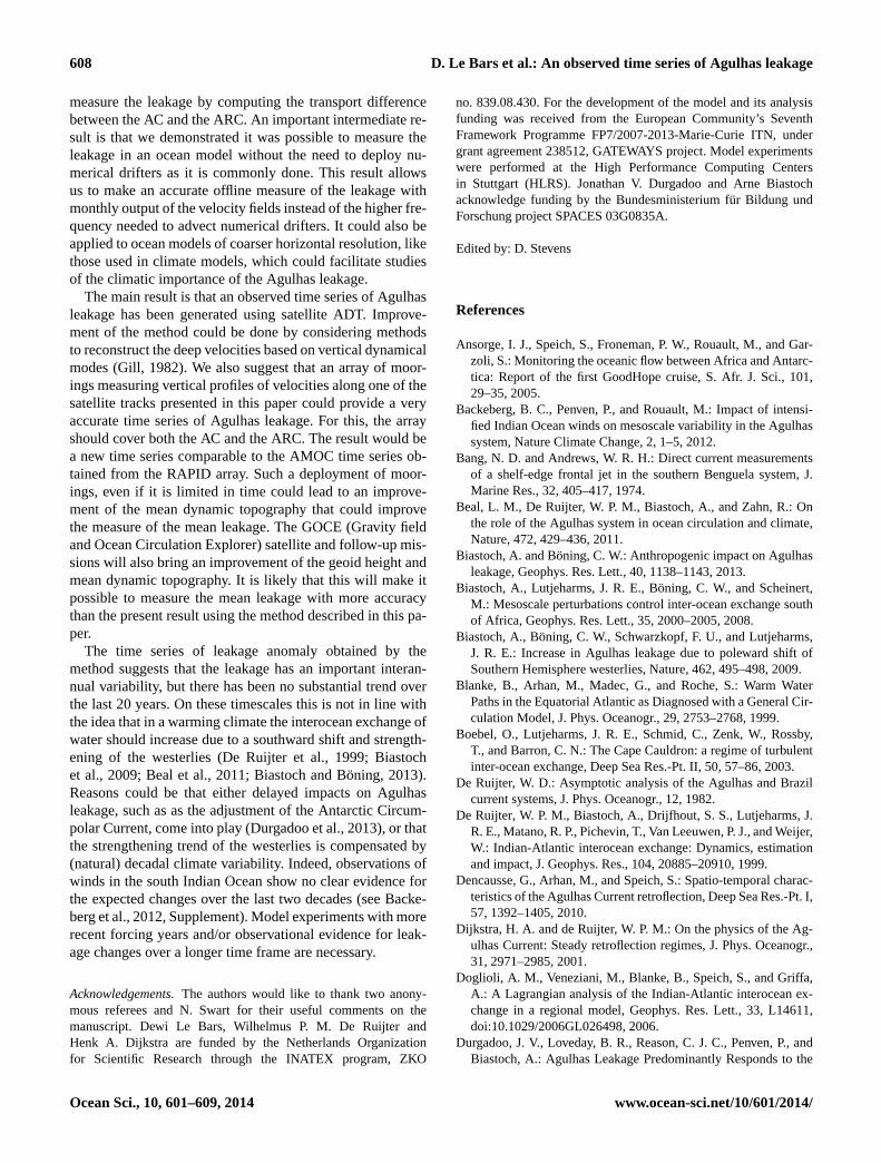
L (t)
Figure 2. Schematic of vectors used for computation and variableL separating the Indian Ocean area from the extension of the SouthAtlantic Current (SAC).
The INALT01 model is a new version of the AG01-Rmodel that was used for many studies of the AC and Ag-ulhas leakage (Biastoch et al., 2008, 2009; Van Sebille et al.,2009a; van Sebille et al., 2010). Comparison with satellitealtimetry shows that it captures both the mean and the vari-ability of the flow in the AC, Agulhas retroflection, and ARC(Fig.1). One limitation of the model is the relatively weak re-circulation cells between the AC and the ARC in the modelcompared to the altimetry. Using model SSH or satellite ADTwe can compute geostrophic velocities normal to satellitetracks (see Fig.2) as
vg =g
f
∂η
∂lez × et, (1)
where vg is the geostrophic velocity perpendicular to thesatellite track,g is the gravitational acceleration,f is theCoriolis parameter,η is the absolute dynamic topography,ez
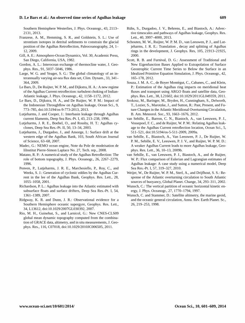
is a vertical unit vector, oriented upward,et is a unit vec-tor tangent to the satellite track, oriented offshore, andl isa coordinate alonget. The velocityvg is determined fromEq. (1) using central finite differences. The results show thatthe mean position and strength of the AC and ARC in themodel compare well with the altimetry along the three cho-sen tracks (Fig.3). This makes the model suitable to test ourmethod to measure Agulhas leakage.
3 Methodology
The method computes the difference between AC and theARC transports from altimetry along satellite tracks. In thisway, we can measure leakage away from the energetic Agul-has retroflection. The three tracks we use are ideally locatedbecause they cross both the AC and the ARC almost perpen-dicularly (Fig.1). They also have the advantage that firstly atthese positions the AC core is not too close to the coast sothe dynamic topography signal has a relatively good quality,
www.ocean-sci.net/10/601/2014/ Ocean Sci., 10, 601–609, 2014

604 D. Le Bars et al.: An observed time series of Agulhas leakage
Track 122 Track 198 Track 20
c a b
Figure 3. Along-track geostrophic velocities averaged over the period of time common to the model and satellite data (from October 1992to December 2007) for model data (blue) and satellite data (red).
and secondly the ARC is limited in extension by the Agul-has Plateau. We define Agulhas leakage as the along-trackcumulative transport from the coast to the distanceL and tothe depthH :
8AL(t) =
L(t)∫0
0∫−H(l)
v(t,z, l)dzdl, (2)
wherez is the vertical coordinate andv is the velocity per-pendicular to the track. Depending on the case we takev ei-ther as the geostrophic velocity computed from the sea sur-face height field or the model velocity field.H is the depth ofintegration, it is either the bottom topography or a maximumdepth. As we want to integrate the full ARC, the point deter-mining L is located at the separation between the ARC andthe southern limb of the subtropical “supergyre”. The differ-ence between these two currents is that the ARC originatesfrom the AC. Therefore, we seek all the streamlines originat-ing from the AC looping around to the ARC. If we assumegeostrophic balance then the streamlines are contours of con-stant ADT. The following algorithm is used to detect thesestreamlines.
From a monthly mean field of ADT (Fig.4a) the val-ues of ADT higher than a certain threshold are selected(Fig. 4 b). The block of points connected to the Indian Oceanis then selected (Fig.4c). Connected here means that allthe grid cells in this group touch each other on at least oneof their sides. This is performed using the Python functionscipy.ndimage.measurements.label4. For instance, if an Ag-ulhas ring detaches from the AC then its ADT value is highbut it is not connected to the Indian Ocean anymore. Typ-ically at the beginning of the algorithm, for high values ofthe threshold (high levels of ADT) the group of points repre-sents only the heart of the southwestern Indian Ocean gyre.Then as the threshold is decreased, by increments of 1 cmthe group of points becomes larger and larger. At some pointthere is a jump when the group of connected points extends
4see http://docs.scipy.org/doc/scipy/reference/generated/scipy.ndimage.measurements.label.html
all the way to the western Atlantic Ocean, as illustrated inFig. 4d, which represents the group of Indian Ocean pointsfor a threshold 1 cm lower than on panel c. This happens be-cause there is a region of relatively lower ADT values be-tween the western Indian Ocean and the western AtlanticOcean subtropical gyres. The patterns presented in Fig.4care selected because for an ADT threshold 1 cm smaller thanthe Indian Ocean group of points, represented by the red pat-tern, would extend west of 30◦ W.
We define the optimal Indian Ocean group of points asthe largest possible group with the condition that it shouldnot extent “too far” in the Atlantic. Naturally the size of thegroup depends on what is defined as “too far”. The sensitivityof the western end of the Indian Ocean group of points to thelongitude of the western boundary used in the algorithm, e.g.,the longitude for which we consider that the group extends“too far” in the Atlantic Ocean, is shown in Fig.5. We seethat for both the model and the altimetry data the westernend of the Indian Ocean group of points converges towardsa constant value for a western boundary longitude between20 and 30◦ W. The value at 30◦ W is therefore chosen for allthe results in this paper as we see that the size of the IndianOcean group of points has converged before this longitudefor both the altimetry and the model. A simplified algorithmis presented.Algorithm:Loop on time:
Loop on ADT threshold (from high to low values, usingincrements of 1 cm):
Select values of ADT higher than threshold.Select group of points connected to the Indian Ocean.If the group extends to 30◦ W:
Break the loop; the previous threshold is the ADTvalue that separates the ARC and the ACC.
Else: continue to loop.
The ADT threshold selected as described above representsthe lowest ADT level that does not leak. This algorithm isapplied on each monthly mean ADT field, and the thresholdlevels are used to compute the functionL at all times,L being
Ocean Sci., 10, 601–609, 2014 www.ocean-sci.net/10/601/2014/

D. Le Bars et al.: An observed time series of Agulhas leakage 605
a
b
c
d
Figure 4. Selection of the limit between the ARC and the ACCusing satellite ADT.(a) Initial ADT, (b) selection of the values ofADT higher than a certain threshold,(c) selection of the group ofvalues corresponding to the Indian Ocean and(d) the extent of theIndian Ocean group for a threshold 1 cm smaller, showing a jumpof the red area all the way to 30◦ W.
the along-track distance from the coast to the location wherethe ADT crosses the threshold. Given the velocity along thetrack and the depth of integration, it is possible to computethe leakage along the satellite tracks. In the following sec-tions this method is used for both model data and satellitealtimetry.
4 Measuring the leakage within INALT01
Using the model we compare three methods to measureAgulhas leakage: (i) the traditional method of Lagrangianparcels, considered here as “ground truth”, (ii) the integra-tion of the full-depth model velocities along satellite tracksbetween the coast and the boundary of the ARC as deter-mined by the algorithm presented in Sect.3, and (iii) a re-construction using only the model SSH.
4.1 Using the full velocity field
The vertical velocity profile within the model shows a sur-face intensified AC and ARC along the three satellite tracks(Fig. 6). To compute the leakage we choose to integrate thefull-depth velocity. The parameterH in Eq. (2) is the wa-ter column depth (for best comparison with the Lagrangiandrifters method). Using Eq. (2) with the full-depth model
Figure 5. Convergence of the western limit of the group of IndianOcean points with the position of the western boundary of the do-main on which the algorithm is applied for model data (blue) andsatellite data (red).
velocities we compute time series of leakage along the satel-lite tracks, and plot the annual averages (Fig.7a). The resultsare similar along the three tracks, with a mean leakage of19.8, 21.8 and 22.1 Sv along tracks 20, 198 and 122 respec-tively. The standard deviation computed from monthly av-erages is high: 4.2, 4.7 and 6.7 Sv respectively, which leadsto a low cross-correlation of the detrended time series: 0.41between tracks 20 and 198 and 0.38 between tracks 198and 122. Note that the time series all have a small positivetrend. The cross-correlation is small mostly because of thedeep ocean. If the top 1500 m is considered then the cross-correlation between the transport along these tracks is 0.72between tracks 20 and 198, and 0.81 between tracks 198 and122. An explanation for the importance of the deep ocean indecorrelating the time series is that the signal could propa-gate slower at depth. It would then be necessary to take a lagbetween the different tracks to improve these correlations.This lag would have to depend on the depth and would prob-ably have to be different for the AC and for the ARC, but thiswork is outside the scope of this paper.
Track 20 is chosen for comparison with the Lagrangianmethod because of the lower standard deviation of the leak-age (see Fig.7b). For the period 1948–2003, the mean leak-age from the integration of the model velocity along track20 is 19.4 Sv compared with 19.3 Sv from the Lagrangianmethod. These close numbers show that the algorithm thatdetermines the separation between the ARC and the south-ern limb of the subtropical “supergyre” performs adequately.The time series of leakage computed with the two methods
www.ocean-sci.net/10/601/2014/ Ocean Sci., 10, 601–609, 2014

606 D. Le Bars et al.: An observed time series of Agulhas leakage
Figure 6. Depth profiles of the 60-year averaged velocity component normal to the satellite tracks in the INALT01. Positive values are in thenortheast direction.
is also similar with a cross-correlation of 0.68 (Fig. 7b). Apositive trend of 0.95 and 1.02 Sv per decade is found forthe integration of model velocity and Lagrangian methodsrespectively.
These results demonstrate that it is possible to compute theleakage from the integration of the model velocities along thesatellite tracks. We now compute the leakage from the SSHonly.
4.2 Using SSH
In this section we aim to reproduce the leakage time seriesusing only surface information. We compute geostrophic ve-locities from SSH according to Eq. (1), and integrate alongeach track, assuming that the velocities are constant untila certain depth, and zero below. The depth of the integra-tion is chosen to have a mean leakage as close as possi-ble to the computations using the model velocities. A maxi-mum depth of 840 m gives a mean leakage of 19.4, 19.4 and22.4 Sv along tracks 20, 198 and 122 respectively, for the pe-riod 1958–2003 (Fig.7c). The cross-correlations between thethree leakage time series at different tracks using this methodare higher than using the model velocity with 0.94 betweentracks 20 and 198 and 0.91 between tracks 198 and 122. Thisis the result of a strong constraint on the volume transportdue to the velocity integration between the coast and a valueof SSH for each month. In fact, the transport of a barotropicgeostrophic flow across a vertical section only depends on thedepth of the section and on the difference of SSH at the be-ginning and at the end of this section (Wunsch and Stammer,1998). The volume transport differs between the three tracksbecause the SSH is free to evolve at the coast, and becausethe depth,H , is not constant along the section, it follows thebottom topography until a depth of 840 m.
More importantly, the leakage computed along track 20from the SSH method compares well with the velocity in-tegration method (Fig.7b), with a cross-correlation of 0.78.Obviously, if one is only interested in the surface flow thenthe cross-correlation increases. For instance, if the leakage
a
c
b
Track 20 Track 198 Track 122
Track 20 Track 198 Track 122
Lagrangian Full Velocity SSH
Tran
spor
t (S
v)
Tran
spor
t (S
v)
Tran
spor
t (S
v)
Figure 7. (a) Leakage computation from the integration of modelvelocity along three satellite tracks.(b) Comparison between threemethods to compute the leakage over track 20 in the model: La-grangian parcels (black), integration of full model velocity (orange)and derived from the SSH (green).(c) Leakage computation fromthe SSH method in the model. All the curves show annual averages.
is computed from Eq. (2) using model velocities from thesurface to 1500 m depth then the cross-correlation with theSSH method is 0.86. We also notice that for the other tracksthe cross-correlation between the full depth transport and themethod based on only SSH is smaller, it is 0.56 for track 122and 0.16 along track 198. Along these tracks the transport ismore baroclinic (see Fig.6) and a more sophisticated method
Ocean Sci., 10, 601–609, 2014 www.ocean-sci.net/10/601/2014/

D. Le Bars et al.: An observed time series of Agulhas leakage 607
a
b
Tran
spor
t (S
v)
Tran
spor
t (S
v)
Track 20 Track 198 Track 122
Figure 8. (a)Absolute value of leakage computation from satellitealtimetry along three satellite tracks and(b) anomalies with respectto the time average.
of reconstruction of the deep flow either by computation ofthe normal modes (Gill , 1982; Wunsch, 1997) or by othereigenfunctions (Scott and Furnival, 2012) might prove use-ful. This is however outside the scope of this paper.
These results show that it is possible to have a good ap-proximation of the leakage from “perfect measurements” ofSSH, as given by model outputs.
5 Measuring the leakage from satellite altimetry
It is possible to compute the leakage with the same methodas presented in the previous section using satellite ADT. Thesurface geostrophic velocities are computed with Eq. (1) andthe volume transport is integrated with Eq. (2) assuming thatvelocities are independent of the depth. Taking a maximumdepth of 840 m, which was shown to be appropriate for themodel, three time series are constructed (Fig.8a). Contraryto the time series computed from the model, Fig.8a showsthat the mean transport is different along the three tracks.This is likely due to the low accuracy of the mean dynamictopography. Errors of the order of 10 cm are expected (Rioet al., 2011) and such an error along a satellite track wouldlead to a difference of 9 Sv in the volume transport of leakage(Wunsch and Stammer, 1998). To avoid this important sourceof error we consider the anomalies with respect to the timeaverage (Fig.8b) and find a consistent signal from the threetracks. The cross-correlation between the leakage time seriesat tracks 20 and 198 is 0.86 and 0.88 between tracks 198 and122. The difference between the three signals includes themeasurement error and can be considered as the error of themethod. Differences of up to 4 Sv can be found in 2005 and2010, but the three signals agree on the overall interannualvariability.
Tran
spor
t (S
v)
Lagrangian SSH model SSH altimetry
20 y
ears
tre
nd (S
v/20
year
s)
a
b
Figure 9. (a) Comparison of leakage anomaly computed frommodel output using the Lagrangian parcels (black) and the SSHmethod (green) and from satellite altimetry using the SSH method(blue) along track 20.(b) The 20-year trend (Sv per 20 years) fromthe same methods as(a). The blue star is obtained from the 20 yearsof altimetry data and blue circles in are a sensitivity analysis of thetrend computed over 18 years between 1993–2010, 1994–2011 and1995–2012.
A direct comparison of the leakage anomaly within themodel and altimetry computed with the same SSH methodalong track 20 shows a similar range of values, but no clearcorrelation (Fig.9a). This is not a surprise because of thenonlinearity of the system and possible biases in the atmo-spheric forcing of the model. As the model simulation stopsin 2007, only 15 years are available for comparison with thealtimetry. Over this short period the trends have the samesign in the model and altimetry, 0.6 and 2.9 Sv decade−1 re-spectively. However, the trend of leakage computed over the20 years of altimetry is close to zero or negative (Fig.9b).This shows that, when computing trends of such short timeseries, a few years of additional data can have a big influence.If we compare with the model data, such a situation of a neg-ative trend did not happen since the early 1960s. However,we have to be careful in the extrapolation of the results be-fore the altimetry era, as we see that discrepancies are foundbetween the model and the satellite data during the periodwhere they overlap.
6 Conclusions
We presented a new method based on along-track andmapped satellite altimetry to measure the anomalies of theAgulhas leakage. This method is based on an algorithmthat detects the separation between the ARC and the south-ern limb of the subtropical “supergyre”, which allows us to
www.ocean-sci.net/10/601/2014/ Ocean Sci., 10, 601–609, 2014
608 D. Le Bars et al.: An observed time series of Agulhas leakage
measure the leakage by computing the transport differencebetween the AC and the ARC. An important intermediate re-sult is that we demonstrated it was possible to measure theleakage in an ocean model without the need to deploy nu-merical drifters as it is commonly done. This result allowsus to make an accurate offline measure of the leakage withmonthly output of the velocity fields instead of the higher fre-quency needed to advect numerical drifters. It could also beapplied to ocean models of coarser horizontal resolution, likethose used in climate models, which could facilitate studiesof the climatic importance of the Agulhas leakage.
The main result is that an observed time series of Agulhasleakage has been generated using satellite ADT. Improve-ment of the method could be done by considering methodsto reconstruct the deep velocities based on vertical dynamicalmodes (Gill , 1982). We also suggest that an array of moor-ings measuring vertical profiles of velocities along one of thesatellite tracks presented in this paper could provide a veryaccurate time series of Agulhas leakage. For this, the arrayshould cover both the AC and the ARC. The result would bea new time series comparable to the AMOC time series ob-tained from the RAPID array. Such a deployment of moor-ings, even if it is limited in time could lead to an improve-ment of the mean dynamic topography that could improvethe measure of the mean leakage. The GOCE (Gravity fieldand Ocean Circulation Explorer) satellite and follow-up mis-sions will also bring an improvement of the geoid height andmean dynamic topography. It is likely that this will make itpossible to measure the mean leakage with more accuracythan the present result using the method described in this pa-per.
The time series of leakage anomaly obtained by themethod suggests that the leakage has an important interan-nual variability, but there has been no substantial trend overthe last 20 years. On these timescales this is not in line withthe idea that in a warming climate the interocean exchange ofwater should increase due to a southward shift and strength-ening of the westerlies (De Ruijter et al., 1999; Biastochet al., 2009; Beal et al., 2011; Biastoch and Böning, 2013).Reasons could be that either delayed impacts on Agulhasleakage, such as as the adjustment of the Antarctic Circum-polar Current, come into play (Durgadoo et al., 2013), or thatthe strengthening trend of the westerlies is compensated by(natural) decadal climate variability. Indeed, observations ofwinds in the south Indian Ocean show no clear evidence forthe expected changes over the last two decades (seeBacke-berg et al., 2012, Supplement). Model experiments with morerecent forcing years and/or observational evidence for leak-age changes over a longer time frame are necessary.
Acknowledgements.The authors would like to thank two anony-mous referees and N. Swart for their useful comments on themanuscript. Dewi Le Bars, Wilhelmus P. M. De Ruijter andHenk A. Dijkstra are funded by the Netherlands Organizationfor Scientific Research through the INATEX program, ZKO
no. 839.08.430. For the development of the model and its analysisfunding was received from the European Community’s SeventhFramework Programme FP7/2007-2013-Marie-Curie ITN, undergrant agreement 238512, GATEWAYS project. Model experimentswere performed at the High Performance Computing Centersin Stuttgart (HLRS). Jonathan V. Durgadoo and Arne Biastochacknowledge funding by the Bundesministerium für Bildung undForschung project SPACES 03G0835A.
Edited by: D. Stevens
References
Ansorge, I. J., Speich, S., Froneman, P. W., Rouault, M., and Gar-zoli, S.: Monitoring the oceanic flow between Africa and Antarc-tica: Report of the first GoodHope cruise, S. Afr. J. Sci., 101,29–35, 2005.
Backeberg, B. C., Penven, P., and Rouault, M.: Impact of intensi-fied Indian Ocean winds on mesoscale variability in the Agulhassystem, Nature Climate Change, 2, 1–5, 2012.
Bang, N. D. and Andrews, W. R. H.: Direct current measurementsof a shelf-edge frontal jet in the southern Benguela system, J.Marine Res., 32, 405–417, 1974.
Beal, L. M., De Ruijter, W. P. M., Biastoch, A., and Zahn, R.: Onthe role of the Agulhas system in ocean circulation and climate,Nature, 472, 429–436, 2011.
Biastoch, A. and Böning, C. W.: Anthropogenic impact on Agulhasleakage, Geophys. Res. Lett., 40, 1138–1143, 2013.
Biastoch, A., Lutjeharms, J. R. E., Böning, C. W., and Scheinert,M.: Mesoscale perturbations control inter-ocean exchange southof Africa, Geophys. Res. Lett., 35, 2000–2005, 2008.
Biastoch, A., Böning, C. W., Schwarzkopf, F. U., and Lutjeharms,J. R. E.: Increase in Agulhas leakage due to poleward shift ofSouthern Hemisphere westerlies, Nature, 462, 495–498, 2009.
Blanke, B., Arhan, M., Madec, G., and Roche, S.: Warm WaterPaths in the Equatorial Atlantic as Diagnosed with a General Cir-culation Model, J. Phys. Oceanogr., 29, 2753–2768, 1999.
Boebel, O., Lutjeharms, J. R. E., Schmid, C., Zenk, W., Rossby,T., and Barron, C. N.: The Cape Cauldron: a regime of turbulentinter-ocean exchange, Deep Sea Res.-Pt. II, 50, 57–86, 2003.
De Ruijter, W. D.: Asymptotic analysis of the Agulhas and Brazilcurrent systems, J. Phys. Oceanogr., 12, 1982.
De Ruijter, W. P. M., Biastoch, A., Drijfhout, S. S., Lutjeharms, J.R. E., Matano, R. P., Pichevin, T., Van Leeuwen, P. J., and Weijer,W.: Indian-Atlantic interocean exchange: Dynamics, estimationand impact, J. Geophys. Res., 104, 20885–20910, 1999.
Dencausse, G., Arhan, M., and Speich, S.: Spatio-temporal charac-teristics of the Agulhas Current retroflection, Deep Sea Res.-Pt. I,57, 1392–1405, 2010.
Dijkstra, H. A. and de Ruijter, W. P. M.: On the physics of the Ag-ulhas Current: Steady retroflection regimes, J. Phys. Oceanogr.,31, 2971–2985, 2001.
Doglioli, A. M., Veneziani, M., Blanke, B., Speich, S., and Griffa,A.: A Lagrangian analysis of the Indian-Atlantic interocean ex-change in a regional model, Geophys. Res. Lett., 33, L14611,doi:10.1029/2006GL026498, 2006.
Durgadoo, J. V., Loveday, B. R., Reason, C. J. C., Penven, P., andBiastoch, A.: Agulhas Leakage Predominantly Responds to the
Ocean Sci., 10, 601–609, 2014 www.ocean-sci.net/10/601/2014/
D. Le Bars et al.: An observed time series of Agulhas leakage 609
Southern Hemisphere Westerlies, J. Phys. Oceanogr., 43, 2113–2131, 2013.
Franzese, A. M., Hemming, S. R., and Goldstein, S. L.: Use ofstrontium isotopes in detrital sediments to constrain the glacialposition of the Agulhas Retroflection, Paleoceanography, 24, 1–12, 2009.
Gill, A. E.: Atmosphere-Ocean Dynamics, Vol. 30, Academic Press,San Diego, California, USA, 1982.
Gordon, A. L.: Interocean exchange of thermocline water, J. Geo-phys. Res., 91, 5037–5046, 1986.
Large, W. G. and Yeager, S. G.: The global climatology of an in-terannually varying air-sea flux data set, Clim. Dynam., 33, 341–364, 2009.
Le Bars, D., De Ruijter, W. P. M., and Dijkstra, H. A.: A new regimeof the Agulhas Current retroflection: turbulent choking of Indian-Atlantic leakage, J. Phys. Oceanogr., 42, 1158–1172, 2012.
Le Bars, D., Dijkstra, H. A., and De Ruijter, W. P. M.: Impact ofthe Indonesian Throughflow on Agulhas leakage, Ocean Sci., 9,773–785, doi:10.5194/os-9-773-2013, 2013.
Lutjeharms, J. and Cooper, J.: Interbasin leakage through Agulhascurrent filaments, Deep Sea Res.-Pt. I, 43, 213–238, 1996.
Lutjeharms, J. R. E., Boebel, O., and Rossby, H. T.: Agulhas cy-clones, Deep Sea Res.-Pt. II, 50, 13–34, 2003.
Lutjeharms, J., Durgadoo, J., and Ansorge, I.: Surface drift at thewestern edge of the Agulhas Bank, 103, South African Journalof Science, 63–68, 2007.
Madec, G.: NEMO ocean engine, Note du Pole de modeisation delíInstitut Pierre-Simon Laplace No. 27, Tech. rep., 2008.
Matano, R. P.: A numerical study of the Agulhas Retroflection: Therole of bottom topography, J. Phys. Oceanogr., 26, 2267–2279,1996.
Penven, P., Lutjeharms, J. R. E., Marchesiello, P., Roy, C., andWeeks, S. J.: Generation of cyclonic eddies by the Agulhas Cur-rent in the lee of the Agulhas Bank, Geophys. Res. Lett., 28,1055–1058, 2001.
Richardson, P. L.: Agulhas leakage into the Atlantic estimated withsubsurface floats and surface drifters, Deep Sea Res.-Pt. I, 54,1361–1389, 2007.
Ridgway, K. R. and Dunn, J. R.: Observational evidence for aSouthern Hemisphere oceanic supergyre, Geophys. Res. Lett.,34, L13612, doi:10.1029/2007GL030392, 2007.
Rio, M. H., Guinehut, S., and Larnicol, G.: New CNES-CLS09global mean dynamic topography computed from the combina-tion of GRACE data, altimetry, and in situ measurements, J. Geo-phys. Res., 116, C07018, doi:10.1029/2010JC006505, 2011.
Rühs, S., Durgadoo, J. V., Behrens, E., and Biastoch, A.: Advec-tive timescales and pathways of Agulhas leakage, Geophys. Res.Lett., 40, 3997–4000, 2013.
Schouten, M. W., Ruijter, W. P. M. D., van Leeuwen, P. J., and Lut-jeharms, J. R. E.: Translation , decay and splitting of Agulhasrings in the development, J. Geophys. Res, 105, 21913–21925,2000.
Scott, R. B. and Furnival, D. G.: Assessment of Traditional andNew Eigenfunction Bases Applied to Extrapolation of SurfaceGeostrophic Current Time Series to Below the Surface in anIdealized Primitive Equation Simulation, J. Phys. Oceanogr., 42,165–178, 2012.
Souza, J. M. A. C., de Boyer Montègut, C., Cabanes, C., and Klein,P.: Estimation of the Agulhas ring impacts on meridional heatfluxes and transport using ARGO floats and satellite data, Geo-phys. Res. Lett., 38, L21602, doi:10.1029/2011GL049359, 2011.
Srokosz, M., Baringer, M., Bryden, H., Cunningham, S., Delworth,T., Lozier, S., Marotzke, J., and Sutton, R.: Past, Present, and Fu-ture Changes in the Atlantic Meridional Overturning Circulation,B. Am. Meteorol. Soc., 93, 1663–1676, 2012.
van Sebille, E., Barron, C. N., Biastoch, A., van Leeuwen, P. J.,Vossepoel, F. C., and de Ruijter, W. P. M.: Relating Agulhas leak-age to the Agulhas Current retroflection location, Ocean Sci., 5,511–521, doi:10.5194/os-5-511-2009, 2009a.
van Sebille, E., Biastoch, A., Van Leeuwen, P. J., De Ruijter, W.P. M., Sebille, E. V., Leeuwen, P. J. V., and Ruijter, W. P. M. D.:A weaker Agulhas Current leads to more Agulhas leakage, Geo-phys. Res. Lett., 36, 10–13, 2009b.
van Sebille, E., van Leeuwen, P. J., Biastoch, A., and de Ruijter,W. P.: Flux comparison of Eulerian and Lagrangian estimates ofAgulhas leakage: A case study using a numerical model, DeepSea Res.-Pt. I, 57, 319–327, 2010.
Weijer, W., De Ruijter, W. P. M., Sterl, A., and Drijfhout, S. S.: Re-sponse of the Atlantic overturning circulation to South Atlanticsources of buoyancy, Global Planet. Change, 34, 293–311, 2002.
Wunsch, C.: The vertical partition of oceanic horizontal kinetic en-ergy, J. Phys. Oceanogr., 27, 1770–1794, 1997.
Wunsch, C. and Stammer, D.: Satellite altimetry, the marine geoid,and the oceanic general circulation, Annu. Rev. Earth Planet. Sc.,26, 219–253, 1998.
www.ocean-sci.net/10/601/2014/ Ocean Sci., 10, 601–609, 2014