appendix e geology, terrain and soils of the refinery and rsfeisdocs.dsdip.qld.gov.au/gladstone...
TRANSCRIPT
J:\JOBS\42625791\10230 REPORT COMPILATION\SECTION 16 - APPENDICES\APPENDICES COMPILIATION REV 2\APPENDIX E SOILS TERRAIN & LAND CAPABILITY\APPENDIX E TERRAIN AND SOILS 1C.DOC\22-MAR-07
Appendix E Geology, Terrain and Soils of the Refinery and RSF

Contents
J:\JOBS\42625791\10230 REPORT COMPILATION\SECTION 16 - APPENDICES\APPENDICES COMPILIATION REV 2\APPENDIX E SOILS TERRAIN & LAND CAPABILITY\APPENDIX E TERRAIN AND SOILS 1C.DOC\22-MAR-07
i
Appendix E Geology, Terrain and Soils of the Refinery and RSF
E.1 Methodology
E.1.1 Method of Assessment E.1.2 Reference Data Sources E.1.3 Field Investigation E.1.4 Soil Characterisation
E.2 Geomorphology
E.2.1 Geological Regimes E.2.2 Terrain Units
E.3 Soils
E.3.1 Soils Classification E.3.2 Soil Types and Occurrences E.3.3 Soil Physical and Chemical Properties
E.4 Topsoil Resources
E.4.1 Method of Assessment E.4.2 Results of Assessment E.4.3 Topsoil Management
E.5 Implications for Rehabilitation Strategies
E.5.1 Soil Properties
E.6 Soil Erosion
E.6.1 Basis for the Assessment of Erosion Potential E.6.2 Erosion Control Measures
E.7 Land Capability Assessment
E.7.1 Method of Assessment E.7.2 Land Suitability Classification for Cropping And Grazing In The Semi-Arid
Sub-Tropics Of Queensland.
E.8 Site and Soil Characterisation
Contents
J:\JOBS\42625791\10230 REPORT COMPILATION\SECTION 16 - APPENDICES\APPENDICES COMPILIATION REV 2\APPENDIX E SOILS TERRAIN & LAND CAPABILITY\APPENDIX E TERRAIN AND SOILS 1C.DOC\22-MAR-07
ii
E.9 Laboratory Data Summary
Appendix V.1 Methodology
J:\JOBS\42625791\10230 REPORT COMPILATION\SECTION 16 - APPENDICES\APPENDICES COMPILIATION REV 2\APPENDIX E SOILS TERRAIN & LAND CAPABILITY\APPENDIX E TERRAIN AND SOILS 1C.DOC\22-MAR-07
V-1
E Geology, Terrain and Soils of the Refinery and RSF
E.1 Methodology
E.1.1 Method of Assessment
Terrain analysis and mapping has been carried out for the refinery (EIS Figure 8.1.1) and also for the proposed RSF (EIS Figure 9.1.1). The terrain in the respective operations areas has been assessed in terms of geology (geological regimes), topography and landform (surface form and slope) and soil types. Terrain mapping has been carried out primarily from interpretation of aerial photos with reference to existing geological, topographical, soils information using the background data sources detailed below. This was followed by a site reconnaissance survey and soil sampling operations, which have provided the basis for identifying “terrain units” which occur within the proposed development area.
A terrain unit comprises a mappable discrete or recurring area of land that is considered to have a unique combination of physical attributes in terms of bedrock, surface slope and form, and soil/substrate conditions. Accordingly, engineering and environmental characteristics determined at one location may be extrapolated to other occurrences of the same terrain unit. Descriptions of the terrain units identified are given in Appendix E 2. The occurrence and distribution of terrain units within the refinery and the RSF are shown in EIS Figures 8.1.2 and 9.1.2 respectively.
E.1.2 Reference Data Sources
Data sources used as a basis for the evaluation, mapping, description and characterisation of terrain conditions have included available soils and land resources information, recently revised regional geological mapping of the general area and previous EIS studies undertaken for other projects in the general area. These references data sources have included:
• Land Systems of the Capricornia Coast, Map 3 – Calliope Area, by Forster BA and Barton AL, Department of Primary Industries, 1995;
• Topographic Map of the RSF (5m contours), prepared by Geometrix May 2006.
• Orthophoto Map Sheet Series 1:25,000 Edition 1, Queensland Department of Mapping Survey: Calliope Crossing – Sheet 9132;
• Geoscience Data for the Gladstone 1:100,000 Geological Sheet area 9150, mapping revised by GSQ Natural Resource Sciences July 2004;
• Queensland State Government colour aerial photography Gladstone Series (QAP 5713) flown 27.04.99 at an approximate photo scale 1:25,000;
• Comalco Alumina Project Gladstone Environmental Impact Statement prepared by Dames and Moore (1998); and
• L G Chem Chlor Alkali/Ethylene Dichloride Plant EIS prepared by URS Australia Feb.2003.
Appendix V.1 Methodology
J:\JOBS\42625791\10230 REPORT COMPILATION\SECTION 16 - APPENDICES\APPENDICES COMPILIATION REV 2\APPENDIX E SOILS TERRAIN & LAND CAPABILITY\APPENDIX E TERRAIN AND SOILS 1C.DOC\22-MAR-07
V-2
E.1.3 Field Investigation
Field investigations were carried out to provide ground truth for the terrain mapping. A total of 205 soil samples from 48 site locations, 10 within the refinery site and 38 within the currently proposed RSF site, were investigated at the locations shown in the EIS Figures 8.1.2 and 9.1.2 respectively. Site conditions were assessed at each sampling location and the soil profile at each site was identified using a small purpose-built 4WD auger core soil sampling rig. Representative soil samples were collected for soil classification and the identification of indicative soil physical and chemical properties. Site conditions and soil profiles from each sampling location were described generally in accordance with the guidelines of the Australian Soil and Land Survey Field Handbook (McDonald et. al., 1990). Observations of the profile form, soil texture, soil (Munsell) colour, structure, moisture condition and consistency were recorded.
E.1.4 Soil Characterisation
Soil samples were subject to indicative soil physical and chemical testing. Indicative testing included measurements of pH and EC, together with classification of soil dispersion potential based on a modified Emerson soil aggregate stability test (Emerson & Seedsman, 1981). Site details and soil descriptions are included in Appendix E 8. Samples from representative soil profiles were selected for laboratory soil analyses. These were carried out by SGS Pty Limited (NATA Approved) laboratory at Toowoomba. The analyses included the following:
• pH (1:5 H2O), Electrical Conductivity (EC), Chloride (Cl);
• Nitrate Nitrogen, available Phosphorus, Organic Carbon (OC) and Sulfur;
• Exchangeable (Major) Cations and CEC; and
• Copper (Cu), Zinc (Zn), Manganese (Mn), Iron (Fe) and Boron (Bo).
The results of the indicative testing are included in Appendix E 8. A summary of the results of the laboratory analyses is included in Appendix E 9.
Appendix V.2 Geomorphology
J:\JOBS\42625791\10230 REPORT COMPILATION\SECTION 16 - APPENDICES\APPENDICES COMPILIATION REV 2\APPENDIX E SOILS TERRAIN & LAND CAPABILITY\APPENDIX E TERRAIN AND SOILS 1C.DOC\22-MAR-07
V-1
E Heading Style 1 This is Hidden Text it will not print
E.2 Geomorphology
E.2.1 Geological Regimes
The geology in the project area has been mapped as part of the Natural Resources Mines and Energy Geological Survey of Queensland, Geoscience Data revision of the Regional and 1:100,000 Map Sheet areas of Queensland (NRM&E, 2004). The main geological formations that have been identified to occur within the project area include:
• Quaternary Alluvium (Qa); river and floodplain deposits comprising clay, silt, sand, gravel;
• Quaternary - Pleistocene Older Alluvial Deposits (Qpa) - clay, silt, sand, gravel on higher alluvial plains;
• Quaternary Colluvium (Qr):-consisting of residual soils and colluvial deposits of clay, silt, sand and gravel;
• Quaternary Holocene Deposits (Qhm):- comprising estuarine coastal flats, supratidal flats and coastal grass-lands, with saline mud, muddy sand, silt and clays;
• Tertiary-Quaternary Colluvium and Residual Soils (TQr):-alluvio-colluvial deposits and residual soils in valley floors with clay, silt, sand and gravel deposits;
• Late Permian-Early Triassic Intrusives (PRg):- comprising grey fine to coarse-grained porphyritic gabbro, hornblende and quartz diorite and biotite hornblende quartz monzo-diorite;
• Permian-Carboniferous Berserker Group (CPk):- comprising mudstone, siltstone, felsic volcaniclastic sandstone and conglomerate, minor limestone and rhyolitic ignimbrite;
• Early Carboniferous Rockhampton Group (Cr) :-including dark grey mudstone, siltstone, felsic volcaniclastic sandstone, polymictic conglomerate, oolitic and pisolitic limestone;
• Devonian-Carboniferous Doonside Formation (DCd):- comprising chert, jasper, siltstone, sandstone, tuff, limestone and altered basalt; and
• Devonian-Carboniferous Mt. Alma Formation (DCa):-consisting of thinly interbedded fine-grained sandstone, siltstone and conglomerate.
E.2.2 Terrain Units
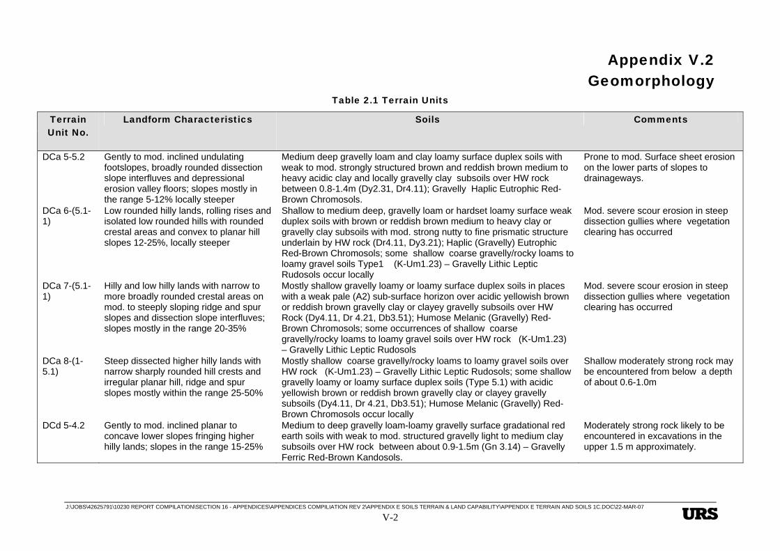
The terrain units are described in detail in Table 2.1 below.
Appendix V.2 Geomorphology
J:\JOBS\42625791\10230 REPORT COMPILATION\SECTION 16 - APPENDICES\APPENDICES COMPILIATION REV 2\APPENDIX E SOILS TERRAIN & LAND CAPABILITY\APPENDIX E TERRAIN AND SOILS 1C.DOC\22-MAR-07 V-2
Table 2.1 Terrain Units
Terrain Unit No.
Landform Characteristics Soils Comments
DCa 5-5.2 Gently to mod. inclined undulating footslopes, broadly rounded dissection slope interfluves and depressional erosion valley floors; slopes mostly in the range 5-12% locally steeper
Medium deep gravelly loam and clay loamy surface duplex soils with weak to mod. strongly structured brown and reddish brown medium to heavy acidic clay and locally gravelly clay subsoils over HW rock between 0.8-1.4m (Dy2.31, Dr4.11); Gravelly Haplic Eutrophic Red-Brown Chromosols.
Prone to mod. Surface sheet erosion on the lower parts of slopes to drainageways.
DCa 6-(5.1-1)
Low rounded hilly lands, rolling rises and isolated low rounded hills with rounded crestal areas and convex to planar hill slopes 12-25%, locally steeper
Shallow to medium deep, gravelly loam or hardset loamy surface weak duplex soils with brown or reddish brown medium to heavy clay or gravelly clay subsoils with mod. strong nutty to fine prismatic structure underlain by HW rock (Dr4.11, Dy3.21); Haplic (Gravelly) Eutrophic Red-Brown Chromosols; some shallow coarse gravelly/rocky loams to loamy gravel soils Type1 (K-Um1.23) – Gravelly Lithic Leptic Rudosols occur locally
Mod. severe scour erosion in steep dissection gullies where vegetation clearing has occurred
DCa 7-(5.1-1)
Hilly and low hilly lands with narrow to more broadly rounded crestal areas on mod. to steeply sloping ridge and spur slopes and dissection slope interfluves; slopes mostly in the range 20-35%
Mostly shallow gravelly loamy or loamy surface duplex soils in places with a weak pale (A2) sub-surface horizon over acidic yellowish brown or reddish brown gravelly clay or clayey gravelly subsoils over HW Rock (Dy4.11, Dr 4.21, Db3.51); Humose Melanic (Gravelly) Red-Brown Chromosols; some occurrences of shallow coarse gravelly/rocky loams to loamy gravel soils over HW rock (K-Um1.23) – Gravelly Lithic Leptic Rudosols
Mod. severe scour erosion in steep dissection gullies where vegetation clearing has occurred
DCa 8-(1-5.1)
Steep dissected higher hilly lands with narrow sharply rounded hill crests and irregular planar hill, ridge and spur slopes mostly within the range 25-50%
Mostly shallow coarse gravelly/rocky loams to loamy gravel soils over HW rock (K-Um1.23) – Gravelly Lithic Leptic Rudosols; some shallow gravelly loamy or loamy surface duplex soils (Type 5.1) with acidic yellowish brown or reddish brown gravelly clay or clayey gravelly subsoils (Dy4.11, Dr 4.21, Db3.51); Humose Melanic (Gravelly) Red-Brown Chromosols occur locally
Shallow moderately strong rock may be encountered from below a depth of about 0.6-1.0m
DCd 5-4.2 Gently to mod. inclined planar to concave lower slopes fringing higher hilly lands; slopes in the range 15-25%
Medium to deep gravelly loam-loamy gravelly surface gradational red earth soils with weak to mod. structured gravelly light to medium clay subsoils over HW rock between about 0.9-1.5m (Gn 3.14) – Gravelly Ferric Red-Brown Kandosols.
Moderately strong rock likely to be encountered in excavations in the upper 1.5 m approximately.
Appendix V.2 Geomorphology
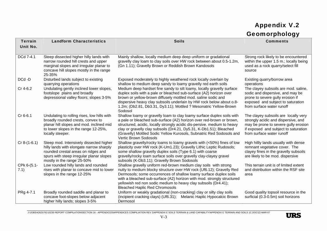
J:\JOBS\42625791\10230 REPORT COMPILATION\SECTION 16 - APPENDICES\APPENDICES COMPILIATION REV 2\APPENDIX E SOILS TERRAIN & LAND CAPABILITY\APPENDIX E TERRAIN AND SOILS 1C.DOC\22-MAR-07 V-3
Terrain Unit No.
Landform Characteristics Soils Comments
DCd 7-4.1 Steep dissected higher hilly lands with narrow rounded hill crests and upper marginal slopes and irregular planar to concave hill slopes mostly in the range 25-35%
Mainly shallow, locally medium deep deep uniform or gradational gravelly clay loam to clay soils over HW rock between about 0.5-1.2m, (Gn 1.11); Gravelly Brown or Reddish Brown Kandosols
Strong rock likely to be encountered within the upper 1.5 m.; locally being used as a rock quarry/select fill source
DCd -D Disturbed lands subject to existing quarrying operations
Exposed moderately to highly weathered rock locally overlain by shallow to medium deep sandy to loamy gravelly red earth soils
Existing quarry/borrow area operations
Cr 4-6.2 Undulating gently inclined lower slopes, footslope plains and broadly depressional valley floors; slopes 3-5%
Medium deep hardset fine sandy to silt loamy, locally gravelly surface duplex soils with a pale or bleached sub-surface (A2) horizon over brown or yellow-brown diffusely mottled mod. saline sodic and dispersive heavy clay subsoils underlain by HW rock below about o.8-1.2m; (Db2.81, Db3.31, Dy3.11); Mottled ? Mesonatric Yellow-Brown Sodosol
The clayey subsoils are mod. saline, sodic and dispersive, and may be prone to severe gully erosion if exposed and subject to saturation from surface water runoff
Cr 6-6.1 Undulating to rolling rises, low hills with broadly rounded crests, convex to planar hill slopes and mod. inclined mid to lower slopes in the range 12-25%, locally steeper.
Shallow loamy or gravelly loam to clay loamy surface duplex soils with a pale or bleached sub-surface (A2) horizon over red-brown or brown, structured, acidic, locally strongly acidic dis-persive. medium to heavy clay or gravelly clay subsoils (Dr4.21, Dy5.31, K-Db1.51); Bleached (Gravelly) Mottled Sodic Yellow Kurosols, Subnatric Red Sodosols and Vertic Brown Sodosols
The clayey subsoils are locally very strongly acidic and dispersive, and may be prone to severe gully erosion if exposed and subject to saturation from surface water runoff
Cr 8-(1-6.1) Steep mod. Intensively dissected higher hilly lands with elongate narrow sharply rounded crestal areas on ridges and spurs with steep irregular planar slopes mostly in the range`25-50%
Shallow gravelly/rocky loams to loamy gravels with (<50%) fines of low plasticity over HW rock (K-Um1.23); Gravelly Lithic Leptic Rudosols; some shallow gravelly duplex soils (Type 6.1) with coarse gravelly/rocky loam surface soils over gravelly clay-clayey gravel subsoils (K-Db3.11); Gravelly Brown Sodosols
High hillly lands usually with dense remnant vegetative cover. The clayey fines in the gravelly subsoils are likely to be mod. dispersive
CPk 6-(5.1-7.1)
Low rounded hilly lands and rounded rises with planar to concave mid to lower slopes in the range 12-25%
Shallow gravelly uniform red-brown medium clay soils with strong nutty to medium blocky structure over HW rock (Uf6.12); Gravelly Red Dermosols; some occurrences of shallow loamy surface duplex soils with a bleached sub-surface (A2) horizon with mod. strongly structured yellowish red non sodic medium to heavy clay subsoils (Dr4.41); Bleached Haplic Red Chromosols
This terrain unit is of limited extent and distribution within the RSF site area
PRg 4-7.1 Broadly rounded saddle and planar to concave foot-slopes below adjacent higher hilly lands; slopes 3-5%
Uniform or weakly gradational (non-cracking) clay or silty clay soils (incipient cracking clays) (Uf6.31); Melanic Haplic Hypocalcic Brown Dermosol
Good quality topsoil resource in the surficial (0.3-0.5m) soil horizons

Appendix V.2 Geomorphology
J:\JOBS\42625791\10230 REPORT COMPILATION\SECTION 16 - APPENDICES\APPENDICES COMPILIATION REV 2\APPENDIX E SOILS TERRAIN & LAND CAPABILITY\APPENDIX E TERRAIN AND SOILS 1C.DOC\22-MAR-07 V-4
Terrain Unit No.
Landform Characteristics Soils Comments
PRg 7-7.1 Mod. dissected hilly and low hilly lands planar to concave mid to lower hill slopes forming intervening broadly depressional dissection and erosion valleys; slopes variable up to 35%
Shallow uniform clay soils with dark-coloured organic rich well-structured tending to self-mulching medium clay surface soils and fine to medium and locally coarser structured heavy clay subsoils over HW rock (Uf6.12, Uf6.11); Melanic Haplic Eutrophic Black-Brown Dermosols
Good quality topsoil resource in the surficial (0.3-0.5m) soil horizons
TQr5-(6.2-7.1)
Gently to mod. inclined lower slopes forming irregular undulating depressional valley floors, locally with discontinuous alluvial flats and stream terraces adjacent to drainageways and stream channels; slopes variable mostly in the range 3-7%, locally steeper
Layered alluvio-colluvial soils with shallow to medium deep gravelly silt loam to well-structured medium clay surficial soils with clayey coarse gravel and medium to heavy clay lenses of varying thickness in the deeper subsoil layers; Gravelly Fluvic-Colluvic Clastic Rudosols; some occurrences of medium deep loamy surface duplex soils with brown and yellowish-brown diffusely mottled slight to mod. saline, sodic heavy clay subsoils (Dy3.42, Db2.12, Uf6.32); Mottled Subnatric Brown Sodosols, Melanic-Vertic Black Dermosols
Mixed residual and colluvial soils on footslopes and layered alluvial-colluvial soils on drainage flats and stream terraces; subject to periodic flooding in parts
Qm 0-9 Near level tidal mangrove flats, slopes typically <0.5% but steeper approaching banks of tidal channels.
Organic rich saline clays, silty clays, sandy loams and sand (Uf6.61) – Intertidal Hydrosols.
Subject to permanent/regular tidal inundation, potential ASS environment.
Qm 0-7 Drainageways and tidal inlets within the tidal mud flats complex.
Saline clays silty clays and sandy and thin silty to loamy surface gradational soils with mottled clayey subsoils (Uf6.61) – Intertidal Hydrosols.
Bare or sparse mangroves fringing tidal inlets; existing and potential ASS environment, subject to regular tidal inundation.
Qm 1-7 Supra-tidal flats and salt pans, mostly bare of vegetation apart from local occurrences of samphire and other sparse marine plants.
Saline clays with crusting surface and grey mottled saline muds and sands (Uf6.61) – Extratidal Hydrosols.
Subject to occasional tidal inundation; existing and potential ASS environment; deep, soft, compressible soils.
Qm 1-6 Level to very slightly inclined extra-tidal flats mainly fringing the margins of the marine tidal flats complex; slopes <1%.
Deep fine sandy to silty clay loamy surface, structured duplex soils with mottled saline and sodic sub-soils (Dd 2.12, Dy 3.12) Mottled Extratidal Hydrosols.
Subject only to occasional tidal inundation; existing and potential ASS environmental; vegetation is mainly marine couch grassland with scattered Melaleuca.
Qm D Disturbed land modified mainly by filling operations.
Mainly fill (Anthroposols) underlain by Quaternary marine deposits. Structural fill may be underlain by existing or potential ASS; shallow groundwater environment.
Appendix V.2 Geomorphology
J:\JOBS\42625791\10230 REPORT COMPILATION\SECTION 16 - APPENDICES\APPENDICES COMPILIATION REV 2\APPENDIX E SOILS TERRAIN & LAND CAPABILITY\APPENDIX E TERRAIN AND SOILS 1C.DOC\22-MAR-07 V-5
Terrain Unit No.
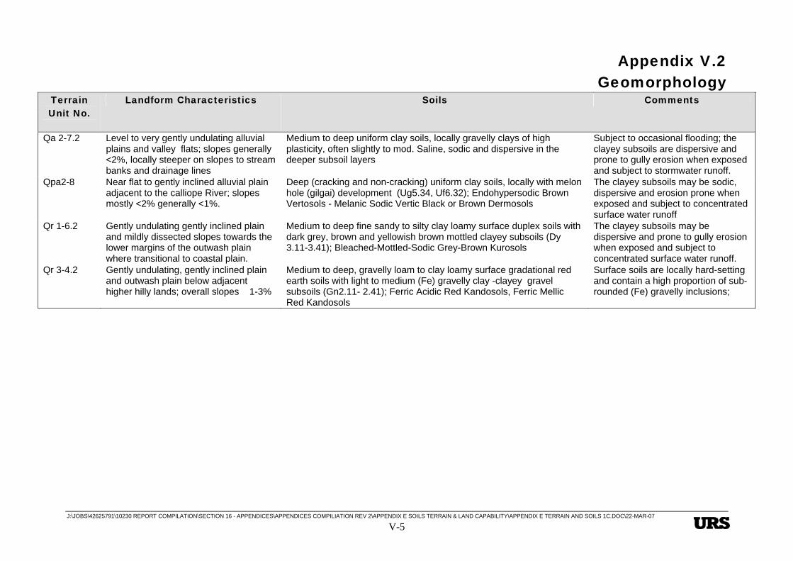
Landform Characteristics Soils Comments
Qa 2-7.2 Level to very gently undulating alluvial plains and valley flats; slopes generally <2%, locally steeper on slopes to stream banks and drainage lines
Medium to deep uniform clay soils, locally gravelly clays of high plasticity, often slightly to mod. Saline, sodic and dispersive in the deeper subsoil layers
Subject to occasional flooding; the clayey subsoils are dispersive and prone to gully erosion when exposed and subject to stormwater runoff.
Qpa2-8 Near flat to gently inclined alluvial plain adjacent to the calliope River; slopes mostly <2% generally <1%.
Deep (cracking and non-cracking) uniform clay soils, locally with melon hole (gilgai) development (Ug5.34, Uf6.32); Endohypersodic Brown Vertosols - Melanic Sodic Vertic Black or Brown Dermosols
The clayey subsoils may be sodic, dispersive and erosion prone when exposed and subject to concentrated surface water runoff
Qr 1-6.2 Gently undulating gently inclined plain and mildly dissected slopes towards the lower margins of the outwash plain where transitional to coastal plain.
Medium to deep fine sandy to silty clay loamy surface duplex soils with dark grey, brown and yellowish brown mottled clayey subsoils (Dy 3.11-3.41); Bleached-Mottled-Sodic Grey-Brown Kurosols
The clayey subsoils may be dispersive and prone to gully erosion when exposed and subject to concentrated surface water runoff.
Qr 3-4.2 Gently undulating, gently inclined plain and outwash plain below adjacent higher hilly lands; overall slopes 1-3%
Medium to deep, gravelly loam to clay loamy surface gradational red earth soils with light to medium (Fe) gravelly clay -clayey gravel subsoils (Gn2.11- 2.41); Ferric Acidic Red Kandosols, Ferric Mellic Red Kandosols
Surface soils are locally hard-setting and contain a high proportion of sub-rounded (Fe) gravelly inclusions;

Appendix V.3 Soils
J:\JOBS\42625791\10230 REPORT COMPILATION\SECTION 16 - APPENDICES\APPENDICES COMPILIATION REV 2\APPENDIX E SOILS TERRAIN & LAND CAPABILITY\APPENDIX E TERRAIN AND SOILS 1C.DOC\22-MAR-07
V-1
E Heading Style 1 This is Hidden Text it will not print
E.3 Soils
E.3.1 Soils Classification
The soils in the project area (which includes both the refinery site and the RSF site) have been identified based on the examination of 48 soil profiles and assigned to one of eight generic soil classes as shown in Table 3.1. Each soil class may include one or more soil type variants as shown in Table 3.2 and in order to fully characterise each soil type, the soils have been classified in terms of four commonly used systems of soil identification namely:
• The common Australian soil group name, generally following Stace et al. (1968) and Northcote et. al. (1975);
• The Principal Profile Form based on Northcote (1971);
• The Australian Engineering Soil Classification (AS 1726-1993); and
• The Australian Soil Classification by Isbell (1996).
E.3.2 Soil Types and Occurrences
The occurrence and distribution of soil types within the project area is shown in EIS Figure 8.1.3 for the refinery site and EIS Figure 9.1.3 for the RSF site. Descriptions of site conditions and the soil types found at the sampling locations investigated within the respective site areas are included in Appendix E 8. The descriptions also include th e results of indicative testing carried out to characterise the soil physical and general chemical properties of each soil type. These results, together with other more detailed laboratory analyses, have provided the basis for the assessment of terrain units in terms of topsoil suitability and indicative topsoil stripping depths, soil erosion potential and for determining the pre-construction agricultural land capability of terrain units.
E.3.3 Soil Physical and Chemical Properties
The results of the indicative soil physical and chemical testing are included in Appendix E 8. The results of laboratory testing carried out are summarised in Appendix E 9.
Appendix V.3 Soils
J:\JOBS\42625791\10230 REPORT COMPILATION\SECTION 16 - APPENDICES\APPENDICES COMPILIATION REV 2\APPENDIX E SOILS TERRAIN & LAND CAPABILITY\APPENDIX E TERRAIN AND SOILS 1C.DOC\22-MAR-07 V-2
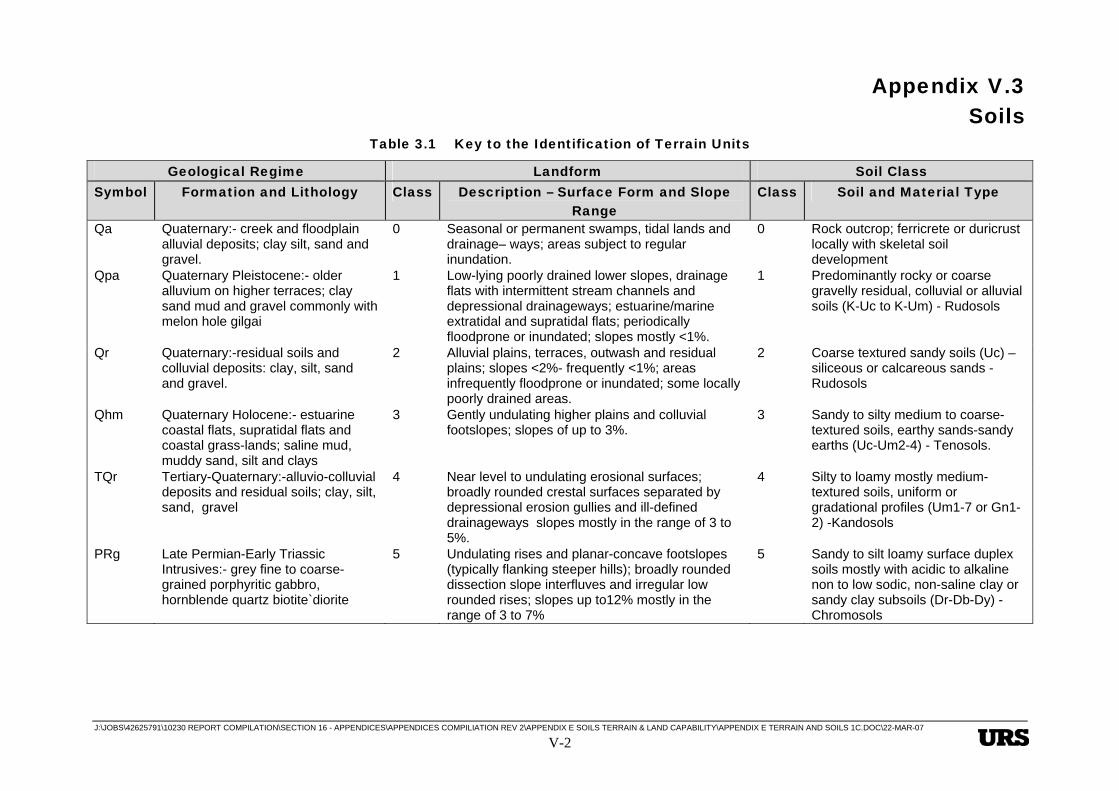
Table 3.1 Key to the Identification of Terrain Units
Geological Regime Landform Soil Class Symbol Formation and Lithology Class Description – Surface Form and Slope
Range Class Soil and Material Type
Qa Quaternary:- creek and floodplain alluvial deposits; clay silt, sand and gravel.
0 Seasonal or permanent swamps, tidal lands and drainage– ways; areas subject to regular inundation.
0 Rock outcrop; ferricrete or duricrust locally with skeletal soil development
Qpa Quaternary Pleistocene:- older alluvium on higher terraces; clay sand mud and gravel commonly with melon hole gilgai
1 Low-lying poorly drained lower slopes, drainage flats with intermittent stream channels and depressional drainageways; estuarine/marine extratidal and supratidal flats; periodically floodprone or inundated; slopes mostly <1%.
1 Predominantly rocky or coarse gravelly residual, colluvial or alluvial soils (K-Uc to K-Um) - Rudosols
Qr Quaternary:-residual soils and colluvial deposits: clay, silt, sand and gravel.
2 Alluvial plains, terraces, outwash and residual plains; slopes <2%- frequently <1%; areas infrequently floodprone or inundated; some locally poorly drained areas.
2 Coarse textured sandy soils (Uc) – siliceous or calcareous sands - Rudosols
Qhm Quaternary Holocene:- estuarine coastal flats, supratidal flats and coastal grass-lands; saline mud, muddy sand, silt and clays
3 Gently undulating higher plains and colluvial footslopes; slopes of up to 3%.
3 Sandy to silty medium to coarse-textured soils, earthy sands-sandy earths (Uc-Um2-4) - Tenosols.
TQr Tertiary-Quaternary:-alluvio-colluvial deposits and residual soils; clay, silt, sand, gravel
4 Near level to undulating erosional surfaces; broadly rounded crestal surfaces separated by depressional erosion gullies and ill-defined drainageways slopes mostly in the range of 3 to 5%.
4 Silty to loamy mostly medium-textured soils, uniform or gradational profiles (Um1-7 or Gn1-2) -Kandosols
PRg Late Permian-Early Triassic Intrusives:- grey fine to coarse-grained porphyritic gabbro, hornblende quartz biotite`diorite
5 Undulating rises and planar-concave footslopes (typically flanking steeper hills); broadly rounded dissection slope interfluves and irregular low rounded rises; slopes up to12% mostly in the range of 3 to 7%
5 Sandy to silt loamy surface duplex soils mostly with acidic to alkaline non to low sodic, non-saline clay or sandy clay subsoils (Dr-Db-Dy) - Chromosols

Appendix V.3 Soils
J:\JOBS\42625791\10230 REPORT COMPILATION\SECTION 16 - APPENDICES\APPENDICES COMPILIATION REV 2\APPENDIX E SOILS TERRAIN & LAND CAPABILITY\APPENDIX E TERRAIN AND SOILS 1C.DOC\22-MAR-07 V-3
Geological Regime Landform Soil Class Symbol Formation and Lithology Class Description – Surface Form and Slope
Range Class Soil and Material Type
CPk Permian-Carboniferous Berserker Group: - mudstone, siltstone, felsic volcaniclastic sandstone and conglomerate, minor limestone and rhyolitic ignimbrite
6 Rolling to moderately steep hilly lands and rises mostly with planar to broadly rounded hill slopes and dissection slope interfluves; slopes typically 12 to 25% locally steeper.
6 Silty or clay loamy surface duplex soils with strongly acidic or strongly alkaline, sodic often saline clay subsoils (Dr-Db-Dy) - Kurosols, Sodosols
Cr Early Carboniferous Rockhampton Group :- dark grey sandstone, siltstone, poly-mictic conglomerate, oolitic limestone
7 Moderately steep to steep dissected low hilly lands; with ridge and spur slopes up to 35% , locally steeper in dissection gullies
7 Uniform or weakly gradational (non-cracking) clay or silty clay soils (incipient cracking clays) (Uf6, Gn3-4 ) Dermosols, Ferrosols
DCd Devonian-Carboniferous Doonside Formation:- chert, jasper, siltstone, sandstone, tuff, limestone and altered basalt
8 Mostly steep to very steep higher hilly lands, with locally sharply incised erosion gullies; hill and ridge slopes are typically convex to planar mostly in a range 25 to 50%.
8 Uniform (cracking) grey, brown or red clay soils (Ug1 – Ug5) - Vertosols
DCa Devonian-Carboniferous Mt. Alma Formation:- thinly interbedded fine-grained sandstone, siltstone and conglomerate
D Disturbed lands modified by cut and/or fill operations or existing industrial development activities.
9 N/A
Example :- Terrain Unit (Cr 6-6.1) Geological Regime Cr; Landform 6; Soil Type 6.1 Note: 1. Dual symbols for soil type, eg.(4-5) indicate that both material types or integrades between the two types occur within the mapping unit. 2. Soil types designated 4.1, 5.1, 6.1, 7.1 etc. indicate shallow soil variants (<0.6m) mostly underlain by HW Rock. Soil types designated 4.2, 5.2, 6.2, 7.2 etc., indicate the occurrence of medium deep (0.6-1.2m) or deep (1.2-1.5m+) soil variants over HW Rock or other substrate materials.

Appendix V.3 Soils
J:\JOBS\42625791\10230 REPORT COMPILATION\SECTION 16 - APPENDICES\APPENDICES COMPILIATION REV 2\APPENDIX E SOILS TERRAIN & LAND CAPABILITY\APPENDIX E TERRAIN AND SOILS 1C.DOC\22-MAR-07 V-4
Table 3.2 Soil Types in the Project Area
Soil Classification Soil Class Soil Type
Aust. Soil(1)
Group P.P.F.(2) U.S.C.(3) A.S.S.(4)
1. Predominantly rocky or coarse gravelly residual, colluvial, alluvial soils (>60% rock cobbles and gravel)
Shallow coarse gravelly/ rocky loams to loamy gravels over HW rock
Skeletal Soils/ Lithosols
K-Um1.23 GW-GM-GC Very Gravelly Lithic Leptic Rudosols
2. Coarse textured uniform sand or gravelly sand soils; residual soils or alluvium
(No mapped occurrences in the project area) Lithosols/Alluvial Soils/Siliceous Sands
Uc2-Uc4 or Uc1
SP, SM, SM-SP
Lithic/Stratic /Arenic Rudosols,
3. Earthy sands – sandy earth soils, coarse to medium-textured soils
(No mapped occurrences in the project area) Earthy Sands/ Sandy Earths
Uc5.21 SM-SC,SP-SC, SC
Paralithic Leptic Tenosols
4. Uniform or gradational, medium-textured soils, loams, gravelly loam soils
4.1. Shallow to medium deep uniform or gradational gravelly clay loam to gravelly light to medium clay soils over HW rock between 0.5-12m
(Lateritic) Red Earths
Gn1.11
GC-CL/GC
Gravelly Red-Brown Kandosols
Appendix V.3 Soils
J:\JOBS\42625791\10230 REPORT COMPILATION\SECTION 16 - APPENDICES\APPENDICES COMPILIATION REV 2\APPENDIX E SOILS TERRAIN & LAND CAPABILITY\APPENDIX E TERRAIN AND SOILS 1C.DOC\22-MAR-07 V-5
Soil Classification Soil Class Soil Type
Aust. Soil(1)
Group P.P.F.(2) U.S.C.(3) A.S.S.(4)
4.2. Medium to deep gravelly clay loam-loamy gravelly surface gradational red earth soils with massive apedal tending to weak to mod. structured gravelly light to medium clay subsoils over HW rock or gravelly colluvium between about 0.6-1.5m+
(Lateritic) Acidic Red Earths
Gn3.14,
Gn2.11,
GC/GC-CL/GC Ferric Red Kandosols
Ferric Acidic Red Kandosols
5.1. Shallow to medium deep, gravelly loam or hardset loamy surface weak duplex soils with brown or reddish brown medium to heavy clay or gravelly clay subsoils over HW rock
Yellow-Brown, Red Podzolic Soils
Dy4.11
Dr4.21
Db3.51
CL/CL-CH
GC/GC-CL
CL/GC-CL/CL-CH
Bleached Eutrophic Red-Brown Chromosols;
Melanic Brown Chromosols
5. Sandy to silt loamy surface duplex soils with acidic to alkaline non sodic, non-saline clay or sandy clay subsoils
5.2. Medium deep gravelly loam and clay loamy surface duplex soils with weak to mod. strongly structured brown and reddish brown medium to heavy acidic clay and locally gravelly clay subsoils over Hw rock between 0.8-1.4m.
Yellow-Brown, Red Podzolic Soils
Dy2.31
Dr4.11
CL/CH
GC/CL-CH
Haplic Eutrophic Red-Brown Chromosols
6. Silty or clay loamy surface duplex soils with strongly acidic or strongly alkaline, sodic often saline clay subsoils
6.1 Shallow clay loam to gravelly loamy surface duplex soils with a pale or bleached sub-surface (A2) horizon over red-brown or brown, structured, acidic, locally strongly acidic dis-persive. medium to heavy clay or gravelly clay subsoils
Soloths, Solodic Soils
Db1.11
Dr4.21
Dy5.31
K-Db1.51
GC/GC-CL/CH Bleached-Mottled Sodic Yellow-Brown Kurosols; Sub-natric Bleached Red Sodosols;
Vertic Brown Sodosols

Appendix V.3 Soils
J:\JOBS\42625791\10230 REPORT COMPILATION\SECTION 16 - APPENDICES\APPENDICES COMPILIATION REV 2\APPENDIX E SOILS TERRAIN & LAND CAPABILITY\APPENDIX E TERRAIN AND SOILS 1C.DOC\22-MAR-07 V-6
Soil Classification Soil Class Soil Type
Aust. Soil(1)
Group P.P.F.(2) U.S.C.(3) A.S.S.(4)
6.2. Medium deep hardset sandy to silt loamy, locally gravelly surface duplex soils with a pale or bleached (A2) horizon over brown or yellow-brown diffusely mottled mod. saline, sodic and dispersive heavy clay subsoils
Solodic Soils,
Soloths
Db2.81
Db3.31-Dy2.43
Dy3.41-Dy3.11
CL-ML/CH
CL-ML/GM-GC/CH
Mottled Mesonatric Yellow-Brown Sodosols;
Bleached Mottled Sodic Grey
Kurosols
7.1. Shallow uniform clay soils with dark-coloured organic rich friable well-structured medium clay surface soils over strong fine to medium structured heavy clay subsoils over HW rock
Dark Brown (Non-Cracking) Friable Clay Soils
Uf6.11, Uf6.31, Uf6.12
CL/CL-CH or CH
CL-CH/CH
Melanic Black-Brown Dermosols
Gravelly Red-Brown Dermosols
7. Uniform or weakly gradational (non-cracking) clay or silty clay soils (incipient cracking clays)
7.2. Medium to deep uniform clay soils, locally gravelly clays of high plasticity, often slightly to mod. saline, sodic and dispersive in the deeper subsoil layers
Alluvial Soils
Dense Hard Pedal Sodic-Saline Clays
Uf6.32
Uf6.22
Uf6.31
CH/CH
CL-CH/CH
GC-CH/CH
Melanic Vertic Sodic Brownish-Black Dermosols
8. Uniform (cracking) grey, brown or red clay soils
Uniform Dark Grey-Brown (Cracking) Clay Soils Grey-Brown (Cracking) Clays
Ug5.15 CH/CH Endocalcareous Self-mulching Black Vertosols
Notes: (1) - Common Soil Group Name Stace et.al. (1968); (2) - Principal Profile Form Northcote (1971); (3) - Engineering Soil Class (AS 1764-1990); (4) - Australian Soil Classification Isbell (1996).

Appendix V.4 Topsoil Resources
J:\JOBS\42625791\10230 REPORT COMPILATION\SECTION 16 - APPENDICES\APPENDICES COMPILIATION REV 2\APPENDIX E SOILS TERRAIN & LAND CAPABILITY\APPENDIX E TERRAIN AND SOILS 1C.DOC\22-MAR-07
V-7
E Heading Style 1 This is Hidden Text it will not print
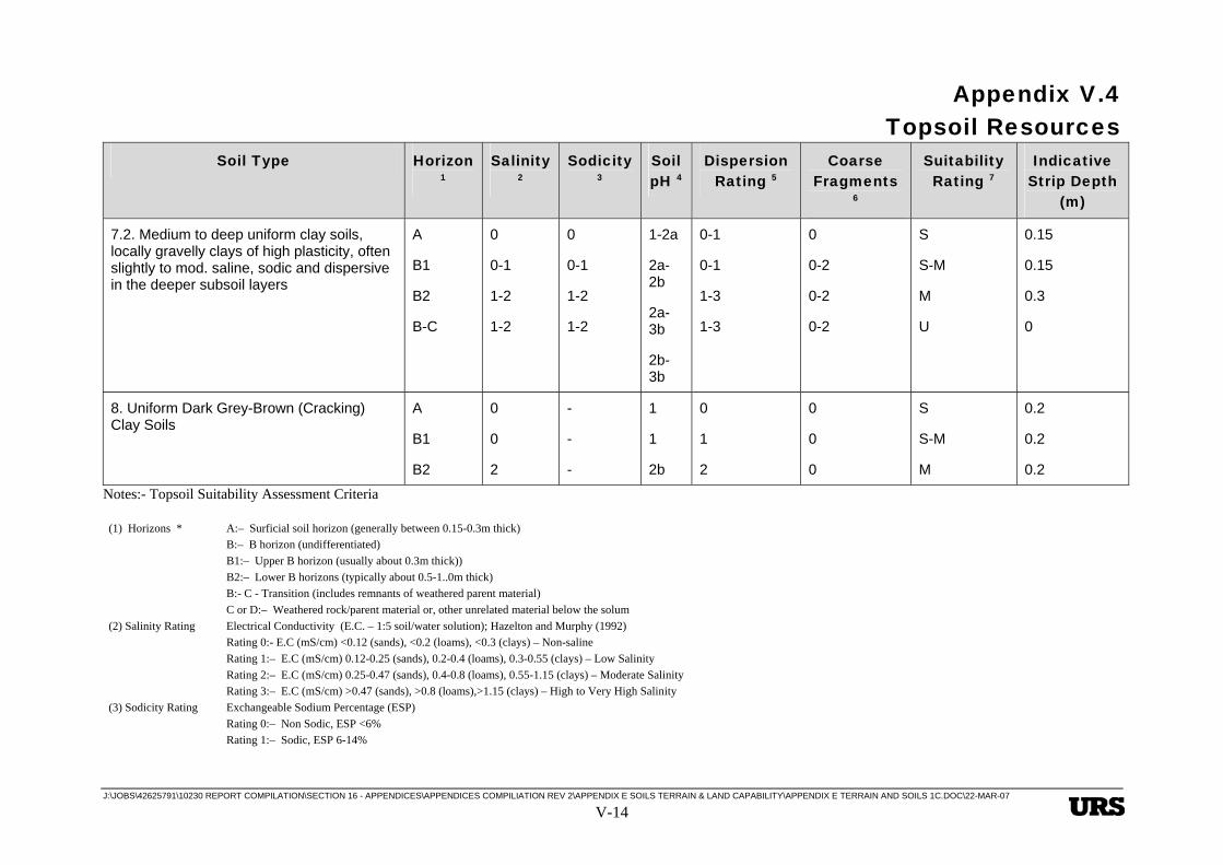
E.4 Topsoil Resources
E.4.1 Method of Assessment
Based on the findings of the reconnaissance soil survey, together with the results of the indicative and laboratory testing undertaken, an assessment has been made of topsoil suitability for rehabilitation of lands that may be disturbed as a result of the project development and construction activities. Together with field observations of soil surface condition, soil texture and structure, Table 4.1 provides the basis used to evaluate the suitability in terms of physical and chemical properties of the soils for use as topsoil for land rehabilitation purposes. The criteria and parameters used for the assessment are also included in Table 4.1. Based on the assessment, indicative topsoil stripping depths of suitable (S) or suitable to marginal (S-M) material have been determined. These materials are considered to constitute suitable or acceptable materials for use as topsoil for site rehabilitation purposes and should be salvaged from areas likely to be subject to disturbance as a result of site development activities. Table 4.1 also provides an assessment of materials that are considered to be marginal (M) for use as topsoil material, but would have acceptable properties for the use as subsoil resources, if required. If salvaged, the marginal materials should be stripped and stockpiled separately from the suitable topsoil materials.
E.4.2 Results of Assessment
Reference to Table 4.1 indicates that useable topsoil resources are mainly confined to the surficial (A) horizon materials that contain seed-stock, micro-organisms and nutrients necessary for plant growth and to a lesser extent in the upper (B1) soil horizons in some soil types. Soil microbial activity, organic matter content and other parameters affecting soil fertility and productivity, usually tend to decrease with depth in the B2 and deeper subsoil horizons. In summary, the following general comments can be made with respect to topsoil suitability and availability within the project area. However more detailed assessments of topsoil resources may need to be undertaken prior to the commencement of construction activities in site-specific areas.
In terms of acceptable soil physical and chemical properties and the extent of occurrence within the project area, the most suitable sources of topsoil occur in soil class 7 and class 8 specifically in terrain units Qa2-7.2, Qpa2-8, and PRg4-7.1 and PRg7-7.1. The surficial (A) soil horizons of these soil types are typically about 0.15-0.2m thick and usually comprise the most suitable material resources in terms of soil physical and chemical properties. The subsoil (B1) or upper (B) horizons that occur between depths of about 0.2-0.4m (bgl), are usually of lesser quality in terms of soil nutrient levels and soil physical characteristics, but may be useable as a topsoil supplement, if blended with the surficial soil horizon materials or used to extend the potential plant root zone depth. In most cases, the deeper (B2) horizons are unsuitable for use as a topsoil supplement, due to elevated levels of acidity-alkalinity, salinity, sodicity and/or other adverse soil attributes such as excessively coarse soil structure, very strong (tough) dry consistence, or moderate to strong dispersion characteristics.

Appendix V.4 Topsoil Resources
J:\JOBS\42625791\10230 REPORT COMPILATION\SECTION 16 - APPENDICES\APPENDICES COMPILIATION REV 2\APPENDIX E SOILS TERRAIN & LAND CAPABILITY\APPENDIX E TERRAIN AND SOILS 1C.DOC\22-MAR-07
V-8
The shallow rocky/stony loams and very gravelly clay soils of class 1 occur extensively within the RSF area mostly within terrain units Cr8-(1-6.1) and DCa8-(1-5.1). These soils mostly contain up to high amounts of weathered rock cobbles, ferruginous and/or siliceous stone or gravel and are typically only about 0.2-0.4m thick and underlain by weathered rock. As such the soils are considered to be only marginal for use as a topsoil resource. However in places some surficial less rocky gravelly clay loam or gravelly light to medium clay soils occur that contain useful reserves of seed-stock and organic matter that could be recovered if topsoil resources in the general vicinity and elsewhere are limited.
Class 4 soils occur within the refinery site in terrain units Qr3-4.2, DCd5-4.2 and DCd7-4.1. These soils include shallow to medium deep gradational gravelly loam to gravelly clay soils which due to their gravelly nature, are considered to be marginal for use as topsoil and only really suitable for use as a sub-soil supplement if required. However the surface soil horizons appear to contain appreciable levels of seed-stock and organic matter and the upper 0.2m may be worth salvaging for use or blending with other potential topsoil resources if required.
Class 5 soils type 5.1 occur in the RSF area within terrain units DCa6-(5.1-1), DCa7-(5.1-), in places in areas mapped as DCa8-(1-5.1) and CPk6-(5.1-7.1). They comprise mostly shallow gravelly hardset acidic locally strongly acidic loamy surface duplex soils with a weakly developed pale sub-surface (A2) horizon. Although mostly quite gravelly, the upper 0.15m should, where possible, be recovered for topsoil use. The A2 and upper B horizon layers can be recovered for use as a sub-soil supplement if required. The loamy surface duplex soils type 5.2 in terrain unit CPa5-5.2 are generally somewhat less gravelly in the surficial soil layers than soil type 5.1. The loamy (A1/A2) horizon is mostly about 0.2m thick and the upper 0.3m thickness of the (B) horizon have both been rated as suitable to marginal (S-M) for use as topsoil.
Class 6 soils type 6.1 occur in the RSF area in terrain units Cr6-6.1 and in places in areas mapped as Cr8-(1-6.1). They comprise shallow hardset acidic loamy and gravelly loamy surface duplex soils with a pale or bleached sub-surface (A2) horizon and locally strongly acidic, sodic and dispersive clay sub-soils. Depending on the gravel content and acidity levels in the surface soils, the upper 0.15m may be worth recovering to take advantage of the organic matter and seed-stock content. The sub-surface (A2) horizon has been rated as marginal for topsoil use but may be recovered as a sub-soil supplement if required.
The sandy to silt loamy and gravelly loamy surface duplex soils type 6.2 occur in both the refinery site and the RSF site. The silt loamy surface soils are hard-setting and pulverulent when disturbed and reworked. The surficial (A1) horizon is usually about 0.15m in thickness and should be salvaged for the organic matter and seed-stock content, for use or blending with other potential topsoil resources where required. The sub-surface (A2) and/or the upper (B1) horizons usually about 0.2m thick, have been rated as marginal (M) for topsoil use and should only be recovered as a subsoil supplement where required.

Appendix V.4 Topsoil Resources
J:\JOBS\42625791\10230 REPORT COMPILATION\SECTION 16 - APPENDICES\APPENDICES COMPILIATION REV 2\APPENDIX E SOILS TERRAIN & LAND CAPABILITY\APPENDIX E TERRAIN AND SOILS 1C.DOC\22-MAR-07
V-9
E.4.3 Topsoil Management
Topsoil stripping
Prior to the commencement of the stripping of topsoil, areas will be cleared of vegetation. Trees will be felled and together with shrubby vegetation, pushed into windrows for chipping and/or burning. Prior to burning, consideration will be given to salvaging any marketable timber as well as wood chipping/mulching and composting of the smaller branches, shrubs and foliage. Following a suitable period and process of composting, the product can be used to provide a thin surface mulch to improve the topsoil productivity. If burning of any large remaining timber is undertaken, the ash beds may be incorporated with the topsoil during the topsoil stripping operations.
Where both the topsoil and subsoil supplement materials are required to be stripped, these will be stripped and placed in separate stockpiles where possible. Earthmoving plant operators will be trained and/or supervised to ensure that stripping operations are conducted in accordance with stripping plans and in-situ soil conditions. This will ensure that all suitable topsoil material resources are salvaged and that the quality of the stripped topsoil is not reduced through contamination with unsuitable soils. Care will be taken during stripping, stockpiling, and/or re-spreading to ensure that structural degradation of the soil is avoided and that excessive compaction does not occur during stockpiling.
Stockpiling
Where possible, topsoil material will be re-spread directly from stripped areas onto areas being rehabilitated. Where this is not possible, topsoil shall be stored in stockpiles. Topsoil stockpiles will be located in areas that are outside the plant site disturbance area and at least 50m away from drainage lines. Drainage from higher areas will be diverted around stockpiles to prevent erosion. Sediment controls will be installed downstream of the stockpiles to collect any washed sediment.
Stockpiles will be formed in low mounds of minimum height (approximately 3 m maximum) and maximum surface area, consistent with the storage area available. Stockpiles will be deep ripped and sown with local seed-stock and legumes in order to keep the soil healthy and maintain biological activity. Topsoil stockpiles will be clearly sign-posted for easy identification and to avoid any inadvertent losses. Establishment of weeds on the stockpiles will also be monitored and controlled.
Respreading
Rehabilitation planning will include topsoil material respreading considerations including:
• Balancing required rehabilitation topsoil quantities against stored stockpile inventories;
• Planning the source of topsoil material to maximise direct respreading from stripping areas and to minimise the length of time that material is stored in stockpiles; and
• Selective placement of more erodible (sandy to sandy loam) topsoil materials on flatter areas and not on steeper slopes, to minimise erosion.

Appendix V.4 Topsoil Resources
J:\JOBS\42625791\10230 REPORT COMPILATION\SECTION 16 - APPENDICES\APPENDICES COMPILIATION REV 2\APPENDIX E SOILS TERRAIN & LAND CAPABILITY\APPENDIX E TERRAIN AND SOILS 1C.DOC\22-MAR-07
V-10
During the removal of soils from the stockpiles, care will be taken to minimise structural degradation of the soils. The upper and lower sections of the stockpiles will be mixed to spread seed stock and micro-fauna through the lower sections of the stockpile. Topsoil material will be re-spread in even layers at a thickness appropriate for the intended land use of the area to be rehabilitated. The rehabilitation strategy will include the following measures that are designed to minimise the loss of topsoil material re-spread on rehabilitated areas:
• Cross ripping to encourage rainfall infiltration and minimise runoff;
• Reseeding soon after respreading to establish revegetation cover as early as possible;
• Installation of contour banks where necessary to limit slope lengths and runoff velocities; and
• Installation of collection drains and sediment dams to contain runoff and suspended sediment.
Appendix V.4 Topsoil Resources
J:\JOBS\42625791\10230 REPORT COMPILATION\SECTION 16 - APPENDICES\APPENDICES COMPILIATION REV 2\APPENDIX E SOILS TERRAIN & LAND CAPABILITY\APPENDIX E TERRAIN AND SOILS 1C.DOC\22-MAR-07 V-11
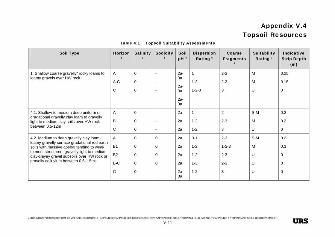
Table 4.1 Topsoil Suitability Assessments
Soil Type Horizon 1
Salinity 2
Sodicity 3
Soil pH 4
Dispersion Rating 5
Coarse Fragments
6
Suitability Rating 7
Indicative Strip Depth
(m)
1. Shallow coarse gravelly/ rocky loams to loamy gravels over HW rock
A
A-C
C
0
0
0
-
-
-
2a-3a
2a-3a
2a-3a
1
1-2
1-2-3
2-3
2-3
3
M
M
U
0.25
0.15
0
4.1. Shallow to medium deep uniform or gradational gravelly clay loam to gravelly light to medium clay soils over HW rock between 0.5-12m
A
B
C
0
0
0
-
-
-
2a
2a
2a
1
1-2
1-2
2
2-3
3
S-M
M
U
0.2
0.2
0
4.2. Medium to deep gravelly clay loam-loamy gravelly surface gradational red earth soils with massive apedal tending to weak to mod. structured gravelly light to medium clay-clayey gravel subsoils over HW rock or gravelly colluvium between 0.6-1.5m+
A
B1
B2
B-C
C
0
0
0
0
0
0
0
0
0
-
2a
2a
2a
2a
2a-3a
0-1
1-2
1-2
1-3
1-2
2-3
1-2-3
2-3
2-3
3
S-M
M
U
U
U
0.2
0.3
0
0
0

Appendix V.4 Topsoil Resources
J:\JOBS\42625791\10230 REPORT COMPILATION\SECTION 16 - APPENDICES\APPENDICES COMPILIATION REV 2\APPENDIX E SOILS TERRAIN & LAND CAPABILITY\APPENDIX E TERRAIN AND SOILS 1C.DOC\22-MAR-07 V-12
Soil Type Horizon 1
Salinity 2
Sodicity 3
Soil pH 4
Dispersion Rating 5
Coarse Fragments
6
Suitability Rating 7
Indicative Strip Depth
(m)
5.1. Shallow to medium deep, gravelly loam or hardset loamy surface weak duplex soils with brown or reddish brown medium to heavy clay or gravelly clay subsoils over HW rock
A1
A2
B/B-C
C
0
0
0
0
0
0
0
0
2a-3a
2a
2a
2a-1-3b
1
1
1
1-2
1-2
1-2
0-2
3
S-M
M
M
U
0.15
0.15
0.2
0
5.2. Medium deep gravelly loam and clay loamy surface duplex soils with weak to mod. strongly structured brown and reddish brown medium to heavy acidic clay and locally gravelly clay subsoils over Hw rock between 0.8-1.4m.
A1/A2
B
B-C
C
0
0
0
0
-
-
-
-
2a
2a
1-2a
1-2b
1-2
1
1-3
1-2
0-2
1-2
2
3
S-M
S-M
M
U
0.2
0.2
0.3
0
6.1 Shallow clay loam to gravelly loamy surface duplex soils with a pale or bleached sub-surface (A2) horizon over red-brown or brown, structured, acidic, locally strongly acidic dispersive. medium to heavy clay or gravelly clay subsoils
A
A2
B
B-C
C
0
0
0
0
0-1
-
-
-
-
-
2a-3a
2a-3a
2a
3a
2a
1
1-3
2-3
2-3
3
2-3
1-2
0
2-3
3
S-M
M
M-U
U
U
0.15
0.15
0.25
0
0
Appendix V.4 Topsoil Resources
J:\JOBS\42625791\10230 REPORT COMPILATION\SECTION 16 - APPENDICES\APPENDICES COMPILIATION REV 2\APPENDIX E SOILS TERRAIN & LAND CAPABILITY\APPENDIX E TERRAIN AND SOILS 1C.DOC\22-MAR-07 V-13
Soil Type Horizon 1
Salinity 2
Sodicity 3
Soil pH 4
Dispersion Rating 5
Coarse Fragments
6
Suitability Rating 7
Indicative Strip Depth
(m)
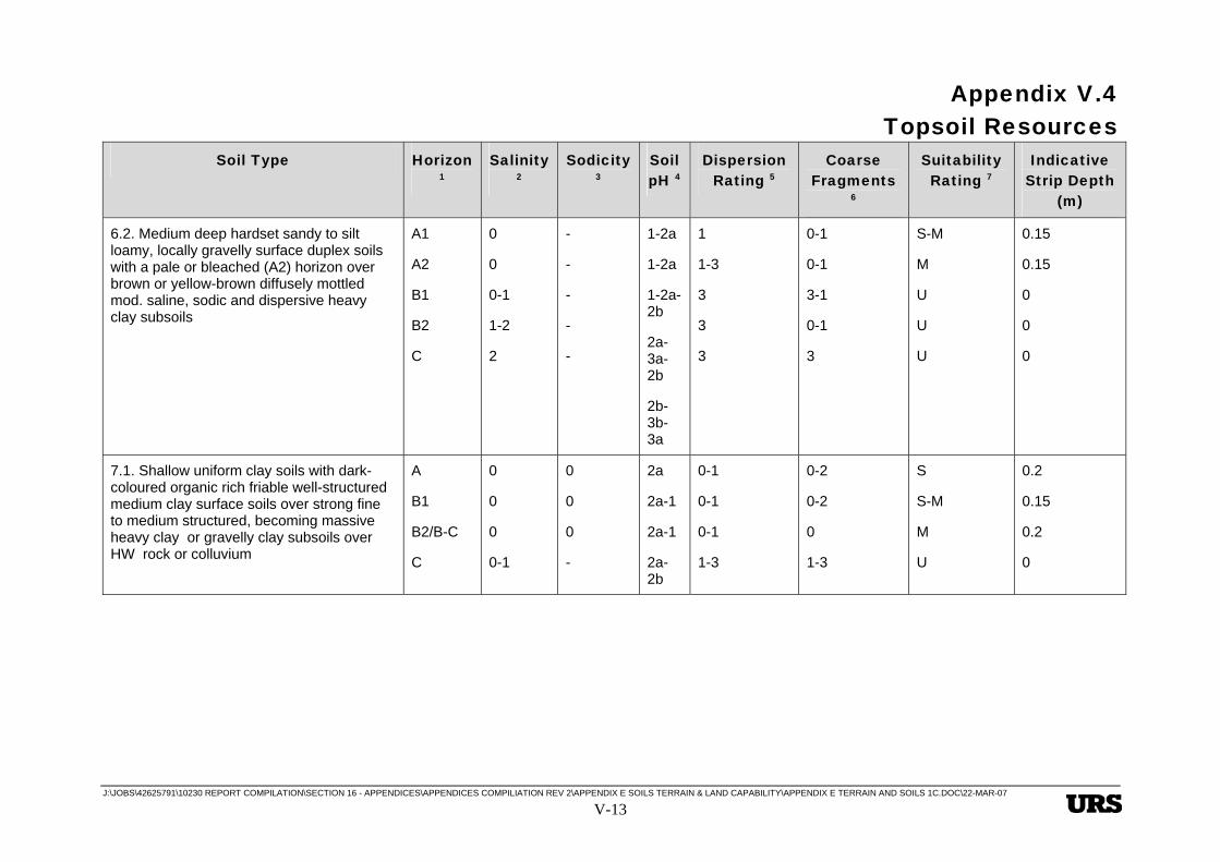
6.2. Medium deep hardset sandy to silt loamy, locally gravelly surface duplex soils with a pale or bleached (A2) horizon over brown or yellow-brown diffusely mottled mod. saline, sodic and dispersive heavy clay subsoils
A1
A2
B1
B2
C
0
0
0-1
1-2
2
-
-
-
-
-
1-2a
1-2a
1-2a-2b
2a-3a-2b
2b-3b-3a
1
1-3
3
3
3
0-1
0-1
3-1
0-1
3
S-M
M
U
U
U
0.15
0.15
0
0
0
7.1. Shallow uniform clay soils with dark-coloured organic rich friable well-structured medium clay surface soils over strong fine to medium structured, becoming massive heavy clay or gravelly clay subsoils over HW rock or colluvium
A
B1
B2/B-C
C
0
0
0
0-1
0
0
0
-
2a
2a-1
2a-1
2a-2b
0-1
0-1
0-1
1-3
0-2
0-2
0
1-3
S
S-M
M
U
0.2
0.15
0.2
0
Appendix V.4 Topsoil Resources
J:\JOBS\42625791\10230 REPORT COMPILATION\SECTION 16 - APPENDICES\APPENDICES COMPILIATION REV 2\APPENDIX E SOILS TERRAIN & LAND CAPABILITY\APPENDIX E TERRAIN AND SOILS 1C.DOC\22-MAR-07 V-14
Soil Type Horizon 1
Salinity 2
Sodicity 3
Soil pH 4
Dispersion Rating 5
Coarse Fragments
6
Suitability Rating 7
Indicative Strip Depth
(m)
7.2. Medium to deep uniform clay soils, locally gravelly clays of high plasticity, often slightly to mod. saline, sodic and dispersive in the deeper subsoil layers
A
B1
B2
B-C
0
0-1
1-2
1-2
0
0-1
1-2
1-2
1-2a
2a-2b
2a-3b
2b-3b
0-1
0-1
1-3
1-3
0
0-2
0-2
0-2
S
S-M
M
U
0.15
0.15
0.3
0
8. Uniform Dark Grey-Brown (Cracking) Clay Soils
A
B1
B2
0
0
2
-
-
-
1
1
2b
0
1
2
0
0
0
S
S-M
M
0.2
0.2
0.2
Notes:- Topsoil Suitability Assessment Criteria
(1) Horizons * A:– Surficial soil horizon (generally between 0.15-0.3m thick) B:– B horizon (undifferentiated) B1:– Upper B horizon (usually about 0.3m thick)) B2:– Lower B horizons (typically about 0.5-1..0m thick) B:- C - Transition (includes remnants of weathered parent material) C or D:– Weathered rock/parent material or, other unrelated material below the solum (2) Salinity Rating Electrical Conductivity (E.C. – 1:5 soil/water solution); Hazelton and Murphy (1992) Rating 0:- E.C (mS/cm) <0.12 (sands), <0.2 (loams), <0.3 (clays) – Non-saline Rating 1:– E.C (mS/cm) 0.12-0.25 (sands), 0.2-0.4 (loams), 0.3-0.55 (clays) – Low Salinity Rating 2:– E.C (mS/cm) 0.25-0.47 (sands), 0.4-0.8 (loams), 0.55-1.15 (clays) – Moderate Salinity Rating 3:– E.C (mS/cm) >0.47 (sands), >0.8 (loams),>1.15 (clays) – High to Very High Salinity (3) Sodicity Rating Exchangeable Sodium Percentage (ESP) Rating 0:– Non Sodic, ESP <6% Rating 1:– Sodic, ESP 6-14%
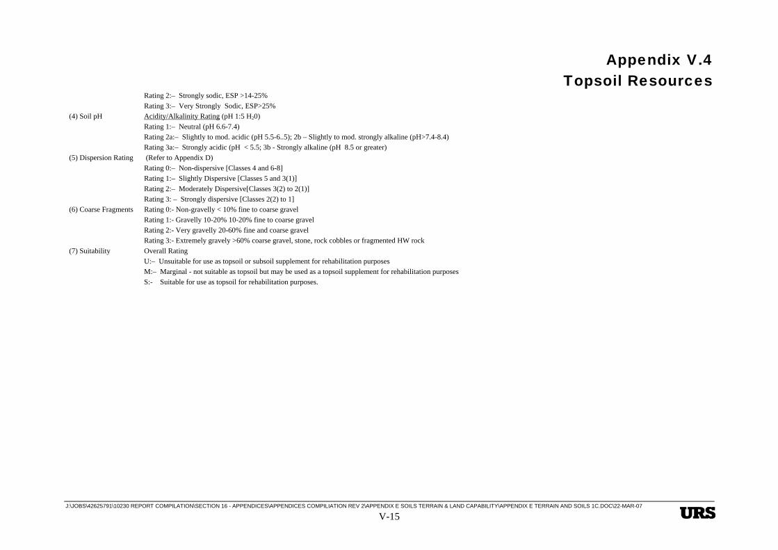
Appendix V.4 Topsoil Resources
J:\JOBS\42625791\10230 REPORT COMPILATION\SECTION 16 - APPENDICES\APPENDICES COMPILIATION REV 2\APPENDIX E SOILS TERRAIN & LAND CAPABILITY\APPENDIX E TERRAIN AND SOILS 1C.DOC\22-MAR-07 V-15
Rating 2:– Strongly sodic, ESP >14-25% Rating 3:– Very Strongly Sodic, ESP>25% (4) Soil pH Acidity/Alkalinity Rating (pH 1:5 H20) Rating 1:– Neutral (pH 6.6-7.4) Rating 2a:– Slightly to mod. acidic (pH 5.5-6..5); 2b – Slightly to mod. strongly alkaline (pH>7.4-8.4) Rating 3a:– Strongly acidic (pH < 5.5; 3b - Strongly alkaline (pH 8.5 or greater) (5) Dispersion Rating (Refer to Appendix D) Rating 0:– Non-dispersive [Classes 4 and 6-8] Rating 1:– Slightly Dispersive [Classes 5 and 3(1)] Rating 2:– Moderately Dispersive[Classes 3(2) to 2(1)] Rating 3: – Strongly dispersive [Classes 2(2) to 1] (6) Coarse Fragments Rating 0:- Non-gravelly < 10% fine to coarse gravel Rating 1:- Gravelly 10-20% 10-20% fine to coarse gravel Rating 2:- Very gravelly 20-60% fine and coarse gravel Rating 3:- Extremely gravely >60% coarse gravel, stone, rock cobbles or fragmented HW rock (7) Suitability Overall Rating U:– Unsuitable for use as topsoil or subsoil supplement for rehabilitation purposes M:– Marginal - not suitable as topsoil but may be used as a topsoil supplement for rehabilitation purposes S:- Suitable for use as topsoil for rehabilitation purposes.
Appendix V.5 Implications for Rehabilitation Strategies
J:\JOBS\42625791\10230 REPORT COMPILATION\SECTION 16 - APPENDICES\APPENDICES COMPILIATION REV 2\APPENDIX E SOILS TERRAIN & LAND CAPABILITY\APPENDIX E TERRAIN AND SOILS 1C.DOC\22-MAR-07
V-1
E Heading Style 1 This is Hidden Text it will not print
E.5 Implications for Rehabilitation Strategies
E.5.1 Soil Properties
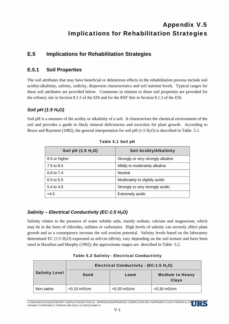
The soil attributes that may have beneficial or deleterious effects in the rehabilitation process include soil acidity/alkalinity, salinity, sodicity, dispersion characteristics and soil nutrient levels. Typical ranges for these soil attributes are provided below. Comments in relation to these soil properties are provided for the refinery site in Section 8.1.5 of the EIS and for the RSF Site in Section 9.1.3 of the EIS.
Soil pH (1:5 H2O)
Soil pH is a measure of the acidity or alkalinity of a soil. It characterises the chemical environment of the soil and provides a guide to likely mineral deficiencies and toxicities for plant growth. According to Bruce and Rayment (1982), the general interpretation for soil pH (1:5 H2O) is described in Table 5.1.
Table 5.1 Soil pH
Soil pH (1:5 H2O) Soil Acidity/Alkalinity
8.5 or higher Strongly or very strongly alkaline
7.5 to 8.4 Mildly to moderately alkaline
6.6 to 7.4 Neutral
6.5 to 5.5 Moderately to slightly acidic
5.4 to 4.5 Strongly to very strongly acidic
<4.5 Extremely acidic
Salinity – Electrical Conductivity (EC-1:5 H2O)
Salinity relates to the presence of water soluble salts, mainly sodium, calcium and magnesium, which may be in the form of chlorides, sulfates or carbonates. High levels of salinity can severely affect plant growth and as a consequence increase the soil erosion potential. Salinity levels based on the laboratory determined EC (1:5 H2O) expressed as mS/cm (dS/m), vary depending on the soil texture and have been rated in Hazelton and Murphy (1992); the approximate ranges are described in Table 5.2.
Table 5.2 Salinity - Electrical Conductivity
Electrical Conductivity - (EC-1:5 H2O)
Salinity Level Sand Loam Medium to Heavy Clays
Non saline <0.10 mS/cm <0.20 mS/cm <0.30 mS/cm

Appendix V.5 Implications for Rehabilitation Strategies
J:\JOBS\42625791\10230 REPORT COMPILATION\SECTION 16 - APPENDICES\APPENDICES COMPILIATION REV 2\APPENDIX E SOILS TERRAIN & LAND CAPABILITY\APPENDIX E TERRAIN AND SOILS 1C.DOC\22-MAR-07
V-2
Electrical Conductivity - (EC-1:5 H2O)
Salinity Level Sand Loam Medium to Heavy Clays
Slightly saline 0.10-0.25 mS/cm 0.20-0.40 mS/cm 0.30-0.55 mS/cm
Moderately saline
0.25-0.47 mS/cm 0.40-0.80 mS/cm 0.56-1.15 mS/cm
Highly saline 0.48-0.95 mS/cm 0.81-1.60 mS/cm 1.16-2.30 mS/cm
Extremely saline >0.95 mS/cm >1.60 mS/cm >2.30 mS/cm
Sodicity
Sodicity is the level of exchangeable sodium in the soil and is determined using the exchangeable sodium percentage (ESP) which is the amount of exchangeable sodium expressed as a percentage of the effective cation exchange capacity (ECEC). General ratings for sodicity established by Northcote and Skene (1972) are described in Table 5.3.
Table 5.3 Sodicity
ESP% Rating
<6 Non-Sodic
6-14 Sodic
>14-25 Strongly Sodic
>25 Very Strongly Sodic
Sodic soils tend to exhibit the following problems:
• Very severe surface crusting;
• Likely dispersion on wetting;
• Very low infiltration and hydraulic conductivity;
• Very hard dense sub-soils;
• High susceptibility to severe gully erosion; and
• High susceptibility to tunnel erosion.

Appendix V.5 Implications for Rehabilitation Strategies
J:\JOBS\42625791\10230 REPORT COMPILATION\SECTION 16 - APPENDICES\APPENDICES COMPILIATION REV 2\APPENDIX E SOILS TERRAIN & LAND CAPABILITY\APPENDIX E TERRAIN AND SOILS 1C.DOC\22-MAR-07
V-3
Dispersion Characteristics
Soil aggregate stability refers to the stability of soil aggregates when immersed in water in the natural or subsequently remoulded condition. Instability may be indicated by slaking and/or partial or total dispersion of the clay particles forming the soil aggregate. The Dispersion Class No.-Emerson (1981) provides a measure of soil dispersion potential or structural stability of soils when immersed in distilled or de-ionised water. The general levels of dispersion assigned to the various classes are explained below in Table 5.4.
Table 5.4 Dispersion Characteristics
Dispersion Class No*
Dispersion Rating
1, 2(4) Very high
2(2), 2(3), High
2(1), 3(4), 3(3), 3(2) Moderate
3(1) and 5 Slight
6, 7, 8 Negligible/Aggregated * Dispersion Sub Classes (Charman, 1978) (1) - Slight milkiness adjacent to the aggregates (2) - Obvious milkiness < 50% of the aggregates affected (3) - Obvious milkiness, >50% of the aggregate affected (4) - Total dispersion leaving only sand grains
Soil Nutrients
With respect to topsoil suitability and existing general levels of soil fertility, depending on soil texture and plant available moisture capacity, some of the more important soil chemical requirements relate to the general levels of soil available nitrogen, phosphorus, potassium and organic matter content. With respect to the surficial soil horizons, the general levels of soil nutrients relevant for normal plant growth are as described in Table 5.5.
Table 5.5 Soil Nutrients
Soil Nutrient Level Ratings
Analyte Unit Very Low Low Moderate High Very High
Nitrogen (Total) mg/kg <5 5-15 15-25 25-50 >50
Phosphorus mg/kg <5 5-10 10-17 18-25 25
Potassium (Ex.)
Potassium
me/100g <0..2 0.2-0.3 0.3-0.7 0.7-2.0 >2.0
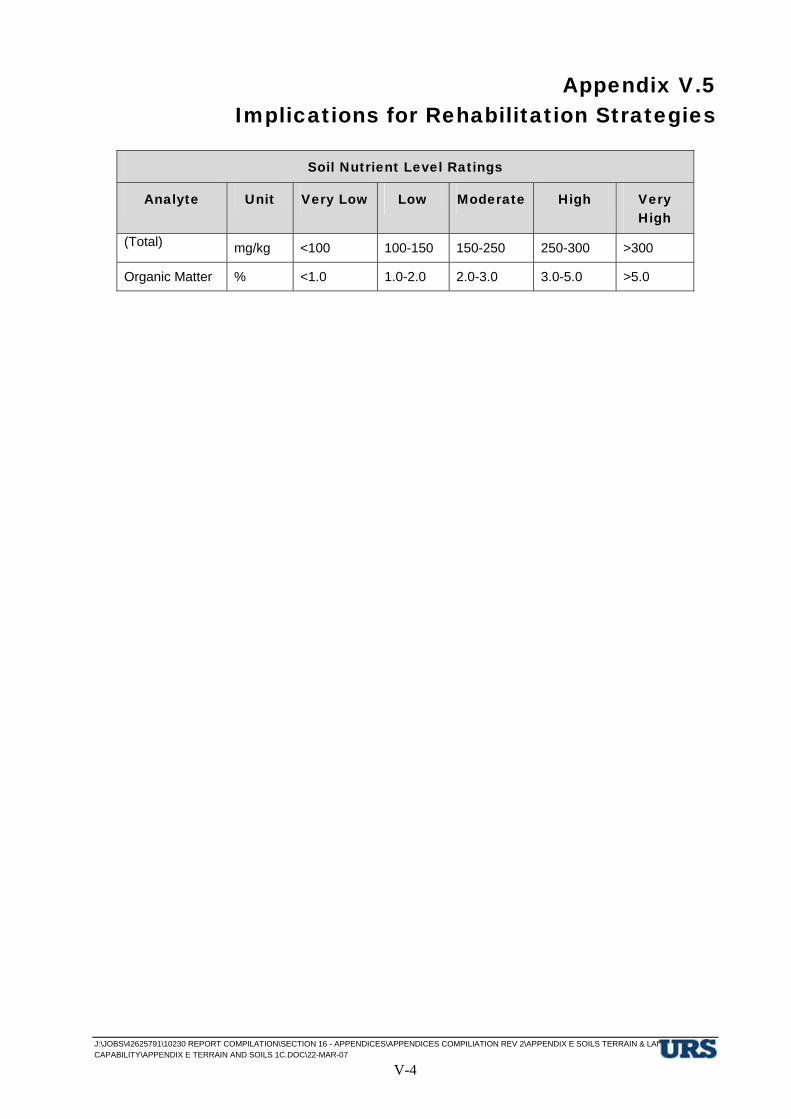
Appendix V.5 Implications for Rehabilitation Strategies
J:\JOBS\42625791\10230 REPORT COMPILATION\SECTION 16 - APPENDICES\APPENDICES COMPILIATION REV 2\APPENDIX E SOILS TERRAIN & LAND CAPABILITY\APPENDIX E TERRAIN AND SOILS 1C.DOC\22-MAR-07
V-4
Soil Nutrient Level Ratings
Analyte Unit Very Low Low Moderate High Very High
(Total) mg/kg <100 100-150 150-250 250-300 >300
Organic Matter % <1.0 1.0-2.0 2.0-3.0 3.0-5.0 >5.0

Appendix V.6 Soil Erosion
J:\JOBS\42625791\10230 REPORT COMPILATION\SECTION 16 - APPENDICES\APPENDICES COMPILIATION REV 2\APPENDIX E SOILS TERRAIN & LAND CAPABILITY\APPENDIX E TERRAIN AND SOILS 1C.DOC\22-MAR-07
V-1
E Heading Style 1 This is Hidden Text it will not print
E.6 Soil Erosion
Susceptibility of the land surface to erosion (erosion potential) is related to a combination of factors including rainfall, runoff, soil erodibility, surface hydrology, surface slope and length, surface cover and condition, and land use. Estimating soil loss through water erosion is complex because the relationship between these factors varies depending on the intensity and duration of rainfall events. For example, the amount of runoff will vary depending on the soil permeability, the existing water content of the soil, as the wetter the soil initially, the more rapidly runoff will occur. In addition, rainfall patterns in the local region are markedly seasonal generally with wet summers and dry winters. Hence, erosion events would be expected to be more likely to occur during the summer period, but high intensity rainfall events may occur in either the wet or dry seasons and can result in significant erosion events.
The project construction activities will involve clearing of existing vegetation and earthworks activities that are likely to disturb significant areas of land for considerable periods of time. The extent of the environmental impact likely to result from such activities has been rated on a terrain unit basis in EIS Table 8.1.3 for the refinery site and in EIS Table 9.1.2 for the RSF site. The basis of the assessment of erosion potential is provided below. The general erosion control measures that will be employed to minimise soil erosion within the proposed development areas are provided below.
E.6.1 Basis for the Assessment of Erosion Potential
The susceptibility of different soil types to erosion (soil erodibility) is a function of soil texture, and physical and chemical properties. The extent to which an area may be subject to erosion (erosion potential) is a function of factors such as surface slope and form, topographic position in the landscape (runon/runoff), rainfall intensity, surface condition and surface/plant cover.
Soil erodibility classes identified by Mills and Murphy, (1977) are summarised as follows:
• Low Erodibility – soils with high amounts of organic matter (OM), with surficial soils comprising sand or loamy sand (permitting high infiltration), or aggregated non-dispersive clay surface and/or subsoils;
• Moderate Erodibility:- soils with medium levels of OM, with surface soils comprising medium amounts of sand, silt and clay i.e. medium-textured (loamy) surface soils, with slightly dispersive (Dispersion Class Nos. 3 or 5) or aggregated slightly dispersive clay surface and/or subsoils;
• High Erodibility:- soils with low levels of OM, soils with bleached (A2) subsoil horizons with high amounts of fine sand and/or silt, soils with a fine strongly structured (self-mulching) clayey surface horizon, or moderately to highly dispersive clayey surface and/or subsoils (Dispersion Class Nos. 1 or 2).
The potential for accelerated erosion to occur (erosion potential) due to construction activities in the project area as a result of clearing and/or surface disturbance, has been assessed as follows:

Appendix V.6 Soil Erosion
J:\JOBS\42625791\10230 REPORT COMPILATION\SECTION 16 - APPENDICES\APPENDICES COMPILIATION REV 2\APPENDIX E SOILS TERRAIN & LAND CAPABILITY\APPENDIX E TERRAIN AND SOILS 1C.DOC\22-MAR-07
V-2
• Low (L) - The combination of surface slope, run-on/run-off and soil erodibility is such that no appreciable erosion damage is anticipated.
• Moderate (M) - Significant short term erosion is likely to occur due to the combination of slope, soil erodibility factors and extent of run-on/run-off. Erosion control can be achieved using structural works, topsoiling and revegetation techniques, and other site specific intensive soil conservation works. Some slightly dispersive soil layers may be present in the profile.
• High (H) - High to very high erosion losses are likely due to steepness of slopes, soil erodibility factors and surface runoff conditions. Intensive soil conservation works will be required to minimise the effects of erosion. Moderately high to highly dispersive soil layers may be present.
E.6.2 Erosion Control Measures
Erosion and sediment controls, which will be implemented during construction of the refinery and RSF (where applicable) are as follows:
• Vegetation clearing will be conducted progressively so that the minimum area necessary for efficient operations is cleared at any time;
• Earthworks batters that will remain will be constructed to stable slopes and re-vegetated soon after construction;
• Runoff from areas subject to earthworks will be collected in drains and directed through sediment traps and settling ponds to remove suspended sediment prior to discharge from the site;
• Stockpiles of topsoil material will be seeded and will have drainage diversion and sediment controls for runoff water;
• Rehabilitated slopes will have contour drains to minimise slope lengths and runoff velocities;
• Runoff from rehabilitated areas will be collected in contour drains and collection drains and directed to sediment dams and settling ponds to remove suspended sediment prior to draining from the site;
• Monitoring of potential erosion areas; and
• A maintenance program will be implemented to ensure the proper functioning of drainage and sediment control structures.

Appendix V.7 Land Capability Assessment
J:\JOBS\42625791\10230 REPORT COMPILATION\SECTION 16 - APPENDICES\APPENDICES COMPILIATION REV 2\APPENDIX E SOILS TERRAIN & LAND CAPABILITY\APPENDIX E TERRAIN AND SOILS 1C.DOC\22-MAR-07
V-1
E Heading Style 1 This is Hidden Text it will not print
E.7 Land Capability Assessment
E.7.1 Method of Assessment
An assessment of the agricultural land capability of the project area has been carried out to provide a benchmark of existing/potential agricultural land use. As required in the project Terms of Reference, in accordance with State Planning Policy 1/92: Development and the Conservation of Agricultural Land, the assessment has been based on the four class system for defining Good Quality Agricultural Land as detailed in the guidelines from the Department of Primary Industries (DPI) and the Department of Housing and Local Government (DHLGP - 1993). The land classes are summarised as follows:
Class A:- Crop Land; land suitable for current and potential crops with limitations to production which range from nil to moderate levels.
Class B:- Limited Crop Land; land that is marginal for current and potential crops due to severe limitations, but is suitable for pastures. Engineering and/or agronomic improvements may be required before the land is considered suitable for sustainable cropping/cultivation.
Class C:- Pasture land; land suitable for improved or native pastures due to limitations which preclude continuous cultivation for crop production. Some areas may tolerate a short period of ground disturbance for pasture establishment.
Class D:- Non-agricultural Land; land not suitable for agricultural uses due to extreme limitations. This may comprise undisturbed land with significant habitat, conservation and/or catchment values, or land that may be unsuitable because of very steep slopes, shallow soils, rock outcrop or poor drainage.
The assessment of Land Suitability for Agriculture for an area, requires the evaluation of the potential for the land to sustain a specific land use. In order to determine the appropriate agricultural land class, terrain units identified within the project area have been assessed for land suitability for cattle grazing. The soil and landform limitations criteria on which the land suitability classifications have been determined are included in Appendix A.5 and are based on the guidelines for agricultural land evaluation published by the Queensland Department of Primary Industries (DPI - 1990), modified to some extent by inclusion of criteria proposed by Shields and Williams (1991). The system of classification is based on the identification of physical and chemical limiting factors or constraints with respect to a specific land use, adopting the following protocols:
Class 1:- High quality land with few or very minor limitations for the intended land use.
Class 2:- Land with minor limitations for the intended land use.
Class 3:- Land with moderate limitations to sustaining the intended land use.
Class 4:- Marginal land requiring major inputs to sustain the intended land use.
Class 5:- Unsuitable land due to extreme limitations for the intended land use.

Appendix V.7 Land Capability Assessment
J:\JOBS\42625791\10230 REPORT COMPILATION\SECTION 16 - APPENDICES\APPENDICES COMPILIATION REV 2\APPENDIX E SOILS TERRAIN & LAND CAPABILITY\APPENDIX E TERRAIN AND SOILS 1C.DOC\22-MAR-07
V-2
Based on the current and recent history of land use in the general vicinity of the proposed development sites, this relates primarily to cattle grazing on partially cleared land with improved or native pastures in the RSF site area and limited grazing of native grasses under remnant woodland in the Refinery site area. No dry-land (rainfed) cropping has been undertaken within either of the areas due to severe constraints with respect to topographic constraints, shallow rocky/gravelly soils in the RSF site and very limited plant available water capacity and nutrient deficiency constraints for the soils in the Refinery site.
E.7.2 Land Suitability Classification for Cropping And Grazing In The Semi-Arid Sub-Tropics Of Queensland.
The following ratings tables (Table 7.1, 7.2 and 7.3) present criteria used for determining land suitability for broadacre cropping and for beef cattle grazing in the semi-arid sub-tropics. These tables are based primarily on criteria proposed by Queensland Department of Primary Industries guidelines for agricultural land evaluation (Land Resources Branch 1990), Shields and Williams (1991) and McDonald (1986).

Appendix V.7 Land Capability Assessment
J:\JOBS\42625791\10230 REPORT COMPILATION\SECTION 16 - APPENDICES\APPENDICES COMPILIATION REV 2\APPENDIX E SOILS TERRAIN & LAND CAPABILITY\APPENDIX E TERRAIN AND SOILS 1C.DOC\22-MAR-07 V-3
Table 7.1 Suitability for beef cattle grazing
Land suitability Class Limitation
1 2 3 4 5
Water availability (est.) (m)
PAWC >125mm PAWC 100-125mm PAWC 75-100mm PAWC 50-75mm PAWC < 50mm
Nutrient deficiency
(n)
Brigalow, gidgee, blackwood or softwood scrub soils and former scrub soils with Bicarb. P > 10 ppm
Eucalypt vegetation and downs, with Bicarb. P > 10 ppm and other major nutrients levels rated as low
Major soil nutrients rated very low,- or Bicarb. P 5-10 ppm excludes sands and loams >75 cm deep, or underlain by shallow rock.
Sands and loams at least 75 cm deep or overlying rock at shallow depth, with Bicarb. P 5-10 ppm, or Bicarb. P <4 ppm
Soil physical factors
(p)
Cracking clays with very fine self-mulch (<2mm), or Rigid soils with a loose, soft or firm surface when dry
Cracking clays with fine self mulch (peds 2-10mm), or Rigid soils with a hard setting surface when dry
Cracking clays with coarse peds (>10mm) or crust on the surface
Salinity
(sa)
Rootzone EC <0.15 mS/cm or Rootzone Cl <300 ppm
Rootzone EC 0.15-0.3 mS/cm or Rootzone Cl 300-600ppm
Rootzone EC 0.3-0.9 mS/cm or Rootzone Cl 600-900 ppm
Rootzone EC 0.9-1.2 mS/cm, or Rootzone C1 900-1500 ppm
Rootzone EC>1.2 mS/cm or Rootzone Cl>1500ppm
Rockiness (R) <20% coarse surface gravel (>6 cm diam.) and rock outcrop
20-50% coarse surface gravel and rock outcrop
50-90% surface cobble and rock outcrop
>90% surface cobble and rock outcrop
Rock outcrop and surface coarse fragments cover total area
Microrelief (g) Melonholes (gilgai) (semi-circular depressions at least 30cm deep, and adjacent mounds) cover <20% surface area
Shallow gilgai (30-60cm deep) cover 20-50% surface area
Deep melonholes (>60 cm deep) cover 20-50% of surface area

Appendix V.7 Land Capability Assessment
J:\JOBS\42625791\10230 REPORT COMPILATION\SECTION 16 - APPENDICES\APPENDICES COMPILIATION REV 2\APPENDIX E SOILS TERRAIN & LAND CAPABILITY\APPENDIX E TERRAIN AND SOILS 1C.DOC\22-MAR-07 V-4
Land suitability Class Limitation
1 2 3 4 5
pH (1:5 H2O)
(a)
5.6-6.6 6.6-8.0
5.0-5.6
8.0-9.0
4.5-5.0
9.0-10.0
4.0-4.5
>10.0
<4.0
ESP (@10cm)
(so)
<5.0 5-10 10-15 15-30 >30
Wetness
(w)
Undulating terrain or elevated plains
Low-lying level plains; or plains with rigid soils with strongly sodic subsoil (ESP >15 at< 60 cm- bgl, or Non-sodic pale grey and yellow mottled rigid soils <50 cm bgl
Shallow seasonal and permanent swamps, or drainage ways
Permanent lakes and deep swamps
Topography
(t)
Occasional deep gullies impede cultivation to some extent
Overall slopes 6-15%, some gullying makes cultivation for pasture improvement difficult
Many deep gullies make cultivation for sowing pastures impractical, or Slopes >15% make contour cultivation impractical
Strongly dissected terrain (>75% of area), preventing adequate herd management
Water erosion
(e)
Slopes <1% on sodic rigid soils or Slopes <3% on all other soils
Slopes 1-3% on sodic rigid soils or Slopes 3-6% on cracking clays, or Slopes 3-12% on non-sodic rigid soils
Slopes 3-6% on sodic rigid soils or Slopes 6-9% on cracking clays, or Slopes 12-20% on non-sodic rigid soils
Slopes 6-12% on sodic rigid soils or Slopes 9-15% on cracking clays or Slopes 20-45% on non-sodic rigid soils
Slopes >45%
Flooding
(f)
Nil or rare flooding
(1 in >10 year events)
Periodic flooding
(1 in 2-10 year events)
Regular flooding
(1 in 2 year events)
Very frequent (annual) and/or erosive flooding
Appendix V.7 Land Capability Assessment
J:\JOBS\42625791\10230 REPORT COMPILATION\SECTION 16 - APPENDICES\APPENDICES COMPILIATION REV 2\APPENDIX E SOILS TERRAIN & LAND CAPABILITY\APPENDIX E TERRAIN AND SOILS 1C.DOC\22-MAR-07 V-5
Land suitability Class Limitation
1 2 3 4 5
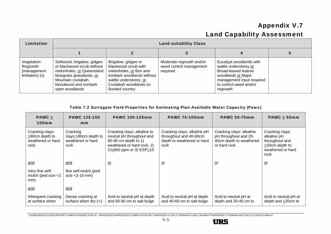
Vegetation Regrowth (management limitation) (v)
Softwood, brigalow, gidgee or blackwood scrub without melonholes, or Queensland bluegrass grasslands, or Mountain coolabah, bloodwood and ironbark open woodlands
Brigalow, gidgee or blackwood scrub with melonholes, or Box and ironbark woodlands without wattle understorey, or Coolabah woodlands on flooded country
Moderate regrowth and/or weed control management required
Eucalypt woodlands with wattle understorey or Broad-leaved teatree woodlands or Major management input required to control weed and/or regrowth
Table 7.2 Surrogate Field Properties for Estimating Plan Available Water Capacity (Pawc)
PAWC > 150mm
PAWC 125-150 mm
PAWC 100-125mm PAWC 75-100mm PAWC 50-75mm PAWC < 50mm
Cracking clays: >90cm depth to weathered or hard rock
Cracking clays:>90cm depth to weathered or hard rock
Cracking clays: alkaline to neutral pH throughout and 60-90 cm depth to 1) weathered or hard rock, 2) Cl>600 ppm or 3) ESP>15
Cracking clays: alkaline pH throughout and 40-60cm depth to weathered or hard rock
Cracking clays: alkaline pH throughout and 20-40cm depth to weathered or hard rock
Cracking clays: alkaline pH throughout and <20cm depth to weathered or hard rock
and and or or or or
Very fine self-mulch (ped size <2 mm)
fine self-mulch (ped size <2-10 mm)
and and
Infrequent cracking at surface when
Dense cracking at surface when dry (>1
Acid to neutral pH at depth and 60-90 cm to salt bulge
Acid to neutral pH at depth and 40-60 cm to salt bulge
Acid to neutral pH at depth and 20-40 cm to
Acid to neutral pH at depth and <20cm to

Appendix V.7 Land Capability Assessment
J:\JOBS\42625791\10230 REPORT COMPILATION\SECTION 16 - APPENDICES\APPENDICES COMPILIATION REV 2\APPENDIX E SOILS TERRAIN & LAND CAPABILITY\APPENDIX E TERRAIN AND SOILS 1C.DOC\22-MAR-07 V-6
PAWC > 150mm
PAWC 125-150 mm
PAWC 100-125mm PAWC 75-100mm PAWC 50-75mm PAWC < 50mm
dry (<1 crack per square metre)
crack per square metre)
with EC>0.9 mS/cm or Cl>900 ppm
with EC>0.9 mS/cm or C1>900 ppm
salt bulge with EC>0.9 mS/cm or C1>900 ppm
salt bulge with EC>0.8 mS/cm or C1>800 ppm
and and and and and and
Alkaline to neutral pH throughout
Alkaline to neutral pH throughout
and and
C1>600 ppm within 90cm of the surface
C1>600 ppm within 90cm of the surface
and and
ESP < 15 within 90 cm of the surface
ESP < 15 within 90 cm of the surface
and
Rigid soils (non-sodic)
Rigid soils (non-sodic) Rigid soils (non-sodic) Rigid soils (non-sodic) Rigid soils (non-sodic)
and
Loams, clay loams, non-cracking clays, duplex soils and gradational earths
Loams, clay loams, non-cracking clays, duplex soils and gradational earths
Loams, clay loams, non-cracking clays, duplex soils and gradational earths
Loams, clay loams, non-cracking clays, duplex soils and gradational earths
Loams, clay loams, non-cracking clays, duplex soils and gradational earths
and and and and and
>125 cm depth to 75-125 cm depth to 50-75 cm depth to 30-50 cm depth to <30 cm depth to

Appendix V.7 Land Capability Assessment
J:\JOBS\42625791\10230 REPORT COMPILATION\SECTION 16 - APPENDICES\APPENDICES COMPILIATION REV 2\APPENDIX E SOILS TERRAIN & LAND CAPABILITY\APPENDIX E TERRAIN AND SOILS 1C.DOC\22-MAR-07 V-7
PAWC > 150mm
PAWC 125-150 mm
PAWC 100-125mm PAWC 75-100mm PAWC 50-75mm PAWC < 50mm
weathered or hard rock
weathered or hard rock weathered or hard rock weathered or hard rock weathered or hard rock
or or or or or
>125 cm to salt bulge with EC > 0.9 mS/cm or C1>900 ppm
75-125 cm to salt bulge with EC > 0.9 mS/cm or C1>900 ppm
50-75 cm to salt bulge with EC > 0.9 mS/cm or C1>900 ppm
30-50 cm to salt bulge with EC > 0.9 mS/cm or C1>900 ppm
Sands and sandy loams >90 cm deep
Sands and sandy loams 45-90cm deep
Shallow sands and sandy loams <45 deep
Rigid soils (sodic) Rigid soils (sodic) Rigid soils (sodic)
Duplex soils with subsoil becoming sodic (ESP 6-14) within 60 cm of the surface but not strongly sodic (ESP >15) within 90 cm
Duplex soils with subsoil becoming sodic (ESP 6-14) becoming strongly sodic (ESP >15) within 60 cm of surface
Duplex soils with a strongly sodic (ESP >25) becoming within 45 cm of surface

Appendix V.7 Land Capability Assessment
J:\JOBS\42625791\10230 REPORT COMPILATION\SECTION 16 - APPENDICES\APPENDICES COMPILIATION REV 2\APPENDIX E SOILS TERRAIN & LAND CAPABILITY\APPENDIX E TERRAIN AND SOILS 1C.DOC\22-MAR-07
V-8
Table 7.3 Alternative/Additional Criteria for the Assessment of Land Suitability Classes for Agriculture – Limiting Factors
Limitation Criteria for Degree of Limitation Suitability Class
Sub-Class
Symbol
Rainfed Cropping Grazing Lands
<1.0% <1.0%
1 -
1.0 - 2.0% 1.0 - 2.0%
2 t2
3.0 - 6.0% 3.0 - 6.0%
3 t3
6.0 - 15% >6.0%
4 t4
Topography
(Slope classes influencing water management and erosion control)
>15% -
5 t5
No flooding 1 f1
Frequency < 1 in 10 years (occasional) 2 f2
Frequency 1 in 5 - 10 years (infrequent) 3 f3
Frequency > 1 in 5 years (frequent) 4 f4
Flooding
(Crop losses due to flooding may occur)
Subject to erosive flooding 5 f5
No surface micro-relief 1 -
Vertical interval of surface micro-relief <250mm 2 g2
Vertical interval of surface micro-relief 250 – 600mm 3 g3
Micro-relief
(Gilgai and gullying, surface levelling required)
Vertical interval of surface micro-relief >600mm 4 g4
No cobble, stone or rock 1 -
Some stone picking may be required for certain crops 2 r2
Tillage restricted; stone picking required 3 r3
Tillage difficult; stone/cobble picking necessary 4 r4
Stoniness
(Limitations to cultivation)
Tillage impractical; not practicable to remove stone 5 r5
Soil Physical Properties
>450mm to subsoil with extremely hard dry consistence
1 -

Appendix V.7 Land Capability Assessment
J:\JOBS\42625791\10230 REPORT COMPILATION\SECTION 16 - APPENDICES\APPENDICES COMPILIATION REV 2\APPENDIX E SOILS TERRAIN & LAND CAPABILITY\APPENDIX E TERRAIN AND SOILS 1C.DOC\22-MAR-07
V-9
Limitation Criteria for Degree of Limitation Suitability Class
Sub-Class
Symbol
200 – 450mm to subsoil with extremely hard dry consistence
2 pb2
100 – 200mm to subsoil with extremely hard dry consistence
3 pb3
(1) Depth to hard impermeable subsoil – restricted root development and water entry
<100mm to subsoil with extremely hard dry consistence
4 pb4
No surface crust and surface horizon is not hard setting
1 -
Hard setting surface with mod. hard dry consistence 2 pc2
Hard setting surface with hard dry consistence 3 pc3
(2) Surface crust/hard setting surface condition
Hard setting surface with very hard dry consistence 4 pc4
Surface textures/soil type changes occur on average:
150 – 300m apart 3 pd3
(3) Soil type distribution complexity
< 150m apart 4 pd4
Rainfed Cropping Grazing Lands
Soil types with surficial sand to sandy loam texture to depths of:
<450mm 2 pt2
450-900mm 3 pt3
(4) Soil Texture
>900mm 4 pt4
(5) Gravel Beds Gravel beds >150mm thick, <450mm from the surface 4 pg4
Effective Depth Deep (>1000mm) >600mm
1 -
Mod. Deep (600 – 1000mm) 400-600mm
2 d2
Mod. Shallow (450 – 600mm) 250-400mm
3 d3
Shallow (250 – 450mm) 150-250mm
4 d4
(Depth to rock or hardpan, or other soil layer limiting root development and plant available water capacity)
Very shallow (<250mm) <150mm
5 d5
Salinity/Sodicity E.C. 1:5 soil/water suspension >1mS/cm at depths of:
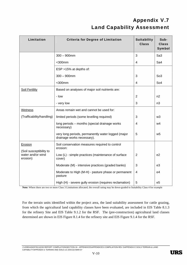
Appendix V.7 Land Capability Assessment
J:\JOBS\42625791\10230 REPORT COMPILATION\SECTION 16 - APPENDICES\APPENDICES COMPILIATION REV 2\APPENDIX E SOILS TERRAIN & LAND CAPABILITY\APPENDIX E TERRAIN AND SOILS 1C.DOC\22-MAR-07
V-10
Limitation Criteria for Degree of Limitation Suitability Class
Sub-Class
Symbol
300 – 900mm 3 Sa3
<300mm 4 Sa4
ESP >15% at depths of:
300 – 900mm 3 So3
<300mm 4 So4
Based on analyses of major soil nutrients are:
- low 2 n2
Soil Fertility
- very low 3 n3
Areas remain wet and cannot be used for:
limited periods (some levelling required) 3 w3
long periods – months (special drainage works necessary)
4 w4
Wetness
(Trafficability/handling)
very long periods, permanently water logged (major drainage works necessary).
5 w5
Soil conservation measures required to control erosion:
Low (L) - simple practices (maintenance of surface cover)
2 e2
Moderate (M) - intensive practices (graded banks) 3 e3
Moderate to High (M-H) - pasture phase or permanent pasture
4 e4
Erosion
(Soil susceptibility to water and/or wind erosion)
High (H) - severe gully erosion (requires reclamation) 5 e5 Note: Where there are two or more Class 3 Limitations allocated, the overall rating may be down-graded to Suitability Class 4 for example
For the terrain units identified within the project area, the land suitability assessment for cattle grazing, from which the agricultural land capability classes have been evaluated, are included in EIS Table 8.1.3 for the refinery Site and EIS Table 9.1.2 for the RSF. The (pre-construction) agricultural land classes determined are shown in EIS Figure 8.1.4 for the refinery site and EIS Figure 9.1.4 for the RSF.

Appendix V.8 Site and Soil Characterisation
J:\JOBS\42625791\10230 REPORT COMPILATION\SECTION 16 - APPENDICES\APPENDICES COMPILIATION REV 2\APPENDIX E SOILS TERRAIN & LAND CAPABILITY\APPENDIX E TERRAIN AND SOILS 1C.DOC\22-MAR-07 V-11
E Heading Style 1 This is Hidden Text it will not print
E.8 Site and Soil Characterisation
Table 8.1 Site and Soil Characterisation
Site ID
Depth (m)
Terrain Unit
Soil Horizon
Site Description Soil Colour
(Munsell)
Soil pH (1:5 H2O)
EC (1:5 H2O)
(mS/cm)
Dispersion Class No.
Comments/Soil Classification
P8 0-0.45 Qr3 – 4.2 A Fine Gravelly LOAM (GC-ML) low plasticity dark brown massive apedal pulverulent, loose with 30% ‘s r-r (Fe & Si) gravel (2-15mm)
7.5 YR 3/3 5.7 0.031 5 Loamy surface (NHS) gravely gradational soil (Gn 2.11) & Ferric – Acidic Gravelly Red Kandosol
0.45-0.7
B Fine Gravelly light to medium CLAY (GC-CL) low to medium plasticity reddish brown, massive, a pedal, pulverulent with 45-50% fine s/a – s/r-r (Si, Fe) gravel 2-15mm
5YR 4/6 5.7 0.021 2 (1)
0.7-0.9 B-C Gravelly CLAY (GC_CL) low plasticity reddish brown, massive, apedal, pulverulent, loose dry, 50% fine s/a-a-s/r-r (Fe, Si) gravel 5-15mm
5YR 4/4 5.5 0.029 2 (1)
0.9-1.24
C Clayey GRAVEL (GC) low to medium plasticity, reddish brown, massive apedal dry
5YR 4/3 5.4 0.028 2 (1)

Appendix V.8 Site and Soil Characterisation
J:\JOBS\42625791\10230 REPORT COMPILATION\SECTION 16 - APPENDICES\APPENDICES COMPILIATION REV 2\APPENDIX E SOILS TERRAIN & LAND CAPABILITY\APPENDIX E TERRAIN AND SOILS 1C.DOC\22-MAR-07 V-12
with 60% fine to medium s/a, s/r-r (Si) chert & (Fe) ferruginous gravel (2-25mm)
P9 0-0.2 Qr3 – 4.2 A Gravelly Clay LOAM (GC-CL) low to medium plasticity lines, reddish brown dry pulverulent massive a pedal 30% fine s/a-a-r (Si, Fe) gravel (2-15mm)
5YR 4/3 6.4 0.055 5 Loamy (NHS) surface gradational red earth soil (Gn 4.11); Ferric Mellic Red Kandosol
0.2-0.4 B1 Light to medium CLAY (CL) low to medium plasticity, weak to moderate fine prismatic (St. D. C.)
5YR 4/4 6.0 0.022 5
0.4-0.6 B2 Loamy light to medium CLAY (CL) low to medium plasticity, dark red, moderate fine polyhedral (rough) (F-St. D.C) 10-15% fine s/r-r (Fe) gravel
2.5YR 4/6 5.7 0.033 5
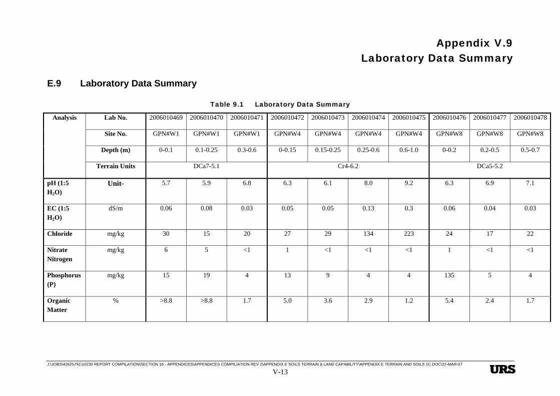
Appendix V.9 Laboratory Data Summary
J:\JOBS\42625791\10230 REPORT COMPILATION\SECTION 16 - APPENDICES\APPENDICES COMPILIATION REV 2\APPENDIX E SOILS TERRAIN & LAND CAPABILITY\APPENDIX E TERRAIN AND SOILS 1C.DOC\22-MAR-07 V-13
E Heading Style 1 This is Hidden Text it will not print
E.9 Laboratory Data Summary
Table 9.1 Laboratory Data Summary
Lab No. 2006010469 2006010470 2006010471 2006010472 2006010473 2006010474 2006010475 2006010476 2006010477 2006010478
Site No. GPN#W1 GPN#W1 GPN#W1 GPN#W4 GPN#W4 GPN#W4 GPN#W4 GPN#W8 GPN#W8 GPN#W8
Depth (m) 0-0.1 0.1-0.25 0.3-0.6 0-0.15 0.15-0.25 0.25-0.6 0.6-1.0 0-0.2 0.2-0.5 0.5-0.7
Analysis
Terrain Units DCa7-5.1 Cr4-6.2 DCa5-5.2
pH (1:5 H2O)
Unit- 5.7 5.9 6.8 6.3 6.1 8.0 9.2 6.3 6.9 7.1
EC (1:5 H2O)
dS/m 0.06 0.08 0.03 0.05 0.05 0.13 0.3 0.06 0.04 0.03
Chloride mg/kg 30 15 20 27 29 134 223 24 17 22
Nitrate Nitrogen
mg/kg 6 5 <1 1 <1 <1 <1 1 <1 <1
Phosphorus (P)
mg/kg 15 19 4 13 9 4 4 135 5 4
Organic Matter
% >8.8 >8.8 1.7 5.0 3.6 2.9 1.2 5.4 2.4 1.7
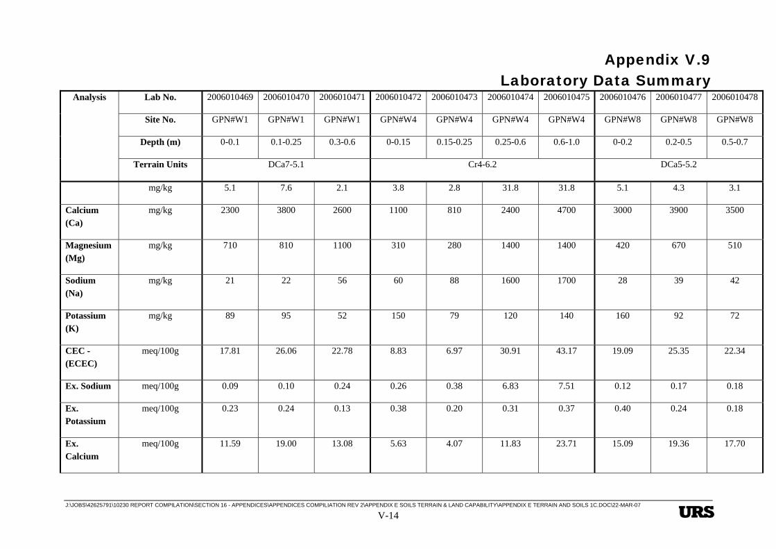
Appendix V.9 Laboratory Data Summary
J:\JOBS\42625791\10230 REPORT COMPILATION\SECTION 16 - APPENDICES\APPENDICES COMPILIATION REV 2\APPENDIX E SOILS TERRAIN & LAND CAPABILITY\APPENDIX E TERRAIN AND SOILS 1C.DOC\22-MAR-07 V-14
Lab No. 2006010469 2006010470 2006010471 2006010472 2006010473 2006010474 2006010475 2006010476 2006010477 2006010478
Site No. GPN#W1 GPN#W1 GPN#W1 GPN#W4 GPN#W4 GPN#W4 GPN#W4 GPN#W8 GPN#W8 GPN#W8
Depth (m) 0-0.1 0.1-0.25 0.3-0.6 0-0.15 0.15-0.25 0.25-0.6 0.6-1.0 0-0.2 0.2-0.5 0.5-0.7
Analysis
Terrain Units DCa7-5.1 Cr4-6.2 DCa5-5.2
E Sulfur mg/kg 5.1 7.6 2.1 3.8 2.8 31.8 31.8 5.1 4.3 3.1
Calcium (Ca)
mg/kg 2300 3800 2600 1100 810 2400 4700 3000 3900 3500
Magnesium (Mg)
mg/kg 710 810 1100 310 280 1400 1400 420 670 510
Sodium (Na)
mg/kg 21 22 56 60 88 1600 1700 28 39 42
Potassium (K)
mg/kg 89 95 52 150 79 120 140 160 92 72
CEC - (ECEC)
meq/100g 17.81 26.06 22.78 8.83 6.97 30.91 43.17 19.09 25.35 22.34
Ex. Sodium meq/100g 0.09 0.10 0.24 0.26 0.38 6.83 7.51 0.12 0.17 0.18
Ex. Potassium
meq/100g 0.23 0.24 0.13 0.38 0.20 0.31 0.37 0.40 0.24 0.18
Ex. Calcium
meq/100g 11.59 19.00 13.08 5.63 4.07 11.83 23.71 15.09 19.36 17.70

Appendix V.9 Laboratory Data Summary
J:\JOBS\42625791\10230 REPORT COMPILATION\SECTION 16 - APPENDICES\APPENDICES COMPILIATION REV 2\APPENDIX E SOILS TERRAIN & LAND CAPABILITY\APPENDIX E TERRAIN AND SOILS 1C.DOC\22-MAR-07 V-15
Lab No. 2006010469 2006010470 2006010471 2006010472 2006010473 2006010474 2006010475 2006010476 2006010477 2006010478
Site No. GPN#W1 GPN#W1 GPN#W1 GPN#W4 GPN#W4 GPN#W4 GPN#W4 GPN#W8 GPN#W8 GPN#W8
Depth (m) 0-0.1 0.1-0.25 0.3-0.6 0-0.15 0.15-0.25 0.25-0.6 0.6-1.0 0-0.2 0.2-0.5 0.5-0.7
Analysis
Terrain Units DCa7-5.1 Cr4-6.2 DCa5-5.2
Ex. Magnesium
meq/100g 5.90 6.72 9.33 2.56 2.32 11.94 11.58 3.48 5.58 4.28
ESP % 0.5 0.4 1.1 2.9 5.5 22.1 17.4 0.6 0.7 0.8
Ca/Mg Ratio 2.0 2.8 1.4 2.2 1.8 1.0 2.0 4.3 3.5 4.1
Copper (Cu)
mg/kg 3.5 3.3 0.8 0.3 0.3 0.6 0.5 2.6 1.2 1.1
Zinc (Zn) mg/kg 4.2 3.3 0.7 1.8 1.4 0.6 0.5 2.0 0.5 0.5
Manganese (Mn)
mg/kg 36 23 6 15 8 4 1 29 5 13
Iron (Fe) mg/kg 133 175 12 94 121 20 14 44 18 16
Boron (B) mg/kg 1.1 1.2 1.0 1.1 0.8 2.7 1.6 1.4 1.3 1.1
Analysis Lab No. 2006010499 2006010500 2006010501 2006010502 2006010503 2006010504

Appendix V.9 Laboratory Data Summary
J:\JOBS\42625791\10230 REPORT COMPILATION\SECTION 16 - APPENDICES\APPENDICES COMPILIATION REV 2\APPENDIX E SOILS TERRAIN & LAND CAPABILITY\APPENDIX E TERRAIN AND SOILS 1C.DOC\22-MAR-07 V-16
Site No. GPN#P12 GPN#P12 GPN#P17 GPN#P17 GPN#P17 GPN#P17
Depth (m)
0.1-0.4 0.9-1.1 0-0.15 0.2-0.4 0.4-0.6 0.8-1.0
Terrain Units
Qr3-4.2 Qr1-6.2
pH (1:5 H2O) Unit- 6.0 6.4 5.3 5.2 5.6 5.8
EC (1:5 H2O) dS/m 0.18 0.05 0.12 0.13 0.07 0.07
Chloride mg/kg 12 17 105 95 39 70
Nitrate Nitrogen mg/kg <1 <1 <1 <1 <1 <1
Phosphorus (P) mg/kg 6 13 8 3 3 4
Organic Matter % 4.1 1.6 1.7 0.7 0.8 1.1
E Sulfur mg/kg 65.2 15.4 21.7 21.2 15.3 13
Calcium (Ca) mg/kg 1200 990 160 88 52 140
Magnesium (Mg) mg/kg 190 380 300 890 690 780
Sodium (Na) mg/kg 12 28 140 200 150 170
Potassium (K) mg/kg 130 56 63 96 63 58
CEC - (ECEC) meq/100g 7.70 8.34 4.61 9.97 6.82 8.12
Ex. Sodium meq/100g 0.05 0.12 0.62 0.89 0.63 0.75

Appendix V.9 Laboratory Data Summary
J:\JOBS\42625791\10230 REPORT COMPILATION\SECTION 16 - APPENDICES\APPENDICES COMPILIATION REV 2\APPENDIX E SOILS TERRAIN & LAND CAPABILITY\APPENDIX E TERRAIN AND SOILS 1C.DOC\22-MAR-07 V-17
Lab No. 2006010499 2006010500 2006010501 2006010502 2006010503 2006010504
Site No. GPN#P12 GPN#P12 GPN#P17 GPN#P17 GPN#P17 GPN#P17
Depth (m)
0.1-0.4 0.9-1.1 0-0.15 0.2-0.4 0.4-0.6 0.8-1.0
Analysis
Terrain Units
Qr3-4.2 Qr1-6.2
Ex. Potassium meq/100g 0.34 0.14 0.16 0.25 0.16 0.15
Ex. Calcium meq/100g 5.76 4.95 0.80 0.44 0.26 0.70
Ex. Magnesium meq/100g 1.55 3.13 2.51 7.44 5.77 6.52
ESP % 0.6 1.4 13.4 8.9 9.2 9.2
Ca/Mg Ratio 3.7 1.6 0.3 0.1 0.0 0.1
Copper (Cu) mg/kg 0.9 0.8 1.2 1.2 1.2 2.8
Zinc (Zn) mg/kg 0.6 0.7 1.3 0.6 0.6 0.8
Manganese (Mn) mg/kg 37 66 7 1 1 2
Iron (Fe) mg/kg 13 22 152 76 34 47
Boron (B) mg/kg 0.9 0.7 1.4 1.4 1.1 1.1
Appendix V.9 Laboratory Data Summary
J:\JOBS\42625791\10230 REPORT COMPILATION\SECTION 16 - APPENDICES\APPENDICES COMPILIATION REV 2\APPENDIX E SOILS TERRAIN & LAND CAPABILITY\APPENDIX E TERRAIN AND SOILS 1C.DOC\22-MAR-07
V-18