city of chilton year 2030 comprehensive plan recommended plan7a9ca024-e5d7-4c94-90… · city of...
TRANSCRIPT

K:\Comprehensive Plan WEBSITE\Chilton 2030 Comprehensive Plan - MASTER DOCUMENT.doc i City of Chilton Year 2030 Recommended Comprehensive Plan
City of Chilton
Year 2030 Comprehensive Plan
Recommended Plan
Contents Page 1. Issues and Opportunities ....................................................................................................... 1-1
1.1 Introduction ................................................................................................................ 1-1 1.2 Calumet County Planning Process ............................................................................. 1-4 1.3 Comprehensive Plan Development Process ............................................................... 1-9 1.4 State Comprehensive Planning Goals ......................................................................... 1-9 1.5 City of Chilton Mission Statement ........................................................................... 1-10 1.6 City of Chilton Planning Goals ................................................................................ 1-11 1.7 Issues and Opportunities Goals and Objectives ....................................................... 1-14 1.8 Issues and Opportunities Policies and Recommendations ....................................... 1-15 1.9 Issues and Opportunities Programs .......................................................................... 1-16
2. Population and Housing ........................................................................................................ 2-1
2.1 Introduction ................................................................................................................ 2-1 2.2 Population ................................................................................................................... 2-2 2.3 Population Trends and Forecasts ................................................................................ 2-7 2.4 Housing Characteristics ............................................................................................ 2-12 2.5 Housing Trends and Forecasts .................................................................................. 2-19 2.6 Housing for All Income Levels ................................................................................ 2-23 2.7 Housing for All Age Groups and Persons with Special Needs ................................ 2-24 2.8 Promoting Availability of Land and Housing Stock for Development/Redevelopment
of Low-Income and Moderate-Income Housing ...................................................... 2-24 2.9 Maintaining and Rehabilitating the Existing Housing Stock ................................... 2-25 2.10 Housing Goals and Objectives ................................................................................. 2-25 2.11 Housing Policies and Recommendations ................................................................. 2-27 2.12 Housing Programs .................................................................................................... 2-28
3. Transportation ....................................................................................................................... 3-1
3.1 Introduction ................................................................................................................ 3-1 3.2 Existing Road System ................................................................................................. 3-1 3.3 Road Functional/Jurisdictional Classification ............................................................ 3-2 3.4 Traffic Volume Trends ............................................................................................... 3-7 3.5 Additional Modes of Transport .................................................................................. 3-7 3.6 Existing State and Regional Transportation Plans and Coordination ....................... 3-11 3.7 Planned Transportation Improvements ..................................................................... 3-12

K:\Comprehensive Plan WEBSITE\Chilton 2030 Comprehensive Plan - MASTER DOCUMENT.doc ii City of Chilton Year 2030 Recommended Comprehensive Plan
3.8 Transportation Goals and Objectives ....................................................................... 3-12 3.9 Transportation Policies and Recommendation ......................................................... 3-13 3.10 Transportation Programs .......................................................................................... 3-14
4. Utilities and Community Facilities ........................................................................................ 4-1
4.1 Introduction ................................................................................................................ 4-1 4.2 Administrative Facilities, Services, and Buildings ..................................................... 4-1 4.3 Police Services ............................................................................................................ 4-2 4.4 Emergency Medical Services ..................................................................................... 4-2 4.5 Fire Protection Services .............................................................................................. 4-2 4.6 Schools ........................................................................................................................ 4-2 4.7 Quasi Public Facilities ................................................................................................ 4-5 4.8 Parks, Recreation, and Open Space ............................................................................ 4-5 4.9 Solid Waste Management and Recycling ................................................................. 4-10 4.10 Communication and Power Facilities ....................................................................... 4-10 4.11 Sanitary Sewer Service ............................................................................................. 4-10 4.12 Public Water Supply ................................................................................................. 4-11 4.13 Stormwater Management .......................................................................................... 4-11 4.14 Health Care Facilities ............................................................................................... 4-11 4.15 Day Care Facilities ................................................................................................... 4-12 4.16 Expansion or Rehabilitation of Existing Utilities and Facilities, Approximate
Timetable .................................................................................................................. 4-12 4.17 Future Needs for Government Services .................................................................... 4-15 4.18 Utilities and Community Facilities Goals and Objectives ........................................ 4-18 4.19 Utilities and Community Facilities Policies and Recommendations ........................ 4-22 4.20 Utilities and Community Facilities Programs .......................................................... 4-23
5. Agricultural, Natural, and Cultural Resources ...................................................................... 5-1
5.1 Introduction ................................................................................................................ 5-1 5.2 Forests, Farmland, and Agriculture ............................................................................ 5-1 5.3 Topography ................................................................................................................. 5-5 5.4 Metallic and Non-Metallic Mineral Resources .......................................................... 5-5 5.5 Watersheds and Drainage ........................................................................................... 5-5 5.6 Wetlands ..................................................................................................................... 5-6 5.7 Floodplains ................................................................................................................. 5-6 5.8 Surface Water Features ............................................................................................... 5-7 5.9 Groundwater ............................................................................................................. 5-11 5.10 Air Quality ................................................................................................................ 5-12 5.11 Environmentally Sensitive Areas ............................................................................. 5-12 5.12 Threatened and Endangered Species ........................................................................ 5-17 5.13 Historical and Cultural Resources ............................................................................ 5-18 5.14 Archaeological Sites and Cemeteries ....................................................................... 5-18 5.15 Community Design ................................................................................................... 5-22 5.16 Agricultural, Natural, and Cultural Resources Goals and Objectives ...................... 5-27 5.17 Agricultural, Natural, and Cultural Resources Policies and Recommendations ...... 5-28 5.18 Agricultural, Natural, and Cultural Resources Programs ......................................... 5-29

K:\Comprehensive Plan WEBSITE\Chilton 2030 Comprehensive Plan - MASTER DOCUMENT.doc iii City of Chilton Year 2030 Recommended Comprehensive Plan
6. Economic Development ........................................................................................................ 6-1 6.1 Introduction ................................................................................................................ 6-1 6.2 Labor Force ................................................................................................................. 6-2 6.3 Economic Base ........................................................................................................... 6-5 6.4 Environmentally Contaminated Sites for Commercial or Industrial Use ................. 6-10 6.5 Strengths and Weaknesses Analysis ......................................................................... 6-11 6.6 Desired Economic Development .............................................................................. 6-17 6.7 Economic Development Goals and Objectives ........................................................ 6-18 6.8 Economic Development Policies and Recommendations ........................................ 6-20 6.9 Economic Development Programs ........................................................................... 6-21
7. Intergovernmental Cooperation ............................................................................................. 7-1
7.1 Introduction ................................................................................................................ 7-1 7.2 Inventory of Existing Agreements .............................................................................. 7-3 7.3 Relationships with Other Governmental Units ........................................................... 7-4 7.4 Intergovernmental Opportunities, Conflicts, and Resolutions ................................... 7-5 7.5 Boundary Agreements and Provision of Services ...................................................... 7-9 7.6 Intergovernmental Cooperation Goals and Objectives ............................................. 7-10 7.7 Intergovernmental Cooperation Policies and Recommendations ............................. 7-11 7.8 Intergovernmental Cooperation Programs ................................................................ 7-12
8. Land Use ................................................................................................................................ 8-1
8.1 Introduction ................................................................................................................ 8-1 8.2 Existing Land Use ...................................................................................................... 8-1 8.3 Supply, Demand, and Price Trends ............................................................................ 8-7 8.4 Existing and Potential Land Use Conflicts ................................................................. 8-7 8.5 Projected Supply and Demand of Land Uses over Planning Period .......................... 8-8 8.6 Future Land Use ....................................................................................................... 8-13 8.7 Municipal Border “Buffer’’ Planning ....................................................................... 8-23 8.8 Smart Growth Areas ................................................................................................. 8-25 8.9 Land Use Goals and Objectives ................................................................................ 8-27 8.10 Land Use Policies and Recommendations ................................................................ 8-28 8.11 Land Use Programs .................................................................................................. 8-29
9. Implementation ...................................................................................................................... 9-1
9.1 Introduction ................................................................................................................ 9-1 9.2 Local Action Plan ....................................................................................................... 9-2 9.3 Regulatory Land Use Management Tools .................................................................. 9-2 9.4 Non-Regulatory Land Use Management Tools ........................................................ 9-13 9.5 Integration and Consistency of Planning Elements .................................................. 9-14 9.6 Mechanism to Measure Progress .............................................................................. 9-15 9.7 Comprehensive Plan Amendments and Updates ...................................................... 9-15 9.8 Implementation Goals and Objectives ...................................................................... 9-16 9.9 Implementation Policies and Recommendations ...................................................... 9-17 9.10 Implementation Programs ......................................................................................... 9-17

K:\Comprehensive Plan WEBSITE\Chilton 2030 Comprehensive Plan - MASTER DOCUMENT.doc iv City of Chilton Year 2030 Recommended Comprehensive Plan
Tables Table 2-1 Population Counts, Calumet County, 1970-2000 ................................................... 2-3 Table 2-2 Population Change, Calumet County, 1970-2000 .................................................. 2-4 Table 2-3 Population Estimates, Calumet County, 2000-2004 ............................................... 2-5 Table 2-4 Population by Age Cohort, Calumet County, 2000 ................................................ 2-7 Table 2-5 WDOA Population Forecasts, Calumet County, 2000-2025 .................................. 2-9 Table 2-6 Linear Population Forecast, Calumet County, 2000-2030 .................................... 2-10 Table 2-7 ECWRPC Population Forecasts, Calumet County, 2005-2030 ............................ 2-11 Table 2-8 Housing Units, Calumet County, 1990-2000 ........................................................ 2-13 Table 2-9 Housing Occupancy and Tenure, Calumet County, 1990 and 2000 ..................... 2-14 Table 2-10 Housing Occupancy and Tenure, City of Chilton, 1990 and 2000 ....................... 2-14 Table 2-11 Units in Structure, Calumet County, 2000 ............................................................ 2-15 Table 2-12 Year Structures Were Built, Calumet County, 2000............................................. 2-16 Table 2-13 Housing Values, Calumet County, 2000............................................................... 2-17 Table 2-14 Persons Per Household, Calumet County, 1990 and 2000 ................................... 2-18 Table 2-15 Linear Trends Housing Unit Projection, Calumet County, 2000-2030 ................ 2-19 Table 2-16 Building Permit Forecast, Calumet County Municipalities, 2000-2030............... 2-20 Table 2-17 ECWRPC Household Forecast A, Calumet County, 2005-2030 .......................... 2-21 Table 2-18 ECWRPC Household Forecast B, Calumet County, 2005-2030 .......................... 2-22 Table 2-19 WDOA Household Forecast, Calumet County, 2000-2025 .................................. 2-23 Table 3-1 Miles of Road by Municipality, Calumet County, 2004 ......................................... 3-2 Table 3-2 Functional Classifications, City of Chilton, 2004 ................................................... 3-3 Table 3-3 AADT Counts, City of Chilton, 2000 and 2004 ..................................................... 3-7 Table 3-4 Railroad Miles, Calumet County, 2004 .................................................................. 3-9 Table 4-1 Existing Park and Recreation Acreage by Ownership, City of Chilton, 2007 ........ 4-6 Table 6-1 Civilian Labor Force Annual Averages, Calumet County and Wisconsin, 1999-2002 ............................................................................................................... 6-2 Table 6-2 Educational Attainment of Persons Age 25 and Over, Calumet County and City of Chilton, 2000 ............................................................ 6-3 Table 6-3 Travel Time to Work, Calumet County and Wisconsin, 2000 ............................... 6-4 Table 6-4 Household Income, Calumet County and Wisconsin, 2000 ................................... 6-5 Table 6-5 Employment by Industry, City of Chilton, Calumet County, and Wisconsin, 2000 ...................................................................................................... 6-6 Table 6-6 Employment by Occupation, City of Chilton, Calumet County, and Wisconsin,
2000......................................................................................................................... 6-7 Table 6-7 Average Annual Wage by Industry, Calumet County, 2006 .................................. 6-8 Table 6-8 Commuting Patterns, Calumet County, 2000 ......................................................... 6-9 Table 8-1 Existing Land Use, City of Chilton, 2004............................................................... 8-2 Table 8-2 Real Estate Equalized Valuation, City of Chilton, 2001-2006 ............................... 8-7 Table 8-3 Projected Land Use Demand (acres), City of Chilton, 2000-2030 ......................... 8-9 Table 8-4 Future Land Use, City of Chilton, 2007 ............................................................... 8-19

K:\Comprehensive Plan WEBSITE\Chilton 2030 Comprehensive Plan - MASTER DOCUMENT.doc v City of Chilton Year 2030 Recommended Comprehensive Plan
Figures Figure 2-1 Percentage of Total Population by Age Cohort, Calumet County, 1990-2000 ..... 2-6 Figure 2-2 Comparative Population Forecast, City of Chilton, 2005-2030 .......................... 2-12 Figure 8-1 Existing Land Use, City of Chilton, 2004 ............................................................. 8-3 Figure 8-2 Future Land Use, City of Chilton, 2007 .............................................................. 8-19
Maps Map 1-1 Regional Setting ............................................................................................................ 1-7 Map 3-1 Existing Transportation System .................................................................................... 3-5 Map 4-1 Existing Utilities and Community Facilities ................................................................. 4-3 Map 4-2 Proposed Transportation and Utilities and Community Facilities .............................. 4-16 Map 5-1 Soils ............................................................................................................................... 5-3 Map 5-2 Environmental and Water Features ............................................................................... 5-9 Map 5-3 Natural Features .......................................................................................................... 5-15 Map 5-4 Historical and Cultural Features .................................................................................. 5-25 Map 6-1 Economic Development, TIF ...................................................................................... 6-15 Map 8-1 Existing Land Use ......................................................................................................... 8-5 Map 8-2 Natural Resource Management ................................................................................... 8-11 Map 8-3 Future Land Use .......................................................................................................... 8-21 Map 8-4 Preferred Land Use within ETJ ................................................................................... 8-31


City of Chilton Year 2030 Recommended Comprehensive Plan Foth Infrastructure & Environment, LLC • 1-1 December 2007
Chilton City Hall and Community Center
1. Issues and Opportunities 1.1 Introduction
The City of Chilton Year 2030 Comprehensive Plan will guide the future of the City of Chilton for the next 25 years. This document meets the requirements of Wisconsin’s Comprehensive Planning Legislation, Wisconsin Statutes 66.1001. Development of the City of Chilton Year 2030 Comprehensive Plan was in response to the passage of Wisconsin’s comprehensive planning legislation (Statute 66.1001). This law requires all municipalities (counties, cities, towns, and villages) to adopt a comprehensive plan by the year 2010 if they wish to make certain local land use decisions. After the year 2010, any municipality that regulates land use must make their zoning, subdivision/land division, shoreland/floodplain, and official mapping decisions in accordance with that community’s comprehensive plan. A community is often motivated to plan by the issues it must address and the opportunities it wishes to pursue. In addition, a community must react to local, regional, state, and national trends that influence development patterns and service levels. However, a community is more than the borders which encompass it as a part of the region, state, and nation. A community is defined by the people who live and work there, the houses and businesses, the parks and natural features, its past, its present, and its future. No matter the location, change is the one certainty that visits all places, and no community is immune to its affects. How a community changes, how that change is perceived, and how change is managed all have a direct impact on the community. An understanding of the history, combined with a vision of the community’s future is fundamental to making sound decisions. Hence, the foundation of comprehensive planning follows the premise of balance among the past (how we got here), the present (what we have here), and the future (what do we want here). The Issues and Opportunities element of the comprehensive plan provides perspective on the planning process, public participation, demographic information, trends and forecasts, and the overall goals of the comprehensive plan. A more detailed assessment of specific issues and opportunities relative to each plan element for the City of Chilton is discussed within the respective plan element. Introduction to the City of Chilton
Located in the heart of Calumet County, the City of Chilton offers the appearance of small-town Wisconsin while within a 30 mile radius of major population centers including Appleton, Green

Foth Infrastructure & Environment, LLC • 1-2 City of Chilton Year 2030 Recommended Comprehensive Plan December 2007
Bay, De Pere, Sheboygan, Manitowoc, and Fond du Lac. Chilton is the county seat and lies between Lake Winnebago and Lake Michigan. The scenic south branch of the Manitowoc River winds through the city, and city parks overlook Lake Chilton. Just outside the city, the county operated Ledge View Nature Center features caves, trails, a 60 foot observation tower, and an extensive educational center. Day to day living in Chilton offers many amenities including a fully accredited hospital with paramedic and ambulance service, clinics, and a therapy center. Chilton is home to a Fox Valley Technical College extension. Chilton also has an impressive list of restaurants, retail stores, and industrial manufacturing businesses. The remainder of this comprehensive plan will further detail the unique features of the City of Chilton and Calumet County. City of Chilton Issues and Opportunities
At the first meeting of the planning process held on August 17, 2005, participants identified issues and opportunities the community will face over the planning period. These issues and opportunities were addressed throughout the planning process and have been utilized to create goals and objectives. The following are the issues and opportunities identified: Neighborhoods and Residential Development 1. City Neighborhoods: connectivity to activity areas, defining boundaries, and relationship
from broader scale. 2. Two active subdivisions being currently developed – 200+ lots. 3. Land near Chilton High School has high potential for development.
a. School site has 178 potential lots if developed to city standards. Intergovernmental Coordination 4. Coordination with neighboring communities, more active with Charlestown than with
Chilton. a. Service coordination with Charlestown: City wells located in town. b. Two subdivision areas known as Riverview Heights and Maple Heights, and one
unincorporated residential area (Hayton) have potential for city water and sewer services in the future.
5. Chilton deliberately "relaxed” the Extraterritorial Jurisdiction (ETJ) reviews and requirements as recommended in the 1998 comprehensive plan to be non-confrontational. a. City wants to work with the neighbors. b. Land use and community facility coordination will be important in both short and long
term. Economic Development 6. Economic Development coordination active through Rural Development (RDA). 7. Uptown and downtown planning and redevelopment underway.
a. Uptown Master Plan completed in 2003; Uptown Redevelopment Plan approved in 2005

City of Chilton Year 2030 Recommended Comprehensive Plan Foth Infrastructure & Environment, LLC • 1-3 December 2007
b. Downtown Master Plan completed in 2005; Downtown Redevelopment Plan approved in 2006
c. Public/Private Coordination: City facilitating development by working with developers and property/business owners to encourage maintenance and improvement of properties. i. Three properties acquired in the uptown area via the RDA through TIF #4
purchases.
8. Economic needs analysis from the county perspective will need to be coordinated. a. Not looking at development from within, but viewing needs at a regional level and
strategizing marketing and demand based on outside perspective. 9. TIF planning: TIF #1 and #3 closed; TIF #2 refinanced (Business Park); TIF # 4 (Uptown)
and #5 (Downtown) developed in 2005. 10. Business Park: Less than 20 acres available for development. 11. City actively manages land sales and marketing of industrial properties.
a. Continue to actively develop TIF and commercial properties. Utilities and Community Facilities 12. Infrastructure will be adequate for both sewer and water with improvement to wastewater
treatment plant. a. Facilities planning has been completed for both water and sewer. b. Sewage treatment will be adequate with wastewater treatment improvements –
commercial/industrial wildcard – possible to develop in size. c. Water (wells) are east of the city; one main transmission line in place for water. Long
term, the city wants to develop secondary transmission line for backup.
Transportation 13. Both state highways (32/57 and 151) serving Chilton have been rebuilt by the end of 2005.
a. Major asset and opportunity. 14. City active in local road improvement through Capital Improvement Planning. Land Use 15. Commercial uses to be focused on the central business districts and south side of city and in
industrial park area. a. STH 151 corridor growing. b. Commercial uses could be expanded depending on the area. c. Coordination with redevelopment plans is needed.
16. Residential expansion has been to the east and south. There is possible west side expansion. 17. Recreation/Parks: Have a plan in place, need to coordinate.
a. Solid park system in city. b. Ledge Park connection with trail/river trail development. c. Trail development needs to be coordinated with private property owners. d. Morrissey Field development:
i. Winter and summer activity development/focus ii. Play area with community built playground, skateboard park and splash pads
Foth Infrastructure & Environment, LLC • 1-4 City of Chilton Year 2030 Recommended Comprehensive Plan December 2007
Implementation 18. Zoning Code:
a. Needs to be upgraded; has not been comprehensively reviewed for a long time. b. Try to focus on/leverage into the planning process.
19. Marketing logo “Think Chilton” is beginning to be incorporated into city identity. 20. Chilton Advantages:
♦ High quality school district. ♦ Regional destination for services. ♦ Safe community. ♦ High quality of life. ♦ Access to recreational amenities. ♦ Hospital Calumet Medical Center recently expanded.
1.2 Calumet County Planning Process
Phase I, Plan for Planning
During the summer of 2003, Calumet County facilitated a “Plan for Planning” process with local communities to identify needs and desires of a planning process. The process was intended to determine:
♦ The work effort needed to develop a county comprehensive plan in conformance with Wisconsin’s Comprehensive Planning legislation.
♦ The resources, both internal and external, that could contribute to the planning effort.
♦ An efficient and coordinated planning process between Calumet County and its communities.
♦ How the document and maps should be built.
♦ The committee structure to direct the comprehensive planning process.
♦ Staff and consultant workloads and responsibilities.
♦ Comprehensive plan development costs and the number of participating communities. This process resulted in the submission of a Wisconsin Department of Administration (WDOA) Comprehensive Planning Grant on November 1, 2003. In February of 2004, the county was informed by the state that Calumet County and its participating communities were awarded $248,000 to develop a comprehensive plan. Phase II, Plan Development
Development of the Calumet County Year 2025 Comprehensive Plan was in response to the passage of Wisconsin’s comprehensive planning legislation (Statute 66.1001). This law requires all municipalities (counties, cities, towns, and villages) to adopt a comprehensive plan by the
City of Chilton Year 2030 Recommended Comprehensive Plan Foth Infrastructure & Environment, LLC • 1-5 December 2007
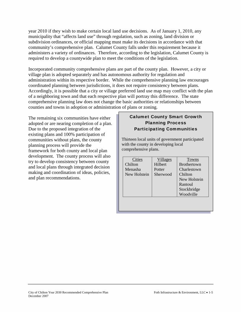
Calumet County Smart Growth Planning Process
Participating Communities Thirteen local units of government participated with the county in developing local comprehensive plans.
Cities Chilton Menasha New Holstein
Villages Hilbert Potter Sherwood
Towns Brothertown Charlestown Chilton New Holstein Rantoul Stockbridge Woodville
year 2010 if they wish to make certain local land use decisions. As of January 1, 2010, any municipality that “affects land use” through regulation, such as zoning, land division or subdivision ordinances, or official mapping must make its decisions in accordance with that community’s comprehensive plan. Calumet County falls under this requirement because it administers a variety of ordinances. Therefore, according to the legislation, Calumet County is required to develop a countywide plan to meet the conditions of the legislation. Incorporated community comprehensive plans are part of the county plan. However, a city or village plan is adopted separately and has autonomous authority for regulation and administration within its respective border. While the comprehensive planning law encourages coordinated planning between jurisdictions, it does not require consistency between plans. Accordingly, it is possible that a city or village preferred land use map may conflict with the plan of a neighboring town and that each respective plan will portray this difference. The state comprehensive planning law does not change the basic authorities or relationships between counties and towns in adoption or administration of plans or zoning. The remaining six communities have either adopted or are nearing completion of a plan. Due to the proposed integration of the existing plans and 100% participation of communities without plans, the county planning process will provide the framework for both county and local plan development. The county process will also try to develop consistency between county and local plans through integrated decision making and coordination of ideas, policies, and plan recommendations.

Foth Infrastructure & Environment, LLC • 1-6 City of Chilton Year 2030 Recommended Comprehensive Plan December 2007
This page intentionally left blank.

City of Chilton Year 2030 Recommended Comprehensive Plan Foth Infrastructure & Environment, LLC • 1-7 December 2007
Map 1-1 Regional Setting

Foth Infrastructure & Environment, LLC • 1-8 City of Chilton Year 2030 Recommended Comprehensive Plan December 2007
This page intentionally left blank.

City of Chilton Year 2030 Recommended Comprehensive Plan Foth Infrastructure & Environment, LLC • 1-9 December 2007
1.3 Comprehensive Plan Development Process
Public Participation
The Wisconsin comprehensive planning legislation (s. 66.1001) specifies that the governing body for a unit of government must prepare and adopt written procedures to foster public participation in the comprehensive planning process. The procedures must include open discussion, communication programs, information services, and public meetings for which advance notice has been provided, in every stage of the preparation of a comprehensive plan. In addition, the participation procedures must provide for wide distribution of proposed drafts, alternatives, and amendments of the comprehensive plan. The public participation procedures should address how members of the public can send written comments on the plan to the governing body, and how the governing body will respond. The City of Chilton has complied with all public participation requirements as detailed in Wisconsin Statutes 66.1001 by adopting and initiating a public participation plan. The City of Chilton adopted a public participation plan on March 2, 2004. Local Meetings
Plan Commission Meetings The City of Chilton Planning Commission meets the second Wednesday of each month. During the comprehensive planning process, components of the comprehensive plan were discussed to provide input to the development of the plan. The adopted minutes of each Plan Commission meeting are available for review by contacting the City Clerk. Public Informational Meeting Two joint public informational meetings with the towns of Chilton and Charlestown were held. The first occurred May 10, 2007 at the Chilton City Hall. The second occurred on October 3, 2007. Both meetings discussed progress on each community’s comprehensive plan. The meetings also discussed intergovernmental opportunities and land use compatibility along municipal borders. Public Hearing A public hearing on this plan was held Tuesday, September 18, at the Chilton City Hall. 1.4 State Comprehensive Planning Goals
Wisconsin’s comprehensive planning law (Smart Growth) established 14 local comprehensive planning goals to guide state land use actions and local planning efforts. Specifically, local units of government and state agencies are encouraged to design their programs, policies, infrastructure, and investments to strike a balance between their individual missions and the local comprehensive planning goals. The following 14 local comprehensive planning goals were considered throughout the planning process.

Foth Infrastructure & Environment, LLC • 1-10 City of Chilton Year 2030 Recommended Comprehensive Plan December 2007
1. Promote the redevelopment of lands with existing infrastructure and public services and the maintenance and rehabilitation of existing residential, commercial, and industrial structures.
2. Encourage neighborhood designs that support a range of transportation choices. 3. Protect natural areas, including wetlands, wildlife habitats, lakes and woodlands, open
spaces, and groundwater resources. 4. Protect economically productive areas, including farmland and forests. 5. Encourage land uses, densities, and regulations that promote efficient development
patterns and relatively low municipal, state government, and utility costs. 6. Preserve cultural, historic, and archaeological sites. 7. Encourage coordination and cooperation among nearby units of government. 8. Build community identity by revitalizing main streets and enforcing design standards. 9. Provide an adequate supply of affordable housing for all income levels throughout each
community. 10. Provide adequate infrastructure and public services and a supply of developable land to
meet existing and future market demand for residential, commercial, and industrial uses. 11. Promote the expansion or stabilization of the current economic base and the creation of a
range of employment opportunities at the state, regional, and local levels. 12. Balance individual property rights with community interests and goals. 13. Plan and develop land uses that create or preserve varied and unique urban and rural
communities. 14. Provide an integrated, efficient, and economical transportation system that provides
mobility, convenience, and safety and meets the needs of all citizens including transit-dependent and disabled.
1.5 City of Chilton Mission Statement
To provide prompt, efficient, cost-effective service and leadership in a friendly manner for the purpose of enhancing the quality of life and growth in the City of Chilton. We will accomplish our vision and mission statements by emphasizing the following:
♦ Develop and promote teamwork both within and between departments.

City of Chilton Year 2030 Recommended Comprehensive Plan Foth Infrastructure & Environment, LLC • 1-11 December 2007
Issues and Opportunities
Housing
♦ Set and accomplish priorities and attainable goals; then accomplish them. ♦ Be accountable for defined responsibilities. ♦ Encourage long range planning at all department levels. ♦ Foster a truthful and respectful work environment. ♦ Communicate clearly and effectively to each other and the public. ♦ Be proactive rather than reactive. ♦ Provide an environment that encourages and supports professional growth through
training and education. ♦ Emphasize we are here to serve the people and are stewards of their money.
That the City of Chilton be a friendly, safe, community oriented city providing services efficiently and effectively with a vital balance of residential, commercial, industrial, and public facilities serving all of the people. 1.6 City of Chilton Planning Goals
This section contains the goals for each of the nine elements as described and required by Wisconsin’s comprehensive planning law. Goals, objectives, policies, and programs will also be included within each of the respective planning elements. The following goals were developed by the City of Chilton to guide and focus the planning process. Goals are broad, value-based statements expressing public preferences for the long term (20 years or more). They address key issues, opportunities, and problems that affect the community. The source of the goal follows the goal statement.
Goal: To organize and plan a complete strategy for city improvement and growth management
(City of Chilton Comprehensive Plan, 1998). Goal: Balance individual property rights with city interests and goals (Smart Growth planning
process).
Goal: To preserve, enhance, and expand the residential character in areas of single-family
housing (City of Chilton Comprehensive Plan, 1998). Goal: To preserve and develop high quality housing areas to satisfy the demand for an adequate
number of dwellings of various types of densities (City of Chilton Comprehensive Plan, 1998).
Goal: Maintain an adequate, balanced housing supply that will meet the needs of current and
future residents and promote a range of housing choices for anticipated income levels, age groups, and special housing needs (Smart Growth planning process).
Foth Infrastructure & Environment, LLC • 1-12 City of Chilton Year 2030 Recommended Comprehensive Plan December 2007
Transportation
Utilities and Community Facilities
Goal: Provide for housing development that maintains the attractiveness and characteristics of
the city (Smart Growth planning process).
Goal: Maintain and improve the quality, safety, and efficiency of the transportation networks in
Chilton (City of Chilton Comprehensive Plan, 1998). Goal: Provide a cost effective transportation system for the movement of people and goods
(Smart Growth planning process).
Goal: Provide needed infrastructure improvements and high quality cost effective community
facilities and services to serve existing development and planned growth in an efficient, economical and environmentally safe manner (City of Chilton Comprehensive Plan, 1998).
Goal: Ensure proper treatment of wastewater to protect public health, groundwater quality, and
surface water quality while meeting current and future needs (Smart Growth planning process).
Goal: Promote stormwater management practices in order to reduce property and public
property damage and to protect water quality (Smart Growth planning process). Goal: Ensure that the water supply for the city has sufficient capacity, is in compliance with
drinking water quality standards and regulations, and is available to meet present and future needs (Smart Growth planning process).
Goal: Promote effective solid waste disposal and recycling services and systems that protect the
public health, natural environment, and general appearance of land uses within the city (Smart Growth planning process).
Goal: Ensure that adequate open space and recreational facilities are provided for and made
accessible to all residents of Chilton, with emphasis on preserving unique historic and natural features (City of Chilton Comprehensive Plan, 1998 and Open Space and Recreation Plan, 2007).
Goal: Seek the provision of reliable, efficient, and well-planned utilities to adequately serve
existing and future development (Smart Growth planning process). Goal: Encourage improved access to health care facilities and child care (Smart Growth
planning process).

City of Chilton Year 2030 Recommended Comprehensive Plan Foth Infrastructure & Environment, LLC • 1-13 December 2007
Agricultural, Natural, and Cultural Resources
Economic Development
Intergovernmental Cooperation
Goal: Provide a level of police, fire, and emergency services that meets present and future
needs (Smart Growth planning process). Goal: Promote quality schools and access to educational opportunities (Smart Growth planning
process).
Goal: Support the agricultural resources of the county and the region (Smart Growth planning
process). Goal: To conserve, protect, and improve the environmental resources of the city and the
surrounding area (City of Chilton Comprehensive Plan, 1998). Goal: Preserve a small town atmosphere including attractive city entrances, small businesses, a
vital downtown, and community culture and events (Smart Growth planning process).
Goal: Provide an adequate framework for the expansion and continual redevelopment of
commercial and industrial uses in Chilton (City of Chilton Comprehensive Plan, 1998). Goal: Support the organizational growth of economic development programs in the city,
county, and region (Smart Growth planning process). Goal: Maintain and improve the utility, communication, and transportation infrastructure
systems that promote economic development (Smart Growth planning process). Goal: Promote entrepreneurial development and new business attraction efforts (Smart Growth
planning process). Goal: Support opportunities to increase and diversify the city’s tax base (Smart Growth
planning process).
Goal: Establish mutually beneficial intergovernmental relations with other units of government
(Smart Growth planning process).
Foth Infrastructure & Environment, LLC • 1-14 City of Chilton Year 2030 Recommended Comprehensive Plan December 2007
Land Use
Implementation
Goal: Create a balanced pattern of complementary urban land uses (City of Chilton
Comprehensive Plan, 1998).
Goal: Promote consistency between plan recommendations, ordinances, and other land use
regulations (Smart Growth planning process). 1.7 Issues and Opportunities Goals and Objectives
Wisconsin Statutes 66.1001 requires a statement of overall goals and objectives of the local governmental unit to guide the future development and redevelopment of the local governmental unit over a 20-year planning period. The following are the goals and objectives developed by the City of Chilton. (The source of each goal and objective is noted in parentheses.) Goal: To organize and plan a complete strategy for city improvement and growth
management (City of Chilton Comprehensive Plan, 1998). Objectives 1. Increase the potential of city staff to utilize their strengths for the betterment of city
administration (Smart Growth planning process). 2. Maintain and improve the quality of life within the city (City of Chilton Comprehensive
Plan, 1998). 3. Work with property owners and potential developers for improvements (City of Chilton
2005-2006 Goals and Objectives). Goal: Balance individual property rights with city interests and goals. Objectives 1. Maintain a city newsletter to inform residents of city programs, projects and other
applicable information (Smart Growth planning process). 2. Promote the city web site as a portal for further disseminating of information to citizens on
community affairs (City of Chilton 2005-2006 Goals and Objectives).

City of Chilton Year 2030 Recommended Comprehensive Plan Foth Infrastructure & Environment, LLC • 1-15 December 2007
3. Maintain an adequate level of citizen participation throughout all stages of plan and ordinance development, amendment, and implementation (Smart Growth planning process).
4. Comply with federal and state statutory and case law pertaining to property rights and the
valid regulation of them. 1.8 Issues and Opportunities Policies and Recommendations
Policies and recommendations build on goals and objectives by providing more focused responses and actions to the goals and objectives. Policies and recommendations become the tools that the community should use to aid in making land use decisions. Policies that direct action using the words “will” or “shall” are advised to be mandatory and regulatory aspects of the implementation of the comprehensive plan. In contrast, those policies that direct action using the word “should” are advisory and intended to serve as a guide. Policies
1. The city shall use the comprehensive plan as a tool to guide city decision making (Smart Growth Planning Process).
2. The city shall seek a variety of grants and alternative methods of funding planned
improvements (City of Chilton Comprehensive Plan, 1998). 3. City policies, ordinances, and decisions regarding land use shall be made in conformance
with the comprehensive plan to the fullest extent (Smart Growth Planning Process). 4. All future city policies, actions, and programs will be developed and implemented in a
manner that is consistent and accommodating to the goals and objectives identified within the comprehensive plan (Smart Growth Planning Process).
Recommendations
Recommendations are specific actions or projects that the community should be prepared to complete. Completion of these actions and projects is consistent with the community’s policies, and therefore will help fulfill the comprehensive plan goals and objectives. 1. Develop a partnership with the Calumet County Planning Department and other
communities towards developing a county wide vision for regional economic stability and land use compatibility.
2. Respond to changes or amendments to the comprehensive planning law (ss. 66.1001) as
they potentially impact the city. 3. Implement the recommendations of subsequent plan elements that support the remediation
of city issues and enhance opportunities.
Foth Infrastructure & Environment, LLC • 1-16 City of Chilton Year 2030 Recommended Comprehensive Plan December 2007
1.9 Issues and Opportunities Programs
The following programs are currently utilized by the community or are available for use by the community to implement the goals, objectives, policies, and recommendations identified. AB608, Wisconsin Act 233 – Clarification of Smart Growth Law This bill was signed into law in April 2004. This new law reduces the number of programs or actions with which a comprehensive plan must be consistent. Under the new legislation, the only actions which must be consistent with a comprehensive plan are official mapping, local subdivision regulation, and zoning ordinances, including zoning of shorelands or wetlands in shorelands. The bill also iterates that a Regional Planning Commission’s comprehensive plan is only advisory in its applicability to a political subdivision (a city, village, town, or county), and a political subdivision’s comprehensive plan. Wisconsin Department of Administration, Demographic Services Center The Demographic Services Center’s primary responsibility is to develop annual total population estimates for all Wisconsin towns, villages, and cities. It also makes annual estimates of the voting age population for all municipalities and total population estimates for Zip Code Areas. In addition, the Demographic Services Center develops population projections by age and sex for the counties, population projections of total population for all municipalities, and estimates of total housing units and households for all counties. For further information on the Service Center contact the WDOA or visit its web-site at www.doa.state.wi.us.

City of Chilton Year 2030 Recommended Comprehensive Plan Foth Infrastructure & Environment, LLC • 2-1 December 2007
2. Population and Housing 2.1 Introduction
Housing is very important for Wisconsin and its communities. Housing costs are the single largest expenditure for most Wisconsin residents. For homeowners, their home is likely their most valuable asset and largest investment. Housing also plays a critical role in state and local economies. The housing in a community may be its largest asset. The construction industry and other occupations that support housing are a major portion of the economy. Residential development is also a major source of revenue for local communities in the form of property taxes. Beyond the financial aspects of housing, there are also social effects that are not so easily measured. People develop a sense of pride in their homes, which in turn creates a sense of community and a likely increase in participation in community activities. Housing is also a function of population. Housing demand, type of housing desired, and housing prices are driven by the population found in an area. Therefore, housing characteristics and an evaluation of population are provided in the same planning element. Wisconsin’s comprehensive planning law requires that a comprehensive plan include a housing element and provide demographic information. The comprehensive planning process also necessitates that each community analyze the impact of local, state, and federal policies and regulations on the development of various types of housing. The analysis is intended to take into account the current and projected housing needs in the community. The analysis should result in policies that provide opportunities for the development of the types and amounts of housing expected to be needed over a 20-year planning horizon. There are a number of benefits that can be realized by developing a housing element and analyzing demographics:
♦ The process of developing the housing element encourages citizens to start thinking and talking about local housing concerns.
♦ The data collection and analysis can increase understanding of the local housing situation and the residents who live in the community.
♦ The data allows for an understanding of future trends and how the community can prepare for change.
♦ More influence over the nature of future housing development can be attained.
♦ It increases the chances that housing decisions are coordinated with decisions regarding other comprehensive plan elements such as the land use, transportation, economic development, utilities and community facilities, and agricultural, natural, and cultural resources elements.

Foth Infrastructure & Environment, LLC • 2-2 City of Chilton Year 2030 Recommended Comprehensive Plan December 2007
♦ It can bring together a diverse range of groups, agencies, and citizens that otherwise may not work together.
♦ It provides the chance to consider the community’s housing concerns in relation to those of adjacent communities.
The following sections discuss in more detail, specific information about the City of Chilton’s housing stock and patterns, demographics, and future trends. United States Census 2000
A significant amount of information, particularly with regard to population, housing, and economic development, was obtained from the U.S. Bureau of the Census. There were four primary methodologies for data collection employed by the Census in 2000, STF-1 through STF-4. STF-1 data were collected through a household-by-household census and represent responses from every household within the country. STF-2 data are similar to STF-1, however, data are available to the census tract level for limited information meeting an established population threshold. To get more detailed information, the U.S. Census Bureau also randomly distributes a long-form questionnaire to one in six households throughout the nation. Tables that use this sample data are indicated as STF-3 and STF-4 data. Throughout this report, data from the U.S. Census will be designated as STF-1 or STF-3 data. It should be noted that STF-1 and STF-3 data may differ for similar statistics, due to survey limitations, non-response, or other attributes unique to each form of data collection. 2.2 Population
Population Counts
Population change is the primary component in tracking growth as well as predicting future population trends. Population characteristics influence future economic development and relate directly to demands on community services, housing, education, utilities, social services, and recreational facility needs. Tables 2-1 and 2-2 display the population trends of local communities, Calumet County, and the State of Wisconsin from 1970 to 2000.

City of Chilton Year 2030 Recommended Comprehensive Plan Foth Infrastructure & Environment, LLC • 2-3 December 2007
Table 2-1 Population Counts, Calumet County, 1970-2000
*Municipality crosses at least one county line; data provided are for the entire municipality. Source: U.S. Bureau of the Census, STF-1, 1970-2000. Calumet County total does not equal the sum of municipalities listed due to communities located in other counties.
Municipality 1970 1980 1990 2000T. Brillion 1,324 1,191 1,300 1,438T. Brothertown 1,420 1,494 1,409 1,404T. Charlestown 1,079 1,090 875 789T. Chilton 1,116 1,120 998 1,130T. Harrison 3,260 3,541 3,195 5,756T. New Holstein 1,513 1,527 1,406 1,457T. Rantoul 1,243 1,184 895 812T. Stockbridge 1,285 1,248 1,317 1,383T. Woodville 1,207 1,160 1,071 993V. Hilbert 896 1,176 1,211 1,089V. Potter 0 0 252 252V. Sherwood 350 372 837 1,550V. Stockbridge 582 567 579 649C. Appleton* 56,377 58,913 65,695 70,087C. Brillion 2,588 2,907 2,840 2,937C. Chilton 3,030 2,965 3,240 3,708C. Kiel* 2,848 3,083 2,910 3,450C. Menasha* 14,836 14,728 14,711 16,331C. New Holstein 3,012 3,412 3,342 3,301Calumet County 27,604 30,867 34,291 40,631Wisconsin 4,417,731 4,705,642 4,891,769 5,363,690
Foth Infrastructure & Environment, LLC • 2-4 City of Chilton Year 2030 Recommended Comprehensive Plan December 2007
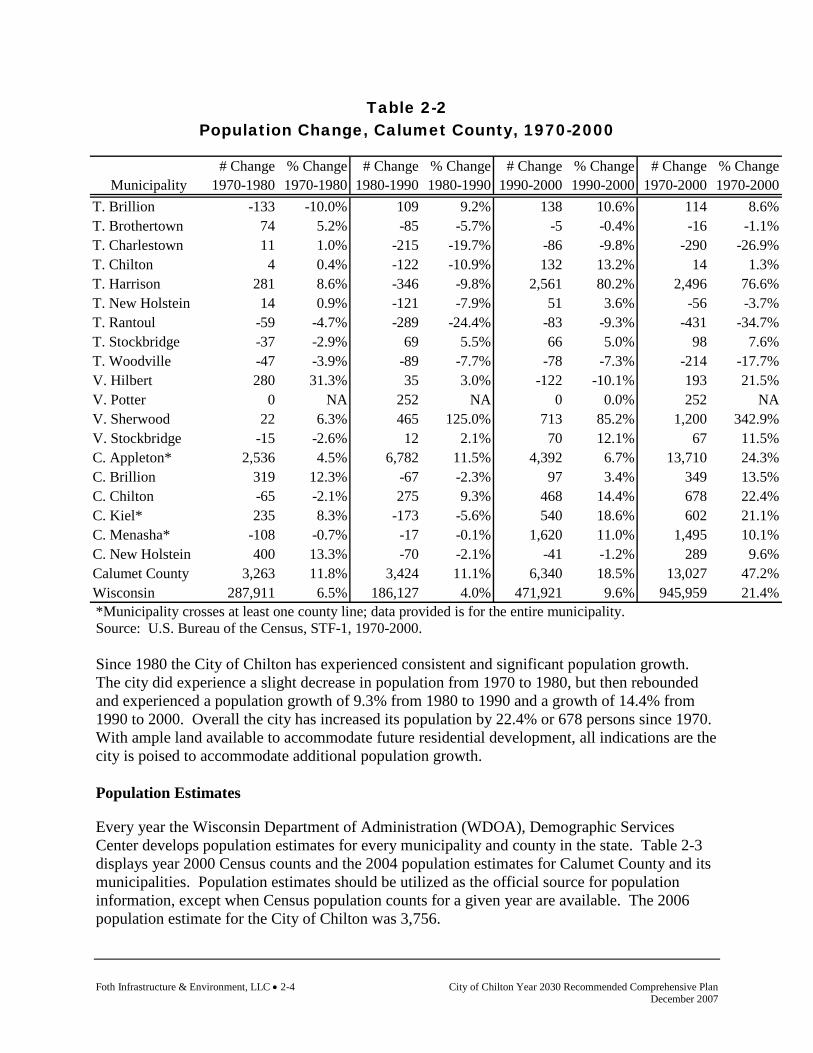
Table 2-2 Population Change, Calumet County, 1970-2000
*Municipality crosses at least one county line; data provided is for the entire municipality. Source: U.S. Bureau of the Census, STF-1, 1970-2000. Since 1980 the City of Chilton has experienced consistent and significant population growth. The city did experience a slight decrease in population from 1970 to 1980, but then rebounded and experienced a population growth of 9.3% from 1980 to 1990 and a growth of 14.4% from 1990 to 2000. Overall the city has increased its population by 22.4% or 678 persons since 1970. With ample land available to accommodate future residential development, all indications are the city is poised to accommodate additional population growth. Population Estimates
Every year the Wisconsin Department of Administration (WDOA), Demographic Services Center develops population estimates for every municipality and county in the state. Table 2-3 displays year 2000 Census counts and the 2004 population estimates for Calumet County and its municipalities. Population estimates should be utilized as the official source for population information, except when Census population counts for a given year are available. The 2006 population estimate for the City of Chilton was 3,756.
# Change % Change # Change % Change # Change % Change # Change % ChangeMunicipality 1970-1980 1970-1980 1980-1990 1980-1990 1990-2000 1990-2000 1970-2000 1970-2000
T. Brillion -133 -10.0% 109 9.2% 138 10.6% 114 8.6%T. Brothertown 74 5.2% -85 -5.7% -5 -0.4% -16 -1.1%T. Charlestown 11 1.0% -215 -19.7% -86 -9.8% -290 -26.9%T. Chilton 4 0.4% -122 -10.9% 132 13.2% 14 1.3%T. Harrison 281 8.6% -346 -9.8% 2,561 80.2% 2,496 76.6%T. New Holstein 14 0.9% -121 -7.9% 51 3.6% -56 -3.7%T. Rantoul -59 -4.7% -289 -24.4% -83 -9.3% -431 -34.7%T. Stockbridge -37 -2.9% 69 5.5% 66 5.0% 98 7.6%T. Woodville -47 -3.9% -89 -7.7% -78 -7.3% -214 -17.7%V. Hilbert 280 31.3% 35 3.0% -122 -10.1% 193 21.5%V. Potter 0 NA 252 NA 0 0.0% 252 NAV. Sherwood 22 6.3% 465 125.0% 713 85.2% 1,200 342.9%V. Stockbridge -15 -2.6% 12 2.1% 70 12.1% 67 11.5%C. Appleton* 2,536 4.5% 6,782 11.5% 4,392 6.7% 13,710 24.3%C. Brillion 319 12.3% -67 -2.3% 97 3.4% 349 13.5%C. Chilton -65 -2.1% 275 9.3% 468 14.4% 678 22.4%C. Kiel* 235 8.3% -173 -5.6% 540 18.6% 602 21.1%C. Menasha* -108 -0.7% -17 -0.1% 1,620 11.0% 1,495 10.1%C. New Holstein 400 13.3% -70 -2.1% -41 -1.2% 289 9.6%Calumet County 3,263 11.8% 3,424 11.1% 6,340 18.5% 13,027 47.2%Wisconsin 287,911 6.5% 186,127 4.0% 471,921 9.6% 945,959 21.4%
City of Chilton Year 2030 Recommended Comprehensive Plan Foth Infrastructure & Environment, LLC • 2-5 December 2007
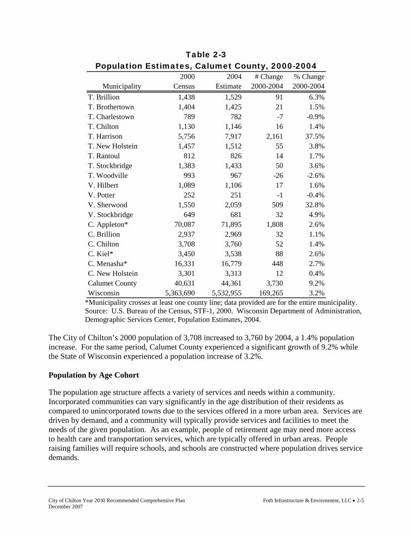
Table 2-3 Population Estimates, Calumet County, 2000-2004
2000 2004 # Change % ChangeMunicipality Census Estimate 2000-2004 2000-2004
T. Brillion 1,438 1,529 91 6.3%T. Brothertown 1,404 1,425 21 1.5%T. Charlestown 789 782 -7 -0.9%T. Chilton 1,130 1,146 16 1.4%T. Harrison 5,756 7,917 2,161 37.5%T. New Holstein 1,457 1,512 55 3.8%T. Rantoul 812 826 14 1.7%T. Stockbridge 1,383 1,433 50 3.6%T. Woodville 993 967 -26 -2.6%V. Hilbert 1,089 1,106 17 1.6%V. Potter 252 251 -1 -0.4%V. Sherwood 1,550 2,059 509 32.8%V. Stockbridge 649 681 32 4.9%C. Appleton* 70,087 71,895 1,808 2.6%C. Brillion 2,937 2,969 32 1.1%C. Chilton 3,708 3,760 52 1.4%C. Kiel* 3,450 3,538 88 2.6%C. Menasha* 16,331 16,779 448 2.7%C. New Holstein 3,301 3,313 12 0.4%Calumet County 40,631 44,361 3,730 9.2%Wisconsin 5,363,690 5,532,955 169,265 3.2%
*Municipality crosses at least one county line; data provided are for the entire municipality. Source: U.S. Bureau of the Census, STF-1, 2000. Wisconsin Department of Administration, Demographic Services Center, Population Estimates, 2004.
The City of Chilton’s 2000 population of 3,708 increased to 3,760 by 2004, a 1.4% population increase. For the same period, Calumet County experienced a significant growth of 9.2% while the State of Wisconsin experienced a population increase of 3.2%. Population by Age Cohort
The population age structure affects a variety of services and needs within a community. Incorporated communities can vary significantly in the age distribution of their residents as compared to unincorporated towns due to the services offered in a more urban area. Services are driven by demand, and a community will typically provide services and facilities to meet the needs of the given population. As an example, people of retirement age may need more access to health care and transportation services, which are typically offered in urban areas. People raising families will require schools, and schools are constructed where population drives service demands.

Foth Infrastructure & Environment, LLC • 2-6 City of Chilton Year 2030 Recommended Comprehensive Plan December 2007
This social dynamic of a community’s age structure has evolved into a significant trend throughout the country, and is evident in Wisconsin and also Calumet County. The baby-boomer generation, which is a large segment of the overall population, is nearing retirement age. Service demands will result from the age distribution. How a community serves the population demands created by the age distribution is as much a factor in defining community character as the location of the community itself. It will become increasingly important to anticipate potential service demands created from the population shift. Figure 2-1 displays population cohorts by the percentage of the total population for 1990 and 2000 in Calumet County.
Figure 2-1 Percentage of Total Population by Age Cohort, Calumet County,
1990-2000
Source: U.S. Bureau of the Census, STF-1, 1990-2000. Figure 2-1 charts the shifting of the population to older age groups over the 10-year period shown. In 1990, 14.9% of the population was in the 35 to 44 age group, but in 2000 this same group accounted for 18.3% of the population. A similar trend was found for the 45 to 54 age group. Both age groups have employment demands, are raising families, and are building new homes, which have substantial impact on community facilities, housing, economic development, and land use. Relative to persons 60 and older, the total number of retirement age persons is growing significantly, yet is less as a percentage of the total when compared statistically to the other age categories. Table 2-4 displays population by age cohort for all communities in Calumet County for 2000.
8.3%
5.8%
17.9%
9.4%
3.5%
7.0%
13.7%
18.3%
13.5%
6.3%
3.9%
1.2%
4.0%
14.9%
7.2%
8.5%9.2%
7.5%
3.4%
5.7%
3.9%4.5%4.8%
8.0%
0.0%
2.0%
4.0%
6.0%
8.0%
10.0%
12.0%
14.0%
16.0%
18.0%
20.0%
Under5
5 to 9 10 to14
15 to19
20 to24
25 to34
35 to44
45 to54
55 to59
60 to64
65 to74
75 to84
85 andover
% o
f Tot
al P
opul
atio
n
1990 2000
City of Chilton Year 2030 Recommended Comprehensive Plan Foth Infrastructure & Environment, LLC • 2-7 December 2007
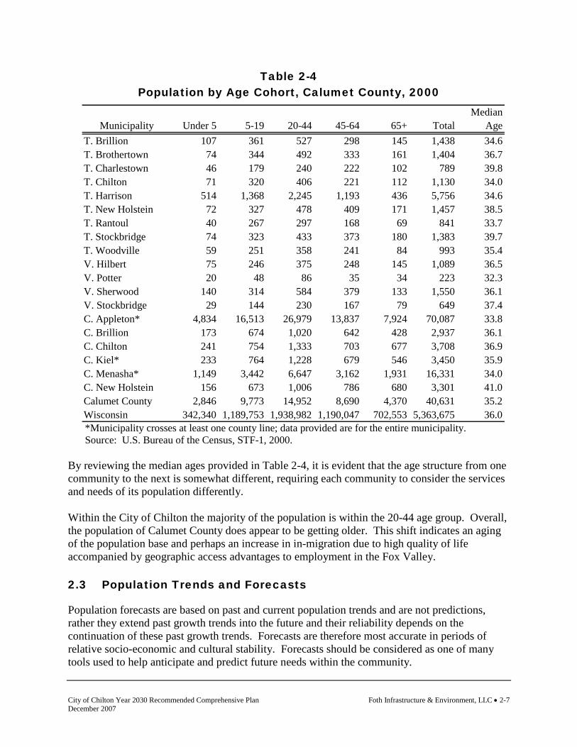
Table 2-4 Population by Age Cohort, Calumet County, 2000
*Municipality crosses at least one county line; data provided are for the entire municipality. Source: U.S. Bureau of the Census, STF-1, 2000.
By reviewing the median ages provided in Table 2-4, it is evident that the age structure from one community to the next is somewhat different, requiring each community to consider the services and needs of its population differently. Within the City of Chilton the majority of the population is within the 20-44 age group. Overall, the population of Calumet County does appear to be getting older. This shift indicates an aging of the population base and perhaps an increase in in-migration due to high quality of life accompanied by geographic access advantages to employment in the Fox Valley. 2.3 Population Trends and Forecasts
Population forecasts are based on past and current population trends and are not predictions, rather they extend past growth trends into the future and their reliability depends on the continuation of these past growth trends. Forecasts are therefore most accurate in periods of relative socio-economic and cultural stability. Forecasts should be considered as one of many tools used to help anticipate and predict future needs within the community.
MedianMunicipality Under 5 5-19 20-44 45-64 65+ Total Age
T. Brillion 107 361 527 298 145 1,438 34.6T. Brothertown 74 344 492 333 161 1,404 36.7T. Charlestown 46 179 240 222 102 789 39.8T. Chilton 71 320 406 221 112 1,130 34.0T. Harrison 514 1,368 2,245 1,193 436 5,756 34.6T. New Holstein 72 327 478 409 171 1,457 38.5T. Rantoul 40 267 297 168 69 841 33.7T. Stockbridge 74 323 433 373 180 1,383 39.7T. Woodville 59 251 358 241 84 993 35.4V. Hilbert 75 246 375 248 145 1,089 36.5V. Potter 20 48 86 35 34 223 32.3V. Sherwood 140 314 584 379 133 1,550 36.1V. Stockbridge 29 144 230 167 79 649 37.4C. Appleton* 4,834 16,513 26,979 13,837 7,924 70,087 33.8C. Brillion 173 674 1,020 642 428 2,937 36.1C. Chilton 241 754 1,333 703 677 3,708 36.9C. Kiel* 233 764 1,228 679 546 3,450 35.9C. Menasha* 1,149 3,442 6,647 3,162 1,931 16,331 34.0C. New Holstein 156 673 1,006 786 680 3,301 41.0Calumet County 2,846 9,773 14,952 8,690 4,370 40,631 35.2Wisconsin 342,340 1,189,753 1,938,982 1,190,047 702,553 5,363,675 36.0

Foth Infrastructure & Environment, LLC • 2-8 City of Chilton Year 2030 Recommended Comprehensive Plan December 2007
Wisconsin Department of Administration (WDOA) Population Forecasts
The Wisconsin Department of Administration (WDOA), Demographic Services Center develops population forecasts for the State of Wisconsin in accordance with Wisconsin Statute 16.96. Forecasts created by WDOA are deemed the official determinations for the state. WDOA forecasts to the year 2030, for the State of Wisconsin, reveal several important trends that should be noted. These trends are anticipated at the state level, and will therefore have effects on county level and local population characteristics as well.
♦ Wisconsin’s population in 2030 is projected to be 6.35 million, nearly one million more than the 2000 census count of 5.36 million.
♦ The working age population – ages 18 through 64 – will peak in 2015 at 3.67 million and,
by 2030 decline slightly to 3.60 million (but still be 300,000 above the 2000 census count).
♦ The volume of deaths will increase substantially due to the aging population.
♦ The 65-plus population will increase slowly up to 2010, and then grow dramatically as
the Baby Boomers join the ranks of the elderly. Senior citizens formed 13% of the state’s total population in 2000. Their proportion will rise to 21% in 2030.
Table 2-5 displays the WDOA population forecasts for Calumet County to the year 2025.

City of Chilton Year 2030 Recommended Comprehensive Plan Foth Infrastructure & Environment, LLC • 2-9 December 2007
Table 2-5 WDOA Population Forecasts, Calumet County, 2000-2025
*Municipality crosses at least one county line; data provided are for the entire municipality. Source: Wisconsin Department of Administration, Demographic Services Center, Final Population Projections for Wisconsin Municipalities: 2000-2025, January 2004. According to the WDOA, the City of Chilton is estimated to experience a population growth of 706 persons between 2000 and 2025, or 19.0% growth. Linear Trend Population Forecasts
Linear forecasts were created by using the 1970, 1980, 1990, and 2000 census counts. Increasing and decreasing population counts were used to calculate a constant value that was based on past census counts. These constant values were used to project the population to the year 2030 using a linear trend. Therefore, linear trends are based directly on historical population trends. Table 2-6 displays the resulting linear trends from the 2000 census count to the estimated 2030 projection. In general, the linear forecasts that are provided are more conservative than the WDOA forecasts provided in the previous section.
2000 Projection Projection Projection Projection Projection # Change % ChangeMunicipality Census 2005 2010 2015 2020 2025 2000-2025 2000-2025
T. Brillion 1,438 1,529 1,609 1,682 1,759 1,829 391 27.2%T. Brothertown 1,404 1,403 1,392 1,376 1,366 1,351 -53 -3.8%T. Charlestown 789 764 734 702 673 642 -147 -18.6%T. Chilton 1,130 1,140 1,142 1,140 1,141 1,139 9 0.8%T. Harrison 5,756 7,375 8,941 10,445 11,954 13,396 7,640 132.7%T. New Holstein 1,457 1,501 1,536 1,566 1,599 1,627 170 11.7%T. Rantoul 812 779 741 701 664 626 -186 -22.9%T. Stockbridge 1,383 1,426 1,460 1,487 1,519 1,545 162 11.7%T. Woodville 993 959 919 877 839 799 -194 -19.5%V. Hilbert 1,089 1,062 1,028 990 956 920 -169 -15.5%V. Potter 252 271 288 303 320 335 83 32.9%V. Sherwood 1,550 1,990 2,413 2,818 3,225 3,614 2,064 133.2%V. Stockbridge 649 671 687 701 717 731 82 12.6%C. Appleton* 70,087 73,022 75,670 78,237 80,874 83,214 13,127 18.7%C. Brillion 2,937 2,979 3,000 3,010 3,030 3,039 102 3.5%C. Chilton 3,708 3,881 4,025 4,153 4,292 4,414 706 19.0%C. Kiel* 3,450 3,635 3,812 3,990 4,173 4,317 867 25.1%C. Menasha* 16,331 16,547 16,706 16,873 17,103 17,412 1,081 6.6%C. New Holstein 3,301 3,306 3,289 3,260 3,243 3,215 -86 -2.6%Calumet County 40,631 44,182 47,398 50,381 53,473 56,336 15,705 38.7%Wisconsin 5,363,690 5,563,896 5,751,470 5,931,386 6,110,878 6,274,867 911,177 17.0%
Foth Infrastructure & Environment, LLC • 2-10 City of Chilton Year 2030 Recommended Comprehensive Plan December 2007
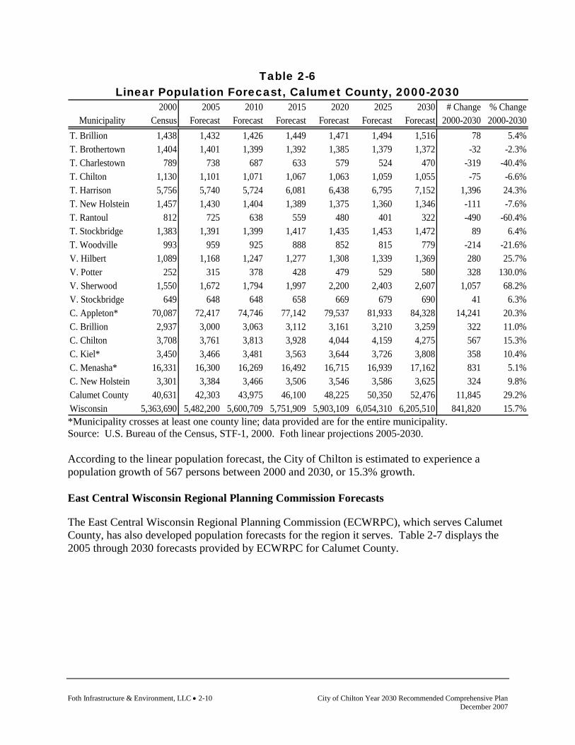
Table 2-6 Linear Population Forecast, Calumet County, 2000-2030
2000 2005 2010 2015 2020 2025 2030 # Change % ChangeMunicipality Census Forecast Forecast Forecast Forecast Forecast Forecast 2000-2030 2000-2030
T. Brillion 1,438 1,432 1,426 1,449 1,471 1,494 1,516 78 5.4%T. Brothertown 1,404 1,401 1,399 1,392 1,385 1,379 1,372 -32 -2.3%T. Charlestown 789 738 687 633 579 524 470 -319 -40.4%T. Chilton 1,130 1,101 1,071 1,067 1,063 1,059 1,055 -75 -6.6%T. Harrison 5,756 5,740 5,724 6,081 6,438 6,795 7,152 1,396 24.3%T. New Holstein 1,457 1,430 1,404 1,389 1,375 1,360 1,346 -111 -7.6%T. Rantoul 812 725 638 559 480 401 322 -490 -60.4%T. Stockbridge 1,383 1,391 1,399 1,417 1,435 1,453 1,472 89 6.4%T. Woodville 993 959 925 888 852 815 779 -214 -21.6%V. Hilbert 1,089 1,168 1,247 1,277 1,308 1,339 1,369 280 25.7%V. Potter 252 315 378 428 479 529 580 328 130.0%V. Sherwood 1,550 1,672 1,794 1,997 2,200 2,403 2,607 1,057 68.2%V. Stockbridge 649 648 648 658 669 679 690 41 6.3%C. Appleton* 70,087 72,417 74,746 77,142 79,537 81,933 84,328 14,241 20.3%C. Brillion 2,937 3,000 3,063 3,112 3,161 3,210 3,259 322 11.0%C. Chilton 3,708 3,761 3,813 3,928 4,044 4,159 4,275 567 15.3%C. Kiel* 3,450 3,466 3,481 3,563 3,644 3,726 3,808 358 10.4%C. Menasha* 16,331 16,300 16,269 16,492 16,715 16,939 17,162 831 5.1%C. New Holstein 3,301 3,384 3,466 3,506 3,546 3,586 3,625 324 9.8%Calumet County 40,631 42,303 43,975 46,100 48,225 50,350 52,476 11,845 29.2%Wisconsin 5,363,690 5,482,200 5,600,709 5,751,909 5,903,109 6,054,310 6,205,510 841,820 15.7% *Municipality crosses at least one county line; data provided are for the entire municipality. Source: U.S. Bureau of the Census, STF-1, 2000. Foth linear projections 2005-2030. According to the linear population forecast, the City of Chilton is estimated to experience a population growth of 567 persons between 2000 and 2030, or 15.3% growth. East Central Wisconsin Regional Planning Commission Forecasts
The East Central Wisconsin Regional Planning Commission (ECWRPC), which serves Calumet County, has also developed population forecasts for the region it serves. Table 2-7 displays the 2005 through 2030 forecasts provided by ECWRPC for Calumet County.

City of Chilton Year 2030 Recommended Comprehensive Plan Foth Infrastructure & Environment, LLC • 2-11 December 2007
Table 2-7 ECWRPC Population Forecasts, Calumet County, 2005-2030
2000 2004 WDOA ECWRPC ECWRPC ECWRPC ECWRPC ECWRPC ECWRPC # Change % ChangeMunicipality Census Estimate 2005 2010 2015 2020 2025 2030 2000-2030 2000-2030
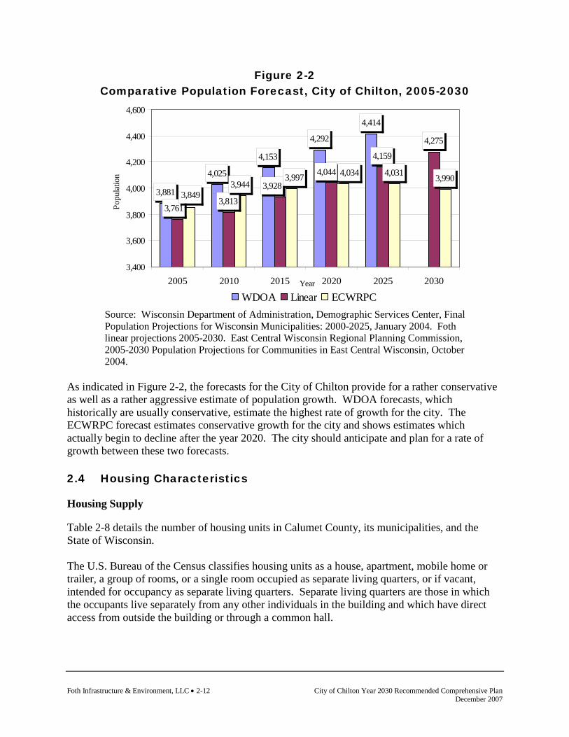
T. Brillion 1,438 1,529 1,571 1,643 1,702 1,759 1,803 1,835 397 27.6%T. Brothertown 1,404 1,425 1,448 1,429 1,387 1,332 1,256 1,159 -245 -17.5%T. Charlestown 789 782 787 732 658 572 469 352 -437 -55.4%T. Chilton 1,130 1,146 1,169 1,179 1,172 1,159 1,131 1,090 -40 -3.5%T. Harrison 5,756 7,917 8,384 10,112 11,937 13,930 16,005 18,143 12,387 215.2%T. New Holstein 1,457 1,512 1,540 1,538 1,514 1,479 1,422 1,347 -110 -7.5%T. Rantoul 812 826 833 785 719 641 546 437 -375 -46.2%T. Stockbridge 1,383 1,433 1,465 1,494 1,504 1,508 1,496 1,468 85 6.1%T. Woodville 993 967 975 917 838 744 631 500 -493 -49.6%V. Hilbert 1,089 1,106 1,121 1,090 1,038 974 892 793 -296 -27.2%V. Potter 252 251 259 275 290 306 320 332 80 31.7%V. Sherwood 1,550 2,059 2,188 2,677 3,196 3,765 4,358 4,972 3,422 220.8%V. Stockbridge 649 681 699 724 743 759 770 774 125 19.3%C. Appleton* 10,974 11,241 11,588 12,323 12,982 13,656 14,258 14,788 3,814 34.8%C. Brillion 2,937 2,969 3,022 3,008 2,949 2,866 2,741 2,577 -360 -12.3%C. Chilton 3,708 3,760 3,849 3,944 3,997 4,034 4,031 3,990 282 7.6%C. Kiel* 321 320 324 314 298 278 253 223 -98 -30.5%C. Menasha* 688 1,124 1,225 1,661 2,133 2,655 3,208 3,789 3,101 450.7%C. New Holstein 3,301 3,313 3,364 3,301 3,181 3,028 2,824 2,573 -728 -22.1%Calumet County 40,631 44,361 45,812 49,146 52,239 55,445 58,414 61,141 20,510 50.5% Source: East Central Wisconsin Regional Planning Commission, 2005-2030 Population Projections for Communities in East Central Wisconsin, October 2004. *Municipality crosses at least one county line; data provided are for portion of municipality in Calumet County only. According to the ECWRPC forecast, the City of Chilton is estimated to experience a population growth of 282 persons between 2000 and 2030, or 7.6% growth. Comparative Population Forecasts
Figure 2-2 displays the three population projections for the City of Chilton.
Foth Infrastructure & Environment, LLC • 2-12 City of Chilton Year 2030 Recommended Comprehensive Plan December 2007
Figure 2-2 Comparative Population Forecast, City of Chilton, 2005-2030
3,881
4,025
4,153
4,292
4,414
3,813
4,159
4,275
3,9444,031 3,990
3,761
3,9284,044
3,849
3,997 4,034
3,400
3,600
3,800
4,000
4,200
4,400
4,600
2005 2010 2015 2020 2025 2030Year
Popu
latio
n
WDOA Linear ECWRPC
Source: Wisconsin Department of Administration, Demographic Services Center, Final Population Projections for Wisconsin Municipalities: 2000-2025, January 2004. Foth linear projections 2005-2030. East Central Wisconsin Regional Planning Commission, 2005-2030 Population Projections for Communities in East Central Wisconsin, October 2004.
As indicated in Figure 2-2, the forecasts for the City of Chilton provide for a rather conservative as well as a rather aggressive estimate of population growth. WDOA forecasts, which historically are usually conservative, estimate the highest rate of growth for the city. The ECWRPC forecast estimates conservative growth for the city and shows estimates which actually begin to decline after the year 2020. The city should anticipate and plan for a rate of growth between these two forecasts. 2.4 Housing Characteristics
Housing Supply
Table 2-8 details the number of housing units in Calumet County, its municipalities, and the State of Wisconsin. The U.S. Bureau of the Census classifies housing units as a house, apartment, mobile home or trailer, a group of rooms, or a single room occupied as separate living quarters, or if vacant, intended for occupancy as separate living quarters. Separate living quarters are those in which the occupants live separately from any other individuals in the building and which have direct access from outside the building or through a common hall.
City of Chilton Year 2030 Recommended Comprehensive Plan Foth Infrastructure & Environment, LLC • 2-13 December 2007
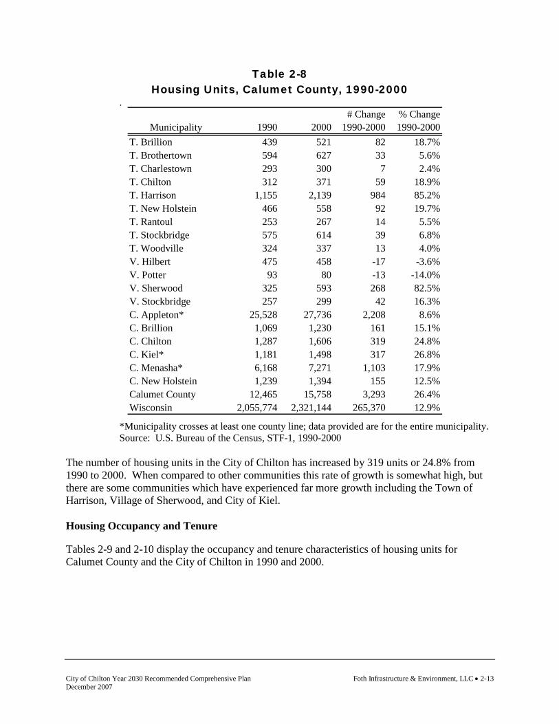
Table 2-8 Housing Units, Calumet County, 1990-2000
.
*Municipality crosses at least one county line; data provided are for the entire municipality. Source: U.S. Bureau of the Census, STF-1, 1990-2000
The number of housing units in the City of Chilton has increased by 319 units or 24.8% from 1990 to 2000. When compared to other communities this rate of growth is somewhat high, but there are some communities which have experienced far more growth including the Town of Harrison, Village of Sherwood, and City of Kiel. Housing Occupancy and Tenure
Tables 2-9 and 2-10 display the occupancy and tenure characteristics of housing units for Calumet County and the City of Chilton in 1990 and 2000.
# Change % ChangeMunicipality 1990 2000 1990-2000 1990-2000
T. Brillion 439 521 82 18.7%T. Brothertown 594 627 33 5.6%T. Charlestown 293 300 7 2.4%T. Chilton 312 371 59 18.9%T. Harrison 1,155 2,139 984 85.2%T. New Holstein 466 558 92 19.7%T. Rantoul 253 267 14 5.5%T. Stockbridge 575 614 39 6.8%T. Woodville 324 337 13 4.0%V. Hilbert 475 458 -17 -3.6%V. Potter 93 80 -13 -14.0%V. Sherwood 325 593 268 82.5%V. Stockbridge 257 299 42 16.3%C. Appleton* 25,528 27,736 2,208 8.6%C. Brillion 1,069 1,230 161 15.1%C. Chilton 1,287 1,606 319 24.8%C. Kiel* 1,181 1,498 317 26.8%C. Menasha* 6,168 7,271 1,103 17.9%C. New Holstein 1,239 1,394 155 12.5%Calumet County 12,465 15,758 3,293 26.4%Wisconsin 2,055,774 2,321,144 265,370 12.9%
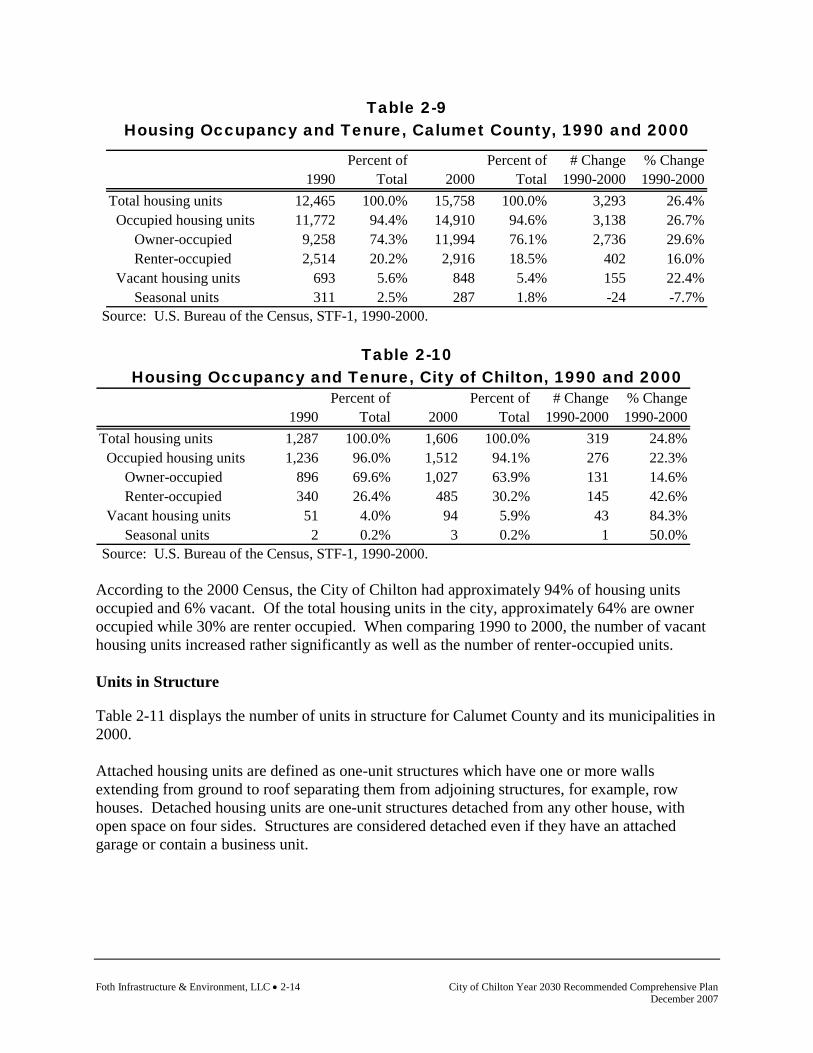
Foth Infrastructure & Environment, LLC • 2-14 City of Chilton Year 2030 Recommended Comprehensive Plan December 2007
Table 2-9 Housing Occupancy and Tenure, Calumet County, 1990 and 2000
Source: U.S. Bureau of the Census, STF-1, 1990-2000.
Table 2-10 Housing Occupancy and Tenure, City of Chilton, 1990 and 2000
Percent of Percent of # Change % Change1990 Total 2000 Total 1990-2000 1990-2000
Total housing units 1,287 100.0% 1,606 100.0% 319 24.8% Occupied housing units 1,236 96.0% 1,512 94.1% 276 22.3% Owner-occupied 896 69.6% 1,027 63.9% 131 14.6% Renter-occupied 340 26.4% 485 30.2% 145 42.6% Vacant housing units 51 4.0% 94 5.9% 43 84.3% Seasonal units 2 0.2% 3 0.2% 1 50.0% Source: U.S. Bureau of the Census, STF-1, 1990-2000.
According to the 2000 Census, the City of Chilton had approximately 94% of housing units occupied and 6% vacant. Of the total housing units in the city, approximately 64% are owner occupied while 30% are renter occupied. When comparing 1990 to 2000, the number of vacant housing units increased rather significantly as well as the number of renter-occupied units. Units in Structure
Table 2-11 displays the number of units in structure for Calumet County and its municipalities in 2000. Attached housing units are defined as one-unit structures which have one or more walls extending from ground to roof separating them from adjoining structures, for example, row houses. Detached housing units are one-unit structures detached from any other house, with open space on four sides. Structures are considered detached even if they have an attached garage or contain a business unit.
Percent of Percent of # Change % Change1990 Total 2000 Total 1990-2000 1990-2000
Total housing units 12,465 100.0% 15,758 100.0% 3,293 26.4% Occupied housing units 11,772 94.4% 14,910 94.6% 3,138 26.7% Owner-occupied 9,258 74.3% 11,994 76.1% 2,736 29.6% Renter-occupied 2,514 20.2% 2,916 18.5% 402 16.0% Vacant housing units 693 5.6% 848 5.4% 155 22.4% Seasonal units 311 2.5% 287 1.8% -24 -7.7%

City of Chilton Year 2030 Recommended Comprehensive Plan Foth Infrastructure & Environment, LLC • 2-15 December 2007
Table 2-11 Units in Structure, Calumet County, 2000
*Municipality crosses at least one county line; data provided are for the entire municipality. Source: U.S. Bureau of the Census, STF-3, 2000. Typical of most communities in Wisconsin, Chilton the majority of housing units in Chilton are comprised of one-unit structures. The city does also have a significant number of units classified as two-unit structures, or generally duplexes, as well as five- to nine-unit structures. Age of Housing Units
The age of the housing stock is an important element to be analyzed when planning for the future. If there is a significant amount of older housing units within the housing supply they will most likely need to be replaced, rehabilitated, or abandoned for new development within the planning period. The age status may lead to a need for county or community housing assistance or redevelopment programs. Allowing for a newer housing supply also requires community planning regarding infrastructure, land availability, community utilities, transportation routes, and a variety of other items which are affected by new housing development. Table 2-12 describes the year that structures were built in Calumet County, its municipalities, and the State of Wisconsin based on the 2000 Census.
1-unit 1-unit 2 3 or 4 5 to 9 10 to 19 20 or Mobile Boat, RV, TotalMunicipality detached attached units units units units more units home van, etc. Units
T. Brillion 384 12 15 2 0 0 0 105 0 518T. Brothertown 518 6 31 1 0 2 0 68 0 626T. Charlestown 270 0 10 4 0 0 2 18 0 304T. Chilton 334 2 30 0 0 0 0 8 0 374T. Harrison 1,890 119 57 0 9 51 0 18 0 2,144T. New Holstein 434 8 20 6 8 0 0 80 0 556T. Rantoul 260 0 2 0 0 0 0 12 0 274T. Stockbridge 573 5 0 0 0 0 0 29 2 609T. Woodville 307 0 4 0 0 0 0 27 0 338V. Hilbert 269 7 27 12 35 15 0 98 0 463V. Potter 46 0 9 7 2 0 0 0 0 64V. Sherwood 504 32 16 9 12 4 12 2 0 591V. Stockbridge 256 11 13 2 1 17 0 5 0 305C. Appleton* 18,740 1,076 2,873 901 1,326 1,028 1,609 122 0 27,675C. Brillion 844 29 102 46 49 49 46 68 0 1,233C. Chilton 1,008 34 267 42 136 55 54 6 0 1,602C. Kiel* 934 55 229 90 43 23 39 72 0 1,485C. Menasha* 4,201 205 984 250 559 276 650 227 0 7,352C. New Holstein 1,010 50 128 60 74 61 24 2 0 1,409Calumet County 11,988 479 998 243 631 540 197 680 2 15,758Wisconsin 1,531,612 77,795 190,889 91,047 106,680 75,456 143,497 101,465 2,703 2,321,144
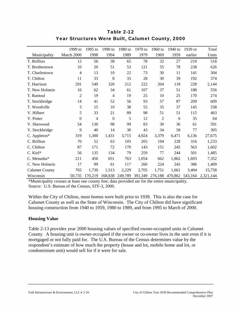
Foth Infrastructure & Environment, LLC • 2-16 City of Chilton Year 2030 Recommended Comprehensive Plan December 2007
Table 2-12 Year Structures Were Built, Calumet County, 2000
*Municipality crosses at least one county line; data provided are for the entire municipality. Source: U.S. Bureau of the Census, STF-3, 2000. Within the City of Chilton, most homes were built prior to 1939. This is also the case for Calumet County as well as the State of Wisconsin. The City of Chilton did have significant housing construction from 1940 to 1959, 1980 to 1989, and from 1995 to March of 2000. Housing Value
Table 2-13 provides year 2000 housing values of specified owner-occupied units in Calumet County. A housing unit is owner-occupied if the owner or co-owner lives in the unit even if it is mortgaged or not fully paid for. The U.S. Bureau of the Census determines value by the respondent’s estimate of how much the property (house and lot, mobile home and lot, or condominium unit) would sell for if it were for sale.
1999 to 1995 to 1990 to 1980 to 1970 to 1960 to 1940 to 1939 or TotalMunicipality March 2000 1998 1994 1989 1979 1969 1959 earlier Units
T. Brillion 12 56 38 65 78 32 27 210 518T. Brothertown 10 20 51 53 121 55 78 238 626T. Charlestown 4 13 10 22 73 30 11 141 304T. Chilton 11 33 8 33 28 30 39 192 374T. Harrison 291 549 320 212 222 204 118 228 2,144T. New Holstein 16 62 34 61 107 37 51 188 556T. Rantoul 2 19 4 19 25 10 25 170 274T. Stockbridge 14 41 52 56 93 57 87 209 609T. Woodville 3 15 10 38 55 35 37 145 338V. Hilbert 5 33 21 89 98 51 51 115 463V. Potter 0 4 0 5 12 2 6 35 64V. Sherwood 54 130 98 99 83 30 36 61 591V. Stockbridge 9 40 14 30 43 34 58 77 305C. Appleton* 319 1,300 1,431 3,715 4,924 3,379 6,471 6,136 27,675C. Brillion 70 52 63 105 205 194 228 316 1,233C. Chilton 87 171 72 170 143 151 245 563 1,602C. Kiel* 56 135 134 79 259 77 244 501 1,485C. Menasha* 211 456 651 763 1,054 662 1,862 1,693 7,352C. New Holstein 17 99 61 117 260 224 245 386 1,409Calumet County 765 1,730 1,513 2,229 2,705 1,751 1,661 3,404 15,758Wisconsin 50,735 170,219 168,838 249,789 391,349 276,188 470,862 543,164 2,321,144

City of Chilton Year 2030 Recommended Comprehensive Plan Foth Infrastructure & Environment, LLC • 2-17 December 2007
Table 2-13 Housing Values, Calumet County, 2000
*Municipality crosses at least one county line; data provided are for the entire municipality. Source: U.S. Bureau of the Census, STF-3, 2000. According to the 2000 Census, the median value of homes in the City of Chilton was $84,900. This was significantly less than the median value reported for Calumet County and the State of Wisconsin. Persons per Household
Table 2-14 displays the number of persons per household for Calumet County in 1990 and 2000.
Less than $50,000 to $100,000 to $150,000 to $200,000 to $300,000 to $500,000 to $1,000,000 MedianMunicipality $50,000 $99,999 $149,999 $199,999 $299,999 $499,999 $999,999 or more (dollars)
T. Brillion 6 105 82 25 6 6 2 1 $102,900T. Brothertown 11 99 86 56 18 0 2 0 $111,600T. Charlestown 17 47 83 16 14 2 0 0 $114,200T. Chilton 3 52 84 26 14 0 0 0 $119,600T. Harrison 2 185 741 460 201 48 21 0 $144,000T. New Holstein 6 79 89 55 24 0 0 0 $117,900T. Rantoul 8 57 37 23 3 4 0 0 $101,200T. Stockbridge 13 89 133 45 21 7 4 0 $122,100T. Woodville 5 80 63 15 10 0 2 0 $102,200V. Hilbert 6 158 70 5 0 0 0 0 $84,000V. Potter 4 30 4 2 0 0 0 0 $82,300V. Sherwood 4 80 117 133 92 23 10 3 $160,000V. Stockbridge 2 115 36 14 11 13 0 0 $93,900C. Appleton* 265 8,835 5,415 1,479 804 223 31 0 $97,900C. Brillion 28 509 186 34 9 0 0 3 $86,900C. Chilton 67 549 202 67 9 0 0 0 $84,900C. Kiel* 32 471 278 72 17 11 0 0 $95,700C. Menasha* 149 2,357 820 271 97 35 21 7 $87,700C. New Holstein 40 625 204 57 13 0 0 0 $85,700Calumet County 245 3,855 3,603 1,356 590 149 41 7 $109,300Wisconsin 73,450 396,893 343,993 173,519 95,163 30,507 7,353 1,589 $112,200
Foth Infrastructure & Environment, LLC • 2-18 City of Chilton Year 2030 Recommended Comprehensive Plan December 2007
Table 2-14 Persons Per Household, Calumet County, 1990 and 2000
*For 2000, data provided are for the entire municipality. For 1990, data provided are only for portion of municipality in Calumet County. Source: U.S. Bureau of the Census, STF-1, 1990-2000.
The number of persons per household in the City of Chilton has decreased from 2.53 in 1990 to 2.35 in 2000. Community Based Residential Facilities (CBRF)
A Community Based Residential Facility (CBRF) is a home or apartment type setting where five or more unrelated adults live together. The goal of the CBRF is to assist individuals in achieving the highest level of independence of which they are capable. Different populations are targeted by the CBRF and some of these populations include elderly, Alzheimer's, emotionally and mentally disturbed, developmentally and physically disabled, and veterans. A CBRF is required to provide assistance with bathing, dressing, grooming, medication, community and in-house activities, information and referral services, health monitoring, and meals. They are not required to have professional nurses on duty 24 hours a day but do have staff available at all times.
Municipality 1990 2000T. Brillion 3.04 2.87T. Brothertown 3.08 2.68T. Charlestown 3.06 2.71T. Chilton 3.28 3.09T. Harrison 3.02 2.88T. New Holstein 3.07 2.70T. Rantoul 3.59 3.22T. Stockbridge 3.01 2.73T. Woodville 3.47 2.98V. Hilbert 2.59 2.53V. Potter 2.77 2.86V. Sherwood 2.76 2.71V. Stockbridge 2.69 2.45C. Appleton* 2.95 2.52C. Brillion 2.75 2.53C. Chilton 2.53 2.35C. Kiel* 2.98 2.42C. Menasha* 3.04 2.35C. New Holstein 2.63 2.36Calumet County 2.89 2.70Wisconsin 2.61 2.50
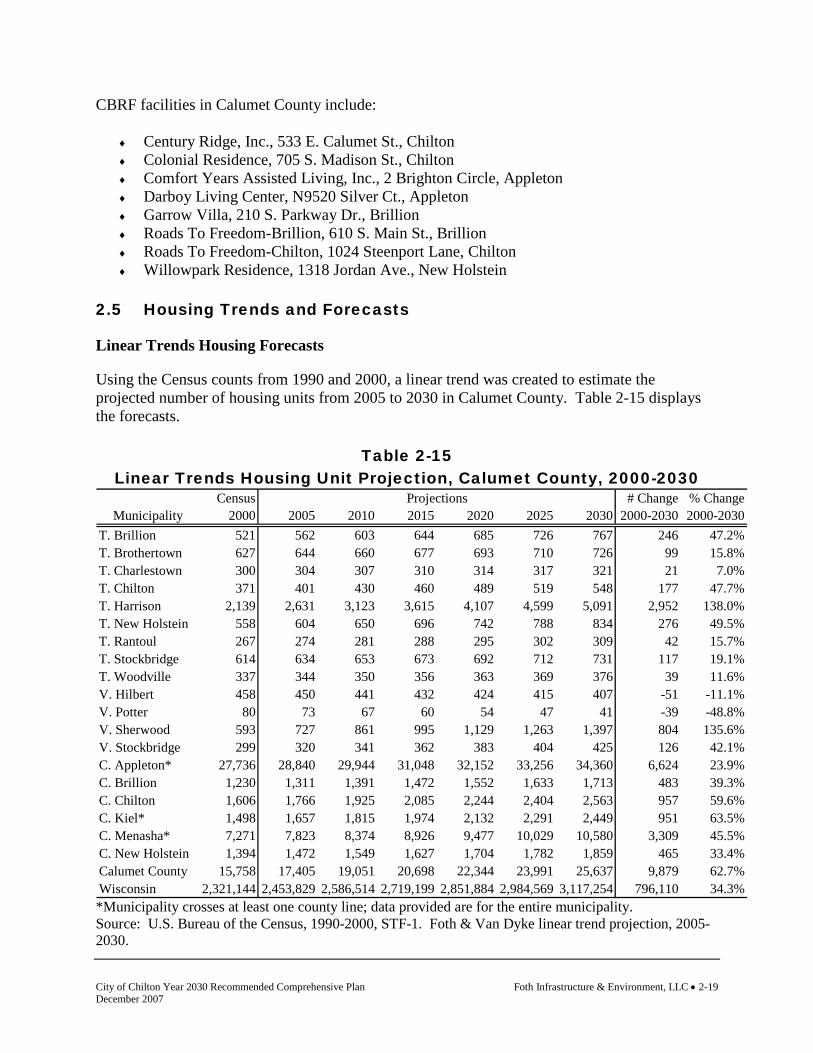
City of Chilton Year 2030 Recommended Comprehensive Plan Foth Infrastructure & Environment, LLC • 2-19 December 2007
CBRF facilities in Calumet County include:
♦ Century Ridge, Inc., 533 E. Calumet St., Chilton ♦ Colonial Residence, 705 S. Madison St., Chilton ♦ Comfort Years Assisted Living, Inc., 2 Brighton Circle, Appleton ♦ Darboy Living Center, N9520 Silver Ct., Appleton ♦ Garrow Villa, 210 S. Parkway Dr., Brillion ♦ Roads To Freedom-Brillion, 610 S. Main St., Brillion ♦ Roads To Freedom-Chilton, 1024 Steenport Lane, Chilton ♦ Willowpark Residence, 1318 Jordan Ave., New Holstein
2.5 Housing Trends and Forecasts
Linear Trends Housing Forecasts
Using the Census counts from 1990 and 2000, a linear trend was created to estimate the projected number of housing units from 2005 to 2030 in Calumet County. Table 2-15 displays the forecasts.
Table 2-15 Linear Trends Housing Unit Projection, Calumet County, 2000-2030
Census # Change % ChangeMunicipality 2000 2005 2010 2015 2020 2025 2030 2000-2030 2000-2030
T. Brillion 521 562 603 644 685 726 767 246 47.2%T. Brothertown 627 644 660 677 693 710 726 99 15.8%T. Charlestown 300 304 307 310 314 317 321 21 7.0%T. Chilton 371 401 430 460 489 519 548 177 47.7%T. Harrison 2,139 2,631 3,123 3,615 4,107 4,599 5,091 2,952 138.0%T. New Holstein 558 604 650 696 742 788 834 276 49.5%T. Rantoul 267 274 281 288 295 302 309 42 15.7%T. Stockbridge 614 634 653 673 692 712 731 117 19.1%T. Woodville 337 344 350 356 363 369 376 39 11.6%V. Hilbert 458 450 441 432 424 415 407 -51 -11.1%V. Potter 80 73 67 60 54 47 41 -39 -48.8%V. Sherwood 593 727 861 995 1,129 1,263 1,397 804 135.6%V. Stockbridge 299 320 341 362 383 404 425 126 42.1%C. Appleton* 27,736 28,840 29,944 31,048 32,152 33,256 34,360 6,624 23.9%C. Brillion 1,230 1,311 1,391 1,472 1,552 1,633 1,713 483 39.3%C. Chilton 1,606 1,766 1,925 2,085 2,244 2,404 2,563 957 59.6%C. Kiel* 1,498 1,657 1,815 1,974 2,132 2,291 2,449 951 63.5%C. Menasha* 7,271 7,823 8,374 8,926 9,477 10,029 10,580 3,309 45.5%C. New Holstein 1,394 1,472 1,549 1,627 1,704 1,782 1,859 465 33.4%Calumet County 15,758 17,405 19,051 20,698 22,344 23,991 25,637 9,879 62.7%Wisconsin 2,321,144 2,453,829 2,586,514 2,719,199 2,851,884 2,984,569 3,117,254 796,110 34.3%
Projections
*Municipality crosses at least one county line; data provided are for the entire municipality. Source: U.S. Bureau of the Census, 1990-2000, STF-1. Foth & Van Dyke linear trend projection, 2005-2030.

Foth Infrastructure & Environment, LLC • 2-20 City of Chilton Year 2030 Recommended Comprehensive Plan December 2007
The linear trend housing unit forecast for the city estimates that 957 housing units will be added to the city between 2000 and 2030, an increase of 59.6%. This high estimate is most likely due to the fact that only 1990 and 2000 data was used to create the linear forecast. During this time the city did experience a high amount of housing growth which is then reflected in the forecast. Building Permit Housing Forecast
Using available information on the number of building permits issued by municipalities and the county, the following forecast was completed. Except where noted, the forecast is based on an 11-year trend of building permit information. Table 2-16 displays the forecasts.
Table 2-16 Building Permit Forecast, Calumet County Municipalities, 2000-2030
Census # Change % ChangeMunicipality 2000 2005 2010 2015 2020 2025 2030 2000-2030 2000-2030
T. Brillion 521 579 637 696 754 812 870 349 67.0%T. Brothertown 627 665 702 740 778 816 853 226 36.1%T. Charlestown 300 310 321 331 342 352 363 63 20.9%T. Chilton 2 371 407 443 479 515 551 587 216 58.2%T. Harrison 2,139 3,009 3,878 4,748 5,617 6,487 7,356 5,217 243.9%T. New Holstein 558 608 659 709 760 810 861 303 54.3%T. Rantoul 267 283 299 315 331 347 362 95 35.8%T. Stockbridge 3 614 666 718 769 821 873 925 311 50.6%T. Woodville 337 359 382 404 426 448 471 134 39.7%V. Hilbert 458 473 487 502 516 531 545 87 19.1%V. Potter 80 86 93 99 105 112 118 38 47.7%V. Sherwood 593 821 1,049 1,278 1,506 1,734 1,962 1,369 230.9%V. Stockbridge 3 299 328 356 385 414 442 471 172 57.5%C. Appleton 1 3,952 4,175 4,397 4,620 4,843 5,066 5,288 1,336 33.8%C. Brillion 1,230 1,276 1,322 1,368 1,414 1,460 1,505 275 22.4%C. Chilton 1,606 1,668 1,731 1,793 1,855 1,917 1,980 374 23.3%C. Kiel 1,4 149 150 151 152 153 154 154 5 3.7%C. Menasha 1,5 263 412 561 710 859 1,008 1,158 895 340.1%C. New Holstein 1,394 1,436 1,478 1,519 1,561 1,603 1,645 251 18.0%Calumet County 15,758 17,711 19,664 21,616 23,569 25,522 27,475 11,717 74.4%
Projections
1 Data are for portion of community in Calumet County only. 2 Includes new homes in shoreland and data obtained from Town Clerk. Clerk data only available for 2000 through 2004. Projections based on five-year average. 3 No data available for 1995. 4 No data available for 1995 and 1996. 5 No data available for 1994, 1995, or 2001. Source: U.S. Bureau of the Census, STF-1, 2000. Calumet County Planning Department, 2004.

City of Chilton Year 2030 Recommended Comprehensive Plan Foth Infrastructure & Environment, LLC • 2-21 December 2007
According to the building permit housing forecast, the City of Chilton is estimated to add a total of 374 housing units between 2000 and 2030, an increase of 23.3%. East Central Wisconsin Regional Planning Commission Household Forecasts
The East Central Wisconsin Regional Planning Commission (ECWRPC), which serves Calumet County, has developed housing forecasts for Calumet County and its municipalities. Official housing projections for the region are not adopted by the Commission, however, for sewer service area planning purposes, draft projections are completed. The Commission has completed two projections utilizing two methodologies for Calumet County. Note that projections are for households rather than total housing units. Households are defined as occupied housing units. Tables 2-17 and 2-18 display the forecasts provided by ECWRPC from 2005 through 2030 for Calumet County.
Table 2-17 ECWRPC Household Forecast A, Calumet County, 2005-2030
# Change % ChangeMunicipality 2000 2005 2010 2015 2020 2025 2030 2000-2030 2000-2030
T. Brillion 501 549 584 615 643 666 682 181 36.1%T. Brothertown 523 543 554 556 551 538 515 -8 -1.5%T. Charlestown 291 292 281 264 240 209 171 -120 -41.2%T. Chilton 366 379 389 395 396 391 380 14 3.8%T. Harrison 1,998 2,913 3,553 4,249 5,001 5,788 6,591 4,593 229.9%T. New Holstein 539 574 593 605 611 609 597 58 10.8%T. Rantoul 261 258 244 223 196 162 121 -140 -53.6%T. Stockbridge 506 539 563 582 596 603 602 96 19.0%T. Woodville 333 329 323 310 291 265 231 -102 -30.6%V. Hilbert 430 445 437 421 396 361 317 -113 -26.3%V. Potter 78 84 90 97 102 108 112 34 43.6%V. Sherwood 572 811 1,008 1,223 1,458 1,705 1,958 1,386 242.3%V. Stockbridge 265 288 307 325 341 354 364 99 37.4%C. Appleton* 3,872 4,096 4,411 4,707 4,988 5,234 5,438 1,566 40.4%C. Brillion 1,155 1,198 1,219 1,223 1,211 1,179 1,127 -28 -2.4%C. Chilton 1,512 1,585 1,657 1,712 1,754 1,776 1,775 263 17.4%C. Kiel* 138 142 147 149 151 150 147 9 6.5%C. Menasha* 241 430 594 778 981 1,200 1,428 1,187 492.5%C. New Holstein 1,329 1,371 1,390 1,389 1,368 1,324 1,257 -72 -5.4%Calumet County 14,910 16,829 18,369 19,870 21,349 22,721 23,948 9,038 60.6%
Projections
*Data only include portion of municipality in Calumet County. Source: East Central Wisconsin Regional Planning Commission, 2004.
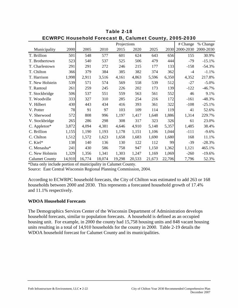
Foth Infrastructure & Environment, LLC • 2-22 City of Chilton Year 2030 Recommended Comprehensive Plan December 2007
Table 2-18 ECWRPC Household Forecast B, Calumet County, 2005-2030
# Change % ChangeMunicipality 2000 2005 2010 2015 2020 2025 2030 2000-2030 2000-2030
T. Brillion 501 548 577 601 624 643 656 155 30.9%T. Brothertown 523 540 537 525 506 479 444 -79 -15.1%T. Charlestown 291 291 272 246 215 177 133 -158 -54.3%T. Chilton 366 379 384 385 382 374 362 -4 -1.1%T. Harrison 1,998 2,911 3,516 4,161 4,863 5,596 6,350 4,352 217.8%T. New Holstein 539 571 574 569 558 539 512 -27 -5.0%T. Rantoul 261 259 245 226 202 173 139 -122 -46.7%T. Stockbridge 506 537 551 559 563 561 552 46 9.1%T. Woodville 333 327 310 285 254 216 172 -161 -48.3%V. Hilbert 430 443 434 416 393 361 322 -108 -25.1%V. Potter 78 91 97 103 109 114 119 41 52.6%V. Sherwood 572 808 996 1,197 1,417 1,648 1,886 1,314 229.7%V. Stockbridge 265 286 298 308 317 323 326 61 23.0%C. Appleton* 3,872 4,094 4,381 4,646 4,910 5,148 5,357 1,485 38.4%C. Brillion 1,155 1,190 1,193 1,178 1,151 1,106 1,044 -111 -9.6%C. Chilton 1,512 1,572 1,623 1,658 1,683 1,690 1,680 168 11.1%C. Kiel* 138 140 136 130 122 112 99 -39 -28.3%C. Menasha* 241 430 586 758 947 1,150 1,362 1,121 465.1%C. New Holstein 1,329 1,356 1,341 1,303 1,247 1,169 1,069 -260 -19.6%Calumet County 14,910 16,774 18,074 19,298 20,533 21,673 22,706 7,796 52.3%
Projections
*Data only include portion of municipality in Calumet County. Source: East Central Wisconsin Regional Planning Commission, 2004. According to ECWRPC household forecasts, the City of Chilton was estimated to add 263 or 168 households between 2000 and 2030. This represents a forecasted household growth of 17.4% and 11.1% respectively. WDOA Household Forecasts
The Demographics Services Center of the Wisconsin Department of Administration develops household forecasts, similar to population forecasts. A household is defined as an occupied housing unit. For example, in 2000 the county had 15,758 housing units and 848 vacant housing units resulting in a total of 14,910 households for the county in 2000. Table 2-19 details the WDOA household forecast for Calumet County and its municipalities.

City of Chilton Year 2030 Recommended Comprehensive Plan Foth Infrastructure & Environment, LLC • 2-23 December 2007
Table 2-19 WDOA Household Forecast, Calumet County, 2000-2025
# Change % ChangeMunicipality 2000 2005 2010 2015 2020 2025 2000-2025 2000-2025
T. Brillion 501 537 576 615 652 688 187 37.3%T. Brothertown 523 526 533 538 542 543 20 3.8%T. Charlestown 291 284 279 272 265 256 -35 -12.0%T. Chilton 366 372 380 387 394 399 33 9.0%T. Harrison 1,998 2,575 3,189 3,803 4,418 5,016 3,018 151.1%T. New Holstein 539 559 584 608 630 650 111 20.6%T. Rantoul 253 244 236 228 219 209 -44 -17.4%T. Stockbridge 506 526 549 571 592 610 104 20.6%T. Woodville 333 324 317 308 300 289 -44 -13.2%V. Hilbert 430 422 416 409 402 392 -38 -8.8%V. Potter 86 95 104 111 119 126 40 46.5%V. Sherwood 572 739 915 1,091 1,267 1,440 868 151.7%V. Stockbridge 265 276 289 300 312 323 58 21.9%C. Appleton* 27,736 28,322 29,897 31,414 32,895 34,114 6,378 23.0%C. Brillion 1,155 1,178 1,211 1,240 1,266 1,286 131 11.3%C. Chilton 1,512 1,586 1,673 1,758 1,839 1,906 394 26.1%C. Kiel* 1,498 1,519 1,624 1,727 1,827 1,907 409 27.3%C. Menasha* 7,271 7,096 7,240 7,362 7,494 7,642 371 5.1%C. New Holstein 1,329 1,332 1,348 1,358 1,366 1,363 34 2.6%Calumet County 14,910 16,262 17,764 19,231 20,679 22,027 7,117 47.7%
Projections
*Municipality crosses at least one county line; data provided are for the entire municipality. Source: Wisconsin Department of Administration, Demographic Services Center. Final Household Projections for Wisconsin Municipalities: 2000-2025. January 2004. The WDOA household forecasts estimates that the city will add 394 households between 2000 and 2025, a growth of 26.1%. Comparative Housing Forecasts
According to available housing unit and household forecasts, the City of Chilton should be prepared for the possibility of experiencing a significant amount of housing growth during the planning period. A growth of 15 to 25% should be anticipated. 2.6 Housing for All Income Levels
Traditionally, most rural towns and small cities have a high percentage of single-family homes, with few other housing types available. Larger communities generally can support and provide a greater variety of housing types, particularly for different income levels. Every community should assess whether the cost of housing in the community matches the ability of residents to pay for it. This is the fundamental question to answer when determining housing affordability and the ability to provide a variety of housing types for various income levels.

Foth Infrastructure & Environment, LLC • 2-24 City of Chilton Year 2030 Recommended Comprehensive Plan December 2007
Although there are many ways to answer this question, the Department of Housing and Urban Development (HUD) offers a common technique, which involves comparing income to housing costs. According to HUD, housing is considered affordable when it costs no more than 30% of total household income (including utilities). Per HUD standards, people should have the choice of having decent and safe housing for no more than 30% of their household income. In the City of Chilton, approximately 14.3% of those with a household mortgage paid 30% or more in monthly owner costs from their household income. For renters in the city, 28.3% paid 30% or more in gross rent as a percentage of their household income. 2.7 Housing for All Age Groups and Persons with Special Needs
As the general population ages, affordability, security, accessibility, proximity to services, transportation, and medical facilities will all become increasingly important. Many of these issues are already important to those with disabilities or other special needs. As new residents move into the area and the population ages, other types of housing must be considered to meet all resident needs. This is particularly true in communities where a large proportion of the population has been long-time residents and there is a desire for these residents to remain in the area during their retirement years. The age structure of the City of Chilton is shifting to older age groups. The majority of the population was in the 20 to 44 age group in 2000. It is anticipated that there will be a shift to the next older age group for the majority of the population during the planning period, requiring the community to further assess its ability to provide housing for all age groups and persons with special needs. The City of Chilton is home to three community based residential facilities as follows:
♦ Century Ridge, Inc., 533 E. Calumet St., Chilton ♦ Colonial Residence, 705 S. Madison St., Chilton ♦ Roads To Freedom-Chilton, 1024 Steenport Lane, Chilton
2.8 Promoting Availability of Land and Housing Stock for
Development/Redevelopment of Low-Income and Moderate-Income Housing
Promoting the availability of underdeveloped or underused land is one way to meet the needs of low- and moderate-income individuals. The community needs to ensure there is an adequate supply of land that is planned or zoned for housing at higher density or for multi-family housing should demand warrant the need for such housing in the future. The community should also use this plan in coordination with developed policies, goals, and objectives to promote the availability of such housing if a need is present. One strategy to promoting the development of affordable housing is to encourage infill development. Infill development is the process of developing vacant or underused parcels within existing urban or developed areas. Infill development contributes to a more compact form of

City of Chilton Year 2030 Recommended Comprehensive Plan Foth Infrastructure & Environment, LLC • 2-25 December 2007
development which is less consumptive of land and resources. Many developers are bypassing vacant urban area land for less expensive land beyond cities or villages edges. A pattern of lower-density development at the urban fringe consumes land (including farmlands, wetlands, and other resource lands) at a much faster rate than redevelopment and infill areas, and typically carries a higher infrastructure cost. Infill housing development promotes utilization of existing utilities and community facilities, conservation of environmental resources, compact transportation patterns, and overall lower cost housing development. The City of Chilton, through this planning process, has identified an ample amount of vacant acreage for residential development to occur. Map 8-3, Preferred Land Use, identifies vacant areas within the city for future residential development. Approximately 180 acres of undeveloped property has been designated for future residential development. 2.9 Maintaining and Rehabilitating the Existing Housing Stock
The maintenance and rehabilitation of the existing housing stock within the community is one of the most effective ways to ensure safe and generally affordable housing while not sacrificing land to development. Over the course of the planning period, the community should continually monitor local housing stock characteristics including, but not limited to, price, aesthetics, safety, cleanliness, and overall suitability with community character. The monitoring process will become important to ensure that steps are taken to preserve the current housing supply before allowing for new development, which has far greater impacts on community resources. To assist in repairing homes, the City of Chilton, through a grant from the Wisconsin Department of Administration, has established the Community Development Block Grant Program (CDBG). Chilton's CDBG Program, which began in 1979, has assisted more than 250 families in purchasing and/or remodeling their homes. There are certain criteria in order to be eligible for a CDBG loan. The CDBG can provide a maximum loan of $15,000 to homeowners to do needed repairs on their homes. Additionally, the CDBG loan can be used to provide a 50 percent match on a down payment of a new home and/or can be used to pay for closing costs. For more information about Chilton's Community Development Block Grant Loans or for a loan application, please contact Chilton City Hall. 2.10 Housing Goals and Objectives
The following are the goals and objectives developed by the City of Chilton regarding housing. (The source of each goal and objective is noted in parentheses.) Goal: To preserve, enhance, and expand the residential character in areas of single-family
housing (City of Chilton Comprehensive Plan, 1998). Objectives 1. Direct residential subdivision development to planned growth areas (Smart Growth
Planning Process).

Foth Infrastructure & Environment, LLC • 2-26 City of Chilton Year 2030 Recommended Comprehensive Plan December 2007
2. Continue to support the city's use of community development block grants for improving housing in the city and supporting home ownership (Smart Growth Planning Process).
Goal: To preserve and develop high quality housing areas to satisfy the demand for an
adequate number of dwellings of various types of densities (City of Chilton Comprehensive Plan, 1998).
Objectives 1. Plan for residential development that provides a balance of low-income, moderate-income,
and high-income housing, and an appropriate mix of single-family, two-family, multi-family, and senior housing (Smart Growth Planning Process).
2. Maintain local and regional efforts to create quality housing with rents affordable to
working families, elderly, and special-need individuals (Smart Growth Planning Process). Goal: Maintain an adequate, balanced housing supply that will meet the needs of current and
future residents and promote a range of housing choices for anticipated income levels, age groups, and special housing needs (Smart Growth Planning Process).
Objectives 1. Designate areas suitable for the development of apartments and similar medium density
residential uses (City of Chilton Comprehensive Plan, 1998). 2. Promote the availability of assisted living and elder care facilities while continually
monitoring the housing needs of the aging population (Smart Growth Planning Process). 3. Support opportunities for high-density residential development within existing
neighborhoods with established sewer, water, parks, sidewalks, and other public infrastructure and facilities (Smart Growth Planning Process).
4. Annually assess the availability of developable land for residential development (Smart
Growth Planning Process). Goal: Provide for housing development that maintains the attractiveness and characteristics
of the city. Objectives 1. Encourage well-designed residential development which provides connectivity between
neighborhoods and activity areas in the city (Smart Growth Planning Process). 2. Encourage the preservation, maintenance, and rehabilitation of historically significant
homes (Smart Growth Planning Process).

City of Chilton Year 2030 Recommended Comprehensive Plan Foth Infrastructure & Environment, LLC • 2-27 December 2007
3. Promote the development of low to moderate-income housing that is consistent in quality, character, and location with the city’s comprehensive plan (Smart Growth Planning Process).
4. Support the use of creative development designs that preserve community character and
natural resources (Smart Growth Planning Process). 5. Enforce zoning, nuisance abatement, and building code requirements in blighted residential
areas (Smart Growth Planning Process). 6. Work toward the removal of blighting influences from residential areas and support the
renewal of deteriorating residential neighborhoods (City of Chilton Comprehensive Plan, 1998).
7. Continue to infill the under-developed residential areas of the city as much as possible prior
to annexing new territory (City of Chilton Comprehensive Plan, 1998). 2.11 Housing Policies and Recommendations
Policies and recommendations build on goals and objectives by providing more focused responses and actions to the goals and objectives. Policies and recommendations become the tools that the community should use to aid in making land use decisions. Policies that direct action using the words “will” or “shall” are advised to be mandatory and regulatory aspects of the implementation of the comprehensive plan. In contrast, those policies that direct action using the word “should” are advisory and intended to serve as a guide. Policies
1. Building and housing codes shall be utilized to ensure the safety of new and existing housing (Smart Growth Planning Process).
2. The city shall utilize the subdivision ordinance to ensure the provision of adequate
infrastructure (City of Chilton Comprehensive Plan, 1998). 3. The city shall prevent the incursion of incompatible, non-residential uses into residential
neighborhoods. Utilize the zoning ordinance and the comprehensive plan when developing new land uses (City of Chilton Comprehensive Plan, 1998).
4. Allow housing opportunities for those with low and moderate income, elderly and
handicapped. Utilize state and federal grants and programs wherever possible to assist in the provision of housing. Such housing should be located in close proximity to services and community facilities (City of Chilton Comprehensive Plan, 1998).
5. Periodically as needed, the city will evaluate its preparedness for an increasing demand for
elderly housing and assisted living facilities (Smart Growth Planning Process).

Foth Infrastructure & Environment, LLC • 2-28 City of Chilton Year 2030 Recommended Comprehensive Plan December 2007
Recommendations
Recommendations are specific actions or projects that the community should be prepared to complete. Completion of these actions and projects is consistent with the community’s policies, and therefore will help fulfill the comprehensive plan goals and objectives. 1. Pursue the development of an additional senior housing project based on market research. 2. Plan for and appropriately zone for adequate undeveloped land to accommodate various
forms of new housing development. 2.12 Housing Programs
The following programs are currently utilized by the community or are available for use by the community to implement the goals, objectives, policies, and recommendations identified. Chilton CDBG Program To assist in either purchasing a new home or repairing one, the City of Chilton, through a grant from the Wisconsin Department of Administration has established the Community Development Block Grant Program (CDBG). Chilton's CDBG Program, which began in 1979, has assisted more than 250 families in purchasing and/or remodeling their homes. There are certain criteria in order to be eligible for a CDBG loan. The CDBG can provide a maximum loan of $15,000 to home owners to do needed repairs on their homes. Additionally, the CDBG loan can provide up to $10,000 for new home purchases. For more information about Chilton's Community Development Block Grant Loans or for a loan application, please contact Chilton City Hall. Chilton Housing Authority – Stanton Place The Housing Authority of the City of Chilton owns and operates Stanton Place, an independent living center for the elderly. Stanton Place is a single-story, 32-unit apartment building providing independent living for the elderly. This complex was constructed in 1983. Three of the apartments are designed especially for use by handicapped residents. Eligible applicants must be 62 years of age (unless handicapped or disabled according to federal guidelines) and meet the income requirements determined by the Department of Housing and Urban Development. For further information, contact the Stanton Place Director. Calumet County Homebuyer Program The Calumet County Homebuyer Program is offered through the county’s planning department and is administered by Mary Bach of Community Housing Coordinators. Funds are allocated to qualifying persons in order to help them make a down payment on a home, make repairs to a home they are purchasing, or even construct a home. Applicants must be income eligible to qualify for services and family size also helps determine eligibility. Applicant must complete an application, participate in homebuyer classes and financial counseling, prepare a spending/savings plan, and use a minimum of $1,000 of personal funds toward the down payment. Applications are available at the County Planning Department office. For more information call Mary Bach at (920) 470-3333.

City of Chilton Year 2030 Recommended Comprehensive Plan Foth Infrastructure & Environment, LLC • 2-29 December 2007
Wisconsin Rural Development, Rural Housing Service The mission of the Rural Housing Service is to enhance the quality of life of rural people through the creation of safe, affordable housing where people can live, work, and prosper as part of a community. The Wisconsin Rural Housing Service offers housing preservation grants, loans and grants for farm labor housing, loans and grants for home improvement and repair, loans for financing housing site development, loans for home purchase or construction, loans on apartment buildings, and self-help technical assistance grants. For further information visit the web-site at www.rurdev.usda.gov/wi/index.html. CAP (Community Action Program) Services, Inc. CAP has been on the frontline of the war on poverty since 1966. As a private, non-profit corporation, CAP offers programs in Marquette, Outagamie, Portage, Waupaca, and Waushara counties as well as in parts of Calumet and Wood counties. CAP Services, Inc. is a member of the Wisconsin Community Action Program Association (WISCAP). CAP offers a number of housing related programs including home buyer’s assistance, weatherization, housing rehabilitation, rental housing assistance, and a lease/purchase program. For more information about CAP Services, Inc. visit their web-site at www.capserv.org. Outagamie Weatherization The weatherization program may help with home weatherization repair and rehab. Outagamie Weatherization manages this program on behalf of Calumet County. For more information on this program call Outagamie Weatherization at (920) 731-7566. Local Housing Organization Grants (LHOG) LHOGs enable community-based organizations and public housing authorities to provide affordable housing opportunities. The program is funded from state general purpose revenue funds. It is administered by the Wisconsin Division of Housing and Intergovernmental Relations (DHIR) and is distributed statewide in response to RFPs on a competitive basis. Habitat for Humanity The goal of this program is to eliminate inadequate housing and poverty housing throughout the world. Local affiliates, including dozens in Wisconsin, are responsible for raising funds, recruiting volunteers, identifying project sites, and constructing owner-occupied housing for the benefit of participating low-income families. Visit www.habitat.org. Wisconsin Housing and Economic Development Authority (WHEDA) The Wisconsin Housing and Economic Development Authority serves Wisconsin residents and communities by working with others to provide creative financing resources and information to stimulate and preserve affordable housing, small business, and agribusiness. Visit the web-page at www.wheda.com Wisconsin Home Energy Assistance Program (WHEAP/LIHEAP) The Energy Services Bureau oversees Wisconsin's Home Energy Assistance Program. This includes the federally funded Low Income Home Energy Assistance Program (LIHEAP) and other related programs. Households with incomes at or below 150% of the federal poverty level
Foth Infrastructure & Environment, LLC • 2-30 City of Chilton Year 2030 Recommended Comprehensive Plan December 2007
may be eligible for assistance. Many households with income from farms, offices, factories, and other work places receive LIHEAP assistance. Visit the web-site for further information, www.heat.doa.state.wi.us/liheap/default.asp Historic Home Owner’s Tax Credits A 25% Wisconsin investment tax credit is available for people who rehabilitate historic non-income producing, personal residences, and who apply for and receive project approval before beginning physical work on their projects. For more information contact the Wisconsin Historical Society.

City of Chilton Year 2030 Recommended Comprehensive Plan Foth Infrastructure & Environment, LLC • 3-1 December 2007
Bridge near downtown Chilton
3. Transportation 3.1 Introduction
Broadly speaking, a transportation system can be defined as any means used to move people and/or products. A community relies daily on its transportation system to transport people and goods effectively and efficiently. It should also have the ability to link the community to neighboring communities and beyond. Additionally, the system should be able to accommodate a variety of transportation modes. Roads and highways account for the majority of a transportation system and are probably the most common paths, however, they are not the only component. Rail lines, waterways, airways, and trails can also contribute to the entire transportation system. Taken together, these individual transportation options create a community’s transportation system. The following sections discuss in more detail, specific information about Chilton’s transportation system. 3.2 Existing Road System
Primary roadways within the community include the following:
♦ STH 57/32 is one of two major roadways linking northern Calumet County to southern destinations in the county. This highway travels from the county’s northern border through Forest Junction, Hilbert, Chilton, New Holstein, and eventually Kiel. This route also provides a linkage to the Green Bay area to the north. This highway provides for north and south entrances to the city and is a major route through the center of the city.
♦ U.S. 151 is a major east-west route for southern Calumet County and the city. This
highway travels from the county’s eastern border through the City of Chilton to the county’s western border. The route then follows the shoreline of Lake Winnebago, providing access to Fond du Lac County.
♦ CTHs F, G, and Y provide minor and major collector functions for the city. CTHs F and
Y will be experiencing reconstruction over the planning period. Table 3-1 shows the total miles of roadway in Calumet County by municipality and by type of roadway.
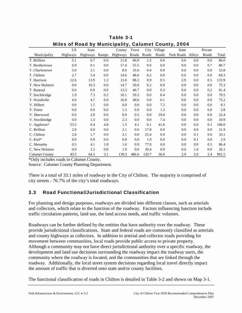
Foth Infrastructure & Environment, LLC • 3-2 City of Chilton Year 2030 Recommended Comprehensive Plan December 2007
Table 3-1
Miles of Road by Municipality, Calumet County, 2004 US State County Town City Village State Private
Municipality Highways Highways Ramps Highways Roads Roads Roads Park Roads Alleys Roads TotalT. Brillion 5.1 6.7 0.0 11.8 60.9 1.5 0.0 0.0 0.0 0.0 86.0T. Brothertown 6.9 0.1 0.0 17.4 55.5 0.0 0.0 0.0 0.0 0.7 80.7T. Charlestown 5.0 3.1 0.0 8.6 35.6 0.4 0.0 0.0 0.0 0.0 52.8T. Chilton 2.7 5.4 0.0 14.6 46.6 0.2 0.0 0.0 0.0 0.0 69.3T. Harrison 12.6 13.9 1.2 13.0 88.3 0.9 0.5 2.9 0.0 0.5 133.9T. New Holstein 0.0 10.3 0.0 14.7 50.0 0.2 0.0 0.0 0.0 0.0 75.3T. Rantoul 0.0 0.9 0.0 13.3 46.7 0.0 0.3 0.0 0.0 0.2 61.4T. Stockbridge 1.9 7.3 0.2 10.1 59.5 0.0 0.4 0.0 0.0 0.0 79.5T. Woodville 4.0 4.7 0.0 16.8 49.6 0.0 0.1 0.0 0.0 0.0 75.2V. Hilbert 0.0 1.5 0.0 0.0 0.0 0.0 7.5 0.0 0.0 0.0 9.1V. Potter 0.0 0.0 0.0 1.5 0.0 0.0 1.3 0.0 0.0 0.0 2.8V. Sherwood 0.0 2.0 0.0 0.9 0.5 0.0 19.0 0.0 0.0 0.0 22.4V. Stockbridge 0.0 1.3 0.0 2.3 0.0 0.0 7.4 0.0 0.0 0.0 10.9C. Appleton* 53.5 0.4 4.8 1.5 4.1 0.1 41.6 0.0 0.0 0.1 106.0C. Brillion 2.0 0.0 0.0 2.1 0.0 17.8 0.0 0.0 0.0 0.0 21.9C. Chilton 2.8 1.7 0.0 3.1 0.0 25.4 0.0 0.0 0.1 0.0 33.1C. Kiel* 0.0 0.9 0.0 0.0 0.0 1.9 0.0 0.0 0.1 0.0 2.9C. Menasha 0.5 4.1 1.8 1.6 0.9 77.0 0.0 0.0 0.0 0.5 86.4C. New Holstein 0.0 2.2 0.0 1.9 0.0 20.4 0.0 0.0 1.6 0.0 26.1Calumet County 43.5 64.5 3.1 139.3 486.6 120.7 36.6 2.9 2.0 2.4 901.5 *Only includes roads in Calumet County. Source: Calumet County Planning Department. There is a total of 33.1 miles of roadway in the City of Chilton. The majority is comprised of city streets - 76.7% of the city’s total roadways. 3.3 Road Functional/Jurisdictional Classification
For planning and design purposes, roadways are divided into different classes, such as arterials and collectors, which relate to the function of the roadway. Factors influencing function include traffic circulation patterns, land use, the land access needs, and traffic volumes. Roadways can be further defined by the entities that have authority over the roadway. These provide jurisdictional classifications. State and federal roads are commonly classified as arterials and county highways as collectors. In addition to arterial and collector roads providing for movement between communities, local roads provide public access to private property. Although a community may not have direct jurisdictional authority over a specific roadway, the development and land use decisions surrounding the roadway impact the roadway users, the community where the roadway is located, and the communities that are linked through the roadway. Additionally, the local street system decisions regarding local travel directly impact the amount of traffic that is diverted onto state and/or county facilities. The functional classification of roads in Chilton is detailed in Table 3-2 and shown on Map 3-1.
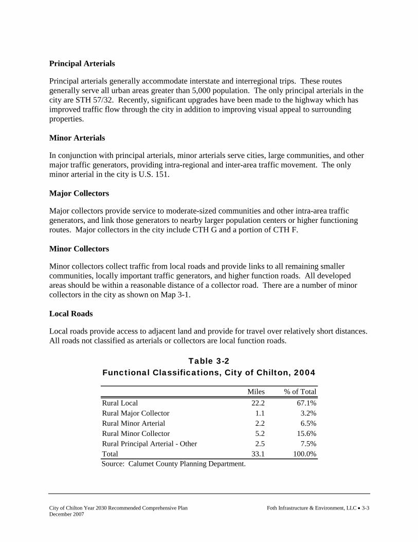
City of Chilton Year 2030 Recommended Comprehensive Plan Foth Infrastructure & Environment, LLC • 3-3 December 2007
Principal Arterials
Principal arterials generally accommodate interstate and interregional trips. These routes generally serve all urban areas greater than 5,000 population. The only principal arterials in the city are STH 57/32. Recently, significant upgrades have been made to the highway which has improved traffic flow through the city in addition to improving visual appeal to surrounding properties. Minor Arterials
In conjunction with principal arterials, minor arterials serve cities, large communities, and other major traffic generators, providing intra-regional and inter-area traffic movement. The only minor arterial in the city is U.S. 151. Major Collectors
Major collectors provide service to moderate-sized communities and other intra-area traffic generators, and link those generators to nearby larger population centers or higher functioning routes. Major collectors in the city include CTH G and a portion of CTH F. Minor Collectors
Minor collectors collect traffic from local roads and provide links to all remaining smaller communities, locally important traffic generators, and higher function roads. All developed areas should be within a reasonable distance of a collector road. There are a number of minor collectors in the city as shown on Map 3-1. Local Roads
Local roads provide access to adjacent land and provide for travel over relatively short distances. All roads not classified as arterials or collectors are local function roads.
Table 3-2 Functional Classifications, City of Chilton, 2004
Miles % of Total
Rural Local 22.2 67.1%Rural Major Collector 1.1 3.2%Rural Minor Arterial 2.2 6.5%Rural Minor Collector 5.2 15.6%Rural Principal Arterial - Other 2.5 7.5%Total 33.1 100.0% Source: Calumet County Planning Department.

Foth Infrastructure & Environment, LLC • 3-4 City of Chilton Year 2030 Recommended Comprehensive Plan December 2007
This page intentionally left blank.

City of Chilton Year 2030 Recommended Comprehensive Plan Foth Infrastructure & Environment, LLC • 3-5 December 2007
Map 3-1 Existing Transportation System

Foth Infrastructure & Environment, LLC • 3-6 City of Chilton Year 2030 Recommended Comprehensive Plan December 2007
This page intentionally left blank.
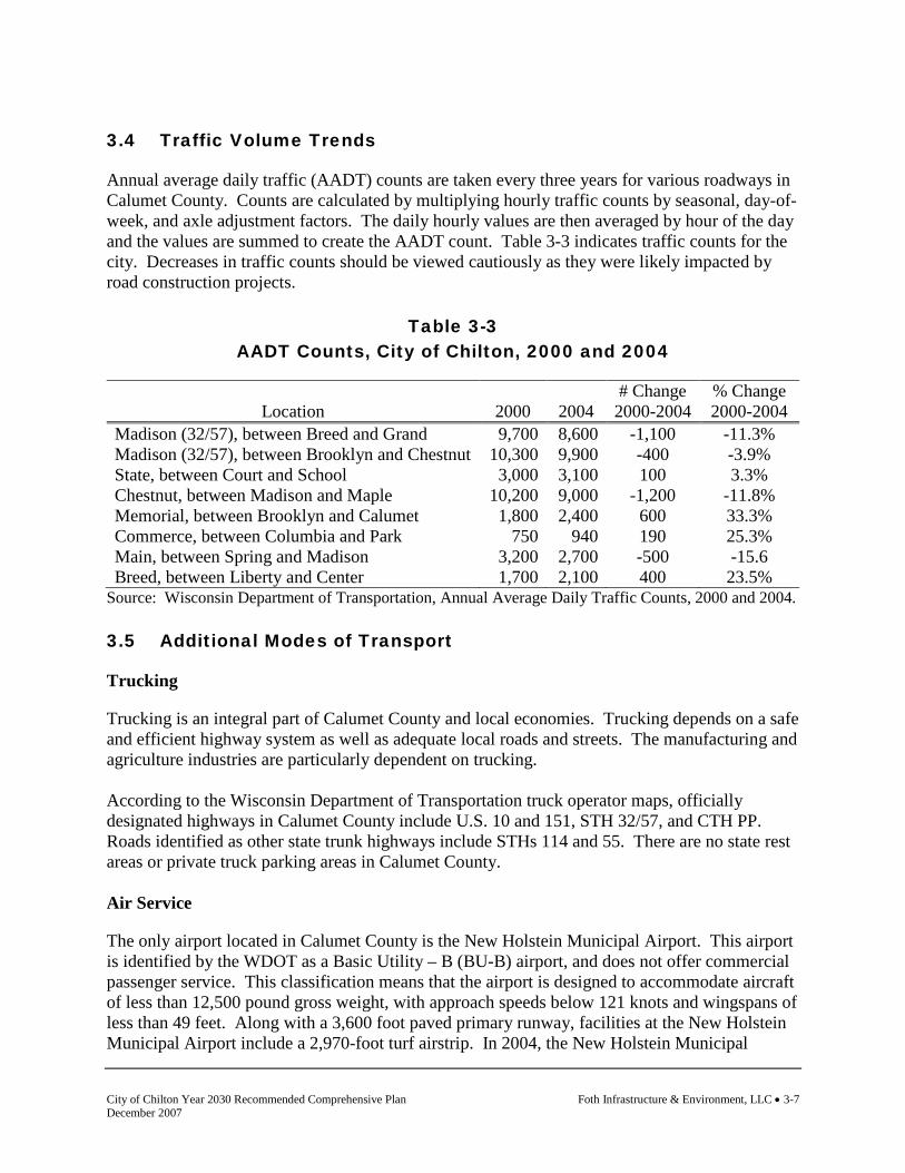
City of Chilton Year 2030 Recommended Comprehensive Plan Foth Infrastructure & Environment, LLC • 3-7 December 2007
3.4 Traffic Volume Trends
Annual average daily traffic (AADT) counts are taken every three years for various roadways in Calumet County. Counts are calculated by multiplying hourly traffic counts by seasonal, day-of-week, and axle adjustment factors. The daily hourly values are then averaged by hour of the day and the values are summed to create the AADT count. Table 3-3 indicates traffic counts for the city. Decreases in traffic counts should be viewed cautiously as they were likely impacted by road construction projects.
Table 3-3 AADT Counts, City of Chilton, 2000 and 2004
Location 2000 2004 # Change
2000-2004 % Change 2000-2004
Madison (32/57), between Breed and Grand 9,700 8,600 -1,100 -11.3% Madison (32/57), between Brooklyn and Chestnut 10,300 9,900 -400 -3.9% State, between Court and School 3,000 3,100 100 3.3% Chestnut, between Madison and Maple 10,200 9,000 -1,200 -11.8% Memorial, between Brooklyn and Calumet 1,800 2,400 600 33.3% Commerce, between Columbia and Park 750 940 190 25.3% Main, between Spring and Madison 3,200 2,700 -500 -15.6 Breed, between Liberty and Center 1,700 2,100 400 23.5%
Source: Wisconsin Department of Transportation, Annual Average Daily Traffic Counts, 2000 and 2004. 3.5 Additional Modes of Transport
Trucking
Trucking is an integral part of Calumet County and local economies. Trucking depends on a safe and efficient highway system as well as adequate local roads and streets. The manufacturing and agriculture industries are particularly dependent on trucking. According to the Wisconsin Department of Transportation truck operator maps, officially designated highways in Calumet County include U.S. 10 and 151, STH 32/57, and CTH PP. Roads identified as other state trunk highways include STHs 114 and 55. There are no state rest areas or private truck parking areas in Calumet County. Air Service
The only airport located in Calumet County is the New Holstein Municipal Airport. This airport is identified by the WDOT as a Basic Utility – B (BU-B) airport, and does not offer commercial passenger service. This classification means that the airport is designed to accommodate aircraft of less than 12,500 pound gross weight, with approach speeds below 121 knots and wingspans of less than 49 feet. Along with a 3,600 foot paved primary runway, facilities at the New Holstein Municipal Airport include a 2,970-foot turf airstrip. In 2004, the New Holstein Municipal
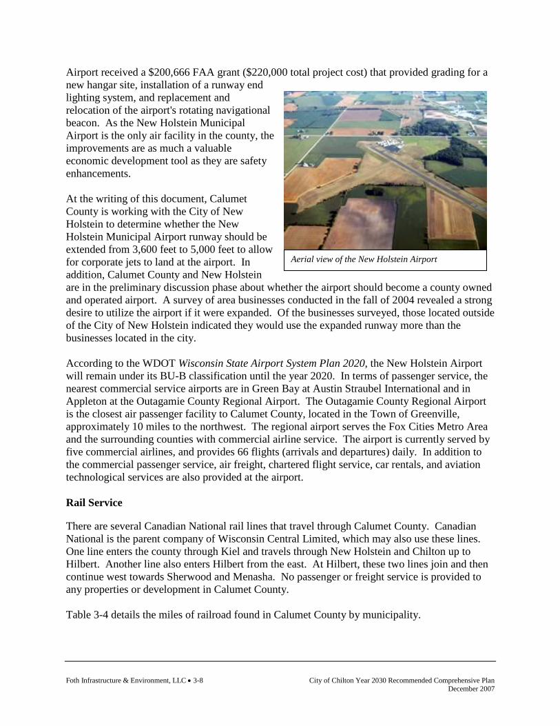
Foth Infrastructure & Environment, LLC • 3-8 City of Chilton Year 2030 Recommended Comprehensive Plan December 2007
Aerial view of the New Holstein Airport
Airport received a $200,666 FAA grant ($220,000 total project cost) that provided grading for a new hangar site, installation of a runway end lighting system, and replacement and relocation of the airport's rotating navigational beacon. As the New Holstein Municipal Airport is the only air facility in the county, the improvements are as much a valuable economic development tool as they are safety enhancements. At the writing of this document, Calumet County is working with the City of New Holstein to determine whether the New Holstein Municipal Airport runway should be extended from 3,600 feet to 5,000 feet to allow for corporate jets to land at the airport. In addition, Calumet County and New Holstein are in the preliminary discussion phase about whether the airport should become a county owned and operated airport. A survey of area businesses conducted in the fall of 2004 revealed a strong desire to utilize the airport if it were expanded. Of the businesses surveyed, those located outside of the City of New Holstein indicated they would use the expanded runway more than the businesses located in the city. According to the WDOT Wisconsin State Airport System Plan 2020, the New Holstein Airport will remain under its BU-B classification until the year 2020. In terms of passenger service, the nearest commercial service airports are in Green Bay at Austin Straubel International and in Appleton at the Outagamie County Regional Airport. The Outagamie County Regional Airport is the closest air passenger facility to Calumet County, located in the Town of Greenville, approximately 10 miles to the northwest. The regional airport serves the Fox Cities Metro Area and the surrounding counties with commercial airline service. The airport is currently served by five commercial airlines, and provides 66 flights (arrivals and departures) daily. In addition to the commercial passenger service, air freight, chartered flight service, car rentals, and aviation technological services are also provided at the airport. Rail Service
There are several Canadian National rail lines that travel through Calumet County. Canadian National is the parent company of Wisconsin Central Limited, which may also use these lines. One line enters the county through Kiel and travels through New Holstein and Chilton up to Hilbert. Another line also enters Hilbert from the east. At Hilbert, these two lines join and then continue west towards Sherwood and Menasha. No passenger or freight service is provided to any properties or development in Calumet County. Table 3-4 details the miles of railroad found in Calumet County by municipality.

City of Chilton Year 2030 Recommended Comprehensive Plan Foth Infrastructure & Environment, LLC • 3-9 December 2007
Table 3-4
Railroad Miles, Calumet County, 2004 % of
Municipality Miles TotalT. Brillion 9.3 15.6%T. Brothertown 0.0 0.0%T. Charlestown 4.3 7.2%T. Chilton 5.4 8.9%T. Harrison 7.2 12.0%T. New Holstein 3.9 6.6%T. Rantoul 7.1 11.7%T. Stockbridge 0.0 0.0%T. Woodville 4.7 7.8%V. Hilbert 5.1 8.5%V. Potter 0.9 1.4%V. Sherwood 1.4 2.3%V. Stockbridge 0.0 0.0%C. Appleton* 0.0 0.0%C. Brillion 3.7 6.2%C. Chilton 3.3 5.5%C. Kiel* 1.3 2.1%C. Menasha* 0.0 0.0%C. New Holstein 2.5 4.2%Calumet County 60.0 100.0%
*Data provided are for rail located in Calumet County only. Source: Calumet County Planning Department.
The City of Chilton is home to 3.3 miles of railroad. The rail line in Chilton is generally located in the northeast portion of the city and abuts a significant amount of industrial property. Businesses which currently utilize the available rail in the city include Worthington Industries, Kaytee, Briess Industries, and Chilton Co-op. Water Transport
Calumet County shares the majority of its western border with Lake Winnebago. While there are a number of marinas and boat landings on its shores, there are no commercial ferries or cruise lines offering passage on the lake. Calumet County is also relatively close to the Bay of Green Bay and Lake Michigan. Both of these water bodies offer commercial services and ports. The Port of Manitowoc handles bulk commodities, newly constructed yachts, and offers a car ferry. The Port of Green Bay is served by a major railroad and several nationally known truck lines providing overnight delivery of goods within a 400-mile radius.

Foth Infrastructure & Environment, LLC • 3-10 City of Chilton Year 2030 Recommended Comprehensive Plan December 2007
Pedestrian and Bicycle Corridors
Pedestrian travel is an integral part of the total transportation picture. Many people rely on walking for exercise as well as for travel from their homes to work, school, or shopping. For the elderly, children, and those who are disabled, having safe and convenient pedestrian facilities is often essential to daily activities. The communities of New Holstein and Kiel boast the Solomon Trail, a paved hiking and biking trail that connects the two communities. The four-mile trail runs along STH 32/57 and under the railroad viaduct. In Kiel, the trail system connects to the River Walk trail, which adds another four miles of scenic hiking and biking trails. Sidewalks are typically installed to provide safe access from residential neighborhoods to heavily used public facilities like libraries, schools and parks. The city exercises a sidewalk policy found within the city zoning ordinance. Transit
There are currently no public transportation systems or bus services in Calumet County. There are urban bus services available in Green Bay, Oshkosh, Fond du Lac, and there is a Fox Cities transit system. A new transit service was announced in June of 2005 between the Fox Cities and Chilton. The New Hope Center in Chilton offers a van to meet passengers twice a day at the new Goodwill location in Darboy where passengers will be able to make connections to and from Valley Transit’s Route 9 – E. College bus route. Transportation for Persons with Disabilities
Specialized public transportation services for the elderly, disabled, and other persons with similar needs for more accessible vehicles is referred to as paratransit. There are currently limited services for individuals requiring paratransit in Calumet County. Taxi service is available in Menasha and other Fox Cities communities, but is limited in Calumet County. There is a volunteer transportation service coordinated through the Calumet County Senior Resources Center that links volunteer drivers with people in need on a request basis.
City of Chilton Year 2030 Recommended Comprehensive Plan Foth Infrastructure & Environment, LLC • 3-11 December 2007
Transportation Impacts Every Level of Government
Coordinated development is an essential component to maintaining roadway functionality. Assessing the impacts on the transportation system through development review and impact analysis prior to development approval is becoming more important at all levels of jurisdictional authority, not just in the heavily populated areas.
3.6 Existing State and Regional Transportation Plans and Coordination
There are currently no transportation related planning documents solely for Calumet County or the City of Chilton. State Plans
The Wisconsin Department of Transportation maintains several plans with statewide policies and recommendations regarding various aspects of transportation. These plans should be taken into consideration when making future transportation decisions. These plans have been reviewed and coordinated throughout the planning process.
♦ Translink 21: A Multi-modal Transportation Plan for Wisconsin’s 21st Century (This plan has been replaced with Corridors 2020. Corridors 2020 is now being updated and will be replaced with Connections 2030 in the next few years.)
♦ Wisconsin State Highway Plan 2020 ♦ Wisconsin Bicycle Transportation Plan 2020 ♦ Wisconsin State Airport System Plan 2020 ♦ Five Year Airport Improvement Plan, 2002 ♦ Wisconsin State Pedestrian Plan 2020 ♦ Wisconsin State Rail Plan (a component of Connections 2030) ♦ Wisconsin Department of Transportation Access Management System Plan ♦ Wisconsin DNR State Trails Network Plan ♦ Statewide Transportation Improvement Plan ♦ Six-Year Highway Improvement Program
Regional Plans
The East Central Wisconsin Regional Planning Commission (ECWRPC) is the official comprehensive planning agency for the East Central Wisconsin Counties of Calumet, Fond du Lac, Green Lake, Marquette, Menominee, Outagamie, Shawano, Waupaca, Waushara, and Winnebago. Services provided by the Commission include land use, comprehensive, and transportation planning for the region. The Transportation Program of the Commission addresses the Transportation element of the comprehensive planning requirements and also has three major functional work elements: the Long Range Plans for the Fox Valley Area Transportation Study area, the Transportation System Management Plan for the urbanized areas, and the Regional Transportation Plan. Existing regional plans were reviewed and coordinated throughout the planning process.
Foth Infrastructure & Environment, LLC • 3-12 City of Chilton Year 2030 Recommended Comprehensive Plan December 2007
3.7 Planned Transportation Improvements
State Transportation Projects
Since 1996, the City of Chilton has experienced significant highway improvements. These improvements have improved traffic flow through the city, upgraded the pedestrian linkages, and improved the appearance of the downtown area. One state project which still needs completion is a reconstruction of USH 151 from STH 32/57 (Madison St.) west to Heimann Street. County Transportation Projects
The Calumet County Highway Department develops and/or revises a five-year capital improvement plan every year. The following are planned projects for 2006 through 2010 that will affect the City of Chilton:
♦ 2007: "Y": STH 32/57 Madison Street to Park Street ♦ 2009: "F": Grand Street to USH "151", Design with City of Chilton ♦ 2010: "Y": Park Street to Breed Street, Design with City of Chilton
3.8 Transportation Goals and Objectives
Following are the goals and objectives developed by the City of Chilton regarding transportation. (The source of each goal and objective is noted in parentheses.) Goal: Maintain and improve the quality, safety, and efficiency of the transportation networks
in Chilton (City of Chilton Comprehensive Plan, 1998). Objectives 1. Balance competing community desires (i.e., scenic beauty, direct highway access, etc.)
with the need to provide for safe roads, intersections, rail crossings, and other transportation features (Smart Growth Planning Process).
2. Require safe locations and designs for access onto local public roadways (Smart Growth
Planning Process). 3. Monitor the need to improve deficient roadways and plan for improvements by utilizing the
city’s capital improvement planning program (Smart Growth Planning Process). 4. Work to achieve a traffic circulation network that conforms to the planned functional
classification of roadways (Smart Growth Planning Process). 5. Maintain a logical, orderly system of streets, maintaining access between existing
developed areas and new development (City of Chilton Comprehensive Plan, 1998).

City of Chilton Year 2030 Recommended Comprehensive Plan Foth Infrastructure & Environment, LLC • 3-13 December 2007
6. Separate truck traffic from local traffic as much as possible using designated truck routes and taking truck traffic impacts into consideration for new commercial or industrial development (City of Chilton Comprehensive Plan, 1998).
7. Ensure that new development will be designed so that local and through traffic remain
separate wherever feasible (City of Chilton Comprehensive Plan, 1998). 8. Maintain streets and sidewalks so as to keep them safe and attractive (City of Chilton
Comprehensive Plan, 1998). Goal: Provide a cost effective transportation system for the movement of people and goods
(Smart Growth Planning Process). Objectives 1. Continue to work on Main Street redevelopment (City of Chilton 2005-2006 Goals and
Objectives). 2. Require developers to bear an equitable share of the costs for the improvement or
construction of the transportation system (road, bike paths, sidewalks, public transportation, etc.) needed to serve new development (Smart Growth Planning Process).
3. Direct future residential, commercial, and industrial development to roadways capable of
accommodating resulting traffic (Smart Growth Planning Process). 4. Maintain adequate public parking facilities (Smart Growth Planning Process). 5. Plan for adequate parking to serve business patrons and employees (City of Chilton
Comprehensive Plan, 1998). 6. Plan for alternative forms of transportation such as pedestrian and bicycle use by
establishing bicycle lanes and paths, off street trails, and sidewalks (City of Chilton Comprehensive Plan, 1998).
7. Monitor the need for transit options, particularly for senior residents (Smart Growth
Planning Process). 3.9 Transportation Policies and Recommendation
Policies and recommendations build on goals and objectives by providing more focused responses and actions to the goals and objectives. Policies and recommendations become the tools that the community should use to aid in making land use decisions. Policies that direct action using the words “will” or “shall” are advised to be mandatory and regulatory aspects of the implementation of the comprehensive plan. In contrast, those policies that direct action using the word “should” are advisory and intended to serve as a guide.

Foth Infrastructure & Environment, LLC • 3-14 City of Chilton Year 2030 Recommended Comprehensive Plan December 2007
Policies
1. New developments plan for future road extensions by analyzing the neighboring developed and undeveloped parcels of land. Require developers to show how their development will connect to existing and possible future streets (City of Chilton Comprehensive Plan, 1998).
2. The city will consider bicycle and pedestrian safety needs when new roads are proposed or
when roadway improvements are made (Smart Growth Planning Process). 3. Residential development proposals will be designed to include an efficient system of
internal circulation for all vehicles and pedestrians including the provision for external collector streets, and trails where applicable, to feed all traffic onto external arterial roads and highways (Smart Growth Planning Process).
4. The existing road network and public facilities and services will be utilized to
accommodate new development to the maximum extent possible (Smart Growth Planning Process).
Recommendations
Recommendations are specific actions or projects that the community should be prepared to complete. Completion of these actions and projects is consistent with the community’s policies, and therefore will help fulfill the comprehensive plan goals and objectives. Short Term
♦ Install traffic lights at corner of Irish Road and USH 151 ♦ CTH "Y" Reconstruction: Madison Street to Park Street
Long Term
♦ CTH "F" Reconstruction: W. Grand Street to Main Street (US 151) ♦ CTH "Y" Reconstruction: Park Street to Breed Street
3.10 Transportation Programs
The following programs are currently utilized by the community or are available for use by the community to implement the goals, objectives, policies, and recommendations identified. Local Roads Improvement Program (LRIP) Established in 1991, the Local Roads Improvement Program (LRIP) assists local governments in improving seriously deteriorating county highways, town roads, and city and village streets. A reimbursement program, LRIP pays predetermined costs with local governments providing the balance. The program has three basic components: County Highway Improvement (CHIP); Town Road Improvement (TRIP); and Municipal Street Improvement (MSIP). Three additional discretionary programs (CHIP-D, TRIP-D and MSIP-D) allow municipalities to apply for additional funds for high-cost road projects. For more information contact the WDOT.

City of Chilton Year 2030 Recommended Comprehensive Plan Foth Infrastructure & Environment, LLC • 3-15 December 2007
Freight Railroad Programs The Wisconsin Department of Transportation offers two programs to help preserve and improve Wisconsin’s freight rail service: The Freight Railroad Preservation Program (FRPP) and the Freight Railroad Infrastructure Improvement Program (FRIIM). These programs provide local units of government, industries, and railroads the assistance they need to preserve essential rail lines and encourage improvements to existing rail lines. Typical projects include track rehabilitation, spur construction, track acquisition, and storage facility construction. For further information contact the Bureau of Railroads and Harbors of the WDOT. Pavement Surface Evaluation and Rating (PASER) PASER is a simple method of rating asphalt and concrete roads on a scale of 1 to 10 and gravel roads on a scale of 1 to 5, based on visual inspection. PASER manuals and a video explain how and why roads deteriorate, and describe proper repair and replacement techniques. PASER ratings can be put into PASERWARE, an easy to use pavement management software. PASERWARE helps to inventory roads and keep track of their PASER ratings and maintenance histories. It also helps to prioritize road maintenance and improvement needs, calculate project costs, evaluate the consequences of alternative budgets and project selection strategies, and communicate those consequences to the public and local officials. Both PASER and PASERWARE are available from the University of Wisconsin’s Transportation Information Center at no charge. The Center also offers free training courses. Transportation Economic Assistance (TEA) Program The Transportation Economic Assistance program provides 50% state grants to governing bodies, private businesses, and consortiums for road, rail, harbor, and airport projects that help attract employers to Wisconsin, or encourage business and industry to remain and expand in the state. Grants of up to $1 million are available for transportation improvements that are essential for an economic development project. It must be scheduled to begin within three years, have the local government's endorsement, and benefit the public. For more information about this program, contact: Wisconsin Department of Transportation, Division of Transportation Investment Management.

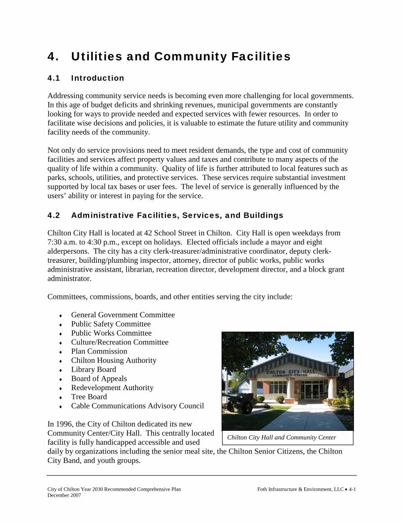
City of Chilton Year 2030 Recommended Comprehensive Plan Foth Infrastructure & Environment, LLC • 4-1 December 2007
Chilton City Hall and Community Center
4. Utilities and Community Facilities 4.1 Introduction
Addressing community service needs is becoming even more challenging for local governments. In this age of budget deficits and shrinking revenues, municipal governments are constantly looking for ways to provide needed and expected services with fewer resources. In order to facilitate wise decisions and policies, it is valuable to estimate the future utility and community facility needs of the community. Not only do service provisions need to meet resident demands, the type and cost of community facilities and services affect property values and taxes and contribute to many aspects of the quality of life within a community. Quality of life is further attributed to local features such as parks, schools, utilities, and protective services. These services require substantial investment supported by local tax bases or user fees. The level of service is generally influenced by the users’ ability or interest in paying for the service. 4.2 Administrative Facilities, Services, and Buildings
Chilton City Hall is located at 42 School Street in Chilton. City Hall is open weekdays from 7:30 a.m. to 4:30 p.m., except on holidays. Elected officials include a mayor and eight alderpersons. The city has a city clerk-treasurer/administrative coordinator, deputy clerk-treasurer, building/plumbing inspector, attorney, director of public works, public works administrative assistant, librarian, recreation director, development director, and a block grant administrator. Committees, commissions, boards, and other entities serving the city include:
♦ General Government Committee ♦ Public Safety Committee ♦ Public Works Committee ♦ Culture/Recreation Committee ♦ Plan Commission ♦ Chilton Housing Authority ♦ Library Board ♦ Board of Appeals ♦ Redevelopment Authority ♦ Tree Board ♦ Cable Communications Advisory Council
In 1996, the City of Chilton dedicated its new Community Center/City Hall. This centrally located facility is fully handicapped accessible and used daily by organizations including the senior meal site, the Chilton Senior Citizens, the Chilton City Band, and youth groups.
Foth Infrastructure & Environment, LLC • 4-2 City of Chilton Year 2030 Recommended Comprehensive Plan December 2007
4.3 Police Services
Chilton Police Department Chilton Police Department staff includes a police chief, five uniformed patrol officers, eight special police, and four crossing guards. 4.4 Emergency Medical Services
Calumet Medical Services Calumet Medical Services provides service to the greatest number of communities in Calumet County including the Towns of Rantoul, Chilton, Stockbridge, Charlestown, Brothertown, and portions of New Holstein and Woodville. Calumet Medical Services also serves the Villages of Hilbert and Potter and the Cities of Chilton and New Holstein. Twenty four hour paramedic and first responders service is provided. 4.5 Fire Protection Services
Chilton Volunteer Fire Department The Chilton Fire Department is a volunteer-based, paid per call department. The department serves the City of Chilton. Portions of the Townships of Brothertown, Chilton, and Charlestown are included. Volunteer staff includes a fire chief, assistant fire chief, battalion chief, secretary/treasurer, and fire fighters. There are a total of 38 personnel. In March of 2003 the department received a new Pierce fire truck. The new engine is capable of carrying 2,000 gallons of water. The department has a total of three pumpers, one tanker, one pumper/tanker, and one aerial unit. The department also has one grass unit and a command/rescue vehicle. 4.6 Schools
Chilton School District
Schools within the district include Chilton Elementary School, Chilton Middle School, and Chilton High School. The district serves the City of Chilton and portions of the Towns of Chilton, Rantoul, Stockbridge, Brothertown, small portion of New Holstein, and the majority of Charlestown. The elementary and middle school were newly renovated and the high school is an entirely new facility that was completed in 2003. Chilton Area Catholic School is a private school located in the City of Chilton. This school was completely renovated in 2003. The school is an elementary school providing education for three year old through sixth grade.

City of Chilton Year 2030 Recommended Comprehensive Plan Foth Infrastructure & Environment, LLC • 4-3 December 2007
Map 4-1 Existing Utilities and Community Facilities

Foth Infrastructure & Environment, LLC • 4-4 City of Chilton Year 2030 Recommended Comprehensive Plan December 2007
This page intentionally left blank.

City of Chilton Year 2030 Recommended Comprehensive Plan Foth Infrastructure & Environment, LLC • 4-5 December 2007
Chilton Public Library
Higher Education
A Fox Valley Technical College (FVTC) site is located in the City of Chilton, which was constructed in 2002. This regional center has five major areas to serve the public: specialized training for business and industry, credit classes for technical and associate degrees, continuing education classes for license renewals, GED/HSED/GOAL, and hobby classes. FVTC’s main campus is in Appleton. 4.7 Quasi Public Facilities
Churches and Cemeteries
♦ Good Shepherd Catholic Church ♦ St. Martin Lutheran ♦ Ebenezer United Church of Christ ♦ Faith Alliance Church
Libraries
Chilton Public Library is a member of the Manitowoc-Calumet County Library System. The library has internet accessible computers and also serves as the city’s job service center. Post Offices
♦ Chilton Post Office, Main Street, Chilton 4.8 Parks, Recreation, and Open Space
County Owned Facilities
Calumet County Fairgrounds The Calumet County Fairgrounds is a 31-acre parcel in the southwest portion of Chilton. The fairgrounds are owned and maintained by the Calumet County Agricultural Association. Facilities include a grandstand and arena, livestock and exhibition buildings, a pavilion, a number of concession buildings, and a quarter-mile dirt track. Locally Owned Parks, Recreation, and Open Space
The City of Chilton maintains eight parks totaling approximately 54.3 acres, but significant open space acreage is owned by the local public school system. Other open space is also found at the Calumet County Fairgrounds. Refer to Table 4-1.

Foth Infrastructure & Environment, LLC • 4-6 City of Chilton Year 2030 Recommended Comprehensive Plan December 2007
Table 4-1 Existing Park and Recreation Acreage by Ownership,
City of Chilton, 2007
Recreation Area City School Private Hobart Park 16.1 Klinkner Park 5.0 Leahy Lions Lakeshore Park 0.4 Nennig Park 15.5 Kiwanis Riverview Park 0.8 Brewery Hill 1.0 Optimist Riverwalk 3.94 Riverside Park 1.2 Morrissey Park 14.3 Chilton School District 100.0 Chilton Area Catholic School 1.0 Calumet County Fairgrounds 58.0 Total 58.24 101.0 58.0 Source: City of Chilton Open Space and Recreation Plan, 2007.
The City of Chilton maintains eight parks totaling 58.24 acres, but the largest provider of open space acreage in the city is the public school system (Table 3). Although its public school sites contain an estimated 100 acres, the school buildings, parking, and other support facilities occupy much of this acreage. Other open space is found at the Calumet County Fairgrounds (58 acres) and Chilton Area Catholic School (one acre). The City also owns two wetland areas. One wetland is located off of S. Park St. behind the city garage. The second wetland is near the water tower south of MB Lane. Both wetland areas are considered to have recreational trail potential. Brewery Hill Brewery Hill is a small-undeveloped side hill area about an acre in size located on the east side of Park Street across the street from the library. The site’s unique feature is a variety of trees donated and planted by local residents, each identified by a small plaque. Hobart Park Hobart Park, Chilton's most intensively developed park, is located on the banks of the millpond in the southern portion of the city. West Chestnut Street provides access to the park. The park lies adjacent to and north of the Calumet County Fairgrounds. A grove of mature trees provides an attractive setting for the picnic area, which includes 15 to 20 tables and several grills. The shelter was recently updated with power and an enclosed serving area. This area has also been enhanced with the addition of a large piece of play apparatus. An old restroom building located in this area, oversized for normal park activities, has been turned over to the Calumet County Agricultural Association, which operates the fairgrounds. In its place, the City has constructed a restroom/fry stand. To the north, a bandstand has also been constructed. “Summer in the Park”
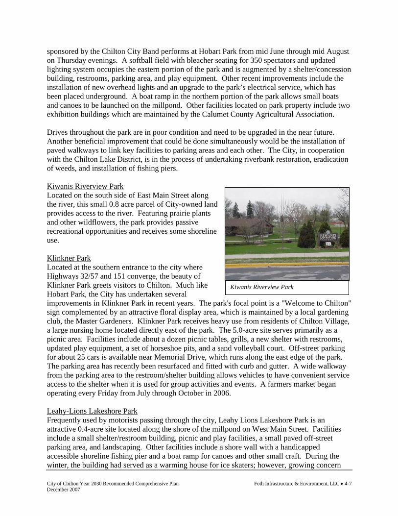
City of Chilton Year 2030 Recommended Comprehensive Plan Foth Infrastructure & Environment, LLC • 4-7 December 2007
Kiwanis Riverview Park
sponsored by the Chilton City Band performs at Hobart Park from mid June through mid August on Thursday evenings. A softball field with bleacher seating for 350 spectators and updated lighting system occupies the eastern portion of the park and is augmented by a shelter/concession building, restrooms, parking area, and play equipment. Other recent improvements include the installation of new overhead lights and an upgrade to the park’s electrical service, which has been placed underground. A boat ramp in the northern portion of the park allows small boats and canoes to be launched on the millpond. Other facilities located on park property include two exhibition buildings which are maintained by the Calumet County Agricultural Association. Drives throughout the park are in poor condition and need to be upgraded in the near future. Another beneficial improvement that could be done simultaneously would be the installation of paved walkways to link key facilities to parking areas and each other. The City, in cooperation with the Chilton Lake District, is in the process of undertaking riverbank restoration, eradication of weeds, and installation of fishing piers. Kiwanis Riverview Park Located on the south side of East Main Street along the river, this small 0.8 acre parcel of City-owned land provides access to the river. Featuring prairie plants and other wildflowers, the park provides passive recreational opportunities and receives some shoreline use. Klinkner Park Located at the southern entrance to the city where Highways 32/57 and 151 converge, the beauty of Klinkner Park greets visitors to Chilton. Much like Hobart Park, the City has undertaken several improvements in Klinkner Park in recent years. The park's focal point is a "Welcome to Chilton" sign complemented by an attractive floral display area, which is maintained by a local gardening club, the Master Gardeners. Klinkner Park receives heavy use from residents of Chilton Village, a large nursing home located directly east of the park. The 5.0-acre site serves primarily as a picnic area. Facilities include about a dozen picnic tables, grills, a new shelter with restrooms, updated play equipment, a set of horseshoe pits, and a sand volleyball court. Off-street parking for about 25 cars is available near Memorial Drive, which runs along the east edge of the park. The parking area has recently been resurfaced and fitted with curb and gutter. A wide walkway from the parking area to the restroom/shelter building allows vehicles to have convenient service access to the shelter when it is used for group activities and events. A farmers market began operating every Friday from July through October in 2006. Leahy-Lions Lakeshore Park Frequently used by motorists passing through the city, Leahy Lions Lakeshore Park is an attractive 0.4-acre site located along the shore of the millpond on West Main Street. Facilities include a small shelter/restroom building, picnic and play facilities, a small paved off-street parking area, and landscaping. Other facilities include a shore wall with a handicapped accessible shoreline fishing pier and a boat ramp for canoes and other small craft. During the winter, the building had served as a warming house for ice skaters; however, growing concern

Foth Infrastructure & Environment, LLC • 4-8 City of Chilton Year 2030 Recommended Comprehensive Plan December 2007
with the millpond’s uncertain ice conditions led the City to move the skating rink to Morrissey Park. Morrissey Park Morrissey Park occupies 14.3 acres of land that formerly housed the Chilton High School (which relocated to the city’s west side in 2003). At the time of this writing, the park included the Chilton High School football field and track, three tennis courts (one double court and one single court), a shelter and the city’s skating rink during the winter months. The Riverwalk meanders through the northern section of the park along the river. A basketball court has an uneven blacktop surface. Finally, there are two fishing piers. In 2004, a Morrissey Park Ad Hoc Committee was formed to develop the park. The committee, which reports to the city’s Culture and Recreation Committee, completed a public survey. Results indicated that a community built park, skateboard park and splash pad aquatic area should be built. In 2007, the committee plans to begin fundraising for the project with construction beginning in phases in 2008—all dependent on the funds raised. Nennig Park Nennig Park is a 15.5-acre site located at the intersection of Dove and Canary Avenues in the northern portion of the city. As this park has developed, it has taken on an increasingly important role in providing community-wide recreational opportunities as well as meeting the needs of neighborhood residents. The active support of the Chilton Athletic Club has played and continues to play a key role in the park's rapid development. Facilities for active recreational activities include two ball diamonds (one for organized play and a second for informal use), two upgraded tennis courts, a soccer/football field, a basketball court, and a volleyball court. Other facilities include an indoor/outdoor shelter, a refreshment stand, two restroom buildings, horseshoe pits, bike rack, a dozen picnic tables, grills, a sandbox, and a wide range of play apparatus. An upgraded off-street parking area for 20 vehicles is available from Canary Avenue and a similar amount of angle parking has been provided along Dove Avenue. Although convenient to activities in the eastern portion of the park, both locations are somewhat removed from the active sports areas, which have a high demand for parking. As a result, a temporary gravel parking area has been created near the new restroom building east of the larger ball diamond. Once other opportunities to create parking elsewhere in the park become available, this parking area should be phased out and converted to open space. The park’s ongoing landscaping program has become increasingly evident as shade trees mature. To enable the development of additional recreational facilities, the City is presently looking at providing off-street parking and another intermediate ball diamond on the west end of the park. Drainage issues will have to be addressed to provide the area with these additions. Optimist Riverwalk The Optimist Riverwalk consisting of 3.94 acres is located on the south side of the river beginning at the Chilton Public Library and ending at Madison Street. This area has a paved walkway, fishing piers, tree plantings by Tree Board members, and flowers maintained by the Optimist Club. The City, in cooperation with the Chilton Lake District, is undertaking shoreline restoration on portions along the riverwalk.

City of Chilton Year 2030 Recommended Comprehensive Plan Foth Infrastructure & Environment, LLC • 4-9 December 2007
Riverside Park Riverside Park occupies a 1.2 acre site along the river on the south side of Grand Street near its intersection with Water Street. The park serves primarily as a small neighborhood park. Facilities include a modest amount of play apparatus, a couple of picnic tables, grills and benches. Chilton Public School Complex The Chilton Public Schools—elementary, middle and high school—are located on a 100-acre parcel located between Court Street and West Main Street in the western portion of the city. Present facilities include an unlighted baseball field with bleacher seating for 300, a complex of three softball and one hardball diamond with total bleacher seating for 300, four basketball hoops, eight tennis courts, a chute ball basket, a Parcours Fitness Trail, a number of swings, slides, metal and tire climbers, and several sandboxes. Several additional game fields and related facilities for interscholastic sports and physical education are planned as part of the high school construction. The northeast portion of the existing site contains a small pond, school forest, and nature trails and is used for science classes. Calumet County Fairgrounds Occupying the southern portion of a parcel it shares with Hobart Park, the grounds provide the home for the annual Calumet County Fair and numerous other events. The fairground has recently been expanded to the south, increasing its size to an estimated 58 acres. The Calumet County Agricultural Association has made a major financial commitment to upgrading and expanding its facilities. Facilities include a new grandstand for its quarter mile dirt track and several livestock, exhibition, and concession buildings. Another addition is a large open shelter for display booths. The old restroom building in the south end of Hobart Park was turned over to the fairgrounds following the construction of new restrooms nearby. Chilton Area Catholic School Located in the heart of the city at the east end of Washington Street, the school's playground areas are available for general public use during much of the time. Facilities include a large paved area north of the school that has four basketball hoops, a tetherball stand and markings for a number of children's games. Updated play equipment and a small soccer field occupy the open area northwest of the school. City Wetlands Although not park sites at the present time, wetland areas located off of S. Park St., behind the city garage and near the water tower south of MB Lane offer excellent potential for creating enhanced wildlife habitat and providing opportunities for environmental education and other nature study activities. There is considerable local interest in exploring opportunities to connect these areas with the nearby Ledge View Nature Center by securing a limited public use easement across intervening private properties. In 2002, the City acquired an additional 15 acres, expanding its holdings to approximately 35 acres.

Foth Infrastructure & Environment, LLC • 4-10 City of Chilton Year 2030 Recommended Comprehensive Plan December 2007
Campgrounds
There are seven camping sites and event camping at the Calumet County Fairgrounds which is administered by the Fair Association. A permit is required for camping. 4.9 Solid Waste Management and Recycling
Garbage is picked up every Tuesday and recyclables are picked up every other week. The city contracts with a private provider for waste pickup and disposal. The city also offers curbside brush pickup every two weeks. Residents need to call city hall to schedule a pickup. In the fall, city crews also conduct curbside pickup of leaves. Grass clippings can be disposed of at the city garage located at 908 S. Maple Street. Composting occurs outside of the city limits. 4.10 Communication and Power Facilities
The following are communication and power providers for the community: Electric
♦ Wisconsin Public Service Telephone
♦ Verizon Natural Gas
♦ Wisconsin Public Service Cable TV Provider
♦ Charter Communications Communication Towers
♦ There is one communication tower in the city located at the Calumet County Courthouse. The city water tower is also used to accommodate internet communication facilities.
4.11 Sanitary Sewer Service
The City of Chilton’s wastewater treatment plant has a design population of 4,000. A plant expansion was completed in 2000. The type of treatment is activated sludge. Average annual design flow is 0.92 mgd with a peak design flow of 5.0 mgd. Annual averages include BOD loading at 2,400 lbs./day, TSS loading at 1,910 lbs./day, TKN loading at 190 lbs./day, NH 3 loading at 80 lbs/day, and P loading at 60 lbs./day. Approximately 95% of the city is served by sanitary sewer. Plant expansion is anticipated in 2008 to increase the biological oxygen demand (BOD) capacity from 2,400 to 3,600 pounds. With this expansion, the plant will go to biological phosphorus removal over chemical phosphorus removal. All other capacities will remain the same.

City of Chilton Year 2030 Recommended Comprehensive Plan Foth Infrastructure & Environment, LLC • 4-11 December 2007
Stormwater Management Facilities
4.12 Public Water Supply
Chilton Municipal Water Utility
The utility was organized in 1919. The utility serves approximately 1,308 residential, 184 commercial, 39 industrial customers, and 24 public customers. The sole source of water for the utility is groundwater via three active wells ranging in depth from 180 to 280 feet. The water supply is obtained from the Silurian Dolomite Aquifer. Total system capacity is 2.5 mgd. The city has three water storage facilities including the following:
♦ 1969 elevated tank, 200,000 gallon capacity ♦ 1978 elevated tank, 300,000 gallon capacity ♦ 1979 reservoir, 500,000 gallon capacity
The utility has approximately 149,250 feet of water main, the majority of which is 6 inch in diameter followed by 8 inch. The utility also has approximately 230 fire hydrants. In 2000, the City of Chilton completed a water system evaluation and plan. The evaluation concluded that the City of Chilton water system is expected to expand. The system will be extended to serve both new development and existing developments that are currently served by private wells. A comprehensive evaluation of the water system facilities was conducted to identify an improvement plan. The plan includes improvements that should be implemented to meet the current and future needs of the community. The city has completed development of a new well site, Well #10, located approximately 1.5 miles east of the city limits in the Town of Charlestown. The new well has a capacity of approximately 500 gpm. Raw water will be pumped to the Well #8 pump house for treatment. Wellhead Protection
A wellhead protection plan was completed in 2004 for Well #10. Prior to the plan a hydro geological analysis was completed for Wells 7, 9, and 10. The Towns of Charlestown and Chilton, Calumet County, and the city meet quarterly to discuss water quality issues and wellhead protection in the area. Refer to the Intergovernmental chapter for information on a intergovernmental agreement regarding water and wellhead protection. 4.13 Stormwater Management
The majority of the city is served by municipal stormwater facilities. 4.14 Health Care Facilities
♦ Calumet Medical Center is a 24 hour hospital and offers emergency services
♦ Affinity Medical Group

Foth Infrastructure & Environment, LLC • 4-12 City of Chilton Year 2030 Recommended Comprehensive Plan December 2007
♦ Century Ridge, assisted living ♦ Colonial Residence, assisted living
In February 2006, Calumet Medical Center announced a $1.6 million expansion. The facility will expand outpatient services, improve patient privacy, and increase technology. The Calumet Medical Center was built in 1956 and became a member of the Affinity Health System in 1998. Stanton Place, City of Chilton
The Housing Authority of the City of Chilton owns and operates Stanton Place, an independent living center for the elderly. Stanton Place is a single-story, 32-unit apartment building providing independent living for the elderly. This complex was constructed in 1983. Three of the apartments are designed especially for use by handicapped residents. 4.15 Day Care Facilities
♦ The Children’s Center ♦ Happy Hour Nursery School ♦ Karen’s House ♦ Littlest Angels Family Day Care ♦ One Room School House ♦ Park and Play Family Day Care ♦ Robin’s Nest Day Care ♦ Sunshine Days Child Care ♦ Here We Grow
4.16 Expansion or Rehabilitation of Existing Utilities and Facilities,
Approximate Timetable
Wisconsin comprehensive planning statutes require that the utilities and community facilities element of a comprehensive plan identify the need for the expansion, construction, or rehabilitation of existing utilities and facilities. The City of Chilton has determined that the following utilities and facilities will need expansion, construction, or rehabilitation over the planning period. Projects are identified as short-term (1-5 years) and long-term (6-20 years). Public Buildings and Administrative Facilities and Services
Short Term ♦ Wastewater Treatment Plant Expansion
Long Term
♦ No projects identified

City of Chilton Year 2030 Recommended Comprehensive Plan Foth Infrastructure & Environment, LLC • 4-13 December 2007
Police Services
Short Term ♦ Review need for additional support facilities
Long Term
♦ Review need for additional support facilities Fire Protection and EMT/Rescue Services
Short Term ♦ No change to current provider arrangements and agreements
Long Term
♦ Review need for additional support facilities Libraries, Cemeteries, and Other Quasi Public Facilities
Short Term ♦ No change to current provider arrangements
Long Term
♦ Library expansion Parks and Recreation
Short Term ♦ Begin implementation of park site plan for Morrissey Park ♦ Construct additional parking at Nennig Park ♦ Construct ball field expansion at Nennig Park ♦ Update the City of Chilton Open Space and Recreation Plan, 2007 ♦ Develop trail from City to Ledge Park
Long Term
♦ Continued implementation of park site plan for Morrissey Park Solid Waste and Recycling
Short Term ♦ No change to current provider arrangements and agreements
Long Term
♦ No change to current provider arrangements and agreements Sanitary Sewer Service
Short Term

Foth Infrastructure & Environment, LLC • 4-14 City of Chilton Year 2030 Recommended Comprehensive Plan December 2007
♦ Continue efforts to expand the wastewater treatment facility Long Term
♦ Upgrade lift stations to accommodate future growth areas. Install additional lift stations where determined necessary to accommodate city growth.
Private On-site Wastewater Treatment Systems (POWTS)
Short Term ♦ Require connection of POWTS to city sewer when public sewer service is made
available. Long Term
♦ Require connection of POWTS to city sewer when public sewer service is made available.
Public Water
Short Term ♦ Install water main looping around east commercial expansion area. ♦ Work with Calumet County and the Towns of Charlestown and Chilton to implement the
wellhead protection plan. ♦ Continue water exploration efforts.
Long Term
♦ Construct new well, storage and treatment facilities to accommodate new growth. Wells will likely to be located on the east side of the city where better quality water exists.
♦ Install a second main water line that links all city wells. ♦ Continue water exploration efforts. ♦ Continue to implement components of the wellhead protection plan.
Stormwater Management
Short Term ♦ Conduct long range stormwater management study to accommodate new growth. ♦ Continue implementation of city stormwater management plan requirements. ♦ Study management options for Lake District (Lake Chilton). Work with Wisconsin
Department of Natural Resources, Town of Charlestown, and Town of Chilton on upstream management.
Long Term
♦ Conduct long range stormwater management study to accommodate new growth. ♦ Continue implementation of city stormwater management plan requirements.
Health Care and Child Care Facilities
Short Term

City of Chilton Year 2030 Recommended Comprehensive Plan Foth Infrastructure & Environment, LLC • 4-15 December 2007
♦ No change recommended to current provider arrangements Long Term
♦ No change recommended to current provider arrangements Local Roads and Bridges
Short Term ♦ Install traffic lights at corner of Irish Street and USH 151 ♦ CTH "Y" Reconstruction: Madison Street to Park Street ♦ Continue five year local road maintenance plan
Long Term
♦ CTH "F" Reconstruction: W. Grand Street to Main Street (US 151) ♦ CTH "Y" Reconstruction: Park Street to Breed Street
Additional Facilities, Programs, or Operations
Short Term ♦ Continue to execute terms of intergovernmental agreement with adjacent towns. ♦ Invest in expertise to protect the city from development of wind turbines in the City's 1½
mile extraterritorial jurisdiction. Long Term
♦ Continue to execute terms of intergovernmental agreement with adjacent towns. 4.17 Future Needs for Government Services
While the previous section detailed infrastructure needs the community will deal with during the planning period, there are also service level needs that may arise in the community. For example, additional police service, need for a building inspector, or additional park and recreation services. Service needs identified as part of the comprehensive planning effort include:
♦ Continue to advance the skills of city administrative positions and delegate to subordinate positions.
♦ Hire additional law enforcement support as needed.
♦ Pursue a third party partner for the development of the Morrissey Park property.
Foth Infrastructure & Environment, LLC • 4-16 City of Chilton Year 2030 Recommended Comprehensive Plan December 2007
Map 4-2 Proposed Transportation and Utilities and Community Facilities

City of Chilton Year 2030 Recommended Comprehensive Plan Foth Infrastructure & Environment, LLC • 4-17 December 2007
This page intentionally left blank.

Foth Infrastructure & Environment, LLC • 4-18 City of Chilton Year 2030 Recommended Comprehensive Plan December 2007
4.18 Utilities and Community Facilities Goals and Objectives
Following are the goals and objectives developed by the City of Chilton regarding utilities and community facilities. (The source of each goal and objective is noted in parentheses.) Goal: Provide needed infrastructure improvements and high quality cost effective community
facilities and services to serve existing development and planned growth in an efficient, economical and environmentally safe manner (City of Chilton Comprehensive Plan, 1998).
Objectives 1. Work towards the placement of utilities underground in existing and proposed developed
areas where feasible (City of Chilton Comprehensive Plan, 1998). 2. Support high level, cost effective services for solid waste, natural gas, electrical, telephone,
cable, telecommunications, and other technology providers (Smart Growth Planning Process).
3. Maintain an adequate system of public infrastructure and building in Chilton (City of
Chilton Comprehensive Plan, 1998). 4. Maintain adequate city personnel to serve the citizens and visitors (City of Chilton
Comprehensive Plan, 1998). 5. Consider the impacts of development proposals on community facilities and services, and
balance the need for city growth with the cost of providing services (Smart Growth Planning Process).
6. Pursue additional cooperation between communities to avoid duplication of facilities and
increase the cost effectiveness of service provided to residents (Smart Growth Planning Process).
7. Monitor the need for new, expanded, or continuation of rehabilitated services and local
government facilities (Smart Growth Planning Process). 8. Increase coordination of utility and community facility planning with the location of future
service areas as guided by the comprehensive plan, environmental considerations, economic development, and growth management policies (Smart Growth Planning Process).
9. Seek adequate and up-to-date plans and programs to address needed city facilities such as
parks, the water system, sewer system, transportation systems, public buildings, etc. (City of Chilton Comprehensive Plan, 1998).

City of Chilton Year 2030 Recommended Comprehensive Plan Foth Infrastructure & Environment, LLC • 4-19 December 2007
10. Maintain public buildings in an attractive condition so as to enhance the appearance of the community and promote civic pride (City of Chilton Comprehensive Plan, 1998).
11. Ensure that areas proposed for new development have adequate water, sewer, and solid
waste disposal service (City of Chilton Comprehensive Plan, 1998). 12. Continue to utilize capital improvement planning to manage and budget for the city’s
infrastructure and improvements (Smart Growth Planning Process). Goal: Ensure proper treatment of wastewater to protect public health, groundwater quality,
and surface water quality while meeting current and future needs (Smart Growth Planning Process).
Objectives 1. Plan sewer extensions and treatment facility improvements so that they can be installed
incrementally as needed in a cost-effective manner (Smart Growth Planning Process). 2. Encourage the use of existing collection infrastructure and treatment capacity prior to the
extension of new infrastructure or construction of new facilities (Smart Growth Planning Process).
3. Consider the use of sewer assessment policies and impact/development fees that will
encourage compact development and discourage scattered development (Smart Growth Planning Process).
Goal: Promote stormwater management practices in order to reduce property and public
property damage and to protect water quality (Smart Growth Planning Process). Objectives 1. Maintain a city stormwater management system which addresses stormwater quality (Smart
Growth Planning Process). 2. Support the preservation of natural open spaces that minimize flooding such as wetlands
and floodplains (Smart Growth Planning Process). Goal: Ensure that the water supply for the city has sufficient capacity, is in compliance with
drinking water quality standards and regulations, and is available to meet present and future needs (Smart Growth Planning Process).
Objectives 1. Continue to monitor groundwater quality and potential contamination issues (Smart
Growth Planning Process).
Foth Infrastructure & Environment, LLC • 4-20 City of Chilton Year 2030 Recommended Comprehensive Plan December 2007
2. Ensure that water treatment facilities are properly maintained, and plan ahead for major improvements in order to reduce the financial impact on the city (Smart Growth Planning Process).
3. Provide information and comments on impacts to groundwater when reviewing proposed
development in the city and in areas of extraterritorial jurisdiction (Smart Growth Planning Process).
4. Continue to monitor the need for a secondary water transmission line (Smart Growth
Planning Process). Goal: Promote effective solid waste disposal and recycling services and systems that protect
the public health, natural environment, and general appearance of land uses within the city (Smart Growth Planning Process).
Objectives 1. Encourage citizen involvement in decisions involving the type, location, and extent of
disposal facilities and services (Smart Growth Planning Process). 2. Increase collection opportunities for the proper recycling and disposal of unique (i.e., tires,
white goods, etc.) and/or hazardous wastes (Smart Growth Planning Process). Goal: Ensure that adequate open space and recreational facilities are provided for and made
accessible to all residents of Chilton, with emphasis on preserving unique historic and natural features (City of Chilton Comprehensive Plan, 1998 and Open Space and Recreation Plan, 2007).
Objectives 1. Provide a full range of recreational facilities to serve all segments of Chilton’s population
on a year-round basis (City of Chilton Open Space and Recreation Plan, 2007 and City of Chilton Comprehensive Plan, 1998).
2. Provide accessible park and recreation facilities for all existing residential areas (City of
Chilton Open Space and Recreation Plan, 2007 and City of Chilton Comprehensive Plan, 1998).
3. Ensure that new residential developments are provided with suitable and accessible park
and recreation facilities (City of Chilton Open Space and Recreation Plan, 2007 and City of Chilton Comprehensive Plan, 1998).
4. Encourage the shared use of city and school recreational facilities (City of Chilton Open
Space and Recreation Plan, 2007 and City of Chilton Comprehensive Plan, 1998).
City of Chilton Year 2030 Recommended Comprehensive Plan Foth Infrastructure & Environment, LLC • 4-21 December 2007
5. Pursue state, federal, and private funding programs which can aid in the acquisition and development of parks, trails, and scenic and environmentally sensitive areas taking into account, related maintenance and operational costs (Smart Growth Planning Process).
Goal: Seek the provision of reliable, efficient, and well-planned utilities to adequately serve
existing and future development (Smart Growth Planning Process). Objectives 1. Cooperate in the planning and coordination of utilities with other agencies and jurisdictions
in order to efficiently serve local and regional growth (Smart Growth Planning Process). 2. Seek to balance desired service levels with potential negative community impacts when
reviewing the proposed design and location of telecommunication, wind energy, or other utility towers (Smart Growth Planning Process).
Goal: Encourage improved access to health care facilities and child care (Smart Growth
Planning Process). Objectives 1. Support requests for the development of properly located and operated child care facilities
(Smart Growth Planning Process). 2. Support school districts or local community organizations in their sponsorship of child care
programs and early development programs (Smart Growth Planning Process). 3. Support the development and expansion of local health care facilities (Smart Growth
Planning Process). Goal: Provide a level of police, fire, and emergency services that meets present and future
needs (Smart Growth Planning Process). Objectives 1. Work to maintain the current ISO rating of the fire department in the city (Smart Growth
Planning Process). 2. Support resident education on ways to reduce the risks of fire and increase access and
response time of emergency vehicles to local residences (Smart Growth Planning Process). 3. Promote the maintenance of the level of quality of emergency service equipment and
facilities and address needs where appropriate (Smart Growth Planning Process). 4. Encourage beneficial and effective police, fire, and EMS cooperative service agreements
(Smart Growth Planning Process).

Foth Infrastructure & Environment, LLC • 4-22 City of Chilton Year 2030 Recommended Comprehensive Plan December 2007
5. Maintain a good working relationship with Calumet County and neighboring communities for utilization of additional emergency services when needed (Smart Growth Planning Process).
6. Work to improve public safety protection for new and existing development (City of
Chilton Comprehensive Plan, 1998). Goal: Promote quality schools and access to educational opportunities (Smart Growth
Planning Process). Objectives 1. Coordinate planning efforts with the local School District to allow them to anticipate future
growth and demographic changes (Smart Growth Planning Process). 2. Maintain support for local libraries in their efforts to increase community education (Smart
Growth Planning Process). 3. Continue to be a partner in the provision of social, cultural, and educational activities for
the entire community (City of Chilton Comprehensive Plan, 1998). 4.19 Utilities and Community Facilities Policies and
Recommendations
Policies and recommendations build on goals and objectives by providing more focused responses and actions to the goals and objectives. Policies and recommendations become the tools that the community should use to aid in making land use decisions. Policies that direct action using the words “will” or “shall” are advised to be mandatory and regulatory aspects of the implementation of the comprehensive plan. In contrast, those policies that direct action using the word “should” are advisory and intended to serve as a guide. Policies
1. Services (functions such as water, sewer, and solid waste) shall be reviewed prior to approving development proposals (City of Chilton Comprehensive Plan, 1998).
2. Erosion and drainage control plans will be required and implemented for new development
(City of Chilton Comprehensive Plan, 1998). 3. The city shall maintain a park and outdoor recreation plan (City of Chilton Comprehensive
Plan, 1998). 4. Provide city water and sanitary sewer to existing and planned developments as necessary.
Land developers will be held responsible for the cost of providing adequate public utilities in new developments (City of Chilton Comprehensive Plan, 1998).
City of Chilton Year 2030 Recommended Comprehensive Plan Foth Infrastructure & Environment, LLC • 4-23 December 2007
5. The city will continually review staffing and professional service needs relative to planning, ordinance development/enforcement, and other governmental services (Smart Growth Planning Process).
6. New development shall follow the comprehensive plan so that growth is controlled and
services can be provided most economically (City of Chilton Comprehensive Plan, 1998). 7. Stormwater management practices shall be used to abate non-point source pollution to
address water quality (Smart Growth Planning Process). 8. Major developments shall adequately address solid waste disposal and recycling needs
during the planning and design stages of projects (Smart Growth Planning Process). Recommendations
Recommendations are specific actions or projects that the community should be prepared to complete. Completion of these actions and projects is consistent with the community’s policies, and therefore will help fulfill the comprehensive plan goals and objectives. 1. Prepare a long range water and sewer utility plan for planned growth areas. 2. Implement the site plan for Morrissey Park. 3. Implement recommendations and the action program identified in the 2007 Open Space
and Recreation Plan. 3. Update the 2007 Open Space and Recreation Plan to maintain WDNR Stewardship
funding eligibility. 4. Conduct a needs assessment analysis for the city’s park system based on the
recommendations of the Open Space and Recreation Plan. Develop ordinance to assist in the funding of needed park improvements
5. See Section 4.16 of this chapter for specific Short Term and Long Term projects. 4.20 Utilities and Community Facilities Programs
The following programs are currently utilized by the community or are available for use by the community to implement the goals, objectives, policies, and recommendations identified. City of Chilton Open Space and Recreation Plan, 2007 The city’s open space and recreation plan was completed in 2007. The plan includes background information on the city, goals and objectives, an inventory of recreational resources, an assessment of recreational needs, recommendations, and an action program. The city should continue to use the strategies developed in this plan in coordination with the comprehensive plan. In addition, this plan must be updated every five years to maintain WDNR Stewardship Fund Grant eligibility.
Foth Infrastructure & Environment, LLC • 4-24 City of Chilton Year 2030 Recommended Comprehensive Plan December 2007
Community Development Block Grant for Public Facilities (CDBG-PF) The Wisconsin CDBG Public Facilities Program is designed to assist economically distressed, smaller communities with public facility improvements. Eligible activities include, but are not limited to, publicly-owned utility system improvements, streets, sidewalks, and community centers. Federal grant funds are available annually. The maximum grant for any single applicant is $750,000. Grants are only available up to the amount that is adequately justified and documented with engineering or vendor estimates. For more information on this program contact the Wisconsin Department of Commerce, Division of Community Development. Community Development Block Grant Public Facilities for Economic Development (CDBG-PFED) The CDBG Public Facilities for Economic Development Program helps underwrite the cost of municipal infrastructure necessary for business development that retains or creates employment opportunities. Eligible activities are improvements to public facilities such as water systems, sewerage systems, and roads that are owned by a general or special purpose unit of government, and which will principally benefit businesses, and which as a result will induce businesses to create jobs and invest in the community. The Wisconsin Department of Commerce, Bureau of Community Finance should be contacted for further information. Brownfields Initiative The Brownfields Initiative provides grants to persons, businesses, local development organizations, and municipalities for environmental remediation activities for brownfield sites where the owner is unknown, cannot be located, or cannot meet the cleanup costs. The Wisconsin Department of Commerce, Bureau of Community Finance should be contacted for further information. Community Development Block Grant Blight Elimination and Brownfield Redevelopment Program (CDBG-BEBR) The Blight Elimination and Brownfield Redevelopment Program is designed to assist communities with assessing or remediating the environmental contamination of an abandoned, idle, or underused industrial or commercial facility or site in a blighted area, or one that qualifies as blighted. Critical to obtaining a grant is a redevelopment plan that describes how the property will be reused for commercial or industrial development that results in jobs and private investment in the community. The Wisconsin Department of Commerce, Bureau of Community Finance should be contacted for further information. Tax Incremental Financing (TIF) TIF can help a municipality undertake a public project to stimulate beneficial development or redevelopment that would not otherwise occur. It is a mechanism for financing local economic development projects in underdeveloped and blighted areas. Taxes generated by the increased property values pay for land acquisition or needed public works. The Wisconsin Department of Commerce should be contacted for further information.
City of Chilton Year 2030 Recommended Comprehensive Plan Foth Infrastructure & Environment, LLC • 4-25 December 2007
Aids for the Acquisition and Development of Local Parks Funds are available to assist local communities acquire and develop public outdoor recreation areas as per s. 23.09 (20), Wis. Stats. Counties, towns, cities, villages, and Indian Tribes with an approved Comprehensive Outdoor Recreation Plan are eligible to apply. The program is offered by the WDNR, Bureau of Community Financial Assistance. There is a 50% local match required. Awards are granted on a competitive basis. Acquisition and development of public outdoor recreation areas are eligible projects. Priority is given to the acquisition of land where a scarcity of outdoor recreation land exists. Clean Water Fund Program Funds are available to protect water quality by correcting existing wastewater treatment and urban storm water problems and preventing future problems as per s. 281.58 and 281.59, Wis. Stats. Cities, towns, villages, counties, town sanitary districts, public inland lake protection and rehabilitation districts, metropolitan sewerage districts, and federally-recognized tribal governments are eligible to apply. Eligible projects include construction of treatment works, sewer systems, interceptors, and urban stormwater runoff treatment systems. Projects that are necessary to prevent violation of discharge permits, meet new or changed discharge limits, or correct water quality or human health problems in unsewered areas may receive priority for funding. Low interest loans are available for planning, design, and construction of wastewater treatment projects and urban storm water runoff projects approved by the Department. The program is offered by the WDNR, Bureau of Community Financial Assistance.

City of Chilton Year 2030 Recommended Comprehensive Plan Foth Infrastructure & Environment, LLC • 5-1 December 2007
5. Agricultural, Natural, and Cultural Resources
5.1 Introduction
The natural resources of a community offer a clean and abundant supply of groundwater and surface water, assure safe air to breathe, and provide a natural landscape of terrestrial and aquatic habitats such as forest, prairies, and wetlands. Natural resources include the parks, trails, scenic areas, and other outdoor places people rely on for recreation. Natural resources are essential to a vibrant economy – measured in tourism revenues, enhanced property values, sustainable agriculture and wood products, low cost raw materials (such as sand, gravel, and stone), available water for manufacturing processes, etc. There are many state and some federal regulations designated to protect Wisconsin’s natural resources. Some state laws, including those for floodplains, shorelands, and wetlands, establish minimum use and protection standards that must be adopted and administered by local governments. But not all natural resources are protected by state law. Local governments throughout the state have the flexibility to plan for and develop their own local ordinances to deal with the unique land use issues/conflicts in their communities and to protect the natural resources they value most. Development must be carefully adjusted to coincide with the ability of the agricultural, natural, and cultural resource base to support the various forms of urban and rural development. This balance must be maintained to prevent the deterioration of that underlying and sustaining base, because these resources make each community unique. These features promote civic pride and often create a sense of place. 5.2 Forests, Farmland, and Agriculture
According to the land use inventory conducted by the Calumet County Planning Department, the City of Chilton contains approximately 967 acres of farmland (35.3% of total city acreage). This total includes both existing farms and associated cropland. A majority of this acreage is located on the city’s west and south sides. A planned conversion of farmland to other more intensive land use types such as residential, commercial and industrial is expected over the 20 year planning period. Map 5-1 shows the soil types within the city. Forest land in the city is limited to approximately 98 acres (3.6%). Most of this acreage is located along the South Branch of the Manitowoc River and its tributaries. This total does not include forest land associated with city parks which have been classified “Recreational” The City of Chilton has been recognized by the National Arbor Day Foundation with the “Tree City USA” designation. This award is given to communities that manage an ongoing inventory of trees (green infrastructure) on public property to the benefit of the community. The City of Chilton has received the designation for 13 consecutive years.

Foth Infrastructure & Environment, LLC • 5-2 City of Chilton Year 2030 Recommended Comprehensive Plan December 2007
This page intentionally left blank.

City of Chilton Year 2030 Recommended Comprehensive Plan Foth Infrastructure & Environment, LLC • 5-3 December 2007
Map 5-1 Soils

Foth Infrastructure & Environment, LLC • 5-4 City of Chilton Year 2030 Recommended Comprehensive Plan December 2007
This page intentionally left blank.
City of Chilton Year 2030 Recommended Comprehensive Plan Foth Infrastructure & Environment, LLC • 5-5 December 2007
5.3 Topography
The rolling topography found in the Chilton area is the result of past glacial activity. Most of the landforms are comprised of glacial till and the city itself lies in the heart of a drumlin field that stretches east to west across the south central portion of Calumet County and neighboring Fond du Lac County. Elevation changes within the corporate limits approach 100 feet. 5.4 Metallic and Non-Metallic Mineral Resources
Wisconsin Administrative Code NR 135 required that all counties adopt and enforce a Non-Metallic Mining Reclamation Ordinance that establishes performance standards for the reclamation of active and future non-metallic mining sites, but not abandoned sites. It is intended that NR 135 will contribute to environmental protection, productive end land use, and potential to enhance habitat and increase land values and tax revenues. According to the Calumet County Planning Department there are approximately 20 active non-metallic mining sites and five abandoned sites located in Calumet County (see Utilities and Community Facilities element). Of the 20 active mining sites, eight are limestone sites, two are sand and gravel sites, and 10 are gravel-only sites. The East Central Wisconsin Regional Planning Commission administers the Wisconsin Statutes, Chapter NR 135, non-metallic mining reclamation program for Winnebago, Outagamie, Shawano, Waupaca, and Calumet Counties. The Calumet County Non-Metallic Mining Reclamation Ordinance was adopted in 2001. All site operators are required to apply for a permit and must prepare and submit a reclamation plan. 5.5 Watersheds and Drainage
Wisconsin has redesigned its natural resource management approach around the concepts of eco-regions, areas of similar character and structure typically related to drainage basins or watersheds. This shift in approach recognizes that working with the natural structure and function of resources, as opposed to strictly political or social boundaries, will provide more successful results. Basins and watersheds are interconnected areas of land draining from surrounding ridge tops to a common point such as a lake or stream confluence. All lands and waterways can be found within one watershed or another. The City of Chilton lies within the South Branch of the Manitowoc River Watershed. Location within this watershed means stormwater runoff drains eastward away from Lake Winnebago to the Manitowoc River with eventual discharge into Lake Michigan.
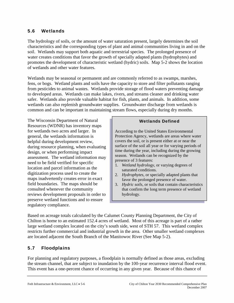
Foth Infrastructure & Environment, LLC • 5-6 City of Chilton Year 2030 Recommended Comprehensive Plan December 2007
Wetlands Defined According to the United States Environmental Protection Agency, wetlands are areas where water covers the soil, or is present either at or near the surface of the soil all year or for varying periods of time during the year, including during the growing season. Wetlands can be recognized by the presence of 3 features: 1. Wetland hydrology, or varying degrees of
saturated conditions. 2. Hydrophytes, or specially adapted plants that
favor the prolonged presence of water. 3. Hydric soils, or soils that contain characteristics
that confirm the long term presence of wetland hydrology.
5.6 Wetlands
The hydrology of soils, or the amount of water saturation present, largely determines the soil characteristics and the corresponding types of plant and animal communities living in and on the soil. Wetlands may support both aquatic and terrestrial species. The prolonged presence of water creates conditions that favor the growth of specially adapted plants (hydrophytes) and promotes the development of characteristic wetland (hydric) soils. Map 5-2 shows the location of wetlands and other water features. Wetlands may be seasonal or permanent and are commonly referred to as swamps, marshes, fens, or bogs. Wetland plants and soils have the capacity to store and filter pollutants ranging from pesticides to animal wastes. Wetlands provide storage of flood waters preventing damage to developed areas. Wetlands can make lakes, rivers, and streams cleaner and drinking water safer. Wetlands also provide valuable habitat for fish, plants, and animals. In addition, some wetlands can also replenish groundwater supplies. Groundwater discharge from wetlands is common and can be important in maintaining stream flows, especially during dry months. The Wisconsin Department of Natural Resources (WDNR) has inventory maps for wetlands two acres and larger. In general, the wetlands information is helpful during development review, during resource planning, when evaluating design, or when performing impact assessment. The wetland information may need to be field verified for specific location and parcel information as the digitization process used to create the maps inadvertently creates error in exact field boundaries. The maps should be consulted whenever the community reviews development proposals in order to preserve wetland functions and to ensure regulatory compliance. Based on acreage totals calculated by the Calumet County Planning Department, the City of Chilton is home to an estimated 152.4 acres of wetland. Most of this acreage is part of a rather large wetland complex located on the city’s south side, west of STH 57. This wetland complex restricts further commercial and industrial growth in the area. Other smaller wetland complexes are located adjacent the South Branch of the Manitowoc River (See Map 5-2). 5.7 Floodplains
For planning and regulatory purposes, a floodplain is normally defined as those areas, excluding the stream channel, that are subject to inundation by the 100-year recurrence interval flood event. This event has a one-percent chance of occurring in any given year. Because of this chance of

City of Chilton Year 2030 Recommended Comprehensive Plan Foth Infrastructure & Environment, LLC • 5-7 December 2007
Manitowoc River
flooding, development in the floodplain should be discouraged and the development of park and open space in these areas encouraged. The floodplain includes the floodway and flood fringe. The floodway is the portion of the floodplain that carries flood water or flood flows, while the flood fringe is the portion of the floodplain outside the floodway, which is covered by waters during a flood event. The flood fringe is generally associated with standing water rather than rapidly flowing water. Wisconsin Statute 87.30 requires counties, cities, and villages to implement floodplain zoning. In addition, the Federal Emergency Management Agency (FEMA) has developed flood hazard data. Under the authority of the National Flood Insurance Act of 1968, FEMA conducted studies to determine the location and extent of floodplains and the monetary damage risks related to the insurance of urban development in floodplain areas. According to data assembled by the Calumet County Planning Department, approximately 2,585 acres of land in the City of Chilton are classified as floodplain by FEMA. Under the authority of the National Flood Insurance Act of 1968, FEMA conducted studies to determine the location and extent of flood lands and the monetary damage risks related to the insurance of urban development in flood land area. In Chilton, floodplains are exclusively associated with the South Branch of the Manitowoc River. 5.8 Surface Water Features
South Branch of Manitowoc River and Lake Chilton
The South Branch of the Manitowoc River, which flows northeasterly through the city, is the most important natural resource in Chilton. A dam on the stream behind the central business district creates the 9-acre Lake Chilton, which is seven feet in depth. Small boat ramps at Hobart Park and Leahy Lions Lakeshore Park provide access to the water. Night lighting highlights the unique design of the dam. Other surface water resources are three small spring fed ponds and a sizeable wetland area, which are located near South Madison Street in the southern portion of the city.

Foth Infrastructure & Environment, LLC • 5-8 City of Chilton Year 2030 Recommended Comprehensive Plan December 2007
This page intentionally left blank.

City of Chilton Year 2030 Recommended Comprehensive Plan Foth Infrastructure & Environment, LLC • 5-9 December 2007
Map 5-2 Environmental and Water Features

Foth Infrastructure & Environment, LLC • 5-10 City of Chilton Year 2030 Recommended Comprehensive Plan December 2007
This page intentionally left blank.
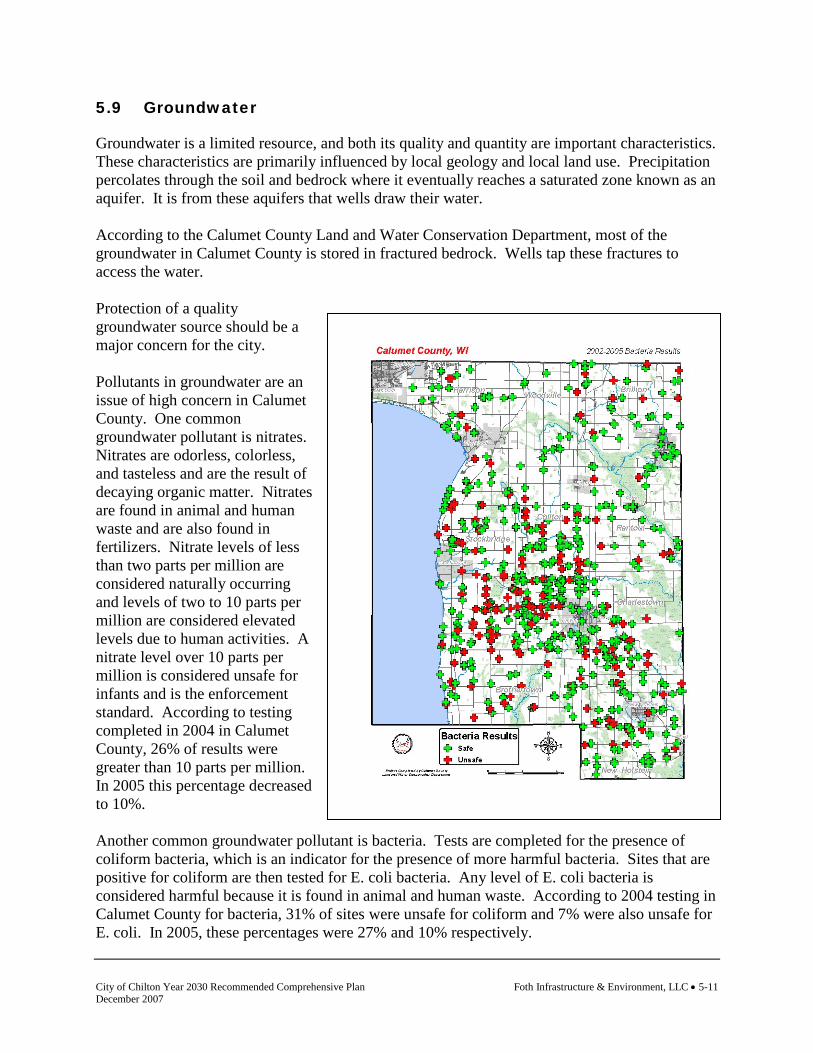
City of Chilton Year 2030 Recommended Comprehensive Plan Foth Infrastructure & Environment, LLC • 5-11 December 2007
5.9 Groundwater
Groundwater is a limited resource, and both its quality and quantity are important characteristics. These characteristics are primarily influenced by local geology and local land use. Precipitation percolates through the soil and bedrock where it eventually reaches a saturated zone known as an aquifer. It is from these aquifers that wells draw their water. According to the Calumet County Land and Water Conservation Department, most of the groundwater in Calumet County is stored in fractured bedrock. Wells tap these fractures to access the water. Protection of a quality groundwater source should be a major concern for the city. Pollutants in groundwater are an issue of high concern in Calumet County. One common groundwater pollutant is nitrates. Nitrates are odorless, colorless, and tasteless and are the result of decaying organic matter. Nitrates are found in animal and human waste and are also found in fertilizers. Nitrate levels of less than two parts per million are considered naturally occurring and levels of two to 10 parts per million are considered elevated levels due to human activities. A nitrate level over 10 parts per million is considered unsafe for infants and is the enforcement standard. According to testing completed in 2004 in Calumet County, 26% of results were greater than 10 parts per million. In 2005 this percentage decreased to 10%. Another common groundwater pollutant is bacteria. Tests are completed for the presence of coliform bacteria, which is an indicator for the presence of more harmful bacteria. Sites that are positive for coliform are then tested for E. coli bacteria. Any level of E. coli bacteria is considered harmful because it is found in animal and human waste. According to 2004 testing in Calumet County for bacteria, 31% of sites were unsafe for coliform and 7% were also unsafe for E. coli. In 2005, these percentages were 27% and 10% respectively.
Foth Infrastructure & Environment, LLC • 5-12 City of Chilton Year 2030 Recommended Comprehensive Plan December 2007
Calumet County is particularly susceptible to groundwater contamination because fractured dolomite underlies most of the county. These fractures allow water and pollutants to move more efficiently and rapidly. There are also several large areas of the county which have thin soils over bedrock. Pollutants spread, stored, or spilled on thin soils can easily move through the thin soil layer and enter the groundwater. Unused wells can serve as direct pipelines to the groundwater. Contaminants at or near the surface, such as animal and human wastes or lawn and agricultural fertilizers, can enter the groundwater easily through unused wells and sinkholes. Calumet County draws all of its water from the same aquifer (the Silurian Niagara Dolomite). Thus, all areas and all wells are susceptible to some extent. The source of contamination is often less than one mile from the well itself. This water is influenced by activities on the surface that occurred in the last year or two. Groundwater movement through the fractured dolomite is multidirectional. Thus, it is difficult to trace the specific path and origin of pollutants. Relative to the City of Chilton, history has shown that the best water quality occurs on the east side of the city. Future exploration efforts for new wells will likely occur there. Wellhead protection is paramount to the future expansion plans of the city. Joint efforts with other surrounding towns to protect this resource are critical in ensuring the groundwater resource is not contaminated. 5.10 Air Quality
In order to evaluate the quality of the air and to protect the public health, a series of National Ambient Air Quality Standards (NAAQS) has been developed by the U.S. Environmental Protection Agency (EPA) as established in section 109 of the Clean Air Act. According to the Wisconsin Air Quality Report, as prepared by the Wisconsin Department of Natural Resources (WDNR), the air pollutants affecting Wisconsin include sulfur dioxide, suspended particulate matter, carbon monoxide, ozone, oxides of nitrogen, lead, sulfates, and nitrates. Calumet County is considered an attainment area, which is an area that meets the NAAQS defined in the Federal Clean Air Act. While compliance with NAAQS is not likely to become a concern in Calumet County, there are localized air quality issues that commonly face rural areas. Concerns with airborne particulates, or dust, may also be a concern where residential land use is in close proximity to extraction operations or agricultural operations. Outdoor burning can lead to air quality problems in a particular neighborhood if garbage or other materials that release toxic substances are burned, or if burning occurs in a densely populated area. Issues might arise from open burning, the improper use of burning barrels, or the improper use of outdoor wood burners (furnaces). 5.11 Environmentally Sensitive Areas
Niagara Escarpment
The Niagara Escarpment is the steep face of a 650-mile sickle-shaped cuesta (bedrock ridge) that runs from the northeastern United States south of Rochester, New York, across portions of

City of Chilton Year 2030 Recommended Comprehensive Plan Foth Infrastructure & Environment, LLC • 5-13 December 2007
southeastern Canada, and then southward north and west of Lake Michigan to southeastern Wisconsin. The primary bedrock type is dolomite. The Escarpment is made of rock that was originally deposited as sediment on an ancient sea floor that existed about 430 to 450 million years ago. The present day cliffs were formed over millions of years through the differential erosion of rocks of varying hardness and enhanced by the action of glaciers during the last ice age. In Wisconsin, the Escarpment extends for over 230 miles, from Rock Island, off the northern tip of the Door Peninsula, south to northern Waukesha and Milwaukee Counties. The Escarpment is discontinuous in Wisconsin and differs in elevation and amount of exposure from one end to the other. The geology of the Escarpment greatly influences its ecological attributes. One example is the presence of karst, or solution features of the bedrock that allows organic matter to accumulate. Cold air and sometimes water move through the fractured bedrock creating unique microhabitats. Many highly specialized species, such as rare terrestrial snails, are found in these microhabitats. Niagara Escarpment outcrops in Calumet County are concentrated in the southwestern two-thirds of the county, especially along the east shore of Lake Winnebago, with scattered outcrops in the northeast. Relative to the City of Chilton, the most significant environmental resource is the South Branch of the Manitowoc River and Lake Chilton. Protection of the resource can be supported by a number of tools such as floodplain zoning, area wide stormwater management practices, and the outright acquisition of adjacent properties within the river’s buffer zone.

Foth Infrastructure & Environment, LLC • 5-14 City of Chilton Year 2030 Recommended Comprehensive Plan December 2007
This page intentionally left blank.

City of Chilton Year 2030 Recommended Comprehensive Plan Foth Infrastructure & Environment, LLC • 5-15 December 2007
Map 5-3 Natural Features

Foth Infrastructure & Environment, LLC • 5-16 City of Chilton Year 2030 Recommended Comprehensive Plan December 2007
This page intentionally left blank.
City of Chilton Year 2030 Recommended Comprehensive Plan Foth Infrastructure & Environment, LLC • 5-17 December 2007
5.12 Threatened and Endangered Species
Wisconsin's Natural Heritage Inventory (NHI), established in 1985 by the Wisconsin Legislature, is maintained by the Wisconsin Department of Natural Resources (WDNR) Bureau of Endangered Resources. The NHI program is responsible for maintaining data on the locations and status of rare species, natural communities, and natural features in Wisconsin. The Wisconsin NHI program is part of an international network of inventory programs that collect, process, and manage data on the occurrences of natural biological diversity using standard methodology. Wisconsin's Natural Heritage Inventory program's three objectives are to: collect information on occurrences of rare plants and animals, high-quality natural communities, and significant natural features in Wisconsin; standardize this information, enter it into an electronic database, and mark locations on base maps for the state; and use this information to further the protection and management of rare species, natural communities, and natural features. According to the NHI the following rare species and natural communities are found in the county. The dates following the occurrence name notes the most recent year the occurrence was recorded in the county. Refer to the Calumet County Inventory and Trends Report for mapped locations of occurrences. County Aquatic Occurrences
Animal Yellow Rail, Coturnicops noveboracensis, 1991 Side-swimmer, Crangonyx gracilis, 1994 Banded Killifish, Fundulus diaphanous, 1964 Greater Redhorse, Moxostoma valenciennesi, 1979 Blanchard's Cricket Frog, Acris crepitans blanchardi, 1982 Plants Ram's-head Lady's-slipper, Cypripedium arietinum, 1891 Natural Communities Open Bog, 1982 Shrub-carr, 1982 Emergent Marsh, 1982 Floodplain Forest, 1979 Northern Wet Forest, 1982 County Terrestrial Occurrences
Animal Land Snail, Succinea bakeri, 1998 Land Snail, Catinella gelida, 1998 Bat Hibernaculum, Bat hibernaculum, 1986 Dentate Supercoil, Paravitrea multidentata, 1996

Foth Infrastructure & Environment, LLC • 5-18 City of Chilton Year 2030 Recommended Comprehensive Plan December 2007
Thin-lip Vallonia, Vallonia perspective, 1998 Broad-winged Skipper, Poanes viator, 1990 Northern Ringneck Snake, Diadophis punctatus edwardsii, 1986 Plants Snow Trillium, Trillium nivale, 1995 Yellow Gentian, Gentiana alba, 1992 Prairie Parsley, Polytaenia nuttallii, 1848 Short's Rock-cress, Arabis shortii, 1994 Natural Communities Dry Cliff, 1983 Moist Cliff, 1983 Talus Forest, 1999 Southern Mesic Forest, 2000 5.13 Historical and Cultural Resources
Preserving important aspects of our past gives us a sense of continuity and meaning and historic preservation efforts often foster community pride. Because cultural resources provide an important window to the past, many Wisconsin residents seek to retain those resources that make their communities distinctive. The presence of these resources also creates a level of respect for those individuals who formed the character of the community new residents now enjoy. Overall, planning for cultural resource preservation can have several benefits. The cultural resource section of a comprehensive plan can serve as the first step in a cultural and historic preservation effort. This section can also be used as a base for a more detailed analysis of historic preservation at a later date. 5.14 Archaeological Sites and Cemeteries
Our lives are influenced by what we learn from our own experiences and by the events that have shaped the communities we live in and the institutions and organizations we encounter. Our history gives us a sense of place and a framework to understand the world. It provides continuity and meaning in our lives and it can be a basis for economic development through preservation programs and Heritage Tourism. People have been living in the area for a millennium, with hunting, fishing, and farming playing a central role in people’s lives. This story of agriculture, resource use, and land stewardship is preserved in archaeological sites, buildings, landscapes, written accounts, photographs, governmental records, and the thoughts and ideas people remember and pass along by word of mouth. Planning can play a critical part in protecting these resources and in learning from this wealth of experience. Land-use planning and land-use decisions will directly impact historic buildings, archaeological sites, and cemeteries.

City of Chilton Year 2030 Recommended Comprehensive Plan Foth Infrastructure & Environment, LLC • 5-19 December 2007
Archaeological sites include places where people lived, where they worked, and where they worshiped. These sites were made by the people who lived at the village, farm, or logging camp located just down the road. Archaeological sites occur figuratively and literally under our feet. Archaeology is well suited for providing important information about the lives of people who are not well represented in the written record. Archaeological sites are non-renewable resources and once a site is destroyed, either by natural or human related activities, it cannot be reclaimed. The Wisconsin Historical Society (WHS) maintains a list of archaeological sites and cemeteries referred to as the Archaeological Site Inventory (ASI) a component of the Wisconsin Archaeological and Historic Resource Database (WisAHRD). The Archaeological Site Inventory (ASI) is the most comprehensive list of archaeological sites, mounds, unmarked cemeteries, marked cemeteries, and cultural sites available. The ASI does not include all of the sites and cemeteries present in the state, however. It includes only those sites that have been reported to the Wisconsin Historical Society. The information in the ASI is a compilation of reports covering a period of 150 years. The information for each entry varies widely and WHS has not been able to verify all of the entries. Few of these sites have been evaluated for their importance. The ASI is changed and updated on a daily basis and recommendations about site importance may change as new information becomes available. The attached site list will become quickly out of date and a procedure for updating the list should be developed. This ASI information is confidential and is not subject to Wisconsin’s open records law (Wis. Stats. §§ 44.48 and 157.70). This information is also protected by Federal Law (Section 304 of the National Historic Preservation Act, Section 9(a) of the Archaeological Resources Protection Act of 1979). This caution not only helps protect archaeological sites but also protects landowners since private landowners own the majority of archaeological sites in the Community. Under Wisconsin law, Native American burial mounds, unmarked burials, and all marked and unmarked cemeteries are protected from intentional disturbance. If you have any questions concerning the law, please contact the Coordinator of the Burial Sites Preservation Program at the Wisconsin Historical Society. Archaeological Sites and Cemeteries in the Community of Chilton
The Wisconsin Historical Society maintains a list of archaeological sites and cemeteries referred to as the Archaeological Site Inventory (ASI). Since only a small portion of the Community has been surveyed for the presence of archaeological sites and cemeteries, the sites listed in the inventory represent only a fraction of the sites that are actually present. Notably missing are sites related to the history of agriculture in the area; a way of life that started 1,000 years ago as well early home and business sites. Local residents and American Indian communities who have and do live and work in the area possess much additional information on other archaeological sites and cemeteries. Steps should be taken to have this information incorporated into the land use plan. Up to this point in time, three archaeological sites and cemeteries have been reported for the Community. Map 5-4 shows the location of historical and cultural features. The following types of sites have been identified:
Foth Infrastructure & Environment, LLC • 5-20 City of Chilton Year 2030 Recommended Comprehensive Plan December 2007
♦ Cemeteries ♦ Cache/storage pit
This sample of sites does not reflect the rich history of the area. Many more sites are present in the area and many certainly may be eligible for the National Register and may be important. Where are archaeological sites going to be located? Using the results of archaeological surveys, relevant historical and environmental data, the following high priority areas were designated:
♦ Higher, dryer areas adjacent to rivers, streams, creeks, lakes, wetlands. ♦ Higher, dryer areas adjacent to older abandoned rivers, streams, creeks, lakes, wetlands. ♦ Areas adjacent to older historic features such as trails, early roads, rail corridors, and
earlier communities. Cemeteries, Burial Mounds, and Other Burials
Cemeteries and burial areas have been set aside as special areas throughout Wisconsin history and they have been given special protection under the law. Under Wisconsin law, Native American burial mounds, unmarked burials, and all marked and unmarked cemeteries are protected from intentional disturbance. If anyone suspects that a Native American burial mound or an unmarked or marked burial is present in an area, the Burial Sites Preservation Office should be notified. If human bone is unearthed during any phase of a project, all work must cease, and the Burial Sites Preservation Office must be contacted at 1-800-342-7834 to be in compliance with Wis. Stat. 157.70 which provides for the protection of all human burial sites. Work cannot resume until the Burial Sites Preservation Office gives permission. If you have any questions concerning the law, please contact the Coordinator of the Burial Sites Preservation Program at the Wisconsin Historical Society, Dr. Leslie Eisenberg, 608-264-6503. At the present time, a total of two cemetery or burial sites have been identified in the community. Since a systematic survey of the county has not been completed, additional cemeteries and burials may be present. As part of the planning process all cemeteries and burials in the community should be cataloged under Wis. Stat. 157.70 to provide for the maximum protection of these important sites and to clearly define their boundaries. Determining Which Sites are Important
How do we know which archaeological sites need preservation? Under Wisconsin law Native American burial mounds, unmarked burials, and all marked and unmarked cemeteries are protected. In addition to these, a wide variety of archaeological sites may be worthy of preservation. Through the use of the State and National Register of Historic Places a procedure for identifying important sites is available. The criteria include: a good local example of an architectural style and period; association with a person important in our past; represent an
City of Chilton Year 2030 Recommended Comprehensive Plan Foth Infrastructure & Environment, LLC • 5-21 December 2007
important period, movement or trend in local, state or national history; or have the potential to yield important information about our past through archaeological investigations. Protecting Important Archaeological Sites. The wide variety of methods used to protect natural resources can also be used to protect archaeological sites. For example, land purchases, easement purchases, zoning, and the state operates a tax exemption program for property owners. With the 1991 changes to Wis. Stats. 70.11 [see 70.11(13m)] it became possible to provide a property tax exemption for owners of archaeological sites listed in the National or State Register of Historic Places. To obtain the tax exemption, the landowner has to agree to place a permanent protective covenant for the site area in the deed for the property. The tax exemption program makes the landowner and subsequent owners, stewards of Wisconsin's past. The intent of the program is not to discourage all use of the property containing a site, but to encourage land use planning that protects sites. Under Wisconsin law, Native American burial mounds, unmarked burials, and all marked and unmarked cemeteries are protected from intentional disturbance. How are archaeological sites and cemeteries identified and evaluated? Archaeological identification and evaluations are required for a variety of projects that receive Federal or State funding, licenses, or permits. These projects are automatically forwarded to the Wisconsin Historical Society for review. Local residents frequently report sites and cemeteries.
Recommendations
♦ The development of a strong cultural resource component will allow the residents to identify valuable sites and locations and clarify the important role they play in the present and in planning for the future. This can provide a variety of rewards such as heritage tourism, economic development, and other community enrichments.
♦ Local residents and American Indian communities who have or do live and work in the
area possess much additional information on the history of the community and steps should be taken to have this information incorporated into the land use plan.
♦ As part of the planning process, all cemeteries and burials in the community should be
cataloged under Wis. Stat. 157.70 to provide for the maximum protection of these important sites and to clearly define their boundaries.
♦ Archaeological investigations should be completed at the locations of known
archaeological sites to assess the impacts of projects on these resources and archaeological investigations should be completed at high potential areas as identified through research.

Foth Infrastructure & Environment, LLC • 5-22 City of Chilton Year 2030 Recommended Comprehensive Plan December 2007
Caution
♦ It is not uncommon to find evidence of American Indian villages and other earlier settlements in the form of houses, storage areas, burials, and other undisturbed deposits underneath the tilled layer in farm fields or in urban settings.
Contact, or for further information:
Office of State Archaeologist Historic Preservation-Public History Division Wisconsin Historical Society John H. Broihahn [email protected] 608-264-6496 July 2005 [Community of Chilton] Archaeological sites and cemeteries in the Community of Chilton, Calumet County:
State Site #/ Burial Code # Site Name/Type Cultural Study Unit
Town-Range-Section
CT-0009 Unnamed Site ♦ Cache/pit/hearth
1. Unknown Prehistoric 18, 20, E, 18 18, 20, E, 18
BCT-0012 Chilton Hillside Cemetery ♦ Cemetery/burial
1. Historic Euro-American
2. Historic Indian
18, 20, E, 7
BCT-0013 St. Mary's Catholic Cemetery ♦ Cemetery/burial
18, 20, E, 7
5.15 Community Design
Community design as a cultural resource helps explain the origins and history of how a given community looks, feels, and functions in the present day. Components of the origin of community design include historic settlement patterns, resource use (like mining, farming, and forestry) in rural areas, the industries and businesses that influenced urban areas, transportation features and traffic flow patterns, natural features like rivers, lakes, and wetlands, and the heritage and values of the people that lived in a community in the past and that live there today. These factors might be expressed through street layout, building architecture, landscaping, preservation of natural features, development density, and other components of development design. The design of a community as seen today might also be influenced by community decisions including the use of zoning and subdivision controls, the establishment of parks and other community facilities, the use of historic preservation, and in some cases, the use of land use planning.

City of Chilton Year 2030 Recommended Comprehensive Plan Foth Infrastructure & Environment, LLC • 5-23 December 2007
Uptown Master Plan, 2003 In 2003 the Chilton Redevelopment Authority worked with a consultant to develop the Uptown Master Plan. The plan included background research, preparation of maps, visioning sessions, identification of assets and opportunities, and the framework for the revitalization of the uptown. The Plan will be a guide to direct the revitalization and redevelopment of the “Uptown Area” The Uptown Areas rich history of manufacturing and business is different than the city’s downtown. This plan includes recommendations for planning and design guidance, public improvements, site redevelopment, and implementation.

Foth Infrastructure & Environment, LLC • 5-24 City of Chilton Year 2030 Recommended Comprehensive Plan December 2007
This page intentionally left blank.

City of Chilton Year 2030 Recommended Comprehensive Plan Foth Infrastructure & Environment, LLC • 5-25 December 2007
Map 5-4 Historical and Cultural Features

Foth Infrastructure & Environment, LLC • 5-26 City of Chilton Year 2030 Recommended Comprehensive Plan December 2007
This page intentionally left blank.

City of Chilton Year 2030 Recommended Comprehensive Plan Foth Infrastructure & Environment, LLC • 5-27 December 2007
5.16 Agricultural, Natural, and Cultural Resources Goals and
Objectives
Following are the goals and objectives developed by the City of Chilton regarding agricultural, natural, and cultural resources. (The source of each goal and objective is noted in parentheses.) Goal: Support the agricultural resources of the county and the region (Smart Growth
Planning Process). Objectives 1. Maintain an attractive and unique small town environment with higher density
development which will have less impact on agricultural lands (Smart Growth Planning Process).
2. Encourage the growth of agriculture related businesses and services in the city’s
commercial and industrial areas. (Smart Growth Planning Process) Goal: To conserve, protect, and improve the environmental resources of the city and the
surrounding area (City of Chilton Comprehensive Plan, 1998). Objectives 1. Address the potential impacts of proposed public and private development on groundwater
quality and quantity, surface water quality, stormwater runoff, green space, and woodlands (Smart Growth Planning Process).
2. Direct future development away from wetlands, floodplains, steep slopes, areas of exposed
bedrock, high groundwater areas, marginal soil areas, rare or unique, and environmentally sensitive natural resources (Smart Growth Planning Process).
3. Support the decrease of sources of point and non-point source stormwater pollution (Smart
Growth Planning Process). 4. Support data collection and monitoring efforts that further the understanding of factors
influencing the quantity, quality and flow patterns of groundwater (Smart Growth Planning Process).
5. Encourage the creation and preservation of buffers and building setbacks between intensive
land uses and surface water features (Smart Growth Planning Process). 6. Explore options to improve the management of stormwater runoff (Smart Growth Planning
Process).
Foth Infrastructure & Environment, LLC • 5-28 City of Chilton Year 2030 Recommended Comprehensive Plan December 2007
7. Manage growth to preserve and create additional interconnected green space corridors (Smart Growth Planning Process).
Goal: Preserve a small town atmosphere including attractive city entrances, small businesses,
a vital downtown, and community culture and events (Smart Growth Planning Process).
Objectives 1. Manage the potential impacts of development proposals on those features that the city
values as a part of its character and identity (Smart Growth Planning Process). 2. Explore options for achieving improved design and appearance of non-residential buildings
and sites in areas that define the character of the city (Smart Growth Planning Process). 3. Work cooperatively with historical societies to identify, record, and protect city features
with historical or archaeological significance (Smart Growth Planning Process). 4. Encourage efforts that promote the history, culture, and heritage of the city (Smart Growth
Planning Process). 5. Work cooperatively with historical societies to identify, record, and protect community
features with historical or archaeological significance (Smart Growth Planning Process). 5.17 Agricultural, Natural, and Cultural Resources Policies and
Recommendations
Policies and recommendations build on goals and objectives by providing more focused responses and actions to the goals and objectives. Policies and recommendations become the tools that the community should use to aid in making land use decisions. Policies that direct action using the words “will” or “shall” are advised to be mandatory and regulatory aspects of the implementation of the comprehensive plan. In contrast, those policies that direct action using the word “should” are advisory and intended to serve as a guide. Policies
1. New development will avoid wetlands, steep slopes, and flood hazard areas (City of Chilton Comprehensive Plan, 1998).
2. The river shall be protected from erosion. Take advantage of sources of funding by
applying for grants that can improve river conditions (City of Chilton Comprehensive Plan, 1998).
3. New development shall be located on soils that have adequate bearing capacity and are
suitable for excavation and site preparation. Require developers to provide professionally
City of Chilton Year 2030 Recommended Comprehensive Plan Foth Infrastructure & Environment, LLC • 5-29 December 2007
prepared soil studies to determine the adequacy and to recommend mitigation measures for probable negative impacts (City of Chilton Comprehensive Plan, 1998).
4. Development occurring within or near independent environmental resources shall
incorporate those resources into the development rather than harm or destroy them (Smart Growth Planning Process).
5. All development proposals will be reviewed and evaluated for their potential effects on the
groundwater supply and quality (Smart Growth Planning Process). 6. New development shall be designed in a manner that protects woodlands, floodplains,
wetlands, natural drainageways, steep slopes and other environmentally sensitive areas (City of Chilton Comprehensive Plan, 1998).
7. Light and noise pollution shall be addressed when evaluating proposed non-residential
development (Smart Growth Planning Process). 8. The potential impacts of development proposals on historical and archeological resources
shall be addressed (Smart Growth Planning Process). Recommendations
Recommendations are specific actions or projects that the community should be prepared to complete. Completion of these actions and projects is consistent with the community’s policies, and therefore will help fulfill the comprehensive plan goals and objectives. 1. Conduct long range stormwater management study to accommodate new growth. Continue
implementation of city stormwater management plan requirements. 2. Lake District improvements (work with county and towns on upstream management). 5.18 Agricultural, Natural, and Cultural Resources Programs
The following programs are currently utilized by the community or are available for use by the community to implement the goals, objectives, policies, and recommendations identified. Calumet County Cooperative Extension Cooperative Extension develops practical educational programs tailored to local needs and based on University of Wisconsin knowledge and research. County-based Extension educators are University of Wisconsin faculty and staff who are experts in agriculture and agribusiness, community and economic development, natural resources, family living, and youth development. For more information on the services of the Calumet County Cooperative Extension visit its website at www.uwex.edu/ces/cty/calumet/index.html. Calumet County Historical Museum Antique machinery, old cars and trucks, and much more can be viewed at the museum. The facility is operated by the Calumet County Historical Society. Open to the public on Sundays

Foth Infrastructure & Environment, LLC • 5-30 City of Chilton Year 2030 Recommended Comprehensive Plan December 2007
from 1-4pm, June through September, or by appointment. The museum is located south of Chilton on the corner of Irish Road and Hwy 32/57. Chilton Area Community Foundation The Chilton Area Community Foundation was created in 2001. It is affiliated with the Community Foundation for the Fox Valley Region, Inc., a nonprofit public charity. The Foundation is in place to help people improve the quality of life in Chilton and the surrounding area. This is accomplished by effectively managing donors’ financial gifts and exercising good financial stewardship to make certain that Foundation grants are used effectively and efficiently to support worthwhile causes and projects. The Foundation offers donors a wide variety of philanthropic options. For further information visit the website for the Community Foundation for the Fox Valley Region at www.cffoxvalley.org.
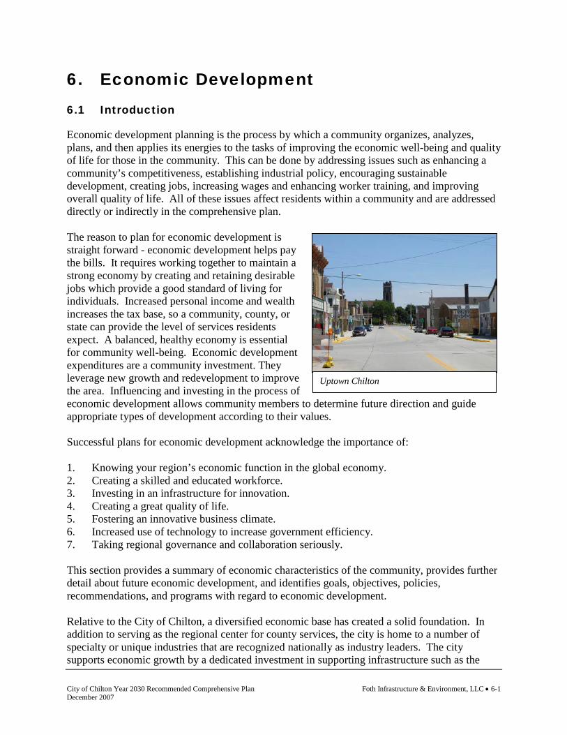
City of Chilton Year 2030 Recommended Comprehensive Plan Foth Infrastructure & Environment, LLC • 6-1 December 2007
Uptown Chilton
6. Economic Development 6.1 Introduction
Economic development planning is the process by which a community organizes, analyzes, plans, and then applies its energies to the tasks of improving the economic well-being and quality of life for those in the community. This can be done by addressing issues such as enhancing a community’s competitiveness, establishing industrial policy, encouraging sustainable development, creating jobs, increasing wages and enhancing worker training, and improving overall quality of life. All of these issues affect residents within a community and are addressed directly or indirectly in the comprehensive plan. The reason to plan for economic development is straight forward - economic development helps pay the bills. It requires working together to maintain a strong economy by creating and retaining desirable jobs which provide a good standard of living for individuals. Increased personal income and wealth increases the tax base, so a community, county, or state can provide the level of services residents expect. A balanced, healthy economy is essential for community well-being. Economic development expenditures are a community investment. They leverage new growth and redevelopment to improve the area. Influencing and investing in the process of economic development allows community members to determine future direction and guide appropriate types of development according to their values. Successful plans for economic development acknowledge the importance of: 1. Knowing your region’s economic function in the global economy. 2. Creating a skilled and educated workforce. 3. Investing in an infrastructure for innovation. 4. Creating a great quality of life. 5. Fostering an innovative business climate. 6. Increased use of technology to increase government efficiency. 7. Taking regional governance and collaboration seriously. This section provides a summary of economic characteristics of the community, provides further detail about future economic development, and identifies goals, objectives, policies, recommendations, and programs with regard to economic development. Relative to the City of Chilton, a diversified economic base has created a solid foundation. In addition to serving as the regional center for county services, the city is home to a number of specialty or unique industries that are recognized nationally as industry leaders. The city supports economic growth by a dedicated investment in supporting infrastructure such as the
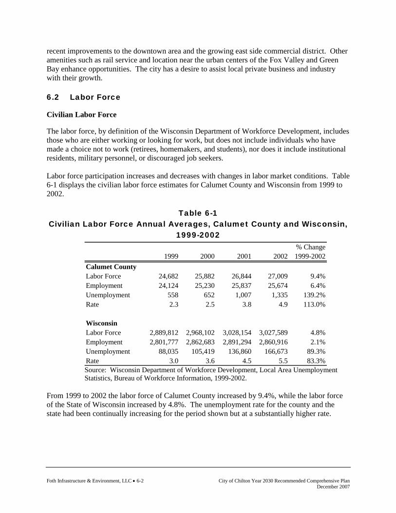
Foth Infrastructure & Environment, LLC • 6-2 City of Chilton Year 2030 Recommended Comprehensive Plan December 2007
recent improvements to the downtown area and the growing east side commercial district. Other amenities such as rail service and location near the urban centers of the Fox Valley and Green Bay enhance opportunities. The city has a desire to assist local private business and industry with their growth. 6.2 Labor Force
Civilian Labor Force
The labor force, by definition of the Wisconsin Department of Workforce Development, includes those who are either working or looking for work, but does not include individuals who have made a choice not to work (retirees, homemakers, and students), nor does it include institutional residents, military personnel, or discouraged job seekers. Labor force participation increases and decreases with changes in labor market conditions. Table 6-1 displays the civilian labor force estimates for Calumet County and Wisconsin from 1999 to 2002.
Table 6-1 Civilian Labor Force Annual Averages, Calumet County and Wisconsin,
1999-2002
Source: Wisconsin Department of Workforce Development, Local Area Unemployment Statistics, Bureau of Workforce Information, 1999-2002.
From 1999 to 2002 the labor force of Calumet County increased by 9.4%, while the labor force of the State of Wisconsin increased by 4.8%. The unemployment rate for the county and the state had been continually increasing for the period shown but at a substantially higher rate.
% Change1999 2000 2001 2002 1999-2002
Calumet CountyLabor Force 24,682 25,882 26,844 27,009 9.4%Employment 24,124 25,230 25,837 25,674 6.4%Unemployment 558 652 1,007 1,335 139.2%Rate 2.3 2.5 3.8 4.9 113.0%
WisconsinLabor Force 2,889,812 2,968,102 3,028,154 3,027,589 4.8%Employment 2,801,777 2,862,683 2,891,294 2,860,916 2.1%Unemployment 88,035 105,419 136,860 166,673 89.3%Rate 3.0 3.6 4.5 5.5 83.3%

City of Chilton Year 2030 Recommended Comprehensive Plan Foth Infrastructure & Environment, LLC • 6-3 December 2007
Educational Attainment
Table 6-2 displays the educational attainment level of Calumet County and City of Chilton residents who were age 25 and older in 2000. The educational attainment level of persons within a community is often an indicator of the overall income, job availability, and well being of the community. Lower educational attainment levels in an area can also be a hindrance to attracting certain types of businesses, typically those that require high technical skills and upper management types of positions.
Table 6-2 Educational Attainment of Persons Age 25 and Over,
Calumet County and City of Chilton, 2000
Percent of Percent ofAttainment Level Number Total Number TotalLess than 9th grade 221 9.0% 1,464 5.6%9th to 12 grade, no diploma 283 11.5% 1,840 7.1%High school graduate (includes equivalency) 1,117 45.4% 10,575 40.6%Some college, no degree 354 14.4% 4,571 17.5%Associate degree 186 7.6% 2,203 8.5%Bachelor's degree 244 9.9% 3,979 15.3%Graduate or professional degree 57 2.3% 1,436 5.5%Total persons age 25 and over 2,462 100.0% 26,068 100.0%
City of Chilton Calumet County
Source: U.S. Bureau of the Census, STF-3, 2000.
In the City of Chilton, approximately 45% of persons age 25 and over have graduated high school or completed the equivalency. Approximately 8% have an associate degree, 10% have a bachelor’s degree, and 2.3% have a graduate or professional degree. Travel Time to Work
For most of the general population, the location of their home is dependent upon the location of their work. Knowing the amount of time people are willing to travel to work can serve as an indication for future locations of housing and/or economic development. Table 6-3 displays the travel time to work for Calumet County, its municipalities, and the State of Wisconsin in 2000.

Foth Infrastructure & Environment, LLC • 6-4 City of Chilton Year 2030 Recommended Comprehensive Plan December 2007
Table 6-3 Travel Time to Work, Calumet County and Wisconsin, 2000
*Municipality crosses at least one county line, data provided are only for portion in Calumet County. Source: U.S. Bureau of the Census, STF-3, 2000. Only included workers age 16 and over. For City of Chilton residents who drive to work, most had a commute time of five to nine minutes. This would generally indicate that these residents work within the city or within a very close proximity. A large number of residents had a commute of less than five minutes as well. Household Income
The household income within an area can offer some additional insight regarding the local economy, types of jobs in the area, and the general economic base. Table 6-4 displays the 2000 household incomes for Calumet County, its municipalities, and the State of Wisconsin as reported by the 2000 Census.
Less than 5 to 10 to 20 to 30 to 40 to 60 or more Worked at 5 minutes 9 minutes 19 minutes 29 minutes 39 minutes 59 minutes minutes homeT. Brillion 47 139 170 122 151 52 31 67T. Brothertown 18 65 270 142 84 90 39 88T. Charlestown 42 119 109 36 15 56 14 21T. Chilton 44 125 187 84 60 51 16 88T. Harrison 73 367 1,358 788 313 126 98 136T. New Holstein 90 152 269 85 131 67 9 73T. Rantoul 24 66 151 58 39 33 18 80T. Stockbridge 35 76 163 174 183 78 32 41T. Woodville 39 58 157 126 64 19 25 87V. Hilbert 41 54 185 121 110 83 13 3V. Potter 17 7 49 10 15 9 4 0V. Sherwood 32 34 234 306 139 28 43 32V. Stockbridge 16 20 66 70 96 37 23 11C. Appleton* 153 657 3,244 987 407 148 96 68C. Brillion 254 446 221 170 266 151 41 39C. Chilton 314 531 283 218 122 235 90 28C. Kiel* 23 35 51 33 14 13 0 2C. Menasha* 16 39 155 72 6 22 26 6C. New Holstein 353 464 467 160 89 87 41 61Calumet County 1,631 3,454 7,789 3,762 2,304 1,385 657 931Wisconsin 135,194 398,697 917,206 531,628 307,835 181,568 113,181 105,395
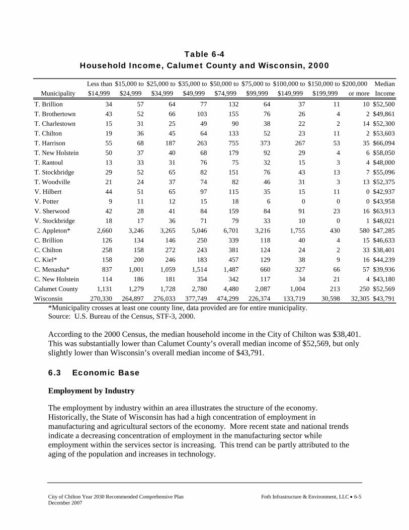
City of Chilton Year 2030 Recommended Comprehensive Plan Foth Infrastructure & Environment, LLC • 6-5 December 2007
Table 6-4 Household Income, Calumet County and Wisconsin, 2000
*Municipality crosses at least one county line, data provided are for entire municipality. Source: U.S. Bureau of the Census, STF-3, 2000. According to the 2000 Census, the median household income in the City of Chilton was $38,401. This was substantially lower than Calumet County’s overall median income of $52,569, but only slightly lower than Wisconsin’s overall median income of $43,791. 6.3 Economic Base
Employment by Industry
The employment by industry within an area illustrates the structure of the economy. Historically, the State of Wisconsin has had a high concentration of employment in manufacturing and agricultural sectors of the economy. More recent state and national trends indicate a decreasing concentration of employment in the manufacturing sector while employment within the services sector is increasing. This trend can be partly attributed to the aging of the population and increases in technology.
Less than $15,000 to $25,000 to $35,000 to $50,000 to $75,000 to $100,000 to $150,000 to $200,000 MedianMunicipality $14,999 $24,999 $34,999 $49,999 $74,999 $99,999 $149,999 $199,999 or more Income
T. Brillion 34 57 64 77 132 64 37 11 10 $52,500T. Brothertown 43 52 66 103 155 76 26 4 2 $49,861T. Charlestown 15 31 25 49 90 38 22 2 14 $52,300T. Chilton 19 36 45 64 133 52 23 11 2 $53,603T. Harrison 55 68 187 263 755 373 267 53 35 $66,094T. New Holstein 50 37 40 68 179 92 29 4 6 $58,050T. Rantoul 13 33 31 76 75 32 15 3 4 $48,000T. Stockbridge 29 52 65 82 151 76 43 13 7 $55,096T. Woodville 21 24 37 74 82 46 31 3 13 $52,375V. Hilbert 44 51 65 97 115 35 15 11 0 $42,937V. Potter 9 11 12 15 18 6 0 0 0 $43,958V. Sherwood 42 28 41 84 159 84 91 23 16 $63,913V. Stockbridge 18 17 36 71 79 33 10 0 1 $48,021C. Appleton* 2,660 3,246 3,265 5,046 6,701 3,216 1,755 430 580 $47,285C. Brillion 126 134 146 250 339 118 40 4 15 $46,633C. Chilton 258 158 272 243 381 124 24 2 33 $38,401C. Kiel* 158 200 246 183 457 129 38 9 16 $44,239C. Menasha* 837 1,001 1,059 1,514 1,487 660 327 66 57 $39,936C. New Holstein 114 186 181 354 342 117 34 21 4 $43,180Calumet County 1,131 1,279 1,728 2,780 4,480 2,087 1,004 213 250 $52,569Wisconsin 270,330 264,897 276,033 377,749 474,299 226,374 133,719 30,598 32,305 $43,791
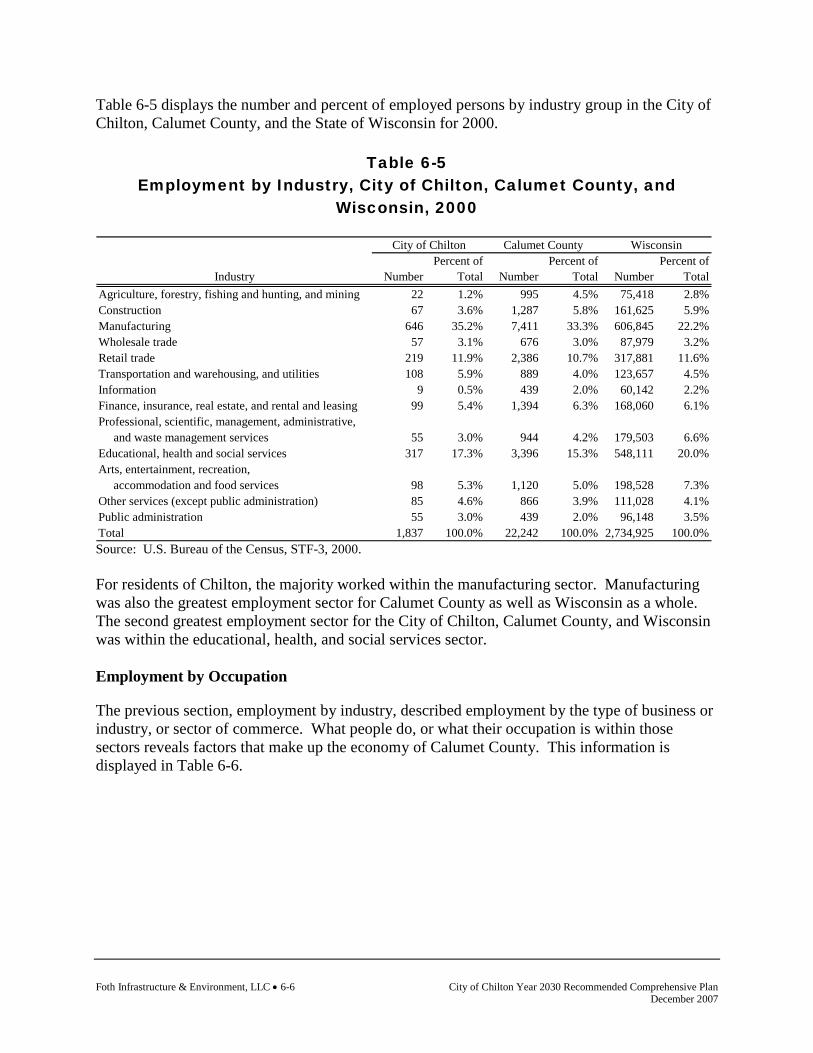
Foth Infrastructure & Environment, LLC • 6-6 City of Chilton Year 2030 Recommended Comprehensive Plan December 2007
Table 6-5 displays the number and percent of employed persons by industry group in the City of Chilton, Calumet County, and the State of Wisconsin for 2000.
Table 6-5 Employment by Industry, City of Chilton, Calumet County, and
Wisconsin, 2000
Percent of Percent of Percent ofIndustry Number Total Number Total Number Total
Agriculture, forestry, fishing and hunting, and mining 22 1.2% 995 4.5% 75,418 2.8%Construction 67 3.6% 1,287 5.8% 161,625 5.9%Manufacturing 646 35.2% 7,411 33.3% 606,845 22.2%Wholesale trade 57 3.1% 676 3.0% 87,979 3.2%Retail trade 219 11.9% 2,386 10.7% 317,881 11.6%Transportation and warehousing, and utilities 108 5.9% 889 4.0% 123,657 4.5%Information 9 0.5% 439 2.0% 60,142 2.2%Finance, insurance, real estate, and rental and leasing 99 5.4% 1,394 6.3% 168,060 6.1%Professional, scientific, management, administrative, and waste management services 55 3.0% 944 4.2% 179,503 6.6%Educational, health and social services 317 17.3% 3,396 15.3% 548,111 20.0%Arts, entertainment, recreation, accommodation and food services 98 5.3% 1,120 5.0% 198,528 7.3%Other services (except public administration) 85 4.6% 866 3.9% 111,028 4.1%Public administration 55 3.0% 439 2.0% 96,148 3.5%Total 1,837 100.0% 22,242 100.0% 2,734,925 100.0%
WisconsinCity of Chilton Calumet County
Source: U.S. Bureau of the Census, STF-3, 2000. For residents of Chilton, the majority worked within the manufacturing sector. Manufacturing was also the greatest employment sector for Calumet County as well as Wisconsin as a whole. The second greatest employment sector for the City of Chilton, Calumet County, and Wisconsin was within the educational, health, and social services sector. Employment by Occupation
The previous section, employment by industry, described employment by the type of business or industry, or sector of commerce. What people do, or what their occupation is within those sectors reveals factors that make up the economy of Calumet County. This information is displayed in Table 6-6.
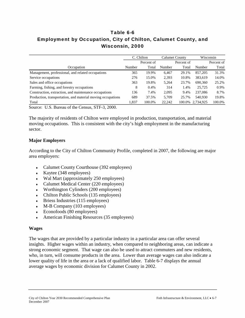
City of Chilton Year 2030 Recommended Comprehensive Plan Foth Infrastructure & Environment, LLC • 6-7 December 2007
Table 6-6 Employment by Occupation, City of Chilton, Calumet County, and
Wisconsin, 2000
Percent of Percent of Percent ofOccupation Number Total Number Total Number Total
Management, professional, and related occupations 365 19.9% 6,467 29.1% 857,205 31.3%Service occupations 276 15.0% 2,393 10.8% 383,619 14.0%Sales and office occupations 363 19.8% 5,264 23.7% 690,360 25.2%Farming, fishing, and forestry occupations 8 0.4% 314 1.4% 25,725 0.9%Construction, extraction, and maintenance occupations 136 7.4% 2,095 9.4% 237,086 8.7%Production, transportation, and material moving occupations 689 37.5% 5,709 25.7% 540,930 19.8%Total 1,837 100.0% 22,242 100.0% 2,734,925 100.0%
C. Chilton Calumet County Wisconsin
Source: U.S. Bureau of the Census, STF-3, 2000. The majority of residents of Chilton were employed in production, transportation, and material moving occupations. This is consistent with the city’s high employment in the manufacturing sector. Major Employers
According to the City of Chilton Community Profile, completed in 2007, the following are major area employers:
♦ Calumet County Courthouse (392 employees) ♦ Kaytee (348 employees) ♦ Wal Mart (approximately 250 employees) ♦ Calumet Medical Center (220 employees) ♦ Worthington Cylinders (200 employees) ♦ Chilton Public Schools (135 employees) ♦ Briess Industries (115 employees) ♦ M-B Company (103 employees) ♦ Econofoods (80 employees) ♦ American Finishing Resources (35 employees)
Wages
The wages that are provided by a particular industry in a particular area can offer several insights. Higher wages within an industry, when compared to neighboring areas, can indicate a strong economic segment. That wage can also be used to attract commuters and new residents, who, in turn, will consume products in the area. Lower than average wages can also indicate a lower quality of life in the area or a lack of qualified labor. Table 6-7 displays the annual average wages by economic division for Calumet County in 2002.
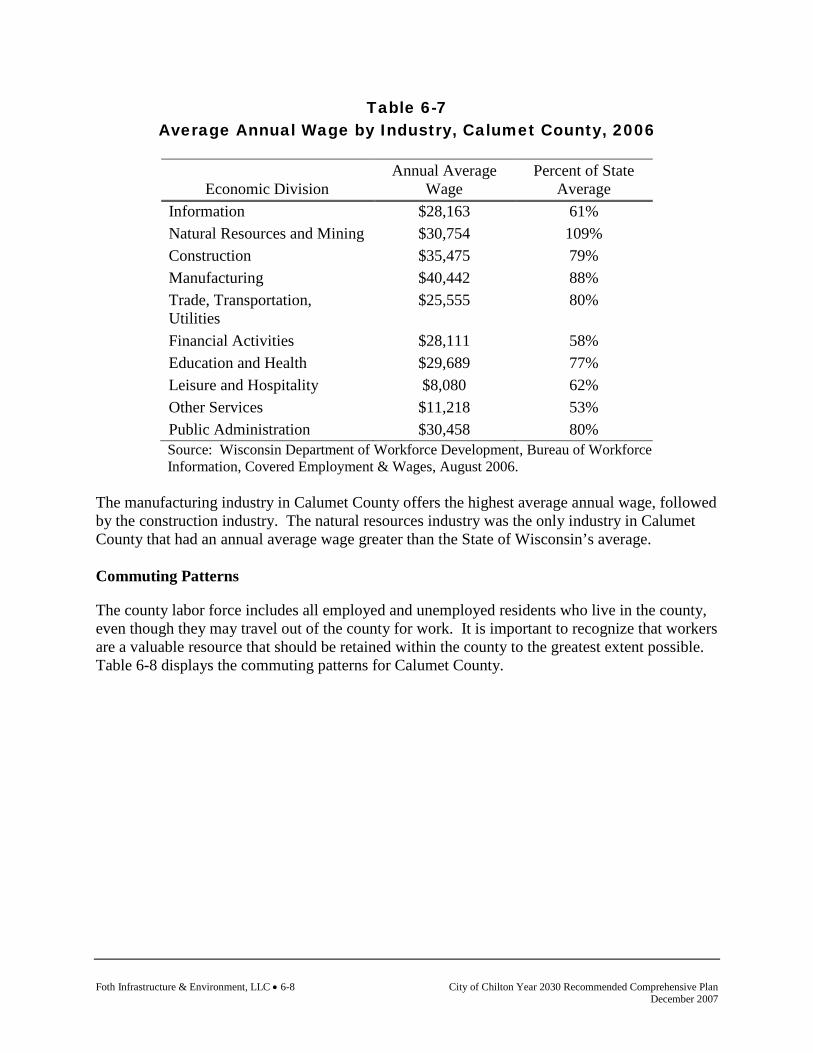
Foth Infrastructure & Environment, LLC • 6-8 City of Chilton Year 2030 Recommended Comprehensive Plan December 2007
Table 6-7 Average Annual Wage by Industry, Calumet County, 2006
Economic Division Annual Average
Wage Percent of State
Average Information $28,163 61% Natural Resources and Mining $30,754 109% Construction $35,475 79% Manufacturing $40,442 88% Trade, Transportation, Utilities
$25,555 80%
Financial Activities $28,111 58% Education and Health $29,689 77% Leisure and Hospitality $8,080 62% Other Services $11,218 53% Public Administration $30,458 80% Source: Wisconsin Department of Workforce Development, Bureau of Workforce Information, Covered Employment & Wages, August 2006.
The manufacturing industry in Calumet County offers the highest average annual wage, followed by the construction industry. The natural resources industry was the only industry in Calumet County that had an annual average wage greater than the State of Wisconsin’s average. Commuting Patterns
The county labor force includes all employed and unemployed residents who live in the county, even though they may travel out of the county for work. It is important to recognize that workers are a valuable resource that should be retained within the county to the greatest extent possible. Table 6-8 displays the commuting patterns for Calumet County.

City of Chilton Year 2030 Recommended Comprehensive Plan Foth Infrastructure & Environment, LLC • 6-9 December 2007
Table 6-8 Commuting Patterns, Calumet County, 2000
Live in Travel toCalumet County Calumet County Net
Area Work in: From: CommuteOutagamie County 6,739 1,611 -5,128Winnebago County 3,423 570 -2,853Manitowoc County 713 1,968 1,255Sheboygan County 632 433 -199Brown County 598 467 -131Fond du Lac County 494 614 120Waupaca County 69 30 -39Milwaukee County 33 23 -10Portage County 14 22 8Dodge County 13 11 -2Elsewhere 234 163 -71Work in Calumet County 8,951 8,951 0Total 21,913 14,863 -7,050 Source: U.S. Bureau of the Census, STF-3, 2000.
Approximately 7,000 more workers leave Calumet County for work than come to the county for work. Calumet County loses the majority of its labor force to Outagamie County, followed by Winnebago County. Calumet County does attract 1,255 workers from Manitowoc County. According to the 1990 Census, of the 17,270 workers in the county at the time, approximately 9,060 worked in another county while 8,146 worked in Calumet County. Therefore, in 1990 approximately 47.2% of workers lived and worked in Calumet County and by 2000 this figure decreased to 40.8%. Employment Forecast
An important feature of determining the economic health and future of Calumet County and its communities is to determine the amounts and types of jobs currently available as well as make predictions for the future. In November of 2003, the Wisconsin Department of Workforce Development (WDWD) released a report titled Wisconsin Projections 2000-2010: Employment in Industries and Occupations, which examined jobs in over 70 industries and 750 occupations. Many of the projections and estimates provided in the report will affect Calumet County and/or local economies. Overall, the number of jobs in Wisconsin is expected to grow by 9.6% by 2010. While employment in Wisconsin’s manufacturing sector has shrunk in the past few years, this sector is anticipated to gain back some of the jobs lost since 2000. The manufacturing industries projected to add the most jobs are lumber and wood products, furniture and fixtures, and food
Foth Infrastructure & Environment, LLC • 6-10 City of Chilton Year 2030 Recommended Comprehensive Plan December 2007
and kindred products. The manufacturing industries expected to lose the most jobs are industrial machinery and equipment, primary metal, and electronic and other electrical equipment. The services sector will be the job growth leader, spurred on by the aging of Wisconsin’s population, technological innovations in health services and computer services, and continued outsourcing of business functions. Over 70% of the new jobs in the services sector will be in health, business, educational, or social services. Another sector expected to add numerous jobs is retail trade. This increase is expected due to population and tourism growth, and the likelihood that people will continue to prepare fewer meals at home. Job Loss Training Opportunities
A $1.2 million federal grant announced in February 2007 will provide job counseling and training assistance to about 400 workers affected by plant closings in Calumet County. Most of the money will go to assist workers recently laid off by Chilton Products, Chilton, Brillion Iron Works, Brillion, and Tecumseh Power Co., New Holstein. The funds will go to the state, which in turn will funnel it to the Fox Valley Workforce Development Board in Neenah. The federal grant should provide assistance to every displaced worker personally valued at about $2,500. The goal of the grant is to get every person retrained and re-employed. Western Industries, parent company of Chilton Products, announced in October 2006 that it would close its Chilton plant and transfer its plastics blow-molding operations to Kansas and cut 95 local workers. The Chilton Products plant closed in December 2006. Tecumseh Products Co. announced in 2006 that it would close its New Holstein manufacturing plant by the end of August 2007 and lay off the 320 workers at the facility. Heus Manufacturing Co. of New Holstein, a contract machine shop with about 100 workers, announced that it will sign a lease to use 85,000 square feet of the 440,000 Tecumseh facility. 6.4 Environmentally Contaminated Sites for Commercial or Industrial
Use
The Environmental Protection Agency (EPA) and the Wisconsin Department of Natural Resources (WDNR) urge the clean up of environmentally contaminated commercial or industrial sites to utilize the lands for more productive uses. According to the WDNR, Calumet County has a variety of sites that are in need of clean up or where clean up is underway. According to the WDNR’s Bureau of Remediation and Redevelopment Tracking System (BRRTS) there are five types of environmentally contaminated sites in Calumet County. They are classified as follows:
♦ Spills: A discharge of a hazardous substance that may adversely impact, or threaten to adversely impact, public health, welfare, or the environment. Spills are usually cleaned up quickly.
City of Chilton Year 2030 Recommended Comprehensive Plan Foth Infrastructure & Environment, LLC • 6-11 December 2007
♦ LUST: A Leaking Underground Storage Tank that has contaminated soil and/or groundwater with petroleum. Some LUST cleanups are reviewed by the WDNR and some are reviewed by the Wisconsin Department of Commerce.
♦ ERP: Environmental Repair (ERP) sites are sites other than LUSTs that have
contaminated soil and/or groundwater. Examples include industrial spills (or dumping) that need long term investigation, buried containers of hazardous substances, and closed landfills that have caused contamination. The ERP module includes petroleum contamination from above-ground (but not from underground) storage tanks.
♦ General Property: This module contains records of various milestones related to liability
exemptions, liability clarifications, and cleanup agreements that have been approved by the WDNR to clarify the legal status of the property.
♦ VPLE: A voluntary Property Liability Exemption (VPLE) is an elective process in which
a property owner conducts an environmental investigation and cleanup of an entire property and then receives limits on future liability for that contamination under s. 292.15, Wisconsin Statutes. An individual, business, or unit of government can receive the liability exemption after a completed cleanup is approved.
For the City of Chilton, as of August 2005, there were a total of 50 sites identified by BRRTS as being located within the City or Town of Chilton and as being open or conditionally closed (indicating that further remediation may be necessary). To determine sites that are located in the city versus sites that are located in the town, an assessment of site addresses would be required. Of the total 50 sites identified by BRRTS, seven sites are identified as ERP’s, five are identified as LUST sites, one is identified as a VPLE site, and the remaining are all identified as spill sites. With regard to economic development and potential sites for redevelopment or remediation, ERP and LUST sites offer the greatest potential for re-use. The City of Chilton should complete a more thorough review of these site locations and their status to determine economic development potential. The City of Chilton has actively been working to cleanup contaminated sites in the community. In 2004, 2005, and 2006, the city received Site Assessment Grants (SAG) from the WDNR to complete site investigations for several locations on Main Street. This also included asbestos investigations and removal as well as demolition. 6.5 Strengths and Weaknesses Analysis
A determination of the strengths and weaknesses of the City of Chilton and its economy provide the basic planning steps for future economic development. Strengths should continue to be promoted and new development, which fits well with these features, should be encouraged. Weaknesses should be improved or further analyzed and new development, which displays aspects similar to identified weaknesses, should be discouraged. The economic strengths and weaknesses of the city are as follows:

Foth Infrastructure & Environment, LLC • 6-12 City of Chilton Year 2030 Recommended Comprehensive Plan December 2007
Strengths
♦ Located relatively near major urban centers of Green Bay and the Fox Valley ♦ Chilton is the County seat ♦ Availability of highway access ♦ Quality education, i.e., Fox Valley Technical College ♦ High quality of life ♦ Rail service ♦ City contains high level “unique” industries that are currently healthy ♦ Most industries non-competitive within the city ♦ City known as a Regional Service Center to Calumet County ♦ Diversity of existing employment ♦ Quality community infrastructure, sewer, water, roads, etc. ♦ Current industries identified as national leaders in their respective industries ♦ City has invested in commercial development visions and has put forth funding to
implement ♦ Very professional web-site to attract business ♦ Improving cooperation between private industry and government
Weaknesses
♦ Advancing and aging workforce ♦ Recent closing of area businesses such as Chilton Products and Tecumseh Products ♦ Lack of trained “skilled” labor ♦ Lack of county economic vision
Tax Incremental Financing Districts
Tax Incremental Financing (TIF) can help a municipality undertake a public project to stimulate beneficial development or redevelopment that would not otherwise occur. It is a mechanism for financing a local economic development project in underdeveloped and blighted areas. Taxes generated by the increased property values pay for land acquisition or needed public works.
The Chilton Industrial Park changed names in 2007 to the Chilton Business Park. A new sign has been erected.

City of Chilton Year 2030 Recommended Comprehensive Plan Foth Infrastructure & Environment, LLC • 6-13 December 2007
City of Chilton TIF Summary The City of Chilton has created a total of five districts as follows:
♦ TIF #1, created in 1990 and closed in 2005. This TIF was located in the industrial park. ♦ TIF #2, created in 1992. It is located south of Clay Street to Calumet Street, with land
south of Irish Rd from Calumet to railroad added in 2001. ♦ TIF #3, created in 1995 and closed in 2005. It is located on the south side of Chilton. ♦ TIF #4, created in 2005. It is located uptown from Madison Street west to State and
School Street south to the river. ♦ TIF #5, created in 2005. It is located downtown from Webster Street north to Grand
Street and Adams Streets west to Mill/Pennsylvania. Map 6-1 shows the location of TIF districts within the city. For further information refer to Section 6.6, Desired Economic Development.

Foth Infrastructure & Environment, LLC • 6-14 City of Chilton Year 2030 Recommended Comprehensive Plan December 2007
This page intentionally left blank.

City of Chilton Year 2030 Recommended Comprehensive Plan Foth Infrastructure & Environment, LLC • 6-15 December 2007
Map 6-1 Economic Development, TIF

Foth Infrastructure & Environment, LLC • 6-16 City of Chilton Year 2030 Recommended Comprehensive Plan December 2007
This page intentionally left blank.

City of Chilton Year 2030 Recommended Comprehensive Plan Foth Infrastructure & Environment, LLC • 6-17 December 2007
6.6 Desired Economic Development
Similar to most communities in Calumet County, the City of Chilton would welcome most economic opportunities that do not sacrifice community character or require a disproportionate level of community services per taxes gained. The categories or particular types of new businesses and industries that are desired by the community are generally described in the goals, objectives, and policies. City of Chilton Business Park (formerly the Chilton Industrial Park)
Created in 1990, the current business park has expanded greatly over the years. This expansion is due to companies that are leaders in their perspective fields and find Chilton is a great place to start and expand a business. For example, Kaytee Products announced in 2002 a $9.2 million expansion of its existing Chilton facility. Kaytee and the City of Chilton worked together to secure grants from the State of Wisconsin to improve transportation access to Kaytee and the rest of the industrial park, which helped make the company's expansion possible. Other businesses located in the park include Briess Malt and Ingredients Co., American Finishing Resources Inc., Backyard Native Inc., Denmark Distributing Inc., and WalMart. In 2001, Chilton expanded its business park by adding 44 acres of land. This additional land, which has 21 acres vacant, is available for businesses wanting to start, expand, or relocate. Improvements to the land were made and sites are available to begin construction. Chilton's Business Park is fully serviced with electrical, water, sewer, fiber optic, natural gas lines, and three phase power. Rail access is available. Access roads with curb and gutter flow traffic through the site. In 2003, the city created the Chilton Industrial Park Design and Development Guidelines. These guidelines were put in place to enhance existing investment and attract the highest and best use possible for the site. Currently, the total acreage of the business park is 120, with approximately 17 acres available. Uptown/Downtown Revitalization
For a majority of the city’s 125 years, Chilton’s central business districts - the uptown and the downtown - have been the center of economic, commercial, and retail activity. Like many communities, the edges of the community have grown, leaving the city’s center in need of revitalization. To address this concern, Chilton began an aggressive campaign to improve these core areas. In 2002, the city commissioned Vandewalle & Associates to create a Central Business District Opportunity Analysis that describes the opportunities for land use, redevelopment, urban design, and economic development for these two districts. The opportunity analysis created a five-step process to begin implementing change:
1. Creation of a Redevelopment Authority to oversee redevelopment activities. 2. Creation of a Master Plan that defines reuse and redevelopment projects. 3. Creation of a statutorily-mandated redevelopment district and project plan. 4. Identification and creation of financing strategies, including tax increment finance, state
and federal grant programs and private donations.
Foth Infrastructure & Environment, LLC • 6-18 City of Chilton Year 2030 Recommended Comprehensive Plan December 2007
5. Creation of a coherent implementation strategy to actively pursue and coordinate public and private development as well as economic development.
The city began by establishing a Redevelopment Authority (RDA) in late 2002. After setting its goals and objectives, the RDA hired Vandewalle & Associates to create a master plan for the city’s uptown area. This involved many meetings between citizens, business and property owners, and government officials to discuss needs and wants for the uptown area, in addition to providing needed material to help create the vision, goals, and plan. In early 2004, the master plan was completed. The master plan provides the following:
1. Defines the uptown area. 2. Provides a vision for the uptown area. 3. Recommends specific public improvement projects and site redevelopment areas.
As the master plan was being completed, Wisconsin laws regarding Tax Increment Financing (TIF) changed. These new changes, which allowed communities to expand or create new TIF areas, were a benefit to the redevelopment plans. In September 2004, the city announced a plan to close two of its current TIF districts and create a new district for both the uptown and downtown areas. In addition, the city is seeking grants and other financial assistance to complete some of the revitalization projects defined in the Uptown Master Plan that was completed in 2005. Finally, a Downtown Master Plan was created to closely study the area and plan area redevelopment. In March 2005, the Chilton City Council and the Joint Review Board approved the creation of two TIF districts--TIF #4 is the uptown area, TIF #5 is the downtown. In addition, excess funds from TIF #2 can be used to fund TIFs #4 and #5. While these projects will take time to complete, the city feels that with the support of its citizens, positive changes can be made to better the entire community. 6.7 Economic Development Goals and Objectives
Following are the goals and objectives developed by the City of Chilton regarding economic development. (The source of each goal and objective is noted in parentheses.) Goal: Provide an adequate framework for the expansion and continual redevelopment of
commercial and industrial uses in Chilton (City of Chilton Comprehensive Plan, 1998). Objectives 1. Improve the appearance of the city’s commercial districts (City of Chilton Comprehensive
Plan, 1998). 2. Plan to locate new commercial development in relation to existing uses and in conformance
with the comprehensive plan (City of Chilton Comprehensive Plan, 1998).

City of Chilton Year 2030 Recommended Comprehensive Plan Foth Infrastructure & Environment, LLC • 6-19 December 2007
3. Work to accommodate the changing commercial economy of the city (City of Chilton Comprehensive Plan, 1998).
4. Continue to actively market the city in order to attract needed service and retail
establishments to the commercial areas (City of Chilton Comprehensive Plan, 1998). 5. Promote business retention, expansion, and recruitment efforts that are consistent with the
city’s comprehensive plan (Smart Growth Planning Process). Goal Support the organizational growth of economic development programs in the city,
county, and region (Smart Growth Planning Process). Objectives 1. Cooperate with communities regarding comprehensive planning and economic
development issues (Smart Growth Planning Process). 2. Continue an open line of communication with industries to assist them in their needs (City
of Chilton 2005-2006 Goals and Objectives). 3. Work with the Calumet County Tourism Association and Chamber of Commerce to
promote the Chilton area as a destination point for visitors (City of Chilton 2005-2006 Goals and Objectives).
4. Support area technical colleges, universities, and work force development agencies in their
efforts (Smart Growth Planning Process). 5. Continue economic development coordination through RDA and/or local business groups
(Smart Growth Planning Process). Goal: Maintain and improve the utility, communication, and transportation infrastructure
systems that promote economic development (Smart Growth Planning Process). Objectives 1. Enhance a vital downtown and outlying commercial and retail districts and provide
adequate pedestrian areas and aesthetic features which encourage consumer activity and enhance community character (Smart Growth Planning Process).
2. Support the development of regional facilities, cultural amenities, and services that will
strengthen the long-term attractiveness of the city, Calumet County, and the region (Smart Growth Planning Process).
3. Respond to the infrastructure needs of established businesses in order to meet their
expansion and facility needs when they are consistent with the city’s comprehensive plan (Smart Growth Planning Process).

Foth Infrastructure & Environment, LLC • 6-20 City of Chilton Year 2030 Recommended Comprehensive Plan December 2007
Goal: Promote entrepreneurial development and new business attraction efforts (Smart Growth Planning Process).
Objectives 1. Support the pursuit of local, state, and federal funding and assistance that will help
entrepreneurs start new businesses (Smart Growth Planning Process). 2. Distinguish and promote features unique to the city in order to create a unique identity
within the county (Smart Growth Planning Process). 3. Work with Calumet County Planning Department to establish an economic vision for the
county (Smart Growth Planning Process). 4. Consider the potential impacts of proposed business development on the city and its
existing economic base (Smart Growth Planning Process). Goal: Support opportunities to increase and diversify the city’s tax base (Smart Growth
Planning Process). Objectives 1. Consider the benefits of city growth in relation to the cost of providing public services
(Smart Growth Planning Process). 2. Ensure that there are available commercial and industrial lands close to adequate
transportation services to accommodate desired economic growth in the city (Smart Growth Planning Process).
3. Continue to actively develop and promote TIF district and commercial properties (Smart
Growth Planning Process). 4. Support business development that will add to the long-term economic stability of the city
(Smart Growth Planning Process). 5. Work to attract and establish new industrial and commercial development (Smart Growth
Planning Process). 6. Encourage growth of existing industries and work to retain businesses (City of Chilton
Comprehensive Plan, 1998). 6.8 Economic Development Policies and Recommendations
Policies and recommendations build on goals and objectives by providing more focused responses and actions to the goals and objectives. Policies and recommendations become the tools that the community should use to aid in making land use decisions. Policies that direct

City of Chilton Year 2030 Recommended Comprehensive Plan Foth Infrastructure & Environment, LLC • 6-21 December 2007
action using the words “will” or “shall” are advised to be mandatory and regulatory aspects of the implementation of the comprehensive plan. In contrast, those policies that direct action using the word “should” are advisory and intended to serve as a guide. Policies
1. The use of TIF shall be annually evaluated by the city. Strategies for further investment and improvements to TIF districts shall be proposed (Smart Growth Planning Process).
2. The city shall review and update as necessary the City of Chilton Business Park Site
Design and Development Guidelines (Smart Growth Planning Process). 3. The city shall maintain an up-to-date brochure for prospective businesses (City of Chilton
Comprehensive Plan, 1998). 4. The city shall maintain a web page(s) with links to key sites that would help attract
business persons to Chilton (City of Chilton Comprehensive Plan, 1998). 5. City leaders and/or their representatives shall meet with existing industry leaders regularly
to discuss their needs and see if the city can accommodate them in their needs (City of Chilton Comprehensive Plan, 1998).
Recommendations
Recommendations are specific actions or projects that the community should be prepared to complete. Completion of these actions and projects is consistent with the community’s policies, and therefore will help fulfill the comprehensive plan goals and objectives. 1. Continue to implement the Uptown Master Plan and Downtown Redevelopment Plan. 2. Market commercial development on the city’s south side, formerly TIF #3 (City of Chilton
2005-2006 Goals and Objectives). 3. Continue to fund studies and conduct market research in an effort to identify opportunities
for industrial and business growth within the city (Smart Growth Planning Process). 6.9 Economic Development Programs
The following programs are currently utilized by the community or are available for use by the community to implement the goals, objectives, policies, and recommendations identified. Chilton Area Chamber of Commerce The Chilton Area Chamber of Commerce is dedicated to the future growth, health, and prosperity of the City of Chilton. The Chamber of Commerce is organized to unite, advertise, and advance the commercial, mercantile, and manufacturing interests of the City of Chilton; to improve civic and industrial conditions; to promote just and equitable principles of business and trade among its members; and do all things possible for the promotion of business and civic

Foth Infrastructure & Environment, LLC • 6-22 City of Chilton Year 2030 Recommended Comprehensive Plan December 2007
interest. The Chilton Area Chamber of Commerce currently has 165 members. Any person, association or organization can join the Chamber. The Chamber’s web-site can be found at www.chiltonchamber.com. Chilton Redevelopment Authority Chilton's Redevelopment Authority (RDA) was formed in October 2002 to actively participate in the redevelopment activities in the city's central business districts. The RDA has several defined objectives including the following: 1. Promote the development of Chilton’s Uptown and Downtown Business Districts primarily
as a facilitator by working with developers and entrepreneurs to invest in these areas and by working with property and business owners to encourage maintenance and improvement of their properties and businesses.
2. Eliminate blight and increase the valuation of property and tax base with better use. 3. Encourage retail and commercial business growth. 4. Keep open lines of communication between the RDA and the community. Chilton Area Development Corporation Organized in the 1950s, Chilton Area Development Corporation (CADC) is a for-profit stock corporation. The stated goal is to promote commercial and industrial development in the city. CADC was originally organized to assist and promote Chilton Metal Products coming to the city. Many local businesses and individuals are stockholders. In the recent past, CADC was instrumental in assisting the City of Chilton with the development of its TIF districts. Most recently, it played an investment role in the location and construction of the Best Western Stanton Inn. Wisconsin Department of Commerce The Wisconsin Department of Commerce (WDOC) has several grant programs and services available to communities or businesses within communities. The federally funded Community Development Block Grant (CDBG) program can be used for housing, economic development, and public facility improvements. WDOC also offers many more business assistance and financing programs as well as economic development news and statistics. For more information regarding available WDOC services call (608) 266-1018 or visit its web-site at www.commerce.state.wi.us for a further list of programs and financial resources.
♦ Community Development Block Grant for Economic Development (CDBG-ED): The CDBG-ED program was designed to assist businesses that will invest private funds and create jobs as they expand or relocate to Wisconsin. The Wisconsin Department of Commerce awards the funds to a general-purpose unit of government (community) which then loans the funds to a business. When the business repays the loan, the community may retain the funds to capitalize a local revolving loan fund. This fund can then be utilized to finance additional economic development projects within the community. For more information contact the Wisconsin Department of Commerce.
City of Chilton Year 2030 Recommended Comprehensive Plan Foth Infrastructure & Environment, LLC • 6-23 December 2007
♦ Community Development Block Grant for Public Facilities for Economic Development (CDBG-PFED): The Public Facilities for Economic Development (PFED) program is designed to assist communities with expanding or upgrading their infrastructure to accommodate businesses that have made a firm commitment to create jobs and invest in the community. Eligible activities are those improvements to public facilities such as water systems, sewerage systems, and roads that are owned by a general or special purpose unit of government, that will principally benefit one or more businesses, and that as a result will induce the business(es) to create additional jobs and to invest in the community. The total amount of all CDBG-PFED assistance received by an eligible government may not exceed $1,000,000 per calendar year. The total amount of CDBG-PFED assistance that can be provided to benefit a single business or related businesses may not exceed $750,000. For more information contact the Wisconsin Department of Commerce, Bureau of Community Development.
♦ Brownfields Program: This program provides information and assistance related to
brownfields redevelopment. The Brownfields Development Consultant can assist in the identification and resolution of regulatory and liability issues as they relate to environmentally contaminated properties. Contact Jason Scott, 608/261-7714.
♦ Business Retention and Expansion Survey: This program helps communities produce
confidential, comprehensive data profiles on businesses in the community in order to develop a systematic approach to business retention. Contact Lorie Ham, 608/266-9884.
♦ Main Street Program: This program helps communities revitalize their downtown areas.
The National Main Street Center and state staff offer a comprehensive range of professional services that follow a four-point approach: organization, promotion, design, and economic restructuring.
♦ Wisconsin Youth Apprenticeship Program: This program helps businesses prepare future
workers and is an integral part of the State Department of Workforce Development’s workforce training strategy. Youth apprenticeship is a rigorous two-year elective program for high school juniors and seniors that combines academic and technical classroom instruction and on-the-job training from business mentors.
Joint Effort Marketing (JEM) Grant Program The Joint Effort Marketing (JEM) Grant Program provides partnership funding to help non-profit organizations promote tourism and to maintain a strong tourism industry in Wisconsin. JEM is based on state statutes and administrative rules that govern its administration, and permit the department to conduct a matching grant program with local non-profit organizations on a cooperative basis. The program offers Wisconsin's tourism communities a variety of options to assist in the development of marketing initiatives. Contact the Wisconsin Department of Transportation for further information.
Foth Infrastructure & Environment, LLC • 6-24 City of Chilton Year 2030 Recommended Comprehensive Plan December 2007
Wisconsin Department of Workforce Development The Wisconsin Department of Workforce Development (DWD) is a state agency charged with building and strengthening Wisconsin's workforce in the 21st century and beyond. The Department's primary responsibilities include providing job services, training, and employment assistance to people looking for work, at the same time as it works with employers on finding the necessary workers to fill current job openings. Under the DWD umbrella, a wide variety of employment programs can be found which include securing jobs for the disabled, assisting former welfare recipients as they make a transition into work, promoting 72 job centers, linking youth with the jobs of tomorrow, protecting and enforcing worker's rights, processing unemployment claims, and ensuring workers compensation claims are paid in accordance with the law. There are six divisions within the Department which is headed by a Secretary appointed by the Governor. For further information visit the web-site at www.dwd.state.wi.us. Fox Valley Technical College (FVTC) Manufacturers look to FVTC for training and services to improve their efficiency and competitiveness. FVTC has a vast array of expertise to help with applied manufacturing projects and problems targeted at improving productivity and strengthening the region's manufacturing economy. E-mail or call (920) 735-2525 (Appleton) or (920) 236-6156 (Oshkosh) to learn the comprehensive assistance FVTC can provide manufacturers.
City of Chilton Year 2030 Recommended Comprehensive Plan Foth Infrastructure & Environment, LLC • 7-1 December 2007
Calumet County Intergovernmental Coordination
Calumet County has 35 units of government and special purpose districts.
♦ 6 Cities ♦ 9 Towns ♦ 4 Villages ♦ 11 School Districts ♦ 4 Sanitary Districts ♦ 1 Lake Protection District
Two cities in Calumet County, Menasha and Kiel, partially lie in two counties. The City of Appleton lies in three counties.
7. Intergovernmental Cooperation 7.1 Introduction
In general terms, intergovernmental cooperation is any arrangement by which officials of two or more jurisdictions coordinate plans, policies, and programs to address and resolve issues of mutual interest. It can be as simple as communicating and sharing information, or it can involve entering into formal intergovernmental agreements and sharing resources such as equipment, buildings, staff, and revenue. It can even involve consolidating services and jurisdictions or transferring territory. Many issues cross jurisdictional boundaries, affecting more than one community. For example, air, water, and wildlife pass over the landscape regardless of boundaries so that one jurisdiction’s activities with regard to air, water, and wildlife impacts other jurisdictions downwind or downstream. Today, increased communication technologies and personal mobility mean that people, money, and resources also move across jurisdictions, as quickly and freely as air and water. Persons traveling along roadways use a network of transportation routes, moving between jurisdictions without even realizing it. Frequently, the action of one governmental unit impacts others. Increasingly, we have come to the realization that many vital issues are regional in nature. Watersheds, economic conditions, commuter patterns, housing, media markets, and effects from growth and change are all issues that spill over municipal boundaries and impact the region as a whole. Intergovernmental Cooperation Benefits
There are many reasons intergovernmental cooperation makes sense. The following are some examples:
♦ Cost Savings – Cooperation can save money by increasing efficiency and avoiding unnecessary duplication. Cooperation can enable some communities to provide their residents with services that would otherwise be too costly.

Foth Infrastructure & Environment, LLC • 7-2 City of Chilton Year 2030 Recommended Comprehensive Plan December 2007
♦ Opportunity to Address Regional Issues – By communicating and coordinating their actions, and working with regional and state jurisdictions, local communities are able to address and resolve issues which are regional in nature.
♦ Early Identification of Issues – Cooperation enables jurisdictions to identify and resolve
potential conflicts at an early stage, before affected interests have established rigid positions, before the political stakes have been raised, and before issues have become conflicts or crises.
♦ Reduced Litigation – Communities that cooperate are able to resolve issues before they
become mired in litigation. Reducing the possibility of costly litigation can save communities money, as well as the disappointment and frustration of unwanted outcomes.
♦ Consistency – Cooperation can lead to consistency of the goals, objectives, plans,
policies, and actions of neighboring communities and other jurisdictions.
♦ Predictability – Jurisdictions that cooperate provide greater predictability to residents, developers, businesses, and others. Lack of predictability can result in lost time, money, and opportunity.
♦ Understanding – As jurisdictions communicate and collaborate on issues of mutual
interest, they become more aware of one another’s needs and priorities. They can better anticipate problems and work to avoid them.
♦ Trust – Cooperation can lead to positive experiences and results that build trust between
jurisdictions.
♦ History of Success – When jurisdictions cooperate successfully in one area, the success creates positive feelings and an expectation that other intergovernmental issues can be resolved as well.
♦ Service to Citizens – The biggest beneficiaries of intergovernmental cooperation are
citizens for whom government was created in the first place. They may not understand, or even care about, the intricacies of a particular intergovernmental issue, but all Wisconsin residents can appreciate their benefits, such as costs savings, provision of needed services, a healthy environment, and a strong economy.
This element will contain information regarding existing plans or agreements, opportunities for the future, and existing and potential conflicts, and will identify goals, objectives, policies, recommendations, and programs for intergovernmental cooperation.

City of Chilton Year 2030 Recommended Comprehensive Plan Foth Infrastructure & Environment, LLC • 7-3 December 2007
7.2 Inventory of Existing Agreements
City of Chilton, Town of Charlestown, Town of Chilton, and Calumet County The City of Chilton, Town of Charlestown, Town of Chilton, and Calumet County have established an intergovernmental agreement under Wisconsin Statutes 66.0301. The agreement was originally executed in October 1, 2001. The agreement was amended in May 2006 to include the Town of Chilton. The intent of the agreement includes:
♦ Provide a mechanism and forum to discuss and plan for the orderly development and boundary issues of territory adjacent to the city, approximately 1.5 miles beyond the city boundary, into the town. This area is described as the growth area.
♦ Provide appropriate and cost-effective services in the growth area.
♦ Include the county and its representative in zoning of the growth area.
♦ Control urban sprawl by preventing unplanned development and protecting natural resources.
♦ Promote and jointly plan highway improvements.
♦ Provide for land disposal of bio-solids from the city’s sewage treatment plant in the town and provide for town cooperation with the city in developing and drilling new municipal wells.
The agreement details zoning, sanitary, annexation, and general planning issues in growth areas and establishes a Joint Planning Committee. The city and towns agree to share financial and maintenance responsibility for specific roads in the growth area. The towns agree to permit land disposal of bio-solids in accordance with DNR rules and will not object to the city locating additional wells in the towns. Any new development in the growth areas will require municipal services and therefore annexation to the city. The original agreement went into effect in October 2001 and was updated in May 2006. The term of the agreement is five years, 10 years for water and sewer service, and shall be renewed by mutual agreement between the city, towns, and county. East Shore Recycling Commission The East Shore Recycling Commission was started in 1994. Member communities include the Cities of Brillion, Chilton, Kiel, and New Holstein and the Villages of Hilbert, Potter, and Sherwood, and the Towns of Brillion, Brothertown, Calumet (Fond du Lac County), Charlestown, New Holstein, and Rantoul. Communities work together to jointly negotiate recycling collection and processing contracts with private providers. By working together these municipalities feel they are offered a better rate on recycling services from providers. The existing contract for these services will expire in 2007. The Commission is run with established bylaws and a board which meets as needed. The Commission has recently begun working on recycling education through funds offered by a grant program called Recycling Efficiency.

Foth Infrastructure & Environment, LLC • 7-4 City of Chilton Year 2030 Recommended Comprehensive Plan December 2007
Calumet County Region
7.3 Relationships with Other Governmental Units
School Districts
Calumet County is served by a total of 11 school districts and the City of Chilton is served by the Chilton School District. The city’s relationship with the school district is generally limited, but there are opportunities for cooperation. Cooperation is most feasible in the sharing of public buildings or facilities and the coordination of park and recreation facilities or programs. The siting of new school facilities is mainly conducted by the school district. Typically the city will have a limited role in this process. However, the city’s comprehensive plan can be a resource in the future for siting facilities and analyzing potential locations, demographics, and transportation issues. Adjacent Local Governments
As previously stated, the City of Chilton and the Towns of Charlestown and Chilton have a formalized agreement to pursue land use issues within the areas impacted by the three communities (see Section 7.2). Region
In recent years Calumet County has been experiencing an increasing role in the region. The county’s significant population growth has resulted in an increased interdependent relationship in the region as a whole for economic development, transportation, natural resource protection, tourism, housing, and planning. This is evident by the number of regional programs and groups that are available to the county and local municipalities including the Fox Cities Economic Development Partnership, Northeast Wisconsin Stormwater Consortium, New North, Inc., Northeast Wisconsin Regional Economic Partnership, Niagara Escarpment Resource
City of Chilton Year 2030 Recommended Comprehensive Plan Foth Infrastructure & Environment, LLC • 7-5 December 2007
Network, and several other regionally focused efforts. Calumet County, as well as many local municipalities, are active participants in regional efforts and cooperation and will continue to be in the future. State
The City of Chilton and Calumet County maintain relationships with a variety of state agencies and departments. The majority of these relationships may be characterized as regulatory in nature. Calumet County, acting as an arm of the state, must ensure enforcement of many state regulations and rules and therefore work with a variety of state agencies and departments on rule enforcement, compliance monitoring, and reporting. The city has a more limited role in dealing with state regulations. The county’s relationships are most common with departments such as the Department of Natural Resources, Department of Revenue, Department of Health and Family Services, and Department of Justice. The City of Chilton and Calumet County also maintain relationships with state agencies that are more related to program implementation. These programs can include goals to improve economic development, housing, natural resources, education, and cultural resources. These types of relationships are most common with departments such as Agriculture, Trade and Consumer Protection, Department of Commerce, State Historical Society, Department of Transportation, Department of Tourism, Department of Public Instruction, and the Department of Natural Resources. Overall, the majority of state agencies and departments have both a regulatory function and a program based or advancement and planning function. The City of Chilton has a good working relationship with a number of state agencies that help ensure compliance with state regulations as well as the advancement in providing services to citizens. Other Governmental Units
Other than the agreements mentioned above, the City of Chilton does not maintain any other intergovernmental agreements. 7.4 Intergovernmental Opportunities, Conflicts, and Resolutions
Potential Opportunities
Numerous opportunities exist for further cooperation with other units of government. Four primary intergovernmental opportunities include the following:
♦ Cooperation with services ♦ Cooperation with regulations ♦ Cooperation by sharing revenue ♦ Cooperation with boundaries
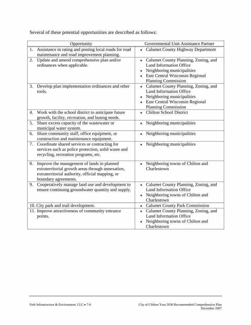
Foth Infrastructure & Environment, LLC • 7-6 City of Chilton Year 2030 Recommended Comprehensive Plan December 2007
Several of these potential opportunities are described as follows:
Opportunity Governmental Unit Assistance Partner 1. Assistance in rating and posting local roads for road
maintenance and road improvement planning. ♦ Calumet County Highway Department
2. Update and amend comprehensive plan and/or ordinances when applicable.
♦ Calumet County Planning, Zoning, and Land Information Office
♦ Neighboring municipalities ♦ East Central Wisconsin Regional
Planning Commission 3. Develop plan implementation ordinances and other
tools. ♦ Calumet County Planning, Zoning, and
Land Information Office ♦ Neighboring municipalities ♦ East Central Wisconsin Regional
Planning Commission 4. Work with the school district to anticipate future
growth, facility, recreation, and busing needs. ♦ Chilton School District
5. Share excess capacity of the wastewater or municipal water system.
♦ Neighboring municipalities
6. Share community staff, office equipment, or construction and maintenance equipment.
♦ Neighboring municipalities
7. Coordinate shared services or contracting for services such as police protection, solid waste and recycling, recreation programs, etc.
♦ Neighboring municipalities
8. Improve the management of lands in planned extraterritorial growth areas through annexation, extraterritorial authority, official mapping, or boundary agreements.
♦ Neighboring towns of Chilton and Charlestown
9. Cooperatively manage land use and development to ensure continuing groundwater quantity and supply.
♦ Calumet County Planning, Zoning, and Land Information Office
♦ Neighboring towns of Chilton and Charlestown
10. City park and trail development. ♦ Calumet County Park Commission 11. Improve attractiveness of community entrance
points. ♦ Calumet County Planning, Zoning, and
Land Information Office ♦ Neighboring towns of Chilton and
Charlestown
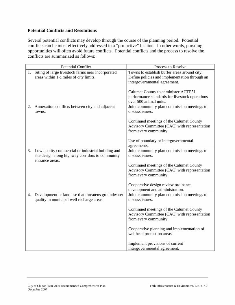
City of Chilton Year 2030 Recommended Comprehensive Plan Foth Infrastructure & Environment, LLC • 7-7 December 2007
Potential Conflicts and Resolutions
Several potential conflicts may develop through the course of the planning period. Potential conflicts can be most effectively addressed in a “pro-active” fashion. In other words, pursuing opportunities will often avoid future conflicts. Potential conflicts and the process to resolve the conflicts are summarized as follows:
Potential Conflict Process to Resolve 1. Siting of large livestock farms near incorporated
areas within 1½ miles of city limits. Towns to establish buffer areas around city. Define policies and implementation through an intergovernmental agreement. Calumet County to administer ACTP51 performance standards for livestock operations over 500 animal units.
2. Annexation conflicts between city and adjacent towns.
Joint community plan commission meetings to discuss issues. Continued meetings of the Calumet County Advisory Committee (CAC) with representation from every community. Use of boundary or intergovernmental agreements.
3. Low quality commercial or industrial building and site design along highway corridors to community entrance areas.
Joint community plan commission meetings to discuss issues. Continued meetings of the Calumet County Advisory Committee (CAC) with representation from every community. Cooperative design review ordinance development and administration.
4. Development or land use that threatens groundwater quality in municipal well recharge areas.
Joint community plan commission meetings to discuss issues. Continued meetings of the Calumet County Advisory Committee (CAC) with representation from every community. Cooperative planning and implementation of wellhead protection areas. Implement provisions of current intergovernmental agreement.
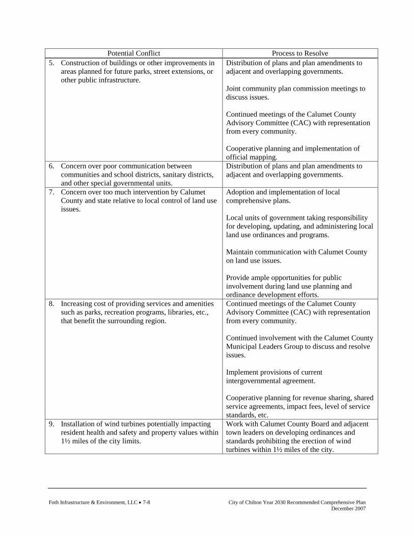
Foth Infrastructure & Environment, LLC • 7-8 City of Chilton Year 2030 Recommended Comprehensive Plan December 2007
Potential Conflict Process to Resolve 5. Construction of buildings or other improvements in
areas planned for future parks, street extensions, or other public infrastructure.
Distribution of plans and plan amendments to adjacent and overlapping governments. Joint community plan commission meetings to discuss issues. Continued meetings of the Calumet County Advisory Committee (CAC) with representation from every community. Cooperative planning and implementation of official mapping.
6. Concern over poor communication between communities and school districts, sanitary districts, and other special governmental units.
Distribution of plans and plan amendments to adjacent and overlapping governments.
7. Concern over too much intervention by Calumet County and state relative to local control of land use issues.
Adoption and implementation of local comprehensive plans. Local units of government taking responsibility for developing, updating, and administering local land use ordinances and programs. Maintain communication with Calumet County on land use issues. Provide ample opportunities for public involvement during land use planning and ordinance development efforts.
8. Increasing cost of providing services and amenities such as parks, recreation programs, libraries, etc., that benefit the surrounding region.
Continued meetings of the Calumet County Advisory Committee (CAC) with representation from every community. Continued involvement with the Calumet County Municipal Leaders Group to discuss and resolve issues. Implement provisions of current intergovernmental agreement. Cooperative planning for revenue sharing, shared service agreements, impact fees, level of service standards, etc.
9. Installation of wind turbines potentially impacting resident health and safety and property values within 1½ miles of the city limits.
Work with Calumet County Board and adjacent town leaders on developing ordinances and standards prohibiting the erection of wind turbines within 1½ miles of the city.

City of Chilton Year 2030 Recommended Comprehensive Plan Foth Infrastructure & Environment, LLC • 7-9 December 2007
7.5 Boundary Agreements and Provision of Services
Boundary and Land Use Agreements
Decisions about municipal boundaries are usually linked to land use and utility service decisions. Towns and neighboring villages/cities should work toward mutually agreeable solutions for long-term municipal boundaries and land use. The Land Use chapter of this document addresses this issue in detail. Continuing cooperation on comprehensive plans is one good way to achieve coordination among neighboring communities. Going further, plans can be formalized through intergovernmental boundary and land use agreements. Formal intergovernmental agreements may cover agreed future land uses in planned transition areas, set long term municipal boundaries, or set utility expansion limits. Such agreements help minimize potential for future conflicts as time passes. There are two main formats for intergovernmental agreements under Wisconsin Statutes. The first is available under Section 66.0301, which allows any two or more communities to agree to cooperate for the purpose of furnishing services or the joint exercise of any power or duty authorized under state law. The City of Chilton and the Town of Charlestown have adopted an agreement under this provision. While this is the most commonly used approach, a “66.0301” agreement is limited by the restriction that the municipalities must be able to exercise co-equal powers. Another format for an intergovernmental agreement is a “cooperative plan” under Section 66.0307 of the Wisconsin Statutes. This approach is more labor intensive and ultimately requires state approval of the agreement, but does not have some of the limitations of the 66.0301 agreement format. Cooperative Provisions of Utilities, Services, and Community Facilities
Consolidating and coordinating services and facilities between communities is done with the intent to achieve cost savings and improvement in services. Cooperative service agreements are particularly important in the current era of diminishing government financial resources. To advance intergovernmental cooperation with respect to community facilities and utilities, the community should:
♦ Encourage cooperative utility system planning in areas that are already developed but may need a higher or more reliable level of sewage treatment over the 20-year planning period. Coordination between neighboring communities on this issue is of particular relevance where higher density developments are close to villages and cities with public utilities. Other alternatives for water treatment for these types of areas include group (or community) waste treatment systems or separate sanitary or utility districts.
♦ Ensure county policy continues to guide urban development into areas with public
sanitary sewer and/or water systems and assist in working out intergovernmental agreements between towns and nearby cities or villages to extend public services into development areas in accordance with area development plans.
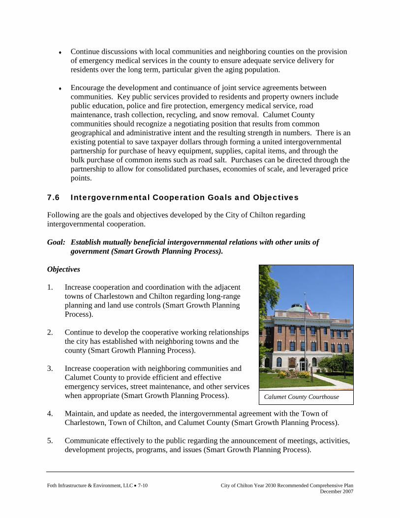
Foth Infrastructure & Environment, LLC • 7-10 City of Chilton Year 2030 Recommended Comprehensive Plan December 2007
Calumet County Courthouse
♦ Continue discussions with local communities and neighboring counties on the provision of emergency medical services in the county to ensure adequate service delivery for residents over the long term, particular given the aging population.
♦ Encourage the development and continuance of joint service agreements between
communities. Key public services provided to residents and property owners include public education, police and fire protection, emergency medical service, road maintenance, trash collection, recycling, and snow removal. Calumet County communities should recognize a negotiating position that results from common geographical and administrative intent and the resulting strength in numbers. There is an existing potential to save taxpayer dollars through forming a united intergovernmental partnership for purchase of heavy equipment, supplies, capital items, and through the bulk purchase of common items such as road salt. Purchases can be directed through the partnership to allow for consolidated purchases, economies of scale, and leveraged price points.
7.6 Intergovernmental Cooperation Goals and Objectives
Following are the goals and objectives developed by the City of Chilton regarding intergovernmental cooperation. Goal: Establish mutually beneficial intergovernmental relations with other units of
government (Smart Growth Planning Process). Objectives 1. Increase cooperation and coordination with the adjacent
towns of Charlestown and Chilton regarding long-range planning and land use controls (Smart Growth Planning Process).
2. Continue to develop the cooperative working relationships
the city has established with neighboring towns and the county (Smart Growth Planning Process).
3. Increase cooperation with neighboring communities and
Calumet County to provide efficient and effective emergency services, street maintenance, and other services when appropriate (Smart Growth Planning Process).
4. Maintain, and update as needed, the intergovernmental agreement with the Town of
Charlestown, Town of Chilton, and Calumet County (Smart Growth Planning Process). 5. Communicate effectively to the public regarding the announcement of meetings, activities,
development projects, programs, and issues (Smart Growth Planning Process).
City of Chilton Year 2030 Recommended Comprehensive Plan Foth Infrastructure & Environment, LLC • 7-11 December 2007
6. Maintain cooperative intergovernmental agreements with the adjacent towns to address annexation, expansion of public sewer and water services, land use compatibility and growth management (Smart Growth Planning Process).
7.7 Intergovernmental Cooperation Policies and Recommendations
Policies and recommendations build on goals and objectives by providing more focused responses and actions to the goals and objectives. Policies and recommendations become the tools that the community should use to aid in making land use decisions. Policies that direct action using the words “will” or “shall” are advised to be mandatory and regulatory aspects of the implementation of the comprehensive plan. In contrast, those policies that direct action using the word “should” are advisory and intended to serve as a guide. Policies
1. The city shall continue cooperative planning efforts with the surrounding towns, districts, associations, service providers, and the county (Smart Growth Planning Process).
2. The city should work with the neighboring towns to match land use plans and policies
along municipal boundaries to promote consistency and minimize potential conflicts (Smart Growth Planning Process).
3. Neighboring towns and districts should be invited to any future meetings in which
amendments or updates to the comprehensive plan are made or discussed that affect them (Smart Growth Planning Process).
4. A multi-jurisdictional planning effort will be considered when the comprehensive plan is
updated (Smart Growth Planning Process). 5. Before the purchase of new city facilities or equipment or the re-instatement of service
agreements, the city should pursue options for trading, renting, sharing, or contracting such items from neighboring jurisdictions (Smart Growth Planning Process).
Recommendations
Recommendations are specific actions or projects that the community should be prepared to complete. Completion of these actions and projects is consistent with the community’s policies, and therefore will help fulfill the comprehensive plan goals and objectives. 1. Work to provide more detailed provisions in the agreement with the Towns of Chilton and
Charlestown in an effort to reach land use border compatibility, efficient services, and ground water protection. Develop a meeting schedule and timeline to reach these objectives.

Foth Infrastructure & Environment, LLC • 7-12 City of Chilton Year 2030 Recommended Comprehensive Plan December 2007
7.8 Intergovernmental Cooperation Programs
The following programs are currently utilized by the community or are available for use by the community to implement the goals, objectives, policies, and recommendations identified. Calumet County Municipal Leaders Group This group is comprised of all city mayors, village clerks, and town chairpersons in Calumet County. They meet quarterly to discuss ways to cooperate better and share services. The group is organized through the County Administrator’s Office. Office of Land Information Services, Municipal Boundary Review Municipal Boundary Review regulates the transition of unincorporated areas to city or village status through municipal annexation, incorporation, consolidation, or by joint city-village-town activities involving cooperative boundary plans and agreements. Such agreements may change territorial boundaries and may provide for the sharing of municipal services. Staff members are available upon request to meet with local officials and citizens to discuss annexation, incorporation, consolidation, and cooperative boundary plans. Contact the Wisconsin Department of Administration, Office of Land Information Services for further information. League of Wisconsin Municipalities The League of Wisconsin Municipalities is a not-for-profit association of municipalities. Established in 1898, the League acts as an information clearinghouse, lobbying organization, and legal resource for Wisconsin municipalities. Its membership consists of 378 villages and all of the 190 cities in the state. UW-Extension Local Government Center The mission of the Local Government Center is to provide focus, coordination, and leadership to UW System educational programs for local government, and to expand the research and knowledge base for local government education. The Center conducts and coordinates educational programming in general local government, local government finance, growth management, and community planning and design. Additional programs are under development. Educational programs are delivered through the two-way audio Educational Telecommunications Network (ETN), satellite television, and state-wide and regional workshops. The Center supports the programming of county-based Extension faculty. A variety of resources regarding intergovernmental cooperation is available through the Local Government Center. For further information visit its web-site at www.uwex.edu/lgc/. Wisconsin Partnership The State of Wisconsin offers local government contract purchasing, technical advice, data and financial assistance to more efficiently provide government services and increase cooperation. At www.WisconsinPartnership.wi.gov a variety of information is provided to help local governments become more cost-effective.
City of Chilton Year 2030 Recommended Comprehensive Plan Foth Infrastructure & Environment, LLC • 8-1 December 2007
Land Use Inventory Existing land use as of 2004 was inventoried by the East-Central Wisconsin Regional Planning Commission using aerial photography, other existing maps, field verification, and input from local communities. The existing land use inventory incorporates land use classifications that were determined to best represent the character and features of the county while being classified consistently throughout the East-Central planning region.
8. Land Use 8.1 Introduction
Land use is a means of broadly classifying how land is used and how it could be used in the future. Each type of use has its own characteristics that can determine compatibility, location, and preference to other land uses. The maps, especially existing land use, are used to analyze the current pattern of development, and serve as the framework for formulating how land will be used in the future. Land use regulations, private market demands, ownership patterns, and resource management programs all contribute to the character of the community as it is known today. A primary function of this land use element is to help guide future land use in a way that is compatible, desirable, and accepted by the local community. This requires the consideration of a range of ideas and opinions relative to land use, property rights, and community values. The community can effectively manage land use through sensible land use controls and policies. Because land use is a people-oriented process, personal opinions, desires, attitudes, and legal and political considerations all have land use impacts. 8.2 Existing Land Use
Table 8-1, Figure 8-1, and Map 8-1 detail the existing land uses found in the City of Chilton. Land use is a means of broadly classifying different types of activities relating to how land is used. Chilton’s corporate boundary encompasses nearly four square miles. About half of the city’s total land area remains undeveloped. Residential areas account for the largest portion of developed land in the city. Much of Chilton’s most recent residential growth has occurred in the northwestern and southeastern portions of the city. Although still largely undeveloped, the western portion of Chilton holds excellent potential for long range residential growth because of the area’s lack of soil limitations and its proximity to the city’s elementary, middle school, and new high school. Chilton’s commercial core is concentrated in the heart of the city near the intersection of Main and Madison Streets. A smaller secondary commercial area is located near the railroad tracks several blocks to the northeast. Newer commercial growth has occurred along STH 57 at both north and south entrances into the city. Recent industrial development is concentrated in Chilton’s business park, which is located near USH 151 on the city’s east side. New large retail commercial development in the form of Wal-Mart has recently occurred adjacent the business park along USH 151. Most of its long standing industries are found near the eastern located rail

Foth Infrastructure & Environment, LLC • 8-2 City of Chilton Year 2030 Recommended Comprehensive Plan December 2007
line and in the southern portion of the city adjacent to Park Street. As described above, Map 8-1 shows the city’s existing land use pattern. Map 8-2 shows the location of properties owned by public entities. Further analysis of individual land use types are described in Table 8-1 and Figure 8-1.
Table 8-1 Existing Land Use, City of Chilton, 2004
Feature Acreage % of Total
Residential 468.1 17.1%
Single Family Residential 425.3 15.5% Multi-Family 42.8 1.6% Mobile Home 0.0 0.0%Commercial 135.4 4.9%Industrial 182.8 6.7% Quarry 2.1 0.1%Institutional 132.2 4.8%Transportation & Utilities 272.9 10.0%Farm & Cropland 967.4 35.3%Forestlands 98.2 3.6%Recreational 109.4 4.0%Open/Other 333.7 12.2%Water 40.1 1.5%Total 2,740.0 100.0% Source: Calumet County Planning Department.

City of Chilton Year 2030 Recommended Comprehensive Plan Foth Infrastructure & Environment, LLC • 8-3 December 2007
Land Use Connections
Land use is integrated with all elements of the comprehensive planning process. Changes in land use are not isolated, but rather are often the end result of a change in another element. For example, development patterns evolve over time as a result of population growth, the development of new housing, the development of new commercial or industrial sites, the extension of utilities or services, or the construction of a new road.
Utilities & Community Facilities
Implementation Issues & Opportunities
Transportation
Population & Housing
Intergovernmental Cooperation
Economic Development
Agricultural, Natural & Cultural Resources
Land Use
Figure 8-1
Existing Land Use, City of Chilton, 2004
Water, 1.5%
Recreational, 4.0%
Open/Other, 12.2%
Trans. & Utilities, 10.0%
Institutional, 4.8% Industrial,
6.7%
Commercial, 4.9%
Farm & Cropland,
35.3%
Forestlands, 3.6%
Residential, 17.1%
Source: Calumet County Planning Department.

Foth Infrastructure & Environment, LLC • 8-4 City of Chilton Year 2030 Recommended Comprehensive Plan December 2007
This page intentionally left blank.

City of Chilton Year 2030 Recommended Comprehensive Plan Foth Infrastructure & Environment, LLC • 8-5 December 2007
Map 8-1 Existing Land Use

Foth Infrastructure & Environment, LLC • 8-6 City of Chilton Year 2030 Recommended Comprehensive Plan December 2007
This page intentionally left blank.

City of Chilton Year 2030 Recommended Comprehensive Plan Foth Infrastructure & Environment, LLC • 8-7 December 2007
8.3 Supply, Demand, and Price Trends
Equalized Valuation
The equalized value of real property provides insight into land pricing and is a vital component to the provision of public facilities and services. The increase in real property in a community allows for additional tax revenue necessary to fund public facilities and service programs. Equalized values are based on the full market value of all taxable property in the state, except for agricultural land. In order to provide property tax relief for farmers, the value of agricultural land is determined by its value for agricultural uses rather than for its possible development value, which is termed a “use value” system, rather than one based on full market value. Table 8-2 details the total equalized values for real estate in the City of Chilton from 2001 to 2006 by land category. Like most Wisconsin communities, the City of Chilton has experienced significant growth in equalized valuation. The largest incremental growth occurred in the residential and commercial markets. On the other hand, the agricultural market experienced a loss in equalized valuation due primarily to the conversion of farmland within the city’s boundary.
Table 8-2 Real Estate Equalized Valuation, City of Chilton, 2001-2006
Year Residential Commercial Manufacturing Agricultural Other* Total Real
Estate 2001 $103,907,200 $33,788,400 $19,539,600 $336,700 $333,600 $157,905,500 2002 $107,185,300 $36,119,200 $22,288,500 $166,700 $350,800 $166,110,500 2003 $112,435,900 $38,836,200 $22,812,800 $156,600 $572,300 $174,813,800 2004 $116,841,600 $41,551,500 $23,301,400 $126,600 $510,200 $182,331,300 2005 $127,854,000 $45,342,400 $23,152,900 $127,100 $510,900 $196,987,300 2006 $142,593,300 $46,638,300 $22,733,000 $133,500 $535,500 $212,633,600
*Includes forest, agricultural forest, undeveloped, and other land. Source: Wisconsin Department of Revenue, Statement of Changes in Equalized Values by Class and Item, 2001-2006.
8.4 Existing and Potential Land Use Conflicts
The following existing and potential unresolved land use conflicts have been identified by the City of Chilton. While the multi-jurisdictional planning process was designed to provide maximum opportunities for the resolution of both internal and external land use conflicts, some issues may remain. Due to their complexity, the long range nature of comprehensive planning, and the uncertainty of related assumptions, these conflicts remain unresolved and should be monitored during the plan implementation. Note that some of the following conflicts are in

Foth Infrastructure & Environment, LLC • 8-8 City of Chilton Year 2030 Recommended Comprehensive Plan December 2007
regard to local issues, some to county level issues, and some involve both levels of government involvement. Existing Land Use Conflicts
♦ Storage of junk vehicles and general lack of property or building maintenance. ♦ Solid or hazardous waste handling facilities. ♦ Land spreading of bio-solids near city. ♦ Non-uniform management of issues which cross municipal boundaries. ♦ Residential and industrial or high intensity commercial incompatibility. ♦ Residential and agriculture incompatibility. ♦ Poorly designed or unattractive commercial or industrial development. ♦ Lack of screening or buffering between incompatible uses. ♦ Home-based businesses that take on the characteristics of primary commercial or
industrial uses. Potential Land Use Conflicts
♦ Potential location of wind energy systems near growth area of the city. ♦ ATCP 51 regulations and the lack of ability of communities to restrict agricultural
expansion in planned buffer areas. ♦ Impacts to groundwater from intensive agriculture or rural development. ♦ Siting of undesirable or poorly designed land uses in the interim between plan adoption
and development or amendment of implementation tools. ♦ Poorly designed or unattractive rural development in community gateways or entrance
points. ♦ Annexation impacts to town tax base. ♦ Meeting the service demands of newly developed areas. ♦ Truck traffic through commercial area within the city.
8.5 Projected Supply and Demand of Land Uses over Planning Period
Table 8-3 displays estimates for the total acreage that will be utilized by residential, commercial/industrial, institutional, and agricultural land uses for five year increments through the year 2030 in the City of Chilton. These future land use demand estimates are largely dependent on population increases and should only be utilized for planning purposes in combination with other indicators of land use demand.

City of Chilton Year 2030 Recommended Comprehensive Plan Foth Infrastructure & Environment, LLC • 8-9 December 2007
Table 8-3 Projected Land Use Demand (acres), City of Chilton, 2000-2030
Year Residential 1 Commercial/Industrial 2 Institutional 3 Agricultural/Open Land/Forests 4
2000 468.1 318.1 514.4 1,399.32005 474.8 322.7 521.8 1,380.72010 481.4 327.2 529.0 1,362.52015 495.9 337.0 545.0 1,322.12020 510.5 347.0 561.0 1,281.42025 525.0 356.8 577.0 1,241.12030 539.7 366.8 593.1 1,200.4
1Residential includes single family, multiple family, and mobile homes. 2Commercial/Industrial includes commercial, industrial, and quarries. 3Institutional includes institutional, transportation, utilities, and recreation. 4Agricultural/Open Land/Forests includes farm and cropland, open/other land, and forestlands. Year 2000 acreage figures were obtained from existing land use calculations as described below Table 8-3. Year 2005 to 2030 acreage calculations were projected by utilizing a linear population projection. Projected demand for residential, commercial/industrial, and institutional land use assume that the ratio of the city’s 2000 population to current land area in each use will remain the same in the future. In other words, each person will require the same amount of land for each particular land use as he/she does today. The projected decline in agricultural/open land/forests is based on the amount of land that is demanded by the other three projected land use categories. As shown by Table 8-3, the city will need to convert approximately 72 acres of vacant land to residential development over the next 25 years. This total could increase if the city were to surpass the linear growth projections. Approximately, 49 additional acres will be needed to accommodate commercial and industrial growth. However, given the development of large commercial establishments, such as Wal-Mart, and the fact that city is a regional commercial center to Calumet County, the projected commercial and industrial acreages may be low. Future locations to accommodate this growth are shown on Map 8-3.

Foth Infrastructure & Environment, LLC • 8-10 City of Chilton Year 2030 Recommended Comprehensive Plan December 2007
This page intentionally left blank.
City of Chilton Year 2030 Recommended Comprehensive Plan Foth Infrastructure & Environment, LLC • 8-11 December 2007
Map 8-2 Natural Resource Management

Foth Infrastructure & Environment, LLC • 8-12 City of Chilton Year 2030 Recommended Comprehensive Plan December 2007
This page intentionally left blank.

City of Chilton Year 2030 Recommended Comprehensive Plan Foth Infrastructure & Environment, LLC • 8-13 December 2007
8.6 Future Land Use
The future land use plan is one of the primary components of the comprehensive plan that can be used as a guide for local officials when considering future development within the community. The plan is long-range and will need to be reevaluated periodically to ensure that it remains consistent with changing trends and conditions. Major components of the future land use plan include the preferred land use map and the future land use classifications. The descriptions provided as well as the Implementation element will provide the city with decision making and planning tools to implement the future land use map. Future Land Use Classifications and the Preferred Land Use Map
The preferred land use map represents the desired arrangement of future land use. The classifications are intended to reflect community desires and to display how land is planned for future use(s). The classifications were used to create the preferred land use map (Map 8-3) to graphically represent the desired arrangement of land use for the next 20 years and to guide and assist in growth management decisions and community development. The classifications address the type of intended use, the location of development, and density. According to Section 66.1001 Wis. Stats., Comprehensive Planning, the Land Use element of a comprehensive plan must specify the general location of future land uses by net density or other classification. To address this requirement, the following future land use classifications have been developed for the City of Chilton to promote the desired features of the community. The future land use classifications are simply designated areas of consistent character, use, and density that share similar goals and objectives for future use. The future land use classifications are not zoning districts and do not have the authority of zoning. However, they can be used to help guide land use decisions through a number of different implementation tools such as land division ordinances and coordination with zoning regulations. The classifications are intended for use by local officials as a guide when making land use management decisions. Detailed below are the classifications that were selected by the City of Chilton:
♦ Residential (yellow) ♦ Multiple Family Residential (3+ units) (light orange) ♦ Commercial (red) ♦ Industrial (purple) ♦ Utilities and Community Services (grey) ♦ Recreational (green) ♦ Rural Character (brown) ♦ Institutional (light blue) ♦ Extraterritorial Jurisdiction Planning Area (cross hatch)

Foth Infrastructure & Environment, LLC • 8-14 City of Chilton Year 2030 Recommended Comprehensive Plan December 2007
Residential (Yellow)
Purpose The Residential designation is designed to include existing and planned residential development as well as other forms of residential development that will be served by municipal sewer and water systems and as dictated by the city’s zoning code and map. Planned residential expansions will occur primarily occur through recorded subdivisions. Densities will be regulated by the city’s zoning ordinance as found in the R-1 Single Family Residential District, R-D Duplex and R-2 One and Two Family Districts. Intent The residential areas designated on the future land use map reflect all areas that are currently in or are planned for residential use. The Residential District is intended to accommodate primarily single-family residential development, but may allow some additional uses in accordance with the city’s zoning code. Mobile home parks and attached condominiums would not be categorized as single-family residential but as General Residential. Where agricultural uses occur in these mapped areas, it is anticipated that the area will transition to residential in the future.
♦ Lot sizes will maintain an 8,000 square feet minimum. ♦ The net density in this district should not exceed six (6) dwelling units per acre. ♦ Other uses generally allowed in this district could include public and quasi-public uses,
elder care facilities, and utilities in accordance with the Zoning Ordinance. ♦ Use of the Planned Unit Development Overlay District (hereinafter referred to as PUD)
would be an acceptable use in this Future Land Use Classification. A PUD is established to provide a voluntary regulatory framework designed to
encourage and promote improved environmental and aesthetic design in the city by allowing for greater freedom, imagination, and flexibility in the development of land while ensuring substantial compliance to the basic intent of the zoning ordinance and the general plan for community development.
Multi-Family Residential (Light Orange)
Purpose The Multi-Family Residential designation is designed to include existing and planned multi-family residential development as well as other forms of residential development that will be served by municipal sewer and water systems. Densities will be regulated by the city’s zoning ordinance as found in the R-3 Multiple Family Residential and R-C Multi-Family Residential District/Downtown Area Districts. Intent The Multi-Family Residential Future Land Use Classification reflects areas that are currently in residential use and some areas that are currently in or planned for higher density residential uses. It also includes the majority of areas that are currently zoned for multi-family uses. A limited higher density multi-family development may also be permitted in appropriate locations along the periphery of this district adjacent to transportation corridors, commercial areas, and schools. This district is intended to accommodate primarily multi-family residential development.

City of Chilton Year 2030 Recommended Comprehensive Plan Foth Infrastructure & Environment, LLC • 8-15 December 2007
♦ Lot sizes will be 15,000 square feet with no less than 2,000 square feet per unit. ♦ Multi-family units shall be at least three (3) units and not exceed eight (8) units per
structure. ♦ The net density in this district should not exceed seven (7) buildings per acre (assumes a
minimum of three (3) units per building, therefore 6,000 square foot minimum per building).
♦ Other uses generally allowed in this district could include two family dwellings, public and quasi-public use, elder care facilities, utilities, and multi-family structures greater than eight (8) units.
♦ Use of the PUD would be an acceptable use in this future land use classification. Commercial (Red)
Purpose The Commercial future land use is planned to represent existing commercial type land uses and anticipated future commercial areas. Densities will be regulated by the city’s zoning ordinance as found in the C-1 General Business, C-2 Central Business, and C-3 Commercial Districts. Intent The Commercial classification is intended to accommodate large and small-scale commercial and office development. A wide range of retail, service lodging, and office uses are appropriate in this district.
♦ This classification is located primarily along the major transportation corridors in Chilton.
♦ It is important for development within these districts to be attractively designed or substantially screened as necessary along these corridors as they establish a community image for the city.
♦ Use of the PUD would be an acceptable use in this Future Land Use Classification. ♦ Site plan requirements will be required to review the development proposals in
accordance with city plans and codes. ♦ Future development should be serviced by public water, sewer, and storm sewer. ♦ Future development should adhere to site plan and building design review requirements.
Industrial (Purple)
Purpose The Industrial designation is designed to include existing and planned industrial development that will be served by municipal sewer and water systems, served by highways and roads that can accommodate transportation needs of industrial uses, and as dictated by the city’s zoning code and map. Densities will be regulated by the city’s zoning ordinance as found in the I-1 Industrial District and I-2 General Industry District.

Foth Infrastructure & Environment, LLC • 8-16 City of Chilton Year 2030 Recommended Comprehensive Plan December 2007
Intent The Industrial classification is intended to include Chilton’s existing and planned business park and industrial expansion areas. This district is intended to be served by appropriate water and sewer facilities to meet industrial business requirements and provide an area for industrial uses that provide employment for local citizens as well as support the local tax base of the City of Chilton.
♦ Use of PUD would be an acceptable use in this future land use classification. ♦ Lot minimum would be 7,200 square feet in area and shall be not less than 60 feet in
width. ♦ Development applications shall, before a building permit is issued, present detailed site
plans pertaining to the proposed structures to the city plan commission. ♦ Future development should be serviced by public water, sewer, and storm sewer. ♦ Future development should adhere to site plan and building design review requirements.
Utilities and Community Services (Brown)
Purpose The Utilities and Community Services designation is designed to include existing and planned areas for land uses intended for public and quasi-public uses (not including park and recreation areas). Intent This classification is intended to accommodate civic, institutional, and related uses such as government facilities, schools, utilities, churches, post offices, police and fire stations, and cemeteries. It is important for public and institutional developments within this district to set a high standard for architecture and site design for the community, which has been accomplished with City Hall and the library. Lot area and width requirements shall provide sufficient area for the principal structure and its accessory structures, off-street parking and loading areas as required by the Chilton Zoning Ordinance. Recreational (Green)
Purpose The Parks and Recreation designation is designed to include existing and planned park and recreation areas. The locations of these areas will be further dictated by the city’s zoning ordinance. Intent The Recreational classification is intended to include all existing park and recreational areas as well as some additional areas which will allow for the city to serve a growing population’s recreation needs.
♦ Classification to be coordinated with the Chilton Outdoor Recreation and Open Space Plan.
City of Chilton Year 2030 Recommended Comprehensive Plan Foth Infrastructure & Environment, LLC • 8-17 December 2007
♦ Lot area and width requirements shall provide sufficient area for the principal structure and its accessory structures, off-street parking, and loading areas as required by the Chilton Zoning Ordinance.
♦ Emphasize inter-municipal trail connections to city facilities. Rural Character (Brown)
Purpose This classification is intended to maintain limited developed areas within the city that contain a rural character appeal. The city should limit intensive land use development and allow this area to be used as a buffer to adjacent town agricultural uses. Conversion of Rural Character land to more intensive type land use should only occur when planned growth warrants the need for additional lands. Intent Preserve the existing rural character of undeveloped lands within the city. Provide ample undeveloped land to accommodate planned future growth. Provide a buffer to adjacent town agricultural activities. Preserve the integrity of environmentally sensitive areas. The City of Chilton would have to develop a Rural Character Zoning district within chapter 16 of their Zoning Code to implement this classification. Extraterritorial Growth Area
Purpose To plan for areas adjacent to incorporated communities in accordance with designated future land use classifications. Cities and villages that have adopted a subdivision ordinance or official map can exercise extraterritorial plat approval jurisdiction for three miles beyond the corporate limits of a first, second, or third class city and one and one-half miles beyond the limits of a fourth class city or village. Chilton is a Class four (4) city by population, and has the statutory ability to engage the review of land divisions for 1.5 miles from its existing border. In addition, an incorporated community may exercise extraterritorial zoning power in the unincorporated areas surrounding the city within one and one-half miles of a municipal boundary. Extraterritorial zoning may be initiated by a city adopting a resolution and providing notice of the extraterritorial area to be zoned. The city may unilaterally adopt an interim zoning ordinance to preserve existing zones or uses for up to two years while a comprehensive zoning plan is being prepared. A joint committee, consisting of three city plan commission members and three town members must approve of the plan and regulations by majority vote. Intent To recognize the growth areas within the Extraterritorial Area of the city and allow for their efficient growth into more rural areas in accordance with coordinated utility and other public services. Development within the planned transition area should be phased outward from the urban edge of the city.

Foth Infrastructure & Environment, LLC • 8-18 City of Chilton Year 2030 Recommended Comprehensive Plan December 2007
Policies 1. The city should review the location (review of land divisions) and use of property (zoning
review) in the existing extraterritorial area in accordance with the Comprehensive Plan (Smart Growth Planning Process).
2. Coordination of lot size, proposed density of development, and the use of lands in the
extraterritorial area need to be executed within the context of The City of Chilton Year 2030 Comprehensive Plan (Smart Growth Planning Process).
3. It is recommended the extraterritorial area for land divisions be expanded to 1.5 miles
from the existing city boundary as allowed by statute. a. Lands within the extraterritorial area should be protected from patterns of
development that would impede urbanization. b. Any non-farm development within these areas should be limited to clustered
residential neighborhoods (these developments should include significant tracts of connected open spaces for natural areas, agriculture, or recreation) or uses consistent with the Year 2030 Preferred Land Use within ETJ Map and the Zoning Map.
c. Any development within these areas should be planned through an Area Development Plan or site specific master plan to assess future urban development patterns and an efficient extension of urban services.
d. Proposed uses need to be assessed for ability to be served by public services such as sewer and water in accordance with established engineering and feasibility studies.
e. Water quality should be addressed in all site planning for future development. 4. Lands within the designated extraterritorial areas shall be maintained at a density of one
unit per 20 acres with the exception of any areas designated as rural character as shown on Map 8-4 (Preferred Land Use within ETJ). The density within these areas shall be maintained at one unit per two acres. The city shall pursue exercising the density standard as part of its extraterritorial plat review authority within the 1.5 miles of the city limits as a means to preserve agricultural land within this area (Smart Growth Planning Process). A unit in the extraterritorial area is defined as one (1) single family home or one (1) two-family home. (Ord. No. 1085 2/7/12 & Ord. No. 1079 8/2/11)
5. The city shall require annexation prior to extension of urban services unless addressed by
an intergovernmental agreement. The extension of urban services shall be within the future growth areas identified on the Preferred Land Use Map (Smart Growth Planning Process).
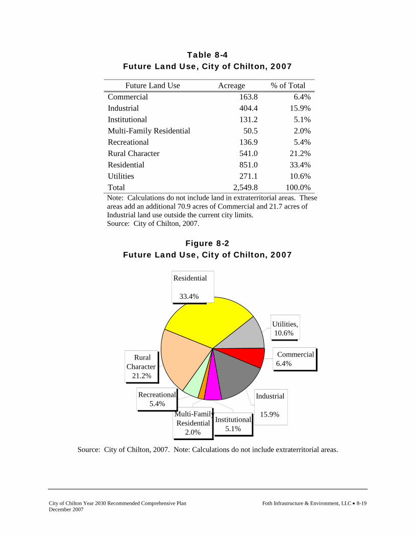
City of Chilton Year 2030 Recommended Comprehensive Plan Foth Infrastructure & Environment, LLC • 8-19 December 2007
Table 8-4 Future Land Use, City of Chilton, 2007
Future Land Use Acreage % of Total
Commercial 163.8 6.4% Industrial 404.4 15.9% Institutional 131.2 5.1% Multi-Family Residential 50.5 2.0% Recreational 136.9 5.4% Rural Character 541.0 21.2% Residential 851.0 33.4% Utilities 271.1 10.6% Total 2,549.8 100.0% Note: Calculations do not include land in extraterritorial areas. These areas add an additional 70.9 acres of Commercial and 21.7 acres of Industrial land use outside the current city limits. Source: City of Chilton, 2007.
Figure 8-2
Future Land Use, City of Chilton, 2007
Source: City of Chilton, 2007. Note: Calculations do not include extraterritorial areas.
Commercial 6.4%
Residential 33.4%
Rural Character
21.2%
Industrial 15.9%
Institutional, 5.1%
Multi-Family Residential
2.0%
Recreational, 5.4%
Utilities, 10.6%

Foth Infrastructure & Environment, LLC • 8-20 City of Chilton Year 2030 Recommended Comprehensive Plan December 2007
This page intentionally left blank.

City of Chilton Year 2030 Recommended Comprehensive Plan Foth Infrastructure & Environment, LLC • 8-21 December 2007
Map 8-3 Future Land Use

Foth Infrastructure & Environment, LLC • 8-22 City of Chilton Year 2030 Recommended Comprehensive Plan December 2007
This page intentionally left blank.

City of Chilton Year 2030 Recommended Comprehensive Plan Foth Infrastructure & Environment, LLC • 8-23 December 2007
8.7 Municipal Border “Buffer’’ Planning
The Calumet County Year 2025 Comprehensive Plan recommends that cities, villages, and surrounding towns designate a buffer area surrounding all cities, villages, and hamlets to coordinate land use, density, development site design, infrastructure utilization, and development review. It is also recommended that the community and town meet jointly to coordinate and designate the buffer planning area. It is further recommended that the towns and incorporated community neighbors be allowed to establish buffer locations consistent with their planned development areas or that adequately address areas of concern. The County Advisory Committee (CAC) recommended that communities cooperatively plan the border areas and that a buffer area should be established. The CAC did not establish a specific buffer area. The CAC recognized that different communities may want smaller or larger buffers depending on their particular issues, but that buffer planning is necessary to accomplish coordinated development within the boundary areas. The CAC recommendation for buffer planning was supported by the Calumet County Agricultural Task Force, which recommended a 1,000 foot expansion restriction boundary around cities and villages. The Agriculture Task Force created draft siting standards for expansion of agricultural operations. One such Task Force standard was that new, large farms (those in excess of 500 animal units) be located at least 1,000 feet from the incorporated boundaries of a municipality or from the respective sewer service planning area, whichever distance was greater. The CAC recommendation was based on the Task Force recommendation, in that buffer planning around incorporated communities has sound rationale and is needed to allow significant economic investments to occur in areas of high potential conflict. Agricultural expansion within the buffer area is a significant planning issue. Buffer planning discussions at the county level were driven by the potential to have large agricultural operation expansion near incorporated boundaries. The county plan promotes ongoing cooperation between towns and adjacent cities or villages when facing municipal boundary and/or land use issues. Decisions about municipal boundaries are usually linked to land use and utility service decisions. Towns and neighboring villages/cities should work toward mutually agreeable solutions for long-term municipal boundaries and land use. Continuing cooperation on comprehensive plans is one good way to achieve coordination among neighboring communities. The county planning process was designed to facilitate conversation between adjacent units of government. The intent is to ultimately bridge the planning with the longer term intent to formalize management of the buffer areas through intergovernmental boundary and land use agreements. The City of Chilton supports these approaches. ATCP 51 Siting Regulations and Buffer Planning
There are conditions that may preclude coordinated buffer planning from occurring. The City of Chilton’s plan indicates a desire for land around the city to be set aside as a buffer where large farm operations would be prohibited and density managed. The buffer would allow the city to manage growth more efficiently in regard to services, as well as manage potential conflicts of non-compatible land uses.

Foth Infrastructure & Environment, LLC • 8-24 City of Chilton Year 2030 Recommended Comprehensive Plan December 2007
Some towns have no objection to large farms being restricted from a buffer area, but do not want a rural character buffer around the city as lands classified as rural character do not allow for agricultural uses. Exclusive agricultural zoning allows the land owner tax credits and immunity from city assessments (such as sewer or curb and gutter). The conflict occurs as the current state DATCP ruling (ATCP 51) does not allow for a community to restrict agricultural expansion (such a restriction would exist if in a planned buffer area) and still allow landowners to receive tax credits for exclusive agricultural zoning. The current ATCP 51 ruling only allows a large farm restriction from an agricultural area that has been scientifically proven to be incapable of supporting large farm operations due to health and safety reasons. The only way to stop the potential for agricultural expansion is to plan and then zone an area as a non-agricultural land use area, which is contrary to the town’s plans. The towns are not advocating for agricultural expansion near the city, nor do they want to limit farmers’ eligibility for tax credits or force them into a situation where their land use is considered non-conforming. The county plan recommends the State of Wisconsin consider revisions that would allow land around a city to remain in agricultural production, allow for exclusive agriculture benefits, and yet restrict large farms. Changes need to be made to the ATCP 51 siting rule for this to occur. The county plan also recommends, for the sake of intergovernmental cooperation and good planning, that language should be added to the individual community land use chapters. Such language would afford the incorporated communities some comfort, while still allowing farmers a clear direction as to where they can and cannot site a large facility. This was discussed and supported at the October 3, 2006, Intergovernmental Boundary Agreement Meeting between the Towns of Charlestown and Chilton and the City of Chilton. The reason this plan advocates planning to bridge the intergovernmental boundary and/or land use agreements is that villages and cities already have statutory authority to exercise certain land use controls in the 1½ mile extraterritorial jurisdictions (ETJ). Cities and villages may:
♦ Include lands in their ETJ in planning documents (e.g., city/village desired development areas).
♦ Adopt or amend subdivision ordinances to allow village or city review and approval of subdivision plats and CSMs within the ETJ.
♦ Adopt an official map to identify recommended expanded road rights-of-way, future road alignments, and sites for public buildings and parks in the ETJ.
♦ If mutually agreeable, enact extraterritorial zoning within all or parts of the ETJ. This approach may freeze existing zoning for up to two years. Permanent extraterritorial zoning within the ETJ can only take place with agreement of the affected town.
Map 8-4 shows the planned land use for areas outside of the existing corporate limits but within the extraterritorial area that the city has exercised its right to plan. The planning process will not resolve all the conflicts between adjacent communities. Several communities did meet at various times with each other during the planning process to discuss in principle the main land use and development concerns, share plan recommendations and associated land use management strategies, and to discuss/allow either party(s) to discern the potential for cooperation and
City of Chilton Year 2030 Recommended Comprehensive Plan Foth Infrastructure & Environment, LLC • 8-25 December 2007
conflict resolution. Local community plan recommendations were developed with the intent to leverage said recommendations into intergovernmental agreements, such is the case recognized in the City of Chilton Year 2030 Comprehensive Plan. The agreements may cover preferred land uses in edge areas, set long-term municipal boundaries, or set utility expansion limits. The municipal boundary coordination will also potentially lead to revisions in the county Growth Management Map and the associated land area designations that will support intensive development. In the end, any agreements or cooperation can be leveraged to help resolve or minimize future conflicts as time passes, local officials change, and initial ideals and reasons for cooperation decline as connectivity to the planning process fades. Further detail for intergovernmental agreements can be found in Chapter 7, the Intergovernmental Cooperation element. The planning process does not solve all the conflict within border areas. It was intended, however, that communities try and work together to develop common language and intent of how lands are to be managed within border areas. The county plan therefore recommends the towns and adjacent cities/villages that could not come to preliminary terms on coordinated land use policy within buffer areas, or that could not establish buffer areas in premise, meet within one year of this plan adoption to establish the mechanism for how development will be managed in the border areas. 8.8 Smart Growth Areas
A Smart Growth Area is defined as “An area that will enable the development and redevelopment of lands with existing infrastructure and municipal, state and utility services, where practicable, or that will encourage efficient development patterns that are both contiguous to existing development at densities which have relatively low municipal, state governmental and utility costs.” The arrangement of incorporated municipalities scattered throughout Calumet County’s landscape, creates the perfect situation to practice “Smart Growth” (directing growth into areas served with adequate utility and service infrastructures). The Calumet County planning process and subsequently the City of Chilton Comprehensive Plan is based on the following six principles as identified by the American Planning Association. Principle 1: Efficient Use of Land Resources
Smart development supports the preservation of land and natural resources. Approximately 541 acres or 21.2% of future land use within the City of Chilton is designated to preserve land and natural resources. Within these designations residential development is limited, environmentally sensitive areas such as wetlands, floodplains, and contiguous woodlands are protected, and future development must utilize the existing street network to minimize additional local road maintenance costs. Principle 2: Full Use of Urban Services
Smart development means creating neighborhoods where more people will use existing services like water lines and sewers, roads, emergency services, and schools. The Calumet County

Foth Infrastructure & Environment, LLC • 8-26 City of Chilton Year 2030 Recommended Comprehensive Plan December 2007
planning process has identified areas within its cities and villages to accommodate growth and development. The support function of Calumet County’s cities and villages as service centers to the surrounding rural farming area supports this principle. Principle 3: Mix of Uses
Compact neighborhoods that contain a mix of residential, commercial, and recreation spaces within walking distance of each other promote a reduction in auto use, community identity, a variety of housing types and a safe environment for all age groups. Calumet County’s cities and villages contain a well-balanced mix of residential, commercial, and industrial development. A greater challenge for Calumet County communities such as the City of Chilton is the promotion of growth in an attempt to create jobs through new industry and businesses. Populations residing in adjacent rural towns are also partners in supporting a variety of mixed uses within cities and villages. The city's planning efforts in the uptown and downtown areas support mix-use concepts. Principle 4: Transportation Options
A well designed transportation network promotes safety, alternative modes of transport, and less traffic congestion and air pollution. Calumet County’s rural nature does not contain the density to support a wide variety of specialized alternative modes of transportation such as public busing. However, the county does possess opportunities for bike routes and trails. The city also maintains a sidewalk system adjacent to places of common pedestrian travel. Principle 5: Detailed, Human Scale Design
In human-scale neighborhoods, a wide mix of housing types are clustered around one or more well-defined neighborhood centers which support jobs, commercial activity, and a range of services. This principle was of limited importance in the Calumet County planning process due to the smaller size of incorporated communities (cities and villages) within the county. Principle 6: Implementation
A community’s ability to adopt smart development principles will, of necessity, require intergovernmental cooperation to apply the principles. This plan has worked to avoid the duplication of services and the creation of additional layers of government by coordinating the development of its comprehensive plan and administration of various ordinances. This plan recommends continued discussions and cooperation relative to land use planning and ordinance administration between City of Chilton, Towns of Chilton and Charlestown and

City of Chilton Year 2030 Recommended Comprehensive Plan Foth Infrastructure & Environment, LLC • 8-27 December 2007
Calumet County. The four government entities have an agreement in place which establishes a forum for discussion relative to land use and service related issues. 8.9 Land Use Goals and Objectives
Following are the goals and objectives developed by the City of Chilton regarding land use. Goal: Create a balanced pattern of complementary urban land uses (City of Chilton
Comprehensive Plan, 1998). Objectives 1. Focus areas of new growth where public utilities and services can be provided most
efficiently (Smart Growth Planning Process). 2. Identify preferred land use areas that will increase compatibility between existing land uses
and work to avoid future land use conflicts (Smart Growth Planning Process). 3. Ensure compatibility of neighboring uses with existing and proposed industrial uses (City
of Chilton Comprehensive Plan, 1998). 4. Maintain basic design standards for commercial and industrial development to protect
property values and encourage quality design in the city (Smart Growth Planning Process). 5. Encourage urban in-fill, which is future development in areas where urban services are
already in place (Smart Growth Planning Process). 6. Utilize vacant land within Chilton to its maximum potential (City of Chilton
Comprehensive Plan, 1998). 7. Identify future growth areas and begin planning for incremental development which
maximizes efficiency and cost-effectiveness (Smart Growth Planning Process). 8. Plan new development so that it is appropriately placed in consideration of the physical
properties of the land (City of Chilton Comprehensive Plan, 1998). 9. Plan adjacent land uses so that they are compatible to such factors as smoke, noise, odor,
traffic, activity, and appearance (City of Chilton Comprehensive Plan, 1998). 10. Limit expansion of nonconforming uses by implementing the Zoning Ordinance and
requiring new uses to conform to the comprehensive plan (City of Chilton Comprehensive Plan, 1998).
11. Encourage the full use of vacant and underutilized property in the city through the use of
the Community Development Authority, Tax Incremental Financing, grant programs and by soliciting developers for reuse (City of Chilton Comprehensive Plan, 1998).

Foth Infrastructure & Environment, LLC • 8-28 City of Chilton Year 2030 Recommended Comprehensive Plan December 2007
12. Work toward the elimination of nonconforming uses (City of Chilton Comprehensive Plan,
1998). 8.10 Land Use Policies and Recommendations
Policies and recommendations build on goals and objectives by providing more focused responses and actions to the goals and objectives. Policies and recommendations become the tools that the community should use to aid in making land use decisions. Policies that direct action using the words “will” or “shall” are advised to be mandatory and regulatory aspects of the implementation of the comprehensive plan. In contrast, those policies that direct action using the word “should” are advisory and intended to serve as a guide. Policies
1. The compatibility of adjacent land uses shall be considered when making decisions about proposed land uses (City of Chilton Comprehensive Plan, 1998).
2. Control of land divisions shall be achieved by implementing the comprehensive plan and
the subdivision ordinance, zoning ordinance and floodplain ordinance (City of Chilton Comprehensive Plan, 1998).
3. The zoning ordinance and comprehensive plan shall be followed when siting new uses. Do
not rezone a property without first considering adjacent uses and compatibility issues as well as the land use element designation (City of Chilton Comprehensive Plan, 1998).
4. All development proposals shall meet the intent of the Future Land Use Plan classifications
as described within the Land Use element of the City of Chilton Year 2030 Comprehensive Plan (Smart Growth Planning Process).
Recommendations
Recommendations are specific actions or projects that the city should be prepared to complete. Completion of these actions and projects is consistent with the community’s policies, and therefore will help fulfill the comprehensive plan goals and objectives. 1. Amend the city zoning ordinance to reflect the intentions of the Preferred Land Use Map
(Map 8-3) of the City of Chilton Year 2030 Comprehensive Plan. Remove the Agricultural Zoning District within the zoning code and replace it with a "Rural Character" District.
2. The city should pursue the development of an extraterritorial zoning ordinance with the
Towns of Chilton and Charlestown to protect borders from incompatible land use. If an extraterritorial zoning ordinance can not be adopted, the city should pursue exercising a one unit per 20 acre density standard as part of its extraterritorial plat review authority within the 1.5 miles of the city limits as a means to preserve agricultural land within this area.
Revised Ord. No. 1079 8/2/2011

City of Chilton Year 2030 Recommended Comprehensive Plan Foth Infrastructure & Environment, LLC • 8-29 December 2007
3. It is the City of Chilton’s desire that no large scale animal unit expansions occur within an identified buffer around the city. This can be accomplished through an intergovernmental agreement with both the Towns of Chilton and Charlestown.
8.11 Land Use Programs
The following programs are currently utilized by the community or are available for use by the community to implement the goals, objectives, policies, and recommendations identified. Uptown and Downtown Master Plans The Chilton Redevelopment Authority worked with a consultant to construct master plans for both the Uptown and Downtown districts. The Uptown plan was completed in 2003, and the Downtown plan was completed in 2005. The plans included background research, preparation of maps, visioning sessions, identification of assets and opportunities, and the framework for the revitalization of the uptown. This also included recommendations for planning and design guidance, public improvements, site redevelopment, and implementation. Uptown and Downtown Redevelopment Plans The Uptown and Downtown Redevelopment Plans were created to closely study and plan the redevelopment of both districts. Plan objectives include: 1. Eliminate blight, including the dilapidation and deterioration of buildings. 2. Assemble land into functional parcels. 3. Remove impediments to redevelopment due to diversity of ownership. 4. Encourage coordinate redevelopment of parcels in accordance to the City of Chilton
Comprehensive Plan and design guidelines set forth by the Redevelopment Authority. 5. Seek private redevelopment of parcels. In March 2005, the Chilton City Council and the Joint Review Board approved the creation of TIF #5 in the downtown. While projects will take time to complete, the city feels that with the support of its citizens that positive changes can be made to better the entire community. City of Chilton Comprehensive Plan, 1998 The City of Chilton’s previous comprehensive plan was completed in 1998. Major features of the plan included background data and trends, goals, objectives, recommendations, development concepts, land use and traffic plan, and a plan for implementation. This plan was used as a support material to this Smart Growth planning effort - the creation of the City of Chilton Year 2030 Comprehensive Plan. Wisconsin Land Information Program The Wisconsin Land Information Program is a voluntary, statewide program that provides financial support to local governments for land records modernization efforts. All 72 Wisconsin counties voluntarily participate in the Program. The Wisconsin Land Information Board

Foth Infrastructure & Environment, LLC • 8-30 City of Chilton Year 2030 Recommended Comprehensive Plan December 2007
oversees the Program's policies. The Board's statutory authority includes preparing guidelines to coordinate the modernization of land records and land information systems; implementing a grant program for local governmental units; approval of countywide plans for land records modernization; serving as the clearinghouse for access to land information; and providing technical assistance and advice to state agencies and local governmental units with land information responsibilities. Division of Intergovernmental Relations, Wisconsin Department of Administration The Division of Intergovernmental Relations provides staff support to the Wisconsin Land Council, and it administers the Wisconsin Land Information Program in conjunction with the Wisconsin Land Information Board. It also houses Plat Review and Municipal Boundary Review, both of which have statutory authority for approval of specific land use related requests, and the GIS Services, dedicated to the efficient use of geographic information systems. For further information about the division visit its web-site via the WDOA web-site at: www.doa.state.wi.us. UW-Extension Center for Land Use Education The Center for Land Use Education uses a team-based approach to accomplish its dual missions in campus based undergraduate and graduate education and extension outreach teaching related to: land use planning, plan and ordinance administration, project impact and regional trends analysis, and public involvement in local land use policy development. For more information on the Center for Land Use Education visit its web-site at www.uwsp.edu/cnr/landcenter/.

City of Chilton Year 2030 Recommended Comprehensive Plan Foth Infrastructure & Environment, LLC • 8-31 December 2007
Map 8-4 Preferred Land Use within ETJ Amended 2-7-2012 Ordinance No. 1085, Exhibit A


City of Chilton Year 2030 Recommended Comprehensive Plan Foth Infrastructure & Environment, LLC • 9-1 December 2007
Planning and Implementation Just as the comprehensive plan does not work independently of other community documents, the implementation element does not work independently of the other elements in the plan. In fact, the implementation element is one of the best ways to demonstrate the integration of all the elements. Through implementation, the connectivity among community issues and opportunities, housing, transportation, utilities and community facilities, agricultural, natural, and cultural resources, economic development, intergovernmental cooperation, and land use is realized. Decisions should be made based on the knowledge that one decision can affect all the elements involved and there are direct and indirect effects of all actions.
9. Implementation 9.1 Introduction
The Implementation element includes a compilation of programs and specific actions to be completed in a stated sequence. These programs and specific actions will be used to implement the goals, objectives, policies, and recommendations contained within the earlier elements of this plan. The Implementation element also includes a section on mechanisms to measure progress that will allow the community to determine if it is successfully implementing its comprehensive plan. In addition, this element also describes how all of the plan elements will be integrated and made consistent, as well as amendment and comprehensive plan update procedures. Implementation Framework
Comprehensive plans establish the general policy framework for decision making. The Wisconsin comprehensive planning law defines the elements of a comprehensive plan and requires that if a local government engages in official mapping, subdivision regulation, zoning, or zoning of shorelands and wetlands then actions of that local governmental unit must be “consistent with” the comprehensive plan by January 1, 2010. Therefore, any local governmental unit that wants, for example, to regulate the subdivision of land or regulate land use through zoning or any other means is required to have a comprehensive plan. Adoption of this comprehensive plan meets the intent of the legislation. Citizen Participation
Just as citizen participation is an important step required throughout the planning process, it is also an essential implementation tool. Citizens and local officials must be made aware of the goals of their comprehensive plan when they consider and make decisions such as reviewing a land division request. The more participation, the more ownership the plan or any implementation tool will likely receive. In addition, a public hearing is always required before an ordinance of any type can take effect.
Foth Infrastructure & Environment, LLC • 9-2 City of Chilton Year 2030 Recommended Comprehensive Plan December 2007
9.2 Local Action Plan
The following are major recommendations of the Implementation element: 1. The city will need to do a comprehensive review of the zoning code to implement the
recommendations outlined in the comprehensive plan. Primary changes include modifying the zoning map to help implement the Preferred Land Use Map (Map 8-3) in the comprehensive plan.
Responsibility: Planning Commission and City Council Timeframe: 2007/2008 2. The city should pursue the development of an extraterritorial zoning ordinance with the
Towns of Chilton and Charlestown to protect borders from incompatible land use. To provide interim protection, the city should pursue exercising a one unit per 20 acre standard as part of it’s extraterritorial plat review authority within the 1.5 miles of the city limits as a means to preserve agricultural land within this area. Extraterritorial plat review authority would be administered through Chapter 17, the subdivision and platting code.
Responsibility: Planning Commission and City Council Timeframe: 2008. This effort should commence once the 2007 City of Chilton
Comprehensive Plan is adopted.
Changes to Applicable Land Use Controls
The remainder of the Implementation element will review regulatory and non-regulatory implementation tools and review their current use in the community as well as provide recommendations for their use in the future. All of the community’s existing land use controls are discussed and any recommended changes are provided. 9.3 Regulatory Land Use Management Tools
Regulatory tools stem from local government’s responsibility and authority to protect public health, safety, and welfare. Most regulatory tools are in the form of ordinances. The following regulatory tools were reviewed and discussed as part of the comprehensive plan process: Conventional Zoning
Under Wisconsin Statutes, counties, cities, villages, and towns with village powers are authorized to adopt zoning ordinances. Zoning is one method of implementing or carrying out the comprehensive plan. Zoning regulates the use of land, lot size, density, and the height and size of structures. A conventional zoning ordinance is probably the most commonly used land use implementation tool, especially in villages and cities. Under conventional zoning, districts (defined areas of consistent use and density) are established which typically follow parcel boundaries and legal descriptions. Each district or zoning category contains a list of permitted and conditional uses which define “rights” within the district. Revised Ord. No. 1079 8/2/2011

City of Chilton Year 2030 Recommended Comprehensive Plan Foth Infrastructure & Environment, LLC • 9-3 December 2007
City of Chilton Status/Recommendation(s) Status: The City of Chilton administers a City Zoning Code (Ordinance) under Chapter 16 of the City of Chilton Municipal Code. Chapter 16 outlines the purpose, rules, definitions, and provisions of the identified land use zoning districts. The districts are administered through the code and zoning map. Recommendation(s): The city will need to do a comprehensive review of the zoning code to implement the recommendations outlined in the comprehensive plan. Primary changes include modifying the zoning map to help implement the Preferred Land Use Map (Map 8-3) in the comprehensive plan. Specific change includes the creation of a "Rural Character" zoning district. Timeline: 2007. Work should commence immediately on the zoning code amendments once the comprehensive plan is adopted.
Land Division/Subdivision Ordinance
Achieving the goals, objectives, and policies of the comprehensive plan will be significantly influenced by how land will be divided and developed in the future. Pursuant to Section 236 of the Wisconsin Statutes, a community, by ordinance, could review the subdivision of land within its corporate limits. A land division ordinance is a tool to control how, when, and if rural farmland, woodlands, and open spaces will be divided and developed while protecting the needs and welfare of the community. It also regulates how new lots will be made ready for future development, such as providing for adequate access (required roads, driveways), wastewater treatment, and water supply. The impact of land division regulations is more permanent than zoning (which regulates the type of development that takes place on a parcel) because once land is divided into lots and streets are laid out, development patterns are set. Local review and regulation of future divisions of land can therefore be effective tools to realize plan goals of maintaining agriculture as a strong part of the local economy, protecting natural resources, and retaining rural character. A community can require a new land division be in conformance with its comprehensive plan as a basis of approval. The key to implementing this objective is twofold. First, the ordinance should clearly state that consistency with the community’s comprehensive plan is a criterion of approval. Secondly, the ordinance should contain a provision requiring the proponent for a land division to submit a clear and concise letter of intent as part of the land division application. The letter of intent submitted as part of the application record can be used to decide if the lot proposed to be created will adequately accommodate the future use of the property. Development of a local land division ordinance could also incorporate "conservation design guidelines and standards” to help implement the plan goals, objectives, and policies supporting protection of the community’s agricultural lands and open spaces. Conservation subdivisions are intended to be an alternative approach to the conventional lot-by-lot division of land in rural areas which spreads development evenly throughout a tract of land without regard to the natural features of the area.

Foth Infrastructure & Environment, LLC • 9-4 City of Chilton Year 2030 Recommended Comprehensive Plan December 2007
The development and ultimate success of a local land division ordinance in plan implementation will require the community to address regulatory, administrative, and intergovernmental considerations. Adoption of the local land division ordinance must be consistent with state statutes and will require local administration (e.g., application review, fee collection, public hearings, inspection, enforcement, etc.).
City of Chilton Status/Recommendation(s) Status: The City of Chilton administers a Subdivision and Platting Code under Chapter 17 of the City of Chilton Municipal Code. Chapter 17 outlines the requirements, design standards, and variance procedures for subdivisions and minor land divisions. Recommendation(s): The city should pursue the development of an extraterritorial zoning ordinance with the Towns of Chilton and Charlestown to protect borders from incompatible land use. To provide interim protection, the city should pursue exercising a one unit per 20 acre density standard as part of its extraterritorial plat review authority within the 1.5 miles of the city limits as a means to preserve agricultural land within this area. Extraterritorial plat review authority would be administered through Chapter 17, the subdivision and platting code. Timeline: 2008. This effort should commence once the City of Chilton Year 2030 Comprehensive Plan is adopted.
Official Maps
Cities, villages, and towns may adopt official maps. These maps, adopted by ordinance or resolution, may show existing and planned streets, highways, historic districts, parkways, parks, playgrounds, railroad right-of-way, waterways, and public transit facilities. The map may also include a waterway if it is included in a comprehensive surface water drainage plan. No building permit may be issued to construct or enlarge any building within the limits of these mapped areas except pursuant to conditions identified in the law. Counties may also prepare plans for the future platting of land or for the future location of streets, highways, or parkways in the unincorporated areas of the county. These plans do not apply to the extraterritorial plat approval jurisdiction of a city or village unless the city or village consents. Official maps are not used frequently because few communities plan anything but major thoroughfares and parks in detail in advance of the imminent development of a neighborhood.
City of Chilton Status/Recommendation(s) Status: The City of Chilton has adopted an Official Map by ordinance. The latest revision to the map occurred June 2006.
Revised Ord. No. 1079 8/2/2011

City of Chilton Year 2030 Recommended Comprehensive Plan Foth Infrastructure & Environment, LLC • 9-5 December 2007
Recommendation(s): Update the official map to include collector streets on the west side of the city to accommodate residential growth (see Map 4-2). Timeline: 2007
Sign Ordinances
A sign ordinance restricts the type, size, and location of signs within a community. It also often restricts the types of materials that can be used to construct signs. These ordinances can regulate signage to achieve a number of community values such as improved property values, public safety, and glare control. Counties, towns, cities, and villages may all adopt sign ordinances and billboard regulations.
City of Chilton Status/Recommendation(s) Status: Signage is reviewed under Chapter 16, Zoning Code, of the City of Chilton Municipal Code. Recommendation(s): None. Amend as necessary.
Historic Preservation Ordinances
The objectives of a comprehensive plan which note the need to preserve important historic structures and sites can be implemented through the adoption of a historic preservation ordinance. These ordinances are meant to protect historic buildings and districts. Counties, towns, cities, and villages have express authority to enact historic preservation ordinances. In addition, the Wisconsin Legislature has determined that historic preservation is such an important objective that all cities and villages that contain any property listed on either the national register of historic places or the state register of historic places must enact a historic preservation ordinance to regulate historic or archeological landmarks and historic districts in an effort to preserve those landmarks.
City of Chilton Status/Recommendation(s) Status: The City of Chilton does not administer a Historic Preservation Ordinance. Recommendation(s): None
Design Review/Site Plan Regulations
Design review involves the review and regulation of the design of buildings and their sites. Design review standards are often included as part of zoning and subdivision ordinances. They seek to protect communities from multi-family, commercial, industrial, and institutional development which would detract from the appearance of the community and reduce property values. Such an ordinance is especially recommended for communities with buildings of historic or architectural importance and where tourism is a major economic activity.

Foth Infrastructure & Environment, LLC • 9-6 City of Chilton Year 2030 Recommended Comprehensive Plan December 2007
City of Chilton Status/Recommendation(s) Status: The City of Chilton administers performance standards, Section 16.14, of the Zoning Code, Chapter 16. However, the performance standards do not address building design and appearance standards. The city does administer Site Design and Development Guidelines for the Business Park (formerly the Industrial Park) and has an active Architectural Committee to review development proposals within the TIF Districts. Recommendation(s): Maintain existing building design and appearance standards for development within the Business Park and TIF Districts.
Building, Mechanical, Housing, and Sanitary Codes
Cities, villages, towns, and counties may enact building and sanitary codes. Building codes are sets of regulations that set standards for the construction of buildings in a community. Building codes ensure that new and altered construction will be safe. These codes must conform to the state building, plumbing, and electrical codes. Housing codes define standards for how a dwelling unit is to be used and maintained after it is built. To enforce the codes, inspections are required by the local municipality. This code is concerned with keeping housing from falling into dilapidation and thus keeping neighborhoods from falling into blight.
City of Chilton Status/Recommendation(s) Status: Chapters 8, 9, and 10 of the City of Chilton Municipal Code address building, mechanical and sanitary regulations. Specifically, Section 10.05 addresses the administration of the Wisconsin Uniform Dwelling Code. In addition, Chapter 11 contains a plumbing code. Recommendation(s): None. Update codes as necessary. Timeline: Continuous
Erosion/Stormwater Control Ordinances
Village of Chilton Status/Recommendation(s) Status: The City of Chilton does not administer an Erosion Control or Stormwater Management Ordinance. Section 16.14, Performance Standards, found within Chapter 16 of the City’s Municipal Code address drainage but not stormwater management practices. The city administers a stormwater management policy that utilizes WDNR Administrative Code NR 216 as a means to address stormwater management. Recommendation(s): None. Maintain current policy.

City of Chilton Year 2030 Recommended Comprehensive Plan Foth Infrastructure & Environment, LLC • 9-7 December 2007
Overlay Zoning
Overlay zones allow special regulations within all or a portion of a zoning district or several districts. This type of zoning can be helpful if there is one particular resource that needs to be protected in a consistent way, regardless of what district it is located in.
City of Chilton Status/Recommendation(s) Status: The City of Chilton does not administer any overlay zoning. Recommendation(s): None
Extraterritorial Zoning
Any city or village that has a plan commission may exercise extraterritorial zoning power in the unincorporated areas surrounding the city or village. The extraterritorial zoning power may be exercised in the unincorporated areas located within three miles of the corporate limits of a first, second, or third class city, or within one and one-half miles of a fourth class city or village. Chilton is a Class four (4) city by population, and has the statutory ability to engage the review of land divisions for 1.5 miles from its existing border. Extraterritorial zoning may be initiated by a city or village adopting a resolution and providing notice of the extraterritorial area to be zoned. The city or village may unilaterally adopt an interim zoning ordinance to preserve existing zones or uses for up to two years while a comprehensive zoning plan is being prepared. A joint committee, consisting of three city or village plan commission members and three town members must approve of the plan and regulations by majority vote. Extraterritorial zoning is not commonly used in the State of Wisconsin.
City of Chilton Status/Recommendation(s) Status: The City of Chilton has taken a first step in the administration of Extraterritorial Zoning with the Town of Charlestown by forming a committee and developing a map which shows the impacted area. However, to date, no formal plan has been developed for the area or an ordinance adopted. Recommendation(s): The city should pursue the development of an extraterritorial zoning ordinance with the Towns of Chilton and Charlestown to protect borders from incompatible land use. The ordinance should address land use within the identified area, specifically the protection of the city’s border to large animal confinement operations and wind energy systems. Timeline: 2008
Planned Unit Developments (PUDs)
Planned unit developments (also sometimes referred to as “planned development districts”) allow developers to vary some of the standards in local zoning ordinances to provide for

Foth Infrastructure & Environment, LLC • 9-8 City of Chilton Year 2030 Recommended Comprehensive Plan December 2007
innovative approaches that may allow for better design and arrangement of open space to protect natural resources. PUDs require flexibility from both the developer and local government.
City of Chilton Status/Recommendation(s) Status: The City of Chilton Zoning Code, Chapter 16, section 16.24 includes provisions and approval criteria for Planned Unit Development Districts. Recommendation(s): None. Maintain the flexibility and design freedom this classification offers developers.
Extraterritorial Plat Review
Cities and villages that have adopted a subdivision ordinance or official map can exercise extraterritorial plat approval jurisdiction for three miles beyond the corporate limits of a first, second, or third class city and one and one-half miles beyond the limits of a fourth class city or village. Chilton is a Class four (4) city by population, and has the statutory ability to engage the review of land divisions for 1.5 miles from its existing border. Specifics relative to Extraterritorial Plat Review can be found under Wis. Stats. S.236.02 (5).
City of Chilton Status/Recommendation(s) Status: Historically, the City of Chilton has not exercised full authority of extraterritorial powers. However due to concern over the type and density of development adjacent to the city’s border in the unincorporated towns, the use of this land use management tool should prompt consideration. The use of this tool is customary by most Wisconsin cities and villages. Recommendation(s): The city should pursue the development of an extraterritorial zoning ordinance with the Towns of Chilton and Charlestown to protect borders from incompatible land use. To provide interim protection, the city should pursue exercising a one unit per 20 acre density standard as part of its extraterritorial plat review authority within the 1.5 miles of the city limits as a means to preserve agricultural land within this area. Extraterritorial plat review authority would be administered through Chapter 17, the subdivision and platting code. Timeline: 2008. This effort should commence once the 2007 City of Chilton Comprehensive Plan is adopted.
Driveway Ordinance Driveway ordinances are developed to establish standards for driveways that will provide for safe and adequate access from private development to public right-of-ways, and also to maintain appropriate access spacing, access-point design, and total number of access points to public roads. In addition, a driveway ordinance provides an opportunity for local review to ensure that the driveway is providing proper access for such uses as a single-family residence which is consistent with the community’s comprehensive plan. The term “driveway” is generally defined Revised 8/2/2011 Ord. No. 1079

City of Chilton Year 2030 Recommended Comprehensive Plan Foth Infrastructure & Environment, LLC • 9-9 December 2007
to mean private driveway, road, field road, or other means of travel through any part of a private parcel of land which connects or will connect with any public roadway. The ordinance typically only impacts new driveways or driveways which serve major land use modifications. Use of a driveway or “access” ordinance to regulate land use is limited, but a significant number of towns throughout the state, due to the requirement to service existing development for emergency purposes (i.e., fire, ambulance), have adopted driveway ordinances.
City of Chilton Status/Recommendation(s) Status: The City of Chilton’s Municipal Code, Section 5.045, contains a defined section for the review and permitting of driveway access to public streets. Recommendation(s): None. Amend existing code, Section 5.045 as necessary.
Intergovernmental Agreements
Any municipality may contract with other municipalities to receive or furnish services or jointly exercise power or duties required or authorized by law. The term “municipality” is defined to include the state, counties, cities, villages, towns, school districts, sanitary districts, public library systems, regional planning commissions, and other governmental and quasi-governmental entities. The requirements and procedures set forth for intergovernmental agreements are minimal. Such arrangements can prove useful in the implementation of a plan by facilitating efficient provision of public facilities and services. In Dodge County, intergovernmental agreements have been used to execute cooperation between communities for services such as fire and emergency rescue.
City of Chilton Status/Recommendation(s) Status: The City of Chilton, Town of Charlestown, Town of Chilton, and Calumet County have established an intergovernmental agreement under Wisconsin Statutes 66.0301. The agreement was originally executed in October 1, 2001. The agreement was amended in May 2006 to include the Town of Chilton. The intent of the agreement includes:
♦ Provide a mechanism and forum to discuss and plan for the orderly development and
boundary issues of territory adjacent to the city, approximately 1.5 miles beyond the city boundary, into the town. Area is described as the growth area.
♦ Provide appropriate and cost effective services in the growth area.
♦ Include the county and representative in zoning of the growth area.
♦ Control urban sprawl by preventing unplanned development and protecting natural resources.
♦ Promote and jointly plan highway improvements.

Foth Infrastructure & Environment, LLC • 9-10 City of Chilton Year 2030 Recommended Comprehensive Plan December 2007
♦ Provide for land disposal of bio-solids from the city’s sewage treatment plant in the town and provide for town cooperation with the city in developing and drilling new municipal wells.
The agreement details zoning, sanitary, annexation, and general planning issues in growth areas and establishes a Joint Planning Committee. The city and towns agree to share financial and maintenance responsibility for specific roads in the growth area. The towns agree to permit land disposal of bio-solids in accordance with DNR rules and will not object to the city locating additional wells in the towns. Any new development in the growth areas will require municipal services and therefore annexation to the city. The original agreement went into effect in October 2001 and was updated in May 2006. The term of the agreement is five years, 10 years for water and sewer service, and shall be renewed by mutual agreement between the city, towns, and county. The City of Chilton also maintains an agreement with the Towns of Charlestown, Brothertown, and Chilton for fire protection services. In the agreement, the town pays the city for fire protection services. The agreement has provided adequate service in a cost-effective arrangement.
Recommendation(s): Work to provide more detailed provisions in the intergovernmental agreement with the Towns of Chilton and Charlestown in an effort to reach land use border compatibility, efficient services, and ground water protection. Develop a meeting schedule and timeline to reach these objectives. Timeline: 2008
Annexation
The state has granted cities and villages the power to annex. The power to extend municipal boundaries into adjacent unincorporated (town) lands allows a community to control development on its periphery. Contrary to popular belief, annexation occurs at the request of town residents, not at the request of the incorporated municipality. Petitions for annexation are filed by the town landowners and the village or city acts upon the annexation petition. Wisconsin Act 317 – Revisions to Annexation Procedures Under this Act, which was enacted in April of 2004, no city or village may annex any territory if none of the city’s or village’s territory is in the same county as the territory to be annexed. The Act also requires cities and villages to make payments for five years to towns that lose territory due to annexations. Cities and villages will have to pay the town from which the land is annexed, the amount of the town tax for the annexed property. The Act gives an exemption from this payment for cities and villages that have boundary agreements with the neighboring towns.

City of Chilton Year 2030 Recommended Comprehensive Plan Foth Infrastructure & Environment, LLC • 9-11 December 2007
Specialized Ordinances
Given specific issues and needs within a particular community, a number of “specialized” ordinances may be required to regulate local public health and safety concerns, protect private property, and avoid public nuisances. The following ordinances have received increased attention due to local issues. Telecommunications Ordinance Ordinances can be used to minimize the visual effects of towers, maximize the capacity of existing towers, and reduce impacts to adjacent properties. Local governments cannot unilaterally prohibit cell towers by ordinance, zoning, or any other means. However, local governments can enact ordinances to prohibit towers from certain specially identified areas, regulate tower height, specify minimum setbacks, require collocation strategies, and encourage landscaping and disguising techniques. An important benefit of having a telecommunications ordinance is that it provides decision-making consistency and decreases the chances of discrimination against a particular company. The ordinance provides a basis for conditional use provisions or denials. The Telecommunications Act of 1996 requires all denials to be in writing and supported by sufficient evidence. Telecommunication ordinances seek to balance business and industry needs with community character, aesthetics, and resident needs.
City of Chilton Status/Recommendation(s) Status: The City of Chilton’s Municipal Code contains a defined section, Section 16.27 that addresses telecommunication towers. Recommendation(s): None. Amend existing section as necessary.
Public Nuisance Ordinance A public nuisance is a thing, act, occupation, condition or use of property which: substantially annoys, injures or endangers the comfort, health, repose and safety of the public; renders the public insecure in life or in the use of property; offends the public morals or decency; or obstructs or renders dangerous for passage any street, alley, highway, navigable body of water or other public way or the use of public property. An ordinance defines public nuisances and provides a mechanism to prevent and, when necessary, to abate a public nuisance, including the recovery of costs and fines for such enforcement. Chapter 823 of the Wisconsin Statutes also provides for procedures by which both public and private nuisances can be abated.
City of Chilton Status/Recommendation(s)
Status: Chapter 8 of the City of Chilton Municipal Code defines and regulates public nuisances and provides for abatement, cost and penalty procedures.
Recommendation(s): Maintain and amend as needed.
Timeline: Continuous

Foth Infrastructure & Environment, LLC • 9-12 City of Chilton Year 2030 Recommended Comprehensive Plan December 2007
Orderly Conduct Ordinances Municipalities regulate and/or prohibit a myriad of certain acts that can adversely affect the public health, safety and welfare. Examples of such acts include: discharging and shooting of firearms and other missiles; discharging of fireworks; excessive noise; violation of liquor laws; gambling, prostitution; loitering; curfew violation; truancy; nude dancing; and disturbing the peace. Such regulations and/or prohibitions must balance the public health, safety and welfare with the constitutionally protected rights of the individual.
City of Chilton Status/Recommendation(s)
Status: Chapter 7 of the City of Chilton Municipal Code contains a number of proscribed or regulated activities and conduct in this category of orderly conduct. Other chapters in the city's Municipal Code also regulate and/or prohibit certain acts or conduct in order to protect public health, safety and welfare. An example would be Chapter 4 entitled the Traffic Code.
Recommendation(s): Maintain and amend as needed.
Timeline: Continuous
Cooperative Boundary Agreements
Cooperative boundary agreements can reduce some of the conflict regarding boundary issues, including annexation, that often arise between towns and their incorporated neighbors (cities and villages). The legislature has provided express enabling authority for these agreements. The communities involved in such agreements undertake cooperative preparation of a plan for the areas concerned. The plan for changing or maintaining boundaries, and for controlling land use and services, is sent to the Department of Administration. If the plan is approved, a contract binding the parties to it is put into effect.
City of Chilton Status/Recommendation(s) Status: The City of Chilton does not have a formal cooperative boundary agreement with either of their bordering towns. The existing Intergovernmental Agreement between the Towns of Charlestown and Chilton (see Section 9.3.14) does contain some preliminary criteria for a formal boundary agreement to occur. Recommendation(s): Work to provide more detailed provisions in the current intergovernmental agreement with the Towns of Chilton and Charlestown in an effort to reach land use border compatibility. Develop a meeting schedule and timeline to reach these objectives. Timeline: 2008

City of Chilton Year 2030 Recommended Comprehensive Plan Foth Infrastructure & Environment, LLC • 9-13 December 2007
9.4 Non-Regulatory Land Use Management Tools
There are several non-regulatory options available to local municipalities to influence local land use. The following tools were considered as part of the planning process. Acquisition Tools
Land Acquisition Communities and non-profit conservation organizations can acquire land for conservation, public service and development purposes simply by purchasing it outright.
City of Chilton Status/Recommendation(s) Status: The City of Chilton does acquire properties for the purpose of addressing specific recommendations found within adopted plans or economic initiatives. Examples include land for parks or land to facilitate redevelopment efforts in the downtown, uptown, or Business Park areas. Recommendation(s): Acquire land as recommended in specific plans such as the Open Space and Recreation Plan, the Downtown Redevelopment Plan, and the Uptown Master Plan. Timeline: Continuous.
Fiscal Tools
Capital Improvements Program (CIP) The capital improvements program is a way of implementing issues related to capital facilities specified in a plan. Capital improvements are those projects which require the expenditure of public funds for the acquisition, construction, or replacement of various public buildings such as police and fire halls, schools, and city/village/town halls, roads and highways, water and sewer facilities, and parks and open space. A capital improvements program is a listing of proposed public projects according to a schedule of priorities, usually over a five year programming period. A CIP allows local communities to plan for capital expenditures and minimize unplanned expenses. Sources of funding for capital improvements include impact fees, subdivision requirements, special assessments, and revenue or general obligation bonding. The usefulness of the CIP depends upon the community properly budgeting for expenditures as part of the community’s annual capital improvements budget.
City of Chilton Status/Recommendation(s) Status: The City of Chilton maintains a CIP program. The program is based upon the value of city wide capital using a 30 year depreciation schedule as suggested by auditors.

Foth Infrastructure & Environment, LLC • 9-14 City of Chilton Year 2030 Recommended Comprehensive Plan December 2007
Improvements are budgeted accordingly. The city also maintains an equipment and five year street capital improvement plan. Recommendation(s): Maintain the current CIP Program. Timeline: Continuous
Impact Fees Cities, villages, towns, and counties may impose impact fees. Impact fees are financial contributions imposed on developers by a local government as a condition of development approval. Impact fees are one response to the growing funding gap in infrastructure dollars between revenues and needs. Impact fees help shift a portion of the capital cost burden of new development to developers in an effort to make new development responsible for serving itself rather than raising taxes on existing development. Local governments can use impact fees to finance highways and other transportation facilities, sewage treatment facilities, storm and surface water handling facilities, water facilities, parks and other recreational facilities, solid waste and recycling facilities, fire and police facilities, emergency medical facilities, and libraries. Impact fees cannot be used to fund school facilities. Furthermore, counties can not use impact fees to fund highways and other transportation related facilities.
City of Chilton Status/Recommendation(s) Status: The city currently does not exercise any impact fees for projects. However, the city does utilize developer agreements to ensure certain development and service provisions are addressed. Recommendation(s): Review periodically for future implementation possibilities. Timeline: Continuous
9.5 Integration and Consistency of Planning Elements
Comprehensive planning legislation requires that the Implementation element describe how each of the nine elements of the comprehensive plan will be integrated and made consistent with the other elements of the plan. The planning process that was used to create the City of Chilton Year 2030 Comprehensive Plan required all elements of the plan to be produced in a simultaneous manner. No elements were created independently from the other elements of the plan, therefore eliminating the threat of inconsistency. There are no known inconsistencies within the plan or individual elements or between goals, objectives, policies, and recommendations. Over time, the threat of inconsistency between the plan and existing conditions will increase, requiring amendments and/or updates to be made. Over time, additional plans regarding specific features within the community may also be developed (e.g., outdoor recreation plan, downtown

City of Chilton Year 2030 Recommended Comprehensive Plan Foth Infrastructure & Environment, LLC • 9-15 December 2007
development plan). The process used to develop any further detailed plans should be consistent with this City of Chilton Year 2030 Comprehensive Plan. 9.6 Mechanism to Measure Progress
Comprehensive planning legislation requires that the implementation element provide a mechanism to measure community progress toward achieving all aspects of the comprehensive plan. An acceptable method is to evaluate two primary components - policies and recommendations. Both are listed within each identified plan element (usually the last sections within each element). To measure the effectiveness of an adopted policy, the community must determine if the policy has met the intended purpose. For example, the City of Chilton has listed a policy under Section 4, Utilities and Community Facilities element, Policy #3 which states, “ The city shall maintain a park and outdoor recreation plan" To determine whether the policy is achieving the community’s intention a “measure” must be established. In the case of this policy, the measure is simply does the city have an active outdoor recreation plan that it utilizes to guide park decisions. Each listed policy within each plan element should be reviewed periodically to determine the plan’s effectiveness. Likewise, recommendations listed within each element can be measured. For recommendations, the ability to “measure” progress toward achievement is very straight forward in that the recommendations have either been implemented or not. To ensure the plan is achieving intended results, periodic reviews should be conducted by the Plan Commission and results reported to the governing body and the public. 9.7 Comprehensive Plan Amendments and Updates
The City of Chilton should regularly evaluate its progress toward achieving the goals, objectives, policies, and recommendations within the comprehensive plan. It may be determined that amendments are needed to maintain the effectiveness and consistency established within the plan. Amendments are minor changes to the overall plan and should be done after careful evaluation to maintain the plan as a tool upon which decisions are based. According to comprehensive planning legislation, the same process that was used to adopt the plan shall also be used when amendments are made. The city should be aware that as more compliant plans are developed, the amendment procedure may be clarified or changed and should therefore be monitored. Comprehensive planning statutes require that the comprehensive plan be updated at least once every 10 years. An update requires revisiting the entire planning document. Unlike an amendment, an update often includes a substantial re-write of the text, an updating of the inventory and tables, and substantial changes to maps, if necessary. The plan update process should be planned for in a similar manner as was allowed for the initial creation of this plan,

Foth Infrastructure & Environment, LLC • 9-16 City of Chilton Year 2030 Recommended Comprehensive Plan December 2007
including similar time and funding allotments. State statutes should also be monitored for any changes and new or removed language. 9.8 Implementation Goals and Objectives
Following are the goals and objectives developed by the City of Chilton regarding implementation. Goal: Promote consistency between plan recommendations, ordinances, and other land use
regulations (Smart Growth Planning Process). Objectives 1. Maintain a "Local Action Plan” as part of the Implementation element to assist the Plan
Commission, City Council, and other jurisdictions with the administration of the comprehensive plan (Smart Growth Planning Process).
2. Work on the Smart Growth implementation with the adjoining towns and the county (Smart
Growth Planning Process). 3. Support increased enforcement of existing ordinances as necessary (Smart Growth
Planning Process). 4. Encourage citizen participation in order to increase local input in the decision making
process (Smart Growth Planning Process). 5. Conduct periodic reviews of the comprehensive plan for consistency with the goals,
objectives, maps, policies and programs contained within and amend when appropriate (Smart Growth Planning Process).
6. Utilize the zoning and subdivision ordinances and other implementation measures as tools
to implement the comprehensive plan (City of Chilton Comprehensive Plan, 1998). 7. The Plan Commission should review the comprehensive plan on a regular basis and update
as necessary. The review should look at the goals, objectives, policies and recommendations to affirm their relevance. Amendments should be made as necessary (City of Chilton Comprehensive Plan, 1998).
8. Refer to the comprehensive plan when making zoning changes or when considering
conditional use permits (City of Chilton Comprehensive Plan, 1998). 9. Maintain adequate staff and budget to enforce the zoning ordinance and ensure that they
are knowledgeable in the rules of the zoning ordinance (City of Chilton Comprehensive Plan, 1998).
City of Chilton Year 2030 Recommended Comprehensive Plan Foth Infrastructure & Environment, LLC • 9-17 December 2007
9.9 Implementation Policies and Recommendations
Policies and recommendations build on goals and objectives by providing more focused responses and actions to the goals and objectives. Policies and recommendations become the tools that the community should use to aid in making land use decisions. Policies that direct action using the words “will” or “shall” are advised to be mandatory and regulatory aspects of the implementation of the comprehensive plan. In contrast, those policies that direct action using the word “should” are advisory and intended to serve as a guide. Policies
1. All proposed development shall be reviewed for consistency with the comprehensive plan (Smart Growth Planning Process).
2. All future development proposals shall be consistent with the goals and objectives and
policies of the comprehensive plan (Smart Growth Planning Process). 3. A capital improvements program plan shall be implemented for capital expenditures (City
of Chilton Comprehensive Plan, 1998). 4. Every five years the city will evaluate the availability of funds for updating the
comprehensive plan. If adequate funds are not available then a strategy will be developed to ensure that sufficient funds are available for a comprehensive plan update (Smart Growth Planning Process).
Recommendations
Recommendations are specific actions or projects that the community should be prepared to complete. Completion of these actions and projects is consistent with the community’s policies, and therefore will help fulfill the comprehensive plan goals and objectives. 1. Please refer to prior Sections 9.3 and 9.4 for specific recommendations. 9.10 Implementation Programs
The following programs are currently utilized by the community or are available for use by the community to implement the goals, objectives, policies, and recommendations identified. Plan implementation programs have been identified under the previous plan elements.