climate change vulnerability assessment of the wangchuck
TRANSCRIPT

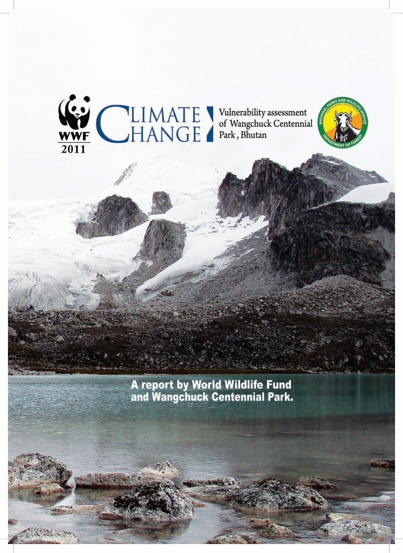
Climate Change Vulnerability assessment ofWangChuCk Centennial Park
i

Author(s) : Phurba lhendup, eric Wikramanayake, sarah freeman, nikolai sindorf, kinley gyeltshen and Jessica forrest.
SUPPORT TEAMS
WWF Bhutan 1. Vijay moktan 2. Pema tshering 3. Dechen yeshi
WWF US
1. Jon miceler 2.JeffPrice 3. bart Wickel
Wangchuck Centennial Park
1. Damber singh rai 2. tenzin 3. lekey Dorji 4. ratna bdr. mongar 5. rinzin
Copy right© photographs: Phurba lhendup (for those not cited)
Design and layout : kado
Printed at: norbu rabten Press, thimphu.
For further information contact
freshwater and climate change programWWF-BhutanProgramOfficePost box no.210, kawajangsa, thimphutel : +975 3 23316 fax: +975 3 23518Email:[email protected]
Copyright © WWf & WCPthimphu, bhutanaugust 2011
ii
WewouldliketoconveyourappreciationtoallcontributingteamsfromWangchuckCentennialPark, WWf us and WWf bhutan for their dedicationandeffortwhichhasledtothis
research report. We would also like to thank the reviewers fromWWFUSoffice(JudyOgelthorpe,JonMiceler,BartWickel, June reyes, eliot levine, shubash lohani) for their commentsandconstructiveinputs.ThesuggestionsmadebyJonathanCookandJohnMathewsduringthetimeofproposal development are also appreciated.
ThisinitiativeisapartofprogramfundedbyWWFFinland,WWFUSandMinistryofForeignAffairs,FinlandforenablingbiodiversityconservationintheWangchuckCentennialPark. the authors would like to gratefully acknowledge their generosity.
Finally,ourappreciationandheartfeltgratitudealsogotoallthemembersoflocalcommunitiesfromChhokhor,Tang,NubiandSephugeogsandofficialswhoprovidednecessaryinformationduringthetimeofourresearchinthefield.HelprenderedfromthepersonnelattheHydromatstationsinbumthang and trongsa are also appreciated.
lastly, the team cannot go without thanking the royal GovernmentofBhutanforthecontinuoussupporttoenableWWFconservationactivitiesinBhutan.
thank you all and tashi Delek!
ACknOWlEdgEMEnTS
iii

iv
Contents1. Introduction
1.1 background 1
1.2 goal 2
1.3 Objectives 2
2. DescriptionofEnvironment
2.1 overview of bhutan 2
2.2 Climate 3
2.3 topography, geology and soils 3
2.4 biodiversity and habitats 5
2.5 Water resources 6
2.6 SocioeconomicConsiderations 7
2.7 land-use, development and infrastructure 7
2.8 InstitutionalArrangements 8
3. Vulnerability
3.1 terrestrial biodiversity 8
3.1.1. methods 8
3.1.2. results and Discussion 13
3.1.3. Conclusions 28
3.2 CommunitiesandLivelihoods 29
3.2.1. methods 29
3.2.2. results and Discussion 34
3.2.3. Conclusions 45
3.3 WaterResourcesandAquaticBiodiversity 45
3.3.1. methods 45
3.3.2. results and Discussion 46
3.3.3. Conclusions 57
3.4 SynergisticVulnerabilities 48
4. RecommendationsforAdaptationand management of WCP
4.1 terrestrial biodiversity 59
4.2 Communities&Livelihoods 61
4.3 WaterResourcesandAquaticBiodiversity 63
4.4 Synergisticvulnerabilities 64
5. Conclusions 65
6. bibliography 66
Climate change has become a grave concern for bhutan’s people, wildlife, and ecosystems. the impacts of climate
change present a new set of challenges in our effortstoprotectandconservebiodiversityandalso reduce conditions of poverty that exertadditionalpressuresonourenvironment.
our challenge is further compounded by the fact that our country’s geological conditionsare rugged and fragile, with steep sloping terrain that makes us even more vulnerable. together with the risks of landslides and soil erosion, glacial lake outburst floods (GLOFs)threaten bhutan. in 1994, we experienced the catastrophicdischargeofoneparticularGLOFinPunakha Valley, and many other glacial lakes are nowincreasinglyatriskofbursting.
Considering that the climate change is one of the biggest threats to conservation and livelihoodimprovement, WWf has made it a priority to initiate a climate change program. Thisprograminvolvesworkingwithscientists,policyexperts, and conservationists to understandthe causes and impacts of climate change and, more important, to determine a path forward to achieve climate stability and protection ofbiodiversity and livelihoods. there are two widely known approaches to address climate changeand its impacts.Thefirst ismitigation,which limits further climate change by reducing the production and release of greenhousegases (ghgs) into the atmosphere. the second isadaptation,whichhelpsuscopewithclimatechange impacts that have already occurred or may occur in the future. however, due to the fact that bhutan is presently not a major emitterofGHGs,local-leveladaptationismoreappropriate and feasible than is mitigation.on the other hand, even if it were possible to stabilizeGHGemissions,climatechangeeffectsarebound to lastmany years, and adaptationwillultimatelybenecessary.
Adapting to climate change requires a greaterunderstanding of the impacts of climate change and assessment of the aspects of bhutan’s environment and society that are most vulnerable. We then need to apply this information in order to design appropriateadaptationmeasuresthataimtoreducethesevulnerabilities.Adaptationmeasuresshouldbemainstreamed or integrated into conservationmanagement and sustainable development planning and other livelihood enhancement activitiessothatadaptationtoclimatechangebecomes an integrated part of these programs, not a separate program.
the enclosed pilot study conducts a climate change vulnerability assessment in Wangchuck Centennial Park and focuses on three components: biodiversity, livelihood, and water. Thestudylooksattheresourcesettingsinandaround the park, assesses the vulnerability of each resource to climate change, and recommendsappropriateadaptationmeasuresthat seek to reduce these vulnerabilities. Thisreport is written not with the intention ofexcellinginastrictlyscientificdebatebutratherwith an aim of making vulnerability research a priorityinBhutansothatappropriateadaptationmeasures can be put in place. this report sets the scene for future research in our country to successfully combat the ongoing threat of climate change.
kinzang namgay CountryRepresentativeWWf bhutan
foreWorD
v
bhutan has long been a model for environmental stewardship. Its commitment to conservation andpreservationoftheenvironmentisdemonstratedbytheproactiveresponsetotheglobalchallengeposedbyclimatechange.Inadditiontobeingoneofthefewcountries in the world where carbon sinks are greater than greenhouse gas emissions, bhutan declared its intentiontoensurethatitsemissionsnotexceeditssequestration capacity, by making a pledge duringtheUNConventionofParties(COP15)inCopenhagenin 2010 to remain a carbon-neutral country. Despite such intentions, the impacts of climate change areevident in bhutan due to emissions elsewhere. Adapting to these impacts will be challenging, butit is critical to do so for the future of the people,economy, and ecosystems of bhutan. a crucial step in theadaptationprocessistheassessmentofclimatechange vulnerability. the current study represents this step for Wangchuck Centennial Park (WCP) and its surrounding areas.
WCP is the largest protected area in bhutan, and its relevance to the people of bhutan is paramount. Thepark’sgazettingin2008safeguardedthecriticalecosystemconnectivityofthemountainousnorthernportionofthecountry.Theparkisthesharedhomeofabout 580 households, some 244 species of vascular plants, 25 confirmed speciesofmammals, and130species of birds that are known to breed in the park. furthermore, WCP’s streams and rivers form the headwaters that feed four major rivers in bhutan, supportingbothimportantpristinehabitatsformanyspeciesoffloraandfaunaandthecountry’seconomicdevelopment through hydropower. to ensure that conservationanddevelopmentgoalscontinuetobemet in the face of climate change, three analyses were carried out to assess the vulnerability of (1) terrestrial biodiversity,(2)communitiesandlivelihoods,and(3)waterresourcesandaquaticecosystems.
the analyses carried out found that although there are many uncertainties about how climatechange will manifest itself in this region of the eastern himalayas, there is convergence both in the literature and observations taken from thecommunity vulnerability assessment that annual mean temperature is following a warming trend and thatprecipitation isassociatedwithhigh levelsof variability and uncertainty. these trends will lead to shifts in seasonal streamflow, ecosystems, anddistributionsofspeciesdependingonhabitatshifts.Thedeteriorationofecosystemconnectivityandtheincrease of habitat fragmentation are identified as
major sources of vulnerability for both terrestrial andaquatic ecosystems. More specifically,
thecentralandwesternportionsofthepark appear to be more resilient
to climate change and are
therefore prioritized for terrestrialbiodiversity conservation. This differsfrom the results of the freshwater ecosystems analysisthatprioritizedtheeasternportionduetoitshigherdiversityaquaticecosystems.
livelihoods based on pastoralism and agriculture maybeaffectedbynewdiseases,pests,andparasitesand by shifting phenological and seasonal changesinducedbyclimaticchanges.Asaresult,vulnerabilityatacommunitylevel,particularlyamongsubsistencefarmers, isconsideredtobehigh.Alternativecrops,introduction of irrigation systems, and sustainableharvest of forest products are some strategies to hedgeagainstlivelihoodvulnerabilities.
the results of the climate change vulnerability assessment of WCP present a compelling case for parallel tracksofaction toaddressknowledgegapswhile starting to implement specific programs toincrease the adaptive capacity ofWCP. Because ofthe uncertainties associated with climate changeprojections and predictions, continuousmonitoringsystemsanddatacollectionofaquaticandterrestrialbiodiversity, species ranges, species and food web responsestoclimatevariations,hydrologyandwateruse, harvest of natural resources and the state of these resources, and other bioclimatic indicatorsof climate change are critical to understanding thecurrent conditions and climate responses ofWCP’shabitats and inhabitants.
filling in these knowledge gaps, however, is not the sole solution. Information presented in the currentreport should be expanded upon and integrated into the conservation and development “planningprocess” (e.g., hydropower development). Central to theseefforts,localinstitutionsshouldbemademoreadaptive (e.g., through increased knowledge andfinancial resources) inorder to facilitateadaptationamong local communities and promote adaptiveactions. Additionally, a zoning exercise should beundertaken to preserve climate- resilient habitat and ecosystem connectivity to “climate proof” the parkforconservationmanagementofitsbiodiversityandecosystem services.
the Wangchuck Centennial Park Climate Change Vulnerability Assessment represents the firstattempttointegrateclimatechangeadaptationintoconservation efforts in Bhutan. Consequently, theimplications of this report extendbeyond its directrelevance to the people, species, and ecosystems of WCP.ThisreportrepresentsthefirststepinaniterativeprocesstoincreasetheadaptivecapacityofBhutanin the face of climate change in order to preserve a propitious future for its people, ecosystems, andeconomy.
EXECUTIVE SUMMARY
vi
�
Wangchuck Centennial Park
Climate ChangeVulnerability Assessment
1.1 BackgroundBhutan is one of the few countries in the world that currently has a negative balance of greenhouse gas emissions, meaning that more greenhouse gases are sequestered than emitted. This can be attributed largely to the large intact forest cover and limited level of industrialization. However, Bhutan is highly vulnerable to various climate-related impacts and natural hazards due to the very active geological conditions, great variations in precipitation, and steep, high-elevation terrain. Apart from experiencing natural landslides and erosion, the mountainous region is becoming increasingly susceptible to glacial lake outburst floods (GLOFs), which are thought to be a result of glacial melting due to climate change. Due to the continued emissions of greenhouse gases by the industrialized nations of the world, Bhutan is faced with the impacts of a changing climate, many of them with profound implications for the extremely diverse ecosystems, traditional livelihoods and cultures, and the development trajectory of the country. Thus, there is an acute need in Bhutan to develop a pragmatic set of approaches that prepares the nation for the impacts of climate change and attempts to reduce vulnerability of the nation’s natural resources, human communities, development goals, and economic outlook.
Until recently, the primary climate change adaptation (CCA) strategy seen in Bhutan focused on disaster risk reduction (DRR) and the threat of glacial lake outburst floods (GLOFs) in particular. This focus reflected the rapid shifts that were observed at high elevations in snowpack and glacial resources and due to the rapid formation of lakes with a great potential to cause harm. At present, a more robust understanding of the depth and breadth of these impacts has been developing among policymakers, scientists, and citizens. The fingerprints of climate change are now clearly seen in a wide variety of sectors, including agriculture, hydropower, human health and sanitation, environmental and biodiversity conservation, and infrastructure development and planning. For example, the increased risks from GLOFs; erratic rainfall patterns with consequent landslides, flash floods, and changing water availability; discernibly warmer ambient temperatures that are leading to phenological changes and glacial retreat are some of the impacts that are already being witnessed in the country. These phenomena are widely attributed to climate change and are expected to increase in severity in the coming decades.
Addressing climate change and its effects presents
challenges that are twofold. The first is mitigation to limit further change by reducing the production of greenhouse gases and their concentration within the atmosphere. The second challenge is adaptation, which consists of actions taken to prepare for observed and expected climatic changes. While the former requires global action, the latter can be tackled at national and local levels. In the context of the country’s largest national park, Wangchuck Centennial Park (WCP), this means two concrete lines of action:
1) Protection of the carbon sinks possibly supported by international mitigation programs such as the United Nations Collaborative Programme on Reducing Emissions from Deforestation and Forest Degradation in Developing Countries (REDD). This global policy framework is designed to reduce the rate of climate change over many decades, and it stretches well beyond any single nation’s boundaries.
2) Climate change adaptation (CCA), with local and national as well as regional and international components, many of which focus on practical action, planning, and policy development and implementation.
Perhaps the most widespread response to CCA is, “How does it differ from what we are already doing?” In many ways, CCA may be considered a process rather than a final product (Levine 2011). CCA relates to why and how processes are undertaken such that climatic factors are explicitly considered; thus the outputs from CCA may not be different than current best practices for resource management, but with the explicit difference that climate has been considered in both its impacts on the resource (vulnerability), as well as the fact that the practice remains resilient under high levels of uncertainty. This requires practices to be evaluated and considered jointly as part of a larger adaptive management plan, which is typically not the case today. Because climate change impacts are bound to increase in coming decades, climate-resilient sustainable resource management will become increasingly important to explicitly address over time.
The Intergovernmental Panel on Climate Change describes vulnerability as the degree to which a natural or social system is susceptible to, or unable to cope with, adverse effects of climate change, including increased climate variability (e.g., the frequency and severity of weather extremes such as floods and droughts) and downside risk, or potential to be harmed. It follows that the evaluation of a given system’s susceptibility
1. Introduction

Wangchuck Centennial Park
Climate ChangeVulnerability Assessment
�
to adverse climate impacts is a vulnerability assessment, or VA. Methods for conducting VAs vary widely but typically include an assessment of climate change impacts, climate resilience, strengths, and opportunities. Climate change impact assessment identifies impacts and associated risks in a given area. The evaluation of climate resilience for social systems includes a review of practices, planning, and policies. For natural systems, climate resilience is determined by the intrinsic values of the system to cope with climatic variability. Through the combination of climate impact and resilience evaluations, a VA is able to identify climate-related risks and thereby show when current actions are already sufficient or when major changes are needed.
A VA that contributes to the understanding of the degree to which a system is vulnerable to climate change impacts often provides a first step toward developing a
platform to adopt appropriate adaptation measures. Therefore, it is essential that a VA identify climate-related risks and their synergies with nonclimate risks and then ascertain the risks that can be abated and those that must simply be endured. In short, a VA is the underpinning of an adaptation plan of action. Ideally, a VA provides a background of relevant scientific research, stakeholder engagement, policy and institutional analysis, and economic and development trajectories. The VA proposed here is intended to assess the climate change vulnerability of Wangchuck Centennial Park. Specifically, it will address climate change vulnerability of livelihoods, water resources, ecological communities, and relevant natural resource management practices and policies in order to provide guidance for appropriate adaptation recommendations.
1.2 GoalThe goal of this VA is to enhance the preparedness, adaptive capacity, and resilience of vulnerable communities, biodiversity, and water resources in and around Wangchuck Centennial Park.
1.3 Objectives The main objectives of the study were to:
1. Assess the climate change vulnerability of terrestrial biodiversity in and around WCP.
2. Assess the climate vulnerability of communities in and around WCP.
3. Assess climate vulnerability of freshwater systems.
4. Provide recommendations for decreasing vulnerability and increasing resilience of WCP’s conservation values, through management of ecosystems and ecological services and sustainable and adaptive livelihoods for local communities.
2. Description of Environment2.1 Overview of BhutanBhutan is a small Buddhist kingdom nestled in the steep mountains of the Eastern Himalayas. The country has a complex topography of deeply incised, narrow valleys that cut through steep, rugged mountain ranges. The elevation increases rapidly from about 150 meters along the southern border to mountain peaks above
7,000 meters in the north. This geographical diversity combined with equally diverse climate conditions and a biogeographic history contributes to Bhutan’s wide range of biodiversity and ecosystems. A network of 10 protected areas connected by biological corridors conserves the diverse ecosystems in the country, from subtropical to midtemperate to alpine zones (Figure 2-1).
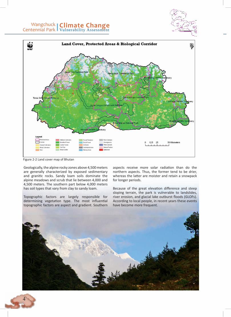
WCP was established as a tribute by the government and people of Bhutan to the Wangchuck Dynasty for selflessly leading Bhutan for 100 years and ensuring its sovereignty, stability, and tranquility. Located in the north-central part of Bhutan, WCP was formally gazetted as a national park on June 10, 2008. The 4914 square-kilometer park is now the largest protected area in the country. It connects with Bumdeling Wildlife Sanctuary to the east and with Jigme Dorji National Park to the west to form a contiguous protected area covering the entire northern frontier of the country (Figure 2-2) and plays an important role in conserving, protecting, and maintaining the integrity of specific ecosystems; species; and cultural, historical, and religious sites.
Bhutan Area : 38,394 sq km Population : 671,083 Economy : Agrarian, pastoral, hydropower, tourism.
Seventy-nine percent of the population depends on Renewable Natural Resources Sector (agriculture, animal husbandry, and forestry subsectors) for their livelihood and income. Staple crops include rice, wheat, maize, potatoes, buckwheat, and barley. Livestock are important as a source of milk, meat, and draft power. Forests provides timber, fuelwood, medicinal herbs, and food.

�
Wangchuck Centennial Park
Climate ChangeVulnerability Assessment
2.2 ClimateThe climate in northern Bhutan varies by altitude and is dominated largely by monsoons. In WCP, the climate in the southeast can become hot, with a more temperate climate in the inner valleys of Bumthang, Trongsa, and part of Wangdue. The northern portion of WCP has an alpine climate, with year-round snow on the main summits. There are two major seasons: the summer rainy season, which runs from May through September, and the winter dry season which runs from October to April. During the summer months, lightning and thunder often precede rainfall with cumulusnimbus clouds and light showers. Continuous rainfall can occur for several days, which can at times result in landslides that block trails and waterways. Streams and rivers swell and carry huge amounts of silt and forest debris. The winter months are typically marked by cold winds, very low nighttime temperatures and moderate daytime temperatures, cloudiness, light showers, and snowfall.
2.3 Topography, Geology, and SoilsThe northern portion of the park is characterized by a steep and rugged topography with barren, rocky ridges and peaks that ascend beyond 5,000 meters. The park also contains several permanently snow-covered mountains, such as Gangkar Puensum, Rinchen Zoegila, and Jazayla. A significant number of intact glaciers feed lakes and downstream rivers, particularly the Punatshang chu1 (Sunkosh), Mangde chu, Chamkar chu, and Kurichu (tributaries of Manas) that flow south through deeply incised valleys and gorges. Below 4,600 meters, between the tree line and exposed rock, the slopes are gentler, with alpine meadows and scrub-lands. This area forms a substantial portion of the park’s total geographical area.
Figure 2-1 Map of Bhutan and its protected areas in the context of the Eastern Himalays
1 Chu is the Bhutanese term for river.
Wangchuck Centennial Park
Climate ChangeVulnerability Assessment
�
Geologically, the alpine rocky zones above 4,500 meters are generally characterized by exposed sedimentary and granitic rocks. Sandy loam soils dominate the alpine meadows and scrub that lie between 4,000 and 4,500 meters. The southern part below 4,000 meters has soil types that vary from clay to sandy loam.
Topographic factors are largely responsible for determining vegetation type. The most influential topographic factors are aspect and gradient. Southern
aspects receive more solar radiation than do the northern aspects. Thus, the former tend to be drier, whereas the latter are moister and retain a snowpack for longer periods.
Because of the great elevation difference and steep sloping terrain, the park is vulnerable to landslides, river erosion, and glacial lake outburst floods (GLOFs). According to local people, in recent years these events have become more frequent.
Figure 2-2 Land cover map of Bhutan

�
Wangchuck Centennial Park
Climate ChangeVulnerability Assessment
Table 2-1 High-elevation ecoregions, ecological zones, and habitat types in Bhutan’s mountains
Ecoregion Ecological Zone2 Habitat Type3 DistributionEastern Himalayanalpine meadows
Alpine zone (>4,000 m)
Alpine scree ~ 4,800-5,100 m, close to high passes and snowline. Characterized by scanty vegetation of cushion plants. Habitat used by snow leopard and occasionally by Tibetan wolf.
Alpine meadows and scrub
~ 4,000-4,800 m. Highly diverse herbs and grasses. Includes many plants of medicinal value. Important grazing ground for wild ungulates, especially blue sheep and takin. Important habitat for snow leopards.
Eastern HimalayanBroadleaf andconifer forests
Sub-alpine zone (3,000-4,000m)
Juniper forest Forms the transitional zone between tree line and alpine meadows, ~ 3,800-4,000 m, especially on slopes with high humidity. Important refuge for takin.
Fir forest Characteristic of the highest forested ridges between 3,200 and 4,000 m. Dominated by fir (Abies densa), some junipers (J. recurva and J. pseudosabina) in higher elevations. An undergrowth with bamboo and Sorbus provides important habitat for the red panda and Himalayan musk deer.
Mixed coniferforest
~ 2,700-3,200m. Mono-species stands of spruce (Picea spinulosa) or hemlock (Tsuga dumosa), or an intermix with blue pine (Pinus wallichiana) in the lower elevations, larch (Larix griffithii) in the higher elevations.
cool temperatezone (2,500-3,000m)
Cool broadleaf forest
~ 2,700-2,850 m. Usually along river valleys. Considered a transitional zone between lower-elevation broadleaf forests and temperate conifers at higher elevation.
2 (Wangda and Oshawa 2006)3 (Grierson and Long 1983)
2.4 Biodiversity and HabitatsBhutan presents one of the best opportunities to conserve high-elevation Eastern Himalayan ecoregions, which harbor globally important biodiversity. Bhutan’s mountain ecoregions contain a diversity of alpine and temperate habitat types that harbor many endangered and endemic species (Wikramanayake et al. 2001).
The park includes three ecological zones with six different habitat types, namely, cool broadleaf forests, mixed conifer forests (hemlock and spruce), fir forests, juniper forests, alpine meadows and scrub, and alpine scree (Table 2-1). Within these zones there are 244 recorded species of vascular plants belonging to 51 families. There are 25 species of documented mammals, from typically low-elevation species such as capped langur, barking deer, sambar, leopard cat, Himalayan black bear, dhole, jungle cat, common
leopard, and tiger to high-elevation species such as serow, takin, marten, pika, fox, snow leopard, and blue sheep (WCP Draft Management Plan 2011). Notably, evidence of tigers is found between 3,200 and 4,000 meters, indicating overlap between the elevational distribution of tigers and snow leopards.
An avifauna survey confirmed 130 species of birds that are confirmed to be breeding in the park. The raven, Bhutan’s national bird, and the Himalayan monal are
two species of particular importance in the park; both are nationally protected species listed in Schedule I of the Forests and Nature Conservation Act, 1995. The park is also home to other IUCN-listed birds, including the satyr’s tragopan, hoary-throated barwing (a restricted range species), and two populations of black-necked cranes. To date, no studies on reptiles, amphibians, or invertebrates have been carried out, although some 46 species of butterflies have been recorded.
Wangchuck Centennial Park
Climate ChangeVulnerability Assessment
�
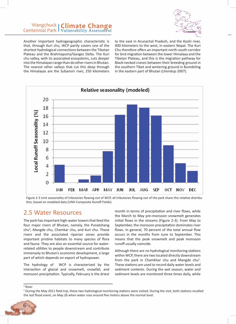
Figure 2-3 Unit seasonality of tributaries flowing out of WCP, all tributaries flowing out of the park share this relative distribu-tion, based on modeled data (UNH Composite Runoff Fields)
2.5 Water ResourcesThe park has important high-water towers that feed the four major rivers of Bhutan, namely, the Punatshang chu4, Mangde chu, Chamkar chu, and Kuri chu. These rivers and the associated riparian zones provide important pristine habitats to many species of flora and fauna. They are also an essential source for water-related utilities to people downstream and contribute immensely to Bhutan’s economic development, a large part of which depends on export of hydropower.
The hydrology of WCP is characterized by the interaction of glacial and snowmelt, snowfall, and monsoon precipitation. Typically, February is the driest
month in terms of precipitation and river flows, while the March to May pre-monsoon snowmelt generates initial flows in the streams (Figure 2-3). From May to September, the monsoon precipitation dominates river flows. In general, 70 percent of the total annual flow occurs in the months from June to September. This means that the peak snowmelt and peak monsoon runoff usually coincide.
Although there are no hydrological monitoring stations within WCP, there are two located directly downstream from the park in Chamkhar chu and Mangde chu5. These stations are used to record daily water levels and sediment contents. During the wet season, water and sediment levels are monitored three times daily, while
4 River5 During the May 2011 field trip, these two hydrological monitoring stations were visited. During the visit, both stations recalled the last flood event, on May 26 when water rose around five meters above the normal level.
Another important hydrogeographic characteristic is that, through Kuri chu, WCP partly covers one of the shortest hydrological connections between the Tibetan Plateau and the Brahmaputra/Ganges Delta. The Kuri chu valley, with its associated ecosystems, cuts deeper into the Himalayan range than do other rivers in Bhutan. The nearest other valleys that cut this deep through the Himalayas are the Subansiri river, 250 kilometers
to the east in Arunachal Pradesh, and the Koshi river, 400 kilometers to the west, in eastern Nepal. The Kuri Chu therefore offers an important north-south corridor for bird migration between the lower Himalaya and the Tibetan Plateau, and this is the migration pathway for Black-necked cranes between their breeding ground in the southern Tibet and wintering ground in Bumdeling in the eastern part of Bhutan (Lhendup 2007).
�
Wangchuck Centennial Park
Climate ChangeVulnerability Assessment
hourly measurements are taken during flood events. River cross sections are taken monthly, and flows are calibrated using propeller measurements on suspended cables. The stations are under management of the Department of Energy and are strategically located to inform the construction of dams downstream in both rivers. Twenty years of data are freely available in hard copy at the WWF-Bhutan office for all monitoring stations in Bhutan.
Water resources are minimally exploited in and around WCP. Existing rural communities tap their drinking water from springs or streams that are high up the slope. Most of the drinking water systems have their own water users’ associations that perform routine maintenance on the infrastructure originally provided by the government. Field visits indicated that at least
one source was inside an actively grazed meadow, which could result in water quality problems, an insight into potential problems of management of these water sources. One users’ group reported that in the past they used to take water from an unhealthy source, which resulted in increased rates of diseases.
Agriculture and larger towns typically draw water from slightly larger streams and springs that are lower in the watershed relative to the drinking water supply. This is largely due to the fact that agricultural water use has significantly higher quantitative and lower qualitative requirements as compared to drinking water. Larger communities have better water quality infrastructure in place (e.g., filter screens and siltation basins), due to their higher capacity to mobilize contributions and maintain this kind of infrastructure.
2.6 Socioeconomic ConsiderationsAgricultural production and livestock rearing are the main livelihoods of the people in the park, although Cordyceps6 collection from the northern fringes of the park has recently emerged as a significant source of revenue.
The majority of agricultural land falls outside of the park boundaries, with the exceptions of Zhabzethang and Nagsephel villages in Chhokhor geog7. Accordingly, there is not much impact on biodiversity from agriculture, unlike in other protected areas where there are many more settlements within the park boundaries. Dryland agriculture is practiced in villages at higher elevations, above 2,000 meters, while wetland agriculture is practiced in villages at lower elevations. The main crops raised in the dryland villages are wheat, barley, buckwheat (sweet and bitter), paddy, mustard, potato, and vegetables, depending upon the altitude of the villages. In the wetland, the main food crop is paddy, followed by cereals and legumes. Some cash crops, such as oranges, guavas, and sugarcane, are also grown. The main challenges for the agricultural sector are crop damage by wildlife, pests, and diseases and the lack of marketing and transport.
The majority of households own livestock, especially cattle, yak, and sheep. All yak and some sheep rearing occurs in the northern portion of WCP, while cows
are typically reared in the lower elevations. Typically, livestock are reared in large herds, with relatively low productivity per head. Other livestock include horses, poultry, and pigs, depending on the altitude. Forests are often regarded as open access for grazing, and livestock depredation by wild animals such as tigers, common and snow leopards, wild dogs, bears, and wolves is common, resulting in human-wildlife conflict.
Almost all households rely on wood for cooking and space heating. They also depend on large varieties of forest products for subsistence. These products range from construction materials (timber, sand, and boulders) to nonwood forest products (NWFPs), which are used as sources of essential nutrients, medicines, and handicrafts. The annual average household income from Cordyceps in Dangchu and Kashi geogs is about Nu. 30,000, while some households earn more than Nu. 100,000 (WCP Draft Management Plan 2011).
2.7 Land-use, Development and InfrastructureThe villages and agricultural land are located mostly along the lower reaches of the Chamkhar chu and the Mangde chu. A few groups of yakherders live in the northern parts of the park and use the park as grazing grounds for their livestock. Temperate pastures are found throughout the park, mostly along the main trails and along the ridges above the villages.
6 Caterpillar fungus, Cordyceps sinensis, locally known as Yartsha guen boub which is literally translated as summer grass and winter worm.7 Subdistrict

Wangchuck Centennial Park
Climate ChangeVulnerability Assessment
�
A few villages in the buffer zones have access to farm roads, electricity, and the telephone network. There is no major infrastructure apart from village houses and monasteries, but a hydropower scheme is being developed that includes run-of-the-river dams on all the major tributaries leaving the park. Although construction would occur downstream from the park, possible indirect impacts could affect aquatic biodiversity in the park. By definition, run-of-the-river dams are supposed to divert only a portion of the river flow, but often the entire river is diverted during the dry season. This practice has a high likelihood of destroying most species that depend on ecosystem processes provided by these rivers.
There are also a few trekking routes in the park that are frequently used by tourists. In addition to the wildlife and scenic beauty, there are several sites of cultural and religious significance in the park, including the hot spring (Dur Tshachu), where Guru Padmasambhava is supposed to have taken a bath. Additionally, the park has the potential to promote ecotourism in water -related recreational sports such as boating, skiing, fishing, and canoeing, among others.
2.8 Institutional ArrangementsThe main government institutions in the park are Renewable Natural Resources (RNR) Centers (agriculture extension office, livestock extension office, and forestry extension office), park ranger offices, basic health units, schools, and nonformal education centers. Access to these service centers in the park varies by geog. Lunana geog is a five-day walk from the main road and markets, making it the most isolated in the park. Health, primary education, and extension services located at the geog center are a half-day walk from this geog’s villages. Kashi geog is one day away from the nearest market, but it takes two days to reach health services and RNR posts. In other geogs, basic facilities such as RNR and health services are less than a half-day walk from the respective villages. The community and primary schools are within a half-day walk for most villages. For herders, the geog livestock extension officers and health staff make two scheduled visits annually for vaccination, medication, and other consultations. Additional visits are made as requested by the herders.
Resources are largely managed informally at a community level. For example, each community consists
of around 15 water user associations (WUAs), which have no organizational mandate at the community level. If alternative water sources are added to WUAs in the future, this could result in competition over access to the sources among the different WUAs.
3. VulnerabilityAnnual mean temperature has demonstrated a consistent warming trend in the Himalayas, at approximately three times the global average. Future climatic projections for the Himalayas indicate continued warming and increased precipitation at higher elevations (Xu et al. 2009, Shrestha and Devkota 2010). These same studies, however, also note that precipitation projections are associated with high uncertainties and that the models used are wet-biased at higher altitudes. Thus, Bhutan’s biodiversity—and biodiversities in the high elevations, which are generally most sensitive to ambient temperature changes—will very likely be impacted by these changes. Various studies along the Himalayas have already indicated signs of upslope forest shifts (Dubey et al. 2003, Vijayprakash and Ansari 2009), which can impact species distributions and ecological interactions. The changes to ecosystems and ecological processes can also impinge on human-wildlife interactions, natural resource extraction and dependency of local communities, land use patterns, Bhutan’s national economic development plans, and frequency and intensity of natural disasters and vulnerability to these events.
3.1 Terrestrial BiodiversitySince WCP harbors several endangered and endemic species, the changes to ecosystems, ecological interactions, and processes expected from change will require conservation management to mitigate or alleviate the impacts.
3.1.1. MethodsA synopsis of methods usedIn this subsection, a synopsis of the methods used to assess the vulnerability of Bhutan’s high-elevation biodiversity to climate change is presented. More detailed and technical descriptions of the methods are provided in the subsequent sections.
In this analysis, both qualitative assessments, based on the biological characteristics of several focal species, and multivariate analyses combined with climate models
�
Wangchuck Centennial Park
Climate ChangeVulnerability Assessment
were employed. This two-tiered approach allowed us to a) cross check the results from the climate models against the likely biological responses from the focal species, and b) provide a spatial component that will be useful for conservation planning and management.
The focal species used to assess the potential effects of climate change are the snow leopard, tiger, red panda, musk deer, takin, and several species of birds. The rationale for selecting these species is provided in Table 3-1.
The same approach was used to look at potential changes to key crops—potatoes, barley, and wheat—and thus potential land use changes for agriculture under future climate change scenarios. The results can be used to ascertain if changing climate can make critical areas in the park more vulnerable to land use change and to plan management strategies accordingly.
First, species profiles were developed for the focal species (see Appendix A), based on known population distributions and trends and ecological and physiological characteristics. These traits were used to assess the potential vulnerability of these species to climate change. Information was derived from the available literature and expert opinion.
Second, multivariate analyses to evaluate the primary climate and nonclimate drivers of focal species’ habitat and agricultural suitability at two different scales were used. The results were used in a model to map current species distributions and agricultural suitability and then their potential habitat shifts under a high greenhouse gas emission scenario (IPCC 4 – HADCM3
-A2). The current and future habitat projections were then compared to determine the potential impacts of climate change on these species’ habitats and agricultural practices.
By combining the qualitative and modeling results, it is possible to better understand the vulnerability of species’ habitat under future climatic conditions and to make targeted conservation recommendations, especially for WCP.
Focal Species SelectionSince the Himalayas are relatively unexplored biologically, it is impossible to make comprehensive assessments of the vulnerability of all species to climate change impacts. Instead, given the urgent need to plan for climate change, a focus was placed on charismatic flagship species such as the snow leopard and tiger to be umbrella species, because their ecological requirements, which include large spatial areas of relatively undisturbed habitat, will also that contain many lesser-known, cryptic species that escape conservation attention.
The focal species were selected from a suite of target species identified in the ecoregion conservation framework for the Eastern Himalayas (Wikramanayake et al. 2001) (Table 3-1). These species also overlap with a set of focal species of high conservation importance identified by a stakeholder group of government officials, experts, and NGO staff for corridor planning in Bhutan in November 2010.
Table 3-1 Focal species selected for the climate vulnerability assessment in Bhutan
Snow leopard (Panthera uncia). An endangered species and an umbrella species for other alpine biodiversity. This analysis has already been conducted as part of a Himalaya-wide assessment.
Tiger (Panthera tigris). The “mountain tigers” of Bhutan are found at elevations of 4,000+m, but in broadleaf and occasionally in mixed conifer forests. This is the only tiger population that is adapted to live at high elevations. Tigers are also considered an umbrella species for habitat connectivity for other forest-dwelling species.
Musk deer (Moschus chrysogaster) and red panda (Ailurus fulgens). Both are habitat specialist species and umbrella species for conservation of old-growth Himalayan temperate and conifer forests and the biodiversity therein.
Takin (Budorcas taxicolor). A threatened species. One of the few isolated Himalayan populations occurs in WCP.
Blue sheep (Pseudois nayaur). A large mountain ungulate, it is also the primary prey for snow leopards.
Altitudinal migrant and habitat specialist birds.
Wangchuck Centennial Park
Climate ChangeVulnerability Assessment
�0
Analysis of species’ population, ecology, and physiology and the expected response to climate change
A matrix based on the framework from Galbraith and Price (n.d.) was used to “score” the population, ecological, and physiological characteristics of the selected species. The qualitative assessments were used to develop species profile descriptions, which include potential impacts from climate change (Appendix A).
Multivariate analysis of environmental drivers of species ranges and agricultural suitability under current climate conditions
A multivariate analysis was performed to identify the primary climatic and environmental drivers of the selected focal species and agricultural suitability. Two climate datasets at different scales were used to test for consistency in results at two scales. The stronger of the two statistical correlations for projecting potential future species distributions under climate change, based on habitat shifts, was selected. The first climate dataset tested was the WorldClim 19 bioclimatic variables (Hijmans et al. 2005). WorldClim climate surfaces consist of weather station monthly temperature and precipitation values averaged between the years 1950 to 2000 and interpolated using elevation and distance to weather station to fill in expected climate values between weather stations. Bioclimatic variables are then derived from the monthly average temperature and precipitation surfaces. Finally, the WorldClim climate surfaces available at 30-second (approximately 1 km) resolution were selected.
The second climate dataset tested was the general circulation model (GCM) from the Wallace Initiative, representing current climate conditions. The Wallace Initiative current climate surfaces represent modeled climate conditions over the surface of the earth at 0.5 degree resolution, which is approximately 50 km. The Wallace Initiative dataset includes the same 19 bioclimatic variables but at a coarser resolution.
In a third analysis, the 1 km climate layers were augmented with slope, aspect, and distance to rivers, which might also be considered species drivers. These additional abiotic variables were not included in the 50 km scale analysis because the averaging slope, aspect, and distance to rivers over 50 km grid cells do not yield meaningful results.
The maximum entropy model, MAXENT (Phillipps 2006), was used to identify important drivers of species distribution for all focal species (except the snow
leopard and tiger–see below). Additionally, MAXENT was used to help understand the important drivers of agricultural suitability for wheat, potatoes, and barley. MAXENT is an inductive model that generates a predicted distribution of species using environmental variables and species occurrence points. The same set of observation points was used for each species during analyses, at the two climate data scales and with the addition of other abiotic variables. The results of MAXENT included heuristic and jackknife analyses which were consulted to note predominant climate variables affecting focal species habitat and agricultural suitability. To measure and compare the modeled results for accuracy, the area under curve (AUC) score was consulted, and the resulting species distribution map from MAXENT was compared to what is known about the current distribution of the species.
A different approach was used to determine the primary climatic drivers of snow leopard and tiger habitat, relying on the results of an earlier in-depth study (Forrest et al. in prep). Snow leopards live in the alpine zone, above the tree line, while tigers are found below the tree line. Forest and alpine zones can thus be used as proxies for suitable habitat for these two species. Forest and alpine habitat occurrence points were generated as the dependent variables. A literature review informed the selection of the dominant environmental drivers of forest and alpine zones, which were prepared using current WorldClim data. Additionally, bioclimatic variables and an iterative approach using a logistic regression and correlation tests were used to sift out autocorrelated variables and find the variables that yielded the strongest regression curve. Finally, the raster calculator in ArcGIS 9.3 was used to project the results spatially, and overlay on the existing forest and alpine zones to check results.
Projecting potential future habitat and agricultural suitability under a high emissions climate scenario
Next, potential species range shifts under a high emissions scenario (IPCC 4 – HADCM3 A2) were projeced using existing relationships between environmental/climatic variables and observations established in the previous step (Erasmus et al 2002, Araujo et al. 2004, Bomhard et al. 2005, Hijmans and Graham 2006, Hannah et al. 2007, Jarvis et al. 2008). Red panda, musk deer, takin, and agricultural suitability relied on downscaled climate data from the International Center for Tropical Agriculture (CIAT) and the Consultative Group on international Agriculture Research (CGIAR) (Ramirez and Jarvis 2010). Bioclimatic variables were

��
Wangchuck Centennial Park
Climate ChangeVulnerability Assessment
selected from the IPCC Fourth Assessment Report (Intergovernmental Panel on Climate Change (IPCC) 2007), produced with the HADCM3 general circulation model (GCM) representing the A2 emissions scenario, and projected to the year 2080. The HADCM3 GCM was selected because it is a moderate GCM globally and seems to replicate historical climate in Bhutan fairly well (Price 2011). The A2 scenario in 2080 was selected to represent a relatively high emissions scenario, assuming that more moderate emissions scenarios would yield intermediate levels of change between A2 and the current conditions. Additionally, the A2 scenario was considered a reasonable selection, because observed emissions from 2000 to 2007 have been found to exceed even the highest IPCC emissions scenario (Raupach et al. 2007, McMullen and Jabbour 2009). Future climate surfaces were downscaled to 30s by CIAT and CGIAR using the change factor method, which involves finding the difference between current averages in monthly precipitation and temperature projected by the GCM and the 2080 averages and then adding the difference to the current 30s WorldClim surfaces (Wilby et al. 2004, Ramirez and Jarvis 2010, Wiens, Seavy, and Jongsomjit 2011). The bioclimatic variables were complemented with other abiotic variables that will remain the same under climate change. These were slope, aspect, and distance to riverbeds. For the tree-line-dependent species (snow leopards and tiger), an ensemble average of 16 IPCC Fourth Assessment GCMs representing the A2 scenario from Climate Wizard (www.climatewizard.org) was used, and future variables were constructed using the change factor method (Adam and Lettenmaier 2003, Wood et al. 2004, Mehl et al. 2007, Maurer 2009). Only the future variables that emerged as significant in the multivariate analysis of current climate and other abiotic variables were used. Namely, these were mean temperature during the growing season (defined as months where TMEAN > 0 C), average monthly precipitation during the growing season, total precipitation during the winter (monthly TMEAN <= 0 C), and December to February total precipitation. Since blue sheep occupy a similar niche to snow leopards, the snow leopard habitat results were used to interpret potential climate change impacts on blue sheep habitat as well.
WorldClim 1km data were used as the current climate surface for each analysis, because these yielded more biologically credible representations of current ranges. Future climate conditions represent change from current conditions over a broad area the size of a GCM cell. Potential future habitat for each species was
projected based on the same variables and methods used to map habitat in the current situation (using a maximum entropy model for red pandas, musk deer, takin, and agricultural suitability, and a logistic regression model for mapping the future potential habitat of forest or alpine habitat generalists, snow leopards, and tigers).
Caveats and Limitations
While methods selected were used to control for uncertainty, it is important to recognize that the maps produced represent one possible, not a certain future. Climate modeling provides a lens through which to view where things may be going, but it has to be cross-checked by what is known of the species’ biological and behavioral requirements with respect to climate drivers—which are also not comprehensive. Therefore, given the uncertainties associated with the models, the model should be viewed as guides to what may happen, interpreted in conjunction with other information and knowledge about each species and not a perceived as indicative of a definitive future scenario of what will happen. Thus, while conservation management strategies can be based on these recommendations, they will also require close monitoring that allows for adaptive management strategies.
Climate Model While it is acknowledged that much debate exists about the use of climate models for predicting potential changes in future habitat, this approach was selected because there is little knowledge of the exact physiological parameters that define each individual species’ or community’s tolerance to climate shift. Therefore, an automated approach was preferable for sorting through statistical relationships between several environmental and climate variables and identifying those that are most significant. But the results must be interpreted along with other information and as one component of an adaptation plan.
Climate models suggest that the climate will become warmer and wetter in the Himalayas (UNEP 2009, Xu et al. 2009). A general circulation model (GCM) for the species distribution analysis (HADCM3) that represented an intermediate future both globally and in Bhutan was selected. This GCM has also tracked past climate conditions well. For tigers and snow leopards, an ensemble average of 16 climate models was used. This also represents an intermediate climate projection for Bhutan in a future with high greenhouse gas emissions.
Wangchuck Centennial Park
Climate ChangeVulnerability Assessment
��
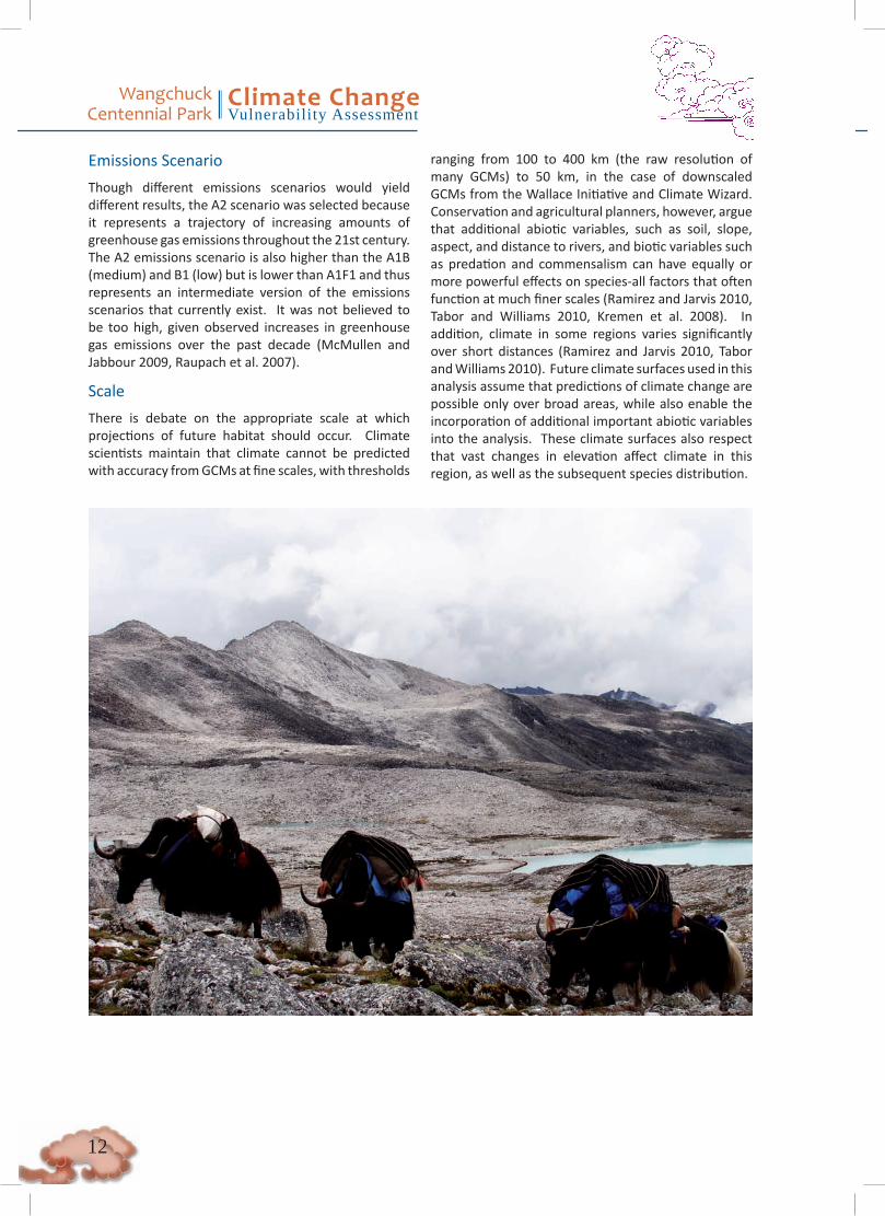
Emissions Scenario Though different emissions scenarios would yield different results, the A2 scenario was selected because it represents a trajectory of increasing amounts of greenhouse gas emissions throughout the 21st century. The A2 emissions scenario is also higher than the A1B (medium) and B1 (low) but is lower than A1F1 and thus represents an intermediate version of the emissions scenarios that currently exist. It was not believed to be too high, given observed increases in greenhouse gas emissions over the past decade (McMullen and Jabbour 2009, Raupach et al. 2007).
Scale
There is debate on the appropriate scale at which projections of future habitat should occur. Climate scientists maintain that climate cannot be predicted with accuracy from GCMs at fine scales, with thresholds
ranging from 100 to 400 km (the raw resolution of many GCMs) to 50 km, in the case of downscaled GCMs from the Wallace Initiative and Climate Wizard. Conservation and agricultural planners, however, argue that additional abiotic variables, such as soil, slope, aspect, and distance to rivers, and biotic variables such as predation and commensalism can have equally or more powerful effects on species-all factors that often function at much finer scales (Ramirez and Jarvis 2010, Tabor and Williams 2010, Kremen et al. 2008). In addition, climate in some regions varies significantly over short distances (Ramirez and Jarvis 2010, Tabor and Williams 2010). Future climate surfaces used in this analysis assume that predictions of climate change are possible only over broad areas, while also enable the incorporation of additional important abiotic variables into the analysis. These climate surfaces also respect that vast changes in elevation affect climate in this region, as well as the subsequent species distribution.
��
Wangchuck Centennial Park
Climate ChangeVulnerability Assessment
3.1.2. Results and Discussiona. Potential Responses of the Focal Species to Projected Climate Change
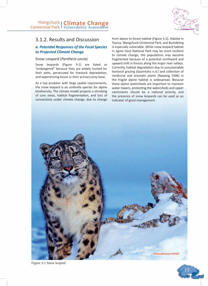
Snow Leopard (Panthera uncia)Snow leopards (Figure 3-1) are listed as “endangered” because they are widely hunted for their pelts, persecuted for livestock depredation, and experiencing losses in their primary prey base.
As a top predator with large spatial requirements, the snow leopard is an umbrella species for alpine biodiversity. The climate model projects a shrinking of core areas, habitat fragmentation, and loss of connectivity under climate change, due to change
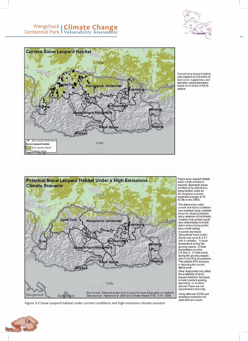
from alpine to forest habitat (Figure 3-2). Habitat in Toorsa, Wangchuck Centennial Park, and Bumdeling is especially vulnerable. While snow leopard habitat in Jigme Dorji National Park may be more resilient to climate change, the populations may become fragmented because of a potential northward and upward shift in forests along the major river valleys. Currently, habitat degradation due to unsustainable livestock grazing (Gyamtsho n.d.) and collection of medicinal and aromatic plants (Nawang 1996) in the fragile alpine habitat is widespread. Because these alpine watersheds are important to maintain water towers, protecting the watersheds and upper catchments should be a national priority, and the presence of snow leopards can be used as an indicator of good management.
Figure �-� Snow leopard
Wangchuck Centennial Park
Climate ChangeVulnerability Assessment
��
Figure 3-2 Snow Leopard habitat under current conditions and high emissions climate scenario
��
Wangchuck Centennial Park
Climate ChangeVulnerability Assessment
Potential direct (physiological) vulnerability to climate changeA warming trend in the Himalayas could cause the elevation of the tree line to increase and thereby reduce the size of the alpine zone available to snow leopards between tree line and the upper limits of their altitude range imposed by oxygen limits. The upper elevation threshold of most Himalayan mammals is 5,500m, and snow leopards are observed only occasionally at higher elevations (Sharma 2002, Thapa 2011).
Potential indirect (ecological) vulnerability to climate changeA warming trend could result in loss and fragmentation of alpine habitat. Studies show that there is already an upslope movement of forests in several regions of the Himalayas (Dubey et al. 2003, Vijayprakash and Ansari 2009). The upslope movement of forests could also result in competitive displacement (or even predation) of snow leopards by tigers, common leopards, and wild dogs.
Fragmentation and loss of alpine habitat can also result in smaller core areas, limiting the population size that can be supported within them. As habitat becomes fragmented, connectivity between core areas could become lost, isolating populations, reducing genetic diversity, and compromising population viability.
Furthermore, as domesticated yak herds become confined in these smaller alpine meadows, yak herds and herders will displace the snow leopards’ natural prey species, so the snow leopards will turn to killing yaks as the natural prey becomes depleted, increasing conflict and retaliatory killing.
Potential effects of climate change on status and distribution in BhutanThe climate model indicates considerable loss of snow leopard habitat in Bhutan, especially in Wangchuck Centennial Park, Toorsa, and Bumdeling (Figure 3-2). Eastern parts of Jigme Dorji National Park will also lose some habitat, but generally most habitats seem resilient to change. However, the populations in the eastern and western parts of the park could become isolated if forest habitat responded to projected climate change as a northward shift along the upper reaches of the Mo chu. Loss of habitat connectivity has long-term implications for population viability of snow leopard populations, especially because connectivity with the populations in Tibet would also become tenuous because of unsuitable habitat. While trees are already “encroaching” in previously alpine areas, the transition from alpine zones to forest habitat to a new equilibrium is expected to occur beyond the timescale
of the emissions scenario, into the 22nd century (Dubey et al. 2003, Vijayprakash and Ansari 2009).
Blue Sheep (Pseudois nayaur)8 Blue sheep are listed as a species of “least concern” in the IUCN Red List. They are not commercially hunted or killed for body parts; however, they are displaced and persecuted by yak herders, who consider them to be direct competitors for forage with livestock. The habitat impact will be similar to that for snow leopards because they have a wide range distribution across the Himalayas, but blue sheep can live at higher elevations than snow leopards can. Thus, the populations will be less subject to fragmentation. However, widespread loss of blue sheep populations could affect population numbers of snow leopards that prey on these sheep. Overall, it is unlikely that blue sheep will be impacted by climate change-related habitat change, but they may become susceptible to diseases, and populations should be monitored.
Potential direct (physiological) vulnerability to climate changeIt is unlikely that a warming trend would have significant physiological impacts on blue sheep. However, a recent outbreak of sarcoptic mange with fatal consequences was reported in blue sheep in the extreme northern regions of Pakistan. The disease is usually common in domestic ruminants in temperate and tropical climates but now seems to have infected blue sheep, a cold, high-altitude-habitat-adapted species that probably has not developed an immune response to the parasite (Dagleish et al. 2007). Thus, there is a danger that a warming climate could result in blue sheep populations elsewhere being exposed to similar diseases with severe consequences.
Potential indirect (ecological) vulnerability to climate changeA warming trend could result in loss and fragmentation of alpine habitat due to the expected upslope movement of forests in the Himalaya Mountains. However, because blue sheep prefer steep, rocky alpine scree habitat, it is unlikely that forests would intrude into these habitat, because the edaphic conditions and steep slopes would not be able to support dense tree growth.
Potential effects of climate change on status and distribution in BhutanThe expected impacts of climate change on blue sheep habitat will be similar to those on snow leopards (Figure 3-1). However, blue sheep can live at higher elevations, and the degree of habitat and population fragmentation and isolation may not be as severe at
8 Derived from (Harris 2010) and references therein
Wangchuck Centennial Park
Climate ChangeVulnerability Assessment
��
elevations greater than 5,500 m. Climate-driven disease may pose a greater risk to blue sheep than habitat loss might, although both pose threats, particularly if they occur together.
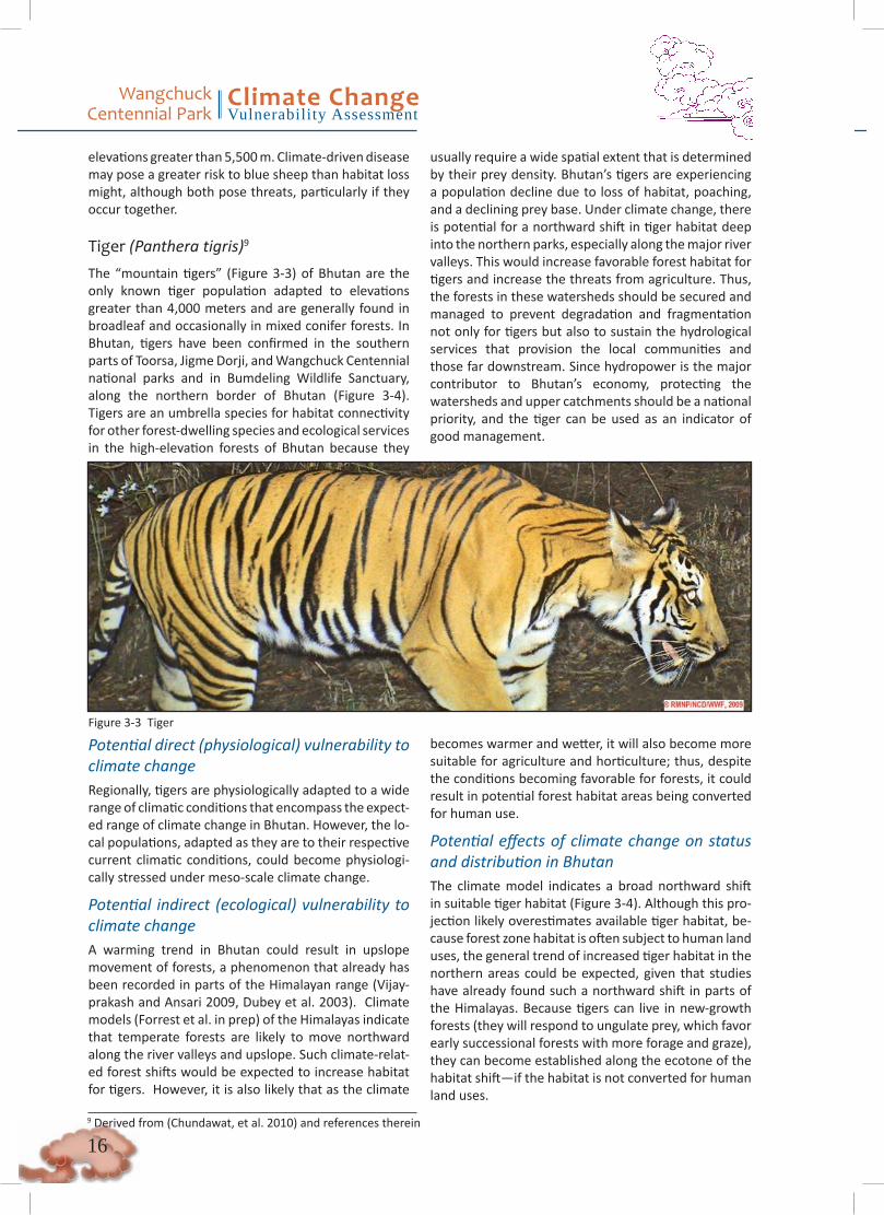
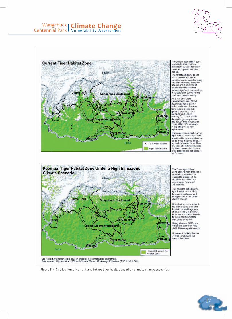
Tiger (Panthera tigris)9 The “mountain tigers” (Figure 3-3) of Bhutan are the only known tiger population adapted to elevations greater than 4,000 meters and are generally found in broadleaf and occasionally in mixed conifer forests. In Bhutan, tigers have been confirmed in the southern parts of Toorsa, Jigme Dorji, and Wangchuck Centennial national parks and in Bumdeling Wildlife Sanctuary, along the northern border of Bhutan (Figure 3-4). Tigers are an umbrella species for habitat connectivity for other forest-dwelling species and ecological services in the high-elevation forests of Bhutan because they
usually require a wide spatial extent that is determined by their prey density. Bhutan’s tigers are experiencing a population decline due to loss of habitat, poaching, and a declining prey base. Under climate change, there is potential for a northward shift in tiger habitat deep into the northern parks, especially along the major river valleys. This would increase favorable forest habitat for tigers and increase the threats from agriculture. Thus, the forests in these watersheds should be secured and managed to prevent degradation and fragmentation not only for tigers but also to sustain the hydrological services that provision the local communities and those far downstream. Since hydropower is the major contributor to Bhutan’s economy, protecting the watersheds and upper catchments should be a national priority, and the tiger can be used as an indicator of good management.
Potential direct (physiological) vulnerability to climate changeRegionally, tigers are physiologically adapted to a wide range of climatic conditions that encompass the expect-ed range of climate change in Bhutan. However, the lo-cal populations, adapted as they are to their respective current climatic conditions, could become physiologi-cally stressed under meso-scale climate change.
Potential indirect (ecological) vulnerability to climate changeA warming trend in Bhutan could result in upslope movement of forests, a phenomenon that already has been recorded in parts of the Himalayan range (Vijay-prakash and Ansari 2009, Dubey et al. 2003). Climate models (Forrest et al. in prep) of the Himalayas indicate that temperate forests are likely to move northward along the river valleys and upslope. Such climate-relat-ed forest shifts would be expected to increase habitat for tigers. However, it is also likely that as the climate
becomes warmer and wetter, it will also become more suitable for agriculture and horticulture; thus, despite the conditions becoming favorable for forests, it could result in potential forest habitat areas being converted for human use.
Potential effects of climate change on status and distribution in BhutanThe climate model indicates a broad northward shift in suitable tiger habitat (Figure 3-4). Although this pro-jection likely overestimates available tiger habitat, be-cause forest zone habitat is often subject to human land uses, the general trend of increased tiger habitat in the northern areas could be expected, given that studies have already found such a northward shift in parts of the Himalayas. Because tigers can live in new-growth forests (they will respond to ungulate prey, which favor early successional forests with more forage and graze), they can become established along the ecotone of the habitat shift—if the habitat is not converted for human land uses.
9 Derived from (Chundawat, et al. 2010) and references therein
Figure 3-3 Tiger
��
Wangchuck Centennial Park
Climate ChangeVulnerability Assessment
Figure 3-4 Distribution of current and future tiger habitat based on climate change scenarios
Wangchuck Centennial Park
Climate ChangeVulnerability Assessment
��
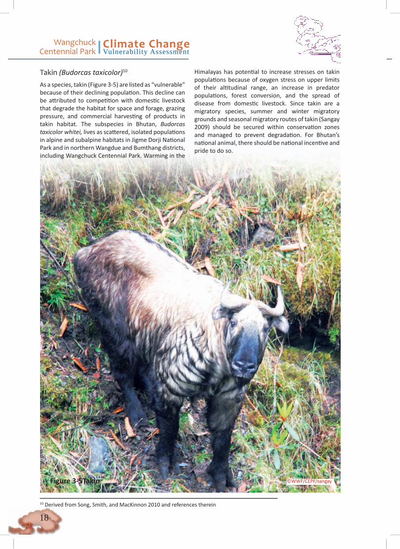
Takin (Budorcas taxicolor)10
As a species, takin (Figure 3-5) are listed as “vulnerable” because of their declining population. This decline can be attributed to competition with domestic livestock that degrade the habitat for space and forage, grazing pressure, and commercial harvesting of products in takin habitat. The subspecies in Bhutan, Budorcas taxicolor whitei, lives as scattered, isolated populations in alpine and subalpine habitats in Jigme Dorji National Park and in northern Wangdue and Bumthang districts, including Wangchuck Centennial Park. Warming in the
Himalayas has potential to increase stresses on takin populations because of oxygen stress on upper limits of their altitudinal range, an increase in predator populations, forest conversion, and the spread of disease from domestic livestock. Since takin are a migratory species, summer and winter migratory grounds and seasonal migratory routes of takin (Sangay 2009) should be secured within conservation zones and managed to prevent degradation. For Bhutan’s national animal, there should be national incentive and pride to do so.
Figure 3-5Takin
10 Derived from Song, Smith, and MacKinnon 2010 and references therein
©WWF/CEPF/sangay
��
Wangchuck Centennial Park
Climate ChangeVulnerability Assessment
Potential direct (physiological) vulnerability to climate changeA warming trend in the Himalayas could place takin under oxygen stress at the upper limits of their altitude range. Takin could also become vulnerable to disease, especially spread from domestic livestock, and warmer, wetter conditions to which they are not well adapted.
Potential indirect (ecological) vulnerability to climate changeA warmer, wetter climate could result in loss of summer grazing and rutting grounds if alpine meadows are lost to forest encroachment or converted for human uses. Takin could also fall prey to an increase in tigers and wild dogs in these forests. As habitat becomes fragmented, there could be loss of seasonal migratory routes.
Potential effects of climate change on status and distribution in BhutanBecause takin populations are relatively small and localized, they could be vulnerable to diseases and stochastic events, including floods from glacial lake outbursts.
Musk deer (Moschus chrysogaster)11 The Himalayan musk deer is listed as “endangered” because it is widely and intensely hunted for its musk gland and is experiencing loss and degradation of its subalpine forest habitat. Subalpine forests represent the forest-alpine meadow ecotone where climate-related habitat change may be most pronounced. In Bhutan, the most suitable musk deer habitat are in Toorsa, Jigme Dorji, and Wangchuck Centennial national parks (Figure 3-6). The analysis indicates a narrow range of preferences in terms of temperature and precipitation, which is compounded by the musk deer’s preferred habitat of intact, dense vegetation. With climate change, musk deer could experience an upslope habitat shift. While the model suggests there could be extensive habitat loss in the eastern region, the western region would be more resilient. Toorsa, Jigme Dorji, and Wangchuck Centennial national parks may continue to be the best-protected areas for
musk deer conservation in the future under climate change. However, musk deer monitoring programs are recommended under the management plans of the eastern parks to track the response to climate change.
Potential direct (physiological) vulnerability to climate changeAlthough no physiological studies have been conducted, the narrow horizontal band of distribution within the Himalayas suggests that a warming trend could result in temperature-related physiological stress or shifting of the musk deer’s habitat upslope from their current location.
Potential indirect (ecological) vulnerability to climate changeA warming trend could potentially result in loss and fragmentation of subalpine forests at meso- and micro-spatial scales, resulting in smaller core areas of intact habitat for musk deer. Widespread habitat loss could also occur, as indicated by the projection in Bhutan (Figure 3-7). The warming trend could allow expose musk deer to additional predators, such as wild dogs.
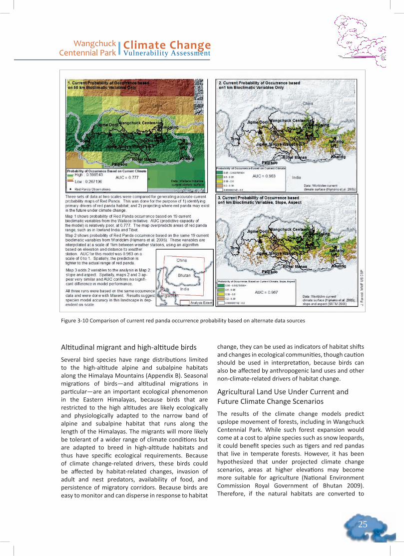
Potential effects of climate change on status and distribution in BhutanThe climate model indicates that most musk deer habitat in protected areas in western Bhutan will be resilient to the impacts of climate change (Figure 3 -6). Musk deer habitat in southern and central parts of Wangchuck Centennial Park will remain, with some loss in the eastern area of the park. Most of the habitat in Jigme Dorji and Toorsa national parks and surrounding area will also be resilient to climate change impacts. However, almost all suitable habitats in the east, especially in Sakteng and Thrumshingla, will be lost. It is noted that moderate-resolution climate data represents the current habitat of musk deer better than does modeled habitat based on the coarser, 50 km data. Thus, the moderate-resolution climate dataset for the future climate projection of occurrence (Figure 3-6) was selected.
11 Derived from (Wang and Harris 2010) and references therein

Wangchuck Centennial Park
Climate ChangeVulnerability Assessment
�0
Figure 3-6 Distribution of current and future musk deer habitat based on climate change scenarios

��
Wangchuck Centennial Park
Climate ChangeVulnerability Assessment
Figure 3-7 Comparison of current musk deer occurrence probability based on alternate data sources
Wangchuck Centennial Park
Climate ChangeVulnerability Assessment
��
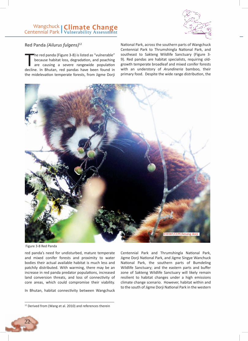
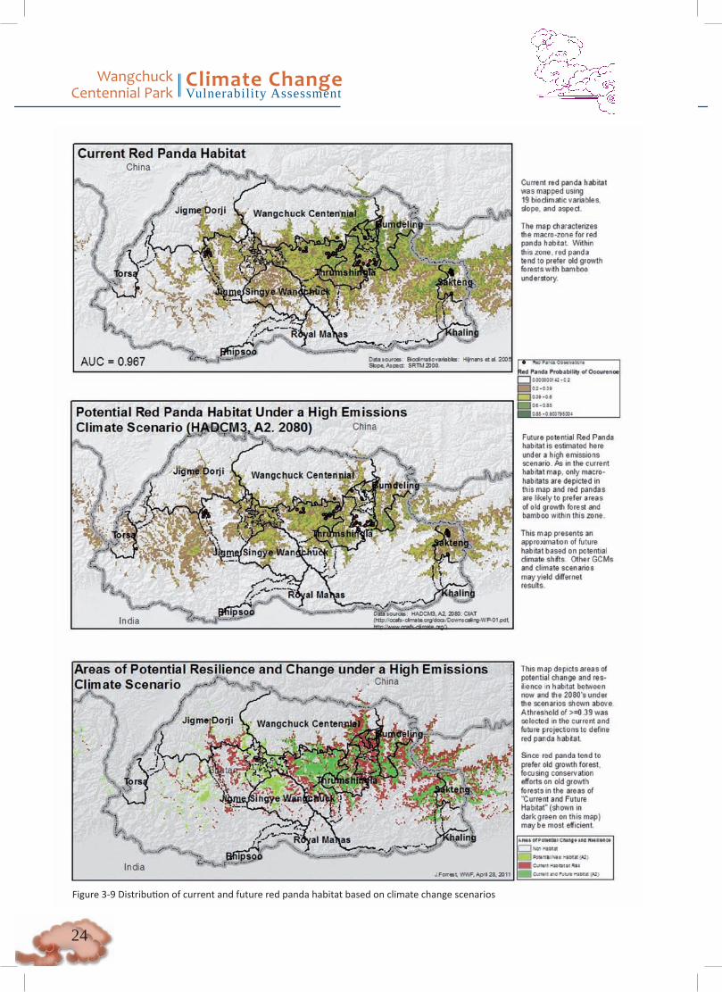
Red Panda (Ailurus fulgens)12
The red panda (Figure 3-8) is listed as “vulnerable” because habitat loss, degradation, and poaching are causing a severe rangewide population
decline. In Bhutan, red pandas have been found in the midelevation temperate forests, from Jigme Dorji
National Park, across the southern parts of Wangchuck Centennial Park to Thrumshingla National Park, and southeast to Sakteng Wildlife Sanctuary (Figure 3-9). Red pandas are habitat specialists, requiring old- growth temperate broadleaf and mixed conifer forests with an understory of Arundineria bamboo, their primary food. Despite the wide range distribution, the
12 Derived from (Wang et al. 2010) and references therein
Figure 3-8 Red Panda
©WWF/CEPF/kesang dorji
red panda’s need for undisturbed, mature temperate and mixed conifer forests and proximity to water bodies their actual available habitat is much less and patchily distributed. With warming, there may be an increase in red panda predator populations, increased land conversion threats, and loss of connectivity of core areas, which could compromise their viability. In Bhutan, habitat connectivity between Wangchuck
Centennial Park and Thrumshingla National Park, Jigme Dorji National Park, and Jigme Singye Wanchuck National Park, the southern parts of Bumdeling Wildlife Sanctuary; and the eastern parts and buffer zone of Sakteng Wildlife Sanctuary will likely remain resilient to habitat changes under a high emissions climate change scenario. However, habitat within and to the south of Jigme Dorji National Park in the western

��
Wangchuck Centennial Park
Climate ChangeVulnerability Assessment
region are vulnerable to climate change impacts under a high emissions scenario. Thus, the buffer zone linking Wangchuck Centennial Park and Thrumshingla National Park, as well as the parks themselves, should be considered important for long-term conservation of red panda habitat.
Potential direct (physiological) vulnerability to climate change
No physiological studies of red pandas are available ,and the potential consequences of climate change cannot be assessed.
Potential indirect (ecological) vulnerability to climate change
A warming trend could potentially result in loss and fragmentation of the red panda habitat, especially impacting the bamboo. Because red pandas prefer old- growth forests with large, mature trees, it is unlikely that they will seek or find climate refuge in new-growth forests during climate change-related habitat shifts. As habitat becomes fragmented, connectivity between core areas could become lost, isolating populations and compromising their viability.
If a warming trend allows new predators such as wild dogs, smaller felids (e.g., jungle cats, marble cats, golden cats), and other predators such as mongooses to move into higher elevations, predation pressure on red pandas could increase.
A warming trend could also make the habitat more vulnerable to conversion and degradation for
anthropogenic land use, especially for agriculture and more intensive livestock grazing.
Potential effects of climate change on status and distribution in Bhutan
The climate model indicates that the region between Wangchuck Centennial Park and Thrumshingla Na-tional Park would be most resilient to climate change impacts under a high emissions scenario (Figure 3-9). Thus, the buffer zone of Wangchuck Centennial Park should be considered important red panda habitat for long-term conservation. Because red panda have already been recorded from this buffer zone, which forms an important habitat link with Thrumshingla National Park, the forests should be secured from conversion and degradation.
The model also indicates that current red panda habitat in and around Sakteng Wildlife Sanctuary in the east will be resilient to climate change. However, habitat within and to the south of Jigme Dorji National Park in the western region is vulnerable to climate change impacts under a high emissions scenario, al-though the habitat link between Jigme Dorji National Park and Jigme Singye Wangchuck National Park could represent suitable red panda habitat under this climate change scenario. It is noted that moderate resolution climate data represents the current habitat of red panda better than does modeled habitat based on the coarser, 50 km data. Thus, the moderate-reso-lution climate dataset for the future climate projection (Figure 3-10) was selected.
Wangchuck Centennial Park
Climate ChangeVulnerability Assessment
��
Figure 3-9 Distribution of current and future red panda habitat based on climate change scenarios
��
Wangchuck Centennial Park
Climate ChangeVulnerability Assessment
Altitudinal migrant and high-altitude birds
Several bird species have range distributions limited to the high-altitude alpine and subalpine habitats along the Himalaya Mountains (Appendix B). Seasonal migrations of birds—and altitudinal migrations in particular—are an important ecological phenomenon in the Eastern Himalayas, because birds that are restricted to the high altitudes are likely ecologically and physiologically adapted to the narrow band of alpine and subalpine habitat that runs along the length of the Himalayas. The migrants will more likely be tolerant of a wider range of climate conditions but are adapted to breed in high-altitude habitats and thus have specific ecological requirements. Because of climate change-related drivers, these birds could be affected by habitat-related changes, invasion of adult and nest predators, availability of food, and persistence of migratory corridors. Because birds are easy to monitor and can disperse in response to habitat
change, they can be used as indicators of habitat shifts and changes in ecological communities, though caution should be used in interpretation, because birds can also be affected by anthropogenic land uses and other non-climate-related drivers of habitat change.
Agricultural Land Use Under Current and Future Climate Change Scenarios
The results of the climate change models predict upslope movement of forests, including in Wangchuck Centennial Park. While such forest expansion would come at a cost to alpine species such as snow leopards, it could benefit species such as tigers and red pandas that live in temperate forests. However, it has been hypothesized that under projected climate change scenarios, areas at higher elevations may become more suitable for agriculture (National Environment Commission Royal Government of Bhutan 2009). Therefore, if the natural habitats are converted to
Figure 3-10 Comparison of current red panda occurrence probability based on alternate data sources

Wangchuck Centennial Park
Climate ChangeVulnerability Assessment
��
Figure 3-11 Suitability for wheat production under current and potential future conditions
agriculture as changing climatic conditions make them more suitable for crops, there could be potential loss and fragmentation of critical wildlife habitat, with consequent loss of connectivity.
However, the climate models for agriculture indicate that land in WCP will probably not become much more suitable for the key crops—potatoes, barley, and wheat—and may even become less suitable (see Figure
3-11, Figure 3 -12, and Figure 3-13). An area in the southeast of WCP may become nominally more suitable for wheat, but projected climatic conditions are poorer for potatoes and barley. However, given the inherent uncertainly of climate models, park management should closely monitor these areas and take preemptive action to prevent loss and fragmentation of important habitat for other uses, including for other newly introduced crops and climate-resistant cultivars.

��
Wangchuck Centennial Park
Climate ChangeVulnerability Assessment
Figure 3-12 Suitability for potato production under current and potential future conditions

Wangchuck Centennial Park
Climate ChangeVulnerability Assessment
��
Figure 3-13 Suitability for barley production under current and potential future conditions
b. Multivariate Analysis
The results of the two-scale analysis using WorldClim data and general circulation models data from the Wallace Initiative are shown in Appendix C.
3.1.3. ConclusionsThe analysis predicted that forests will move upslope, a phenomenon that has already been confirmed in other parts of the Himalayas (Dubey et al. 2003, Vijayprakash and Ansari 2009). Responses from people in and around Wangchuck Centennial Park during surveys have also confirmed such an upslope movement of the tree line; as is noted in the following section on Community and Livelihood vulnerability assessment (Section 3.2), the yak herders in particular have said that the subalpine Juniper scrub forest is gradually encroaching into the alpine areas.
Additionally, during the socioeconomic survey (Section
3.2), people reported that there has been a perceptible increase in temperature and that the rainfall pattern has become erratic, with shorter, more intense rainfall than in the past. These perceptions are based on indicators such as changes in plant phenology (some trees are flowering earlier); the ability to grow vegetables that are usually grown at warmer, lower altitudes; the occurrence of new diseases in crops and livestock; and even the appearance of mosquitoes at higher altitudes. People have also reported that snowfall occurs earlier in the year, but that snowpack melts faster, now leaving bare and dry hillsides that used to be covered in snow.
Therefore, the responses from local communities confirm the general trends predicted by the climate models presented in this report. Thus, conservation management of WCP should consider these trends and their consequences to further hedge against climate-driven impacts that can directly and indirectly affect the park’s biodiversity and the ecosystem services.
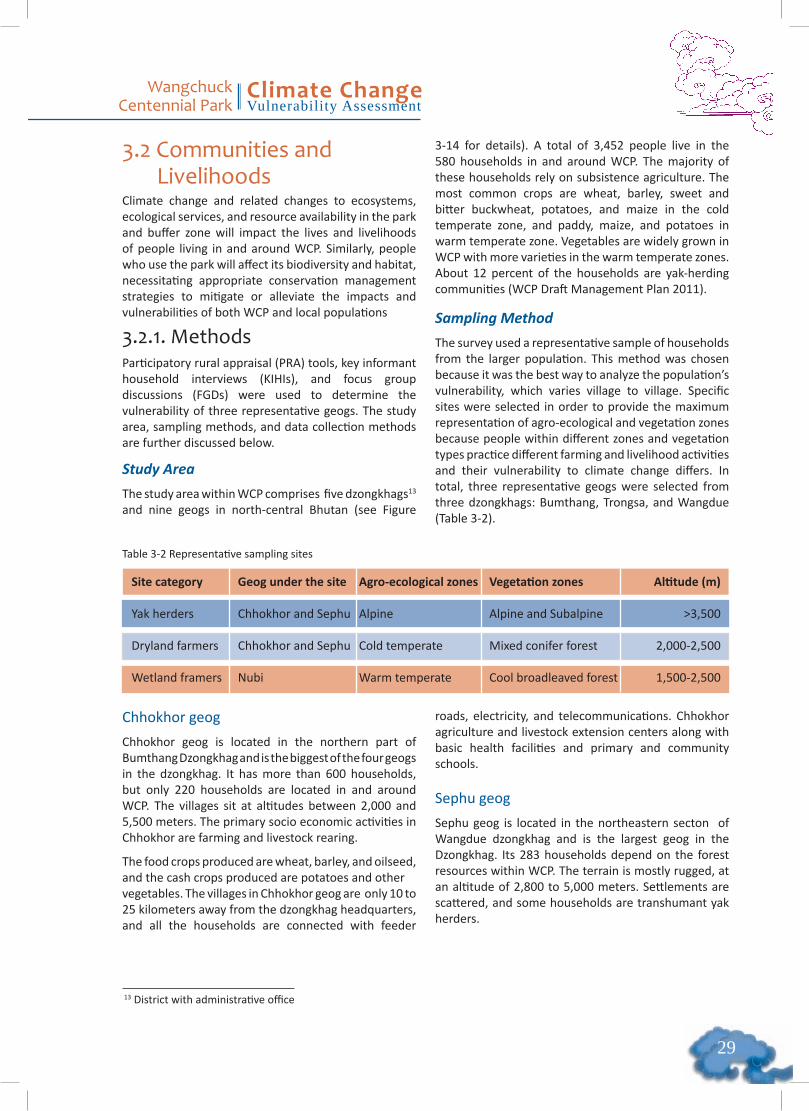
��
Wangchuck Centennial Park
Climate ChangeVulnerability Assessment
3.2 Communities and LivelihoodsClimate change and related changes to ecosystems, ecological services, and resource availability in the park and buffer zone will impact the lives and livelihoods of people living in and around WCP. Similarly, people who use the park will affect its biodiversity and habitat, necessitating appropriate conservation management strategies to mitigate or alleviate the impacts and vulnerabilities of both WCP and local populations
3.2.1. MethodsParticipatory rural appraisal (PRA) tools, key informant household interviews (KIHIs), and focus group discussions (FGDs) were used to determine the vulnerability of three representative geogs. The study area, sampling methods, and data collection methods are further discussed below.
Study Area
The study area within WCP comprises five dzongkhags13 and nine geogs in north-central Bhutan (see Figure
3-14 for details). A total of 3,452 people live in the 580 households in and around WCP. The majority of these households rely on subsistence agriculture. The most common crops are wheat, barley, sweet and bitter buckwheat, potatoes, and maize in the cold temperate zone, and paddy, maize, and potatoes in warm temperate zone. Vegetables are widely grown in WCP with more varieties in the warm temperate zones. About 12 percent of the households are yak-herding communities (WCP Draft Management Plan 2011).
Sampling Method
The survey used a representative sample of households from the larger population. This method was chosen because it was the best way to analyze the population’s vulnerability, which varies village to village. Specific sites were selected in order to provide the maximum representation of agro-ecological and vegetation zones because people within different zones and vegetation types practice different farming and livelihood activities and their vulnerability to climate change differs. In total, three representative geogs were selected from three dzongkhags: Bumthang, Trongsa, and Wangdue (Table 3-2).
Chhokhor geog
Chhokhor geog is located in the northern part of Bumthang Dzongkhag and is the biggest of the four geogs in the dzongkhag. It has more than 600 households, but only 220 households are located in and around WCP. The villages sit at altitudes between 2,000 and 5,500 meters. The primary socio economic activities in Chhokhor are farming and livestock rearing.
The food crops produced are wheat, barley, and oilseed, and the cash crops produced are potatoes and other vegetables. The villages in Chhokhor geog are only 10 to 25 kilometers away from the dzongkhag headquarters, and all the households are connected with feeder
roads, electricity, and telecommunications. Chhokhor agriculture and livestock extension centers along with basic health facilities and primary and community schools.
Sephu geog
Sephu geog is located in the northeastern secton of Wangdue dzongkhag and is the largest geog in the Dzongkhag. Its 283 households depend on the forest resources within WCP. The terrain is mostly rugged, at an altitude of 2,800 to 5,000 meters. Settlements are scattered, and some households are transhumant yak herders.
Site category Geog under the site Agro-ecological zones Vegetation zones Altitude (m)
Yak herders Chhokhor and Sephu Alpine Alpine and Subalpine >3,500
Dryland farmers Chhokhor and Sephu Cold temperate Mixed conifer forest 2,000-2,500
Wetland framers Nubi Warm temperate Cool broadleaved forest 1,500-2,500
13 District with administrative office
Table 3-2 Representative sampling sites
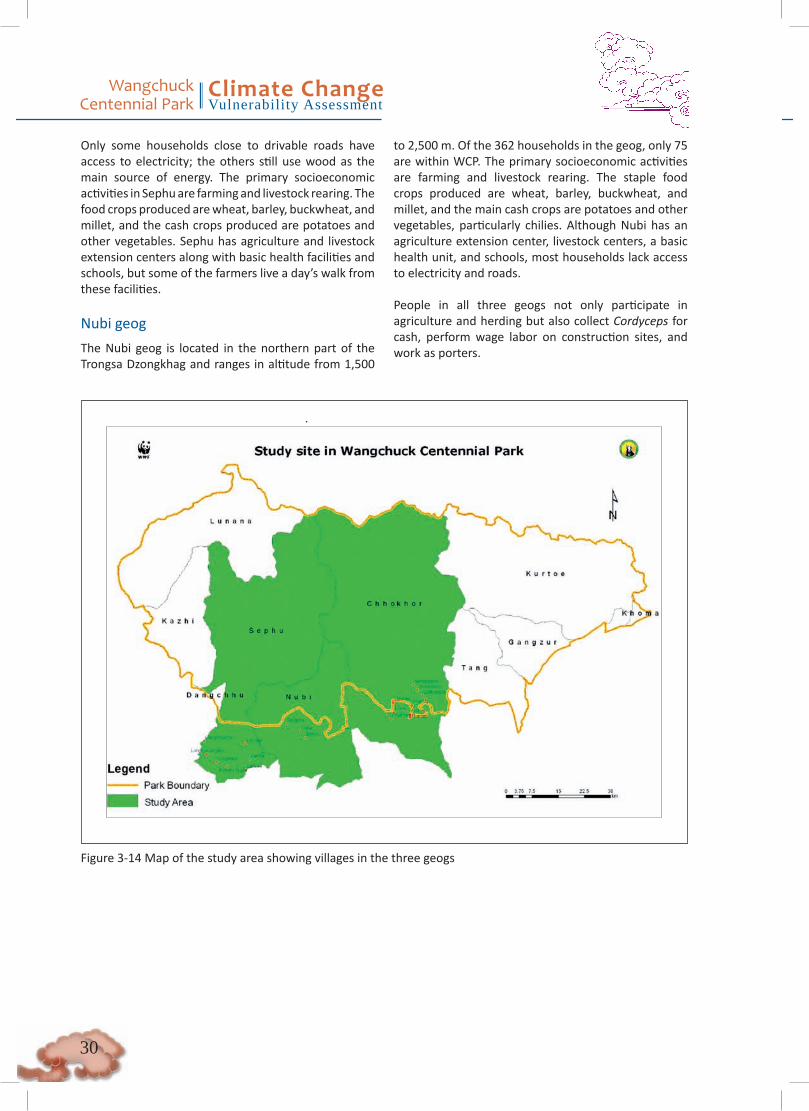
Wangchuck Centennial Park
Climate ChangeVulnerability Assessment
�0
Only some households close to drivable roads have access to electricity; the others still use wood as the main source of energy. The primary socioeconomic activities in Sephu are farming and livestock rearing. The food crops produced are wheat, barley, buckwheat, and millet, and the cash crops produced are potatoes and other vegetables. Sephu has agriculture and livestock extension centers along with basic health facilities and schools, but some of the farmers live a day’s walk from these facilities.
Nubi geog
The Nubi geog is located in the northern part of the Trongsa Dzongkhag and ranges in altitude from 1,500
to 2,500 m. Of the 362 households in the geog, only 75 are within WCP. The primary socioeconomic activities are farming and livestock rearing. The staple food crops produced are wheat, barley, buckwheat, and millet, and the main cash crops are potatoes and other vegetables, particularly chilies. Although Nubi has an agriculture extension center, livestock centers, a basic health unit, and schools, most households lack access to electricity and roads.
People in all three geogs not only participate in agriculture and herding but also collect Cordyceps for cash, perform wage labor on construction sites, and work as porters.
Figure 3-14 Map of the study area showing villages in the three geogs
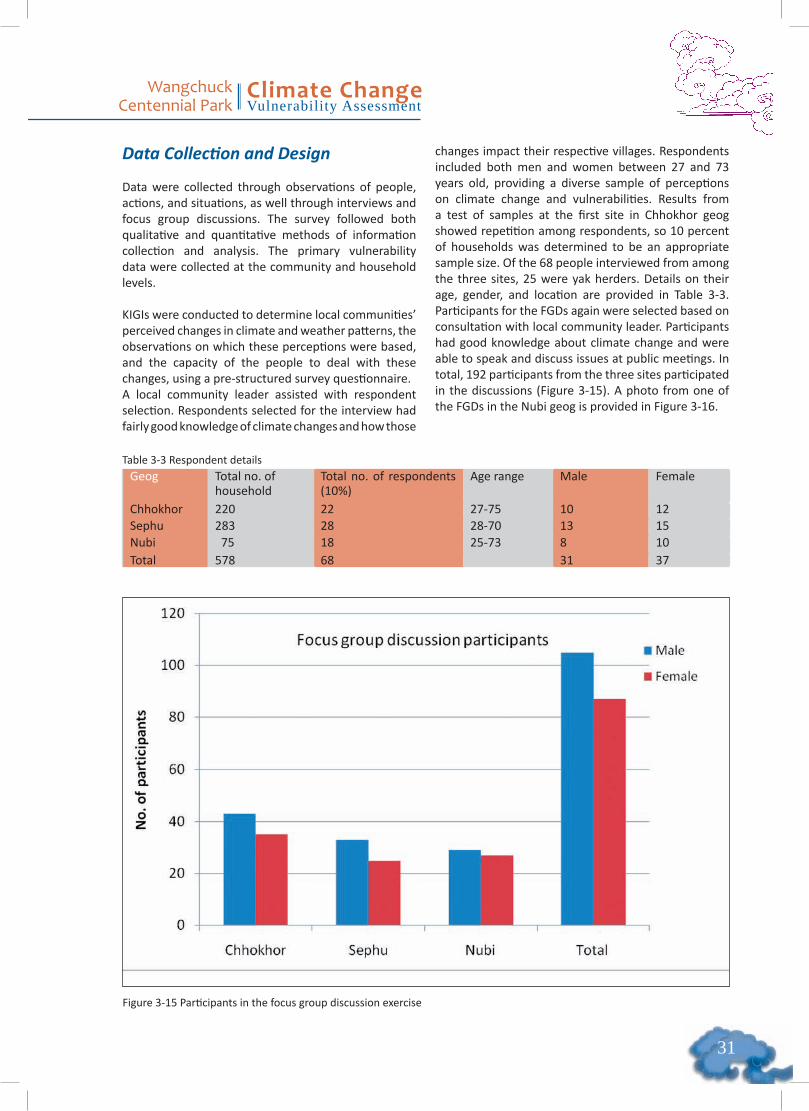
��
Wangchuck Centennial Park
Climate ChangeVulnerability Assessment
Table 3-3 Respondent detailsGeog Total no. of
householdTotal no. of respondents (10%)
Age range Male Female
Chhokhor 220 22 27-75 10 12Sephu 283 28 28-70 13 15Nubi 75 18 25-73 8 10Total 578 68 31 37
Data Collection and Design
Data were collected through observations of people, actions, and situations, as well through interviews and focus group discussions. The survey followed both qualitative and quantitative methods of information collection and analysis. The primary vulnerability data were collected at the community and household levels.
KIGIs were conducted to determine local communities’ perceived changes in climate and weather patterns, the observations on which these perceptions were based, and the capacity of the people to deal with these changes, using a pre-structured survey questionnaire.A local community leader assisted with respondent selection. Respondents selected for the interview had fairly good knowledge of climate changes and how those
changes impact their respective villages. Respondents included both men and women between 27 and 73 years old, providing a diverse sample of perceptions on climate change and vulnerabilities. Results from a test of samples at the first site in Chhokhor geog showed repetition among respondents, so 10 percent of households was determined to be an appropriate sample size. Of the 68 people interviewed from among the three sites, 25 were yak herders. Details on their age, gender, and location are provided in Table 3-3. Participants for the FGDs again were selected based on consultation with local community leader. Participants had good knowledge about climate change and were able to speak and discuss issues at public meetings. In total, 192 participants from the three sites participated in the discussions (Figure 3-15). A photo from one of the FGDs in the Nubi geog is provided in Figure 3-16.
Figure 3-15 Participants in the focus group discussion exercise

Wangchuck Centennial Park
Climate ChangeVulnerability Assessment
��
Hazard ranking
The hazard ranking was done to identify different climatic hazards that the local people face in their region and understand their current coping strategies. During the group discussions, local people were asked to list the climatic hazards they face and then rank those hazards in terms of the intensity of impact on people’s livelihood. Livelihood resource ranking
The livelihood resource ranking was used to determine Local communities’ most important livelihood resources by listing all livelihood resources and ranking them in order of importance.
Vulnerability Matrix
The most important livelihood resources from the above exercise were then aligned vertically on the left side of a chart, with the most important livelihood resource at the top. Participants were then asked to align hazards horizontally on the chart, starting with the most serious hazards to the left (Figure 3-17). After listing and ranking the livelihood resources and hazards, the participants were asked to determine the impact of each hazard on each livelihood resource, using a scale of 0 to 3, where 0 = no impact on the resource, 1 = low impact, 2 = medium impact, and 3= significant impact. This matrix was then used to determine the hazards that the participants felt had the most serious impact
on their livelihoods, thereby allowing researchers to identify the most vulnerable livelihood resources and understand the coping strategies used to address these hazards.
Seasonal Calendar
A seasonal calendar listed the main seasonal events, by months, in the daily life of the participants. Each event was categorized by intensity using a scale from one star to three stars. For example, high rainfall intensity scored three stars (***); medium, two stars (**); and low one star(*). If no events occurred, the category was left blank for that particular month. The intensities were classified into time (current and past) to determine how the events changed over the past 10-20 years. The exercise was also used to analyze changes in seasonal activities to identify periods of stress, hazards, diseases, famines, and vulnerabilities and to understand livelihoods and coping strategies.
Figure 3-16 Participants in the focus group discussion exercise
Figure 3-17 Photo of a vulnerability matrix from Nubi geog
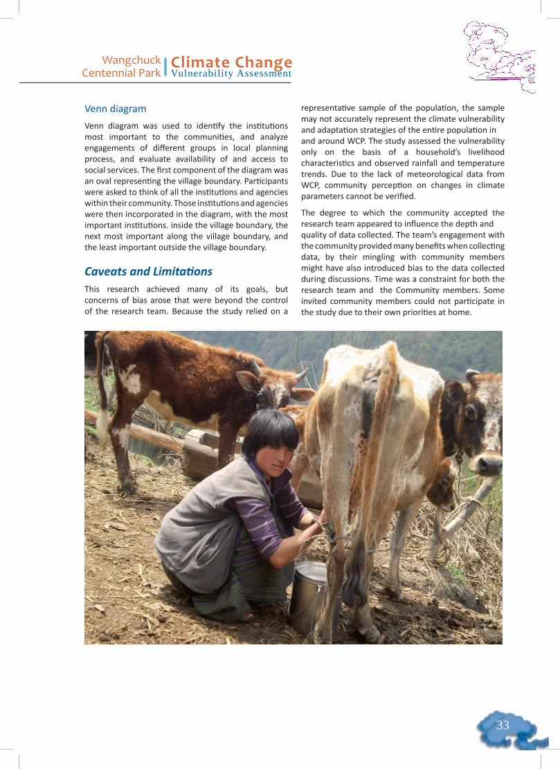
��
Wangchuck Centennial Park
Climate ChangeVulnerability Assessment
Venn diagram
Venn diagram was used to identify the institutions most important to the communities, and analyze engagements of different groups in local planning process, and evaluate availability of and access to social services. The first component of the diagram was an oval representing the village boundary. Participants were asked to think of all the institutions and agencies within their community. Those institutions and agencies were then incorporated in the diagram, with the most important institutions. inside the village boundary, the next most important along the village boundary, and the least important outside the village boundary.
Caveats and Limitations This research achieved many of its goals, but concerns of bias arose that were beyond the control of the research team. Because the study relied on a
representative sample of the population, the sample may not accurately represent the climate vulnerability and adaptation strategies of the entire population inand around WCP. The study assessed the vulnerability only on the basis of a household’s livelihood characteristics and observed rainfall and temperature trends. Due to the lack of meteorological data from WCP, community perception on changes in climate parameters cannot be verified.
The degree to which the community accepted the research team appeared to influence the depth andquality of data collected. The team’s engagement with the community provided many benefits when collecting data, by their mingling with community members might have also introduced bias to the data collected during discussions. Time was a constraint for both the research team and the Community members. Some invited community members could not participate in the study due to their own priorities at home.

Wangchuck Centennial Park
Climate ChangeVulnerability Assessment
��
3.2.2. Results and DiscussionPerception of Climate Parameters
Ninety-one percent of the 68 respondents said they had heard about climate change through media, most-ly via radio broadcasts and television, and from talking to other people. Ninety-six percent of the respond-ents said they felt that the climate is changing, with 89
percent indicating they feel a perceptible increase in temperature (Figure 3-18).
Analysis shows that local communities observed changes in climate parameters; including temperature rainfall, snowfall, and frost, that affected their liveli-hoods (Figure 3-19). The seasonal calendars in three geogs also show changes in these parameters (Appen-dices D, E and F).
Figure 3-18 Perception of climate change (N=68)
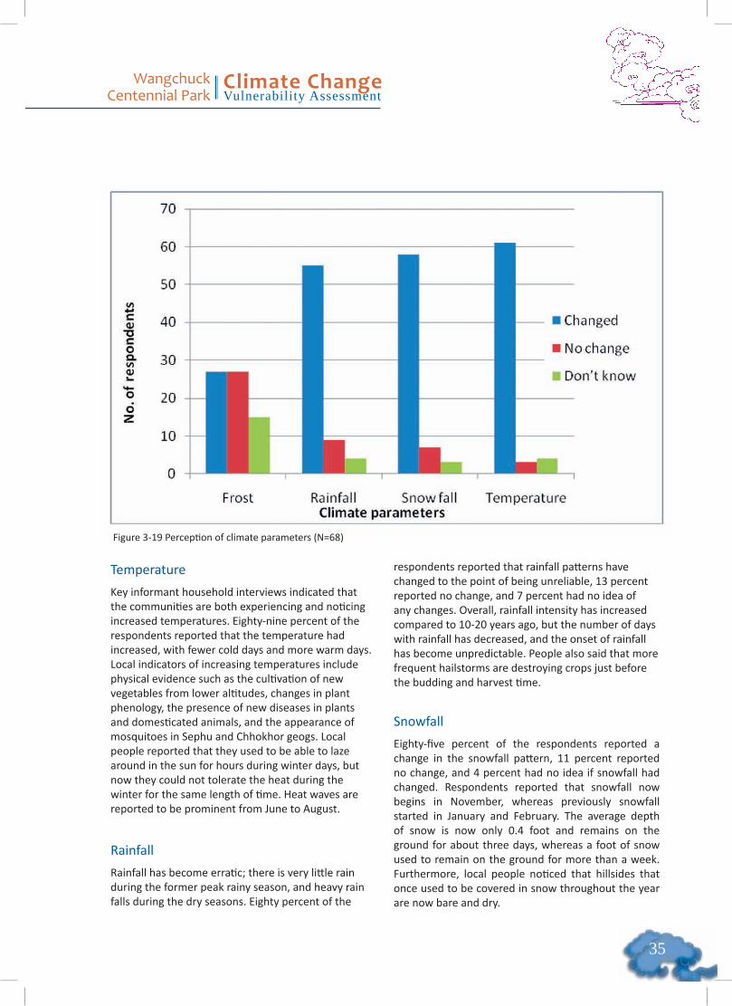
��
Wangchuck Centennial Park
Climate ChangeVulnerability Assessment
Figure 3-19 Perception of climate parameters (N=68)
Temperature Key informant household interviews indicated that the communities are both experiencing and noticing increased temperatures. Eighty-nine percent of the respondents reported that the temperature had increased, with fewer cold days and more warm days. Local indicators of increasing temperatures include physical evidence such as the cultivation of new vegetables from lower altitudes, changes in plant phenology, the presence of new diseases in plants and domesticated animals, and the appearance of mosquitoes in Sephu and Chhokhor geogs. Local people reported that they used to be able to laze around in the sun for hours during winter days, but now they could not tolerate the heat during the winter for the same length of time. Heat waves are reported to be prominent from June to August.
Rainfall
Rainfall has become erratic; there is very little rain during the former peak rainy season, and heavy rain falls during the dry seasons. Eighty percent of the
respondents reported that rainfall patterns have changed to the point of being unreliable, 13 percent reported no change, and 7 percent had no idea of any changes. Overall, rainfall intensity has increased compared to 10-20 years ago, but the number of days with rainfall has decreased, and the onset of rainfall has become unpredictable. People also said that more frequent hailstorms are destroying crops just before the budding and harvest time.
Snowfall
Eighty-five percent of the respondents reported a change in the snowfall pattern, 11 percent reported no change, and 4 percent had no idea if snowfall had changed. Respondents reported that snowfall now begins in November, whereas previously snowfall started in January and February. The average depth of snow is now only 0.4 foot and remains on the ground for about three days, whereas a foot of snow used to remain on the ground for more than a week. Furthermore, local people noticed that hillsides that once used to be covered in snow throughout the year are now bare and dry.

Wangchuck Centennial Park
Climate ChangeVulnerability Assessment
��
Frost Equal number (39%) of respondents reported noticing either change or no change in the frost pattern, and 22 percent responded that they had no idea if there had been any changes. Those who reported a change in the frost pattern indicated that frost now occurs intermittently from October to April, sometimes with high intensity, whereas frost used to occur only from December through early March.
Impacts of Climate Change onLivelihoods While local people may not be aware of the drivers of climate change, they seem to understand climate change in terms of warming and erratic weather patterns and the impact it has on their livelihoods. Vulnerability of Livelihood Resources
Agriculture, livestock rearing and Cordyceps collection are the three most important livelihood resources in all three geogs (Figure 3-20). In Chhokhor geog,
cash-paid wage labor in construction activities is the fourth most important livelihood resource. Tourism is another vital source of livelihood in Chhokhor, creating jobs for porters, cooks’ helpers, and local guides. Sephu and Nubi geogs do not benefit from any tourism-related livelihood opportunities. Of the three geogs, Chhokhor and Sephu provide the greatest number of livelihood opportunities, with Nubi lagging behind.
The livelihood activities most vulnerable to hazards in areas are agriculture livestock rearing, and Cordyceps collection which, are ranked as first, second, and third, respectively (Figure 3-21). Of the three geogs, Nubi is the most vulnerable in terms of livelihood resources.Agriculture and livestock are traditional livelihood activities handed down through generations.
Starting in 2004, the local communities began harvesting Cordyceps, which has become the third-highest revenue earner. In 2009, WCP and the Ugyen Wangchuck Institute for Conservation and Environment (UWICE) conducted a study in
Figure 3-20 Livelihood resource rankings from three geogs

��
Wangchuck Centennial Park
Climate ChangeVulnerability Assessment
Figure 3-21 Livelihood resource vulnerability
WCP to determine the Cordyceps collections’ probable impact on the alpine environment and its contribution to livelihoods (WCP and UWICE 2009). The study showed that collectors earned about Nu. 10.03 million (approximately US$230,000) between 2004 and 2009. This amount contributed greatly to people’s livelihoods. An increase in the number of Cordyceps collectors, however, is likely to reduce individual income and the fungus’s sustainability.
Crops’ susceptibility to disease impacts livelihood in Nubi geog, the most important cash crop grown is chilies, which are then dried for sale and barter for food grains. A few years ago, an unknown crop disease paired with chili wilt decimated the entire chili crop, causing the farmers heavy losses. Some local people think that imported hybrid chili seedlings carried the disease, while others blame higher temperatures that produce conditions favorable for disease to thrive in their area.
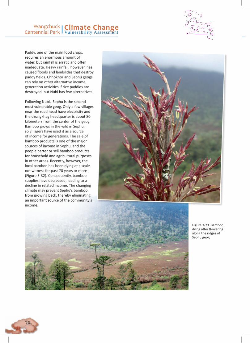
Wangchuck Centennial Park
Climate ChangeVulnerability Assessment
��
Figure 3-23 Bamboo dying after flowering along the ridges of Sephu geog
Paddy, one of the main food crops, requires an enormous amount of water, but rainfall is erratic and often inadequate. Heavy rainfall, however, has caused floods and landslides that destroy paddy fields. Chhokhor and Sephu geogs can rely on other alternative income generation activities if rice paddies are destroyed, but Nubi has few alternatives.
Following Nubi, Sephu is the second most vulnerable geog. Only a few villages near the road head have electricity and the dzongkhag headquarter is about 80 kilometers from the center of the geog. Bamboo grows in the wild in Sephu, so villagers have used it as a source of income for generations. The sale of bamboo products is one of the major sources of income in Sephu, and the people barter or sell bamboo products for household and agricultural purposes in other areas. Recently, however, the local bamboo has been dying at a scale not witness for past 70 years or more (Figure 3-32). Consequently, bamboo supplies have decreased, leading to a decline in related income. The changing climate may prevent Sephu’s bamboo from growing back, thereby eliminating an important source of the community’s income.
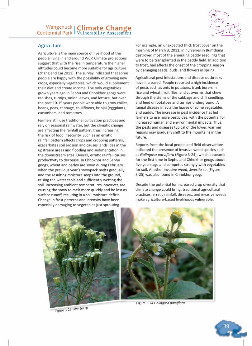
��
Wangchuck Centennial Park
Climate ChangeVulnerability Assessment
Agriculture Agriculture is the main source of livelihood of the people living in and around WCP. Climate projections suggest that with the rise in temperature the higher altitudes could become more suitable for agriculture (Zhang and Cai 2011). The survey indicated that some people are happy with the possibility of growing new crops, especially vegetables, which would supplement their diet and create income. The only vegetables grown years ago in Sephu and Chhokhor geogs were radishes, turnips, onion leaves, and lettuce, but over the past 10-15 years people were able to grow chilies, beans, peas, cabbage, cauliflower, brinjal (eggplant), cucumbers, and tomatoes.
Farmers still use traditional cultivation practices and rely on seasonal rainwater, but the climatic change are affecting the rainfall pattern, thus increasing the risk of food insecurity. Such as an erratic rainfall pattern affects crops and cropping patterns, exacerbates soil erosion and causes landslides in the upstream areas and flooding and sedimentation in the downstream sites. Overall, erratic rainfall causes productivity to decrease. In Chhokhor and Sephu geogs, wheat and barley are sown during February, when the previous year’s snowpack melts gradually and the resulting moisture seeps into the ground, raising the water table and sufficiently wetting the soil. Increasing ambient temperatures, however, are causing the snow to melt more quickly and be lost as surface runoff, resulting in a soil moisture deficit. Change in frost patterns and intensity have been especially damaging to vegetables just sprouting.
For example, an unexpected thick frost cover on the morning of March 3, 2011, in nurseries in Bumthang destroyed most of the emerging paddy seedlings that were to be transplanted in the paddy field. In addition to frost, hail affects the onset of the cropping season by damaging seeds, buds, and flowers in spring.
Agricultural pest infestations and disease outbreaks have increased. People reported a high incidence of pests such as ants in potatoes, trunk borers in rice and wheat, fruit flies, and cutworms that chew through the stems of the cabbage and chili seedlings and feed on potatoes and turnips underground. A fungal disease infects the leaves of some vegetables and paddy. The increase in pest incidence has led farmers to use more pesticides, with the potential for increased human and environmental impacts. Thus, the pests and diseases typical of the lower, warmer regions may gradually shift to the mountains in the future.
Reports from the local people and field observations indicated the presence of invasive weed species such as Galingosa parviflora (Figure 3-24), which appeared for the first time in Sephu and Chhokhor geogs about five years ago and competes strongly with vegetables for soil. Another invasive weed, Swertia sp. (Figure 3-25) was also found in Chhokhor geog.
Despite the potential for increased crop diversity that climate change could bring, traditional agricultural practices, erratic rainfall, diseases, and invasive weeds make agriculture-based livelihoods vulnerable.
Figure 3-24 Galingosa parviflora
Figure 3-25 Swertia sp
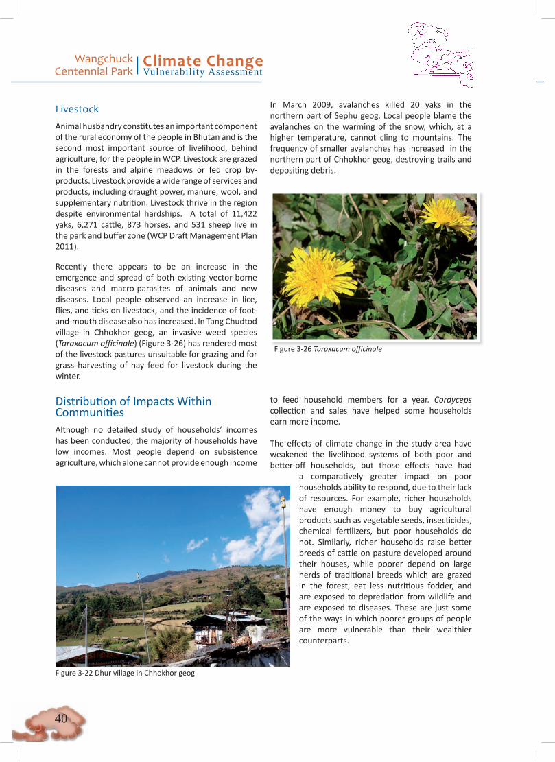
Wangchuck Centennial Park
Climate ChangeVulnerability Assessment
�0
Distribution of Impacts WithinCommunitiesAlthough no detailed study of households’ incomes has been conducted, the majority of households have low incomes. Most people depend on subsistence agriculture, which alone cannot provide enough income
to feed household members for a year. Cordyceps collection and sales have helped some households earn more income.
The effects of climate change in the study area have weakened the livelihood systems of both poor and better-off households, but those effects have had
a comparatively greater impact on poor households ability to respond, due to their lack of resources. For example, richer households have enough money to buy agricultural products such as vegetable seeds, insecticides, chemical fertilizers, but poor households do not. Similarly, richer households raise better breeds of cattle on pasture developed around their houses, while poorer depend on large herds of traditional breeds which are grazed in the forest, eat less nutritious fodder, and are exposed to depredation from wildlife and are exposed to diseases. These are just some of the ways in which poorer groups of people are more vulnerable than their wealthier counterparts.
Livestock Animal husbandry constitutes an important component of the rural economy of the people in Bhutan and is the second most important source of livelihood, behind agriculture, for the people in WCP. Livestock are grazed in the forests and alpine meadows or fed crop by-products. Livestock provide a wide range of services and products, including draught power, manure, wool, and supplementary nutrition. Livestock thrive in the region despite environmental hardships. A total of 11,422 yaks, 6,271 cattle, 873 horses, and 531 sheep live in the park and buffer zone (WCP Draft Management Plan 2011).
Recently there appears to be an increase in the emergence and spread of both existing vector-borne diseases and macro-parasites of animals and new diseases. Local people observed an increase in lice, flies, and ticks on livestock, and the incidence of foot-and-mouth disease also has increased. In Tang Chudtod village in Chhokhor geog, an invasive weed species (Taraxacum officinale) (Figure 3-26) has rendered most of the livestock pastures unsuitable for grazing and for grass harvesting of hay feed for livestock during the winter.
In March 2009, avalanches killed 20 yaks in the northern part of Sephu geog. Local people blame the avalanches on the warming of the snow, which, at a higher temperature, cannot cling to mountains. The frequency of smaller avalanches has increased in the northern part of Chhokhor geog, destroying trails and depositing debris.
Figure 3-26 Taraxacum officinale
Figure 3-22 Dhur village in Chhokhor geog
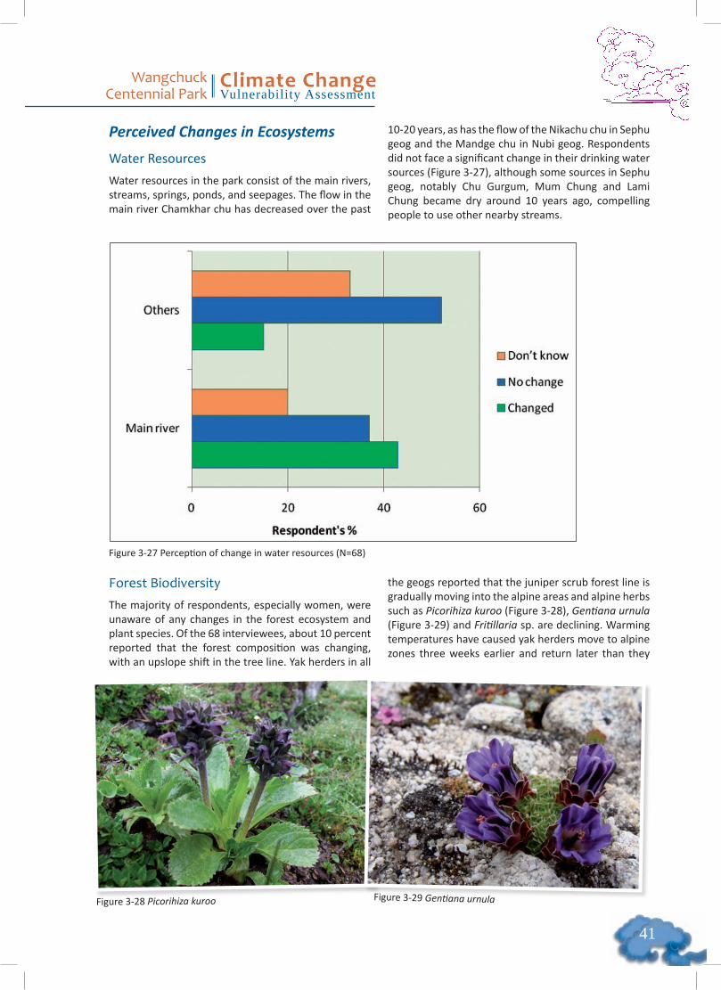
��
Wangchuck Centennial Park
Climate ChangeVulnerability Assessment
Perceived Changes in Ecosystems
Water Resources
Water resources in the park consist of the main rivers, streams, springs, ponds, and seepages. The flow in the main river Chamkhar chu has decreased over the past
10-20 years, as has the flow of the Nikachu chu in Sephu geog and the Mandge chu in Nubi geog. Respondents did not face a significant change in their drinking water sources (Figure 3-27), although some sources in Sephu geog, notably Chu Gurgum, Mum Chung and Lami Chung became dry around 10 years ago, compelling people to use other nearby streams.
Figure 3-27 Perception of change in water resources (N=68)
Forest Biodiversity The majority of respondents, especially women, were unaware of any changes in the forest ecosystem and plant species. Of the 68 interviewees, about 10 percent reported that the forest composition was changing, with an upslope shift in the tree line. Yak herders in all
the geogs reported that the juniper scrub forest line is gradually moving into the alpine areas and alpine herbs such as Picorihiza kuroo (Figure 3-28), Gentiana urnula (Figure 3-29) and Fritillaria sp. are declining. Warming temperatures have caused yak herders move to alpine zones three weeks earlier and return later than they
Figure 3-28 Picorihiza kuroo Figure 3-29 Gentiana urnula
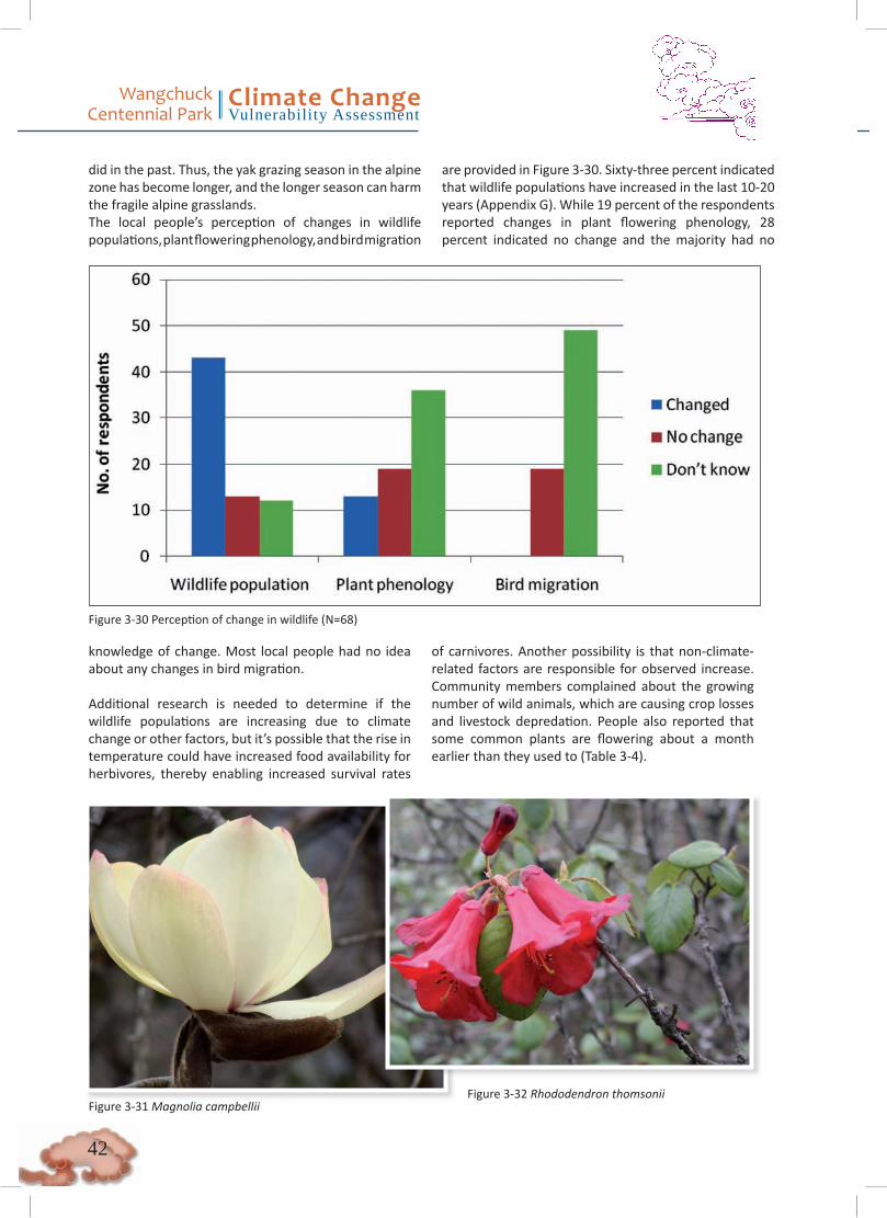
Wangchuck Centennial Park
Climate ChangeVulnerability Assessment
��
did in the past. Thus, the yak grazing season in the alpine zone has become longer, and the longer season can harm the fragile alpine grasslands.The local people’s perception of changes in wildlife populations, plant flowering phenology, and bird migration
are provided in Figure 3-30. Sixty-three percent indicated that wildlife populations have increased in the last 10-20 years (Appendix G). While 19 percent of the respondents reported changes in plant flowering phenology, 28 percent indicated no change and the majority had no
Figure 3-30 Perception of change in wildlife (N=68)
Figure 3-31 Magnolia campbelliiFigure 3-32 Rhododendron thomsonii
knowledge of change. Most local people had no idea about any changes in bird migration.
Additional research is needed to determine if the wildlife populations are increasing due to climate change or other factors, but it’s possible that the rise in temperature could have increased food availability for herbivores, thereby enabling increased survival rates
of carnivores. Another possibility is that non-climate-related factors are responsible for observed increase. Community members complained about the growing number of wild animals, which are causing crop losses and livestock depredation. People also reported that some common plants are flowering about a month earlier than they used to (Table 3-4).
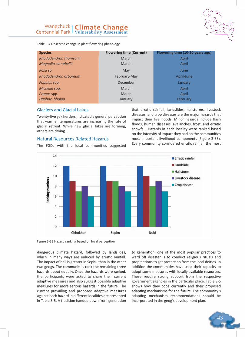
��
Wangchuck Centennial Park
Climate ChangeVulnerability Assessment
Table 3-4 Observed change in plant flowering phenology
Species Flowering time (Current) Flowering time (10-20 years ago)
Rhododendron thomsonii March AprilMagnolia campbellii March April
Rosa sp. May June
Rhododendron arboreum February-May April-June
Populus spp. December January
Michelia spp. March AprilPrunus spp. March AprilDaphne bholua January February
Glaciers and Glacial Lakes Twenty-five yak herders indicated a general perception that warmer temperatures are increasing the rate of glacial retreat. While new glacial lakes are forming, others are drying.
Natural Resources Related HazardsThe FGDs with the local communities suggested
that erratic rainfall, landslides, hailstorms, livestock diseases, and crop diseases are the major hazards that impact their livelihoods. Minor hazards include flash floods, human diseases, avalanches, frost, and erratic snowfall. Hazards in each locality were ranked based on the intensity of impact they had on the communities most important livelihood components (Figure 3-33). Every community considered erratic rainfall the most
Figure 3-33 Hazard ranking based on local perception
dangerous climate hazard, followed by landslides, which in many ways are induced by erratic rainfall. The impact of hail is greater in Sephu than in the other two geogs. The communities rank the remaining three hazards about equally. Once the hazards were ranked, the participants were asked to share their current adaptive measures and also suggest possible adaptive measures for more serious hazards in the future. The current prevailing and proposed adaptive measures against each hazard in different localities are presented in Table 3-5. A tradition handed down from generation
to generation, one of the most popular practices to ward off disaster is to conduct religious rituals and propitiations to get protection from the local deities. In addition the communities have used their capacity to adopt some measures with locally available resources. These require strong support from the respective government agencies in the particular place. Table 3-5 shows how they cope currently and their proposed adapting mechanisms for the future. The community’s adapting mechanism recommendations should be incorporated in the geog’s development plan.

Wangchuck Centennial Park
Climate ChangeVulnerability Assessment
��
Table 3-5 Current and proposed adaptive measures for the hazards
Type of hazard Current adaptive measures Community-proposed adaptive measures
Erratic rainfall
Perform puja and propitiation to please local deities, so that it rains in time
Develop alternative livelihood activities, such as wage labor and small businesses (especially shops)
Develop irrigation facilities in the Paddy-growing areas
Find dryland crops that do not need much water to grow
Work with the Food Corporation of Bhutan to subsidize the price of foodstuffs
Landslide Create a drainage system in the fields Plant trees
Train people in land management
Hailstorm No adaptive measures adopted currently
No measures proposed, because hailstorms are so unpredictable
Livestock disease Visit nearby veterinary hospital for treatment
Supplement dairy products from shops
Rear fewer head and better cattle breeds instead of large numbers of traditional breeds
Provide support for livestock dairy farming
Crop disease
Visit nearby agriculture extension agent (works sometimes)
Develop alternative livelihood activities, such as wage labor and small businesses (especially shops)
Enhance awareness program on healthy crop cultivation
Explore disease-resistant crops for the farmers
ResilienceInstitutional ArrangementsUnder its Regional Climate Risk Reduction program, the United Nations Development Programme has trained some communities in Chhokhor geog on minimizing risk from glacial lake outbursts and earthquakes. No other meetings or training programs have been conducted, nor have any other institutions been involved directly with the region’s climate adaptation activities.
This lack of education and involvement led to a session during which participants listed and ranked organizations and institutions that they would like to see get involved in the region. The highest-ranked institutions were from the renewable natural resources sector (extension offices of agriculture, livestock, and forestry) and the basic health unit. The agriculture extension office provides subsidized farm input supplies and sometimes conducts land management training programs. The livestock extension office provides livestock services, including important annual livestock vaccinations. The forestry extension service helps people plant trees and on landslide-prone slopes. The institutions already offer these services, which
pertain specifically to climate change adaptation, demonstrating that some level of adaptation and coping activities has already been mainstreamed, except there is no explicit mention of “climate change adaptation.” A sample of institution mapping (Venn diagram) from Chhokhor geog is presented in Appendix H.
Current coping strategies Community members have limited awareness and knowledge about the causes of climate change and likely future trends in climate hazards, so they have done little to prepare for future changes. The community’s measures to cope with current climate- and non-climate-induced changes are based on both traditional knowledge and modern technology.
Farmers have started to change their cropping patterns. More varieties of vegetables are grown now than previously; for instance, buckwheat (bitter and sweet) has been replaced by potatoes in Chhokhor and Sephu to take advantage of the large-scale commercialization of potatoes while the buckwheat yield declined. In Chhokhor geog, farmers focus on subsistence vegetable farming instead of cultivating cereal crops. In Nubi geog, some communities use pipe-borne water for irrigation

��
Wangchuck Centennial Park
Climate ChangeVulnerability Assessment
instead of open drainage, in order to reduce losses from evaporation and leakage due to landslides. Some communities started using greenhouses to protect vegetables from frost in winter.
Natural pastures and other grazing areas in the forest have shrunk as a result of land degradation and trees encroaching into former pastures, so some communities have begun to keep smaller numbers of improved-breed cattle, which are fed in stalls and graze land around houses, instead of the large herds of traditional breeds. Yak herders now go to the alpine areas three weeks early and remain there longer in an attempt to escape the heat. They maintain the trails and build small temporary bridges to cross streams that rise higher now than they ever did during the monsoon season.
Within their capacity, farmers have been coping the best that they can. Their strategies are limited to the resources they possess and can access. Information on predicted changes in weather patterns is crucial for farmers to plan cropping practices, but this information is beyond the reach of ordinary farmers, who lack both the knowledge and the access to technology that can help with decision making. To help these farmers, institutions can gather this information and spread it through their networks, and also share information on successful indigenous approaches in the area.
3.2.3. ConclusionsCommunities in WCP have stated clearly that they are already experiencing higher temperatures, more erratic rainfall patterns, less snowfall, and changes in the intensity of frost. A number of indicators, including invading weeds, outbreaks of pests and diseases, landslides, and soil moisture deficiency, support the communities’ claims. Climate changes have made sectors such as agriculture and livestock—the main sources of livelihood— vulnerable. Because of their poor education, low income, inability to process information and knowledge, and lack of access to options and opportunities, poor and marginalized households are more vulnerable to the effect of climate change than are richer households. Among the three study sites, Nubi geog is the most vulnerable, due to the limited number of viable sources of income and the lack of developmental activities that could enhance livelihood opportunities.
Local knowledge, practices, and innovations are important elements for community-based coping and adaptation mechanisms, but the implementation of such mechanisms is limited. Among the strategies already being practiced are changes in cropping patterns, changes in the choice and the use of embankments
for landslide prevention. The communities had fewer innovations and mechanisms to deal with climate risks and hazards in other areas, such as forestry and livestock rearing. Due to limited awareness, knowledge, and capacity at the local level, communities were unable to understand climate change scenarios, address issues, and conduct long-term planning.
No dedicated institutions are involved in climate change issues in the study area, and the local governmental institutions (extension offices of agriculture, livestock, and forestry and the basic health unit) able to participate are unaware of climate change and its impacts. These institutions’ regular activities overlap with climate change work but do not explicitly mention “climate change adaptation.” Therefore, raising awareness and sensitization in groups and institutions, providing technical and financial support for vulnerable groups, shifting toward sustainable land management, and strengthening the agricultural system are some recommended short-term adaptation strategies, and research and development, technology transfer, and financing and stakeholders mapping are some long-term strategies.
3.3 Water Resources and Aquatic BiodiversityThe major processes that determine the hydrological balance of the basins draining the Himalayas are changing, due in part to climate change (UNEP 2009). Climate change projections indicate it is likely that the snowmelt contribution to streamflow will decrease and shift to earlier in spring and the snowfall season will begin earlier, a phenomenon already reported by the local people (see Section 3.2.2). The monsoons are expected to start later and end earlier. In short, it is likely that the monsoon component will intensify around the June-September peak, while snowmelt change will increase flows earlier in spring (February-April) and later in fall (October-December). On an annual scale, the contribution from the change in snowfall will seem to have minimum impact, but on a monthly scale the impacts will be more evident, particularly in the spring and fall.
3.3.1. MethodsThe assessment of climate change vulnerability of water resources and aquatic biodiversity requires consideration of current use and possible future development stressors as they relate to possible anthropogenic changes in natural processes. The assessment presented below considers current and future water use, temperature sensitivity, GLOFs and wetlands, aquatic biodiversity, and ecosystem connectivity.
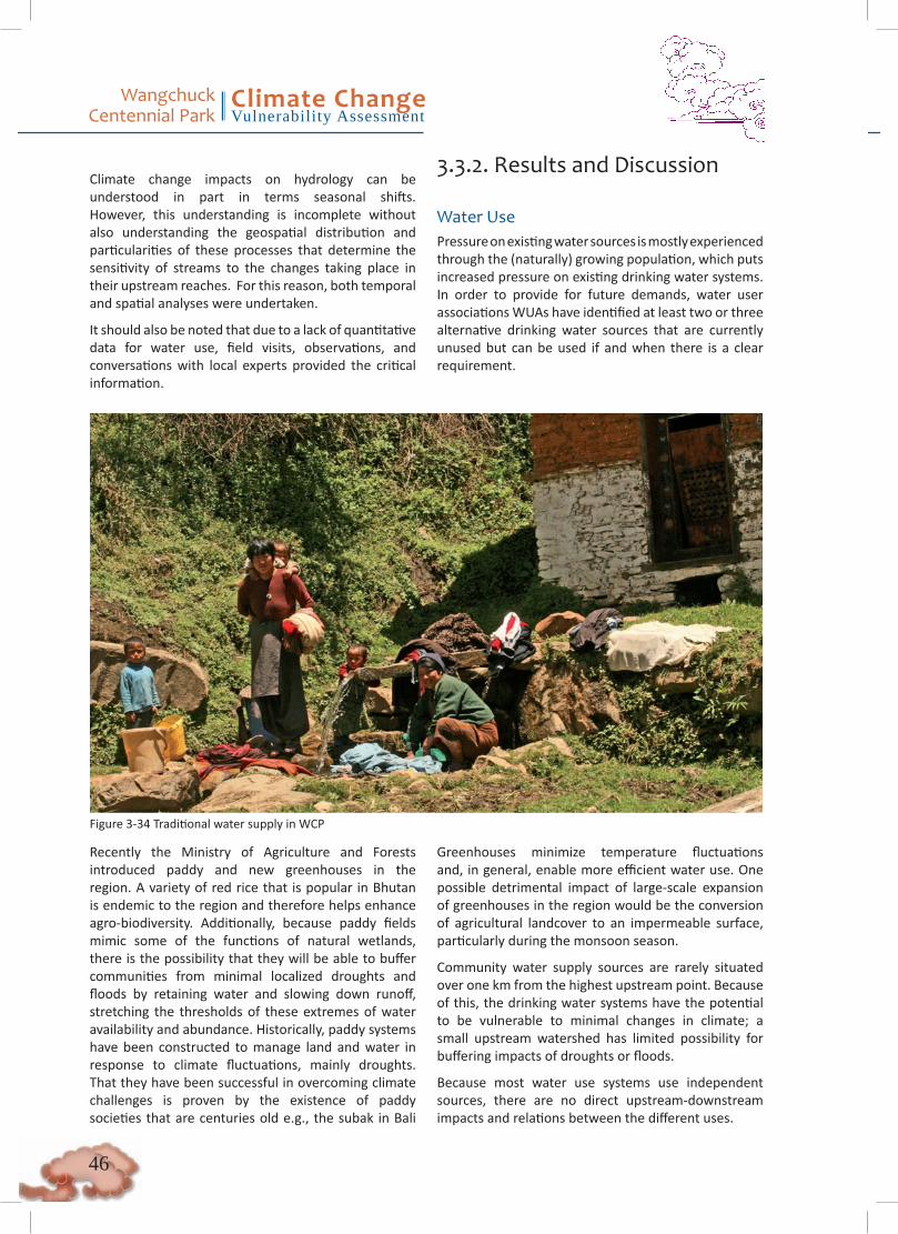
Wangchuck Centennial Park
Climate ChangeVulnerability Assessment
��
Climate change impacts on hydrology can be understood in part in terms seasonal shifts. However, this understanding is incomplete without also understanding the geospatial distribution and particularities of these processes that determine the sensitivity of streams to the changes taking place in their upstream reaches. For this reason, both temporal and spatial analyses were undertaken.
It should also be noted that due to a lack of quantitative data for water use, field visits, observations, and conversations with local experts provided the critical information.
3.3.2. Results and Discussion
Water UsePressure on existing water sources is mostly experienced through the (naturally) growing population, which puts increased pressure on existing drinking water systems. In order to provide for future demands, water user associations WUAs have identified at least two or three alternative drinking water sources that are currently unused but can be used if and when there is a clear requirement.
Figure 3-34 Traditional water supply in WCP
Recently the Ministry of Agriculture and Forests introduced paddy and new greenhouses in the region. A variety of red rice that is popular in Bhutan is endemic to the region and therefore helps enhance agro-biodiversity. Additionally, because paddy fields mimic some of the functions of natural wetlands, there is the possibility that they will be able to buffer communities from minimal localized droughts and floods by retaining water and slowing down runoff, stretching the thresholds of these extremes of water availability and abundance. Historically, paddy systems have been constructed to manage land and water in response to climate fluctuations, mainly droughts. That they have been successful in overcoming climate challenges is proven by the existence of paddy societies that are centuries old e.g., the subak in Bali
Greenhouses minimize temperature fluctuations and, in general, enable more efficient water use. One possible detrimental impact of large-scale expansion of greenhouses in the region would be the conversion of agricultural landcover to an impermeable surface, particularly during the monsoon season.
Community water supply sources are rarely situated over one km from the highest upstream point. Because of this, the drinking water systems have the potential to be vulnerable to minimal changes in climate; a small upstream watershed has limited possibility for buffering impacts of droughts or floods.
Because most water use systems use independent sources, there are no direct upstream-downstream impacts and relations between the different uses.
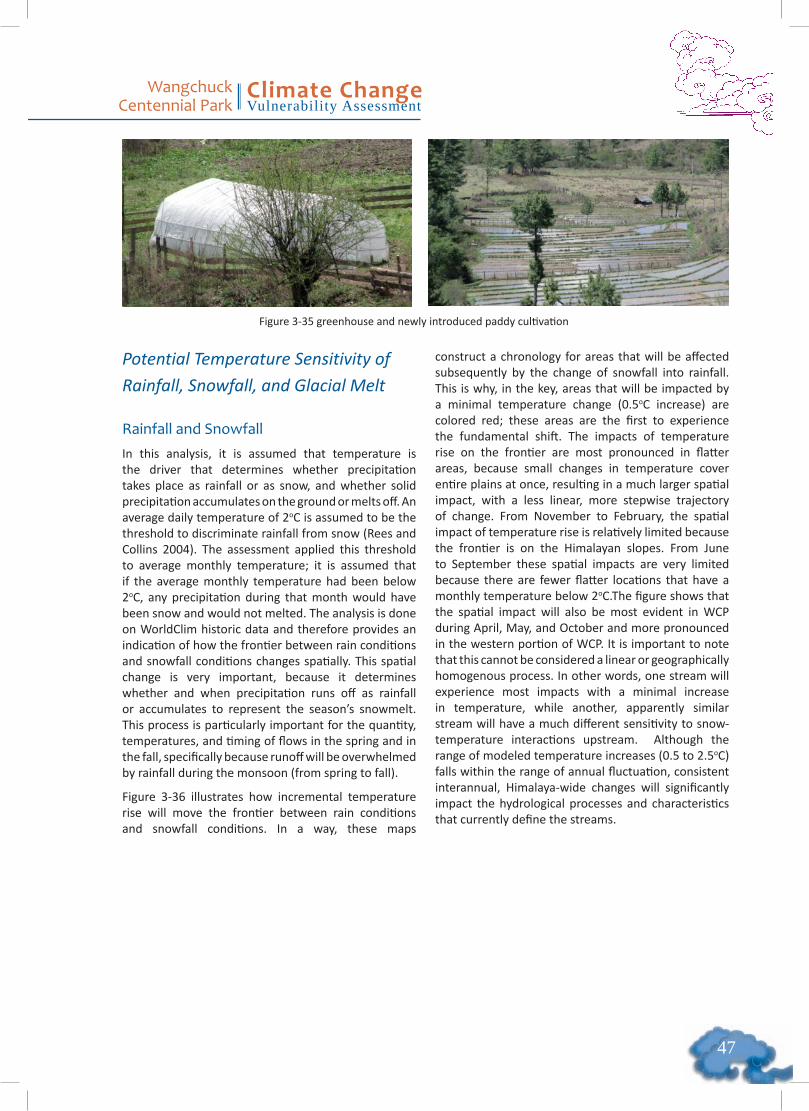
��
Wangchuck Centennial Park
Climate ChangeVulnerability Assessment
Potential Temperature Sensitivity of Rainfall, Snowfall, and Glacial Melt
Rainfall and SnowfallIn this analysis, it is assumed that temperature is the driver that determines whether precipitation takes place as rainfall or as snow, and whether solid precipitation accumulates on the ground or melts off. An average daily temperature of 2oC is assumed to be the threshold to discriminate rainfall from snow (Rees and Collins 2004). The assessment applied this threshold to average monthly temperature; it is assumed that if the average monthly temperature had been below 2oC, any precipitation during that month would have been snow and would not melted. The analysis is done on WorldClim historic data and therefore provides an indication of how the frontier between rain conditions and snowfall conditions changes spatially. This spatial change is very important, because it determines whether and when precipitation runs off as rainfall or accumulates to represent the season’s snowmelt. This process is particularly important for the quantity, temperatures, and timing of flows in the spring and in the fall, specifically because runoff will be overwhelmed by rainfall during the monsoon (from spring to fall).
Figure 3-36 illustrates how incremental temperature rise will move the frontier between rain conditions and snowfall conditions. In a way, these maps
construct a chronology for areas that will be affected subsequently by the change of snowfall into rainfall. This is why, in the key, areas that will be impacted by a minimal temperature change (0.5oC increase) are colored red; these areas are the first to experience the fundamental shift. The impacts of temperature rise on the frontier are most pronounced in flatter areas, because small changes in temperature cover entire plains at once, resulting in a much larger spatial impact, with a less linear, more stepwise trajectory of change. From November to February, the spatial impact of temperature rise is relatively limited because the frontier is on the Himalayan slopes. From June to September these spatial impacts are very limited because there are fewer flatter locations that have a monthly temperature below 2oC.The figure shows that the spatial impact will also be most evident in WCP during April, May, and October and more pronounced in the western portion of WCP. It is important to note that this cannot be considered a linear or geographically homogenous process. In other words, one stream will experience most impacts with a minimal increase in temperature, while another, apparently similar stream will have a much different sensitivity to snow-temperature interactions upstream. Although the range of modeled temperature increases (0.5 to 2.5oC) falls within the range of annual fluctuation, consistent interannual, Himalaya-wide changes will significantly impact the hydrological processes and characteristics that currently define the streams.
Figure 3-35 greenhouse and newly introduced paddy cultivation
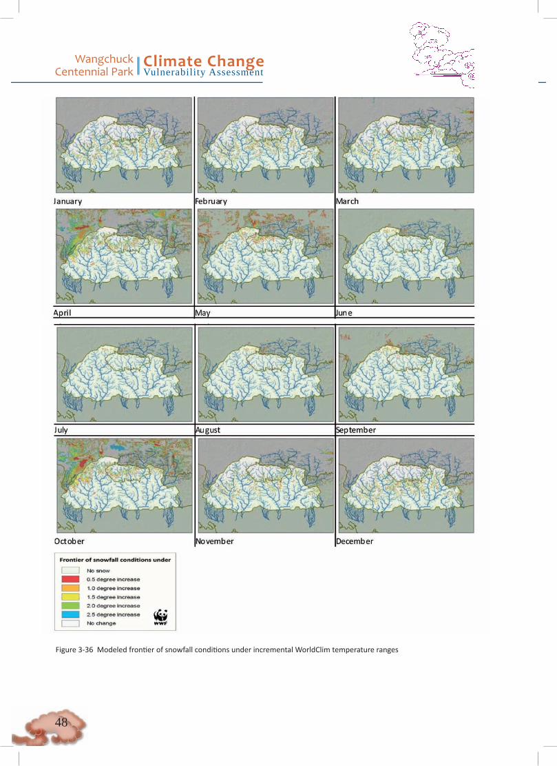
Wangchuck Centennial Park
Climate ChangeVulnerability Assessment
��
Figure 3-36 Modeled frontier of snowfall conditions under incremental WorldClim temperature ranges

��
Wangchuck Centennial Park
Climate ChangeVulnerability Assessment
Figure 3-37 Glacier - fed stream in WCP
GlaciersGlacier-fed streams provide water year-round, in summer because of glacial melt and in winter because the pressure on hundreds of meters of icepack liquefies water at its base, regardless of subzero temperatures. Glaciers provide essential temperature, chemical, and microbiological processes toward downstream rivers and are central to supporting freshwater ecosystems hundreds of kilometers downstream. However, it is relatively unclear to what extent the amount of glacial water can be considered important to downstream water balances. To date, a general water balance theory of how glaciers supply water does not exist. Until now, accumulation of snowfall has contributed to a glacier’s survival, yet recently many glaciers have begun to retreat, and different theories attempt to explain the reason for this phenomenon.
In their 2001 estimate, ICIMOD stated that there are about 127.25 cubic kilometers of ice stored in around 600 glaciers in Bhutan (Mool et al. 2001). The published estimates of Bhutan’s annual renewable water resources (i.e., the amount of water that flows out of Bhutan rivers) are between 78 (FAO 2008) and 95 (WRI 2003) cubic kilometers. The relation between glacial ice storage and annual renewable resources and the principle of continuity (why the glaciers are still here) means that glaciers cannot be considered of essential importance in flow quantities to “1.3 billion of people downstream” (Bajracharya, Mool, and Shrestha 2008) year in year-out (Kaser et al. 2010).
Using the principle of continuity, glaciers cannot be considered a renewable resource; it is not how they were formed in the first place, and it is not why they are still here. The formation of glaciers took place in times when snow accumulation exceeded annual melt-off, which means the system was never stationary or in equilibrium. Over the last several centuries, however, the glaciers have been considered in relative equilibrium, which implies that snow accumulation
has been more or less equal to melt-off. This perceived equilibrium is driven by a process that takes centuries-the time it takes from snowfall to travel to the base of the glacier and melt-off under the pressure of centuries of snow accumulation.
In recent decades on many glaciers, melt-off has exceeded snow accumulation. This process can be attributed to different observations:
• Temperatures have increased significantly due to climate fluctuation, hence less solid precipitation accumulates and/or surface melt-off occurs.
• Darker pollution has accumulated on the glaciers and decreased their albedo, triggering surface melt-offs.
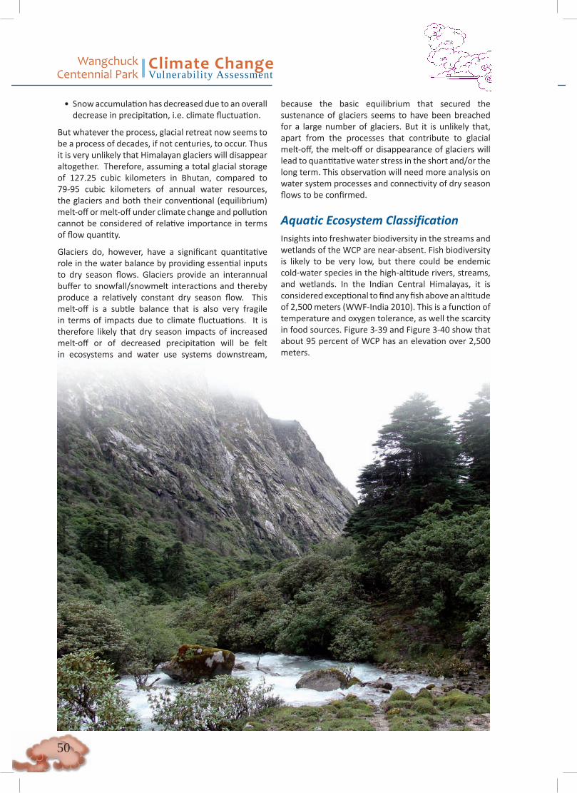
Wangchuck Centennial Park
Climate ChangeVulnerability Assessment
�0
• Snow accumulation has decreased due to an overall decrease in precipitation, i.e. climate fluctuation.
But whatever the process, glacial retreat now seems to be a process of decades, if not centuries, to occur. Thus it is very unlikely that Himalayan glaciers will disappear altogether. Therefore, assuming a total glacial storage of 127.25 cubic kilometers in Bhutan, compared to 79-95 cubic kilometers of annual water resources, the glaciers and both their conventional (equilibrium) melt-off or melt-off under climate change and pollution cannot be considered of relative importance in terms of flow quantity.
Glaciers do, however, have a significant quantitative role in the water balance by providing essential inputs to dry season flows. Glaciers provide an interannual buffer to snowfall/snowmelt interactions and thereby produce a relatively constant dry season flow. This melt-off is a subtle balance that is also very fragile in terms of impacts due to climate fluctuations. It is therefore likely that dry season impacts of increased melt-off or of decreased precipitation will be felt in ecosystems and water use systems downstream,
because the basic equilibrium that secured the sustenance of glaciers seems to have been breached for a large number of glaciers. But it is unlikely that, apart from the processes that contribute to glacial melt-off, the melt-off or disappearance of glaciers will lead to quantitative water stress in the short and/or the long term. This observation will need more analysis on water system processes and connectivity of dry season flows to be confirmed.
Aquatic Ecosystem ClassificationInsights into freshwater biodiversity in the streams and wetlands of the WCP are near-absent. Fish biodiversity is likely to be very low, but there could be endemic cold-water species in the high-altitude rivers, streams, and wetlands. In the Indian Central Himalayas, it is considered exceptional to find any fish above an altitude of 2,500 meters (WWF-India 2010). This is a function of temperature and oxygen tolerance, as well the scarcity in food sources. Figure 3-39 and Figure 3-40 show that about 95 percent of WCP has an elevation over 2,500 meters.
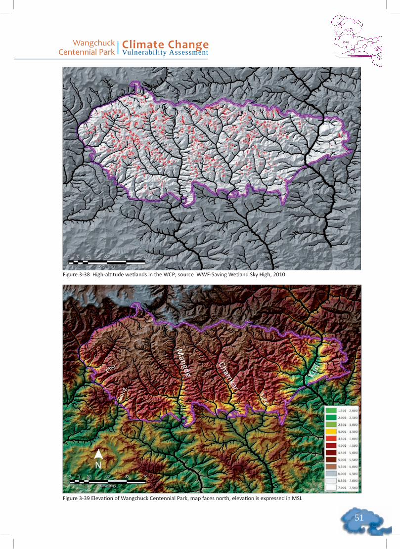
��
Wangchuck Centennial Park
Climate ChangeVulnerability Assessment
Figure 3-39 Elevation of Wangchuck Centennial Park, map faces north, elevation is expressed in MSL
Figure 3-38 High-altitude wetlands in the WCP; source WWF-Saving Wetland Sky High, 2010

Wangchuck Centennial Park
Climate ChangeVulnerability Assessment
��
Figure 3-40 Cumulative distribution of WCP elevation based in HydroSHEDS 15s elevations
Due to a paucity of freshwater biodiversity data and a lack of understanding of its connection to climate, it is difficult to make claims on the impacts of climate change on aquatic biodiversity in the high montane streams and rivers at this point. It is, however, undisputable that the ecosystems inside WCP support unique and essential processes that support freshwater biodiversity downstream. The hydrological processes driven by the glacial, snow, and monsoon interaction (see Figure 3-41) are key to these freshwater ecosystems.

��
Wangchuck Centennial Park
Climate ChangeVulnerability Assessment
Figure 3-41 Map of Bhutan showing rivers with glacial, snow, and spring-/rain-fed sources (modeled using GLIMS, WorldClim and HydroSHEDS databases)
With limited knowledge on actual freshwater biodiversity, the best proxy to determine climate change vulnerabilities would be to focus on the primary hydrological processes that sustain freshwater biodiversity through an ecosystem classification. The following classification was initially defined for the Kali River basin (WWF-India, Uttar Pradesh) in order to identify mahseer life cycle requirements, including
the seasonal spawning grounds, winter grounds, summer retreats. River temperatures are the primary requirement. Due to the importance of temperature for species, temperature classes and breaks throughout Bhutan (Table 3-6) should be verified and redefined through an iterative process that involves a wider range of freshwater experts.
Classes Breaks
Elevation LowMidAlpine
< 1,000 meters1,000 – 2,000 meter2,000 meter <
Sources Glaciers Snowfed Rain/springfed Glacier upstream (GLIMS database) 3 months of snow condition upstream rest of the streams
Stream size Small MediumLarge
< 50 km from source50 – 100 km from source100 km < from source
Table 3-6 Classification of streams in Bhutan (based on a Central Himalayan exercise, WWF-India)
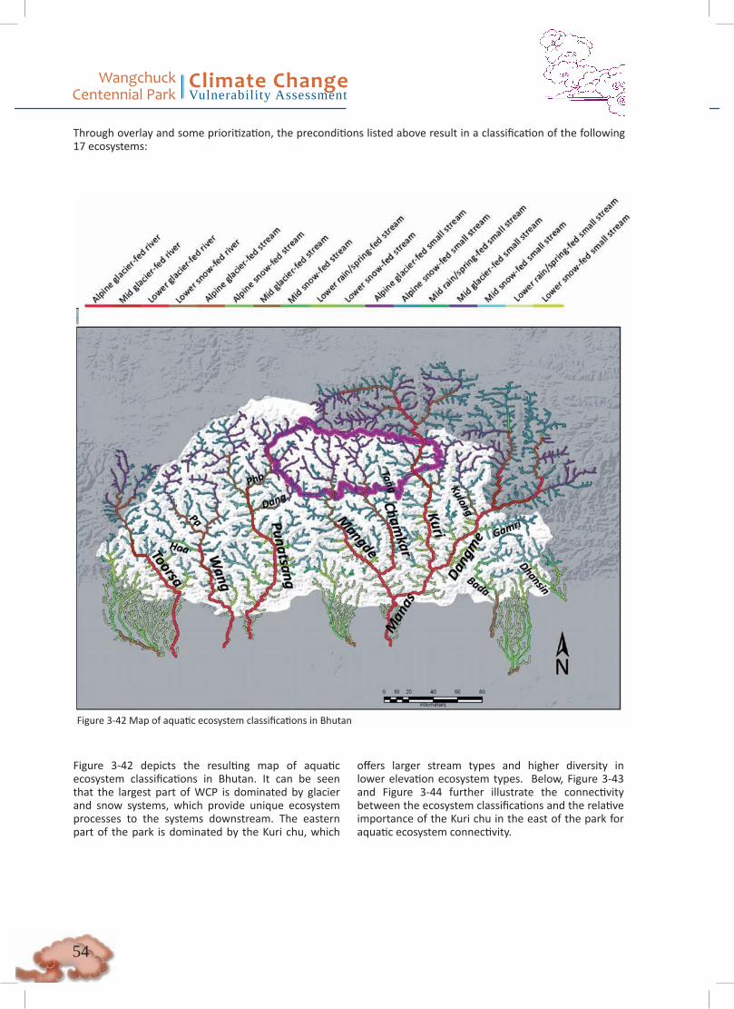
Wangchuck Centennial Park
Climate ChangeVulnerability Assessment
��
Figure 3-42 Map of aquatic ecosystem classifications in Bhutan
Figure 3-42 depicts the resulting map of aquatic ecosystem classifications in Bhutan. It can be seen that the largest part of WCP is dominated by glacier and snow systems, which provide unique ecosystem processes to the systems downstream. The eastern part of the park is dominated by the Kuri chu, which
offers larger stream types and higher diversity in lower elevation ecosystem types. Below, Figure 3-43 and Figure 3-44 further illustrate the connectivity between the ecosystem classifications and the relative importance of the Kuri chu in the east of the park for aquatic ecosystem connectivity.
Through overlay and some prioritization, the preconditions listed above result in a classification of the following 17 ecosystems:
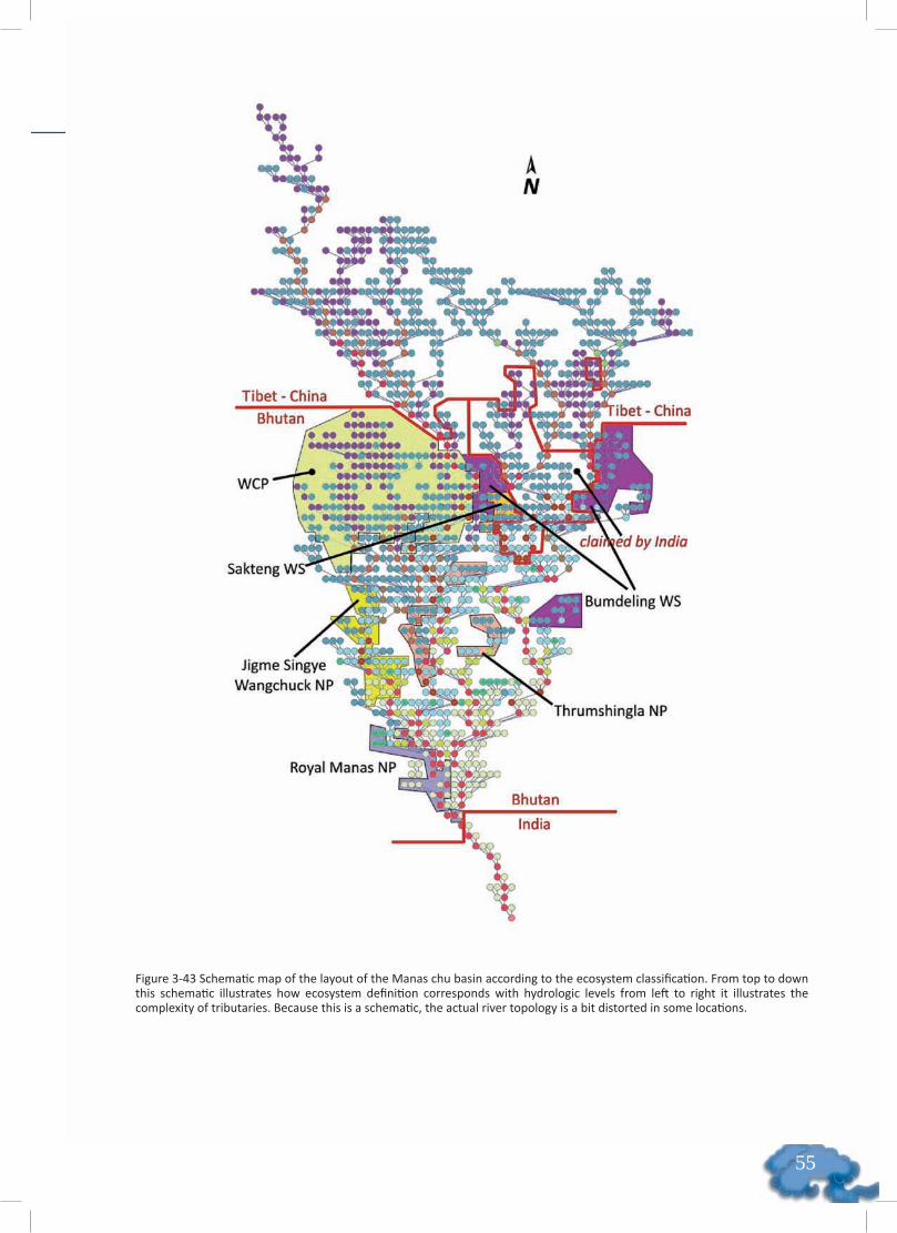
��
Wangchuck Centennial Park
Climate ChangeVulnerability Assessment
Figure 3-43 Schematic map of the layout of the Manas chu basin according to the ecosystem classification. From top to down this schematic illustrates how ecosystem definition corresponds with hydrologic levels from left to right it illustrates the complexity of tributaries. Because this is a schematic, the actual river topology is a bit distorted in some locations.
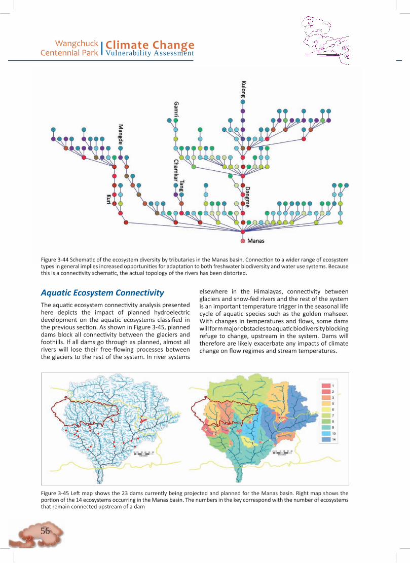
Wangchuck Centennial Park
Climate ChangeVulnerability Assessment
��
Figure 3-44 Schematic of the ecosystem diversity by tributaries in the Manas basin. Connection to a wider range of ecosystem types in general implies increased opportunities for adaptation to both freshwater biodiversity and water use systems. Because this is a connectivity schematic, the actual topology of the rivers has been distorted.
Aquatic Ecosystem ConnectivityThe aquatic ecosystem connectivity analysis presented here depicts the impact of planned hydroelectric development on the aquatic ecosystems classified in the previous section. As shown in Figure 3-45, planned dams block all connectivity between the glaciers and foothills. If all dams go through as planned, almost all rivers will lose their free-flowing processes between the glaciers to the rest of the system. In river systems
elsewhere in the Himalayas, connectivity between glaciers and snow-fed rivers and the rest of the system is an important temperature trigger in the seasonal life cycle of aquatic species such as the golden mahseer. With changes in temperatures and flows, some dams will form major obstacles to aquatic biodiversity blocking refuge to change, upstream in the system. Dams will therefore are likely exacerbate any impacts of climate change on flow regimes and stream temperatures.
Figure 3-45 Left map shows the 23 dams currently being projected and planned for the Manas basin. Right map shows the portion of the 14 ecosystems occurring in the Manas basin. The numbers in the key correspond with the number of ecosystems that remain connected upstream of a dam

��
Wangchuck Centennial Park
Climate ChangeVulnerability Assessment
Furthermore, if all dams are constructed according to the configuration above in Figure 3-43, only 39 percent of ecosystem connectivity will remain in the Manas basin15. This percentage is based on a connectivity algorithm that measures ecosystem connectivity with regard to river network length (Sindorf and et al n.d.). Compared to other basins, the layout of the 23 dams in the Manas cannot be considered optimal in terms of ecosystem connectivity. The reason for this might be that the Manas geography does not allow for much flexibility in dam location, related to slopes and snow/glacial interaction. More specifically, inside the WCP, the Mangde chu (five ecosystems) and Chamkar chu
(three ecosystems) will lose their connectivity to the rest of the system, whereas the projected dam layout maintains the connectivity of the Tang chu (nine ecosystems) to the main system downstream.
Despite the risks related to hydropower development, under current development paths in Bhutan, it is very likely that incremental hydropower development will occur. During the May 2011 field visit in Trongsa, meetings taking place between Indian experts and the Mangdechu Hydroelectric Project Authority of the Bhutanese government were witnessed (MHPA, Royal Government of Bhutan 2010).
15 For example, in the Mekong River basin, 46% of connectivity remains after the construction of about 50 large dams
3.3.3. ConclusionsGenerally, WCP can be characterized by glacial and snow systems that produce unique hydrology and ecosystem processes downstream. Water use is minimal and to date does not have any perceivable significant impacts on the annual water balance. The eastern part of the park is dominated by the Kuri chu, which offers larger stream types and higher diversity in lower elevation ecosystem types. The western part of the park is dominated by glacial-fed systems that are likely to have lower but more endemic aquatic biodiversity.
Climatic trends such as increased intensity of rainfall events, erratic precipitation, a shift in the onset and end of the monsoon, and changes in snowmelt will
have impacts that are unevenly distributed over space and time. One example of this is that it is expected that earlier and increased snowmelt, particularly in the western portion of the park, could have implications for the two hydroelectric projects being planned immediately downstream of WCP. Cumulative impacts of increased variability in streamflow and implementation of the planned hydropower project have the potential to impact ecosystem connectivity and resilience. Additionally, due to community positioning within the watershed, it is possible that climatic variability, particularly changes in precipitation patterns, may acutely impact drinking and irrigation water supply for communities that rely on small springs in the headwaters of the basin.

Wangchuck Centennial Park
Climate ChangeVulnerability Assessment
��
3.4 Synergistic VulnerabilitiesAlthough specific climate change scenarios remain largely uncertain, all three analyses agree on the major trends in climate: increased temperature; increased intensity of rainfall events; more erratic precipitation patterns, including a shift in the monsoon season; and linked changes in the hydrograph. These trends are predicted in global circulation models biophysical indicators and corroborated further by analysis presented in the previous chapters. Conservation management of WCP should consider these trends and their consequences.
Generally speaking, vulnerability at a community level and particularly among subsistence farmers can be considered high. This is due in part to the high exposure and sensitivity of water supplies and consequently agrarian livelihoods to climatic variability. Additional stressors to subsistence livelihoods include hazards (hailstorms, landslides, and erratic rainfall), pests,
diseases, and invasive plants and animals. At present, there is low adaptive capacity within the communities due to a lack of knowledge and capacity at the local community and institutional levels to understand climate change scenarios, address issues, and conduct long-term planning.
Deterioration of ecosystem connectivity in the face of development pressures and climate change remains a major source of vulnerability for both terrestrial and aquatic ecosystems. Terrestrial ecosystem fragmentation from shifting habitats is considered an important indirect impact of climate change for takin, musk deer, red panda, and snow leopards. Tigers may benefit from increased habitat if the forest shifts are allowed to occur naturally, without land conversion. The potential for increased habitat fragmentation and increased competition over resources (e.g., land for livestock grazing) could be a source for human-wildlife conflict, although the extent to which this could be an issue is uncertain.
��
Wangchuck Centennial Park
Climate ChangeVulnerability Assessment
4.Recommendations for Adaptation and Management of WCP4.1 Terrestrial BiodiversityMaintain connectivity with Jigme Dorji for snow leopards and other alpine species. Wide-ranging species such as snow leopards require large spatial areas, and climate change scenarios indicate habitat fragmentation and loss of connectivity.
Maintain connectivity with Thrumshingla and Jigme Singye Wangchuck national parks for red panda and other forest-dwelling species. There is currently good red panda habitat connecting Wangchuck Centennial Park and Thrumshingla National Park, and it appears that this habitat will remain suitable even under climate change. In addition, moderate habitat exists between Wangchuck Centennial Park and Jigme Singye Wangchuck Park that should also be considered for maintaining connectivity.
Secure the southern regions of Wangchuck Centennial Park as core conservation areas. Climate change scenarios indicate upslope shifts of temperate forest habitats along the southern region of the park. These forests can support Bhutan’s mountain tigers. But changing climatic conditions could also favor agriculture and horticulture; thus, these forests in the park should not be allowed to be converted.
Use better irrigation technology for water harvesting and small reservoirs for sustained and controlled water release. Because the erratic rainfall, longer hot and dry periods, soil erosion, and loss of soil fertility will result in decreased agricultural productivity, there could be a tendency to convert more land to agriculture as compensation and to achieve larger yields, but forests in the southern parts of the park and buffer zone could be vulnerable. Water harvesting and storage can help maintain agricultural productivity in present agricultural lands and mitigate erosion and landslides from excessive runoff.
Ensure sustainable harvesting techniques for Cordyceps from the alpine zones of the park. Cordyceps has become an important revenue generator for local communities. While it is likely that the warmer and wetter trend will increase the range of Cordyceps, the destructive collection methods will have to be regulated to prevent excessive damage to the sensitive alpine habitat. Thus, ensuring a sustainable Cordyceps harvest will reduce dependency on agriculture and livestock as a livelihood, which, together with a better irrigation and soil management system, will negate the
need to expand agricultural and pasture land.
Take proactive steps with park management to ease the degradation pressure from alpine habitats. In addition to Cordyceps, over 30 other species of medicinal and aromatic plants are collected from the park, especially from the alpine and subalpine zone. Many of these species, such as the Himalayan yew (Taxus baccata) have proven medical value. Thus, conservation and management of these species and their habitats for a sustainable yield are important. But as alpine meadows shrink in size, the stressors from the plant-collecting practices and pressure from yak grazing will become concentrated into smaller habitat areas. Social surveys have indicated that already yak are taken to the alpine grazing areas earlier than before and kept there for longer, which must surely increase the level of habitat degradation.
Identify alpine areas that are no longer being grazed and zone as wildlife conservation areas. Socio-economic surveys of the park and its buffer zone have indicated that some livestock herders are already downsizing livestock herds or giving up the practice altogether (WCP Draft Management Plan 2011). Because herders have customary ownership and rights to use specific areas in the alpine zone for grazing their yak herds, areas that are no longer being grazed can be turnded into conservation areas where sustainable Cordyceps collection can be permitted. They can also be promoted as alpine wilderness areas for nature tourism, which can bring additional revenue to the park and to the local communities while providing refuge for species such as snow leopard, blue sheep, takin, and other alpine communities.
Take care in controlling the transmission of diseases among wildlife species. Disease control for animals under climate change could result in epidemics that could persist to affect both domestic and wildlife populations through feedback loops. Local communities have already reported an increase in diseases and parasites among the livestock in recent years, and this can be attributed to the increasing temperature and changes in rainfall patterns. Because yak are taken to the alpine zones in the summer, care should be taken to prevent the transmission of diseases to wildlife species, because the warming climatic conditions will make species such as blue sheep, takin, and even marmots more vulnerable to such diseases.
Secure representative habitats of the Eastern Himalayan broadleaf and conifer forests (a Global 200 ecoregion (Olson et al. 2001) for conservation, especially for species such as red pandas and musk deer that require relatively old-growth forests for habitat. Several forests along the southern border of the park—especially along the rivers that flow through the park—
Wangchuck Centennial Park
Climate ChangeVulnerability Assessment
�0
and in the southern buffer zone represent good habitat for red pandas and musk deer, and the projections indicate they could be resilient to climate change. Both red pandas and musk deer can be used as focal species for such a conservation strategy that includes creating habitat linkages between Wangchuck Centennial Park and the adjacent Thrumshingla National Park.
Consider the habitat requirements of altitudinal migrant birds when planning the linkages between the Wangchuck Centennial Park and adjacent parks. Loss of habitat along the migratory pathways can disrupt these seasonal movements and prevent successful nesting, which can eventually cause local extirpation.
Species-Specific Recommendations
Snow Leopard• Reduce existing stressors—especially poaching,
retaliatory killing, and habitat degradation from overgrazing by livestock that reduce prey availability- to increase viability of snow leopard populations and make them more resilient to climate change stressors.
• Promote transboundary conservation with China, especially because the connectivity between habitat in northern Bhutan and Tibet will likely become more important under climate change
• Create zoned management areas of high importance for snow leopards under a climate change scenario.
• Use snow leopards as a flagship and indicator species of good management in upper water catchments. Conservation actions for the alpine region along the northern boundary are also important to protect Bhutan’s water towers, which are critical for sustained national economic development and Gross National Happiness of the people (in the context of Bhutan).
• Monitor snow leopard populations and include them as an indicator of ecological integrity and response to climate change of the northern ecosystems.
• Explore options of payments for environmental services as sustainable funding for snow leopard conservation (including the habitat), and develop programs for implementation.
• Conduct snow leopard research to better determine their population status, distribution, and habitat use in Bhutan.
Blue Sheep• Reduce habitat degradation from livestock grazing
and unsustainable collection of medicinal plants.
• Secure alpine habitat as wildlife conservation zones where livestock grazing and plant harvesting are excluded. These areas can potentially bring direct compensatory revenue to local communities through trekking and tourism programs that promote “alpine wilderness” areas.
• Monitor blue sheep populations for diseases, especially from domesticated livestock.
• Implement an education and awareness program for herders to prevent persecution of blue sheep and counter the perception that they compete with livestock for grazing areas.
Tiger• Secure the watersheds of the major river valleys
within the northern parks and the respective buffer zones from degradation and fragmentation. Conserving these forests will be important to sustain the hydrological services from these rivers.
• Secure forested corridors between the protected areas for tiger dispersal and to maintain tigers as a metapopulation, especially among the populations in the northern and midhill protected areas. These mountain tigers are the only ecotype adapted to live at high elevations and are important from a global conservation perspective.
• Prevent habitat fragmentation from the planned road network (Beier 2010), or at least minimized it, through application of green Infrastructure standards (Quintero et al. 2010).
• Explore options of payments for environmental services, conservation offsets from major infrastructure, and Wildlife Premium Market payments as sustainable funding for tiger conservation, and develop programs for implementation.
• Use mountain tigers as a flagship or indicator species of sustainable development, especially for good management of the watershed and upper catchments, because Bhutan’s forests are critical for sustained national economic development (in the context of Bhutan).
Takin• Identify and zone takin habitat and distribution
as conservation areas, including the summer and winter grounds and seasonal migratory routes, to prevent habitat degradation. Include altitudinal buffers in management zones upslope from their current habitat to accommodate potential changes in climate.

��
Wangchuck Centennial Park
Climate ChangeVulnerability Assessment
• Prevent burning and degradation of the juniper forests at the ecotone of alpine meadows; these forests are important winter refuges for takin.
• Monitor populations for possible diseases under changing climatic conditions.
Musk Deer• Secure the intact habitat in Toorsa, Jigme Dorji,
and Wangchuck Centennial parks through park zoning plans that prevent habitat conversion and degradation.
• Survey Sakteng Wildlife Sanctuary for musk deer, and if present, include musk deer population monitoring in the Park management plan to observe the population’s response (if any) to climate change.
• Monitor musk deer populations in the corridor between the Jigme Dorji-Wangchuck Centennial park complex and Jigme Singye Wangchuck as an indicator of climate change.
• Maintain transboundary connectivity in the west, with Sikkim.
• Prevent poaching to reduce the threats and allow populations to become resilient to climate change- related stressors.
Red Panda• Bring the region between Wangchuck Centennial
Park and Thrumshingla National Park under conservation management to prevent forest degradation and conversion.
• Secure the habitat between Jigme Dorji National Park and Jigme Singye Wangchuck National Park within the corridor system and prevent forest degradation and conversion. These habitat linkages are important for conservation because they are important corridors and habitat for other biodiversity and are also significant representations of Eastern Himalayan ecoregions that have been converted to other land use elsewhere in the region.
• Protect current red panda populations and bamboo habitat, particularly populations and habitat at higher elevations along altitudinal gradients.
• Assess all infrastructure and development plans within linkages between Jigme Dorji National Park and Jigme Singye Wangchuck National Park to ensure that habitat fragmentation is prevented or, at least minimized with appropriate mitigations to retain connectivity for wildlife movement, including red panda, across the development areas.
• Secure the old-growth forests in the southern parts of Bumdeling and the eastern parts of Sakteng (including the eastern buffer zone) wildlife sanctuaries; these forests already support red panda populations and indicate resilience to future climate change scenarios.
Altitudinal Migrant and High-Altitude Birds• Develop a more comprehensive survey and
database of habitat specialist and altitudinal migrant bird species to better understand their migratory and nesting behavior and their habitat use in the Himalaya Mountains.
• Incorporate monitoring of selected bird species into park and corridor management plans, because changes in distribution can indicate habitat shifts and changes in ecological communities due to climate change.
4.2 Communities and LivelihoodsClimate change affects every sector, so adaptation measures require an integrated approach that includes agriculture water resources management, soil and forest conservation and management, disaster risk reduction, and diversification of the communities’ livelihood opportunities. All development sectors need to consider climate change adaptation, because the impacts of climate change will affect development, and vice versa. Following are proposed adaptation strategies based on the vulnerability assessment in WCP:
Raise awareness of the cause of climate change and its impacts. As far as WWF and WCP know, this is the first climate change vulnerability assessment of livelihood in Bhutan, despite the fact that climate change has impacted the livelihood or the rural poor for so long. The study found that rural communities already had a good understanding of local climate patterns and were accustomed to dealing with them, but the rural communities most impacted by climate change had a very limited understanding about the cause of climate change and its impacts on such rural communities. Climate change projections suggest greater uncertainty and possibly more extreme conditions in the future, meaning that communities’ current practices, processes, systems, and infrastructures may become increasingly unsuitable. Future climate change adaptation is aggravated by the fact that local perceptions and interpretations of climate variability

Wangchuck Centennial Park
Climate ChangeVulnerability Assessment
��
can be broad and diverse among communities and within different social groups. Raising community awareness is important to increase local resilience and promote ‘no regrets’ strategies such as refraining from cutting and burning forests for farming, collecting trash in one’s surroundings, turning off electronic items when not in use, and planting trees in critical areas (e.g., river banks, steep slopes, watershed areas). Awareness-raising activities will also enhance the adaptation planning process by identifying community problems related to climate change and identifying intervention strategies such as traditional practices and new technologies and the resources (existing and needed) for this.
Diversify agricultural crops. Agriculture will remain a major component of the livelihood strategy of the rural poor, so agricultural livelihood opportunities need to be further supported as the climate changes. Fields that used to yield enough for families are no longer adequate, due not only to climate change but also to larger families and smaller landholdings. Soil productivity has diminished as a result of improper soil management. Crop varieties need to be diversified to include those that grow even under erratic rainfall and water conditions. Grain crops are communities’ priorities, so if communities cannot grow the grains they prefer, they need to choose other grains to grow. If annual crops fail, farmers should be encouraged to grow perennial crops fruits or others that can withstand erratic rainfall better than the annuals. In addition to diversification, organic pesticides and fertilizers need to promoted, adopted, and scaled up. Changes in weather events and increased incidence of pests and pathogens will reduce yields, making the use of fertilizers and pesticides imperative. Organic pesticides can be produced with materials available on farm and will not damage the soil.
Implement sustainable land and soil management practices. Soil and land management will need to adopt climate-adaptive measures in order to build the resilience of agricultural systems. Local rivers and streams are characterized by “flashy” hydrographs, making the high variability of a precipitation event a primary concern in the region. For example, high- intensity rainfall events result in soil erosion, flooding, and occasional landslides. Conversely, low flows and a lack of storage systems result in drought conditions and crop damage.
Organic matter in soil should be conserved through low tillage and maintenance of soil cover. This practice will improve and stabilize the soil structure, allowing soils to absorb more water thereby reducing surface run off, which can result in soil erosion and flooding. Crop
rotation should be encouraged for the maintenance of permanent soil cover, leaving crop residues or cover crops that can increase soil organic matter and reduce impacts from flooding, erosion, drought, heavy rain, and other hazards.
Enhance a productive and efficient livestock program. Because livestock is one of the main livelihood activities in the region, people should be encouraged to rear fewer stall-fed productive cattle (improved breed) instead of larger numbers of traditional cattle. If encouraged and supported, this plan would lead to greater income generation, sufficient grazing areas, and increased fodder availability. Dairy products such as milk, butter, and cheese are a major part of the Bhutanese diet, but neither the villages nor the dairy farms can meet public demand. A community-based dairy farm in some of the affected geogs such as Nubi could help solve this shortage. Another option would be to incorporate hybrid Jersey bulls into the existing cattle population so that their offspring would be more productive than the current herd.
Promote fruit and fodder trees in the villages. As indicated in the results of this study, local people both rear livestock and tend farms as a means of livelihood, exerting pressure on already degraded forests for grazing and fodder collection by nearby villages. People who raise cattle must travel far from the villages to graze their herds, often exposing the animals to predators. The communities are beginning to prefer improved livestock breeds to local cattle, because the improved breeds increase productivity, requiring less manpower for stall feeding, which, in turn, requires fodder cultivation. Promotion of fodder includes growing native fodder tree species providing training on how to plant and care for the trees, in collaboration with forestry and livestock extension agents in the geog. Planting fruit trees around houses and in fields will help improve nutrition and allow people to supplement their income by selling the fruit at markets.
Build capacity of local leaders. Local leaders must increase their knowledge of crop livelihood and diversification in order to cope with climatic variability. Before planning any interventions, a proper assessment of the impact of climate change is essential. Adaptation measures such as crop diversification, purchase of crop and livestock insurance, and risk transfer mechanisms implementation should be developed to minimize the risk of climate change.
Liaise with the current institutions. The institutional mapping process carried out as part of the study provides information about the existing institutional capacity in the study areas. Future intervention work

��
Wangchuck Centennial Park
Climate ChangeVulnerability Assessment
through this already active network must be done in order to target the most pressing community needs and minimize setup cost. The extension offices of agriculture, livestock, and forestry, as well as the local administration office, already are active and have the most potential to help in the future.
Enhance ecosystem resilience. Extensive research is required on both opportunities and constraints in biodiversity conservation in the changing context of risks and vulnerabilities posed by climate change. Such research must determine which species are lost and why, and what implication the loss has on livelihood strategies of local communities. Furthermore, research needs to be done to increase our understanding of how community adaptation plans and strategies impact local ecosystems. Using this information, it would be possible to develop solutions that reduce as much as possible nonclimate stresses on ecosystems. It would also help avoid “maladaptation,” which can bring benefits to communities in the short term but in the longer term may adversely affect both ecosystems and the people who depend on them. Results and recommendations from any research should be mainstreamed into the WCP conservation management plan.
The integrity of the ecosystem should be maintained through measures to build resilience and facilitate adjustments to change, including reducing nonclimate stressors identifying and maintaining/restoring corridors and forest and wildlife resources; and implementing integrated approaches such as integrated watershed management, which takes into account the needs of local and more distant water users as well as those of natural resource species and freshwater biodiversity and allows for flexibility in light of changing conditions. Adaptation measures in land use and landscape management, agro-forestry and species selection, and silvicultural practices in different ecological zones need to be planned, and local individual and institutional capacity need to be strengthened in order to implement them. The existing protected area networks system needs to be bolstered to prevent further habitat fragmentation which could hinder adaptive migration of species.
Implement local mitigation initiatives. Small-scale disaster risk reduction measures such as installation of embankments, planting in barren and degraded areas, repair and maintenance of infrastructures, and adaptation of infrastructure for greater extremes (e.g., in rainfall, streamflow). Following proper training in communities, these low-cost measures can be implemented using available local resources.
Establish weather monitoring stations. As the impact of climate change gets more intense, the early
detection and study of the signals of climatic change and its impacts on hydrological, ecological, and social systems become priorities. Hardly any data exist on hydroclimatic conditions, so weather monitoring stations in WCP should be established, based on delineation of the park into coherent watersheds, in a GIS environment, using spatial techniques.
4.3 Water Resources and Aquatic BiodiversityCreate community-level capacity in drinking water source allocation and quality. Each community consists of around 15 WUAs, which have no organizational mandate at the community level. If alternative water sources are being added to WUAs in the future, this will likely result in competition over access to the sources among the different WUAs.
Engage in EIA and planning processes for upcoming hydropower projects immediately downstream from the park. During this state, the projects are still in their feasibility stage, which means that EIAs are still to be conducted. It is essential for WWF-Bhutan (with support from the WWF network) to take active part in these EIAs and identify opportunities during this stage. Studies should be undertaken to better understand the climatic sensitivities of local hydrology and ecosystems that the dams will impact. A special focus should be placed on ensuring that operational rules of these dams are climate-adaptive and minimize ecosystem vulnerabilities where possible. Additionally, it is essential that climate parameters be taken into consideration when designing and implementing mitigation measures.
Environmental Impact Assessments have become routine in dam planning but often are mere assessments and do not provide for mitigation to limit environmental impacts (Baran et al. 2011). It is therefore essential that WWF-Bhutan take a leading role concerning environmental issues in dam planning, making use of WWF-wide expertise, such as the Rapid Basin-wide Hydropower Sustainability Assessment Tool (Mekong River Commission 2011). Environmental concerns (eg., ecosystem connectivity, climate change, and the operation of environmental flow regimes) are to be addressed and opportunities to mitigate environmental impacts are to be explored. In many cases, incorporation of environmental concerns in the design of a dam is not in direct conflict with hydropower efficiency, but concerns need to be addressed before the design and construction of a dam. Agreements should be in place based on constant seasonal flow regimes, and not only on daily flow quantities. There are examples of how daily flow quantities were agreed upon but a

Wangchuck Centennial Park
Climate ChangeVulnerability Assessment
��
power company used the practice of hydro-ramping:Several times a day the river flowed at maximum and minimum banks levels within a matter of hours. This devastated downstream aquatic life but maximized power generation (Irwin and Freeman 2002).
Study, test, and implement local drought and flood mitigation techniques. Because paddy fields mimic some of the functions of natural wetlands, there is the possibility that they will be able to buffer communities from minimal localized droughts and floods. Although these paddy fields are not designed to provide these functions, they may prove to be an effective adaptation strategy that should be further investigated.
Climate adaptive solutions for ensuring reliable water supplies will have to be identified. This is likely to involve diversification of water sources rather than reliance on springs from the same source or headwaters. This does make the Bhutan/WCP context an exceptional one in terms of conventional freshwater climate change adaptation in the Himalayas. Both in Nepal and Northern India, the water resource context is more stressed and water use systems are in competition over the existing resources.
Continued monitoring and analysis. Data from existing meteorological stations should be further analyzed and additional hydrometeorological stations established. The data collected would be exceptionally useful for follow-up studies on climate and water resources and could serve as inputs to (future) environmental flow conditions to be maintained by the planned hydropower dams. Additionally, an isotope analysis to ascertain the percent contribution of glacial melt to streamflow would contribute greatly to understanding the sensitivity of local hydrology to climatic variability.
Assess freshwater biodiversity. Little is known about freshwater biodiversity in Upper Bhutan and as such, this represents a large knowledge gap that needs to be addressed. Additionally, the ecosystem classifications should be further tested by freshwater biologists.
4.4 Synergistic VulnerabilitiesContinued analysis with additional data. The present study clearly identifies gaps in information in aquatic and terrestrial biodiversity, species ranges, hydrology, water use, and hydroclimatological parameters. Monitoring and evaluation of local ecosystems, climate, and biodiversity should be set as a priorities. Accordingly, monitoring stations should be established to monitor various species that can be used as indicators of ecosystem health (e.g., the presence of snow leopards and tigers can be used as an indicator of
good management of the headwaters). Through better understanding and tracking changes in WCP, measures to avoid or mitigate potential negative impacts may be developed.
Adaptive institutions and institutions for adaptation. Institutions, including RNR centers, park ranger offices, basic health units, schools, and nonformal education centers, should be provided make them more resilient to climate change. These institutions should also be provided with information and resources that allow them to facilitate adaptation at the community level. For example, WUAs should be provided with the necessary tools to assess their current and selected alternate water sources’ sensitivity to climate variability. Additionally, climate change adaptation should be mainstreamed into the geog development plans.
Livelihood. Communities should be helped to understand climate-related uncertainties and should develop methods to minimize risks. Some methods for agricultural sector production may include the use of greenhouses, land and soil management to minimize grazing pressures, and crop diversification. Throughout this process, particular attention should be paid to the poor, particularly subsistence farmers, who are likely to bear the brunt of negative impacts of climate change.
Connectivity. Connectivity plays a key role in ensuring the ability of ecosystems and biodiversity to respond to climate shocks. Preserving connectivity in WCP will include corridors particularly for wide-ranging species (e.g., preserving connectivity with Jigme Dorji). Active participation in development planning processes, including those of downstream dams, will be essential to informing these processes to preserve the connectivity necessary to sustain ecosystems. It is important to note that connectivity transcends national boundaries, and therefore efforts to preserve the necessary level of connectivity should take into consideration transboundary conservation.
Hazard mitigation and preparedness. Information regarding hazards and risks should be made available to communities. Measures that ensure preparedness should be developed and should consider possibilities for diversification of livelihoods.
Identify and preserve climate refugia. Refugia, or areas that act to harbor species during climate events, are crucial for reducing vulnerability of species. Both the headwaters and southern regions of the park have been identified as critical areas to focus on. These efforts should be undertaken in coordination with community-based activities.

��
Wangchuck Centennial Park
Climate ChangeVulnerability Assessment
5. ConclusionsBhutan, despite having the second-lowest per capita GHG emissions (UNDP n.d.), has demonstrated an ongoing commitment to confronting through both the mitigation and adaptation the challenges posed by climate change. The impacts of climate change in Bhutan are evident and will continue to be manifested well into the future. Adapting to these impacts will be critical for the people, economy, and ecosystems of Bhutan.
The results of the climate change vulnerability assessment of WCP present a compelling case for undertaking parallel tracks of action to address knowledge gaps while starting to implement specific programs that will increase the adaptive capacity of Wangchuck Centennial Park and its ecosystems and communities. The specific priorities established in this report are:
• Further assessment and continued monitoring of aquatic and terrestrial biodiversity, hydrology, and species ranges.
• Preservation of climate refugia for terrestrial species in the western portion of the park.
• Protection of aquatic ecosystem connectivity and hydrological processes, particularly in the eastern portion of the park, through engagement in hydropower planning processes.
• Increasing the capacity of local institutions to provide information and resources to communities for hazard mitigation and preparedness, crop diversification, and management of water supply.
• General preservation of ecosystem and habitat connectivity through mitigation and/or reduction of nonclimate stressors.
The path forward will require an iterative process where by continuous feedback from assessments can be integrated into future road maps for both conservation and development efforts that are resilient to climate change. Although the current report is focused on Wangchuck Centennial Park, it represents the first attempt to integrate climate change adaptation into conservation in Bhutan. Consequently, the implications of the findings of this report extend beyond WCP. It is, in essence, the first step toward increasing the adaptive capacity of Bhutan in order to preserve a propitious future for its people, ecosystems, and economy in the face of a changing climate.
Wangchuck Centennial Park
Climate ChangeVulnerability Assessment
��
6. BibliographyAdam, J. C., and D. P. Lettenmaier. “Adjustment of global gridded precipitation for systematic bias.” J. Geophys. Res., no. 108 (2003): 1-14.
Araujo, M. B., M. Cabeza, W. Thuiller, L. Hannah, and P. Williams. “Would climate change drive species out of reserves? An assessment of existing reserve-selection methods.” Global Change Biology 10, no. 9 (2004): 1618-1626.
Bajracharya, S. R., P. K. Mool, and B. R. Shrestha. “Global Climate Change and Melting of Himalayan Glaciers.” In Melting Glaciers and Rising Sea Levels: Impacts and Implications, by Prabha Shastri Ranade, 28-46. India: The Icfai University Press, 2008.
Baran, E., M. Larinier, G. Ziv, and G. Marmulla. Review of the fish and fisheries aspects in the feasibility study and the environmental impact assessment of the proposed Xayaburi dam on the Mekong mainstream. WWF-Greater Mekong Program, 2011.
Beier, P. Regulatory Framework for Biological Corridors in Bhutan. unpublished consultant report to Nature Conservation Division, Bhutan and WWF-Bhutan, WWF-Bhutan, 2010.
Bomhard, B., et al. “Potential impacts of future land use and climate change on the Red List status of the Proteaceae in the Cape Floristic Region, South Africa.” Global Change Biology 11, no. 9 (2005): 1452-1468.
Dagleish, M. P., Q. Ali, R. K. Powell, D. Butz, and M. H. Woodford. “Fatal Sarcoptes scabiei Infection of Blue Sheep (Pseudois nayaur) in Pakistan.” Journal of Wildlife Diseases 43, no. 3 (2007): 512-517.
Dubey, B., R. R. Yadav, J. Singh, and R. Chaturvedi. “Upward shift of Himalayan pine in western Himalaya, India.” Current Science 85, no. 8 (2003): 1135-1136.
Erasmus, B. F. N., A. S. Van Jaarsveld, S. L. Chown, M. Kshatriya, and K. J. Wessels. “Vulnerability of South African taxa to climate change.” Global Change Biology 8 (2002): 679-693.
FAO. Aquastat. 2008. http://www.fao.org/nr/water/aquastat/main/index.stm (accessed June 2011).
Forrest, J., et al. “Snow Leopard (Panthera uncia) Conservation and Climate Change: Assessing the Vulnerability of Snow Leopard Habitat in the Himalaya.” in prep.
Galbraith, H., and J. Price. “A Framework for Predicting the Potential Vulnerability of Species to climate change.” Unpublished.
Grierson, A. J.C., and D. G. Long. Flora of Bhutan, Vol.1. Edinburgh: Royal Bot.Gard. , 1983.
Gyamtsho, Pema. “Condition and potential for improvement of high altitude rangelands.” http://www.bhutanstudies.org.bt/pubFiles/v7-4.pdf.
Hannah, L., et al. “Protected area needs in Changing Climate.” Frontiers in Ecology and Evolution 5, no. 3 (2007): 131-138.
Hijmans, R. J., and C. J. Graham. “The ability of climate envelope models to predict the effect of climate change on species distributions.” Global Change Biology 12 (2006): 2272–2281.
Hijmans, R. J., S. E. Cameron, J. L. Parra, P. G. Jones, and A. Jarvis. “Very high resolution interpolated climate surfaces for global land areas.” International Journal of Climatology 25, no. 15 (2005): 1965–1978.
Intergovernmental Panel On Climate Change (IPCC). “Climate Change 2007: The Physical Science Basis.” 2007.
Irwin, E. R., and M. C. Freeman. “Proposal for adaptive management to conserve biotic integrity in a regulated segment of the Tallapoosa River, Alabama, USA, 2009.” Conservation Biology 16, no. 5 (2002): 1212-1222.
Jarvis, A., A. Lane, and R. Hijmans. “The effect of climate change on crop wild relatives.” Agriculture, Ecosystems and Environment 126, no. 1-2 (2008): 13-23.

��
Wangchuck Centennial Park
Climate ChangeVulnerability Assessment
Kaser, Georg, Martin Großhauser, and Ben Marzeion. “Contribution potential of glaciers to water availability in different climate regimes.” PNAS 107, no. 47 (2010).
Kremen, C., et al. “Aligning conservation priorities across taxa in Madagascar with high resolutions planning tools.” Science 320 (2008): 222-226.
Levine, E. “How is Climate Change Adaptation Different from Business as Usual?” Climate Prep. February 16, 2011.http://www.climateprep.org/2011/02/16/how-is-climate-change-adaptation-different-from-business-as-usual/ (accessed June 2011).
Lhendup, P. Black-necked Cranes in Bhutan: Migration Routes, Threats and Conservation Prospects. M.Sc. Thesis, Bangkok: Asian Institute of Technology, 2007.
Maurer, E. P., J. C. Adam, and A. W. Wood. “Climate Model based consensus on the hydrologic impacts of climate change to the Rio Lempa basin of Central America.” Hydrology and Earth System Sciences, no. 13 (2009): 183-194.
McMullen, C. P., and J. Jabbour. “Climate Change Science Compendium 2009 – United Nations Environment Programme (UNEP).” UNEP. 2009. http://www.unep.org/compendium2009/ (accessed June 3, 2011).
Mehl, G. A., et al. “The WCRP CMIP3 multi-model dataset: A new era in climate change research.” Bulletin of the American Meteorological Society 88 (2007): 1383-1394.
Mekong River Commission. Media Release: Innovative Tool for Mekong Basin-wide sustainable hydropower assessment launched. January 26, 2011. http://www.mrcmekong.org/MRC_news/press11/innovative-tool-for-mekong-basin.html (accessed June 2011).
MHPA, Royal Government of Bhutan. Mangdechhu Hydroelectric Project Authority. 2010. http://mhpa.gov.bt/content/about-mangdechhu-hydroelectric-project-authority (accessed June 2011).
Mool, P. K., D. Wangda, S. R. Bajracharya, K. Kunzang, D. R. Gurung, and S. P. Joshi. Inventory of glaciers, glacial lakes, and glacial lake outburst floods: Monitoring and early warning systems in the Hindu Kush-Himalayan region – Bhutan. Kathmandu: ICIMOD, 2001.
National Environment Commission Royal Government of Bhutan. “Strategizing climate change for Bhutan.” 2009.
Nawang, Raling. “Non-Wood Forrest Products of Bhutan.” FAO Corporate Document Repository. 1996. http://www.fao.org/docrep/X5335e/x5335e05.htm (accessed June 2011).
Olson, D. M., et al. “Terrestrial ecoregions of the world: a new map of life on Earth.” BioScience, 2001: 933-938.
Phillipps, S. J., R. P. Anderson, and R. E. Shapire. “Maximum entropy modeling of species geographic distributions.” Ecological Modelling, no. 190 (2006): 231-259.
Price, Jeff, interview by J. Forrest. personal communication (2011).
Quintero, J., R. Roca, A. Morgan, A. Mathu, and X. Shi. Smart green infrastructure in tiger range countries. Washington, D.C.: The World Bank, 2010.
Ramirez, J., and A. Jarvis. Downscaling Global Circulation Model Outputs: The Delta Method. Decision and Policy Analysis Working Paper No. 1, CIAT, CGIAR Challenge Program on Climate Change, Agriculture and Food Security, 2010.
Raupach, Michael R., et al. “Global and regional drivers of accelerating CO2 emissions.” PNAS 104, no. 24 (2007): 10288–10293.
Rees, Gwyn, and David N. Collins. An assessment of the impacts of deglaciation on the water resources of the Himalaya, Vol. 2. Final Technical Report, DFID, 2004.

Wangchuck Centennial Park
Climate ChangeVulnerability Assessment
��
Sangay, T. Bhutan takin (Budorcas taxicolor whitei) and its spatio-temporal distribution at Boe Neuli and Langdra Ney, Kashi, Wangdi Phodrang District, Bhutan. CEPF small grant terminal progress report, Unpublished, 2009.
Sharma, B. D. Himalayan Environment Conservation. New Delhi: Anmol Publications Pvt. Ltd., 2002.
Shrestha, A. B., and L. P. Devkota. Climate Change in the Eastern Himalayas: Observed Trends and Model Predictions. Climate Change Impact and Vulnerability in the Eastern Himalayas – Technical Report 1. ICIMOD, 2010.
Sindorf, N., and etal. “Ecosystem connectivity and dam connectivity in the Mekong.” 2011. in prep.
Tabor, K., and J. W. Williams. “Globally downscaled climate projections for assessing the consercation impacts of climate change.” Ecological Applications 20, no. 2 (2010): 554-565.
Thapa, Kamal. WWF Snow Leopard Expert (June 2011).
The Royal Government of Bhutan, National Environment Commission. First Greenhouse Gas Inventory. Initial National Communication Under the United Nations Framework Convention on Climate Change, UNFCCC, 2000.
UNDP. UNDP Bhutan Going Green. www.undp.org.bt/UNDP-Bhutan-Going-Green.htm (accessed July 5, 2011).
UNEP. Recent trends in melting glaciers, tropospheric temperatures over the Himalayas and summer monsoon rainfall over India. Division of Early Warning and Assessment (DEWA). United Nations Environment Programme (UNEP), 2009.
Vijayprakash, V., and A. S. Ansari. “Climate change and vegetation shift of Abies spectabilis D.Don in the tree line areas of Gwang Kharqa in Sankhuwasava District of eastern Nepal.” MSc Thesis, 2009.
Wangda, P., and M. Oshawa. “Forest pattern analysis along the topographical and climatic gradient of the dry west and humid east slope of Duchula, western Bhutan.” Journal of Renewable Natural Resources Bhutan 2 (2006): 1-17.WCP and UWICE. “Study of Cordyceps Collection in WCP.” 2009.
“WCP Draft Management Plan.” 2011.
Wiens, J. A., N. E. Seavy, and D. Jongsomjit. “Protected areas in climate space: What will the future bring?” Biological Conservation 144 (2011): 2119–2125.
Wikramanayake, E. D., C. Carpenter, H. Strand, and M. McKnight. Ecoregion-Based Conservation in the Eastern Himalaya. Identifying Important Areas for Biodiversity Conservation. World Wildlife Fund (WWF) and Center for Integrated Mountain Development (ICIMOD), 2001.
Wilby, R. L., S. P. Charles, E. Zorita, B. Timball, P. Whetton, and L. O. Mearns. “Guidelines for Use of Climate Scenarios Developed from Statistical Downscaling Methods.” IPCC Data Distribution Centre. 2004. http://www.ipcc-data.org/guidelines/dgm_no2_v1_09_2004.pdf (accessed June 2011).
Wood, A. W., L. R. Leung, V. Sridha, and D. P. Lettenmaier. “Hydrologic implications of dynamical and statistical approaches to downscaling climate model outputs.” Climatic Change, no. 62 (2004): 189–216.
WRI. “Earthtrends.” Water Resources and Freshwater Ecosystems-- Bhutan. 2003. http://earthtrends.wri.org/pdf_library/country_profiles/wat_cou_064.pdf (accessed June 2011).
WWF-India. “Identifying ecologically critical areas in Himalayan river basins: Pilot-study – the Kali river basin.” Draft Report, 2010.
Xu, J., et al. “The melting Himalayas: Cascading effects of climate change on water, biodiversity, and livelihoods.” Conservation Biology, no. 23 (2009): 520–530.
Zhang, X., and X. Cai. “Climate change impacts on global agricultural land availability.” Environmental Research Letters 6 (2011): 8.

��
Wangchuck Centennial Park
Climate ChangeVulnerability Assessment
Appendix A Qualitative assessments of the population, ecological, and physiological characteristics of the focal species
Module 1 components and scores used in categorizing the “baseline” vulnerabilities (Vb) of T&E species
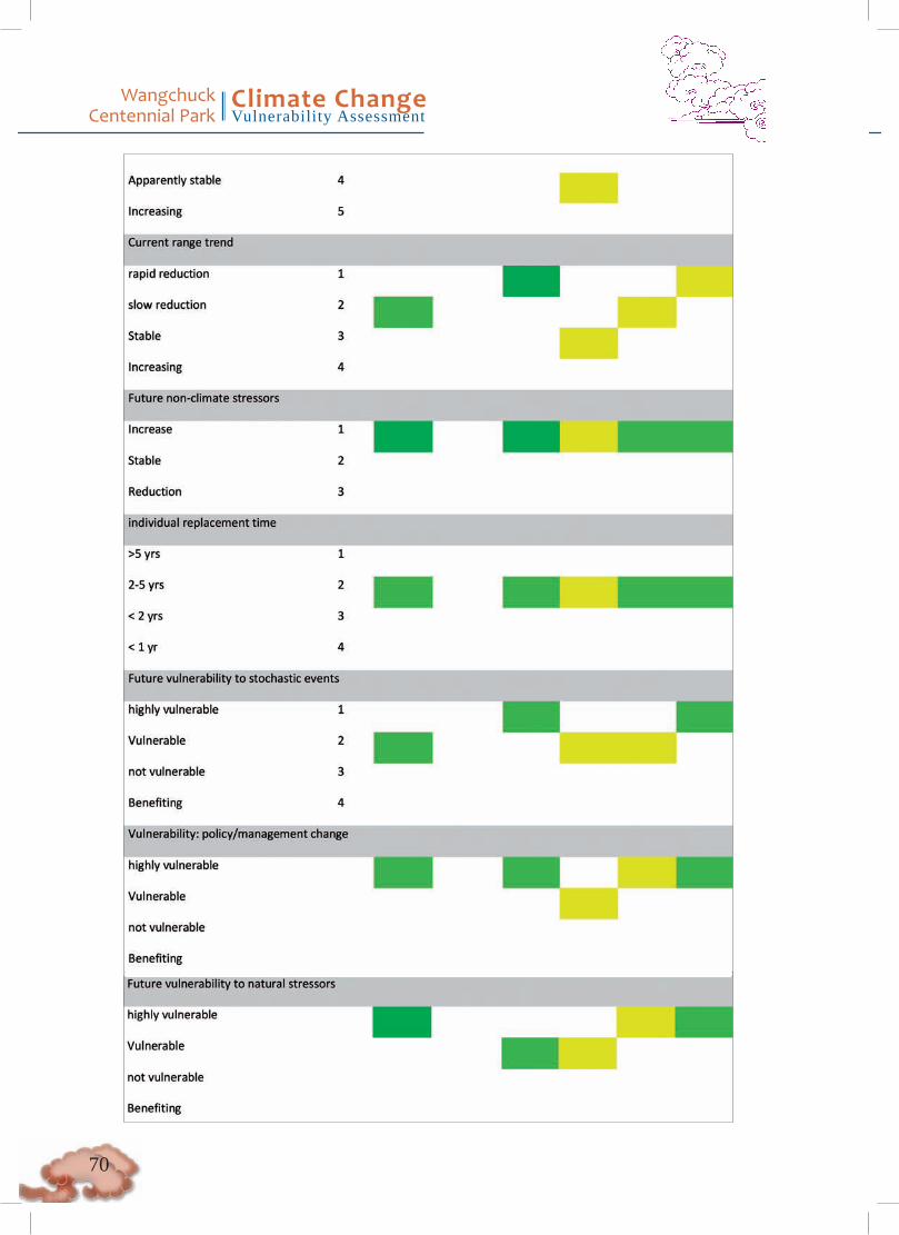
Wangchuck Centennial Park
Climate ChangeVulnerability Assessment
�0

��
Wangchuck Centennial Park
Climate ChangeVulnerability Assessment

Wangchuck Centennial Park
Climate ChangeVulnerability Assessment
��

��
Wangchuck Centennial Park
Climate ChangeVulnerability Assessment
Appendix B Habits and habitat requirement of selected altitudinal migrant and high-altitude specialist birds
Information derived from Grimmett et al1.
English Name Scientific Name Habits and HabitatsAltitudinal Migrant or Resident
Fire-tailed Sunbird Aethopyga ignicauda Breeds in rhododendron shrubberies in summer. Winters in broadleaved and mixed forests
M
Rosy Pipit Anthus roseatus Breeds on slopes above treeline in high Himalayas in summer. Winters in plains and foothills in N subcontinent.
M
Dark-breasted Rosefinch Carpodacus nipalensis Breeds in high altitude shrubberies in summer. Winters in forest clearings.
M
White-browed Rosefinch Carpodacus thura Breeds in high altitude shrubberies in summer. Winters on bushy hills.
M
Grandala Grandala coelicolor Rocky slopes and stony meadows in alpine zone in summer. Lower altitudes in winter.
M
Blood Pheasant Ithaginis cruentus High altitude forests. R
Snow Partridge Lerwa lerwa High altitude rocky and grassy slopes with scrub above treeline R
Himalayan Monal Lophophorus impejanus Summers on rocky and grass-covered slopes. Winters in forests. M
Kalij Pheasant Lophura leucomelanos Forest with dense undergrowth R
Fire-tailed Myzornis Myzornis pyrrhoura Himalayan resident. Subalpine shruberies, mossy forest and bamboo.
R
Coal Tit Parus ater Coniferous and mixed forest R
Grey-crested Tit Parus dichrous Broadleaved and mixed forest R
Smokey warbler Phylloscopus fuligiventer Breeds in C and E Himalayas in high altitude shrubberies. Winters in adjacent foothills and plains in dense undergrowth near water.
M
Hume’s Warbler Phylloscopus humei Breeds in coniferous forest and subalpine shrubberies in summer. Winters in forest and secondary growth in plains.
M
Crimson-browed Rosefinch Propyrrhula puniceus Breeds in high altitude shrubberies in summer. Winters in forest undergrowth.
M
Alpine accentor Prunella collaris Resident in open stony slopes and rocky pastures. R
Yellow billed chough Pyrrhocorax graculus Resident in alpine pastures of high mountains. R
Red-billed Chough Pyrrhocorax pyrrhocorax Resident in alpine pastures of high mountains. R
Golden bush robin Tarsiger chrysaeus Summers in subalpine shrubberies and forest undergrowth. Winters in forest undergrowth and dense shrub.
M
Golden Bush-Robin Tarsiger chrysaeus Summers in subalpine shrubberies and forest undergrowth. Winters in forest undergrowth and dense shrub.
M
Rufous-breasted Bush-Robin
Tarsiger hyperythrus Breeds in bushes at forest edges in high Himalayas. Winters in moist forests in NE Indian hills.
M
Satyr Tragopan Tragopan satyra Resident in temperate and subalpine forest R
Temminick’s Tragopan Tragopan temminickii Resident in temperate and subalpine forest R
Winter Wren Troglodytes troglodytes Breeds on high-altitude rocky and busy slopes in summer. Winters in forest undergrowth
M
Plain-backed Thrush Zoothera mollissima Breeds on high-altitude rocky and grassy slopes in summer. Winters in forest and open country with bushes.
M
� Grimmett, R. C. Inskipp, and T. Inskipp. �999. Birds of India: Pakistan, Nepal, Bangladesh, Bhutan, Sri Lanka, and the Maldives. Princeton University Press.
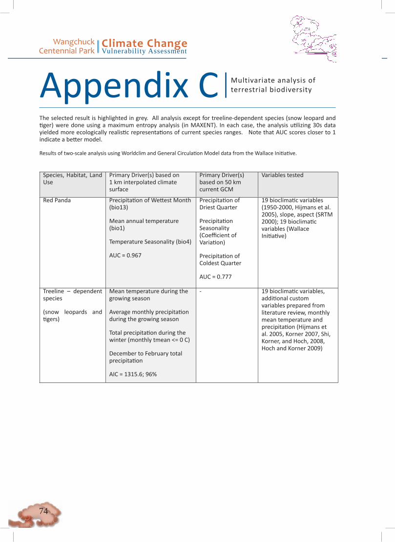
Wangchuck Centennial Park
Climate ChangeVulnerability Assessment
��
The selected result is highlighted in grey. All analysis except for treeline-dependent species (snow leopard and tiger) were done using a maximum entropy analysis (in MAXENT). In each case, the analysis utilizing 30s data yielded more ecologically realistic representations of current species ranges. Note that AUC scores closer to 1 indicate a better model.
Results of two-scale analysis using Worldclim and General Circulation Model data from the Wallace Initiative.
Species, Habitat, Land Use
Primary Driver(s) based on 1 km interpolated climate surface
Primary Driver(s) based on 50 km current GCM
Variables tested
Red Panda Precipitation of Wettest Month (bio13)
Mean annual temperature (bio1)
Temperature Seasonality (bio4)
AUC = 0.967
Precipitation of Driest Quarter
Precipitation Seasonality (Coefficient of Variation)
Precipitation of Coldest Quarter
AUC = 0.777
19 bioclimatic variables (1950-2000, Hijmans et al. 2005), slope, aspect (SRTM 2000); 19 bioclimatic variables (Wallace Initiative)
Treeline – dependent species
(snow leopards and tigers)
Mean temperature during the growing season
Average monthly precipitation during the growing season
Total precipitation during the winter (monthly tmean <= 0 C)
December to February total precipitation
AIC = 1315.6; 96%
- 19 bioclimatic variables, additional custom variables prepared from literature review, monthly mean temperature and precipitation (Hijmans et al. 2005, Korner 2007, Shi, Korner, and Hoch, 2008, Hoch and Korner 2009)
Appendix C Multivariate analysis of terrestrial biodiversity
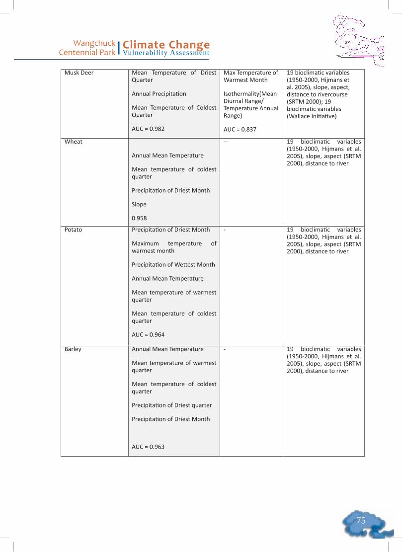
��
Wangchuck Centennial Park
Climate ChangeVulnerability Assessment
Musk Deer Mean Temperature of Driest Quarter
Annual Precipitation
Mean Temperature of Coldest Quarter
AUC = 0.982
Max Temperature of Warmest Month
Isothermality(Mean Diurnal Range/Temperature Annual Range)
AUC = 0.837
19 bioclimatic variables (1950-2000, Hijmans et al. 2005), slope, aspect, distance to rivercourse (SRTM 2000); 19 bioclimatic variables (Wallace Initiative)
Wheat
Annual Mean Temperature
Mean temperature of coldest quarter
Precipitation of Driest Month
Slope
0.958
-- 19 bioclimatic variables (1950-2000, Hijmans et al. 2005), slope, aspect (SRTM 2000), distance to river
Potato Precipitation of Driest Month
Maximum temperature of warmest month
Precipitation of Wettest Month
Annual Mean Temperature
Mean temperature of warmest quarter
Mean temperature of coldest quarter
AUC = 0.964
- 19 bioclimatic variables (1950-2000, Hijmans et al. 2005), slope, aspect (SRTM 2000), distance to river
Barley Annual Mean Temperature
Mean temperature of warmest quarter
Mean temperature of coldest quarter
Precipitation of Driest quarter
Precipitation of Driest Month
AUC = 0.963
- 19 bioclimatic variables (1950-2000, Hijmans et al. 2005), slope, aspect (SRTM 2000), distance to river
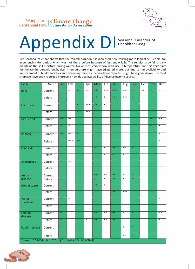
Wangchuck Centennial Park
Climate ChangeVulnerability Assessment
��
The seasonal calendar shows that the rainfall duration has increased now causing more land slide. People are experiencing dry period which was not there before because of less snow falls. The regular snowfall usually maintains the soil moisture during winter. Avalanches started now with rise in temperature and this very risky for the Yak herders.Although, rise in temperature might have triggered more, but due to the availability and improvement of health facilities and veterinary services the incidence reported might have gone down. The food shortage have been reported improving now due to availability of diverse income source.
EVENTS CHANGES Jan Feb Apr May Jun Jul Aug Sep Oct Nov Dec
Rain Current * ** ** ** *** *** *** ** ** * *
Before * ** ** *** *** **
Hailstorm Current * *** ** *
Before * ***
Dry Period Current ** ** ** **
Before * * * *
Snowfall Current ** ** * *
Before *** ** *
Landslide Current * * ** ** *
Before * * *
Avalanches Current * **
Before
Animal disease
Current ** ** ** * *Before * * ** * *
Crop disease Current ** **
Before ** ***
Watershortage
Current * * *
Before
Humandisease
Current * ** ** ** * * **
Before * * ** ** ** *
Food shortage Current * * *
Before ** **-Low **-Medium ***-High Blank box- no activity
Appendix D Seasonal Calander of Chhokhor Geog

��
Wangchuck Centennial Park
Climate ChangeVulnerability Assessment
Sephu geog has the same trend of seasonal changes as Chhohkor, but Sephu is experiencing more water shortage now since some spring water sources have already dried up. Also, they are experiencing food shortage during the harvest period and it was reported that the grains stored from the previous harvest are now not able to meet the requirement till next harvest season due to population rise and low productivity.
EVENTS CHANGES Jan Feb Apr May Jun Jul Aug Sep Oct Nov Dec
Rain Current * * ** ** *** *** *** ** ** *
Before * * ** *** *** **
Hailstorm Current ** *** *
Before ** **
Dry Period Current ** ** ** *
Before * * * *
Snowfall Current *** ** * **
Before ** * * **
Landslide Current * ** ** ** *
Before * ** ** **
Avalanches Current ** ** ***
Before *
Animal disease Current * *** *** ** *
Before * ** * * * ***
Crop disease Current *** *** *** ** **
Before * * ** ** * * * *
Water shortage Current ** ** ** * **
Before * * *
Human disease Current * ** ** ** * *
Before * ** ** ** * *
Food shortage Current * ** *
Before * * *
*-Low **-Medium ***-High Blank box- no activity
Appendix E Seasonal Calendar of Sephu Geog

Wangchuck Centennial Park
Climate ChangeVulnerability Assessment
��
The change of seasonal changes in Nubi geog is similar to other two geogs, but disasters such as land landslide and diseases are more pronounced here. People in the geog are also experiencing some drinking water shortages in winter which are likely to increase in the future.
EVENTS CHANGES Jan Feb Mar Apr May Jun Jul Aug Sep Oct Nov DecRain Current * * ** *** *** *** *** ** * *
Before * ** *** *** *** ** **
Hailstorm Current * *** *** ** ** * *
Before *** ** **
Dry Period Current ** ** * ** **
Before * ** * * *
Snowfall Current ** ** * * * ** *
Before *** *** ** * ** ***
Landslide Current * ** ** **
Before * **
Avalanches Current **
Before *
Animal disease Current * * * * * * * * * * * *
Before * * * * * * *** *** * * * *
Crop disease Current ** * * *** *** * * *
Before ** **
Water shortage Current * ** * *
Before
Human disease Current * ** ** ** ** ** * * * *
Before * ** *** *** ** ** * * * *
Food shortage Current ** ** *
Before * ** *
*-Low **-Medium ***-High Blank box- no activity
Seasonal Calendar of Nubi GeogAppendix F
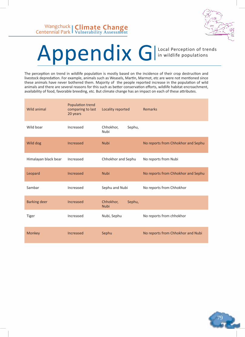
��
Wangchuck Centennial Park
Climate ChangeVulnerability Assessment
The perception on trend in wildlife population is mostly based on the incidence of their crop destruction and livestock depredation. For example, animals such as Weasels, Martin, Marmot, etc are were not mentioned since these animals have never bothered them. Majority of the people reported increase in the population of wild animals and there are several reasons for this such as better conservation efforts, wildlife habitat encroachment, availability of food, favorable breeding, etc. But climate change has an impact on each of these attributes.
Wild animalPopulation trend comparing to last 20 years
Locality reported Remarks
Wild boar Increased Chhokhor, Sephu, Nubi
Wild dog Increased Nubi No reports from Chhokhor and Sephu
Himalayan black bear Increased Chhokhor and Sephu No reports from Nubi
Leopard Increased Nubi No reports from Chhokhor and Sephu
Sambar Increased Sephu and Nubi No reports from Chhokhor
Barking deer Increased Chhokhor, Sephu, Nubi
Tiger Increased Nubi, Sephu No reports from chhokhor
Monkey Increased Sephu No reports from Chhokhor and Nubi
Local Perception of trends in wildlife populationsAppendix G
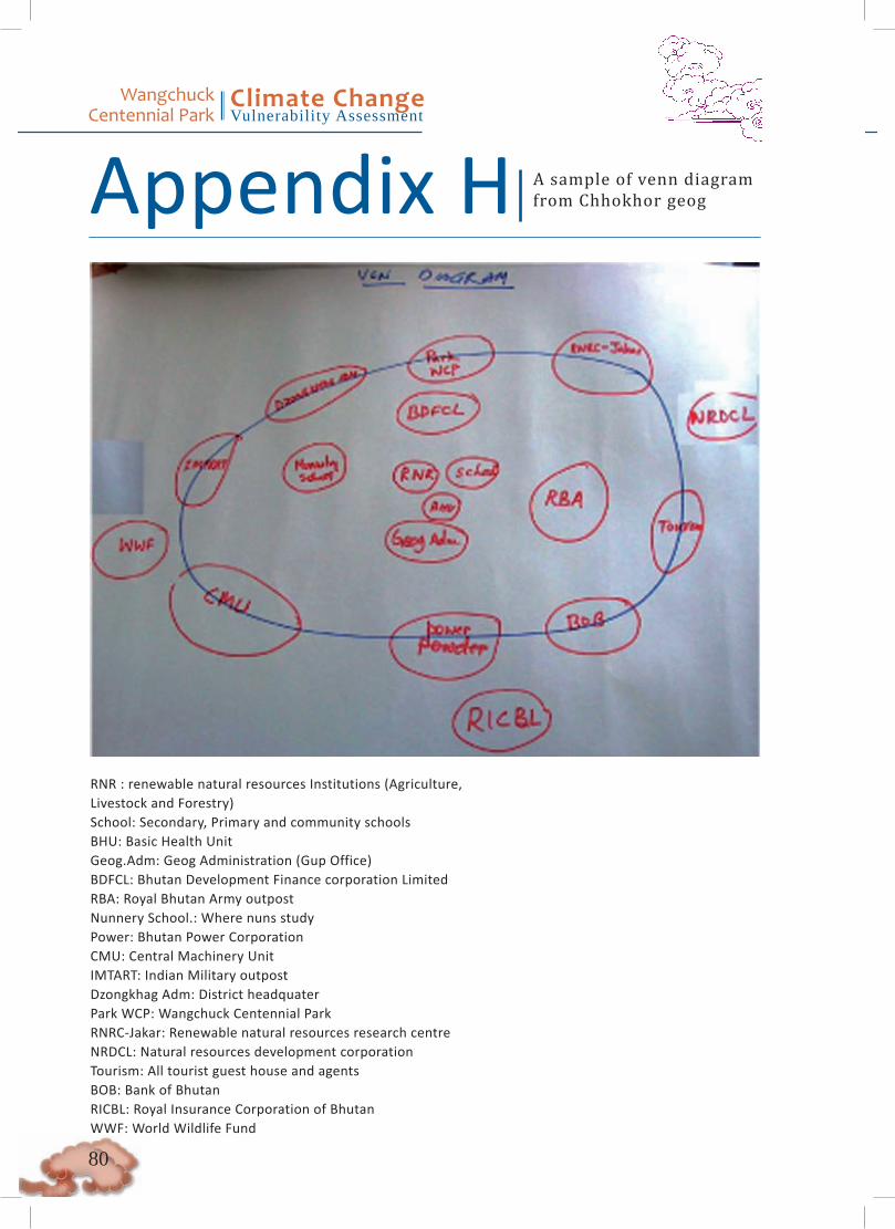
Wangchuck Centennial Park
Climate ChangeVulnerability Assessment
�0
RNR : renewable natural resources Institutions (Agriculture, Livestock and Forestry) School: Secondary, Primary and community schools BHU: Basic Health Unit Geog.Adm: Geog Administration (Gup Office) BDFCL: Bhutan Development Finance corporation Limited RBA: Royal Bhutan Army outpost Nunnery School.: Where nuns study Power: Bhutan Power Corporation CMU: Central Machinery Unit IMTART: Indian Military outpost Dzongkhag Adm: District headquater Park WCP: Wangchuck Centennial Park RNRC-Jakar: Renewable natural resources research centre NRDCL: Natural resources development corporation Tourism: All tourist guest house and agents BOB: Bank of Bhutan RICBL: Royal Insurance Corporation of Bhutan WWF: World Wildlife Fund
A sample of venn diagram from Chhokhor geog Appendix H