defence area 2 - arts and humanities data service
TRANSCRIPT

Report on Old Lodge Warren (Defence Area 17) - page 1 of 7
DEFENCE AREA 17 OLD LODGE WARREN 1. Area details: The defence area is 2 miles E of Crowborough and 6 miles SW of Tunbridge Wells. County: East Sussex.
Parish: Rotherfield. NGR: centre of area, TQ 546309.
1.1 Area Description: [see Map 1]. Old Lodge Warren is a narrow strip of woodland managed by the Woodland Trust running parallel with, and to the east of, the Crowborough to Tunbridge Wells railway line. This woodland is extended to the east, across a stream running in a steep-sided gully at the north of the area, by Hornshurst Wood, and, at the south, by Rochester's Forest. A further railway line, now dismantled, ran at a distance further to the east. Aerial photographic evidence shows that much of the woodland, particularly to the south of the area, has largely generated since the Second World War on what was once much more open heathland. This is an area of Wealden upland characterised by sandy soils. The south-western limit of the area is bounded by Palesgate Road, a narrow lane that crosses the railway line by a bridge, running from close to Jarvis Brook in the south and demarcating the spreading eastern suburbs of Crowborough. Immediately to the east of this lane at its southern end is an area of small, enclosed fields. At the north of the area is a sewage works and a lane at Redgate Mill Farm. To the west, the area is bounded by the railway line and to the east by the stream in its steep valley, with thickly-forested slopes rising steeply beyond. Because of the wooded, enclosed nature of the landscape there are no clear viewsheds.
Fig. 1 - The thickly-wooded nature of much of the defence area. Sixty years ago this landscape was more open heathland.
2. Assessment.
Report on Old Lodge Warren (Defence Area 17) - page 2 of 7
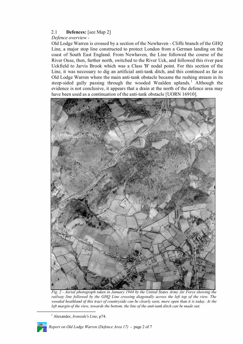
2.1 Defences: [see Map 2] Defence overview - Old Lodge Warren is crossed by a section of the Newhaven - Cliffe branch of the GHQ Line, a major stop line constructed to protect London from a German landing on the coast of South East England. From Newhaven, the Line followed the course of the River Ouse, then, further north, switched to the River Uck, and followed this river past Uckfield to Jarvis Brook which was a Class 'B' nodal point. For this section of the Line, it was necessary to dig an artificial anti-tank ditch, and this continued as far as Old Lodge Warren where the main anti-tank obstacle became the rushing stream in its steep-sided gully passing through the wooded Wealden uplands.1
Fig. 2 - Aerial photograph taken in January 1944 by the United States Army Air Force showing the railway line followed by the GHQ Line crossing diagonally across the left top of the view. The wooded heathland of this tract of countryside can be clearly seen, more open than it is today. At the left margin of the view, towards the bottom, the line of the anti-tank ditch can be made out.
Although the evidence is not conclusive, it appears that a drain at the north of the defence area may have been used as a continuation of the anti-tank obstacle [UORN 16910].
1 Alexander, Ironside's Line, p74.

Report on Old Lodge Warren (Defence Area 17) - page 3 of 7
The GHQ Line was constructed from June-November 1940, the company, Mowlem, being contracted to build it, making use of a large number of local sub-contractors. Six senior civil engineers were placed in charge of different sections, one of whom was based at Crowborough, with an office as well at Jarvis Brook. Bricks from the Crowborough Brickworks were used for the shuttering of the pillboxes, and heavy earth-moving equipment was brought from London to dig the anti-tank ditches.2
The Line was defended through Old Lodge Warren by type 24 infantry pillboxes, some of variant form, set at regular intervals either along the embankment of the railway line or on the steep slope above the stream. The fields alongside Palesgate Road were crossed by a section of the artificial anti-tank ditch, and where this met the B2100 road to the south there was almost certainly a roadblock. A further roadblock would have been constructed where the Line crossed the lane at the north of the area by Redgate Mill Farm. The GHQ Line across this area of the Weald was but part of a further system of stop lines and 'grid fences' built in 1940 to defend the South East from invasion. [See Defence Area 12 - Dorking Gap, for a description of this defence in depth]. Nodal point defence was also part of this system, and, in addition to Jarvis Brook, other adjacent nodal points were established at Uckfield, Crowborough Cross, Eridge Station, and Tunbridge Wells.3
The defence works - The brick-shuttered infantry pillboxes (type 24s) along the Old Lodge Warren section of the GHQ Line are complete, although one [UORN 658] has suffered blast damage at some time and lies in a shattered state. However, many of the pillboxes are so badly overgrown that they are extremely difficult to locate, and entry into them to assess their condition is virtually impossible.
Fig. 3 - The tangled, overgrown remains of type 24 pillbox, UORN 658.
2 Greeves, The Construction of the GHQ Stop-Line. 3 TNA: PRO WO 199/544.

Report on Old Lodge Warren (Defence Area 17) - page 4 of 7
Fig. 4 - UORN 669: this pillbox was approached by a flight of steps down to its entrance. The overgrown condition of many of the pillboxes in Old Lodge Warren can be understood from this photograph.
The fact that this run of pillboxes has no missing gaps is known from the reference numbers that can still be seen stencilled on their interior anti-ricochet walls. They are numbered from the north - A108 [UORN 663] to A118 [UORN 680]. Towards the south of the area, a pillbox, basically a type 24 but adapted to suit its position [UORN 675], was dug into the side of the railway embankment. It is built on a massive concrete base, with an entrance on the north side and a brick and concrete wall at the rear to guard against land slippage. Close to a disused pumping station, in a prominent situation where the footpath crosses the stream, a further type 24 pillbox stands up high on a bank with an entrance approached by a flight of steps from the north side. The base of this pillbox is becoming undermined by the stream, and is in urgent need of consolidation.
Fig. 5 - UORN 666: type 24 pillbox, now undermined by the action of the adjacent stream and in need of consolidation.

Report on Old Lodge Warren (Defence Area 17) - page 5 of 7
As has been stated, many of the pillboxes are very overgrown and difficult to locate. One in excellent exterior and interior condition, however, is UORN 663 towards the north of the area. The colour of the bricks used in its shuttering is a deeper red than the other adjacent pillboxes.
Fig. 6 - Interior of pillbox UORN 663. The slots in the whitewashed brickwork beneath the embrasures were to take the mountings for Bren light machine guns so these could be sighted on fixed lines. At the very north of the defence area, an unusual pillbox of a variant form is set low in the ground [UORN 660]. It is so overgrown that its exact form cannot be determined, and it is recommended that work be undertaken to clear it so that it can be inspected more closely and recorded fully. An open hole in the ground close by represents a public danger and, after examination, it should be closed off.
Fig. 7 - UORN 660: a pillbox of unknown shape is set close to the ground and is heavily overgrown. Work should be undertaken to clear and consolidate it.

Report on Old Lodge Warren (Defence Area 17) - page 6 of 7
2.2 Landscape: The landscape of the defence area has received no development since the Second World War. However, its character has changed with a far greater woodland cover today than sixty years ago. The heathland nature of much of this Wealden upland, on both sides of the railway line, can be seen from wartime aerial photographs [see Fig. 2]. Certainly, in the southern parts of the study defence area, the more open characteristics of the landscape prevailing at that time are indicated by the fact that a series of widely scattered linear earthworks can be made out, some sharply angled. The purpose of these is not known, but they may have a First World War origin and relate to training carried out by troops known to have been encamped at Crowborough. The woodland between the railway and the stream is managed by the Woodland Trust, and this body produced a map for the Defence of Britain Project showing the positions of the pillboxes within its boundaries.4
However, such is the density of the woodland undergrowth that one pillbox [UORN 635] was missed from the map.
A footpath runs parallel with the railway line from Palesgate Road to the disused pumping station at the site of pillbox, UORN 666. Here it turns to cross the stream and enter Hornshurst Wood. However, a path continuing alongside the railway towards Redgate Mill Farm can be found by climbing the bank behind this pillbox. Locating many of the pillboxes in this area is not a task for the faint-hearted. However, several alongside the footpath can be viewed relatively easily. The area is best approached from Palesgate Road, where there is a pull-off point just north of the ford.
2.3 Statement of Significance: Old Lodge Warren provides a good example of a complete run of infantry pillboxes
along the course of a section of stop line. The difficult terrain of this Wealden upland area can be appreciated, showing how the topography of stream and hill, backed by the railway, was used to form the main anti-tank obstacle. Although some pillboxes are heavily overgrown and it is difficult to view them, others are more accessible and in good condition, providing good, clean examples of the type 24 infantry pillbox.
Although it would be impractical to suggest that all the pillboxes should be freed from
their overgrowth, nevertheless it is suggested that work should be undertaken on two of the structures - UORN 666, where the undercut of the pillbox base should be filled, and UORN 660, where the overgrowth should be removed so the pillbox can be seen clearly and consolidated as necessary.
Information on the Old Lodge Warren section of the GHQ Line and its pillboxes could
be provided for public interest and education. 3. Recommendations:
1. That the surviving anti-invasion defence works at Old Lodge Warren, and in the extensions to this tract of woodland to north and south, be considered of national importance. They enable this section of the defence of the Wealden GHQ Line to
4 Defence of Britain Project Archive, NMR.

Report on Old Lodge Warren (Defence Area 17) - page 7 of 7
be interpreted, and provide evidence of the articulation of the defence and the inter-relationship of its functionally different components.
2. That the undercut to the base of pillbox, UORN 666, be consolidated, and pillbox,
UORN 660, be freed of overgrowth and the adjacent dangerous hole filled. 3. That consideration be given, possibly in collaboration with East Sussex County
Council, the local authority, and the Woodland Trust, to providing an information board on the defence works at Old Lodge Warren. A 'pillbox walk' could also be described on the board.
4. Supporting material. 4.1 Photographs:
Figs. 1 and 3-7 - taken (AWF) during field survey, 4.12.2003. Fig. 2 - US/7PH/GP/LOC165 fr.5062 (30.1.1944) - NMR.
4.2 Documentary Source: 'List of Nodal Points in Eastern Command', September 1940 (from General
Headquarters Papers, Home Forces) - TNA: PRO WO 199/544.
4.3 Published Sources: Colin Alexander, Ironside's Line (Historic Military Press, 1999). I.D. Greeves, 'The Construction of the GHQ Stop-Line: Eridge to Newhaven,
June-November 1940' (from Fortress no.16, pp52-61, February1993).
4.4 Aerial Photographs: US/7PH/GP/LOC165 frs.5061-5062 (30.1.1944) - NMR. CPE/UK/1966 fr.2160 (10.4.1947) - NMR.
4.5 Ordnance Survey 1: 2500 Plans:
TQ 5430-5530 (1970) - BLML. TQ 5431-5531 (1970) - BLML.
4.6 Defence of Britain Project Database: [see 5. 'Annex'].