dnr-managed public land strategy-11-14-13 public land strategy advisory committee mr. tom bailey...
TRANSCRIPT
Department of Natural Resources
Managed Public Land StrategyJuly 1, 2013
TM
DNR-MANAGED PUBLIC LAND STRATEGY ADVISORY COMMITTEE
Mr. Tom Bailey Executive Director Little Traverse Conservancy Mr. Charlie Becker Resource Supervisor Plum Creek Timber Company Mr. Rich Bowman Director of Government Relations The Nature Conservancy Dr. Bryan Burroughs Executive Director Michigan Trout Unlimited Mr. Rick Chapla The Right Place Ms. Denise Cline GIS Specialist/Community Planner/US23 Heritage Route Program Coordinator Northeast Michigan Council of Governments Ms. Ann Conklin Chief Operating Officer Michigan Recreation and Park Association Mr. Tim Ervin Consultant Alliance for Economic Success
Mr. Brad Garmon Director of Conservation Michigan Environmental Council Mr. Phil Koro Michigan Operations Manager Chevron North America Exploration and Production Company Ms. Amy Mangus Leader of Plan Implementation Southeast Michigan Council of Government Mr. Bill Manson Executive Director Michigan Snowmobile Association Ms. Erin McDonough Executive Director Michigan United Conservation Clubs Dr. William Porter Boone and Crocket Professor Michigan State University Mr. Jim Stachnik Team Lead, Land Manager Chevron North America Exploration and Production Company Mr. Dan Stencil Executive Officer Oakland County Parks and Recreation Mr. Dennis West President Northern Initiatives
TABLE OF CONTENTS
EXECUTIVE SUMMARY .................................................................................................. 1
INTRODUCTION ............................................................................................................. 7
State Land Facts ...................................................................................................... 13
PART ONE - STRATEGY .............................................................................................. 15
Goal 1: Provide Quality Outdoor Public Recreation Opportunities ........................... 15
Goal 2: Foster Regional Economic Prosperity ......................................................... 19
Goal 3: Protect Natural and Cultural Resources ...................................................... 22
PART TWO - LOOKING TO THE FUTURE ........................................................................ 25
How the DNR Will Refocus Public Lands Ownership ............................................... 25
Key Actions over the Next Six Years ....................................................................... 29
PART THREE - IMPLEMENTATION TIMETABLE ................................................................ 34
CONCLUSION ............................................................................................................. 35


July 1, 2013 1
EXECUTIVE SUMMARY
In his Energy and Environment and State of the State messages, Governor Rick Snyder called upon the Department of Natural Resources (DNR) to create a “strategy that protects the character and productive capacity of Michigan’s wide array of natural resources assets for future generations.”
The DNR-Managed Public Land Strategy (Strategy) was developed using an extensive model of public engagement across a broad range of partners and other interested groups and individuals. The DNR met with the ten counties that have the most DNR-managed public lands, held six facilitated meetings with Michigan Economic Development Corporation (MEDC) Community Leadership Councils and nine public open houses, and accepted public comments for approximately one month (550 comments were received). The DNR organized a meeting for 500 critical stakeholders and stakeholder organizations to receive their comments and concerns on the Strategy.
In addressing this call, the Strategy provides a framework for the continued conservation, use and management of public lands to provide an enhanced quality of life for Michigan residents and visitors and ensure the best use of public land. The Strategy provides goals, desired outcomes, metrics, and measurable objectives to protect Michigan’s natural and cultural resources, provide quality outdoor public recreation opportunities, and foster regional economic prosperity. The Strategy and its appendices (in greater detail) provide a comprehensive overview of DNR-managed public lands and their contribution to the state, answering the questions:
Where are DNR-managed public lands located?
Why does the DNR manage public lands?
What values are tied to DNR-managed public lands?
How are DNR-managed public lands managed now and how will they be managed in the future?
Where DNR-managed public lands are located
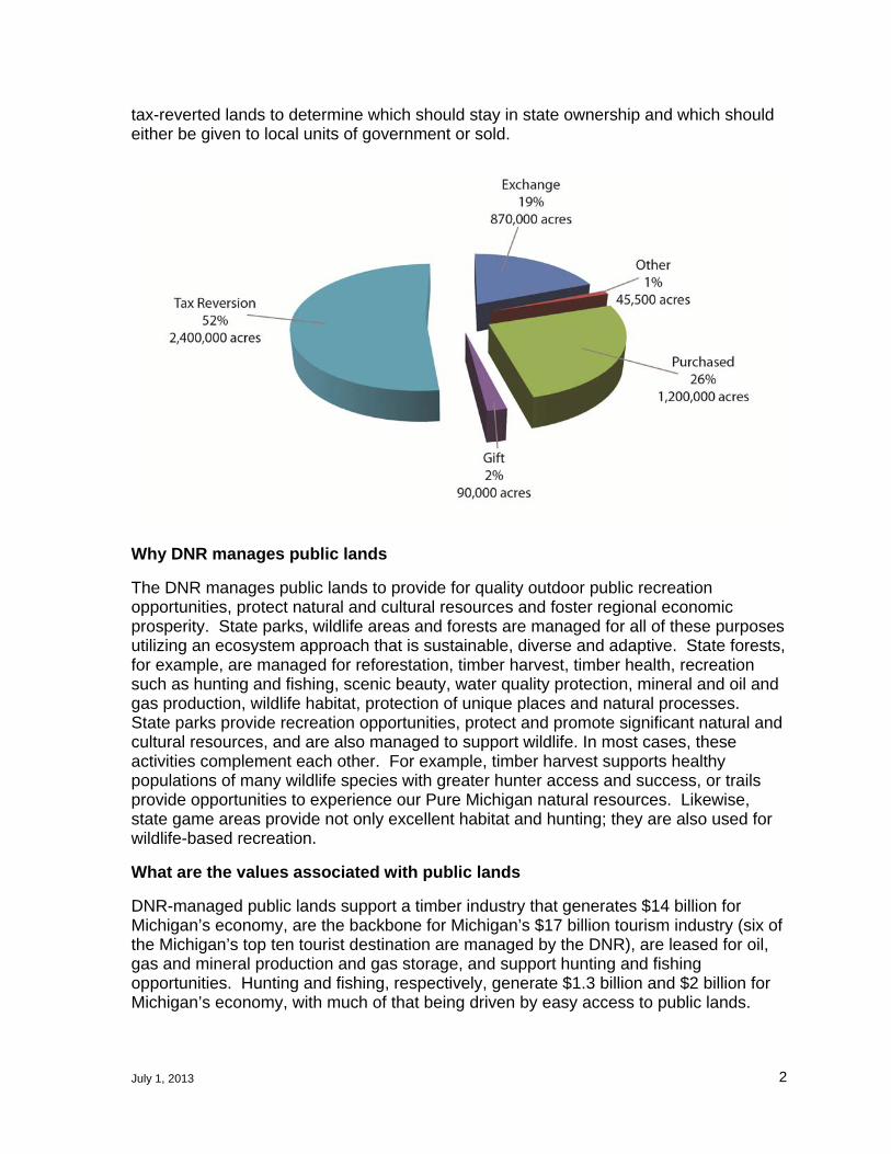
The DNR manages 4.6 million acres of public land and 6.4 million acres of mineral rights. Most of the 6.4 million acres of minerals includes the 4.6 million acres of public land. Of those,
2.4 million acres were acquired by tax reversion and are located primarily in the northern Lower Peninsula and the Upper Peninsula.
1.2 million acres were purchased (three-quarter of these acres were acquired utilizing game funds) and the remainder were acquired through gifts, court settlements, or from the federal government.
Of the 4.6 million acres of public lands, more than 3.8 million acres are designated as state forests, 352,000 acres are designated as state parks or recreation areas, and 360,000 acres are in designated state game areas. State parks, state forests and state game areas all contain tax-reverted and purchased lands. These lands were acquired through deliberative processes that reflected state policy and public sentiment at the time. Twice in Michigan’s history, citizen committees reviewed the state’s portfolio of
July 1, 2013 2
tax-reverted lands to determine which should stay in state ownership and which should either be given to local units of government or sold.
Why DNR manages public lands
The DNR manages public lands to provide for quality outdoor public recreation opportunities, protect natural and cultural resources and foster regional economic prosperity. State parks, wildlife areas and forests are managed for all of these purposes utilizing an ecosystem approach that is sustainable, diverse and adaptive. State forests, for example, are managed for reforestation, timber harvest, timber health, recreation such as hunting and fishing, scenic beauty, water quality protection, mineral and oil and gas production, wildlife habitat, protection of unique places and natural processes. State parks provide recreation opportunities, protect and promote significant natural and cultural resources, and are also managed to support wildlife. In most cases, these activities complement each other. For example, timber harvest supports healthy populations of many wildlife species with greater hunter access and success, or trails provide opportunities to experience our Pure Michigan natural resources. Likewise, state game areas provide not only excellent habitat and hunting; they are also used for wildlife-based recreation.
What are the values associated with public lands
DNR-managed public lands support a timber industry that generates $14 billion for Michigan’s economy, are the backbone for Michigan’s $17 billion tourism industry (six of the Michigan’s top ten tourist destination are managed by the DNR), are leased for oil, gas and mineral production and gas storage, and support hunting and fishing opportunities. Hunting and fishing, respectively, generate $1.3 billion and $2 billion for Michigan’s economy, with much of that being driven by easy access to public lands.

July 1, 2013 3
DNR-managed lands also provide natural benefits such as air pollution removal, water quality protection, wildlife habitat, and stormwater management. A recent economic analysis produced for the state of New York found that every dollar invested in acquiring public lands provided a seven-dollar return in natural goods and services. DNR-managed public lands stabilize local property values and promote Michigan’s quality of life. During the public outreach conducted during the development of this Strategy, elected local officials, business leaders and the public all acknowledged the importance of public lands to their communities.
How are DNR lands being managed
The DNR manages state-owned lands to protect and enhance the public trust while providing for the use and enjoyment of those lands as outlined by the Michigan Natural Resources and Environmental Protection Act (PA 451 of 1994) including the requirement that lands under its control be managed so that there is no net loss of lands open for hunting. State parks, wildlife areas and state forests all have tactical management plans that are regularly updated. Currently, regional state forest management plans are being reviewed by the public. Other plans, such as the State Parks and Outdoor Recreation Blue Ribbon Panel Report or the Statewide Comprehensive Outdoor Recreation Plan, inform land management decisions.
How will lands be managed and owned in the future
The strategy provides a framework for future management of DNR-managed lands centered on three goals: protecting natural and cultural resources, fostering regional economic prosperity and providing quality public outdoor recreation. These goals collectively represent how the DNR will take care of what the public currently owns with an eye to providing world-class experiences and opportunities for generations to come. It identifies outcomes and measurable objectives for each goal and draws upon the DNR’s extensive use of technology to manage these resources. On the ground management of DNR-managed lands will continue to be guided by tactical plans developed with public input.
Key Actions
Over the next six years, the DNR will focus regionally and act collaboratively, move aggressively to link facilities, become more data-driven, unify plans with regions and local units of governments, focus on quality of facilities and increase marketing. The DNR will continue to utilize technology to drive land management decisions and make it easier for local government, citizens and stakeholders to access this data. The DNR will seek continuous quality improvement in our technology systems to allow for the department, its partners and the public to understand and participate in transparent public land management decisions.
By refocusing ownership, measuring progress toward meeting desired outcomes and implementing measurable objectives, we will drive significant change in the oversight of DNR-managed lands and our method for engaging with the public and local units of government. This new way of management depends on collaboration and partnerships with local units of governments, regional planning organizations and other critical partners. This approach reflects today’s strategic goals for public land management with any eye toward the immediate future, as well as the need to adapt to emerging
July 1, 2013 4
trends and issues with public lands for the benefit of generations to come. It also strives for the highest quality hunting, fishing and outdoor public recreation experience for Michigan citizens and visitors.
Land Disposal
The strategy also identifies a new approach for ownership of DNR-managed lands that builds upon past initiatives to consolidate DNR-managed lands. The goal of the new approach for disposal and strategic acquisitions is to focus on achieving a portfolio of ownership that provides for world class outdoor public recreation experiences, protects Michigan’s unique cultural and natural assets and fosters regional economic prosperity.
The DNR will identify lands for potential disposal under five considerations:
1. Parcels that are either:
a. 200 acres or less and don’t adjoin other DNR-managed public lands; or
b. Difficult to administer due to the irregular shape of their boundary.
Lands meeting these criteria have been identified and total approximately 240,000 acres.
2. Lands lacking public access.
3. Lands nominated by field managers because of concerns with management effectiveness and efficiencies, or to reduce user conflict.
4. Lands that were identified in previous consolidation efforts and unsuccessfully offered to conservation partners.
5. Large blocks of land would be made available for exchange with similar blocks of land for purposes of consolidating ownerships.
Conveyance of surplus parcels will be conducted in a manner that provides for the continued protection of important natural or cultural resources or recreation values. The DNR would also seek to purchase or exchange lands that enhance recreational opportunities, protect significant natural or cultural resources. Land would also be treated as surplus where it improves the bottom line for regional economic prosperity.
The 240,000 acres and other identified potential surplus lands will be reviewed by the DNR, local units of government and the public on a county-by-county basis utilizing criteria that recognize the metrics identified in this Strategy. Based upon the criteria, parcels will be placed into one of four categories: dispose, offer to a local units of government or alternative conservation owner, make available for exchange, or retain in state ownership.
Targeted Investments
Targeted strategic investments in land located within priority areas is a critical component of this new approach. These investments will help achieve the DNR’s mission and desired outcomes by meeting one or more of the following criteria:
Complete the goals, outcomes and measurable objectives identified in the Strategy.
Contribute to existing initiatives or plans, (e.g. trail corridor acquisition for strategic trail connections)
Resolve user conflict

July 1, 2013 5
Improve the quality of the state’s land portfolio or the user’s experience
Project Boundary Review
Improved project boundary alignment of DNR-managed lands to more closely reflect actual land ownership is a linchpin of the DNR’s approach to smarter and more efficient land management and investment, while providing world class experience for residents and visitors. Currently, there are approximately 1.9 million acres of privately-owned lands scattered within DNR-managed project boundaries. Moving forward, the DNR will focus on the goal of reducing (by 1 million acres) the amount of private lands within DNR-managed project boundaries by more closely aligning the boundaries of state recreation areas, state game areas and state forests with current and realistically anticipated future ownership. The remaining privately-owned lands within the boundaries will be acquired only if they further the measurable objectives in the Strategy. In other cases, boundaries will be expanded to reflect priority acquisitions, especially in Southern Michigan.
Timetable for Implementation
One to six months:
Gain legislative approval of the Public Land Management Strategy.
Meet with each of the ten MEDC Community Leadership Councils to present the assets and attributes of DNR-managed public lands and to facilitate continuing discussions and action on utilizing these lands for regional prosperity initiatives.
Identify the gaps in the Belle Isle to Wisconsin trail and begin acquisition and development where needed.
Complete the DNR facilities inventory.
Complete the DNR Comprehensive Trails Plan.
Meet with the five counties with the least percentage of DNR-managed lands to identify how to fulfill the measurable objectives identified in the Strategy as they related to these counties.
In collaboration with the Michigan Natural Resources Trust Fund (MNRTF) Board of Trustees realign the MNRTF criteria to reflect the goals and measurable objectives of the Strategy.
Begin integration and implementation of the Blue Ribbon Committee on State Parks and Outdoor Recreation report, Statewide Comprehensive Outdoor Recreation Plan (SCORP) and Comprehensive Trails Plan.
Prepare an Implementation Plan for the Strategy.
Six months to one year:
Continue disposal of surplus property through sale, transfer or exchange, including the lands identified as surplus from the 240,000 acres. Ensure that disposal doesn’t depress local land prices and/or local land use patterns.
Implement the new MNRTF criteria.

July 1, 2013 6
Utilize the results of input received through collaboration with counties and MEDC Community Leadership Councils to implement the strategy when applying for funding through MNRTF.
Start the Implementation Plan
Year Two:
Dispose of additional surplus lands through sale, transfer or exchange.
Analyze the results of the DNR facilities inventory for most efficient use of existing and potential locations for customer service and staff support.
Continue the Implementation Plan.
July 1, 2013 7
INTRODUCTION
Since before statehood, land in Michigan has been highly desired for its natural resource values – first for food and furs and then timber and minerals. Today, Michigan’s public lands are prized for those same things, being managed for wildlife habitat, hunting and fishing opportunities, timber, oil and gas production, recreational opportunities and mineral development. Michigan’s public lands contribute greatly to the state’s economy, supporting tens of thousands of jobs, pouring tens of billions of dollars into local businesses and contributing to the high quality of life critical to the state’s future economic prosperity. DNR-managed public lands also play a critical role in providing ecosystem goods and services such as air pollution removal, water quality protection, and storm water management. A 2012 Trust for Public Lands economic impact study of public lands in the State of New York found that every $1 invested in securing public ownership of lands provided $7 in economic value in natural goods and services.1 A similar return should be expected from DNR-managed public lands.
The North American Model of Wildlife Conservation and the Public Trust Doctrine, the foundations that drive the acquisition and management of public lands, both rests on the principle that wildlife and, more broadly, natural resources belong to everyone. Managing wildlife and other natural resources for the common good would not be
possible without public lands. In Michigan, the recognition that our quality of life is linked to the quality of our resources led to some of the earliest laws protecting our land and waters. It also led to the constitutional provision identifying the Michigan Legislature with responsibility for the use and protection of Michigan’s natural resources.
While long, the road to modern public land management has always reflected the philosophy and policies of the times, as outlined in the History section of this document. Through time, lands were purchased and sold, boundaries were re-aligned and consolidated and public land management evolved with scientific advances and changes in the public’s recreational pursuits.
The use of the State’s land has changed over time, but certain fundamentals have not changed. Wildlife and fish require adequate and appropriate habitat. Lakes and streams need undeveloped land for recharge areas and to filter pollutants. Forests and other plants need to exist at a level of abundance to pollinate, survive and thrive. While the DNR has the responsibility to respond to public demands for recreation and resources, it also has a duty to manage resources in a manner that reflects the realities of nature and the intricacies of the inner workings of living systems.
1 The Economic Benefits of New York’s Environmental Protection Fund, Trust for Public Lands, 2012
“The abundance of public land in Michigan has a huge impact on our business. I’ve been in a lot of other states, and Michigan is blessed with public lands, especially for those that don’t have access to private land. We notice an increase in traffic traveling north for firearm deer season opening day. The result is an increase of traffic going through our stores in Clare and Gaylord. And it’s not just hunting and fishing – public lands also contribute to the sales of equipment for camping and canoeing.” – Jeff Poet, President, Jay’s Sporting Goods
July 1, 2013 8
This Strategy reflects today’s goals for public land management with an eye toward ensuring the best of Michigan for future generations. It also remains flexible to adapt to emerging trends and issues with public lands. Adaptability is vital because, as history shows, use patterns vary and land management will continue to change along with it.
Reason for the Strategy
In his November 2012 “Ensuring Our Future - Energy and Environment Message,” Governor Rick Snyder called for a “public land management strategy that protects the character and productive capacity of Michigan’s wide array of natural resource assets for future generations.” He directed the state to become more strategic about the “what” and “why” of ownership of public land. He stated that public lands should protect the unique places that provide habitat or other natural resources. The Governor said the strategy needs to ensure that high-value recreation experiences are available and attractive, and that all of the lands owned and managed by the state further these goals. Also in his Energy and Environment message, Governor Snyder encouraged the continued use of an ecosystem management approach to balance the demands for outdoor recreation, resource protection and economic opportunity. PA 240 of 2012 also called for the development of a strategic plan for public land management and tied the amount of public land that could be managed by the DNR to the approval of the strategic plan by the Legislature.
Protecting natural and cultural resources, providing quality outdoor public recreational opportunities and fostering regional economic prosperity are the core responsibilities of the DNR and are the three goals that drive this Strategy. These responsibilities the DNR cannot or should not accomplish alone. Strong partnerships and collaborations are imperative to fulfill these responsibilities and sustain both the social and economic opportunities that DNR-managed public land provides. Other governmental agencies, land conservancies and the private sector own significant amounts of land and also assist in protecting natural and cultural resources, providing quality outdoor public recreation opportunities and fostering regional economic prosperity. Michigan’s integrated network of outdoor recreation opportunities is provided by the state and federal government, local and regional governments, non-profits and the private sector. This Strategy calls for increased integrated planning among all land managers to clarify roles and responsibilities, grow opportunities, maintain standards for quality across all public facilities and improve marketing of opportunities.
Nearly every acre of DNR-managed land is actively managed for multiple uses and values with consideration for timber production, oil, gas and mineral development, fish and wildlife and their habitats, resource protection, recreation, resource functions, cultural significance, and public access. Appendix 2 has as an example, a tactical management plan of one state forest compartment that shows all of the activities managed in one area. These multiple uses are often at odds and the DNR utilizes an ecosystem approach to balance the social, ecological and economic demands in resolving conflicts. The multiple demands for the use of public land will continue to evolve and provide challenges as pressures from current uses increase and new opportunities, such as biomass fuels, emerge.
This Strategy should be viewed as a six-year framework for public lands managed by the DNR and not a tactical management document. This framework will ensure that

July 1, 2013 9
Michigan will remain ‘Pure Michigan’ and be a place future generations will continue to live, work and play. The desired outcomes, objectives and metrics in this Strategy define how the DNR will manage public lands for the benefit of all Michiganders and for a variety of uses with minimal conflict. It sets priorities for the DNR, its stakeholders and partners who share in protecting public lands and the natural resources they hold. A foundation is laid for a new way to manage, acquire and dispose of DNR-managed public lands that builds upon past success, yet remains adaptable to the changing needs and uses of DNR-managed public lands. The Strategy is divided into three equal parts: 1) public land management strategy; 2) a framework on how the DNR will manage public lands differently in the future, including a new approach for the disposal and strategic investment in state land and 3) a timetable for implementing the Strategy. The appendices provide detailed background information about DNR-managed public lands important for informing the Strategy.
The Strategy was developed and informed with the input of local units of government, economic developers, regional community leaders, stakeholders and interested citizens. An advisory committee helped develop the desired outcomes for each goal. Meetings between DNR leadership and county leadership were held in the ten counties with the most DNR-managed lands. Facilitated discussions with MEDC Community Leadership Councils were organized in six locations throughout the state to discuss how DNR-managed lands could help facilitate local economic prosperity initiatives. Nine public open houses were held in dispersed locations to receive feedback on the draft Strategy. The public also had approximately one month to provide comments on the Strategy via the DNR’s website. Over 550 citizens took that opportunity. The DNR also organized a meeting for 500 critical stakeholders and stakeholder organizations including all of the members of the DNR advisory committees to receive their comments and concerns on the Strategy. Throughout the development process, the DNR kept the Natural Resources Commission and the balance of the Quality of Life team (Departments of Environmental Quality and Agriculture and Rural Development) informed about the Strategy and provided opportunities to comment.
History
From the beginning of statehood, the State of Michigan has been in the real estate business and the owner of substantial acres of land. State policy shaped by public opinion determined how Michigan’s public lands were viewed and how much land was retained in state ownership. The current DNR-managed public land holdings -- state parks and recreation areas, boating access sites, historic sites, game and wildlife areas and state forests -- were acquired through a deliberative process that reflected state policy and public opinion at the time. Early state policy supported the sale of public land for settlement and development, changed to support the sale of land for extraction, and then evolved to a policy of owning and managing public lands for public benefits.
When Michigan was admitted to the Union in 1837, the state’s public land management role was to sell land for settlement and support the development of government functions. Many of these lands went through several cycles of tax reversion as the land was cleared of timber resources and subsequent attempts at agriculture failed. From the 1890s through the 1930s, the state underwent a series of economic downturns that caused lands to revert to the state for non-payment of taxes -- over 116 million acres (the land reverted multiple times) in a 22-year period. The Legislature created the State

July 1, 2013 10
Forestry Commission in 1899 and began to set aside forest reserves as one of the efforts to stop this cycle of tax delinquencies. Further expansion of the state forests occurred with the creation of the Public Domain Commission in 1909. That same year, legislative action required the state to reserve the mineral rights on all lands sold or homesteaded and in 1911 the Legislature provided the state with the authority to exchange lands to consolidate ownership.
The exploitation of land and resources triggered the rise of the conservation movement and state policy changed to a focus on wise allocation of land, rather than sale for short-term gain. Various commissions, including the Public Lands and Fisheries (1873), Forestry (1899) and Parks (1919), were created to manage resources and to stop tax reversions. The commissions were eliminated and their functions merged into the new Department of Conservation under the direction of the Conservation Commission in 1921. One of the first rulings of the new Conservation Commission was that no state lands bordering upon the Great Lakes or any inland lake were to be sold, but were to be held for the “enjoyment of the people.”
Throughout its tenure, the Department of Conservation set forth a strategy to co-manage public lands whereby the Game and Forestry Divisions could not conduct land management practices without concurrence from the other division. This approach was similar to the current concept of co-management. It continues to be the cornerstone of DNR public land management and is a nationally recognized model for public land management.
In 1922, under the guidance of the United States Department of Agriculture (USDA), the Michigan Land Economic Survey was created to review the lands in northern Michigan and determine their value for agriculture or whether they were more suitable for recreation, other public uses or should be sold. The USDA Land Use Planning Program also had a land planning effort which lasted until the 1950s. These planning initiatives were intended to stop the tax reversion cycle.
By 1938, land use planning committees were organized for each county in the state. They were comprised of some 1,700 local, county, township and school officials who reviewed all state land holdings, including tax-reverted lands, and made recommendations for their future. Recommendations included retaining the land in public ownership (state or local) or selling to private land owners.
As a result of this review, by 1950, over 1.3 million acres were sold and 130,000 acres were turned over to local governments. The remaining acres were added to the state forest, wildlife areas or state park systems.
Through sustained investment and management, lands stripped of their timber grew into a robust state forest system that supports the state’s timber industry, provides numerous outdoor recreation opportunities, nurtures natural resources and has restored natural processes. State parks have evolved as recreation demands have changed and the quality of the resources improved as the land healed. Game and fish species rebounded as habitat improved and harvest was carefully managed.
There have been two previous extensive reviews of Michigan’s public land policy, in 1984 and again in 1996. The Report of the Task Force on Public Lands Policy was presented to Governor James Blanchard in 1984 and provided a series of 24
July 1, 2013 11
recommendations regarding the state’s public land. The primary points of this report were that the state needed to consolidate its ownership of land and that the Task Force “did not find a need for major changes to land management practices and philosophies.” In 1996, the Senate Select Committee on Public Land Ownership, Purchase and Management also conducted an extensive study of the DNR’s land acquisition policy as well as other state land-holding agencies. The committee proposed seven “principle changes” in the state’s land acquisition policy including 1) greater flexibility in state programs to allow for shifts in land policy, 2) adopt new attitudes and incentives to work with the private sector, and 3) that the Legislature should reaffirm its role as the chief conservator of the state’s natural assets.
In 2003, the DNR initiated a thorough review of its land ownership in response to Natural Resources Commission Policy 2627 of 2003. This project, known as the DNR Land Ownership Strategy, implemented a four-phase approach to review the DNR land ownership pattern, evaluate DNR-managed public lands from a natural resources perspective, and dispose of those parcels that did not contribute to the overall mission of the DNR. The purpose of the land ownership review was to continue the ongoing effort to consolidate state land ownership for a variety of economic, outdoor recreation and other natural resource benefits. In addition, it sought land management efficiencies by reducing trespass issues, addressing shooting safety zone encroachments and the need to monitor and survey public/private boundary lines.
Today, the DNR manages state-owned lands in a manner that protects and enhances the public trust while providing for the use and enjoyment of those lands as required in the Natural Resources and Environmental Protection Act. As such, state parks, wildlife areas and state forests are managed for multiple use and multiple objectives utilizing principles of ecosystem management, application of technologies such as geographic information systems (GIS) and implementation of adaptive management techniques to sustain the diversity and productivity of Michigan's natural resources. Management of state parks and recreation areas, state game and wildlife areas, state forests and state fisheries are guided by tactical management plans.
Land Management Plans
State Parks and Recreation Areas: A General Management Plan which considers a park’s importance in terms of natural, cultural and historic resources, and recreational and educational opportunities has been developed for each state park and are in the process of being updated. Management Zones are identified in each plan which reflects the resource protection goals and recreation development opportunities for different areas within each park. For each management zone identified, individual long-range (10-year) action goals are developed.
State Game and Wildlife Areas: The purpose of wildlife project areas is to provide habitat for wildlife populations and public lands for hunting and trapping. There areas are managed by DNR’s Wildlife Division, whose over-riding priorities for these lands as well as for co-managed state forest lands are described in the Wildlife Division’s Guiding Principles and Strategies (GPS). Master plans describe the desired future conditions of wildlife areas (for example, in the thumb area of Michigan the desired condition in state game areas is grasslands for pheasants) and set goals to improve wildlife habitat and the infrastructure for wildlife-related recreational activities.

July 1, 2013 12
Fisheries: Statewide angler opportunity and habitat protection goals are provided in Fisheries Division’s Strategic Plan “Charting the Course.” Fish community and habitat objectives are established for lakes Superior, Michigan, Huron, and Erie through collaborative efforts under the Great Lakes Fishery Commission. Goals for inland lakes are established through Fisheries Division’s “Conservation Guidelines for Michigan Lakes and Associated Natural Resources”. Status of the Fisheries Reports establishes management actions for both inland lakes and small streams, and River Assessment Reports provide management direction for major watersheds throughout the state.
State Forests: The DNR uses a hierarchical, geographic planning framework to coordinate planning activities and guide operational decisions for state forest management. That framework includes a strategic state-level plan, 2008 Michigan State Forest Management Plan (SFMP), three draft operational Regional State Forest Management Plans (RSFMP), and tactical forest management unit-level planning. State forests are co-managed by Forest Resources, Wildlife and Fisheries Divisions, all tactical/operation plans for the forests must be agreed to by all three divisions.
Use of Technology: The DNR uses Geographic Information System (GIS) to assist in planning and management of public lands. GIS and other interactive mapping tools provide natural resource data to DNR staff in a format that allows for large volumes of information related to land to be gathered, manipulated and analyzed. The results of the analysis is produced in formats that can be shared with other land managers and DNR staff for further analysis or the public in the form of maps.
Protected and Unique Areas: The DNR manages protected and unique areas in state parks, wildlife areas and state forests as required under a number of different statutes. State parks have “Environmentally Sensitive Zones” where use is highly restricted and management is wholly focused on attaining and maintaining a pristine natural resource environment. There are 48 designated Natural Areas, most of which occur on DNR-managed lands within state parks, such as the dunes at Ludington State Parks, Laughing Whitefish Falls or St. John’s Wet Prairie. These lands were dedicated under PA 451 of 1994, Part 351. Critical dunes as regulated under PA 451 of 1994, Part 353 are also found on state lands. Designated Natural Rivers under PA 451 of 1994, Part 305, flow through state lands and the DNR must manage those rivers according to law. Critical habitat areas are designated for some federal and state-endangered species such as the Kirtland’s warbler and the piping plover. Ecological Reference Areas have also been designated on state land and serve as models for ecological reference within the state. These areas are high quality examples of functioning ecosystems that are primarily influenced by natural ecological processes.

July 1, 2013 13
State Land Facts
Statewide surface total 4,592,400 acres Statewide total mineral ownership 6,400,000 acres
Division Tax Reverted
AcresPurchased
AcresMisc.
AcresTotal
AcresForest Resources Division 2,306,000 1,500,000 37,000 3,843,000Parks and Recreation Division 56,000 246,000 50,000 352,000Wildlife Division 29,000 317,000 14,000 360,000Fisheries Division 2,000 3,300 400 5,700Boating and Water Access 16,000 15,000 700 31,700Total Acres 2,409,000 2,081,300 102,100 4,592,400
From 1921 to 2012 the DNR:
Disposed of 2.5 million acres of land.
Gave nearly 150,000 acres of land to local governments.
Received almost 100,000 acres of land as gifts.
Purchased approximately 166,000 acres of land utilizing Michigan Natural Resources Trust Fund between 1980 and 2012.
During the last ten years, the DNR:
Expanded its land ownership base by 66,738 acres through purchase or exchange.
Sold, transferred and exchanged 33,846 acres.
Timber
By providing a steady flow of timber to the market, the state forest system is a key participant in the $14 billion forest industry, which directly employs 26,000 people in Michigan.
In 2012, DNR timber sales resulted in 800,000 cords of wood being harvested for the market.
Regional Forest Management Plans define the amount of sustainable harvest that can occur in state forests. If additional harvest above this number is desired, additional timber lands would need to be acquired.
The state forest system has received dual certification from the Forest Stewardship Council (FSC) and the Sustainable Forestry Initiative (SFI). Certification improves the global market competitiveness of Michigan’s certified timber products, resulting in improved economic gain for Michigan’s rural, timber dependent communities. Certification also assures high standards for quality land management. This achievement is critical to the sustainability of state forests and integral to conserving the quality of life that makes Michigan a great place to live.

July 1, 2013 14
Almost 11 percent of Michigan’s forestlands are enrolled in the Commercial Forest Program, a program which provides property tax breaks to private landowners in return for them managing for timber production and providing public access for hunting, fishing and trapping.
Minerals/Oil and Gas
Michigan has 1.1 trillion cubic feet of natural gas storage capacity in depleted oil fields, the greatest volume of any state. Thirteen percent of the capacity is on DNR-managed public lands. Storage of natural gas reserves results in lower, more predictable and year-around natural gas supply for Michigan’s citizens and industry.
Currently, 50 percent of state-owned mineral rights in the Lower Peninsula are leased for oil and gas production. Leases are a result of industry nominations based upon market demand, current oil and gas activity and new exploration initiatives.
Oil and gas revenues to the MNRTF, Game and Fish Protection Fund and the State Park Endowment Fund have totaled almost $2 billion.
Parks, Recreation, and Tourism
In 2012, Michigan state parks hosted one million visitor camp nights and 22 million visitors.
The DNR manages more than 1,300 boat launches and more than 80 harbors in support of the state’s $4 billion boating industry.
Michigan has more than 12,000 miles of trails and the 2,623 miles of rail-trail are the most of any state.
Michigan mountain biking, ORV and snowmobile trails are regularly cited as among the best in their class.
Wildlife
The state has 9.9 million acres of land (federal, DNR-managed and lands enrolled in the Commercial Forest Act) that are open to the public for hunting. DNR-managed public lands provide approximately 40 percent of this total.
Hunters provide an estimated $1.3 billion annually to Michigan’s economy.
Michigan has seven managed waterfowl areas and 187 state game areas.
Michigan ranks third in the nation in the number of hunters who spend 11.9 million days afield.
Fisheries
Approximately 1.4 million Michigan residents and 347,000 nonresidents fished in Michigan in 2011, contributing an estimated $2 billion to Michigan’s economy and supporting 38,000 jobs.
An angler in Michigan is never more than seven miles from fishable waters.
Bassmaster Magazine recently named Lake St. Clair as the top bass fishing lake in the country and Field and Stream Magazine has named Michigan as the top destination for fly-fishing.
Michigan has the most diverse portfolio of freshwater fishing in the world.

July 1, 2013 15
PART ONE - STRATEGY
Part One of the Strategy defines the reason why the state owns public lands. The Strategy identifies the goals and desired outcomes from managing those lands that are providing quality outdoor public recreation opportunities, fostering regional economic prosperity and protecting natural and cultural features, the three primary responsibilities of the DNR. It also identifies the metrics that will be used by the DNR and stakeholders to determine if desired outcomes are being met. Utilizing metrics to measure program progress is evolving in the DNR, and the identified metrics should be expected to also evolve as additional data is collected. This part begins to answer the question of “how” the DNR manages land by identifying measurable objectives. Many of the objectives are products of planning efforts such as the State Forest Management Plan, Fisheries Division’s Charting the Course, the Wildlife Division’s Guiding Principles and Strategies (GPS), Parks and Recreation Division’s Strategic Plan, Michigan Snowmobile and Trails Advisory Committee’s Comprehensive Trail Plan, ORV Strategic Plan and the Michigan State Parks and Outdoor Recreation Blue Ribbon Panel’s work. The plan in which each measurable objective appears is identified. New measurable objectives not tied to an existing plan are identified as such. Detailed explanation of each measurable objective is provided in Appendix Two.
Goal 1: Provide Quality Outdoor Public Recreation Opportunities
Michigan citizens and visitors have the opportunity to enjoy a vast diversity of recreational activities and facilities ranging from the traditional --such as camping, hunting, fishing, snowmobiling and ORV use --to new and emerging, like white water paddling, disc golf and trail running. Many of these opportunities are found at DNR-managed public facilities including 101 state parks and recreation areas, 3.9 million acres of state forests, 110 state game and wildlife areas, more than 1,300 public water access sites and over 12,000 miles of trails. Michigan’s many outdoor recreational activities also offer opportunities to connect to cultural resources, for example along trails and at lake and river access points, creating a sense of discovery that enriches the recreational experience.
Collaborations play an important role in fulfilling recreationists’ desires for multiple and varied opportunities. For example, the state’s renowned trail system is provided by state, federal, regional and local units of government as well as the private and nonprofit sectors. Collaborations between the private and public sectors are also important in providing other recreational opportunities. Private guides utilize state land for hunting or angling opportunities. The private sector provides the amenities that enrich a snowmobile trip or a deer camp experience.
For many small businesses, proximity to DNR-managed public lands has a direct impact on their bottom line. Bob and Kurt Eppley, the owners of Alpine Cycles in Port Huron, next to the increasingly popular 37-mile Bridge to Bay Trail, have noticed a steady increase in sales of road and mountain bikes, and cyclists coming in for repairs – both residents and tourists. Katherine Weaver, owner of Weavers Market on Harsens Island, definitely notices the impact of waterfowl hunters coming to the island’s DNR St. Clair Flats Wildlife Area to hunt.

July 1, 2013 16
“Without waterfowl hunters, business would die after September,” Weaver said. “I wish there were more [hunters]! We need hunters to hold us over once the summer people leave the island. [Hunters ensure] October to December is great for business.”
Because Michiganders and visitors to the state love to recreate, there is an increasing demand for more facilities, more trails, new experiences, bigger campsites and increased access for hunting and fishing. There is also increasing demand for facilities that serve the disabled as 19.7 percent of the general population has disabilities, as do 37 percent of those who are age 65 or older. Many of the disabilities impact mobility.
Often these demands conflict with existing uses, whether it is with an existing trail, timber or wildlife management effort, oil and gas activity or need for cultural resource protection. The DNR and its partners must and do manage these conflicts.
Desired outcomes for recreation opportunities
Citizens and tourists experience Michigan’s incredible natural and cultural resources through diverse, adaptable and accessible outdoor recreation opportunities (including universally accessible as appropriate).
Michigan’s population has the opportunity to be physically active through outdoor recreation opportunities.
The recreational system in the state is planned, developed and managed collaboratively among all recreational providers.
Metric for access to public lands
Increase citizen satisfaction with the amount of public recreation facilities by five percent.
The DNR will regularly conduct a survey of Michigan citizens to measure their use and enjoyment of Michigan’s outdoor recreation resources. The baseline survey was conducted in 2012 to inform the 2013-2017 Statewide Comprehensive Outdoor Recreation Plan (SCORP). Seventy-nine percent of the respondents were satisfied or very satisfied with the amount of outdoor recreation in Michigan.
Measurable objectives regarding access to DNR-managed public lands
Completion of a road plan that ensures motorized and non-motorized access to public land. (Act 240, 2012)
Provide access for every citizen to 500 acre blocks of public land within 15 miles of their residence. (SCORP, Wildlife GPS, State Forest Management Plan)
Increase access to the amount of land available for dispersed public recreation in southern Michigan by 25 percent with emphasis in areas with low per capita access (DNR-Managed Public Land Strategy Advisory Committee (DNR-MPLSAC)).
Work with MEDC regions and local partners to establish unique natural or cultural resource brands for each region. (DNRMPLSAC)
“Our customers use state land to access local lakes and the Kalamazoo River, and we often send customers looking for good hiking experiences out to Allegan State Game Area.” – Skip Lee, owner of Lee’s Adventure Sports in Portage
July 1, 2013 17
Metric for access to the water
With partners, provide 100 new access sites on inland lakes, rivers, the Great Lakes and connecting waters.
Access to Michigan’s water has always been a state priority. This metric incorporates the land and water access objectives that are reflected in the strategic plan of the Parks and Recreation Division and in the goals for land and river access established by the Fisheries Division. Water access includes walk-in, boat carry-in and motorized and non-motorized water access.
Measurable objectives for access to water
Working with local governments, provide public access on all priority lakes over 100 acres. (New Objective)
Provide access to 25 percent of smaller lakes (less than 100 acres in size) that have a publicly important recreational opportunity. (New Objective)
Complete a gap analysis of existing access points on navigable or publicly important rivers and streams, and fill identified gaps by providing public access every six miles on larger riverine systems and at least one location on smaller stream systems. (New Objective)
Provide a safe harbor of refuge system on the Great Lakes with one harbor every 30 miles. (PRD Strategic Plan)
Provide public access every five miles on the Great Lakes. (Great Lakes Water Trail Plan)
Provide access every mile on Lake St. Clair and the Detroit River from Lake Huron to Lake Erie. (DNR-MPLSAC)
Metric for trails
Complete ten priority connections as identified by the Michigan Snowmobile and Trails Advisory Council (MSTAC).
The MSTAC endorsed an action item in its Comprehensive Trail Plan to identify priority trail connections for completion in the next six years.
Measurable objectives for trails
Designate public water trails that have appropriate signage, amenities and promotion on 30 percent of Michigan’s navigable waters, five connected lake systems, and 75 percent of the Great Lakes and connecting channels shoreline (Michigan Comprehensive Trails Plan (MCTP)).
Provide a well-maintained, interconnected system of multi-use trails that are within five miles of 90 percent of Michigan’s citizens. (MCTP)
Fill critical linkages to complete the five (Great Lakes) lake-to-lake linear trails. (MCTP)
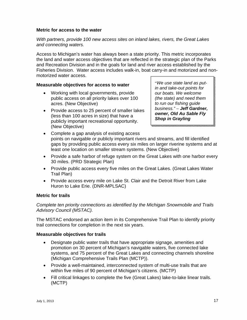
“We use state land as put-in and take-out points for our boats. We welcome (the state) and need them to run our fishing guide business.” – Jeff Gardner, owner, Old Au Sable Fly Shop in Grayling

July 1, 2013 18
Fill critical linkages to complete the proposed hike and bike trail system from Belle Isle to Wisconsin. (Governor Snyder)
Develop an interconnected snowmobile trail system on secure permanent easements.(MCTP)
Create an interconnected system of equestrian trails in southeast Michigan by connecting equestrian looped routes. (MCTP)
Provide at least 4,000 miles of safe and connected off-road vehicle (ORV) opportunities. (ORV Strategic Plan)
Develop bike connections to the state’s extensive off-road multi-use recreation trail network to create better access for communities, neighborhoods and families. (MCTP)
Complete the acquisition and development of the 400 undeveloped miles of the 1,150-mile North Country National Scenic Trail within the state. (MCTP)
Metric for urban recreation
Establish five signature urban parks with partners.
This metric is a priority action identified in The Future of Michigan’s Parks and Outdoor Recreation: A Report to Governor Rick Snyder, Sept. 23, 2012 by the Michigan State Parks and Outdoor Recreation Blue Ribbon Panel.
Measurable objective for urban recreation
Use parks and recreation as a key tool for revitalizing Michigan’s core urban areas by working with partners to establish five signature parks and integrate green infrastructure into Michigan’s urban redesign and redevelopment efforts. (Michigan State Parks and Outdoor Recreation Blue Ribbon Panel).
Metric for diversity of recreational offerings
Increase the percent of citizen’s satisfied with the diversity of recreation opportunities provided in the state.
The DNR will regularly conduct a survey of Michigan citizens to measure their use and enjoyment of Michigan’s outdoor recreation resources. The baseline survey of Michigan residents was conducted in 2012 to inform the 2013-2017 Statewide Comprehensive Outdoor Recreation Plan (SCORP). Seventy-nine percent of the respondents were satisfied or very satisfied with the amount of outdoor recreation in Michigan.
“(State land) is very valuable to our business, during hunting season, most of the campers who stay at Apple Creek use state land.” – Mary Ann Brennan, owner of Apple Creek Campground and RV Park in Grass Lake

July 1, 2013 19
Goal 2: Foster Regional Economic Prosperity
DNR-managed public lands provide critical support to the state’s land-based industries and regional economies. State forest lands provide more than 20 percent of the timber that supports Michigan’s $14 billion timber economy. It is an industry that wants to grow, said Chad Bisballe of Bisballe Forest Products in Lake City.
“State land is important to the viability of our forest product company. More land would help in bringing more wood to market—as long as the land does not get used for set aside areas or other restrictions when it does not warrant it.”-- Bisballe noted.
Governor Snyder recently noted the potential for expansion and the economic advantage that Michigan’s natural gas underground storage industry provides to the state. Access to state land for natural gas exploration is a definite business advantage, according to Glen W. Merrill, Jr., Senior Land Representative for ANR Pipeline Company in Big Rapids.
“The value of state land leases encourages the development of critical energy infrastructure benefiting Michigan’s energy users and the energy industry providing the service. Access to state land reduces the uncertainty and delay the energy projects would have if faced with having to negotiate with many individual land owners for easement rights,” Merrill noted.
Michigan’s rich and varied natural and cultural resources and recreational opportunities also support the state’s $17.7 billion tourism industry. Half of the state’s 6,200 miles of snowmobile trails are located on state land and provide a steady flow of winter visitors to northern Michigan communities. The two weeks of firearm deer season are financially critical in many rural areas, when hunters flood restaurants, hotels and grocery stores. Last year, Michigan state parks hosted over 22 million visitors who spent time and money in surrounding communities. State parks also exceeded one million camp nights. Michigan has world-class trout streams and visitors access these streams through sites developed and managed by the DNR. Communities like Vanderbilt were founded during the lumber era and now depend on the North Central State Trail and the Pigeon River Country State Forest for its economic prosperity. Emmet County is experiencing increased tourism because of their ‘dark sky’ area designation which includes Wilderness State Park, bringing in astronomy enthusiasts to have clear night views of stars, constellations, meteor showers, lunar eclipses and other celestial observations.
In Luce County, businesses know the value of being close to DNR-managed public lands and the recreation amenities they support, said Jomay Bomber, director of the Newberry Area Chamber of Commerce:
“Tourism is huge for Luce County and our biggest attractions are the natural resources. The #1 draw to this area is Tahquamenon Falls State Park. These visitors drive the local restaurant and hotel businesses. Because so many people visit the park, it has a big impact on the tourism in the area. The public land also draws people to the area for hunting, fishing and trail use, which is huge. I would estimate that at least 60 percent of the businesses in the county are tied to tourism. This does not include other businesses impacted by public lands, such as the logging industry.”

July 1, 2013 20
The economic benefits of public lands are well understood in western states. According to West is Best: How Public Lands in the West Create a Competitive Economic Advantage.2 “Western non-metropolitan counties with more than 30 percent of the county’s land base in federal protected status such as national parks, monuments, wilderness, and other similar designations increased jobs by 345 percent over the last 40 years. By comparison, similar counties with no protected federal public lands increased employment by 83 percent.” Similar to western states, Michigan has the natural resource assets to create a competitive economic advantage.
Desired outcomes for natural resource based industries
Outdoor recreation opportunities that enhance local and regional economies and assist in retaining and attracting youth and other critical workers.
Thriving and sustainable state forest products industries that support communities by providing jobs, products and diverse and resilient forests.
Michigan is one of America's favorite four seasons travel experience (Michigan Tourism Strategic Plan).
Strong and sustainable oil and gas industries that promote national security maximize production opportunities and minimize adverse impacts.
Extraction of non-renewable resources on DNR-managed public lands provides sustainable funding for investments in public land, another non-renewable resource.
Michigan’s unique geology is promoted for natural gas storage to stabilize energy costs and ensures natural gas supply.
Strong metallic and nonmetallic mineral industries that leverage unique geological opportunities minimize adverse resource impacts and provide sustained prosperity to local economies.
A renewable energy industry that becomes competitive by capitalizing on Michigan’s unique geology.
Vibrant fisheries and wildlife-based industries that promote Michigan’s world class fisheries and wildlife opportunities and sustain local economies.
Metric for forest products industry
Increase career-related forest products jobs by 10 percent.
This is a goal established for the forest products industry and endorsed at the Governor’s Forest Products Summit.
2 West is Best:How Publc Lands in the West Create a Competitive Economic Advantage, Headwater Economic, November 2012.
“Our state forest land base is a critical aspect of the raw material supply chain here in Michigan and was part of the decision to start our O.S.B. business here over 30 years ago.” – Todd Johnson, Forestry Services Manager, Weyerhaeuser NR Company

July 1, 2013 21
Measurable objective for forest products industry
The DNR will meet the sustainable timber harvest goals as established in the regional forest management plans. (New Objective)
Metric for mineral management
Increase the number of acres leased for mineral production and underground natural gas storage by 10 percent.
While the oil and gas and mineral industries have not established measurable objectives for the growth of their industries, the DNR is interested in supporting this important natural resource industry as measured by increasing the number of acres of state land leased for mineral production, while still protecting the State’s other natural resource values.
Measurable objectives for mineral management
Continue to hold regular oil and gas lease auctions to make leasable DNR-managed public lands available for production. (New Objective)
Metric for tourism
Increase by 10 percent, the attendance at the ten least visited state parks.
A recent article in Bridge Magazine indicated that six of the top ten tourist attractions in Michigan are managed by the DNR (Holland, Grand Haven, Warren Dunes, Mackinac Island, and Muskegon State Parks and Island Lake Recreation Area.) Increasing attendance at the ten least visited state parks helps to increase tourism throughout the state. Public lands are also vital for trails of all kinds, from snowmobile to mountain bike. The DNR is an active partner with Pure Michigan. All of these factors reflect the important role that DNR-managed public lands play in Michigan’s tourism industry and contribute to a growing tourism sector.
Measurable objectives for tourism
Three percent increase in tourism at historic parks. (Michigan Historical Center)
Increase nonresident state park passes from 250,000 to 275,000. (DNR Scorecard)
Increase overnight stays at marinas by 3 percent. (New Objective)
Increase the annual number of anglers that purchase a fishing license for the first time from 245,790 to 260,000. (DNR Scorecard)
Increase the number of new hunters who purchase a hunting license from 99,361 to 110,000 each year. (DNR Scorecard)
Increase participation in nonconsumptive wildlife-based outdoor recreation by 10 percent. (Wildlife Division’s GPS)
Implement a marketing strategy that highlights Michigan’s unique natural and cultural assets in partnership with Pure Michigan. (New Objective)
Measurable objective for wildlife and fisheries-based industries
Maintain the number of licensed charter boats above 500 statewide. (New Objective)

July 1, 2013 22
Goal 3: Protect Natural and Cultural Resources
DNR-managed public lands contain significant natural and cultural resources that, considered as a whole, make Michigan a special place. Nestled in the Great Lakes, with a tapestry of varied of ecosystems, Michigan is home to an enormous variety of wildlife and fish species, diverse forest systems and numerous outdoor recreation opportunities that provides a means for people to connect with the natural world. Receding glaciers left Michigan with unique geological features, including a legacy of world class trout streams supported by ever-flowing cold groundwater and thousands of lakes. Some of these, like the state’s big inland lakes, are found nowhere else in the world. The quality of our Great Lakes depends on natural systems, like coastal wetlands and healthy rivers that flow into the Great Lakes. Cultural resources -- archaeological sites, landscapes shaped by human activity and standing structures -- all reflect the unique ways that people have interacted with Michigan’s natural resources and made the places of Michigan their own. Michigan’s spectacular natural resources draw visitors from around the world. Providing ample access to the state’s natural resources in turn supports thousands of small businesses.
“As a small business owner and a commercial fishing guide, it is extremely valuable to utilize state land access sites and rivers. In my business, standing in a state-owned river is a must and showing customers the closest access site is always helpful,” said John Karakashian, a fishing guide with Baldwin Bait & Tackle, who works with customers on the Pere Marquette and Muskegon rivers. “More access and availability of state land opens up recreational opportunities to residents and visitors. Through those opportunities more licenses will be sold to outdoor users. A reduction in access sites will limit users and reduce revenue -- not to mention reduce tourist spending throughout the state.”
Protecting both natural and cultural resources and natural systems is the state’s responsibility as recognized in the Michigan Constitution. Degradation or loss of public land directly impacts many aspects of the state’s economy – forest products, tourism, oil and gas production, hunting and fishing, mineral development and countless small businesses that rely on outdoor recreation pursuits. Degradation or loss of natural functions (e.g. flood retention, pollution prevention, and water filtration) requires the lost function(s) to be replaced with often more costly engineered solutions. Protecting the natural and cultural resources on DNR-managed lands ensures continued contribution to the state’s economy and sustainable quality of life for the citizens of the state.
Desired outcomes for protecting natural and cultural resources
• Future generations have an opportunity to also experience high-quality natural and cultural resources.
• Diversity of resilient cover types and natural communities sustain healthy ecosystems and species populations for future generations and economic prosperity.
• Michigan’s identity as the Great Lakes State is sustained.
July 1, 2013 23
Metric for cover types and population goals
Double the number of fish and wildlife habitat projects accomplished with partners.
Fish and wildlife habitat projects completed with partners, are critical to the long-term health of DNR-managed state land and to sustainable and abundant fish and wildlife populations. One of the outcomes from the passage of the hunting and fishing license restructuring package will be additional grant dollars directed to habitat improvement projects by partners.
Measurable objectives for cover types and population goals
• Achieve habitat management goals for grassland, mesic conifer, aspen cover types and wetlands to assist in achieving the goals as stated in the Upper Mississippi & Great Lakes Region Joint Venture (waterfowl), Michigan Pheasant Restoration Initiative, American Woodcock Conservation Plan and North American Waterfowl Management Plan.
• Achieve population goals for state and federally-listed nongame species as defined in recovery plans including those for the Karner Blue Butterfly, Kirtland’s Warbler and Piping Plover.
• Double the number of acres involved in habitat partnership projects from the 2013 baseline. (New Objective)
Metric for healthy forest
Maintain annual forest certification
A variety of age classes and tree types needs to be actively managed in order to promote vigorous and healthy forests, reduce the impacts of large scale outbreaks from major forest pests, and minimize the growth and impacts of catastrophic disturbances. Certification substantiates that the DNR is appropriately managing public lands to ensure healthy forests.
Measurable objective for healthy forest
Pursue and maintain third-party certification to ensure sustainable healthy forests. (New Objective)
Forest certification promotes the sustainable management of forest ecosystems resulting in healthy forests. A matrix of forest age classes needs to be actively managed in order to promote vigorous and healthy forests, preclude the impacts of large scale outbreaks from some major forest pests, and minimize the growth and impacts of catastrophic disturbances.
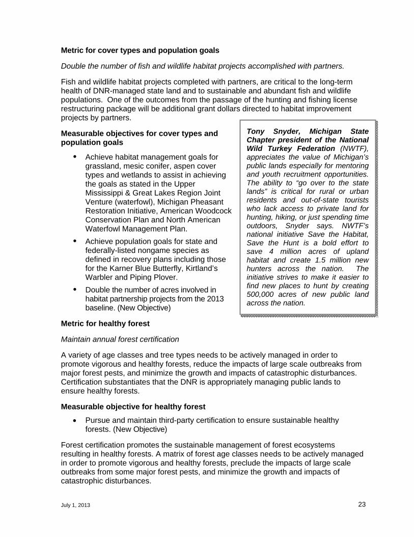
Tony Snyder, Michigan State Chapter president of the National Wild Turkey Federation (NWTF), appreciates the value of Michigan’s public lands especially for mentoring and youth recruitment opportunities. The ability to “go over to the state lands” is critical for rural or urban residents and out-of-state tourists who lack access to private land for hunting, hiking, or just spending time outdoors, Snyder says. NWTF’s national initiative Save the Habitat, Save the Hunt is a bold effort to save 4 million acres of upland habitat and create 1.5 million new hunters across the nation. The initiative strives to make it easier to find new places to hunt by creating 500,000 acres of new public land across the nation.

July 1, 2013 24
Metric for diversity
Achieve Forest Stewardship Council (FSC) and Sustainable Forest Initiative (SFI) standards for biodiversity management within state forests.
Annual audits are conducted on state-managed forests by FSC and SFI to ensure that the state forests are managed to meet the requirements of forest certification. Certification requires integrated management of biological, social and economic factors.
Measurable objective for diversity
Maintain or enhance quality of natural communities found in designated areas such as Natural Areas, Natural Rivers, or Critical Dunes. (New Objective)
Metric for protection of cultural resources
Complete cultural features spatial comprehensive database
A comprehensive database of known cultural features on state lands needs to be completed to advance the protection of Michigan’s cultural resources. This metric reflects an important first step in meeting the outcome of future generations having an opportunity to experience Michigan’s natural and cultural resources.
Measurable objectives for cultural protection
Work with partners to develop a protection strategy for ten critical, culturally-significant, rare and unique places in state parks. (Parks and Recreation Division’s Strategic Plan and Governor’s Blue Ribbon Panel on State Parks and Outdoor Recreation)
Develop a comprehensive database of known cultural features on state land. (New Objective)
Metric for protection of aquatic resources
Increase the miles of corridors under active management for each aquatic habitat classification by 20% from a baseline established in 2013.
Healthy aquatic habitats depend on the use of the land and how water travels through the landscape. Priority watersheds will be managed through DNR and partnership initiatives to maintain and restore aquatic habitats and their connectivity.
Measurable objectives for protection of aquatic resources
Develop a strategy using current GIS-based classification systems to protect representative river, lake, and Great Lakes coastal habitats in each region by 2015. (New Objective)
Conserve and manage aquatic species and their habitats as identified in Fisheries Division’s strategic plan, Charting the Course. (New Objective)
“We depend on state land for our survival. We cater almost entirely to folks who enjoy the outdoors – fly-fishers, hunters, hikers, bird watchers, mountain bikers. All these pursuits, so popular among our customers, depend on public lands. Access to state lands offered by this area of Michigan is one of the main attractions of a trip ‘Up North.” –Josh Greenberg, owner of Gates Au Sable Lodge in Grayling

July 1, 2013 25
PART TWO - LOOKING TO THE FUTURE
Part Two of the Strategy outlines how the DNR will manage public lands and activities associated with public lands differently in the future. It identifies a new approach for strategic investment in and disposal of DNR-managed public lands to focus land ownership that provides for quality outdoor public recreation opportunities, protects natural and cultural resource protection and fosters regional economic prosperity. The Strategy also discusses seven new ways that DNR’s activities associated with public land management will change. To ensure that DNR-managed public lands are meeting local needs, the DNR will engage more with local and regional units of government to understand their priorities, participate in regional planning efforts, and collaborate on land ownership issues.
How the DNR will Refocus Public Lands Ownership
In response to the question “what public lands should the DNR manage,” the following section describes the process the DNR will utilize going forward to balance the state’s portfolio of public lands.
The DNR continuously engages in acquisition, exchange or disposal of land to meet its diverse mission. To guide the future of DNR’s public land ownership, a new strategy will be used for both strategic investments and disposal of state lands. The intent of this new approach is to focus ownership on priority areas, ensure quality outdoor public recreation opportunities, protection of natural and cultural resources and foster regional economic prosperity. It will also increase efficiencies in state land management.
The new strategic direction will be implemented in a four-phased approach:
Phase 1: Identify State Lands for Disposal
The DNR will identify lands for potential disposal under five considerations:
1. Lands that are either 200 acres or less and do not adjoin other DNR- managed public lands or the irregular shape of their boundaries makes them difficult to administer. Lands meeting these criteria have been mapped and total approximately 240,000 acres.
2. Lands lacking public access.
3. Lands nominated by field land managers because of concerns with management effectiveness or efficiencies, or to reduce user conflict.
“Chippewa Landing is a canoe livery/campground on the Manistee River that has been in business for 50+ years. For a majority of that time, the business has been located on privately-owned lands and operated under a lease with the landowners. Recently the landowners decided that they wanted to sell their property, putting the future of Chippewa Landing at risk. The State of Michigan acquired this property and in an effort to ensure continued public access to this stretch of the Manistee River, has continued the lease of the Chippewa Landing canoe livery and campground. In doing so, the future of this business is more secure. Chippewa Landing is dependent upon the State of Michigan ownership. This property is a very valuable asset to the State because without it, good public access for use of this stretch of the river would be nil. This is a unique property and I’m glad that the State owns it.” – Rick Walsh, business owner, Chippewa Landing in Manton

July 1, 2013 26
4. Lands that were identified as available for acquisition by conservation partners in the 2008 land consolidation effort but were not acquired.
5. Large blocks of land would be made available for exchange with other similar blocks of lands. This would offer the opportunity to consolidate state and private land ownership.
These acres will be reviewed by the DNR, local units of government and the public on a county-by-county basis utilizing criteria that recognize the outcomes, metrics and measurable objectives identified in this plan.
Phase 2: Focused Project Boundaries
Once the review has been completed, the DNR will establish updated project boundaries for state forests, state game areas, state wildlife areas, state recreation areas, and state parks with a goal of reducing privately-held inholding by one million acres. In most cases, boundaries will be tightened. In other cases, boundaries will be expanded to reflect priority acquisitions, especially in southern Michigan.
Phase 3: Disposal of or Strategic Investment in Identified Priority Lands
Disposal
An important component of this new strategic direction is to make effective use of those lands that are determined to be surplus to public needs. Conveyance of these parcels may be conducted in a manner that 1) provides for their continued protection of important natural or cultural resource or recreation values; 2) provides a means to purchase or exchange for more desirable replacement lands; or 3) supports local economic activities. These acres will be reviewed by the DNR, local units of government and the public on a county-by-county basis utilizing criteria that recognize the objectives and metrics identified in this plan. Based upon the criteria, parcels will be placed into one of four categories: dispose, offer to a local units of government or alternative conservation owner, make available for exchange, or retain in state ownership.
Evaluation criteria may include the following (additional criteria are in the Appendix):
Pertinence to the DNR’s mission and the Strategy’s desired outcomes;
Presence or absence of significant natural or cultural features, recreation facilities or potential, water access, trails or regional economic opportunities; or
Other relevant natural resource, public recreation, and cultural resource values;
An exchange or sale of these lands will result in an improvement in the location or pattern of state ownership and will provide for greater natural resource value.
Disposal Process
Lands will be offered to local units of government and Alternative Conservation Owner’s (ACO) for 30 days. Public Use deeds may be used where appropriate. Local units of government will be given first priority for acquisition.
The Legislature has 30 days to review all proposed land disposals.
The potential land disposal is also posted on the DNR website for at least 30 days to allow for public comment.

July 1, 2013 27
The public has an opportunity to provide comment on proposed disposals at the Natural Resources Commission prior to the formal approval of the land disposal by the Director.
Parcels will then be offered for sale through sealed bid auctions.
Any parcels remaining after the sealed bid auction will be available for direct purchase.
As with current practice, DNR-managed public lands are available for exchange at any time.
Proceeds from the sale of land are deposited into the fund that was used to purchase the lands. For example, the proceeds from the sale of lands purchased with the assistance of the Michigan Natural Resources Trust Fund (MNRTF) are deposited back into the MNRTF. Proceeds from the sale of lands acquired through tax reversion are deposited into the Land Exchange Facilitation Fund. Laws govern how the funds can be used.
Strategic Investment
Strategic acquisition of land in priority areas is a critical component of this new approach. Strategic investment will help achieve the DNR’s mission and desired outcomes by meeting one or more of the following criteria:
Complete the goals, outcomes and measurable objectives identified in the Strategy;
Contribute to existing initiatives or plans such as trail corridor acquisition for priority connections to surrounding communities or state or local facilities;
Resolve user conflict;
Improve the quality of the state’s land portfolio or the user’s experience.
Strategic Investment Process
Lands nominated for acquisition will be reviewed internally to ensure compliance with goals and measurable objectives.
If internally approved, the DNR will collaborate with the local units of government regarding the proposed purchase.
The Legislature has 30 days to review all proposed land acquisitions.
The potential land acquisition is also posted on the DNR website for at least 30 days to allow for public comment.
The public has an opportunity to provide comment on proposed strategic investments at the Natural Resources Commission prior to the formal approval of the land acquisition by the Director.

July 1, 2013 28
Phase 4: Maintain an Up-to-Date Public Land Base
In compliance with PA 240 of 2012, after six years the DNR and its partners will formally review the Strategy, considering changing land ownership and management priorities. On an on-going basis, the DNR and its partners will evaluate its land holdings, and as appropriate, will offer for sale, exchange or transfer those lands whose highest and best use would be to support local public priorities. This continuous process will assist in informing the MNRTF grant applications and the utilization of other acquisition funding sources.

July 1, 2013 29
Key Actions over the Next Six Years
Refocusing ownership, measuring progress toward meeting desired outcomes and implementing measurable objectives will precipitate significant change in the management of DNR-managed public lands and the engagement model of the DNR. The measurable objectives found in Part One will drive the DNR’s management over the next six years. In addition, the DNR will move forward with the following transparent actions as they related to the management of DNR managed lands.
Become Data Driven
The DNR has significant data that is utilized for management of wildlife and fisheries resources and the management of state lands for oil, gas, timber and mineral production and recreation which also may be valuable to assist in regional economic prosperity initiatives. To ensure that public lands are meeting the needs of Michigan’s citizens, visitors, wildlife and businesses, the DNR will do the following:
1. Conduct regular citizen surveys to keep current on outdoor recreation interests, needs, and satisfaction and emerging trends.
2. Complete the gap analysis called for by the Michigan State Park and Outdoor Recreation Blue Ribbon Panel on recreation assets, high quality rare or representative natural areas and other culturally significant assets to ensure that Michigan’s portfolio of public lands is assisting in implementing the Strategy and to help focus investments in priority areas.
3. Conduct regular analysis of recreational, hunting and fishing trends to determine changing facility and access needs.
4. Complete an analysis of the economic value of state lands and products from those lands. This analysis could be used by local and regional economic development initiatives as well as the DNR to make investment decisions.
5. Understand the recreation and resource drivers for retaining and attracting young people and target investments to those factors.
6. Continue to improve the use of metrics and indicators to measure and report progress toward meeting desired outcomes.
7. Gain an understanding of the data needs of local units of government, regional planning organizations and the private sector regarding natural and cultural resources and recreation. Supply the data in a useful format to help drive local initiatives.
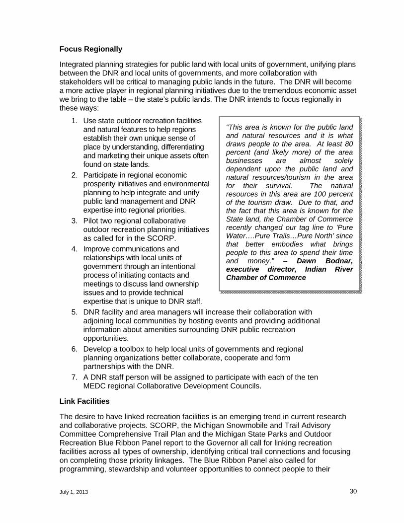
July 1, 2013 30
Focus Regionally
Integrated planning strategies for public land with local units of government, unifying plans between the DNR and local units of governments, and more collaboration with stakeholders will be critical to managing public lands in the future. The DNR will become a more active player in regional planning initiatives due to the tremendous economic asset we bring to the table – the state’s public lands. The DNR intends to focus regionally in these ways:
1. Use state outdoor recreation facilities and natural features to help regions establish their own unique sense of place by understanding, differentiating and marketing their unique assets often found on state lands.
2. Participate in regional economic prosperity initiatives and environmental planning to help integrate and unify public land management and DNR expertise into regional priorities.
3. Pilot two regional collaborative outdoor recreation planning initiatives as called for in the SCORP.
4. Improve communications and relationships with local units of government through an intentional process of initiating contacts and meetings to discuss land ownership issues and to provide technical expertise that is unique to DNR staff.
5. DNR facility and area managers will increase their collaboration with adjoining local communities by hosting events and providing additional information about amenities surrounding DNR public recreation opportunities.
6. Develop a toolbox to help local units of governments and regional planning organizations better collaborate, cooperate and form partnerships with the DNR.
7. A DNR staff person will be assigned to participate with each of the ten MEDC regional Collaborative Development Councils.
Link Facilities
The desire to have linked recreation facilities is an emerging trend in current research and collaborative projects. SCORP, the Michigan Snowmobile and Trail Advisory Committee Comprehensive Trail Plan and the Michigan State Parks and Outdoor Recreation Blue Ribbon Panel report to the Governor all call for linking recreation facilities across all types of ownership, identifying critical trail connections and focusing on completing those priority linkages. The Blue Ribbon Panel also called for programming, stewardship and volunteer opportunities to connect people to their
“This area is known for the public land and natural resources and it is what draws people to the area. At least 80 percent (and likely more) of the area businesses are almost solely dependent upon the public land and natural resources/tourism in the area for their survival. The natural resources in this area are 100 percent of the tourism draw. Due to that, and the fact that this area is known for the State land, the Chamber of Commerce recently changed our tag line to ’Pure Water….Pure Trails…Pure North’ since that better embodies what brings people to this area to spend their time and money.” – Dawn Bodnar, executive director, Indian River Chamber of Commerce

July 1, 2013 31
outdoor “places.” To link people and facilities across a broad range of ownership types with the outdoors, the DNR will:
1. Expand and adapt Recreation 101 programming, which teaches new outdoor skills to novices, both in state parks and with partner organizations, to grow the public’s use of outdoor recreation offerings and appreciation of resource stewardship.
2. Identify, prioritize, acquire and develop critical connections between DNR-managed facilities and between DNR-managed facilities and other recreational facilities and opportunities.
3. Establish a trails-oriented economic development program to link communities with DNR-managed trails. Lessons learned from this initiative will be applied to linking other DNR assets with surrounding communities.
4. Establish a pilot project to identify priorities associated with a river corridor, measures needed to protect the key values of that corridor, and the collaborators’ opportunities to address those measures. Lessons learned from the pilot project will be applied to other key river corridors.
5. Improve signage on all DNR-managed facilities and trails that link them to surrounding communities.
6. Implement the road plan identified as a measurable objective under Goal One.
7. With partners develop ten ‘experience’ trails to guide citizens and visitors around the state to see Michigan’s unique cultural and natural opportunities. The U.P. Iron Ore Heritage Trail is an example of an experience trail that allows users to appreciate Michigan’s iron ore heritage on a multi-use recreation trail. Examples of additional trails include a woodcock-hunting trail, a fly-fishing trail or a bird-watching trail or those listed in the Michigan State Parks and Outdoor Recreation Blue Ribbon Panel report.
Participate in Integrated Planning
The SCORP calls for improved collaboration and cooperation among all outdoor recreation providers to ensure that Michigan’s recreation system meets the needs and desires of its residents. The same collaboration and cooperation is needed to ensure that DNR-managed lands meet the needs of local and regional economies. Over the next six years, the DNR will:
1. Complete a southeast Michigan recreation plan with partners to identify roles, responsibilities, areas for expansion and strategies for meeting outdoor recreation needs. The plan will build upon the gap analysis discussed under the ‘Data Driven’ section, interest and need surveys, and priorities of the partnering organizations.
2. Work with the mineral industry and other resource-based sectors to help identify desired outcomes and measurable objectives for DNR-managed public lands, recognizing the need to balance multiple values and activities.
3. Participate in local and regional planning initiatives.

July 1, 2013 32
Increase Collaboration
As stated earlier, collaboration with partners is essential in protecting natural and cultural resources, providing quality outdoor public recreation opportunities and fostering regional economic prosperity. Bob Frye of Cross Country Ski Headquarters in Roscommon already collaborates with the state as a part of his tourism business. Frye leases state land to maintain a network of cross country ski trails for his business.
“I think this is a good example of how the private sector and the public sector can partner and add value for everyone without destroying the very ‘Pure Michigan’ part of northern Michigan that residents and tourists from many states and provinces have come here to love and enjoy,” Frye said.
Over the next six years, the DNR will work collaboratively with its partners to improve the outdoor recreation system of the state, enhance the quality and diversity of its facilities, grow Michigan’s resource-based economy, restore habitats and species and protect cultural resources. This is not a new approach, but the DNR recognizes that it can only meet its mission by increasing collaboration and partnerships. It will:
1. Improve the process by which citizens can become a ‘Friends’ organization to a DNR-managed facility or program.
2. Launch annual meetings among public, private and non-profit recreation providers to foster collaboration and cooperation, proactively resolve conflicts and coordinate among competing demands for the public land base.
3. Expand the fisheries and wildlife habitat restoration, improvement and enhancement programs with partner organizations.
4. Collaborate with other large property owners, the federal and local governments to work on large-scale land consolidation efforts that are mutually beneficial and provide a public benefit.
5. Collaborate with the forest products industry and other economic interests to expand employment opportunities, increase forest product markets, and coordinate competing demands on DNR-managed public lands.
6. Encourage the participation of Michigan artisans at state facilities.
Focus on the Quality of Facilities
SCORP, the Comprehensive Trail Strategy, and the Blue Ribbon Panel report all recognize the importance of maintaining quality facilities to retain and attract visitors.
Over the course of the next six years, DNR’s Parks and Recreation Division (PRD) expects to focus capital outlay funding on upgrading and replacing aging and obsolete infrastructure. Replacement/upgrades will use a ‘sustained contraction’ approach. For example, two campground restroom buildings may be replaced with one centrally located building. Reviewing recreation trends in camping will influence the level of electrical service being replaced in a campground rather than like-kind replacement. All infrastructure replacement will consider longevity and sustainability. Many underground septic systems are failing due to their age. PRD will reassess these systems to determine priorities for improvement, repair and replacement in order to protect the overall water quality of the surrounding area. PRD recently instituted a fund-match incentive to encourage local friends groups to raise funds for recreational elements, such as new play

July 1, 2013 33
equipment or a fishing pier. This approach helps PRD provide the recreational amenities that our customers value, while still allowing PRD to focus spending on major infrastructure improvements. Other measures include:
1. Guidelines for quality maintenance will be established for the DNR-managed trail system and other DNR-managed recreational facilities and regular inspections will be made to ensure compliance with guidelines.
2. Proactive enforcement strategies will ensure that visitors to DNR-managed facilities have fun, feel a sense of safety, environmental integrity is maintained and illegal use of DNR-managed lands is controlled.
3. Complete the DNR Facilities Inventory and analyze the results for opportunities for the most efficient use of existing and potential locations for customer service and staff support.
Increase Marketing
Over the next six years, the DNR will focus its marketing efforts to fully leverage all of the recreational, natural and cultural resource protection and economic benefits provided by DNR-managed public lands. To achieve this, the DNR will:
1. Continue to partner with Pure Michigan to promote Michigan’s natural and cultural features, and also improve its geo-referenced database to allow outdoor enthusiasts to better plan their outdoor fun and utilize the amenities provided by local communities.
2. Increase public understanding of natural resources management, recreation offerings and resource-based industries through the use of technology, including more Web-based tools like MI-Hunt, which allows hunters to identify public hunting lands, or mobile applications such as the downloadable audio tour of Porcupine Mountains Wilderness State Park.
3. Ensure that easily accessible maps are available for all DNR-managed facilities.
4. Collaborate with the public health community to highlight the linkages between outdoor recreation and opportunities for improved individual and family health.
5. Work with land-based industries to provide improved information and processes to help guide the industries’ investment decisions.
6. Improve the permitting system for events and use of state land to cross-market facilities, attract event users to surrounding communities, and better understand the economic impact of the events.
7. Improve marketing efforts to encourage the purchase of hunting and fishing licenses and increase camp night reservations.
8. Pilot two collaborations between the DNR and local convention and visitors bureaus to increase marketing of unique local and regional state managed assets.
9. Provide DNR’s photography and video to local marketing initiatives.

July 1, 2013 34
PART THREE - IMPLEMENTATION TIMETABLE
Part Three of the Strategy identifies the timetable for implementation of the new acquisition and disposal approach and the actions identified in Part Two.
One to six months
Gain legislative approval of the Public Land Management Strategy.
Meet with each of the ten MEDC Community Leadership Councils to present the assets and attributes of DNR-managed public lands and facilitate continuing discussions and action on utilizing these lands for regional prosperity initiatives.
Identify the gaps in the Belle Isle to Wisconsin hike and bike trail and begin acquisition and development where needed.
Complete the DNR Facilities Inventory.
Complete and adopt the DNR Comprehensive Trail Plan.
Meet with the five counties with the least percentage of DNR-managed lands to identify how to fulfill the measurable objectives identified in the Strategy as they relate to these counties.
In collaboration with the MNRTF Board of Trustees realign the Michigan Natural Resources Trust Fund criteria to reflect the goals and measurable objectives of the Strategy.
Begin integration and implementation of the Blue Ribbon Committee on State Parks and Outdoor Recreation Blue Ribbon Panel report, SCORP and Comprehensive Trail Plan.
Prepare an Implementation Plan for the Strategy.
Six months to one year
Continue disposal of surplus property through sale, transfer or exchange including the surplus lands identified from the original 240,000 acres. Ensure that disposal doesn’t depress local land prices or land use patterns.
Implement the new MNRTF criteria.
Utilize the results of input received through collaboration with counties and MEDC Community Leadership Councils to implement the strategy when applying for MNRTF.
Start the Implementation Plan.
Year Two
Dispose of additional surplus lands through sale, transfer or exchange
Analyze the results of the DNR Facilities Inventory for most efficient use of existing and potential locations for customer service and staff support.
Continue the Implementation Plan.


July 1, 2013 35
CONCLUSION
From its much-prized furs and forests in the 18th and 19th centuries to the modern, professionally managed woods, water and minerals, Michigan has long benefitted from its abundance of natural and cultural resources. Today, Michigan citizens and businesses demand investment in public lands as a way to grow the economy through tourism, forestry, oil and gas exploration, hunting and fishing and outdoor recreation. Tomorrow, our children will choose to stay in Michigan, and we will attract young people from elsewhere, because we use our wealth of land-based resources to reinvent Michigan, grow our economy, and create an unmatched quality of life.
“If you seek a pleasant peninsula, look about you” is the official motto of the state of Michigan. Keeping that promise requires nurturing opportunities for recreation, collaborating with natural resource-based industries and protecting ecosystems to keep them functioning and healthy. This Public Land Management Strategy ensures that DNR-managed public lands will continue to support this mission by providing quality outdoor public recreation facilities, protecting natural and cultural resources and fostering regional economic prosperity. This Strategy also ensures that DNR-managed public lands will be focused in priority areas and managed efficiently. It charts a course for DNR-managed public lands to play a more integrated role in regional prosperity initiatives and create a sense of place -- for now, and for the future -- by taking a collaborative approach with partners.
For generations, Michiganders have valued protection of natural resources and access to public lands on which they can enjoy and use those resources. These values are a part of nearly every Michigander’s experience – whether casting a line into the Detroit River at Milliken State Park in downtown Detroit, tracking a deer in the Pigeon River Country State Forest, hiking among the hemlocks at Porcupine Mountains Wilderness State Park or making a living in the forest products industry. The future of these resources, and future access for our children, is dependent upon an adaptable land management strategy that evolves with the trends, interests and needs of people, businesses and our communities.