ground water exploration- an · pdf fileground water exploration-an introduction. a...
TRANSCRIPT
11
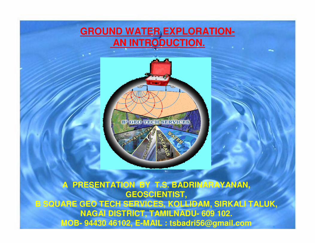
GROUND WATER EXPLORATION-AN INTRODUCTION.
A PRESENTATION BY T.S. BADRINARAYANAN, GEOSCIENTIST,
B SQUARE GEO TECH SERVICES, KOLLIDAM, SIRKALI TALUK, NAGAI DISTRICT, TAMILNADU- 609 102.
MOB- 94430 46102, E-MAIL : [email protected]
22
PRELUDEPRELUDE
•• Water is one of the MankindWater is one of the Mankind’’s most vital resources.s most vital resources.
•• An adequate supply of water is one of the preAn adequate supply of water is one of the pre--requisites requisites for development and industrial growth. for development and industrial growth.
•• In areas where surface water is not available, In areas where surface water is not available, Groundwater constitutes significant part of active fresh Groundwater constitutes significant part of active fresh water resources of the world and is obviously water resources of the world and is obviously dependable source for all the needs.dependable source for all the needs.
•• The stress on water resources started due to exploding The stress on water resources started due to exploding irrigation, domestic and industrial demands. irrigation, domestic and industrial demands.
•• The finite water resources are being explored to quench The finite water resources are being explored to quench the thirst of millions of the populace.the thirst of millions of the populace.
33
WATER NEEDS AND WATER NEEDS AND
CONSUMPTIONCONSUMPTION
•• In a developing country like India, the minimum daily In a developing country like India, the minimum daily
requirement of a person is 200 litres for domestic use, requirement of a person is 200 litres for domestic use,
while an equal or large amount will be needed for other while an equal or large amount will be needed for other
purposes.purposes.
•• It is estimated that out of the total of 1122 billion cubic It is estimated that out of the total of 1122 billion cubic
meters of water utilized in India annually, 430 billion meters of water utilized in India annually, 430 billion
cubic meters is met from surface sources and the rest cubic meters is met from surface sources and the rest
is met from ground water resources. is met from ground water resources.
[Source, Hand Book for TWAD Hydrogeologists, 2002].[Source, Hand Book for TWAD Hydrogeologists, 2002].
44
GROUND WATERGROUND WATER
•• Ground water is a mineral that occurs in the Ground water is a mineral that occurs in the subsurface within sediments, rocks, desertic subsurface within sediments, rocks, desertic sand, ice & snow.sand, ice & snow.
•• It gets replenished from meteoric precipitation.It gets replenished from meteoric precipitation.
•• Ground water is most widely distributed Ground water is most widely distributed precious resource of the Earth.precious resource of the Earth.
•• Among the natural water resources, ground Among the natural water resources, ground water forms an invisible component of the water forms an invisible component of the system.system.
55
GROUND WATERGROUND WATER
66
ORGIN OF GROUND WATERORGIN OF GROUND WATER
PRECIPITATION.
INFILTRATION
RECHARGE
77
GROUND WATER EXPLORATIONGROUND WATER EXPLORATION•• Though the ground water resources are widely distributed, NatureThough the ground water resources are widely distributed, Nature
does not provide ground water at the places of our choice.does not provide ground water at the places of our choice.
•• The occurrence and distribution of ground water resources are The occurrence and distribution of ground water resources are
confined to certain geological formations and structures.confined to certain geological formations and structures.
•• The ground water at all locations may not be directly used if thThe ground water at all locations may not be directly used if the e
quality of water is poor.quality of water is poor.
•• All these problems can be solved using proper exploration All these problems can be solved using proper exploration
techniques.techniques.
•• Explore is derived from Latin word Explore is derived from Latin word explorare explorare meaningmeaning-- to learn or to learn or
investigate.investigate.
•• The proper exploration of ground water resources involves apart The proper exploration of ground water resources involves apart
from source location, the well design and construction. These from source location, the well design and construction. These are are
all an integral part of the scheme of exploitation & management.all an integral part of the scheme of exploitation & management.
88
GROUND WATER EXPLORATIONGROUND WATER EXPLORATION--
HISTORYHISTORY
•• The development of water resources seems to The development of water resources seems to have started first in India & Egypt.have started first in India & Egypt.
•• Open wells for irrigation & drinking water were Open wells for irrigation & drinking water were in common use in India as early as in the in common use in India as early as in the Mahabharata period about 6,000 years ago.Mahabharata period about 6,000 years ago.
•• Exploitation of ground water on modern lines Exploitation of ground water on modern lines can be said to have started at the turn of the can be said to have started at the turn of the century. The first tube well was sunk in 1935 in century. The first tube well was sunk in 1935 in Uttar Pradesh. Uttar Pradesh.
99
OBJECTIVE OF GROUND WATER OBJECTIVE OF GROUND WATER
EXPLORATIONEXPLORATION•• Usually the ground water exploration projects Usually the ground water exploration projects
pass through the phase of regional surveys, pass through the phase of regional surveys,
leading to detailed surveys and ultimately leading to detailed surveys and ultimately
resulting in the exploitation of ground water by resulting in the exploitation of ground water by
means of bore holes, wells.means of bore holes, wells.
•• The main objective of these surveys is to study The main objective of these surveys is to study
and understand the hydrological cycle of the and understand the hydrological cycle of the
region, to have an overall concept about the region, to have an overall concept about the
type, nature & number of aquifers, the quality of type, nature & number of aquifers, the quality of
ground water.ground water.
1010
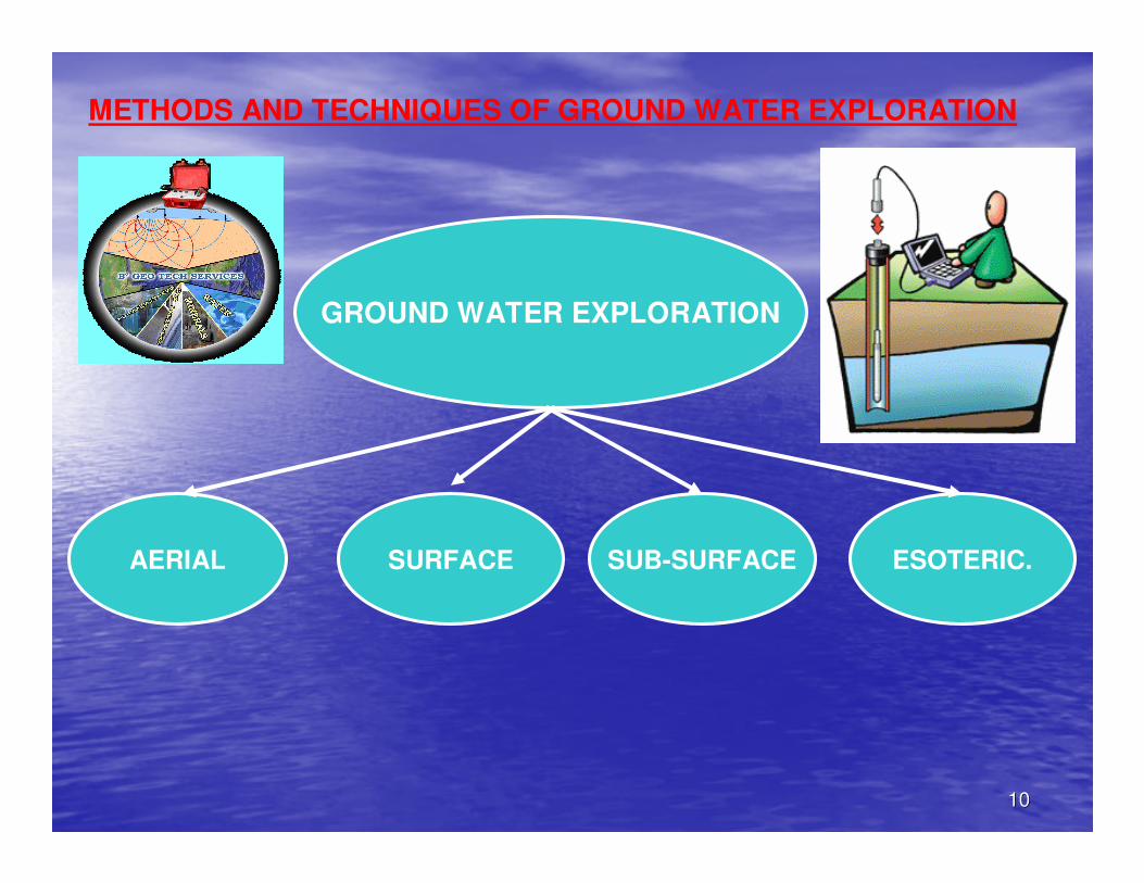
GROUND WATER EXPLORATION
AERIAL SURFACE SUB-SURFACE ESOTERIC.
METHODS AND TECHNIQUES OF GROUND WATER EXPLORATION
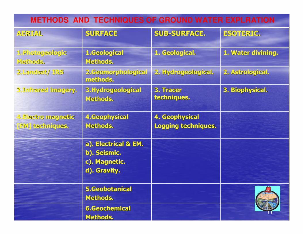
11116.Geochemical6.Geochemical
Methods.Methods.
5.Geobotanical5.Geobotanical
Methods.Methods.
a). Electrical & EM.a). Electrical & EM.
b). Seismic.b). Seismic.
c). Magnetic.c). Magnetic.
d). Gravity.d). Gravity.
4. Geophysical4. Geophysical
Logging techniques.Logging techniques.
4.Geophysical4.Geophysical
Methods.Methods.
4.Electro magnetic4.Electro magnetic
[EM] techniques.[EM] techniques.
3. Biophysical.3. Biophysical.3. Tracer 3. Tracer
techniques.techniques.3.Hydrogeological3.Hydrogeological
Methods.Methods.
3.Infrared imagery.3.Infrared imagery.
2. Astrological.2. Astrological.2. Hydrogeological.2. Hydrogeological.2.Geomorphological 2.Geomorphological
methods.methods.2.Landsat/ IRS2.Landsat/ IRS
1. Water divining.1. Water divining.1. Geological.1. Geological.1.Geological1.Geological
Methods.Methods.
1.Photogeologic1.Photogeologic
Methods.Methods.
ESOTERIC.ESOTERIC.SUBSUB--SURFACE.SURFACE.SURFACESURFACEAERIALAERIAL
METHODS AND TECHNIQUES OF GROUND WATER EXPLRATION
1212
1. AERIAL METHOD1. AERIAL METHOD
The most convenient methods for reconnaissance surveys The most convenient methods for reconnaissance surveys
of large areas aimed at identification of watershed of large areas aimed at identification of watershed
characteristics of basins and locating prospective areas are characteristics of basins and locating prospective areas are
the methods of aerial exploration.the methods of aerial exploration.

1313
1.1. REMOTE SENSING1.1. REMOTE SENSING
•• Remote sensing refers to obtaining reliable information about EaRemote sensing refers to obtaining reliable information about Earthrth’’s s
surface without physical contact, through the use of Electro magsurface without physical contact, through the use of Electro magnetic netic
radiation [EMR] as source energy and the sensors to record the iradiation [EMR] as source energy and the sensors to record the images.mages.
•• The aerial photos are those taken from an aircraft mounted with The aerial photos are those taken from an aircraft mounted with the the
cameras, which shoot directly the terrain within the visible specameras, which shoot directly the terrain within the visible spectrum or ctrum or
in the near infrared region. The photos are taken in panchromatiin the near infrared region. The photos are taken in panchromatic c
[black & white], color & infrared.[black & white], color & infrared.
•• The RS data are found extremely useful in identifying the variouThe RS data are found extremely useful in identifying the various s
geologic, geomorphic units, structures like faults, lineaments, geologic, geomorphic units, structures like faults, lineaments, joints, joints,
fractures, folds and drainage which are important since they confractures, folds and drainage which are important since they control the trol the
movement and occurrence of ground water.movement and occurrence of ground water.
1414
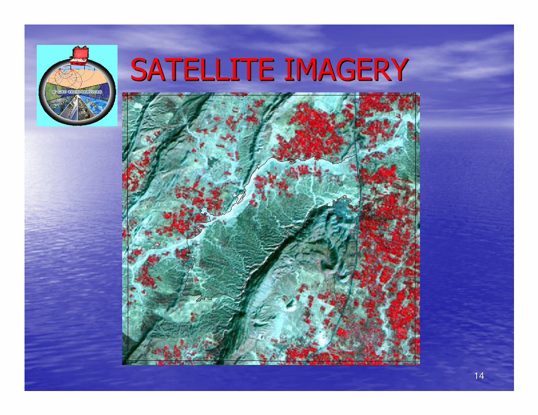
SATELLITE IMAGERYSATELLITE IMAGERY
1515
AERIAL PHOTOGRAPHYAERIAL PHOTOGRAPHY
•• Ground water investigation of an area requires Ground water investigation of an area requires the nature of lithological units, their structural the nature of lithological units, their structural dispositions, geomorphic set up, surface water dispositions, geomorphic set up, surface water conditions & climate of the area which can be conditions & climate of the area which can be studied through satellite images & aerial studied through satellite images & aerial photographs that provide detailed information photographs that provide detailed information about a large part of the surface of the earth in about a large part of the surface of the earth in a very short time.a very short time.
•• Remote sensing data do not directly detect Remote sensing data do not directly detect deeper subsurface resources, but RS techniques deeper subsurface resources, but RS techniques have been effectively used in ground water have been effectively used in ground water exploration.exploration.
1616
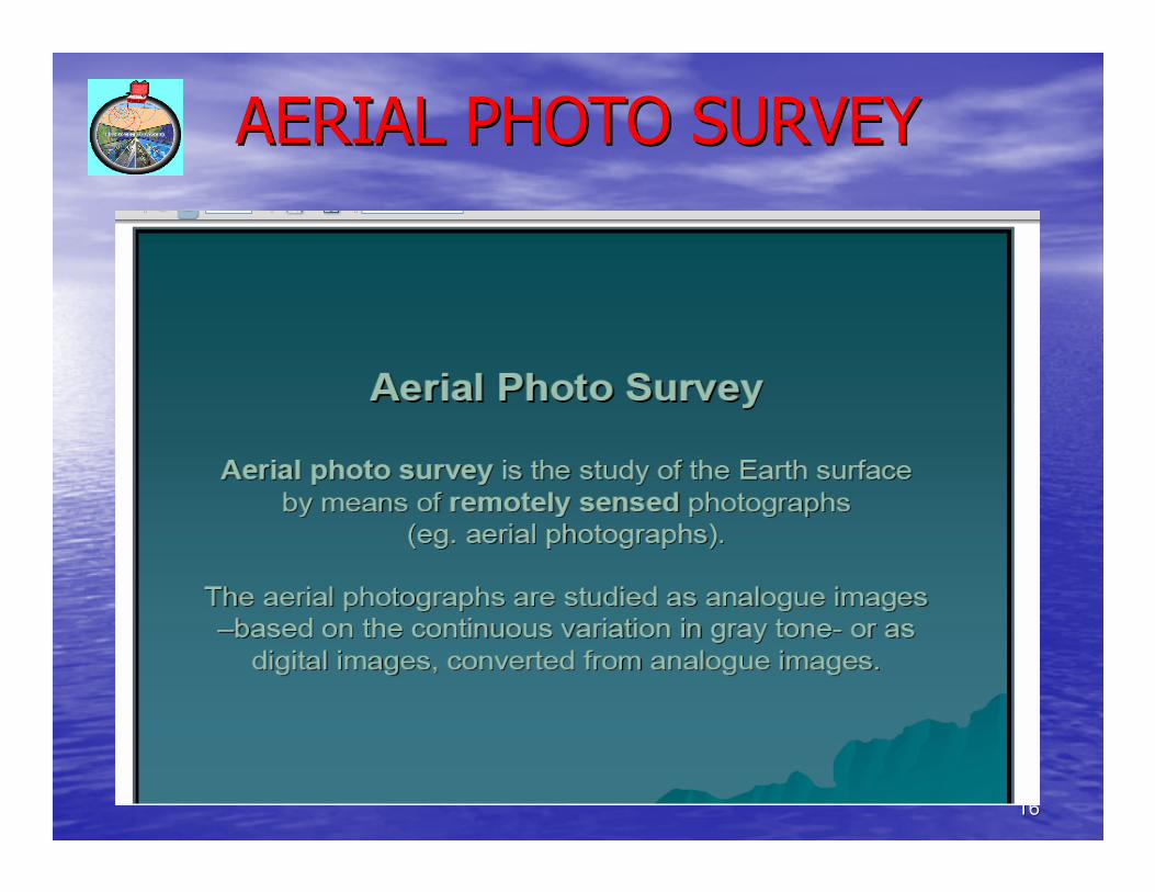
AERIAL PHOTO SURVEYAERIAL PHOTO SURVEY
1717
ADVANTAGES OF AERIAL PHOTO SURVEYADVANTAGES OF AERIAL PHOTO SURVEY
1818
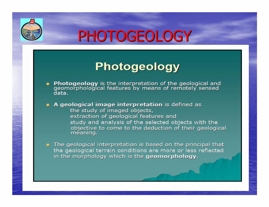
PHOTOGEOLOGYPHOTOGEOLOGY
1919
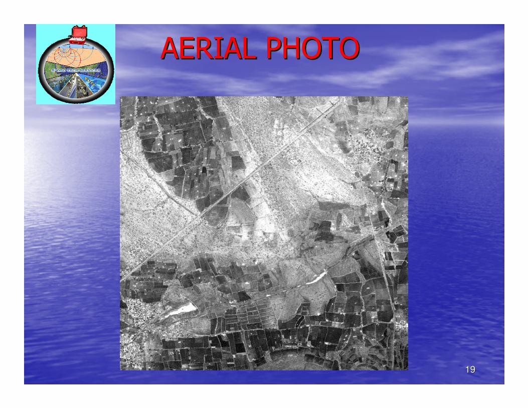
AERIAL PHOTOAERIAL PHOTO
2020
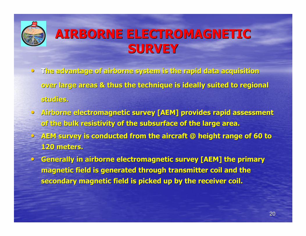
AIRBORNE ELECTROMAGNETIC AIRBORNE ELECTROMAGNETIC
SURVEYSURVEY
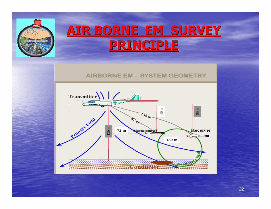
•• TThe advantage of airborne system is the rapid data acquisition he advantage of airborne system is the rapid data acquisition
over large areas & thus the technique is ideally suited to regioover large areas & thus the technique is ideally suited to regional nal
studies.studies.
•• Airborne electromagnetic survey [AEM] provides rapid assessment Airborne electromagnetic survey [AEM] provides rapid assessment
of the bulk resistivity of the subsurface of the large area.of the bulk resistivity of the subsurface of the large area.
•• AEM survey is conducted from the aircraft @ height range of 60 tAEM survey is conducted from the aircraft @ height range of 60 to o
120 meters.120 meters.
•• Generally in airborne electromagnetic survey [AEM] the primary Generally in airborne electromagnetic survey [AEM] the primary
magnetic field is generated through transmitter coil and the magnetic field is generated through transmitter coil and the
secondary magnetic field is picked up by the receiver coil.secondary magnetic field is picked up by the receiver coil.
2121
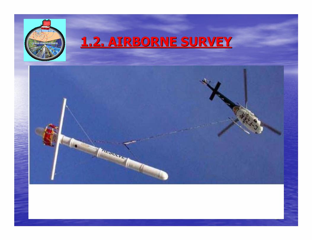
1.2. AIRBORNE SURVEY1.2. AIRBORNE SURVEY
2222
AIR BORNE EM SURVEY AIR BORNE EM SURVEY
PRINCIPLEPRINCIPLE
2323
2. SURFACE METHODS2. SURFACE METHODS
•• The most common and time tested The most common and time tested
methods are the surface variants of methods are the surface variants of
different techniques from geology, different techniques from geology,
geomorphology, hydrogeology, geophysics geomorphology, hydrogeology, geophysics
etc.etc.
•• These methods are applied where the These methods are applied where the
purpose is the detailed study of the purpose is the detailed study of the
distribution of potential water bearing distribution of potential water bearing
zones in lateral and vertical directions.zones in lateral and vertical directions.
2424
2.1. GEOLOGICAL METHODS2.1. GEOLOGICAL METHODS
•• The ground water occurrence and movement The ground water occurrence and movement mainly depend on the geology of the area. mainly depend on the geology of the area. Geological studies are very much essential. Geological studies are very much essential.
•• The type of terrain, rock formations, lithological The type of terrain, rock formations, lithological units, geological structures like lineament, fold, units, geological structures like lineament, fold, fault, joints and fracture system have to be fault, joints and fracture system have to be studied in depth.studied in depth.
•• Only after the geological investigations, the type Only after the geological investigations, the type of geophysical method to be conducted may be of geophysical method to be conducted may be decided. decided.
2525
2.2. GEOMORPHOLOGICAL 2.2. GEOMORPHOLOGICAL
METHODSMETHODS
•• After a thorough study of the satellite imagery After a thorough study of the satellite imagery
and geomorphology map, a field check is highly and geomorphology map, a field check is highly
necessary to know the geomorphological necessary to know the geomorphological
features to assess the ground water potential.features to assess the ground water potential.
•• The geomorphic units like pediments, flood The geomorphic units like pediments, flood
plains, drainage pattern, soil types, lineaments plains, drainage pattern, soil types, lineaments
which primarily control the occurrence, which primarily control the occurrence,
movement and potential of ground water have movement and potential of ground water have
to be investigated in detail.to be investigated in detail.
2626
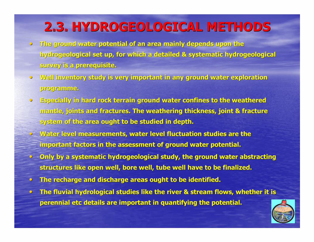
2.3. HYDROGEOLOGICAL METHODS2.3. HYDROGEOLOGICAL METHODS•• The ground water potential of an area mainly depends upon the The ground water potential of an area mainly depends upon the
hydrogeological set up, for which a detailed & systematic hydroghydrogeological set up, for which a detailed & systematic hydrogeological eological
survey is a prerequisite.survey is a prerequisite.
•• Well inventory study is very important in any ground water exploWell inventory study is very important in any ground water exploration ration
programme.programme.
•• Especially in hard rock terrain ground water confines to the weaEspecially in hard rock terrain ground water confines to the weathered thered
mantle, joints and fractures. The weathering thickness, joint & mantle, joints and fractures. The weathering thickness, joint & fracture fracture
system of the area ought to be studied in depth.system of the area ought to be studied in depth.
•• Water level measurements, water level fluctuation studies are thWater level measurements, water level fluctuation studies are the e
important factors in the assessment of ground water potential.important factors in the assessment of ground water potential.
•• Only by a systematic hydrogeological study, the ground water absOnly by a systematic hydrogeological study, the ground water abstracting tracting
structures like open well, bore well, tube well have to be finalstructures like open well, bore well, tube well have to be finalized.ized.
•• The recharge and discharge areas ought to be identified.The recharge and discharge areas ought to be identified.
•• The fluvial hydrological studies like the river & stream flows, The fluvial hydrological studies like the river & stream flows, whether it is whether it is
perennial etc details are important in quantifying the potentialperennial etc details are important in quantifying the potential. .
2727
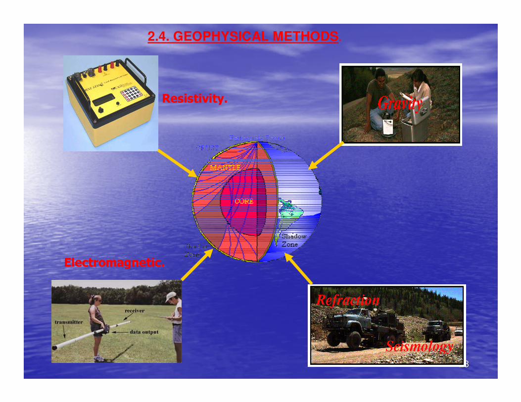
2.4. GEOPHYSICAL METHODS.
2828
2.4. GEOPHYSICAL METHODS.
Resistivity.
Electromagnetic.
2929
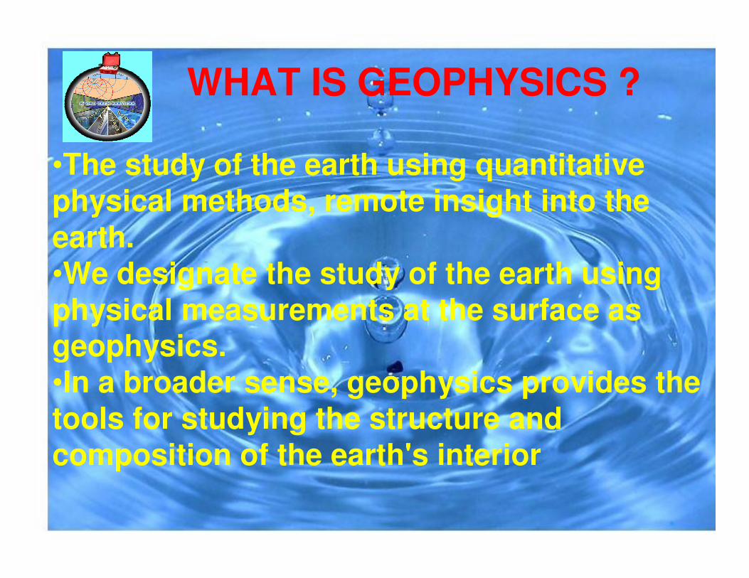
WHAT IS GEOPHYSICS ?
•The study of the earth using quantitative physical methods, remote insight into the earth.•We designate the study of the earth using physical measurements at the surface as geophysics. •In a broader sense, geophysics provides the tools for studying the structure and composition of the earth's interior
3030
GEOPHYSICAL INVESTIGATION
• Geophysical methods comprise of measurement of signals from natural or induced phenomena of physical properties of sub surface formation.• Various physical properties that are made use of in different geophysical techniques are electrical conductivity, magnetic susceptibility, density, elasticity & radioactivity.
3131
GROUND WATER GEOPHYSICS OR GROUND WATER GEOPHYSICS OR
HYDROGEOPHYSICSHYDROGEOPHYSICS
•• All ground water investigation All ground water investigation
requires the service of Geophysical requires the service of Geophysical
method as it aids in determining the method as it aids in determining the
subsurface structure.subsurface structure.
•• Exploring the ground water by Exploring the ground water by
geophysical method is termed geophysical method is termed
Ground water geophysics.Ground water geophysics.
3232
GEOPHYSICAL METHODS USED IN GEOPHYSICAL METHODS USED IN
GROUND WATER EXPLORATIONGROUND WATER EXPLORATION
•• A]. Electrical method.A]. Electrical method.
•• B]. Electro magnetic method.B]. Electro magnetic method.
•• C]. Seismic method.C]. Seismic method.
•• D]. Magnetic method.D]. Magnetic method.
•• E]. Gravity method.E]. Gravity method.
3333
2. 4A2. 4A-- ELECTRICAL PROSPECTING ELECTRICAL PROSPECTING
METHODSMETHODS
•• Electrical methods of prospecting include a large group of geophElectrical methods of prospecting include a large group of geophysical ysical
techniques employed for investigating the electrical fields of ttechniques employed for investigating the electrical fields of the earth.he earth.
•• Such fields are generated in the earth naturally or artificiallySuch fields are generated in the earth naturally or artificially by generators by generators
or batteries.or batteries.
•• The distribution & intensity of electrical fields depend on the The distribution & intensity of electrical fields depend on the source of source of
excitation as well as upon the electrical properties & geologicaexcitation as well as upon the electrical properties & geological structures l structures
in the region.in the region.
•• The different electrical properties that influence electrical fiThe different electrical properties that influence electrical fields are elds are
primarily the resistivity primarily the resistivity ρρ, the dielectric permeability , the dielectric permeability µµ & magnetic & magnetic
permeability permeability εε..
•• Electrical parameters vary depending upon the lithology & more iElectrical parameters vary depending upon the lithology & more influenced nfluenced
by the presence, content & quality of water.by the presence, content & quality of water.
3434
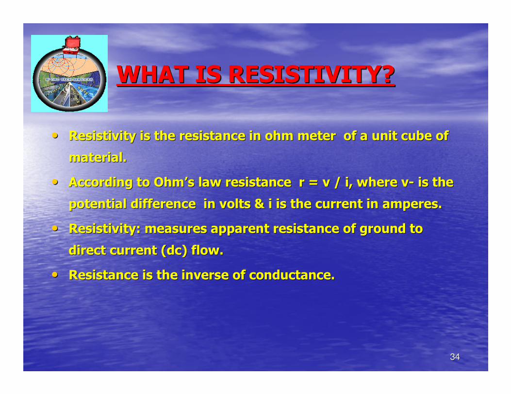
WHAT IS RESISTIVITY?WHAT IS RESISTIVITY?
•• Resistivity is the resistance in ohm meter of a unit cube of Resistivity is the resistance in ohm meter of a unit cube of
material.material.
•• According to OhmAccording to Ohm’’s law resistance r = v / i, where vs law resistance r = v / i, where v-- is the is the
potential difference in volts & i is the current in amperes.potential difference in volts & i is the current in amperes.
•• Resistivity: measures apparent resistance of ground to Resistivity: measures apparent resistance of ground to
direct current (dc) flow.direct current (dc) flow.
•• Resistance is the inverse of conductance.Resistance is the inverse of conductance.
3535
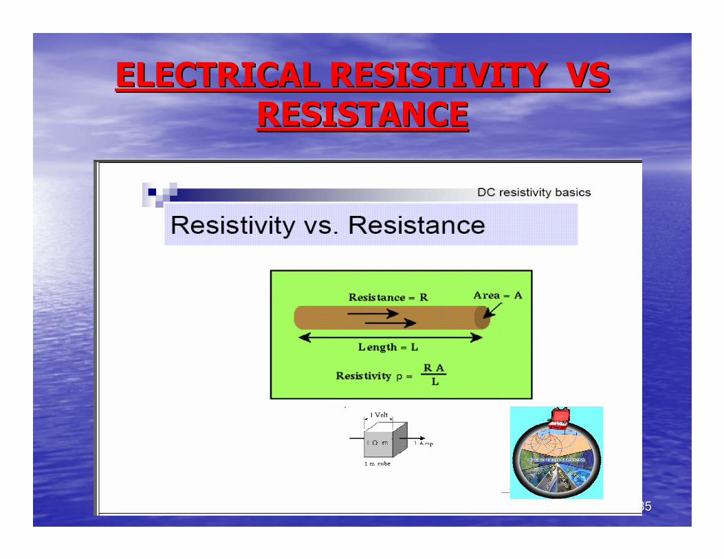
ELECTRICAL RESISTIVITY VSELECTRICAL RESISTIVITY VS
RESISTANCERESISTANCE
3636
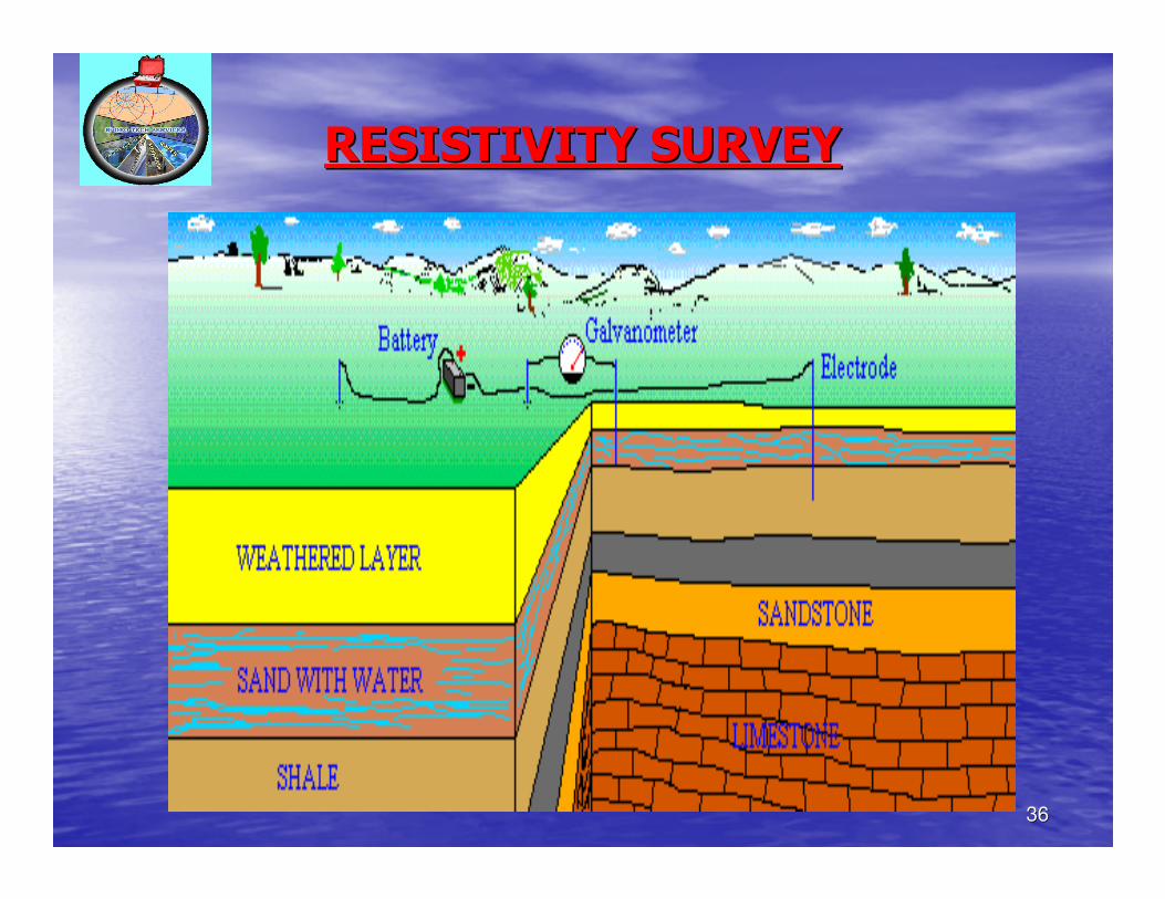
RESISTIVITY SURVEYRESISTIVITY SURVEY
3737
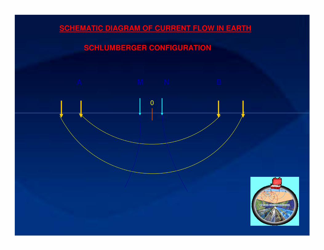
A M N B
SCHEMATIC DIAGRAM OF CURRENT FLOW IN EARTH
SCHLUMBERGER CONFIGURATION
0
3838
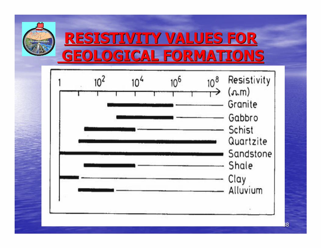
RESISTIVITY VALUES FORRESISTIVITY VALUES FOR
GEOLOGICAL FORMATIONSGEOLOGICAL FORMATIONS
3939
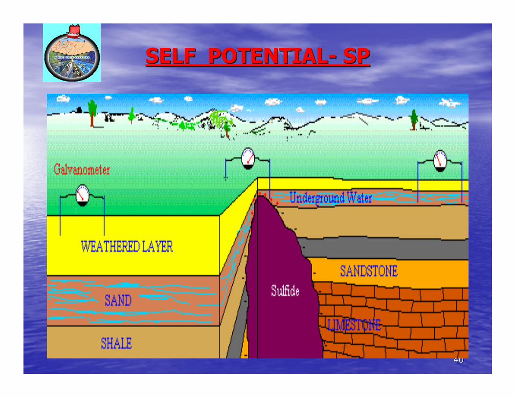
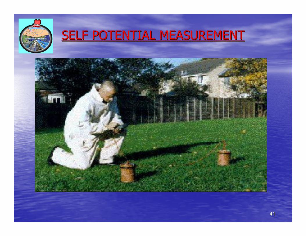
SELF OR SPONTANEOUS POTENTIALSELF OR SPONTANEOUS POTENTIAL-- SPSP
•• Self potential is naturally occurring electric potential in the Self potential is naturally occurring electric potential in the ground ground
due to several origin.due to several origin.
•• Self potential is of 3 kindsSelf potential is of 3 kinds--
•• Diffusion potential.Diffusion potential.
•• Membrane potential.Membrane potential.
•• ElectroElectro--kinetic potential.kinetic potential.
•• SP measurementsSP measurements-- 2 non2 non--polarizable electrodes & a high polarizable electrodes & a high
impedance milliimpedance milli--volt meter are sufficient to make sp volt meter are sufficient to make sp
measurements.measurements.
•• Two field methodsTwo field methods-- gradient & total field methods.gradient & total field methods.
4040
SELF POTENTIALSELF POTENTIAL-- SPSP
4141
SELF POTENTIAL MEASUREMENTSELF POTENTIAL MEASUREMENT
4242
2. 4B2. 4B-- ELECTROMAGNETIC METHODSELECTROMAGNETIC METHODS
•• Electromagnetic methods based on the measurement of Electromagnetic methods based on the measurement of
conductivity of subsurface minerals & formations conductivity of subsurface minerals & formations –– useful for useful for
exploring minerals & ground water.exploring minerals & ground water.
•• The flow of electrical current in conductor is always accompanieThe flow of electrical current in conductor is always accompanied d
by the presence of magnetic fields.by the presence of magnetic fields.
•• The interaction of electrical & magnetic fields is governed by The interaction of electrical & magnetic fields is governed by
MaxwellMaxwell’’s equation & well known laws of ampere & faraday.s equation & well known laws of ampere & faraday.
•• Geophysical methods make use of the interaction of electrical & Geophysical methods make use of the interaction of electrical &
magnetic fields with each other & their mutual interaction withmagnetic fields with each other & their mutual interaction with
matter to determine the properties of electrical conductivity ormatter to determine the properties of electrical conductivity or
magnetic permeability of the earth.magnetic permeability of the earth.
•• Telluric method makes use of the electric field due to naturallyTelluric method makes use of the electric field due to naturally
flowing earth currents by activities in the ionosphere.flowing earth currents by activities in the ionosphere.
•• Magnetic Magnetic –– telluric [MT] method makes use of the electromagnetic telluric [MT] method makes use of the electromagnetic
fields due to telluric earth currents & measures time variationsfields due to telluric earth currents & measures time variations for for
the deep subsurface structures.the deep subsurface structures.
4343
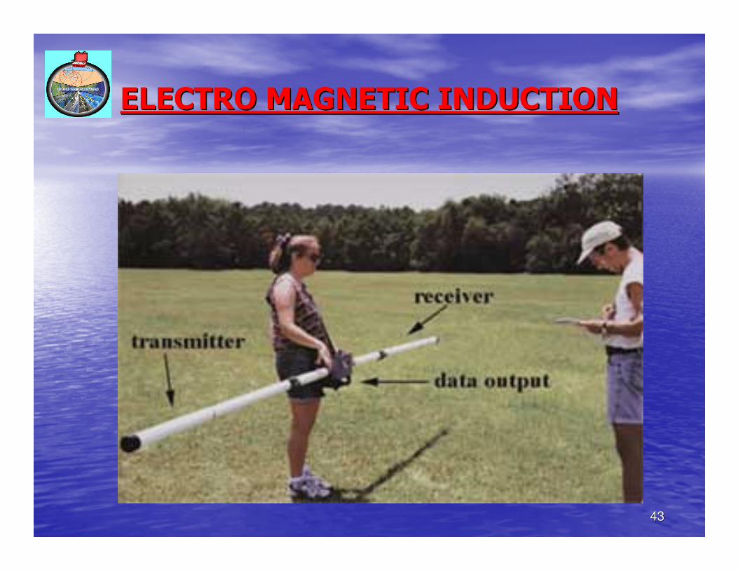
ELECTRO MAGNETIC INDUCTIONELECTRO MAGNETIC INDUCTION
4444
2. 4C2. 4C-- SEISMIC METHODSSEISMIC METHODS
•• Seismic prospecting developed from seismology, the science of Seismic prospecting developed from seismology, the science of
earth quakeearth quake-- also called applied / exploration seismology.also called applied / exploration seismology.
•• It has its basics in utilizing the propagational time of elasticIt has its basics in utilizing the propagational time of elastic waves waves
excited @ the surface.excited @ the surface.
•• The energy generated @ the source travels as waves & these The energy generated @ the source travels as waves & these
elastic waves have different transmission times.elastic waves have different transmission times.
•• Most widely used artificial sources of generating elastic waves Most widely used artificial sources of generating elastic waves are are
explosions explosions –– non explosive sources such as mechanical vibrations non explosive sources such as mechanical vibrations
are also used.are also used.
4545
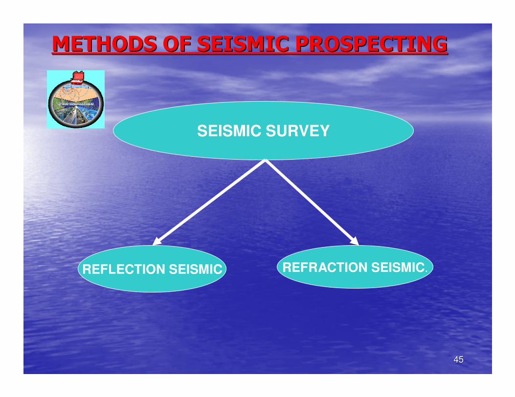
METHODS OF SEISMIC PROSPECTINGMETHODS OF SEISMIC PROSPECTING
SEISMIC SURVEY
REFLECTION SEISMIC REFRACTION SEISMIC.
4646
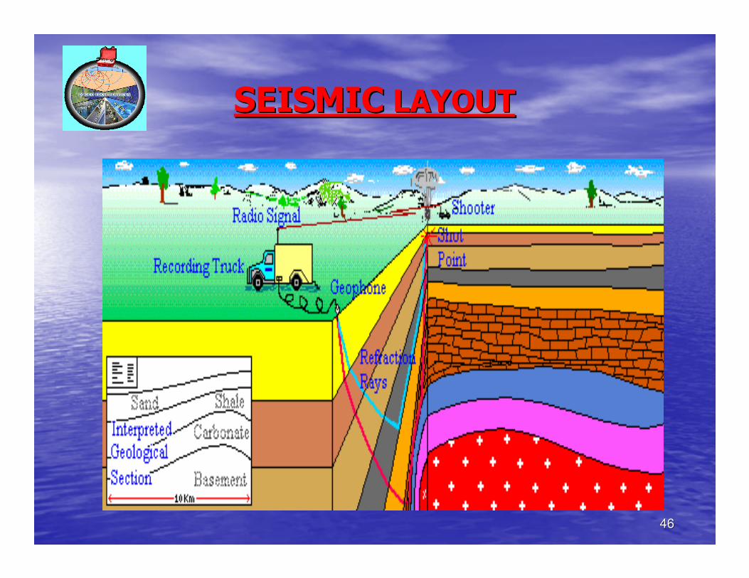
SEISMICSEISMIC LAYOUTLAYOUT
4747
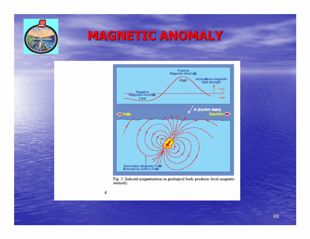
2. 4D2. 4D-- MAGNETIC METHODSMAGNETIC METHODS
•• Magnetic method based on the measurement of Magnetic method based on the measurement of
susceptibilty contrast between the anomalous susceptibilty contrast between the anomalous
body & the rock around it.body & the rock around it.
•• Ferromagnetic minerals particularly magnetite Ferromagnetic minerals particularly magnetite
are the main source of local magnetic anomalies. are the main source of local magnetic anomalies.
•• Instruments measuring magnetic susceptibility Instruments measuring magnetic susceptibility
are called magnetometersare called magnetometers-- different types different types ––
Schmidst & torsion magnetometers, the flux gate Schmidst & torsion magnetometers, the flux gate
magnetometer, the proton precision & rubidium magnetometer, the proton precision & rubidium
vapour magnetometers.vapour magnetometers.
4848
MAGNETIC ANOMALYMAGNETIC ANOMALY
4949
2. 4E2. 4E-- GRAVITY METHODGRAVITY METHOD
•• Measurements of the gravitational field at a series of differentMeasurements of the gravitational field at a series of different
locations over an area of interest. the objective in exploratiolocations over an area of interest. the objective in exploration n
work is to associate variations with differences in the distribuwork is to associate variations with differences in the distribution tion
of densities and hence rock types.of densities and hence rock types.
•• Based on the measurement of density contrast between the Based on the measurement of density contrast between the
anomaly causing body & the surrounding rocks.anomaly causing body & the surrounding rocks.
•• This method may be used for the exploration of minerals, ground This method may be used for the exploration of minerals, ground
water, oil & gas.water, oil & gas.
•• In mineral exploration this method is useful particularly for heIn mineral exploration this method is useful particularly for heavy avy
mineralsminerals-- barite & chromite.barite & chromite.
5050
GRAVITY SURVEY
5151
GRAVIMETERGRAVIMETER
5252
3. SUB3. SUB--SURFACE METHODSSURFACE METHODS
•• The subsurface methods are useful only The subsurface methods are useful only
where a borehole is available or can be where a borehole is available or can be
drilled for the purpose of verifying the drilled for the purpose of verifying the
results of surface investigations. results of surface investigations.
•• Quantitative data on aquifers is obtained Quantitative data on aquifers is obtained
to determine the suitability of aquifers for to determine the suitability of aquifers for
exploitation.exploitation.
5353
3.13.1-- GEOLOGICALGEOLOGICAL
•• Under subsurface geological methods, the bore Under subsurface geological methods, the bore
hole soil & rock samples collection is highly hole soil & rock samples collection is highly
essential to study the lithological units, to essential to study the lithological units, to
prepare liholog, to identify granular zones to prepare liholog, to identify granular zones to
locate the aquifers.locate the aquifers.
•• Litholog of a pilot bore hole is highly useful to Litholog of a pilot bore hole is highly useful to
correlate with geophysical logs to ascertain the correlate with geophysical logs to ascertain the
quality, well design & construction.quality, well design & construction.
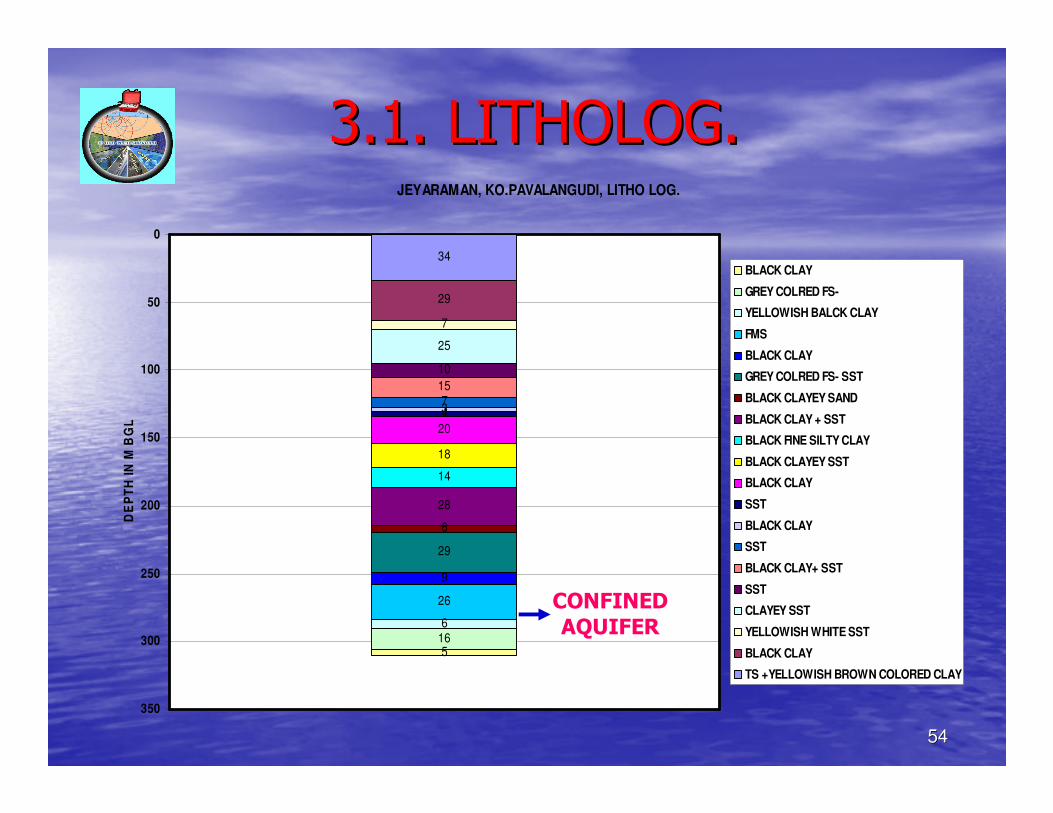
5454
3.1. LITHOLOG.3.1. LITHOLOG.JEYARAMAN, KO.PAVALANGUDI, LITHO LOG.
34
29
7
25
10
15734
20
18
14
28
6
29
9
26
6165
0
50
100
150
200
250
300
350
DE
PT
H I
N M
BG
L.
BLACK CLAY
GREY COLRED FS-
YELLOWISH BALCK CLAY
FMS
BLACK CLAY
GREY COLRED FS- SST
BLACK CLAYEY SAND
BLACK CLAY + SST
BLACK FINE SILTY CLAY
BLACK CLAYEY SST
BLACK CLAY
SST
BLACK CLAY
SST
BLACK CLAY+ SST
SST
CLAYEY SST
YELLOWISH WHITE SST
BLACK CLAY
TS +YELLOWISH BROWN COLORED CLAY
CONFINEDAQUIFER
5555
3.23.2-- HYDROGEOLOGICALHYDROGEOLOGICAL
•• Under sub surface hydrogeological methods, Under sub surface hydrogeological methods,
the water level studies, the aquifer system the water level studies, the aquifer system
studies & pumping tests are important.studies & pumping tests are important.
•• Pumping test is a controlled field Pumping test is a controlled field
experiment to find out the hydraulic experiment to find out the hydraulic
characteristics of an aquifer or the yield characteristics of an aquifer or the yield
characteristics of a well.characteristics of a well.
5656
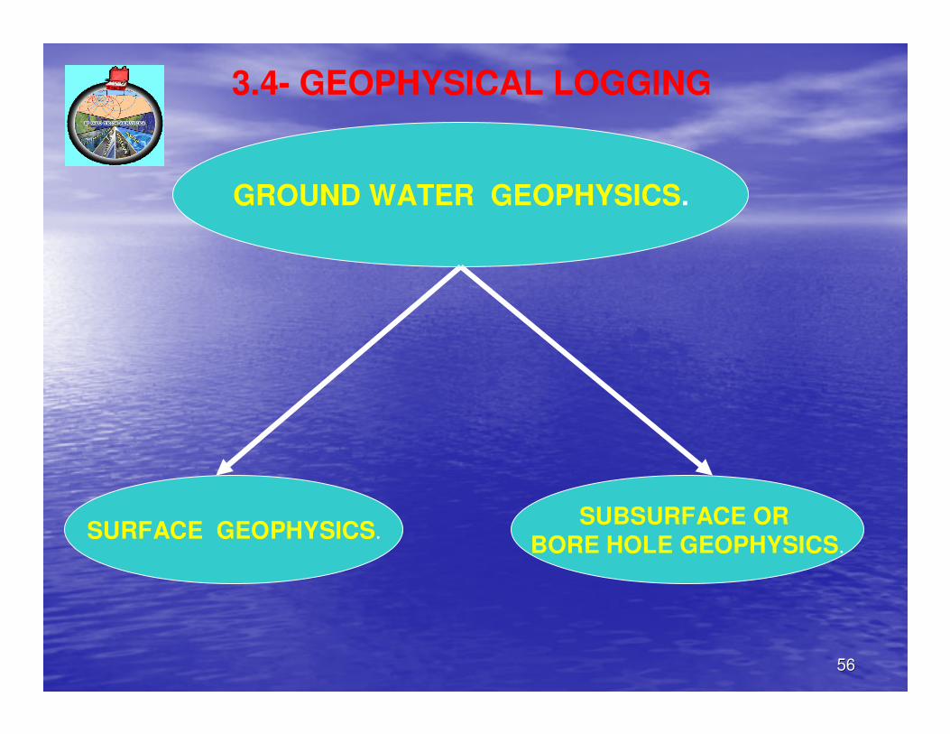
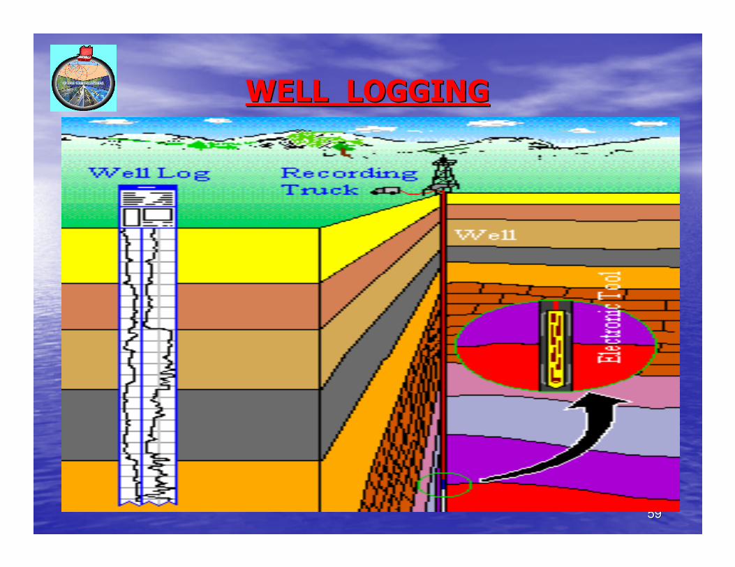
GROUND WATER GEOPHYSICS.
SURFACE GEOPHYSICS.SUBSURFACE OR
BORE HOLE GEOPHYSICS.
3.4- GEOPHYSICAL LOGGING
5757
3.4- GEOPHYSICAL LOGGING TECHNIQUES OR
BORE HOLE GEOPHYSICS- AN OUTLINE
• Geophysical logging of boreholes came a long way since 1927, when
Schlumberger brothers ran the firs electric log.
• In India the geophysical logging of water well was carried out for the
first time in 1953 by GSI, in Bihar.
• Basically there are two types of logging techniques- first utilizing the
natural source & second utilizing stimulated controlled source.
• Geophysical logging technique utilizes the measurement of certain
physical Parameters across different subsurface formations with the
help of sensing probe inside the bore hole providing a continuous
record of these parameters versus depth.
• These parameters are interpreted in terms of lithology, porosity,
moisture content & quality of formation fluids.
• Different physical properties like electrical conductivity, magnetic
susceptibility, radioactivity & velocity etc are utilized.
5858
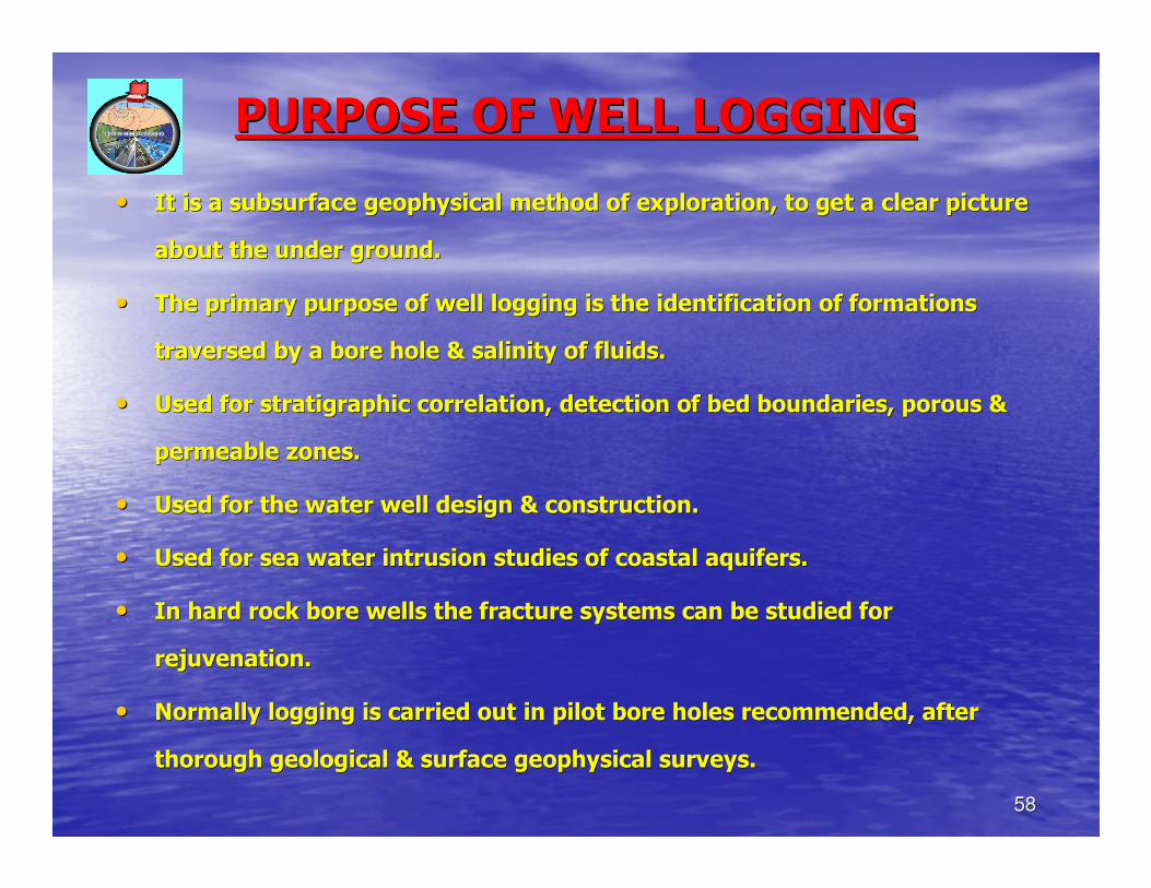
PURPOSE OF WELL LOGGINGPURPOSE OF WELL LOGGING
•• It is a subsurface geophysical method of exploration, to get a cIt is a subsurface geophysical method of exploration, to get a clear picture lear picture
about the under ground.about the under ground.
•• The primary purpose of well logging is the identification of forThe primary purpose of well logging is the identification of formations mations
traversed by a bore hole & salinity of fluids. traversed by a bore hole & salinity of fluids.
•• Used for stratigraphic correlation, detection of bed boundaries,Used for stratigraphic correlation, detection of bed boundaries, porous & porous &
permeable zones.permeable zones.
•• Used for the water well design & construction.Used for the water well design & construction.
•• Used for sea water intrusion studies of coastal aquifers.Used for sea water intrusion studies of coastal aquifers.
•• In hard rock bore wells the fracture systems can be studied for In hard rock bore wells the fracture systems can be studied for
rejuvenation.rejuvenation.
•• Normally logging is carried out in pilot bore holes recommended,Normally logging is carried out in pilot bore holes recommended, after after
thorough geological & surface geophysical surveys. thorough geological & surface geophysical surveys.
5959
WELL LOGGINGWELL LOGGING
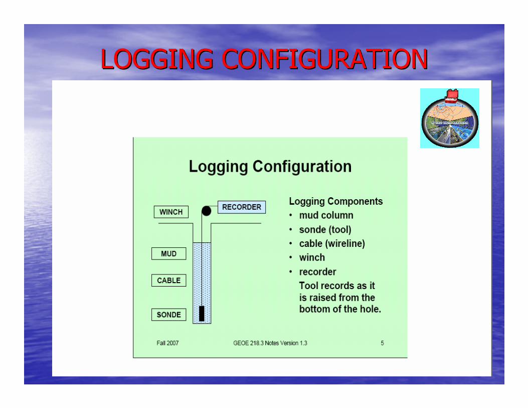
6060
LOGGING CONFIGURATIONLOGGING CONFIGURATION
6161
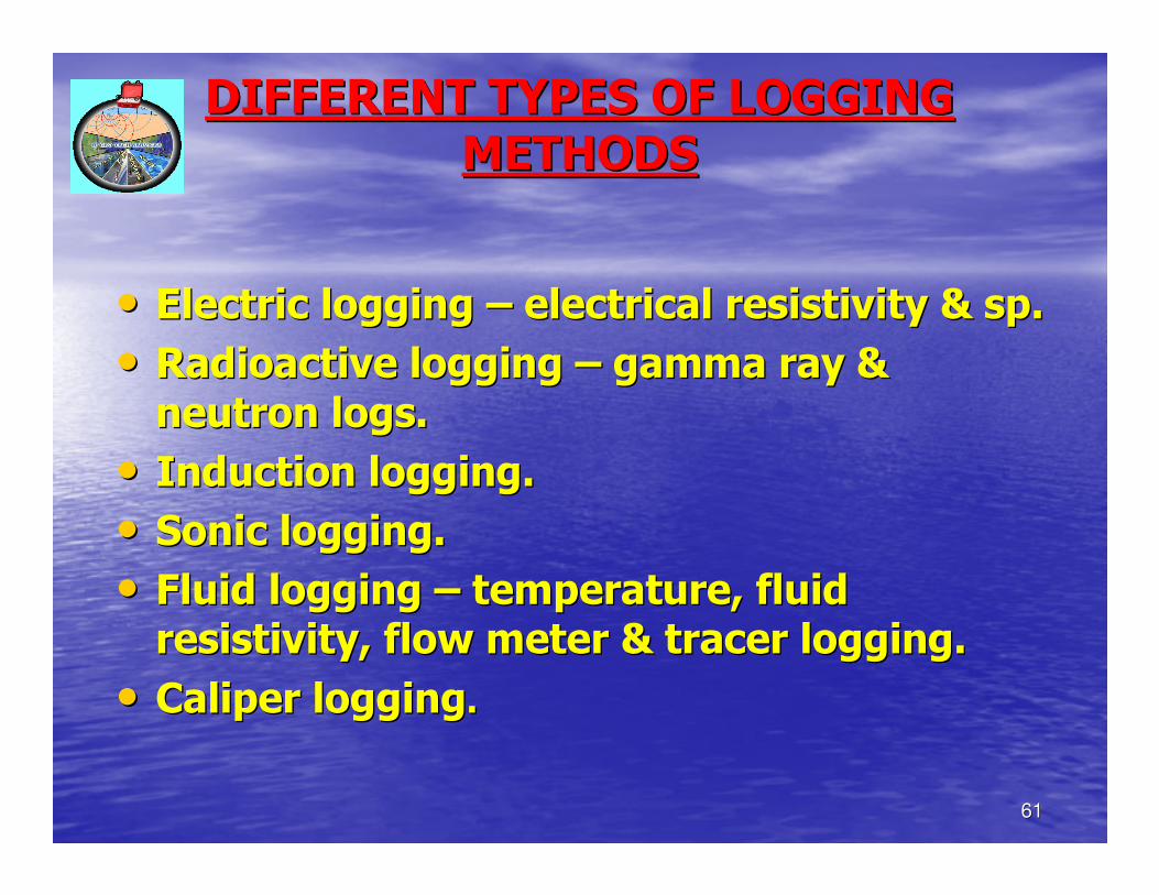
DIFFERENT TYPES OF LOGGING DIFFERENT TYPES OF LOGGING
METHODSMETHODS
•• Electric logging Electric logging –– electrical resistivity & sp.electrical resistivity & sp.
•• Radioactive logging Radioactive logging –– gamma ray & gamma ray &
neutron logs.neutron logs.
•• Induction logging.Induction logging.
•• Sonic logging.Sonic logging.
•• Fluid logging Fluid logging –– temperature, fluid temperature, fluid
resistivity, flow meter & tracer logging.resistivity, flow meter & tracer logging.
•• Caliper loggingCaliper logging..
6262
2.4.12.4.1-- ELECTRIC WELL LOGGINGELECTRIC WELL LOGGING
•• The continuous recording of electrical resistance / resistivity The continuous recording of electrical resistance / resistivity & sp of the formations & sp of the formations
by a drill bore hole is electric logging.by a drill bore hole is electric logging.
•• Point resistance & resistivity logsPoint resistance & resistivity logs--the response of formations in form of resistance the response of formations in form of resistance
offered to the electric conduction is measured in 2 modesoffered to the electric conduction is measured in 2 modes-- resistance & resistivity.resistance & resistivity.
•• Sp logSp log-- the potential drop between bore hole electrode & a reference elthe potential drop between bore hole electrode & a reference electrode @ the ectrode @ the
surface is recorded.surface is recorded.
•• Sp logs are highly useful in deciphering saline water & clay preSp logs are highly useful in deciphering saline water & clay predominant zones.dominant zones.
•• Resistivity logsResistivity logs-- normal resitivity logs are 4 electrode systemnormal resitivity logs are 4 electrode system-- used for ground water used for ground water
& mineral explorations.& mineral explorations.
6363
2.4.22.4.2-- RADIOACTIVE LOGGINGRADIOACTIVE LOGGING
•• The principle is that the atoms of a few naturally occurring The principle is that the atoms of a few naturally occurring
elements spontaneously disintegrate accompanied by elements spontaneously disintegrate accompanied by
radiations of alpha, beta & gamma rays.radiations of alpha, beta & gamma rays.
Principal uses Principal uses ––
•• Best suited to for lithology identification & stratigraphic Best suited to for lithology identification & stratigraphic
correlations.correlations.
•• Can be used in both in open holes & cased wells.Can be used in both in open holes & cased wells.
•• Depths & thickness of clay & non clay beds can be obtained.Depths & thickness of clay & non clay beds can be obtained.
•• Gamma ray data are valuable as a supplement to the Gamma ray data are valuable as a supplement to the
electric log, in particular to help identify thin clay layers & electric log, in particular to help identify thin clay layers &
porous zones in dense rocks.porous zones in dense rocks.
•• Neutron logs are useful in determining the porosity of Neutron logs are useful in determining the porosity of
formations.formations.
•• Radioactive mineral resources in the subsurface can be Radioactive mineral resources in the subsurface can be
identified.identified.
6464
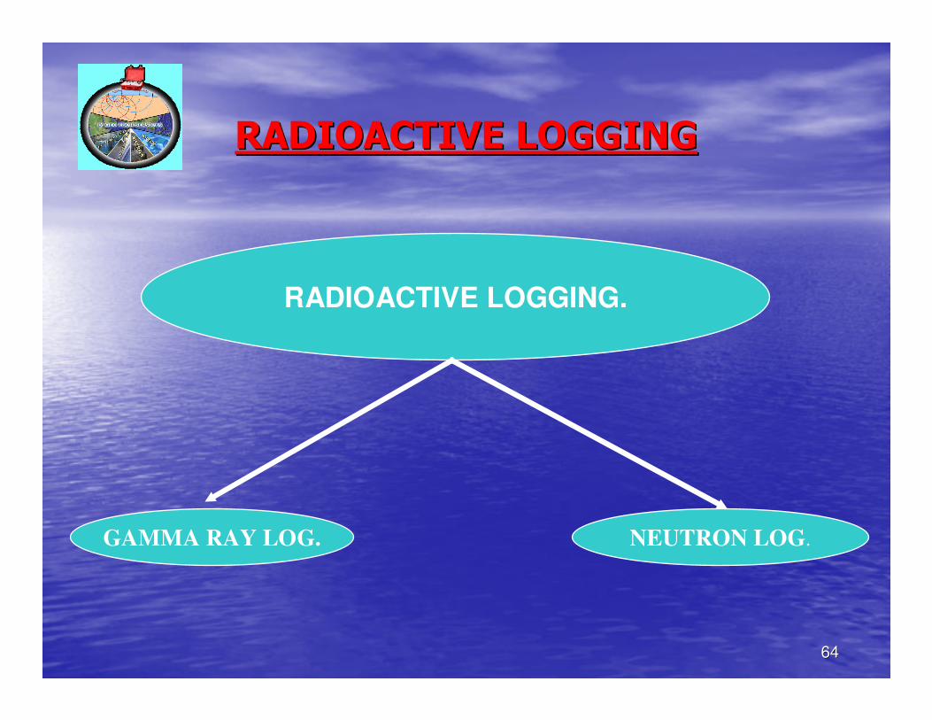
RADIOACTIVE LOGGINGRADIOACTIVE LOGGING
RADIOACTIVE LOGGING.
GAMMA RAY LOG. NEUTRON LOG.
6565
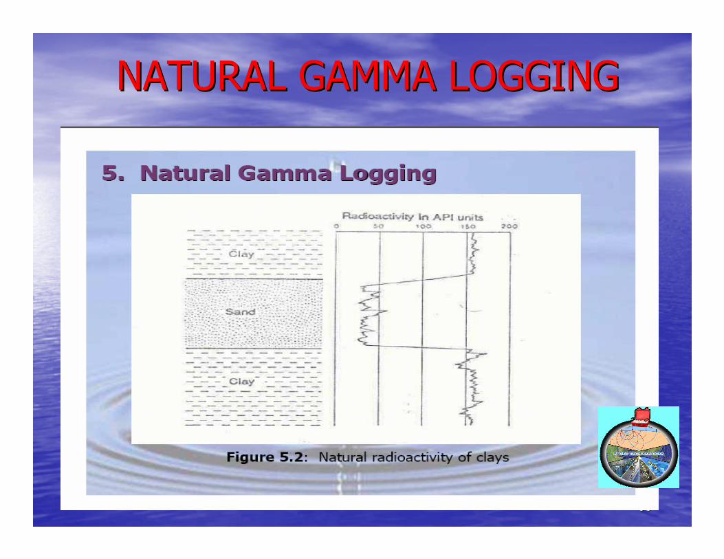
NATURAL GAMMA LOGGINGNATURAL GAMMA LOGGING
6666
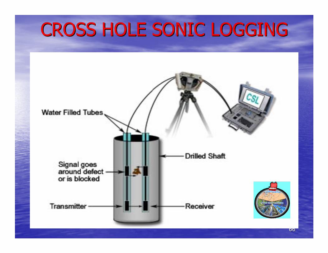
CROSS HOLE SONIC LOGGINGCROSS HOLE SONIC LOGGING
6767
2.6. GEOCHEMICAL METHODS2.6. GEOCHEMICAL METHODS•• Water quality is as important as quantity in hydrogeological stuWater quality is as important as quantity in hydrogeological studies.dies.
•• The science dealing with the chemical quality of water is calledThe science dealing with the chemical quality of water is calledHydrogeochemistry.Hydrogeochemistry.
•• Ground water comes into contact with various minerals which are Ground water comes into contact with various minerals which are soluble in water. The dissolved minerals determine the usefulnessoluble in water. The dissolved minerals determine the usefulness of s of the water for various purposes.the water for various purposes.
•• The presence of some minerals beyond certain limits may make it The presence of some minerals beyond certain limits may make it unsuitable for irrigation, drinking or industrial purposes.unsuitable for irrigation, drinking or industrial purposes.
•• The quality of water depends upon the total quantity of dissolveThe quality of water depends upon the total quantity of dissolved d solids depicted by parts per million.solids depicted by parts per million.
•• In any ground water development, it is essential to conduct In any ground water development, it is essential to conduct chemical analysis of representative samples of water. chemical analysis of representative samples of water.
•• Chemical analysis of water samples is done based on the purpose Chemical analysis of water samples is done based on the purpose of of usage. For drinking purpose physio chemical analysis of water usage. For drinking purpose physio chemical analysis of water sample is conducted to know the potability.sample is conducted to know the potability.
•• For each purpose there are water quality standards to be followeFor each purpose there are water quality standards to be followed.d.
6868
2. 62. 6-- GEOCHEMICAL METHODGEOCHEMICAL METHOD……..
•• The simplest classification of water is The simplest classification of water is
based on the TDS. The four main types of based on the TDS. The four main types of
water are fresh, brackish, saline & brine.water are fresh, brackish, saline & brine.
•• The water quality should satisfy the The water quality should satisfy the
requirements or standards set for the requirements or standards set for the
specific use, namely domestic, livestock, specific use, namely domestic, livestock,
agricultural and industrial purposes.agricultural and industrial purposes.
6969
2.62.6-- GEOCHEMICAL METHODGEOCHEMICAL METHOD……..
•• There are some critical parameters like total dissolved solids [There are some critical parameters like total dissolved solids [TDS], TDS],
hardness, alkalinity, fluoride, nitrate and iron to decide the chardness, alkalinity, fluoride, nitrate and iron to decide the chemical hemical
quality & potability of drinking water.quality & potability of drinking water.
•• The quality of ground water depends upon geology, hydrogeology, The quality of ground water depends upon geology, hydrogeology,
soils, exploitation, rain fall and so on.soils, exploitation, rain fall and so on.
•• Sea water intrusion and pollution are the other factors in qualiSea water intrusion and pollution are the other factors in quality ty
degradation.degradation.
•• Pollution of ground water may be defined as the artificially indPollution of ground water may be defined as the artificially induced uced
degradation. Pollution contaminates the water making it unfit fodegradation. Pollution contaminates the water making it unfit for r
usage creating hazards to public health.usage creating hazards to public health.
•• The major contaminant sources are septic tank systems, sanitary The major contaminant sources are septic tank systems, sanitary
land fills, chemical land fills & waste water disposal ponds.land fills, chemical land fills & waste water disposal ponds.
•• The main cause of pollution in coastal aquifers is the sea waterThe main cause of pollution in coastal aquifers is the sea water
intrusion which occurs when permeable formations outcrop into a intrusion which occurs when permeable formations outcrop into a
body of sea water and when there is a landward hydraulic gradienbody of sea water and when there is a landward hydraulic gradient. t.
7070
2. 52. 5-- GEOBOTANICAL METHODGEOBOTANICAL METHOD
•• Under surface method of ground water Under surface method of ground water
exploration, geobotanical method is the exploration, geobotanical method is the
very oldest since the ancient Rig, very oldest since the ancient Rig,
Adharvana Vedhas and Varahamihira, a Adharvana Vedhas and Varahamihira, a
versatile astronomer, hydrologist in 6versatile astronomer, hydrologist in 6thth
century in his magnum opus century in his magnum opus ““BRAHAT BRAHAT
SAMHITASAMHITA”” described termite mounds described termite mounds
associated with palm and neem trees as associated with palm and neem trees as
good hydrologic indicators.good hydrologic indicators.
7171
4. ESOTERIC METHOD4. ESOTERIC METHOD
•• Even from early ages, ground water prospecting Even from early ages, ground water prospecting
was carried out by water diviners, dowsers by was carried out by water diviners, dowsers by
following certain traditions and beliefs.following certain traditions and beliefs.
•• Water divining and dowsing methods are still in Water divining and dowsing methods are still in
practice, using Y shaped twigs, copper rods, key practice, using Y shaped twigs, copper rods, key
chain & wrist watch.chain & wrist watch.
•• These attempts were not always successful as These attempts were not always successful as
they were not based upon sound scientific they were not based upon sound scientific
reasoning. reasoning.
7272
GEOGRAPHIC INFORMATION GEOGRAPHIC INFORMATION
SYSTEM [GIS]SYSTEM [GIS]
•• A GIS is a computer system capable of capturing, storing, A GIS is a computer system capable of capturing, storing,
analyzing, and displaying geographically referenced information;analyzing, and displaying geographically referenced information;
that is, data identified according to location.that is, data identified according to location.
•• GIS is a computer based information system used to digitally GIS is a computer based information system used to digitally
represent & analyze the geographic features present on the represent & analyze the geographic features present on the
earthearth’’s surface.s surface.
•• Geographic information system (GIS) technology can be used for Geographic information system (GIS) technology can be used for
scientific investigations, resource management, and development scientific investigations, resource management, and development
planning. planning.
7373
COMPONENTS OF GISCOMPONENTS OF GIS
1.1. Hardware: GIS relies on a computer for storage & processing of dHardware: GIS relies on a computer for storage & processing of data.ata.
2.2. Software: The core of GIS system lies the GIS software itself prSoftware: The core of GIS system lies the GIS software itself providing oviding
the functionality to store, manage, link, query & analyze geograthe functionality to store, manage, link, query & analyze geographic phic
data.data.
3.3. Data: Data for GIS comes in two formsData: Data for GIS comes in two forms-- geographic or spatial data & geographic or spatial data &
attribute or spatial data.attribute or spatial data.
4.4. Methods: GIS systems are designed & developed to aid the data Methods: GIS systems are designed & developed to aid the data
management & decision support processes.management & decision support processes.
5.5. People: The system usersPeople: The system users-- those who will use the GIS to solve spatial those who will use the GIS to solve spatial
problems.problems.

7474
GIS COMPONENTS
7575
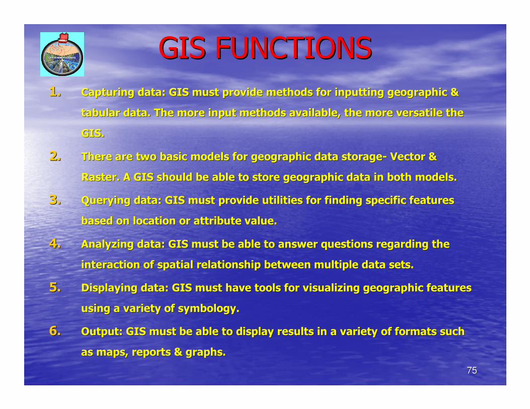
GIS FUNCTIONSGIS FUNCTIONS
1.1. Capturing data: GIS must provide methods for inputting geographiCapturing data: GIS must provide methods for inputting geographic & c &
tabular data. The more input methods available, the more versatitabular data. The more input methods available, the more versatile the le the
GIS.GIS.
2.2. There are two basic models for geographic data storageThere are two basic models for geographic data storage-- Vector & Vector &
Raster. A GIS should be able to store geographic data in both moRaster. A GIS should be able to store geographic data in both models.dels.
3.3. Querying data: GIS must provide utilities for finding specific fQuerying data: GIS must provide utilities for finding specific features eatures
based on location or attribute value.based on location or attribute value.
4.4. Analyzing data: GIS must be able to answer questions regarding tAnalyzing data: GIS must be able to answer questions regarding the he
interaction of spatial relationship between multiple data sets.interaction of spatial relationship between multiple data sets.
5.5. Displaying data: GIS must have tools for visualizing geographic Displaying data: GIS must have tools for visualizing geographic features features
using a variety of symbology.using a variety of symbology.
6.6. Output: GIS must be able to display results in a variety of formOutput: GIS must be able to display results in a variety of formats such ats such
as maps, reports & graphs.as maps, reports & graphs.
7676
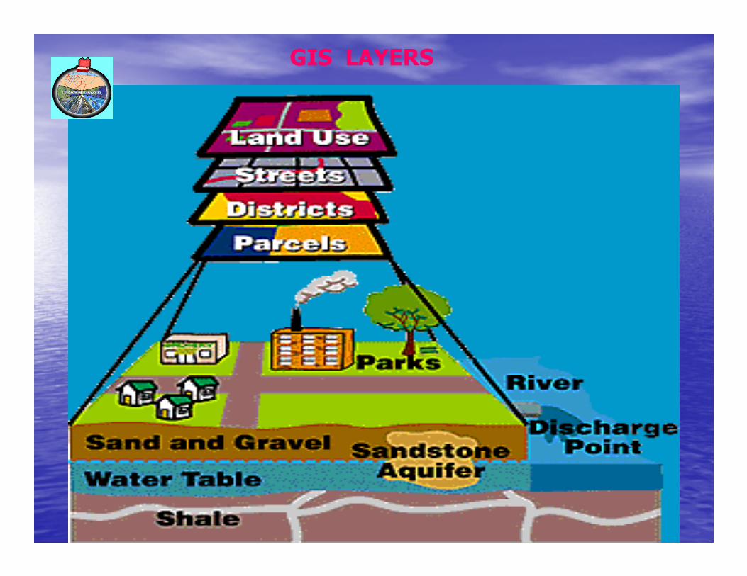
GIS LAYERS
7777
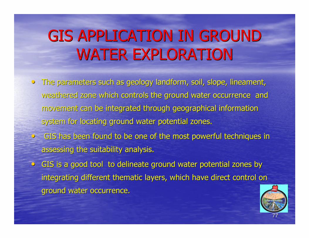
GIS APPLICATION IN GROUND GIS APPLICATION IN GROUND
WATER EXPLORATIONWATER EXPLORATION
•• The parameters such as geology landform, soil, slope, lineament,The parameters such as geology landform, soil, slope, lineament,
weathered zone which controls the ground water occurrence and weathered zone which controls the ground water occurrence and
movement can be integrated through geographical information movement can be integrated through geographical information
system for locating ground water potential zones.system for locating ground water potential zones.
•• GIS has been found to be one of the most powerful techniques inGIS has been found to be one of the most powerful techniques in
assessing the suitability analysis. assessing the suitability analysis.
•• GIS is a good tool to delineate ground water potential zones byGIS is a good tool to delineate ground water potential zones by
integrating different thematic layers, which have direct controlintegrating different thematic layers, which have direct control on on
ground water occurrence. ground water occurrence.
7878
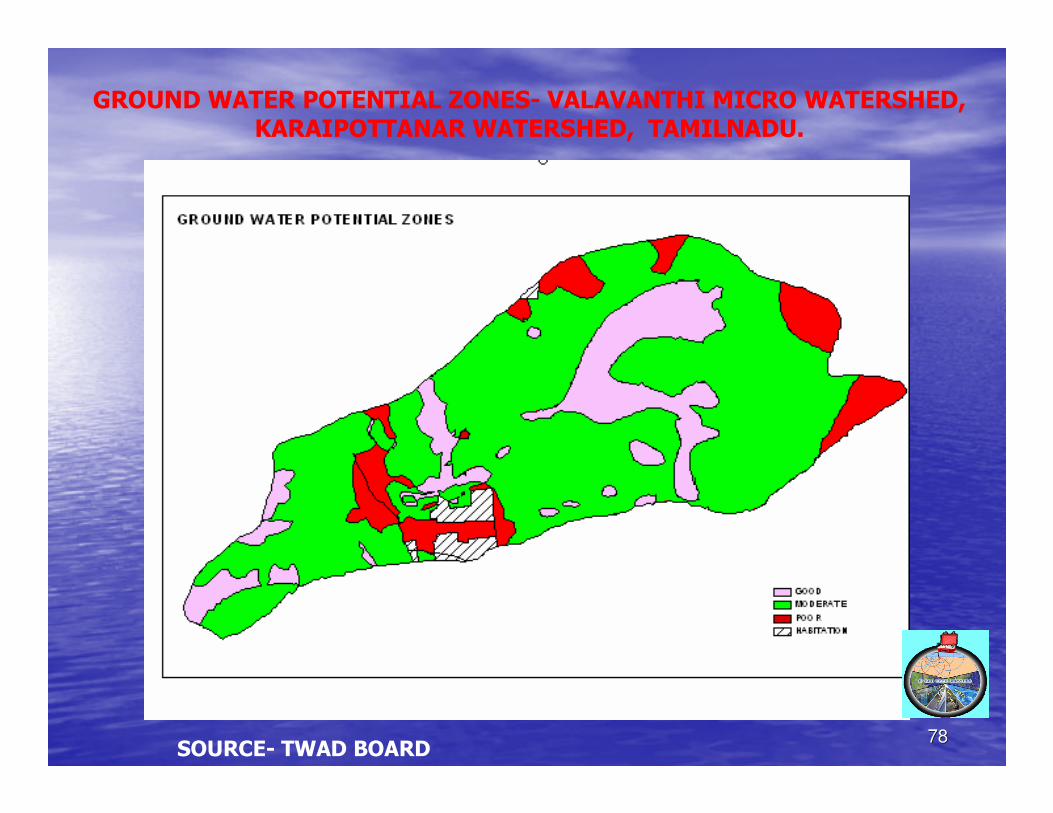
GROUND WATER POTENTIAL ZONES- VALAVANTHI MICRO WATERSHED, KARAIPOTTANAR WATERSHED, TAMILNADU.
SOURCE- TWAD BOARD
7979
CONCLUSIONCONCLUSION
•• Thus there are several methods and techniques Thus there are several methods and techniques to explore the ground water potential.to explore the ground water potential.
•• The success of ground water exploration The success of ground water exploration depends upon the methodology adapted based depends upon the methodology adapted based on the geology & field conditions.on the geology & field conditions.
•• Exploration is the first stage, followed by drilling, Exploration is the first stage, followed by drilling, development and finally well completion.development and finally well completion.
•• The explored water should be exploited correctly The explored water should be exploited correctly and managed properly. and managed properly.
•• Water is precious. Let us conserve.Water is precious. Let us conserve.
8080
THANK YOU. HAVE A NICE DAY
T.S. BADRINARAYANAN, GEOSCIENTIST,B SQUARE GEO TECH SERVICES, 97- AGRAHARAM STREET, KOLLIDAM, SIRKALI TALUK, NAGAI DISTRICT, TAMILNADU- 609 102.MOB- 94430 46102, E-MAIL : [email protected]