organized by sponsored by
TRANSCRIPT
01
02
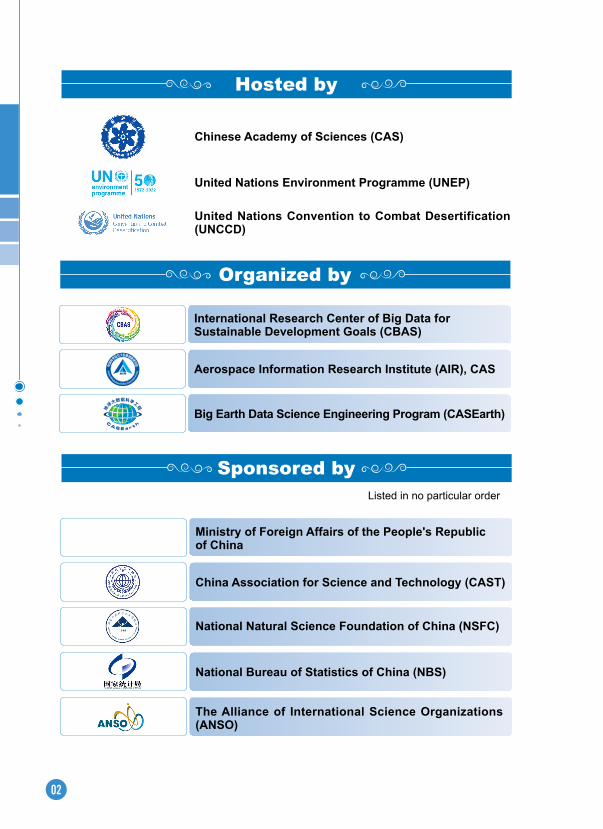
Chinese Academy of Sciences (CAS)
United Nations Environment Programme (UNEP)
United Nations Convention to Combat Desertification (UNCCD)
Hosted by
Sponsored by
China Association for Science and Technology (CAST)
Ministry of Foreign Affairs of the People's Republic of China
(Listed in no particular order)
National Natural Science Foundation of China (NSFC)
Organized by
International Research Center of Big Data for Sustainable Development Goals (CBAS)
Aerospace Information Research Institute (AIR), CAS
Big Earth Data Science Engineering Program (CASEarth)
National Bureau of Statistics of China (NBS)
The Alliance of International Science Organizations (ANSO)

03
Group on Earth Observations (GEO)
International Society for Digital Earth (ISDE)
Integrated Research on Disaster Risk (IRDR)
International Center on Space Technologies for Natural and Cultural Heritage (HIST) under the auspices of UNESCO
Digital Belt and Road Program (DBAR)
Committee on Data of the International Science Council (CODATA)
04
(Listed in no particular order)
◎ Chinese National Committee of ISDE
◎ Pan-Eurasian Experiment (PEEX)
◎ Key Laboratory of Digital Earth Science, CAS
◎ State Key Laboratory of Remote Sensing Science, China
◎ Institute of Geographic Sciences and Natural Resources Research, CAS
◎ Institute of Oceanography, CAS
◎ Computer Network Information Center, CAS
◎ Innovation Academy for Microsatellites, CAS
◎ Northwest Institute of Eco-Environment and Resources, CAS
◎ Institute of Botany, CAS
◎ The Academy of Digital China (Fujian)
◎ CAS-TWAS Centre of Excellence on Space Technology for Disaster Mitigation (SDIM)
◎ IRDR China National Committee (IRDR CHINA)
◎ Key Laboratory of Earth Observation of Hainan Province, China
◎ China Centre for International Science and Technology Exchange
◎ CAST UN Consultative Committee on Disaster Risk Reduction
◎ University of Chinese Academy of Sciences
◎ Peking University, China
◎ Tsinghua University, China
◎ Fujian Normal University, China
◎ Nanjing University, China
◎ Tongji University, China
◎ Wuhan University, China
◎ Sun Yat-Sen University, China
◎ The University of Hong Kong
◎ Jiangxi Normal University, China
◎ Fudan University, China
Co-organized by
05
◎ Xiamen University, China
◎ Nanjing Normal University, China
◎ China University of Geosciences, Wuhan
◎ Chengdu University of Technology, China
◎ Northwest University, China
◎ Central South University, China
◎ Ocean University of China
◎ Laboratory of Target Microwave Properties of Zhejiang Provice, China
◎ Climate Change Research Strategy Center, National Research Council of Thailand (NRCT)
◎ Institute for Scientific Research of Aerospace Monitoring, Moscow, Russia (ISR ‘AEROCOSMOS’)
◎ University of Helsinki, Finland
◎ University of Zambia, Zambia
◎ University of South Carolina, USA
◎ Institut des Régions Arides-Medenine, Tunisia
◎ Chouaib Doukkali University, Morocco
◎ Institute of Methodologies for Environmental Analysis, National Research Council, Italy
◎ Global Change System for Analysis, Research and Training (START)
◎ China-U.S. Green Fund
◎ Bulletin of Chinese Academy of Sciences

24
07
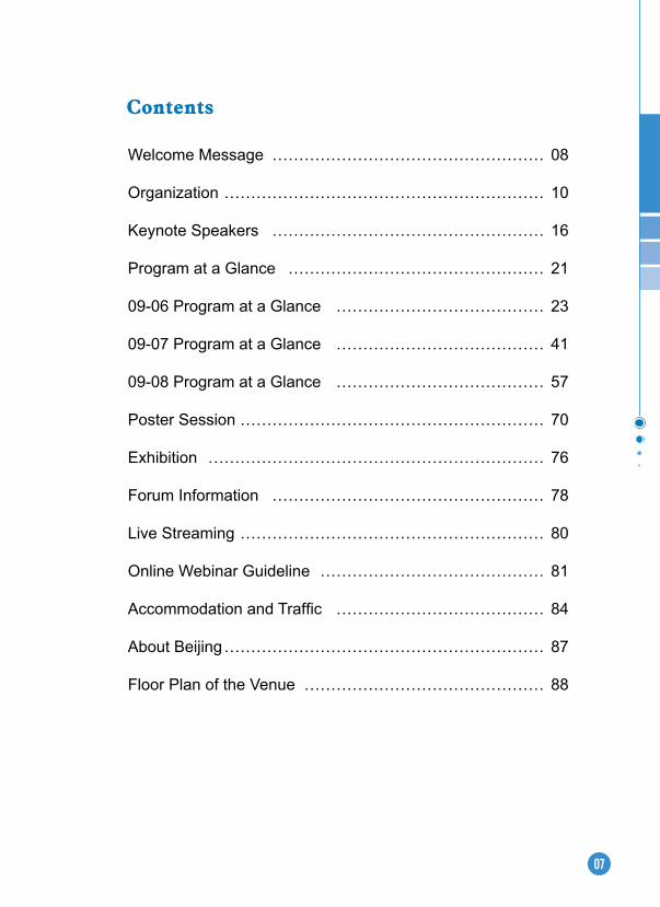
Welcome Message …………………………………………… 08
Organization …………………………………………………… 10
Keynote Speakers …………………………………………… 16
Program at a Glance ………………………………………… 21
09-06 Program at a Glance ………………………………… 23
09-07 Program at a Glance ………………………………… 41
09-08 Program at a Glance ………………………………… 57
Poster Session ………………………………………………… 70
Exhibition ……………………………………………………… 76
Forum Information …………………………………………… 78
Live Streaming ………………………………………………… 80
Online Webinar Guideline …………………………………… 81
Accommodation and Traffic ………………………………… 84
About Beijing …………………………………………………… 87
Floor Plan of the Venue ……………………………………… 88
Contents
08
The United Nations 2030 Agenda for Sustainable Development entered its "Decade of Action" in 2020. However, its implementation still faces several constraints such as lack of data, insufficient research on indicator systems, and uneven progress in its implementation. Among these, the need for data and methods is the most important and urgent.
Scientific and technological innovations play an important role in providing solutions to several of these challenges. Therefore, the United Nations initiated the "Technology Facilitation Mechanism" (TFM) to promote and improve technological and scientific support for policy interventions and decision support systems towards achieving sustainable development goals. Many countries in recent years has increased its reliance on science, technology, and innovation to promote economic and social development and is implementing new strategies which are consistent and complementary to its commitments to the UN Sustainable Development Goals. One of the key avenues within their strategy is to improve its capacity to analyze and utilize data for scientific and technological progress through a strong focus on research on big data and its integration with data from different natural and social science domains. This encompasses land, ocean, atmosphere, urban settlements, and human activity and holds immense potential for new solutions towards sustainable development goals. UN Secretary-General has also emphasized better use of data, and harnessing science, technology, and innovation with a greater focus on digital transformation.
During his address at the 75th UN General Assembly on 22 September 2020, Chinese President Xi Jinping announced that China will set up an International Research Center of Big Data for Sustainable Development Goals to support the implementation of the United Nations 2030 Agenda for Sustainable Development. The Centre aims to be a public science and technology platform for big data for sustainable development, a center for scientific research on sustainable development, a hub for innovations in data information services and technologies, a high-end think tank on sustainable development, and a center for developing talent and improving human capacity through education and training. Through these roles, the Center will serve UN agencies and UN Member States in implementing the 2030 Agenda.
The Center will be officially inaugurated on 6 September 2021, and to mark this important occasion, the International Forum on Big Data for Sustainable Development Goals (FBAS) will be held in Beijing, China, from 6 to 8 September 2021. The theme of the
Welcome Message
09
GUO Huadong International Research Center of Big Data for Sustainable
Development Goals
Alessandro ANNONI International Society for
Digital Earth
forum is " Big Data for Implementing the Sustainable Development Goals", with a special focus on building a global partnership for SDGs, innovation and demonstration of big data applications for sustainable development, cutting-edge technologies and information platforms for assessing SDGs, and Digital Earth and sustainable development.
We would like to warmly welcome experts, scholars, engineers, managers and other stakeholders from all over the world to join us at this forum. We look forward to sharing the latest achievements, scientific exchanges, and exploring future cooperation with all participants.
We look forward to meeting you physically in Beijing or virtually at the FBAS during the golden autumn to discuss the bright future of big data for global Sustainable Development Goals.
Co-Chairs of the International Forum on Big Data forSustainable Development Goals
10
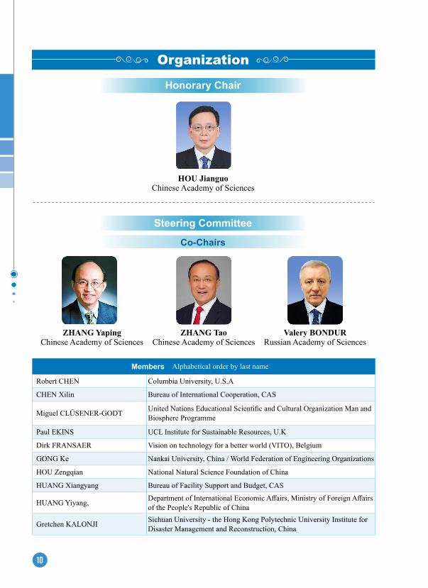
Organization
HOU JianguoChinese Academy of Sciences
Co-Chairs
ZHANG YapingChinese Academy of Sciences
ZHANG TaoChinese Academy of Sciences
Valery BONDURRussian Academy of Sciences
Members(Alphabetical order by last name)
Robert CHEN Columbia University, U.S.A
CHEN Xilin Bureau of International Cooperation, CAS
Miguel CLÜSENER-GODT United Nations Educational Scientific and Cultural Organization Man and Biosphere Programme
Paul EKINS UCL Institute for Sustainable Resources, U.K
Dirk FRANSAER Vision on technology for a better world (VITO), Belgium
GONG Ke Nankai University, China / World Federation of Engineering Organizations
HOU Zengqian National Natural Science Foundation of China
HUANG Xiangyang Bureau of Facility Support and Budget, CAS
HUANG Yiyang, Department of International Economic Affairs, Ministry of Foreign Affairs of the People's Republic of China
Gretchen KALONJI Sichuan University - the Hong Kong Polytechnic University Institute for Disaster Management and Reconstruction, China
Honorary Chair
Steering Committee

11
LIU Yanhua Consultant of the State Council, China
Zaffar Sadiq MOHAMED-GHOUSE Surveying and Spatial Sciences Institute, Australia
Barend MONS Committee on Data of the International Science Council (CODATA)
Barbara RYAN World Geospatial Industry Council
Pete SMITH University of Aberdeen, U.K
Monthip SRIRATANA National Research Council of Thailand (NRCT)
Wang Qinglin Department of International Affairs, China Association for Science and Technology
WEN Ya Bureau of Science and Technology for Development, CAS
WU Lixin Ocean University of China
YE Yujiang Department of Basic Research, Ministry of Science and Technology of the People's Republic of China
ZHANG Renhe Fudan University, China
Co-Chairs
XU GuanhuaMinistry of Science and
Technology of the People’s Republic of China
Markku KULMALAUniversity of Helsinki,
Finland
WU YirongAerospace Information Research Institute, CAS
Members(Alphabetical order by last name)
Thomas BLASCHKE Universität Salzburg, Australia
David CASTLE University of Victoria, Canada
CHEN Deliang University of Gothenburg, Sweden
CHEN Ge Ocean University of China
CHEN Jingming Fujian Normal University, China
FU Bojie Research Center for Eco-Environmental Sciences, CAS
Hiromichi FUKUI International Digital Earth Applied Science Research Center
GONG Huili Capital Normal University, China
Scientific Committee

12
GONG Jianya Wuhan University, China
GU Yidong Technology and Engineering Center for Space Utilization, CAS
GUO Lei Academy of Mathematics and Systems Science, CAS
Natarajan ISHWARAN International Centre on Space Technologies for Natural and Cultural Heritage (HIST) under the auspices of UNESCO
JIANG Kejun Energy Research Institute of the National Development and Reform Commission, China
JIAO Nianzhi Xiamen University, China
JIN Zhijun Sinopec Petroleum Exploration and Production Research Institute, China Petroleum and Chemical Corporation
KANG Le Institute of Zoology, CAS
Shahbaz KHAN United Nations Educational, Scientific and Cultural Organization
Toshio KOIKE International Centre for Water Hazard and Risk Management under the auspices of UNESCO
LI Deren Wuhan University, China
LIU Congqiang Tianjin University, China
LU Naimeng National Satellite Meteorological Center, China
MENG Xiaofeng Renmin University of China
Graciela METTERNICHT University of New South Wales, Australia
MU Mu Fudan University, China
Stefano NATIVI National Research Council, Italy
PAN Delu Second Institute of Oceanography, State Oceanic Administration, People's Republic of China
Qin Dahe Northwest Institute of Eco-Environment and Resources, CAS
Steven RAMAGE Group on Earth Observations (GEO)
Soroosh SOROOSHIAN University of California, Irvine
TONG Qingxi Aerospace Information Research Institute, CAS
WU Guoxiong Institute of Atmospheric Physics, CAS
XIA Jun Wuhan University, China
XUE Lan Tsinghua University, China
YANG Guangwen Tsinghua University, China
YAO Tandong Institute of Tibetan Plateau Research, CAS
ZHANG Si South China Sea Institute of Oceanography, CAS
ZHOU Chenghu Institute of Geographic Sciences and Natural Resources Research, CAS
13
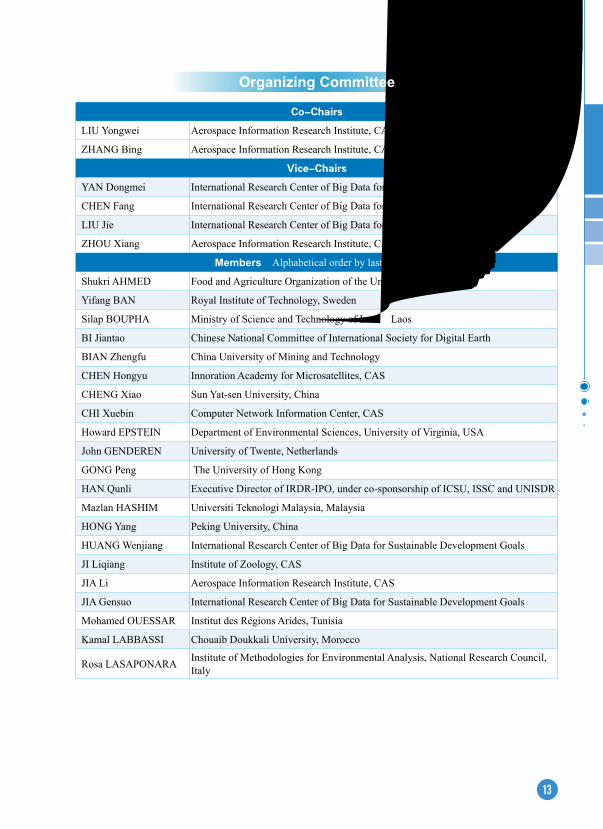
Co-Chairs
LIU Yongwei Aerospace Information Research Institute, CAS
ZHANG Bing Aerospace Information Research Institute, CAS
Vice-Chairs
YAN Dongmei International Research Center of Big Data for Sustainable Development Goals
CHEN Fang International Research Center of Big Data for Sustainable Development Goals
LIU Jie International Research Center of Big Data for Sustainable Development Goals
ZHOU Xiang Aerospace Information Research Institute, CAS
Members(Alphabetical order by last name)
Shukri AHMED Food and Agriculture Organization of the United Nations
Yifang BAN Royal Institute of Technology, Sweden
Silap BOUPHA Ministry of Science and Technology of Laos,Laos
BI Jiantao Chinese National Committee of International Society for Digital Earth
BIAN Zhengfu China University of Mining and Technology
CHEN Hongyu Innoration Academy for Microsatellites, CAS
CHENG Xiao Sun Yat-sen University, China
CHI Xuebin Computer Network Information Center, CAS
Howard EPSTEIN Department of Environmental Sciences, University of Virginia, USA
John GENDEREN University of Twente, Netherlands
GONG Peng The University of Hong Kong
HAN Qunli Executive Director of IRDR-IPO, under co-sponsorship of ICSU, ISSC and UNISDR
Mazlan HASHIM Universiti Teknologi Malaysia, Malaysia
HONG Yang Peking University, China
HUANG Wenjiang International Research Center of Big Data for Sustainable Development Goals
JI Liqiang Institute of Zoology, CAS
JIA Li Aerospace Information Research Institute, CAS
JIA Gensuo International Research Center of Big Data for Sustainable Development Goals
Mohamed OUESSAR Institut des Régions Arides, Tunisia
Kamal LABBASSI Chouaib Doukkali University, Morocco
Rosa LASAPONARA Institute of Methodologies for Environmental Analysis, National Research Council, Italy
Organizing Committee
14
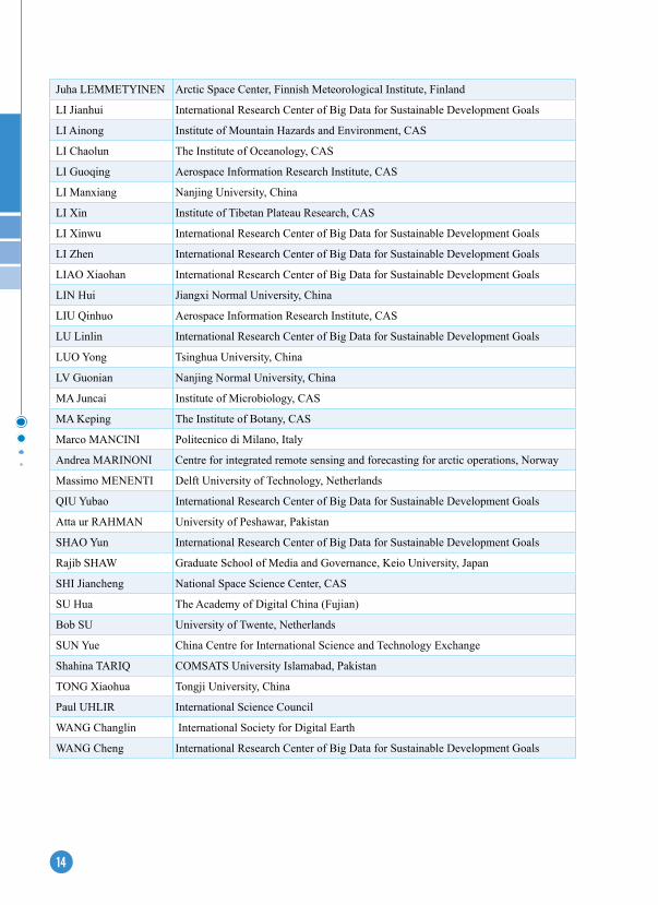
Juha LEMMETYINEN Arctic Space Center, Finnish Meteorological Institute, Finland
LI Jianhui International Research Center of Big Data for Sustainable Development Goals
LI Ainong Institute of Mountain Hazards and Environment, CAS
LI Chaolun The Institute of Oceanology, CAS
LI Guoqing Aerospace Information Research Institute, CAS
LI Manxiang Nanjing University, China
LI Xin Institute of Tibetan Plateau Research, CAS
LI Xinwu International Research Center of Big Data for Sustainable Development Goals
LI Zhen International Research Center of Big Data for Sustainable Development Goals
LIAO Xiaohan International Research Center of Big Data for Sustainable Development Goals
LIN Hui Jiangxi Normal University, China
LIU Qinhuo Aerospace Information Research Institute, CAS
LU Linlin International Research Center of Big Data for Sustainable Development Goals
LUO Yong Tsinghua University, China
LV Guonian Nanjing Normal University, China
MA Juncai Institute of Microbiology, CAS
MA Keping The Institute of Botany, CAS
Marco MANCINI Politecnico di Milano, Italy
Andrea MARINONI Centre for integrated remote sensing and forecasting for arctic operations, Norway
Massimo MENENTI Delft University of Technology, Netherlands
QIU Yubao International Research Center of Big Data for Sustainable Development Goals
Atta ur RAHMAN University of Peshawar, Pakistan
SHAO Yun International Research Center of Big Data for Sustainable Development Goals
Rajib SHAW Graduate School of Media and Governance, Keio University, Japan
SHI Jiancheng National Space Science Center, CAS
SU Hua The Academy of Digital China (Fujian)
Bob SU University of Twente, Netherlands
SUN Yue China Centre for International Science and Technology Exchange
Shahina TARIQ COMSATS University Islamabad, Pakistan
TONG Xiaohua Tongji University, China
Paul UHLIR International Science Council
WANG Changlin International Society for Digital Earth
WANG Cheng International Research Center of Big Data for Sustainable Development Goals
15
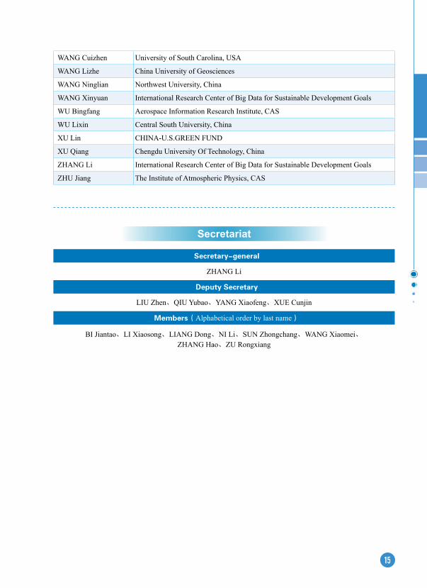
WANG Cuizhen University of South Carolina, USA
WANG Lizhe China University of Geosciences
WANG Ninglian Northwest University, China
WANG Xinyuan International Research Center of Big Data for Sustainable Development Goals
WU Bingfang Aerospace Information Research Institute, CAS
WU Lixin Central South University, China
XU Lin CHINA-U.S.GREEN FUND
XU Qiang Chengdu University Of Technology, China
ZHANG Li International Research Center of Big Data for Sustainable Development Goals
ZHU Jiang The Institute of Atmospheric Physics, CAS
Secretary-general
ZHANG Li
Deputy Secretary
LIU Zhen、QIU Yubao、YANG Xiaofeng、XUE Cunjin
Members(Alphabetical order by last name)
BI Jiantao、LI Xiaosong、LIANG Dong、NI Li、SUN Zhongchang、WANG Xiaomei、ZHANG Hao、ZU Rongxiang
Secretariat
16
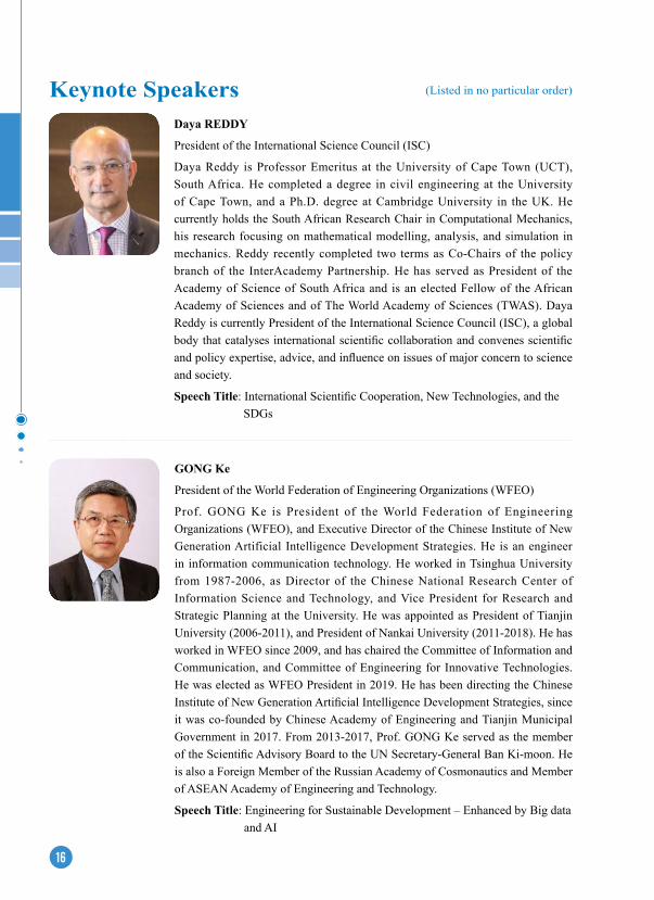
Daya ReDDY
President of the International Science Council (ISC)
Daya Reddy is Professor Emeritus at the University of Cape Town (UCT), South Africa. He completed a degree in civil engineering at the University of Cape Town, and a Ph.D. degree at Cambridge University in the UK. He currently holds the South African Research Chair in Computational Mechanics, his research focusing on mathematical modelling, analysis, and simulation in mechanics. Reddy recently completed two terms as Co-Chairs of the policy branch of the InterAcademy Partnership. He has served as President of the Academy of Science of South Africa and is an elected Fellow of the African Academy of Sciences and of The World Academy of Sciences (TWAS). Daya Reddy is currently President of the International Science Council (ISC), a global body that catalyses international scientific collaboration and convenes scientific and policy expertise, advice, and influence on issues of major concern to science and society.
Speech Title: International Scientific Cooperation, New Technologies, and the SDGs
GONG Ke
President of the World Federation of Engineering Organizations (WFEO)
Prof. GONG Ke is President of the World Federation of Engineering Organizations (WFEO), and Executive Director of the Chinese Institute of New Generation Artificial Intelligence Development Strategies. He is an engineer in information communication technology. He worked in Tsinghua University from 1987-2006, as Director of the Chinese National Research Center of Information Science and Technology, and Vice President for Research and Strategic Planning at the University. He was appointed as President of Tianjin University (2006-2011), and President of Nankai University (2011-2018). He has worked in WFEO since 2009, and has chaired the Committee of Information and Communication, and Committee of Engineering for Innovative Technologies. He was elected as WFEO President in 2019. He has been directing the Chinese Institute of New Generation Artificial Intelligence Development Strategies, since it was co-founded by Chinese Academy of Engineering and Tianjin Municipal Government in 2017. From 2013-2017, Prof. GONG Ke served as the member of the Scientific Advisory Board to the UN Secretary-General Ban Ki-moon. He is also a Foreign Member of the Russian Academy of Cosmonautics and Member of ASEAN Academy of Engineering and Technology.
Speech Title: Engineering for Sustainable Development – Enhanced by Big data and AI
Keynote Speakers (Listed in no particular order)

17
LIU Jian
Director of the Science Division, UN Environment Programme (UNEP)
Dr. Jian Liu is currently the Director of the Science Division, UN Environment Programme (UNEP). From March 2017 to February 2021, he also served as UNEP Chief Scientist as an adjunct to his function as Director of Science Division.
Jian LIU has over 30 years of professional experience in science and policy, in the specific domains of ecosystems management, agriculture, environment and climate change at national, regional and global levels, in particular in developing countries. Jian holds a doctorate degree in Physical Geography from the Graduate School of Chinese Academy of Sciences, Beijing, China. He was the Director of UNEP’s International Ecosystem Management Partnership, the first global centre on ecosystem management in the global south, which he established, as the founding director.
Prior to this appointment, he served as the Chief of UNEP’s Climate Change Adaptation Unit and the Deputy Secretary of the Intergovernmental Panel on Climate Change (IPCC).
Speech Title: Measuring Progress: Environment and SDGs
David CASTLe
Professor at the University of Victoria, and Research in Residence at the Office of the Chief Science Advisor to the Prime Minister of Canada
Dr. David Castle is a Professor in the School of Public Administration and the Gustavson School of Business at the University of Victoria and a Research in Residence at the Office of the Chief Science Advisor to the Prime Minister of Canada. His research is focused on science, technology and innovation policy, with a particular emphasis on regulation, standards, intellectual property and public consultation associated with life science innovation.
Dr. Castle is a member of the Science Advisory Committee of the Council of Canadian Academies. He is a Director for Canada’s national research and education network provider, Canarie, and is the Chair of Research Data Canada’s Steering Committee. Since 2019 he has been a member of the Scientific Committee of the ISC’s World Data System (WDS) and has recently joined the Canadian National Committee for the Committee on Data (CODATA) of the International Science Council (ISC). As a member of the OECD Global Science Forum Expert Group he contributed to the 2020 report, Building Digital Workforce Capacity and Skills for Data Intensive Science.
Speech Title: Making Big Data Relevant to Sustainable Development Goals
18
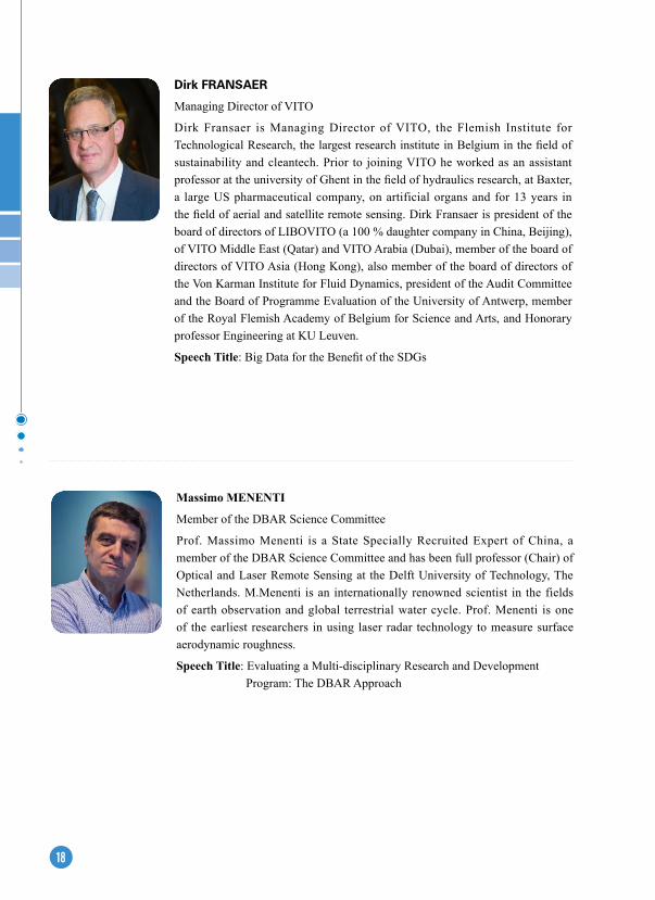
Massimo MeNeNTI
Member of the DBAR Science Committee
Prof. Massimo Menenti is a State Specially Recruited Expert of China, a member of the DBAR Science Committee and has been full professor (Chair) of Optical and Laser Remote Sensing at the Delft University of Technology, The Netherlands. M.Menenti is an internationally renowned scientist in the fields of earth observation and global terrestrial water cycle. Prof. Menenti is one of the earliest researchers in using laser radar technology to measure surface aerodynamic roughness.
Speech Title: Evaluating a Multi-disciplinary Research and Development Program: The DBAR Approach
Dirk FranSaer
Managing Director of VITO
Dirk Fransaer is Managing Director of VITO, the Flemish Institute for Technological Research, the largest research institute in Belgium in the field of sustainability and cleantech. Prior to joining VITO he worked as an assistant professor at the university of Ghent in the field of hydraulics research, at Baxter, a large US pharmaceutical company, on artificial organs and for 13 years in the field of aerial and satellite remote sensing. Dirk Fransaer is president of the board of directors of LIBOVITO (a 100 % daughter company in China, Beijing), of VITO Middle East (Qatar) and VITO Arabia (Dubai), member of the board of directors of VITO Asia (Hong Kong), also member of the board of directors of the Von Karman Institute for Fluid Dynamics, president of the Audit Committee and the Board of Programme Evaluation of the University of Antwerp, member of the Royal Flemish Academy of Belgium for Science and Arts, and Honorary professor Engineering at KU Leuven.
Speech Title: Big Data for the Benefit of the SDGs

19
Markku KULMALA
Professor at University of Helsinki
Academician, prof. Markku Kulmala leads the Institute for Atmospheric and Earth System Research (INAR), University of Helsinki. He is active in international initiatives to improve comprehensive continuous measurement networks all around the world, and to solve air quality climate change interactions. Kulmala’s research consists of SMEAR (Stations for Measuring the Earth surface Atmosphere Relationships) field stations and GlobalSMEAR network. Kulmala has published over 1000 original research papers, 18 of which in Nature, 17 in Science and 7 in Physical Review Letters. According to the ISI Web of Knowledge, Kulmala has been 1st in the Citation Rankings in Geosciences (1.5.2011 – 30.4.2018). The total number of citations is over 62000 (from over 20000 different papers). His H-factor is 122. Prof. Kulmala is the Foreign Member of Chinese Academy of Sciences, and Russian Academy of Sciences. He is a member of 5 other Academies. He acts as a president of European Center of International Eurasian Academy of Sciences. He is winner of many international awards (>10) and has nine honored doctoral degrees / professorships.
Speech Title: Pan-Eurasian Experiment: Significance of Continuous Comprehensive Observations - SMEAR Concept
Clovis FReIRe
Economist at the Division on Technology and Logistics of the United Nations Conference on Trade and Development (UNCTAD)
Dr. Clovis Freire is an Economist working at the Division on Technology and Logistics of the United Nations Conference on Trade and Development (UNCTAD). He is trained as a Computer Engineer with a PhD in Economics from the UNU-MERIT/University of Maastricht, specialized in Economics of Technological Change and Innovation. He coordinated and was the lead author of the Technology and Innovation Report 2021. Before joining UNCTAD, in his 18 years with the United Nations, he worked at the Department of Economic and Social Affairs in New York and the Economic and Social Commission for Asia-Pacific, in Bangkok, on various issues related to technology and socio-economic development such as Science, Technology, and Innovation for the SDGs, building productive capacities in the least developed countries, ICT and Space technologies for development, and disaster risk reduction.
Speech Title: Big Data to Bridge Big Gaps: Strategic Directions for Research
20
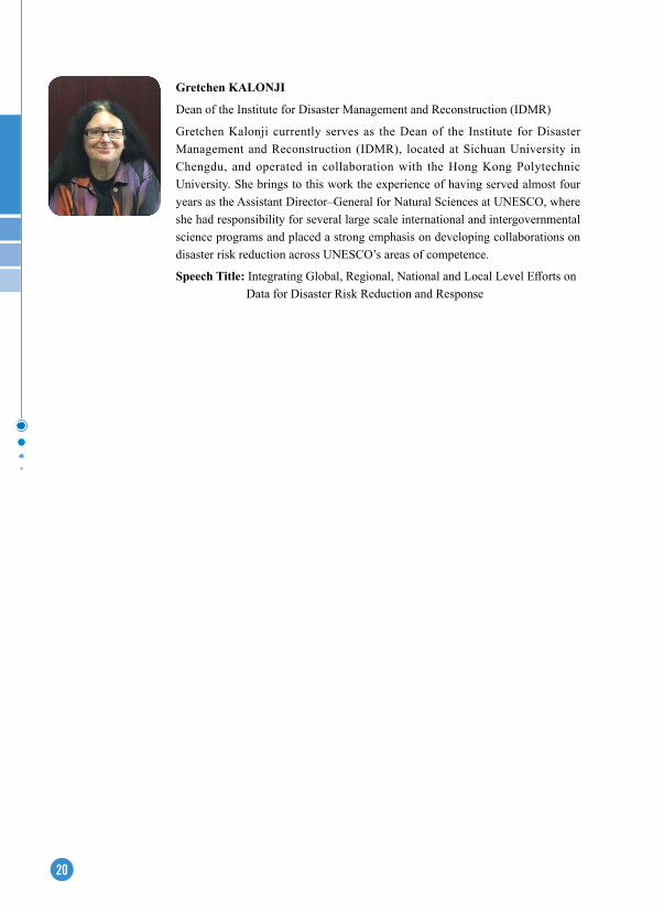
Gretchen KALONJI
Dean of the Institute for Disaster Management and Reconstruction (IDMR)
Gretchen Kalonji currently serves as the Dean of the Institute for Disaster Management and Reconstruction (IDMR), located at Sichuan University in Chengdu, and operated in collaboration with the Hong Kong Polytechnic University. She brings to this work the experience of having served almost four years as the Assistant Director–General for Natural Sciences at UNESCO, where she had responsibility for several large scale international and intergovernmental science programs and placed a strong emphasis on developing collaborations on disaster risk reduction across UNESCO’s areas of competence.
Speech Title: Integrating Global, Regional, National and Local Level Efforts on Data for Disaster Risk Reduction and Response
21
Prog
ram
at a
Gla
nce
21
Sept
embe
r 6Se
ptem
ber 7
Sept
embe
r 8
Mor
ning
Ope
ning
Cer
emon
y &
In
augu
ratio
n C
erem
ony
of C
BA
SK
eyno
te S
essi
on II
Key
note
Se
ssio
n III
HIS
T 10
th
Ann
iver
sary
Sy
mpo
sium
Tea
Bre
ak
Key
note
Ses
sion
IFo
rum
on
Eart
h O
bser
vatio
n fo
r SD
Gs
Big
Ear
th D
ata
to s
uppo
rt
SDG
s
Afte
rnoo
n
Lunc
h
Bui
ldin
g a
digi
tal
silk
road
an
d gl
obal
pa
rtne
rshi
p fo
r SD
Gs
Cut
ting-
edge
te
chno
logi
es
and
info
rmat
ion
plat
form
s fo
r as
sess
ing
SDG
s
Inno
vatio
n an
d de
mon
stra
tion
of b
ig d
ata
appl
icat
ion
for
sust
aina
ble
deve
lopm
ent
Dig
ital
Eart
h an
d su
stai
nabl
e de
velo
pmen
t
DB
AR
Scie
nce
Team
Mee
ting
(Invi
ted)
Res
earc
h on
big
Ear
th d
ata
to s
uppo
rt s
usta
inab
le
deve
lopm
ent g
oals
Tea
Bre
ak
Bui
ldin
g a
digi
tal
silk
road
an
d gl
obal
pa
rtne
rshi
p fo
r SD
Gs
Cut
ting-
edge
te
chno
logi
es
and
info
rmat
ion
plat
form
s fo
r as
sess
ing
SDG
s
Inno
vatio
n an
d de
mon
stra
tion
of b
ig d
ata
appl
icat
ion
for
sust
aina
ble
deve
lopm
ent
Dig
ital
Eart
h an
d su
stai
nabl
e de
velo
pmen
t
DB
AR
Scie
nce
Team
Mee
ting
(Invi
ted)
Clo
sing
Cer
emon
y

24
22 23
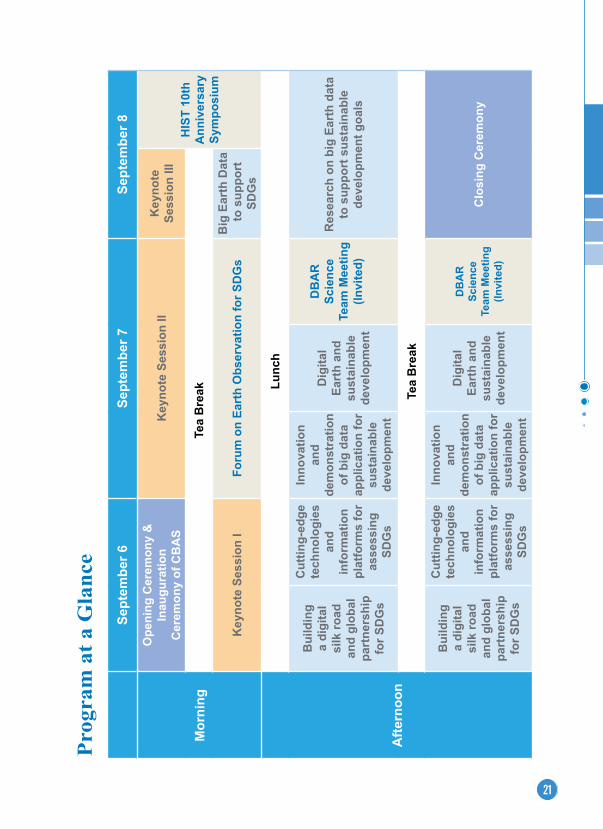
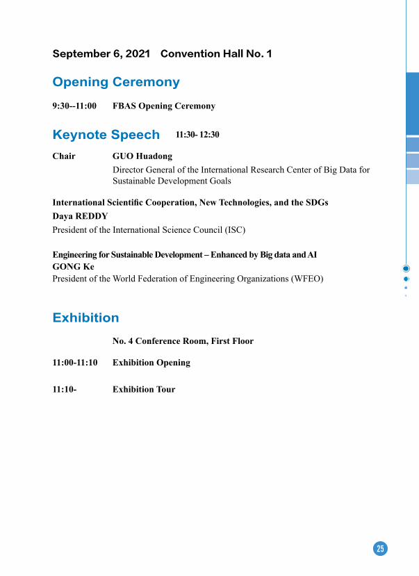
09-06 Program at a Glance 09:30-11:00 Opening Ceremony (Convention Hall No. 1)
11:00-11:30 Tea Break
11:30-12:30 Keynote Speech (Convention Hall No. 1)
12:30-13:30 Lunch
13:30-15:00
Building a Digital Silk Road and Global Partnership for SDGS Cutting-edge Technologies and Information Platforms for Assessing SDGs
Environmental Dimension of
SDGs
Activities around Belt and Road from Scientific
Data Center
Agriculture and Food Security
Digital Belt and Road-Big Earth Data for
Sustainable Development
and Management of Coast and Sea
Digital Heritage and Sustainability
Achieving the SDGs in cities
and regions
Hyperspectral Earth
Observation-1
Frontier Technology of
Microwave Earth Observation
Hyperspectral LiDAR
Technology and Application
Virtual Geographic
Scenario and Digital Twin
Big Space Earth Data
Frontier Methods and Techniques
for Earth Observation
203A 203B 203C 203D 201A 201CD 305E 305D 305C 305B 305A 201B
15:00-15:30 Tea Break
15:30-17:00
Building a Digital Silk Road and Global Partnership for SDGS Cutting-edge Technologies and Information Platforms for Assessing SDGs
Big Earth Data for Disaster
Risk Reduction and Sustainable Development
Goals
Water Resource Security and
Efficient Utilization under Global Change
Big Earth Data and Sustainable
Cities
Big Earth Data for Sustainable Development in High Mountain Asia and Arctic
region
Digital Earth Poles and SDGs
(Invited)
Digital Modeling and Simulation
Hyperspectral Earth
Observation-2
Applications of Earth
Observation Technology
for Energy and Environment
BIM/CIM Information Model and
Virtual Geographic
Environment System
Application of Spatial
Information Technology
LiDAR Earth Observation
Sustainable Development of the UNESCO
Designated Sites
203A 203B 203C 203D 201CD 201A 305E 305D 305C 305B 305A 201B
25
September 6, 2021 Convention Hall No. 1
Opening Ceremony
9:30--11:00 FBAS Opening Ceremony
Keynote Speech 11:30- 12:30
Chair GUO HuadongDirector General of the International Research Center of Big Data for Sustainable Development Goals
International Scientific Cooperation, New Technologies, and the SDGsDaya ReDDY President of the International Science Council (ISC)
engineering for Sustainable Development – enhanced by Big data and AIGONG Ke President of the World Federation of Engineering Organizations (WFEO)
Exhibition
No. 4 Conference Room, First Floor
11:00-11:10 exhibition Opening
11:10- exhibition Tour
26
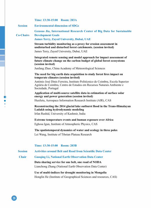
Time: 13:30-15:00 Room: 203B
Session Activities around Belt and Road from Scientific Data Center
Chair Guoqing Li, National Earth Observation Data Center
Data sharing service for one belt, one road of NODALianchong Zhang (National Earth Observation Data Center)
Use of multi-indices for drought monitoring in MongoliaHonglin He (Institute of Geographical Sciences and resources, CAS)
Time: 13:30-15:00 Room: 203A
Session environmental dimension of SDGs
Co-ChairsGensuo Jia, International Research Center of Big Data for Sustainable Development GoalsJames Terry, Zayed University, Dubai, UAEStream turbidity monitoring as a proxy for erosion assessment in undisturbed and disturbed forest catchments. (session invited)James Terry, Zayed University, Dubai, UAE
Integrated remote sensing and model approach for impact assessment of future climate change on the carbon budget of global forest ecosystems (session invited)Junfang Zhao, China Academy of Meteorological Sciences
The need for big earth data acquisition to study forest fires impact on temperate climates (session invited)António José Dinis Ferreira, Instituto Politécnico de Coimbra, Escola Superior Agrária de Coimbra, Centro de Estudos em Recursos Naturais Ambiente e Sociedade, PortugalApplication of multi-source satellite data in estimation of surface solar energy and power generation (session invited)Husiletu, Aerospace Information Research Institute (AIR), CAS
Reconstructing the 2014 glacial lake outburst flood in the Trans-Himalayan Ladakh using hydrodynamic modelingIrfan Rashid, University of Kashmir, India
extreme temperature events and human exposure over AfricaEghosa Igun, Institute of Atmospheric Physics, CAS
The spatiotemporal dynamics of water and ecology in three polesLei Wang, Institute of Tibetan Plateau Research
27
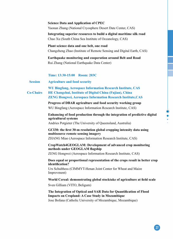
Time: 13:30-15:00 Room: 203C
Session Agriculture and food security
Co-ChairsWU Bingfang, Aerospace Information Research Institute, CASHE Changchui, Institute of Digital China (Fujian), ChinaZENG Hongwei, Aerospace Information Research Institute,CAS
Progress of DBAR agriculture and food security working groupWU Bingfang (Aerospace Information Research Institute, CAS)
enhancing of food production through the integration of predictive digital agricultural systemsAndries Potgieter (The University of Queensland, Australia)
GCI30: the first 30-m resolution global cropping intensity data using multisource remote sensing imageryZHANG Miao (Aerospace Information Research Institute, CAS)
CropWatch4GeOGLAM: Development of advanced crop monitoring methods under GEOGLAM flagshipZENG Hongwei (Aerospace Information Research Institute, CAS)
Does equal or proportional representation of the crops result in better crop identification?Urs Schulthess (CIMMYT-Henan Joint Center for Wheat and Maize Improvment)
World Cereal: demonstrating global stocktake of agriculture at field scaleSven Gilliam (VITO, Beligum)
The Integration of Optical and SAR Data for Quantification of Flood Impacts on Cropland: A Case Study in MozambiqueJose Bofana (Catholic University of Mozambique, Mozambique)
Science Data and Application of CPeC Yaonan Zhang (National Cryosphere Desert Date Center, CAS)
Integrating superior resources to build a digital maritime silk road Chao Xu (South China Sea Institute of Oceanology, CAS)
Plant science data and one belt, one road Changzheng Zhao (Institute of Remote Sensing and Digital Earth, CAS)
earthquake monitoring and cooperation around Belt and Road Rui Zhang (National Earthquake Data Center)
28
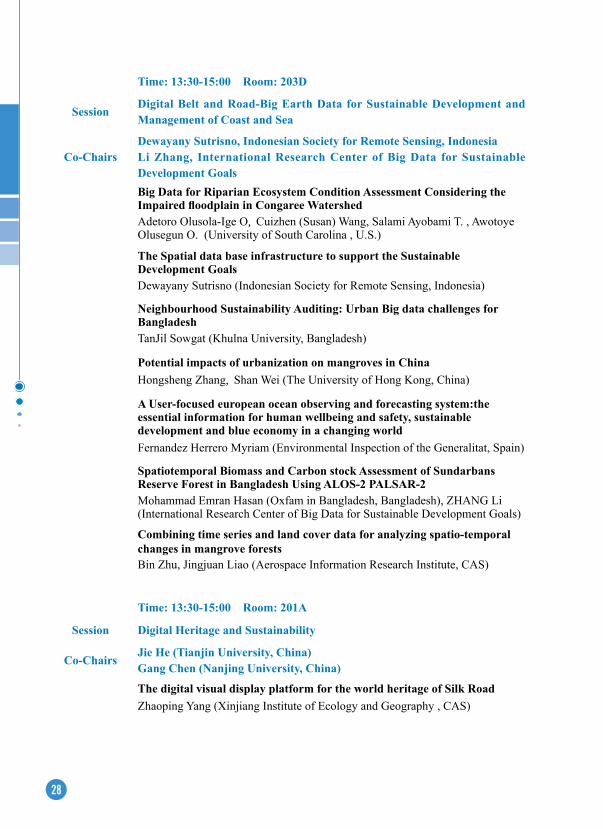
Time: 13:30-15:00 Room: 203D
SessionDigital Belt and Road-Big earth Data for Sustainable Development and Management of Coast and Sea
Co-ChairsDewayany Sutrisno, Indonesian Society for Remote Sensing, IndonesiaLi Zhang, International Research Center of Big Data for Sustainable Development GoalsBig Data for Riparian ecosystem Condition Assessment Considering the Impaired floodplain in Congaree Watershed Adetoro Olusola-Ige O, Cuizhen (Susan) Wang, Salami Ayobami T. , Awotoye Olusegun O. (University of South Carolina , U.S.)
The Spatial data base infrastructure to support the Sustainable Development GoalsDewayany Sutrisno (Indonesian Society for Remote Sensing, Indonesia)
Neighbourhood Sustainability Auditing: Urban Big data challenges for Bangladesh TanJil Sowgat (Khulna University, Bangladesh)
Potential impacts of urbanization on mangroves in ChinaHongsheng Zhang, Shan Wei (The University of Hong Kong, China)
A User-focused european ocean observing and forecasting system:the essential information for human wellbeing and safety, sustainable development and blue economy in a changing worldFernandez Herrero Myriam (Environmental Inspection of the Generalitat, Spain)
Spatiotemporal Biomass and Carbon stock Assessment of Sundarbans Reserve Forest in Bangladesh Using ALOS-2 PALSAR-2Mohammad Emran Hasan (Oxfam in Bangladesh, Bangladesh), ZHANG Li (International Research Center of Big Data for Sustainable Development Goals)
Combining time series and land cover data for analyzing spatio-temporal changes in mangrove forestsBin Zhu, Jingjuan Liao (Aerospace Information Research Institute, CAS)
Time: 13:30-15:00 Room: 201A
Session Digital Heritage and Sustainability
Co-ChairsJie He (Tianjin University, China)Gang Chen (Nanjing University, China)
The digital visual display platform for the world heritage of Silk RoadZhaoping Yang (Xinjiang Institute of Ecology and Geography , CAS)
29
RS and GIS applications in Liangzhu Sites ArchaeologyNingyuan Wang (Zhejiang Provincial Institute of Cultural Relics and Archaeology)
Tacit Knowledge and Digital Heritage: Chinese Traditional Color Studies from a Digital Humanities ApproachJing Chen (Nanjing University)
Construction of the National Cultural Park supported by the Whole-line Image and 3D Database of the Ming Great Wall Zhe Li (Tianjin University)
Cultural Heritage Project of Mapping Ancient Jiangsu: Digital Representation of Historical and Cultural Landscape of Jiangsu Province with Maps of Local ChroniclesGang Chen (Nanjing University, China)
World Heritage Protection and Sustainable DevelopmentShizhen Xiao (Guizhou Normal University)
Time: 13:30-15:00 Room: 201A
Session Achieving the SDGs in cities and regions
Time: 13:30-15:00 Room: 305e
Session Hyperspectral earth Observation-1
Co-ChairsBing Zhang (Aerospace Information Research Institute, CAS)Liangpei Zhang (Wuhan University)Spaceborne SIF Hyperspectral Imaging TechnologyYinnian Liu (Shanghai Institute of Technical Physics, CAS)Hyperspectral Remote Sensing Image Processing: From data and method driven to demand and question guidedPeijun Du (Nanjing University)
Digital earth and Intelligent Processing for Remote Sensing Data Mingyi He (Northwestern Polytechnical University)
Spectral Super-resolution for Satellite Images and Its ApplicationWeidong Sun (Tsinghua University), Xiaolin Han
estimating the geochemical information from vegetation coverage area using the hyperspectral dataFuping Gan (China Aero Geophysical Survey and Remote Sensing Center for Natural Resources)
Application of hyperspectral remote sensing on soil salinization in arid regionJianli Ding (Xinjiang Universtity)
30
Time: 13:30-15:00 Room: 305DSession Frontier Technology of Microwave Earth Observation
Co-ChairsZhen Li (International Research Center of Big Data for Sustainable Development Goals)Guoman Huang (Chinese Academy of Surveying and Mapping)
High-Resolution Land Surface Freeze/Thaw Detection using Sentinel-1 and AMSR2 data- A Case Study of Genhe Watershed, ChinaLingmei Jiang, Jian Wang (Beijing Normal University)Passive microwave remote sensing inversion of snow parameters in Northeast ChinaXiaofeng Li, Guangrui Wang, Xiuxue Chen, Yanling Wei (Northeast Institute of Geography and Agricultural Ecology, CAS)Microwave radiometry experiment on snow in Altay ChinaLiyun Dai, Tao Che (Northwest Institute of Eco-Environment and Resources, CAS)Analysis of soil moisture retrieval application over agricultural areas based on multi-incidence and multi-temporal Polarimetric SAR observationsHongtao Shi, Jie Yang Pingxiang Li (Wuhan University)Multi-space-scale differential correction algorithm for InSAR atmospheric phase delay Zhigang Yu (Shandong University of Science and Technology), Guoman Huang (Chinese Academy of Surveying and Mapping)
Inter-Calibration of HY-2B Passive Microwave Data in Land Surface and First Result for SWe RetrievalQuan Chen, Shuo Gao, Zhen Li (International Research Center of Big Data for Sustainable Development Goals), Wu Zhou (National Satellite Ocean Application Service)
Time: 13:30-15:00 Room: 305CSession Hyperspectral LiDAR Technology and Application
Co-Chairs Wei Gong (Wuhan University, China)Dong Liu (Hefei Institutes of Physical Science, CAS)
Earth Observation Hyperspectral LiDAR Technology, Application and Recent ProgressWei Gong (Wuhan University, China), Shuo Shi, Shalei Song, Zheng Niu, Cheng Wang, Haiyan Guan, Wei Li, Shui Gao, Yi Lin
Development and Performance Tests of a Full-Time Hyperspectral Full-Waveform Lidar Decheng Wu (Hefei Institutes of Physical Science, CAS), Dong Liu, Liyong Qian, Xiaojun Zhou, Liujun Zhong, Wei Wei, Shuo Shi, Shalei Song, Wei Gong, Yingjian Wang
31
Discussion on some technical issues and strategies in hyperspectral full-waveform lidar data processingZhengjun Liu (Chinese Academy of Sureying & Mapping), Yiming Chen , Wei Gong, Xiaolu Li, Jianwei Wu, Xiangguo Lin, Lin Si, Qingdong Wang, Shenghua Xu
Application of hyperspectral LiDAR for scientific exploring: Sleep characteristics of standing trees?Yi Lin (Peking University)
Three-dimensional extraction of vegetation biochemical parameters based on hyperspectral lidar and its applicationShuai Gao (Aerospace Information Research Institute, CAS), Zheng Niu, Gang Sun, Kaiyi Bi, Changsai Zhang, Jie Bai
Mechanism of wavelength selection for Hyperspectral LiDARShuo Shi (Wuhan University), Wei Gong, Jia Sun, Hongyan Zhang, Jian Yang, Lin Du, Wei Wang
Time: 13:30-15:00 Room: 305B
Session Virtual Geographic Scenario and Digital Twin
Co-Chairs Guonian Lv (Nanjing Normal University, China)Min Chen (Nanjing Normal University, China)
Real 3D spatial information platform and data twin railwayQing Zhu (Southwest Jiaotong University, China)
Scene cognition and real scene construction based on generalized point cloudChun Liu (Tongji University, China)
Sonic, optic, electric and magnetic data acquisition and classification in geographic sceneChun Ye (Nanjing Normal University, China)
Key technology of digital twin road constructionZhen Dong (Wuhan University, China)
Dynamic evolution model construction and spatial reasoning of geographic scene based on "process-event"Yi Huang (Nanjing University of Posts and Telecommunications, China)
Marine information visualization in an immersive panoramic sphere environmentYing Ma (Ocean University of China, China)
32
Time: 13:30-15:00 Room: 305A
Session Big Space earth Data
Chair Lizhe Wang (China University of Geosciences, Wuhan)
Marine hydrological disasters and intelligent prediction under the background of global changeTianyu Zhang (Guangdong Ocean University)
Application of Deep Learning in Physical OceanographyJiuke Wang (National Marine Environmental Forecasting Center)
Spatiotemporal Remote Sensing Image Fusion with Generative Adversarial NetworksPeng Liu (Aerospace Information Research Institute, CAS)
Remote sensing big data processing technology for the production of global changing parameter productsYan Ma (Aerospace Information Research Institute, CAS)
An adaptive geographic meshing and coding method for remote sensing dataXiaohui Huang (China University of Geosciences, Wuhan)Geographic grid model-based spatial-temporal index and storage for trajectory data
Hong Liu (China University of Geosciences, Wuhan)
Time: 13:30-15:00 Room: 201B
Session Frontier Methods and Techniques for earth Observation
Co-Chairs Yonghong Hu (Aerospace Information Research Institute, CAS)Hanlin Ye (Aerospace Information Research Institute, CAS)
Absolute radiometric calibration evaluation and analysis of satellite-borne micro-optical payloadsYonghong Hu (Aerospace Information Research Institute, CAS)
Vision-based high-precision positioning of robots in complex scenesShoujun Jia (Tongji University)
Application of low altitude thermal infrared ground mapping data based on forest firesYapeng Li (Space Star Technology Co., LTD)
Absolute radiation calibration evaluation of JL01 satellite micro-optical sensor based on point source targetLin Yan (Aerospace Information Research Institute, CAS)
33
Research Progress in on-orbit geometric calibration of SDGSAT-1Hanlin Ye (Qian Xuesen Laboratory of Space and Technology, China Academy of Space Technology)
Polarimetric calibration experiment using natural targets for Chinese Airborne PolSAR DataLe Yang (Wuhan University)
Time: 15:30-17:00 Room: 203A
Session Big earth Data for Disaster Risk Reduction and Sustainable Development Goals
Co-ChairsFang Chen, International Research Center of Big Data for Sustainable Development GoalsRajib SHAW, Keio University, Japan
Use of Satellite Data for Disaster Risk Management by NSeT in NepalAmod Dixit (National Society for Earthquake Technology - Nepal)
Monitoring Glacial Lakes and Susceptibility Assessment of Glacial Lake Outburst Floods in Western HimalayasAtta-ur-Rahman (University of Peshawar-Pakistan), Fareeha Siddique
UNDRR / ISC Sendai Hazard Definition and Classification Review and Hazard Information Profile supplementVirginia Murray (Public Health England), Kanza Ahmed and Maddie Weir
Cooling effect from wetlands: a nature-based solution for disaster resilience?Harsha Dias Dahanayake (University of Colombo, Sri Lanka), Deepthi Wickramasinghe, D.D.G.L Dahanayaka
Modeling the Disaster Chain Mechanism under Landscape evolution after an earthquake in a Mountainous areaCongrong Li (Aerospace Information Research Institute, CAS), Bo YU, Lei WANG
exposure elements in Disaster Databases and Availability for Local Scale Application: Case Study of Kuala Lumpur, MalaysiaNurfashareena Muhamad (Universiti Kebangsaan Malaysia), Joy Jacqueline Pereira
34
Time: 15:30-17:00 Room: 203B
Session Water Resource Security and Efficient Utilization under Global Change
Co-Chairs Li Jia, Aerospace Information Research Institute, CASBob Su, University of Twente, Netherlands
DBAR Water: Progress and Future Plan Li Jia (Aerospace Information Research Institute, CAS)
A framework for multi-dimensional drought assessmentBob Su (University of Twente, Netherlands)
Monitoring of water Irrigation by Remote Sensing: impact of climate change in the irrigated area of Doukkala, MoroccoKamal Labbassi (Chouaib Doukkali University, Morocco)
Recent advances and current needs for improving our understanding of glacier and hydro-climatic processes in the southern AndesRicardo Villalba (Instituto Argentino de Nivología, Glaciologiay Ciencias Ambientales (IANIGLA) - CONICET, Mendoza, Argentina)
Rapid land use changes and impacts on water resources in Ghana Amos T. Kabo-bah (University of Energy and Natural Resources, Ghana)
Climate Smart Agriculture Approach and Smart Irrigation System for Management of Water Resources in Developing CountriesZakaria Fouad Fawzy Hassan (Agriculture and Biological Research Division- National Research Centre, Egypt), Shaymaa I. Shedeed
Transboundary hydrology, Climate change and its impact on flood factors in the Kabul-Swat floodplain, PakistanAtta-ur Rahman (University of Peshawar, Pakistan)
Flood changes in the large endorheic Tarim BasinGonghuan Fang (Xinjiang Institute of Ecology and Geography, CAS)
Time: 15:30-17:00 Room: 203C
Session Big earth Data and Sustainable Cities
Co-ChairsYifang Ban, KTH Royal Institute of Technology, SwedenLinlin Lu, International Research Center of Big Data for Sustainable Development Goals
Big Open Data and standardized methodologies to generate harmonized indicators for SDG 11 Martino Pesaresi (Joint Research Centre, European Commission, Italy), Daniele Ehrlich, Thomas Kemper
35
Developing a regional-specific set of indicators and baseline assessment for enhanced achievement of SDGs for Bangkok Metropolitan RegionVilas Nitivattananon (Asian Institute of Technology, Thailand), Sirinapha Srinonil
earth Observation Big Data and Deep Learning for Urbanization Monitoring to Support Sustainable Urban DevelopmentYifang Ban (KTH Royal Institute of Technology, Sweden), Sebastian Hafner
Scenarios simulation and analysis of future land use under the constraints of multiple SDGs indicatorsLijiao Chang, Min Cao (Nanjing Normal University, China), Min Chen et al.
Future "Local Climate Zone" spatial change simulation in Greater Bay Area under the shared socioeconomic pathways and ecological control lineGuangzhao Chen (The Chinese University of Hong Kong, China), Jing Xie, Chao Ren
explorary Analysis of Hydraulic Simulation and Satellite Images for Flood Hazard Characterization: A Case Study of Indus River at Muzaffargarh, Punjab,Aqil Tariq (State Key laboratory of Information Engineering in Surveying, Mapping and Remote Sensing, Wuhan University, China), Hong Shu, Linlin Lu
Assessing the impact of urban ventilation corridors to environmental benefits: Application in Hefei, ChinaYunhao Fang (Huazhong University of Science and Technology, China), Liyuan Zhao
Monitoring and modeling the patterns and trends of urban growth in Karachi, PakistanSalma Hamza (Bahria University Karachi Campus, Pakistan), Muhammad Fahad Baqa, Meiling Zhou, Linlin Lu
Time: 15:30-17:00 Room: 203D
Session Big earth Data for Sustainable Development in High Mountain Asia and Arctic region
Co-Chairs Andrea Marinoni, Arctic University of Norway (UiT), NorwayMassimo Menenti, Delft University of Technology, NetherlandsAtmospheric and ecosystem Big Data and United Nations’ Sustainable Development GoalsHanna k Lappalainen (PEEX, Helsinki University, Finland)
Research on the ice climatology of cold region lakes Matti J Leppäranta (Helsinki University, Finland)
36
Time: 15:30-17:00 Room: 203CD
Session Digital earth Poles and SDGs (Invited)
Glacier related hazards in Sino-Pakistan and Sino-Nepal CorridorsQiao Liu (Institute of Mountain Hazards and Environment,CAS)
Synthetic aperture radar data analysis by deep learning for automatic sea ice classificationAndrea Marinoni (Arctic University of Norway, Norway)
Supraglacial drainage density of the Greenland Ice Sheet estimated from high-resolution satellite imagery and climate modelsKang Yang (Nanjing University, China)
Development and application of NMeFC Arctic Ice-Ocean Prediction SystemXi Liang (NMEFC, China)
Cold Regions Cross-Continental Open Data Sharing in Support of The Sustainable Development GoalsBente Lilja Bye (BLB, Norway)
Time: 15:30-17:00 Room: 201A
Session Digital Modeling and SimulationChair Xicheng Tan (Wuhan University)
Research on Flood emergency Analysis Method Based on Distributed Integrated Workflow of Geological ModelXicheng Tan (Wuhan University)
A Recurrent Neural Network Based Asphalt Pavement Aging Condition Detection MethodXiao Chen (Peking University)
Research on Construction Technology of Visual Positioning Dataset in Indoor Complex Illumination environmentChen Chen (Tongji University)
A fast cloud detection method for thermal infrared images of CASearth satelliteKaiqiang Ge (Aerospace Information Research Institute, CAS)
Design and implementation of global remote sensing real-time monitoring and fixed-point update cloud platformQingyang Li (Capital Normal University)
37
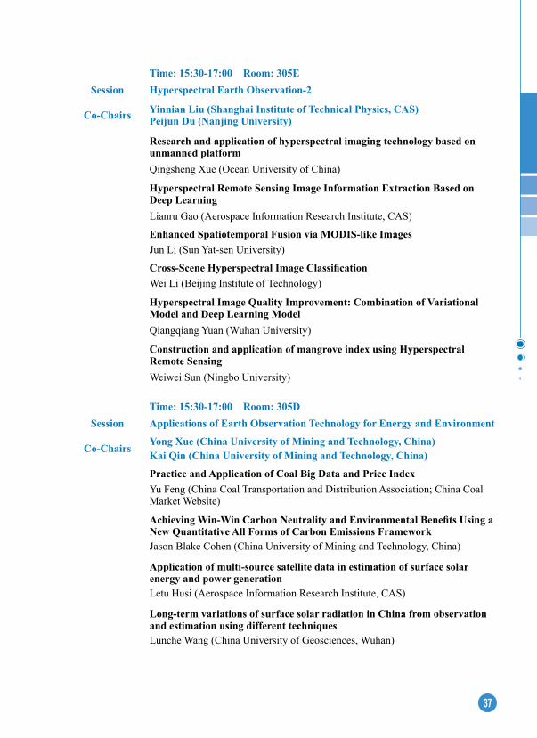
Time: 15:30-17:00 Room: 305eSession Hyperspectral earth Observation-2
Co-Chairs Yinnian Liu (Shanghai Institute of Technical Physics, CAS)Peijun Du (Nanjing University)
Research and application of hyperspectral imaging technology based on unmanned platformQingsheng Xue (Ocean University of China)
Hyperspectral Remote Sensing Image Information extraction Based on Deep LearningLianru Gao (Aerospace Information Research Institute, CAS)
enhanced Spatiotemporal Fusion via MODIS-like ImagesJun Li (Sun Yat-sen University)
Cross-Scene Hyperspectral Image ClassificationWei Li (Beijing Institute of Technology)
Hyperspectral Image Quality Improvement: Combination of Variational Model and Deep Learning ModelQiangqiang Yuan (Wuhan University)
Construction and application of mangrove index using Hyperspectral Remote SensingWeiwei Sun (Ningbo University)
Time: 15:30-17:00 Room: 305DSession Applications of earth Observation Technology for energy and environment
Co-ChairsYong Xue (China University of Mining and Technology, China)Kai Qin (China University of Mining and Technology, China)
Practice and Application of Coal Big Data and Price IndexYu Feng (China Coal Transportation and Distribution Association; China Coal Market Website)
Achieving Win-Win Carbon Neutrality and Environmental Benefits Using a New Quantitative All Forms of Carbon Emissions FrameworkJason Blake Cohen (China University of Mining and Technology, China)
Application of multi-source satellite data in estimation of surface solar energy and power generationLetu Husi (Aerospace Information Research Institute, CAS)
Long-term variations of surface solar radiation in China from observation and estimation using different techniquesLunche Wang (China University of Geosciences, Wuhan)

38
Time: 15:30-17:00 Room: 305C
Session BIM/CIM Information Model and Virtual Geographic environment System
Co-Chairs Guonian Lv (Nanjing Normal University, China)Songshan Yue (Nanjing Normal University, China)
Definition and capabilities of CIMBin Song (Beijing Freedo Technology Company Ltd.)
Practice of City Information Model (CIM) Tao Yang (China Academy of Urban planning and Design)
3D building modeling method based on construction dataLiangchen Zhou (Nanjing Normal University)
A Data Acquisition Method for Digital Base in Urban Space Wang Guo (Shanghai Huace Navigation Technology Company Ltd.)
Airport experimental platform based on the definition of digital twin modelXuefeng Wang (Beijing Boneng Technology Co., Ltd.), Pin Li, Jingting Han, Huanran Qi
Representation and Construction of Multi-LOD Model for BuildingsYunfei Shi (Linyi University)
ecological restoration monitoring based on multi-remote sensing data from large surface coal mine area of grasslandNisha Bao (Northeastern University, China)
Research on 3D implicit modeling and automatic updating method of orebody and software developmentJiateng Guo (Northeastern University, China)
Time: 15:30-17:00 Room: 305BSession Application of Spatial Information Technology
Co-ChairsJiantao Bi (Aerospace Information Research Institute,Chinese Academy of Sciences)Lisa Liu (Beijing SUYOO Infrmation Technology Co.,Ltd.)Digital Agriculture Applications Support for Sustainable Rural DevelopmentYanghua Liu (PIESAT Information Technology Co., Ltd.)
Consolidate the foundation of the digital earth and enhance the development pattern of the spatial information industryJingye Shi (Geovis Technology Co.,Ltd)

39
Geological Hazard early Warning System Based on Radar Remote Sensing Zhen Shi (Quanzhou Zhongke Xingqiao Aerospace Technology Co., Ltd.)
Construction of Urban Comprehensive Governance Grid SystemWei Chen (Wuhan Emap Information Technology Co., Ltd.)
Time: 15:30-17:00 Room: 305A
Session LiDAR earth Observation
Co-Chairs Sheng Nie (Aerospace Information Research Institute, CAS)Yanjun Su (Institute of Botany, CAS)
Application of lidar technology in forest carbon sink estimationYanqiu Xing (Northeast Forestry University)
The applications of LiDAR in precision silviculture and sustainable management for subtropical forestsLin Cao (Nanjing Forestry University)
Interpolation-guided neural network for mapping canopy height of China’s forests by integrating GeDI and ICeSat-2 dataYanjun Su (Institute of Botany, CAS)
Polar application of multi-source satellite laser altimetry dataGuoyuan Li (Land Satellite Remote Sensing Application Center, MNR)
High-resolution Mapping of Forest Vertical Structures at Regional ScaleWenli Huang (Wuhan University)
Vegetation parameter retrievals using ICeSat-2 data Sheng Nie (Aerospace Information Research Institute, CAS)
Time: 15:30-17:00 Room: 201B
Session Sustainable Development of the UNeSCO Designated Sites
Co-ChairsXinyuan Wang, International Research Center of Big Data for Sustainable Development Goals Rosa Lasaponara, IMAA-CNR, Italy
World Heritage Conservation & Sustainable DevelopmentFeng Jing (Asia-Pacific Unit, World Heritage Centre, UNESCO)
Towards Integrated approach for risk assessment of Cultural Heritage SitesRohit Jigyasu (Programme Unit of the Urban Heritage, Climate Change & Disaster Risk Management, International Centre for the Study of the Preservation and Restoration of Cultural Property (ICCROM))

40
UNeSCO Designated Sites’ Contributions in Achieving the Sustainable Development GoalsLei Luo (International Centre on Space Technologies for Natural and Cultural Heritage (HIST) under the Auspices of UNESCO)
Digital Transformation in Culture Heritage: PakistanShahina Tariq (COMSATS University Islamabad, Pakistan)
SAR Interferometry to assess vulnerability over cultural heritage sites: The SCIENCE Greece-China project and Acropolis of Athens resultsIssaak Parcharidis (Harokopio University, Greece)
Space for Heritage: towards a Sustainable DevelopmentRosa Lasaponara (Institute of Methodologies for Environmental Analysis (IMAA), National Research Council (CNR), Italy)
42 41
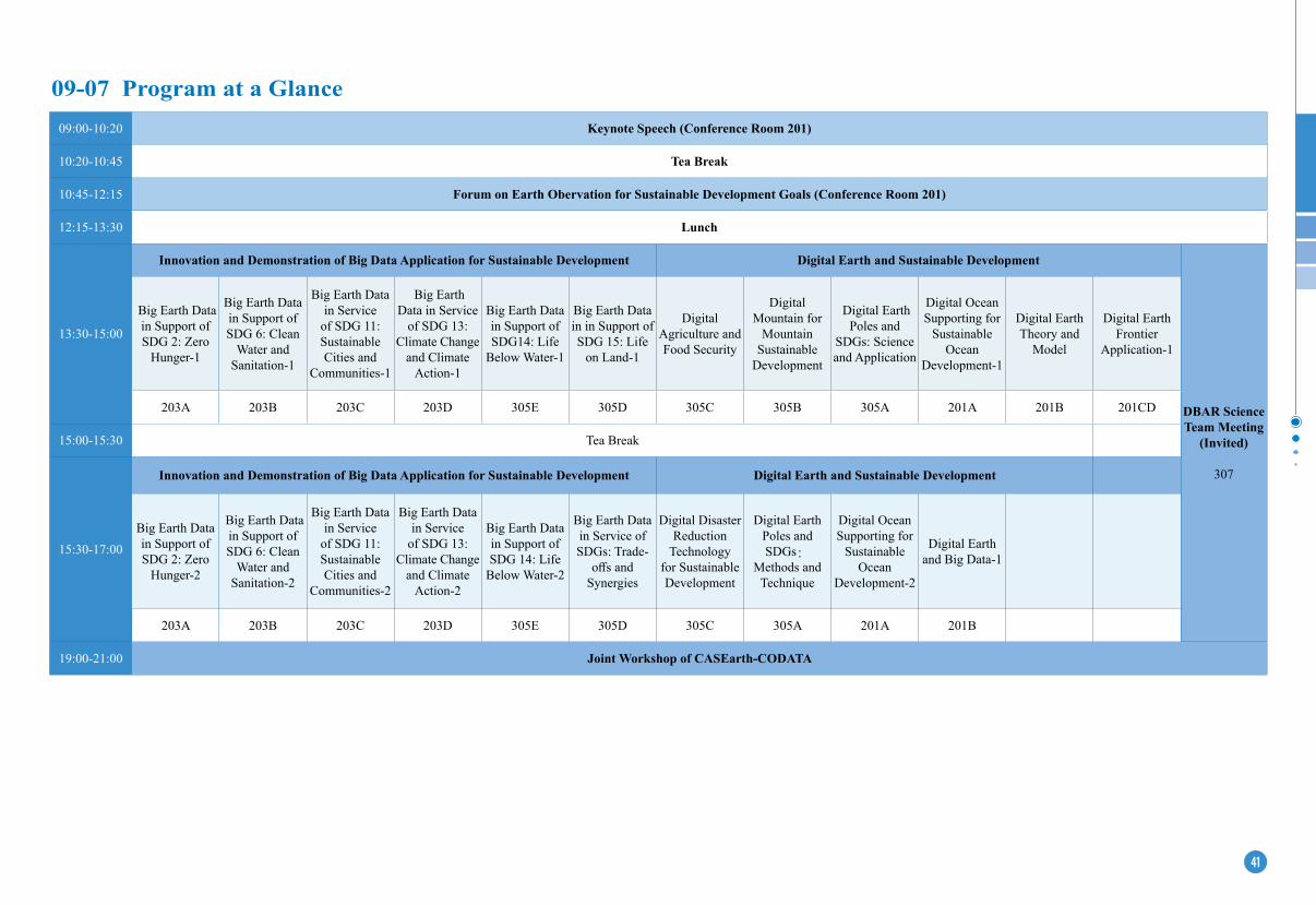
09-07 Program at a Glance 09:00-10:20 Keynote Speech (Conference Room 201)
10:20-10:45 Tea Break
10:45-12:15 Forum on Earth Obervation for Sustainable Development Goals (Conference Room 201)
12:15-13:30 Lunch
13:30-15:00
Innovation and Demonstration of Big Data Application for Sustainable Development Digital earth and Sustainable Development
DBAR Science Team Meeting
(Invited)
307
Big Earth Data in Support of SDG 2: Zero
Hunger-1
Big Earth Data in Support of SDG 6: Clean
Water and Sanitation-1
Big Earth Data in Service
of SDG 11: Sustainable Cities and
Communities-1
Big Earth Data in Service
of SDG 13: Climate Change
and Climate Action-1
Big Earth Data in Support of SDG14: Life
Below Water-1
Big Earth Data in in Support of SDG 15: Life
on Land-1
Digital Agriculture and Food Security
Digital Mountain for
Mountain Sustainable
Development
Digital Earth Poles and
SDGs: Science and Application
Digital Ocean Supporting for
Sustainable Ocean
Development-1
Digital Earth Theory and
Model
Digital Earth Frontier
Application-1
203A 203B 203C 203D 305E 305D 305C 305B 305A 201A 201B 201CD
15:00-15:30 Tea Break
15:30-17:00
Innovation and Demonstration of Big Data Application for Sustainable Development Digital earth and Sustainable Development
Big Earth Data in Support of SDG 2: Zero
Hunger-2
Big Earth Data in Support of SDG 6: Clean
Water and Sanitation-2
Big Earth Data in Service
of SDG 11: Sustainable Cities and
Communities-2
Big Earth Data in Service
of SDG 13: Climate Change
and Climate Action-2
Big Earth Data in Support of SDG 14: Life
Below Water-2
Big Earth Data in Service of SDGs: Trade-
offs and Synergies
Digital Disaster Reduction
Technology for Sustainable Development
Digital Earth Poles and SDGs:
Methods and Technique
Digital Ocean Supporting for
Sustainable Ocean
Development-2
Digital Earth and Big Data-1
203A 203B 203C 203D 305E 305D 305C 305A 201A 201B
19:00-21:00 Joint Workshop of CASearth-CODATA
43
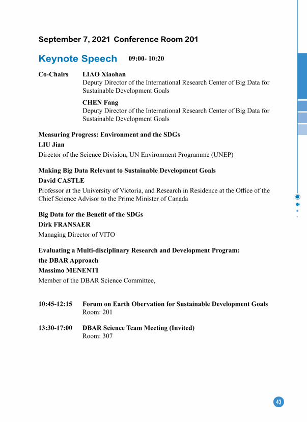
September 7, 2021 Conference Room 201
Keynote Speech 09:00- 10:20
Co-Chairs LIAO XiaohanDeputy Director of the International Research Center of Big Data for Sustainable Development Goals
CHeN FangDeputy Director of the International Research Center of Big Data for Sustainable Development Goals
Measuring Progress: environment and the SDGsLIU JianDirector of the Science Division, UN Environment Programme (UNEP)
Making Big Data Relevant to Sustainable Development GoalsDavid CASTLe Professor at the University of Victoria, and Research in Residence at the Office of the Chief Science Advisor to the Prime Minister of Canada
Big Data for the Benefit of the SDGsDirk FRANSAeRManaging Director of VITO
evaluating a Multi-disciplinary Research and Development Program: the DBAR ApproachMassimo MeNeNTIMember of the DBAR Science Committee,
10:45-12:15 Forum on earth Obervation for Sustainable Development Goals Room: 201
13:30-17:00 DBAR Science Team Meeting (Invited) Room: 307

44
Time: 13:30-15:00 Room: 203A
Session Big earth Data in Support of SDG 2: Zero Hunger-1
Co-Chairs Bingfang Wu, Aerospace Information Research Institute, CASLijun Zuo, Aerospace Information Research Institute, CAS
Spatial pattern of cropland in China: evolution process, effects and reconstructionXiangbin Kong (China Agricultural University)
Observation and simulation of global agricultural land dynamics based on remote sensingLe Yu (Tsinghua University)
Crop growth monitoring based on UAV multi-source remote sensingRan Meng (Huazhong Agricultural University)
Cropped land dynamic change and spatial variations from 2010-2020 in Mediterranean RegionsHongwei Zeng (Aerospace Information Research Institute, CAS)
Sustainable Intensification of cropland in ChinaLijun Zuo (Aerospace Information Research Institute, CAS)
Time: 13:30-15:00 Room: 203B
Session Big earth Data in Support of SDG 6: Clean Water and Sanitation-1
Co-Chairs Colin Herron, Global Water Partnership (GWP)Shanlong Lu, Aerospace Information Research Institute, CAS
Rethinking water for SDG 6Edoardo Borgomeo (University of Oxford)
Monitoring freshwater ecosystems from space in support of implementing SDG target 6.6Stuart Crane (Freshwater Unit, Ecosystems Division, UNEP)
Spatiotemporal dynamics of vegetaed wetlands in China, 2000-2020Zongming Wang (Northeast Institute of Geography and Agroecology, CAS)
Long time series water extent analysis for SDG 6.6.1 based on the GEE platform Weiguo Jiang (Beijing Normal University)

45
Time: 13:30-15:00 Room: 203C
Session Big earth Data in Service of SDG 11: Sustainable Cities and Communities-1
Co-Chairs Qihao Weng, Hong Kong Polytechnic UniversityXiaoling Zhang, City University of Hong Kong
Big Data from Space – How data can change the way we see the urban worldHannes Taubenböck (Deutsches Zentrum für Luft- und Raumfahrt)
Remaking sustainability science in the era of big dataXiaoling Zhang (City University of Hong Kong)
Big earth Data in support of the Urban Sustainable DevelopmentZhongchang Sun (Aerospace Information Research Institute, CAS)
Community resilience in a post-COVID world: data for climate resilience and disaster risk reductionBapon (shm) Fakhruddin (Tonkin + Taylor International Ltd, New Zealand)
Urban landscape modelling and sustainable analysis with fusing crowdsourcing and remote sensing dataShihong Du (Peking University)Global observation of urban land-cover composite and thermal environment for improving urban sustainabilityWenhui Kuang (Institute of Geographic Sciences and Natural Resources Research, CAS)
Time: 13:30-15:00 Room: 203D
Session Big earth Data in Service of SDG 13: Climate Change and Climate Action-1
Co-ChairsGensuo Jia, International Research Center of Big Data for Sustainable Development GoalsLei Huang, Aerospace Information Research Institute, CASIPCC and extreme Weather Panmao Zhai (Chinese Academy of Meteorological Sciences)
Climate Change and Climate ActionTianjun Zhou (Institute of Atmospheric Physics, CAS)
Climate actions over southeast AsiaMonthip Sriritana (NECT, Thailand)
Recent Changes of the Cryosphere and its Impacts Cunde Xiao (Beijing Normal University)
46
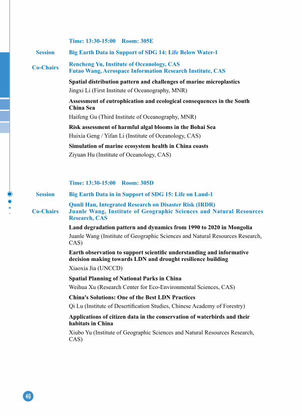
Time: 13:30-15:00 Room: 305e
Session Big Earth Data in Support of SDG 14: Life Below Water-1
Co-Chairs Rencheng Yu, Institute of Oceanology, CASFutao Wang, Aerospace Information Research Institute, CAS
Spatial distribution pattern and challenges of marine microplasticsJingxi Li (First Institute of Oceanography, MNR)
Assessment of eutrophication and ecological consequences in the South China SeaHaifeng Gu (Third Institute of Oceanography, MNR)
Risk assessment of harmful algal blooms in the Bohai SeaHuixia Geng / Yifan Li (Institute of Oceanology, CAS)
Simulation of marine ecosystem health in China coastsZiyuan Hu (Institute of Oceanology, CAS)
Time: 13:30-15:00 Room: 305D
Session Big earth Data in in Support of SDG 15: Life on Land-1
Co-ChairsQunli Han, Integrated Research on Disaster Risk (IRDR)Juanle Wang, Institute of Geographic Sciences and Natural Resources Research, CASLand degradation pattern and dynamics from 1990 to 2020 in MongoliaJuanle Wang (Institute of Geographic Sciences and Natural Resources Research, CAS)Earth observation to support scientific understanding and informative decision making towards LDN and drought resilience buildingXiaoxia Jia (UNCCD)
Spatial Planning of National Parks in ChinaWeihua Xu (Research Center for Eco-Environmental Sciences, CAS)
China's Solutions: One of the Best LDN Practices Qi Lu (Institute of Desertification Studies, Chinese Academy of Forestry)
Applications of citizen data in the conservation of waterbirds and their habitats in ChinaXiubo Yu (Institute of Geographic Sciences and Natural Resources Research, CAS)

47
Time: 13:30-15:00 Room: 305C
Session Digital Agriculture and Food Security
Co-Chairs Nana Yan (Aerospace of Remote Sensing and Digital Earth, CAS)Huanjun Liu (Northeast Institute of Geographyand Agroecology, CAS)
Mapping Paddy Rice in Two Major Planting Techniques over Jiangsu Province of China Using Multitemporal SAR Imagery: Direct-seeded Rice vs Transplanted RiceTao Chen (Nanjing Agricultural University)
Spatial-Temporal Variations and Driving Factor Analysis of Winter Fallow Fields in Jianghan Plain Zhongyuan Li (Hubei University)
Blacksoil area conservation with digital agricultureHuanjun Liu (Northeast Institute of Geographyand Agroecology, CAS)
Integrated AI &RS Technology Appplicaiton in Grain SecurityGong Zhang (Beijing GAGO Ltd)
Applications of Precision Decision-making for family farm based on Ground-UAV-Satellite multi-source perceptual information fusionXingang Xu (National Engineering Research Center for Information Technology in Agriculture)
Drought monitoring method and system for MongoliaSheng Chang (Aerospace of Remote Sensing and Digital Earth, CAS)
Time: 13:30-15:00 Room: 305B
Session Digital Mountain for Mountain Sustainable Development
Co-Chairs Ainong Li (Institute of Mountain Hazards and Environment, CAS)Zongming Wang (Northeast Institute of Geography and Agroecology, CAS)
Remote Sensing Monitoring and Integrated Assessment for the eco-environment along China-Pakistan economic Corridor Ainong Li (Institute of Mountain Hazards and Environment, CAS)
Global high-resolution monitoring of mountain green cover index (SDG 15.4.2)Jinhu Bian (Institute of Mountain Hazards and Environment, CAS)
Monitoring land cover changes over the last three decades in mountainous areas of the China Central-Asia West-Asia economic corridorAmin Naboureh (Institute of Mountain Hazards and Environment, CAS)
48
Digital Terrain Analysis for Mountain Sustainable DevelopmentLiyang Xiong (Nanjing Normal University)
Green Vegetation estimation and Location Analysis of Nature Reserves in Fujian Province, China Using the Shadow-Eliminated Vegetation Index (SeVI)Hong Jiang (Fuzhou University, The Academy of Digital China)Slow-moving landslide activity and intensity assessment using the SBAS method in the Fujin catchment, Northwest ChinaShibiao Bai (Institute of Mountain Hazards and Environment, CAS, Nanjing Normal University)
Time: 13:30-15:00 Room: 305A
Session Digital earth Poles and SDGs: Science and Application
Co-Chairs Jiancheng Shi (National Space Science Center, CAS)Zemin Wang (Wuhan University)
Snow cover model and its validationJiancheng Shi (National Space Science Center, CAS)
The surface and basal melting characteristics of the Antarctic ice shelfZemin Wang (Wuhan University)
Polar Remote Sensing and Global Sea Level RiseRongxing Li (Tongji University)
Spatial and temporal change patterns of near-surface CO2 and CH4 concentrations in different permafrost regions on the Mongolian Plateau from 2010 to 2017Tonghua Wu (The Northwest Institute of Eco-Environment and Resources, CAS)
Influence of Gas Flaring on Vegetation Changes in Siberia AreaYubao Qiu (International Research Center of Big Data for Sustainable Development Goals)
earth three poles remote sensing: change and comparativeWenjin Wu (Aerospace Information Research Institute, CAS)

49
Time: 13:30-15:00 Room: 201A
Session Digital Ocean Supporting for Sustainable Ocean Development-1
Co-Chairs Song Sun (Institute of oceanology, CAS)Yan Bai (Second Institute of Oceanography, MNR, China)
Data-model-driven ocean big data analysisZhenHong Du (Zhejiang University)
Remote Sensing of Deepsea and its application in ocean warming Hua Su (FuZhou University)
Prediction of Sea Surface Temperature in the South China Sea Based on Deep LearningZengzhou Hao (Second Institute of Oceanography, MNR, China)
A Preliminary Study on the Application of Artificial Intelligence in OceanographyLe Gao (Institute of oceanology, CAS)
Spaceborne SAR and artificial intelligence for Arctic sea ice and ocean dynamicsXiaoming Li (Aerospace Information Research Institute, CAS)Research on microwave scattering characteristics of emulsified crude oilJie Guo (Yantai institute of coastal zone research, CAS)
Time: 13:30-15:00 Room: 201B
Session Digital earth Theory and Model
Chair Xiaoping Du (Aerospace Information Research Institute, CAS)
A Spatio-Temporal Data Model for Dynamic earth’s MagnetosphereCifeng Wang (Space Science Big Data Technology Laboratory, National Space Science Center, CAS)
Key technologies and applications of remote sensing big data platformChen Xu (Aerospace Information Research Institute, CAS)
Modeling vague spatiotemporal objects based on interval type-2 fuzzy setsYue Yin (Nanjing Normal University)
Dynamic processing coordinate datum of digital earth and new generation of spatial information datum systemZhengkang Zuo (Peking University)Travel-mode classification based on GPS-trajectory data and geographic information using XGBoost classifier
Huiling Jin (Tongji University)
50
Time: 15:30-17:00 Room: 203A
Session Big earth Data in Support of SDG 2: Zero Hunger-2
Co-Chairs Lijun Zuo, Aerospace Information Research Institute, CASBingfang Wu, Aerospace Information Research Institute, CAS
Delivery of land-based climate mitigation actions on the SDGsPete Smith (University of Aberdeen, UK)
Global Crop Pest and Disease Habitat Monitoring and Risk ForecastingWenjiang Huang (International Research Center of Big Data for Sustainable Development Goals)
Food production and climate change in China----spatial-temporal variations derived from modelling results with high resolution datasetsWen Zhang (The Institute of Atmospheric Physics, CAS)
Big data for food security: case studies for SSA and SeAPatricio Grassini (University of Nebraska, USA)
Global cropping system modelling: past, present and futureLiangzhi You (Institute of Food Policy Research Institute, USA)
Time:13:30-15:00 Room: 201CD
Session Digital earth Frontier Application-1
Co-Chairs Lihui Luo (Northwest Institute of Eco-Environment and Resources, CAS)Mingyang Lv (Aerospace Information Research Institute, CAS)
Vulnerability assessment of freeze-thaw disasters in High Mountain AsiaLihui Luo (Northwest Institute of Eco-Environment and Resources, CAS)Spatial and temporal variation of near-surface permafrost freezing and thawing in high Asia based on remote sensing dataXuting Liu (Aerospace Information Research Institute, CAS)A dataset of surge-type glaciers in the High Mountain Asia based on earth observationMingyang Lv (Aerospace Information Research Institute, CAS)Vegetation community characteristics and diversity changes of glacier foreshore based on aerial photography by UAVTianfeng Wei (Gansu Agricultural University)High-resolution Freeze-thaw Intensity Extraction Method of Antarctic Ice Sheet Based on Time-series SAR DataQi Zhu (Aerospace Information Research Institute, CAS)
51
Time: 15:30-17:00 Room: 203BSession Big earth Data in Support of SDG 6: Clean Water and Sanitation-2
Co-Chairs Yajun Liu, International Eco-safety Cooperative Organization (IESCO)Hongtao Duan, Nanjing Institute of Geography & Limnology, CAS
Precise Water and Sanitation Service Delivery through e-Household-based Survey: a case study from IndonesiaFany Wedahuditama (GWP-South-East Asia)Remote-sensed Forel-Ule Index, water clarity, and trophic state of global large lakes and reservoirsJunsheng Li (Aerospace Information Research Institute, CAS)The evaluation of global water use efficiency changes of crops based on remote sensingChaolei Zheng, Li Jia (Aerospace Information Research Institute, CAS)Observations of water clarity in large lakes in eastern China with multi-source remote sensing: Implications for SDG 6.3.2 evaluationMing Shen, Hongtao Duan (Nanjing Institute of Geography & Limnology, CAS)
Time: 15:30-17:00 Room: 203CSession Big earth Data in Service of SDG 11: Sustainable Cities and Communities-2
Co-Chairs Dengsheng Lu, Fujian Normal UniversityChunlin Huang, Northwest Institute of Eco-Environment and Resources, CASBig eO Data Analytics and the Contemporary Urbanization in the Brazilian Amazon: Challenges and Opportunities for Bringing more Safety, Resilience and Sustainability in Rural-Urban Continuum RegionsAntonio Miguel Vieira Monteiro (Instituto Nacional de Pesquisas Espaciais - INPE)Global impervious surface mapping using multi-source data and implication to SDG11Dengsheng Lu (Fujian Normal University)The indicator of surface disturbances for the sustainability assessment of world cultural heritage sitesFulong Chen (Aerospace Information Research Institute, CAS)
Where to live? Housing affordability assessment of cities in ChinaHaimeng Liu (Institute of Geographic Sciences and Natural Resources Research, CAS)Large-scale road extraction from optical and SAR images using deep learning networksHongsheng Zhang (The University of Hong Kong)Interannual Variation of Natural Disaster Risk in China - A Municipal View from 2010 to 2020Peng Zhang (National Disaster Reduction Center of China, Ministry of Emergency Management of the People’s Republic of China)
52
Time: 15:30-17:00 Room: 203D
Session Big earth Data in Service of SDG 13: Climate Change and Climate Action-2
Co-ChairsGensuo Jia, International Research Center of Big Data for Sustainable Development GoalsLei Huang, Institute of Remote Sensing and Digital Earth, CAS
Global Real Time Carbon monitoring Zhu Liu (Tsinghua University)Spatial pattern of atmospheric CO2 concentration and its driving factors derived from satellite observationsLiping Lei (Aerospace Information Research Institute, CAS research )
National-level NPP distribution and its driversDailiang Peng (Aerospace Information Research Institute, CAS research )
New understanding of climate change driven by Big Earth DataGensuo Jia ( International Research Center of Big Data for Sustainable Development Goals)
Time: 15:30-17:00 Room: 305e
Session Big Earth Data in Support of SDG 14: Life Below Water-2
Co-Chairs Rencheng Yu , Institute of Oceanology, CASFutao Wang , Aerospace Information Research Institute, CAS
Delivery of land-based climate mitigation actions on the SDGsChengyi Wang (Aerospace Information Research Institute , CAS)
Identifying spatiotemporal patterns of coastal aquaculture ponds in China for SDG 14Dehua Mao (Northeast Institute of Geography and Agroecology, CAS)
Declining oxygen in temperate marginal shelf under multiple stressors: a case study in the Yellow and Bohai SeasQinsheng Wei (First Institute of Oceanography, MNR)
Towards a more sustainable coastal environment: how big earth data contributes the SDG14 in MSR countriesLi Zhang / Bowei Chen (Aerospace Information Research Institute , CAS)
53
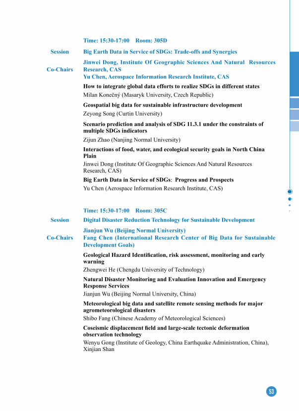
Time: 15:30-17:00 Room: 305D
Session Big earth Data in Service of SDGs: Trade-offs and Synergies
Co-ChairsJinwei Dong, Institute Of Geographic Sciences And Natural Resources Research, CASYu Chen, Aerospace Information Research Institute, CASHow to integrate global data efforts to realize SDGs in different statesMilan Konečný (Masaryk University, Czech Republic)
Geospatial big data for sustainable infrastructure developmentZeyong Song (Curtin University)
Scenario prediction and analysis of SDG 11.3.1 under the constraints of multiple SDGs indicatorsZijun Zhao (Nanjing Normal University)Interactions of food, water, and ecological security goals in North China PlainJinwei Dong (Institute Of Geographic Sciences And Natural Resources Research, CAS)Big earth Data in Service of SDGs: Progress and ProspectsYu Chen (Aerospace Information Research Institute, CAS)
Time: 15:30-17:00 Room: 305CSession Digital Disaster Reduction Technology for Sustainable Development
Co-ChairsJianjun Wu (Beijing Normal University)Fang Chen (International Research Center of Big Data for Sustainable Development Goals)
Geological Hazard Identification, risk assessment, monitoring and early warningZhengwei He (Chengdu University of Technology)Natural Disaster Monitoring and evaluation Innovation and emergency Response ServicesJianjun Wu (Beijing Normal University, China)Meteorological big data and satellite remote sensing methods for major agrometeorological disastersShibo Fang (Chinese Academy of Meteorological Sciences)Coseismic displacement field and large-scale tectonic deformation observation technology Wenyu Gong (Institute of Geology, China Earthquake Administration, China), Xinjian Shan
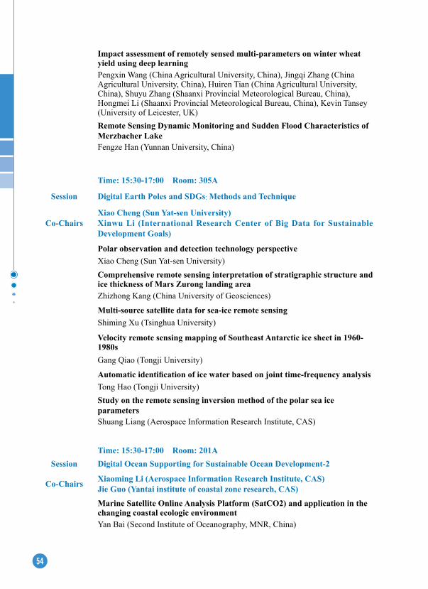
54
Impact assessment of remotely sensed multi-parameters on winter wheat yield using deep learningPengxin Wang (China Agricultural University, China), Jingqi Zhang (China Agricultural University, China), Huiren Tian (China Agricultural University, China), Shuyu Zhang (Shaanxi Provincial Meteorological Bureau, China), Hongmei Li (Shaanxi Provincial Meteorological Bureau, China), Kevin Tansey (University of Leicester, UK)Remote Sensing Dynamic Monitoring and Sudden Flood Characteristics of Merzbacher LakeFengze Han (Yunnan University, China)
Time: 15:30-17:00 Room: 305A
Session Digital earth Poles and SDGs: Methods and Technique
Co-ChairsXiao Cheng (Sun Yat-sen University)Xinwu Li (International Research Center of Big Data for Sustainable Development Goals)
Polar observation and detection technology perspectiveXiao Cheng (Sun Yat-sen University)Comprehensive remote sensing interpretation of stratigraphic structure and ice thickness of Mars Zurong landing areaZhizhong Kang (China University of Geosciences)
Multi-source satellite data for sea-ice remote sensingShiming Xu (Tsinghua University)
Velocity remote sensing mapping of Southeast Antarctic ice sheet in 1960-1980s Gang Qiao (Tongji University)
Automatic identification of ice water based on joint time-frequency analysisTong Hao (Tongji University)Study on the remote sensing inversion method of the polar sea ice parametersShuang Liang (Aerospace Information Research Institute, CAS)
Time: 15:30-17:00 Room: 201ASession Digital Ocean Supporting for Sustainable Ocean Development-2
Co-Chairs Xiaoming Li (Aerospace Information Research Institute, CAS)Jie Guo (Yantai institute of coastal zone research, CAS)
Marine Satellite Online Analysis Platform (SatCO2) and application in the changing coastal ecologic environment Yan Bai (Second Institute of Oceanography, MNR, China)
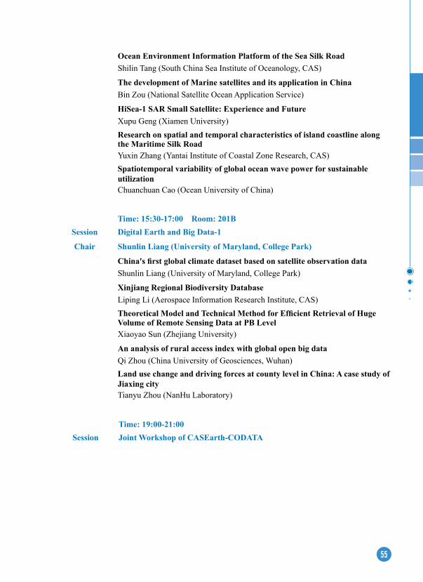
55
Time: 15:30-17:00 Room: 201BSession Digital earth and Big Data-1
Chair Shunlin Liang (University of Maryland, College Park)
China's first global climate dataset based on satellite observation dataShunlin Liang (University of Maryland, College Park)
Xinjiang Regional Biodiversity DatabaseLiping Li (Aerospace Information Research Institute, CAS)Theoretical Model and Technical Method for Efficient Retrieval of Huge Volume of Remote Sensing Data at PB LevelXiaoyao Sun (Zhejiang University)
An analysis of rural access index with global open big dataQi Zhou (China University of Geosciences, Wuhan)Land use change and driving forces at county level in China: A case study of Jiaxing cityTianyu Zhou (NanHu Laboratory)
Time: 19:00-21:00Session Joint Workshop of CASearth-CODATA
Ocean environment Information Platform of the Sea Silk RoadShilin Tang (South China Sea Institute of Oceanology, CAS)
The development of Marine satellites and its application in ChinaBin Zou (National Satellite Ocean Application Service)
HiSea-1 SAR Small Satellite: experience and FutureXupu Geng (Xiamen University)Research on spatial and temporal characteristics of island coastline along the Maritime Silk RoadYuxin Zhang (Yantai Institute of Coastal Zone Research, CAS)Spatiotemporal variability of global ocean wave power for sustainable utilizationChuanchuan Cao (Ocean University of China)

58
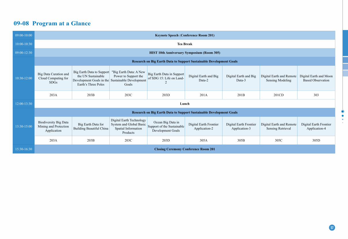
56 57
09:00-10:00 Keynote Speech (Conference Room 201)
10:00-10:30 Tea Break
09:00-12:30 HIST 10th Anniversary Symposium (Room 305)
10:30-12:00
Research on Big earth Data to Support Sustainable Development Goals
Big Data Curation and Cloud Computing for
SDGs
Big Earth Data to Support the UN Sustainable
Development Goals in the Earth’s Three Poles
"Big Earth Data: A New Power to Support the
Sustainable Development Goals
Big Earth Data in Support of SDG 15: Life on Land-
2
Digital Earth and Big Data-2
Digital Earth and Big Data-3
Digital Earth and Remote Sensing Modeling
Digital Earth and Moon Based Observation
203A 203B 203C 203D 201A 201B 201CD 303
12:00-13:30 Lunch
13:30-15:00
Research on Big earth Data to Support Sustainable Development Goals
Biodiversity Big Data Mining and Protection
Application
Big Earth Data for Building Beautiful China
Digital Earth Technology System and Global Basic
Spatial Information Products
Ocean Big Data in Support of the Sustainable
Development Goals
Digital Earth Frontier Application-2
Digital Earth Frontier Application-3
Digital Earth and Remote Sensing Retrieval
Digital Earth Frontier Application-4
203A 203B 203C 203D 305A 305B 305C 305D
15:30-16:30 Closing Ceremony Conference Room 201
09-08 Program at a Glance
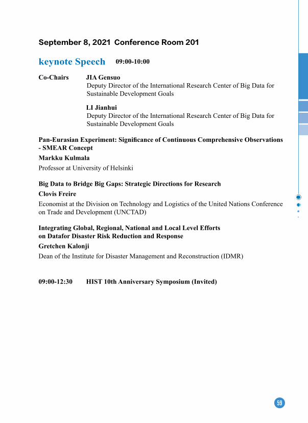
59
September 8, 2021 Conference Room 201
keynote Speech 09:00-10:00
Co-Chairs JIA GensuoDeputy Director of the International Research Center of Big Data for Sustainable Development Goals
LI JianhuiDeputy Director of the International Research Center of Big Data for Sustainable Development Goals
Pan-Eurasian Experiment: Significance of Continuous Comprehensive Observations - SMeAR ConceptMarkku Kulmala Professor at University of Helsinki
Big Data to Bridge Big Gaps: Strategic Directions for ResearchClovis FreireEconomist at the Division on Technology and Logistics of the United Nations Conference on Trade and Development (UNCTAD)
Integrating Global, Regional, National and Local Level Efforts on Datafor Disaster Risk Reduction and ResponseGretchen Kalonji Dean of the Institute for Disaster Management and Reconstruction (IDMR)
09:00-12:30 HIST 10th Anniversary Symposium (Invited)
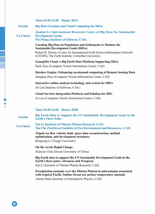
60
Time:10:30-12:00 Room: 203A
Session Big Data Curation and Cloud Computing for SDGs
Co-ChairsJianhui Li (International Research Center of Big Data for Sustainable Development Goals)Wei Wang (Institute of Software, CAS)
Curating Big Data on Population and Settlements to Monitor the Sustainable Development Goals (SDGs) Robert R. Downs (Center for International Earth Science Information Network (CIESIN), The Earth Institute, Columbia University)
GuangMu Cloud: a Big earth Data Platform Supporting SDGsHaili Xiao (Computer Netork Information Center, CAS)
Databox engine: enhancing on-demand computing of Remote Sensing DataJianghua Zhao (Computer Netork Information Center, CAS)
Interactive online analysis technology and system for SDGsJie Liu( Institute of Software, CAS )
Cloud Services Integration Platform and Solution for SDGZe Luo (Computer Netork Information Center, CAS)
Time:10:30-12:00 Room: 203B
Session Big earth Data to Support the UN Sustainable Development Goals in the earth’s Three Poles
Co-Chairs Xin Li (Institute of Tibetan Plateau Research, CAS)Tao Che (Northwest Institute of Eco-Environment and Resources, CAS)
Tripole ice flow velocity field: space-time reconstruction, method optimization, and development trendency Rongxing Li (Tongji University)
On the Arctic Rapid ChangeXianyao Chen (Ocean University of China)
Big earth data to support the UN Sustainable Development Goals in the earth’s three poles: Advances and Prospects Xin Li (Institute of Tibetan Plateau Research, CAS)
Precipitation anomaly over the Tibetan Plateau in mid-autumn associated with tropical Pacific–Indian Ocean sea surface temperature anomalyAnmin Duan (Institute of Atmospheric Physics, CAS)
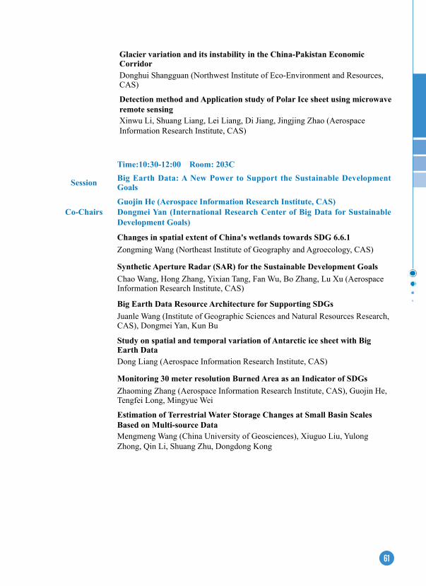
61
Time:10:30-12:00 Room: 203C
Session Big Earth Data: A New Power to Support the Sustainable Development Goals
Co-ChairsGuojin He (Aerospace Information Research Institute, CAS)Dongmei Yan (International Research Center of Big Data for Sustainable Development Goals)
Changes in spatial extent of China's wetlands towards SDG 6.6.1Zongming Wang (Northeast Institute of Geography and Agroecology, CAS)
Synthetic Aperture Radar (SAR) for the Sustainable Development GoalsChao Wang, Hong Zhang, Yixian Tang, Fan Wu, Bo Zhang, Lu Xu (Aerospace Information Research Institute, CAS)
Big earth Data Resource Architecture for Supporting SDGsJuanle Wang (Institute of Geographic Sciences and Natural Resources Research, CAS), Dongmei Yan, Kun Bu
Study on spatial and temporal variation of Antarctic ice sheet with Big earth DataDong Liang (Aerospace Information Research Institute, CAS)
Monitoring 30 meter resolution Burned Area as an Indicator of SDGsZhaoming Zhang (Aerospace Information Research Institute, CAS), Guojin He, Tengfei Long, Mingyue Wei
estimation of Terrestrial Water Storage Changes at Small Basin Scales Based on Multi-source DataMengmeng Wang (China University of Geosciences), Xiuguo Liu, Yulong Zhong, Qin Li, Shuang Zhu, Dongdong Kong
Glacier variation and its instability in the China-Pakistan economic Corridor Donghui Shangguan (Northwest Institute of Eco-Environment and Resources, CAS)
Detection method and Application study of Polar Ice sheet using microwave remote sensingXinwu Li, Shuang Liang, Lei Liang, Di Jiang, Jingjing Zhao (Aerospace Information Research Institute, CAS)
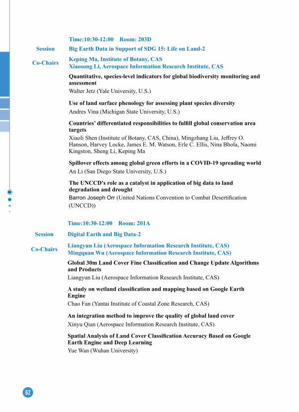
62
Time:10:30-12:00 Room: 203DSession Big earth Data in Support of SDG 15: Life on Land-2
Co-Chairs Keping Ma, Institute of Botany, CASXiaosong Li, Aerospace Information Research Institute, CAS
Quantitative, species-level indicators for global biodiversity monitoring and assessmentWalter Jetz (Yale University, U.S.)
Use of land surface phenology for assessing plant species diversityAndres Vina (Michigan State University, U.S.)
Countries’ differentiated responsibilities to fulfill global conservation area targetsXiaoli Shen (Institute of Botany, CAS, China), Mingzhang Liu, Jeffrey O. Hanson, Harvey Locke, James E. M. Watson, Erle C. Ellis, Nina Bhola, Naomi Kingston, Sheng Li, Keping Ma
Spillover effects among global green efforts in a COVID-19 spreading worldAn Li (San Diego State University, U.S.)
The UNCCD's role as a catalyst in application of big data to land degradation and droughtBarron Joseph Orr (United Nations Convention to Combat Desertification (UNCCD))
Time:10:30-12:00 Room: 201A
Session Digital earth and Big Data-2
Co-Chairs Liangyun Liu (Aerospace Information Research Institute, CAS)Mingquan Wu (Aerospace Information Research Institute, CAS)
Global 30m Land Cover Fine Classification and Change Update Algorithms and ProductsLiangyun Liu (Aerospace Information Research Institute, CAS)
A study on wetland classification and mapping based on Google Earth engineChao Fan (Yantai Institute of Coastal Zone Research, CAS)
An integration method to improve the quality of global land coverXinyu Qian (Aerospace Information Research Institute, CAS)
Spatial Analysis of Land Cover Classification Accuracy Based on Google earth engine and Deep LearningYue Wan (Wuhan University)
63
Time:10:30-12:00 Room: 201BSession Digital earth and Big Data-3
Co-Chairs Liangfu Chen (Aerospace Information Research Institute, CAS)Honghe Xu (Nanjing Institute of Geology and Paleontology, CAS)
China's current demand for satellite big data for ozone pollution prevention and controlLiangfu Chen (Aerospace Information Research Institute, CAS)Fitness-of-use of Multi-source Geospatial Big Data for assessing urban green space in SDG 11.7: A Case Study in NingboMinwen Jin (University of Nottingham Ningbo China;.Institute of Geographic Sciences and Natural Resources Research, CAS)Reconstruction methods for high spatiotemporal continuous remotely sensed land surface temperature: a case study of hubei provinceRan Li (China University of Geosciences, Wuhan)Research on Time-Series Feature Correlation Analysis Method Based on DTW AlgorithmYiming Liu (Peking University)Geological resource visualization research based on earth's paleobiodiversity dataXu Honghe (Nanjing Institute of Geology and Paleontology, CAS)Distributed Management and WeB Visualization of large-scale Spatio-temporal HeatmapQi Xu (Wuhan Universtiy)
Multi-scale Convolution Block Attention Network for Local Climate Zone Classification from Sentinel-2 imageRenfeng Wang (China University of Geosciences, Wuhan)
SDG9.1.1: estimation of population proportion on both sides of rural roads and Remote Sensing extraction Method ResearchMingquan Wu (Aerospace Information Research Institute,CAS)
Time:10:30-12:00 Room: 201CDSession Digital earth and Remote Sensing Modeling
Chair Xiyong Hou (Yantai Institute of Coastal Zone Research, CAS)Near-term monitoring and multi-scenario analysis to 2100 for land use and land cover change in China’s coastal zoneXiyong Hou (Yantai Institute of Coastal Zone Research, CAS)Acoustic Observation and evaluation for the Benthic Habitat in the Artificial Reef AreaDong Li (Yantai Institute of Coastal Zone Research, CAS)
64
Time:10:30-12:00 Room: 303Session Digital earth and Moon Based Observation
Co-Chairs Guang Liu (Aerospace Information Research Institute, CAS)Lu Zhang (Aerospace Information Research Institute, CAS)
Moon-based Earth observations- a new means to monitor Earth energy budgetGuang Liu (Aerospace Information Research Institute, CAS)Distribution of Earth's short-wave outward radiated energy at lunar orbital altitudeJie Wu (Aerospace Information Research Institute, CAS)Anisotropy analysis of Earth outgoing radiation viewed from a Moon-based platformJing Huang (Aerospace Information Research Institute, CAS)
exploration of Moon-based observations for polar vortex variationYu Deng (Peking University)
A Standardized GIS Web Service Oriented Shared-nothing Architecture - Taking Species Distribution Modeling as an exampleXiaoyu Liu (Fuzhou University)Research on global potential distribution of main cold spring coral reef based on integrated modeling methodRuiju Tong (Fujian University of Technology)Study on sediment changes of west islet based on Sentinel-2 and GF-2 imagesHongrong Wu (Aerospace Information Research Institute, CAS; Yangtze University)
Time:13:30-15:00 Room: 203A
Session Biodiversity Big Data Mining and Protection Application
Co-Chairs Keping Ma (Institute of Botany CAS)Qinghua Guo (Institute of Botany, CAS)
Cross-scale vegetation mapping and biodiversity research supported by big ecological remote sensing data in ChinaQinghua Guo (Institute of Botany, CAS)
Prioritizing the biodiversity variables that can be retrieved from satelliteAndrew Skidmore (University of Twente, Netherland)International Barcode of Life – DNA tools for science, conservation and sustainabilityDonald Hobern (International Barcode of Life Consortium, Australia)

65
How could Global Biodiversity Information Facility better support post 2020 global biodiversity frameworkJoe Miller (GBIF Secretariat, Denmark)
The new Catalogue of Life for a better service to biodiversity informaticsOlaf Banki (Naturalis Biodiversity Center, Netherlands)
Towards the Atlas of the Russian Flora: e-data are changing our realityAlexey Seregin (Irkutsk State University, Russia)
Time:13:30-15:00 Room: 203B
Session Big earth Data for Building Beautiful China
Co-Chairs
Chunlin Huang (Northwest Institute of Eco-Environment and Resources, CAS)Chaoyang Wu (Institute of Geographical Sciences and Natural Resources Research, CAS)Big earth data in support of the research on vegetation phenologyXiaoyue Wang (Institute of Geographical Sciences and Natural Resources Research, CAS)SDG Clean Air Big Data Application Innovation ResearchTing Yang (Institute of Atmospheric Physics, CAS)Sustainable development path analysis in poverty-stricken city of China from the perspective of Production-Living-ecology Space Dong Jiang (Institute of Geographical Sciences and Natural Resources Research, CAS, China), Jingying Fu, Gang Lin, Mengmeng HaoIdentifying high-risk areas of airborne disease in “movement-encounter” networkFangye Du (Institute of Geographical Sciences and Natural Resources Research, CAS)Mega-city region sustainability assessment and obstacles identification with GIS-entropy-TOPSIS model: A case in Yangtze River Delta urban agglomeration, ChinaZhonghao Zhang (Shanghai Normal University, China) , Jun Gao, Xueyan Xu, Shimeng Sun, Tao LongAnalysis of determinants dominating sustainability in the endorheic regions Yinchun Ge (Northwest Institute of Eco-Environment and Resources, CAS)Spatial-temporal changes of China’s mangrove forests over the past 50 years: An analysis towards the Sustainable Development Goals (SDGs) Mingming Jia (Northeast Institute of Geography and Agroecology, CAS), Zongming Wang, Dehua Mao
66
Time:13:30-15:00 Room: 203C
Session Digital earth Technology System and Global Basic Spatial Information Products
Co-ChairsXiangtao Fan (Aerospace Information Research Institute, CAS)Wenjiang Huang (International Research Center of Big Data for Sustainable Development Goals)
Operational Monitoring of Near Real-time Land Surface Dynamics from Polar-orbiting and Geostationary Satellites in Support of Sustainable Agriculture and Land ManagementXiaoyang Zhang (South Dakoda State University)
The Swiss Data Cube - Towards a Digital Earth solution for Sustainable DevelopmentGregory Giuliani (UN Environment GRID-Geneva/ University of Geneva, Switzerland)
New generation digital earth engine and platformXiangtao Fan (Aerospace Information Research Institute, CAS)
Comprehensive Information Platform for ecological and environment Management: Construction and ProspectMingxiang Huang (Information Center, Ministry of Ecology and Environment, China)
Global crop pest and disease habitat monitoring and risk forecastingWenjiang Huang (International Research Center of Big Data for Sustainable Development Goals)
Spatiotemporal changes of forest density in China since 2000Ronggao Liu (Institute of Geographic Sciences and Nature Resources Research, CAS)
Time:13:30-15:00 Room: 203DSession Ocean Big Data in Support of the Sustainable Development GoalsChair Chaolun Li (Institute of Oceanology, CAS)
Sustainable Development of coastal ecosystem: opportunity and challengeSong Sun (Institute of Oceanology, CAS)
Advanced ocean coupled model is the core for big data Fangli Qiao (First Institute of Oceanography, MNR, China)
Ocean AI: A new bridge from data to knowledgeGe Chen (Ocean University of China, China)

67
Time:13:30-15:00 Room: 305A
Session Digital earth Frontier Application-2
Chair Shiyong Yan (China University of Mining and Technology, China)Deformation Pattern Observation and Analysis by TS-InSAR in coal resource-exhausted regionShiyong Yan (China University of Mining and Technology, China)Characterization of seasonal movement of Cheeuping landslide based on time-series InSAR technologyYiting Go (Aerospace Information Research Institute, CAS)Research on monitoring urban construction waste dust film cover based on remote sensingLi Zilu (Key Laboratory of Digital Earth Science, Aerospace Information Research Institute, CAS)Landscape pattern and ecological sustainability analysis of watershed ecosystem using spatial information entropyLiu Xintong (Tsinghua University)Comparative study on health evaluation of typical cities in China based on multi-source dataZhuoran Lv (Aerospace Information Research Institute, CAS)A practical method for extracting displacement of segments in shield tunnels using mobile laser scanning dataShida Wang (Tongji University)
Time:13:30-15:00 Room: 305B
Session Digital earth Frontier Application-3
Chair Kai Qin (China University of Mining and Technology, China)Remote Sensing Monitoring of Atmospheric environment in China's energy Golden Triangle Kai Qin (China University of Mining and Technology, China)
Big Data supports SDG with a new global mangrove dataFenzhen Su (Institute of Geographic Sciences and Natural Resources Research, CAS)Mitigation strategies of marine ecological disaster: observation and data requirementsRencheng Yu (Institute of Oceanology, CAS)

68
Time:13:30-15:00 Room: 305C
Session Digital earth and Remote Sensing Retrieval
Co-Chairs Kebin Zhang (Beijing Forestry University)Tingting Zhang (Aerospace Information Research Institute, CAS)
Case studies of land degradation monitoring & assessment by use of earth big data in ChinaKebin Zhang (Beijing Forestry University)Soil Erosion Dynamics Evaluation in Inner Mongolia with Long Time Series Remote Sensing DataWei Jiang (China Institute of Water Resources and Hydropower Research)A full element study on microwave characteristics of soil salinization process under controlled environmentTingting Zhang (Aerospace Information Research Institute, CAS)
A study on full element measurement of microwave characteristics of soil water content change process under controlled environmentQiang Gao (Aerospace Information Research Institute, CAS)Retrieval technology of soil water content in corps cotton field based on UAV hyperspectral dataKailei Xu (MEIHANG Remote Sensing Information Co., Ltd)Analysis of the impact of snowpack changes on the Qinghai-Tibet Plateau on drought in the Yangtze and Yellow River basinsHeng Zhou (Aerospace Information Research Institute, CAS)
Fine-grained crop classification method for airborne SAR time-series images supported by migration learningXingli Qin (Wuhan University)Dynamic of alpine timberline and its response to climate change in Hengduan Mountains over the past 3 decadesLei Tian (Aerospace Information Research Institute, CAS)A novel approach to winter wheat mapping by automatic generation of training samples and one-class classification on Google Earth EngineGaoxiang Yang (Nanjing Agricultural University)Spatial and temporal variation patterns and aggregation of crop residue burning at county scale in Northeast ChinaYi Wang (Northeast Normal University)A hybrid ANN and Bayesian approach for retrieving GAI from several decametric satellites: Calibration, modification and validationJingwen Wang (Aerospace Information Research Institute, CAS)
69
Time:13:30-15:00 Room: 305D
Session Digital earth Frontier Application-4
Co-Chairs Hongzhong Li (Shenzhen Institutes of Advanced Technology, CAS)Shibing Zhu (Institute of Nature Sourses and Ecology, HAS)
extraction of Hainan rubber forest based on multi-temporal Sentinel-2 imagesHongzhong Li (Shenzhen Institutes of Advanced Technology, CAS)
Application analysis of change detection based on sentinel-2 remote sensing image in urban expansion -- a case study of Xiong'an AreaYu Du (Capital Normal University)The rapid production methods of global forest cover products and the current status of forest coverXiaomei Zhang (Aerospace Information Research Institute, CAS)High-precision vegetation data interpretation in the Xiaoxinganling region based on remote sensing dataShibing Zhu (Institute of Nature Sourses and Ecology, HAS)Urban forest canopy height inversion using spaceborne laser ICeSAT2 LiDARShufan Wang (Tongji University)
15:30-16:30 Closing Ceremony
Conference Room 201
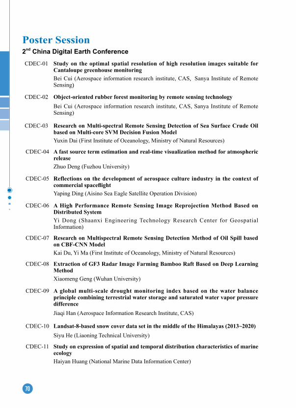
70
Poster Session
CDEC-01 Study on the optimal spatial resolution of high resolution images suitable for Cantaloupe greenhouse monitoringBei Cui (Aerospace information research institute, CAS, Sanya Institute of Remote Sensing)
CDEC-02 Object-oriented rubber forest monitoring by remote sensing technologyBei Cui (Aerospace information research institute, CAS, Sanya Institute of Remote Sensing)
CDEC-03 Research on Multi-spectral Remote Sensing Detection of Sea Surface Crude Oil based on Multi-core SVM Decision Fusion ModelYuxin Dai (First Institute of Oceanology, Ministry of Natural Resources)
CDEC-04 A fast source term estimation and real-time visualization method for atmospheric releaseZhuo Deng (Fuzhou University)
CDEC-05 Reflections on the development of aerospace culture industry in the context of commercial spaceflightYaping Ding (Aisino Sea Eagle Satellite Operation Division)
CDEC-06 A High Performance Remote Sensing Image Reprojection Method Based on Distributed SystemYi Dong (Shaanxi Engineering Technology Research Center for Geospatial Information)
CDEC-07 Research on Multispectral Remote Sensing Detection Method of Oil Spill based on CBF-CNN ModelKai Du, Yi Ma (First Institute of Oceanology, Ministry of Natural Resources)
CDEC-08 extraction of GF3 Radar Image Farming Bamboo Raft Based on Deep Learning MethodXiaomeng Geng (Wuhan University)
CDEC-09 A global multi-scale drought monitoring index based on the water balance principle combining terrestrial water storage and saturated water vapor pressure differenceJiaqi Han (Aerospace Information Research Institute, CAS)
CDEC-10 Landsat-8-based snow cover data set in the middle of the Himalayas (2013~2020)Siyu He (Liaoning Technical University)
CDEC-11 Study on expression of spatial and temporal distribution characteristics of marine ecologyHaiyan Huang (National Marine Data Information Center)
2nd China Digital Earth Conference
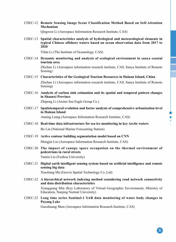
71
CDEC-12 Remote Sensing Image Scene Classification Method Based on Self-Attention MechanismQingwen Li (Aerospace Information Research Institute, CAS)
CDEC-13 Spatial characteristics analysis of hydrological and meteorological elements in typical Chinese offshore waters based on ocean observation data from 2017 to 2020Yifan Li (The Institute of Oceanology, CAS)
CDEC-14 Dynamic monitoring and analysis of ecological environment in sanya coastal tourism areaZhichao Li (Aerospace information research institute, CAS, Sanya Institute of Remote Sensing)
CDEC-15 Characteristics of the Geological Tourism Resources in Hainan Island, ChinaZhichao Li (Aerospace information research institute, CAS, Sanya Institute of Remote Sensing)
CDEC-16 Analysis of carbon sink estimation and its spatial and temporal pattern changes in Shaanxi ProvinceZhipeng Li (Aisino Sea Eagle Group Co.)
CDEC-17 Spatiotemporal evolution and factor analysis of comprehensive urbanization level in Hainan IslandAnning Liang (Aerospace Information Research Institute, CAS)
CDEC-18 Real-time data infrastructure for sea ice monitoring in key Arctic watersBo Lin (National Marine Forecasting Station)
CDEC-19 Active contour building segmentation model based on CNNMengjia Liu (Aerospace Information Research Institute, CAS)
CDEC-20 The impact of canopy space occupation on the thermal environment of pedestrians in rural streetsYamin Liu (Fuzhou University)
CDEC-21 Digital earth intelligent sensing system based on artificial intelligence and remote sensing big dataXiaoliang Ma (Geovis Spatial Technology Co.,Ltd)
CDEC-22 A hierarchical network indexing method considering road network connectivity and data distribution characteristicsXiangqiang Min (Key Laboratory of Virtual Geographic Environment, Ministry of Education, Nanjing Normal University)
CDEC-23 Long time series Sentinel-1 SAR data monitoring of water body changes in Poyang LakeGuozhuang Shen (Aerospace Information Research Institute, CAS)
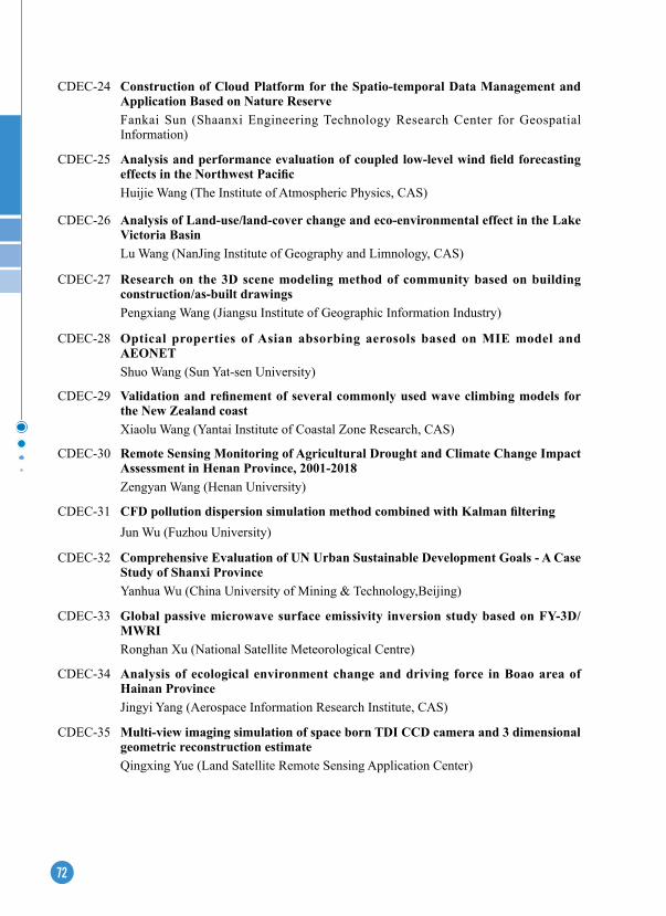
72
CDEC-24 Construction of Cloud Platform for the Spatio-temporal Data Management and Application Based on Nature ReserveFankai Sun (Shaanxi Engineering Technology Research Center for Geospatial Information)
CDEC-25 Analysis and performance evaluation of coupled low-level wind field forecasting effects in the Northwest PacificHuijie Wang (The Institute of Atmospheric Physics, CAS)
CDEC-26 Analysis of Land-use/land-cover change and eco-environmental effect in the Lake Victoria BasinLu Wang (NanJing Institute of Geography and Limnology, CAS)
CDEC-27 Research on the 3D scene modeling method of community based on building construction/as-built drawingsPengxiang Wang (Jiangsu Institute of Geographic Information Industry)
CDEC-28 Optical properties of Asian absorbing aerosols based on MIe model and AeONeTShuo Wang (Sun Yat-sen University)
CDEC-29 Validation and refinement of several commonly used wave climbing models for the New Zealand coastXiaolu Wang (Yantai Institute of Coastal Zone Research, CAS)
CDEC-30 Remote Sensing Monitoring of Agricultural Drought and Climate Change Impact Assessment in Henan Province, 2001-2018Zengyan Wang (Henan University)
CDEC-31 CFD pollution dispersion simulation method combined with Kalman filteringJun Wu (Fuzhou University)
CDEC-32 Comprehensive evaluation of UN Urban Sustainable Development Goals - A Case Study of Shanxi ProvinceYanhua Wu (China University of Mining & Technology,Beijing)
CDEC-33 Global passive microwave surface emissivity inversion study based on FY-3D/MWRIRonghan Xu (National Satellite Meteorological Centre)
CDEC-34 Analysis of ecological environment change and driving force in Boao area of Hainan ProvinceJingyi Yang (Aerospace Information Research Institute, CAS)
CDEC-35 Multi-view imaging simulation of space born TDI CCD camera and 3 dimensional geometric reconstruction estimate Qingxing Yue (Land Satellite Remote Sensing Application Center)
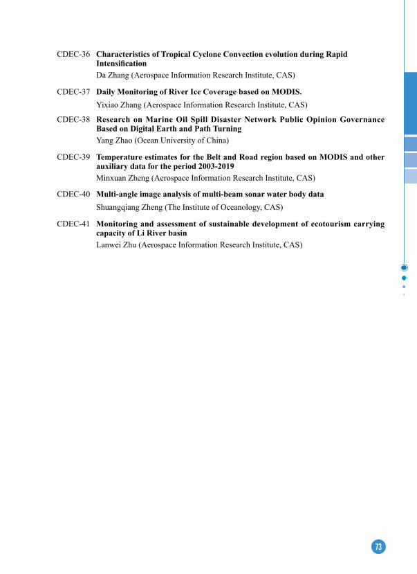
73
CDEC-36 Characteristics of Tropical Cyclone Convection evolution during Rapid IntensificationDa Zhang (Aerospace Information Research Institute, CAS)
CDEC-37 Daily Monitoring of River Ice Coverage based on MODIS.Yixiao Zhang (Aerospace Information Research Institute, CAS)
CDEC-38 Research on Marine Oil Spill Disaster Network Public Opinion Governance Based on Digital earth and Path TurningYang Zhao (Ocean University of China)
CDEC-39 Temperature estimates for the Belt and Road region based on MODIS and other auxiliary data for the period 2003-2019Minxuan Zheng (Aerospace Information Research Institute, CAS)
CDEC-40 Multi-angle image analysis of multi-beam sonar water body dataShuangqiang Zheng (The Institute of Oceanology, CAS)
CDEC-41 Monitoring and assessment of sustainable development of ecotourism carrying capacity of Li River basinLanwei Zhu (Aerospace Information Research Institute, CAS)
74
The 5th Digital Belt and Road Conference (DBAR 2021)
DBAR-01 Crop classification and migration model in Hetao area based on GEE and Sentinel dataYueran Hu, Aerospace Information Research Institute, CAS
DBAR-02 Analysis of Spatiotemporal Variation Characteristics and Driving Mechanism of NPP in Terrestrial Vegetation Ecosystems of ChinaHaiyan Tu, Xinjiang Institute of Ecology and Geography, CAS
DBAR-03 Counter terrorism resilience evaluation responding to climate context in BRI regionsYijing LI King's College London
DBAR-04 Coupling Model of Electric Energy Consumption and Total Noctilucent Value in Cambodia Assist the Digital Belt and Road programXumiao GAO, Mingquan WU, Aerospace Information Research Institute, CAS
DBAR-05 Analysis of land use change and its driving force in Taiyuan CityYujie Zhang, Xi’an University of Science and Technology
DBAR-06 Water availability surpasses warmth in controlling global vegetation trendsAnzhi Zhang, Institute of Atmospheric Physics
DBAR-07 Monitoring the spatiotemporal variation of Siberian crane habitats in Poyang Lake wetland, ChinaLin Zou, Jiangxi Normal University
DBAR-08 Spatio-temporal distribution and environmental factors of lung cancer mortalityJingjing Tang, Anhui Jianzhu University & Anhui Academy of Territory Spacial Planning and Ecology
DBAR-09 Analysis of spatial distribution of CVD and multiple environmental factors in urban residentsBeichen Wang, Anhui Jianzhu University
DBAR-10 Uneven Evolution of the Ecological Environment of the Guangdong-Hong Kong-Macao Greater Bay Area in the Urbanization ProcessHongzhong Li, Shenzhen Institute of Advanced Technology
DBAR-11 The global long-term vegetation dynamics inferred from satellite optical and microwave observationsMinhua Wang, Institute of Atmospheric Physics
DBAR-12 Open Science for Geographical Indication Products’ Geo-Ecosystem Health and Sustainability Chuang Liu, Institute of Geographic Science and Natural Resources Research, CAS
DBAR-13 Scenarios simulation of the Change of Terrestrial Carbon Storage and Carbon Emissions under the constraints of multiple SDGs indicatorsXue Hu, Nanjing Normal University
75
DBAR-14 Impact of urban multiple environmental factors on incidence of lung cancerYuwei Li, Anhui Jianzhu University
DBAR-15 Optimizing a Network of Drone-aided Healthcare Services in rural RwandaChinasa Ikelu, Institut de Mathematiques et de Sciences Physiques (IMSP)
DBAR-16 A deep learning based algorithm for detecting aerosol in the morning and evening of himawari-8 geostationary satelliteYuanlin Chen, Aerospace Information Research Institute (AIR)
DBAR-17 Arctic Region Imperious Areas Map Based on Sentinel-1 and Sentinel-2Xiaoqing Xu, Sun Yat-Sen University
DBAR-18 Long-term hydrometeorological and snow observations in the Tianshan Mountains, Xinjiang ChinaQian Li, Xinjiang Institute of Ecology and Geography, CAS
DBAR-19 Analysis of sea surface temperature variation in the Northeastern Passage of the Arctic in the past 30 yearsMeng Yang, Sch Earth Resources, China University of Geosciences, Wuhan, China
DBAR-20 Characteristic Evaluation of GPM Rainfall Remote Sensing Data in the Northeast Passage of the ArcticMaoce Cheng, Sch Earth Resources, China University of Geosciences, Wuhan, China
DBAR-21 Temporal and Spatial Variation of Surface Energy Flux in permafrost regions on the Qinghai-Tibet Plateau and Arctic Regions Using CMIP6 ModelsRen Li, Northwest Institute of Eco-Environment and Resources (NIEER), CAS
DBAR-22 Surging Dynamics of South Rimo Glacier, Eastern KarakoramKunpeng Wu, Yunnan University
DBAR-23 Study on Accuracy Evaluation and Downscaling Method of Satellite Precipitation ProductsNing Zhao,Guilin University of Electronic Technology
DBAR-24 Estimating building height of China using multi-source spatial dataPeimin Chen, Sun Yat-Sen University
DBAR-25 Land Cover Classification of High Resolution Remote Sensing Image by Using Deep LearningQingting Li, Aerospace Information Research Institute, CAS
DBAR-26 Geospatial Study of Groundwater Quality and Banana (Musa spp.) Production –Uthal, Balochistan, PakistanSalma Hamza, Bahria University Karachi Campus, Pakistan
DBAR-27 Using satellite image analysis for exploring the irrigation systems in arid and semiarid ecosystems of Tunisia in Roman Times: a case study of Taberguite (Medenine; Tunisia) Lamia Touil, Flsh Sousse Tunisia
76
exhibition
In conjunction with the forum, the Exhibition on Big Earth Data Facilitating the Monitoring and Evaluation of SDGs will be held. This exhibition is hosted by the Chinese Academy of Sciences(CAS), and co-sponsored by the International Research Center of Big Data for Sustainable Development Goals(CBAS), the Aerospace Information Research Institute(AIR), CAS and the Big Earth Data Science Engineering Program(CASEarth). The exhibition is located on the first floor of the Beijing International Convention Center with an area of 1500 square meters.
As one of the activities to commemorate “the 50th Anniversary of the Restoration of the Lawful Seat of the China in the United Nations”, the exhibition will focus on the theme of “Science, Technology and Innovation Facilities the 2030 Agenda”. This exhibition includes four parts, i.e., 100 case studies of SDGs, the world's first sustainable development science satellite(SDGSAT-1) developed by CAS, independently developed public data products and data sharing service for SDGs, and comprehensive demonstration of Big Data promoting SDGs. The exhibition aims to present the practical values and prospects of Big Earth Data in monitoring and evaluating SDGs.
(1) 100 Case Studies of SDGs
This part shows 100 case studies, which cover six SDGs: SDG2 “Zero Hunger”, SDG6 “Clean Water and Sanitation”, SDG11 “Sustainable Cities and Communities”, SDG13 “Climate Action”, SDG14 “Life below Water”, and SDG15 “Life on Land”.
(2) SDGSAT-1
This area exhibits the world’s first SDG scientific satellite (SDGSAT-1), independently developed by CAS. Designed for meeting requirements of monitoring and evaluating the indicators related to SDGs, three payloads, i.e., thermal infrared, glimmer and multispectral imagers, are onboard the SDGSAT-1. This satellite will be launched in October, 2021. The exhibition area also showcases China's Earth observation satellite system, including a series of satellite systems in meteorology, oceans, resources, environment and Gaofen, as well as acceptable international satellite data.
(3) Data Products
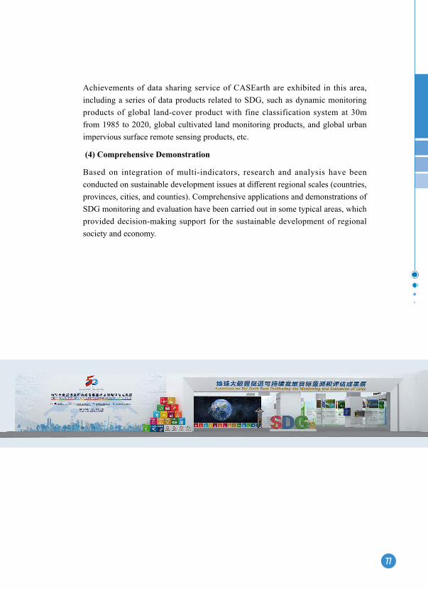
77
Achievements of data sharing service of CASEarth are exhibited in this area, including a series of data products related to SDG, such as dynamic monitoring products of global land-cover product with fine classification system at 30m from 1985 to 2020, global cultivated land monitoring products, and global urban impervious surface remote sensing products, etc.
(4) Comprehensive Demonstration
Based on integration of multi-indicators, research and analysis have been conducted on sustainable development issues at different regional scales (countries, provinces, cities, and counties). Comprehensive applications and demonstrations of SDG monitoring and evaluation have been carried out in some typical areas, which provided decision-making support for the sustainable development of regional society and economy.

78
Forum Information
Conference Venue: Beijing International Convention Center (BICC)
The International Forum on Big Data for Sustainable Development Goals will be held at Beijing International Convention Center (BICC). BICC is a well-known venue in Beijing which has served almost 1,000 various international and domestic conventions, exhibitions and meetings each year since its openning in 1990.
In 2002 BICC was merged by North Star Industrial Group, creating a stronger reputation with more effective management. BICC is situated on the site of the Asian Games Village, a flourishing area of Beijing with conference centers, office buildings, shopping centers and entertainment venues. It is located on the North Fourth Ring road, just 20 kilometers from the International Capital Airport and 9 kilometers from the city center. BICC is also very close to the Olympic Games central area where the the famous Bird’s Nest is located.
BICC, which comprises of 48 different conference rooms with an exhibition hall of 5000 square meters, provides 5 star services. The North Star Continental Grand Hotel adjacent to BICC is a 4 star hotel with 538 guest rooms and 5 restaurants serving different types of cuisine. It’s the ideal place for international and domestic conferences, cultural events and business meetings.
www.bicc.com.cn

79
SecretariatThe secretariat is located in the 202 conference room on the second floor of the Beijing International Convention Center.
Registration & information desk
The registration desk will be open in the main lobby of level one at Beijing International Convention Center (BICC) based on the following schedule for the participants to check in and collect their conference materials:
Date Time
Tuesday-September 6 11:00-17:00
Wednesday-September 7 08:00-17:00
Thursday-September 8 08:00-12:00
Name TagsUpon arrival at the International Forum on Big Data for Sustainable Development Goals, delegates will receive the name tag and meeting materials. Please be sure to wear your tag at all sessions.
Time zoneBeijing is located in Greenwich Mean Time Zone +8:00;China’s country telephone code is 0086 and Beijing’s city telephone code is 010.
Forum LanguageOpening Ceremony: Bilingual (Chinese & English)
On-site Meetings: Bilingual (Chinese & English)
Keynote & Online Webinar: Bilingual (Chinese & English)
WIFIA free WIFI connection is available in public areas of BICC. Please use your device to search “BICC WLAN” and log in with your mobile phone number.
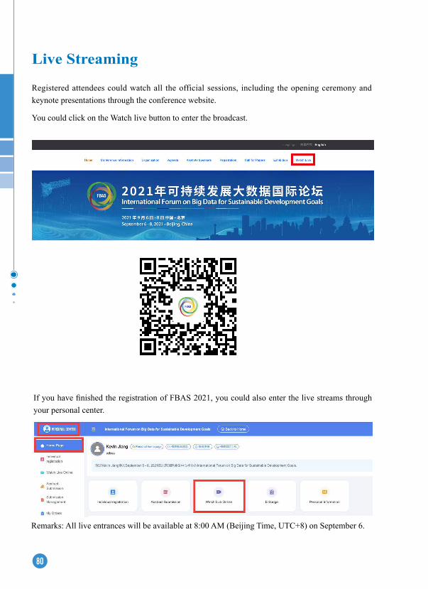
80
Live Streaming
Registered attendees could watch all the official sessions, including the opening ceremony and keynote presentations through the conference website.
You could click on the Watch live button to enter the broadcast.
If you have finished the registration of FBAS 2021, you could also enter the live streams through your personal center.
Remarks: All live entrances will be available at 8:00 AM (Beijing Time, UTC+8) on September 6.
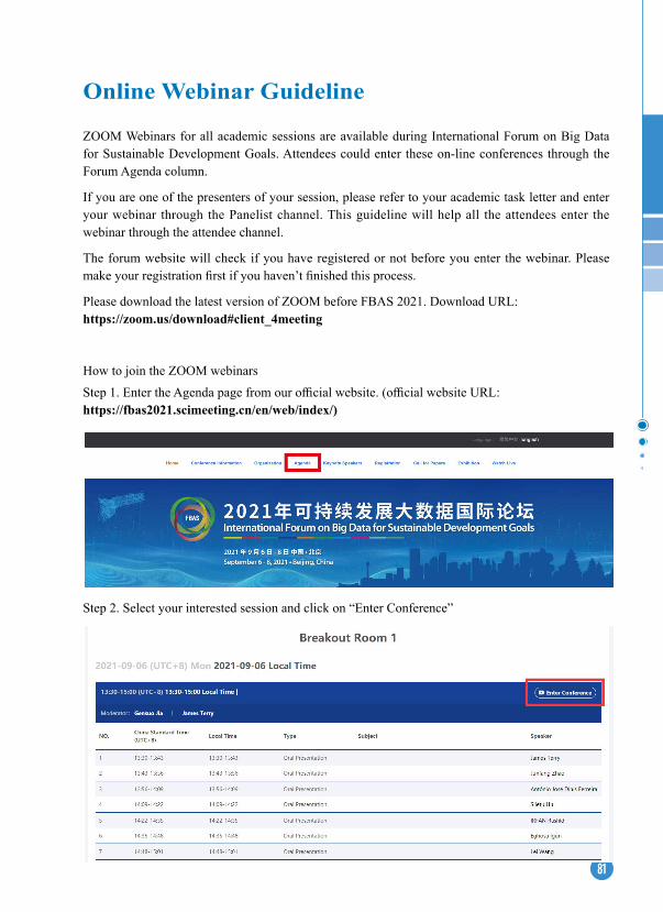
81
Online Webinar Guideline
ZOOM Webinars for all academic sessions are available during International Forum on Big Data for Sustainable Development Goals. Attendees could enter these on-line conferences through the Forum Agenda column.
If you are one of the presenters of your session, please refer to your academic task letter and enter your webinar through the Panelist channel. This guideline will help all the attendees enter the webinar through the attendee channel.
The forum website will check if you have registered or not before you enter the webinar. Please make your registration first if you haven’t finished this process.
Please download the latest version of ZOOM before FBAS 2021. Download URL: https://zoom.us/download#client_4meeting
How to join the ZOOM webinarsStep 1. Enter the Agenda page from our official website. (official website URL: https://fbas2021.scimeeting.cn/en/web/index/)
Step 2. Select your interested session and click on “Enter Conference”
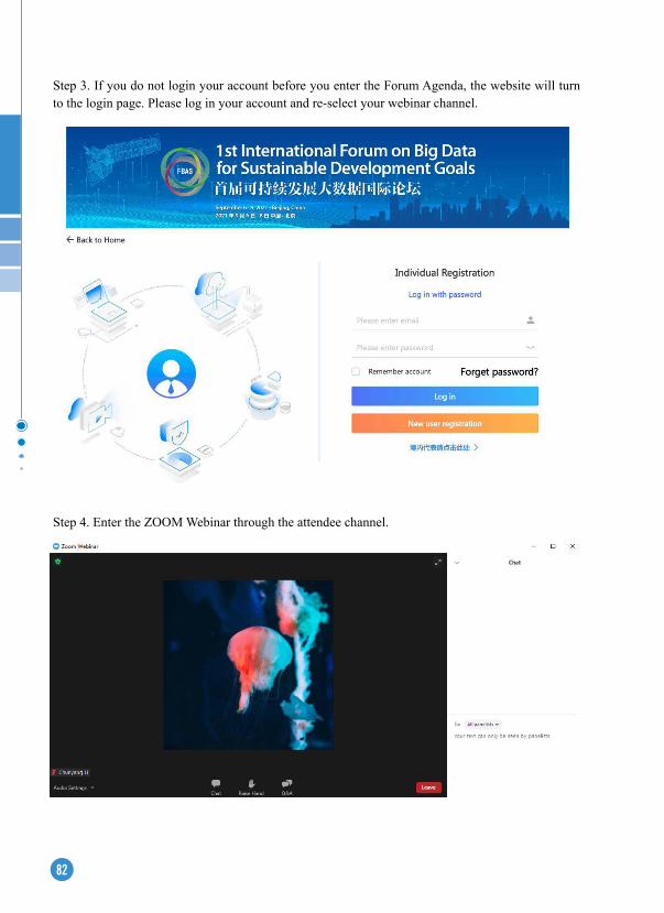
82
Step 4. Enter the ZOOM Webinar through the attendee channel.
Step 3. If you do not login your account before you enter the Forum Agenda, the website will turn to the login page. Please log in your account and re-select your webinar channel.

83
Remarks:- During the forum, attendees could communicate with others through Chat/Raise hand/Q&A column. Please use appropriate words during academic exchanges. If you need any help during the session, the staff in the webinar will provide assistance.- Screenshot and recording are not allowed during the forum. Attendees are required to observe the copyright protection of the academic group. Thanks for your cooperation.- If you have any questions on entering the webinars, please contact us by [email protected].
84
Accommodation and TrafficThe conference will be held in Beijing International Conference Center. Please pay attention to the following hotel reservation and transportation information:
Hotel bookingThe following hotels have agreed to reserve rooms for guests during the conference. Please book early due to the limited number of rooms in the hotel. All bookings are subject to successful confirmation of payment. Please indicate that you will attend this conference when booking the payment.
(1) Beijing Continental Grand Hotel(2) North Star Huiyuan Prime Hotel(3) North Star Yayuncun Hotel(4) China National Convention Center Grand Hotel
Traffic and surroundings(1) From Beijing Capital International Airport to BICCa) TaxiBeijing Capital International Airport provides taxi stations at the airport, so you can take a taxi from the airport to the congress venue.Taxi Locations:T1: Outside Gate 1 on F1 T2: Outside Gate 5 to 9 on F1 T3: Please refer to the signs inside the terminal building Fare: About RMB 120 (USD $ 20 including toll). The cost is subject to change depending on actual traffic conditions.
b) By Airport Shuttle Take the shuttle bus Line 5 (to Zhongguancun) and get off at Asian Games Village (Anhui Bridge) station, then walk towards the west for about 400 meters to BICC.Fare: RMB 24 (USD $4)c) By Airport ExpressAirport Express (get off at Dongzhimen) – Special Public bus No.2 (get off at Anhuiqiaobei) Airport Express (get off at Sanyuanqiao) - Subway 10 (get off at Beitucheng ) - Subway 8 (get off at Olympic Sports Center)
(2) From Railway Station to BICCa) From Beijing Railway Station to BICC
85
Subway 2 (get off at GulouDajie) - Subway 8 (get off at Olympic Sports Center) Subway 2 (get off at Yonghegong) – Subway 5 (get off at Huixinxijie Beikou) Special Public Bus No. 2 (get off at Anhuiqiaobei)
b) From Beijing West Railway Station Subway 9 (get off at Baishiqiaonan) - Subway 6 (get off at Nanluoguxiang) - Subway 8 (get off at Olympic Sports Center) Public Bus No.387 (get off at Anhuiqiao Bei)
c) From Beijing South Railway Station Subway 14 (get off at Puhuangyu) – Subway 5 (get off at Huixinxijie Beikou) - Public Bus 983/658/386/490 (get off Yayuncun) Subway 4 Daxing Line (get off at Xuanwumen) – Subway 2 (get off at Guloudajie) – Subway 8 (get off at Olympic Sports Center)Subway 4 Daxing line (get off at Pinganli) - Subway 6 (get off at Nanluoguxiang) – Subway 8 (get off at Olympic Sports Center)
Note:1. You may change money at the Banks or Money Exchange at the airport beforehand since you need Chinese money (RMB) for the public transportation.2. There will be quite some walk with ups and downs especially at the subway station for transfers if you go to BICC by airport shuttle, airport express or subway. We have received quite negative feedback from our previous events about the inconveniences caused by taking airport express and subway, so we would like to suggest that you take taxi to BICC.
DiningThe buffet lunch is available during the meeting and the buffet voucher is included in your registration package.
Dining place: Beijing Continental Grand HotelDining Time:12:00-13:00
Liability and Insurance The Secretariat and Organizers of FBAS 2021 will not take the liability for personal accidents or loss of or damage to private property of participants. Participants are advised not to leave their personal belongings unattended in conference rooms and throughout the conference venue.
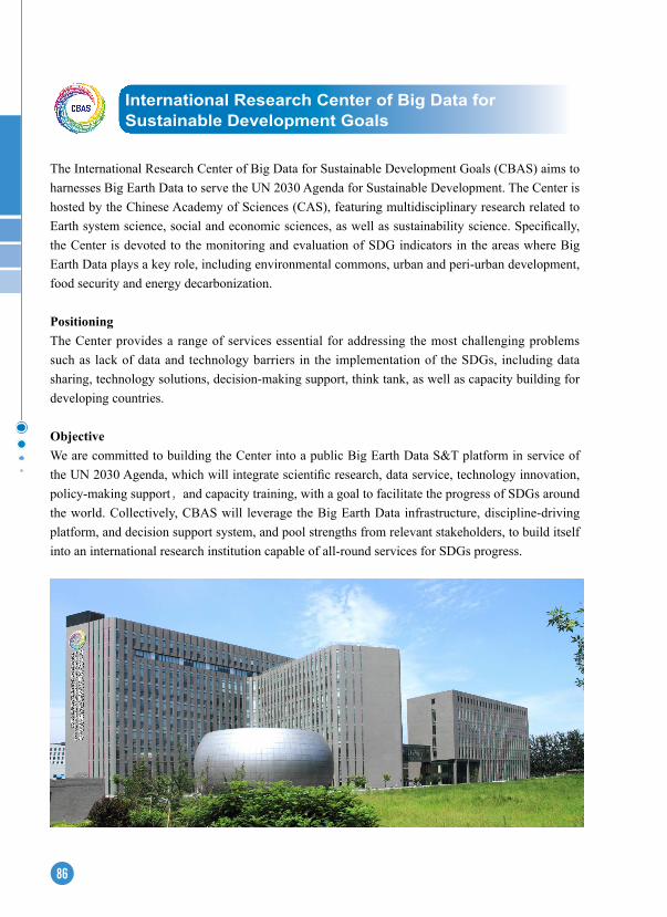
86
The International Research Center of Big Data for Sustainable Development Goals (CBAS) aims to harnesses Big Earth Data to serve the UN 2030 Agenda for Sustainable Development. The Center is hosted by the Chinese Academy of Sciences (CAS), featuring multidisciplinary research related to Earth system science, social and economic sciences, as well as sustainability science. Specifically, the Center is devoted to the monitoring and evaluation of SDG indicators in the areas where Big Earth Data plays a key role, including environmental commons, urban and peri-urban development, food security and energy decarbonization.
PositioningThe Center provides a range of services essential for addressing the most challenging problems such as lack of data and technology barriers in the implementation of the SDGs, including data sharing, technology solutions, decision-making support, think tank, as well as capacity building for developing countries.
ObjectiveWe are committed to building the Center into a public Big Earth Data S&T platform in service of the UN 2030 Agenda, which will integrate scientific research, data service, technology innovation, policy-making support,and capacity training, with a goal to facilitate the progress of SDGs around the world. Collectively, CBAS will leverage the Big Earth Data infrastructure, discipline-driving platform, and decision support system, and pool strengths from relevant stakeholders, to build itself into an international research institution capable of all-round services for SDGs progress.
International Research Center of Big Data for Sustainable Development Goals
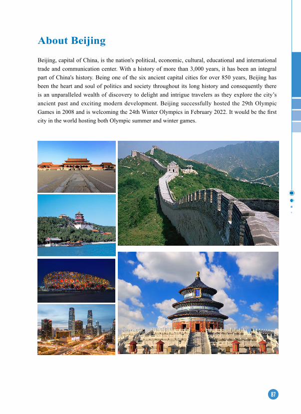
87
About Beijing
Beijing, capital of China, is the nation's political, economic, cultural, educational and international trade and communication center. With a history of more than 3,000 years, it has been an integral part of China's history. Being one of the six ancient capital cities for over 850 years, Beijing has been the heart and soul of politics and society throughout its long history and consequently there is an unparalleled wealth of discovery to delight and intrigue travelers as they explore the city’s ancient past and exciting modern development. Beijing successfully hosted the 29th Olympic Games in 2008 and is welcoming the 24th Winter Olympics in February 2022. It would be the first city in the world hosting both Olympic summer and winter games.
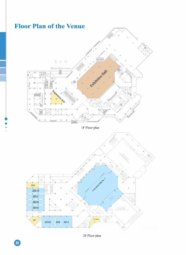
88
Floor Plan of the Venue
1F Floor plan
2F Floor plan

89
3F Floor plan

90
Notes

91
Notes

92
Notes

93
Notes

94
Notes
95