phoenix sky harbor international airport case study - · pdf filethe city soon recognized that...
TRANSCRIPT
Phoenix Sky Harbor International AirportEnterprise GIS Takes Off
CHALLENGE
The City of Phoenix’s growing Aviation Department needed an information system that would help improve customer service and safety and allow airport personnel to effectively manage work activities.
RESULTS
• GIS includes business tools for ef� ciently managing the airport’s operations and growing number of assets.
• Staff members access accurate and current information in the Web-based GIS to effectively manage work activities.
• Reports show compliance with FAA standards managed and tracked in GIS.
One of the 10 busiest airports in the world, with approximately 1,500 flights, 100,000 passengers, and 700 tons of cargo daily, Phoenix Sky Harbor International Airport generates an economic impact of more than $90 million a day for Arizona’s largest metropolitan area. With a growing pool of travelers and cargo relying on safe passage to a final destination, operational efficiency is of the utmost importance to the airport and the City of Phoenix.
The Challenge
The City of Phoenix, which operates Sky Harbor and other regional airports in the area, realized that its growing Aviation Department needed an information system that would help improve customer service and safety and allow approximately 200 airport personnel to effectively manage work activities. The city soon recognized that the most effective solution was a geographic information system (GIS) that could combine data locked in existing information systems into a single user interface.
A major requirement was that a significant number of staff would need to access the GIS to review or plan maintenance work orders, check interior space measurements and calculate rates for airport tenants, create area maps with aerial images showing existing conditions and planned improvements, insert maps into slide presentations for management, and output maps and data for internal and external reporting.
The Solution
The city selected ESRI business partner Woolpert, Inc., a design, engineering, and geospatial firm, to assist with the implementation of its new enterprise GIS. Woolpert built a system with all the data
CASE STUDY
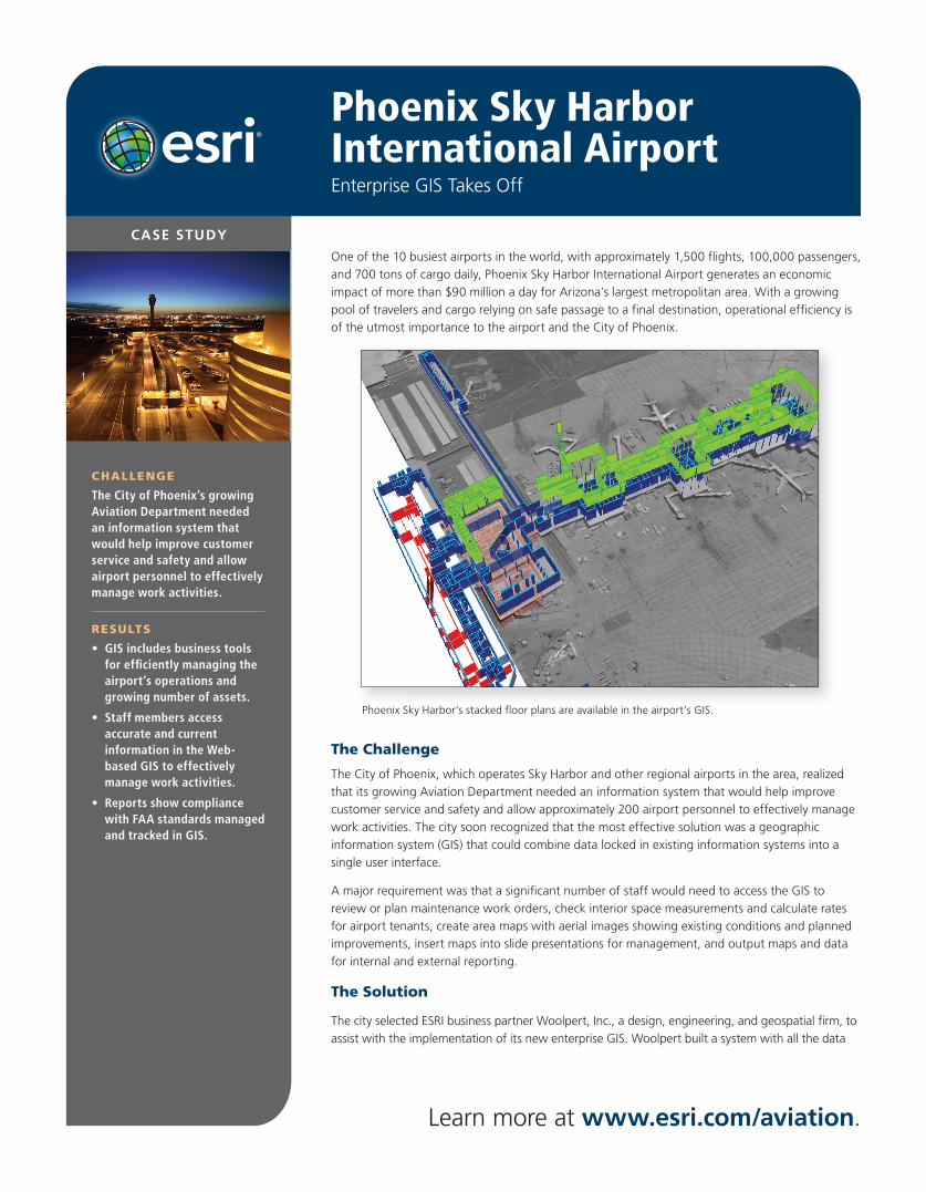
Phoenix Sky Harbor’s stacked floor plans are available in the airport’s GIS.
Learn more at www.esri.com/aviation.
Phoenix Sky Harbor International Airport
Learn more at www.esri.com/aviation.
ESRI SOFTWARE USED
• ArcGIS Server
• ArcGIS Desktop
OTHER SOFTWARE USED
• Oracle®
• Microsoft® SQL Server®
• Apache Tomcat™
DATA USED
• City of Phoenix GIS Data—
100 Layers
• Aerial Photography
• CAD Data
• Survey Data
HARDWARE
• Hewlett-Packard® Blade Servers
• Hewlett-Packard SAN Devices w/5 TB Storage
• Hewlett-Packard GIS Workstations
for the GIS stored in Oracle Spatial and accessed through the ArcSDE® technology in ArcGIS® Server. Aviation Department personnel use the resultant system via a Web portal. The enterprise GIS also includes business tools for managing the airport’s operations and growing number of assets.
The airport’s enterprise system now gives airport employees access to
• Aerial photography and digital orthophotos of the airport and surrounding operations area
• Aboveground features and underground utility data
• A geodatabase design with 300 feature classes, from smoke detectors and passenger assistance monitors to noise contours and 3D roof prints
• Interior floor plan data and attribution for buildings in and around the airport, collected via floor plan surveys and CAD drawing conversions
• An intranet viewing portal of all airport facilities
The Results
A critical component of the Aviation Department’s enterprise GIS is its interface being integrated with its work order management system. When a maintenance worker must replace air conditioning equipment, the worker accesses the portal to find the exact location as well as other equipment nearby that is due for maintenance. This exercise maximizes productivity, as it combines activities. Another custom application helps users manage airfield signage. Employees can access signage locations and images through the portal, plan and track maintenance, and generate reports to show compliance with Federal Aviation Administration (FAA) standards.
The airport’s GIS also features a project planning tool that allows users to add a proposed project location to the GIS; query the system; and run reports to detect potential conflicts, such as affected utilities and other projects planned in that area. Naturally, some operating practices needed to be revamped before the GIS was implemented. Aviation Department workflows were redesigned so that changes in the field, such as new construction, retrofits, maintenance, and tenant improvements, could be intercepted, captured, and recorded in the system by the airport’s GIS technicians. The GIS enables the technicians to update the system constantly, with most changes being completed within days.
Sky Harbor is currently using its GIS for the design process of PHX Sky Train, which will transport passengers to and from the airport, reducing the number of vehicles, easing traffic and curb congestion, and providing a seamless connection with the regional light rail system.
Copyright © 2010 ESRI. All rights reserved. ESRI, the ESRI globe logo, ArcGIS, ArcSDE, @esri.com, and www.esri.com are trademarks, registered trademarks, or service marks of ESRI in the United States, the European Community, or certain other jurisdictions. Other companies and products mentioned herein may be trademarks or registered trademarks of their respective trademark owners.
G40750 5/10skf
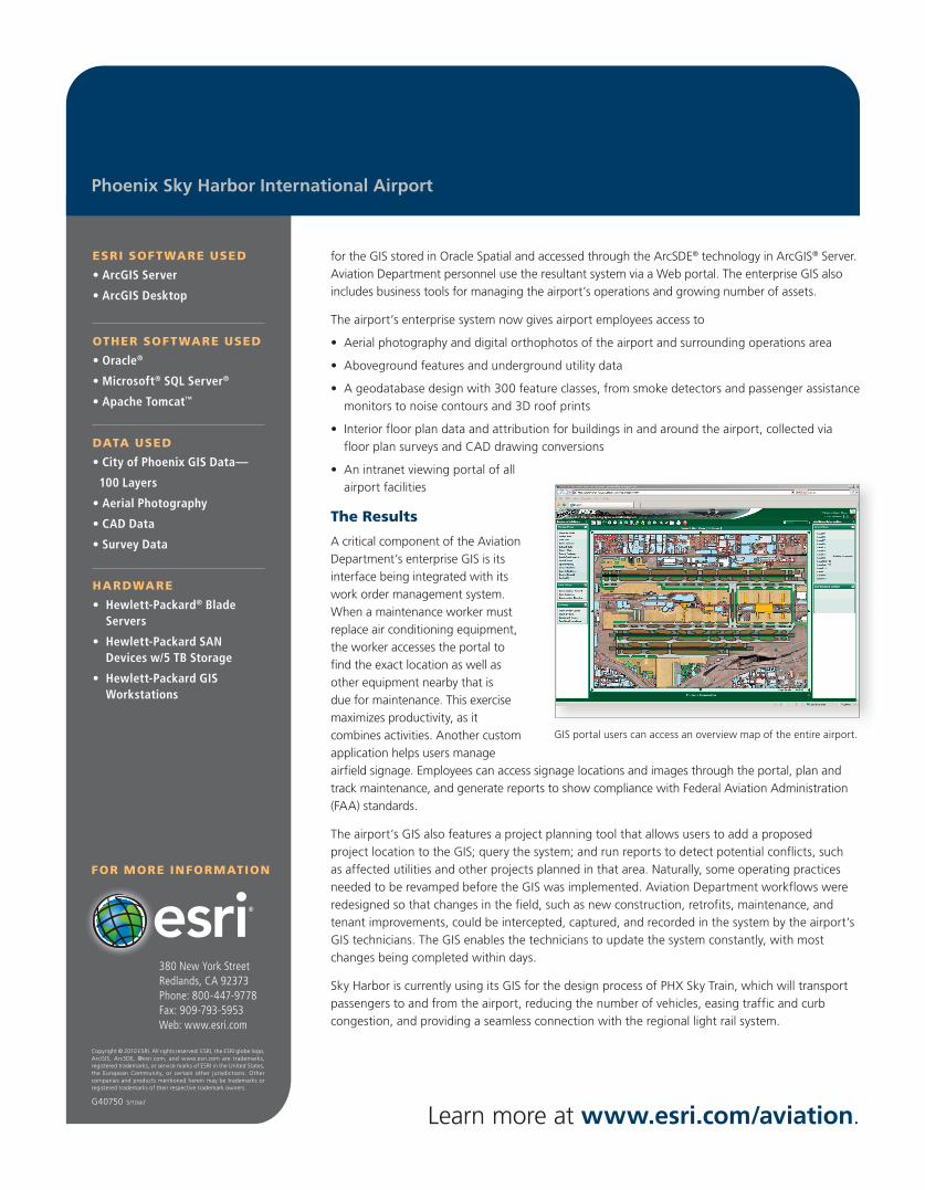
GIS portal users can access an overview map of the entire airport.
380 New York StreetRedlands, CA 92373Phone: 800-447-9778Fax: 909-793-5953Web: www.esri.com
FOR MORE INFORMATION