pre-construction notification (pcn) form
TRANSCRIPT


Pre-Construction Notification (PCN) Form For Nationwide Permits and Regional General Permits (along with corresponding Water Quality Certifications)
September 29, 2018 Ver 3
Please note: fields marked with a red asterisk * below are required. You will not be able to submit the form until all mandatory questions are answered.
Also, if at any point you wish to print a copy of the E-PCN, all you need to do is right-click on the document and you can print a copy of the form.
Below is a link to the online help file.
https://edocs.deq.nc.gov/WaterResources/0/edoc/624704/PCN%20Help%20File%202018-1-30.pdf
County (or Counties) where the project is located:*
Is this project a public transportation project?*
Is this a NCDOT Project?*
(NCDOT only) T.I.P. or state project number:
WBS #*
1a. Type(s) of approval sought from the Corps:*
1b. What type(s) of permit(s) do you wish to seek authorization?*
This form may be used to initiate the standard/individual permit process with the Corps. Please contact your Corps representative concerning submittals for standard permits. All required items thatare not provided in the E-PCN can be added to the miscellaneous upload area located at the bottom of this form.
1c. Has the NWP or GP number been verified by the Corps?*
Nationwide Permit (NWP) Number:
NWP Numbers (for multiple NWPS):
1d. Type(s) of approval sought from the DWR:*
1e. Is this notification solely for the record because written approval is not required?
*For the record only for DWR 401 Certification:
For the record only for Corps Permit:
1f. Is this an after-the-fact permit application?*
A. Processing Information
Yadkin
Yes NoThis is any publicly funded by municipal,state or federal funds road, rail, airport transportation project.
Yes No
B-5389
46104.1.1(for NCDOT use only)
Section 404 Permit (wetlands, streams and waters, Clean Water Act)Section 10 Permit (navigable waters, tidal waters, Rivers and Harbors Act)
Nationwide Permit (NWP)Regional General Permit (RGP)Standard (IP)
Yes No
14 - Linear transportation
List all NW numbers you are applying for not on the drop down list.
check all that apply
401 Water Quality Certification - Regular 401 Water Quality Certification - ExpressNon-404 Jurisdictional General Permit Riparian Buffer AuthorizationIndividual Permit
Yes No
Yes No
Yes No

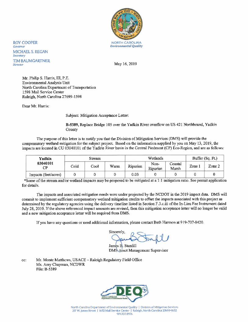
1g. Is payment into a mitigation bank or in-lieu fee program proposed for mitigation of impacts?
Acceptance Letter Attachment
1h. Is the project located in any of NC's twenty coastal counties?*
1j. Is the project located in a designated trout watershed?*
Link to trout information: http://www.saw.usace.army.mil/Missions/Regulatory-Permit-Program/Agency-Coordination/Trout.aspx
1a. Who is the Primary Contact?*
1b. Primary Contact Email:*1c. Primary Contact Phone:*
1d. Who is applying for the permit?*
1e. Is there an Agent/Consultant for this project?*
2. Owner Information
1a. Name of project:*
1b. Subdivision name:
1c. Nearest municipality / town:*
If so, attach the acceptance letter from mitigation bank or in-lieu fee program.
Yes No
Click the upload button or drag and drop files here to attach document
B-5389 DMS Acceptance.pdf 67.76KBFILE TYPE MUST BE PDF
Yes No
Yes No
B. Applicant Information
NCDOT
[email protected](xxx)xxx-xxxx
(919)707-6108
Owner Applicant (other than owner)(Check all that apply)
Yes No
2a. Name(s) on recorded deed:*
2b. Deed book and page no.:
2c. Responsible party:
2d. Address*
2e. Telephone Number:*
2f. Fax Number:
2g. Email Address:*
NC Department of Transportation
(for Corporations)
City
RaleighState / Province / Region
NC
Postal / Zip Code
27699Country
USA
Street Address
1598 Mail Service CenterAddress Line 2
(xxx)xxx-xxxx
(919)707-6108
(xxx)xxx-xxxx
C. Project Information and Prior Project History
1. Project Information
Replace Bridge 105 over Yadkin River Overflow on US 421 Northbound Lane
(if appropriate)
Lewisville
2. Project Identification

2a. Property Identification Number: 2b. Property size:
2c. Project Address
2d. Site coordinates in decimal degrees
Please collect site coordinates in decimal degrees. Use between 4-6 digits (unless you are using a survey-grade GPS device) after the decimal place as appropriate, based on how the location wasdetermined. (For example, most mobile phones with GPS provide locational precision in decimal degrees to map coordinates to 5 or 6 digits after the decimal place.)
Latitude:* Longitude:*
3. Surface Waters
3a. Name of the nearest body of water to proposed project:*
3b. Water Resources Classification of nearest receiving water:*
Surface Water Lookup
3c. What river basin(s) is your project located in?*
3d. Please provide the 12-digit HUC in which the project is located.*
River Basin Lookup
4. Project Description and History
4a. Describe the existing conditions on the site and the general land use in the vicinity of the project at the time of this application:*
4b. Have Corps permits or DWR certifications been obtained for this project (including all prior phases) in the past?*
4d. Attach an 8 1/2 X 11 excerpt from the most recent version of the USGS topographic map indicating the location of the project site. (for DWR)
4e. Attach an 8 1/2 X 11 excerpt from the most recent version of the published County NRCS Soil Survey map depicting the project site. (for DWR)
4f. List the total estimated acreage of all existing wetlands on the property:
4g. List the total estimated linear feet of all existing streams on the property:
4h. Explain the purpose of the proposed project:*
4i. Describe the overall project in detail, including indirect impacts and the type of equipment to be used:*
4j. Please upload project drawings for the proposed project.
5. Jurisdictional Determinations
(tax PIN or parcel ID) (in acres)
City State / Province / Region
Postal / Zip Code Country
Street Address
Address Line 2
36.105545ex: 34.208504
-80.515655-77.796371
Deep Creek
WS-IV
Yadkin-PeeDee
030401011103
Surrounding land use is primarily agricultural land, with a row of trees along the unnamed tributary.
Yes No Unknown
Click the upload button or drag and drop files here to attach document
File type must be pdf
Click the upload button or drag and drop files here to attach document
File type must be pdf
0.03
(intermittent and perennial)
209
The B-5389 project is needed to replace bridge 105 because it is functionally obsolete. Its sufficiency rating is 64.7. The project purpose is to replace the functionally obsolete bridgewith one that meets current NCDOT design standards.
The proposed project will replace the existing two-lane bridge (Bridge No. 105) with another two-lane bridge in the same location. The proposed replacement structure will be a multi-span structure that is approximately 455 feet in length, with a 38-foot wide clear deck width. The project’s total length is 1,500 feet. The existing northbound lane bridge will be replacedwith a new structure at the existing location. Traffic on the northbound lanes will be maintained during construction with an on-site detour located north of the existing bridge location.Standard road building equipment such as trucks, dozers, and cranes will be used.
Click the upload button or drag and drop files here to attach document
B-5389 Permit Drawings.pdf 2.13MB
B-5389 Roadway Plans.pdf 2.27MBFile type must be pdf

5a. Have the wetlands or streams been delineated on the property or proposed impact areas?*
Comments:
5b. If the Corps made a jurisdictional determination, what type of determination was made?*
Corps AID Number:
5c. If 5a is yes, who delineated the jurisdictional areas?
Name (if known):
Agency/Consultant Company:
Other:
5d1. Jurisdictional determination upload
6. Future Project Plans
6a. Is this a phased project?*
Are any other NWP(s), regional general permit(s), or individual permits(s) used, or intended to be used, to authorize any part of the proposed project or related activity? Thisincludes other separate and distant crossing for linear projects that require Department of the Army authorization but don’t require pre-construction notification.
1. Impacts Summary
1a. Where are the impacts associated with your project? (check all that apply):
2. Wetland ImpactsIf there are wetland impacts proposed on the site, then complete this question for each wetland area impacted.
"W." will be used in the table below to represent the word "wetland".
2a. Site #* (?) 2a1 Reason* (?) 2b. Impact type * (?) 2c. Type of W.* 2d. W. name * 2e. Forested* 2f. Type of Jurisdicition* (?)
2g. Impact area*
2g. Total Temporary Wetland Impact
2g. Total Permanent Wetland Impact
2g. Total Wetland Impact
2h. Comments:
3. Stream ImpactsIf there are perennial or intermittent stream impacts (including temporary impacts) proposed on the site, then complete this question for all stream sites impacted.
"S." will be used in the table below to represent the word "stream".
3a. Reason for impact* (?) 3b.Impact type * 3c. Type of impact* 3d. S. name * 3e. Stream Type *(?)
3f. Type of Jurisdiction*
3g. S. width* 3h. Impact length*
Yes No Unknown
Two small wetland areas and one intermittent stream were identified in the study area. No JD sitevisit was held.
Preliminary Approved Not Verified Unknown N/A
Example: SAW-2017-99999
Carolina Ecosystems, Inc.
Click the upload button or drag and drop files here to attach document
File type must be PDF
Yes No
No.
D. Proposed Impacts Inventory
Wetlands Streams-tributaries BuffersOpen Waters Pond Construction
3 Bridge replacement P Headwater Forest WA No Corps 0.020(acres)
4 Bridge replacement P Headwater Forest WB No Corps 0.010(acres)
0.000
0.030
0.030
Both wetlands are a total take.

S1
S2
S3
** All Perennial or Intermittent streams must be verified by DWR or delegated local government.
3i. Total jurisdictional ditch impact in square feet:
3i. Total permanent stream impacts:
3i. Total temporary stream impacts:
3i. Total stream and ditch impacts:
3j. Comments:
1. Avoidance and Minimization
1a. Specifically describe measures taken to avoid or minimize the proposed impacts in designing the project:*
1b. Specifically describe measures taken to avoid or minimize the proposed impacts through construction techniques:*
2. Compensatory Mitigation for Impacts to Waters of the U.S. or Waters of the State
2a. Does the project require Compensatory Mitigation for impacts to Waters of the U.S. or Waters of the State?
2c. If yes, mitigation is required by (check all that apply):
2d. If yes, which mitigation option(s) will be used for this project?
4. Complete if Making a Payment to In-lieu Fee Program
4a. Approval letter from in-lieu fee program is attached.
4b. Stream mitigation requested:4c. If using stream mitigation, what is the stream temperature:
NC Stream Temperature Classification Maps can be found under the Mitigation Concepts tab on the Wilmington District's RIBITS website.
4d. Buffer mitigation requested (DWR only): 4e. Riparian wetland mitigation requested:
4f. Non-riparian wetland mitigation requested: 4g. Coastal (tidal) wetland mitigation requested:
4h. Comments
*** Recent changes to the stormwater rules have required updates to this section .***
Site 1 - Ditch outletprotection
Permanent Bank Stabilization SA Intermittent Both 6Average (feet)
23(linear feet)
Site 2 - Bridge Replacement Temporary Dewatering SA Intermittent Both 6Average (feet)
145(linear feet)
Site 5 - Temporary streamcrossing
Temporary Dewatering SA Intermittent Both 6Average (feet)
89(linear feet)
0
23
234
257
Temporary impacts total 0.03 acre
E. Impact Justification and Mitigation
The proposed replacement bridge will be on the same alignment as the existing bridge. Deck drains on the proposed structure will not be dischargedover open water, reducing stream pollution associated with roadway runoff. The runoff from deck drains will be discharged onto a Class B rip rapdissipator pad. Additional measures implemented to reduce impacts to the stream and surrounding properties include maintaining existing drainagepatterns and using rip rap at drainage outlets to dissipate energy and reduce erosion.
NCDOT will adhere to Best Management Practices for Construction and Maintenance Activities.
Yes No
DWR Corps
Mitigation bank Payment to in-lieu feeprogram
Permittee ResponsibleMitigation
Yes No
(linear feet)
0
(square feet)
0(acres)
0.03
(acres)
0(acres)
0
No mitigation is required for the stream bank stabilization or temporary stream impacts as these impacts do not constitute a loss of waters of the US.
F. Stormwater Management and Diffuse Flow Plan (required by DWR)

1. Diffuse Flow Plan
1a. Does the project include or is it adjacent to protected riparian buffers identified within one of the NC Riparian Buffer Protection Rules?
For a list of options to meet the diffuse flow requirements, click here.
If no, explain why:
2. Stormwater Management Plan
2a. Is this a NCDOT project subject to compliance with NCDOT’s Individual NPDES permit NCS000250?*
Comments:
1. Environmental Documentation
1a. Does the project involve an expenditure of public (federal/state/local) funds or the use of public (federal/state) land?*
1b. If you answered “yes” to the above, does the project require preparation of an environmental document pursuant to the requirements of the National or State (North Carolina)Environmental Policy Act (NEPA/SEPA)?*
1c. If you answered “yes” to the above, has the document review been finalized by the State Clearing House? (If so, attach a copy of the NEPA or SEPA final approval letter.)*
NEPA or SEPA Final Approval Letter
2. Violations (DWR Requirement)
2a. Is the site in violation of DWR Water Quality Certification Rules (15A NCAC 2H .0500), Isolated Wetland Rules (15A NCAC 2H .1300), or DWR Surface Water or Wetland Standards orRiparian Buffer Rules (15A NCAC 2B .0200)?*
3. Cumulative Impacts (DWR Requirement)
3a. Will this project (based on past and reasonably anticipated future impacts) result in additional development, which could impact nearby downstream water quality?*
3b. If you answered “no,” provide a short narrative description.
4. Sewage Disposal (DWR Requirement)
4a. Is sewage disposal required by DWR for this project?*
5. Endangered Species and Designated Critical Habitat (Corps Requirement)
5a. Will this project occur in or near an area with federally protected species or habitat?*
5b. Have you checked with the USFWS concerning Endangered Species Act impacts?*
5c. If yes, indicate the USFWS Field Office you have contacted.
5d. Is another Federal agency involved?*
5e. Is this a DOT project located within Division's 1-8?*
5f. Will you cut any trees in order to conduct the work in waters of the U.S.?*
Yes No
No buffered resources within project area.
Yes No
G. Supplementary Information
Yes No
Yes No
Yes No
Click the upload button or drag and drop files here to attach document
FILE TYPE MUST BE PDF
Yes No
Yes No
Due to the minimal transportation impact resulting from this bridge replacement, this project will neither influence nearby land uses nor stimulategrowth. Therefore, a detailed indirect or cumulative effects study will not be necessary.
Yes No N/A
Yes No
Yes No
Asheville
Yes No Unknown
Yes No
Yes No
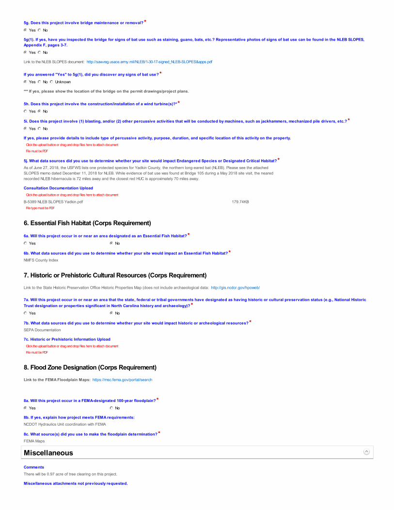
5g. Does this project involve bridge maintenance or removal?*
5g(1). If yes, have you inspected the bridge for signs of bat use such as staining, guano, bats, etc.? Representative photos of signs of bat use can be found in the NLEB SLOPES,Appendix F, pages 3-7.
Link to the NLEB SLOPES document: http://saw-reg.usace.army.mil/NLEB/1-30-17-signed_NLEB-SLOPES&apps.pdf
If you answered "Yes" to 5g(1), did you discover any signs of bat use?*
*** If yes, please show the location of the bridge on the permit drawings/project plans.
5h. Does this project involve the construction/installation of a wind turbine(s)?**
5i. Does this project involve (1) blasting, and/or (2) other percussive activities that will be conducted by machines, such as jackhammers, mechanized pile drivers, etc.?*
If yes, please provide details to include type of percussive activity, purpose, duration, and specific location of this activity on the property.
5j. What data sources did you use to determine whether your site would impact Endangered Species or Designated Critical Habitat?*
Consultation Documentation Upload
6. Essential Fish Habitat (Corps Requirement)
6a. Will this project occur in or near an area designated as an Essential Fish Habitat?*
6b. What data sources did you use to determine whether your site would impact an Essential Fish Habitat?*
7. Historic or Prehistoric Cultural Resources (Corps Requirement)
Link to the State Historic Preservation Office Historic Properties Map (does not include archaeological data: http://gis.ncdcr.gov/hpoweb/
7a. Will this project occur in or near an area that the state, federal or tribal governments have designated as having historic or cultural preservation status (e.g., National HistoricTrust designation or properties significant in North Carolina history and archaeology)?*
7b. What data sources did you use to determine whether your site would impact historic or archeological resources?*
7c. Historic or Prehistoric Information Upload
8. Flood Zone Designation (Corps Requirement)
Link to the FEMA Floodplain Maps: https://msc.fema.gov/portal/search
8a. Will this project occur in a FEMA-designated 100-year floodplain?*
8b. If yes, explain how project meets FEMA requirements:
8c. What source(s) did you use to make the floodplain determination?*
Comments
Miscellaneous attachments not previously requested.
Yes No
Yes No
Yes No Unknown
Yes No
Yes No
Click the upload button or drag and drop files here to attach document
File must be PDF
As of June 27, 2018, the USFWS lists one protected species for Yadkin County, the northern long-eared bat (NLEB). Please see the attachedSLOPES memo dated December 11, 2018 for NLEB. While evidence of bat use was found at Bridge 105 during a May 2018 site visit, the nearedrecorded NLEB hibernacula is 72 miles away and the closest red HUC is approximately 70 miles away.
Click the upload button or drag and drop files here to attach document
B-5389 NLEB SLOPES Yadkin.pdf 179.74KBFile type must be PDF
Yes No
NMFS County Index
Yes No
SEPA Documentation
Click the upload button or drag and drop files here to attach document
File must be PDF
Yes No
NCDOT Hydraulics Unit coordination with FEMA
FEMA Maps
Miscellaneous
There will be 0.97 acre of tree clearing on this project.

*
I have given true, accurate, and complete information on this form;I agree that submission of this PCN form is a “transaction” subject to Chapter 66, Article 40 of the NC General Statutes (the “Uniform Electronic Transactions Act”);I agree to conduct this transaction by electronic means pursuant to Chapter 66, Article 40 of the NC General Statutes (the “Uniform Electronic Transactions Act”);I understand that an electronic signature has the same legal effect and can be enforced in the same way as a written signature; ANDI intend to electronically sign and submit the PCN form.
Full Name:*
Signature
Date
Click the upload button or drag and drop files here to attach document
B-5389 Signed Cover Letter.pdf 1.25MBFile must be PDF or KMZ
Signature
By checking the box and signing below, I certify that:
Mack Christopher Rivenbark III
5/17/2019

STATE OF NORTH CAROLINA
DEPARTMENT OF TRANSPORTATION
ROY COOPER JAMES H. TROGDON, III GOVERNOR SECRETARY
Mailing Address: NC DEPARTMENT OF TRANSPORTATION PROJECT DEVELOPMENT & ENVIRONMENTAL ANALYSIS UNIT 1598 MAIL SERVICE CENTER RALEIGH NC 27699-1598
TELEPHONE: 919-707-6000 FAX: 919-212-5785
WEBSITE:NCDOT.GOV
Location: CENTURY CENTER, BUILDING B
1020 BIRCH RIDGE DRIVE RALEIGH NC 27610
December11,2018
TO: ErinCheely,EnvironmentalProgramConsultant EnvironmentalCoordination&PermittingGroup,EAUFROM: MelissaMiller,EnvironmentalProgramConsultant BiologicalSurveysGroup,EAUSUBJECT: Section 7 survey results for the northern long‐eared bat (Myotis
septentrionalis)associatedwiththereplacementofBridgeNo.105overtheYadkinRiveroverflowonUS421NBLinYadkinCounty,TIPNo.B‐5389.
The North Carolina Department of Transportation (NCDOT, Division 11) proposes toreplaceBridgeNo.105theYadkinRiveroverflowonUS421NBLinYadkinCounty,TIPNo.B‐5389.Theexistingbridgeisaninespanstructurewithconcretebeams,deck,guardrailsandendwalls.Theoveralllengthofthestructureis451feet.TheprojecttoreplaceBridgeNo.105hasbeenreviewedforeffectsonthenorthernlong‐earedbat (NLEB). AsofMay4,2015,NLEB is listedby theU.S.FishandWildlifeService(USFWS)as “Threatened”under theEndangeredSpeciesActof1973.AsofDecember11,2018, NLEB is listed by USFWS(http://www.fws.gov/raleigh/species/cntylist/nc_counties.html)as“probable/potential”inYadkinCounty.According to the North Carolina Natural Heritage Program (NHP) Biotics Database,mostrecently updated October 2018, the nearest NLEB hibernacula record is 72 milesnorthwestoftheproject(EOID32171)andnoknownNLEBroosttreesoccurwithin150feetoftheprojectarea.EO32171representsGrandfatherMountainsitewithmultipleobservationsfrom1986to2011.
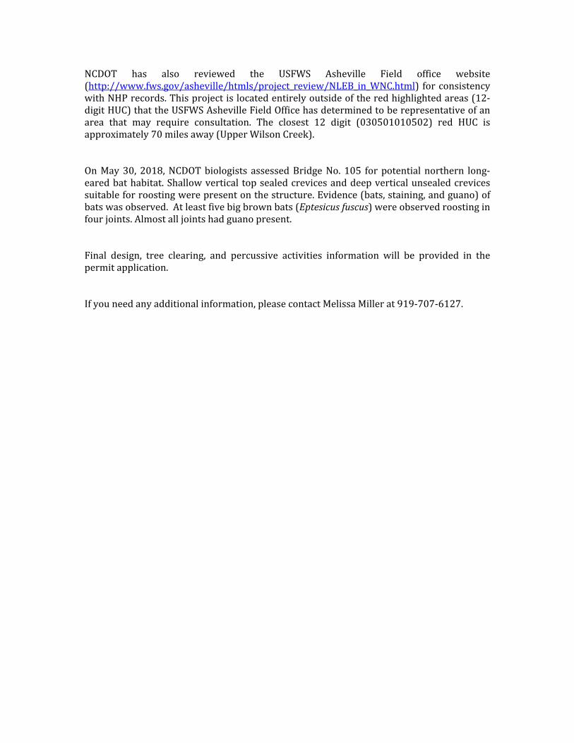
NCDOT has also reviewed the USFWS Asheville Field office website(http://www.fws.gov/asheville/htmls/project_review/NLEB_in_WNC.html) forconsistencywithNHPrecords.Thisprojectislocatedentirelyoutsideoftheredhighlightedareas(12‐digitHUC)thattheUSFWSAshevilleFieldOfficehasdeterminedtoberepresentativeofanarea that may require consultation. The closest 12 digit (030501010502) red HUC isapproximately70milesaway(UpperWilsonCreek).OnMay30, 2018,NCDOTbiologists assessedBridgeNo. 105 forpotentialnorthern long‐earedbathabitat.Shallowvertical topsealedcrevicesanddeepverticalunsealedcrevicessuitableforroostingwerepresentonthestructure.Evidence(bats,staining,andguano)ofbatswasobserved.Atleastfivebigbrownbats(Eptesicusfuscus)wereobservedroostinginfourjoints.Almostalljointshadguanopresent.Final design, tree clearing, and percussive activities information will be provided in thepermitapplication.Ifyouneedanyadditionalinformation,pleasecontactMelissaMillerat919‐707‐6127.

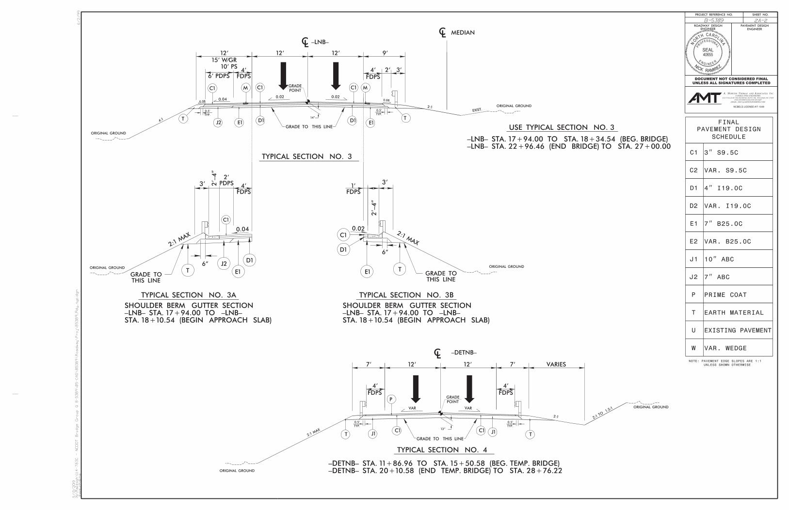
(Version 2.08; Released April 2018)46104.1.1 TIP No.: B-5389 County(ies): Yadkin Page 1 of 1
TIP Number: Date:
Phone: Phone:Email: Email:
County(ies):CAMA County?
Yes
Design/Future: Year: 2040 Existing: Year:
Aquatic T&E Species? No Comments:
Yes N/ANoDeck Drains Discharge Over Water Body? (If yes, provide justification in the General Project Narrative) (If yes, describe in the General Project Narrative; if no, justify in the
General Project Narrative)(If yes, provide justification in the General Project Narrative)
Two 12' lanes with 4' inside paved shoulder and 10' outside paved shoulder; 4:1 median slopes2:1 outside slopes
30,300
Project Includes Bridge Spanning Water Body? Deck Drains Discharge Over Buffer? Dissipator Pads Provided in Buffer? N/ANRTR Stream ID:
Annual Avg Daily Traffic (veh/hr/day):
Existing SiteProject Length (lin. miles or feet):
ac.
Surface Water Body (1): Water Supply IV (WS-IV)NCDWR Surface Water Classification for Water Body
N/ABuffer Rules in Effect:
None
25,000
Two 12' lanes with 4' inside paved shoulder and 10' outside paved shoulder; 4:1 median slopes2:1 outside slopes
Waterbody Information
2020
NCDWR Stream Index No.:
46104.1.1
Impairments:Other Stream Classification:
Primary Classification:
Project Built-Upon Area (ac.) ac.
905 Jones Franklin Road
North Carolina Department of Transportation
Highway Stormwater Program STORMWATER MANAGEMENT PLAN
FOR NCDOT PROJECTS
Project Type:
1000 Birch Ridge Drive Address:
General Project InformationB-5389
WBS Element:
Bridge ReplacementWBS Element:Sungate Design Group, P.A.NCDOT Contact:
919-707-6488
Raleigh, NC 27606
Contractor / Designer:
Address:
4/24/2019
YadkinLewisville
Tierre Peterson (Structures Management Unit)
Raleigh, NC 27610
River Basin(s): City/Town:
1.7Typical Cross Section Description:
Surrounding Land Use:
General Project Narrative:(Description of Minimization of Water Quality Impacts)
No
Rural; Agricultural
Deep Creek 12-84
1.4
0.343 milesProject Description
Proposed Project
Yadkin-Pee Dee
NoneSupplemental Classification: None
Wetlands within Project Limits?
The proposed bridge replacement project will replace Yadkin County bridge #105, on US 421 North Bound over the Yadkin River overflow. The proposed bridge is 4 @ 115' 63" Modified Bulb Tee bridge. The existing bridge is 9 @ 50' concrete girder on concrete bents. Deck Drains on the proposed structure will not be discharged over open water, reducing stream pollution associated with roadway runoff. The runoff from deck drains will be discharged onto a class B rip rap dissipator pad. Additional measures implemented to reduce impacts to the stream and surrounding properties include, maintaining existing drainge patterns, and using rip rap pads at drainage outlets to dissipate energy and reduce erosion.

WETLAND AND SURFACE WATER IMPACTS PERMIT
SHEET 1 OF 6PERMIT DRAWING
REDLINE DRAINAGE PLANS
6-16-2018
RALEIGH, NORTH CAROLINA 27606
SUNGATE DESIGN GROUP, P.A.
NC COA No. C-0890
905 JONES FRANKLIN ROAD
VICINITY MAP
BendWest
421
YA
DKIN
RIV
ER
SR 1605
SR 1001SR
1001
SR
1570
YADKIN
COUNTY
FORSYTH COUNTY
SR 1301
SR 3317
SR
1301
421
B-5389PROJECT
CONVENTIONAL PLAN SHEET SYMBOLSSTATE OF NORTH CAROLINA, DIVISION OF HIGHWAYS
US 421 NB
US 421 SB
US 421 NB
US 421 SB
OV
ERF
LO
W
YA
DKIN
RIV
ER
YA
DKIN
RIV
ER
OV
ER
FL
OW
-DETNB-
-LNB-
-LNB- STA. 31+00.00END TIP PROJECT B-5389
-LNB- STA. 12+88.32BEGIN TIP PROJECT B-5389
-LNB- STA. 18+39.36BEGIN BRIDGE -LNB- STA. 22+92.36
END BRIDGE
OU
TSID
E
OF FLO
OD
PLAIN
BOUNDARY (GIS)100-YR FLOODPLAIN
OUTSIDE OF FLOODPLAIN
BOUNDARY (GIS)100-YR FLOODPLAIN
OUTSIDE OF FLOODPLAIN
NA
D 83/ 2
001
NC
GRID
TOTAL LENGTH TIP PROJECT B-5389 = 0.343 MI.
LENGTH STRUCTURE TIP PROJECT B-5389 = 0.086 MI.
LENGTH ROADWAY TIP PROJECT B-5389 = 0.257 MI.
4/6 5/7
TO YADKINVILLE
TO LEWISVILLE
SR
1570 (D
IN
KIN
S
BO
TT
OM
S
RD)
-LNB- 12+65.42BEGIN CONSTRUCTION
-LNB- 31+00.00END CONSTRUCTION
CLEARING ON THIS PROJECT SHALL BE PERFORMED TO THE LIMITS ESTABLISHED BY METHOD ___THIS PROJECT IS NOT WITHIN ANY MUNICIPAL BOUNDARIES.THIS IS A CONTROLLED-ACCESS PROJECT WITH ACCESS BEING LIMITED TO INTERCHANGES.
BRIDGE NO.105 OVER YADKIN RIVER OVERFLOW
ON US 421 NORTHBOUND LANES
DRAINAGE, GRADING, PAVING, & STRUCTURE
25 50 10050
25 50 10050
5 10 20
D
T
V
=
=
=
=
=
=
25,000
70
%
%
MPH
ADT
ADT
2020
2040
% *
FUNC CLASS =
K
YADKIN COUNTY
10
PE
B-5389
INCOMPLETE PLANSDO NOT USE FOR R/W ACQUISITION
DOCUMENT NOT CONSIDERED FINAL
UNLESS ALL SIGNATURES COMPLETED
0
0
0
PROFILE (HORIZONTAL)
PROJECT LENGTH
RIGHT OF WAY DATE:
LETTING DATE:
STATE STATE PROJECT REFERENCE NO.
STATE PROJ. NO. F. A. PROJ. NO.
NO.TOTALSHEETS
N.C.SHEET
1
DESIGN DATA
SIGNATURE:
SIGNATURE:
P.E.
P.E.
2018 STANDARD SPECIFICATIONS
PROJECT ENGINEER
PROJECT DESIGN ENGINEER
GRAPHIC SCALES
PLANS
PROFILE (VERTICAL)
HYDRAULICS ENGINEER
ENGINEER
ROADWAY DESIGN
LOCATION:
TYPE OF WORK:
09/08/99
DIVISION OF HIGHWAYSSTATE OF NORTH CAROLINA
0
00
5/10/2019
B5389_
Hy
d_pr
m_
wet_psh_01.dgn
jharve
y
TIP P
ROJE
CT:
B-5389
AR
TM
E
N
N
A
S
O H
DE
P
TOF TRA
SPO
RT
TIO
N
TA
TE
OF N RTC
A
RO
LIN
ADESCRIPTION
of Transportation in the Office of:
Prepared for the North Carolina Department
NCBELS LICENSE # F-1049
NCDOT CONTACT
46104.1.1
6
10
65
30,300
REGIONAL TIER
JUNE 26, 2018
JACQUELYN BOWLES, PE
CO
NT
RA
CT:_
__
* (TTST =3%+ DUAL=3%)
= 55 MPHVdet
JOHN E. RICHARDS, III, PE
RURAL FREEWAY
CONSULTING ENGINEERS
ORTON HOMAS AND ASSOCIATES, INC.MA. T
6131 FALLS OF NEUSE ROAD, SUITE 106, RALEIGH, NC 27609
(919) 855-9989 FAX:(919) 855-5687
EMAIL: [email protected]
N/A
RICHARD HINTON, EI
See Sheet 1-B For Conventional Symbols
MAY 21, 2019

SHEET 2 OF 6PERMIT DRAWING
SEE SHEET 8 FOR PROFILE VIEW
-LNB- STA. 18+14.36BEGIN APP SLAB
-LNB- STA. 18+39.36BEGIN BRIDGE
-LNB- STA. 22+92.36END BRIDGE
-LNB- STA. 23+17.36END APP SLAB
NA
D 83/ 2
001
SKETCH SHOWING BRIDGE/PAVEMENT RELATIONSHIP
MA
TC
HLIN
E SEE S
HEET 5 -LN
B- 21+
00.0
0
LEGEND
PAVED SHOULDER
R/W SHEET NO.
5/10/2019
B5389_
Hyd_pr
m_
wet_psh_04.d
gn
jharvey
8/17/99
INCOMPLETE PLANSDO NOT USE FOR R/W ACQUISITION
SHEET NO.PROJECT REFERENCE NO.
ROADWAY DESIGNENGINEER ENGINEER
4B-5389
HYDRAULICS
DOCUMENT NOT CONSIDERED FINAL
UNLESS ALL SIGNATURES COMPLETED
CONSULTING ENGINEERS
ORTON HOMAS AND SSOCIATES, NC.MA. T A I
6131 FALLS OF NEUSE ROAD, SUITE 106, RALEIGH, NC 27609
(919) 855-9989 FAX:(919) 855-5687
EMAIL: [email protected]
NCBELS LICENSE # F-1049
WETLANDDENOTES FILL INF F
S SSURFACE WATER
DENOTES IMPACTS IN
TS TSIMPACTS IN SURFACE WATER
DENOTES TEMPORARY
SITE 1
SITE 3
SITE 2
STS
F
SITE 4
SITE 5
TS
F
CROSSING
TEMP STREAM
JESSIE J. CLODFELTER
AND WIFE
WILLIAM STEVEN CLODFELTER
W. LOGAN JACKSON, JR.
ELLEN PARIISH JACKSON AND
BE
TTIE
D.
WIL
ES
EXISTING R/WEXISTING R/W
EXISTING R/W
EXISTING R/W
EXISTING R/WEXISTING R/W
EXIS
TIN
G R/
W
EXIS
TIN
G
R/
WE
XIS
TIN
G
R/
W
EIP
4x4 GRANITE MON
GRASS
DIN
KIN
S
BO
TT
OM
S
RO
AD 22.5'
BS
T
DIN
KIN
S
BO
TT
OM
S
RO
AD 22.5'
BS
T
;
;
;
;
US 421 NBL 24' BST
US 421 SBL 35' BST 15"
CM
P
CONC PAVED DITCH
DI
48"
CM
P
36"
CM
P
METAL FLUME
8"
CM
P
ONLY
DIRECTION
APPROX.
METAL FLUME
8"
CM
P
ONLY
DIRECTION
APPROX.
WOODS
METAL FLUME
8"
CM
P
MT
L
MT
L
WOODS GRAVEL
BST1SFMTLBUS
CO
NC
DO
CK
BST
GRAVEL
12" RCP
ONLY
DIRECTION
APPROX.
MT
L
MT
L
48"
WW
48" W
W
48" WW
SIG
N
WOODS
48" WW
WOODS
VA
R. S
OIL R
D
48" WW
WOODS
YA
DKIN
RIV
ER
OV
ER
FL
OW
YA
DKIN
RIV
ER
OV
ERF
LO
W
BILLBOARD
MTL
MTL
MTL
MTL
WOODS
WOODS
MTL
MTL
MTL
MTL
48" WW
48" WW
SIGN
48" WW
48"
WW
MTL
MTL
MTL
MTL
WOODS
TO YADKINVILLE
LEANN M. DOUB
DARRELL DOUB AND WIFE
LEANN M. DOUB
DARRELL DOUB AND SPOUSE
MELISSA B. DOUB AND
JEFFREY W. DOUB AND SPOUSE
179.82'+9
8.65
-LNB-
138.52'+8
3.42
-LNB-
65.97'
+19.67
-LNB-
130.79'+9
2.36
-LNB-
131.27'+0
1.41
-LNB-
169.64'+6
4.25
-LNB-
F
F
FF
1
2
10
15
20
-EL-
-LNB-
CAT-1
EXIS
T.
15"
RC
P-IV
15"
TB 2GI
TB 2GI
2GI
EST. 7 SY GFEST. 2 TONS
CL 'B' RIP RAP
RETAIN
REPLACE 2GIREMOVE AND
RETAIN
RETAIN
RETAIN
RETAIN
RETAIN
15" RCP-III
FROM STA. 19+21 TO STA. 22+51 -LNB- RTFROM STA. 18+77 TO STA. 19+05 -LNB- RT
DETAIL 4
GEOTEXTILE
GROUND
PLAN VIEW
PROFILE VIEW
DECK DRAIN DISSIPATOR PAD
*NOTE: CENTER PAD DIRECTLY BELOW DECK DRAINS
Geotextile= 282 syType of Liner=90 TONS CL B Rip-RapL=358 ft.
PADDISSIPATOR
( Not to Scale)
1.0'
L
5 ft.
SEE DETAIL 3EMBANKMENTRIPRAP AT
( Not to Scale)
RIP RAP AT EMBANKMENT
STA. 19+55 -LNB- LT
DETAIL 3
Grade
Ditch1.5 ft.
GEOTEXTILE
Geotextile= 20 syType of Liner= 13 TONS,CL I Rip-Rap
10'min.
1.0'min.
( Not to Scale)LATERAL 2' BASE DITCH
2:1D
B
b
d2:1 1"/Ft.
FROM STA. 15+00 TO STA. 19+55 -LNB- LT
DETAIL 1
b=5.0 Ft.
B=2.0 Ft.
Max. d=1.5 Ft.
Min. D=1.5 Ft.
*When B is < 6.0'
Type of Liner=Class B Rip-Rap
Ground
Natural
Slope
Fill
GEOTEXTILE
SEE DETAIL 1EST. 691 SY GFD
EST. 255 TONDITCH w/ CL B RIPRAP
LATERAL 2' BASE
.02.0
2
.02.0
2
.04
.03
.02.0
2
EXIS
T.

SHEET 3 OF 6PERMIT DRAWING
SEE SHEET 8 FOR PROFILE VIEW
-LNB- STA. 18+14.36BEGIN APP SLAB
-LNB- STA. 18+39.36BEGIN BRIDGE
-LNB- STA. 22+92.36END BRIDGE
-LNB- STA. 23+17.36END APP SLAB
NA
D 83/ 2
001
SKETCH SHOWING BRIDGE/PAVEMENT RELATIONSHIP
MA
TC
HLIN
E SEE S
HEET 5 -LN
B- 21+
00.0
0
LEGEND
PAVED SHOULDER
R/W SHEET NO.
5/10/2019
B5389_
Hyd_pr
m_
wet_psh_04a_con.d
gn
jharvey
8/17/99
INCOMPLETE PLANSDO NOT USE FOR R/W ACQUISITION
SHEET NO.PROJECT REFERENCE NO.
ROADWAY DESIGNENGINEER ENGINEER
4B-5389
HYDRAULICS
DOCUMENT NOT CONSIDERED FINAL
UNLESS ALL SIGNATURES COMPLETED
CONSULTING ENGINEERS
ORTON HOMAS AND SSOCIATES, NC.MA. T A I
6131 FALLS OF NEUSE ROAD, SUITE 106, RALEIGH, NC 27609
(919) 855-9989 FAX:(919) 855-5687
EMAIL: [email protected]
NCBELS LICENSE # F-1049
WETLANDDENOTES FILL INF F
S SSURFACE WATER
DENOTES IMPACTS IN
TS TSIMPACTS IN SURFACE WATER
DENOTES TEMPORARY
SITE 1
SITE 3
SITE 2
STS
F
SITE 4
SITE 5
TS
F
CROSSING
TEMP STREAM
701
702
702
702
703
703
703
703
703
704
704
7047
04
704
704
704
705
705705705
705
705
705
705
705
705
705
705
705
705
705
705
706
706
706
706
706
706
706
706
706
706
706
706 7
06
706
706
707
707
707
707
707
707
707
707
708
708
708
708
708
708
708
708
708
709
709
709
709
710
710
710
710
710
710
710
710
710
711
711
711
711
712
712
712
712
713
713
713
713
714
714
714
714
715
715
715
715
715715
715
715
716
716
716
716
717
717
717
717
717
717
718
718
718
718
718
719
719
719
719
719
719
720
720
720
720
720
720
720720
720
720
720
720
721
721
721
721
721
721
722
722
722
722
722
722
723
723
723
723
723
723
723
723
724
724
724 724
724
724
724
725
725
725
725
725
725 725
725
725
725725
725
725
725
726
726
726
726726
726
726
727
727
727
727727
727
727
727
727
727
728
728
728
728 728
728
728
728
728
729
729
729
729 729
729729
729
729
730
730
730
730
730730 730
730
730
730730730
730
730
730
730
730
731
731
731
731 731
731
731731
731
731
732
732
732
732732
732
732
732
732
732
732
732
732
732
732
732
732
733
733
733
733 733
733
733
733733
733
733
733
733
733
733
733
733733
733
733
733
734
734
734734 734
734734734
734
734
734734
734 734
734
734
734
734
734
734
734
734
734734
734
734
734 73
4 734734
735
735
735
735
735735
735
735
735
735
735
735
735
735
735
735
735
735735 735 735 735
735
735
735
735735735
735
735735 735
735 735 735
735
735
735735735
735
735
735
735
735
735
736
736
736
736
736
736
73673
673
6 736
736
737
737
737
737
737
738
738
738
738
738
738
739
739
739
739
739
740
740
740
740
740
740
740
740
740
740
741
741
741
741
741
741
741
742
742
742
742
743
743
743
744
744
744
745
745
745
745
745
746
746
746
746
747
747
747
748
748
748
749
749
750
750
750
750
750
751
751752
752
753
753
754
755
755
755
756
757
758
759
760
761
762
JESSIE J. CLODFELTER
AND WIFE
WILLIAM STEVEN CLODFELTER
W. LOGAN JACKSON, JR.
ELLEN PARIISH JACKSON AND
BE
TTIE
D.
WIL
ES
EXISTING R/WEXISTING R/W
EXISTING R/W
EXISTING R/W
EXISTING R/WEXISTING R/W
EXIS
TIN
G R/
W
EXIS
TIN
G
R/
WE
XIS
TIN
G
R/
W
EIP
4x4 GRANITE MON
GRASS
DIN
KIN
S
BO
TT
OM
S
RO
AD 22.5'
BS
T
DIN
KIN
S
BO
TT
OM
S
RO
AD 22.5'
BS
T
;
;
;
;
US 421 NBL 24' BST
US 421 SBL 35' BST 15"
CM
P
CONC PAVED DITCH
DI
48"
CM
P
36"
CM
P
METAL FLUME
8"
CM
P
ONLY
DIRECTION
APPROX.
METAL FLUME
8"
CM
P
ONLY
DIRECTION
APPROX.
WOODS
METAL FLUME
8"
CM
P
MT
L
MT
L
WOODS GRAVEL
BST1SFMTLBUS
CO
NC
DO
CK
BST
GRAVEL
12" RCP
ONLY
DIRECTION
APPROX.
MT
L
MT
L
48"
WW
48" W
W
48" WW
SIG
N
WOODS
48" WW
WOODS
VA
R. S
OIL R
D
48" WW
WOODS
YA
DKIN
RIV
ER
OV
ER
FL
OW
YA
DKIN
RIV
ER
OV
ERF
LO
W
BILLBOARD
MTL
MTL
MTL
MTL
WOODS
WOODS
MTL
MTL
MTL
MTL
48" WW
48" WW
SIGN
48" WW
48"
WW
MTL
MTL
MTL
MTL
WOODS
TO YADKINVILLE
LEANN M. DOUB
DARRELL DOUB AND WIFE
LEANN M. DOUB
DARRELL DOUB AND SPOUSE
MELISSA B. DOUB AND
JEFFREY W. DOUB AND SPOUSE
179.82'+9
8.65
-LNB-
138.52'+8
3.42
-LNB-
65.97'
+19.67
-LNB-
130.79'+9
2.36
-LNB-
131.27'+0
1.41
-LNB-
169.64'+6
4.25
-LNB-
F
F
FF
1
2
10
15
20
-EL-
-LNB-
CAT-1
EXIS
T.
15"
RC
P-IV
15"
TB 2GI
TB 2GI
2GI
EST. 7 SY GFEST. 2 TONS
CL 'B' RIP RAP
RETAIN
REPLACE 2GIREMOVE AND
RETAIN
RETAIN
RETAIN
RETAIN
RETAIN
15" RCP-III
FROM STA. 19+21 TO STA. 22+51 -LNB- RTFROM STA. 18+77 TO STA. 19+05 -LNB- RT
DETAIL 4
GEOTEXTILE
GROUND
PLAN VIEW
PROFILE VIEW
DECK DRAIN DISSIPATOR PAD
*NOTE: CENTER PAD DIRECTLY BELOW DECK DRAINS
Geotextile= 282 syType of Liner=90 TONS CL B Rip-RapL=358 ft.
PADDISSIPATOR
( Not to Scale)
1.0'
L
5 ft.
SEE DETAIL 3EMBANKMENTRIPRAP AT
( Not to Scale)
RIP RAP AT EMBANKMENT
STA. 19+55 -LNB- LT
DETAIL 3
Grade
Ditch1.5 ft.
GEOTEXTILE
Geotextile= 20 syType of Liner= 13 TONS,CL I Rip-Rap
10'min.
1.0'min.
( Not to Scale)LATERAL 2' BASE DITCH
2:1D
B
b
d2:1 1"/Ft.
FROM STA. 15+00 TO STA. 19+55 -LNB- LT
DETAIL 1
b=5.0 Ft.
B=2.0 Ft.
Max. d=1.5 Ft.
Min. D=1.5 Ft.
*When B is < 6.0'
Type of Liner=Class B Rip-Rap
Ground
Natural
Slope
Fill
GEOTEXTILE
SEE DETAIL 1EST. 691 SY GFD
EST. 255 TONDITCH w/ CL B RIPRAP
LATERAL 2' BASE
.02.0
2
.02.0
2
.04
.03
.02.0
2
EXIS
T.

SHEET 4 OF 6PERMIT DRAWING
SEE SHEET 9 FOR PROFILE VIEW
-DETNB- STA. 20+07.45END BRIDGE
-DETNB- STA. 15+54.45BEGIN BRIDGE
NA
D 83/ 2
001
DESIGN SPEED 55 MPH
DETOUR -DETNB-
SKETCH SHOWING BRIDGE/PAVEMENT RELATIONSHIP MA
TC
HLIN
E SEE S
HEET 7 -D
ETN
B- 18
+00.0
0
LEGEND
PAVED SHOULDER
R/W SHEET NO.
5/10/2019
B5389_
Hyd_pr
m_
wet_psh_06.d
gn
jharvey
8/17/99
INCOMPLETE PLANSDO NOT USE FOR R/W ACQUISITION
SHEET NO.PROJECT REFERENCE NO.
ROADWAY DESIGNENGINEER ENGINEER
6B-5389
HYDRAULICS
DOCUMENT NOT CONSIDERED FINAL
UNLESS ALL SIGNATURES COMPLETED
CONSULTING ENGINEERS
ORTON HOMAS AND SSOCIATES, NC.MA. T A I
6131 FALLS OF NEUSE ROAD, SUITE 106, RALEIGH, NC 27609
(919) 855-9989 FAX:(919) 855-5687
EMAIL: [email protected]
NCBELS LICENSE # F-1049
WETLANDDENOTES FILL INF F
S SSURFACE WATER
DENOTES IMPACTS IN
TS TSIMPACTS IN SURFACE WATER
DENOTES TEMPORARY
SITE 1
SITE 3
SITE 2
STS
F
SITE 4
SITE 5
TS
F
CROSSING
TEMP STREAM
JESSIE J. CLODFELTER
AND WIFE
WILLIAM STEVEN CLODFELTER
W. LOGAN JACKSON, JR.
ELLEN PARIISH JACKSON AND
BE
TTIE
D.
WIL
ES
EXISTING R/WEXISTING R/W
EXISTING R/W
EXISTING R/W
EXISTING R/WEXISTING R/W
EXIS
TIN
G R/
W
EXIS
TIN
G
R/
WE
XIS
TIN
G
R/
WE
XIS
TIN
G
R/
W
EIP
4x4 GRANITE MON
GRASS
GRASS
DIN
KIN
S
BO
TT
OM
S
RO
AD 22.5'
BS
T
DIN
KIN
S
BO
TT
OM
S
RO
AD 22.5'
BS
T
;
;
;
;
US 421 NBL 24' BST
US 421 SBL 35' BST 15"
CM
P
CONC PAVED DITCH
DI
48"
CM
P
36"
CM
P
METAL FLUME
8"
CM
P
ONLY
DIRECTION
APPROX.
METAL FLUME
8"
CM
P
ONLY
DIRECTION
APPROX.
WOODS
METAL FLUME
8"
CM
P
MT
L
MT
L
WOODS GRAVEL
BST1SFMTLBUS
CO
NC
DO
CK
BST
GRAVEL
12" RCP
ONLY
DIRECTION
APPROX.
MT
L
MT
L
48"
WW
48" W
W
48" WW
SIG
N
WOODS
48" WW
WOODS
VA
R. S
OIL R
D
48" WW
WOODS
YA
DKIN
RIV
ER
OV
ER
FL
OW
YA
DKIN
RIV
ER
OV
ERF
LO
W
BILLBOARD
MTL
MTL
MTL
MTL
WOODS
WOODS
MTL
MTL
MTL
MTL
48" WW
48" WW
SIGN
48" WW
48"
WW
MTL
MTL
MTL
MTL
WOODS
TO YADKINVILLE
LEANN M. DOUB
DARRELL DOUB AND WIFE
LEANN M. DOUB
DARRELL DOUB AND SPOUSE
MELISSA B. DOUB AND
JEFFREY W. DOUB AND SPOUSE
179.82'+9
8.65
-LNB-
138.52'+8
3.42
-LNB-
65.97'
+19.67
-LNB-
130.79'+9
2.36
-LNB-
131.27'+0
1.41
-LNB-
169.64'+6
4.25
-LNB-
1
2
F
F
F
F
.00 .0
1 .02 .03 .04
.04
.02
.02 .0
1
.03
TEMP. 15" w/ ELBOWS
EST. 5 SY GFEST. 1 TONTEMP. CL 'B' RIP RAP
TEMP. CONC. FLUME
SEE DETAIL 7EMBANKMENTRIPRAP AT
( Not to Scale)
RIP RAP AT EMBANKMENT
STA. 16+96 -DETNB- LT
DETAIL 7
Grade
Ditch1.5 ft.
GEOTEXTILE
Geotextile= 20 syType of Liner= 13 TONS,CL I Rip-Rap
10'min.
1.0'min.
GRADE TO DRAIN
( Not to Scale)LATERAL 2' BASE DITCH
2:1D
B
b
d2:1 1"/Ft.
FROM STA. 12+38 TO STA. 16+96 -DETNB- LT
DETAIL 5
b=5.0 Ft.
B=2.0 Ft.
Max. d=1.5 Ft.
Min. D=1.5 Ft.
*When B is < 6.0'
Type of Liner=Class B Rip-Rap
Ground
Natural
Slope
Fill
GEOTEXTILE
SEE DETAIL 5EST 689 SY GFD
EST 254 TONSDITCH w/ CL B RIPRAP
LAT. 2' BASE
-DETNB-
-LNB-
EXIS
T.
10
15

SHEET 5 OF 6PERMIT DRAWING
SEE SHEET 9 FOR PROFILE VIEW
-DETNB- STA. 20+07.45END BRIDGE
-DETNB- STA. 15+54.45BEGIN BRIDGE
NA
D 83/ 2
001
DESIGN SPEED 55 MPH
DETOUR -DETNB-
SKETCH SHOWING BRIDGE/PAVEMENT RELATIONSHIP MA
TC
HLIN
E SEE S
HEET 7 -D
ETN
B- 18
+00.0
0
LEGEND
PAVED SHOULDER
R/W SHEET NO.
5/10/2019
B5389_
Hyd_pr
m_
wet_psh_06a_con.d
gn
jharvey
8/17/99
INCOMPLETE PLANSDO NOT USE FOR R/W ACQUISITION
SHEET NO.PROJECT REFERENCE NO.
ROADWAY DESIGNENGINEER ENGINEER
6B-5389
HYDRAULICS
DOCUMENT NOT CONSIDERED FINAL
UNLESS ALL SIGNATURES COMPLETED
CONSULTING ENGINEERS
ORTON HOMAS AND SSOCIATES, NC.MA. T A I
6131 FALLS OF NEUSE ROAD, SUITE 106, RALEIGH, NC 27609
(919) 855-9989 FAX:(919) 855-5687
EMAIL: [email protected]
NCBELS LICENSE # F-1049
WETLANDDENOTES FILL INF F
S SSURFACE WATER
DENOTES IMPACTS IN
TS TSIMPACTS IN SURFACE WATER
DENOTES TEMPORARY
SITE 1
SITE 3
SITE 2
STS
F
SITE 4
SITE 5
TS
F
CROSSING
TEMP STREAM
701
702
702
702
703
703
703
703
703
704
704
7047
04
704
704
704
705
705705705
705
705
705
705
705
705
705
705
705
705
705
705
706
706
706
706
706
706
706
706
706
706
706
706 7
06
706
707
707
707
707
707
707
707
707
708
708
708
708
708
708
708
708
708
709
709
709
709
710
710
710
710
710
710
710
710
710
711
711
711
711
712
712
712
712
713
713
713
713
714
714
714
714
715
715
715
715
715715
715
715
716
716
716
716
717
717
717
717
717
717
718
718
718
718
718
719
719
719
719
719
719
720
720
720
720
720
720
720720
720
720
720
720
721
721
721
721
721
721
722
722
722
722
722
722
723
723
723
723
723
723
723
723
724
724
724 724
724
724
724
725
725
725
725
725
725 725
725
725
725725
725
725
725
726
726
726
726726
726
726
727
727
727
727727
727
727
727
727
727
728
728
728
728 728
728
728
728
728
729
729
729
729 729
729729
729
729
730
730
730
730
730730 730
730
730
730730730
730
730
730
730
730
731
731
731
731 731
731
731731
731
731
732
732
732
732732
732
732
732
732
732
732
732
732
732
732
732
732
733
733
733
733 733
733
733
733733
733
733
733
733
733
733
733
733733
733
733
733
734
734
734734 734
734734734
734
734
734734
734 734
734
734
734
734
734
734
734
734
734734
734
734
734 73
4 734734
735
735
735
735
735735
735
735
735
735
735
735
735
735
735
735
735
735735 735 735 735
735
735
735
735735735
735
735735 735
735 735 735
735
735
735735735
735
735
735
735
735
735
736
736
736
736
736
736
73673
673
6 736
736
737
737
737
737
737
738
738
738
738
738
738
739
739
739
739
739
740
740
740
740
740
740
740
740
740
740
741
741
741
741
741
741
741
742
742
742
742
743
743
743
744
744
744
745
745
745
745
745
746
746
746
746
747
747
747
748
748
748
749
749
750
750
750
750
750
751
751752
752
753
753
754
755
755
755
756
757
758
759
760
761
762
JESSIE J. CLODFELTER
AND WIFE
WILLIAM STEVEN CLODFELTER
W. LOGAN JACKSON, JR.
ELLEN PARIISH JACKSON AND
BE
TTIE
D.
WIL
ES
EXISTING R/WEXISTING R/W
EXISTING R/W
EXISTING R/W
EXISTING R/WEXISTING R/W
EXIS
TIN
G R/
W
EXIS
TIN
G
R/
WE
XIS
TIN
G
R/
WE
XIS
TIN
G
R/
W
EIP
4x4 GRANITE MON
GRASS
GRASS
DIN
KIN
S
BO
TT
OM
S
RO
AD 22.5'
BS
T
DIN
KIN
S
BO
TT
OM
S
RO
AD 22.5'
BS
T
;
;
;
;
US 421 NBL 24' BST
US 421 SBL 35' BST 15"
CM
P
CONC PAVED DITCH
DI
48"
CM
P
36"
CM
P
METAL FLUME
8"
CM
P
ONLY
DIRECTION
APPROX.
METAL FLUME
8"
CM
P
ONLY
DIRECTION
APPROX.
WOODS
METAL FLUME
8"
CM
P
MT
L
MT
L
WOODS GRAVEL
BST1SFMTLBUS
CO
NC
DO
CK
BST
GRAVEL
12" RCP
ONLY
DIRECTION
APPROX.
MT
L
MT
L
48"
WW
48" W
W
48" WW
SIG
N
WOODS
48" WW
WOODS
VA
R. S
OIL R
D
48" WW
WOODS
YA
DKIN
RIV
ER
OV
ER
FL
OW
YA
DKIN
RIV
ER
OV
ERF
LO
W
BILLBOARD
MTL
MTL
MTL
MTL
WOODS
WOODS
MTL
MTL
MTL
MTL
48" WW
48" WW
SIGN
48" WW
48"
WW
MTL
MTL
MTL
MTL
WOODS
TO YADKINVILLE
LEANN M. DOUB
DARRELL DOUB AND WIFE
LEANN M. DOUB
DARRELL DOUB AND SPOUSE
MELISSA B. DOUB AND
JEFFREY W. DOUB AND SPOUSE
179.82'+9
8.65
-LNB-
138.52'+8
3.42
-LNB-
65.97'
+19.67
-LNB-
130.79'+9
2.36
-LNB-
131.27'+0
1.41
-LNB-
169.64'+6
4.25
-LNB-
1
2
F
F
F
F
.00 .0
1 .02 .03 .04
.04
.02
.02 .0
1
.03
TEMP. 15" w/ ELBOWS
EST. 5 SY GFEST. 1 TONTEMP. CL 'B' RIP RAP
TEMP. CONC. FLUME
SEE DETAIL 7EMBANKMENTRIPRAP AT
( Not to Scale)
RIP RAP AT EMBANKMENT
STA. 16+96 -DETNB- LT
DETAIL 7
Grade
Ditch1.5 ft.
GEOTEXTILE
Geotextile= 20 syType of Liner= 13 TONS,CL I Rip-Rap
10'min.
1.0'min.
GRADE TO DRAIN
( Not to Scale)LATERAL 2' BASE DITCH
2:1D
B
b
d2:1 1"/Ft.
FROM STA. 12+38 TO STA. 16+96 -DETNB- LT
DETAIL 5
b=5.0 Ft.
B=2.0 Ft.
Max. d=1.5 Ft.
Min. D=1.5 Ft.
*When B is < 6.0'
Type of Liner=Class B Rip-Rap
Ground
Natural
Slope
Fill
GEOTEXTILE
SEE DETAIL 5EST 689 SY GFD
EST 254 TONSDITCH w/ CL B RIPRAP
LAT. 2' BASE
-DETNB-
-LNB-
EXIS
T.
10
15
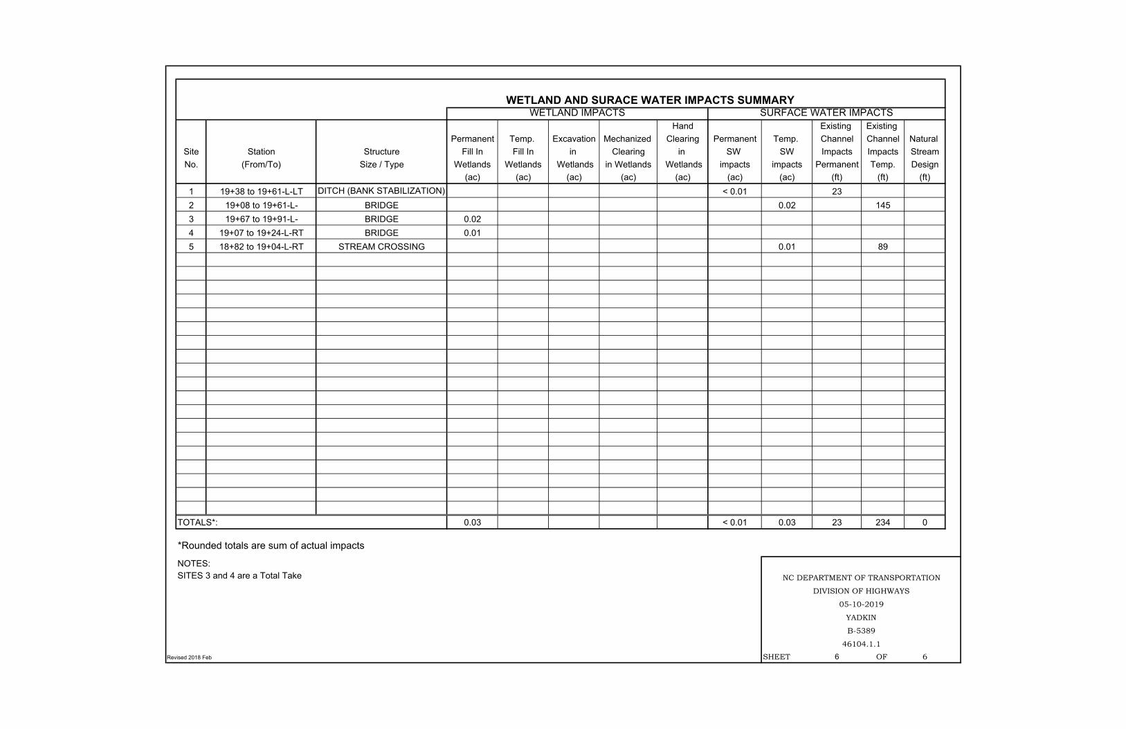
Hand Existing Existing Permanent Temp. Excavation Mechanized Clearing Permanent Temp. Channel Channel Natural
Site Station Structure Fill In Fill In in Clearing in SW SW Impacts Impacts StreamNo. (From/To) Size / Type Wetlands Wetlands Wetlands in Wetlands Wetlands impacts impacts Permanent Temp. Design
(ac) (ac) (ac) (ac) (ac) (ac) (ac) (ft) (ft) (ft)1 19+38 to 19+61-L-LT DITCH (BANK STABILIZATION) < 0.01 232 19+08 to 19+61-L- BRIDGE 0.02 1453 19+67 to 19+91-L- BRIDGE 0.024 19+07 to 19+24-L-RT BRIDGE 0.015 18+82 to 19+04-L-RT STREAM CROSSING 0.01 89
TOTALS*: 0.03 < 0.01 0.03 23 234 0
Revised 2018 Feb SHEET 6 OF 6
WETLAND AND SURACE WATER IMPACTS SUMMARYWETLAND IMPACTS SURFACE WATER IMPACTS
YADKIN
B-5389
46104.1.1
NC DEPARTMENT OF TRANSPORTATION
DIVISION OF HIGHWAYS
05-10-2019
*Rounded totals are sum of actual impacts
NOTES:SITES 3 and 4 are a Total Take