received - geologyontario.mndmf.gov.on.ca · iv 198 certificate o analysif s fo humur s layes soir...
TRANSCRIPT

5 2 N 0 1 S W 9 9 7 9 2 . 8 2 7 B AV , 010
SUMMARY REPORT
198^ SUMMER PROGRAMME
FLY LAKE PR03ECT
U C m SUBPROVINCE
NORTHWESTERN ONTARIO
RECEIVED JUL 1 2 1985
MINING lANOS SECTION
Prepared by: Getty Canadian Metals, Limited F.W. Nielsen, P.Eng. September, 198<f W.S. Ferreira, M.Sc.
Edited by a.G. Bryant, M.Sc.

TABLE OF
bifN01SW9979 2.8278 AVIS LAKE
List of Figures List of Tables List of Maps List of Appendices
SUMMARY
CONCLUSIONS
RECOMMENDATIONS
PART I: INTRODUCTION
1.1 General 1.2 198'f Sumnner Programme 1.3 Personnel
PART II: GEOLOGICAL, GEOCHEMICAL, GEOPHYSICAL AND TRENCHING PROGRAMME RESULTS
2.1 FL-1 CLAIM GROUP
2.1.1 Introduction 2.1.2 Location and Access 2.1.3 Claims 2A.it Previous Work 2.1.3 Geology 2.1.6 Lithogeochemistry 2.1.7 Conclusions and Recommendations
1
ii iii
V
1
2
5
5 5 5
10
10
10 10 10 12 12 13 13
0 1 0 C
2.2 FL-2 CLAIM GROUP
2.2.1 Introduction 2.2.2 Location and Access 2.2.3 Claims 2.2.it Previous Work 2.2.5 Geology 2.2.6 Lithogeochemistry 2.2.7 Soil Geochemistry 2.2.8 Conclusions and Recommendations
15
15 15 15 15 17 17 17 17
2.3 FL-3 CLAIM GROUP
2.3.1 Introduction 2.3.2 Location and Access 2.3.3 Claims 2.3A Previous Work 2.3.5 Geology 2.3.6 Lithogeochemistry 2.3.7 Soil Geochemistry 2.3.8 Trenching 2.3.9 Conclusions and Recommendations
19
19 19 19 19 19 21 21 23 23

TABLE OF CONTENTS PAGE NO.
2A FL-H CLAIM GROUP 25
2.5
2.6
2.7
l.tiA Introduction 25 2A.2 Location and Access 25 2A3 Clainns 25 2A.k Previous Work 25 2A.5 Geology 25 2A.6 Lithogeochemistry 27 2A.7 Soil Geochemistry 27 2A.% Conclusions and Recommendat ions 27
FL-5 CLAIM GROUP 29
2.5.1 Introduction 29 2.5.2 Location and Access 29 2.5.3 Claims 29 2.5A Previous Work 29 2.5.5 Geology 29 2.5.6 Soil Geochemistry 31 2.5.7 Conclusions and Recommendat ions 31
FL-6 CLAIM GROUP 32
2.6.1 Introduction 32 2.6.2 Location and Access 32 2.6.3 Claims 32 2.(>.k Previous Work 32 2.6.5 Geology 32 2.6.6 Lithogeochemistry 3k 2.6.7 Soil Geochemistry 3k 2.6.8 Trenching 36 2.6.9 Conclusions and Recommendat ions 36
FL-7 CLAIM GROUP 39
2.7.1 Introduction 39 2.7.2 Location and Access 39 2.7.3 Claims 39 2.7.k Previous Work 39 2.7.5 Geology 2.7.6 Lithogeochemistry k2 2.7.7 Soil Geochemistry k5 2.7.8 Conclusions and Recommendat ions k6

TABLE OF CONTENTS PAGE NO.
2.8 FL-8 CLAIM GROUP 1 7
2.8.1 Introduction tt7 2.8.2 Location and Access 'f? 2.8.3 CJaims k? 2.ZA Previous Work 2.8.5 Geology 2.8.6 Lithogeochemistry 50 2.8.7 Conclusions and Reconnnnendations 50
2.9 FL-9 CLAIM GROUP 52
2.9.1 Introduction 52 2.9.2 Location and Access 52 2.9.3 Clainns 52 2.9.^* Previous Work 52 2.9.5 Geology 5 » 2.9.6 Lithogeochemistry 5k 2.9.7 Soil Geochemistry 56 2.9.8 Conclusions and Recommendat ions 56
3. REFERENCES 57

LIST OF FIGURES
FIGURE If DESCRIPTION SCALE
J Location Map. 1:1,58^^,000
2. Claim Block Outlines and 1:300,000 Regional Geology.
3. FL-1 Claim Group. 1:31,680
li. FL-2 Claim Group. 1:31,680
5. FL-3 Claim Group. 1:31,680
6. FL-3 Property, Trench Description 1:60 and Sample Results.
7. FL-^ Claim Group. 1
8. FL-5 Claim Group. 1
9. FL-6 Claim Group. 1
10. FL-6 Trench Plan and Sample Results 1
11. FL-6 Trench Description and 1 Sample Results.
12. FL-7 Claim Group. 1:31,680
13. FL-8 Caim Claim Group. 1:31,680
I'f. FL-9 Claim Group. 1:31,680
31,680
31,680
31,680
25
25
PAGE
6
7
11
16
20
2H
26
30
33
37
38
itO
U8
53
-1-
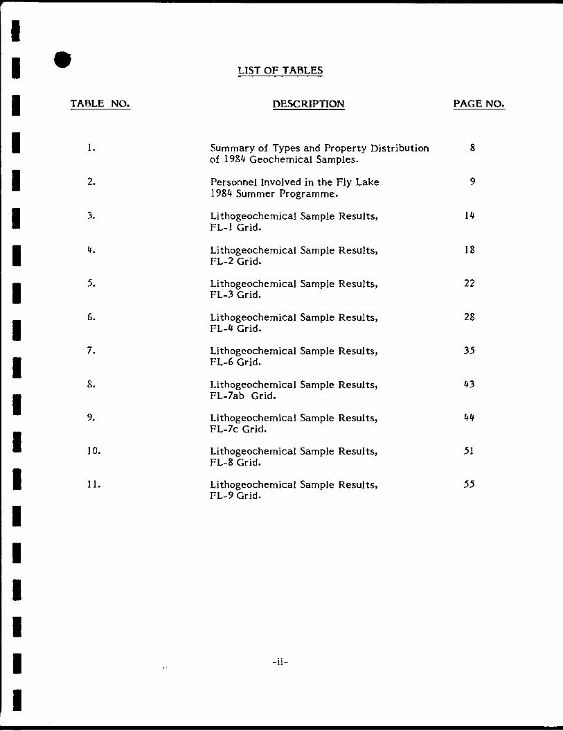
LIST OF TABLES
TABLE NO. DESCRIPTION PAGE NO.
1. Summary of Types and Property Distribution 8 of ISS'f Geochemical Samples.
2. Personnel Involved in the Fly Lake 9 198^ Summer Programme.
3. Lithogeochemical Sample Results, I'f FL-1 Grid.
't. Lithogeochemical Sample Results, 18 FL-2 Grid.
5. Lithogeochemical Sample Results, 22 FL-3 Grid.
6. Lithogeochemical Sample Results, 28 FL-'f Grid.
7. Lithogeochemical Sample Results, 35 FL-6 Grid.
8. Lithogeochemical Sample Results, FL-7ab Grid.
9. Lithogeochemical Sample Results, 'f'f FL-7C Gr id .
10. Lithogeochemical Sample Results, 51 FL-8 Grid.
11. Lithogeochemical Sample Results, 55 FL-9 Grid.
-11-

LIST OF MAPS
MAP NO. TITLE SCALE LOCATION
7
8
9
1 0
11
12
13
Geology and Lithogeochemical 1:5000 Sample Locations, FL-1 Clainn Group
Geology and Lithogeochemical 1:2500 Sample Locations, FL-2 Claim Group Grid FL-2
Humic Soil Sample Location Map, 1:2500 FL-2 Claim Group, Grid FL-2
Soil Geochemistry, FL-2 Claim Group, 1:2500 Grid FL-2
Geology and Lithogeochemical Sample 1:2500 Locations, FL-3 Claim Group, Grid FL-3a
Geology and Lithogeochemical Sample 1:2500 Locations, FL-3 Claim Group, Grid Fl-3b
Humic Soil Sample Location Map, 1:2500 FL-3 Claim Group, Grid FL-3b
Soil Geochemistry, FL-3 Claim Group, 1:2500 Grid FL-3b
Geology and Lithogeochemical Sample 1:2500 Locations, FL-^ Claim Group, Grid FL-'^
Humic Soil Sample Location Map, 1:2500 FL-'t Claim Group, Grid FL-'f
Soil Geochemistry, FL-'f Claim Group 1:2500 Grid FL-^t
Humic Soil Sample Location Map, 1:2500 FL-5 Claim Group, Grid FL-5
Soil Geochemistry, FL-5 Claim Group 1:2500 Grid FL-5
Map Volume
Map Volume
Map Volume
Map Volume
Map Volume
Map Volume
Map Volume
Map Volume
Map Volume
Map Volume
Map Volume
Map Volume
Map Volume
-111-

LIST OF MAPS
MAP NO. TITLE SCALE LOCATION
If
15
16
17
18
19
20
21
22
23
25
26
27
Geology and Llthogeochemical 1:2500 Sample Locations, FL-6 Claim Group, Grid FL-6
Humic Soil Sample Location Map, 1:2500 FL-6 Claim Group, Grid FL-6
Soil Geochemistry, FL-6 Claim Group, 1:2500 Grid FL-6
Geology and Llthogeochemical 1:2500 Sample Locations, FL-7 Claim Group, Grid FL-7ab
Humic Soil Sample Location Map, 1:2500 FL-7 Claim Group, Grid FL-7ab
Soil Geochemistry, FL-7 Claim Group 1:2500 Grid FL-7ab
Geology and Llthogeochemical 1:2500 Sample Locations, FL-7 Claim Group, Grid FL-7C
Humic Soil Sample Location Map, 1:2500 FL-7 Claim Group, Grid FL-7c
Soil Geochemistry, FL-7 Claim Group, 1:2500 Group, Grid FL-7c
Geology and Llthogeochemical Sample 1:2500 Locations, FL-7 Claim Group, Grid FL-7d
Geology and Llthogeochemical 1:5000 Sample Locations, FL-8 Claim Group Grid FL-8
Geology and Llthogeochemical 1:2500 Sample Locations, FL-9 Claim Group, Grid FL-9
Humic Soil Sample Location Map, 1:2500 FL-9 Claim Group, Grid FL-9
Soil Geochemistry, FL-9 Claim Group, 1:2500 Grid FL-9
Map Volume
Map Volume
Map Volume
Map Volume
Map Volume
Map Volume
Map Volume
Map Volume
Map Volume
Map Volume
Map Volume
Map Volume
Map Volume
Map Volume
- I V -

LIST OF APPENDICES
APPENDIX NO. DESCRIPTION
I Univariate Statist ics for FJy Lake Humus Samples.
II Cer t i f i ca tes of Analysis for Rock Geochemistry and Assays, Fly Lake Properties.
III 1984 Cer t i f i ca tes of Whole Rock Analysis, Fly Lake Properties.
IV 1984 Cer t i f i ca tes of Analysis for Humus Layer Soil Samples, Fly Lake Properties.
- V -

- 1 -
SUMMARY
The FJy Lake Project is a 100% Getty funded project designed to tes t the base and precious meta] potential of a number of geophysical and/or geochemical ta rge ts generated from the 1983 Uchi Reconnaissance Program. All t a rge ts are in the Confederation Lake area of the Archean aged, east-west trending Uchi Volcanic Belt about 80 kilometres east of Red Lake, Ontario.
The 198 ^ summer program is a logical continuation of the 198 ^ winter geophysical program which included line cutting, Max Min II EM and proton magnetometer surveys on seven of the nine Fly Lake properties. Geophysical surveys were carried out on claim groups FL-2, 3, U, 5, 6, 7 and 9 and all bedrock conductors defined by the airborne geophysical survey were delineated on the ground.
The 198 ^ summer program consisted of geological mapping, prospecting of conductor areas, soil sampling (A1 horizon), lithogeochemical sampling and in some instances geophysical surveys with a VLF-EM. The VLF-EM work was minimal and was only done on grids FL-5, 6 and 9 in order to further define several EM conductors which had not been fully delineated during the winter program. Soil sampling was limited to the vicinity of the various EM conductors with samples analyzed for Au, As, Cu and Zn. Results from the vast majority of the areas were largely disappointing with few, if any anomalous samples returned. Significant values in Au were returned from grid FL-9 while locally anomalous values in As, Cu and Zn were returned from other grids.
Geological mapping and prospecting uncovered three mineralized zones, one on each of three of the7grids. OngridFL-3trenchingrevealedabundantgraphitewithassociatedpyrl te and pyrrhotite. Assay results from systematic chip sampling revealed nothing of economic interest . On grid FL-'f a rubbly gossan zone with pyrite, pyrrhoti te and magneti te was sampled and also revealed very l i t t le of economic interes t . On grid FL-6 two zones of a single mineralized trend were uncovered. In one exposure a grab sample assayed 2.6% As and 1100 ppb Au. Systematic 0.5 met re chip samples from across the zone were assayed, however, and indicated no significant gold values. The conductive zone was caused by pyrite, pyrrhoti te and magnet i te over relatively narrow widths.
Only four days were spent on claim group FL-1. The airborne geophysical survey did not indicate any bedrock EM conductors that would readily explain the anomalous lake sediment values in the area . Consequently the property received a lower priority rating with only geological mapping and limited lithogeochemical sampling carried out. The claim group is believed to be underlain by stratigraphy similar to that which hosts the former South Bay Cu-Zn deposit.
On claim group FL-8, a geological mapping and lithogeochemical sampling program was undertaken. A two man crew operating out of a fly camp on Narrow Lake mapped the entire property at a scale of 1:5000. It was found that the contact between cycle I and cycle II volcanic rocks crosses the property. This contact appears to be marked by a fault with geochemically Cu rich chemical sediments in close proximity. It was also discovered that anomalous Au values in lake sediments generally coincide with the intersection point of major structures and chemical sediments.

-2-
CONCLUSIONS
U. The FL-1 claim group is underlain by geology which is stratigraphically and chronologically favourable for the deposition of massive sulphide deposits. Enhanced magnetic maps derived from the Dighem III airborne geophysical survey Indicate some weak but evident anomalies which are believed to be caused by disseminated magneti te within a Q.F.P. unit . The lack of an airborne EM response in the area may only indicate that a large massive sulphide deposit does not exist within about 100 metres of surface. The highly significant lake sediment values in Cu, Zn and Mo remain to be explained for the area.
2. A weak airborne conductor is located immediately north of the FL-1 Claim Group, beneath Fly Lake. Favourable geology and the local geochemical anomaly suggest follow-up is necessary for base metal deposits.
3. Soil sampling, lithogeochemical sampling, prospecting and mapping results for claim groups FL-1, 2, 3, U and 5 did not indicate any significant anomalies or areas of economic potential.
i . On claim group FL-6, conductor 6F is overlain by a swamp which drains 300 metres to the south into a small geochemically anomalous pond with S'f ppm Cu and 10 ppm As. A formational contact is interpreted a t the conductor axis. Conductive zone 6G is not significantly auriferous and conductive zones 6A, 6B, 6C, 6D and 6E are unexposed but along trend from zones identified on the Papaonga Lake property. Conductive zone 6C and probably 6 0 coincide with conductive zone 2C which hosts the Northeast Asp-Au showing on the Papaonga Lake property.
5. On claim group FL-7 none of the EM conductors was found to outcrop and all remain largely unexplained. On grid 7ab conductor 7A is spatially related to intense carbonate alteration and is considered a second priority drill ta rget . On grid 7c conductor 7cA is quite strong with anomalous soil sample values in Cu spatially related to i t . Conductor 7cB is of considerable strike length but is believed to be at the contact between a tholeiit ic volcanic suite and a calc alkaline volcanic suite of rocks. Lake sediments in the vicinity of this conductor are anomalous in Au, Cu and Mo. The regional Cu-Mo anomaly has not been explained to date .
6. Claim group FL-8 was found to host major s t ructural fea tures and chemical sediments. Anomalous lake sediment values in Cu were probably explained by the anomalous Cu associated with the chemical sediment units. Anomalous values in Au and As have not been explained. The area is considered geologically favourable for gold deposits with geological and/or structural controls.
7. On claim group FL-9 one of the EM conductors is proximal to an Au, Sb and Cu anomaly in soil samples. Work done to the east in 1956-57, indicated that the stratigraphy has undergone carbonatization and silicification and hosts pyrite, pyrrhotite and tourmaline mineralization. It is not known if the mineralized sections of core produced from the 1957 drilling were assayed for gold as iron was the targeted commodity. The conductive zone and stratigraphy are considered favourable for gold mineralization.

-3-
8. The establishment of cut grids and detailed geophysical definition of single conductors of relatively short str ike length has proven to be a high cost endeavor. The cost effect iveness of the Uchi Reconnaissance progrann in tackling such targets has been enlightening and fur ther work of this nature should be pat terned a f t e r the format established for the Uchi Recce program wherein pace and compass grids were established for VLF-EM and magnetic surveys. In fu ture , such targets as FL-2, FL-'t and FL-5 should be assigned to this lower cost evaluation technique.
9. Detailed prospecting and geological mapping are essential to determine the cause of conductors in low outcrop density regions. Any conductor that is or can be exposed on surface can subsequently be trenched and sampled. In many instances this permits re-allocation of drilling funds for work on other targets .
10. Soil sampling of the A1 horizon in areas of relatively thin overburden is an ef fec t ive way to determine If mineralization of potential economic significance exists in any given area. The results of the Fly Lake soil sampling program indicated very l i t t le of potential interest and eliminated a number of targets before the drilling stage.

-U-
RECOMMENDATIONS
1. Additional work is recommended on and adjoining the FL-1 claim group. The weak airborne conductor located immediately north of the FL-1 claim group should be staked and investigated for its base metal potential . This conductor underlies Fly Lake so a winter program will be required. Further study should also be made of airborne data for the property and the results co-ordinated with geological mapping and sampling already done on the property. If only deep target potential exists then a program of deep drilling, down hole geophysics and geochemistry will be required to adequately test the property.
2. No further work is recommended on the FL-2, 3, 4 and 5 claim groups due to the lack of anomalous results from soil sampling, lithogeochemical sampling, prospecting and mapping surveys.
3. On claim group FL-6, conductors 6B and 6F should be considered for drilling since they appear to be along trend from the geochemically anomalous soils of conductive zone 2B on the Papaonga Lake property.
On claim group FL-7 several targets are recommended for drilling. Conductor 7A should be drill tested in the area of intense carbonate al terat ion. Conductor 7cA should be considered for drill testing in the vicinity of the Cu anomaly and conductor 7cB should be tested in the vicinity of the Au, Cu and Mo anomalies.
5. On claim group FL-8 fur ther geochemical and geophysical surveys should be carried out over major s tructural fea tures and chemical sediments found during the 198 ^ mapping program.
6. On claim group FL-9 a preliminary drill tes t for significant gold mineralization is recommended in the vicinity of the Au-Sb-Cu anomaly.

-5-
PARTI; INTRODUCTION
1-1 General
The Fly Lake Project is a 100% Getty funded programme designed to evaluate precious and base metal targets in the Confederation Lake area of the Archean aged, east-west trending Uchi Volcanic Belt, about 80 kilometres east of Red Lake, Ontario (Figure 1). The ta rge ts were a number of airborne EM and magnetic anomalies and lake sediment anomalies defined as part of the aggressive, successful, regional Uchi Recce exploration programme carried out in 1983. Reconnaissance geological, lithogeochemical and Landsat interpretat ion data obtained in 1983 also contributed significantly in prioritization of the targets for subsequent ground acquisition that culminated in a total of 263 claims staked to protect nine di f ferent target areas. The properties are referred to as the FL-1, 2, 3, i f , 5, 6, 7, 8 and 9 claim groups (Figure 2) which cumulatively comprise the 19SU Fly Lake Project .
The target base metal deposit is 5-15 MM tonnes averaging 2% Cu, 6% Zn and 2 oz Ag/ton. The precious metal target deposit is 1-5 MM tonnes averaging 0.30 oz Au/tonne.
During February and March 198 ^ a winter geophysical program was conducted on claim groups FL-2, 3, U, 5, 6 and 7. Line cut grids were established and Max Min II EM and proton magnetometer surveys (in conjunction with a base station recorder) were conducted over these grids. All conductors defined by the Dighem III airborne system were delineated on the ground except for one very low priority, questionable bedrock conductor on grid 7c.
1.2 198<t Summer Programme
The 198 ^ summer programme objective was to determine the cause of the various airborne EM conductors and lake sediment anomalies. Geological mapping, prospecting, humus layer soil sampling, lithogeochemical sampling and on several properties, minor VLF-EM survey work were carried out . The results of the 198 » work programme are presented, by property, in Part 2 of this report . A summary of the number of each type of geochemical sample collected from each of the nine propeties is provided in Table 1 and the univariate s tat is t ics are provided in Appendix I.
1.3 Personnel
The summer programme was carried out between early 3une and late August, 198^. A list of personnel involved is provided in Table 2.

I
I
I
I
I
- 6 -
/ .<. VJ
/
SondyX^
/
<
i l l ït 5
operty
'vHii.
FAVOURABLE L A K E VOLCANIC BELT
1
-.'••A
/
UCHI LAKE VOLCANIC BELT
Confedera t ion
L E G E N D
l'^î? Volcanic Complex
Airport
All weolher rood
Proposed rood 3 Major producers (historic) O Fly Lake Area
16 o Scale
4 0 km —J
Figure 1
PAPAONGA PROPERTY
L O C A T I O N M A P
UCHI V O L C A N I C B E L T P R O J E C T N O R T H W E S T E R N ONTAR IO
CMtC^ DB'T J.G. B. IdMl FEB./es
i.Tt 5? a 55 I scale I: l ,5e<l ,00D
Getty Canadian Metals, Ltd.

- 8 -
TABLE 1
SUMMARY OF TÏPES AND PROPEKTY DISTRIBUTION OF 1984
GBOCHEMICAL SAMPLES
FLY LAKE PROPERTIES
PROPERTY LITHOGEOCHEMICAL SAMPT.F." FOR
WHOLE ROCK ANALYSIS
LITHOGEOCHEMICAL SAMPLES FOR
SELEL'i'EU ELEMENTS
CHIP AND GRAB SAMPLES FROM
TRENCHES
SOIL SAMPLES A^ HORIZON
FL-1 31
FL-2 7 78 FL-3 19 31 68
FL-4 12 46
FL-5 29 FL-6 22 18 149
FL-7 52 175
FL-8 31
FL-9 14 72
TOTAL ' 31 157 49 617

-9-
TABLE 2
PERSONNEL INVOLVED IN THE
FLY LAKE 198<f SUMMER PROGRAM
SURVEY OR WORK CATEGORY/NAME, TITLE
Project Supervision
W.D. Ewert Ph.D. Project Exploration Geologist
Field Supervision and Trench Blasting
W. Nielsen B.Sc. Consulting Geologist
Geochemical Survey Orientation
L. Bloom M.Sc. Geologist
EMPLOYER
Getty Mines, Limited
W. Nielsen, Consulting Geologist
Getty Mines, Limited
Geological Mapping, and Trenching, Soil Survey and Otfier; Grids PL-1 and PL-2
B. Drost B.Sc Student Graduate
W. Ferreira M.Sc. Contract Geologist
D. Graham B.Sc. Contract Geologist
K. 3aworski
3. Kerr
G. Muir B.Sc.
Other
M. Wiskeman
B. Strapp
Student
Student
Student Graduate
Pilot
Expeditor
Getty Mines, Limited
Mayman Exploration Services
Mayman Exploration Services
Getty Mines, Limited
Getty Mines, Limited
Getty Mines, Limited
Ranger Helicopters
Mayman Exploration Services

-10-
PART 2: 198'f GEOLOGICAL, GEOCHEMICAL, GEOPHYSICAL AND TRENCHING PROGRAMME RESULTS
2.1 FL-1 CLAIM GROUP (BOWERMAN TOWNSHIP, N.T.S. 52K15, 52N2)
2.1.1 Introduction
In 1983, Get ty Canadian Metals, Limited carried out a regional lake sedinnent survey which covered the area of the FL-1 claim group. Highly anomalous values in Zn and Cu indicated a possible source of massive sulphide mineralization. A total of claims were staked to protect the area containing the most anomalous lake sediment values. A subsequent helicopter-borne geophysical survey failed to delineate any bedrock conductors in the area of the claim group. This altered the desired approach to the claim group as it was fe l t that if any massive sulphide deposit did exist in the area then it would have to occur at a considerable depth. Consequently a limited geological mapping and lithogeochemical mapping program was undertaken in order to determine if local geology was favourable and to see if any broad al terat ion pat terns emerged from the sampling program.
Two men with helicopter assistance spent four days carrying out the required work.
2.1.2 Location ctnd Access
The FL-1 claim group is located approximately 79 kilometers due east of Red Lake with the north boundary of the claim group covering the southernmost portion of Fly Lake (Figures 1 and 2). Access is by f loat or ski equipped a i rc ra f t chartered from Red Lake to Fly Lake. A canoe or skidoo can be used to gain access to the centre of the property by way of a creek to a small lake. A helicopter, available for charter out of Red Lake gave easy access to all parts of the property.
It should be noted that a tornado went through what is now the western part of the property a number of years ago. The wind fall in this area is ext reme.
2.1.3 Claims
The property consists of contiguous claims (Figure 3) which were staked in October of 1983 and recorded on October 27, 1983. The claims are numbered 77517k to 775221 inclusive and are recorded under the name of Getty Canadian Metals, Limited. An area of approximately 1,920 acres (768 hectares) is covered by the property.

Il
I 0 . 2 0
L_ L _ S c a l e
1 . 0 km I
I Figxire 3
FLY LAKE PROPERTIES UCHI VOLCANIC BELT, N.W. ONTARIO
FL—1
CLAIM GROUP
D«*WN BY: JfïR D*TE A p r i l • 8b CHECKDBY A T Df^WG ho NTS SCALE 1 :31 ,680
Getty Canadian Metals, Ltd.

-12-
2.1.'^ Previous Work
In 1975 Kerr Addison Mines, Limited carried out magnetometer and VLF-EM surveys over the eastern-most part of the property. No conductors of any consequence were defined and no fur ther work was done in the immediate area of the claim group although it is known tha t Kerr Addison did drill a number of holes in the Fly Lake area which did intersect short widths of Cu-Zn mineralization.
In the late 1970's St. 3oseph Exploration, Ltd. held a claim group partially coincident with the present FL-1 group. Magnetometer and EM surveys were carried out on a grid . Although no drill holes were collared within the area of the present FL-1 property there were several holes that tested a conductor located just east of the property. Nothing of economic importance was intersected and St. 3oseph still holds a claim group which t ies onto the eastern boundary of the FL-1 group.
2.1.5 Geology
The property is underlain by a sequence of in termediate and felsic f ragmentai volcanic rocks as well as some intermediate flows (Map 1). These have subsequently been intruded by a multi-unit felsic porphyry (probably a Q.F.P.) as well as a pluton of granodioritic composition.
The intermediate fragmentai formation consists primarily of light to medium grey tuff with greater than 10% mafic minerals and less than 10% f r e e quar tz . A phyric felsic flow about 300 m thick ocurs within this formation.
The felsic f ragmentai formation consists mainly of a buff coloured tuff with 5% to 30% f r ee quartz crystals. Rare discordant and concordant chlorite veins up to 30 cm wide occur in the northwest part of the property. One to three percent disseminated pyrite was found in other areas of the property. A fault which is marked by good schistosity occurs near the southern contact of this formation.
The granitic pluton has inhomogeneous compositional and textural components at the outcrop scale.
The felsic porphyry unit is compositionally and texturally diverse and appears to grade into the granitic pluton to the south. This may possibly indicate a differentiat ion of the pluton.

-13-
2.1.6 LithoReochemistry
During the mapping program, 31 lithogeochemical samples of varying lithologies were collected and sent for geochemical analysis. X-Ray Assay Labs of Toronto carried out whole rock analysis by X.R.F. while Cu and Zn were determined by D.C.P. Sample locations are provided on Map 1 and Cu, Zn analytical data are summarized with rock type names in Table 3.
Intermediate and felsic volcanic rocks in the southeast part of the property host all but one of the above background Cu and Zn values which range to S'f ppm and 240 ppm respectively. One altered granite sample f rom the southwest part of the property also contained above background Zn (130 ppm). Whole rock analytical data is provided in Appendix III. Comprehensive evaluation of the data and comparison with regional data will be required before conclusions and recommendations can be made.
2.1.7 Conclusions and Recommendations
A study of the regional geology indicates that the area underlain by the FL-1 claim group is stratigraphically similar to tha t found at the South Bay Mine. Anomalous lake sediments in the area indicate a possible mineralized source although airborne geophysical results do not indicate any bedrock conductors. This may imply that a mineralized source is located a t depths beyond the detection limit of the airborne system. Consequently any massive sulphide deposit will be somewhat more diff icult to find. No fur ther work is recommended until all lithogeochemical results are fur ther studied. Should these results indicate an area of significant al teration then a work program should be formulated around these results.

TABLE 3
FLY LAKE PROJECT 20»6 LITHOGEOCHEMICAL SAMPLE RESULTS
FLY-1 GRID
Sample Rode Description Cu ppm Znppm
D07235 Intermediate tuff (?) 8if.O 33.0 D07236 Intermediate tuff 2 .0 12.0 D07237 Intermediate tuff 2 . 5 92.0 D07238 Granite 2 .0 210.0 D07239 Felsic tuff 7 .0 33.0 D072if0 Quartz porphyry intrusion 1 .5 21.0 D072ifl Quartz prophyry intrusion 1 .5 31.0 D072^2 Quartz porphyry intrusion 5 . 5 k5.0 D072^3 Quartz porphyry intrusion 2 . 5 7 .0 D072itU Quartz porphyry intrusion 6 . 5 67.0 D072ii5 Felsic tuff 61.0 68.0 D072U6 Granite 8 .0 130.0 0072^^7 Felsic tuff 1 .5 21.0 D07376 Granite 6 .0 itV.O D07377 Felsic porphyry and granitic intrusive 3 . 0 35 .0 D07378 Felsic porphyry 2 . 0 22.0 D07379 Felsic tuff 1 .5 20.0 D07380 Felsic tuff 2 .0 6 .5 D07381 Felsic tuff 1.0 l<f.0 D07382 Felsic tu f f ; a l tered; 2% py 12.0 7 .0 D07383 Felsic tu f f ; a l tered 6 . 5 1*7.0 D0738«f Felsic tu f f ; 1 .5 26.0 D07385 Intermediate tuff 8 . 5 110.0 D07386 Felsic flow It.5 210.0 D07387 Felsic tu f f ; unaltered; but high muscovite 8 .0 2^^0.0 D07388 Tuff-breccia 8 .5 150.0 D07389 Felsic tu f f ; well developed cleavage 7 .5 130.0 D07390 Felsic tu f f ; a l tered; high chlorite 2 . 5 35.0 D0739] Felsic tuff 1.0 26.0 D07392 Felsic tu f f ; light green matrix 1 .0 8 .0 D07393 Hornfels (? originally tu f f ) 1.5 19.0

-L-i-
2.2 FL-2 CLAIM GROUP (N.T.S. 52N 1 and 2)
2.2.1 Introduction
In 1983 a Dighem helicopter-borne geophysical survey defined several high priority conductors in the FL-2 area . Eight claims were staked in order to protect these conductors and a line grid was established in February 198^ . This 8.2 km grid was subsequently surveyed with Max Min II EM and proton magnetometer during March 198^ . Two strong conductors with coincident magnetic anomalies were defined and a programme of geological mapping, soil sampling and lithogeochemical sampling was recommended.
2.2.2 Location and Access
The FL-2 claim group is located approximately 9 ^ km due east of the town of Red Lake (Figures 1 and 2). Access is via f loat or ski equipped a i rc ra f t f rom Red Lake to Slate Lake. A boat or skidoo is then required for the 2.5 km trip up the Wenasaga River, which flows into the eastern end of Upper Slate Lake.
2.2.3 Claims
Eight contiguous claims numbered 775631 to 775636 inclusive and 696853 and 69685^» make up the claim group (Figure if). These claims were all recorded on January 19, 198^ under the name of Getty Canadian Metals, Limited, 1200-150 York Street , Toronto, Ontario, M5H 3S5.
2.2A d e v i o u s Work
In 1978, St. 3oseph Explorations Ltd. cut a 13.9 km grid over the same area as the FL-2 claim group. Proton magnetometer and Max Min II EM surveys were carried out over the grid and several conductors defined. The magnetometer survey involved readings taken at 25 m stations and therefore did not accurately define the direct magnetic correlation with the conductors. No fur ther work is recorded but it is strongly suspected tha t the area was prospected and geologically mapped. Soil sampling may also have been carried out. Diamond drilling was not done in this area. Getty personnel did not see any signs of the old St. Joseph grid.

I
B i ' R K E T T T W P ( OR REFER 10 TWR PLAN
\ i
KRL 1 KRL 1
1 KRL 1
1 K,
696853 1 1 77î>63l 1 j 775634 177/5635
KRL 1 KRL ^ KRL 7KRL 1 \l
\ 1 \\ Ejpc.eS'S j 1775636
5i°00' -
FL. - 2 Claim Grgjp
^
0 . 2 0 1.0 km
F i g u r e 4
FLY LAKE PROPERTIES UCHI VOLCANIC BET^T, N.W. ŒTARIO
F L - 2
CLAIM GROUP
DRAWN BY: JGB" CHtCK D BY: JTÇ NTS: S2IT m . s£i[rT:31,680~
Getty Canadian Metais, Ltd.

-17-
2.2.5 Geology
Ontario Geological Survey map P2't08 (Bowen, 1981) indicates the area is underlain by a steeply dipping slate fornnation as well as intermediate to felsic volcanic rocks which are locally intercalated with chemical sediments.
Getty field personnel identified only one observable formation underlying the property (Map 2). It is a schistose, laminated to thinly bedded metagreywacke which is interbedded with a buff coloured metasandstone. Minor quartz lenses and veins are ubiquitous.
A feldspar porphyry sill approximately 3 m wide as well as a mafic intrusive (gabbro) unit were noted west of the claim group.
A more complete description of the sedimentary formation can be seen in the legend on Map 2.
There is no outcrop in the areas underlain by the conductors.
2.2.6 Lithogeodiemistry
Six lithogeochemical samples were sent to X-Ray Assay Labs of Toronto for analysis for Au, As and Sb by neutron activation. One rusty greywacke sample was also analyzed for Cu and Zn. Four of the samples were of quartz while the other two samples were greywacke. Results presented in Table 4 indicate nothing of interest except for the 76 ppb Au returned from one of the greywacke samples. Sample locations are provided on Map 2.
2.2.7 Soil Geochemistry
In order to fur ther tes t the cause of the EM conductor it was decided to carry out a soil sampling program over a selected area of the grid. The A1 (humic) horizon was selected due to the ease of consistent sampling and reasonably reliable results. Seventy eight samples were collected (Map 3) and sent to X-Ray Assay Labs in Toronto for analysis for Au, As, Cu and Zn. Au and As were analyzed by neutron activation with detection limits of 1 ppb and 1 ppm respectively. Cu Zn were analyzed by D.C.P.
Results for all elements are presented on Map k and indicated nothing of particular interest . Univariate s tat is t ics are presented in Appendix I.
2.2.8 Conclusions and Recommendations
There was no significant precious metal or base metal mineralization of any significance encountered. No fur ther work is recommended for the FL-2 property.

-JS-
TABLE k
FLY LAKE PROJECT 20»6 LITHOGEOCHEMICAL SAMPLE RESULTS
FL-2 GRID
Sample Rock Type Au ppb Cu ppm Zn ppm As ppm Sb ppm
D07001 Quartz pod 1 - - < 1 < 0.2
D07002 Quartz vein UOO - - < I < 0.2 D07101 Quartz pod 3 - - 1 < 0.2 D07201 Quartz vein 1 - - 1 < 0.2 D07202 Quartz vein 16 - - 1 < 0.2 D07203 Rusty Greywacke < 1 9.5 21.0 1 0.2 D0720'f Rusty Greywacke 76 - - 1 < 0.2

-19-
2.3 FL-3 CLAIM GROUP (SLATE LAKE-AVIS LAKE AREA, N.T.S. 52K 15 and 16)
2.3.1 Introduction
In 1983 a Dighem helicopter-borne geophysical survey defined a number of medium to high priority conductors of considerable strike length in the Slate Lake area. Twenty claims were staked to protect these conductors and two grids were established over the conductive zones in order to provide control for subsequent ground geophysical surveys. Grid FL-3A was established over a one line airborne conductor which underlies Slate Lake. Grid 3B was established over several rather extensive moderate to strong airborne responses. Both grids were later surveyed with Max Min II EM and proton magnetometer . All airborne reponses were defined on the ground and except for the 3A conductor all conductive zones seem to be accessible on the land portion of the grid. A programme of prospecting, geological mapping, soil sampling and lithogeochemical sampling was recommended for the summer months.
2.3.2 Location and Access
The FL-3 claim group is located approximately 92 km east of Red Lake at the eastern end of Slate Lake (Figure 1 and 2). Access is by float or ski-equipped a i rc raf t f rom Red Lake.
2.3.3 Claims
The FL-3 claim group is made up of 20 contiguous claims which were staked in January 198'» (Figure 5) and recorded January 19, 198^». The claims are numbered 775611 to 775630 inclusive and are recorded under the name of Getty Canadian Metals, Limited, 1200-150 York Street , Toronto, Ontario, M5H 3S5. The claims cover an area of approximately 800 acres (320 hectares) .
2.3.^ Previous Work
No previous competi tor activity is known to have occurred in the area covered by the claim group. St. 3oseph Exploration, Ltd., however, is known to have worked in the Slate Lake area.
2.3.5 Geology
Geological mapping results presented on Maps 5 and 6 indicate that the property is underlain by three formations and a maf ic intrusive (gabbro). The formations consist of a mafic volcanic formation, a metagreywacke sedimentary formation and an intermediate tuff formation.
The mafic volcanic unit only outcrops on grid FL-3A (Map 5) where it appears as an aphanitic, sheared flow which is medium grey in colour.


-21-
On grid FL-3B (Map 6), a large gabbro body outcrops. This unit has a lower amphibolite metamorphic grade which created a coarser than usual (greeschist facies) groundmass crystal size. The unit is made up of 20-90% hornblende-actinolite crystals which range in size from 0.5 to 6 mm. Locally the crystal size varies but no def ini te chill margins were found. The mafic mineral foliation varies from well developed to non-foliated. Plagioclase is interst ial .
The greywacke unit consists of fine grained, laminated, massive beds which are medium grey in colour. These beds are punctuated by slightly coarser very thin beds which are possibly graded.
The intermediate tuff is character ized by a light grey siliceous appearance, well developed cleavage and millimetre to cen t imet re long sericitic lensoidal features.
At line 1E/0+75N mineralization in the form of pyrite, pyrrhoti te and graphite was exposed in outcrop. This is coincident with one of the EM conductors. A trench was opened up across the mineralized zone. Further details on the exposed mineralization can be found later in this report .
2.3.6 Lithogeochemistry
A total of 15 rock samples and k core samples were collected from locations shown on Maps 5 and 6 and sent out for geochemical analysis. The core samples came from a drill core si te on the shore of Slate Lake. This is, no doubt, St. 3oseph Exploration Ltd.'s core from various holes drilled in the Slate Lake area . The location of the core boxes is marked on the accompanying geology map. The samples were sent to X-Ray Assay Labs of Toronto and analyzed for Au, As, Sb, Cu and Zn (samples of quartz were not analyzed for Cu & Zn) Au, As and Sb were analyzed by neutron activation while Cu and Zn were analyzed by D.C.P.
Analytical results are pesented in Table 5 and indicate nothing of economic interest .
2.3.7 Soil Geochemistry
In order to bet ter understand the cause of the various EM conductors it was decided to tes t the land portion of the claim group with soil geochemistry. The A1 (humic) horizon was selected due to the ease of consistent sampling and reasonably reliable results obtainable. Samples were taken at 25 met re spacings for 100 metres on either side of the various conductors. Samples were sent to X-Ray Assay Labs in Toronto for analysis for Au, As, Cu and Zn. Au and As were analyzed by Neutron Activation while Cu and Zn were analyzed by D.C.P. A total of 68 samples were taken over grid FL-3B only.
Results are provided on Map 8 and the univariate s tat is t ics presented in Appendix I. There are no significant, geochemically anomalous results.

TABLE 5 FLY LAKE PROJECT
2046 LITHOGEOCHEMICAL SAMPLE RESULTS
FLY 3 Grid
NOTE: The last k samples were taken from diamond drill core found on the shore of Slate Lake.
SAMPLE ROCK TYPE AU PPB CU PPM ZN PPM AS PPM SB PPM
Do7003 Near massive h 35.0 70.0 140 4.5 py
D0700A Chert or c 1 9.0 5.5 14 0.6 silicified zone
D07009 Qtz-tour vein 1 - - 2 0.3
D07010 Gossan zone 1 70.0 56.0 12 0.7 15 cm wide
D07011 Rusty siliceous i. 1 61.0 170.0 15 0.3 zone
D07205 Pyritiferrous i 1 49.0 66.0 11 1.5 black shale
D07206 M 1 9.0 23.0 3 1.5
D07301 Stream sediment 1 13.0 31.0 1 < 0.2
D07302 Altered gabbro - - 8 1.2
D07303 Rusty siliceous i 1 6.5 10.0 8 0.6 zone
D07304 II < 1 7.5 7.0 13 0.4
D07305 11 c 1 8.0 7.5 4 0.5
D07306 ti c 1 11.0 17.0 4 0.7
D07307 Qtz-tour vein i. 1 - - 4 0.6
D07308 Argillite-chert 6 74.0 71.0 8 0.3
D070U Massive po and 6 230.0 50.0 1 2.1 magnetite
D07015 massive magnetite 3 190.0 140.0 5 3.7
D07104 30% py in black < 1 41.0 63.0 75 1.3 shale
D07309 Qtz vein 38 110.0 100.0 85 2.3

-23-
2.3.8 TrenchinR
At line 1E/0+75N a mineralized zone was found and subsequently trenched and sampled. One H .S met re long trench exposed several mineralized zones which would explain the defined EM conductor in this area. These zones consist of a 20 cm wide band with 60% pyrite and pyrrhotite and a black graphitic shale with minor associated pyrite and pyrrhoti te. The entire trench except for a 1.7 m overburden covered section was sampled in 0.5 met re (or less) sections and sent for analysis for Au, As, Sb, Cu and Zn.
Results can be seen on Figure 6. Nothing of economic interest was defined. Several "high grade" grab samples of the best mineralization also revealed nothing of economic interest .
A second trench, opened up over a distance of 0.5 metres weis also sampled but results indicate nothing of in teres t . This trench is located just west of the main trench along the same mineralized trend.
2.3.9 Conclusions and Recommendations
No further work is recommended for this area .

(A <
e crt p. -O «s c
8
BLACK SHALE with 5-20% pyrite-pyrrhotite ' which occurs in discontinuous veinlets I and disseminations throughout
60% p y - p o zone [ ^ .Grab sample Au tr,Ag nil (#7081)
S i l i c e o u s Beds I
I V rab staple Au tr .Ag'nil (7082)
Buff to light grey siliceous zone (probably CHERT) with 1 to 5% disseminated pyrite
(#7080) massive pyrrhotite grab sample-^
water Au tr.Ag r
30% p y . po
T r e n c h 2
f-H lA 1—4 f t V o rH CN CM 1—1 V V V V rH rH VO o V r-4 1—( 1-4 r» r-H *> V o •V rH O V V • V <~> Csl C) 1—( V V V CN f-H V vr cn vD a\ 1 •t i-H A 1—< n «1 A ft 00 ft rt «t
<N •V CN r-t 0\ 9s 00 •-H 1—4 CM ON VÛ CO CN CM 1—( <r CN CO •< •s <1- 00 *> m 00 CM CM A «1 i-H 00 •0 <P> • A
00 <y\ A « en •<r • • • 00 •NT 00 CM A f-4 <T rv, 00 o o CO v£> m <N CM • • * 1-4 1—( f—< f-H • • • <r «V • • • • • * • • •
cn O t—« M CM 1—1 m o • r». o o o o o A o o o O r. •k f m (T> O cy* n «1 • A o m A rv M w r-» r> <r CM •<t m m oo o vO m CS o UO M o m CN cr> vO tn cn 00 vO m •k M M ^ • rH CN -vT 1—4 t—4 1—i
r> «i O o r> «t o o O o •s 00 A o « n CM <N CO i-H Oi m m CN r-» m f-H U-l O 1—1 rH vO 1—i
C3 t~t r-H 00 00 CM .—I 1—1 •—1 a\ 00 rH 00 -3- lO oo 1—1 00 CO m
r-o r-o
00 r-o r-
1.5
metres
I T r e n c h 1 1
rM 00 LTt r-- 00 <T\ o r-H CN 00 m un tn m LD LD in un LD IX) MD vo IX) vo vX) IX) o o o o o o o O o o O o o o o o r- r- r- r- r- r- r- r- r- r- r- r- r-- r-
00 CT^ o rH CN oo LD XI >X) r- r- D CXrH O o o o o o o o < P. V r- r- r-- r- r- r- •V
cn < fS
00 r. Xi • 00 B o o " c, « r--3 o-m * U -H —
Banded S i l i c e o u s Zone
c cs3 cn
L o c a t i o n : Near 1+OOE; 0+75N
F i g u r e 6
FLY LAKE PROJECT
FLY 3
TRENCH^DESCRIPTION a n d
SAMPLE RESULTS
CHECK'D BY: DRAWS No: SCALE: 1 . b
Getty Mines, Limited

-25-
2.k FL-» CLAIM GROUP (SLATE LAKE AREA, N.T.S. 52K15)
2AA Introduction
In 1983 a Dighem helicopter borne geophysical survey outlined a very high priority conductor at the western end of the survey area . As a result , six claims were staked to protect the conductive horizon. In February, 7.1 km of cut line was established over the target area and the grid was subsequently surveyed with Max Min II EM and proton magnetometer . Three closely spaced conductors with variable magnetic correlations were defined on the ground. Consequently, a programme of prospecting, geology, soil geochemistry and lithogeochemistry was recommended for the 198 ^ summer. Subsequently the priority rating of this conductor was reduced when the results of a subsequent airborne geophysical survey flown to the west indicated tha t it was merely the tail end of a 10 kilometre long regional conductor.
2.4.2 Location and Access
The FL-^ claims are located approximately 92 km east of Red Lake at the eastern end of Slate Lake (Figures 1 and 2). Access is by f loat or ski equipped a i rcraf t f rom Red Lake. Alternative access is by a newly constructed forestry access road which originates in Ear Falls and passes through the southern part of the grid.
2.4.3 Claims
The FL-'t claim group consists of 6 claims (Figure 7) which were staked in January, 198^^ and recorded 3anuary 19, 1984. The claims are numbered 775605 to 775610 and are recorded under the name of Getty Canadian Metals, Limited, 1200-150 York Street , Toronto, Ontario. M5H 3S5. The six claims occupy an area of approximately 240 acres (96 hectares) .
2.4.4 Previous Work
No previous competi tor activity is known to have occurred in this area.
2.4.5 Geology
The claim group is underlain by a maf ic to intermediate volcanic formation which includes two chemical sediment members as well as a siliceous greywacke formation. A detailed description of each formation can be obtained from the accompanying geology map (Map 9).
The various lithologies are south dipping and metamorphosed to lower amphibolite facies.

Slate
Lake
^ t, > " ^ ^ ^ ^ ^
F l y - 3 L,
Upper / I KRL I KRL j i c R L | KRL ^ ,776GZ«
1775623 ' I I p ( I , - " I 7 75629
KRL " PKRLV II RL |KRL I KRL IKRL |KBL Moskooch\ I ^ ^ ! , I ^ l i c ' ^ ' | 7 7 ^ 6 1 j / j ^ S ^ S | 7 75522 1 775G26 |77.î,£27 775630 FKR^^ JKRL I KRL JKRL |KRL " "
I 1 j I \ j'7756l2 ^775613 jJ7756IG '^75621 [775626 | ^
® I , o c P - c J ! ^ I > I
FL - 4 Claim Group
ôô T KRL KRL Jepeko
Cr
775605 I77560B ^776609 KRL IKRL | K R L
/75&0F^ 775607 |7756I0
FLY LAKE PROPERTIES UCHI VOLCANIC BELT, N.W. ONTARIO
F L - 4
CLAIM GROUP
1 .0 km I
F i g u r e 7
DRAWN BY. CHECKDBYTJGB
DATE A p r i l 'ES
Getty Canadian Metals, Ltd.

-27-
The mafic to intermediate volcanic unit consists of coarse grained (1-3 mm crystals) flows, a finer grained interbedded tu f f , a f ine grained intermediate tu f f , a calc silicate chemical sediment which contains interbedded silicified pyritiferrous argillite and another calc-sl l icate chemical sediment which contains disseminated pyrite, and magnet i te .
The siliceous metagreywacke is made up of massive, f ine grained, laminated to thinly bedded material .
Two mineralized zones representing two of the EM conductors are partially exposed on the grid. Conductor 'fB was uncovered for a width of 0.75 m at line ^fW/O+'fON. The cause of the conductor is a dark grey silicified argillite which contains up to 15% pyrite. The pyrite occurs as massive bands which are 1 to 3 mm thick and occur irregularly throughout the host.
Coincident with the axis of conductor 'tC a t grid location 4W/0+10S is a rubbly hillside outcrop. Within this rubble was found massive laminated magneti te beds along with 1 to 5% pyrite and pyrrhoti te in calc-sil icate beds. This mineralization adequately explains the conductive zone.
2.4.6 Lithogeodiemistry
A total of 12 rock samples were taken for lithogeochemical analysis. Sample locations are shown on Map 9. These samples were sent to X-Ray Assay Labs in Toronto for analysis for Au, As and Sb by neutron activation and Cu and Zn by D.C.P.
Results presented in Table 6 indicate very l i t t le of economic interest although one calc-sil icate rock did return 60 ppb Au.
2.4.7 Soil Geochemistry
In order to bet ter understand the cause of the various EM conductors it was decided to tes t selected parts of the are with soil geochemistry. The A1 (humic) horizaon was selected due to the ease of consistent sampling and reasonably reliable results obtainable. Samples were taken at 25 metre intervals for 100 metres on either side of the various conductors. Samples were sent to X-Ray Assay Labs of Toronto for analysis for Au, As, Cu, Zn. Au and As were analyzed by neutron activation while Cu and Zn were analyzed by D.C.P. A total of ^6 samples were taken.
Sample locations and results are plotted on Maps 10 and 11. No significant anomalous areas are present .
2.4.8 Conclusions and RecommendaticHis
No further work is recommended for this a rea .

- 2 8 -
t a b u : 6
FLY LAKE PROJECT 2046
LITHOGEOCHEMICAL SAMPLE RESULTS FLY 4 GRID
SAMPLE ROCK TYPE AU PPB CU PPM ZN PPM AS PPM SB PPM
D07005 Calc-silicate 60 240.0 59.0 1 0.6
D07006 Rusty chemical sediment
<1 36.0 90,0 1 0.2
D07007 Silicified pyritiferrous shale 1 55.0 150.0 9 1.3
D07008 Rusty mafic vol. ^ 1 31.0 49.0 3 0.5
D07012 calc-silicate < 1 51.0 80.0 5 1.3
D07013 Rusty Intermed. tuff?
1 29.0 66.0 2 1.7
D07016 Gossan zone < 1 52.0 75.0 9 0.5
D07102 Red qtz sweat < 1 - - 2 0.2
D07103 Magnetite IF 1 61.0 80.0 4 1.0
D07207 Rusty zone in mafic tuff
2 130.0 120.0 2 0.5
D07208 II < 1 78.0 42.0 2 0.3
D07209 It 3 210.0 49.0 1 0.8

-29-
2.5 FL-3 CLAIM GROUP (AVIS LAKE AREA, N.T.S. 52K16)
2.5.1 Introduction
In 1983 a Dighem helicopter borne geophysical survey defined a weak to moderate one line conductor which was given a high priority rating due to its isolated nature. Four claims were subsequently staked to cover the conductor and a small line grid was cut over the ta rge t in March 198'f. Max-Min II EM and proton magnetometer surveys were carried out over the cut grid but failed to define a conductor. Several flagged lines were then established and the weak conductor was found southwest of the cut grid. A program of geological mapping, prospecting, soil sampling, VLF-EM and lithogeochemistry was recommended for the 198'f summer program.
2.5.2 Location and Access
The FL-5 claims are located approximately km east of Red Lake (Figures 1 and 2). Access is via f loat plane to Badrock Lake and then a 2.5 km walk to the north through an open swamp. Getty personnel accessed the area via helicopter from a base camp on Papaonga Lake.
2.5.3 Claims
The FL-5 claim group consists of four claims (Figure 8) which were staked in January, 198'f and recorded January 19, 198^. The claims are numbered 775601 to 77560U inclusive and all recorded under the name of Getty Canadian Metals, Limited, 1200-150 York Street , Toronto, Ontario, M5H 3S5. The claims cover an area of approximately 160 acres (6** hectares) .
2.5.*^ Previous Work
No previous competitor activity is known to have taken place in the FL-5 area.
2.5.5 Geology Although all grid lines and in between areas were walked and prospected no outcrops were found on the property. The topography is generally f lat with few trees.
Bowen's, 1981 O.G.S. map, P2'^08, indicates that the property is underlain by a slate formation.

i Teprkc
KRL )KRL
y "776601 |77i>604 \ •CRL |KRL
\ 1 7 75G02 |7 7iG03
/
FL - 5 Claim Gax)up
FLY LAKE PROPERTIES UCHI VOLCMJIC BELT, N.W. ONT.
FL - 5 CLAIM GROUP
DftAWN BY: > J ( S CHECKOBr: JGB NTS b2 K16"
April DfUWG N<r
1 :31 ,680
F i g u r e 8 Getty Canadian Metals, Ltd.

-31-
2.5.6 Soil Geochemistry
In order to be t te r understand the cause of the one conductor it was decided to test a selected area of the grid with soil geochemistry. The A! (humic) horizon was selected due to the ease of consistent sampling and reasonably reliable results obtainable. Samples were taken at 25 met re intervals along lines for 100 metres on either side of the conductor. A total of 29 A1 horizon samples were taken and shipped to X-Ray Assay Labs in Toronto for analysis for Au, As, Cu and 2n. Au and As were analyzed by neutron activation technique for a lower detection limit of 1 ppb and 1 ppm respectively. Cu and Zn were analyzed by D.C.P.
The sample locations and analytical results are presented on Maps 12 and 13. No significant anomalous areas are present .
2.5.7 Conclusions and Recommendations
No further work is recommended for this property.

-32-
2.6 FLY-6 CLAIM GROUP (CURIE LAKE AREA, N.T.S. 52K 16)
2.6.1 Introduction
In 1983 a Dighem helicopter borne geophysical survey indicated that several high priority conductors as well as a number of strong regional conductors underlay this area. A total of 32 claims were staked to protect the area and subsequently 35.2 miles of line was cut in February - March, 198'J. This grid was then surveyed with Max-Min II EM and proton magnetometer which defined all the airborne conductors on the ground.
A 198^ summer program of prospecting, geological mapping, soil geochemistry and lithogeochemistry VLF-EM and trenching was recommended.
2.6.2 Location and Access
The FL-6 claim group is located approximately 117 km east south east of Red Lake (Figures 1 and 2). Access is by f loat or ski equipped a i rc ra f t to the eastern end of Papaonga Lake and then a 3 km walk northeast to the cent re of the claim group. Getty personnel accessed the area by helicopter out of a base camp on Papaonga Lake.
2.6.3 Claims
The property consists of 32 contiguous claims (Figure 9) staked in January (30) and 3une (2), 198^ . Claims numbered 775571 to 775600 inclusive were recorded January 19, 198^* and claims 788320 and 788321 were recorded July 6, 198U. All are recorded under the name of Getty Canadian Metals, Limited, 1200-150 York Street, Toronto, Ontario, M5H 3S5. The claims cover an area of approximately 1280 acres (512 hectares).
2.6.t Pevious Work
No competitor activity is known to have taken place in the area .
2.6.5 GeoloRY
The property is underlain by three formations several gabbroic intrusions and a quartz monzonite intrusive which forms part of an extensive batholith to the north (Map lU). Essentially this batholith forms the northern boundary of the Uchi Subprovince in this area. The formations consist of a mafic volcanic flow unit with minor interbeded tuf f , a mixed chemical and clastic sedimentary formation and mafic tuff -metagreywacke formation.
The mafic flow unit with minor interbedded tuff primarily comprises aphanitic to coarse grained (groundmass comprised of actinolite crystals up to 1 mm) massive and pillowed aphyric flows. A thinly bedded, fine grained tuff approximately 2 m thick was observed in one outcrop.

F L - 6 . Claim Groiçi
V - -1 1
1 7 7 5 8 6 1 , 7 7 5 B 6 5 .
1 I 7 7 5 5 7 1 1 7 7 5 5 8 0 J 7 7 5 5 8 1 1 7 7 5 5 9 0 ' T T S S S I ' 7 7 5 6 0 0 „
+ 1 ^ j 1 ^ « R L ( K R L - J K R L , K R L 1 k r l j K R L
7 5 5 7 2 , I I I
1 7 7 5 5 7 9 1 7 7 5 5 8 2 1 7 7 5 5 8 9 1 7 7 5 5 9 2 1 7 7 5 5 9 9
^ 1 L !
j -K R L ' K R L
l 7 7 5 Z 3 0 j 7 7 5 B 6 0 i
J K R L ^ l ~ K R r J ^ " " | K R L
- J I
7 7 5 5 7 B j 7 7 5 5 8 3 | 7 7 5 5 B B
I ' 6 2 1 6 5 9 ^ G 2 1 6 6 ? 1 C 2 I 6 6 5 | 6 2 1 6 6 6 6 2 1 6 7 1 I 6 2 1 6 7 ^
i ' KRT KST ~ P K T T L ^ KRL KRL ,
1 1 I ' ' • ' 6 ? I C . 6 0 l C.Z 1 6 6 5 | 6 ? I 6 6 6 [ 6 2 1 6 6 9 1 6 2 I 6 7 2 | 6 2 1 6 7 5 |
v M ^ I . 1 1 I
Sca le
558] 6 21661 ] r.2l6f <| 62 1 66^1 6 2 I£TOJ G 2J 6 2 1 67 6
F i g u r e 9
FLY LAKE PRDPERTIES UCHI VOLCANIC BELT, N.W. ONTARIO
FL - 6
CLAIM GROUI'
TJGB" CHECK-O BY; N T S m DATt April '«b
[ « A W G No
Getty Canadian Metals, Ltd.

The chemical-clast ic sedimentary formation is hosted by the mafic volcanic unit and contains two members plus a unit that resembles a quartz feldspar porphyry. Member "A" consists of a shale schist with rare laminated beds and patches of magneti te . Member "B" consists of interbedded, massive, sandy, greywacke, schist, chert , shale and minor (mm to cm) beds of near massive sulphides in the form of pyrite and pyrrhoti te. One to ten percent magnet i te is disseminated in all of these beds. This possibly suggests tha t a mixing of materials has taken place. The porphyry unit is an unusually buff coloured rock which contains approximately 10%, 1-3 mm long plagioclase crystals, set in an aphanitic ground mass. This unit may be either an intrusive or an altered t u f f .
The mafic tuff to metagreywacke unit is made up of mixed tuff and metagreywacke beds. A buff to buff-reddish coloured rusty in termediate tuff member also occurs within the formation. This member contains rusty vugs on surface where disseminated sulphide minerals have been weathered out. A more detailed description of the individual formations and their various members can be seen on the accompanying geology map.
With respect to mineralization, only one mineralized area was located. This corresponds to the axis of conductor 6G. The mineralization was found to be pyrite and magnet i te with very minor arsenopyrite noted in one location. The mineralization was exposed in two areas, one a t line 18+05E/9+'f5S while the other was at line 19+00E/9+'t5S. Both areas were trenched and a more detailed account of the mineralization and its environment can be seen in the trenching section of this report .
2.6.6 LithoReodiem istry
A total of 22 lithogeochemical samples were collected from throughout the grid area. Additional samples were collected f rom the trench areas . Sample locations a re shown on Map H .
Samples were shipped to X-Ray Assay Labs in Toronto for analysis for Au, As, Sb, Cu and Zn. Au, As and Sb were analyzed by neutron activation while Cu and Zn were analyzed by D.C.P.
Analytical results presented in Table 7 indicate several samples with significant values in Au and As. The vast majority of these samples come from the area of conductor 6G which was exposed, as previously mentioned. Except for one value of 68 ppb Au from the north end of the grid, no other values were of any interest .
2.6.7 Soil Geochemistry
In order to gain a be t te r understanding of the cause of the various conductors, it was decided to tes t selected areas of the grid with soil geochemistry. The Ai (humic) horizon was selected due to the ease of consistent sampling and reasonably reliable results obtainable. A tota l of 1^9 samples were collected at 25 metre spacings on line for 100 metres on either side of the various conductors. Samples were shipped to X-Ray Assay Labs in Toronto for analysis for Au, As, Cu and Zn. Au and As were analyzed by neutron activation technique to obtain a lower detection limit of 1 ppb and 1 ppm respectively. Cu and Zn were analyzed by D.C.P.

TABLE 7
FLY LAKE PROJECT 2046
LITHOGEOCHEMICAL SAMPLE RESULTS FLY 6 GRID
SAMPLE ROCK TYPE AU PPB CU PPM ZN PPM AS PPM SB PPM
D07113 Biotite schist 68 98.0 9.5 1 0.9 D071U Mafic vol. ' 1 67.0 41.0 1 0.2 D07032 Chemical sed. 13 18.0 7.5 3400 1.5 D07033 Mafic vol. ^ 1 - - 2 0.9 D07034 Chemical sed. 1 48.0 86.0 17 0.8 D07035 Biotite schist ^ 1 92.0 29.0 2 0.6 D07036 Mafic tuff ^ 1 47,0 13.0 2 0.5 D07037 11 ^ 1 - - 6 0.4 D07038 Intermed. tuff ^ 1 39.0 22.0 1 0.2 D07039 II < 1 - - 2 0.4 D07040 Mafic vol. 6 - - 4 0.7 D07219 Chert with py & < 1 5.0 130.0 14 0.4 D07220 asp?
II 1 6.0 9.0 9 0.9 D07221 Gabbro 8 190.0 27.0 7 1.0 D07222 Mafic vol. < 1 7.0 95.0 1 0.2 D07223 II 5 170.0 67.0 22 1.8 D07224 II < 1 100.0 69.0 2 0.2 D07330 Greywacke 7 350.0 27.0 6 1.0 D07331 Chemical sed. 2 13.0 4.0 180 1.0 D07332 Chemical sed. 1100 52.0 4.5 2.6% < 0.2 D07333 with py & asp
II 38 17.0 13.0 520 < 0.2 D07334 II 20 320.0 14.0 91 1.0

-36-
Sample locations and analytical results are plotted on Maps 15 and 16. Gold values indicate nothing of interest with all values less than 10 ppb. However, there appears to be a trend of elevated As values approximately 100 to 125 metres north of conductor 6G. Values range up to 200 ppm As but corresponding Au values are insignificant. Values for Cu and Zn indicate nothing of interest .
It should be noted that conductor 6F was not sampled. The beaver pond 100-125 metres south of this conductor has anomalous Cu and As in the lake sediments.
2.6.8 TrenchiriK
Conductor 6 0 was exposed in two places and it was decided to trench both areas in order to get a bet ter understanding of the mineralization and to adequately sample the mineralized zones. At line 19+00E/9+'t5S two relatively short trenches opened up a mineralized zone over U.5 metres . Seven chip samples, each 0.5 metres or less were taken across the mineralized areas of the trench and sent for analysis for Au, As, Sb, Cu and Zn as described in the lithogeochemistry section of this report . Results indicate geochemically elevated values in As, up to 670 ppm and Au, up to 300 ppb. A gold-arsenic relationship is somewhat apparent.
At line 19E/9+50S a U.5 met re trench was opened up and chip sampled at 0.5 metre intervals. Results indicate somewhat elevated values in Au and As although elevated As values were usually restr icted to a chert unit and the Au values were generally restricted to a rusty-biot i te-magneti te schist unit.
A more detailed description of the trenches can be seen on figures 10 and 11 and the locations are presented on Map I'f.
2.6.9 Conclusions and Recommendations
Conductor 6F, which was not soil sampled is believed to occur at or near an effusive-explosive volcanic lithologie boundary. Esker conditions in the immediate area of the conductor did not allow this area to be covered with soil sampling and therefore very l i t t le is known about the cause of the conductive horizon. This target should be considered for diamond drilling. It is likely that conductor 6F and conductor 6B are along geological trend from conductor 2B on the Papaonga Lake property to the west. Anomalous gold values are present in humus layer soil samples collected from the area of overburden covered conductor 2B which has not been drill tested to date .

- ji / -:3
Buff CHERT with 10% disseminated magnetite trace of garnets and visible pyrite
Sandy Rusty BIOTITE SCHIST MAGNETITE SlightlJ/SCHIST with 5-rusty 15% silvery
pyrite.very I rusty
CHERT interbedded with 15% schist beds, trace of garnets,10% magnetite disseminated through-out
Sample Number ^ 708-^
I jmL
Grab sample 7092
I I I lOHf. I
Au tr Ag nil
70B7 1 7nRR J 2n£p L 70Qn I 7pQi •/
tsi CM f^ o rsi ro O o 3 C- r—< o tn CO
< •o o •-H \D • • m <3 oo m CM m ts) vX> t—( < —1 n CO m
< rs) CSJ •
m oo m o \D rt • • • •
crt E • * o o t •-H o - CL t—1 •—1 — •
V a. - r^ VD CM m o cr. m u O (SJ lO t-H .—4 r. » *> m c •• ( ro m o \£> K) CO 00 tNl o\ U-l CM
Figure .10
FLY LAKE PROJECT #2046
F L - 6
TRENCH 1 DESCRIPTION AND SAMPLE RESULTS
Line 19E/9+30S
DRAWN BY: CHECK'D BY: NTS.: S ? K / 1 6
DATE: Sppr . 1 9RA DRAW'G No:
Getty Canadian Metals, Ltd.

Grab Sample Au tr Ag nil
Grab Sample 7332 Au 1100 ppb As 2.6%
Note: All chert contains 5-10% disseminated magnetite
SCALE 1:50
SHALE with a 15 cm wide zone Of 50% pyrite.
SHALE with 15-20% magnetite, 1-3% pyrite-minor magnetite ^ . „ arsenopyrxtei, trace of garnets
SHALE with minor mag-netite,rustj
1 I 7 0 9 . - ^ 7 0 9 ^ s a m p l e n u m b e r 7 0 9 5 709f i 7 0 9 7 7 0 9 8 7 0 9 9 s a m p l e n u m b e r
o cr^
o o ja r ^ - o r v i CM CM r o 00
D a . »—1 M ^
< Ci. o m n O O o 00 m 00 w f N •> •> r o o\
< ro • • O i n • > -r—1 • • • in •—1 o r—<
E o o D Cl, CN 0 0 CO o m O CL t M m m r o c VO 00 m vD o to CM r o 1—) T—4 00
Figure 11
r
FL-6 ENCH 2 PIJ^N AND SAMPLE RESULTS
L i n e 1 8 + 0 5 E / 9 + A 5 S
DRAWN BY: CHECK'D BY: N.T.S.: 52 K / 1 6
DATE: S e p t . 1 9 8 4 DRAWG No: SCALE: 1 : 2 5
Getty Canadian Metals, Ltd.

-39-
2.7 FL-7 CLAIM GROUP (CURIE LAKE AND ROADHOUSE RIVER AREAS, N.T.S. 52313)
2.7.1 Introduction
r n p o
, V
In 1983 a Dighem helicopter borne geophysical survey delineated a number of medium to high priority EM conductors of varying Intensity and strike length. A regional lake sediment survey, also carried out In 1983 identified this Elf Lake area as anomalous in Cu, Mo and Au, as well as As. In order to protect this large target area 66 claims were staked and four separate line grids established in order to allow control for fu tu re work. In March, 198* Max Min II EM and proton magnetometer surveys were carried out over the cut grid, part of which was a rehabilitated Noranda exploration grid from 1977. All of the airborne EM conductors were defined on the ground with the exception of one questionable bedrock conductor not detected a t the south end of Grid 7C.
A 198 ^ summer programme of prospecting, geological mapping, soil geochemistry and lithogeochemistry was recommended to fur ther evaluate the targets . Extensive eskers and outwash conditions in the area were expected to hamper some of the work planned for the area .
2.7.2 Location and Access
The FL-7 claim group Is located approximately 127 km east south east of the town of Red Lake (Figures 1 and 2). Access is by f loat or ski equipped plane from Red Lake to Elf Lake situated at the western end of the property. The eastern end of the property was accessed by helicopter out of a base camp on Papaonga Lake.
2.7.3 Claims
The FL-7 claim group (Figure 12) comprises 66 contiguous claims which were staked in January, 198^ and recorded January 19, 198^^. The claims are numbered 775505 to 775570 inclusive and are recorded in the name of Getty Canadian Metals, Limited, 1200-150 York Street , Toronto, Ontario, M5H 3S5. The claims cover an area of approximately 26'^0 acres (1056 hectares) .
2.7.4 Previous Work
Noranda Exploration, in 1977, flew an airborne geophysical survey over an extensive area including the ground now covered by the FL-7 claims. Two grids were established over what are now denoted as FL-7C and FL-7D in order to investigate a number of airborne EM conductors. Follow-up work included C.E.M, VLF-EM and magnetometer surveys and geological mapping. A VLF-EM conductor was defined on the present 7D grid but this was not recommended for drilling. Several isolated and poorly defined C.E.M. conductors were found on the present 7C grid but no fur ther work was recommended. The target was massive sulphide deposits.

- 40 -
/
\
-r KRL ICRL J \ I 7T55I3
KRL
KRL
775525
7 7 5 5 6 1
KRL
KRL
1775557 , ^ 1775560 - ' C - J '
' KRL |KRL '"Rl- [KRL KRL ' I ' '' I '775550 1775559
177556 2 1775563 "|KRL ~ \ ^ K R L
! 1 j775566 1776564 I KRL '
7 7 5566
I 775515 1775522
[KRL jKRL IKRL iKRL
' 1775516 i " " ^ ' 1 776509| y x ^ 773S^ I ^ R L rKRL T ) KRL I II
^ _Ji k7755l7 1 775520 •55I0|7765II i - _
RL TKRL I
775518 '775519
' KRL
I JP 1775552 Î8 1775553 I775M0| A i " — 1 1 P , 1 1KRL. ]KRL KRL ,KRL I
I 775568 i I KRL
1775529 I77555Z '77554 > I ^ 7^75553 I 775556 I 775569 • I , —I I p v K R L ! KRL TKRL ^'«RL IKRL • KRL
1 ' I '775630 ' ^ '775542 j 1 775554 1775556 J ^77553^ I C? lA 1 I
I
'icRL
776570
-SO'Sf'H
co'w
.0 _3jO km
F i g u r e 12
FLY LAKE PRDPERTIES UCHI VOLCANIC BELT, N.M. ONTARIO
FL - 7 CLAIM GRDIJP
CMECK D BY. J L i B nTS: 5 2 J 1 3
DRAWG No
Getty Canadian Metals, Ltd.

- ' f i -
2.7.5 GeoloRy
Grids 7ab and 7c (Maps 17 and 20) are underlain by a variety of lithologies including a mafic volcanic formation, an intermediate to felsic tuff formation, a metagreywacke formation which hosts an oxide facies iron formation, felsic porphyry intrusives and mafic intrusives (gabbros).
The mafic volcanic formation which appears to be greater than 1 km thick consists of two members: one predominantly of tuff which is approximately 150 to 250 m thick on grid 7c but lenses out on grids 7a and b; the other member consists predominantly of flows. The tuff member is f ine grained with greater than 60% minerals with good cleavage and locally observable laminated thin beds. The maf ic flows have a groundmass of actinoli te crystals which are up to 1 mm in length and are aphyric. This maf ic formation is known to be of tholeiitic composition.
The intermediate to felsic tuff formation consists of 5 members which are: an intermediate to mafic tuff (andesitic) which is made up of laminated to thinly bedded, buff coloured (weathered surface) tuff interbedded with mafic tuff beds; a mafic to intermediate tuff member; an intermediate to felsic tuff member; a felsic tuff (with t r ace to 15% f r ee quartz) and a tuf f -brecc ia deposit which is approximately 35% matrix with the remainder of the unit blocks and lapilli up to 1 metre in length. The intermediate to felsic units are thought to be calcalkaline in composition.
The felsic porphyry intrusions which are more than likely quartz feldspar porphyry intrusions were only observed on grid 7c. They range in thickness from less than 1 me t re to 12 metres . Two varieties of this unit were mapped. One is a feldspar phyric porphyry while the other is an aphyric to quartz-phyric variety.
The gabbroic intrusives vary in length from approximately 100 metres to 200 metres and have a groundmass of actinoli te crystals which a re greater than 1 mm in d iameter .
Previous mapping to the east in 1956-57 indicated that the intense magnetic anomaly (conductor 7c) is due to a significant oxide facies iron formation which is hosted by a metagreywacke formation. This unit was not seen during the 198^ mapping program due to overburden conditions.
With respect to grid 7d, only one outcrop of a dark green, f ine grained mafic tuff was found. The remainder of the grid is covered with swamp and esker material . However, it is strongly suspected from geophysical evidence that the metagreywacke hosted oxide iron formation underlies the southwest portion of the grid.
Structurally the rocks strike predominantly east-west with dips varying between north and steeply south. Magnetic evidence indicates tha t tliis area is close to the nose of a major anticline which would explain the varying dips. Folding is isoclinal with a tight V shaped fold, plunging moderately to the north observed in the southwest portion of grid 7c. The intermediate to felsic tuff formation is flanked by the mafic tuff formation on both sides which suggests a fur ther confirmation of a major east-west trending fold system.

An equal area net plot indicates that lithologies are mainly a north dipping sequence which wavers locally.
The main structural fea ture in the area is the Lake St. Joseph fault which is believed to pass through the south end of grids 7b and 7c. This regional fault is generally considered to be the boundary between the Uchi Subprovince and the English River Subprovince. A great deal of movement has occurred both horizontally and vertically over a considerable period of t ime resulting in intensely altered rocks close to the faul t . On grids 7 a and b the area of the fault is marked by al terat ion in the form of silicification, carbonatization, epidotization and potassic al terat ion. Two outcrops of mafic flows approximately 200-300 metres north of the fault have undergone intense pervasive carbonatization. Rocks immediately adjacent to the fault cannot be readily classified due to the intense al terat ion.
Mineralization in the form of a rusty weathered zone was found on claims 773517 and 775518. The zone had been previously found by Noranda in 1977, is approximately 162 metres wide and can be traced intermit tent ly along strike for 200 metres. The zone contains 1-2% disseminated pyrite and pyrrhotite.
An oxide facies iron formation containing laminated to thinly bedded massive magnetite was found on claim 775511 immediately west of grid 7c. The iron formation is 3 metres wide and can be t raced along strike for 60 metres .
With respect to the Max Min II EM conductors, none of these were exposed in outcrop. However the various EM conductors are thought to be hosted by the lithologies listed below.
Conductcw Rode Type
7ab-A Carbonate mafic volcanics 7ab-B Intermediate to felsic tuff 7c-A Mafic volcanics 7c-B Contact between mafic tuff (tholeiitic)
and in termedia te-maf ic tuff (calc alkaline) 7c-C mafic tuff(?) 7c-D Greywacke (conductor due to I.F.) 7d-A Unknown
2.7.6 Lithogeochemistry
A total of f i f ty- two lithogeochemistry samples were collected from all the FL-7 grids-twenty from grids 7a &: b, thirty from grid 7c and two from grid 7d. All samples were shipped to X-Ray Assay Labs in Toronto to be analyzed for Au, As, Sb, Cu and Zn. The majority of quartz vein samples sent for analysis were not analyzed for Cu and Zn. All analytical results are summarized in Tables 8 and 9. Sample locations are marked on Maps 17, 20 and 23.
These results indicate that the rocks in close proximity to the Lake St. Joseph fault contain significant geochemical values in As and occasionally Sb. Au does not appear to be present. All other values from this area are of l i t t le interest .

l/iBIJ^S
f'],Y LAKE PROJECT
2046 LITHOGEOCHEMICAL SAMPLE RESULTS
FLY 7ab GRID
SAMPLE ROCK TYPE AU PPB CU PPM ZN PPM AS PPM SB PPM
D07105
D07106 D07107
D07108 D07109 D07111 D07112
D07310 D07311 D07312
D07313
D07314 D07315 D07320 D07321
D07322
D07323
D07327 D07328 D07329
Carbonated mafic tuff
Qtz vein Intensely carb
rock Qtz vein Qtz-carb vein Felsic Tuff Intensely carb
rock Qtz vein
ti
Rusty felsic-interm.ed tuff Qtz-chlorite
vein Qtz vein
^ 1
2
1
2
cl 1
3 7 1
30
1
1
? 2
Qtz vein < 1 with raalachi te Altered mafic <r 1
tuff Discordant rusty <1
veins Rusty tuff 2
< 1
13
58.0
96.0
1 0 . 0
1 2 . 0
51.0 300.0
48.0
10.0
82.0
37.0
1 6 . 0
57.0
37.0 20.0
72.0
19.0
10
6
34
11
5 27 14
21 10
13
95
11
8
5 7
92
23
71 4
380
^ 0.2
< 0.2
0 .6
^ 0 . 2
0.4 0.4 0.3
0.3 0 .6
0.5
0 . 8
^ 0 . 2
0.5 0.4 0 . 8
2 . 8
1 . 1
2 . 8
0.9 2.3
D07217 D07218
Mafic tuff Qtz Vein
FLY 7d GRID <1 24.0
1
6 1 . 0 2
2
0 . 2
< 0 . 2

- 44 -
TABLE 9
FLY LAKE PROJECT 2046
LITHOGEOCHEMICAL SAMPLE RESULTS FLY 7c GRID
SAMPLE ROCK TYPE AU PPB CU PPM ZN PPM AS PPM SB PPM
D07017 Gossan 20 75.0 95.0 150 1.6 D07018 11 21 81.0 51.0 68 5.0 D07019 Potassic,epidote 7 11.0 39.0 42 0.7
qtz alteration D07020 Rusty carb str. 20 43.0 12.0 170 0.2 D07021 II 24 100.0 23.0 67 0.4 D07022 Qtz carb vein 4 160.0 50.0 21 < 0.2 D07023 Mafic flow with 3 180.0 62.0 17 < 0.2
qtz-carb alt. D0702A mafic-intermed a 79.0 130.0 38 2.3
tuff,l% py. D07025 Silicified tuff a 17.0 38.0 20 1.1 D07026 Felsic dyke 21.0 28.0 A 0.9 D07027 Felsic porphyry <1 9.0 63.0 2 1.0 D07028 Smokey qtz vein < 1 - - 3 0.7 D07029 It <1 5.0 6.0 1 0.4 D07030 Qtz-tour vein 1 - - 18 0.7 D07031 Rusty qtz vein 11 - - 2 0.7 D07110 Qtz vein 5 - - 25 0.4 D07210 Gossan 10 60.0 88.0 15 0.3 D07211 Qtz vein 28 - - 8 0.2 D07212 Gossan 2 56.0 24.0 64 <0.2 D07213 Mafic flow 1 98.0 25.0 12 1.0 D0721A Qtz vein 12 - - 8 0.4 D07215 Qtz tour vein 1 - - 34 0.6 D07216 Massive magnetite '1 - - 3 0.3 D07316 Potassic epidote. cl - - 12 1.6
qtz alteration D07317 Cherty gossan 4 45.0 68.0 100 2.0 D07318 Qtz veinlets 16 — — 43 12.0 D07319 Qtz vein,blue-grey 2 - - 10 1.2 D07324 Mag-argillite IF n 13.0 35.0 24 7.9
D07325 11 1 14.0 30.0 16 8.0 D07326 II 2 12 9.2

Samples taken on grid 7c indicate sonne weakly anomalous Au and possibly Cu values. Samples taken within the mafic volcanic unit near the north end of the grid are anomalous in Cu & As; three samples returned greater than 100 ppm Cu. All samples were taken in areas of carbonate al terat ion. A rusty gossan zone at the south end of the grid, in the vicinity of lines ZO+'fOW and 21+60W, is anomalous in Au and As. Several samples of cherty intermediate tuff at the southeast end of the grid are also weakly anomalous in As. Three samples taken over the oxide facies iron formation at 25+65W/1+85S have anomalous Sb values.
The two samples taken on grid 7d indicate no geochemically anomalous values in Au, As, Sb, Cu or Zn.
2.7.7 Soil Geochemistry
In order to gain a be t ter understanding of the cause of the various conductors, it was decided to tes t selected areas of the grid with soil geochemistry. The Al (humic) horizon was selected due to the ease of consistent sampling and reasonably reliable results obtainable. A total of 50 samples were collected on grids 7a and b while 125 samples were collected from grid 7c. No samples were taken over grid 7d due to the esker conditions. Humic samples were generally collected at 25 metres along lines for 100 metres on either side of the various conductors. These samples were then shipped to X-Ray Assay Labs in Toronto for analysis for Au, As, Cu and Zn. Au and As were analyzed by neutron activation with detection limits of 1 ppb and 1 ppm respectively. Cu and Zn were analyzed by D.C.P. Sample locations and analytical results for grid 7ab are presented on Maps 18 and 19 and for grid 7c are presented on Maps 21 and 22.
Results for grids 7a and b indicate l i t t le of interest except for somewhat elevated values in As along the axis of EM Conductor 7ab-B. With respect to grid 7c, results over conductor 7cA indicate slightly elevated values in As in close proximity to the conductor axis. A value of 76 ppm Cu is also of some interest as it also lies in relatively close proximity to the EM conductor axis.
Conductor 7cB was sampled over the entire area associated with the conductor axis. Analytical results indicate slightly elevated values in As occur somewhat sporadically in the region of the conductor axis. Elevated values of Zn (110 ppm & 220 ppm) in the vicinity of the conductor axis on lines 6+25W and 7+'t5W may also be of interest . Sampling from the area of conductor 7cC revealed no anomalous geochemical results, probably a reflection of the esker deposits that blanket the area.

-it6-
2.7.8 Conclusions and Recommendations
1. Intense carbonate al terat ion in the vicinity of EM conductor 7abA indicates that this target should be considered to be a second priority ta rge t . Unfortunately soil geochemistry indicated nothing of interest except for one value of 1^0 ppm Zn at the axis of the EM conductor.
2. Somewhat elevated As values in soils along the axis of conductor 7abB indicate that this target should be considered as a second priority drill t a rge t .
3. Somewhat elevated As values in soils near the axis of EM conductor 7cA as well as one elevated value in Cu indicate that this ta rge t warrants drilling. The short strike length and strength of the conductor also make this an a t t rac t ive ta rge t . This is a second priority ta rge t .
The long strike length of conductor 7cB is not encouraging but the fac t that it occurs at the contact between a tholeiit ic suite and a calc alkalic suite of rocks upgrades the target somewhat. Slightly elevated As values and elevated Zn values in soils a t the conductor axis on lines 6+25W and 7+'f5W make the ta rge t somewhat more a t t rac t ive . At least one drill hole is recommended for this conductor. This is a second priority conductor.
5. The oxide f a d e s iron formation located west of grid 7c may be of interest especially where the Lake St. Joseph Fault cuts the iron formation. More work in the form of mapping and geochemistry is recommended for this area . Geophysical coverage in the form of a magnetometer survey will also be required.
6. Should other sedimentary hosted oxide f a d e s iron formation prove to be of any economic interest along strike from this area then the iron formation underlying the small lake a t the west end of grid 7c may be of in teres t .

2.8 FL-8 CLAIM GROUP (SKINNER TOWNSHIP, N.T.S. 52N2)
2.8.1 Introduction
In 1983, Get ty Canadian Metals, Limited undertook a regional lake sediment survey in the Birch Lake-Shabu Lake - Shabumani Lake area. Results indicated elevated geochemical values in Au and Cu in the Narrow Lake area in a region which is underlain by the contact between cycle 1 and cycle 2 volcanic sequences of the Confederation Lake Belt. Seventy claims were staked over a geologically, geochemically and structurally favourable area in 198 ^ and a summer exploration program was planned. Prospecting, geological mapping and lithogeochemical sampling were recommended for this follow up program.
2.8.2 Location and Access
The FL-8 claim group is located 67 km northeast of the town of Red Lake (Figures I and 2). It is centred on Narrow Lake which extends through the entire length of the claim group. Access to the area is via f loat or ski equipped a i rcraf t out of Red Lake to Narrow Lake. Various parts of the property are easily accessible by boat in both a north-south and east-west direction.
2.8.3 Claims
The FL-8 property consists of 70 contiguous claims (Figure 13) which were staked in 3anuary, and recorded Danuary 19, 198'». The claims are numbered 775637 to 77570(> inclusive and are recorded under the name of Getty Canadian Metals, Limited, 1200-150 York Street , Toronto, Ontario, M5H 355.
The claim group covers an area of approximately 2,800 acres (1120 hectares).
2.8.« Previous Work
In 19 *8 a small portion of the property on the north shore of Narrow Lake was staked by a 3. Hodgsen and several partners . They had found some narrow pegmatite veins which were slightly radioactive. Assays indicated that there was no uranium of any consequence associated with the veins and no fur ther work was done.
In 1968 C.C. Huston flew an extensive airborne EM and magnetometer geophysical survey over the area which is now covered by the Fly-8 claims. NO conductors of any significance were noted.
Evidence of other previous work was also encountered during the 198 » Getty program. Mapping personnel discovered several pits and trenches which were sunk on quartz veins and one barren massive sulphide occurrence on claims 775637, 775651 and 775697. There is no record of this work in government assessment files.

5M. F 1 . - 8 Claims {Allowed to l a p s e J a n . '85)
7 9 3 B 0 9 | 7 9 3 B n
KUL 1 KRL 7 9 3 B I 0 j 7 9 3 8 1 2 , 7 9 3 B I S
2M.
0 . 2 0 I I—
1 .0 km -J
F i g u r e 13
FLY LAKE PRDPERTIES UCHI VOLCANIC BELT, N.W. ONTARIO
FL - 8
CLAIM GROUP
DRAWN BY. J t j t i CMECKDBY. J l
S W DATt A p r i l ^ DRAWG Mo
Getty Canadian Metals, Ltd.

2.8.5 Geology
The FL-8 claim group was mapped along north-south t raverses carried out a t 100 metre intervals over the ent i re group. Claim lines were traversed in a north-south direction as well. Mapping results are presented on Map
The property, in general terms, is underlain by rocks from two cycles of volcanism as described by Thurston (1978). The cycles are believed to be in faul t contact with each other, with the contact under Narrow Lake.
The Cycle 1 volcanic sequence underlying the property consists of two formations which are probably calc-alkaline in nature . The older formation underlies the southern half of the property and consists of a buff coloured felsic tuff to tuff breccia which is marked by an ext reme diversification in composition and texture. It is overlain by an intermediate tuff which is medium grey in colour and is relatively homogeneous in composition and texture . Locally this lat ter formation formation contains mafic clasts of intrusive origin.
The cycle 2 volcanic sequence underlies the north half of the property and is made up of a monotonous pile of massive and pillowed mafic volcanic flows which are interbedded with rare mafic tuff and chemical sediments. These rocks are probably tholeiitic in composition.
The volcanic rocks of both cycles have been intruded by both felsic porphyrys and mafic intrusives (gabbros). A granitic batholith to the south-west represents the boundary of the Uchi Subprovince in this a rea .
Some problems were experienced in distinguishing maf ic flow interiors f rom the gabbroic rocks. This was arbitrarily solved when it was decided that gabbros contained an average groundmass crystal size of greater than 1 milimetre.
The chemical sediments associated with the cycle 2 maf ic volcanic sequence as unit 5g are only exposed in rubbly boulder piles and on the walls of some old trenches in the northwest part of the property. F>yrrhotite, pyrite, marcasi te and possibly arsenopyrite mineralization was noted in these areas. Another chemical sediment unit (unit U) was exposed near the west end of Narrow Lake. It consists of beds of massive pyrite up to 15 cm wide. This area is coincident with the westerly extrapolation of the major interpreted (Narrow Lake) fault zone between cycle 1 and 2 volcanic sequences.
With regard to structure, concordant faulting, marked by intense alteration and well developed cleavage or shearing is ubiquitous along topographic l ineaments. All outcrops on the property were tested for carbonate and it soon became apparent that calci te occurred primarily along topographic depressions. The most obvious example of this fea ture was along the shores of Narrow Lake.

-30-
Alteration along the faults generally consists of two pervasive mineral assemblages. These were quartz + epidote + sericlte + rare pyrite and calci te + chlorite + serici te. Quartz-epidote al terat ion is marked by destruction of primary textures but with the preservation of minor amphibole. The rocks are usually aphanitic, buff-coloured and form blocky well indurated outcrops. The calcite-chlori te alteration is character ized by total textural destruction and well developed cleavage. These calci te-chlori te assemblages are patchy along the strike length of various faults. Carbonate veins up to 20 cm wide are common and cross cut areas of quartz-epidote al terat ion.
A more detailed description of rock types and alteration can be obtained from the accompanying geology map (Map 2if).
2.8.6 LithoReochemistry
A total of 31 lithogeochemical samples were collected f rom the various lithologies present on the property (Map Samples were shipped to X-Ray Assay Labs in Toronto for analysis for Au, As and Sb by neutron activation. Twelve of the samples were also analyzed for Cu and Zn by D.C.P.
Analytical results are presented in Table 10 and indicate geochemically elevated values in Cu at the west end of the property at the contact between cycle 1 and cycle 2 volcanics. It would appear tha t the Cu is directly associated with the chemical sediment in this area and no doubt the anomalous lake sediment value in Cu is also derived from this chemical sediment. Several quartz veins indicated elevated values in Au but the quartz veins were narrow and of l i t t le economic interes t .
A series of samples collected f rom a bay north of the main arm of Narrow Lake indicate elevated geochemical values in As. These are probably associated with a fault s t ructure which runs through the area .
2.8.7 Conlusions and Recommendations
As the cause of the significant Au values in lake sediments have not been revealed to da te more work is required for this area . Further work in the form of soil and lithogeochemistry are recommended especially in the areas of structural disturbance.

TABLE 10
FLY LAKE PROJECT 2046
LITHOGEOCHEMICAL SAMPLE RESULTS
FLY 8 GRID
SAMPLE ROCK TYPE AU PPB CU PPM ZN PPM AS PPM SB P]
D07226 Mafic Vol 2 21 0.5 D07227 Gabbro <1 - - 2 0.6 D07228 Felsic Tuff 4 - - 2 0.6 D07229 Mafic vol. 4 - - 3 0.7 D07230 I I < 1 - - <1 0.8 D07231 Chemical sed. 3 - - 6 1.8 D07232 II 2 - - 11 0.6 D07233 Granite <1 140.0 110.0 1 < 0.2 D07234 Felsic tuff 21 76.0 64.0 1 ^ 0.2 D07351 Mafic vol. 5 - - 9 1.1 D07352 Qtz vein 2 - - 3 0.8 D07353 Qtz vein-gabbro? 2 - - 21 0.4 D07354 Mafic vol. 17 - - 33 0.7 D07355 I I 12 - - 57 - 0.7 D07356 Felsic Porphyry < 1 - - 3 1.2 D07357 Qtz vein 2 - - 2 1.0 D07359 Chemical sed. 4 390.0 0.5 2 0.6 D07360 11 9 1200.0 0.5 3 0.8 D07361 11 7 IIOO.O 0.5 1 0.7 D07362 I I <1 100.0 11.0 2 0.7 D07363 I I <1 28.0 6.5 2 I.O D07364 11 <1 20.0 74.0 11 0.5 D07365 I I 8 460.0 0.5 0.3 D07366 Qtz vein 100 - - 2 0.7 D07367 Mafic vol-qtz 840 - - 3 0.7 D07368 Gabbro 31 400.0 23.0 <1 0.7 D07369 Qtz vein 2 - - 1 0.2 D07370 Mafic vol. 2 98.0 140.0 12 0.5 D07371 Qtz vein' 1 - - 1 0.2 D07372 Chemical sed. 100.0 10.0 42 0.6 D07358 Massive po ASSAY AU tr, AG tr

-52-
2.9 FL-9 CLAIM GROUP (CURIE LAKE AREA, N.T.S. 52213)
2.9.1 Introduction
In 1983 a Dighem helicopter borne geophysical survey delineated several conductors in this area which were given medium and high priority ratings. Nine claims were staked to cover these favorable targets and a cut grid was established in March 198'^. Magnetometer and Max Min II EM surveys were subsequently carried out over the 8.1 km grid and all airborne conductors were defined on the ground. Prospecting, geological mapping, soil sampling and lithogeochemical sampling were recommended for the 198* summer programme.
Extremely adverse bush conditions were experienced in this area.
2.9.2 Location and Access
The FL-9 claims group is situated approximately 123 km east south east of the town of Red Lake {Figures 1 and 2). Getty personnel accessed the area by helicopter which was positioned in a base camp on Papaonga Lake.
2.9.3 Claims
The FL-9 claim group is made up of 9 contiguous claims (Figure 14) which were staked in March, 198 ^ and recorded March 22, 198^». The claims are numbered 775871 to 775879 inclusive and are recorded in the name of Getty Canadian Metals, Limited, 1200-150 York Street , Toronto, Ontario, M5H 3S5. The claims cover an area of approximately 360 acres (H'f hectares) .
2.9.^ Previous Work
In 1956-57 Valor Lithium Ltd. carried out a magnetometer survey immediately to the east of the present grid. The area was geologically mapped and at least 10 holes were drilled to tes t various magnetic anomalies. Mineralization in the form of pyrite and pyrrhotite was intersected over significant widths in a number of holes with silicification, carbonatization and tourmaline also noted in drill logs. The original ta rge t was oxide f a d e s iron formation and so it is not known if the mineralized sections were assayed for Au or not.

K R L ^ ^ K R L
1
I k r l
7 7 5 B 7 7 ' 7 7 5 6 7 8
1
1
1 7 7 5 B 7 9
K R L ^ K R L " | K R L
7 7 5 8 7 6 1 7 7 5 8 7 6
1
1
1 7 7 5 8 7 4
1
K R L 1 k r l j K R L
7 7 5 8 7 1 ' 7 7 5 8 7 2
1
' 7 7 5 3 7 3 1
F L - 9
F L - 7
v--
\
KKl
/ T7 KRL K R L , -V".. IkRL \ I KRL
I Î I '
1 7 7 5 5 1 Î ) 1^^^)775557 1 ^
I K R L
K R L
J K R L
I I I 7 7 5 5 1 * j 7 7 5 5 2 5 "
! ! — I K R L - J K R L
J I 1 7 7 5 5 1 5 | 7 7 5 5 M
7 7 5 5 2 6 7 7 5 5 3 5 1 7 7 5 5 3 8
K R L K R L
] K R L I K R L
' l 7 7 5 5 ? l 7 ^ 1 2 J7735,6 ,
• J Y K R L J K R L
kr73517 1775520 7 7 5 5 1 1 I -
' 7 7 5 5 1 8 ' 7 7 5 5 1 9
I K R L
1 7 7 5 5 2 7 I 7 7 5 5 5 * | 7 7 5 5 3 9
1 _i
L
K R l I KRL
I. I K R L
I
•J K R L
7 7 5 5 2 8 1 7 7 5 5 3 5 1 7 7 5 5 4 0 1 , K R L K R L
7 7 5 5 2 9 I 7 7 5 5 3 Z J 7 7 5 5 4 1
^ K R L I K R L 1 I
, K R L
0 . 2 0 I L_
S c a l e
1 , 0 km I
F i g u r e 14
FLY-LAKE PKDPERTIES UCHI VOLCANIC BELT, N.W. ONTARIO
FL - 9
CLAIM GROUP
"ÏÏCB" C H E C K t ) B Y
D A T E April -bS" Tt^i-fiRO
Getty Canadian Metals, Ltd.

2.9.5 Geology
The FL-9 claim group is underlain primarily by two formations (Map 25). The first is a mafic volcanic flow unit which is probably of tholeii t ic composition. This formation is flanked on either side by a mafic to intermediate tuff formation which is t runcated to the north by a large batholith of monzonitic composition. An intensely altered contact zone betweeen 25 and 65 metres wide is associated with the batholith. This contact ef fec t ive ly marks the northern limit of the Uchi Subprovince in the area .
The mafic flow unit is made up of f ine to coarse grained flows (actinolite crystals up to 1.5 mm) interbedded with subsidiary mafic t u f f . Locally, the fine grained flows appear to be pillowed.
The mafic to intermediate tuff formation is made up of 50% maf ic tuff which is interbedded with 50% buff coloured (weathered surface) in termediate t u f f . The formation also includes an intermediate tuff member which is est imated to be 10 to 20 metres thick and a chemical sediment member which exhibits rusty weathering.
The intensely al tered rock adjacent to the monzonite near the northern edge of the claims is pervasively altered to such an extent tha t the original textures are totally obli terated. Alteration included epidotization, potassic alteration, carbonatization and silicification. An oxide f a d e s iron formation hosted by this altered rock but in close proximity to a mafic to intermediate tuff was observed at line 9W;1+25N. Massive magnet i te interlayered with massive carbonate was noted.
None of the EM conductors were exposed in outcrop.
2.9.6 Lithogeoc^emistry
A total of I'f lithogeochemical samples were taken on the FL-9 claim group. Sample locations are noted on Map 25. These samples were shipped to X-Ray Assay Labs in Toronto for analysis for Au, As, Sb, Cu and Zn. Quartz veins were analyzed for Au, As and Sb only. Cu and Zn were determined by D.C.P. while Au, As and Sb were analyzed by neutron activation.
Analytical results from these samples a re summarized in Table 11 and indicate very li t t le of economic interest .

TABIoE 11
FLY LAKE PROJECT
2046
LITHOGEOCHEMICAL SAMPLE RESULTS
FLY 9 GRID
SAMPLE ROCK TYPE AU PPB CU PPM ZN PPM ASPPM SB PPM
D07041 Chemical sed. < 1 12.0 20.0 1 0.4
D07042 11 3 26.0 24.0 <1 0.2
D07043 I I 3 29.0 36.0 2 0.2
D07044 Mafic-intermed. 12 130.0 40.0 2 0.6
D07045
D07046
D07047
Tuff Altered rock Altered rock with
magnetite
< 1
<1
1
27.0
11.0
9.0
96.0
43.0
41.0
2
3
2
0.4
0.4
0.3
D07048 11
Altered rock <1 20.0 72.0 3 0.4
D07049
D07050
Altered rock with magnetite
II
4 26.0
15.0
40.0
48.0
2
3
0.3
0.3
D07051 Altered rock 8 39.0 31.0 2 0.3
D07115 Mafic vol 3 120.0 23.0 3 0.2
D07335 Mafic tuff 1 370.0 9.5 15 0.3
D07336 Chemical sed. 5 56.0 34.0 15 0.2
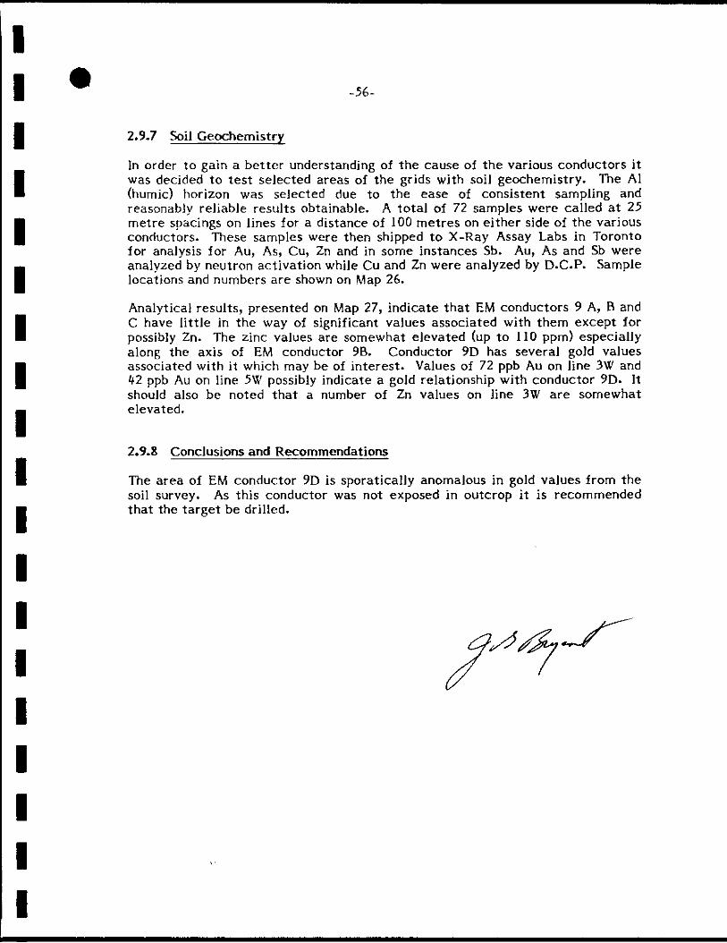
-56-
2.9.7 5k)il Geoctiemistry
In order to gain a be t ter understanding of the cause of the various conductors it was decided to tes t selected areas of the grids with soil geochemistry. The A1 (humic) horizon was selected due to the ease of consistent sannpling and reasonably reliable results obtainable. A total of 72 samples were called at 25 metre spacings on lines for a distance of 100 metres on either side of the various conductors. These samples were then shipped to X-Ray Assay Labs in Toronto for analysis for Au, As, Cu, Zn and in some instances Sb. Au, As and Sb were analyzed by neutron activation while Cu and Zn were analyzed by D.C.P. Sample locations and numbers are shown on Map 26.
Analytical results, presented on Map 27, indicate tha t EM conductors 9 A, B and C have li t t le in the way of significant values associated with them except for possibly Zn. The zinc values are somewhat elevated (up to 110 ppm) especially along the axis of EM conductor 9B. Conductor 9D has several gold values associated with it which may be of in teres t . Values of 72 ppb Au on line 3W and
ppb Au on line 5W possibly indicate a gold relationship with conductor 9D. It should also be noted that a number of Zn values on line 3W are somewhat elevated.
2.9.8 Conclusions and Recommendations
The area of EM conductor 9D is sporatically anomalous in gold values from the soil survey. As this conductor was not exposed in outcrop it is recommended that the ta rge t be drilled.

-57-
3. REFERENCES
Bowen, R.P., 1981; Precambrian Geology of the SJate Lake Area, West Sheet, Kenora District (Patricia Portion). Ontario Geological Survey Preliminary Map P2t^07, Geological Series, Scale l:15,8'f0, Geology 1980, 1981.
Thurston, P.C. and Jackson, M.C., 1978; Confederation Lake Area, District of Kenora, Ontario Geological Survey Preliminary Map P 1975, Scale 1:63,360, Geology in 1975 and 1976.
3.G. Bryant, Exploration Geologist.

APPENDIX I
UNIVARIATE STATISTICS FOR
FLY LAKE HUMUS SAMPLES

FLY LAKE HU^HIS
TABLE OF UNIVARIATE STATISTICS
Grid No. of
Samples Au (ppb) Cu (ppm) Zn (ppm) As (ppm) a> (ppm)
1 33 2.0 (Li/)* 6.9 {2A) 3if.0(11.5) 12.5(4.9) -
2 h5 if.O (2A) 8.9 (2.1) it6.5(17.5) 10.2 (3.5) -
3 68 65
2A (1.5) 7.8 (5.6) 6.8 (2.7)
itO.O {15.U) 12.9 (6.1) -
tt 2.5(1.7) 7.'6 Cf.e) 38.3 (16.0) 37.1 (13.9)
10.7 (4.9) -
5 53 52
2A (1.5) 15.6 (5.9) (21.5) 46.7(18.if)
7.2 (3.7) -
6 116 J13 m
2.8 (1.7)
9.3 (3.9) if7.6(17.1)
9.6(18.9) 7.4 (3.7)
7ab lté 50 kl
1.9(l.«t) 8.6 (6.7) 7.5 (3.5)
46.7 (27.6) 1^7.0 (21.5)
9.5(9.1)
8.3 (3.7)
7c 125 m 121 97
2.0 (1.3) 6.8 (7.0) 6.2 (3.1)
1^2.3 (26.7)
39.1 (18.if)
9.6 (3.8)
0.6 (0.3)
9 72 70 66 65 lik it3
ti.3 (9.5) 3.0 (2.0)
17.8(lif.6)
U . 2 (6.5)
62.6 (27.9)
56.5 (21.if)
8.3 (3.2)
0.9 (0.7) 0.8 (0.3)
ALL 620 607 1 *2
2.7 (3.7) 9.8 (7.9) 46.0 (22.7)
9.9 (9.5) 0.7 (0.5)
* 2.0 (l. 'f) r e fe r s to the mean with the stand and deviation in brackets .

APPENDIX n
FLY LAKE PROPERTIES
198^
CERTIFICATES OF ANALYSIS
FOR
ROCK GEOCHEMISTRY AND ASSAYS

rVy^ /
S I I V L / IO'W'-. I - . K K S ] I - : . : P - S A R . / ^ I KT R U F I T I Z C - I L P A G E
I S A P P L T C I : PP^ ' ' Z K P P K
D 0 7 2 3 5 8 A . 0 ^ 3 3 . 0 D 0 7 2 3 F C 2 . 0 1 2 . 0 D 0 7 2 3 7 2 . 5 9 2 . 0 D 0 7 2 3 8 2 . 0 2 1 0 . D 0 7 2 3 P 7 . 0 3 3 . 0 D 0 7 2 4 C 1 . 5 2 1 . 0 0 0 7 2 4 1 3 . 5 3 1 . 0 D 0 7 2 A 2 5 . 5 A 5 . 0 D 0 7 2 A 3 2 . 5 7 . 0 0 0 7 2 ^ ^ 4 6 . 5 6 7 . 0 D 0 7 2 4 5 6 1 . 0 6 8 . 0 D 0 7 2 4 6 8 . 0 1 3 0 . D 0 7 2 4 7 1 . 5 2 1 . 0 D 0 7 3 7 6 6 . 0 A 7 . 0 D 0 7 3 7 7 3 . 0 3 5 . 0 D 0 7 3 7 8 2 . 0 2 2 . 0 D 0 7 3 7 9 1 . 5 2 0 . 0 D 0 7 3 8 0 2 . 0 6 . 5 D 0 7 3 6 1 1 . 0 1 ^ . 0 D 0 7 3 8 2 1 2 . 0 7 . 0 D 0 7 3 B 3 £ . 5 4 7 . 0 D 0 7 3 8 4 1 . 5 2 6 . 0 D 0 7 3 8 5 8 . 5 1 1 0 . D 0 7 3 8 6 4 . 5 2 1 0 . D 0 7 3 8 7 8 . 0 2 4 0 . D 0 7 3 8 8 8 . 5 1 5 0 . D 0 7 3 8 9 7 . 5 1 3 0 . D 0 7 3 9 0 2 . 5 3 5 . 0 D 0 7 3 9 1 1 . 0 2 6 . 0 D 0 7 3 9 2 1 . 0 8 . 0 D 0 7 3 9 3 1 . 5 1 9 . 0

I .SAY L-'-'J
' S A M P L E
; : ; K A I O R I ES
AU P P B
O T - J ' J L - 8 ' ^ RT
CU PPM
PORT 2 1 5 0 6
ZN PPM
R E F . F I L E 1 6 9 6 0
AS PPM
- E 4 PA
SB PPM
D 0 7 0 0 1 1 — — < 1 < 0 . 2 D 0 7 0 0 2 1 4 0 0 - - — < 1 < 0 . 2 0 0 7 0 0 3 4 3 5 . 0 7 0 . 0 1 4 0 4 . 5 D 0 7 0 0 4 < 1 9 . 0 5 . 5 14 0 . 6 D 0 7 0 D 5 6 0 2 4 0 . 5 9 . 0 1 0 . 6 D 0 7 0 0 6 < 1 3 6 , 0 9 0 . 0 1 0 . 2 D 0 7 0 0 7 1 5 5 . 0 1 5 0 . 9 1 . 3
D 0 7 D 0 B < 1 3 1 . 0 4 9 . 0 3 0 . 5 D 0 7 0 0 9 1 — — 2 0 . 3
D 0 7 0 1 0 1 7 0 . 0 5 6 . 0 12 0 . 7
D 0 7 0 1 1 < 1 6 1 . 0 1 7 0 . 15 0 . 3
D 0 7 0 1 2 < 1 5 1 . 0 8 0 . 0 5 1 . 3
D 0 7 0 1 3 1 2 9 . 0 6 6 . 0 2 1 . 7 D 0 7 0 1 A 6 2 3 0 . 5 0 . 0 1 2 . 1 D 0 7 0 1 5 3 1 9 0 . L A O . 5 3 . 7
D 0 7 0 1 6 < 1 5 2 . 0 7 5 . 0 9 0 . 5 D 0 7 1 0 1 3 — — 1 < 0 . 2
D 0 7 1 0 2 < 1 — — 2 0 . 2
D 0 7 1 0 3 1 6 1 . 0 8 0 . 0 4 1 . 0 D 0 7 1 0 A < 1 4 1 . 0 6 3 . 0 7 5 1 . 3
D 0 7 2 0 1 1 — — 1 < 0 . 2
D 0 7 2 0 2 16 — — 1 < 0 . 2 D 0 7 2 0 3 < 1 9.b 2 1 . 0 1 0 . 2 D 0 7 2 0 ^ 7 6 — — 1 < 0 . 2
D 0 7 2 0 5 < 1 4 9 . 0 6 6 . 0 11 1 . 5
D 0 7 2 0 6 1 9 . 0 2 3 . 0 3 1 . 5
D 0 7 2 0 7 2 1 3 0 . 1 2 0 . 2 0 . 5 D 0 7 2 0 8 < 1 7 8 . 0 4 2 . 0 2 0 . 3 D 0 7 2 0 9 3 2 1 0 . 4 9 . 0 1 0 . 8
D 0 7 3 0 1 1 1 3 . 0 3 1 . 0 1 < 0 . 2
D 0 7 3 0 2 5 — — 8 1 . 2 D 0 7 3 0 3 < 1 6 . 5 1 0 . 0 8 0 . 6 D 0 7 3 0 4 < 1 7 . 5 7 . 0 13 0 . 4
0 0 7 3 0 5 < 1 8 . 0 7 . 5 4 0 . 5 D 0 7 3 0 6 < 1 1 1 . 0 1 7 . 0 4 0 . 7
D 0 7 3 0 7 < 1 — — 4 0 . 6
D 0 7 3 0 8 6 7 4 . 0 7 1 . 0 8 0 . 3 D 0 7 3 0 9 3 8 1 1 0 . 1 0 0 . 85 2 . 3

•'s \ r • . 1 1 • • / f j î ' L i'. v. ; " 1 ! ' j" ' [ ' " r 'V ^ l.'.n. Ct i-2 / j 1 / y ' \ L" 0 l i l t i l i v L / i v i C t 1 l i IV U î - l U . R e s 6 d 2 3?.ÔJ
< : _ : > P A U L O K ^ ; ^ N S K I . A s s s y e r J U L 1 2 1 9 3 4
1 ^ W ^ B o x 2 5 3 , C o c h e n o u r , O n t a r i o P O V I L O
G e t t y M i n e s L t d . ASSAY CERTIFICATE D a t e : J u l y 4 - 8 4
lample No. Description 02/t0n Au oz/ton Ag
l J - 7 0 8 0 P r o i . # 7 0 4 6 3 7 . T r a c e N i l
8 1 n
«1 •1
I 8 2 Flv, T r t ^ a - l •1 ti
• 7 0 9 2 FJo ù J r ^ i l . 1 •1 •1
1 7 1 © 0
• -— •• •
ti It
1
1
• 1
• — •
1
• 1
1 • /
1
• 1
• - i
J
IKf i ^ l Print Co l td

C-
X - R A Y LTV.N A
KAT OK 1TS 2 ' . - J U L - 8 4 R E P O R T 2 1 6 9 1 R E F . F I L E 1 7 2 6 9 - T ' ' . PAGE
^ S A M P L E AU PPB CU PPM ZN PPM AS PPM SB PPH
D 0 7 0 4 4 12 1 3 0 . ^ 0 . 0 2 0 . 6 D 0 7 0 4 5 < 1 2 7 . 0 9 6 . 0 2 0 . 4
D 0 7 0 4 6 < 1 1 1 . 0 4 3 . 0 3 0 . 4
D 0 7 0 4 7 ' 1 9 . 0 4 1 . 0 ' 2 0 . 3 D 0 7 0 A 8 < 1 2 0 . 0 7 2 . 0 3 0 . 4
F / Y V - 0 0 7 0 4 9 4 2 6 . 0 4 0 . 0 2 0 . 3
D 0 7 0 5 0 < 1 1 5 . 0 4 8 . 0 3 0 . 3
D 0 7 0 5 1 8 3 9 . 0 3 1 . 0 2 0 . 3 0 0 7 0 5 2 2 3 4 . 0 7 3 . 0 7 2 3 . 3 0 0 7 0 5 3 2 4 2 . 0 9 2 . 0 2 1 1 . 9 D 0 7 0 5 4 < 1 4 6 . 0 1 2 0 . 4 2 . 0
0 0 7 0 5 5 1 5 6 . 0 1 3 0 . 4 2 . 8
0 0 7 0 5 6 < 1 3 5 . 0 8 1 . 0 6 0 . 9 0 0 7 0 5 7 < 1 6 3 . 0 6 7 . 0 2 3 1 . 3 0 0 7 0 5 8 5 5 0 . 0 8 9 . 0 1 6 0 4 . 4
) 0 0 7 0 5 9 < 1 6 5 . 0 2 1 0 . 9 1 . 5 0 0 7 0 6 0 < 1 5 9 . 0 1 5 0 . 6 1 . 8
0 0 7 0 6 1 < 1 6 6 . 0 1 5 0 . 17 1 . 2
0 0 7 0 6 2 < 1 4 9 . 0 1 2 0 . 4 1 . 2 r y ^ 0 0 7 0 6 3 1 7 2 . 0 9 7 . 0 8 2 . 3
Inr-liti 0 0 7 0 6 4 < 1 7 9 . 0 4 5 . 0 1 1 0 1 . 4 \i-L 0 0 7 0 6 5 1 8 . 0 8 . 0 3 0 . 5
0 0 7 0 6 6 < 1 4 . 5 6 . 0 2 0 . 2 0 0 7 0 6 7 < 1 6 . 0 1 1 . 0 1 9 0 . 4
0 0 7 0 6 8 1 6 . 0 6 . 0 1 8 0 . 7
0 0 7 0 6 9 < 1 7 . 5 8 . 0 6 0 . 4
0 0 7 0 7 0 6 5 4 . 0 4 5 . 0 2 7 0 . 4
0 0 7 0 7 1 1 1 2 . 0 4 4 . 0 4 0 . 7 0 0 7 0 7 2 2 2 2 . 0 5 4 . 0 3 0 . 8 0 0 7 0 7 3 2 4 9 . 0 3 0 . 0 0 . 6
0 0 7 0 7 4 3 4 1 . 0 1 1 0 . 1 0 0 0
0 0 7 0 7 5 < 1 1 6 . 0 7 1 . 0 - 1 8 0 . 6 0 0 7 0 7 6 < 1 1 7 . 0 3 1 . 0 4 0 . 7
0 0 7 0 7 7 < 1 1 5 . 0 3 6 . 0 2 0 . 8
0 0 7 0 7 8 < 1 1 6 . 0 5 1 . 0 3 0 . 6
0 0 7 0 7 9 < 1 1 5 . 0 3 9 . 0 8 0 . 7
0 0 7 0 8 3 < 1 1 4 . 0 8 . 0 2 1 1 . 6
^ 0 0 7 0 8 4 < 1 1 0 . 0 8 . 0 2 2 1 . 3
^ 0 0 7 0 8 5 2 1 7 . 0 2 1 . 0 6 3 0 0 . 5
' 0 0 7 0 8 6 22. 2 6 . 0 9 3 . 0 M O D 0 . 8
'' 0 0 7 0 8 7 1 3 0 5 2 . 0 5 5 . 0 1 8 1 . 3 ' 1 TrtncU. ^ 0 0 7 0 8 8 J ^ 1 5 . 0 1 0 . 0 1 5 1 . 7 ' 1 TrtncU.
/ 0 0 7 0 8 9 8 1 0 . 0 1 4 . 0 3 2 1 . 4
0 0 7 0 9 0 2 9 . 5 7 . 5 1 4 0 0 . 8
0 0 7 0 9 1 6 ] . 1 5 . 0 2 6 . 0 3 0 . 9
/ 0 0 7 0 9 3 2 2 2 . 0 2 6 . 0 2 0 0 1 . 7
^ 0 0 7 0 9 4 1 0 5 8 . 0 3 8 . 0 1 . 3
^ 0 0 7 0 9 5 1 3 0 . 0 1 7 0 . 27 1 . 4
0 0 7 0 9 6 2 4 5 7 0 . 1 5 . 0 13 1 . 4
" 0 0 7 0 9 7 2 9 0 7 0 . 0 1 7 . 0 3 5 0 0 . 7 — «
1 OF

I r - R A Y ^ S A Y L A B O R A T O R I E S R E P O R T 2 1 6 9 1 R E P . F I L E 1 7 2 6 9 - 1 4 PAGE 2 OF 2
SAMPLE AU PPB CU PPM Z N PPM AS PPM SB P P ^ _
D 0 7 0 9 8 3 0 0 7 5 . 0 1 6 . 0 6 7 0 1 . 0 ^^ D 0 7 0 9 9 6 8 L -V .O 8 0 . 0 9 8 1 . 5
D 0 7 1 1 5 3 1 2 0 . 2 3 . 0 3 0 . 2

-RAY
5A^PLE
D 0 7 0 3 3 - R O C K D0703^-ROCK D 0 7 0 3 5 - R O C K D 0 7 0 3 6 - R 0 C K D 0 7 0 3 7 - R 0 C K D D 7 0 3 8 - R 0 C K D 0 7 0 3 9 - R O C K D 0 7 0 A O - R O C K D 0 7 0 ^ 1 - R O C K D 0 7 0 A 2 - R O C K D 0 7 0 A 3 - R D C K D 0 7 1 1 3 - R O C K D 0 7 1 1 A - R 0 C K D 0 7 2 1 9 - R N C K D 0 7 2 2 0 - R 0 C K D 0 7 2 2 1 - R O C K D 0 7 2 2 2 - R N C K D 0 7 2 2 3 - R C C K D 0 7 2 2 ^ - R D C K D 0 7 3 2 6 - R O C K D 0 7 3 2 7 - R 0 C K D 0 7 3 2 8 - R 0 C K D 0 7 3 2 9 - R 0 C K D 0 7 3 3 0 - R 0 C K D 0 7 3 3 1 - R 0 C K D 0 7 3 3 2 - R 0 C K D 0 7 3 3 3 - R O C K D 0 7 3 3 A - R 0 C K D 0 7 3 3 5 - R O C K D 0 7 3 3 6 - R O C K
! 1 r - J'JL - 8 A REPORT 2 l c 3 9 P E F . H
AU PPB CU PPM ZN PPM
<1 —
1 A 8 . 0 8 6 . 0
<1 9 2 . 0 2 9 . 0
<1 4 7 . 0 1 3 . 0
<1 — —
< 1 3 9 . 0 2 2 . C
<1 —
6 —
< 1 1 2 . 0 2 0 . 0
3 2 6 . 0 2 A . 0
3 2 9 . 0 3 6 . 0
68 9 8 . 0 9 . 5
<1 6 7 . 0 4 1 . 0
< 1 5 . 0 1 3 0 .
1 6 . 0 9 . 0
e 1 9 0 . 2 7 . 0
< 1 7 . 0 9 5 . 0
5 1 7 0 . 6 7 . 0
1 1 0 0 . 6 9 . 0
SHP Ml SS SMP M I S S SMP M I S S
SMP Ml SS SMP M I S S SMP M I S S
SMP M I S S SMP M I S S SMP M I S S
SMP M I S S SMP M I S S SMP M I S S SMP 7 3 5 0 . 2 7 . 0
2 1 3 . 0 4 . 0
1 1 0 0 3 2 . 0 4 . 5
3 8 1 7 . 0 1 3 . 0
2 0 3 2 0 . 2 4 . 0
1 3 7 0 . 9 . 5
5 5 6 . 0 3 4 . 0
M P . - ^ I S S . - S A K P L t WAS NOT R E C E I V E D AT XRAL

f i ^ ù
•R.AY ^ S A Y L AL^CKAL O F U L S 1 Ç - J U L - B A R E T O R T 2 1 T 3 9 R E F . F I L E 1 7 2 2 5 - T 2 P A G E 2 O F
S A K P L F A S P P K AS SB PPK
D 0 7 0 3 3 - R D C K 2 — 0 . 9 D 0 7 0 3 ^ - R D C K 1 7 — 0 . 8
D 0 7 0 3 5 - R 0 C K 2 — 0 . 6 D 0 7 0 3 6 - R D C K 2 — 0 . 5 D 0 7 0 3 7 - R 0 C K 6 - - 0 . 4
D 0 7 0 3 e - R O C K 1 — 0 . 2 D 0 7 0 3 9 - R D C K 2 — O . A
D 0 7 0 4 0 - R 0 C K — 0 . 7 0 0 7 0 A Î - R 0 C K 3 — O . ' I D 0 7 0 4 2 - R 0 C K < 1 — 0 . 2 D 0 7 0 4 3 - R D C K 2 — 0 . 2 D 0 7 1 1 3 - R O C K 1 — 0 . 9 D 0 7 1 L A - R O C K 1 — 0 . 2 D 0 7 2 1 9 - R O C K I A —
D D 7 2 2 C - R 0 C K 9 — 0 . 9 D 0 7 2 2 Î - R 0 C K 7 — 1 . 0 D 0 7 2 2 2 - R D C K 1 — 0 . 2 D D 7 2 2 3 - R D C K 22 — 1 . 8 D 0 7 2 2 A - R 0 C K 2 — 0 . 2 D 0 7 3 2 6 - R 0 C K SMP M I S S — SMP M I S S D 0 7 3 2 7 - R 0 C K SMP M I S S — SMP M I S S D 0 7 3 2 8 - R 0 C K SMP M I S S — SMP M I S S D 0 7 3 2 9 - R O C K SMP M I S S — SMP M I S S D 0 7 3 3 0 - R 0 C K 6 — 1 . 0 D 0 7 3 3 J - R 0 C K 180 — 1 . 0 D 0 7 3 3 2 - R 0 C K > 1 0 0 0 0 2 . 6 0 < 0 . 2 D 0 7 3 3 3 - R 0 C K 5 2 0 — < 0 . 2 D 0 7 3 3 A - R 0 C K 9 1 — 1 . 0 D 0 7 3 3 5 - R 0 C K 1 5 — 0 - 3 D 0 7 3 3 6 - R D C K J 5 — 0 . - 2
rI P . M I S S . - SAKPLE WAS NOT R E C E I V E D AT XRAL > - C O N C E N T R A T I O N TOO H I G H FOR TREATMENT BY G E O C H E M I C A L METHOD

/ •
5 A V L t ' r> T T' K H S 1 1 - J U L - E A R E P O R T 2 1 5 4 7 R E F . F I L E 1 7 0 9 3 - / ^ 3 P A G E 1
S A M P L E AU PPB CU PPM 2N PPM AS PPM SB PPM
D 0 7 0 2 A - R O C K < 1 7 9 . 0 1 3 0 . 3 8 2 . 3 D 0 7 0 2 5 - R 0 C K < 1 1 7 . 0 3 8 . 0 2 0 1 . 1 D 0 7 0 2 6 - R D C K < 1 2 1 . 0 2 8 . 0 4 0 . 9 D 0 7 0 2 7 - R 0 C K < 1 9 . 0 6 3 . 0 2 1 . 0 D 0 7 0 2 8 - R 0 C K < 1 — — 3 0 . 7 D 0 7 0 2 9 - R O C K < 1 5 . 0 6 . 0 1 0 . 4 D 0 7 0 3 0 - R 0 C K 1 — 1 8 0 . 7 D 0 7 0 3 1 - R 0 C K 11 — 2 0 . 7 D 0 7 0 3 2 - R 0 C K 13 1 8 . 0 7 . 5 3 4 0 0 1 . 5 D 0 7 1 1 1 - R D C K < 1 1 0 . 0 1 6 . 0 2 7 0 . 4 D 0 7 1 1 2 - R O C K 1 — 14 0 . 3 D 0 7 2 1 3 - R D C K 1 9 8 . 0 2 5 . 0 1 2 1 . 0 D 0 7 2 1 4 - R O C K 1 2 — — 8 0 . 4 D 0 7 2 1 5 - R O C K 1 — — 3 4 0 . 6 D 0 7 2 1 6 - R D C K < 1 — — 3 0 . 3 D 0 7 2 1 7 - R O C K < 1 2 4 . 0 6 1 . 0 2 0 . 2 D 0 7 2 1 8 - R 0 C K 1 — 2 < 0 . 2 D 0 7 3 2 0 - R 0 C K 2 5 1 . 0 3 7 . 0 5 0 . 4 D 0 7 3 2 1 - R 0 C K < 1 3 0 0 . 2 0 . 0 7 0 . 8 D 0 7 3 2 2 - R 0 C K < 1 4 8 . 0 7 2 . 0 9 2 2 . 9 D 0 7 3 2 3 - R 0 C K < 1 1 0 . 0 1 9 . 0 2 3 1 . 1 D 0 7 3 2 A - R 0 C K < 1 1 3 . 0 3 5 . 0 2 4 7 . 9 D 0 7 3 2 5 - R 0 C K 1 1 4 . 0 3 0 . 0 1 6 8 . 0 D 0 7 3 2 6 - R 0 C K 2 — — 1 2 9 . 2 0 0 7 3 2 7 - R O C K 2 — — 7 1 2 . 8 D 0 7 3 2 8 - R 0 C K < 1 — — 4 0 . 9 D 0 7 3 2 9 - R D C K 13 — — 3 8 0 2 . 3
R ,

X - R A V ASSAV L / ^ P . 0 ? A 7 n R I f S 0 9 - J U L - £ i . RE f'DRT 2 1 5 2 2 R E F . F I L E ' i 7 0 7 4 - L l PA3E 1 DF 3
SAMPLE AU PPB CU PPM ZN PPM AS PPM SB PPM
D 0 7 0 1 7 - R 0 C K D 0 7 0 1 8 - R D C K D 0 7 0 1 9 - R 0 C K D 0 7 0 2 0 - R D C K D 0 7 0 2 1 - R D C K D 0 7 0 2 2 - R 0 C K D 0 7 0 2 3 - R 3 C K D 0 7 1 0 5 - R D C K D 0 7 1 0 6 - R 0 C K D 0 7 1 0 7 - R 0 C K D 0 7 1 0 8 - R D C K D 0 7 1 0 9 - R 0 C K D 0 7 1 1 0 - R D C K D 0 7 2 1 0 - R D C K D 0 7 2 1 1 - R D C K D 0 7 2 1 2 - R D C K D 0 7 3 1 0 - R D C K D 0 7 3 1 1 - R D C K D 0 7 3 1 2 - R D C K D 0 7 3 1 3 - R D C K D 0 7 3 1 4 - R D C K D 0 7 3 1 5 - R D C K D 0 7 3 1 6 - R D C K D 0 7 3 1 7 - R 0 C K D 0 7 3 1 8 - R D C K 0 0 7 3 1 9 - R D C K
20 21
7 20 24
A 3 1
<1 2 1 2 5
I D 28
2 3 7 1
3 0 1 1
<1
16 2
7 5 . 0 8 1 . 0 11.0 4 3 . 0
100. 160. 180.
5 8 . 0
9 6 . 0
60.0
5 6 . 0
1 2 . 0
4 5 . 0
9 5 . 0 5 1 . 0 3 9 . 0 12.0 2 3 . 0 5 0 . 0 62.0 82.0
3 7 . 0
8 8 . 0
2 4 . 0
5 7 . 0
68.0
1 5 0 68 42
1 7 0 6 7 21 1 7 10
6 3 4 11
5 2 5 1 5
8 6 4 21 10 1 3 9 5 11
8 12
100 4 3 10
1.6 5 .0 0 .7 0.2 0.4
<0.2 <0.2 <0 .2 <0.2 0.6
<0.2 0.4 0 .4 0 .3 0.2
<0.2 . 0 . 3 0.6 0 .9 0.8
<0.2 0.5 1.6 2.0
12.0 1.2

'SAKPLE AU PPB CU PPM 2K PPK AS PPH SB PPK
D 0 7 2 2 6 2 — — 2 1 0 . 5 D 0 7 2 2 7 < 1 — — 2 0 . 6 D 0 7 2 2 8 ^ — — 2 0 . 6 D 0 7 2 2 9 A - - — 3 0 . 7 D 0 7 2 3 D < 1 — < 1 0 . 8 D 0 7 3 5 1 5 — — 9 1 . 1 D 0 7 3 5 2 2 — — 3 0 . 8 D 0 7 3 5 3 2 — — 2 1 O . A D 0 7 3 5 4 1 7 - - — 33 0 . 7 D 0 7 3 5 5 12 — — 57 0 . 7 D 0 7 3 5 6 < 1 — — 3 1 . 2 D 0 7 3 5 7 2 — — 2 1 . 0 D 0 7 3 5 9 4 3 9 0 . < 0 . 5 2 0 . 6 D 0 7 3 6 D 9 1 2 0 0 . < 0 . 5 3 0 . 8 D 0 7 3 6 1 7 1 1 0 0 . < 0 . 5 1 0 . 7 D 0 7 3 6 2 < 1 1 0 0 . 1 1 . 0 2 0 . 7 D 0 7 3 6 3 < 1 2 8 . 0 6 . 5 2 1 . 0 D 0 7 3 6 A < 1 2 0 . 0 7 4 . 0 1 1 0 . 5 D 0 7 3 6 5 8 4 6 0 . < 0 . 5 < 1 0 . 3
/ D 0 7 3 6 6 / L 0 0 \ — — 2 0 . 7 Z ^ D 0 7 3 6 7 </ 8 4 0 / — — 3 0 . 7
D 0 7 3 6 8 3 1 4 0 0 . - - - 2 3 . 0 < 1 0 . 7 D 0 7 3 6 9 2 — — 1 0 . 2

X - R I V ASSAV L Î • I F S
SAMPLE AU PPB
r ' 7 ^
2 ' ? Î Î 2 R E F . F - I L E 1 7 6 9 2 - - 0 1 PAGE 1 OF 1
CU PPM ZN PPM AS PPM SB PPM
0 0 7 2 3 1 D 0 7 2 3 2 D 0 7 2 3 3 D 0 7 2 3 A D 0 7 3 7 0 D 0 7 3 7 1 D 0 7 3 7 2
3 2
<1 2 1
2 1
<1
L A O . 7 6 . 0 9 8 . 0
100.
110. 6 4 . 0
1 4 0 .
10.0
6 11
1 1
12 1
4 2
1.8 0.6
<0.2 <0.2
0 . 5 0.2 0.6

I I
m m U FiRE ASSAYlKGLTD. Pnonr Bl-S. 6G2-&] 7] Res. 662-3351
At
•r • G e t t y M i n e s L t d . ,
PAULOKANSKI.Assayer Box 253, Cochenour, Ontario POV ILO
ASSAY CERTIFICATE Date: J u l y 3 0 - 8 4
Ïple No.
-7358
I I I t
i
I
Description
P r o j . # 2 0 4 6
oz/ton Au
T r a c e
ozyton Ag
N i l
a.
A&SDYER;

APPENDIX ni
FLY LAKE PROPERTIES
CERTIFICATES OF
WHOLE ROCK ANALYSIS

X X RRRRR A L L XX XX RR RR AAA L L
XX XX RR RR AA AA LL XXX RR RR AA AA L L XXX RRRRR AAAAAAA LL
XX XX RR RR AA AA L L XX XX RR RR AA AA L L L L L L L X X RR R AA AA L L L L L L L
XRF - WHOLE ROCK A N A L Y S I S
3 I Rot l y P r o y d t Z o f t
GEHY KITES LIMITHI Atln: MAYNl ELOT 150 YŒÎK STREET, SUITE 1200 TFFXWRO, ONTARIO «5H 3S5
CUSTOt€R No. 265
DATE aiBfllTTED 16-AUG-84
REPORT 2:2:244 REF. F I L E 1 7 8 2 t DATE REPORTED l l - S E P - y 4
XRF W R A SUMS INCLUDE ALL ELEMENTS DETERMINED. FOR SUMMATION ELEMENTS ARE CALCULATED AS OXIDES.

TIO: F'2Ci:.
DOl
II07236
D07237
D07238
D07239
D07240
D07241
D07242
D07243
D07244
D07245
D07246
D07247
D0737£,
D07377
D07378
D07379
D07380
D07381
D07382
D07383
D07384
D07385
D07386
D07387
D07388
D07389
II07390
D07391
D07392
50. Î
78.4
77.8
70.2
77.0
71.5
71.6
7t 9
76.2
81.3
77.1
78.0
77.0
76.5
77.9
77.1
73.0
77.5
71.9
75.5
76.6
76.1
111
73.8
74.6
75.2
69.3
72 9
75.8
76.8
13.5 10.7 3.81 1 8 3
11.4 0.10 0.12 5.39
10.2 0 . ^ 1.10 189
1Z9 0.37 1.64 0.59
11.1 0.25 0.62 5.87
1Z2 0 03 4.65 0 . ^
13.5 0.62 Z 36 1.81
11.5 0.18 0.51 5.55
11.8 0.09 4.46 0.70
9. 40 0. 32 0.88 3. 93
11.0 0.06 2 64 0.43
7.01 0.23 1.24 0.93
10.5 0.03 3.78 0.13
10.9 0.20 0.21 5 08
11.1 0.03 2 00 0.04
11.0 0.18 3.07 0.57
10.9 0.06 .5.66 0.26
12 0 0.07 4.09 0.99
11.2 0.02 6.98 <0.01
11.8 0.:^ 0.62 6.69
10.6 0.02 1.97 0.28
10.8 0.06 5.59 0.54
12 6 0.18 2 19 0.93
11.7 0.37 0.98 4.51
11.2 0.03 3.68 0.08
11.2 0.22 0.23 4.61
12 0 0.03 4.29 0.13
10.8 0.06 5.81 0.62
11.0 0.04 3.74 0.12
10.2 0.03 5.45 0.39
0.3(1 12 7 0.15 1.71 0. 17 0. 02 2 2Î; 98.3
2 56 0.59 0.01 0.17 0.03 <0.01 0.47 99.3
2 81 1.62 0.04 0.16 0.02 0.02 0.85 98 5
5. 31 5. 07 0. 09 0.20 0. 02 <0. 01 2 08 98. 6
0.56 2 35 0.02 0.13 0.02 0.02 0 54 98.6
1.75 3 73 0.03 0.38 0.03 0.01 3.39 98.3
4.21 2 21 0.03 0.13 0.01 0 02 1.85 98.4
1.19 2 30 0.03 0.12 0.02 0.02 Ofô 99.3
1.67 0.75 0.01 0.15 0.02 0.01 3.16 99.1
1.19 0.74 0.03 0.10 0.02 0.02 0.77 98.8
2 49 2 60 0.02 0.13 0.02 0.02 2 47 99.1
203 7.23 0.09 0.13 0.02 0.01 1.31 98.3
2 23 1.51 0.02 0.14 0.02 0.02 2 93 ,98.4
2 46 2 47 0. 04 0.13 0.02 0.03 0.47 98.6
3.33 1.46 0.02 0.11 0.01 0.02 2 16 98.3
1.91 1.79 0.02 0.24 0.02 0.01 2 62 98.7
1.21 3.54 0.03 0.35 .-0.04 0.01 3.39 98.6
.1.11 0.79 0.02 0.14 0.02 <0.01 .2 85 99.7
0.34 ,3.54 0.02 0.39 0.04 0.01 ^3.77 98.4
0.10 2.15 0.01 0.34 0.03 0.02 1.00 98.7
2 36 3.51 0.01 0.28 0.03 0.01 2 54 98.4
1.11 0.74 0.01 0.15 0.02 0.01 3.31 98.5
4. 57 3.14 0. 02 0.18 0. 02 0. 01 1. 62 98. 3
2 38 3.35 0.07 0.18 0.02 0.01 0.85 98.3
2 72 2 88 0.05 0.15 0.02 0.01 2 70 98.2
2 23 3.30 0. 08 0.15 0. 02 0. 01 0. 77 98.1
1.81 6.73 0.03 0.17 0.02 0.01 3.70 98.3
0.41 4.63 0.02 0.32 0.04 0.01 3.62 99.3
2 18 2 39 0.02 0.13 0.02 0.01 2 70 98.3
1.29 0.76 0.01 0.25 0.03 0.01 193 92.3

wM
[•x: C.AO kzî: TL:::: r-;: 1:0: FVÛ:. LO; a t
76 < 10.8 0 52 2 49 5. IE 0.08 l.2i 0 01' 0.24 0 02 0.01 1.39 98.5

IKQ-^ 10 330 2C 10
DÔ7236 30 20 190 480 50
W2Ï1 AO 50 220 470 50
D07238 170 <10 270 590 60
D07239 30 20 100 440 70
DÛ7240 20 <10 240 1340 40
D07241 70 20 90 470 90
DÔ7242 50 <10 190 360 50
D07243 30 <10 140 490 50
D0724A 30 <10 180 350 60
IK)7245 50 <10 290 690 100
II07246 80 <10 400 180 40
D07247 40 <10 210 440 70
D07376 50 <10 120 440 - 70
D07377 70 <10 220 480 80
D07378 30 20 250 700 50
D07379 30 30 190 500 40
D07380 20 -20 250 450 ;70
DO/381 10 <10 380 690 '50
D07382 CIO <10 210 690 40
D07333 50 <10 240 720 40
D07384 20 <10 160 440 50
D07385 70 <10 160 540 70
DÔ7386 80 20 190 520 70
D07387 60 <10 180 460 50
1107388 100 40 240 480 60
D07389 40 <10 180 470 60
D07390 20 <10 240 440 50
D07391 40 <10 270 420 80
IIÔ7392 30 <10 300 570 50
Bfii

2f;
<1(1 20 160 670

1
APPENDIX IV
FLY LAKE PROPERTIES
CERTIFICATES OF ANALYSIS
FOR
HUMUS LAYER SOIL SAMPLES

, s V L / 1-: 0 A T D R 1 ^ S 0 6 - J L i L - 8 4 R E P O R T 2 1 3 0 6 R E P . F I L E 1 6 9 F . 0 - E 4
11 S/I<MPLE AU PPB CU PPM 2N PPM AS PPK
2 0 ^ 6 - 1 HUMUS 3 6 . 5 4 4 . 0 19
2 0 - ^ 6 - 2 HUMUS <1 7 . 5 2 1 . 0 7
2 0 ^ 6 - 3 HUMUS 3 9 . 0 3 0 . 0 12
2 0 4 6 - 4 HUMUS <1 9 . 5 2 9 . 0 14
2 0 4 6 - 5 HUMUS 2 5 . 0 3 1 . 0 12
2 0 4 6 - 6 HUMUS 2 9 . 5 2 4 . 0 15
2 0 4 6 - 7 HUMUS 2 4 . 5 2 4 . 0 2 1
2 0 4 6 - 8 HUMUS 3 6 . 5 4 5 . 0 24
2 0 4 6 - 9 HUMUS 3 8 . 0 4 4 . 0 11
2 0 4 6 - 1 0 HUMUS 4 A . O 2 5 . 0 13
2 0 4 6 - 1 1 HUMUS 1 7 . 0 2 4 . 0 12
2 0 4 6 - 1 2 HUMUS 4 7 . 5 3 1 . 0 16
2 0 4 6 - 1 3 HUMUS 3 7 . 5 4 2 . 0 2 0
2 0 4 6 - 1 4 HUMUS 1 7 . 0 2 9 . 0 8
2 0 4 6 - 1 5 HUMUS 1 4 . 5 2 8 . 0 10
2 0 4 6 - 1 6 HUMUS 1 4 . 5 3 0 . 0 9
2 0 4 6 - 1 7 HUMUS 1 6 . 5 3 4 . 0 13
2 0 4 6 - 1 8 HUHUS < 1 6 . 5 2 7 . 0 7
2 0 4 6 - 1 9 HUMUS 2 6 . 0 4 0 . 0 19
2 0 4 6 - 2 0 HUMUS 4 7 . 0 3 3 . 0 16
2 0 4 6 - 2 1 HUMUS 2 5 . 5 2 2 . 0 8
2 0 4 6 - 2 2 HUMUS 2 6 . 5 4 5 . 0 11
2 0 4 6 - 2 3 HUMUS < 1 5 . 5 2 9 . 0 11
2 0 4 6 - 2 4 HUMUS 6 6 . 0 4 3 . 0 16
2 0 4 6 - 2 5 HUMUS 3 6 . 5 5 9 . 0 12
2 0 4 6 - 2 6 HUMUS 4 8 . 5 4 9 . 0 9
2 0 4 6 - 2 7 HUMUS 1 8 . 5 1 9 . 0 14
2 0 4 6 - 2 8 HUMUS 1 8 . 0 3 5 . 0 8
2 0 4 6 - 2 9 HUMUS < 1 4 . 0 3 2 . 0 9
2 0 4 6 - 3 0 HUMUS 1 3 . 5 1 9 . 0 1 7
2 0 4 6 - 3 1 HUMUS 1 2 . 5 1 5 . 0 7
2 0 4 6 - 3 2 HUMUS 1 1 6 . 0 5 6 . 0 1
2 0 4 6 - 3 3 HUMUS 1 9 . 5 6 0 . 0 1 0
2 0 4 6 - 3 4 HUMUS J 6 . 0 4 9 . 0 1 1
2 0 4 6 - 3 5 HUMUS < 1 9 . 0 . 5 7 . 0 22
2 0 4 6 - 3 6 HUMUS 4 . 0 3 1 . 0 11
2 0 4 6 - 3 7 HUMUS 6 1 4 . 0 4 5 . 0 9
2 0 4 6 - 3 8 HUMUS 4 7 . 5 4 3 . 0 11
2 0 4 6 - 3 9 HUMUS 2 8 . 5 4 2 . 0 12
2 0 4 6 - 4 0 HUMUS 4 6 . 0 5 7 . 0 17
2 0 4 6 - 4 1 HUMUS 3 4 . 0 3 2 . 0 13
2 0 4 6 - 4 2 HUMUS 4 6 . 0 4 2 . 0 1 1
2 0 4 6 - 4 3 HUMUS < 1 4 . 0 3 8 . 0 9
2 0 4 6 - 4 4 HUMUS 2 6 . 5 3 0 . 0 10
2 0 4 6 - 4 5 HUMUS 1 5 . 0 3 6 . 0 10
2 0 4 6 - 4 6 HUMUS 2 6 . 5 2 5 . 0 14
2 0 4 6 - 4 7 HUMUS 6 7 . 0 4 2 . 0 13
2 0 4 6 - 4 8 HUMUS 2 9 . 0 3 5 . 0 12
2 0 4 6 - 4 9 HUMUS 4 7 . 0 4 4 . 0 10
2 0 4 6 - 5 0 HUMUS 2 5 . 5 3 2 . 0 12
2 DF

. r i - J U L - f ! A Kti'ORT Z150t> R E F . F 1 L E î 6 9 6 0 -
SAMPLE AU PPB e u PPM ZN PPM AS P
R 2 0 4 6 - 5 1 HUMUS 3 7 . 5 4 1 . 0 2 0 2 0 A 6 - 5 2 HUMUS 2 6 . 5 2 1 . 0 12
2 0 A 6 - 5 3 HUMUS 2 7 . 0 4 9 . 0 13 2 0 4 6 - 5 4 HUMUS 7 1 2 . 0 5 4 . 0 18
2 0 4 6 - 5 5 HUMUS 4 2 9 . 0 9 3 . 0 24
2 0 4 6 - 5 6 HUMUS 2 6 . 5 3 8 . 0 1 0
2 0 4 6 - 5 7 HUMUS < 1 3 . 0 2 7 . 0 1 1
2 0 4 6 - 5 8 HUMUS 3 4 . 5 2 9 . 0 10
2 0 4 6 - 5 9 HUMUS 2 2 . 5 3 8 . 0 13
2 0 4 6 - 6 0 HUMUS 2 3 . 5 2 3 . 0 7
2 0 4 6 - 6 1 HUMUS 2 4 . 5 1 5 . 0 11
2 0 4 6 - 6 2 HUMUS <1 6 . 0 2 2 . 0 4
2 0 4 6 - 6 3 HUMUS <1 4 . 0 1 2 . 0 2
2 0 4 6 - 6 4 HUMUS 3 5 . 5 2 2 . 0 1 0
2 0 4 6 - 6 5 HUMUS 3 9 . 0 4 5 . 0 12
2 0 4 6 - 6 6 HUMUS 3 7 . 0 3 5 . 0 10 2 0 4 6 - 6 7 HUMUS 5 1 0 . 0 3 5 . 0 15
2 0 4 6 - 6 8 HUMUS 2 8 . 5 6 6 . 0 1 1
2 0 4 6 - 6 9 HUMUS 4 6 . 5 5 9 . 0 13
2 0 4 6 - 7 0 HUMUS 3 6 . 0 5 1 . 0 15
2 0 4 6 - 7 1 HUMUS 3 1 5 . 0 6 3 . 0 12
2 0 4 6 - 7 2 HUMUS 6 7 . 5 6 0 . 0 9
2 0 4 6 - 7 3 HUMUS 1 8 . 0 5 1 . 0 6
2 0 4 6 - 7 4 HUMUS 2 2 1 . 0 2 9 . 0 3
2 0 4 6 - 7 5 HUMUS < 1 9 . 0 2 2 . 0 3
2 0 4 6 - 7 6 HUMUS < 1 8 . 0 2 8 . 0 2 2 0 4 6 - 7 7 HUMUS 1 6 . 0 2 1 . 0 3
2 0 4 6 - 7 8 HUMUS < 1 5 . 5 2 1 . 0 2
2 0 4 6 - 7 9 HUMUS < 1 4 . 5 1 4 . 0 5 2 0 4 6 - 8 0 HUMUS 2 1 9 . 0 4 1 . 0 4
2 0 4 6 - 8 1 HUMUS 1 6 . 5 2 8 . 0 8 2 0 4 6 - 8 2 HUMUS 2 1 4 . 0 3 3 . 0 4 2 0 4 6 - 8 3 HUMUS 2 1 2 . 0 1 8 . 0 8
2 0 4 6 - 8 4 HUMUS 2 3 2 . 0 2 4 . 0 5
2 0 4 6 - 8 5 HUMUS 4 2 8 . 0 4 4 . 0 1 1
2 0 4 6 - 8 6 HUMUS 3 9 . 5 3 0 . 0 . 9
2 0 4 6 - 8 7 HUMUS 2 7 . 5 2 7 . 0 1 3 2 0 4 6 - 8 8 HUMUS 4 1 1 . 0 4 0 . 0 1 4
2 0 4 6 - 8 9 HUMUS 1 8 . 5 8 5 . 0 1 0
2 0 4 6 - 9 0 HUMUS 5 8 . 5 6 3 . 0 1 2 2 0 4 6 - 9 1 HUMUS 2 8 . 0 7 2 . 0 1 3
2 0 4 6 - 9 2 HUMUS 3 5 . 5 6 6 . 0 13 2 0 4 6 - 9 3 HUMUS 1 3 2 . 0 2 2 . 0 3
2 0 4 6 - 9 4 HUMUS 1 9 . 0 2 2 . 0 3
2 0 4 6 - 9 5 HUMUS 1 1 0 . 0 1 9 . 0 3
2 0 4 6 - 9 6 HUMUS 1 1 2 . 0 1 9 . 0 5
2 0 4 6 - 9 7 HUMUS 1 1 1 . 0 3 1 . 0 5
2 0 4 6 - 9 8 HUMUS 1 5 . 5 2 5 . 0 11
2 0 4 6 - 9 9 HUMUS <1 6 . 0 7 6 . 0 12
2 0 4 6 - 1 0 0 HUMUS 1 3 . 0 1 6 . 0 4
3 LiF

L; i.r - ^ 1 ^.f. ! t S O f . - J U L - f . ' . Fi E F . F- 1 L E 16 96 0 - E
K.PLE AU PPB CU PPH 2N PPH AS PP
2 0 ^ 6 - 1 0 1 HUKUS <1 4 . 0 2 5 . 0 9
2 0 - ^ 6 - 1 0 2 HUMUS <1 6 . 5 3 7 . 0 11
2 0 4 6 - 1 0 3 HUMUS 2 4 . 5 6 4 . 0 11
2 0 A 6 - 1 0 4 HUMUS <1 6 . 0 5 9 . 0 12
2 0 ' » 6 - 1 0 5 HUMUS 5 8 . 0 7 1 . 0 10
2 0 A 6 - 1 0 6 HUMUS 4 7 . 0 3 6 . 0 15
2 0 ' i 6 - 1 0 7 HUMUS 5 6 . 5 4 0 . 0 16 20^^6 -108 HUMUS 2 7 . 0 5 1 . 0 10
2 0 ' t 6 - 1 0 9 HUMUS 2 5 . 0 2 5 . 0 9
2 0 ' » 6 - 1 3 0 HUMUS 3 4 . 0 3 4 . 0 10
2 0 < ^ 6 - l l l HUMUS 5 4 . 5 3 7 . 0 17
20<»6 -112 HUMUS < 1 5 . 0 3 0 . 0 12
T O ' i ô - l l B HUMUS <1 9 . 5 3 5 . 0 7 2 0 4 6 - l l < t HUMUS 1 9 . 5 3 6 . 0 4
2 0 4 6 - 1 1 5 HUMUS ' 2 5 . 5 4 1 . 0 13
2 0 4 6 - 1 1 6 HUMUS 6 8 . 5 2 8 . 0 18
2 0 4 6 - 1 1 7 HUMUS 2 7 . 0 6 2 . 0 13
2 0 4 6 - 1 1 8 HUMUS 2 5 . 5 6 0 . 0 17 2 0 4 6 - 1 1 9 HUMUS 3 6 . 5 5 5 . 0 18 2 0 4 6 - 1 2 0 HUMUS 3 5 . 0 4 3 . 0 11
2 0 4 6 - 1 2 1 HUMUS 3 6 . 0 4 6 . 0 8
2 0 4 6 - 1 2 2 HUMUS 2 6 . 5 3 2 . 0 11 2 0 4 6 - 1 2 3 HUMUS 1 7 . 5 3 2 . 0 10
2 0 4 6 - 5 0 1 HUMUS 6 1 0 . 0 3 2 . 0 14
2 0 4 6 - 5 0 2 HUMUS 4 7 . 0 2 6 . 0 14
2 0 4 6 - 5 0 3 HUMUS < 1 8 . 0 3 7 . 0 6
2 0 4 6 - 5 0 4 HUMUS 2 5 . 0 4 2 . 0 13 2 0 4 6 - 5 0 5 HUMUS 3 6 . 0 2 6 . 0 15
2 0 4 6 - 5 0 6 HUMUS 3 6 . 0 1 8 . 0 1 1 2 0 4 6 - 5 0 7 HUMUS 1 8 . 5 2 0 . 0 13
2 0 4 6 - 5 0 8 HUMUS 3 9 . 5 2 9 . 0 14
2 0 4 6 - 5 0 9 HUMUS 1 1 1 . 0 2 8 . 0 9 2 0 4 6 - 5 1 0 HUMUS 7 3 . 5 4 9 . 0 1 6
2 0 4 6 - 5 1 1 HUMUS ' 6 6 . 5 4 8 . 0 1 5
2 0 4 6 - 3 1 2 HUMUS 3 7 . 0 3 3 . 0 15
2 0 4 6 - 5 1 3 HUMUS 1 - 7 ^ 5 2 3 . 0 7
2 0 4 6 - 5 1 4 HUMUS 2 1 1 . 0 3 2 . 0 7
2 0 4 6 - 5 1 5 HUMUS 1 1 4 . 0 2 5 . 0 5 2 0 4 6 - 5 1 6 HUMUS 2 1 6 . 0 4 3 . 0 6
2 0 4 6 - 5 1 7 HUMUS 2 8 . 0 4 1 . 0 1 1
2 0 4 6 - 5 1 8 HUMUS 2 9 . 0 4 9 . 0 14
2 0 4 6 - 5 1 9 HUMUS 5 9 . 5 4 9 . 0 11
2 0 4 6 - 5 2 0 HUMUS 6 8 . 5 8 8 . 0 9
2 0 4 6 - 5 2 1 HUMUS 1 9 . 0 5 7 . 0 4
2 0 4 6 - 5 2 2 HUMUS 2 9 . 0 4 4 . 0 7
2 0 4 6 - 5 2 3 HUMUS 3 8 . 0 6 5 . 0 12
2 0 4 6 - 5 2 4 HUMUS 2 9 . 0 2 6 . 0 1 1
2 0 4 6 - 5 2 5 HUMUS 2 1 0 . 0 2 7 . 0 12
2 0 4 6 - 5 2 6 HUMUS 1 8 . 0 2 4 . 0 9
2 0 4 6 - 5 2 7 HUMUS 5 7 . 5 3 9 . 0 14

2 0 4 6 -ZD^tb-20^ 6-2 0 A 6 -2 0 4 6 -2 0 4 6 -2 0 4 6 -2 0 4 6 -2 0 4 6 -2 0 4 6 -2 0 4 6 -2 0 4 6 -2 0 4 6 -2 0 4 6 -2 0 4 6 -2 0 4 6 -2 0 4 6 -2 0 4 6 -2 0 4 6 -2 0 4 6 -2 0 4 6 -2 0 4 6 -2 0 4 6 -2 0 4 6 -2 0 4 6 -2 0 4 6 -2 0 4 6 -2 0 4 6 -2 0 4 6 -2 0 4 6 -2 0 4 6 -2 0 4 6 -2 0 4 6 -
. 2 0 4 6 -2 0 4 6 -^ 0 4 6 -2 0 4 6 -2 0 4 6 -2 0 4 6 -2046 -2046 -2046 -
528 529 5 3 0 5 3 1 532 5 3 3 534 535 536 537 538 539 540 541 542 5 4 3 544 545 546 547 548 549 5 5 0 551 552 5 5 3 554 555 556 5 5 7 558 5 5 9 5 6 0 5 6 1 5 6 2 5 6 3 564 5 6 5 566
-5 67 -568 569
HUKUS HUMUS HUMUS HUMUS HUMUS HUMUS HUMUS HUMUS HUMUS HUMUS HUMUS HUMUS HUMUS HUMUS HUMUS HUMUS HUMUS HUMUS HUMUS HUMUS HUMUS HUMUS HUMUS HUMUS HUMUS HUMUS HUMUS HUMUS HUMUS HUMUS HUMUS HUMUS HUMUS HUMUS HUMUS HUMUS HUMUS HUMUS HUMUS HUMUS HUMUS HUMUS
J LiL- ri^ RLPOf.'.l ? 1 5 0 6 RE F »F 1 LE 1 c, =
• U PPE^ CU PPM ZN PPM AS PP
<1 1 1 - 0 4 7 . 0 10 7 9 . 5 5 9 . 0 12 5 8 . 0 5 0 . 0 8 7 9 . 0 8 3 . 0 6 7 9 . 0 7 2 . 0 8 A 9 . 0 5 0 . 0 4
5 1 2 . 0 4 1 . 0 7
4 1 0 . 0 6 2 . 0 6 5 8 . 0 6 4 . 0 11
7 1 0 . 0 4 5 - 0 6 7 7 - 5 5 2 - 0 13 3 7 . 5 5 8 . 0 6
7 7 . 5 6 6 . 0 11 6 7 - 0 6 5 . 0 12 6 9 . 0 5 7 . 0 16
7 9 . 5 7 0 . 0 12 7 1 1 . 0 6 6 . 0 12 9 1 0 . 0 6 8 . 0 7
2 5 . 0 3 5 . 0 29 2 5 . 5 5 9 . 0 11 4 5 . 0 7 6 . 0 26 7 A . O 3 7 . 0 25 3 •4.0 3 5 . 0 13 3 8 . 0 4 1 . 0 17 3 5 . 0 3 5 . 0 16 3 5 . 0 4 2 . 0 12 3 4 . 0 3 9 . 0 16
<1 3 . 5 3 8 . 0 18 1 4 . 5 2 2 . 0 14 7 5 . 0 3 5 . 0 28 2 6 . 0 3 1 . 0 19 1 6 . 5 3 7 . 0 22 2 7 . 0 3 4 . 0 18
1 7 . 5 3 1 - 0 2 7 <1 8 . 0 4 1 . 0 22
3 5 . 5 3 2 . 0 12 2 4 . 5 3 8 . 0 20 4 6 . 0 4 1 . 0 19 2 4 . 5 3 1 . 0 13 2 6 . 5 3 1 . 0 11 3 6 . 0 3 7 . 0 13 4 6 . 0 4 1 . 0 15

- R ' : i .L-A-. C . R U S 1 1 - J U L - C ^ R { . r 0 rs 1 Z 1 - k l f . F i I t
SAMPLE AU PPB CU PPK ZN PPH AS PPK
W - ^ f c - l 2A-HUMUS 3 6 . 5 3 2 . 0 14 2 0 4 6 - 1 2 5 - H U H U S 1 6 . 0 3 9 . 0 9 2 D 4 6 - 1 2 6 - H U H U S 2 4 . 5 2 0 . 0 13
2 0 4 6 - 1 2 7 - H U H U S 1 4 . 0 2 7 . 0 11 20^^6-1 28-HUHUS 3 4 . 0 3 2 . 0 10 2 0 4 6 - 1 2 9 - H U H U S 3 3 . 5 2 5 . 0 4
2 0 4 6 - 1 3 0 - H U M U S 1 4 . 0 1 6 . 0 5 2 0 4 6 - 1 3 1 - H U H U S 1 3 . 0 3 1 . 0 8 20<»6-132-HUMUS 2 4 . 0 3 3 . 0 9
2 0 ' i 6 - 1 3 3 - H U M U S 1 4 . 0 3 0 . 0 10 2 0 A 6 - 1 3 A - H U H U S 2 3 . 5 1 8 . 0 11 2 0 4 6 - 1 3 5 - H U M U S 1 3 . 5 2 4 . 0 9
2 0 4 6 - 1 3 6 - H U M U S 1 3 . 0 3 4 . 0 8 2 0 A 6 - 1 3 7 - H U M U S < 1 8 . 0 2 2 . 0 5 2 0 4 6 - 1 3 8 - H U M U S 3 4 . 5 2 4 . 0 5 2 0 4 6 - 1 3 9 - H U M U S <1 3 . 5 1 8 . 0 4
2 0 4 6 - 1 4 0 - H U M U S <1 2 . 5 2 5 . 0 4 2 0 4 6 - 1 4 1 - H U M U S 1 3 . 5 1 7 . 0 6
20<iV6-l A2-HUHUS 6 1 0 . 0 1 1 0 . 14
2 0 A 6 - 1 4 3 - H U M U S 4 5 . 0 6 2 . 0 16 2 0 4 6 - 1 4 4 - H U H U S <1 4 . 0 3 3 . 0 6
2 0 4 6 - 1 4 5 - H U M U S < 1 6 . 0 3 4 . 0 8 2 0 4 6 - 1 4 6 - H U H U S 2 8 . 5 - 4 3 . 0 17 2 0 4 6 - 1 4 7 - H U M U S 1 3 . 0 3 0 . 0
2 0 4 6 - 1 4 B - H U M U S 1 1 1 . 0 7 3 . 0 9 2 0 4 6 - 1 A 9 - H U M U S 5 1 1 . 0 3 2 . 0 8 2 0 4 6 - 1 5 0 - H U M U S 2 9 . 5 3 2 . 0 10
20< i6 -151 -HUMUS 1 5 . 5 3 4 . 0 12 2 0 4 6 - 1 5 2 - H U M U S 1 2 . 0 2 1 . 0 -A 2 0 4 6 - 1 5 3 - H U M U S < 1 4 . 0 2 5 . 0 5 2 0 A 6 - 1 5 4 - H U H U S 1 1 0 . 0 - 2 7 . 0 5 2 0 A 6 - 1 5 5 - H U M U S 1 " 7 . 5 2 1 . 0 5 2 0 4 6 - 1 5 6 - H U M U S 1 5 . 0 3 9 . 0 .11 2 0 4 6 - 1 5 7 - H U M U S 2 2 . 5 ^ 2 . 0 2 0 4 6 - 1 5 8 - H U M U S < 1 3 . 5 ^ 4 . 0 7 2 0 4 6 - 1 5 9 - H U M U S A 3 0 . 0 a 4 0 . 2 0 4 6 - 1 6 0 - H U M U S 1 1 1 . 0 9 5 . 0 1 2 0 4 6 - 1 6 1 - H U H U S 3 1 1 . 0 8 3 . 0 3 2 0 4 6 - 1 6 2 - H U M U S 5 1 2 . 0 8 3 . 0 8
2 0 4 6 - 1 6 3 - H U M U S 4 1 0 . 0 3 4 . 0 10 2 0 4 6 - 1 6 4 - H U M U S 2 1 0 . 0 4 7 . 0 8 2 0 4 6 - 1 6 5 - H U M U S 4 1 0 . 0 8 9 . 0 7
2 0 4 6 - 1 6 6 - H U M U S 1 7 . 0 5 0 . 0 4 2 0 4 6 - 1 6 7 - H U M U S 7 2 ^ 1 7 . 0 8 8 . 0 1 2 0 4 6 - 1 6 8 - H U M U S <1 4 6 . 0 5 5 . 0 10
2 0 4 6 - 1 6 9 - H U M U S 1 7 . 5 4 8 . 0 8 2 0 4 6 - 1 7 0 - H U H U S 2 7 . 0 6 9 . 0 9
2 0 4 6 - 1 7 1 - H U H U S <1 1 4 . 0 2 9 . 0 1
2 0 4 6 - 1 7 2 - H U H U S 42-^ 1 9 . 0 4 4 . 0 9 2 0 4 6 - 1 7 3 - H U M U S 1 1 1 . 0 2 0 . 0 7
r^GE LJ t-
SB PPK
1.1 0.8 0.8 1.1 0 . 5 0 - 3 0 . 3 O .A O . A O.A 0.8 0 . 9
0 . 3 0 . 3 0.2 0 . 3 0.2 0.8 0.8 0 . 4 0 . 4 0.8 0 . 7 0 . 7
1 . 0 0 . 8 0 . 3 0 . 5 0 . 3 0.2
. 0 . 5 <0^1
1.0 a . 2 0 . 9 1.2 0 . 4 5 . 0 0.8 0.6 1.0
<0.2 0.8 0 . 7

i 1 - J J L - t H K t i ' lZiKl Ï 1 5 v 7 RE F . F JLC 1 7 ^ j ' - ». 3 f f - b t 3 CF
AU PPB C U P P K ZN PPK AS PPM SB PPH
w A 6 - 1 7 A - H U H U S 2 1 2 . 0 9 6 . 0 8 0 . 7
2 0 A 6 - 1 7 5 - H U M U S 2 1 0 , 0 5 8 . 0 1 0 0 . 9
2 0 ^ 6 - 1 7 6 - H U M U S 4 3 2 . 0 5 2 . 0 5 0 . 4
2 0 A 6 - 1 7 7 - H U M U S 3 1 4 . 0 3 4 . 0 6 0 . 4
Z 0 4 6 - 1 7 8 - H U M U S 5 2 6 - 0 2 7 . 0 6 0 . 7
2 0 4 6 - 1 7 9 - H U M U S 2 4 0 . 0 9 3 . 0 5 0 . 5
2 0 ^ 6 - 1 8 0 - H U H U S 2 1 1 . 0 3 0 . 0 8 0 . 9
2 0 ^ 6 - 1 8 1 - H U H U S 3 1 3 . 0 5 8 . 0 6 0 . 8
2 0 ^ 6 - 1 8 2 - H U M U S < 1 1 0 . 0 5 1 . 0 1 1 1 . 1
2 0 ^ 6 - 1 8 3 - H U M U S 5 1 2 . 0 8 8 . 0 9 0 . 9
2 0 4 6 - 1 8 A - H U M U S 3 1 3 . 0 2 7 . 0 12 0 . 7
2 0 4 6 - 1 8 5 - H U M U S 1 1 8 . 0 3 2 . 0 5 0 . 4
2 0 4 6 - 1 8 6 - H U M U S 5 4 4 . 0 3 1 . 0 6 0 . 6
2 0 4 6 - 1 8 7 - H U M U S 4 2 9 . 0 4 4 . 0 1 2 0 . 6
2 0 4 6 - 1 8 B - H U M U S 1 1 5 . 0 5 0 . 0 9 0 . 9
2 0 4 6 - 1 B 9 - H U M U S 1 7 . 5 6 9 . 0 1 1 1 . 0
2 0 4 6 - 1 9 0 - H U M U S 2 1 5 . 0 4 6 . 0 7 1 . 0 2 0 4 6 - 1 9 1 - H U M U S 2 1 2 . 0 6 8 . 0 8 1 . 1
2 0 4 6 - 1 9 2 - H U M U S 4 1 5 . 0 6 7 . 0 9 1 . 0
2 0 4 6 - 1 9 3 - H U H U S 5 1 6 . 0 4 3 . 0 1 0 0 . 7 2 0 4 6 - 1 9 4 - H U M U S 1 1 6 . 0 1 1 0 . 1 2 1 . 0
2 0 4 6 - 1 9 5 - H U M U S 5 1 3 . 0 1 1 0 . 9 1 . 0
2 0 4 6 - 1 9 6 - H U M U S 2 1 0 . 0 4 1 . 0 9 0 . 8
2 0 4 6 - 1 9 7 - H U H U S 3 9 . 0 7 7 . 0 12 1 . 3
2 0 4 6 - 1 9 8 - H U M U S 2 1 0 . 0 2 8 . 0 1 1 0 . 9
2 0 4 6 - 1 9 9 - H U M U S 2 7 . 0 5 6 . 0 1 4 0 . 8
2 0 4 6 - 2 0 0 - H U M U S 1 6 . 0 3 7 . 0 1 0 0 . 8
2 0 4 6 - 2 0 1 - H U M U S 3 8 . 0 7 3 . 0 1 4 0 . 9
2 0 4 6 - 2 0 2 - H U M U S 3 1 9 . 0 8 5 . 0 9 - 0 . 8
2 0 4 6 - 5 8 6 - H U M U S 2 1 1 . 0 J 9 . 0 " 1 4 1 . 0
2 0 4 6 - 1 0 5 1 - H U M U S 2 4 . 0 2 4 . 0 1 0 0 . 5
2 0 4 6 - 1 0 5 2 - ' H U H U S 2 5 . 0 3 8 . 0 2 2 0 . 7
2 0 4 6 - 1 0 5 3 - H U M U S 2 J 9 . 0 8 « . 4
1 2 0 4 6 - 1 0 5 4 - H U M U S 4 - 4 . 5 4 ; 0 . 3
2 0 4 6 - 1 0 5 5 - H U M U S 4 . 0 > 2 7 . 0 -15 I : 0 . 5
2 0 4 6 - 1 0 5 6 - H U M U S 2 5 . 0 - 7 7 . 0 1 3 0 . 3
2 0 4 6 - 1 0 5 7 - H U M U S 4 - 7 . 5 1 2 0 . 1 9 1 . 1
2 0 4 6 - 1 0 5 8 - H U M U S 2 6 . 5 4 0 . 0 1 1 0 . 9
2 0 4 6 - 1 0 5 9 - H U H U S < 1 3 . 0 3 4 . 0 12 0 . 6
2 0 4 6 - 1 0 6 0 - H U M U S 3 5 . 0 4 2 . 0 8 0 . 8
2 0 4 6 - 1 0 6 1 - H U M U S 1 7 . 5 3 1 . 0 7 0 . 7
2 0 4 6 - 1 0 6 2 - H U H U S 1 6 . 0 4 3 . 0 1 2 1 . 1
2 0 4 6 - 1 0 6 3 - H U M U S 1 7 . 5 4 9 . 0 1 5 0 . 8
2 0 4 6 - 1 0 6 4 - H U M U S 1 5 . 5 3 9 . 0 7 0 . 7
2 0 4 6 - 1 0 6 5 - H U H U S 2 8 . 5 4 9 . 0 7 0 . 7
2 0 4 6 - 1 0 6 6 - H U M U S 3 1 0 . 0 6 6 . 0 8 0 . 6
2 0 4 6 - 1 0 6 7 - H U M L ) S 3 9 . 5 2 2 0 . 12 0 . 9
2 0 4 6 - 1 0 6 8 - H U H U S 3 4 . 5 6 4 . 0 14 0 . 7
2 0 4 6 - 1 0 6 9 - H U M U S 2 3 . 5 8 6 . 0 15 0 . 5
2 0 4 6 - 1 0 7 0 - H U M U S 2 6 . 5 7 2 . 0 1 0 0 . 7

I i
. - r, t ^ ^S.î. / ^ i / • A 1 Î t S 1 i - J-.L - f)A7 KFR . r i L E i 7 C53-A3 P G E 4 n i
5AHP I E All PPB CU fPH ZU PPM AS PPM SB PPM
m ? Ç I I 6 - 1 0 7 1 - H U K U S 5 8 . 0 6 4 . 0 7 0 . 8
2 0 < » 6 - 1 0 7 2 - H U M U S 4 1 3 . 0 7 5 . 0 8 1 . 2
2 0 ' . 6 - 1 0 7 3 - H U M U S 1 6 . 5 4 5 . 0 8 0 . 9
Z O ' J B - L O T A - H U H U S 1 4 . 0 4 3 . 0 1 0 0 . 4
2 0 A 6 - 1 0 7 5 - H U M U S 1 6 . 0 4 6 . 0 1 4 0 . 3
2 0 A 6 - 1 0 7 6 - H U M U S 2 5 . 0 5 8 . 0 8 0 . 8
2 0 4 6 - 1 0 7 7 - H U M U S 5 7 . 0 1 1 0 . 9 1 . 3
2 0 ^ 6 - 1 0 7 8 - H U M U S 2 4 . 5 3 3 . 0 8 0 . 7
2 0 4 6 - 1 0 7 9 - H U M U S 2 1 0 . 0 5 9 . 0 7 0 . 4
2 0 ' V 6 - 1 0 8 0 - H U H U S 5 8 . 0 5 6 . 0 1 2 0 . 7
2 0 ^ 6 - 1 0 8 1 - H U M U S 4 8 . 0 9 0 . 0 1 1 0 . 8
2 0 4 6 - 1 0 8 2 - H U M U S 3 1 0 . 0 9 3 . 0 1 1 0 . 9
2 0 A 6 - 1 0 8 3 - H U M U S 2 6 . 5 3 4 . 0 9 0 . 9
2 0 4 6 - 1 0 8 4 - H U M U S 3 7 . 0 5 1 . 0 9 0 . 9 2 0 4 6 - 1 0 8 5 - H U M U S 1 5 . 0 9 7 . 0 0 . 4
2 0 4 6 - 1 0 8 0 - H U M L J S 3 5 . 0 6 6 . 0 1 8 0 . 9
2 0 4 6 - 1 0 8 7 - H U M U S 2 6 . 0 6 8 . 0 1 5 0 . 6
2 0 4 6 - 1 0 8 8 - H U M U S 5 7 . 0 7 1 . 0 1 3 - 1 . 2
2 0 4 6 - 1 0 8 9 - H U M U S 2 3 . 5 3 2 . 0 - 2 1 0 . 4
2 0 4 6 - 1 0 9 0 - H U M U S 3 A . O 6 8 . 0 1 3 0 . 7
2 0 4 6 - 1 0 9 1 - H U M U S 3 5 . 0 5 3 . 0 1 0 0 . 7
2 0 4 6 - 1 0 9 2 - H U M U S 3 8 . 0 7 8 . 0 12 0 . 9 2 0 4 6 - 1 0 9 3 - H U M U S 3 7 . 5 2 9 . 0 8 0 . 8
2 0 4 6 - 1 0 9 A - H U H U S .3 5 . 5 2 9 . 0 8 0 . 7
2 0 4 6 - 1 0 9 5 - H U M U S 4 8 . 5 6 I ; o 1 0 0 . 6
2 0 4 6 - 1 0 9 6 - H U M U S 2 4 . 5 3 4 . 0 1 2 0 . 9
2 0 4 6 - 1 0 9 7 - H U M U S 1 5 . 5 - 1 4 . 0 7 0 . 6
2 0 4 6 - 1 5 0 0 - H U M U S 3 7 . 0 2 7 . 0 1 0 O . B
2 0 4 6 - 1 5 0 1 - H U M U S 3 3 . 5 3 3 . 0 9 0 . 6
2 0 4 6 - 1 5 0 2 - H U H U S 3 5 . 0 2 4 . 0 1 1 0 . 6
2 0 4 6 - 1 5 0 3 - H U M U S 3 6 . 0 ^ 3 0 . 0 ; 3 0 . 2
2 0 4 6 - 1 5 0 4 - H U M U S 1 3 . 5 3 5 . 0 J .1.1 0 . 6
2 0 4 6 - 1 5 0 5 - H U M U S 2 2 . 5 3 0 . 0 'i. -4 J) . 3
. 2 0 4 6 - 1 5 0 6 - H U M U S 1 3 . 0 3 3 . 0 3 - 0 . 2
2 0 4 6 - 1 5 0 7 - H U M U S 2 3 . 0 / 2 2 . 0 . 3 - ^ : ; 0 . 2
2 0 4 6 - 1 5 0 8 - H U M U S < 1 4 . 0 J 2 7 - 0 , 0 . 4
2 0 4 6 - 1 5 0 9 - H U M U S < 1 5 - 5 3 1 . 0 9 2 0 4 6 - 1 5 1 0 - H L ) M U S 2 - 2 . 5 1 1 4 . 0 6 - 0 . 2
2 0 4 6 - 1 5 1 1 - H U H U S < 1 3 . 0 2 5 . 0 8
2 0 4 6 - 1 5 1 2 - H U M U S < 1 4 . 0 3 2 . 0 14 - 0 . 5
2 0 4 6 - 1 5 1 3 - H U M U S 2 4 . 0 2 6 . 0 9 0 . 4

Al ; £S L i J 1 c D
T
LESLIE DON 1L L S » O N T A R I O M3B 3JA
PHONE A 1 6 - A ^ 5 - 5 7 5 5 T E L E X 0 6 - 9 8 6 9 A 7
C E R T I F I C A T E OF A N A L Y S I S
T O : GETTY MINES L I M I T E D A T T N : WAYNE EWERT 1 5 0 YORK STREET^ S U I T E 1 2 0 0 TORONTO» ONTARIO M5H 3 S 5
CUSTOMER NO.
DATE S U B M I T T E D
2 2 - J U N - 8 ^
2 6 5
REPORT 2 1 6 1 3
155 HUMUS P R O J . 2 0 ^ 6
WERE ANALYSED AS FOLLOWS
AU PPB CU PPM 2N PPM AS PPM
R E F . F I L E 1 7 1 6 A - S R
t r t « ! IW&FT
METHOD D E T E C T I O N L I M I T NA 1 . 0 0 0 DCP 0 . 5 0 0 DCP 0 . 5 0 0 NA 1 - 0 0 0
DATE 1 7 - J U L - 8 4
X - R A Y ASSAY L A B O R A T O R I E S L I M I T E D
C E R T I F I E D BY ^ ^ ^ ^

. ^ -- . ; . L - : I P 0 1 : w -1 :: • ••i A . r i 1 L i 7 1 6
S AKPLE AU Pf 't; CU PPM 2N PPM AS PP V
5 1 6 . 0 3 5 . 0 3 4 1 2 . 0 9 8 . 0 6
2 0 4 6 - 2 0 5 1 8 . 5 7 2 . 0 8
Z0^b-20b 4 1 0 . 0 7 2 . 0 12 2 0 4 6 - 2 0 7 2 1 7 . 0 7 0 . 0 13 2 0 4 6 - 2 0 8 5 2 5 . 0 1 2 0 . 1 1
2 0 4 6 - 2 0 9 3 1 1 . 0 6 8 . 0 7
2 0 4 6 - 2 1 0 7 3 0 . 0 3 5 . 0 8 2 0 4 6 - 2 1 1 1 1 1 . 0 8 7 . 0 16
2 0 4 6 - 2 1 2 5 2 6 . 0 4 4 . 0 6
2 0 4 6 - 2 1 3 2 2 1 . 0 1 2 0 . 10 2 0 4 6 - 2 1 4 8 3 1 . 0 4 3 . 0 12
2 0 4 6 - 2 1 5 9 6 4 . 0 3 1 . 0 6 2 0 4 6 - 2 1 6 1 1 3 . 0 1 2 0 . 7
2 0 4 6 - 2 1 7 < 1 7 . 5 7 0 . 0 6
2 0 4 6 - 2 1 8 4 9 . 0 4 6 . 0 6
2 0 4 6 - 2 1 9 2 1 6 . 0 4 6 . 0 1 5 2 0 4 6 - 2 2 0 < 1 " 7 . 5 2 8 . 0 9
2 0 4 6 - 2 2 1 5 1 5 . 0 4 9 . 0 8
2 0 4 6 - 2 2 2 8 9 7 . 0 6 7 . 0 4 2 0 4 6 - 2 2 3 3 5 3 . 0 8 0 . 0 1 0
2 0 4 6 - 2 2 4 2 1 1 . 0 7 9 . 0 7
2 0 4 6 - 2 2 5 6 2 1 . 0 5 1 . 0 6 2 0 4 6 - 2 2 6 5 1 2 . 0 7 3 . 0 6
2 0 4 6 - 2 2 7 < 1 2 2 . 0 1 2 0 . 1 2 2 0 4 6 - 2 2 8 2 9 . 5 6 4 . 0 9 2 0 4 6 - 2 2 9 2 1 2 . 0 3 0 . 0 2
2 0 4 6 - 2 3 C < 1 . 1 1 . 0 3 7 . 0 1 1 2 0 4 6 - 2 3 1 3 7 ^ 5 5 3 . 0 5 2 0 4 6 - 2 3 2 NH " 7 . 0 5 1 . 0 NH
2 0 4 6 - 2 3 3 4 1 0 . 0 2 1 . 0 3 2 0 4 6 - 2 3 4 2 9 . 0 4 9 . 0 7 . 2 0 4 6 - 2 3 5 6 2 7 . 0 4 9 . 0 .15
2 0 4 6 - 2 3 6 1 1 ^ 0 . 8 4 . 0 •5
:2 0 4 6 - 2 3 7 3 : i 2 . o 5 4 . 0 r3
2 0 4 6 - 2 3 8 . ^ 1 0 . 0 6 0 . 0 • B
2 0 4 6 - 2 3 9 3 1 6 . 0 , 6 B . 0 1 0
2 0 4 6 - 2 4 G 5 2 2 . 0 5 3 . 0 1 0 2 0 4 6 - 2 4 1 3 1 1 . 0 6 9 . 0 5
2 0 4 6 - 2 4 2 6 1 0 . 0 7 4 . 0 5
2 0 4 6 - 2 4 3 2 7 . 5 5 1 . 0 6 2 0 4 6 - 2 4 4 3 1 1 . 0 8 6 . 0 2
2 0 4 6 - 2 4 5 1 1 3 . 0 6 8 . 0 8 2 0 4 6 - 2 4 6 < 1 8 . 5 5 0 . 0 10 2 0 4 6 - 5 9 9 2 4 . 0 3 7 . 0 . 3
2 0 4 6 - 6 0 0 2 9 . 5 5 1 . 0 8 2 0 4 6 - 6 0 1 5 2 0 » 0 6 4 . 0 8 2 0 4 6 - 6 0 2 4 9 . 5 4 1 . 0 9
2 0 4 6 - 6 0 3 3 8 . 0 3 8 . 0 8 2 0 4 6 - 6 0 4 2 6 . 0 44 . 0 6
NH - NOT HUHUS

I s ^ fH L
Jjjk
I : : V - JI
AU PPh CU PPW
^ 2 0 4 6 - 6 0 5 3 8 . 5 - 2 0 4 6 - 6 0 6 2 9 . 5
2 0 4 6 - 6 0 7 5 1 1 . 0
2 0 4 6 - 6 0 8 3 4 . 5 2 0 4 6 - 6 0 9 3 8 . 5 2 0 4 6 - 6 1 0 < 1 3 . 0
2 0 4 6 - 6 1 1 2 6 . 5 2 0 4 6 - 6 1 2 5 8 . 5 2 0 4 6 - 6 1 3 3 9 , 5 2 0 ^ 6 - 6 1 4 A <1 8 , 5 2 0 4 6 - 6 1 4 B 3 8 , 5 2 0 4 6 - 6 1 5 2 4 , 0
2 0 4 6 - 6 1 6 2 6 , 0 2 0 A 6 - 6 1 7 2 1 2 , 0 2 0 4 6 - 6 1 8 1 7 . 5
2 0 4 6 - 6 1 9 7 8 . 0 2 0 4 6 - 6 2 0 5 7 . 5 2 0 4 6 - 6 2 1 3 T . O
2 0 4 6 - 6 2 2 5 8 . 5 2 0 4 6 - 6 2 3 6 7 . 5 2 0 4 6 - 6 2 4 8 8 . 0
2 0 4 6 - 6 2 5 2 7 . 5 2 0 4 6 - 6 2 6 5 8 . 0 2 0 4 6 - 6 2 7 1 1 1 . 0 2 0 4 6 - 6 2 8 3 5 . 0 2 0 4 6 - 6 2 9 2 3 . 5 2 0 4 6 - 6 3 0 2 3 . 5
2 0 4 6 - 6 3 1 1 3 . 0 2 0 4 6 - 6 3 2 1 3 . 5 2 0 4 6 - 6 3 3 2 3 . 5 2 0 4 6 - 6 3 4 < 1 3 . 5 2 0 4 6 - 6 3 5 3 7 . 0 2 0 4 6 - 6 3 6 ^ - 4 1 2 . 0
2 0 4 6 - 6 3 7 < 1 B . 5 2 0 4 6 - 6 3 8 3 3 4 . 0 2 0 4 6 - 6 3 9 - 1 0 . 0 2 0 4 6 - 6 4 0 1 2 0 4 6 - 6 4 1 NH 1 0 . 0 2 0 4 6 - 6 4 2 <1 1 1 . 0
2 0 4 6 - 6 4 3 2 7 . 5 2 0 4 6 - 6 4 ^ 2 1 1 . 0 2 0 4 6 - 1 0 9 8 9 7 . 0
2 0 ' i 6 - 1 0 9 9 3 1 0 . 0 2 0 4 6 - 1 1 0 0 4 1 2 . 0 2 0 4 6 - 1 1 0 1 2 1 1 , 0
2 0 4 6 - 1 1 0 2 2 1 1 . 0
2 0 4 6 - 1 1 0 3 < 1 1 4 . 0 2 0 4 6 - 1 1 0 4 4 1 1 , 0
2 0 ^ 6 - 1 1 0 5 8 1 4 , 0
2 0 ^ , 6 - 1 1 0 6 7 9 , 0
NH - NOT HUMUS % •
1613 K c ' . f I L r i 1 I t-.-^-i-. ( / . i c
2N PPM AS PPK
1 9 , 0 60.0 B 3 . 0 5 9 , 0 A2, 0 - ^5 ,0 A 6 . 0 60,0 5 8 . 0 3 3 . 0 7 2 . 0 18.0 6 4 . 0 8 9 . 0 A 5 . 0
5 8 . 0 4 6 . 0 3 4 . 0 5 9 . 0 5 8 . 0 5 0 . 0 3 6 . 0 4 8 . 0 4 1 . 0 3 1 . 0 4 9 . 0 4 6 . 0 4 2 . 0 2 9 . 0 4 9 . 0
^ 2 . 0 4 9 . 0
- •43 -0 -16 . t )
^ 9 . 0
1 3 9 . 0 1 9 . 0 2 4 . 0 11.0 5 3 . 0 82.0
1 0 0 . 5 8 . 0 5 4 . 0 6 5 . 0 60.0 6 4 . 0 5 6 . 0
8 11 16
8 8
11 6
12 6 7 11
5 7 10
9 9
11 6 7
10 5 7 7 6
20 11
5 6 A « 4
3 3 ;22
' 3
' 3 NH
200 12
5 4 7 6 9 5 5 7 5
J-"*"

I 1 - ; - Pi-r-.l ? 1 c l 3 L r . f ' L E I
s AKPl c AU PPL cu 2N AS Pi
^ Z O ' . ô - l l O ? 5 8 . 5 6 5 . 0 6
2 0 ^ 6 - 1 1 0 6 2 8 . 5 4 9 . 0 5 Z O ' . ô - l l O Ç < 1 1 0 . 0 7 3 . 0 10
2 0 ^ . 6 - 1 1 1 0 2 6 . 0 4 9 . 0 7
2 0 A 6 - 1 Î 1 1 3 8 . 5 4 4 . 0 8 2 0 ^ ^ 6 - 1 1 1 2 NH 5 . 5 2 6 . 0 NH
2 0 ^ . 6 - 1 1 1 3 3 7 . 5 5 0 . 0 5
2 0 A 6 - 1 1 1 ^ 3 " 7 . 5 3 7 . 0 8 2 0 A 6 - 1 1 1 5 2 B . O 5 9 . 0 3
2 0 < . 6 - n i 6 NH 8 . 5 6 0 . 0 NH
2 0 ' i 6 - l l 17 2 1 2 . 0 5 8 . 0 9
2 0 4 6 - 1 1 1 6 3 8 . 0 3 5 . 0 4
2 0 4 6 - 1 1 1 9 1 2 . 5 - 2 6 . 0 3
2 0 4 6 - 1 1 2 0 NH 7 . 0 2 2 . 0 NH
2 0 4 6 - 1 1 2 1 3 1 2 . 0 4 1 . 0 1 1
2 0 4 6 - 1 1 2 2 NH 1 2 . 0 5 0 . 0 NH
2 0 4 6 - 1 1 2 3 2 6 . 5 4 2 . 0 4 2 0 4 6 - 1 1 2 4 3 8 . 0 3 5 . 0 - 4
2 0 4 6 - 1 1 2 5 1 7 . 5 3 7 . 0 3
2 0 4 6 - 1 1 2 6 2 8 . 5 4 5 . 0 5
2 0 4 6 - 1 1 2 7 1 2 . 0 2 4 . 0 3
2 0 4 6 - 1 5 1 4 2 8 . 0 5 1 . 0 5 2 0 4 6 - 1 5 1 5 2 8 . 0 4 0 . 0 7
2 0 4 6 - 1 5 1 6 2 9 . 5 4 7 . 0 7
2 0 4 6 - 1 5 1 7 5 1 9 . 0 5 3 . 0 3 3 2 0 4 6 - 1 5 1 8 3 9 . 5 3 2 . 0 8
2 0 4 6 - 1 5 1 9 2 9 . 0 4 4 . 0 7
2 0 4 6 - 1 5 2 0 2 7 . 5 4 7 . 0 -A 2 0 4 6 - 1 5 2 1 3 1 0 . 0 5 4 . 0 8
2 0 4 6 - 1 5 2 2 < 1 9 . 5 3 5 . 0 .-Î- . 7
2 0 4 6 - 1 5 2 3 3 l l . O , 3 3 . 0 «4, 2 5 2 0 4 6 - 1 5 2 4 -4 9 ^ 5 V 7 8 . 0 Î 9
2 0 4 6 - 1 5 2 5 1 7 . 0 4 - 4 3 . 0 g . ' 3 0
. 2 0 4 6 - 3 5 2 6 < 1 3 . 5 37«-t ) l y 5
_ 2 0 4 6 - 1 5 2 7 . ' JZ , a 6 . t ) 3 2 2 0 4 6 - 1 5 2 8 • 9 . 0 : 2 0 4 6 - 1 5 2 9 - 1 5 . T ) ' 2 0 4 6 - 1 5 3 0 3 1 9 . 0 - 3 9 . o f ? 6 2 0 4 6 - 1 5 3 1 3 8 . 0 6 2 . O ^ : " 8
2 0 4 6 - 1 5 3 2 -4 5 . 5 3 4 . 0 3 3
2 0 4 6 - 1 5 3 3 1 8 . 0 3 1 . 0 7 2 0 4 6 - 1 5 3 4 2 3 5 . 0 3 9 . 0 3
2 0 4 6 - 1 5 3 5 3 1 1 . 0 4 7 . 0 5
2 0 4 6 - 1 5 3 6 3 1 4 . 0 2 3 . 0 55
2 0 4 6 - 1 5 3 7 3 9 . 0 4 2 . 0 7
2 0 4 6 - 1 5 3 8 2 7 . 5 5 1 . 0 4 2 0 4 6 - 1 5 3 9 4 9 . 0 6 4 . 0 1 0
2 0 4 6 - 1 5 4 0 4 1 3 . 0 3 8 . 0 4
2 0 4 6 - 1 5 4 1 2 1 1 . 0 6 4 . 0 8
2 0 4 6 - 1 5 4 2 < 1 5 . 5 1 8 . 0 8
-
NH - NOT HUHUS

I M
; ' S » ' ' - , ' L 5- • 1 - J . iL " - R L 1 1 ; 1 -"> ' ^ ? . r 11L 171
' ' L- » - AU r-'p. CU Pî K ZK PPM AS PPK
2 0 A 6 - 1 5 A 3 3 1 0 . 0 3 3 . 0 B 2 9.5 3 5 . 0 5 2 9.0 5 6 - 0 5
NH 8 . 5 3 7 . 0 NH 2 0 A 6 - 1 5 4 7 NH 1 2 . 0 7 6 . 0 NH
Ic . s - ; .
NH - NOT H U H U S

- J JL - c - KL - - ; 1
• -2 0 ^ 6 2 0 4 6 2 0 4 6 2 OA 6 2 0 4 6 2 0 4 6 -2 0 4 6 -2 0 4 6 -2 0 4 6 -2 0 4 6 -2 0 4 6 -2 0 4 6 -2 0 4 6 -2 0 4 6 -2 0 4 6 -2 0 4 6 -2 0 4 6 -2 0 4 6 -2 0 4 6 -2 0 4 6 -2 0 4 6 -2 0 4 6 -2 0 4 6 -2 0 4 6 -2 0 4 6 -2 0 4 6 -2 0 4 6 -2 0 4 6 -2 0 4 6 -2 0 4 6 -2 0 4 6 -2 0 4 6 -
. . : 2 0 4 6 2 0 4 6
' .2046-^ 0 4 6 -•2 046 2 0 4 6 2 0 4 6 2 0 4 6 2 0 4 6 2 04 6 2 04 6 2 0 4 6 2 0 4 6 2 0 4 6 2 0 4 6 2 0 4 6 2 0 4 6
L - T i f : AU PPB CU PPK 2 r. ? P AS PP^
247 -HUMUS 2 4 8 - H U ^ U S 2 4 9 - H U H U S 25C-HUMUS 251 -HUMUS 2 5 2 - H U M U 5 2 5 3 - H U M U S 2 5 4 - H U M U S 2 5 5 - H U M U S
-25.6-HU»''US - 2 5 7 - H U M U S - 2 5 8 - H U M U S ' - 2 5 9 - H U M U S - 2 6 0 - H U K U S - 2 6 1 - H U M U S - 2 6 2 - H U M U S - 2 6 3 - H U M U S - 2 6 4 - H U M U S - 2 6 5 - H U M U S - 1 1 2 8 - H U M U S - 1 1 2 9 - H U M U S - 1 1 3 0 - H U M U S - 1 1 3 1 - H U M U S - 1 1 3 2 - H U M U S - 1 1 3 3 - H U M U S - 1 1 3 4 - H U M U S - 1 1 3 5 - H U M U S - 1 1 3 6 - H U M U S - 1 1 3 7 - H U M U S - 1 1 3 8 - H U M U S - 1 1 3 9 - H U M U S - 1 J 4 D - H U M U S - 1 1 4 3 - H U M U S - a i 4 2 - > I U M U S - 1 1 4 3 - H U M U S - 1 1 4 4 - H U M U S - 1 1 4 5 - H U M U S - 1 1 4 6 - H U M U S - 1 1 4 7 - H U M U S - 1 Î 4 8 - H U M U S - 1 1 4 9 - H U M U S - 1 1 5 0 - H U M U S - 1 1 5 1 - H U M U S - 1 1 5 2 - H U M U S - 1 1 5 3 - H U M U S - 1 1 5 4 - H U M U S - 1 1 5 5 - H U M U S - 1 1 5 6 - H U M U S - 1 1 5 7 - H U H U S - 1 1 5 8 - H U M U S
1 2 5 . 0 5 0 . 0 5
1 1 7 . 0 3 7 . 0 4
2 2 8 . 0 2 4 . 0 3
2 2 1 . 0 4 4 . 0 5
< 1 3 3 . 0 3 2 . 0 3
2 1 7 . 0 2 4 . 0 2
< 1 1 8 . 0 2 2 . 0 •2
2 2 0 . 0 9 3 . 0 8
5 1 9 . 0 4 3 . 0 9
3 1 1 . 0 6 7 . 0 10
2 1 5 . 0 4 5 . 0 10
2 1 7 . 0 2 4 . 0 11
2 1 2 . 0 3 2 - 0 8
4 1 4 . 0 3 6 . 0 J 3
< 1 1 9 . 0 2 7 - 0 3
2 2 1 - 0 3 6 . 0 14
3 2 4 . 0 3 6 . 0 7
1 1 2 . 0 3 4 - 0 7
4 1 2 . 0 6 0 . 0 1 5
3 2 0 . 0 9 5 - 0
4 3 4 . 0 3 1 . 0 -4
4 1 3 . 0 • 4 9 . 0
2 1 0 . 0 2 5 - 0
3 1 0 . 0 5 3 - 0 8
NH 8 . 5 3 9 . 0 NH
1 1 4 . 0 4 8 - 0 ii
1 , 1 4 . 0 3 9 - 0 5 3 8 . 0 4 2 - 0 6
1 1 9 . 0 : 5 0 - 0 7
5 9 . 0 6 6 . 0 1 7 . 0 2 7 - 0 , — 4 ,
2 : I l . t ) 3 2 - t )
4 • 3 8 - 0 '
. • 'l ' ' _ 1 5 . t ) "i • : 2 8 i 0 ' - V
' -, A ' •• • • 3
•
1 3 - 0 - : ^
-4 - • • " - • . " -V. . <
2 1 1 . 0 : ^ 5 - 0 : •
3. 2 1 ^ 0 5 5 - 0 .
2 1 2 . 0 • 2 6 . 0 ; ^ ; • •4
1 1 5 . 0 24 . 0 .3 :
6 1 2 . 0 4 7 . 0 1 1 1 5 . 0 7 8 . 0 6
3 1 1 . 0 5 6 . 0 12
1 1 9 . 0 4 3 . 0 8
2 1 8 . 0 5 9 . 0 1 0
3 7 . 5 1 3 0 . 1 1
2 1 3 . 0 5 4 . 0 22
2 2 0 . D 6 1 . 0 6
NH - NOT HUHUS

I . - 1 A S a >' \
r-a"
/.'^.i'l £
' 2 0 A 6 - 1 1 5 9 - H U M U S 2 0 ^ 6 - 1 1 6 0 - H U M U S 2 0 A 6 - 1 1 6 3 - H U M U S 2 0 A 6 - 3 1 6 2 - H U M U S
c u r
L- \Li
ZK ppy.
2 1 7 3
10.0 1 3 . 0 2 0 . 0
B . O
A 3 . 0 ^ 6 . 0 81.0 9 1 . 0
iS r
11 9
10 10
- -liJ .
1

I J U L - R E - 0 K T : i ^ ? R F F . F 1 L 17 O T - I - L L ; AGE 2 OF
^ ^ S A M P L E AU P P B L U P P M 2 N P P K A S P P M
W " Z O ' i ô - S T O - H U M U S 1 1 0 . 0 5 0 . 0 10
2 0 4 6 - 5 7 1 - H U M U S 2 7 - 0 5 0 . 0 7
2 0 4 6 - 5 7 2 - H U M U S 1 4 . 0 2 7 . 0 1 1 2 0 4 6 - 5 7 3 - H U H U S 1 1 5 . 0 3 2 . 0 8 2 0 A 6 - 5 7 4 - H U M U S - 2 6 . 0 5 1 . 0 10
2 0 < i 6 - 5 7 5 - H U H U S 2 6 . 0 3 4 - 0 . a o
2 0 4 6 - 5 7 6 - H U M U S 1 4 . 0 5 5 . 0 8
2 0 ' i 6 - 5 7 7 - H U M U S " 1 6 . 0 3 0 . 0 9
2 0 4 6 - 5 7 8 - H U M U S 1 6 . 0 1 8 . 0 1 1
2 0 A 6 - 5 7 9 - H U M U S 2 6 . 0 3 0 . 0 15
2 0 4 6 - 5 8 0 - H U M U S 2 6 . 0 2 3 . 0 .12
2 0 4 6 - 5 8 1 - H U M U S < 1 1 1 . 0 2 4 . 0 1 0
2 0 ' t 6 - 3 8 2 - H U M U S -1 2 3 . 0 3 7 - 0 S 2 0 4 6 - 5 8 3 - H U M U S 2 " 7 . 0 1 6 . 0 10
2 0 < » 6 - 5 8 4 - H U M U S 3 9 . 0 4 9 . 0 a 5
2 0 ' i 6 - 5 8 5 - H U M U S 2 8 . 0 3 6 . 0 7 - -
2 0 4 6 - 5 8 7 - H U M U S 6 5 . 5 3 4 . 0 -12 2 0 4 6 - 5 8 B - H U M U S : i - 5 . 5 2 4 . 0 B
2 0 A 6 - 5 8 9 - H U M U S 1 1 0 . 0 2 2 . 0 6
2 0 ' i 6 - 3 9 0 - H U M U S 2 4 . 5 5 1 . 0 17
2 0 ' ^ 6 - 5 9 1 - H U M U S 2 5 . 5 3 1 . 0 9
? 0 ' t 6 - 5 9 2 - H U M U S 1 6 . 5 3 4 . 0 6 2 0 4 6 - 5 9 3 - H U M U S < 1 4 . 5 4 4 . 0 1 1
2 0 4 6 - 5 9 A - H U H U S 2 l l . O 3 3 . 0 . 1 6
2 0 4 6 - 5 9 5 - H U M U S 3 7 6 . 0 3 8 , 0 8 - -
2 0 4 6 - 3 9 6 - H U M U S 1 1 5 . 0 - 2 0 . 0 9
: 2 0 A 6 - 5 9 7 - H U M U S < 1 9 . 5 - 2 8 . 0 .8
2 0 ' ^ 6 - 5 9 8 - H U M U 5 2 1 3 - 0 - 5 0 . 0
,"2 0 4 6 - 1 0 0 1 - H U M U S NH 2 . 0 5 . 0 - - N H . .
. 2 0 4 6 - 1 0 0 2 - H U M U S > , i NH - 6 . 0 - . - WH , ' .
2 0 4 6 - 1 0 0 3 - H U M U S l . ^ NH . 2 . 5 7 . 0 . NH - i . -
2 0 4 6 - a 0 0 4 - H U M U S ^ i NH : : 9 . 5 : 3 6 . 0 : : -NH . -
^ 2 0 4 6 - 1 0 1 D - H U M U S , y . • 3 . - 5 " 3 3 . 0
1 2 0 4 6 ^ O i l - H U M U S ' . ^ 0 4 6 - 1 0 1 2 - H U M U S ^ 0 4 6 - a 0 1 3 - H U M U S v JR
^
. ^ o i o ^ r ^ 0 . 0 & ;
2 0 4 6 - 1 D 1 4 - H U M U S y 9m3 - ^ : 2 6 ^ o -. 2 0 4 6 - 1 0 1 5 - H U M U S ; : T 2 . 0 . ^ 8 5 ^ 0 : ... 12 - y-;,:---2 0 4 6 - 1 0 1 b - H U M U S 2 , /'v- • 1 0 . 0 . 9 6 . 0 . . . . .h • • • - -
2 0 4 6 - 1 0 1 7 - H U M U S • • 2 . . : 1 8 . 0 ~ : 5 2 . 0 .12 .
2 0 4 6 - 1 0 1 8 - H U M U S < 1 9 . 5 2 0 . 0 6
2 D 4 6 - 1 0 1 9 - H U M U S :.-3 4 0 . 0 3 7 . 0 1 0
2 0 4 6 - 1 0 2 0 - H U M U S 1 5 . 0 5 5 . 0 16
2 0 4 6 - 1 0 2 1 - H U M U S 1 1 1 . 0 2 4 . 0 4
2 0 4 6 - 1 0 2 2 - H U M U S 1 5 . 0 2 9 . 0 7
2 0 4 6 - 1 0 2 3 - H U M U S < 1 4 . 0 2 7 . 0 6
2 0 4 6 - 1 0 2 4 - H U M U S 1 5 . 5 6 1 . 0 13
2 0 4 6 - 1 0 2 5 - H U M U S 2 7 . 5 8 4 . 0 5
2 0 4 6 - 1 0 2 6 - H U M U S 2 1 0 . 0 7 8 . 0 10
2 D 4 6 - 1 0 2 7 - H U M U S 3 8 . 5 6 5 . 0 10
NH - NOT HUMUS

- A Y
% ;.0- : 1 ; r S
1
2 0 A 6 -2 0 4 6 -ZO^tb-ZO^tb-20-^6-2046
20<»6 20<»6 20^46
"20A6 2 0 4 6 2 0 4 6 2 0 4 6 2 0 4 6 2 0 4 6 2 0 4 6 2 0 4 6 2 0 4 6
. 2 0 4 6 2 0 4 6 2 0 4 6 2 0 4 6
, 2 0 4 6 2 0 4 6 2 0 4 6
-i-
1 0 2 8 -1 0 2 9 -1 0 3 0 -1 0 3 1 -1 0 3 2 -1 0 3 3 -1 0 3 4 -1 0 3 5 -
-1 0 3 6 -- 1 0 3 8 -- 1 0 3 9 -- 1 0 4 0 -- 1 0 4 1 --1 0 4 2 -- 1 0 4 3 -- 1 0 4 4 -- J 0 4 5 --1 0 4 6 -- 1 0 4 7 -- 1 0 4 B -- 1 0 4 9 -- 1 0 5 0 -- 2 0 0 5 -- 2 0 0 6 -- 2 0 0 7 - 2 0 0 8 - 2 0 0 9 - 2 0 3 7
HUMUS HUMUS HUMUS HUMUS HUMUS HUMUS
-HUMUS -HUHUS -HUMUS -HUMUS -HUMUS -HUMUS -HUHUS -HUMUS -HUMUS -HUMUS -HUMUS -HUHUS -HUMUS -HUMUS -HUHUS - H U H U S -HUHUS -HUMUS -HUHUS -HUMUS -HUHUS - H U H U S
J U L - B ' . r .LpÛRl ? 2 Rï; F . r U E 1 Ï G 7 s - I 1 r A i-> L 3 OF-
AU f ' P b eu PPM ZN PPM AS PPM -
3 1 4 . 0 1 4 0 . 8 -
2 5 . 5 5 4 . 0 9
2 5 . 5 5 7 . 0 9 - . . •
3 7 . 0 7 7 . 0 7
-2 5 . 5 3 6 . 0 6 - - - -
- 3 8 . 5 6 3 . 0 6 - -1 1 . 0 1 1 0 . 8
6 7 . 5 7 7 . 0 10
3 7 . 0 5 1 . 0 10
1 4 . 5 4 7 . 0 7
2 3 . 5 3 0 . 0 £
< 1 5 . 5 1 7 . 0 4
<1 1 1 . 0 3 A . D . 9
1 8 . 5 1 7 . 0 4
< 1 7 . 0 7 6 . 0 1 0
<1 4 . 5 4 2 . 0 "7
<1 A . 5 4 7 . 0 9
<1 3 1 . 0 4 6 . 0 3 -^ 6 . 5 5 7 . 0 7 - -
1 6 . 0 4 8 . 0 7
3 1 9 . 0 4 4 . 0 15
3 9 . 0 7 2 . 0 .10
1 6 . 5 1 4 . 0 4 -
<1 6 . 0 - 2 4 . 0 .5
<1 6 . 5 4 0 . 0 Jb5 -
1 - 5 . 5 - - 2 7 . 0 5 —
<1 3 . 5 3 4 . 0 6
-A - 7 . 0 - 4 9 . 0 - B
••-.fe-:- -f r > ^ - T». '
-M'-
. - - - • : f -
/ - I

^ W V W XAA/V
WP
Zi-OON
l^-00^l
> <y N| * * o
IJ'Gl'ND
sen ISTOSI-; mi"|'; |>()i)r tt'xlMi al prcsiTv.-it ioi), i nt ci-lnddftl s I 11' niul clit'rl ?, beds ,ii-(' 'i-Smiii vviicli'. i Mi-I)(.n.itr v i ' i i i s ; u k I p,. rv;i i s i ve rarhoi ia te <1 111) i c|ii i t ous .
MAI'lC I'l.DWS mt'diuni I'.rf y , apliaiii t i i', n phy r i c , p i ] lovvccl",
Schislt.scMihic|uiU)iis pcTvais ivc c a r b o n ; . ! a n d ca rbona te
1 + ooS
2 + 0 0 5
J + 0 0 5
I
I
S^YMBOLS
" " O " " Approx. 1 ocat i on , 1';M Conductor Axis
WitiU'.ss post
T J 5*4/3 Claim number
U/.P
l i t ho^;cocb(,'mi ca I Mamp 1 locat ion and number
Oil t c rop to
ve 1 ns
X-*—^('ivava>'e,veii ica I , inc I i netl
I'aul t
0 100
Scale 1=2500
2 0 0 m
FLY LAKE PROJECT
FL-3 CLAIM GROUP CKOLOGY AND THOGI'OCHKM I CAI,
SAMPLK LOCATIONS Grid FL-3a
'Mi
JiËMÎ^ By W. F. CHECK OBV J . O f SepL-. 1984-
DRAW G No
Getty Mines, Limited

F T . V T M
Ministry of Naturâl Resources
Report of Work (Geophysica l , Geological , Geochemica l and Expendi tures)
The Mi 5 2 N 0 1 S W 9 9 7 9 2 . 8 2 7 8 A V I S L A K t 9 0 0
Typ» of Surv«v(«>
Claim Hold«r(t) G e o l o g i c a l M a p p i n g
T o w n t h i D o r A r » » , ^ ,
F l y L a k e - C u r r i e L a k e • K e n o r a - R e d - L a k e M i n i n g prospector • t l c *nc * No.
G e t t y C a n a d i a n M e t a l s , L i m i t e d Addrcfi S t e . 1 2 0 0 , 150 Y o r k S t . , T o r o n t o , O n t a r i o
Data of Survay ( f rom & to) , 0 8 84 , 09 84
Day I Mo. | Yr. Day | Mo. j Yr .
Survay Company
G e t t y C a n a d i a n M e t a l s , L i m i t e d Total Milat of Una Cut
C l a i m e d s e p a r a t eLy Nama and Addrais of Author (of Oao-Tachnlcal raport)
F.W. N i e l s e n , W . S . F e r r e i r a , J . G . B r y a n t c / o G e t t y l C a n a d i a n M e t a l s , ' L i m i t e d Credits Requested per Each C l a i m in Co lumns at right M in ing Claims Travers id (List in numer ica l sequence)
Mining Claim cL 1 Mininn Special Provisions Geophysical Days per iCIalm
For first survey:
Enter 40 days. (This includes line cutting)
• Electromagnetic 1
For f irst survey:
Enter 40 days. (This includes line cutting) - Magnetometer
j
For each addit ional survey: - Radiometr ic
using the same grid:
Enter 20 days (for each) - Other
Geological 2 0
Geochemlcat
Man Days Geophysical Days per
Claim Complete reverse side and enter total(s) here
• Electromagnetic
• Magnetometer
• Radiometr ic
- Other
Geological
Geochemical
Ai rborne Credits Days per Claim
Note: Special provisions credits do not apply t o A i rborne Surveys.
Electromagnetic Note: Special provisions credits do not apply t o A i rborne Surveys. Magnetometer
Expendi tures (excludes p o w e ^ f y ^ i n g ) Type of Work Performed .C5 \ Performed on Cl»im(i) w
4e ^ X
00
Calculation of Expenditure
Total Expenditures
$ -5- 15
Instructions Total Days Credits mé\ be appor t ioned at the c la im holder's choice. Enter number of days credits per c lelm selected in columns at right.
Prefix Number
FL- 2 Grou]
6 9 6 8 5 3
6 9 6 8 5 4
E [pend. D lys Cr,
20
20
m m
U 7 7 5 6 1 3
7 7 5 6 3 5
7 7 5 6 3 6
L-
L
3 G r o u p
7 7 5 6 1 1 7 7 5 6 1 2
7 7 5 6 1 4
7 7 5 6 1 9 7 7 5 6 2 3 h
7 7 5 6 2 4
7 7 5 6 2 7 1/
7 7 5 6 2 8 ly
7 7 5 6 2 9 ly
7 7 5 6 3 0 / v 4 G r o u p
7 7 5 6 0 5 7 7 5 6 0 6 7 7 5 6 0 7 7 7 5 6 0 8 7 7 5 6 0 9
20
20
20
20
20
20
20
20
20
20
20
20
20
20
20
20
20
20
Prefix Mining Claim
Number FL-^ Grou
tpqr ^ ^ ^
7756101
sas/B 775574
m
Group
7 7 5 6 0 3 /
77560 77560
775604^ Group
7 7 5 5 7 1 775572 775573
775575
775576 i i b s n
^ 775578 775579 775580 775586 775587 775588?^ 775589
^ 7 7 5 5 9 0 ^ ;
Expend, Days Cr.
t ' d .
20
20
20 20 20
20 20 20 20 20
20 20 20
20 20 20
20
20
20
Total number of mining claims covered by this report of work .
20 ; o n t ' d
Data
J u n e 2 8 , 1 9 8 5 Recorded Holder o ^ g a n t (S
O A . Cer t i f ica t ion V e r i f y i n g R e p ^ of W o r k , - • - • . . . „ . .
I hereby cer t i f y that I h a ^ personal and intirrvite knowledge of the facts $et f o r t h in the Report of Work annexed hereto, having performed the work or witnessed same during and/or after its complet ion and the annexed report is t rue.
N»nne and Postel Address of Person Cer t i fy ing
Certified by (Sigrjature) ^ —
/ - ^ F o r Office Use Only -
Tïrtal D a y s ^ Date Recorded . - Mining i tecorder -Tïrtal D a y s ^
l A M ^ p r o v e d as Recorded Branch Director

CLAIMS LIST CONT'D. FOR
1984 FLY LAKE PROPERTIES GEOLOGICAL . SURVEYS
F L - 6 c o n t ' S x p e n d . Days C r .
KRL 20
7 7 5 5 9 3 / 20
7 7 5 5 9 4 20
7 7 5 5 9 5 '20
775596 <r . • 20
775597 20
775598 / ' 20
775599 20
775600 / • 20
FL-7 G r o u j 3 x p e n d . Days C r .
KRL 77550E 20
775506 20
775507 20
77550E 20
775509 20
775510 20
7 7 5 5 1 1 20
775512 1 20
775514 20
77551E t y 20
775516 I- 20
77551' i ( 20
77551E Ly 20
77551S 20
77552( 1 20
7 7 5 5 2 ] 20 A
77552J 20 / i r
77552Î I 20
77553( 20
7 7 5 5 3 : / 20
. 7 7 ^ 5 3 : y / . / •
20 ^
F L - 7 G r o u p KRL 7 7 5 5 3 2
7 7 5 5 3 3
7 7 5 5 3 9 7 7 5 5 4 0 7 7 5 5 4 1 7 7 5 5 4 2 7 7 5 5 4 7 7 5 5 4 5 775546, 7 7 5 5 5 2 7 7 5 5 6 2
7 7 5 5 6 3 7 7 5 5 6 4 7 7 5 5 6 5 7 7 5 5 6 6
F L - 9 G r o u p
I
n t
L-'
I,
KRL 7 7 5 8 7 2
7 7 5 8 7 3
7 7 5 8 7 4 7 7 5 8 7 5 7 7 5 8 7 8
7 7 5 8 7 9
i / L/
y
d . E x p e n d . D a y s 20
2 0 '
20 20 20
20 20 20 20 20 20
20 20
20 20
E x p e n d . D a y s 20 20 20 20 20 20
9 1 C l a i m s
J . G . B r v a n t . c / o G e t t y C a n a d i a n M e t a l s , L i m i t e d , S t e . 1 2 0 0 , 150 York S t . T o r o n t o , O n t a r i o M5H 3S5
D s t * Car t i f ied
J u n e 2 8 , 1 9 8 5 C*r t i t i »d by ( S i g ^ t u r t ) ^

Ministry of Natural Resources
1985 11 01
Mining Recorder Ministry of Northern Affairs and Mines P.O. Box 5003 Red Lake, Ontario POV 2M0
Dear Sir:
Your Fi le: 118-85 Our Fi le: 2.8278
Enclosed are two copies of a Notice of Intent with statements l i s t i ng a reduced rate of assessment work credits to be allowed for a technical survey. Please forward one copy to the recorded holder of the claims and retain the other. In approximately f i f teen days from the above date, a f ina l l e t te r of approval of these credits w i l l be sent to you. On receipt of the approval l e t t e r , you may then change the work entries on the claim record sheets. For further information, i f required, please contact Mr. R.J. Pichette at 416/955-4888.
rs sincerely.
fL3
fundt 5ctor
Land Management Branch
Whitney Block, Room 6643 Queen's Park Toronto, Ontario M7A 1W3
Ends.
cc: Getty Canadian Metals, Limited Suite 1200 150 York Street Toronto, Ontario M5H 3S5 Attention: J.G. Bryant
Mr. G.H. Ferguson Mining & Lands Commissioner toronto, Ontario
845

Report of Work (Geophysical, Geological, Geochemical and Expenditures)
- S<
The Mining Act
ÙZ ^ I
FLY LAKE PROPERTIES Instruetionc - Please type or print.
— If number of mining claims traversed exceeds space on this fo rm, attach a list.
Note: — Only days credits calculated in the "Expend i tu res" section may be entered in the "Expend. Days Cr . " columns.
— Do not use shaded areas below. Type of Surv«v(f)
Claim Holder( i) G e o l o g i c a l M a p p i n g î^ îy '^ i .a lce ' - C u r r i e L a k e
K e n o x a - R e d L a k e M i n i n g n i ^ L i c e n c e No. ^
G e t t y C a n a d i a n M e t a l s , L i m i t e d Protpector ' i
Addreis S t e . 1 2 0 0 , 150 Y o r k S t . , T o r o n t o , O n t a r i o Survey Company
G e t t y C a n a d i a n M e t a l s , L i m i t e d Name and Address of Author (of Qeo-Tachnical report)
F.W. N i e l s e n , W . S . F e r r e i r a , J . G . B r y a n t
Date of Survey ( f rom & to) , 08 84
Day I Mo. | Yr. , 09 84
Day i Mo. | Yr.
Total Miles of line Cut
C l a i m e d sepa ra t j aLy!
c / o G e t t y C a n a d i a n M e t a l s , L i m i t e d Credits Requested per Each Claim in Columns at right Special Provisions
Geophysical Days per Claim
For first survey:
Enter 40 days. (This Includes line cutt ing)
• Etectromagnetic For f irst survey:
Enter 40 days. (This Includes line cutt ing) • Magnetometer
For each addit ional survey: - Radiometric using the same grid:
Enter 20 days (for each) - Other
Geological 2 0
Geochemical
Man Days Geophysical Days per
Claim Complete reverse side and enter total(s) here
- Electromagnetic
- Magnetometer
• Radiometric
t • Other
Geological
Geochemical
Airborne Credits Days per Claim
Note: Special provisions credits do not apply t o A i rborne Surveys.
Electromagnetic Note: Special provisions credits do not apply t o A i rborne Surveys. Magnetometer
Mining Claims Traversed (List in numerical sequence)
Prefix Mining Claim
Number
FL- 2 G r o u p
6 9 6 8 5 3
6 9 6 8 5 4
Expend. Days Cr.
20
20 7 7 5 6 3 5
7 7 5 6 3 6 3 G r o u p
7 7 5 6 1 1
7 7 5 6 1 2
7 7 5 6 1 3
7 7 5 6 1 4
7 7 5 6 1 9 7 7 5 6 2 3
7 7 5 6 2 4
7 7 5 6 2 7
7 7 5 6 2 8
7 7 5 6 2 9
7 7 5 6 3 0 Expenditures (excludes powe/^b^^ing) Type of Work Performed
Performed on Claim(«)
foo
Calculation of Expenditure Days
Total Expenditures
$
V ,Total
Credits
Instructions Total Days Credits may be epport ioned at the claim holder's choice. Enter number of days credits per claim selected in columns at right.
4 G r o u p
7 7 5 6 0 5
7 7 5 6 0 6 7 7 5 6 0 7
7 7 5 6 0 8
7 7 5 6 0 9
20
20
20
20
20
20
20 20 20
20 20
20
20
20
20 20
20
20
Mining Claim Prefix
F L -Number
G r o u p Cor
7 7 5 6 1 0 G r o u p
7 7 5 6 0 1 7 7 5 6 0 2 7 7 5 6 0 3
7 7 5 6 0 4
G r o u p
7 7 5 5 7 1
7 7 5 5 7 2
7 7 5 5 7 3
7 7 5 5 7 4
7 7 5 5 7 5
7 7 5 5 7 6
7 7 5 5 7 7 7 7 5 5 7 8
7 7 5 5 7 9
7 7 5 5 8 0
7 7 5 5 8 6 7 7 5 5 8 7
7 7 5 5 8 8
7 7 5 5 8 9
7 7 5 5 9 0
Expend. Days Cr.
f d .
20
20 20 20
20
20
20 20
20 20
20
20 20
20
20
20 20
20
20
20
Total number of mining claims covered by this report of work .
c o n t ' d
Date
J u n e 2 8 , 1 9 8 5 Certification Verifying R e p ^ of Work
Recorded Holder or Agent ( ^
A.
For Office Use Only Tefal D a y s ^ ^ D e t e Recorded
MdâT^corded'
I hereby cert i fy that I h a ^ a personal and int imate knowledge of the facts set f o r t h in the Report of Work annexed hereto, having performed the work or witnessed same during and/or after its complet ion and the annexed report Is true.
Name and Postal Address of Person Cert i fy ing
J . G . B r y a n t , c / o G e t t y C a n a d i a n M e t a l s , L i m i t e d , S t e . 1 2 0 0 , 150 York S t . Toronto, Ontario M5H 3S5 Date Certif ied
J u n e 2 8 , 1 9 8 5 Certi f ied by ( S i g p a t u r e ) ^

/
CLAIMS LIST CONT'D,
7 7 5 5 1 9 775520 7 7 5 5 2 1 7 7 5 5 2 8 7 7 5 5 2 9
7 7 5 5 3 0 7 7 5 5 3 1
20 20 20 20 20 20 20
FOR 1984 FLY LAKE PROPERTIES GEOLOGICAL SURVEYS
F L - 6 c o n t ' d . E x p e n d . Days C r . F L - 7 G r o u p c o n t ' d . E x p e n d . D a y s C KRL mm 20 KRL 7 7 5 5 3 2 20
7 7 5 5 9 3 20 7 7 5 5 3 3 20 775594 20 7 7 5 5 3 9 20 7 7 5 5 9 5 '20 7 7 5 5 4 0 20 775596 20 7 7 5 5 4 1 20 7 7 5 5 9 7 20 7 7 5 5 4 2 20 7 7 5 5 9 8 20 7 7 5 5 4 4 20 775599 20 7 7 5 5 4 5 20 775600 20 7 7 5 5 4 6
7 7 5 5 5 2 20 20
F L - 7 G r o u p E x p e n d . Days C r . 7 7 5 5 6 2 20 KRL 7 7 5 5 0 5 20 7 7 5 5 6 3 20
775506 20 7 7 5 5 6 4 20 7 7 5 5 0 7 20 7 7 5 5 6 5 20 7 7 5 5 0 8 20 7 7 5 5 6 6 20 775509 20 775510 20 F L - 9 G r o u p E x p e n d . D a y s Cr 7 7 5 5 1 1 20 KRL 7 7 5 8 7 2 20 7 7 5 5 1 2 20 7 7 5 8 7 3 20 775514 20 7 7 5 8 7 4 20 7 7 5 5 1 5 20 7 7 5 8 7 5 20 7 7 5 5 1 6 20 7 7 5 8 7 8 20 7 7 5 5 1 7 20 7 7 5 8 7 9 20 7 7 5 5 1 8 20
9 1 C l a i m s
J . G . B r y a n t , c / o G e t t y C a n a d i a n M e t a l s , L i m i t e d , S t e . 1 2 0 0 , 150 York S t . T o r o n t o , O n t a r i o M5H 3S5 Oat* Cert i f ied
J u n e 2 8 , 1 9 8 5 er t i f ied by (Signature) ^ —

Ontario
Ministry of Naturai Resources
GEOPHYSICAL - GEOLOGICAL - GEOCHEMICAL TECHNICAL DATA STATEMENT
FUc.
FLY LAKE PROPERTIES
TO BE ATTACHED AS AN APPENDIX TO TECHNICAL REPORT FACTS SHOWN HERE NEED NOT BE REPEATED IN REPORT
TECHNICAL REPORT MUST CONTAIN INTERPRETATION, CONCLUSIONS ETC.
Type of Survey(s) G e o l o c f i c a l M a p p i n g THi ^^ i I ^ K e n o r a - R e d Laï Township or Area F l y L a k e - C u r i e L a k e ; M i n i n g n-i^r.
Claim Holder(s) rîPtH-y P.^^naflian Mpt-al e^ S t e . l 2 0 0 , 150 Y o r k S t . T o r o n t o , O n t a r i o — M 5 H 3S5
Survey Company Gp.-H-y Canac^ ian M^t- .^ls , L i m j t-.f^d
Author of Report F .W. N i e l s o n . W . S . F e r r e i r a & J . G .
Address of Anthnr c / o G e t t y C a n a d i a n M e t a l s ,
Covering Dates of Survey J u l y - A u g u s t , 19 84 (Unecutting to office)
Total Miles of Line Cut 1 2 0 . 2 l . k m ( c l a i m e d e l s e w h e r e )
SPECIAL PROVISIONS CREDITS REQUESTED
ENTER 40 days (includes line cutting) for first survey.
ENTER 20 days for each additional survey using same grid.
Geophysical
--Electromagnetic.
—Magnetometer
—Radiometric
-Other
DAYS per claim.
Geological.
Geochemical.
AIRBORNE CREDITS (Special provision crediti do not apply to airborne (urveys)
Magnetometer. -Electromagnetic. . Radiometric (enter dayi per claim)
or Agent
Res. Geol.. .Qualifications. , I.P I Previous Surveys
File No. Type Date vte^
Claim Holder
i s S Ë C t W
MINING CLAIMS TRAVERSED List numerically
..FL-2...6K.9.UP.....M.L...Ç.9.6.Ç.5.3. (prefix) (number)
6 9 6 8 5 4
7 7 5 6 3 5
7 7 5 6 3 6
F L - 3 G r o u p KRL 7 7 5 6 1 1
612
6 1 3
614
619
6 2 3
624
627
628
629
630
F L - 4 G r o u p KRL 7 7 5 6 0 5
606
607
608
609
610
C o n t ' d , o n a t t ' d . s h e e t .
TOTAL CLAIMS
I
I
837 (6/79)

V CLAIMS LIST CONT'D
FOR
19 84 FLY LAKE PROPERTIES GEODOGICAL SURVEY
F L - 5 G r o u p FL-7 G r o u p
KRL 7 7 5 6 0 1 KRL 7 7 5 5 0 5 602 506 603 507 604 508
509 G r o u p 510
511 7 7 5 5 7 1 512
572 514 573 515 574 516 575 517 576 518 577 519 578 520 579 5 2 1 580 528 586 529 587 530 588 5 3 1 589 532 590 533 5 9 1 539 592 540 593 5 4 1 594 542 595 544 596 545 597 546 59 8 7 7 5 5 5 2 599 775562
775600 563 c o n t ' d .

k - 2 -
CLAIMS LIST CONT'D.
FL-7 Group (cont'd.)
KRL 775564
565
566
FL-9 Group
KRL 775872
873
874
875
775878
879
91 Claims
/

Ministry of Northern Affairs aqiÉ^lnes
Ontario aog^lni
it Technical Assessment Work Credits
Fi le 2.8278
°"Î985 11 01 Mining Recorder's Report of W o r k W 118-85
Recorded Holder
GETTY CANADIAN METALS, LIMITED T o w n s h i p or Area
AREAS OF AVIS LAKE, CURIE LAKE, JUBILLEE LAKE, ROADHOUSE RIVER, SLATE LAKE
Type of survey and number of Assessment days credit per claim
G e o p h y s i c a l
Electromagnetic _
Magnetometer
, Radiometric
days
days
days
Induced polarization
Other
days
days
Mining Claims Assessed
KRL
S e c t i o n 77 (19) See "Mininci Claims Assessed" column
1 6 Geo log i ca l
G e o c h e m i c a l .
days
days
Man days [ |
Special provision ^ ]
Airborne L )
Ground r f
[7] Credits have been reduced because of partial coverage of claims.
Q Credits have been reduced because of corrections to work dates and figures of applicant.
696853-54 775635-36 775611 to 775619 775623-24 775627 to 775605 775571 775586 775505 775514 775528 775539 775544 775552 775562 775872
to to to to to to to to
to to
14 incl
30 incl 10 incl 80 incl 600 incl 12 incl 21 incl 33 incl 42 incl 46 incl
66 incl 75 incl
775878-79
Special credits under section 77 (16) for the following mining claims
No credits have been allowed for the following mining claims
p not suff ic ient ly covered by the survey [ 5 insuff icient technical data f i led
KRL 775601 to 04 inclusive
The Mining Recorder may reduce the above credits if necessary in order that the total number of approved assessment days recorded on each claim does not exceed the maximum allowed as fol lows: Geophysical - 80; Geologocal - 40; Geochemical - 40; Section 77(19) - 60.
828 (85/9)

Ministry of Natural Resources
Ontario
Notice of Intent
for Technical Reports
1985 11 01
2.8278/118-85
An examination of your survey report indicates that the requirements of The Ontario Mining Act have not been fully met to warrant maximum assessment work credits. This notice is merely a warning that you will not be allowed the number of assessment work days credits that you expected and also that in approximately 15 days from the above date, the mining recorder will be authorized to change the entries on his record sheets to agree with the enclosed statement. Please note that until such time as the recorder actually changes the entry on the record sheet, the status of the claim remains unchanged.
If you are of the opinion that these changes by the mining recorder wil l jeopardize your claims, you may during the next fifteen days apply to the Mining and Lands Commissioner for an extension of time. Abstracts should be sent with your application.
If the reduced rate of credits does not jeopardize the status of the claims then you need not seek relief from the Mining and Lands Commissioner and this Notice of intent may be disregarded.
If your survey was submitted and assessed under the "Special Provision-Performance and Coverage" method and you are of the opinion that a re-appraisal under the "Man-days" method would result in the approval of a greater number of days credit per claim, you may, within the said fifteen day period, submit assessment work breakdowns listing the employees names, addresses and the dates and hours they worked. The new work breakdowns should be submitted direct to the Land Management Branch, Toronto. The report will be re-assessed and a new statement of credits based on actual days worked will be issued.
B46 <S2/B>
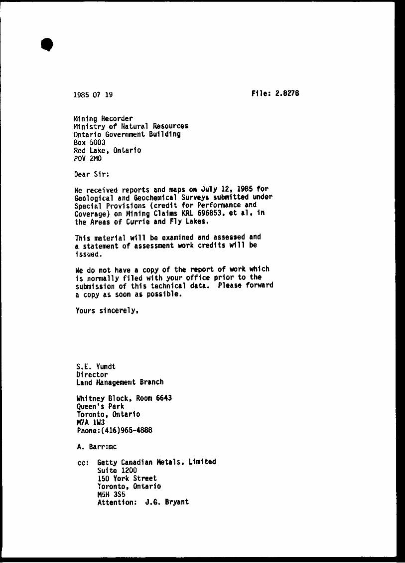
1985 07 19 File: 2.8278
Mining Recorder Ministry of Natural Resources Ontario Government Building Box 5003 Red Lake, Ontario POV 2MÛ
Dear Sir:
We received reports and maps on July 12» 1985 for Geological and Geochemical Surveys submitted under Special Provisions (credit for Performance and Coverage) on Mining Claims KRL 696853. e t a l , in the Areas of Currie and Fly Lakes.
This material will be examined and assessed and a statement of assessment work credits will be Issued.
We do not have a copy of the report of work which i s normally f i led with your of f ice prior to the submission of th is technical data. Please forward a copy as soon as possible.
Yours sincerely.
S.E. Yundt Director Land Management Branch
Whitney Block, Room 6643 Queen's Park Toronto, Ontario M7A 1W3
Phone:(416)965-4888
A. Barr:mc cc: Getty Canadian Metals, Limited
Suite 1200 150 York Street Toronto, Ontario M5H 3S5 Attention: J .6 . Bryant

198S 12 04 Your F l i t : 118-86 Our File: 2.8278
Mining Recorder Ministry of Northern Development and Nines P.O. Box 5003 Red Lake, Ontario FOV 2M0
Dear Sir :
RE: Notice of Intent dated November 1. 1985 Geological Survey on Mining Claims KRL 696853» et a l . In the Areas of Avis Lake, Curie Lake, Jubilee Lake, Roadhouse River and Slate Lake
The assessment work credi t s , as l is ted with the above-mentioned Notice of Intent , have been approved as of the above date.
Please Inform the recorded holder of these mining claims and so Indicate on your records.
Yours sincerely.
S.E. Yundt Director Land Management Branch
Whitney Block, Room 6643 Queen's Park Toronto, Ontario M7A 1W3
Phone:(416)965-4888
SH/mc cc: Getty Canadian Metals, Limited
Suite 1200 150 York Street Toronto, Ontario M5H 3S5 Attention: J .6 . Bryant
End.
Mr. G.H. Ferguson Mining & Lands Commissioner Toronto, Ontario
Resident Geologist Red Lake, Ontario

é
Mining Lands Section Control Sheet
File No
TYPE OF SURVEY GEOPHYSICAL
GEOLOGICAL
GEOCHEMICAL
EXPENDITURE
MINING LANDS COMMENTS:
Signature of Assessor
Date

I
v o 4 .
Î I cv
92®I5'
5I°00'
LU <
U
a: Z) o
L_ 50052'30'
92*'15'
PERKY LAKE 508922
R E F E R E N C E S
A R E A S W I T H D R A W N F R O M DISPOSITION
M.R.O. - MINING RtGHTS ONLY
S.R.O. - SURFACE RIGHTS ONLY
M.+ S. - MINING AND SURFACE RIGHTS
OeKfiption Ordar No. Din OopMition Fil*
l l ^ OCT • ' 41985
LEGEND
H I G H W A Y A N D R O U T f No
O T H f R R O A D S :
T R A I L S
S U R V f c V E U L I N L S
T O W N S H I P S , B A b L L I N h S e T C
L P T S m i n i n g c l a i m s P A R C E L S E T C
U N S U R V E Y E D LINES L O T U N t S
P A R C E I. a O l i N D A R ^
M I N I M G k L a t M S f T ,
R A I L W A Y A N D H l u H l a ^ A A V
U T U IT> L I N E S
N G N t ' E f l t N N l A i S r R t A M
f L O O D I N G O R f I O O D i N G RIGHTS s u b d i v i s i o n o r C O M P O S I P L A N
RESERVATIONS
O R I G I N A L S H O R H I N F
M A R S H O R M U S K . E G
M I N E S
TRAVF RSE MONuMt NT
H 1 n - " r ~ T — ° I i..
y ' -Y '."•'^//f.v/ '/•''•'////
DISPOSITION OF CROWN LANDS
TYPE OF DOCUMENT S^VMBOL
MINING RIGHTS ONLY _ ; .
LEASE,SURFACE & MIN ING RIGHTS
' SURFACE RIGHTS ONLY
" MIN ING RIGHTS ONT.Y .
LlCfeNCF Of OCCUPATION
ORDER IN COUNCIL
RESERVATION
CANCELLED
SAND & GRAVEL
. B B •
.. oc
- <î) NOTE- MINING BKiMTS IN PAnCfLS fATENTtQ PRIOfl TO M*' 6 1913 VESTED ly OHIGINAL OATtNTtt B> THE PUBLIC L A N O S A C T R S O i 9 ' 0 C M A P M O S E C « 3 s u s s e C i
SCALE 1 INCH - 40 CHAINS
I- t t T
1000 VÙOO «300 600U sooo
0 iOO
TOWNSHIP
1000 1 «M
2000 K M I
AREA _
AV I S L A K E
M.N.R. ADMINISTRAtlVE DISTRICT
RED LAKE RIIMIM6 DIVISMm
R E D LAKE LAND TITIIS/ REGISTRY DIVISION
K E N O R A
M i n i s t r y of l a n d N a t u r a l M a n a g e m e n t R e s o u r c e s Branch
Ontario
Oal* J A N U A R Y , 1 9 8 3
NMMbir
G - 1 7 3 4
S2NC1SW9979 2.827S AVIS LAKE B O 0
< >
00
m
1 7 01 J »

I
m
UJ <
UJ CO c o X Q >
O m
v
5SN0ISW9979 2.B278 AVIS LAKE
O
9I*>45'
5|O00'
50®52'30'
5I°00'
—50°52'30
91 ® 45'
LEGEND
HIGHWAY AND ROUTE No. OTHER ROADS TRAILS
SURVEYiP LWESï'; T0WNS^1lf% BASE UNE$, ETC. LOTS, M i w i o CLAIMS, PARCELS, ETC
UWSURVEYED LINES; LOT LINES PARCEL BOUNDARY MINING CLAIMS ETC.
RAI LWAY AND RIGHT OF WAY UTILITY LINES NON-PERENNIAL STREAM FLOODING OR FLOODING RIGHTS SUBDIVISION OR COMPOSITE PLAN RESERVATIONS ORIGINAL SHORELINE MARSH OR MUSKEG MtNES ^
TRAVERSE MONUMENT
DISPOSITION OF CROWN LANDS
TYPE OF DOCUMENT SYMBOL
PATENT, SURFACES MINING RIGHTS • " .SURFACE RIGHTS ONLY © " , MINING RIGHTS ONLY ®
LEASE, SURFACE «I MINING RIGHTS • " .SURFACE RIGHTSONLY„. B " .MINING RIGHTS ONLY O
LICENCE OF OCCUPATION T ORDER-IN-COUNCIL OC RESERVATION 0
CANCELLED ® SAND & GRAVEL — . ©
NOTE: MININO RIGHTS IN PARCELS PATENTED PRIOR TO MAY 6. 1«13, VESTED IN ORIGINAL PATENTEE BY THE PUBLIC LANDS ACT. R.S.O. 1970, CHAP. MO, SEC 63. SUBSEC 1.
R E F E R E N C E S
AREAS WITHDRAWIM FROM DISPOSITION
M.R.O. - MINING RIGHTS ONLY
S.R.O. - SURFACE RIGHTS ONLY
M.+ S. - MINING AND SURFACE RIGHTS
Detcriptittn Oid«r No. 0«t* Difpowlion FH«
mURAL
OCT 21 M I
TLES ^OH
SCALE: 1 INCH = 40 CHAINS
FEET 0 1QOO 2000 4000 6000
0 200 METRES
1000 (1 KM)
2000 U KMI
AREA
ROADHOUSE RIVER M . N . R . ADMINISTRATIVE D I S T R I C T
SIOUX LOOKOUT * Mlf^ J46 D I V I S I O N
RED LAKE LAND TITLES / REGISTRY D I V I S I O N
KENORA (PATRICIA PORTION)
Ministry of Land Natural M a n a g e m e n t
Resources Branch Ontario
FEBRUARY, 1984. Numbtr
G-2187 a i 0
n 0
Q I
01 00
§ o
CO m
> m îj:
02 |yO
1 O

Q I
LU >
LU LU L . L
ÛQ C C "
œ (0
I o
I
Q a
Œ
f T rr
< f T
5 2 N 0 I S W 9 9 7 9 2 . 8 2 7 3 A V I S L A K E 2 2 0

U C H I L A K E G - I 9 0 I and
EARN6EY TWR 92?30' 5I°00'
I e>
LU <
H c r <
Û
UJ
cr
L j .
5I°00'
ro N I
o
L i <
c n >
<
—60®52'30"
92045'
W H I T E M U D L A K E G - 1 9 1 7
Ma
REFERENCES
AREAS WITHDRAWN FROM DISPOStTION
M . R . O . - M I N I N G RIGHTS ONLY
S.R.0; - S W ^ Q M U Q H T S p N L Y
M . + S. - MINtNG AND SURFACE • ' . i- » -Datcription Oraliir No. Oat* Ol tothlow
» f F?
c > •fSi..'
• iMji
1
\
( ! »'
V
• V îr r 4
i •A \
-f »
f.-
Y
.A
LEGEND
HIGHWAY AND ROUTE No.
OTHER ROADS
TRAILS
SURVEYED LINES:
TOWNSHIPS, BASE LINES, ETC.
LOTS, MINING CLAIMS, PARCELS, ETC
UNSURVEYED LINES:
LOT LINES
PARCEL BOUNDARY
MINING CLAIMS ETC.
RAILWAY AND RIGHT OF WAY
UTILITY LINES
NON-PERENNIAL STREAM — — — .
FLOODING OR FLOODING RIGHTS ^
SUBDIVISION OR COMPOSITE PLAN m / A m i m i m . ]
RESERVATIONS
ORIGINAL SHORELINE
MARSH OR MUSKEG
MiNES ^ T R À v e s œ MONUMENT
— - I a 4 -
DISPOSITION OF CROWN LANDS
TYPE OF DOCUMENT
PATENT, SURFACE & MINING WGHTS .
" , SURFACE RIGHTS ONLY-
" .MINING RIGHTS ONLY
LEASE.SURFACE & MINING RIGHTS. .
" , SURFACE RIGHTS ONLY
SYWypL
e d
, MINING RIGHTS O N L Y „ . B
LICENCE OF OCCUPATION ^
ORDERIN-COUNCIL OC
RESERVATION <•)
CANCELLED •
SAND & GRAVEL 0
NOTE : MINING niOHTS IN PARCELS PATENTED PIUOH TO MiAV | 1*13. VESTED IN OflWJINAL PiWrENTEE |V THE KftLtcL! LANDS ACT. R.S.O. 1ST0. CHAT. 3M. tEC* «3, «UWCC ).
SCALE: 1 INCH = 40 CHAINS r 1
F E t T 0 1000 2000 4000
0 200 MÈTRES
1000 t1 KM)
, Î > " • Î
r
| T 1
AREA
SLATE LAKE M.N.R. AOMINISTIIATIVE DISTRICT ^
RED CAKE M i m i f f i DIVISION
RED LAKE LAUD TITLES / REGISTRY DÏVISIO»
O a U F E B . I 9 S 3
52N01SW9979 2.B278 AVIS LAKE S30 ^ ^ i
KENORA/PATRICIA.;^, Minis t ryof Land

r
'-t.
"•p
?
& , " s» ' f
* " i J.
MSI J .f;
V
92°00
P y
La/If
SvM
• - J
v
• /
y
CP- •
KRL j KHL I KRL T" KRl"1
ZIftIZ '62l$l« Uziezo I 6ZI624 ^ 1 L
KRL . KRL I KRL | « « L
I I 6tl«l3 |S2iai7 '62IS2t 62>6ZS KRL T KRL I KRL
L
/ 56
n }
A/
KRL KRL
| ^ L « 2 2 J 6 2 L 6 2 « I 621629 | 6 Z I S 9
I K i L " ^ ] K ^ L KRL r KRL
N ' i I «21619 I«2iei9 l«2l629\j62l«Z7|«2ie3o'«2t9»2
KRL KRIA |KRL I KRL I I
6 2 1 9 9 6 | 6 2 l « 0 0 ' > r 7 5 S 6 2 |7T9866
' K R L ^ K R L H KRL Î~KHL I
775264 ( 7 7 5 2 5 ^ ^ 7 9 2 4 8 "TKRL T K R L " ' KRL
I I >
KRL ' KRL' ' I KRL | K R V - ^ | K R L j KRL I
I 6 2 ( 5 9 3 | ® 2 " ® y f 6 2 l 7 0 r I I I ' ' ' '775861 ,773869
KRL IKRL KRL I J I I
R L " ' ^ KRL 1 KRL j KRL ' KRL TKHL
1/ 7^5263 jl779?95 KRL
77M?62 (775254
KRL |KR
I , - , . , , , 177 5 2301775860 |77Se64 7 7 5 247 |77 9 J 7 ' 77223_5| ^ 1 " " k r T i^RÏ-TT KRL T k R L T KRl- I KS"- | «RLX I KRL \m. j KRL
, j I t ' I 1 1 7 7 5 2 3 1 I 7 - ^ 6 5 9 1779663
! KRL
1
A
'se N
KRL' I i
779 fc*^J 775578 | 77558S
KRL 1 j w L " '
| 7 7 i ^ 7 4 I 775! . 1 ^ > I KRL Î KRL , I KRL 'j I Kfl
l / i / ! I J 775575 j779576 j 77:
775599 \ Y I ' I J
W L , |KRL I
U I ' 79253'77524S . - - I KRL ' KRL
I 7 7 5 2 5 2 ' '
I KRL UflL I KHL
775T!
I \ I 775876 I 775'
I KRL
I 7 7 ^ 7 4
IKRL IKRL , KRL y \ § / \ C/
RL I KRL
Z9I 1775243
KRL
- Î H Ï l h
I "1665 1621668:621671 I 621674' KRL I KRL , KRL KRL , KRL | "icRL ~ KST^Mciii"^ "KRT "j KRL "P KRL~r KRL~' kbT kTi
621639 I «21642 | 62l64sl 62 I64B |»I«9I ' 62 I 6 9 4 6 2 l 6 6 o l 621663 j 62I666| 62166» |62(672| 62)675 KRL KRL ' KRL | , KR L | KRL ' KRT" ^^ÏÏU ilcRll I KHL I JEII ^ ^ -
I 1 I I t I I I L' I '«40 621649 | 6 216521 621 695 j 621659|621 661 | 62I664| 621667 [ 62 I 670 [ 62 1673) 62 I 676 j
TTSa»»
KNL I KRL 77924»
KRL KRL I
LaM* KRL I KRLI ««1- I KRL /I KRL ,6 21693
1775671 I 775^2 '775873 I I I
f i - 7
KRL "KHL I K R L ^ , 1 KRL
T .
755,3 ! 775524 1^5525 | I IKRL , KRL "KRL IKRL |
j < ! 775526 7755351775538 r 1 KRL KRL I KRL ' I '
775527 ! 775634 j 775 5»
17755(4 ] 775523 ! 1 — I C ^ I I 775515 [775522
-J 1 KRL I KRL I KRL I KRL ' KRL ' KRL I _
177 5 177554 779k r— - - - - - - r ^ - - -
<RL T'KRL^^ÏKRL ritB( L"! Him. IKRL jVKRL >fKRL
l y j \ U k 7 7 9 i l < 1 7 7 ^
'KRL 'KRL I Î I I TTMIT I77US0 UTSS^6jJ7S507^^95(0 j7799l( I
^ KRL TKRL i vnk I nnL . j
i i / 1 ^ |J79W j 775519
775528 1 75533 1775540 1 K R L ^ I KRL I 775529 I 77 Swf] 7749*1^
VKRL KRL ,KRL t ^ ] i y ' \ / J f
V
M
56
•50°52'30"
• * 13' 12' tl 92«00"
A
LEGEND
HIGHWAY AND RfM.iTf N ; OTHtR Hf A[)S T R A U S SURVt Vf [M INE ^
f nwNSI' l>s RASE INFS t ' ' L 11 ' W "41N G I A • M"" P A R O
UNSi • • • . • 1 iNf
PA- • %:,A><r iVIiNiN 1 AIMS t T'"
RAILWA> ! i HK.HT 0» A A -UTILlTV t Nf S NON ft Rf 'jNiAt ST M[ AV f LOOniN ' D(J-.iNC) ''niM ' SUBOl ViS ^ 'H OMPOSiU PI AN RESER vA' 'ONS ORIGINA. '.HO«f ; iNt MARSH Wi SK tr, M I N E S
T RAVE HS- Ml )MJM[ \ T
F Tf
DISPOSITION OF CROWN LANDS
TYPE OF D O C U M E N T S Y M B O L
P A T E N T S U R E A C E & M L M N ( ; R I F I H T S • Si R E A C t R i g h t s o n l ' t e
. M I N I N G R I G H T S O N t > " Q
LEASE, S U H E A C E & MINING R I G H T S • - . SUH ACf RIGHTS ONi ^ H
MIN(NG RIGHTS OM v . a L I C E N C E O f O C C U P A T I O N . T O R D E R I N C O U N C I L oc
R E S E R V A T I O N _
CANCELLtO SAND & G H A V F L
NOTE M I M i N - - , R i r i M T S I N P A H t t i S P A I t N l f l l f H O T O M A Y 6
1 9 1 3 v f S T t O IN P - A T J U T t f Tfit PUBLIC LANTS ACT PSO IS 10 <"AP }»o s€r sa suasEC >
R E F E R E N C E S AREAS WITHDRAWN FROM DISPOSITION
MHO. MINING RIGHTS ONLv SBO SURFACE RIGHTS ONLY M S MiNltgG A: I »U:f '
D»»criptioM Qrde> No Uatii Oiipoiiiioi- f ilti
M i U m . R£SQURCES
OCT 16 «B5
TITLES SECTION
SCALE: 1 INCH = 40 CHAINS
0 1000 Î0O0 «000 6000 •ooo
0 200 METRES
1000 I I KM '
AREA
CURIE LAKE f
M N R ADMINISTRATIVE D ISTRICT
SIOUX LOOKOUT M I N I N G D I V I S I O N
RED LAKE LAND T I T L E S / REGISTRY D I V I S I O N
KENORA (PATRICIA PORTION)
Ontario
MiniStryof Land Natural M a n a g e m e n t
Resources Branch
FEBRUARY, 1984. Numkt r
G-1998
o t
Q; Q; œ
o E m
< T t : m
00
é

Sy^A ÊoCS,
X X
7 0 OoifcU-u .JJR-JC
C J i c w v w v ' ,
\ » I GRANmC R.UTON; weathers to a buff color and is light orange on the fresh
LEGEND
O
I 7 O
1 7 5 - ' 5 7 7
( 7
H
Y
o
I I o-
surface. The rock consists of j
25-40% quartz crystals, 1-5 mm long. 50-70% feldspar crystals. 1-5 mm long.
0-10% biotite crystals, 1 mm sized sheafs. The rock shows an unequal distribution of biotite on outcrop scale and feldspar and biotite are locally foliated. Granitic dikes and/or sills up to 5 m wide are common in the porphyry zone.
PELStC PORPHYRY; buff porphyry which consists s i t
0-50% quartz crystals, 1-10 mm long. 0-15% piagioclase crystals, 1-2 mm long, white prisms. 0-40% K-feidspar crystals, 1-2 mm long, tight pink
prisms. 20-100% aphantic groundmass. 0-5% biotite, sericite.
The rock is compositionally and texturally diverse and appears to grade into the granite piutm. The tmit is made up of dikes and/or sills and blobs of porphyry several metres across. 1) felsic porphyry only,
b) felsic porphyry and granite dikes/and or sills and blobs several metres across.
FELSIC TUFF TO lAPILU-TUFFî
Tirff{ buff with 5-30% white and light blue quartz crystals fI-3 mm long); thick to very thick beds.
b) L^il l i -tuff; lapilli and block sized felsic fragments caii be distinguished from the matrix. The matrix {tuff in (a)) approximates ^ e clast composition so fragment boundaries are difficult to distinguish.
c) Silicifieation.
d) Tuff with light green matrix colour due to high muscovite abundance.
e) Pervasive alteration, 1-3% disseminated pyrite. f) Discordant to concordant massive and semi-massive
dtlcx-ite veins up to 3 cm wide, locally sericite and other clay minerals associated.
INTERMEDIATE TUFF, AND TUFF- BRECOA AND FLOWS
a) Light to medium grey tuff with greater than 10% biotite and other mafic minerals and less than 10% free quaru.
b) Felsic flow; which weathers light pink and is light grey on the fresh surface. Contains compositional layers 1-lOcmlhtek.
t- 5% quartz ph^Aocrysts, 1-2 mm long ^ 0-20% feldspar phenocrysts, 1-2 mm long
c) Tuff-breccia; thick bedded, contains 30% matrix and 70% rounded to angular heterollthic clasts up to 50 cm long.
{ ^ n s s
o
Y V o
H (g)
Q \b
4 0 0 metres I
Scale
738Ç
X
-.«C/D FTVIS LAKE 2 5 0 MAP
FLY LAKE PROJECT FL - I CLAIM GROUP
GEOLOGY AND LITHOGEOCHEMICAL
SAMPLE LOCATIONS
DBWWNBY: W.F, CHyCK'DttY: J-G.B.
pjgg; $ept 1g84 OfWUIVONo: SCALC:
Qftty Mteimit Oomiitnyi Ltd

moon -
3ool\J
O O N -
I -
i
loos -
52N01SW9979 2.8278 AVIS LAKE £60
FLY LAKE PROJECT
F L - 2 CLAIM GROUP
G E O L O G Y A N D L I T H O G E O C H E M I C A L
SAMPLE LOCATIONS
Grid F L - 2
DRAWN 8Y: W. F. DATE S E P T 1 9 8 4 CHECK'D BY: J . G . B . DflAW'G No:
N TS. 5 2 N SCALE: 1 : 2 5 0 0
I b i Getty Canadian Metals, Ltd.
M A P 2
CT' -t o O
o
G
Ht
•t
o o C)
AP-
S/MBoLS
/cJÈiiOLAro^JL /ojfcfcufcujLA. «0 1 >>
775G3I ;
O >ê
OwùaJL ..-pfi^vrJi-
/Cr
7 7 5 G 3 /
AJlijCAO^
" " " O cJioom^i pO^ lL JïjCJCeLijL^ (CXrtfvJ-
/cJUi/tv- Jfcirt^j poiat ('TV»
(cJlouur>-> yTvAjL/yrJïfAAJ
^•ST
- O - 3S>
^ ^ ' I
Kisio» v " H s T
-1 1 1
-t (• /
<
77
3 S o - < 0 0 % . pWwxO,. /-5'/7m^
H o - 5 0 % p^oAcvrCjbi.
^ T T O /OL^ifc/ / c /x fe j i j a ' . ^ U L ^ 1 H T -
1
J ^ ^ . ^ u r t j U ^ Q T f c
Jfccr- / S * ^ J U ï U a ,
o —
S C A L E 1 : 2 5 0 0
m e t r e s
7 7 - 5 G 3 3
V V
J '
li. rr
o-
4"
U ' ,-•
7 7 5 ( o 1 5
' N
7 7 5 G 3 G
;> .
1" 1


U •
C D
«0
• t o -
111 I t i l
SI
> <
T l G r ^ x f i ^ ; . /YnSjc^JMirr-o
-ÂftL. icLou^ii» . C- orrx^so^ïotxJL f O ^
OC /yr^^ryv J ^crticL -Jter
^UrtOiOL^fl-' iCrtiyafeJL
XViJcrurp' /QjCdJlfi,.
(Z--"fiAOTT^ucxxil- /Qjadtvrrt-o/rJ::;,^
^Aj^jirJUJb:^ / o ^ pi^^ùjfca. - . ^ J j i u ^ w j k o t i t k . /ou
b /CAftO/m»^ / c J W J C -^U/ t J tAj /CjorCfcimAAfi^i* / o J U < i j
p ^ r i n i W t d j i - iO/»vdL> /on f l J " S O /c/vr
• -
v . - O - -
. . o o v
S - X M B o L S
/ C c n r d t p * ^ ^
/cÀtoULj^ojo^ J ..AmicSLiA^ajcL.^ _A>VUtLuCaJL
/ T T ^ v t A o S t - . ^ o ^ t o j i ^ ^ ^ A t ^ n i w u i J L .
/ijud^Su
JlaâsjL, /o-^JoaJL- ^
/ciiiaimu P O ^ x t / c J U c ^ ^ J L T J L ^ p c x J t
/ o y j ù o j j /O-jS-pA^yxiiT^volfc^
-iitt/njcJx/ /O/rtoL /TTjurr>-J2rtnj jclsUbjJiyyvaltj'myj
J U c ^ J X ^ 3=1 ^ W j l o . / O ^ /dUijE. ^norro
5SN01SW9973 2.6278 AVIS LAKt
MAP 6 -
FLY LAKE PROJECT
ej .AIM GROUP
GEOLOGY ^WaO UTHQGEOCHEMtSTRY SAMPLE LOCATIONS
^ Grid
OBAWNBY: ^F. ^HyK'OBVi
I C K ^ SEPT. 1984
N.T.S.: lft.l$ "f
ISC/M^: I 1 ^ 0 0

oo'
ïA
\V
' - N . 3 . N o SiOrm^aJlft/
-7
SCALE hZSOO
so lOO
me+rea
-A
52N01SW9979 a.8273 AVIS LAKE 2 9 0
FLY LAKE PROJECT
F L - 3 CLAIM GROUP
HUMIC SOIL SAMPLE LOCATIONS Grid FL -3b
DRAWN BY: W. F. CHECK'DBY: J.G.B. NTS.: 52K I5 , 5 g K I 6
DATE: SEPT. 1984 DRAWG No; SCALE: 1^2500
Getty Canadian Metals, Ltd.

à
PP^PH VLfYuJjk.
S C A L e Î 1500
• Anomalous gold values (£8ppb)
Anomalous arsenic values ( iZOppm)
5 0 ( 0 0
mt-l'res
• •» i ;-1: • r .
^ '4 dl
a.
i
3 0 O - \

4 (J ( i N
3 r ) 0 N -
3
L 1 1 5 ( o 0 ^
1 0 i ; N -
He> r h
B
[OJ
<Z
y
I 4 0 0 N
5
3 0 0 N
20 0 N
1 0 0 N
^ a
1 0 0 s
0 s
77SQ>0<b
J O O S
V T
40 OS—-^ — i
. J''
J ' -
.of
L W i t.c . v\' • ,v I U 1 (. ^
BASELINE
i O O S
1^0 O S
3 f ) 0 s
4 t J 0 s L (! W
S X M B O L S
7DOÛ,
52N01SW9979 2.8278 AVÎS LAKE 3 1 0
C m i K )
. M W u J - g o e i x d w .
M c ^ o U t i L c C t t U u c U
S^^OT C J W V , . vxavvvJUU.
100 Scale I<2500
2 0 0 m
E G - E N D
NJAL^VAUTULTC. J .JJU^JLSL
A k ^ JU^AAOÀ /TT^omuX^ JUiJL- UJUM,
CUvplLWot , k c V^OrÇjCOLrrJjCto-. ^
Obi
JUxn^jo^ âS- GO"/, J t u ^
-jjC» /yrxjuixurm^ ,
/SLAJLL
jU^rnijr^adoJL J t b - J t ^ J U J a - o J
jOLmtjL
O S-S/ryvvKx A ^
I ' ^ f S Z p ^ y c f c l o f f l f l
C J W n j L ç o J l
^ ^ J O J ^ O B Ê C . -
o U w e o J j L M ^ J j y ^ Ic. o u U l l .
/euyvJL .u / rd j iAJLt jekUd
-••I-IHX^ zTrXflueoÀut.
/ O U ^ j i n la ^ M j i t f i ' •Mj^jber"
S S Î k /Mno^^rxc i t l s . , / 7 U A / m o f / p a S i k
C )
d )
è)
FLY PROPERTY
CXAIM GROUP ,
GEOU)©Y ond LlTHOOEOCHiMICAL SAMPLE LOCATtONS
Grid F L . - 4

400 N
3 0 0 N
200N
10 ON
B
lOOS
20 OS
3 0 0 S
400S
SCALE 1.2500
250 m e t r e s
4 0 0 N
3 0 0 N
2 0 0 N
100N
BASELINE
r ^ IOCS
2 0 0 S
3 0 0 S
4 0 0 3
"^Jix^jinyij
Sa/mjiSisL
_ N . S . N o Ôtvmpijù
L 7+ 0 0 W L 5+0 OW L4+0 L 34 0 OW L 24 0 0 W L1+0 CW LO+0 0 W
5 2 N 0 1 S W 9 9 7 9 3 . 6 3 7 0 A V I S L A K E 3 £ 0 MAP 10
FLY LAKE PROJECT
F L - 4 CLAIM GROUP
HUMIC SOIL SAMPLE LOCATIONS Grid FL -4
DFmWNBY: W.F. CHECK'DBY: J.G.B. N.TS.: 52KI5
DATE: SEPT. 1904 DRAW'G No:
SCALE: 1 2 5 0 0
Getty Canadian Metals, Ltd. 7 ~

400 N
300M
200N
\00H
loos
200S
3 0 0 S
400S
LAKE
L 70oW t-SOoW t- H o o w L 3 o o w L a o o w i _ t o o W
" i J l g i i ^ N J O L
•
O
Anomalous gold values { ^8ppb)
Anomolous arsenic values (>20ppfn)
0 100 2 0 0 m
CLfj Z- nrr^ £-2û>Tr»Jl/)-Jt oOjdl»^ PPrtn, P P ^
Scale 1=2500
52N0ISW9979 P,827B AVIS LAKE 3 3 0 (7 /
I I
4 0 0 N
3 0 0 M
20C? N
lOON
B A S E U N E
l O O S
ZOOS
3 0 0 S
4 0 0 S LoooW
f l y l a k e p r o j e c t
F L - 4 CLAIM GROUP
SOIL GEOCHEMISTRY Grid F L - 4
DRAWN BY: W.F.
CHeCa<'D BY: J.G.B. DATE: SEPT 1984 DRAWG No:
SCALE: 1:2500
Getty Minerals Company; Ltd.

o o + m
5 ù o + cvi
O Ci
P f J -
Mo 7 c
S ^ ^ r s e f y
T r ç f e f
300 H
77SG01
o o
Ci
SCALE I •• 200 N
200
100 (Sl
BASELINEI
77Sfeoa
looS
a/o 7c
200 s
I,
300Ô S p e x m ^
rneci
i^OOS
8 , f o
10,710
lo,>io
Cj^lo
10, >10
)0, 7lO
10,>10
s o ^ i - a s i
Sto%'35<l
10,710
lOj yin
/0j>|0
10,710
ics >K>
5,1
- a o % . p s 5 ' 10/5
aoffi-^S-j
^oii-aSo 5,10
- ao^G-MÊSl
-JOHG-IItl
- a o f G - u f c o
50MC-JJ5?
—2e>1t.-IJ55•
A/o Of^
I J S - G O ^
î f ly
' T r e ^ e f
No Te
• J O O N
F u t
M
7 7 5 G 0 3
52N01SW9979 2.8278 AVIS LAKE 3 4 0
2
D 8 O + o O o
O
•ZOOM
\00!i
5 / M B O L S
7 7 5 & o i -
BASELINE
^ —SjXWrrs) mjUjTrJij<nj
0 Jt«iiT>rO JicrtDoJouL j ^ocMii r rvo t
-^^^cajtjLeL, /cJioj/nvj
D j i p H , M J b -
oft--KwWio
y
/
Q — ^ o ù s
MAP 12
FLY LAKE PROJECT
F L - 5 PROPERTY
HUMIC SOIL S A M P L E L O C A T I O N S
a n d C L A I M S
Grid FL -5
DRAWN BY: W. F. CHECK 0 BY: J.&. B. N T S . 5 2 K I 6
DATE: SEPT. 1984 DBAW'Q No: SCALE: I 2500
Getty Canadian Metals, Ltd.

SCALE
25 so \oo
me+fts
BASELINE
lOoS
zoo
3,10
2006 - i s j tS
300S !
j i
3,7 — 3 % 3 C
' \n
i^bos vs -la.Go
200 N
100 N
u
5,1 43
i
j-JBjail
3 , l o
7,10
Ml
5A
. o r
i
(.•i^iTjST I
1^—25,50
- 1 3 , %
Sl^SlOM
3,11 [-75,130
1,8
5 A
\
o
l : o o +
5 o +
5 o o o
Ci
300 N
BASELINE
100 s VLF/ixmxJLudfcyu
C ' O r t J L i J o
lOOS _ C U , 2./ru
pp/FTVj pp/m. ELEMCfJTS
UNirs
A Anomalous gold values (^8ppb)
• Anomalous arsenic values (aSOppm)
lÙOS
l i
o o + bo
o O o
9 o
o
FLY LAKE PROJECT
F L - 5 CLAIM GROUP
SOIL GEOCHEMISTRY Grid FL-5
MAP 13 o Getty Canadian Metals, Ltd.
5aN01SW9979 2.8278 AVIS LAKE 3 5 0

uJ O o
Là
8 n s
UJ O a rn
D -ui 8
L
5 - O N
HOON HooN
3ooN 3 0 0 N
5 0 0 N
lOoN
Otoo
Î O O S
J ? o o s
3oos
"iOOS-
^OOS
GOOS
7 0 0 S -
8 0 C &
" f o o 5
/ 0 + o o s
il 00 5
' Q O O t c : .
! 3 0 0 S
H 0 0 5
7
6 a -fels.c &(( /f
GT fcsek'Ro
M cifiâ. T o f i f
l O ' Z o % b l oV 'Aé
C r i ^ s W k r f t x o l s ex-
W d d i
-Hv
l f e r r e t : S e T Ô P F F l ^ u o . s
(û^^vftAfxWi - "Hvi'iv bediAedi
1 ftk
4ooN
fVl4-i
lOON
- y r v t a s s i o e b i c f i f f - l û a x K i ^ « o r + U - ^ j - c i i f i u ^ U c r e
KC^ J HAsUcf ô tÀ^ , lèCd^U'^ \ OA^ iA^aJ^eJ b e d s
O t ^ O O
I O O 5
3 0 0 5
4 0 0 s
5 * 0 0 5
Ê O O S
~7005
ôoos
loos
00s
laoos
I 3 0 C S
IHOOS o |00£ -?OOE 3 0 0 E
5 a N » 1 S W 9 9 7 9 2 . 8 2 7 8 A V I S L A K E 3 6 0
- S é r i e ^ Î N - î f -fo ^ k î i l é i ^ t l k l i c i e r t x â c l s o ^
b iniçfbtddeJ s-c ffote o- C^efî » « f Lj / s t ^ i s i a s é y v j n ^ f c - S u l - p K U g ^
W W ?
Arv. Bo ^h
c .
T
ûv6r 7 0 ^ ^ ^ o - ^ i c s
jit^ wvWtff S
^ L.
«b
a ) >
• •
'
- 'It loctfj-l'crrx
— O
IC-CXL ^ I O-L^ET-RE-CI J I O B S ^ V Ê D L
II c 1 0 0
Scale I--2500
200 m
3 0 0 N
500 N
lOON
D O S
3 0 0 5
HOos
5 0 0 5
G O O S
700 s
^ O O S
^ o o s
lOtoos
t C O S
; I Q O D S
1300 S (30OS
MAP 14
f l y l a k f p r o j e c t
F L - 6 C L A I M G R O U P
G E O L O G Y A N D Ll T H O G E O C H E M I C A L
S A M P L E L O C A T I O N S Grid F L - 6
O HRAV^N 8' ' W.F. i U"Th.-BV J.G.B.
NTS 5 2 K 16
S E P T 1 9 M
; scale 1-2500
Getty Canadian Metals, Ltd.
400s -laooE 3 0 0 E: I100E \50oE IGOOE j 7 0 0 E : I 8 0 0 E n o o E < ? O O O E
400S
T

8 uJ O O
bl 8 UJ
O o rn
m 8
Hi
500n
MOON
3oon
5 0 0 N -
lOoN —
O + O O
loos
3 0 0 5
Hoos—
Acs
G o o s —
700S-
8005-
^ o o s
/ O f O O S
lloos
fgoos
IHOos —
— HOOW w —
3 0 0 N BoûW —
5 0 0 N
lOoN
loos l O o s
~ -JIOOJCIL/
<?00s
3 0 O S
Xr» A»*'», /C, -puuwxlc. jlou-^
.iKiucS /pja: j ut/mto jtoj f
po lx pii»- /itju/itjua/ o?CX>S
300s
H O O S N . S . 1 ^ 0 S M M P L E H o o s
/ 5 * 0 0 5
6 0 O 5
7 0 0 5
5 0 0 s
é o o s
s ^ 135-00 700s i n
o la-s- 50 1 0 0
MIETRES 55D
Ô O O S
foos loos-
l.l' I,'
M-
l i l -
IJ 1,1
I j l -
l,' til-
IIOOS IIOOS
laoos WOO 5 -
1300 S mo S
i T O o W l o o w O i - O O | O O H < ? O O E IHOOS I ^ O O S -
n.s.
a&Ht-uaï
gi Ha-CîLH
gô^K- taa
aoHfc'tai
N.S.
50HC-U&
tJ.S.
LU o o or
vu §
3 o o B UOOE 3 0 0 E h o o E I 5 0 O E
u j
8 LU O
UJ o o CD
UJ
8 C)OoK
SOON
HooN
300/V
500 N
l O O N
0 + 0 0
l o o s
JloaS
3 0 0 5
HOos
500 5
— GOOS
7 0 0 5
^ o o s
loos
lOtOOS
t O O S
/ a o o s
(50OS
M A P 15
FLY LAKE PROJECT
F L - 6 CLAIM GROUP
H U M I C S O I L S A M P L E L O C A T I O N S
Grid F L - 6
DRAWN BY: W. R CHECK 0 BY J.G.B.
N T S . 5 2 K I S
DATE SEPT. 1984 DRAW G No
SCALE 1 ^ 2 5 0 0
Getty Canadian Metats, Ltd.
IGOOE. 1700E. ISOOE n o o E ^?OOOE 400S
5 2 N 0 1 S W 9 9 7 9 2 . 8 2 7 8 A V I S U A K t 370

I
5 ' o r !
HOCN
3OCN
a o c N -
l O o N -
O + O O
loos
J?OOS
3 0 0 5
4 0 0 s
5 O O 5
GE>
( S O O S
80c6r
UJ o o a -
Vli
8 I n
8 o
uJ O o
LJ
8 UJ O O r o u i
8 C<
tu o
M
H o c M
_ 3 0 0 N Boûfs/
— a o o N 5 o o f J
I C O N \ O O N — e,i5-
G D
f,8
-
- n , 8 t
'31,H<}
—li'^l
1,3 — 10,3!
m - 7 , 5 1
-1-5,53
\ 0 0 ! f O O S
3OOS û?CX>5
6,s
- 7 - ^ 5 /
iLSfi
4 1 0 - 8-5,50
3 0 0 5 3 0 0 s
4 0 C S Hoos
^ 0 0 5 500s
(oQ>
GooS ^OOS
7 0 0 5 7 0 0 5 — 5 , 7 - 8 , H 8
<5.7 A
t - Cilo —7-5,58
i
Ô O O S ^ s — S.-T-
1
5,11 - - 7 5 ,
" l o o s
G C
f o t o o s
l l o o s
( p o o s
loos l o o s
U j
8 UJ
uu C) o
UJ O 0 00
UJ
• 8 CT-
G o o i ^
15,78
t>,7 -- 15,H7
(sia^j
GW , -5,H — UiMS*
i ! t •
— 3 4 , 3 1
- R S .
- 1 0 , 5 3 - N . S .
N H — 3 . 7 -
1 . 3 —
J . S " — ô s - . H ?
U - T 5 . Î 7
5 , 7 NH L " J 2 , 5 D (
- 7 , ^ 7
1
2 , 5 - — M H —
H . 7
1
- 1 5 , 3 8 3.H - 0 , 3 5
a , H — | 0 , 5 H S . I - i a , 5 8
H . S . " " 0 ^^ ^
t i i
8 O c>j
Ui O O " S
S O O N
H o o N
-H
u,60
7,5 - 1 , 5 6
8 - 5 ^
H.1
H.t
N.5.
- N . 5
liS^ J i H
- 7 5 , 5 0
_ & 5 O '
3 0 0 N
—10,-73 -
- n . 5 8
^ l a . i o D
10,aa
- K S .
500 N
G E
lOoN
0 ^ 0 0
! c c s
GC
j OOS 1 0 0 5
l aoos ICQ
Scale h 2 5 0 0
2 0 0 m Woo 5 -
I 3 0 0 S
4 0 0 5 — ^ D O W
J \OOW
— I 3 0 C S
3 O C 5
^ <bF M O o s
50O 5
GOOS
xl.8 -
-11,64
\ 1 1
4,6 --11,64 \ 1
— . — — TOGS
f.io —
—7s;5i
— /
•T^A 1
— — ^ o o s
- 11,V7
- /s-,1^ â . l â
1 i 1
1 1
- 8 ,51
1,7
1
-8,31 — 3 5,37 .3,7 4 - 8 , HO j
- 5-5,lt - 17,il — l o o s
5; 13 ^ n,sr3
1.5 3,<b
a.5 - 1 0 , 1 7 3,8
3,5- IO1-OOS • o
I t o o s ppb pp-w
NH
Anomalous gold values ( ^ 8 p p b )
Anonnolous arsenic values ( ï 2 0 p p m )
CU,2:/yu, j i iLuwû/Kt crxdan^ pp/rrvj pp/m. ^u /vu^ /Tvo^ J?UJLTrÙA-j/-no-As /Q/rvaSx^
fY\cr /aojvYvpJ&i.
i S G C S
5 I O O E
IH OOS ^ 0 0 s
30CS
0 < - 0 0 (OOE ^ O O E 3 0 o £ laooE I 3 0 0 E h o o E 1 5 0 O E
J IGOOE I 7 0 0 E L ( B o o t ^ 0 0 E <3OOOe
MAP 16
- I 4 0 0 S
f l y l a k e p r o j e c t F L - 6 CLAIM GROUP
SOIL GEOCHEMISTRY Grid F L - 6
DRAWN BY: W.F. CHECK'DBY: J.G.B. N TS.: 52 K 16
DATE: S E P T 1 9 8 4 DRAWGNO: SCALE 1 : 2 5 0 0
G e t t y C a n a d i a n M e t a l s , l t d
3 S O 52N013*9979 2.8276 AVIS LAKE

I 400 N
TO Ci Ci \p
300 M
ZÛON
lOO N
'OOS
a,5
3.ro
Jo,fo
—3o%' (oSo
| - a o % - | 0 4 e
— a o % - / o %
3 . 3
J.3
j ; io
3
5,3
-50W6-1033
—ao-^G-ioîÊ
— / 0 3 7
— S o ^ - f o ^ e
.5o%-fOMO
13
3,a
r.s
5,5
§ B a -sO
e l f l a k e
/
N M
SCALE I - Z 5 0 0
so
l o s a
- ^o^G' toafe
5 0 4 6 - 1 0 8 5
§
— 5046-/O3M
Ci
52N01SW9979 2,8273 AVIS LAKE 330
/OO
mcVcs
250
X
§
s §
JwLmùc. Jlojuflfl' ^ ^
T-iuctUuwx or^ JWivùc. Jieu^^/c
SjoumpSi.
_ N . S . WO S t v m p f i j i ,
I
s ,3 ao*«i-iog3 10
10,A) -gôHfc-ioaa
—aoMt-ioa/ |o,l5 -AûHC-lû/ojjf/ç
- a û ' t e ' / o a o
10,Jo —SitMi-m
5,5 0,5
-IJ .S
iT.aû
BASELINE
— N.S.
-N.S.
^ 0 0 M
3 0 0 N
Z O O N
100 N
loos
zoos
3006
g I
/c>
i f 7 18
FLY LAKE PROJECT
F L - 7 .CLAIM GROUP
HUMIC SOIL SAMPLE LOCATIONS
Grid rL -7ab
DRAWN BY: W.F. CHECK D BY: J.G.B. N.T.S.; 5ZJ 13
DATE: SEPT 1984 DRAWG No: SCALE: |;2500
Getty Canadian Metals, Ltd

400/Sf
300 M
^ÛO^l
ÎOO N
toos
^ 0 0 M
300 N
z o o N
_ 1 0 0 N
B A S E L I N E
LAKE
— H S . 1 —&S,«fO
- N.S.
m . - a s . 7
N41
ÙH - S t , s
— too s
zoos
s.
300B
g c> o 5:>
§ -t.
I
ppbirP^
(p
NoT HUMic —>N.H.
PPrtr^iPP'»»^ ULmiisL-
1 0 0
Scale i>2500
2 0 0 m I / o
5 S N 0 1 S W 9 9 7 9 2 . 8 2 7 8 A V I S L A K E 4 0 0 •
Anomalous gold values (&8ppb)
Anomalous arsenic values (^20 ppm)
^ /
FLY LAKE PROJECT F L - 7 CLAIM GROUP
SOIL GEOCHEMISTRY Grid FL-7ab
Getty Canadian Metals, Ltd

l 3 5 b N -
1 3 0 0 N
SiHOOW S i i Q o W Q Q ^ O W [ 9 3 0 V\ / ( 8 0 0 W
aooN
I IOoN
T i E U w e l o o o N
I O O N -
8 O O N —
7 O O N —
GOoN
S O O N
4oon —
BOON
<?oôn
lOoN
5 0 0 S
3 0 0 S
4 0 0 5
r ^ e t r e s
l o e o W c | 6 0 W g ^ O W 720 W GOO W ^ 8 0 W 3 6 0 W 5 W W I 5 0 W
10, <30
(O,<3o
10,50
- So%-IOS9
AoHÇt-fose.
•SoH&'foS^
a o ^ e , - f o s s
5 o f f e - J a 5 ' 3
J f o ' t e - j o s j
loos —
7 0 0 S
Gjis-
3,10 I - a o M C - t o C > V
5 ,aoU50»f6- to7£>
3,10
3,10
3,/S
(0,?ol
15,50
— to 8 0
- «076
-Hoii-foiS"
(o,S
5,)o
5,10
;?OH6-tons'
- a ^ ^ - / 0 1 a
fo,5o(—3»% - roST
/o,3o U
js,aD t - - / o f i f c
ly,;»/©
r y / z o
SoHÇ-lSoj
So, ^10
JJo.TiO
0 0
LAKE:
laoÊ 3G0E
5 , > s
5;>5
5 , 3
iS-o'i
- 5o»f6-lSc>3
- SlOHG-lSogi
— H o o
— 3 0 0 ^ /
aooi>/
l o o W
5 6 0 V / l a o w 0 0 l a o E 360e
loos
5 0 0 S
/vijcr /aOArviafiû-'
30OS 7 H 5 - W 6 3 5 " W S o S v /
3 . Ô 5 W 15",>10
Jnb j o m j
D ^ Xar J f f M ^ AflridL
/
^yyyijpjia /TVOrtvJir A»
A 0 ^ a
SOOS K V
GOOS
/5G0V l^HOW o a s v / l a i o w l l o s v y t O G S
185 V/
52N01SW9979 2.8273 AVIS LAKE 4 1 0
FLY LAKE PROJECT
F L - 7 CLAIM GROUP
HUMIC SOIL SAMPLE LOCATIONS
Grid FL-7C
DRAWN BY: W. R
CHECK'DBY: J.G.B. N.T.S.: 52 J 13
DATE: SEPT. 1984
DRAW'G No: SCALE: 1 = 250 0
Getty Canadian Metals, Ltd.

^ c c v J u/ 5 / G C U / 2 0 M O U /
l 3 5 b N - .
! ' I S O IV
r
I g o o W
U o c N
iOON
- N . S .
- N . 5 .
-N-S. i
5,11^4-5,51 i rlOpSia
i 1
I I 1
3,7 s o i
)
1,11 k v " ?
T i £ Li 1 O O O N
6,ta
a . i i U.-i-ï
— 15,35
^ O O N -
gOON
5,8
a<\ — I3.SO
7cA O '
Ï1.7
3,'ï
a,10 —l.Jfe
- K S .
-53 ,37
-Mjio
- W
O
HS
h-
1? - 6 . 3
7 0 O N r
r fvi
5 C o ^ -
^ O O N
3 0 0 N H 3,11,1-1 ^ G - s ; 3a i
2,13,04)—H 5, a o I
y c 3 N
i C N
j
ces"'
^ v :::: —
J? - - - I - -
ovftv- w
/ 8 0 0 W
52N01SW9979 2.8278 AVIS LAKE 4 2 0
l ( ; 6 0 W
i ^ a w j ^ H O W 1 ^ 2 0 w I J O O W
h B T R E S
/ O Ô O IV 9 6 0 w 6 H 0 W
1,0,o-M
5,11^8
— 3-5,5-1
-3 -5 ; 18
— MO,3o
I,«,0-1
M,33
-3 ,3 t
- T S Î â l
lo .a?
o
l a k e
5,0 3 ,
3 ,5 ,03
1,1,0.3
h-
- 3 - 5 , 1 6
u a - s . a s
i,ia,o«
L
10,110 i '
1,11,07
5,8,07
5,10,10 - ' i - s . i a
< 2 , 1 1 , 0 1 I - fe 5 , H o
— I
_ H , a 7
r n a,aio-7
h
1 ^ 8 0
S o o s
•o 0 0 ^ O O Ij
7 C O S / 5 G Û V '5.1 o w i i 0 5 \ V
l o o s
11,0 VJ (oOO w i+eo w 3 6 0 W
3», 8 ,0 S - 1,5] 1,1,01
1,7,0-7 ~75 ;31 a.ci.o V fc-f 5M
1,13,1' —lo,<»3
1,15,0-8 I
11,OS
1,7,0-7 - 5 1
3,8 0-8 ^7-S-, a i L !
5;7,07 — I0,S<1
j 1
i — H-5,33 3 , i q o 7 _ S,S3
3,ia,o ! 3,ia,o ! • 0 3,13,07-
i—
3,11,07 — H 5, GM
5,15,0^ -3-5 ,86.
5>i<y>7
5,1,0% —
Mj8 l -a 13.75"
-
3/0,o-i
•9 3 a
- 7 , 7 ;
— C,68
-5)0,0,
a,<î,Q 4 —
•3,22.
SKooW
l O O S
LAKE:
t 3ow
^c r '
HOC
7 e D
7cC 5< r
• l o c t s i
t e
I 3 0 W 00 I 3 0 Ê .
1 0 0
Scale I ' 2 5 0 0
2 0 0 m
3 0 O S e s s v v JîjD-COjtuo-VVj '
PPB PPM, PPM PPf1,PPf^
ELE-MEf^rrs
L/NiTS
N o SAMPLE
Anomalous gold values (>8ppb)
Anomalous arsenic values ( > 2 6 p p m )
a
MAP 2 2
FLY LAKE PROJECT
FL-7 CLAIM GROUP
SOIL GEOCHEMISTRY
Grid FL-7c
DRAWN BY: W.F. CHECK'DBY: J.G.B. N TS.: 52J 15
DATE: SEPT. 1984 DRAWG No: SCALE: I'ZSOO
Getty Canadian Metals, Ltd.

775S5e
1 0 0
Scale h 2 5 0 0 200 m
" " ftvI a l a k e
4 3 0
MAP 23
FLY LAKE PROJECT F L - 7 CLAIM GROUP
G E O L O G Y A N D L IT H O GE O C H E MIST R Y SAMPLE LOCATIONS
Grid FL-7d
DRAWN BY: W.R
CHECK D BY: J.6.B.
N.T.S.: 52 J 13
PATE SEPT ia f t4 D R A W G No:
SCALE: msiSL
Getty Canadian Metals, Ltd.

D
Ui vi)
w
J
î i i '
L O
-Û vj - d ^ i j )
c \
LO
J o ca
CO ( J g C Û U C r s : a : O
1 1 „ i tf 5 ^ " o O &
- 3
CO N — rt.
O
in K
r-X % < K <
o Q_ 1 I
Î - 1 ^ n
1 ~ cr
I -
< o
UJ X
CO a
£L O 3 O
0O lij a: o
o ^ X CC o.
< -M o - * ^ 00 Û <
Li- > o o
11. o tu o
</)
O ? H û! < O ."5 O o
Ui -I Q. S < CO
t-a LU C/3
O O o lO
W
S «
CQ O -j > -
m o k o LU X u
CM (\i w « z
«s "O CQ c
a
0
1
Q t
m i: < « >
to K m <0
<J) (j) » »

4 o c i
3 o o N
Z o a H
bas^liné:
7 L E & e f M D
n "I n;. • _ -
>/ /TTu w
J î o ^
- . J — —
JitcLn-ftJL /^jCrtLpL. J J â u . ^ ^ IOct^onj (0>>J yCX/ricL
-AAX/ta/J^rtoLclsuJL, _AjvjIoUk> /iXjcJkj J Ï a x q o a a » - .
5
57o G I /rrvv-i-j
a
-AjAjtlla /oJi jo-v.^ S^o'/o oU>/vJU- ..Act- /'VVNajcL-----
J U u , ( /YlTOxil»*/ ^TTU/YLtt/Vxilj.
(OjjlA. ipxcji/^ cyvojjT-JiA'
o
J ^ o A - J W - J U ^ ^ - - J h L C U
2 70Û S
I O % .JU/^kt /TjlcL iC^jAAiO^lii^ jOjyt^J^ J t c . /O J x ^ ^ O - c ^ .
/C*>-tvAjQJi_.
S / M B O L S
To
TP •7"
85" 4
1 0 0
Scale h2500
200m - f - -
' l o l l ®
•e c ^ X
775878
- o —
0JîlwxXj-îxjg^^ U-enjfcûcoJLj
/ 3 JicLdUv^ ^ ^-mniicoJi/ j ..-.VnjcJivt^Ju^
OJUMT. p j y a i . Jio-COsijljcLfKrt^ol (oSa*^ JiitTNl.
a
c ) pcrsiûjirîa. . JloUT*^ poO-T-- ilc-CoM^ «r^oUfeL
flvis l a k e
450 MAP 2 5
FLY LAKE PROJECT FL-9 CLAIM GROUP
G E O L O G Y A N D L IT H 0 G E O C H E Ml C A L
SAMPLE LOCATIONS
Grid FL -9 DRAWN BY: W.R DATE SEPT. 1984 CHECK D BY J.6.B. ORAWG No
N T S . 5 2 J I 3 SCALE 1 : 2 5 0 0
Getty Canadian Metals, Ltd.
_1J h v ^
/

r ^ - -
4 0 0 N
300 N
200 N
100N
100S
200S
300S
400S
5 0 0 S
600S
700S
» o o
- ^ ô H C - P a M
-
o 0 01
o o + 00
o o
it
o o + (0
» o o + in
o o +
ftoWG- SÛT
- ^ K t - a i H
- â o H c - a »
- SfiHQ-lt'i
<26HG-I«ÎG
- j î o f Ê - f Ô ^ '
- a ^ ' / t - i s j
-:ibH-n7
o o
CO 400 N
SOON
200N
-100 N
BASELINE
MC-iS^
-JtOIG'Kèl
- 5 o f 6 - i f e a
.gitHQ-iU,
N.s.
N.s.
lOOS
200S
300S
4 0 0 S
- N . s . No
5 0 0 S
6 0 0 S
100 200 m SCALE 1-2500
7 0 0 S
2,827-8 AVIS LAKE 4 6 0
'M •
MAP 26
FLY LAKE PROJECT
F L - 9 CLAIM GROUP
HUMIC SOIL SAMPLE LOCATIONS
Grid FL -9
DRAWN BY: W. F. CHECK'DBY: J. G. B. isi.tS.: 52 J 13
DATE: SEPT. 1984 DRAW G No: SCALE: 1 : 2 5 0 0
Getty Canadian Metals, Ltd.

4 0 0 N o r
+
O)
o o + 00
o o +
3 0 0 N
2 0 0 N
100N
1 0 0 S
-£.1,11
I B —
2 0 0 S
1 A
—at,SI
— s^a=>
^ C -5 ,0 5,
3 0 0 S -î-1,6
- 7 5 , a s
— /a.HC.
4 0 0 S -
5 0 0 S
6 0 0 S
s-.n
7 , 8
S;
S j o
1.7
—
17,70 —
—I1,G8
—30,-2,5
llj&7 —
— a i J A ?
—31,13
GM,3)
—1-3,1 a o
3/11,0/Î
3,13,1-3
— lO.Hf
1G,IJo
—
O -
S 2 N 0 I S W S 9 7 9 2 . 8 S 7 8 A V I S L A K E
5,1 - (2,88
— I3,a7
-JB -Ml
1
-
a , 1
O o + (JD
o-
o o + m
- - O i
j- 'o.®"' 1 !
! 1
HO,13 I
I
a o + c o
CO
A i
3,3,^0-;?
0,1-0 —ia ,83
-10,34
—10,^7
t,1.0-1
• ^ • 17,88
1110,0-8 - HG,??
1,6,0C —7-5,4&
— N.
N-5.
4 0 0 N
-SOON
2 0 0 N
100 N
BASELINE
100 S
100 200 m Scale 1 2 5 0 0
2 0 0 S
LEG-END
3 0 0 S - p p o O T C i y i r i a É L J î c r c o ± w a ( Y \ , x s ^
4 0 0 S Au,As , S b
PPm, ppo»» IX- TT jbCi
C u , 2Lrr>J PP/n^j ppom-
5 0 0 S
_ N . S . N o 5am^JpSa-
• •
Anomalous gold values 8ppb)
Anomalous arsenic values (^20ppm)
6 0 0 S
7 0 0 S
4 7 0 7
PLY LAKE PROPERTY
F L - 9 CLAIM GROW
SOIL GEOCHEMIStllV Grid FL-9
——- M g i a i — — • DATE: S • l & a A DHAW/N BY: W. F.
CHECK-OBY:^j,S.a. NTS.: sa J 13.
Gdtty Mines, Umited