s1216dr8 v0.2 - navspark.mybigcommerce.comnavspark.mybigcommerce.com/content/s1216dr8_v0.2.pdf ·...
TRANSCRIPT

1
S1216DR8
Features 100% coverage
Continuous position fix in tunnels
Automatic sensor calibration
167 Channel C/A Code
GPS / QZSS / SBAS and GLONASS or Beidou
Perform 16 million time‐frequency hypothesis
testing per second
Open sky hot start 1 sec
Open sky cold start 29 sec
Accuracy 2.5m CEP
Operating temperature ‐40 ~ +85ºC
RoHS compliant
Applications Automotive Navigation
S1216DR8 High‐Performance 167 Channel GNSS Receiver with Dead Reckoning The S1216DR8 GNSS Dead‐Reckoning receiver module combines GNSS position data, gyroscope data (measuring turning angle), and optional odometer data (measuring distance traveled) to formulate position solution. This enables accurate navigation solution in poor signal environment or signal blocked area such as inside tunnels. The S1216DR8 is ideal for applications requiring accurate continuous navigation with 100% availability. S1216DR8 can operate in Automotive Dead Reckoning (ADR) mode if the vehicle wheel‐tick odometer signal is connected; or operate in Odometer‐less Dead Reckoning (ODR) mode if the odometer signal is unconnected. The Extended Kalman Filter algorithm combines GNSS and sensor data with weighting function dependent on GNSS signal quality. In poor signal reception area and multipath environment, the position error is reduced by dead reckoning. The S1216DR8 features 167 channel GNSS receiver with high performance search engine that is capable of testing 16,000,000 time‐frequency hypotheses per second, offering industry‐leading signal acquisition and TTFF speed. With dead‐reckoning feature, position is output as soon as power is applied to the module without the need of getting GPS/GNSS position fix. The receiver is suitable for in vehicle car navigation system that requires high performance continuous navigation, low power, and low cost.

2
TECHNICAL SPECIFICATIONS
Receiver Type 167‐channel Venus 8 engine L1 GPS/QZSS/SBAS, L1 GLONASS or B1 Beidou C/A code
Accuracy Position 2.5m CEP Velocity 0.1m/sec Time 12ns Startup Time 1 second hot start under open sky 28 second warm‐start under open sky (average) 29 second cold‐start under open sky (average) Reacquisition 1s Sensitivity ‐146dBm cold start
‐156dBm tracking Update Rate 1 / 2 / 4 / 8 / 10 Hz Operational Limits Altitude < 18,000m or velocity < 515m/s Serial Interface 3.3V LVTTL level Protocol NMEA‐0183 V3.01 SkyTraq Binary 38400 baud, 8, N, 1 Datum Default WGS‐84 User definable Input Voltage 3.3V+/‐ 10% Input Current 80mA
Dimension 16mm L x 12mm W Weight: 2g Operating Temperature ‐40oC ~ +85oC Storage Temperature ‐55 ~ +100oC Humidity 5% ~ 95%

3
BLOCK DIAGRAM
Module block schematic

4
INTERFACE
PINOUT DESCRIPTION
Pin No. Name Description
1 BOOT_SEL_M No connection for normal use. Pull‐low for loading firmware into empty or corrupted Flash memory from ROM mode for the master processor.
2 SD_MISO No connection for normal use. MISO pin for optional SD‐Card logging
3 1PPS
One‐pulse‐per‐second (1PPS) time mark output, 3V LVTTL. The rising edge synchronized to UTC second when getting 3D position fix. The pulse duration is about 800usec at rate of 1 Hz.
4 ODOMETER Optional car speed pulse input, frequency < 4kHz.
5 TXD2_S No connection for normal use. 2nd UART output from slave processor.
6 RXD2_S No connection for normal use. 2nd UART input from slave processor.
7 GPIO10 No connection for normal use. GPIO10 from master processor.
8 RSTN External reset (active low). Can be left unconnected if unused.
9 SD_CSN No connection for normal use. CSN pin for optional SD‐Card logging.
10 GNDA RF ground
11 RF_IN RF input with 3.3V active antenna bias voltage
12 GNDA RF ground
13 GND Digital ground
14 SD_MOSI No connection for normal use. MOSI pin for optional SD‐Card logging.
15 DIRECTION Optional forward or reverse direction input from vehicle.
16 SD_CLK No connection for normal use. CLK pin for optional SD‐Card logging.

5
17 TXD2_M No connection for normal use. 2nd UART output from master processor.
18 SDA No connection for normal use. Data signal for two wire interface.
19 SCL No connection for normal use. Clock signal for two wire interface.
20 TXD
1st UART serial data output, 3.3V LVTTL. This UART output is normally used for sending position, time and velocity information from the receiver in NMEA‐0183 format. When idle, this pin output HIGH.
21 RXD
1st UART serial data input, 3.3V LVTTL. This UART input is normally for sending commands or information to the receiver in SkyTraq binary protocol. In the idle condition, this pin should be driven HIGH. If the driving circuitry is powered independently of S1216DR8, ensure that this pin is not driven to HIGH when primary power to S1216DR8 is removed.
22 V_BCKP
Backup supply voltage for internal RTC and backup SRAM, 2.5V ~ 3.6V. V_BCKP must be applied whenever VCC is applied. This pin should be powered continuously to minimize the startup time and for keeping DR calibration data. If VCC and V_BCKP are both removed, the receiver will be in factory default mode upon power up, all user configuration and calibrated DR parameters are lost.
23 VCC Main 3.3V DC supply input
24 GND Digital ground

6
APPLICATION CIRCUIT
Automotive Dead‐Reckoning (ADR)
For ADR type of application where vehicle odometer wheel‐tick pulse signal is available, connect pin‐4 ODOMETER to the wheel‐tick signal through appropriate level shifter such that the wheel‐tick signal level is within range of LVTTL (0V ~ 3.3V). Similarly connect pin‐15 DIRECTION to the vehicle forward/reverse signal. For ADR applications that has no forward/reverse indication signal, simply ground the DIRECTION input. Below is a level shifter example circuitry.
Odometer‐less Dead‐Reckoning (ODR)
If the vehicle odometer wheel‐tick pulse signal is not available, then S1216DR8 can operate in odometer‐less
dead‐reckoning mode without the need of external connection to ODOMETER and DIRECTION pins.
When changing between ADR and ODR mode of operation, cold start command should be issued, or the V_BCKP
power should be removed such that internal DR state will be cleared and S1216DR8 will re‐do DR calibration.

7
RECOMMANDED FOOTPRINT
RECOMMANDED REFLOW PROFILE
The reflow profile shown above should not be exceeded, since excessive temperatures or transport times during
reflow can damage the module. Cooling temperature fall rate: max 3°C / sec

8
ELECTRICAL SPECIFICATIONS
ABSOLUTE MAXIMUM RATINGS
Parameter Minimum Maximum Condition
Supply Voltage (VCC) ‐0.5 3.6 Volt
Backup Battery Voltage (V_BCKP) ‐0.5 3.6 Volt
Input Pin Voltage ‐0.5 VCC+0.5 Volt
Input Power at RF_IN +5 dBm
Storage Temperature ‐55 +100 degC
OPERATING CONDITIONS
Parameter Min Typ Max Unit
Supply Voltage (VCC) 3.0 3.3 3.6 Volt
Supply Current (exclude active antenna current) 80 mA
Backup Voltage (V_BCKP) 2.5 3.6 Volt
Backup Current (VCC voltage applied) 1.5 mA
Backup Current (VCC voltage off) 35 uA
Output Low Voltage 0.4 Volt
Output HIGH Voltage 2.4 Volt
Input LOW Voltage 0.8 Volt
Input HIGH Voltage 2 Volt
Input LOW Current ‐10 10 uA
Input HIGH Current ‐10 10 uA
RF Input Impedance (RF_IN) 50 Ohm

9
POWER SUPPLY REQUIREMENT S1216DR8 requires a stable power supply, avoid ripple on VCC pin (<50mVpp). Power supply noise can affect the receiver’s sensitivity. Bypass capacitors should be placed close to the module VCC pin, with values adjusted depending on the amount and type of noise present on the supply line.
BACKUP SUPPLY The purpose of backup supply voltage pin (V_BCKP) is to keep the SRAM memory and the RTC powered when the module is powered down. This enables the module to have a faster time‐to‐first‐fix when the module is powered on again. DR calibration data is also kept in this SRAM. If V_BCKP is not maintained when main power is removed, the receiver will need to go through auto calibration process before DR could take effect every time it’s powered on. The backup current drain is less than 35μA. In normal powered on state, the internal processor access the SRAM and current drain is higher in active mode
ANTENNA CONSIDERATION 3.3V GPS/GLONASS or GPS/Beidou active antenna with 15dB ~ 28dB gain and noise figure less than 2dB can be used for better performance. GPS antenna will also work.
CALIBRATION of DR S1216DR8 performs calibration of gyro bias and odometer scale automatically using GPS. Customer is not required to perform calibration at installation. For product testing or benchmarking, the following procedure steps can achieve efficient calibration quickly after a short period of time: 1. Find a open sky place.
2. Start S1216DR8 and stand still for 60 seconds until position fix is achieved. 3. Drive straight for 500m at speed of at least 40km/hr. 4. For next 3 minutes, drive straight and make at least 360‐deg turns (either two 90‐degrees left turns and right turns,
or four left turns, or four right turns) then drive straight for at least another 300m.
10
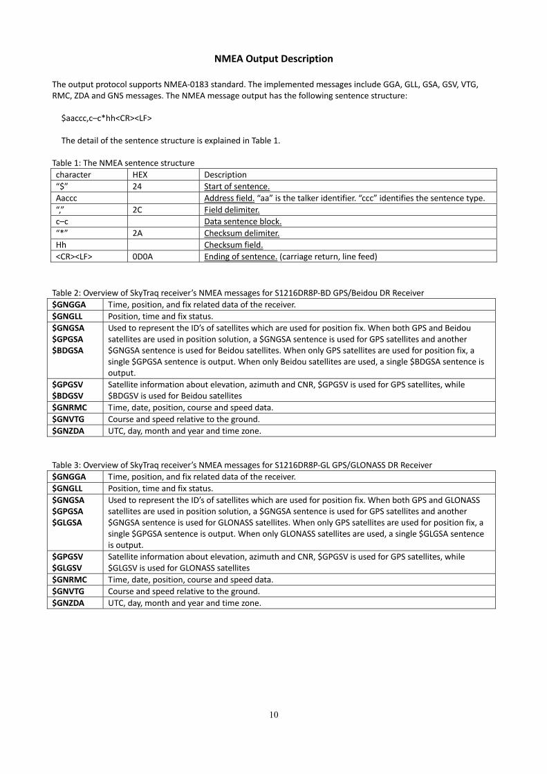
NMEA Output Description The output protocol supports NMEA‐0183 standard. The implemented messages include GGA, GLL, GSA, GSV, VTG, RMC, ZDA and GNS messages. The NMEA message output has the following sentence structure:
$aaccc,c–c*hh<CR><LF> The detail of the sentence structure is explained in Table 1.
Table 1: The NMEA sentence structure
character HEX Description
“$” 24 Start of sentence.
Aaccc Address field. “aa” is the talker identifier. “ccc” identifies the sentence type.
“,” 2C Field delimiter.
c–c Data sentence block.
“*” 2A Checksum delimiter.
Hh Checksum field.
<CR><LF> 0D0A Ending of sentence. (carriage return, line feed)
Table 2: Overview of SkyTraq receiver’s NMEA messages for S1216DR8P‐BD GPS/Beidou DR Receiver
$GNGGA Time, position, and fix related data of the receiver.
$GNGLL Position, time and fix status.
$GNGSA $GPGSA $BDGSA
Used to represent the ID’s of satellites which are used for position fix. When both GPS and Beidousatellites are used in position solution, a $GNGSA sentence is used for GPS satellites and another $GNGSA sentence is used for Beidou satellites. When only GPS satellites are used for position fix, a single $GPGSA sentence is output. When only Beidou satellites are used, a single $BDGSA sentence is output.
$GPGSV $BDGSV
Satellite information about elevation, azimuth and CNR, $GPGSV is used for GPS satellites, while $BDGSV is used for Beidou satellites
$GNRMC Time, date, position, course and speed data.
$GNVTG Course and speed relative to the ground.
$GNZDA UTC, day, month and year and time zone.
Table 3: Overview of SkyTraq receiver’s NMEA messages for S1216DR8P‐GL GPS/GLONASS DR Receiver
$GNGGA Time, position, and fix related data of the receiver.
$GNGLL Position, time and fix status.
$GNGSA $GPGSA $GLGSA
Used to represent the ID’s of satellites which are used for position fix. When both GPS and GLONASS satellites are used in position solution, a $GNGSA sentence is used for GPS satellites and another $GNGSA sentence is used for GLONASS satellites. When only GPS satellites are used for position fix, a single $GPGSA sentence is output. When only GLONASS satellites are used, a single $GLGSA sentence is output.
$GPGSV $GLGSV
Satellite information about elevation, azimuth and CNR, $GPGSV is used for GPS satellites, while $GLGSV is used for GLONASS satellites
$GNRMC Time, date, position, course and speed data.
$GNVTG Course and speed relative to the ground.
$GNZDA UTC, day, month and year and time zone.

11
The formats of the supported NMEA messages are described as follows:
GGA - Global Positioning System Fix Data Time, position and fix related data for a GPS receiver. Structure: $GPGGA,hhmmss.sss,ddmm.mmmm,a,dddmm.mmmm,a,x,xx,x.x,x.x,M,,,,xxxx*hh<CR><LF>
1 2 3 4 5 6 7 8 9 10 11
Example: $GPGGA,111636.932,2447.0949,N,12100.5223,E,1,11,0.8,118.2,M,,,,0000*02<CR><LF> Field Name Example Description 1 UTC Time 111636.932 UTC of position in hhmmss.sss format, (000000.000 ~ 235959.999) 2 Latitude 2447.0949 Latitude in ddmm.mmmm format
Leading zeros transmitted 3 N/S Indicator N Latitude hemisphere indicator, ‘N’ = North, ‘S’ = South 4 Longitude 12100.5223 Longitude in dddmm.mmmm format
Leading zeros transmitted 5 E/W Indicator E Longitude hemisphere indicator, 'E' = East, 'W' = West 6 GPS quality
indicator
1 GPS quality indicator 0: position fix unavailable 1: valid position fix, SPS mode 2: valid position fix, differential GPS mode 3: GPS PPS Mode, fix valid 4: Real Time Kinematic. System used in RTK mode with fixed integers5: Float RTK. Satellite system used in RTK mode. Floating integers 6: Estimated (dead reckoning) Mode 7: Manual Input Mode 8: Simulator Mode
7 Satellites Used 11 Number of satellites in use, (00 ~ 28) 8 HDOP 0.8 Horizontal dilution of precision, (00.0 ~ 99.9) 9 Altitude 108.2 mean sea level (geoid), (-9999.9 ~ 17999.9) 10 DGPS Station ID 0000 Differential reference station ID, 0000 ~ 1023
NULL when DGPS not used 11 Checksum 02

12
GLL – Latitude/Longitude Latitude and longitude of current position, time, and status. Structure: $GPGLL,ddmm.mmmm,a,dddmm.mmmm,a,hhmmss.sss,A,a*hh<CR><LF> 1 2 3 4 5 6 7 8 Example: $GPGLL,2447.0944,N,12100.5213,E,112609.932,A,A*57<CR><LF> Field Name Example Description 1 Latitude 2447.0944 Latitude in ddmm.mmmm format
Leading zeros transmitted 2 N/S Indicator N Latitude hemisphere indicator
‘N’ = North ‘S’ = South
3 Longitude 12100.5213 Longitude in dddmm.mmmm format Leading zeros transmitted
4 E/W Indicator E Longitude hemisphere indicator 'E' = East 'W' = West
5 UTC Time 112609.932 UTC time in hhmmss.sss format (000000.000 ~ 235959.999)
6 Status A Status, ‘A’ = Data valid, ‘V’ = Data not valid 7 Mode Indicator A Mode indicator
‘N’ = Data not valid ‘A’ = Autonomous mode ‘D’ = Differential mode ‘E’ = Estimated (dead reckoning) mode ‘M’ = Manual input mode ‘S’ = Simulator mode
8 Checksum 57

13
GSA – GNSS DOP and Active Satellites GPS receiver operating mode, satellites used in the navigation solution reported by the GGA or GNS sentence and DOP values. Structure: $GPGSA,A,x,xx,xx,xx,xx,xx,xx,xx,xx,xx,xx,xx,xx,x.x,x.x,x.x*hh<CR><LF>
1 2 3 3 3 3 3 3 3 3 3 3 3 3 4 5 6 7 Example: $GPGSA,A,3,05,12,21,22,30,09,18,06,14,01,31,,1.2,0.8,0.9*36<CR><LF> Field Name Example Description 1 Mode A Mode
‘M’ = Manual, forced to operate in 2D or 3D mode ‘A’ = Automatic, allowed to automatically switch 2D/3D
2 Mode 3 Fix type 1 = Fix not available 2 = 2D 3 = 3D
3 Satellite used 1~12 05,12,21,22,30,09,18,06,14,01,31,,
01 ~ 32 are for GPS; 33 ~ 64 are for WAAS (PRN minus 87); 65 ~ 96 are for GLONASS (64 plus slot numbers); 193 ~ 197 are for QZSS; 01 ~ 37 are for Beidou (BD PRN). GPS and Beidou satellites are differentiated by the GP and BD prefix. Maximally 12 satellites are included in each GSA sentence.
4 PDOP 1.2 Position dilution of precision (00.0 to 99.9) 5 HDOP 0.8 Horizontal dilution of precision (00.0 to 99.9) 6 VDOP 0.9 Vertical dilution of precision (00.0 to 99.9) 7 Checksum 36

14
GSV – GNSS Satellites in View Number of satellites (SV) in view, satellite ID numbers, elevation, azimuth, and SNR value. Four satellites maximum per transmission. Structure: $GPGSV,x,x,xx,xx,xx,xxx,xx,…,xx,xx,xxx,xx *hh<CR><LF> 1 2 3 4 5 6 7 4 5 6 7 8 Example: $GPGSV,3,1,12,05,54,069,45,12,44,061,44,21,07,184,46,22,78,289,47*72<CR><LF> $GPGSV,3,2,12,30,65,118,45,09,12,047,37,18,62,157,47,06,08,144,45*7C<CR><LF> $GPGSV,3,3,12,14,39,330,42,01,06,299,38,31,30,256,44,32,36,320,47*7B<CR><LF> Field Name Example Description 1 Number of message 3 Total number of GSV messages to be transmitted (1-5) 2 Sequence number 1 Sequence number of current GSV message 3 Satellites in view 12 Total number of satellites in view (00 ~ 20) 4 Satellite ID 05 01 ~ 32 are for GPS; 33 ~ 64 are for WAAS (PRN minus
87); 65 ~ 96 are for GLONASS (64 plus slot numbers); 193 ~ 197 are for QZSS; 01 ~ 37 are for Beidou (BD PRN). GPS and Beidou satellites are differentiated by the GP and BD prefix. Maximally 4 satellites are included in each GSV sentence.
5 Elevation 54 Satellite elevation in degrees, (00 ~ 90) 6 Azimuth 069 Satellite azimuth angle in degrees, (000 ~ 359 ) 7 SNR 45 C/No in dB (00 ~ 99)
Null when not tracking 8 Checksum 72

15
RMC – Recommended Minimum Specific GNSS Data Time, date, position, course and speed data provided by a GNSS navigation receiver. Structure: $GPRMC,hhmmss.sss,A,dddmm.mmmm,a,dddmm.mmmm,a,x.x,x.x,ddmmyy,,,a*hh<CR><LF> 1 2 3 4 5 6 7 8 9 10 11 Example: $GPRMC,111636.932,A,2447.0949,N,12100.5223,E,000.0,000.0,030407,,,A*61<CR><LF> Field Name Example Description 1 UTC time 0111636.932 UTC time in hhmmss.sss format (000000.000 ~
235959.999) 2 Status A Status
‘V’ = Navigation receiver warning ‘A’ = Data Valid
3 Latitude 2447.0949 Latitude in dddmm.mmmm format Leading zeros transmitted
4 N/S indicator N Latitude hemisphere indicator ‘N’ = North ‘S’ = South
5 Longitude 12100.5223 Longitude in dddmm.mmmm format Leading zeros transmitted
6 E/W Indicator E Longitude hemisphere indicator 'E' = East 'W' = West
7 Speed over ground 000.0 Speed over ground in knots (000.0 ~ 999.9) 8 Course over ground 000.0 Course over ground in degrees (000.0 ~ 359.9) 9 UTC Date 030407 UTC date of position fix, ddmmyy format 10 Mode indicator A Mode indicator
‘N’ = Data not valid ‘A’ = Autonomous mode ‘D’ = Differential mode ‘E’ = Estimated (dead reckoning) mode ‘M’ = Manual input mode ‘S’ = Simulator mode
11 checksum 61
16
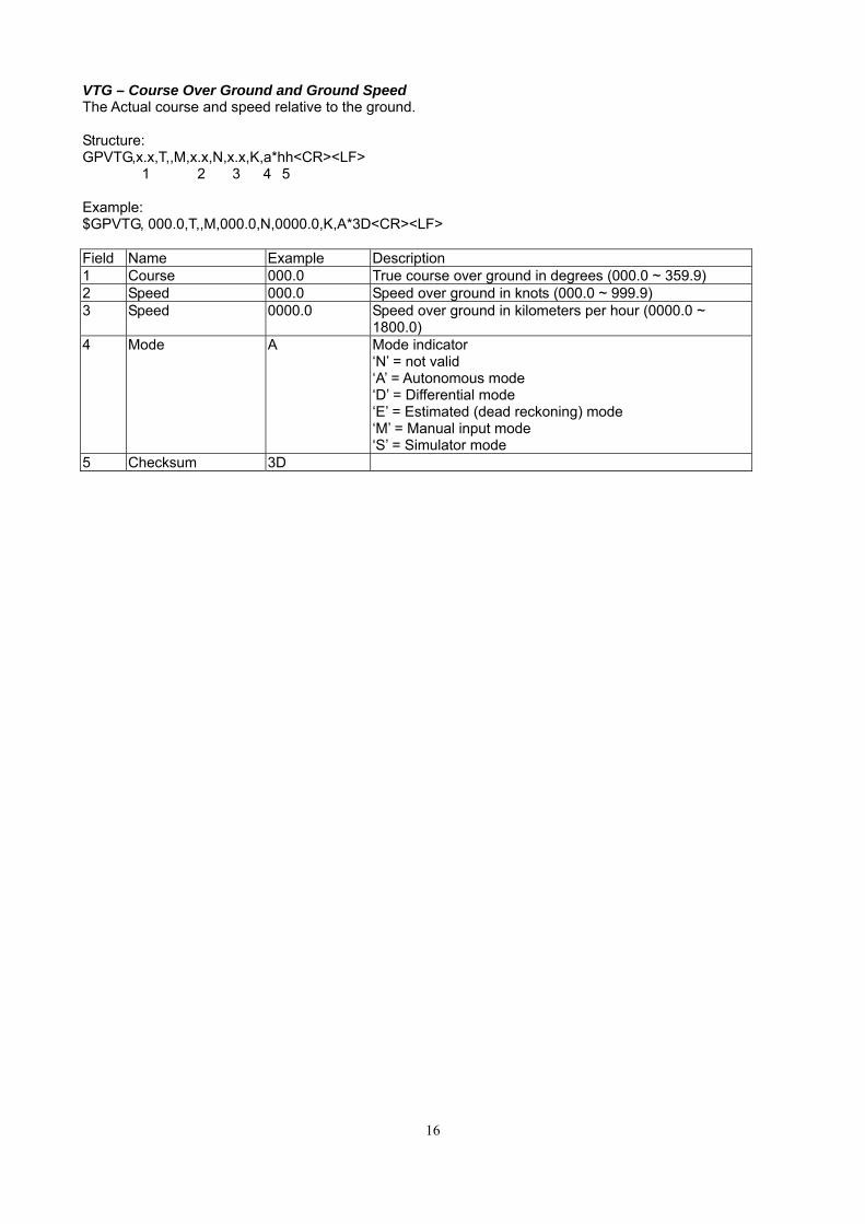
VTG – Course Over Ground and Ground Speed The Actual course and speed relative to the ground. Structure: GPVTG,x.x,T,,M,x.x,N,x.x,K,a*hh<CR><LF> 1 2 3 4 5 Example: $GPVTG, 000.0,T,,M,000.0,N,0000.0,K,A*3D<CR><LF> Field Name Example Description 1 Course 000.0 True course over ground in degrees (000.0 ~ 359.9) 2 Speed 000.0 Speed over ground in knots (000.0 ~ 999.9) 3 Speed 0000.0 Speed over ground in kilometers per hour (0000.0 ~
1800.0) 4 Mode A Mode indicator
‘N’ = not valid ‘A’ = Autonomous mode ‘D’ = Differential mode ‘E’ = Estimated (dead reckoning) mode ‘M’ = Manual input mode ‘S’ = Simulator mode
5 Checksum 3D

17
STI,20 Dead Reckoning Status message
Structure: PSTI,xx,x,x,x,xx,x,x,x,xxx.xx,xx.xx,xx.xx,x.xx*xx<CR><LF> 1 2 3 4 5 6 7 8 9 10 11 12 13 Example: $PSTI,20,1,1,1,32,A,0,1,821.95,20.73,-13.45,6.63*40<CR><LF>
Field
No.
Example Format Unit Description
1 20 numeric - Proprietary message identifier: 20
2 1 numeric - DR Calibration Status
1: calibrated
0: not calibrated
3 1 numeric - Gyro Calibrate Status
1: calibrated
0: not calibrated
4 1 numeric - Sensor input available
1: available
0: not available
5 32 numeric Pulse ADR: odometer pulse count
ODR: 0
6 A character - Position Mode indicator:
A=GPS fix,
N = Data not valid,
E = Estimated(dead reckoning) mode
7 0 numeric - Backward Status
ADR 1: activated, moving backward
0: normal, moving forward
ODR 0
8 1 numeric - Antenna detection (Reserved)
1: antenna available
0: antenna not available
9 821.95 numeric 0.002V Z-axis gyro bias
10 20.73 numeric cm/pulse ADR: odometer scaling factor
ODR: 100
11 -13.45 numeric Deg/sec Z-axis rotation rate
12 6.63 numeric m ADR: distance moved per second
ODR: 0
13 40 hexadecimal - Checksum

18
ORDERING INFORMATION Model Name Description
S1216DR8P‐BD GPS/Beidou Dead Reckoning Receiver Module, with pressure sensor
S1216DR8NP‐BD GPS/Beidou Dead Reckoning Receiver Module, without pressure sensor
S1216DR8P‐GL GPS/GLONASS Dead Reckoning Receiver Module, with pressure sensor
S1216DR8NP‐GL GPS/GLONASS Dead Reckoning Receiver Module, without pressure sensor
The information provided is believed to be accurate and reliable. These materials are provided to customers and may be used for informational purposes only. No responsibility is assumed for errors or omissions in these materials, or for its use. Changes to specification can occur at any time without notice. These materials are provides “as is” without warranty of any kind, either expressed or implied, relating to sale and/or use including liability or warranties relating to fitness for a particular purpose, consequential or incidental damages, merchantability, or infringement of any patent, copyright or other intellectual property right. No warrant on the accuracy or completeness of the information, text, graphics or other items contained within these materials. No liability assumed for any special, indirect, incidental, or consequential damages, including without limitation, lost revenues or lost profits, which may result from the use of these materials. The product is not intended for use in medical, life‐support devices, or applications involving potential risk of death, personal injury, or severe property damage in case of failure of the product.

19
Change Log
Version 0.2, February 5, 2018
1. Updated STI,20
Version 0.1, January 31, 2018
1. Initial release