summary hanges to the - bpa.gov
TRANSCRIPT

Salem-Albany Transmission Line Rebuild Project 1 Final Environmental Assessment
Salem-Albany Transmission Line Rebuild Project Final Environmental Assessment
Bonneville Power Administration
DOE/EA-1946 December 2014
SUMMARY
Bonneville Power Administration (BPA) is proposing to rebuild two of its 115-kilovolt (kV) transmission lines that run between Salem and Albany, Oregon (see Figure 1-1 in the Draft EA). In July 2014, BPA issued a draft Environmental Assessment (EA) for the project, which describes the project, the potential environmental impacts of the project, and mitigation measures to reduce impacts. This document provides changes made to the text of the draft EA, as well as the comments received on the draft EA and BPA’s responses to those comments. The draft EA, with the addition of these changes and the response to comments, constitutes the final EA. The draft EA is available on the project webpage at www.bpa.gov/goto/SalemAlbanyRebuild or by calling 1-800-622-4520.
CHANGES TO THE EA
A number of changes were made to the draft EA and are presented below by the chapter and section in which they appeared in the draft EA. The majority of the changes are related to the results of the 2014 spring and summer field surveys for special-status species, revisions to the number and locations of trees that would be removed, revisions to the number and location of culverts requiring fish passage, and updates to mitigation measures. Where text has been modified, deleted text is indicated as “strikethrough” format and new text is underlined.
CHANGES TO CHAPTER 2—PROPOSED ACTION AND ALTERNATIVES
2.1 PROPOSED ACTION
Table 2-2 on page 2-4 has been revised as follows:
Table 2-2. Proposed Action Activities
Proposed Activity Salem-Albany No. 1 Salem-Albany No. 2 Total
Structure Replacement
Replacement with wood structures 162 301 463
Replacement with steel monopoles 75 0 75
Total structures to be replaced 237 301 538
Structures moved from existing location (number) 83 3 86
Structures with guy wires (number) 52 47 99

2 Bonneville Power Administration DOE/EA-1946
Table 2-2. Proposed Action Activities
Proposed Activity Salem-Albany No. 1 Salem-Albany No. 2 Total
Easement Acquisition
Acquire easements for existing roads (miles) 3 9 12
Acquire easements for new construction roads (miles)
3 4 7
Acquire easements for routes of travel (miles) 2 3 5
Total new easements 8 16 24
Access Road Work
Improvements (miles)1 5 6 12 13 17 19
New construction (miles) 8 6 7 14 15
Reconstruction (miles)2 1 1 2
Route of travel (miles) 7 6 24 22 31 28
Total access road work (miles) 21 43 64
New or improved stream fords (number) 1 3 4
New, repaired, or improved culverts, including cleaning (number)
30 23 50 45 80 68
New or replaced gates (number) 59 51 41 70 100 121
Vegetation Removal
Low-growing vegetation within the right-of-way As needed for construction
As needed for construction
See Vegetation (Section 3.3)
Trees to be removed for road construction (number) 10 5 15
Trees to be removed (for the line)Potential mature danger trees (danger trees) (number)
1,075 605 265 154 1,340 759
High brush to be removed (for the line) Instances of high brush (number)
610 615 160 155 770
Trees to be limbed or pruned (for the line) (number) 30 10 40
Notes: 1 Improvements to existing access roads could involve light blading, excavating and reshaping ditches, installation or replacement of
drainage structures, and gravelling. 2 Reconstruction of existing roads could involve the same work as for road improvements (see Note 1), plus vegetation clearing from
the road bed, grading, reshaping or widening the road, slope stabilization, and placement of subsurface rock.
2.1.1 REPLACEMENT OF TRANSMISSION STRUCTURES
Wood-Pole Structures
The fourth paragraph on page 2-5 has been revised as follows:
The wood poles would be replaced in the same holes of the existing poles where possible and in new holes where the structures need to be moved ahead or behind the existing structures or closer to the center of the right-of-way. On the Salem-Albany No. 1 line, 83 structures would be replaced in slightly different locations (all within the right-of-way); on the Salem-Albany No. 2 line, three structures would

Salem-Albany Transmission Line Rebuild Project 3 Final Environmental Assessment
be replaced in slightly different locations (see Appendix A for a list of structure replacement types and locations relative to existing structure locations).
Steel Monopole Structures
The first paragraph in this subsection (page 2-7) has been revised as follows:
Along the Salem-Albany No. 1 line, about 75 steel monopole structures would be used instead of wood-pole structures (see Figure 2-3) where the line is set off center within the right-of-way—parallel to the BNSF railroad and through a North Albany residential area due to safety concerns.
2.1.4 ACCESS ROADS
The third paragraph in this section (page 2-12) has been revised as follows:
Access road improvements fall into the following categories (also see Table 2-2):
New construction - A total of 15 14 miles of new permanent access roads would be constructed, including 8 miles for Salem-Albany No. 1 and 7 6 miles for Salem-Albany No. 2. New construction would involve clearing vegetation, grading and developing the road prism, installation of drainage structures (culverts, drain dips), and gravelling.
Reconstruction - About 2 miles of existing roads would be reconstructed, one for each of the transmission lines. Reconstruction of existing roads could involve removal of vegetation, grading (to reshape or widen the road, ditches), slope stabilization, installation or replacement of drainage structures, placement of subsurface rock, and gravelling.
Improvements – About 19 17 miles of existing roads would be improved, including 6 5 miles for Salem-Albany No. 1 and 13 12 miles for Salem-Albany No. 2. Improvements to existing access roads could involve light blading, reshaping ditches, installation or replacement of drainage structures, and gravelling.
Routes of Travel - About 28 31 miles of travel routes have been identified, including 6 7 miles for Salem-Albany No. 1 and 22 24 miles for Salem-Albany No. 2. Routes of travel are typically routes to towers in the middle of farm fields where no permanent access is developed. Trucks and crews access the tower by driving over the unimproved field surface. If the field is too wet to drive construction vehicles, it is possible that temporary roads would need to be installed the along a travel route. Temporary roads would be installed with removable wetland mats or by laying geotextile fabric and topping with gravel. The temporary road would be removed following construction and the land would be restored to preconstruction conditions.
Fords, Culverts, and Gates
The second paragraph in this subsection (page 2-13) has been revised as follows:
Twenty-three new Thirty culverts for access roads to the Salem-Albany No. 1 line and 50 45 for the Salem-Albany No. 2 line would be installed, repaired, or cleaned. Culvert work that would occur in fish-bearing streams is discussed in Section 3.4, Fish and Wildlife.
A total of 100 121 gates would be installed or repaired at the entrance to access roads to help restrict unauthorized use or continue a fence to keep livestock contained; 59 51 gates for Salem-Albany No. 1 and 41 70 gates for Salem-Albany No. 2. The need for gate locks would be determined in coordination with the underlying landowners.
4 Bonneville Power Administration DOE/EA-1946
2.1.5 VEGETATION REMOVAL AND PLANTING
The second and third paragraphs of this section (pages 2-14 through 2-15) have been revised as follows:
About 78 acres of grasses, low-shrubs, small saplings, and agricultural crops would be disturbed or cleared for construction activities. About 15 trees would be removed for road construction and about 759 mature 1,380 trees (including both trees inside and outside the right-of-way) and 770 instances of high brush (saplings both inside and outside the right-of-way) along the transmission line rights-of-way have been identified as potential hazards and could be cut, limbed, or topped to prevent electrical flash-overs (BPA 2014a). The list of identified trees presenting a potential hazard to the line will be further analyzed regarding the appropriate treatment (limbed, cut, or topped) these results will be presented in the Final EA.
Danger trees are trees located outside of the transmission line rights-of-way that have the potential to fall or grow too close to the conductor (either when at rest or when swinging as a result of winds) and cause flash-overs or electrical outages. Identifying danger trees includes determining the type of tree, tree height and growth potential, how the tree leans, stability and health (e.g., root pathogen damage), and whether they are located in areas with severe storm damage potential. Although much of the transmission lines cross agricultural fields where there are no threats of danger trees, they also pass through areas of adjacent woodlands or trees lining the edge of fields where danger trees are often identified. Potential danger trees are visible on both sides of the right-of-way in Figure 2-9. Because danger trees have not been removed along the Salem-Albany lines in at least 10 years, they were identified for removal as part of the Proposed Action. In addition, trees remain inside the right-of-way that have been identified as a threat due to proximity to the line. Of the total trees identified as presenting a hazard and marked for removal, 605 1,075 occur along the Salem-Albany No. 1 line and 154 265 along the Salem-Albany No. 2 line. Thirty trees along the Salem-Albany No. 1 line and 10 along the Salem-Albany No. 2 line would be limbed or pruned instead of being removed. Cut trees and limbs could be left in place and the debris scattered or removed depending on the quantity of trees in one given location and the landowner’s preference. At the request of the landowner, the cut trees and debris could be removed. In areas where homes are not immediately adjacent to the danger trees that would be removed, most cut trees would be left in place. Trees Danger trees cut along the railroad right-of-way (structures SA1:9/9 to 17/13) would be removed from the site. An excavator could be used to grub out some of the smaller shrubs growing in the road area. Large mowers or brush cutters (e.g., brush hogs) could also be used to remove vegetation. Any trees or larger limbs growing into the roadway would be cut manually with a chainsaw.

Salem-Albany Transmission Line Rebuild Project 5 Final Environmental Assessment
2.3 COMPARISON OF ALTERNATIVES
Portions of Table 2-4 (page 2-20) have been revised as follows:
Table 2-4. Summary of Impacts of the Proposed Action and No Action Alternative to Environmental Resources
Environmental Resource Proposed Action No Action Alternative
Vegetation
Direct impacts from removal of or disturbance, including crushing vegetation, damage to plant roots from compaction of soils by heavy equipment, and soil disturbance. Long-term loss of vegetation from the relocation of structures, construction of new roads, and danger tree removal. Indirect impacts from the introduction and spread of noxious weed species and disturbance to plant communities from erosion and sedimentation.
Direct impacts to ODFW strategy habitats (grasslands, Oregon white oak woodlands, riparian areas, and wetlands).
Direct impacts to special-status species (thin leaved peavine and meadow checker-mallow) from construction activities. Indirect impacts from habitat loss.
Trees presenting a hazard to the line Danger trees would still be removed. Damage to vegetation from heavy maintenance vehicles needed for repairs could occur over a larger area as drivers follow the most accessible routes to the line during different seasons and from year to year, particularly during wet weather when access is more difficult. Soil compaction and exposure from driving heavy maintenance vehicles in the absence of adequate access roads could result in long-term impacts by facilitating the influx of invasive and noxious weeds and degrading the vegetative community.
Impacts to special-status species and ODFW strategy habitats would not be affected by new access roads, but could experience disturbance during intermittent repair activities.
Fish and Wildlife
Direct impacts from in-water work for ford crossings, stream bank stabilization, and culvert installations. Indirect impacts from changes to water quality from sediment entering streams or accidental hazardous spills from construction equipment.
Temporary displacement of wildlife during transmission line construction and disturbance of habitat. Construction of access roads and tree removal would lead to permanent impacts from loss of habitat, including migratory bird habitat and Oregon white oak woodland, wetland, riparian, and grassland habitats. Indirect impacts from noxious weed infestation of habitat.
Temporary impacts to special-status species (streaked horned lark, Chinook salmon, steelhead, and western pond turtle) from construction. Beneficial impacts to streaked horned lark nesting habitat from new road construction.
No road and drainage improvements would occur and failing culverts would not be replaced. Fish habitat would experience increased turbidity in some areas and fish passage would potentially be limited. Repair access would be intermittent and unplanned, possibly occurring during high flow conditions or periods when Endangered Species Act (ESA)-listed species are present. Danger t Tree removal and subsequent reductions in stream shading would still occur.
Temporary impacts to special-status species from intermittent repair activities. No beneficial impacts to streaked horned lark from construction of new roads.
Downed power lines could create electrocution risk for wildlife or result in wildfire.
6 Bonneville Power Administration DOE/EA-1946
CHANGES TO CHAPTER 3—AFFECTED ENVIRONMENT, ENVIRONMENTAL
CONSEQUENCES, AND MITIGATION MEASURES
3.1 LAND USE, RECREATION, HABITAT CONSERVATION, AND
TRANSPORTATION
3.1.1 AFFECTED ENVIRONMENT
Transportation
The following paragraph has been added to this subsection (page 3-7):
Freight railroads are currently crossed thirteen times by both lines: five crossings by the Salem-Albany No. 1 line, and eight crossings by the Salem-Albany No. 2 line. Railroads crossed are the Southern Pacific Railroad (eight crossings), the Valley and Siletz Railroad (one crossing), the Portland Western Railroad (one crossing), and the Oregon Electric Railroad (three crossings). In addition, the Salem-Albany No. 1 line parallels the Portland and Western Railroad (owned by Burlington Northern-Santa Fe [BNSF] Railroad) for about 8 miles, and the Southern Pacific Railroad for about 0.5 mile.
3.1.2 ENVIRONMENTAL CONSEQUENCES–PROPOSED ACTION
Recreation and Habitat Conservation
The first paragraph on page 3-11 has been revised as follows:
Although the effects during construction would be inconsistent with the Minto-Brown Island Park Revised Master Plan’s philosophy of preserving the park’s pastoral and rural qualities and preserving natural habitat (City of Salem 1995; see Section 3.1.1), the impact would be low since it would cease at the end of the construction season. The permanent road that would be constructed to access structures SA1:2/2 to 2/5 within Minto-Brown Island Park would be utilized for operation and maintenance, but would not impact park visitors or land use because it would be contained within BPA’s existing right-of-way and would be hidden from view from the rest of the park by forested vegetation. The road would, however, alter wetland habitat in this area. In addition, tree habitat would be affected since approximately 43 danger trees have been identified as potential hazards in this same area, which is bounded on both sides by a large woodland. Impacts to natural habitat preservation at the park would be low-to-moderate since wetland and woodland habitat are available adjacent to the right-of-way and in other areas of the park.
Transportation
The third paragraph of this subsection (page 3-13) has been revised as follows:
Removal of old conductors and stringing of new conductors could also affect train service at the 13 transmission line/railroad crossings. BPA would coordinate with railroads to schedule work at railroad crossings to avoid interrupting train service. In addition, two Two structures located in close proximity (10 feet) to the railroad right-of-way would be removed under the Proposed Action. These structures are located at SA1:3/4 and SA1:9/8. When removing these structures, and when removing and replacing the conductor where the transmission line parallels is adjacent to the railroad right-of-way,

Salem-Albany Transmission Line Rebuild Project 7 Final Environmental Assessment
construction crews may need to work within close proximity to the train tracks. Because BPA would coordinate with the railroad to ensure all necessary safety measures are followed, the appropriate permits are obtained, that and construction activities closest to the railroads do not take place at the same time that trains are scheduled to pass through as much as possible. In addition, because the transmission lines and railroad crossings are existing, there would be no long-term effects to the railroads except to improve safety by moving structures further from the railroad at SA1:3/4 and 9/8. Because any potential disruptions to train service would be temporary and minimized by scheduling construction activities to work around train schedules, the right-of-way, there would be no-to-low impacts to rail transportation along the railroad right-of-way during construction.
3.1.3 MITIGATION—PROPOSED ACTION
Mitigation measures have been added and updated (page 3-13), as follows:
Coordinate with managers at Minto-Brown Island Park, E.E. Wilson Wildlife Area, Sydney Landing, Bowers Rock State Park, and Ankeny National Wildlife Refuge regarding seed mixes to be used for revegetation of disturbed areas on or adjacent to these areas to support habitat conservation efforts.
To the extent possible, avoid construction at E. E. Wilson Wildlife Area during the September 1 through October 31 hunting season.
Remove all tree debris generated during vegetation removal from railroad right-of-way.
Communicate the proposed schedule of construction activities to Ankeny NWR personnel and post a notice at the Refuge, if requested by Ankeny NWR personnel, so landowners and visitors would know when they can expect to experience construction-related disruptions.
Coordinate with Ankeny NWR on use of Refuge access roads for tree removal to avoid road damage during the rainy season.
3.2 GEOLOGY AND SOILS
3.2.2 ENVIRONMENTAL CONSEQUENCES – PROPOSED ACTION
Structure and Transmission Line Replacement
The fourth paragraph of this subsection (page 3-17 through 3-18) has been revised as follows:
The wood-pole structures would be treated with a wood preservative called pentachlorophenol (PCP) that is commonly used for treatment of utility poles. PCP contains chlorinated dibenzodoxins and chlorinated dibenzofurans that have the potential to leach into soils or water (if the wood pole is in contact with water, such as wetlands). PCP can move through the pole and leach from the bottom of the pole into the soil near the underground portion of the pole (EPA 2008). PCP tends to move through the pole rapidly for the first few years of use, and then becomes relatively constant with time, has a tendency to rapidly degrade in the environment, and concentrations decrease rapidly with distance from the wood. PCP concentrations decrease by as much as two orders of magnitude between 3 and 8 inches from the wood pole, but that migration is dependent upon localized factors such as soil type, soil chemistry, local weather and topography, initial level of pole treatment, and the age of the pole (Electrical Power Research Institute 1995). In wetlands, some wooden structures would be placed inside corrugated metal pipes, which would may help to contain PCPs and prevent them from leaching into

8 Bonneville Power Administration DOE/EA-1946
surrounding soils. Because PCP does not tend to travel far from the structure and , it generally degrades rapidly in the environment, and in some areas where leaching potential is higher, structures would be placed in pipes, potential soil contamination impacts from the Proposed Action would be low (also see Section 3.6, Wetlands and Floodplains).
3.3 VEGETATION
3.3.1 AFFECTED ENVIRONMENT
Vegetation Communities
The second paragraph of this section (second bullet at the top of page 3-21) has been revised as follows:
Riparian and wetland communities, including those dominated by black hawthorn (Crataegus douglasii) riparian communities along ditches and field drainages, cottonwood (Populus spp.) and willow (Salix spp.) riparian woodlands along streams and rivers species, as well as herbaceous wetlands dominated by invasive reed canary grass. These types are traversed by about 21 percent of the rights-of-way. (Field delineated wetlands are discussed in Section 3.6, Wetlands and Floodplains). For the Final EA, the impacts to these vegetation types were updated to include delineated wetlands and aerial photograph interpretation of remaining areas characterized by GIS data as riparian and wetland. This analysis is provided in Section 3.3.2.
Strategy Habitats
The first paragraph of this section (starting bottom of page 3-23) has been revised as follows:
The Oregon Conservation Strategy describes strategy habitats, which are managed with a priority for conservation due to their importance for ecological values and species conservation (ODFW 2006). Vegetative strategy habitats that occur within the affected area are grasslands (including grass-dominated upland prairie), oak woodlands, wetlands, and riparian woodland habitats, and freshwater aquatic habitats (rivers, streams, and ponds). For information about potentially affected aquatic habitats, see Sections 3.4 and 3.5.
Noxious Weeds
This subsection (page 3-24) has been revised as follows:
Noxious weeds are plant species designated by federal or state law. In Oregon, the Oregon Department of Agriculture (ODA) divides noxious weeds into three categories: A, B, and T. A-listed weeds are of known economic importance whose presence is imminent or which occur in the state in small enough infestations to make eradication or containment possible. B-listed weeds are of known economic importance and are regionally abundant, with control determined at the state, county, or regional level as needed on a case-by-case basis. T-listed weeds are priority noxious weeds designated by the Oregon State Weed Board as a targets for which the ODA develops and implements would develop and implement a statewide management plans (ODA 2010).
Noxious weeds noted during the vegetation reconnaissance survey conducted in winter 2014 included reed canarygrass (Phalaris arundinacea), poison hemlock (Conium maculatum), and Canada thistle (Cirsium arvense) (BPA 2014b). Weed surveys will also be were also conducted in the spring and summer of 2014 (BPA 2014e) and the results incorporated into the Final EA. and identified 27 noxious weed species in 2,564 distinct populations in the affected area. All 27 species are on the state B-list: 5 of

Salem-Albany Transmission Line Rebuild Project 9 Final Environmental Assessment
these are also on the T-list, including field bindweed (Convolvulus arvensis), reed canarygrass, tansy ragwort (Senecio jacobaea), spotted knapweed (Centaurea stoebe), and leafy spurge (Euphorbia esula). Noxious weeds were found in all habitats in the affected area, although unmanaged uplands had the greatest variety and density. In cultivated areas, noxious weeds were not prevalent except along fence rows, roadsides, and around transmission structures. The most common noxious weed in the affected area was Himalayan blackberry (Rubus armeniacus), followed by St. Johnswort (Hypericum perforatum), Canada thistle, and reed canarygrass. Himalayan blackberry was the most common weed in uncultivated upland meadows, while reed canarygrass was the most common weed in wetlands, often forming dense stands that excluded other species. Other of the more common weeds are listed below along with the number of populations found in the affected area:
Himalayan blackberry (Rubus armeniacus) (641 populations)
St. Johnswort (Hypericum perforatum) (393 populations)
Canada thistle (Cirsium arvense) (360 populations)
Reed canarygrass (Phalaris arundinacea) (307 populations) (T-list)
Bull thistle (Cirsium vulgare) (253 populations)
Scotch broom (Cytisus scoparius) (138 populations)
tansy ragwort (Senecio jacobaea) (129 populations) (T-list)
poison hemlock (Conium maculatum) (86 populations)
field bindweed (Convolvulus arvensis) (74 populations) (T-list)
perennial peavine (Lathyrus latifolius) (34 populations)
shiny leaf geranium (Geranium lucidum) (33 populations)
milk thistle (Silybum marianum) (26 populations)
false brome (Brachypodium sylvaticum) (25 populations)
meadow knapweed (Centaurea pratensis) (18 populations)
Special-Status Plants
The second paragraph of this subsection (page 3-25) has been revised as follows:
A special-status plant survey will be was conducted during spring and summer 2014 for the entire length of the existing project rights-of-way excluding cultivated areas, and along access roads located outside of the project rights-of-way (BPA 2014d). The results of the surveys are would be included in Table 3-4 of the Final EA. Table 3-4 shows the special status plant species that have potential to occur or have been found within habitat areas that will be were surveyed.
Salem-Albany Transmission Line Rebuild Project 10 Final Environmental Assessment
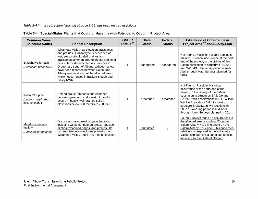
Table 3-4 in this subsection (starting at page 3-26) has been revised as follows:
Table 3-4. Special-Status Plants that Occur or Have the with Potential to Occur in Project Area
Common Name (Scientific Name) Habitat Description
ONHIC Status
Ɨa
State Status
Federal Status
Likelihood of Occurrence in Project Area
ǂb and Survey Plan
Bradshaw's lomatium
(Lomatium bradshawii)
Willamette Valley low elevation grasslands and prairies. Habitat type is described as wet, seasonally flooded prairies and grasslands common around creeks and small rivers. Most documented occurrences in Oregon are south of Albany, although a few have been recorded between Salem and Albany west and east of the affected area. Known occurrences in Baskett Slough and Finley NWR.
1 Endangered Endangered
Not Found .Possible; Suitable habitat is present, historical occurrence at the north end of the project, in the vicinity of the Salem substation to structures SA2:2/9 and SA1: 4/1. Flowering period is mid-April through May. Surveys planned for 2014.
Kincaid's lupine
(Lupinus sulphureus ssp. kincaidii )
Upland prairie remnants and ecotones between grassland and forest. It usually occurs in heavy, well-drained soils at elevations below 838 meters (2,750 feet).
1 Threatened Threatened
Not Found. Possible; Historical occurrence at the north end of the project, in the vicinity of the Salem substation to structures SA2: 2/9 and SA1:4/1; two observations in E.E. Wilson Wildlife Area about 0.8 mile west of structure SA2:21/1 in two locations in 2007.
2 Flowering period is mid-April
through June. Surveys planned in 2014.
Meadow checker-mallow
(Sidalcea campestris)
Occurs across a broad range of habitats including wetlands, riparian areas, roadside ditches, woodland edges, and prairies. Its current distribution includes primarily the Willamette Valley under 700 feet in elevation.
4 Candidatec -
Found: Surveys found 17 occurrences in the affected area, including 12 on the Salem-Albany No. 1 line and 5 on the Salem-Albany No. 2 line. This species is relatively widespread in the Willamette Valley, although it is a candidate species for listing by the State of Oregon.

Salem-Albany Transmission Line Rebuild Project 11 Final Environmental Assessment
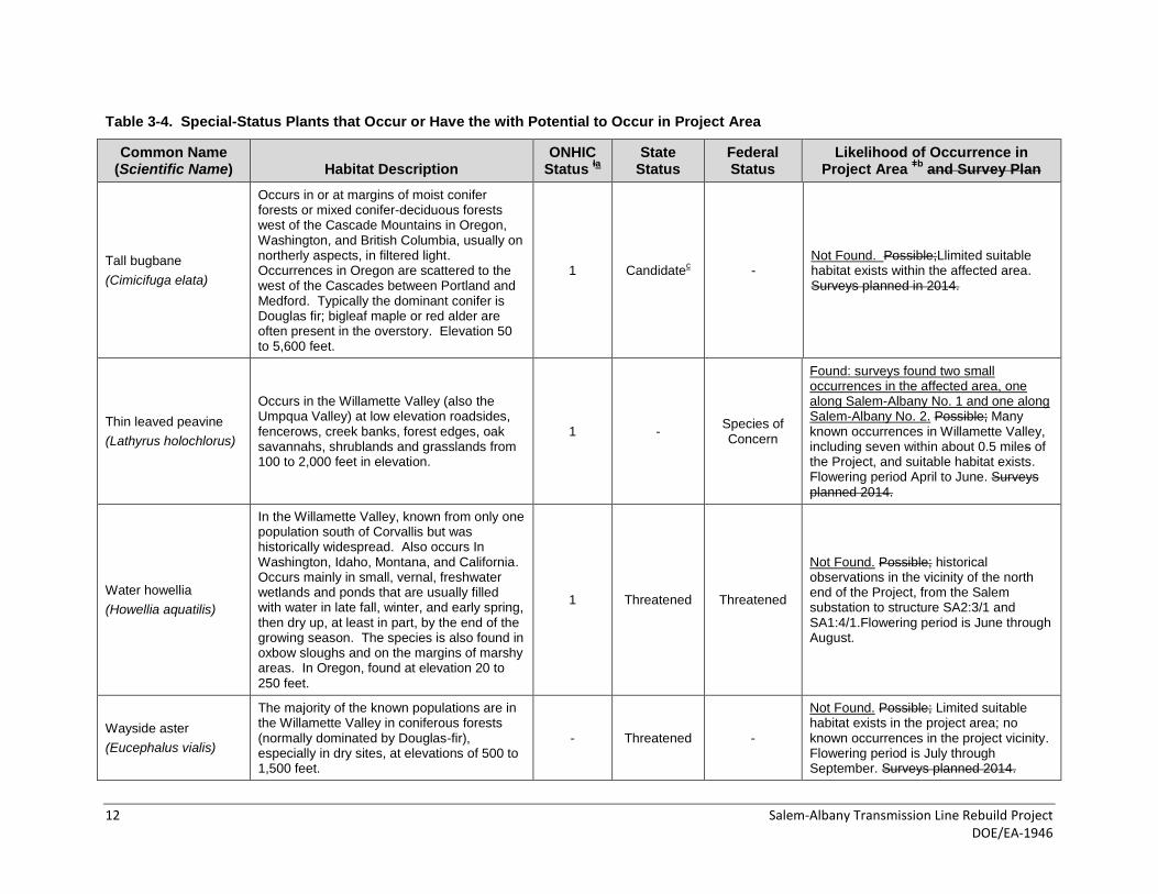
Table 3-4. Special-Status Plants that Occur or Have the with Potential to Occur in Project Area
Common Name (Scientific Name) Habitat Description
ONHIC Status
Ɨa
State Status
Federal Status
Likelihood of Occurrence in Project Area
ǂb and Survey Plan
Nelson’s checker-mallow
(Sidalcea nelsoniana)
Typically found in open prairie remnants along the margins of streams, sloughs, ditches, roadsides, fence rows, drainage swales, and in fallow fields west of the Cascade Mountains, in the Willamette Valley, and occasionally in the Coast Range and north to Lewis County, Washington. Found at sites with seasonally wet soils and within a hydrologic regime where reed canarygrass also thrives. Often found on heavy, poorly draining alluvial clays with hydric characteristics. Occasionally, the species occurs in the understory or at the edges of ash woodlands or among woody shrubs. Found at elevations from about 43 to 610 meters (140 to 2,000 feet).
2 Threatened Threatened
Found: surveys found an individual located on a stream bank along Salem-Albany No. 2. No other occurrences were found in the affected area. Possible A similar species (meadow checker-mallow) was noted during winter 2014 field visits, and plants have been observed at Ankeny NWR about 0.75 mile east of the affected area (USFWS Pers. Comm. 2014). Often occurs with reed canarygrass, which is abundant in wet areas in the rights-of-way. Four observations were recorded in an ephemeral wet area west of a fishing pond in E.E. Wilson Wildlife Area about 1 mile west of structure SA2:21/1 in four locations in 2007. There were also historical observations 0.1 to 2 miles east of structure SA2:11/1; however, this population is thought to be extirpated. Flowering period is May through September. Surveys planned in 2014.
Peacock larkspur*
(Delphinium pavonaceum)
Low, nearly flat areas in moist, silty soils of the Willamette River floodplain at elevations ranging from 45 to 120 meters (150 to 400 feet). It occurs in native wet prairies, on the edges of ash and oak woodlands, and along roadsides and fence rows.
1 Endangered Species of Concern
Not Found. Possible; Seven known occurrences of this species within about 1one mile of the affected area, including observations within Ankeny NWR. Flowering period is April through June. Surveys planned in 2014.
Shaggy horkelia
(Horkelia congesta ssp. Congesta)
Willamette Valley species that occurs in meadows and open woods at 150 to 2,100 feet in elevation. (Also endemic to the Umpqua Valley, Klamath Mountains ecoregion)
1 Candidate c
Species of Concern
Not Found. Possible. Not recorded within the affected area Project. Flowering period April to July.
12 Salem-Albany Transmission Line Rebuild Project DOE/EA-1946
Table 3-4. Special-Status Plants that Occur or Have the with Potential to Occur in Project Area
Common Name (Scientific Name) Habitat Description
ONHIC Status
Ɨa
State Status
Federal Status
Likelihood of Occurrence in Project Area
ǂb and Survey Plan
Tall bugbane
(Cimicifuga elata)
Occurs in or at margins of moist conifer forests or mixed conifer-deciduous forests west of the Cascade Mountains in Oregon, Washington, and British Columbia, usually on northerly aspects, in filtered light. Occurrences in Oregon are scattered to the west of the Cascades between Portland and Medford. Typically the dominant conifer is Douglas fir; bigleaf maple or red alder are often present in the overstory. Elevation 50 to 5,600 feet.
1 Candidatec -
Not Found. Possible;Llimited suitable habitat exists within the affected area. Surveys planned in 2014.
Thin leaved peavine
(Lathyrus holochlorus)
Occurs in the Willamette Valley (also the Umpqua Valley) at low elevation roadsides, fencerows, creek banks, forest edges, oak savannahs, shrublands and grasslands from 100 to 2,000 feet in elevation.
1 - Species of Concern
Found: surveys found two small occurrences in the affected area, one along Salem-Albany No. 1 and one along Salem-Albany No. 2. Possible; Many known occurrences in Willamette Valley, including seven within about 0.5 miles of the Project, and suitable habitat exists. Flowering period April to June. Surveys planned 2014.
Water howellia
(Howellia aquatilis)
In the Willamette Valley, known from only one population south of Corvallis but was historically widespread. Also occurs In Washington, Idaho, Montana, and California. Occurs mainly in small, vernal, freshwater wetlands and ponds that are usually filled with water in late fall, winter, and early spring, then dry up, at least in part, by the end of the growing season. The species is also found in oxbow sloughs and on the margins of marshy areas. In Oregon, found at elevation 20 to 250 feet.
1 Threatened Threatened
Not Found. Possible; historical observations in the vicinity of the north end of the Project, from the Salem substation to structure SA2:3/1 and SA1:4/1.Flowering period is June through August.
Wayside aster
(Eucephalus vialis)
The majority of the known populations are in the Willamette Valley in coniferous forests (normally dominated by Douglas-fir), especially in dry sites, at elevations of 500 to 1,500 feet.
- Threatened -
Not Found. Possible; Limited suitable habitat exists in the project area; no known occurrences in the project vicinity. Flowering period is July through September. Surveys planned 2014.

Salem-Albany Transmission Line Rebuild Project 13 Final Environmental Assessment
Table 3-4. Special-Status Plants that Occur or Have the with Potential to Occur in Project Area
Common Name (Scientific Name) Habitat Description
ONHIC Status
Ɨa
State Status
Federal Status
Likelihood of Occurrence in Project Area
ǂb and Survey Plan
White rock larkspur
(Delphinium leucophaeum)
Found on the edges of oak woodlands, in dry roadside ditches, on basalt cliffs, along riverbanks and bluffs, on moist rocky slopes, and in moist lowland meadows in the Willamette Valley and Lewis County, Washington. It inhabits loose, shallow soils along slopes ranging from horizontal plateaus to vertical cliffs, in open exposed areas to fairly deeply shaded spots 50 to 1,050 feet in elevation. Only known occurrences are near Portland.
1 Endangered Species of Concern
Not Found. Unlikely; Suitable habitat exists, but the species is extremely rare and is not known to occur in the Project vicinity; flowering period is May through June. Surveys planned 2014.
White-topped aster
(Sericocarpus rigidus)
Found in the Willamette Valley, western Washington, and British Columbia. Occurs in open, grassy, seasonally moist prairie and savannah habitats, at elevations ranging from about 100 to 750 feet.
1 Threatened Species of Concern
Not Found. Possible; Suitable habitat exists. Flowering period is late July through September. Surveys planned 2014.
Willamette Valley daisy
(Erigeron decumbens)
Endemic to the Willamette Valley. Inhabits both seasonally flooded bottomland prairies and well-drained upland prairies at elevations ranging from 100 to 1,100 feet.
1 Endangered Endangered
Not Found. Possible; Historical observations in the vicinity of the north end of the Project, from the Salem Substation to structure SA2:3/1 and SA1:4/1. Flowering period is July through early July. Surveys planned 2014.
Willamette Valley larkspur
(Delphinium oreganum)
At low elevations (150 to 1,400 feet) in Willamette Valley, is most commonly found in wet prairies with shrubby or Oregon ash overstory, also roadsides, fencerows, dry oak woodlands, open hillsides, and well-drained native prairies.
1 Candidatec -
Not Found. Possible; Suitable habitat occurs within the Project area; Flowering period May through July; surveys planned 2014.
Source: Oregon Flora Project 2011 unless otherwise noted. 1 ORBIC 2014, ODA 2013,
2 Hammond 2001-2010; USFWS 2006; USFWS 2013; BPA 2010c; BPA 2014b).
aƗ ONHIC rankings: 1. Taxa threatened with extinction or presumed extinct throughout entire range. 2. Taxa threatened with extirpation or presumed extirpated from Oregon. 3. Taxa
needing more information before status is determined. 4. Taxa of conservation concern and requiring continued monitoring. ex – presumed extinct. bǂ Field surveys to determine presence of special-status plant species in the affected area were completed in the spring and summer of 2014.
c State candidate species are species considered for listing as a state threatened or endangered species.
Salem-Albany Transmission Line Rebuild Project 14 Final Environmental Assessment
3.3.2 ENVIRONMENTAL CONSEQUENCES – PROPOSED ACTION
General Vegetation
The last paragraph on page 3-31 and first two paragraphs on page 3-32 have been revised as follows:
The majority of vegetation impacted, outside of agricultural and residential lands, would be in herbaceous and shrub plant communities, both inside and outside the transmission line rights-of-way (a combined 23 percent of permanent impacts and 29 percent of temporary impacts; Table 3-6). The areas described by the Willamette Valley Land Cover dataset as riparian or wetland vegetation types were found to contain a combination of wetland and riparian areas and upland herbaceous or shrub vegetation based on aerial photography interpretation. After wetlands were field delineated, verified wetland areas were subtracted from the Draft EA estimate of riparian and wetland areas. Based on aerial photography interpretation, the remaining areas appear to contain herbaceous and shrub vegetation, occurring primarily at the edges of farm fields, roads, or the railroad right-of-way. would be in wetland plant communities (23 percent of permanent impacts and 17 percent of temporary impacts; Table 3-6). Impacts to wetland vegetation would permanently impact about 8 acres and temporarily impact about 13 acres, as further discussed in Section 3.6.2 (10 percent of permanent impacts and 7 percent of temporary impacts; Table 3-6). All wetland vegetation communities do not necessarily contain jurisdictional wetlands, which are addressed in Section 3.6. Impacts to jurisdictional wetlands would be mitigated through the purchase of mitigation banking credits.
Impacts to forest and woodland vegetation from rebuilding the lines and road work would be avoided to the extent practicable. Although construction of permanent project features would occur in existing right-of-way that goes through 1 acre of mixed upland forest and 5 acres of oak forest, and temporary ground clearing for project construction would occur in existing right-of-way that goes through 3 acres of oak forest and 1 acre of mixed forest, most of these activities would not involve tree clearing since activities associated with the transmission line rebuild would primarily be restricted to within the right-of-way (with the possible exception of tensioning sites and road work). Road construction would require removal of only about six Oregon white oak trees and nine conifer trees within these areas. Tree removal would affect approximately 759 1,340 trees and 770 instances of high brush or saplings identified as potential hazards to the transmission line, with the vast majority occurring along the Salem-Albany No. 1 line (605 danger 1,075 trees and 615 610 instances of high brush) (BPA 2014a). The majority of trees and high brush marked as potentially hazardous include cottonwoods (Populus spp.), big leaf maple (Acer macrophyllum), Oregon white oak (Quercus garryana), and Oregon ash (Fraxinus latifolia), Douglas-fir (Pseudotsuga menziesii), and noble fir (Abies procera) (BPA 2014a). Where possible, tree would be reduced as much as possible Forty trees originally identified for removal would instead be retained by limbing and topping trees while still maintaining the safety and security of roadways and the transmission lines.
Since tree removal would primarily occur along the edges of woodlands and upland forests and not impact entire communities, and removal would be minimized to the extent practicable, impacts to more common woodlands and upland forests would be low (danger tree removal in oak and riparian woodlands is discussed under Oregon Strategy Habitats in Section 3.3.2, and danger tree removal in riparian/wetland plant communities is discussed in Section 3.6.2).

Salem-Albany Transmission Line Rebuild Project 15 Final Environmental Assessment
Table 3-6 starting on page 3-32 has been revised as follows:
Table 3-6. Vegetation Community Impacts
Vegetation Communitya
Permanent Impacts (acres unless otherwise noted) Temporary Impacts (acres)
Herbaceous and Shrub (Currently maintained right-of-way, herbaceous and shrub vegetation (excluding agricultural crops))
8 35
Herbaceous and Shrub (Outside maintained right-of-way)
10 18
Agriculture
(much is within right-of-way)
Row crops: 5
Unmanaged pasture: 7
Annual and perennial grasses: 33
Total Agriculture: 45
Row crops: 12
Unmanaged pasture: 16
Annual and perennial grasses: 79
Total Agriculture: 107
Riparian and Wetland (with Black Hawthorn Riparian)
c
18 8 31 13
Oak Forest 5b 3
b
Upland Mixed Forest 1 b 1
b
Urban or Unvegetated 1 3
Total Impact Acreage 78 180
Potential Trees to be Cut (to be cut, limbed, or topped)
759 1,340 trees -
Trees to be Limbed or Pruned 40 trees -
Trees Removed for Road Work 15 trees -
Potential High Brushd (to be cut) 770 saplings or tree branches -
1Acreage data presented is this section is based on GIS vegetation data (Northwest Habitat Institute 2014), except where
otherwise noted. in combination with field verified wetland data. Impacts to jurisdictional wetlands are discussed in Section 3.6.2, Wetlands and Floodplains b Impacts in forested areas would involve specific tree removal, as listed at the bottom of this table. Acreages reported for impacts
represent areas of impact within these habitat types, but would not necessarily involve tree removal due to careful siting of project features by the road engineer and BPA’s forester. c Based on field verified wetland data collected for the Salem-Albany EA and wetland permit.
d High brush: Saplings or low-hanging branches presenting a potential hazard due to proximity to the transmission line.
Oregon Strategy Habitats
This subsection (page 3-33) has been revised as follows:
Oregon Strategy Habitats that would be affected by the project include oak woodlands, grasslands, wetlands, and riparian woodland habitats. Grassland strategy habitats are not anticipated to be affected because they are extremely rare in the affected environment. Impacts to wetlands and riparian habitats are further discussed in Section 3.6.2.
Potential impacts to oak woodlands would include road reconstruction, new road construction, and danger tree removal in Oregon white oak habitat or mixed hardwood habitat along both lines. Five Oregon white oak trees have been identified as needing removal for road work. A danger Tree

16 Bonneville Power Administration DOE/EA-1946
removal field surveys took place in May, and June, and October of 2014 and identified 66 Oregon white oak trees as potentially presenting a hazard to the line potential danger trees, including 61 on Salem-Albany No. 1 and 5 on Salem-Albany No. 2, primarily due to close proximity to the lines (BPA 2014a). Twenty-one instances of Oregon white oak saplings or low-hanging branches were also identified as potentially creating a hazard as high brush. The majority of marked Oregon white oak trees marked as potential danger trees or high brush occurred within Salem-Albany No. 1 line miles 3, 4, 5, 8, 13, 19, 21, and 22; and in Salem-Albany No. 1 line mile 3.
Impacts to Oregon white oak habitat would be minimized through specific tree selection by BPA’s forester and, where possible, BPA would top or trim Oregon white oak trees rather than completely removing them. This is often an option for oak trees and other hardwoods since they grow slowly and are less prone to wind damage. To further protect oak habitat, Oregon white oak trees that are adjacent to road work areas and would not need to be removed would be flagged to be protected. In addition, danger tree removal along transmission lines affects trees along a linear path, which results in the removal of individual trees rather than an entire woodland. Since woodlands adjacent to the transmission line would remain, and losses of mature trees would be reduced with the minimization measures stated above, impacts to Oregon white oak trees and woodlands would be expected to be moderate.
The permanent removal of 18 acres of herbaceous and shrub vegetation (including 8 acres inside the rights-of-way), primarily for access roads, and 53 acres of temporary disturbance (including 35 acres inside the rights-of-way) would include some impacts to ODFW strategy grasslands (including grass-dominated upland prairie) that occurs in small pockets in the project area (BPA 2014b). Impacts from disturbance would include the potential spread of noxious weeds in these plant communities. However, impacts would be isolated because very little high-quality grassland habitat (areas dominated by a diverse mix of native grasses and forbs) is found within the affected area, which has been highly disturbed by agricultural or residential land use and right-of-way vegetation maintenance. This is partially evidenced by the large number of noxious weed populations found in the affected area (see Section 3.3.2 of the Final EA). Special-status plant surveys conducted in 2014 did find numerous occurrences of meadow checker-mallow and an occurrence of thin-leaved peavine in upland or wetland habitat in or adjacent to the rights-of-way. These species are relatively tolerant of disturbed conditions: associated species included both native and exotic grasses, forbs, and shrubs. In addition, the habitats supporting these species were small, isolated areas typically surrounded by agriculture, pasture, or woodland habitat. However, their presence indicates that the right-of-way may provide some role in conserving these plant communities. Although the affected grasslands are already highly disturbed, the loss and temporary disturbance of these areas would have a low-to-moderate impact on ODFW strategy grasslands since grasslands have become relatively rare in the Willamette Valley. Impacts to strategy grasslands (including grass-dominated upland prairie) are expected to be low, because very little of this habitat type would be expected to be found within the maintained rights-of-way or the adjacent areas disturbed by agricultural or residential land use; plant surveys to be conducted in the spring and summer 2014, will help verify this assumption. Additional information regarding strategy habitats will be added to the Final EA based on plant surveys. Impacts to riparian habitats and wetlands are discussed in detail in Sections 3.4, Fish and Wildlife; 3.5, Water Resources; and 3.6, Wetlands and Floodplains, along with further mention of riparian areas.
Cottonwood and willow riparian woodlands could be affected by a small amount of tree and shrub removal where the transmission lines cross 25 streams and rivers (see Appendix B; also see Sections 3.4.2 and 3.5.2). BPA will continue to refine the number of trees proposed for removal near streams

Salem-Albany Transmission Line Rebuild Project 17 Final Environmental Assessment
prior to construction. Removal of trees and shrubs in these areas would further fragment the riparian woodland habitat along these waterways and reduce available riparian habitat. Impacts to vegetation in the riparian zone for the Proposed Action would primarily involve trees immediately adjacent to the transmission lines. Because impacts are localized with limited tree and shrub removal, impacts would be low-to-moderate.
Special-Status Plants
This subsection, starting on page 3-33, has been revised as follows:
Due to the currently managed or previously disturbed nature of the majority of vegetation potentially impacted by the Proposed Action, special-status plants that are most likely to be encountered, and impacted, are those that occur in disturbed areas. The species found during 2014 field surveys include Nelson’s checker-mallow, thin-leaved peavine, and meadow checker-mallow, which are all known to occur in disturbed environments such as roadsides or fence rows. Project activities that would are most likely to impact special-status plants are construction and reconstruction of access roads due to the larger area affected.
For all species discussed below, the known occurrences or relative likelihood of finding each species is assessed along with potential impact levels. Because of the disturbed and fragmented nature of the majority of potential habitat, the high density of weeds, and the rarity of these species, the likelihood of affecting a large number of individuals is small. If any populations are Populations that were identified through field surveys, they would be flagged in order to be avoided to the extent practicable, reducing the risk of impacts. If avoidance to a particular population would not be possible, BPA would work with USFWS to determine the necessary mitigation measures to reduce impacts to federally listed species, and coordinate with ODFW for state-listed species. Results of the field surveys will be reported in the Final EA. Potential impacts to those species are as follows:
Nelson’s checker-mallow is known to occur near the affected area and is found in roadside ditches, drainage swales, and in seasonally wet areas where reed canarygrass also thrives. All of these are areas that would be potentially impacted by construction activities associated with the Proposed Action. The likelihood of encountering this species is relatively greater than other special-status species given it’s tolerance for disturbance in an already disturbed environment and the amount of potential habitat affected. One individual was found growing in a stream bank below the ordinary high water mark in the Salem-Albany No. 2 right-of-way. It is located outside of any ground disturbing activities that would occur, and would be flagged to ensure that the plant is avoided by the Proposed Action. however, if found, large or numerous populations would not likely be found since it is a rare plant; therefore, with avoidance or other mitigation measures, impacts are anticipated to be no-to-moderate. With this avoidance measure, and since no other occurrences of this species were found, there would likely be no direct impacts to Nelson’s checker-mallow.
Peacock larkspur, thin leaved peavine, meadow checker-mallow, and Willamette Valley larkspur are known to occur near the affected area and are found along roadsides and in fence rows, which would be potentially impacted by construction activities associated with the Proposed Action. Seven known occurrences of peacock larkspur are within about one mile of the affected area, including observations within Ankeny NWR. There are many known occurrences of thin leaved peavine and meadow checker-mallow in the Willamette Valley, including seven and five, respectively, within about 0.5 miles of the affected area. Suitable habitat for Willamette Valley larkspur and meadow checker-mallow occurs within the affected

18 Bonneville Power Administration DOE/EA-1946
area. The likelihood of encountering these species is relatively greater than other special-status species given their occurrence along roadsides and fence rows and the amount of potential habitat affected.; however, with avoidance or other mitigation measures, impacts are anticipated to be no-to-moderate. While peacock larkspur and Willamette Valley larkspur were not found during project surveys, thin leaved peavine and meadow checker-mallow were found. One population of 10 individuals of thin leaved peavine was found in an upland area of the Salem-Albany No. 2 right-of-way; a second population of 7 individuals was found along the margins of a wetland in the Salem-Albany No. 1 right-of-way. Seventeen occurrences of meadow checker-mallow were found: two of these were in the same locations as the thin leaved peavine occurrences, the remaining 15 were found in eight locations along Salem-Albany No. 2 and five locations along Salem-Albany No. 1, in occurrences ranging from 1 to 75 individuals. Thirteen occurrences of the meadow checker-mallow and one of the thin leaved peavine would be marked with flagging and avoided; however, the remaining five occurrences of meadow checker-mallow and one of thin-leaved peavine would likely be impacted by four access road improvements, one new road, and construction disturbance due to their proximity to structures or roadbeds. Since the status of meadow checker-mallow is considered more stable than thin leaved peavine (Natureserve 2014), and since most occurrences would be avoided, the losses would be unlikely to have population level effects, and impacts would be low-to-moderate. Although only one documented occurrence of thin leaved peavine would be affected and the loss would be unlikely to have population level effects, this species is considered somewhat less stable (Natureserve 2014) and is a Species of Concern by USFWS; therefore, impacts would be moderate. There would be no impacts to peacock larkspur and Willamette Valley larkspur since these species were not found.
Water howellia is likely to occur in freshwater wetlands or ponds and on the margins of marshy areas, which are found within the affected area. Historical observations of this species were made in the vicinity of the north end of the affected area, from the Salem substation to structure SA2:3/1 and SA1:4/1. Although suitable habitat may occur, the likelihood of encountering this species is relatively less than other special-status species since known observations are historical, and any potential habitat in the affected area would primarily be in ditches. Accordingly, no individuals of water howellia were found during 2014 spring surveys. Because water howellia was not found during surveys, nor have has it been observed in recent history in the affected area, there would be no impacts to this species. With avoidance or other mitigation measures, impacts are anticipated to be no-to-low.
White rock larkspur is found in dry roadside ditches, which occur frequently within the affected area, however, the species is extremely rare and is not known to occur in the Proposed Action vicinity. The likelihood of encountering this species is relatively less than other special status species due to its rarity and lack of known occurrence. Accordingly, no white rock larkspur were found during 2014 springs surveys. Because white rock larkspur was not found, there would be no impacts to this species. ; impacts are anticipated to be no-to-low through avoidance.
The likelihood of encountering, and therefore impacting, species that are generally found in less disturbed areas, including Bradshaw’s lomatium, Kincaid’s lupine, shaggy horkelia, tall bugbane, wayside aster, white-topped aster, and Willamette Valley daisy, is no-to-low minimal due to the lack of undisturbed habitat. None of these species were found and therefore would experience no impacts from the Proposed Action. Any available potential habitat is fragmented and not likely to support large populations of these species, further reducing the potential for impacts.

Salem-Albany Transmission Line Rebuild Project 19 Final Environmental Assessment
Noxious Weeds
The second paragraph of this subsection (page 3-35) has been revised as follows:
Noxious weed surveys will be were completed in 2014: the results of this survey would serve as a reference for existing conditions prior to project construction. This information would be used to identify where infestations exist to treat them prior to construction and to identify where vehicle wash stations would be useful in reducing the risk of spreading seeds and propagules to uninfested locations. In addition, post-construction noxious weed surveys would be completed in order to determine if construction activities resulted in new infestations in the affected area, and these new infestations would be treated. Invasive weeds that establish in disturbed areas that are not listed as noxious weeds by the state would not be managed by BPA. Since noxious weeds are so widespread in the affected area, there is a risk of increasing their density or spreading them into any uninfested areas through ground disturbance; likewise, other invasive weeds could increase or spread as well. However, with the mitigation of survey and treatment of noxious weeds, the risk of spreading noxious or invasive weeds would be reduced, and impacts to native plant communities would be low-to-moderate.
3.3.3 MITIGATION – PROPOSED ACTION
The following mitigation measures were added or revised on page 3-35:
Clearly mark danger trees for removal and demarcate danger tree removal disturbance limits in oak habitat areas.
Flag the one Nelson’s checker-mallow population, the one population of thin leaved peavine that can be avoided, and the 13 populations of meadow checker-mallow that can be avoided in the affected area during construction to avoid disturbance to these special-status plants.
Monitor revegetated areas until approximately 70 percent cover is established.
Coordinate with managers at Minto-Brown Island Park, E.E. Wilson Wildlife Refuge, Sydney Landing, Bowers Rock State Park, and Ankeny National Wildlife Refuge regarding seed mixes to be used for revegetation of disturbed areas on or adjacent to these areas to support habitat conservation efforts.
Recontour the soils surface if needed to reestablish predisturbance conditions prior to reseeding.
Conduct a post-construction noxious weed survey; treat new noxious weed infestations any existing or new noxious weed or existing infestations that have spread beyond preconstruction survey areas.
Clean vehicles and other equipment that have been in weed infested areas at portable wash stations upon leaving the infested areas to prevent spreading weeds to uninfested areas (including the Ankeny NWR) during construction, as determined from the noxious weed survey. In addition, include portable wash stations to remove weed propagules at other strategic locations as needed.

20 Bonneville Power Administration DOE/EA-1946
3.4 FISH AND WILDLIFE
3.4.1 AFFECTED ENVIRONMENT
ODFW Wildlife Habitat Categories
The second paragraph (set of bullets) on page 3-38 has been revised as follows:
ODFW Category 2 (Essential and limited habitat)
Conservation areas
Hardwood/oak/Douglas fir 25-50
Hardwoods/oak (25-50% oak)
Oak (>75% oak)
Oak/hardwood riparian (<25% oak)
Oak/hardwood riparian (25-50% oak)
Upland critical habitat
Waterway (salmonid critical habitat)
Western pond turtle habitat
(Also see Section 3.3.1 for a discussion of Oregon strategy habitats in the affected area.)
Wildlife and Wildlife Habitats
Mammals
This subsection (page 3-42) has been revised as follows:
The affected area provides habitat for a variety of mammalian species (Table 3-10). Given the surrounding agricultural and urban setting, available habitat is limited. However, the public lands, woodlands along the rights-of-way, and sections of the rights-of-way themselves do provide some diversity and complexity in habitat structure not present within adjacent agricultural lands. In addition, the area provides daily migration corridors for wildlife, including Roosevelt elk, which have been documented at Ankeny and Basket Slough National Wildlife Refuge and adjacent woodlands (Taylor Pers. Comm. 2014; USFWS 2014c).
Special-Status Wildlife Species
Streaked Horned Lark
The first paragraph of this subsection (page 3-44) has been revised as follows:
The streaked horned lark was listed in 2013 under the federal ESA as a threatened species throughout is range and critical habitat was designated in the Willamette Valley (USFWS 2013). Critical habitat has been designated in the middle of Ankeny NWR, east of the Salem-Albany No.1 transmission line, with sightings of individuals and pairs by Ankeny NWR personnel (Selvaggio Pers. Comm. 2014). This sub-unit

Salem-Albany Transmission Line Rebuild Project 21 Final Environmental Assessment
on the Ankeny NWR is currently occupied and is consistently utilized by streaked horned larks (USFWS 2013b). Streaked horned larks have also been documented in the vicinity of Salem-Albany No.1 transmission line in the southern portion east of the line by Albany Road, and west of the line in the E.E. Wilson Management Area. The three documented occurrences outside of the Ankeny NWR are over 15 years old. Streaked horned lark surveys were carried out between May and July 2014 in potential habitat in the affected area (BPA 2014f). Surveyed potential habitat included areas located more than 100 yards from a line of trees, and generally fitting Altman (1999) description for nest sites and territories:
large expanses of herbaceous-dominated habitat (≥ 100 acres);
dominated by grasses (0–6 inches);
relatively high percent of bare ground (17 percent) for territories; and,
high percent cover of bare ground (31 percent) for nest sites.
Examples of survey areas include cultivated grass fields, moderate to heavily grazed pasture, fallow fields, roadside shoulders, Christmas tree farms with trees less than two-years old, and wetland mudflats. Over three survey periods, streaked horned lark were observed at eight locations along the Salem-Albany No. 2 right-of-way and access roads and none were observed along the Salem-Albany No. 1 right-of-way and access roads. In addition, surveys found that the suitability of habitat along individual transects changed throughout the season due to vegetation growth and agricultural harvest and planting activity: e.g., when crops were harvested, vegetation was removed and habitat became available. Streaked horned lark surveys are scheduled for spring 2014 in suitable habitat within the affected area. The survey results will be included in the Final EA.
Fender’s Blue Butterfly
This subsection (starting at the bottom of page 3-46) has been revised as follows:
Fender’s blue butterfly is listed as endangered under the ESA with designated critical habitat. Fender’s blue butterfly uses upland prairies, grasslands, and wet prairies. Known occurrences and designated critical habitats for these species do not occur with the affected area, nor were larval host plants identified within the existing transmission line rights-of-way in recent surveys (Hammond 2002-2010; USFWS 2006; USFWS 2013; BPA 2010c; BPA 2014b). The closest known invertebrate location to the affected area is a population of Fender’s blue butterfly at the Basket Slough NWR, located approximately five miles from the affected area (ORBIC 2013). The dispersal distance (distance a butterfly will travel to feed) of the Fender’s blue butterfly is 1.24 miles, making it highly unlikely that members of the Basket Slough NWR population would disperse into the affected area. That being said, there is a slight possibility that an undocumented population of Fender’s blue butterfly could occur on private property in the vicinity of the affected area. Fender’s blue butterfly requires Kincaid’s lupine to complete their lifecycle. Surveys for Kincaid’s lupine were conducted as part of the 2014 field surveys, but none were found, and there were no sightings of Fender’s blue butterfly (BPA 2014d). would be conducted in summer 2014 and the results of the rare plant surveys, including any sightings of Fender’s blue butterfly, will be included in the Final EA.

22 Bonneville Power Administration DOE/EA-1946
Western Pond Turtle and Western Painted Turtle
This subsection (page 3-47) has been revised as follows:
The western pond turtle has been identified as a federal species of concern and a state sensitive species. Factors limiting western pond turtles include the loss of aquatic and terrestrial habitat. In the Willamette Valley, western pond turtles are most abundant south of Salem, which is outside of the affected area. Within the affected area, western pond turtles could typically occupy intermittent and permanent aquatic habitat that occurs within 200 meters (600 feet) of oak savanna and upland prairie:, which; this terrestrial habitat is used for nesting and overwintering. Known habitat and pond turtle occurrences have been documented within portions of Bowers Rock State Park, and E.E. Wilson Wildlife Area and at Thornton Lake. In addition, four turtle observations have been documented near Salem-Albany No. 1 (observation dates not provided; ODFW Pers. Comm. 2014b). Near the Ankeny Refuge, aquatic turtle habitat is separated from the affected area by the high dike of the railroad tracks; it is unlikely that turtles would cross the railroad tracks to utilize the affected area. The observation in Minto Brown Island Park is outside of the affected area, likely at a pond located to the east. Potentially suitable habitat in the affected area at Minto Brown Island Park would not likely occur in the affected area, which includes dense meadow, disturbed ground in the solid waste facility, existing roads, and agricultural fields. Potential overwintering habitat could occur near the observation point north of the Santiam River. The observation to the south of the Santiam River appears to not be associated with the river, which is located about 0.5 mile from the observation point, but with a relic pond that appears on topographic maps and is no longer in existence.
A pond turtle and nesting habitat survey was conducted in July 2014 at Bowers Rock State Park where potential nesting habitat could be affected by construction activities (BPA 2014g). No signs of nests (i.e., nest plugs) were found, although one adult western pond turtle was observed basking in a pond adjacent to the park. A western pond turtle was also observed crossing the existing access road between this and another pond during a site visit by BPA and an Oregon State Parks and Recreation wildlife biologist in the spring of 2014. Most of the habitat in this portion of the park was deemed to be of poor quality due to past habitat degradation from land use activities (gravel pit) and lack of habitat structure in ponds adjacent to the affected area (Blackstone Pers. Comm. 2014; BPA 2014g). Pond turtle surveys are scheduled for spring 2014 in suitable habitat within the affected area. The results of these surveys will be included in the Final EA.
The western painted turtle has been classified as Sensitive in the Critical category by ODFW. Threats to painted turtles in Oregon are similar to those described above for the pond turtle. Painted turtles spend most of their time in shallow, slow-moving streams, lakes and rivers, preferably with a soft muddy bottom with vegetation and submerged logs. In Oregon, western painted turtles are currently distributed in north-central and north-eastern Oregon, and in the northern portion of the Willamette Basin, north of Salem (Gervais et al. 2009). Therefore it is unlikely that this species would occur in the affected area, the nearest known occurrence of the western painted turtle was before 1984 in the Ankeny NWR, east of Salem-Albany No. 1 (ORBIC 2013).
Salem-Albany Transmission Line Rebuild Project 23 Final Environmental Assessment
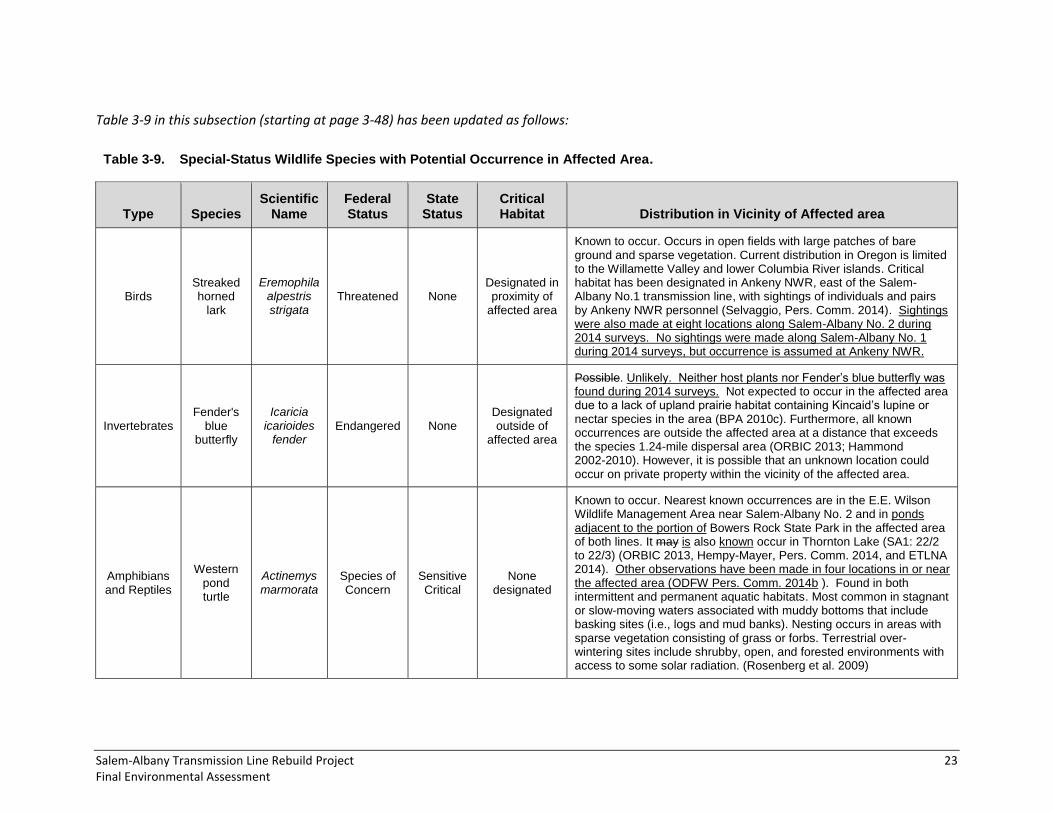
Table 3-9 in this subsection (starting at page 3-48) has been updated as follows:
Table 3-9. Special-Status Wildlife Species with Potential Occurrence in Affected Area.
Type Species Scientific
Name Federal Status
State
Status
Critical Habitat Distribution in Vicinity of Affected area
Birds Streaked horned
lark
Eremophila alpestris strigata
Threatened None Designated in proximity of
affected area
Known to occur. Occurs in open fields with large patches of bare ground and sparse vegetation. Current distribution in Oregon is limited to the Willamette Valley and lower Columbia River islands. Critical habitat has been designated in Ankeny NWR, east of the Salem-Albany No.1 transmission line, with sightings of individuals and pairs by Ankeny NWR personnel (Selvaggio, Pers. Comm. 2014). Sightings were also made at eight locations along Salem-Albany No. 2 during 2014 surveys. No sightings were made along Salem-Albany No. 1 during 2014 surveys, but occurrence is assumed at Ankeny NWR.
Invertebrates Fender's
blue butterfly
Icaricia icarioides
fender Endangered None
Designated outside of
affected area
Possible. Unlikely. Neither host plants nor Fender’s blue butterfly was found during 2014 surveys. Not expected to occur in the affected area due to a lack of upland prairie habitat containing Kincaid’s lupine or nectar species in the area (BPA 2010c). Furthermore, all known occurrences are outside the affected area at a distance that exceeds the species 1.24-mile dispersal area (ORBIC 2013; Hammond 2002-2010). However, it is possible that an unknown location could occur on private property within the vicinity of the affected area.
Amphibians and Reptiles
Western pond turtle
Actinemys marmorata
Species of Concern
Sensitive Critical
None designated
Known to occur. Nearest known occurrences are in the E.E. Wilson Wildlife Management Area near Salem-Albany No. 2 and in ponds adjacent to the portion of Bowers Rock State Park in the affected area of both lines. It may is also known occur in Thornton Lake (SA1: 22/2 to 22/3) (ORBIC 2013, Hempy-Mayer, Pers. Comm. 2014, and ETLNA 2014). Other observations have been made in four locations in or near the affected area (ODFW Pers. Comm. 2014b ). Found in both intermittent and permanent aquatic habitats. Most common in stagnant or slow-moving waters associated with muddy bottoms that include basking sites (i.e., logs and mud banks). Nesting occurs in areas with sparse vegetation consisting of grass or forbs. Terrestrial over-wintering sites include shrubby, open, and forested environments with access to some solar radiation. (Rosenberg et al. 2009)

24 Bonneville Power Administration DOE/EA-1946
3.4.2 ENVIRONMENTAL CONSEQUENCES – PROPOSED ACTION
ODFW Wildlife Habitat Categories
This subsection (page 3-51) has been revised as follows:
In general, activities related to rebuilding the transmission lines and improving existing access roads would occur primarily in habitat classified as ODFW Categories 5 and 6 since the majority of impacts would occur within the maintained rights-of-way, in agricultural areas within the rights-of-way, or along existing roadways (see Table 3-6 in the Final EA). Tree removal and access road construction and reconstruction would have the greatest long-term impacts by permanently altering habitats. Most of the new and reconstructed access roads would affect Category 5 habitats (agricultural areas) and disturbed herbaceous and shrub vegetation in BPA maintained rights-of-way (Categories 6). Some work would also occur in Category 4 habitats, including isolated or disturbed wetlands and black hawthorn riparian areas; Category 3 habitats, including reed canary wetlands and hardwoods; and Category 2 habitats, including conservation areas and a small number of Oregon white oak trees. No Category 1 habitat would be affected by the proposed project. Other impacts would result from the long-term alteration of habitats from danger tree removal and access road construction and reconstruction, which could affect Category 5 habitats (agricultural areas); Category 4 habitats, including black hawthorn riparian hedgerows and isolated or disturbed wetlands; Category 3 habitats, including reed canary and other field-delineated wetlands; and Category 2 habitats such as Oregon white oak forest. The majority of tree removal would affect Category 4 habitats, including Oregon ash and cottonwood, cottonwood riparian, and Douglas fir; followed by a Category 3 habitat, hardwoods (big leaf maple), a Category 3 habitat; followed by the Category 2 habitat of Oregon white oak woodlands (also see Section 3.3.2 for a discussion of potential impacts to Oregon strategy habitats).
BPA would apply a number of avoidance or mitigation measures to reduce impacts to these fish and wildlife habitats (see Section 3.4.3). Mitigation for category 4, 5, and 6 habitats includes fish passage designs for stream crossings, implementation of pollution and control measures, minimizing tree removal, minimizing wetland fill by altering the routes and widths of access roads where possible, wetland mitigation banking, and reseeding and recontouring disturbed areas. Many of the mitigation measures listed for land use, vegetation, geology and soils, floodplains and wetlands, and water resources are also relevant, including conducting a pre- and post-construction noxious weed survey and management, flagging wetland areas to avoid disturbance, reseeding and monitoring of revegetated areas, and others (see Sections 3.1.3, 3.2.3, 3.3.3, 3.5.3, and 3.6.3). For Category 2 and 3 habitats, including Oregon white oak woodlands and conservation areas, the same mitigation measures apply, and BPA is also working with USFWS and ODFW to develop a mitigation strategy for these habitats (see update to mitigation measures in Section 3.4.3 in the Final EA). In addition, BPA would be enhancing Category 2 streaked horned lark habitat by constructing, reconstructing, and improving gravel access roads, as well as additional mitigation measures if deemed necessary to protect the species through consultation with USFWS. Overall, impacts to wildlife habitats from the Proposed Action using ODFW habitat categories as guidance would be low-to-moderate since much of the affected area has already been modified by the existing transmission lines and existing access roads (Categories 5 and 6), impacts are distributed along a linear disturbance area, and the mitigation measures would help reduce impacts to more sensitive habitats (Categories 2, 3, and 4). (For a more detailed analysis regarding the potential impacts to these wildlife habitats as a result of the Proposed Action, see Sections 3.1 through 3.3, the following discussion in Section 3.4, Section 3.6, and Appendix C).

Salem-Albany Transmission Line Rebuild Project 25 Final Environmental Assessment
Fish
The third paragraph of this subsection (page 3-51) has been revised to reflect changes in the need for culverts, the type of culvert proposed, and whether streams are fish bearing as follows:
Seventeen Twenty-six new culverts would be installed along Salem-Albany No. 1, three culverts would be replaced, and one three culvert would be cleaned. Thirty-two Thirty-six new culverts Twenty new culverts would be installed along Salem-Albany No. 2, nine seven culverts would be replaced, improvements would be made to four one culverts, and five one culverts would be cleaned. Activities that have the potential to directly impact fish in the affected area are primarily related to in-water work in fish-bearing streams. The types of culverts proposed in fish-bearing streams are a result of BPA consultation is consulting with ODFW and NMFS, which identified to identify where fish passage is needed. Twenty-four Nine of the stream locations in the affected area that would require culverts or improvements to stream crossings have been identified as having currently or habitat to native migratory fish (ODFW Pers. Comm. 2014) (Table 3-10).
Of the nine proposed crossings of fish bearing streams, the following work would be conducted based on consultations with ODFW: at three crossings, box culverts would be installed to span active stream channels to avoid in-water work; one crossing would receive an in-stream culvert designed for fish passage; two existing railroad crossing culverts would be lengthened and were deemed to not need culverts designed for fish passage due to low risk (fish would only be present during a major flood event and since there is fish blockage immediately upstream); at one crossing the bank would be stabilized and no culvert would be needed; and at one crossing the existing culvert would be cleaned. Five originally proposed crossings of fish bearing streams would be avoided and not require culverts, while nine were deemed by BPA to occur in streams that do not have migratory fish: these crossings were deleted from Table 3-10. Twenty-two proposed new or improved culverts or other in-stream work could affect some of these fish-bearing streams and would require consultation with ODFW to determine if fish passage or improved fish passage is needed. Culverts proposed in waterways determined to support salmon would be designed to be fish passable.
Table 3-10, starting on page 3-52, has been revised to reflect updated culvert needs and revised fish presence data as follows:
Table 3-10. Culvert Work in Fish-Bearing Streams
Stream Tributary To
Nearest Structure
Span Proposed In-Water Work
Likely Native Migratory Fish
Presence1
Response Needed for
Fish Mitigation Stream Type
Unnamed tributary
Pettijohn Creek SA1:3/2 to
3/3
New culvert 44 feet from
Pettijohn Creek Yes None Intermittent
Unnamed tributaries
Willamette River SA1:10/5
Adding length to an existing culvert under railroad tracks
Two new culverts
Yes: possible juvenile refugia
habitat in proximity to the Willamette River
(floodplain connectivity)
Exempt from fish passage design due to low risk and immediate
upstream blockage. Use ODFW in-water work periods.
Intermittent
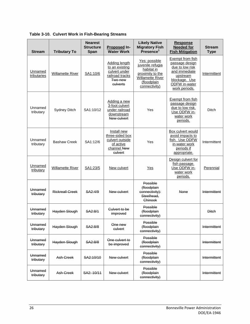
26 Bonneville Power Administration DOE/EA-1946
Table 3-10. Culvert Work in Fish-Bearing Streams
Stream Tributary To
Nearest Structure
Span Proposed In-Water Work
Likely Native Migratory Fish
Presence1
Response Needed for
Fish Mitigation Stream Type
Unnamed tributaries
Willamette River SA1:10/6
Adding length to an existing culvert under railroad tracks
Two new culverts
Yes: possible juvenile refugia
habitat in proximity to the Willamette River
(floodplain connectivity)
Exempt from fish passage design due to low risk and immediate
upstream blockage. Use ODFW in-water work periods.
Intermittent
Unnamed tributary
Sydney Ditch SA1:10/12
Adding a new 3-foot culvert under railroad downstream New culvert
Yes
Exempt from fish passage design due to low risk. Use ODFW in-
water work periods.
Ditch
Unnamed tributary
Bashaw Creek SA1:12/6
Install new three-sided box culvert outside
of active channel New
culvert
Yes
Box culvert would avoid impacts to fish. Use ODFW
in-water work periods if
appropriate.
Intermittent
Unnamed tributary
Willamette River SA1:23/5 New culvert Yes
Design culvert for fish passage.
Use ODFW in-water work
periods.
Perennial
Unnamed tributary
Rickreall Creek SA2:4/9 New culvert
Possible (floodplain
connectivity): Steelhead,
Chinook
None Intermittent
Unnamed tributary
Hayden Slough SA2:8/1 Culvert to be
improved
Possible (floodplain
connectivity) Ditch
Unnamed tributary
Hayden Slough SA2:8/8 One new culvert
Possible (floodplain
connectivity) Intermittent
Unnamed tributary
Hayden Slough SA2:8/8 One culvert to be improved
Possible (floodplain
connectivity) Intermittent
Unnamed tributary
Ash Creek SA2:10/10 New culvert Possible
(floodplain connectivity)
Intermittent
Unnamed tributary
Ash Creek SA2: 10/11 New culvert Possible
(floodplain connectivity)
Intermittent

Salem-Albany Transmission Line Rebuild Project 27 Final Environmental Assessment
Table 3-10. Culvert Work in Fish-Bearing Streams
Stream Tributary To
Nearest Structure
Span Proposed In-Water Work
Likely Native Migratory Fish
Presence1
Response Needed for
Fish Mitigation Stream Type
South Fork Ash
Creek Ash Creek
SA2:11/9 to 11/10
Culvert repair Yes: Chinook,
steelhead Perennial
Unnamed tributary
Talmadge Creek SA2:12/9 One new culvert
Yes Intermittent
Unnamed tributary
Talmadge Creek SA2:12/9 One improved
culvert Yes Intermittent
Field drainage
Undetermined SA2:13/10 One new culvert
Possible Intermittent
Field drainage
Undetermined SA2:15/6 One new culvert
Possible Intermittent
Unnamed Tributary
Luckiamute River
SA2:17/3 to 17/4
Stream bank stabilization
Yes: steelhead, Chinook;
steelhead and Chinook critical
habitat
Use ODFW in-water work
periods. Perennial
Unnamed Tributary
Soap Creek SA2:20/8 to 21/1
Install new three-sided box culvert outside active channel
New culvert
Yes
Box culvert would avoid impacts to fish. Use ODFW
in-water work periods if
appropriate.
Perennial
Bowers Slough
Willamette River SA2:23/7
Install a new three-sided box culvert outside active channel
New culvert
Yes
Box culvert would avoid impacts to fish. Use ODFW
in-water work periods if
appropriate.
Perennial
Calloway Creek
Bowers Slough – tributary to
Willamette River (Muddy Creek
basin)
SA2:24/1 to 24/2
Clean culvert
Yes (Bowers Slough is used
by fall and spring Chinook salmon up to river mile
1.4a)
Use ODFW in-water work
periods. Perennial
Unnamed Tributary
Bowers Slough SA2:27/6 New culvert Yes Perennial
Sources: StreamNet 2014; FishNet 2014. 1 Likely native migratory fish presence based on preliminary review by ODFW (ODFW Pers. Comm. 2014). Consultation with ODFW
regarding fish passage requirements has been completed as of August 2014: Table 3-10 has been updated accordingly. Crossings where streams were determined by ODFW not to have migratory fish or that were able to be avoided by BPA were deleted. is ongoing. Results will be included in the Final EA.
The second paragraph on page 3-53 has been revised as follows:
Impacts to adult ESA-listed salmonids and their habitat would be avoided through adherence to ODFW’s in-water work windows (discussed in Section 3.4.3). During these times, returning adult salmon are likely

28 Bonneville Power Administration DOE/EA-1946
absent from tributaries in the affected area. Although spring Chinook salmon would potentially occur in the mainstem Willamette River during the in-water work window, no in-water work is proposed for this waterbody. Juvenile salmonids are more numerous, have a greater geographic distribution, and inhabit fresh water for a longer duration than adult salmonids; therefore, impacts to juvenile salmonids would be possible during the in-water work window.
Box culvert installation would occur outside of the wetted stream channel and would avoid impacts to fish. In addition, placing rock for bank stabilization (SA2:17/4 to 17/4) and culvert cleaning (SA2:24/1 to 24/2) would involve minimal in-water work. The three culverts that would not be designed for fish passage would occur in ditches or intermittent streams with a low likelihood of fish presence based on floodplain topography or existing barriers. The one new culvert that would occur in a perennial stream with a high likelihood of fish presence would be designed for fish passage (SA1:23/5). Considering the above proposed activities, direct impacts to fish—including ESA listed salmonids—would be minimized, if not avoided, through adherence to NMFS and ODFW requirements. Also, if necessary, fish would be captured and relocated from the immediate impact area prior to construction (addressed in Section 3.4.3). Given that the above direct impacts are localized and would be minimized through the implementation of best management practices, the proposed in-water work would result in low impacts to fish, including ESA-listed salmonids, in perennial streams.
The second paragraph on page 3-54 has been revised as follows:
Currently, danger trees could be removed within the riparian areas of 14 fish-bearing streams 12 perennial and 8 intermittent streams—many of which are likely fish-bearing—including the Santiam River, the Calapooia River, the Luckiamute River, and all four crossings of the Willamette River (no danger trees were identified at the Salem-Albany No. 2 crossing of the Luckiamute and Calapooia rivers) (see Appendix B). Removal of vegetation within or adjacent to streams (e.g., for access road construction or primarily for danger tree removal) has the potential to reduce stream shading, thereby increasing water temperatures. However, proposed vegetation removal within and adjacent to the transmission line rights-of way would be a small proportion of the existing riparian corridor and would be unlikely to result in a system wide effect. Discrete locations where trees would be removed could experience an increase in water temperature due to reduced shading. Increased water temperature could negatively affect growth and reproduction of cold water fish species. Tree stumps would remain and would provide soil stabilization and erosion prevention benefits.
A Special-Status Species subsection has been added to 3.4.2 Environmental Consequences—Proposed Action, Fish section, after the fifth paragraph on page 3-54:
Special-Status Fish Species
The following section describes potential impacts to special-status species that have potential to occur in the affected area: Chinook salmon, steelhead, and Pacific lamprey. Impacts to adults of these species would be largely avoided through adherence to ODFW’s in-water work windows (see Section 3.4.3), as returning adult salmon and adult Pacific lamprey are generally absent from the affected tributaries at those times. However, juveniles could be present because they are more numerous, have a greater geographic distribution, and inhabit fresh water for a longer duration than adults. BPA is consulting with NMFS under the ESA on potential impacts to Chinook salmon and steelhead, and will implement any additional mitigation measures required as a result of this consultation.

Salem-Albany Transmission Line Rebuild Project 29 Final Environmental Assessment
Chinook Salmon – Upper Willamette River ESU, Spring Run
No in-water work is proposed in the mainstem of the Willamette River or Luckiamute River where spring Chinook salmon or its designated critical habitat occurs. However, critical habitat that may contain juvenile salmon could be indirectly affected through work in three Willamette River tributaries: bank stabilization (and a potential temporary increase in sediment inputs) along an unnamed tributary to the Luckiamute River (SA2:17/3-4), a culvert cleaning on Calloway Creek (SA2:24/1-2), and a proposed culvert construction in an unnamed tributary to the Willamette River that potentially provides juvenile refugia habitat (SA1:23/5) (see Table 3-10). Because these activities would occur in smaller tributary streams and juvenile Chinook salmon are known to prefer larger mainstem rivers during summer months (see Section 3.4.1), the majority of juvenile Chinook salmon would likely not be present near work areas during most of the construction season. Given this, and since the project would adhere to ODFW in-water work periods, impacts to Chinook salmon would be low.
Steelhead – Upper Willamette River ESU, Winter Run
Proposed in-water work would not occur in critical habitat for UWR winter run steelhead. Thus, direct impacts would be avoided. Proposed project activities that could potentially affect critical habitat and thereby juvenile steelhead would be confined to one area with proposed bank stabilization along an unnamed tributary to the Luckiamute River (SA2:17/3-4; Table 3-10). This activity could result in temporary increased sediment inputs upstream of the Luckiamute River, which may indirectly affect juvenile steelhead downstream. However, with the implementation of best management practices to limit increased sedimentation (Section 3.4.3), impacts to steelhead would be low.
Pacific Lamprey
Many of the traits of Pacific lamprey are similar to Pacific salmonids (including Chinook salmon and steelhead), and if present, they would therefore be likely to experience similar effects as those described for Chinook and steelhead. With the same mitigation measures implemented, and because they have a low likelihood of being present in the Willamette River basin (Section 3.4.1), anticipated impacts to Pacific lamprey would be low.
Wildlife
General
The last paragraph on page 3-54 has been revised as follows:
Permanent removal of potential habitat due to new road beds and structure footprints, would include 45 acres of agricultural, 18 8 acres of riparian and wetland (all 8.7 of which is jurisdictional wetland), 3 acres of oak habitat (including the removal of about six Oregon white oak trees), 1 acre of upland forest habitat (including the removal of about nine trees), and 18 acres of herbaceous and shrub habitat, 8 of which are acres of currently maintained areas within the rights-of-way. Although the habitat that would be removed provides some structural diversity to wildlife species, much is in existing right-of-way and is already disturbed and degraded; permanent habitat impacts would be anticipated to be low-to-moderate.
The second, third, and fourth paragraphs on page 3-55 have been revised as follows:
Temporary impacts to habitat would be due to construction activities and would include 107 acres in agricultural, 13 31 acres in riparian and wetland, 53 acres in herbaceous and shrub (35 of which are within the maintained right-of-way), 3 acres in oak woodland, and 1 acre in upland forest habitat, and

30 Bonneville Power Administration DOE/EA-1946
35 acres in currently maintained areas within the rights-of-way. Ground temporarily disturbed during construction would be reseeded (see Section 3.3), to help restore habitat. To the extent practicable, these activities would occur within the maintained rights-of-way where the habitat is already disturbed, though some road work and tensioning sites would occur outside of the maintained rights-of-way. The effects to wildlife habitat from these temporary construction activities are anticipated to be low-to-moderate since disturbed areas would be reseeded, but since there is potential for invasive weeds to become established or spread and degrade wildlife habitat. as sensitive habitats could be affected but would be restored upon completion of the Proposed Action.
The Trees that would be removed along the transmission lines and access roads could impact tree-dependent wildlife habitat, as well as directly cause mortality or injury to species, especially nesting birds, during tree felling if conducted during the nesting season—however; BPA does not intend to remove trees during the nesting season. Treed areas provide perching, nesting, and foraging opportunities for a variety of bird species, including overwintering birds. Impacts to birds and tree-dependent wildlife would occur as a result of habitat loss and modification where trees are removed. Trees to be removed are a combination of primarily cottonwood, Douglas fir, and mixed hardwoods, including Oregon white oak woodland. Most of the potential danger trees for removal are located in scattered areas lining agricultural fields, although some line the edges of woodlands adjacent to the right-of-way. The majority of trees (about 605 1,075) would be removed from Salem-Albany No. 1; the remaining (about 154 265) trees would be removed from Salem-Albany No. 2 (BPA 2014a). Removal of trees in oak woodlands would incrementally decrease the availability of this priority habitat, which supports a high diversity of species (see Section 3.3). Most habitats in the affected area are fragmented, and while tree removal would affect site-specific habitat condition, it would primarily occur at the edge of the transmission line, and the adjacent woodlands would remain as available habitat to any displaced wildlife. Because the remaining canopy, understory trees, shrubs, and crown sprouts would continue to provide canopy cover and maintain existing habitat, and since tree removal would occur along a linear path rather than in large areas, the effects of habitat loss on wildlife due to removal of trees are anticipated to be low. Some of the danger trees that would be removed are in riparian areas. Long-term impacts would include the loss of large riparian trees along the Willamette, Santiam, Luckiamute, and Calapooia rivers, which can provide prime nesting, foraging, and roosting habitat for raptors such as osprey and bald eagles. Approximately 38 45 trees have been marked for removal identified as potential danger trees along the transmission lines within 0.1 mile of the Willamette River; 9 trees within 0.1 mile of the Santiam River, 9 trees within 0.1 mile of the Luckiamute River, and 1 tree within 0.1 mile of the Calapooia River (BPA 2014a). However, because numerous riparian trees would remain in adjacent areas in the riparian zones of these rivers, and since danger tree removal would take place outside of the nesting season, impacts to nesting, foraging, and roosting habitat for raptors and other wildlife would be low-to-moderate.
Transmission lines associated with the existing structures are horizontally oriented. Under the Proposed Action, the majority of the structures would maintain this orientation; however, lines associated with the 77 steel monopoles would be converted to a vertical orientation. The 77 single-pole, vertical structures could increase the probability of bird collisions due to an increase in height of the collision zone; however, current literature lacks evidence to support or refute line configuration as an indicator of collision risk (APLIC 2012). Additionally, bird flight diverters would be installed on conductors and fiber in high bird-conductor collision risk area, including established flight corridors near wetlands and along rivers and creeks that are likely to be frequented by birds. From structures SA2:10/8 10/1 to 13/5 12/4 and SA2:12/10 to 13/4, where the Proposed Action crosses or is adjacent to Ankeny NWR, bird yellow swan flight diverters would be installed on the conductors and fiber to reduce the probability of

Salem-Albany Transmission Line Rebuild Project 31 Final Environmental Assessment
avian collision. Swan flight diverters would also be used over river crossings. Since the transmission lines and guy wires would be in the same general location as the existing lines and bird diverts would be installed on conductors over large wetland areas, rivers, and other areas that could be major flyways for waterfowl and waterbirds, low-to-moderate impacts to birds are expected from the upgrade to a vertical steel monopole and low impacts are expected from the other rebuilt lines.
The third paragraph on page 3-56 has been revised as follows:
Wildlife would also be temporarily subjected to increased stress due to the noise and human intrusion associated with construction activities. These disturbances could reduce the foraging effectiveness of adults, disrupt breeding and other activities, and cause adults to leave nest or den sites, which could endanger their young. For instance, raptors nesting in trees or on structures close to the lines could be startled from their nests at the onset of activities. Stringing the line with a helicopter would create the most intensive noise disturbance, and birds nesting close to the line would experience the greatest effects. The helicopter would make three passes over each structure, each time hovering for about 10 to 15 minutes before moving on to the next structure approximately 500 or more feet away. However, because the majority of the affected area occurs in farmland where the use of loud machinery—including aircraft for spraying pesticides (i.e., crop dusters)—occurs frequently during the breeding season, birds and other wildlife are habituated to these types of noise disturbances, so would be less likely to abandon their nests (or dens) for long periods of time, reducing the risk of mortality of young or nest failure. In addition, raptor nests currently found on existing structures would be removed outside of the breeding season prior to construction. Overall, while incidental mortality of birds and wildlife could occur as a result of noise and human disturbance, the impacts would occur at the scale of individuals and would likely not have an impact on regional populations. Additionally, over the long term, the transition from H-frame wood structures to steel monopoles and updated wood structures would reduce the need for inspection and repairs, thereby reducing the frequency of wildlife displacement due to noise, trucks, and human presence. Roosevelt elk and other wildlife moving between feeding and resting habitats during the summer months could be startled away from construction activities. However, movement across or adjacent to the rights-of-way could resume after dusk when construction ends for the day, and once construction moves out of the area. Because the risk of mortality or nest failure would be low, and since the increased stress associated with construction disturbance would be temporary, impacts to birds, Roosevelt elk, and other wildlife from helicopter and other construction noise would be low-to-moderate.
Special-Status Species
The first paragraph of this subsection (bottom of page 3-56) has been revised as follows:
The following section describes potential impacts to special-status species that have potential to occur in the affected area, including, migratory birds, bald eagle, streaked horned lark, purple martin, Oregon vesper sparrow, long-eared myotis, long-legged myotis, western pond turtle, and western painted turtle. Potential impacts to migratory birds are discussed for all birds in the General Wildlife section above.
Streaked Horned Lark
This subsection (page 3-57) has been revised as follows:
Streaked horned lark are known to occupy the critical habitat unit on the Ankeny NWR east of the Salem-Albany No.1 transmission line and have been observed in at least three other sites in the vicinity

32 Bonneville Power Administration DOE/EA-1946
of the Refuge affected area (Selvaggio Pers. Comm. 2014; USFWS Pers. Comm. 2014). Additionally, the managed agriculture fields and wetlands adjacent to the Proposed Action and the disturbed rights-of-way along both lines could provide habitat for this species. Also, fifteen occurrences of streaked horned lark were documented during field surveys along the Salem-Albany No. 2 transmission line and access roads (BPA 2014f). Potential impacts would be similar to those described for general wildlife, although there would likely be beneficial effects as well. Potential adverse effects would include including temporary increased stress during construction and incidental mortality. Noise and physical disturbance associated with construction activities could lead to nest abandonment or destruction. In addition, vehicles could present a hazard through injury or mortality to juveniles and adults foraging on the ground. It would be considered a high impact if streaked horned larks were killed or nests were abandoned during construction, however, the However, the period until young have fledged and when they are most at risk is relatively short (12 days of incubation, then 9 days until fledging), and seasonal restrictions would likely be used in areas with the highest densities of streaked horned lark to avoid reduce impacts. Reduced speed limits could also be used to reduce the risk of juvenile and adult mortality. BPA will prepare has prepared a Biological Assessment to further assess potential impacts and is continuing to work with USFWS to determine potential avoidance or mitigation measures that would be employed to minimize impacts.
Long-term beneficial effects would result from the construction of new gravel roads in open areas that could provide suitable nesting habitat for streaked horned lark (Brown Pers. Comm. 2014a). Since the loss and degradation of suitable habitat is one of the primary reasons for the species’ decline (USFWS 2014b), creating new suitable habitat would contribute to the conservation of this species.
On the Ankeny NWR, habitat for streaked horned lark could be altered reduced in quality from a managed prairie/vernal pool habitat to graveled habitat under access road Options 2 and 3; conversely, available lark nesting habitat adjacent to the Refuge could increase due to the construction of a new graveled access road in wetland and black hawthorn riparian hedgerow habitat under access road Option 1. Additional new access roads that would be expected to provide habitat include those in small areas of cultivated fields along both lines. This could increase the amount of documented lark habitat throughout the season in these areas, where suitable habitat is often only available for part of the breeding season due to crop production (BPA 2014f). Upon completion of the Proposed Action, these new roads would not be used on a regular basis and only traveled for infrequent ongoing inspection and repair (see Chapter 2).; although Although the new use of these areas as use of these roads would have the potential to disrupt larks if they were present, road maintenance use would help maintain low-growing vegetation in lark habitat.
Surveys are scheduled for spring and summer of 2014 and the results will be included in the final EA. If Since breeding pairs are were found within the affected area, BPA will has prepared a Biological Assessment to further assess potential impacts and will continue to work with USFWS to determine potential mitigation measures that would be employed to reduce impacts. With mitigation measures, and the potential increase in suitable lark habitat in the long-term, negative impacts from potential disturbance, injury, and mortality would be expected to be moderate.
Western Pond Turtle and Western Painted Turtle
This subsection (starting on page 3-58) has been revised as follows:
Western pond turtles have the potential to occur in the affected area. Effects This analysis considers both current documented occurrences of western pond turtle based on Oregon Biodiversity Information

Salem-Albany Transmission Line Rebuild Project 33 Final Environmental Assessment
Center (ORBIC) data, and on western pond turtle observation points provided by ODFW after the field survey season and the release of the Draft EA (ODFW Pers. Comm. 2014b).
Direct impacts to the pond turtles’ aquatic life stage would be limited avoided by installing box culverts at to a new culvert installation in an unnamed tributary of Soap Creek near structures SA2:20/8 to 21/1 and an unnamed tributary to the Willamette River near structures SA2:24/1 to 24/2 (see Table 3-10 in Final EA). Pond turtles, if present, could experience indirect impacts by being be stressed or be displaced during construction due to increased activity in the affected area. Effects to the pond turtles’ terrestrial life stage could result from the use of a pulling-tensioning site adjacent to Thornton Lake, and roadwork and construction activities in the vicinity of pond turtle habitat. Depending on the time of year, these activities could result in nest and hatchling mortality or mortality of adults in overwintering (terrestrial) habitat. Construction activities would not affect western pond turtles or their habitat at E.E. Wilson Wildlife Refuge and Minto Brown Island Park based on the distance of documented occurrences and aquatic habitat from the affected area. The pulling-tensioning site and reconstructed access road near Thornton Lake would be located in an orchard/meadow environment south of the pond with densely growing tall grasses and forbs, which would not be conducive to turtle nesting or migration during the construction season. While this area could provide 0.3 acre of overwintering habitat, including leaf litter under trees or bushes, construction activities would primarily occur outside of the winter season, and potential overwintering habitat would remain in the larger orchard area adjacent to the reconstructed access road.
At Bowers Rock State Park, about 0.07 acre of potential nesting habitat with a sandy substrate could be affected by an improved road. However, since no western pond turtles were found nesting at Bowers Rock State Park, and since both nesting and aquatic habitat were deemed to be of low quality in this portion of the park, turtles would unlikely be nesting in this location. Impacts would likely be limited to temporary disturbance of adult turtles using adjacent ponds during construction activities.
Near the Santiam River, potential impacts could include the loss of 0.03 acre of potential overwintering habitat to a new access road on the north side of the river, although adjacent habitat on either side of the affected area would still be available.
Disturbance to western pond turtle in aquatic habitats would be indirect and temporary; however, reconstructed and new access roads could affect a small proportion of potential overwintering habitat near the Santiam River and Thornton Lake, and a reconstructed access road could remove a small amount of low-quality nesting habitat at Bowers Rock State Park, resulting in low impacts to western pond turtle. could result from the use of a pulling-tensioning site adjacent to Thornton Lake, and roadwork and construction activities in the vicinity of pond turtle habitat. Depending on the time of year, these activities could result in nest and hatchling mortality or mortality of adults in overwintering (terrestrial) habitat. These impacts would be offset by mitigation, to be determined in consultation with ODFW. Therefore, disturbances associated with construction activities could have a moderate impact on the western pond turtle by reducing year class recruitment or resulting in adult mortality.
3.4.3 MITIGATION – PROPOSED ACTION
The following mitigation measures, starting on page 3-59, have been revised or added as follows:
Complete in-water construction below the ordinary high water mark (OHWM) work by the ODFW recommended work period between July 1 to October 15.July 1 and September 15, the

34 Bonneville Power Administration DOE/EA-1946
period below ordinary high water, except for west bank tributaries of the Willamette River (Luckiamute River), which is July 1 to October 15.
Isolate work areas and remove and relocate fish prior to commencing in-water work activities in known streams with ESA-listed fish and critical habitat (Bowers Slough, Calloway Creek, and tributaries to the Luckiamute River list streams, the Willamette River, Sydney Ditch, Bashaw Creek, and Soap Creek) in accordance with NMFS guidelines (NMFS 2008). Isolate other in-water work areas prior to culvert installations. Dewater work area as necessary for construction and to minimize turbidity. Do not discharge turbid water to streams.
Design stream crossings (culverts) to comply with fish passage design requirements and recommendations from ODFW and USFWS, to be determined in ongoing consultation and reported in the Final EA.
Conduct fish salvage, if determined to be necessary through consultation with NMFS and recommendations from ODFW.
Divert stream flow around the work area and maintain downstream flow during construction. Use screens per NMFS/ODFW’s Fish Screening Criteria (NMFS 2008) to keep fish from entering pumps used to divert stream flow.
Schedule tree removal (and other vegetation removal as much as possible) between August31 15 and March 1 to minimize impacts to migratory birds. If active nests are found, do not remove trees until the young have fledged.
Abide by any terms and conditions or mitigation measures agreed to with USFWS during ESA consultation for streaked horned larks. These could include avoiding seasonal restrictions on construction until the young have fledged and reduced speed limits in the vicinity of documented larks.
Continue to coordinate construction activities with the Ankeny NWR USFWS to reduce potential construction impacts to Ankeny NWR during sensitive periods for waterfowl, water birds, and shorebirds; and during raptor and migratory bird nesting periods.
Coordinate with Ankeny NWR on use of Refuge access roads for tree removal to avoid road damage during the rainy season.
Install bird diverters on conductors and fiber in high bird-conductor collision risk areas (established flight corridors near wetlands and other bodies and along and within river and creek drainages that are likely to be frequented by large numbers of birds)., including adjacent to Ankeny NWR (SA1:10/1 to 13/5) and 49 spans in other areas. Use swan flight diverters over river crossings and on conductor and fiber at Ankeny NWR, and bird flight diverters in other areas such as smaller streams, etc.
Finalize and implement a mitigation strategy for associated impacts to sensitive habitats, including migratory bird habitat. The anticipated mitigation strategy is to fund the restoration of riparian forest in the Bowers Rock State Natural Area Fitchett Tract mitigation site coordinated by the Calapooia Watershed Council.

Salem-Albany Transmission Line Rebuild Project 35 Final Environmental Assessment
3.5 WATER RESOURCES
3.5.2 ENVIRONMENTAL CONSEQUENCES – PROPOSED ACTION
Structure and Transmission Line Replacement
Pentachlorophenol (PCP)
This section (page 3-65) has been revised as follows:
Once constructed, the new structures could impact groundwater or surface water by leaching PCP, a general biocide that is commonly used as a wood preservative treatment for utility poles, as discussed in Section 3.2.2, Geology and Soils. Because of the demonstrated tendency for PCP to adsorb to soils, the moderately rapid degradation of the compound in the environment, and the localized nature of the compound, it is unlikely that surface or groundwater contamination would result from installation of the new wood poles. In addition, concentrations of PCP released during replacement of structures are not expected to exceed EPA levels of concern for human health. In wetlands, some wooden structures would be placed inside corrugated culverts, which would may help contain PCPs and prevent them from leaching into surrounding soils. Given the nature of PCP and the potential for small areas of localized contamination around structures, Therefore, the impact of PCP associated with new structures installed for the Proposed Action on surface or groundwater quality and any associated drinking water is expected to be low.
Road Work
The second paragraph of this section (starting on page 3-65) has been revised as follows:
Seventeen Twenty-six new culverts would be installed along Salem-Albany No. 1, three culverts would be replaced, and three one culverts would be cleaned. Thirty-six Thirty-two new culverts would be installed along Salem-Albany No. 2, seven nine culverts would be replaced, improvements would be made to one four culverts, and one five culverts would be cleaned. The installation of new culverts and the improvement of old culverts would enhance stream crossings over the long-term, particularly at the crossing of the unnamed tributary to the Luckiamute River on Salem-Albany No. 2, which currently experiences extensive soil erosion during regular flooding events, discussed in Section 3.4.2, Fish). Where culverts would be repaired, replaced, or cleaned, there would be temporary sedimentation and disturbance impacts (increased turbidity) to water resources due to in stream work, however the long-term impacts would be an improvement to water resources due to improved stormwater conveyance as the culverts would be properly sized and functional. New culverts would also cause similar temporary sedimentation and disturbance impacts due to installation; however, streambanks would be stabilized after installation, and the properly sized and installed culverts would not impact water resources long term.
Tree Removal
This section (page 3-66) has been revised as follows:
Trees removal would occur within 100 feet of about 25 streams and rivers (see Appendix B) 16 perennial and 12 intermittent streams. BPA will continue to refine tThe number of trees proposed for removal near streams prior to construction will be confirmed during field work conducted summer 2014. Tree removal has the potential to impact streams by temporarily increasing erosion and sedimentation by

36 Bonneville Power Administration DOE/EA-1946
exposing soils. However, since stumps and low-growing vegetation would be left in place, the risk of erosion and increased sedimentation is low. Tree removal near streams can also expose flowing water to increased solar radiation, which can increase water temperatures. The trees cleared near streams would be a small percentage of the total trees in the area, stumps would remain, and the remaining tree canopy, understory trees, shrubs, and crown sprouts would continue to provide shading and hold soils in place. This limits the potential for increased water temperatures and erosion; therefore, impacts to water quality from tree removal are expected to be low.
3.5.3 MITIGATION—PROPOSED ACTION
The following mitigation measure on page 3-66 has been revised as follows:
Construct, widen, and resurface access roads during the dry season as much as possible when stream flow, rainfall, and runoff are low.
Complete work below the ordinary high water mark during the ODFW recommended in-water work period between July 1 and September October 15.
3.6 WETLANDS AND FLOODPLAINS
3.6.2 ENVIRONMENTAL CONSEQUENCES—PROPOSED ACTION
Wetlands
The wetland text and Table 3-12 (starting on page 3-71) have been revised as follows:
Most (99 percent) of the impacts to wetlands from the Proposed Action would be to palustrine emergent type wetlands (Table 3-12). Replacement of structures within wetlands would primarily result in temporary disturbances of wetland soils and vegetation, as most poles would be replaced in the same hole from which the old ones were removed. To prepare for installation in wetlands, each existing hole would be cleaned out and re-augured so that it is would be approximately 3 feet in diameter and 10 to 12 feet deep. The 2-foot-diameter wood poles would be installed and the hole backfilled. In some wetland locations, wood pole structures would be placed in corrugated metal pipes to improve structure stability: in these cases, the hole would be re-augured to approximately 5 feet a little over 4 feet in diameter and 10 to 12 feet deep. A 4-foot diameter corrugated metal pipe would be installed upright in the hole and extend to the soil surface for all H-frame wood poles installed in wetlands (See Figure 3-6; structures SA1:2/2 to 2/5 and SA1:23/11 to 24/11). (The metal piping would not be needed for steel monopole structures.) The new wood poles would be placed within the vertical pipe and would be back-filled with crushed rock. Because locations where corrugated metal pipes would be needed may not be determined until workers are in the field, impact calculations assumed all structures in wetlands would receive these pipes. The use of corrugated metal pipes surrounding the poles would improve the stability of the poles in soft wetland soils, may help increase the longevity of the wood structures, and may help prevent any leaching of PCP into surrounding areas.

Salem-Albany Transmission Line Rebuild Project 37 Final Environmental Assessment
Table 3-12. Wetland Impacts
Project Activity
Impacts (Acres)
Permanent Temporary
Palustrine Emergent Wetlands
Road Construction, Improvement, or Reconstruction* 7.4 7.7 5.4 0.0
Road Improvement or Reconstruction 1.0 0.0
Culverts, riprap, etc. To be included in the Final
EA None To be included in the Final
EA None
Replacement of Structures (Including relocations and counterpoise)
<0.1 2.8 10.4
Tensioning Sites 0.0 4.7 3.6
Overland Travel Routes of Travel 0.0 0.7 4.0
Palustrine Scrub-Shrub Wetlands
Road Improvement or Reconstruction* <0.1 <0.1 0.0
Replacement of Structures (including relocations) <0.1 0.0 <0.1 0.1
Routes of Travel Temporary Access 0.0 0.0 <0.1
Total 7.5 8.8 12.9 18.1
Source: BPA 2014c
Note: Temporary disturbance areas do not include areas that are permanently impacted.
Totals are rounded to the nearest tenth.
*Temporary impacts from roads include routes of travel.*Road values include associated impacts from culverts, riprap, etc
Temporary impacts associated with structure replacement would consist of construction access by heavy equipment within a 25-foot radius of the structure, construction of temporary roads, and the installation of heavy guy wire anchors and grounding wires at some structures. Impacts to wetlands would occur as wetland vegetation is crushed and soil is compacted or exposed by construction equipment. Temporary impacts from structure replacement would be restricted to 0.06 acre per structure in wetlands, for a total of approximately 18.1 12.9 acres of temporary wetland impacts for all project activities, a decrease of about 5.2 acres of temporary impact due to mitigation measures.
Since many of the wetlands are only seasonally wet, construction equipment would be able to gain access to sections of the transmission line rights-of-way by driving over the wetland areas in the dry season using overland travel routes—primarily in agricultural fields—and thereby minimizing impacts. In places where wet areas persist during the construction season, crane mats or temporary roads constructed of geotextile fabric and rock would be used to cross wet areas and minimize wetland impacts. These mats or temporary roads would be removed following construction. Temporary use of tensioning sites would also have the potential to temporarily impact 3.6 4.7 acres of wetlands, depending on the time of the year that the work is completed. If tensioning sites are used during the wet season, temporary fill (e.g., crane mats) could be used to stabilize machinery and enable access.
Most of the wetland vegetation that would be disturbed during construction would consist of grasses and forbs within the maintained rights-of-way. All disturbed areas would be reseeded with an appropriate seed mix based on existing conditions and inspected to verify establishment. If vegetation

38 Bonneville Power Administration DOE/EA-1946
does not reestablish, contingency measures would be implemented as needed. The gravel layer associated with new permanent access road fords would be covered with existing wetland soils, which would allow the wetland vegetation, typically reed canarygrass, to reestablish. Although the Proposed Action would be temporarily disruptive, the wetland function would likely return to pre-construction conditions after mitigation and restoration are completed (see Section 3.6.3).
Removal of danger trees would be conducted in some wetlands adjacent to the transmission line rights-of-way. Tree removal in wetlands would likely occur adjacent to the rights-of-way at about 20 locations along Salem-Albany No. 1 and 5 locations along Salem-Albany No. 2.
In areas where danger trees are would be removed in wetlands, the tree would be cut above the ground with stumps left in place; work would not disturb the root structure in order to avoid wetland impacts.
Construction, reconstruction, and improvement of new access roads would permanently fill a total of 7.7 7.5 acres of wetlands. These impacts would be dispersed throughout the project area. The largest of these permanent impacts would be to build new roads to structures that currently do not have established access, as follows:
In the area adjacent to the railroad right-of-way to the east and Ankeny NWR, under Option 1 access to structures SA1:12/5 to SA1:11/3 6 and SA1:11/3 to SA1:10/8 would require a 0.9 1.1-mile road and an 0.6-mile road, permanently impacting 3.5 acres of wetland. Option 2 would permanently impacting 1.6 acres of wetland either temporarily or permanently, depending on the Option selected. Options 1 and 2 include construction of a permanent road in a wetland; and Option 3 would include construction of a temporary road in a wetland. Vegetation in this wetland is dominated by reed canarygrass.
1.5 acres to reconstruct an existing access road to provide improved access to 11 structures from SA1:16/10 to 17/9.
1.4 acres to build roads to provide access to structures SA2:8/9 to 10/3.
The additional 1.1 2.5 acres of wetland impacts are dispersed throughout the affected environment.
The widths of new roads that would be constructed in wetlands would be reduced to a finished 12-foot road bed with 2-foot shoulders (for a total road width of 16 feet) (compared to the typical preferred road width of a 14-food road bed with 3-foot shoulders [for a total road width of 20 feet]), where practicable. Wetland mitigation credits would be purchased from an approved mitigation bank for the approximately 8.8 7.5 acres of wetlands that would be permanently impacted due to access roads and structure placement. With this mitigation, and since most of the affected wetlands are already highly disturbed with high densities of invasive weeds, remaining impacts to wetlands would be low.
3.6.3 MITIGATION – PROPOSED ACTION
Mitigation measures have been added or revised on page 3-74 as follows:
Construct new access roads level with existing grades in floodplain areas to avoid restricting or changing water flow.
Reduce road widths to a maximum 16 feet (12-foot-wide roadbed with 2-foot shoulders) in wetlands, where practicable.

Salem-Albany Transmission Line Rebuild Project 39 Final Environmental Assessment
Flag wetland boundaries in the vicinity of construction areas where possible to ensure these areas are avoided during construction: do not exceed a 0.06-acre disturbance area around structures located in wetlands.
Monitor revegetated areas until approximately 70 percent cover is established. Wetland sites should be monitored for 3 years to assure establishment.
Locate staging areas outside of areas with known cultural resources.
3.8 AIR QUALITY AND GREENHOUSE GASES
3.8.2 ENVIRONMENTAL CONSEQUENCES – PROPOSED ACTION
Construction
Greenhouse Gases
The subsection Greenhouse Gases, including Table 3-14 (starting on page 3-94), has been revised to correct a calculation error discovered in the Draft EA, recalculate values based on updated tree removal numbers, and present additional detail. The changes are as follows:
Implementation of the Proposed Action would contribute to greenhouse gas concentrations in several ways. Carbon dioxide, methane, and nitrous oxide emission levels would incrementally increase as vegetation and soils are removed or disturbed during construction of the transmission lines and through the use of construction vehicles. Emissions from vehicles and equipment, which would be fueled by gasoline and diesel combustion motors would incrementally contribute to atmospheric greenhouse gas concentrations. In addition, tree removal would slightly reduce the amount of carbon sequestration that could occur in the area, and result in carbon emissions through tree disposal.
The total amount of greenhouse gas emissions from the Proposed Action would be about 17,530 18,684 metric tons of carbon dioxide equivalents due to vehicle use and tree removal (see Table 3-14).: tThis 18,684 metric tons equates to the annual carbon dioxide emissions of about 3,290 passenger vehicles, and is less than 0.01 percent of the 167,470,000 metric tons of carbon dioxide emitted annually in BPA’s four-state service territory. and This value is below EPA’s 25,000 metric tons reporting threshold (EPA 2011; EPA 2013f). The individual components of the total greenhouse gas emissions are described below.
Greenhouse gas emissions from vehicles and equipment were estimated for the Proposed Action based on the approximate number of vehicles to be used during project construction and the approximate distance those vehicles would travel during the construction period. For the Proposed Action, an estimated eight vehicle round trips per day would occur during the peak construction periods for each transmission line. Construction would take about 480 days, with peak construction activity likely occurring between July and October of 2015 and 2016.
To provide a conservative analysis and ensure that the Proposed Action’s potential contribution to greenhouse gas concentrations are adequately considered, greenhouse gas emissions were calculated for the entire project duration. A round trip for the Proposed Action was considered to be from Salem to the midpoint of the transmission line between the Salem and Albany Substations for both transmission lines (about 13 miles).

40 Bonneville Power Administration DOE/EA-1946
As shown in Table 3-14, construction vehicle emissions would result in an estimated 836 5,077 metric tons of total carbon dioxide equivalent for the entire 2-year construction period. The Proposed Action’s estimated carbon dioxide equivalent emissions from vehicle and equipment use translate roughly to the annual carbon dioxide emissions of 147 894 passenger vehicles.
Table 3-14. Estimated Construction Vehicle Greenhouse Gas Emissions from the Proposed Action
Activity CO2 Emissions (metric tons)
CH4 Emissions (CO2 equivalent
emissions) (metric tons)
N2O Emissions (CO2 equivalent
emissions) (metric tons)
Total CO2 equivalent
emissions (metric tons)
Construction 4,367 608 102 5,077
Tree Clearing 4,893 – – 13,607
TOTAL 18,684
Total CO2 Emissions
in metric tons
Total CH4 Emissions (CO2 equivalent
emissions) in metric tons
Total N2O Emissions (CO2 equivalent
emissions) in metric tons
Total CO2 equivalent emissions in metric tons
159 2 5 836
Measuring emissions from soil disturbances is difficult because these emissions are short-lived and return to background levels within several hours (Kessavalou et al. 1998). Based on the conservative methodology used to estimate construction vehicle emissions, the emissions related to soil disruption and annual vegetation decay are accounted for in the overall construction emission rates. Carbon that would be stored in removed vegetation would be offset in time by the growth and accumulation of carbon in soils and new vegetation.
The approximately 774 1,340 trees that would require removal identified as danger trees or for access roads would result in a permanent loss of that carbon storage source if they were removed. The greenhouse gas emissions from tree removal are broken down further into three segments: 1) carbon that has the potential to be released from the existing trees; and 2) energy consumed while removing the trees from the soil. Tree growth and future carbon sequestration rates are highly variable and depend on several factors, including the species of tree, age of tree, climate, forest density, and soil conditions. To simplify the calculation and ensure estimates were comprehensive, the carbon density for hemlock was used in the calculations since a hemlock forest has the highest carbon density of forests in the Pacific Northwest.
loss of future carbon sequestration that would have occurred if each tree continued to grow to full maturity; and 3) energy consumed while removing the trees from the soil.
For the tree removal carbon estimation, BPA used the following assumptions:

Salem-Albany Transmission Line Rebuild Project 41 Final Environmental Assessment
All of the trees are mixed hardwoods (although the suite of species is a mix of hardwoods and softwoods, a larger proportion of hardwoods is carbon than softwoods, so this provides a higher estimate).
The average moisture content of a green tree is assumed to be 30 percent.
About 50 percent of a tree’s dry-mass is comprised of carbon.
All of the carbon would eventually be oxidized into carbon dioxide and emitted into the atmosphere.
The aboveground biomass of the tree increases with increasing size expressed as a measurement of the tree’s diameter at breast height (dbh).
Each tree would reach 40 inches in dbh at full maturity.
Tree growth and future carbon sequestration rates are highly variable and depend on several factors including the species of tree, age of the tree, climate, forest density, and soil conditions. As an alternative to estimating tree growth rates, mass balance may be estimated. The existing biomass of trees along the transmission lines vary considerably. Most of the trees along the transmission line rights-of-way are less than 40 inches dbh, but BPA based calculations on the assumption that each tree would reach 40 inches in dbh at full maturity. This is a conservative estimate because some trees may not reach full maturity due to natural attrition. Using the same assumptions listed above, each remaining tree that reaches 40 inches in dbh would have a mass of 8,074 kilograms and would sequester approximately 6 metric tons of carbon dioxide equivalents.
The estimated approximately 774 1,340 trees, if not removed, would have sequestered approximately 4,644 13,045 metric tons of carbon dioxide equivalents at full maturity. Removal and disposal of these trees could further result in the release of approximately 319 563 metric tons of carbon dioxide equivalent, for a total of 4,963 13,607 metric tons of carbon dioxide equivalent. The Proposed Action’s estimated carbon dioxide equivalent emissions from tree removal translate roughly to the annual carbon dioxide emissions of 2,396 passenger vehicles. This equates to less than 0.01 percent of the 167,470,000 metric tons of carbon dioxide emitted annually in BPA’s four-state service territory and is below Environmental Protection Agency’s (EPA) 25,000 metric tons reporting threshold.
Therefore, Because of the small amount of total emissions estimated to occur as a result of the Proposed Action, the overall impact on greenhouse gases from tree removal would be low.
3.9 SOCIOECONOMICS, PUBLIC SERVICES, AND ENVIRONMENTAL
JUSTICE
3.9.2 ENVIRONMENTAL CONSEQUENCES – PROPOSED ACTION
Area Economy, Employment, and Income
The fourth paragraph of this subsection on the bottom of page 3-104 has been revised as follows:
Approximately 45 acres of agricultural land would be permanently removed from production or as pasture for access roads, including 33 acres of annual and perennial grass fields, 6 acres of agricultural field row crops, and 7 acres of pasture. would be removed for permanent access roads. Although the
42 Bonneville Power Administration DOE/EA-1946
landowner would no longer be able to use this land for production or pasture to grow crops, most of the roads would be along field edges, and landowners would be compensated for any new road easements.
Public Services
The second paragraph of this subsection on page 3-105has been revised as follows:
Increased truck traffic associated with the Proposed Action would result in minimal localized delays (as described in Section 3.1). These delays would be brief enough to not disrupt the ability of emergency service personnel to respond to emergencies so there would be no impact. Construction plans would incorporate fire prevention measures to limit the potential effects of the Proposed Action on fire departments to a low impact. Medical facilities are located within the affected area, and would likely be able to treat any injuries that occur during construction, without interfering with the ability to serve the larger community; thus, having no impact. Independence High School could experience temporary construction disturbance, including noise, dust, presence of workers, fence removal, and traffic and parking disruptions where the Salem-Albany No. 2 line crosses school property. BPA would work with school personnel to minimize impacts. Project construction would take place from May through December both years, and no impacts on schools or school transportation services would be expected.
3.9.3 MITIGATION – PROPOSED ACTION
The following mitigation measure has been added
Work with school personnel at Independence High School to minimize impacts to the school during construction.
3.10 CULTURAL RESOURCES
3.10.2 ENVIRONMENTAL CONSEQUENCES – PROPOSED ACTION
Archaeological Resources
The first paragraph of this subsection starting on page 3-110 has been revised as follows:
Adverse effects Impacts to cultural resources from the Proposed Action could result from physical ground disturbances caused by material and equipment staging, replacement of structures, construction of access roads, access road upgrades, and vehicle and heavy equipment access to and from work areas. None of the archaeological sites identified for the Proposed Action have been evaluated for the NRHP. Five of the sites on (35BE139, 35MA212, 35MA278, 35PO28, and 35PO86) would not be disturbed by the Proposed Action. Structure replacements would occur within Site 35LIN804 along Salem-Albany No. 1 and Sites 35PO26, 35PO27, 35PO31, and 35PO83 along Salem-Albany No.2: Sites 35PO26 and 35PO27 could also be affected by construction of a proposed access road (BPA 2014h). These five sites are in the process of being evaluated for the NRHP. Construction activities would result in ground disturbance at Sites 35LIN804 in the vicinity of Salem-Albany No. 1, in the vicinity of Salem-Albany No. 2. Based on the proximity of previous finds, undiscovered artifacts could still be in the ground in these areas and could be moved or physically damaged by construction vehicles and access road construction or improvements. However, Sites 35LIN804, 35PO26, and 35PO27 are located in agricultural fields and regularly experience ground disturbance from farm machinery and cultivation, and Sites 35PO31 and 35PO83 are located in town where there has been previous disturbance from mowing and likely other

Salem-Albany Transmission Line Rebuild Project 43 Final Environmental Assessment
land uses (BPA 2014h). Other than the proposed access road, the Proposed Action would not extensively alter existing conditions at these sites. New structures generally would not have an impact since they would be placed in the hole from which the existing structures would be removed, to the extent possible, and only a small amount of auguring would be required: guy wires present on one existing structure would also be replaced in the same location. BPA would coordinate with the SHPO and tribes if any previously undiscovered cultural resources are discovered during construction. In addition, given the potential extent of 35PO26 and 35PO27, In addition, archaeological test excavations have been completed at these sites to better define their boundaries. BPA would use this additional information in consultation with the SHPO and tribes, including whether the proposed access road should be built, or if temporary access needs to be utilized instead to avoid impacts should the road extend into the boundary of the archaeological site. ground disturbance at these five locations would be avoided until the boundaries of these sites have been confirmed through archaeological test excavations, and consultation with SHPO is complete. BPA would work with the SHPO and tribes to determine the appropriate if any mitigation and avoidance measures, in addition to the archaeological excavations and those measures listed in Section 3.10.3, would be needed to reduce impacts for all potentially affected sites. Because ground disturbance within the boundaries of these archaeological sites would be minimal and similar to existing disturbance, and impacts would be minimized through the implementation of mitigation measures, impacts to cultural resources would be no-to-low. Adverse impacts to known resources would be minimized with the mitigation measures, including those identified in Section 3.10.3, resulting Because in no-to-low impacts, depending on the level and amount of disturbance.
3.10.3 MITIGATION – PROPOSED ACTION
The following mitigation measures on page 3-112 have been revised as follows:
Site transmission structures and access roads to avoid known cultural resource sites and limit ground disturbance, as determined during Section 106 consultation.
Provide cultural resource monitors, as necessary, to observe ground-disturbing activities in the vicinity of three areas of previously documented cultural sites near one structure on Salem-Albany No. 1 and two structures on Salem-Albany No. 2. Provide fencing as needed to avoid disturbance.
Locate staging areas outside of areas with known cultural resources.
3.11 NOISE, HEALTH, PUBLIC SAFETY, AND EMF
3.11.2 ENVIRONMENTAL CONSEQUENCES — PROPOSED ACTION
The fifth paragraph of this subsection starting on page 3-117has been revised as follows:
Other construction activities at any given location are also expected to be relatively short in duration (approximately one to two days). In addition, implementation of the mitigation measures described in Section 3.11.3, such as having sound-control devices on construction equipment with gasoline or diesel engines and limiting construction noise to daylight hours (7:00 a.m. to 5:00 p.m.), would reduce noise impacts.

44 Bonneville Power Administration DOE/EA-1946
3.11.3 MITIGATION – PROPOSED ACTION
The following mitigation measures have been changed or added to page 3-123 as follows:
Limit construction noise to daylight hours (7:00 a.m. to 5:00 p.m.).
Require a flagger to be present for any work within 25 feet of a railroad.
Remove felled trees and high brush in their entirety from the railroad right-of-way.
3.12 CUMULATIVE IMPACTS
3.12.4 VEGETATION
The second paragraph of this section (starting on page 3-125) has been revised as follows:
Potential residential and parkland development have been identified in the surrounding area and are described above in Section 3.12.1. Other reasonably foreseeable future actions that could occur in the project area and contribute to vegetation impacts include ongoing maintenance of the Salem-Albany transmission line, other utility ROWs, and other local roads. Contributions to cumulative impacts from the Proposed Action on vegetation would include impacts to special-status (though non-federally listed) plant species: at least part of one occurrence of thin leaved peavine and five occurrences of meadow checker-mallow would be removed or damaged by construction activities or new or widened roads. One occurrence of thin leaved peavine and thirteen occurrences of meadow checker-mallow in the affected area would be avoided. While vegetation maintenance could affect these occurrences in the future, their presence in the right-of-way and along existing roads suggests that past vegetation maintenance has had a minimal effect. Considering the species’ population status and the occurrences that would be avoided, cumulative impacts would be low-to-moderate for thin leaved peavine and low for meadow checker-mallow.
Cumulative impacts to vegetation would also include the potential spread of invasive weeds, removal of some wetland plant communities, herbaceous and shrub vegetation, and riparian plant communities for access roads, and the permanent removal of approximately 759 danger 1,340 trees, 770 instances of high brush, and 78 acres of low-growing vegetation; and additional temporary disturbance of 180 acres. The on-going vegetation management along the right-of-way that has occurred systematically since the line was built in the 1940s would continue to keep the right-of-way in a low-growing vegetative state. Overall, effects of the rebuild would be dispersed along the transmission line rights-of-way, and vegetation losses and damage would be minimized through Through the implementation of mitigation measures discussed in Section 3.3.3, vegetation losses and damage would be minimized; thus, when combined with other past, present, and reasonably foreseeable future actions the Proposed Action would have a low cumulative impact on vegetation.
3.12.5 FISH AND WILDLIFE
Fish
The second paragraph of this subsection on page 3-126 has been revised as follows:
The Proposed Action would have some adverse impacts on fish, including ESA-listed Chinook salmon and steelhead, and fish habitat, (described in above Section 3.4.2), but the impacts would be temporary and small, and no other projects affecting fish or fish habitat are expected to occur in the surrounding area

Salem-Albany Transmission Line Rebuild Project 45 Final Environmental Assessment
at the same time. Stream crossings would be designed to avoid impacts to fish passage using box culverts spanning the active stream channel, or with culverts designed for fish passage. The only exceptions would be where two existing undersized culverts under a railroad track would be lengthened to support an access road, and where another culvert would be installed in an unnamed tributary to Sydney Ditch. Because the existing culverts under the railroad track already block fish passage, and since the area is elevated high above the Willamette River and would only be connected to the river through high event floods, lengthening/installing the culverts would have a minimal cumulative impact to restricting fish passage. Furthermore, the Proposed Action would replace, clean or improve 15 existing culverts, which would improve fish passage in these locations. Because impacts would be temporary and small or have minimal effects to fish passage, the Proposed Action would be expected to have a low cumulative impact on fish and fish habitat.
Wildlife
The subsection Wildlife on page 3-126 has been revised as follows:
Agriculture, vegetation control along roads and utility corridors, and commercial and residential development along with the associated spread of invasive weeds are responsible for most of the past and present impacts to wildlife and wildlife habitat in the project area. Potential residential and parkland development have been identified in the surrounding area and are described above in Section 3.12.1. Other reasonably foreseeable future actions that could occur in the project area include ongoing maintenance of the Salem-Albany transmission lines, other utility rights-of-way, and other local roads. Agricultural activities and commercial and residential development have removed forest, wetland, riparian, and grassland habitats and replaced them with habitats that generally support different wildlife than previously existed in the forests. These ongoing activities, including the rebuild and maintenance of the Salem-Albany transmission lines, cumulatively impact these wildlife and wildlife habitats. The on-going vegetation management along the right-of-way would continue to periodically disturb wildlife when the activities occur. In addition, the habitat in the right-of-way would be kept in a low-growing vegetative state and habitats adjacent to the right-of-way would continue to have trees and brush removed that would pose a threat to the line, including in riparian areas. The Proposed Action would be expected to have a low cumulative impact on wildlife and wildlife habitat since it would remove or affect forest, wetland, riparian, and grassland habitats in small amounts along the project corridor, and mitigation measures discussed in Section 3.4.3 would reduce both temporary disturbance and long-term effects.
Past and ongoing impacts to streaked horned lark include loss and degradation of habitat through agriculture and development. Construction of the Proposed Action could contribute to breeding season stresses on streaked horned lark along various portions of the rights-of-way. However, in the long-term, it would contribute to available habitat through the construction of new gravel roads. Although project construction could cause short-term adverse effects, mitigation measures would be implemented to reduce those effects: this, along with the contribution to available habitat, would result in the Proposed Action having a moderate cumulative impact on streaked horned lark.
Past and ongoing impacts to western pond turtle have included loss of aquatic and terrestrial habitat. The Proposed Action would reduce potential terrestrial wintering habitat and potential low-quality terrestrial nesting habitat through the reconstruction or improvement of two gravel access roads. Adjacent wintering and nesting habitat would not be impacted and the affected areas would be small, resulting in low cumulative impacts.

46 Bonneville Power Administration DOE/EA-1946
3.12.9 AIR QUALITY AND GREENHOUSE GASES
Greenhouse Gases
This subsection on page 3-128 has been revised as follows:
Vehicular traffic, agricultural activities, and commercial and residential facilities in the cumulative effects analysis area all contributed to GHG emissions. These sources of GHG emissions would continue to occur. In terms of cumulative impacts to the atmospheric levels of greenhouse gases, any addition, when considered globally, could contribute to long-term impacts to climate change. However, the concentrations estimated for the Proposed Action (approximately 16,953 18,684 metric tons of carbon dioxide equivalent), when compared to the regional (less than 0.002 percent), national, and global rates, are low. In addition, the potential ability of the Proposed Action to assist in the transmission and distribution of renewable (non-fossil fuel burning) energy, such as wind power, would help offset the Proposed Action’s contribution to cumulative greenhouse gas impacts. As of October 2011, wind, solar, and hydro accounted for 90 percent of the generation capacity transmitted by BPA (BPA 2013).
3.13 NO ACTION ALTERNATIVE
3.13.4 FISH AND WILDLIFE
Wildlife
The first paragraph in this subsection (starting on page 3-131) has been revised as follows:
Under the No Action Alternative, the temporary disturbance and permanent loss of habitats (180 acres and 78 acres, respectively) would not occur since no new access roads would be built or widened and structures would not be relocated. However, An estimated 759danger trees identified along the line or and 770 instances of high brush within the right-of-way would likely still be removed, (although locations and numbers would be somewhat different than with the Proposed Action) resulting in a small reduction in tree or woodland and understory habitat.
3.13.6 WETLANDS AND FLOODPLAINS
The first paragraph in this subsection (starting on page 3-132) has been revised as follows:
The No Action Alternative would avoid needing to permanently fill 7.5 acres 8.8 acres of wetlands and temporarily impact 12.9 acres 18.1 acres of wetlands from access road work, new structure locations, tensioning sites, and removal and reinstallation of structures. Similarly, 34 acres of permanent conversion of vegetated land within the floodplain to compacted gravel surface would also be avoided.

Salem-Albany Transmission Line Rebuild Project 47 Final Environmental Assessment
CHANGES TO CHAPTER 4—ENVIRONMENTAL CONSULTATION, REVIEW, AND PERMIT REQUIREMENTS
4.2 VEGETATION, WILDLIFE, AND FISH
4.2.1 ENDANGERED SPECIES ACT
The second paragraph of this section (page 4-1) has been revised as follows:
Section 7(a)(2) of the ESA requires federal agencies to ensure that the actions they authorize, fund, and carry out do not jeopardize endangered or threatened species or their critical habitats. Section 7(c) of the ESA and other federal regulations require that federal agencies prepare biological assessments addressing the potential effects of major construction actions on listed or proposed endangered species and critical habitats. Five federally listed plant species have potential habitat in the affected area, including Bradshaw’s lomatium, Kincaid’s lupine, Nelson’s checker-mallow, water howellia, and Willamette Valley daisy. Due to the high level of disturbance and habitat fragmentation in the affected area, and the rareness of these species, their likelihood of occurrence is low. Field surveys conducted in 2014 found one occurrence of Nelson’s checker-mallow, which is outside of the disturbance area and would not be affected. No other federally listed plant species were found. However, if any of these species are found during surveys to be carried out during the appropriate season in 2014, BPA would work with USFWS to determine the appropriate mitigation and avoidance measures to minimize impacts. Two fish species, Chinook salmon and steelhead occur in the affected area; and two wildlife species—, including streaked horned lark and Fender’s blue butterfly—have potential habitat in the affected area. BPA is working with NMFS and ODFW NMFS, ODFW, and USFWS, as appropriate, to identify necessary mitigation and avoidance measures to minimize impacts to Chinook salmon and steelhead (see Section 3.4.2 and 3.4.3). Numerous occurrences of streaked horned lark were documented in the affected area during 2014 field surveys, but no Fender’s blue butterfly or host plants were found (see Section 3.4.1). , and to streaked horned lark and Fender’s blue butterfly should either species be found during field surveys in the spring and summer of 2014. BPA is consulting with USFWS on potential impacts to streaked horned lark and identify necessary mitigation and avoidance measures to minimize impacts (see Section 3.4.3). Potential impacts to ESA-listed species are discussed in Chapter 3.4 3.6 Fish and Wildlife, and the results of the field surveys have been will be included in the Final EA.
4.2.7 OREGON FISH PASSAGE LAW
This section, starting on page 4-3, has been revised as follows:
Since August 2001, the owner or operator of an artificial obstruction located in waters in which native migratory fish are currently or were historically present must address fish passage requirements prior to certain trigger events, such as the construction, installation, replacement, extension, or repair of culverts, roads, or any other hydraulic facilities. Laws regarding fish passage are found in Oregon Revised Statutes 509.580 through 509.910 and in Oregon Administrative Rules 635, Division 412. A fish passage plan would be prepared for the culvert that would be placed in the fish-bearing tributary of the Luckiamute (discussed in Section 3.4 Fish and Wildlife), and would be submitted to ODFW. Two fish-bearing stream locations that would receive culverts have been determined in consultation with ODFW and USFWS to require fish passage designs, which would be submitted to ODFW for review (see Section 3.4.2). Any other fish passage plans would be determined in coordination with ODFW. As a

48 Bonneville Power Administration DOE/EA-1946
federal agency, BPA is not required to comply with state and local stream habitat approvals or permits; however, BPA strives to meet or exceed these substantive standards and policies of state and local plans and programs to the maximum extent possible. BPA intends to meet the requirements of these regulations as part of this project, although it would not obtain the written approval that the Proposed Action complies with fish passage laws.
4.2.8 FEDERAL NOXIOUS WEED ACT
This section has been added to page 4-4 as follows:
This federal act, as amended in 2009, directs federal land management agencies to manage undesirable plant species on federal lands when management programs for those species are in place on state or private land in the same area (7 U.S.C. 2814). Undesirable plant species are defined as those that are classified as undesirable, noxious, harmful, exotic, injurious, or poisonous, pursuant to state or federal law. A noxious weed list (7 CFR 360.200) is developed by the Secretary of Agriculture, which lists noxious weeds (as defined by the Plant Protection Act [7 U.S.C. 7701 et seq.]) that are subject to restrictions on interstate movement.
Project construction and maintenance activities on new access roads would create some risk of spreading undesirable plant species in the project area in Polk, Marion, Linn, and Benton counties in Oregon. Twenty-seven noxious weed species that are regulated by ODA as B-list noxious weeds—seven of which are also on the ODA priority T-list—have been found during noxious weed surveys in 2014 in the affected area. BPA would spray these noxious weed populations prior to construction, and return with a post-construction noxious weed survey of the affected area. If post-construction surveys were to identify new populations of noxious weeds or the spread of existing populations, BPA would coordinate with the state, county, and landowners regarding their control or eradication (BPA 2000). See Section 3.3, Vegetation, for a discussion of species, impacts, and mitigation measures.
4.7 STATE AND LOCAL PLAN AND PROGRAM CONSISTENCY The first paragraph of this section on page 4-6 has been revised as follows:
As a Federal agency, BPA is not required to comply with state, county, and local regulations and land-use approvals or permits unless required by federal regulation (such as the Clean Water Act—see Section 4.3); however, BPA strives to meet or exceed these substantive standards and policies of state and local plans and programs to the maximum extent practical. Numerous statutes and rules for the State of Oregon are relevant to the Proposed Action, including Oregon’s Wildlife Policy (Oregon Revised Statutes (ORS) 496.012); Oregon’s Threatened and Endangered Wildlife statutes and administrative rules (ORS 496.171 through 182; (OAR) 635-100-040 and 635-100-0100 through 0130); Oregon’s Sensitive Species Rule (OAR 635-100-040); Oregon Fish and Wildlife Habitat Mitigation Policy (OAR 635-415-0000 through 0025); Fish Passage, Fishways, Screening Devices, Hatcheries near Dams statutes (ORS 509.580 through 910); Oregon Fish Passage Rules (OAR 635-412-005 through 0040); and Oregon ‘s Screening and By Pass Devices for Water Diversions or Obstacles (ORS 498.301 through 326)). BPA has analyzed potential impacts to resources that would normally fall under the jurisdiction of the state, and has proposed avoidance or mitigation measures where possible to minimize impacts (see Sections 3.3, 3.4, and 3.6) . In addition, the Affected Area passes through Polk, Marion, Linn, and Benton counties; and the municipalities of Salem, Independence, and Albany. As the project is an existing line, and the Proposed Action will be completed within the existing right-of-way to the extent practicable, only minor

Salem-Albany Transmission Line Rebuild Project 49 Final Environmental Assessment
impacts to land use would result, primarily from the construction of new access roads. and the project would be consistent with the area’s land use plans.
CHANGES TO CHAPTER 7—REFERENCES
The following references have been added or revised as follows:
Altman, B. 1999. Status and conservation of grassland birds in the Willamette Valley. Unpublished report submitted to Oregon Dept. Fish and Wildlife, Corvallis.
Blackstone, V. (Oregon Parks and Recreation Department). Pers. Comm. 2014. Site visit with Kara Hempy-Mayer (BPA), Spring 2014.
Bonneville Power Administration (BPA). 2014d. Special status plant survey, report, and associated GIS data collected for Salem to Albany Rebuild Project. Conducted by Turnstone Environmental Consultants. September 2014.
Bonneville Power Administration (BPA). 2014e. Noxious weed survey, report, and associated GIS data collected for Salem to Albany Rebuild Project. Conducted by Turnstone Environmental Consultants. September 2014.
Bonneville Power Administration (BPA). 2014f. Streaked horned lark survey, report, and associated GIS data collected for Salem to Albany Rebuild Project. Conducted by Turnstone Environmental Consultants. September 2014.
Bonneville Power Administration (BPA). 2014g. Western pond turtle field survey summary for Salem to Albany Rebuild Project. Conducted by Turnstone Environmental Consultants. September 2014.
Bonneville Power Administration (BPA). 2014h. Cultural Resource Investigations for the Bonneville Power Administration Salem-Albany Transmission Line Rebuild Project, Benton, Linn, Marion, and Polk Counties, Oregon. Conducted by Heritage Research Associates. January 2014.
Brown, Catherine (USFWS) Pers. Comm. 2014a. Phone conversation with Stephanie James of Turnstone Environmental on behalf of BPA, July 8, 2014.
Brown, Catherine (USFWS) Pers. Comm. 2014b. Conference call with BPA team members, September 16, 2014.
Natureserve. 2014. Natureserve Explorer. Website: http://explorer.natureserve.org/. Accessed June 13, 2014 and September 25, 2014.
National Marine Fisheries Service (NMFS). 2008. Anadromous Slamonid Passage Facility Design. Portland, OR: NMFS, Northwest Region. Website: http://www.habitat.noaa.gov/pdf/salmon_passage_facility_design.pdf. Accessed October 30, 2014.

50 Bonneville Power Administration DOE/EA-1946
Oregon Department of Fish and Wildlife (ODFW) Pers. Comm. 2014b. Comment letter from ODFW to Amanda Williams (BPA) August 1, 2014.
Taylor, Nancy (ODFW). Pers. Comm. 2014. Site visit with Kara Hempy-Mayer (BPA), April 1, 2014.
U.S. Fish and Wildlife Service (USFWS). 2007. National Bald Eagle Management Guidelines. May 2007. Website: http://www.fws.gov/southdakotafieldoffice/NationalBaldEagleManagementGuidelines.pdf.
U.S. Fish and Wildlife Service (USFWS). 2008. Fact Sheet Pacific Lamprey (Lampetra tridentata). Portland, OR.
U.S. Fish and Wildlife Service (USFWS). 2014b. Species Fact Sheet—Streaked Horned Lark. Available at http://www.fws.gov/oregonfwo/Species/Data/StreakedHornedLark/. Accessed on September 25, 2014.
U.S. Fish and Wildlife Service (USFWS). 2014c. Elk Management Plan Environmental Assessment (Draft) for the Willamette Valley natioanl Wildlife Refuge Complex. Available at: http://www.fws.gov/uploadedFiles/Region_1/NWRS/Zone_2/Willamette_Valley_Complex/William_L._Finley/Documents/Draft_Elk_EA.pdf. Accessed October 2, 2014.
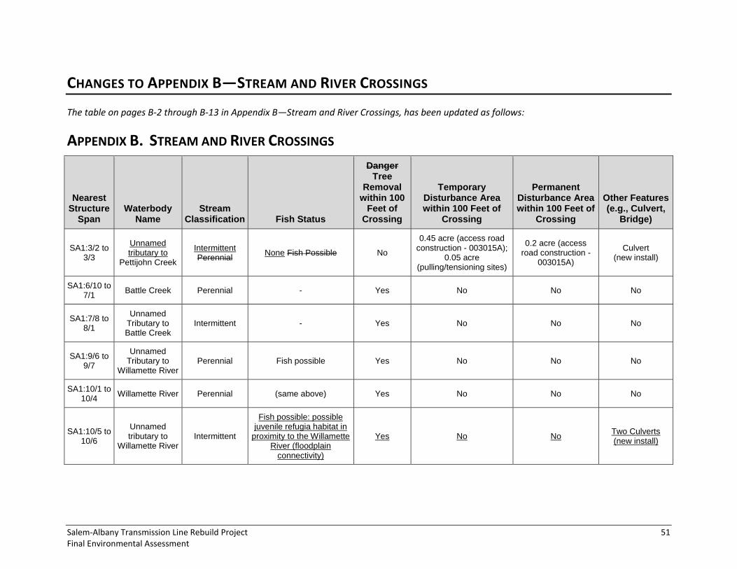
Salem-Albany Transmission Line Rebuild Project 51 Final Environmental Assessment
CHANGES TO APPENDIX B—STREAM AND RIVER CROSSINGS
The table on pages B-2 through B-13 in Appendix B—Stream and River Crossings, has been updated as follows:
APPENDIX B. STREAM AND RIVER CROSSINGS
Nearest Structure
Span Waterbody
Name Stream
Classification Fish Status
Danger Tree
Removal within 100
Feet of Crossing
Temporary Disturbance Area within 100 Feet of
Crossing
Permanent Disturbance Area within 100 Feet of
Crossing
Other Features (e.g., Culvert,
Bridge)
SA1:3/2 to 3/3
Unnamed tributary to
Pettijohn Creek
Intermittent Perennial
None Fish Possible No
0.45 acre (access road construction - 003015A);
0.05 acre (pulling/tensioning sites)
0.2 acre (access road construction -
003015A)
Culvert (new install)
SA1:6/10 to 7/1
Battle Creek Perennial - Yes No No No
SA1:7/8 to 8/1
Unnamed Tributary to Battle Creek
Intermittent - Yes No No No
SA1:9/6 to 9/7
Unnamed Tributary to
Willamette River Perennial Fish possible Yes No No No
SA1:10/1 to 10/4
Willamette River Perennial (same above) Yes No No No
SA1:10/5 to 10/6
Unnamed tributary to
Willamette River Intermittent
Fish possible: possible juvenile refugia habitat in
proximity to the Willamette River (floodplain
connectivity)
Yes No No Two Culverts (new install)

52 Bonneville Power Administration DOE/EA-1946
Nearest Structure
Span Waterbody
Name Stream
Classification Fish Status
Danger Tree
Removal within 100
Feet of Crossing
Temporary Disturbance Area within 100 Feet of
Crossing
Permanent Disturbance Area within 100 Feet of
Crossing
Other Features (e.g., Culvert,
Bridge)
SA1:10/7 to 10/8
Sidney Power Ditch
Ditch
*note that ORBIC data says that ODFW classifies as salmon rearing. ODFW
communication says no.
Yes 0.11 acre (SA1:10/8,
steel monopole) No No
SA1:10/12
Unnamed Tributary to
Sydney Ditch Willamette River
Intermittent Perennial
Present Yes 0.21 acre (SA1:10/10 to 10/12, steel monopole)
No Culvert
(new install) No
SA1:12/6 Unnamed
Tributary to Bashaw Creek
Intermittent Fish bearing No No No Box Culvert (new install)
SA1:14/5 to 14/6
Santiam River Perennial
Fish bearing; Chinook, steelhead, coho; Chinook
and steelhead critical habitat
Yes
0.20 acre (SA1:14/5, steel monopole);
0.002 acre (access road construction - 014010A)
0.01 acre (access road construction -
014010A) No
SA1:19/3 to 19/4
Unnamed Tributary to McCarthy
Slough
Intermittent - Yes 0.25 acre (access road
improvement - 019015A)
0.10 acre (access road improvement -
019015A) No
SA1:20/9 to 21/1
Unnamed Tributary to
Willamette River Intermittent - Yes No No No
SA1:22/7 to 22/8
Unnamed Tributary to
Willamette River Intermittent - Yes
0.0001 acre (SA1:22/7, single-pole wood
structure); 0.003 acre (access road construction - 022045A)
No Culvert
(New Install)
SA1:23/5 to 23/6
Unnamed tributary to
Willamette River Perennial Fish bearing Yes No No
Culvert (new install)

Salem-Albany Transmission Line Rebuild Project 53 Final Environmental Assessment
Nearest Structure
Span Waterbody
Name Stream
Classification Fish Status
Danger Tree
Removal within 100
Feet of Crossing
Temporary Disturbance Area within 100 Feet of
Crossing
Permanent Disturbance Area within 100 Feet of
Crossing
Other Features (e.g., Culvert,
Bridge)
SA1:24/4 to 24/5
SA2:27/9 to 28/1
Unnamed Tributary to
Willamette River Intermittent - Yes
0.01 acre (SA1:24/4, single-pole wood
structure); 0.01 acre (SA1:27/9,
single-pole wood structure);
0.05 acre (access road improvement - 027-080)
0.02 acre (access road improvement -
027-080) No
SA1:24/9 to 24/13
SA2:28/5 to 28/9
Calapooia River Perennial Fish bearing; Chinook, steelhead; Chinook and steelhead critical habitat
Yes 0.04 acre (access road improvement - 028-070)
0.01 acre (access road improvement -
028-070) No
SA2:3/3 to 3/4
McNary Creek Perennial Fish Possible Yes No No No
SA2:3/8 to 3/9
Unnamed Tributary to
McNary Creek Intermittent Fish Possible Yes No No No
SA2:4/3 to 4/4
Unnamed Tributary to
McNary Creek Perennial - Yes
0.01 acre (SA2:4/4, single-pole wood
structure); 0.35 acre (access road construction - 004-030); 0.02 acre (access road improvement - 004-030)
0.17 acre (access road construction -
004-030); 0.01 acre (access
road improvement - 004-030)
Culvert (New Install)
SA2:4/9 to 4/11
Rickreall Creek Perennial Fish bearing; Steelhead,
Chinook, coho Yes
0.001 acre (SA2:4/9, single-pole wood
structure) No No

54 Bonneville Power Administration DOE/EA-1946
Nearest Structure
Span Waterbody
Name Stream
Classification Fish Status
Danger Tree
Removal within 100
Feet of Crossing
Temporary Disturbance Area within 100 Feet of
Crossing
Permanent Disturbance Area within 100 Feet of
Crossing
Other Features (e.g., Culvert,
Bridge)
SA2:6/10 to 7/1
Oak Point Creek Perennial Fish Possible Yes
0.01 acre (SA2:7/1, single-pole wood
structure); 0.08 acre (access road construction - 006-101); 0.23 acre (access road construction - 006-100)
0.04 acre (access road construction -
006-101); 0.11 acre (access road construction -
006-100)
Culvert (Replace)
SA2:8/1 Unnamed
Tributary to Hayden Slough
Ditch None No No No Culvert
(Improvement)
SA2:8/7 to 8/8
Unnamed Tributary to
Hayden Slough Intermittent None Fish possible Yes
0.01 acre (SA2:8/8, single-pole wood
structure); 0.32 acre (access road construction - 008-080); 0.03 acre (access road construction - 008-082); 0.01 acre (access road
reconstruction - 008-081); 0.16 acre (access road
reconstruction - 008-082)
0.15 acre (access road construction -
008-080); 0.01 acre (access road construction -
008-082); 0.01 acre (access
road reconstruction - 008-081); 0.06 acre
(access road reconstruction - 008-
082)
Culvert (New Install)
SA2:10/10 to 10/11
Unnamed Tributary to Ash
Creek
Intermittent Perennial
None Fish bearing; Chinook, steelhead
Yes No No Two Culverts
(new install) No
SA2:12/9 Unnamed
Tributary to Talmadge Creek
Intermittent None No No No Two Culverts
(One new install, one improvement)

Salem-Albany Transmission Line Rebuild Project 55 Final Environmental Assessment
Nearest Structure
Span Waterbody
Name Stream
Classification Fish Status
Danger Tree
Removal within 100
Feet of Crossing
Temporary Disturbance Area within 100 Feet of
Crossing
Permanent Disturbance Area within 100 Feet of
Crossing
Other Features (e.g., Culvert,
Bridge)
SA2:13/8 to 14/1
Unnamed Tributary to
Willamette River Intermittent Fish bearing Fish possible No
0.16 acre (access road construction - 013-100); 0.26 acre (access road improvement - 013-101)
0.08 acre (access road construction -
013-100); 0.10 acre (access
road improvement - 013-101)
Culvert (New Install)
SA2:15/6 to 15/7
Unnamed Tributary to Luckiamute
River
Intermittent Fish bearing Fish possible Yes No 0.72 acre (access road improvement - 015-060)
0.29 acre (access road improvement -
015-060)
No Culvert (New Install)
SA2:16/7 to 16/10
Unnamed Tributary to Luckiamute
River
Intermittent - Yes
0.01 acre (SA2:16/10, single-pole wood
structure); 0.22 acre (access road construction - 016-081); 0.19 acre (access road improvement - 016-040)
0.11 acre (access road construction -
016-081); 0.08 acre (access
road improvement - 016-040)
No
SA2:17/3 to 17/4
Unnamed Tributary to Luckiamute
River
Perennial
Fish bearing; Coho, steelhead, Chinook, Steelhead,; Chinook
Critical Habitat
Yes
0.06 acre (SA2:17/4, steel monopole);
0.20 acre (access road improvement - 017-030)
0.08 acre (access road improvement -
017-030)
Stream Bank Stabilization for Existing Culvert
(Replace)
SA2:17/5 to 17/6
Luckiamute River
Perennial Fish bearing; coho,
steelhead, steelhead Critical Habitat
Yes 0.00001 acre (SA2:17/5,
steel monopole) No No
SA2:20/8 to 21/1
Unnamed Tributary to Soap Creek
Perennial Fish bearing No
0.01 acre (SA2:20/8, single-pole wood
structure); 0.22 acre (access road construction - 020-080)
0.11 acre (access road construction -
020-080)
Box Culvert (New Install)
SA2:23/7 to 23/8
Bowers Slough Perennial Fish bearing No No No Box Culvert (New Install)

56 Bonneville Power Administration DOE/EA-1946
This page intentionally left blank.

Salem-Albany Transmission Line Rebuild Project 57 Final Environmental Assessment
CHANGES TO APPENDIX C—US FISH AND WILDLIFE ANKENY NATIONAL
WILDLIFE REFUGE
C.2 DETAILS OF THE PROPOSED ACTION ADJACENT TO THE ANKENY
NWR
C.2.2 ACCESS ROADS
The first paragraph in in this section (page C-7) has been revised as follows:
Currently, there are no access roads to structures SA1:10/6 to 12/3 and 12/5 to 13/4. BPA would need a road surface that can support heavy construction equipment to implement the Proposed Action. In addition, BPA needs to have safe and reliable access to the transmission lines in the future to ensure transmission system reliability as well as public and worker safety. To better meet these needs, BPA has proposed to improve access to these structures (Figure 4). For SA1:11/6 to 12/4, three access road options were have been analyzed and vetted with Ankeny NWR. Currently, the The preferred option for both BPA and Ankeny NWR is Option 1. (Ankeny NWR would also include considered Option 3 as a preference if wetland mats could be used. : BPA would need to determine if wetland mats would be feasible given the distance that would be crossed). However, BPA determined that while wetland mats could be used, the distance would make the process laborious and time-consuming, with substantial soil disturbance, since the mats would need to be “leap-frogged” over each other to go the entire distance). The options include the following:
Option 1: New construction of about 1 mile of gravel access road in the BPA right-of-way, adjacent to Ankeny NWR, with an approach in the county road easement for Wintel Road and BPA right-of-way (see Figure 4). (Road construction would be as described in Section 2.1.3 of the main body of the Draft EA).
Option 2: New construction of about 1 mile of gravel access road on the Ankeny NWR adjacent to the existing BPA right-of-way, with an approach in the county road easement for Wintel Road. This would require BPA purchase of about 6 acres of Ankeny NWR property.
Option 3: Establishment of a route-of-travel across Ankeny NWR. For the line rebuild work, this route-of-travel would require installation of a temporary road (using geotextile fabric and gravel or wetland mats) across the wetlands present. The road would be removed following construction. For future access needs, this option would require development of a Memorandum of Understanding with USFWS to allow for annual line inspections, periodic maintenance, and potential emergency repairs.
C.2.3 TREE REMOVAL DANGER TREES
The first three paragraphs of this section, starting on page C-9, have been revised as follows:
Tree Danger tree survey and removal are typically done every 4 to 10 years along BPA transmission line rights-of-way to remove or trim trees presenting a hazard to the transmission line. It has been at least 10 years since a comprehensive danger tree survey and removal project has been done for the Salem-Albany No. 1 line, and an estimated 250 51 danger trees have grown into the safety buffer of the

58 Bonneville Power Administration DOE/EA-1946
transmission line in this 3-mile area (this includes trees both inside and outside of the right-of-way). An example of potential danger trees requiring removal for line safety is visible in Figure 5. The tree species identified as danger trees include about 243 33 cottonwoods, 5 9 Douglas-fir, and 2 9 Oregon ash. Many All of these trees are leaning toward the line, while some are old and declining or simply too close to the transmission line. To ensure safety and the reliability of the line, danger trees need to be cut down, limbed, or topped so they no longer present a hazard. Felled trees and branches would be removed. could be left in place, used for stream restoration on the Refuge, or removed depending on requests by either the BNSF railroad (if trees are located on BNSF property) or Ankeny NWR (if trees are located on Refuge property).
Figure 5. Potential Danger Trees Posing a Potential Hazard to the Line East of the Railroad Bed Adjacent to Ankeny NWR Field 6
Because some of the danger trees in this area are located in the swale between the railroad and a dike along the west side of Field 6 in the Refuge, access to the trees would be difficult. A Refuge road located on the dike would be used by crews to approach the trees in pick-up trucks; however, this road would be unlikely to support heavier vehicles that might be needed to remove felled trees and limbs (Selvaggio Pers. Comm. 2014). Alternative access could be possible using the railroad. BPA would work with the Refuge and BNSF Railroad to determine the best method for access. Danger t Tree removal would entail workers on foot using chainsaws along with other equipment to remove the downed trees.

Salem-Albany Transmission Line Rebuild Project 59 Final Environmental Assessment
Estimates are based on LiDAR data and field Field surveys were conducted in May, June, and October 2014. Further analysis will be done to determine which trees could be limbed or topped, and which are located on Ankeny NWR property—versus the BPA right-of-way (on railroad property) or private property.
C.3 POTENTIAL IMPACTS TO THE REFUGE FROM THE PROPOSED
ACTION
C.3.5 VEGETATION
Affected Environment in and adjacent to Ankeny NWR
Special-Status Plants
This subsection (page C-16) has been revised as follows:
The vegetative community in the greater Ankeny NWR includes at least 163 plant species, including wetland and upland herbaceous plants and trees and shrubs typical of the Willamette Valley (Selvaggio Pers. Comm. 2014a). Special-status plants, as defined in this document, are those species that have been identified for protection and/or management under the Federal Endangered Species Act of 1973 (16 U.S.C. 1531 et seq.), or the Oregon Department of Agriculture (ODA 2014). Additionally, rare plants, those which do not have state or federal protective management but are noted to be rare by the Oregon Biodiversity Information Center (ORBIC) were also considered in the areas adjacent to Ankeny NWR. A total of 21 rare plant species may occur within Marion County, of which 13 could have suitable habitat within the affected area between structures SA1:10/6 and 13/4 based on the availability of suitable habitat (see Section 3.3 of the Draft EA for a discussion of species and habitat requirements). None of the plants included on Ankeny NWR’s plant list are included on the rare plant list for Marion County. No state- or ESA-listed plants were found in or adjacent to the Refuge during spring and summer 2014 field surveys (see Section 3.3.1 in the main body of the Draft EA), although an occurrence of meadow checker-mallow and thin leaved peavine were found along the right-of-way to the north and south of the Refuge (also see Section 3.3.1 of the Final EA) (BPA 2014d). A special-status plant survey was will be conducted during spring and summer 2014 in suitable habitat in the affected area, including the rights-of-way and access roads, but excluding cultivated areas.
Noxious Weeds
This subsection (starting on page C-16) has been revised as follows:
Noxious weeds reported on Ankeny NWR’s plant list are Himalayan blackberry, St. Johnswort, Canada thistle, and bull thistle. According to Ankeny NWR’s Comprehensive Conservation Plan, seventeen invasive species have been identified by Refuge staff as those posing serious threats to the various habitats within Ankeny NWR Complex, including Armenian (Himalayan) blackberry, black locust (Robinia pseudoacacia), Canada thistle, English ivy (Hedera helix), false brome (Brachypodium sylvaticum), Fuller’s/Common Teasel, harding grass, Italian prune (Prunus cocomilia), Japanese knotweed (Fallopia japonica), meadow knapweed (Centaurea pratensis), milk thistle (Silybum marianum), periwinkle (Vinca minor), purple loosestrife (Lythrum salicaria), reed canarygrass, Scotch broom (Sarothamnus scoparius), tansy ragwort, and yellow flag iris (Iris pseudacorus) (USFWS 2011). None of the plants found during the vegetation reconnaissance survey conducted in winter 2014 near structure SA1:11/6 are included on the

60 Bonneville Power Administration DOE/EA-1946
state noxious weed list. Further A noxious weed surveys for the affected area, including the rights-of-way and access roads, was will be conducted in the spring and summer 2014. Noxious weeds found on or adjacent to the Refuge include primarily reed canarygrass, bull thistle, St. Johnswort, poison hemlock, Himalayan blackberry, and Canada thistle (also see Section 3.3.2) (BPA 2014e).
Environmental Consequences in and adjacent to Ankeny NWR
Common Vegetation
The third paragraphs in this section (page C-17), has been revised as follows:
Although many of the estimated 250 trees in this area are likely inside the right-of-way, tree removal could include some cottonwoods and other trees in Ankeny NWR on the east side of the railroad. (these numbers will be determined and reported in the Final EA). Because these trees represent a small proportion of the approximately 500 acres of woodlands on the Refuge (see Section 1.3.1 in this Appendix), but because trees are relatively rare this part of the Refuge (Fields 5 and 6), impacts to Ankeny NWR woodlands would be low-to-moderate.
Special-Status Plants
This section, starting at the bottom of page C-18, has been revised as follows:
The risk of finding threatened or endangered rare plant species within the affected area appears to be -to-low for most species based on their habitat requirements and their likelihood of occurrence in the affected area in and adjacent to Ankeny NWR. For Although the affected area provides habitat that could support Nelson’s checker-mallow, which occurs in open prairie remnants along the margins of streams, sloughs, ditches, roadsides, fence rows, and drainage swales, has been observed in the Refuge about 0.75 mile to the east of the affected area (USFWS Pers. Comm. 2014), and is more tolerant of disturbance, none were found there is a moderate likelihood of occurrence and therefore impacts to these species. Therefore, there would be no impact to Nelson’s checker-mallow. However, for all species, Furthermore, the potential habitat that would be affected is low-quality since it is fragmented with a dense cover of reed canarygrass, and the affected environment is not likely to support large populations. There would likely be no impacts to state-listed species since none were found in the affected area.
Surveys for state and federally designated special-status plants as well as rare plants of concern to Ankeny NWR will be conducted during the appropriate season in 2014 in suitable habitat in and adjacent to Ankeny NWR. The results of these surveys will be reported in the final EA. If rare plants are found, mitigation measures could include avoidance by adjusting impact areas if possible, marking off populations to avoid during construction, or others as determined in consultation with ODFW and USFWS (if federally listed plants are affected). If federally protected plants are identified, a biological assessment will be prepared, and BPA will work with USFWS to mitigate impacts. If Nelson’s checkermallow is present, replacement of structures would have a low impact, because avoidance would likely be more possible if plants are found in the right-of-way. New access roads would likely have low-to-moderate impacts given the larger and continuous area affected.

Salem-Albany Transmission Line Rebuild Project 61 Final Environmental Assessment
Mitigation Measures
The following mitigation measure on page C-19 has been removed since no special-status plant species were found on or adjacent to the Refuge:
Abide by any terms and conditions or mitigation measures agreed to with USFWS during ESA consultation if Nelson’s checkermallow or other listed plant species are found. These could include avoidance, flagging of populations, and other measures.
C.3.6 WILDLIFE
Environmental Consequences in and adjacent to Ankeny NWR
General
The second, fourth, and sixth paragraphs of this section, (page C-21 and C-22), have been revised as follows:
Temporary impacts associated with construction activities would occur under all three options and would be related to potential habitat degradation, increased noise (including helicopters), and human intrusion in the affected area. Ground disturbing activities could result in the invasion or spread of invasive weeds such as Himalayan blackberry, which could degrade wildlife habitat (also see Section C.3.5). A temporary increase in noise associated with construction activities could disrupt foraging and breeding activities or cause adults to abandon nest or den sites, endangering their young. Nesting raptors, should they occur in the affected area, are easily disturbed by construction noises and human presence. However, wildlife in the affected area are likely accustomed to periodic noise disturbance from trains and agricultural equipment, so are habituated to these types of loud disturbance and would be less likely to experience high levels of stress and abandon their nests (or dens) for long periods of time, reducing the risk of mortality of young or nest failure. The temporary small loss of remnant wet prairie and shrubby hedgerow (wetland) habitat within the right-of-way (2.6 acres) would be offset by the large amount of available habitat in the adjacent Refuge.
Overall, because construction disturbance would be intermittent and temporary and limited to the area along the right-of-way (and the access road under Options 2 and 3), mitigation measures would include revegetation to help reduce weed establishment (see Section 3.3.3 of the Draft EA), wildlife could access available habitat nearby, and wildlife injury or mortality would occur at the scale of individuals and not likely cause population-level effects, impacts to wildlife would be low-to-moderate.
An estimated 51 250 cottonwoods, Douglas fir, and Oregon ash and other trees (approximately 0.4 acre) would be removed between 10/6 and 13/1 10/8 and 13/4, resulting in both temporary and long-term impacts to wildlife and wildlife habitat both in the Ankeny NWR and on the right-of-way adjacent to the Refuge. Temporary impacts include disturbance from tree felling, which could cause injury or mortality to wildlife—particularly nesting birds and wildlife such as squirrels. However, impacts to wildlife resulting from danger tree removal would be low since danger tree removal would be done outside of the nesting season to reduce the chance of injury or mortality. Long-term impacts to birds and tree-dependent wildlife, including bald eagle and other raptors, would occur as a result of tree habitat loss and modification. The remaining trees, shrubs, and crown sprouts would continue to provide canopy cover, with some tree removal occurring at the edges of woodlands. In addition, trees and riparian woodlands in other areas of the Ankeny NWR cover approximately 600 acres—about 20 percent of all
62 Bonneville Power Administration DOE/EA-1946
available habitats on the Refuge—and would continue to provide habitat (USFWS 2012a). Although the proportion of trees removed from the affected area I
Special-Status Wildlife Species
Streaked Horned Lark
This section, starting on page C-24, has been revised as follows:
Since streaked horned larks are known to forage and nest at the Ankeny NWR, the Proposed Action could have both positive and negative impacts on the species. Negative impacts would include noise Noise and physical disturbance associated with construction activities, which could lead to nest abandonment or destruction. In addition, vehicles could present a hazard to juveniles and adults foraging along the ground, increasing the risk of injury, mortality, or failed nests. Mortality or failed nests would be a high impact on the streaked horned lark due to the federally threatened status of the species. However, the period until young have fledged—and when they are most at risk—is relatively short (12 days of incubation, then 9 days until fledging), and seasonal restrictions for construction would likely be employed to avoid reduce impacts. Reduced speed limits would also likely be used to reduce the risk of juvenile and adult mortality. BPA will prepare has prepared a Biological Assessment to further assess potential impacts and is working with USFWS to determine potential avoidance or mitigation measures that would be employed to minimize impacts.
Construction of a permanent access road under Options 2 and 3 could alter lark nesting habitat from a high quality vernal pool/prairie habitat to a lower quality gravel habitat, which would have a negative impact on the species. Conversely, Option 1 could create potential additional nesting (gravel) habitat with the new permanent road in the swale of the right-of-way, which could be a slightly would be a positive impact (Brown Pers. Comm. 2014a). However, the The 3-inch-long gravel proposed for the road surface may not be suitable or preferred ideal habitat., although streaked horned larks have been observed living on a similar substrate in airports (Brown Pers. Comm. 2014b). Upon completion of the Proposed Action, these roads this road would not be used on a regular basis and only traveled once or twice a year for annual inspections and infrequent maintenance of the road or line. These activities would have the potential to disrupt larks present in the area but would also help maintain their habitat (i.e., vegetation clearing). Since implementation of the Proposed Action would result in a long-term benefit to streaked horned larks, and since any adverse effects would primarily be temporary and minimized with mitigation measures, any disturbance, injury, or mortality resulting from construction would be moderate. Since annual inspections and repair activities would be limited in occurrence and duration and would aid in maintaining habitat, the anticipated impact level of a new access road to streaked horned lark would be moderate.
Mitigation Measures
The following mitigation measures on page C-25 have been revised as follows:
Continue to Ccoordinate construction activities, including helicopter use and tree removal, with the Ankeny NWR (and during Section 7 consultation with USFWS) to reduce impacts during sensitive periods for streaked horned lark and other migratory birds. waterfowl, water birds, shorebirds, and streaked horned lark; and during raptor and migratory bird nesting periods. and other birds.

Salem-Albany Transmission Line Rebuild Project 63 Final Environmental Assessment
Schedule danger tree removal between August and November outside of the bird nesting season to minimize impacts to migratory birds and the Refuge dike road (see Mitigation Measure in Land Use section of this Appendix). If a nest is found it must be deemed inactive prior to removal of the tree.
Install yellow swan bird flight diverters every 50 feet on conductors and fiber to reduce the potential for collision between SA1:10/1 to 13/5. (AFWA 2010). This includes all spans discussed in this Appendix.
Coordinate with Ankeny NWR on use of Refuge access roads for tree removal to avoid road damage during the rainy season.

64 Bonneville Power Administration DOE/EA-1946
PUBLIC COMMENTS
COMMENTS AND RESPONSES This section presents comments received on the Draft EA and responses to those comments, which are presented in their entirety. Comments were received via letter and e-mail. The official comment period was July 3, 2014 to August 6, 2014.
BPA received comments from six entities. Most of the comments received related to environmental concerns, including analysis, impacts, and mitigation for fish and wildlife habitat, special-status species, and migratory birds; the Ankeny National Wildlife Refuge; tree removal; and noxious weed management. Other comments addressed permitting, safety concerns, and vegetation management in railroad rights-of-way.
Each comment was given an identifying number that equates to the order in which it was received. Breaks in the number sequence resulted when comments were deleted because they were submitted in error or had inappropriate content (such as SPAM). Table 1 provides the comment number and the associated author and affiliation.
Table 1. Draft EA Comment Submittals
Comment Number Comment Author / Affiliation
SATLR14 0002 Summers / Portland and Western Railroad
SATLR14 0003 Robison / Union Pacific Railroad
SATLR14 0004 Babbitt / Salem Audubon Society
SATLR14 0005 Young / U.S. Fish and Wildlife Service
SATLR14 0006 Taylor / Oregon Department of Fish and Wildlife
SATLR14 0007 Lewis / Benton County Community Development Department

Salem-Albany Transmission Line Rebuild Project 65 Final Environmental Assessment
Comment SATLR14 0002
Responses to SATLR14 0002
0002-01 BPA has been working with affected railroads to secure the necessary easement adjustments and permits for the Proposed Action and would have them in place prior to construction.
0002-02 The mitigation measures in Section 3.11.3 have been updated in the Final EA to include the provision of requiring a flagger for any work within 25 feet of a railroad track.
0002-03 The mitigation measures in Section 3.11.3 have been updated in the Final EA to include the provision that any felled trees or high brush cut for the project need to be removed in their entirety from the railroad right-of-way.
0002-01
0002-02
0002-03
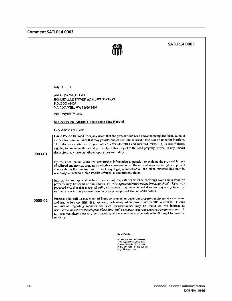
66 Bonneville Power Administration DOE/EA-1946
Comment SATLR14 0003
SATLR14 0003
0003-01
0003-02

Salem-Albany Transmission Line Rebuild Project 67 Final Environmental Assessment

68 Bonneville Power Administration DOE/EA-1946
Responses to SATLR14 0003
0003-01 Please note that no new transmission lines are being proposed. The Proposed Action involves replacing the existing structures and wires of two existing transmission lines (Salem-Albany No. 1 and No. 2). All railroad crossings by the transmission lines are existing crossings and BPA does not believe new applications or permits are required with the exception of construction related permits for right-of-entry. Sections 3.1.1 and 3.1.2 have been updated in the Final EA to better describe the existing crossings for both lines and potential impacts to the railroads.
0003-02 Please see response to comment 0002-01 and 0003-01.
Comment SATLR14 0004
Responses to SATLR14 0004
0004-01 BPA recognizes the Salem Audubon Society’s involvement and interest in the Ankeny National Wildlife Refuge (Refuge), and appreciates your comment in support of the Refuge and future nature education center. BPA will continue to keep you informed of the Proposed Action.
0004-02 BPA acknowledges your support of USFWS comments on this Proposed Action: please see responses to USFWS’s comments with Comments 0005-01 through 0005-12. BPA recognizes the importance of wildlife habitat and public access to the purposes of the Refuge, as discussed in Section C.3.4. While the Proposed Action would impact both wildlife habitat and public access on the Refuge, BPA has been communicating regularly with the Refuge to discuss ways to mitigate those impacts (see response to Comment 0005-01). Mitigation measures that are proposed on the Refuge are listed in Appendix C of the Draft EA, with updates in Sections C.3.5 and C.3.6 of the Final EA, and have been incorporated into the relevant resource mitigation sections in the Final EA.
0004-03 The mailing list has been revised to include your contact information. Thank you for notifying BPA.
0004-01
0004-02
0004-03

Salem-Albany Transmission Line Rebuild Project 69 Final Environmental Assessment
Comment SATLR14 0005
0005-02
SATLR14 0005
0005-01

70 Bonneville Power Administration DOE/EA-1946
0005-02 cont.
0005-03
0005-04
0005-05
0005-06
0005-07
0005-08
0005-09
0005-10

Salem-Albany Transmission Line Rebuild Project 71 Final Environmental Assessment
0005-10 cont.
0005-11
0005-12

72 Bonneville Power Administration DOE/EA-1946
Responses to SATLR14 0005
0005-01 BPA acknowledges receipt of previous comments from the USFWS, both about the Proposed Action at large and the Ankeny National Wildlife Refuge, and appreciates the interest and time USFWS personnel have contributed to the planning and review of the Proposed Action. BPA has attempted to address the concerns and suggestions as much as possible, and has reached out to the USFWS, including Ankeny National Wildlife Refuge, for input on multiple occasions between 2013 and 2014. In addition, BPA requested that USFWS cooperate on the EA to satisfy any potential NEPA requirements it may have for actions affecting the Ankeny National Wildlife Refuge. Although USFWS declined to cooperate on the EA, BPA included an appendix specifically for potential impacts to the Ankeny National Wildlife Refuge. BPA held a meeting with the USFWS in October 2013 to present the general aspects of the Proposed Action, field questions and concerns, and explore the potential for collaboration on federal requirements for both agencies. In addition, BPA attended three site visits with USFWS personnel at the Refuge on December 12, 2013; March 12, 2014; and on April 1, 2014, to discuss design plans, mitigation options, and impact studies on issues ranging from access issues, to hydrology, to bird flight diverters. BPA also held a meeting USFWS on April 30, 2014 to determine the best survey strategy to undertake for streaked horned lark, and is currently consulting with USFWS regarding impacts of the Proposed Action to species listed under the Endangered Species Act.
0005-02 The proposed action is to rebuild the two existing Salem-Albany transmission lines (replace wood-pole structures and other line components and improve access roads). The proposed action is not to conduct ongoing operation and maintenance of the existing line; these activities would be done with or without the rebuild.
As such, Section 2.1.7 of the Draft EA appropriately discusses existing transmission line maintenance and vegetation management as ongoing activities that would continue regardless of whether the project is implemented. In addition, Section 2.2 of the Draft EA discusses how operation and maintenance would continue under the No Action Alterative, in which the line would not be rebuilt, and Section 3.12.1 of the Draft EA considers ongoing operation and maintenance activities as actions that could contribute to cumulative effects to resources that would also be impacted by the rebuild project.
Therefore, potential future vegetation management are not included as part of the Proposed Action in this EA and instead are appropriately analyzed in the cumulative effects section. Additionally, any future vegetation maintenance activities would undergo site-specific NEPA analysis. Sections 3.12.4 and 3.12.5 of the Final EA have been revised to further address this point.
0005-03 The inclusion of Appendix C provides extra detail for an assessment of potential impacts to the Refuge to help facilitate the USFWS in meeting any of its NEPA requirements related to the Project. The main body of the Draft EA presents the overall affected environment and impact assessment of the entire project area and the mitigation measures specific to the Refuge area have been incorporated into the relevant resources sections of the final EA. Also, see response to comment 0005-04.

Salem-Albany Transmission Line Rebuild Project 73 Final Environmental Assessment
0005-04 Both the Draft and Final EA reflect BPA’s and the Ankeny NWR’s preference for the access road Option 1, while still analyzing the three proposed options. BPA is proposing Option 1 and will state a decision along with a decision whether to rebuild the line in the letter accompanying the Final EA and Finding of No Significant Impact.
0005-05 Additional and ongoing tree surveys have determined that there are trees physically on Refuge property that would require removal. Some of the results are presented in Section C.2.3 of the Final EA (also see updated analysis in Sections C.3.5 and C.3.6 of the Final EA). BPA will continue to correspond with the Refuge on this issue, and would minimize impacts to the fullest extent possible on trees adjacent to the Refuge and throughout the project, recognizing the value of trees to wildlife habitat, as discussed in Section C.3.6 of the Draft and Final EA.
0005-06 BPA is now proposing to install swan flight diverters the entire distance between SA1: 10/1 and 13/5. The proposed design has been revised to include the installation of the new conductors, and the mitigation measures in Sections 3.4 and C.3.6 have been updated to reflect this change. (Also see response to comment 0006-27).
0005-07 Please see response to Comment 0005-003 and 0005-004.
0005-08 BPA will continue to correspond with the Refuge and other landowners to address needs and concerns throughout the NEPA process and implementation of the Project, should it go forward. Communications should be directed to Amanda Williams, Project Manager, at [email protected], or 360-619-6634.
0005-09 Issues associated with the Migratory Bird Treaty Act and the U.S. Department of Energy (including BPA)-Service Memorandum of Understanding (MOU) for Executive Order (EO) 13186, the conservation of migratory birds, are addressed in Section 4.2.5 of the Draft EA. The project is consistent with the measures outlined in DOE’s MOU with USFWS and with EO 13186 because—as agreed to in the MOU—BPA would minimize adverse impacts to migratory birds and analyze these impacts as part of the NEPA process. BPA would minimize adverse impacts to migratory birds by installing bird diverters, including those between SA1:10/1 and 13/5 and other high risk areas; managing noxious weeds, replanting with native vegetation where practicable, and implementing seasonal restrictions for tree removal. Effects to migratory birds are discussed along with general wildlife in Sections 3.4.2 and C.3.6 of the Draft EA.

74 Bonneville Power Administration DOE/EA-1946
0005-10 BPA acknowledges that the Project would still affect migratory birds even after mitigation measures are implemented, as described in Section 3.4.4 of the Draft EA; however, these impacts would not be significant because mitigation measures that are consistent with the measures outlined in DOE’s MOU with USFWS would be implemented as part of the Proposed Action (see response to Comment 0005-09). As a result, an environmental impact statement (EIS) will not be prepared and no additional mitigation is required. There are no federal requirements—either in the Migratory Bird Treaty Act, Executive Order 13186, or the Department of Energy MOU with the USFWS—for BPA to compensate for unavoidable impacts to migratory birds. With the mitigation measures referenced above, BPA is acting consistently with the Migratory Bird Treaty Act, Executive Order 13186, and the Department of Energy MOU with the USFWS. BPA is also cooperating on a mitigation strategy with USFWS and ODFW for impacts to certain sensitive habitats and species. This strategy would likely include funding for riparian vegetation restoration at the Bowers Rock State Natural Area Fitchett Tract mitigation area to reduce impacts to wildlife species that may occur as a result of the proposed project.
0005-11 The results of the 2014 field surveys have been included in Sections 3.3.1, 3.3.2, 3.4.1, 3.4.2, 3.12.4, 3.12.5, 4.2.1, C.3.5, and C.3.6 in the Final EA. Mitigation measures have also been updated in response to these results in Sections 3.3.3, 3.4.3, C.3.5, and C.3.6. Final mitigation measures to reduce impacts to Endangered Species Act (ESA)-listed species will be determined as part of BPA’s ESA consultation with USFWS in the fall of 2014.
0005-12 BPA met with USFWS on September 16, 2014 to discuss the results of the 2014 field surveys for streaked horned lark, potential impacts, and appropriate conservation measures and subsequent surveys that would be needed. Because the project would impact streaked horned larks, BPA submitted a biological assessment under Section 7 of the ESA to USFWS and would abide by any terms or conditions included in the biological opinion. In addition, BPA will continue to communicate with ODFW and NOAA Fisheries (NMFS) if they have questions or concerns about the results of the 2014 field surveys and any other updated information pertinent to the Proposed Action. BPA also included an analysis of potential impacts to Chinook salmon and steelhead as part of its Section 7 ESA consultation with NMFS (see updates to Sections 3.4.2 and 3.4.3 in the Final EA).
Sections 3.1.3, 3.3.3, 3.4.3, and 3.6.3 of the Draft EA, and updates to these sections in the Final EA, contain numerous mitigation measures that reduce environmental impacts from the Proposed Action. In addition, Section 3.4.3 has been updated in the Final EA to include a commitment to finalize and implement a mitigation strategy to be developed with USFWS and ODFW for impacts to certain sensitive habitats. As such, BPA will continue to communicate with these agencies and believes the environmental consequences of the Proposed Action would be adequately minimized. (Also see responses to Comments 0005-10 and 0006-22).

Salem-Albany Transmission Line Rebuild Project 75 Final Environmental Assessment
Correspondence SATLR14 0006
SATLR14 0006
0006-02
0006-01

76 Bonneville Power Administration DOE/EA-1946
0006-02 cont.
0006-03
0006-04
0006-05

Salem-Albany Transmission Line Rebuild Project 77 Final Environmental Assessment
0006-05 cont.
0006-06
0006-07
0006-11
0006-12
0006-08
0006-09
0006-10

78 Bonneville Power Administration DOE/EA-1946
0006-12 cont.
0006-13
0006-14
0006-15
0006-16
0006-17

Salem-Albany Transmission Line Rebuild Project 79 Final Environmental Assessment
0006-17 cont.
0006-18
0006-19
0006-20
0006-21
0006-22
0006-23

80 Bonneville Power Administration DOE/EA-1946
0006-23 cont.
0006-24
0006-25
0006-26
0006-27
0006-28
0006-29
0006-30

Salem-Albany Transmission Line Rebuild Project 81 Final Environmental Assessment
0006-30 cont.

82 Bonneville Power Administration DOE/EA-1946

Salem-Albany Transmission Line Rebuild Project 83 Final Environmental Assessment
Responses to SATLR14 0006
0006-01 As noted in Section 4.7 of the Draft EA, and as updated in the Final EA, BPA is not required as a federal agency to comply with state and local land-use approvals, permits, or regulations unless required by federal regulation (such as under the Clean Water Act—see Section 4.3 of the Draft EA). However, BPA does strive to meet or exceed the substantive standards and policies of state and local plans and programs to the maximum extent practicable.
0006-02 BPA will follow NMFS/ODFW’s Fish Screening Criteria for all in-water work, and Section 3.4.3 of this Final EA have been updated to clarify use of this provision. Screens for other potential water withdrawal would not be applicable since the project would not require water to be removed or pumped from fish bearing water bodies for any other purpose. Water needed for dust abatement or other use would be obtained from an approved source such as a municipality.
0006-03 BPA provided an impact analysis on fish passage and included proposed methods of mitigating or avoiding adverse impacts in Sections 3.4.2 and 3.4.3 of the Draft EA. In addition, BPA has worked with ODFW fish biologists to identify which of the Proposed Action’s stream crossings would need fish passage. Project information and maps were shared with ODFW, and an ODFW fish biologist conducted site visits in July and August 2014. Sections 3.4.2 and 3.4.3 in the Final EA have been updated with stream crossing locations requiring fish passage, as identified by ODFW. BPA will be submitting fish passage plans for these stream crossings to ODFW for review.
0006-04 While BPA is not legally obligated to adhere to ODFW’s Oregon Fish and Wildlife Habitat Mitigation Policy, BPA recognizes the importance of the fish and wildlife habitats identified for protection under this policy. Minimizing environmental consequences is one of BPA’s stated purposes under the Proposed Action (see Section 1.3 of the Draft EA). Additionally, BPA considered ODFW’s habitat categories in assessing the Proposed Action’s environmental impacts (see Section 3.4.1 and 3.4.2 of the Draft EA). Section 3.4.2 has been updated in the Final EA to better demonstrate how BPA would avoid, minimize, or mitigate impacts to fish and wildlife habitat and further describes impacts based on ODFW’s categories. (Also see response to comment 0006-20.)
0006-05 BPA conducted an analysis of potential impacts to special-status plants and animals (including threatened, endangered, candidate, species of concern, or sensitive species) with potential to occur in the affected area (see Sections 3.3, 3.4, C.3.5, and C.3.6 of the Draft EA). Updates to these sections based on results from 2014 field surveys are included in the Final EA. Potential impacts to special-status habitats were also addressed in the Draft EA and include Oregon Conservation Strategy habitats in Section 3.3, and ODFW wildlife habitat categories in Section 3.4. BPA contacted ODFW via e-mail and phone to discuss survey protocols for streaked horned lark and inquired as to concerns about other special-status species prior to the survey season in 2014.
Mitigation measures to reduce or eliminate impacts to special-status species, along with other vegetation and wildlife, were listed in Sections 3.3.3, 3.4.3, C.3.5, and C.3.6 of the Draft EA. Seasonal timing restrictions for critical nesting or reproductive periods for migratory birds, streaked horned lark, and western pond turtle were addressed, as were the use of bird diverters in high collision risk areas for birds. Section C.3.6 in the Draft EA considered impacts to migration habitats and wintering areas for migratory birds on the

84 Bonneville Power Administration DOE/EA-1946
Ankeny National Wildlife Refuge. Sections 3.4.1 and 3.4.2 of the Final EA have been updated to further consider impacts to overwintering areas for western pond turtle, daily migration corridors for Roosevelt elk and other wildlife, and impacts to overwintering birds. BPA consulted with USFWS on September 16, 2014 to review potential seasonal restrictions for streaked horned lark as part of its Section 7 consultation. (Also see response to comment 0005-11, 0005-12, 0006-25, and 0006-26). BPA also shared the results of the 2014 streaked horned lark field surveys with ODFW in August 2014 (also see response to Comment 0006-24).
0006-06 Sections 3.1.2, 3.3.2, and C.3.5 of the Draft EA and Sections 3.4.2, 3.12.4, 3.12.5, and C.3.6 of the Final EA explain and analyze the potential impacts from the spread of invasive weeds. Section 3.3.2 of the Draft EA discusses BPA’s strategy for its pre- and post-construction noxious weed survey and management. BPA had a noxious weed survey completed in the potentially affected area in June and July of 2014, and the results of the survey are provided in Sections 3.3.1, 3.3.2, and C.3.5 of the Final EA. This survey provided the names and locations of the noxious weeds observed, along with recommendations for weed management before and during construction—including strategic locations for construction equipment wash stations. BPA would use this information to implement noxious weed control measures and conduct a post-construction noxious weed survey, as stated in Section 3.3.3 of the Draft EA.
0006-07 The Draft EA provided an impact analysis for vegetation and fish and wildlife based on the likelihood of the presence of special-status species (based on previously documented occurrences and habitat requirements), the status of the species, the quality of potentially affected habitats, the nature of the proposed construction impacts, and potential mitigation (see Sections 3.3, 3.4, 4.2.1, C.3.5, and C.3.6). In addition, field surveys for specific special-status species were completed during the appropriate seasons in 2014, and the results of those surveys, along with updated analyses, are provided in Sections 3.3.2, 3.4.2, 3.12.4, 3.12.5, 4.2.1, C.3.5, and C.3.6 in the Final EA.
0006-08 The Draft EA discusses the range of potential impacts from the Proposed Action without avoidance and minimization measures, and then summarizes the ultimate level of impact (no, low, moderate, or high) with avoidance and minimization measures implemented in each resource section.
0006-09 Photomaps showing the locations of proposed activities were provided in Appendix A of the Draft EA. This, along with descriptions of proposed activities in Chapter 2 of the Draft EA, descriptions of the affected environment in Chapter 3 (obtained through both existing databases and field surveys), and discussion of potential impacts to specific resources in Chapter 3, provide the necessary context to assess the overall impacts of the Proposed Action. Where resources were identified in the affected area that would be more sensitive to impacts from the Proposed Action—such as conservation areas (see Section 3.1.2 and Appendix C); documented occurrences of special-status species (see Sections 3.3.2 and 3.4.2); visually sensitive locations (see Section 3.7.2); or fish-bearing streams (see Section 3.4.2)—additional analysis was provided in the Draft EA as well as in the Final EA. In the case of special-status species, consultation is ongoing with management agencies, where appropriate.

Salem-Albany Transmission Line Rebuild Project 85 Final Environmental Assessment
0006-10 Most avoidance measures would be implemented for direct impacts and have been continually developed throughout the project planning process. Roads were designed to avoid many wetland and sensitive areas, such as the Ankeny National Wildlife Refuge property, to the extent practicable. Potential mortality of or loss of nests by most tree-nesting birds would be avoided by conducting tree removal outside of the nesting season to the extent practicable. Potential mortality or stress to fish would be avoided in numerous locations by installing box culverts or culverts designed for fish passage during appropriate in-water work windows, or moving the road away from stream crossings. Degradation to fish habitat through reductions in water quality would be avoided through implementation of erosion BMPs. Removal of trees—including Oregon white oak and other hardwoods—would be avoided where possible by limbing or topping trees or identifying low-risk situations that allow trees to be retained. Potential dDestruction of Nelson’s checker-mallow and most of the other occurrences of special-status plants would be avoided by flagging known populations. Potential mortality and stress to streaked horned lark would be reduced by timing construction to avoid areas with the highest numbers of streaked horned lark during the most sensitive times of the breeding season. Additionally, narrowed roads in wetlands and the use of monopoles would reduce wetland fill, and reduced disturbance areas around structures would reduce the amount of wetland soil disturbance. More details are given in the various resource sections of Chapter 3 of the Draft EA and Final EA.
0006-11 With the incorporation of the results of the 2014 field surveys, the EA has been revised to provide a comprehensive impact analysis for the entire Proposed Action and specific mitigation measures for impacts to each affected resource by activity.
0006-12 See response to Comment 0006-01 and 0006-003. BPA will be submitting fish passage designs to ODFW for review prior to construction.
0006-13 The reduced disturbance area of 0.06 acre per structure would be implemented for wetlands. However, it would not be practicable to do this in the 100-year floodplain, which is extensive in the affected area, and for which temporary disturbance impacts would have no long-term effect. Oak habitats do no extend into the right-of-way where structure replacements and installations would take place.
BPA has utilized the results of the 2014 field surveys to consider avoidance and minimization measures for special-status species documented during the surveys (see Sections 3.3.2, 3.3.3, 3.4.2, and 3.4.3 in the Final EA). For non-ESA-listed species, these primarily include flagging documented occurrences of special-status plant species for avoidance purposes. Other minimization measures—such as implementing additional reduced road widths and reduced disturbance areas around structures in the vicinity of special-status species—were typically deemed impractical. However, where special-status species are located in wetlands, these minimization measures would be carried out regardless and will benefit both species and habitat. Additional mitigation measures to those listed in Section 3.4.3 for ESA-listed wildlife species (streaked horned lark) would be determined through Section 7 consultation with USFWS in the fall of 2014.

86 Bonneville Power Administration DOE/EA-1946
0006-14 BPA would avoid staging areas that would result in impacts to wetlands and cultural resources (see Section 3.6.3 in the Draft EA and Section 3.10.3 in the Final EA). Staging areas would have no long-term impacts to floodplains because the staging areas would be temporary and either located in a previously developed site or restored following the end of construction. Oak habitat would likely be avoided because it would not provide the necessary open conditions for staging areas. Other locations of staging areas would undergo any necessary site-specific environmental review to ensure compliance with federal laws and would require approval by BPA (see Section 2.1.3 in the Draft EA).
0006-15 BPA agrees that new and reconstructed access roads, along with tree removal, would have the most new long-term impacts to fish and wildlife habitat. Routes of travel would have the largest temporary impacts of all project activities based on acreage, although the level of disturbance would generally be less since temporary road beds would not be needed unless there are circumstances where soils would be too wet to support construction vehicles (see Section 2.1.4 of the Draft EA). By providing total impacted acreages for habitats, including impacts from structures, the Draft EA gives a comprehensive analysis of how these habitats would be affected by the Proposed Action (see updated Table 3-6 in the Final EA for wetland and oak habitats; and Section 3.6.2 in the Draft EA for floodplain acreages). As discussed in Section 3.4.2 of the Draft EA, access road work would affect Categories 2 through 6 Habitats, as categorized under the Oregon Fish and Wildlife Habitat Mitigation Policy. Section 3.4.2 in the Final EA has been updated to explain that agricultural areas would have the most acreage permanently affected by new and reconstructed roads, followed by herbaceous and shrub areas inside and outside of the maintained rights-of-way, then wetlands and riparian areas (much of which also includes floodplains), with Oregon white oak and other woodlands affected the least of these habitat types (see Table 3-6).
0006-16 BPA is planning to use temporary access roads along a portion of both lines. In the case of Salem-Albany No. 2, most access to the line (22 miles) is temporary. Temporary access is generally suitable where only a few structures need to be accessed from an established road and/or where soil conditions can support heavy vehicles. BPA project team members met on February 12, 2014 to consider reductions in the number of permanent roads to reduce impacts to wetlands, and were able to remove or shorten several planned roads. In addition, road widths have been reduced from 20 to 16 feet where they would be located in wetland habitats to further minimize impacts (see Section 3.6.2 in the Final EA). Overall, permanent impacts to wetlands from roads have been reduced by 0.3 acres (see Table 3-12 in the Final EA). Road widths and routes were also designed to reduce impacts where their placement would result in the removal of Oregon white oak trees in two locations in line miles 8 and 13 of SA-1. In addition, BPA’s standards for constructing roads in floodplains include engineering them to minimize impacts. Section 3.6.3 has been updated in the Final EA to include this detail.
While BPA recognizes the importance of minimizing environmental impacts, BPA requires permanent access roads to the Salem-Albany No. 1 and 2 lines for repairs to provide reliable transmission service, as discussed in Section 1.2 of the Draft EA. In addition, relying on routes of travel for access to transmission lines in the long-term can result in detrimental impacts to habitats (e.g., see Sections 3.13.2, 3.13.3, and 3.13.6 in the Draft EA) as well as delayed response time in the event of an emergency.

Salem-Albany Transmission Line Rebuild Project 87 Final Environmental Assessment
0006-17 BPA is planning to minimize the removal of Oregon white oak trees by side limbing or topping wherever possible (see Section 3.3.3 of the Draft EA).
0006-18 In Section 3.3.1 of the Draft EA, BPA lists grasslands (including grass-dominated upland prairie), oak woodlands, wetlands, and riparian habitats as strategy habitats under the Oregon Conservation Strategy. Section 3.3.1 has been updated in the Final EA to include freshwater aquatic habitats, and Section 3.3.2 has been updated with additional detail regarding potential impacts to oak woodland, grassland, and riparian (woodland) habitats. Sections 3.4.2 and 3.5.2 discuss potential impacts to freshwater aquatic habitats, and 3.6.2 discusses potential impacts to wetland habitats. The mitigation measures in Sections 3.3.3, 3.4.3, 3.5.3, 3.6.3, and C.3 of the Draft EA list avoidance, minimization, and mitigation for these and other habitats. Please also see responses to Comments 0006-004 and 0006-20. Raptor nests and turtle nesting areas presumably refer to the conservation and protection of strategy species, as listed in the Oregon Conservation Strategy. The presence and potential impacts to nesting raptors and native turtles (western pond turtle and western painted turtle) are discussed in Section 3.4.1 and 3.4.2. While impacts to wildlife species were not analyzed in consideration of their status as ODFW strategy species, they were analyzed in consideration of their status as state-listed species (ORS § 496.171) or federally listed species under the Endangered Species Act.
0006-19 Thank you for your comment. Section 3.3.2 of the Draft EA discusses BPA’s strategy for minimizing impacts to Oregon white oak trees.
0006-20 In the Draft EA, BPA describes the presence of ODFW wildlife habitat categories; describes, generally, the potential impacts to the different habitat categories; and includes measures to minimize impacts to these habitats where possible (see Sections 3.4.1 and 3.4.2). A more detailed analysis was provided in the Draft EA for habitats based on more general categories (e.g., all wetlands instead of isolated or disturbed wetlands [ODFW Category 4] or reed canarygrass wetlands [ODFW Category 3]). Section 3.4.2 has been updated to provide a more thorough discussion of potential impacts to ODFW wildlife habitat categories and BPA’s efforts to minimize those impacts. The mitigation measures in Sections 3.3.3, 3.4.3, 3.5.3, 3.6.3, and C.3 of the Draft EA list avoidance, minimization, and mitigation for these and other habitats. Mitigation measures have been updated in the Final EA. Please see the response to comment 0006-04 for information on BPA’s legal obligations, consideration of ODFW Habitat Mitigation Policy, and efforts to minimize environmental consequences.
0006-21 Table 3-8 in the Draft EA is intended to provide a range of species known to be present in the Willamette Valley, but not those necessarily in the affected area, and so has not been updated. Table 3-9 and Sections 3.4.1 and 3.4.2 have been updated in the Final EA to include the results of the 2014 field surveys. BPA reviewed the map of western pond turtle and western painted turtle observations included with your comment and compared the observation points against proposed project activities—sections 3.4.1 and 3.4.2 have been updated in the Final EA to acknowledge the possibility of additional impacts.

88 Bonneville Power Administration DOE/EA-1946
0006-22 Field survey results from 2014 did not substantially alter the impact assessment for wildlife habitat impacts from the Draft EA (see Section 3.4.2 of the Final EA), although it has altered the impact assessment and mitigation for streaked horned lark, for which numerous occurrences were documented. The impact assessments for strategy habitats and ODFW wildlife habitat categories have been updated in Sections 3.3.2 and 3.4.2 of the Final EA with more detailed discussions regarding impact levels, taking into account avoidance and minimization measures that BPA would be implementing (also see response to Comments 0006-18 and 0006-20).
0006-23 Thank you for your comment. Please see response to Comment 0006-03.
0006-24 On August 8, 2014, ODFW was provided with a synopsis and data from the 2014 streaked horned lark surveys completed for the Proposed Action. This information was included in Sections 3.4.1, 3.4.2, 3.12.5, and 4.2.1 of the Final EA.
0006-25 The objective of the 2014 field surveys was to survey for specific special-status plant and wildlife species for which BPA deemed more information was needed to complete the impact assessment in the Final EA. (See Sections 3.3.1 through 3.3.3 and 3.4.1 through 3.4.3 of the Final EA for a discussion of survey findings, updated analysis of impacts, and avoidance and mitigation measures). BPA is currently consulting with USFWS regarding ESA-listed species (Nelson’s checker-mallow and streaked horned lark) that were found during the field surveys; BPA expects that appropriate mitigation measures would be determined through this consultation (also see response to Comment 0005-11). Where state special-status wildlife species have been found, these areas were added as habitats under Category 2 of ODFW wildlife habitat categories, essential and limited habitat (e.g., western pond turtle). Mitigation measures relevant to specific sites are listed in Sections 3.3.3, 3.4.3, 3.5.3, and 3.6.3 of the Draft EA have been updated in the Final EA. Please also see responses to Comments 0006-04 and 000-20.
0006-26 The 2014 field survey documented numerous occurrences of streaked horned lark, and the results of these surveys and updated analysis are given in Sections 3.4.1 and 3.4.2 of the Final EA. BPA will continue to consult with USFWS in assessing potential impacts from the Proposed Action and determining the necessary mitigation measures to reduce impacts to this federally listed species.
0006-27 Please see Sections 3.4.2 and C.3.6 of the Draft EA and Section 3.4.3 of the Final EA for descriptions of BPA’s strategy for using bird diverters to reduce the potential for bird collisions with transmission lines in high-risk areas: spans are adjacent to the Ankeny National Wildlife Refuge, and 49 additional spans would be marked over other wetlands, rivers, and streams. Between SA1:10/1 and 13/5, BPA would install the larger swan flight diverters no more than 50 feet apart on conductors and fiber. The size and spacing of diverters in other locations would vary depending on the size of the potential corridor and potential risk for collisions. The proposed design has been revised to include the installation of the new bird diverters and updated with more detail in Sections 3.4.3 and C.3.6 of the Final EA. (Also see response to comment 0005-06).
0006-28 There are no staging areas planned to be located in the vicinity of Thornton Lake. A pulling-tensioning site is planned, as are road work and construction activities. Section 3.4.2 of the Final EA has been updated to better describe activities in this area and why they would have low impacts to western pond turtles.

Salem-Albany Transmission Line Rebuild Project 89 Final Environmental Assessment
0006-29 BPA is planning to conduct tree removal between August 15 and March 1 to avoid the bird nesting season. Much of the tree removal would likely take place between September and November to avoid wet ground during the rainy season. Potential impacts to over-wintering birds roosting in danger trees are discussed in Section 3.4.2 in the Draft EA.
0006-30 Site restoration, noxious weed management, and vegetation management are discussed in the Sections 2.1.7, 3.2.3, 3.3.2, 3.3.3, and 3.6.3 of the draft EA, with updates in Sections 3.1.3, 3.3.3, and 3.6.3 of the Final EA discussing reseeding and monitoring. Most of the affected area has been previously disturbed and contains crops, landscaping, or weeds; BPA does not expect issues with re-establishing vegetation to meet pre-existing conditions in these cases. The conservation areas identified in Section 3.1.1 may have areas with higher quality habitats and a higher proportion of native plants. The land management agencies would be contacted to determine the appropriate seed mix to be used in these public lands (see Section 3.1.3 of the Final EA). In addition, disturbed areas that have been reseeded following construction would typically be monitored until a predetermined percentage of ground cover is re-established (e.g., 70 percent). Monitoring is also required as part of a permitted activity such as impacting wetlands and as part of the SWPPP (Storm Water Pollution Prevention Plan). If landowners should have concerns about areas that were disturbed and then re-seeded following construction, they can notify BPA’s Transmission Services Salem District at 503-304-5900.

90 Bonneville Power Administration DOE/EA-1946
Correspondence SATLR14 0007
SATLR14 0007
0007-01

Salem-Albany Transmission Line Rebuild Project 91 Final Environmental Assessment
SATLR14 0007
0007-01 cont.
0007-02

92 Bonneville Power Administration DOE/EA-1946
Responses to SATLR14 0007
0007-01 BPA will review the locations listed for accuracy and completeness, but can confirm that numerous activities associated with the Proposed Action would take place inside Special Hazard Flood Areas (i.e., 100-year floodplain).
0007-02 As noted in Section 4.7 of the Draft EA (and updated in the Final EA), BPA is not required as a federal agency to comply with state and local land-use approvals, permits, or regulations unless required by federal regulation (such as under the Clean Water Act—see Section 4.3 of the Draft EA). However, BPA strives to meet or exceed the substantive standards and policies of state and local plans and programs to the maximum extent practicable. BPA will review the Benton County Floodplain Regulations and contact the Benton County Community Development Department to discuss BPA’s land development activities in the floodplain.