waterfront master plan – corlette to shoal bay, port ... · waterfront master plan background ......
TRANSCRIPT
SYDNEY OFFICE Suite 340, 21 Berry Street PO Box 1612 Telephone +61 2 9925 0444 The Planning Group NSW Pty Ltd North Sydney NSW 2060 North Sydney NSW 2059 Facsimile +61 2 9925 0055 ABN 90 100 209 265 www.tpgnsw.com.au
TOWN PLANNING AND URBAN DESIGN
Waterfront Master Plan – Corlette to Shoal Bay,
Port Stephens. Background Report.
for Department of Lands and Port Stephens Council
1st April 2009
PROJECT NO: 208.048
CAN 100 209 265 / 90 100 209 265
Copyright Notice: The Planning Group NSW Pty Limited
The copyright in this work is vested in The Planning Group NSW Pty Limited and the document is issued in confidence for the purpose only for which it is supplied. It must not be reproduced in whole or in part except under an agreement with, or with the consent in writing of, The Planning Group NSW Pty Limited and then only on the condition that this notice appears in any such reproduction. No information as to the contents or subject matter of this document or any part thereof may be given orally or in writing or communicated in any manner whatsoever to any third party without prior consent in writing of The Planning Group NSW Pty Limited.
Deparment of Lands and Port Stephens Council Waterfront Master Plan Background Report
Waterfront Masterplan Background Report FINAL 090403 Rev: A 03/04/09 - i -
TABLE OF CONTENTS
1. INTRODUCTION ............................................................................................ 1
1.1 THE BRIEF ........................................................................................................ 1
1.2 OBJECTIVES OF THE STUDY ......................................................................... 1
2. STRATEGIC OVERVIEW ............................................................................... 4
2.1 INTRODUCTION ............................................................................................... 4
2.2 RELATED STUDIES ......................................................................................... 4
2.3 THE WATERWAY ............................................................................................. 6
3. MASTERPLAN FRAMEWORK ....................................................................... 6
3.1 INTRODUCTION ............................................................................................... 6
3.2 ACTIVITY NODES ............................................................................................. 8
3.3 THE SHARED PATH (INTEGRATED WALKWAY/CYCLEWAY) .................... 10
3.4 DEFINITIONS .................................................................................................. 12
4. THE WATERFRONT AREAS ....................................................................... 14
4.1 AREA 1: CORLETTE (CORLETTE POINT PARK TO SANDY POINT RESERVE) ...................................................................................................... 14
4.1.1 Area 1: Description and commentary ................................................... 14
4.1.2 Masterplan proposals for Area 1 .......................................................... 16
4.1.3 Waterfront Specific Implementation Actions ........................................ 17
4.2 AREA 2: BAGNALL BEACH AND RESERVE ................................................. 19
4.2.1 Area 2 Description and commentary .................................................... 19
4.2.2 Masterplan proposals for Area 2 .......................................................... 20
4.2.3 Waterfront Specific Implementation Actions ........................................ 22
4.3 AREA 3 – DUTCHMANSBAY AND WEST POINT RESERVE ....................... 23
4.3.1 Area 3 Description and commentary .................................................... 23
Deparment of Lands and Port Stephens Council Waterfront Master Plan Background Report
Waterfront Masterplan Background Report FINAL 090403 Rev: A 03/04/09 - ii -
4.3.2 Masterplan proposals for Area 3 .......................................................... 24
4.3.3 Waterfront Specific Implementation Actions ........................................ 26
4.4 AREA 4 – NELSON BAY ................................................................................. 27
4.4.1 Area 4 Description and commentary .................................................... 27
4.4.2 Masterplan proposals for Area 4 .......................................................... 31
4.4.3 Waterfront Specific Implementation Actions ........................................ 33
4.5 AREA 5 LITTLE BEACH .................................................................................. 35
4.5.1 Area 5 Description and Commentary ................................................... 35
4.5.2 Masterplan proposals for Area 5 .......................................................... 37
4.5.3 Waterfront Specific Implementation Actions ........................................ 38
4.6 AREA 6 ANZAC PARK .................................................................................... 40
4.6.1 Area 6 Description and Commentary ................................................... 40
4.6.2 Masterplan proposals for Area 6 .......................................................... 42
4.6.3 Waterfront Specific Implementation Actions ........................................ 43
4.7 AREA 7 SHOAL BAY NEIGHBOURHOOD COASTAL VILLAGE CENTRE ... 45
4.7.1 Area 7 Description and Commentary ................................................... 45
4.7.2 Masterplan proposals for Area 7 .......................................................... 45
4.7.3 Waterfront Specific Implementation Actions ........................................ 47
4.8 AREA 8 TOMAREE NATIONAL PARK ........................................................... 49
4.8.1 Area 8 Description and Commentary ................................................... 49
4.8.2 Masterplan proposals for Area 8 .......................................................... 49
4.8.3 Waterfront Specific Implementation Actions ........................................ 50
5. IMPLEMENTATION ...................................................................................... 52
5.1 INTRODUCTION ............................................................................................. 52
5.2 SHARED PATH GUIDELINES ........................................................................ 52
5.3 SIGNAGE GUIDELINES ................................................................................. 53

Deparment of Lands and Port Stephens Council Waterfront Master Plan Background Report
Waterfront Masterplan Background Report FINAL 090403 Rev: A 03/04/09 - iii -
5.4 LANDSCAPING GUIDELINES ........................................................................ 55
5.5 AMENITIES / PLAY EQUIPMENT / FURNITURE GUDELINES ..................... 55
5.6 URBAN DESIGN CONTROLS FOR LAND ADJOINING WATERFRONT ...... 56
5.7 COMMERCIAL OPPORTUNITIES .................................................................. 59
APPENDICES
Appendix A: summary review of relevant existing Plans and Policies
Appendix B: Notes from the Community Reference Group Meetings
FIGURES
Figure 1.1: Waterfront Location
Figure 1.2: Photos of Nelson and Shoal Bays
Figure 2.1: Strategic Context
Figure 3.1: Areas and Places
Figure 3.2: Activity Nodes
Figure 3.3: Activity Nodes Flowchart
Figure 3.4: Example image – Bushland Shared Path
Figure 3.5: Elevated Boardwalk Option
Figure 3.6: Example image – Boardwalk Construction detail
Figure 3.7: Example image - Cantilevered cliff edge
Figure 4.1: Area 1 – Extract from Masterplan
Figure 4.2: Area 2 – Extract from Masterplan
Figure 4.3: Area 3 – Extract from Masterplan
Figure 4.4: Nelson Bay Management Units
Figure 4.5: Area 4 – Extract from Masterplan
Figure 4.6: Halifax Holiday Park Site Map
Figure 4.7: Area 5 – Extract from Masterplan
Figure 4.8: Shoal Bay Holiday Park Map

Deparment of Lands and Port Stephens Council Waterfront Master Plan Background Report
Waterfront Masterplan Background Report FINAL 090403 Rev: A 03/04/09 - iv -
Figure 4.8: Area 6 – Extract from Masterplan
Figure 4.9: Area 7 – Extract from Masterplan
Figure 4.10: Area 8 – Extract from Masterplan
Figure 5.1: Photo of existing Nelson Bay (Port Stephens Council) Entry Sign
Figure 5.2 – Indication of need to rationalise existing signage
Figure 5.3: Site specific play equipment
Figure 5.4 Examples of articulated façades
Figure 5.5: Examples of landscaping appropriate to the scale of the development
TABLES
Table 5.1: Potential Commercial Opportunities
Deparment of Lands and Port Stephens Council Waterfront Master Plan Background Report
Waterfront Masterplan Background Report FINAL 090403 Rev: A 03/04/09 - 1 -
1. INTRODUCTION
1.1 THE BRIEF
The Waterfront Masterplan has been prepared in accordance with the requirements of the brief prepared by the Department of Lands and Port Stephens Council dated January 2008. The Masterplan consists of 2 coloured “A3 sized” drawings referenced “The Waterfront Masterplan 208.048 Sheets 1 and 2 of 2”.
This document is a “Background Report” to the Masterplan and provides supporting information. This Report is not a requirement of the brief.
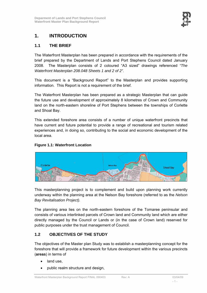
The Waterfront Masterplan has been prepared as a strategic Masterplan that can guide the future use and development of approximately 8 kilometres of Crown and Community land on the north-eastern shoreline of Port Stephens between the townships of Corlette and Shoal Bay.
This extended foreshore area consists of a number of unique waterfront precincts that have current and future potential to provide a range of recreational and tourism related experiences and, in doing so, contributing to the social and economic development of the local area.
Figure 1.1: Waterfront Location
This masterplanning project is to complement and build upon planning work currently underway within the planning area at the Nelson Bay foreshore (referred to as the Nelson Bay Revitalisation Project).
The planning area lies on the north-eastern foreshore of the Tomaree peninsular and consists of various interlinked parcels of Crown land and Community land which are either directly managed by the Council or Lands or (in the case of Crown land) reserved for public purposes under the trust management of Council.
1.2 OBJECTIVES OF THE STUDY
The objectives of the Master plan Study was to establish a masterplanning concept for the foreshore that will provide a framework for future development within the various precincts (areas) in terms of
• land use,
• public realm structure and design,
Deparment of Lands and Port Stephens Council Waterfront Master Plan Background Report
Waterfront Masterplan Background Report FINAL 090403 Rev: A 03/04/09 - 2 -
• built form structure and design,
• infrastructure requirements, and
• environmental outcomes.
The Masterplan has been prepared to respond to the opportunities and constraints of each area along the foreshore and represent ‘best practice’ in waterfront planning.
The masterplanning framework will guide the future development of each area as funding is identified and redevelopment works unfold.
All areas within the Waterfront will be linked to establish an integrated foreshore corridor providing a range of experiences and opportunities for residents and visitors alike.
The Master Plan provides the ability to move easily through a network of leisure and landscape experiences as a primary influence on the masterplanning exercise.
The Masterplan strikes an appropriate balance between the essential environmental, landscape, cultural and recreation values of the foreshore and the need for the sustainable commercial activity/nodes that that can assist with the economic development of the foreshore and its ongoing maintenance.
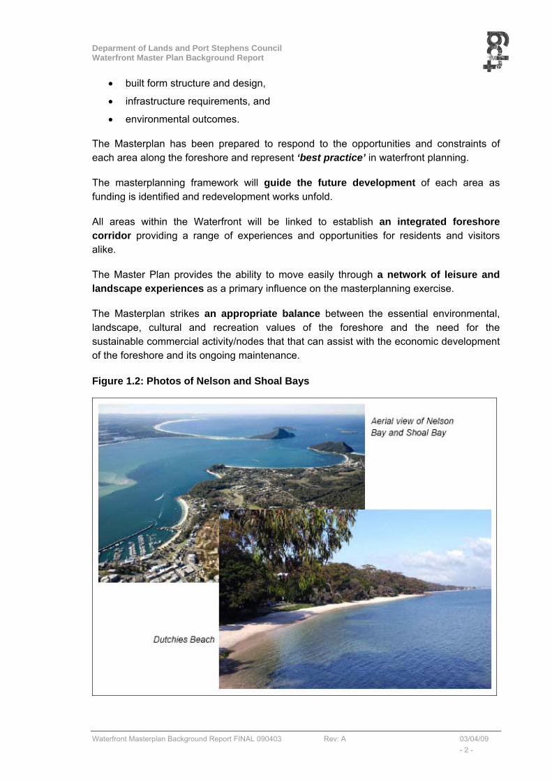
Figure 1.2: Photos of Nelson and Shoal Bays

Deparment of Lands and Port Stephens Council Waterfront Master Plan Background Report
Waterfront Masterplan Background Report FINAL 090403 Rev: A 03/04/09 - 3 -
The Masterplan has been guided by:
(a) Existing management plans and policies (see summary in Appendix A), and;
(b) Community consultation with respect to the extended foreshore zone (see Appendix B).
The community consultation process has involved the following:
• A public notice inviting community engagement, and representation on a Community Reference Group (CRG),
• Selection of a CRG (key stakeholders and representatives from government agencies, local business communities and local residents).
• An ideas workshop as CRG Meeting 1 on 12th June 2008,
• A public information sheet (Newsletter 1) dated 1st July 2008,
• A follow-up workshop as CRG Meeting 2 on 24th July 2008,
• A public information sheet (Newsletter2) dated 18th August 2008,
• A final workshop as CRG Meeting 3 on 26th March 2009.
The Masterplan is to be seen as a key strategic document that can contribute to the economic and social development of the local area by realising the tourism and recreational potential of the foreshore.
It is to be noted that this plan does not authorise foreshore redevelopment or changes to planning controls. Any proposed change in land use or planning controls, including the establishment of sustainable commercial/activity nodes along the foreshore, will be subject to the normal statutory planning processes including environmental assessment and stakeholder consultation.

Deparment of Lands and Port Stephens Council Waterfront Master Plan Background Report
Waterfront Masterplan Background Report FINAL 090403 Rev: A 03/04/09 - 4 -
2. STRATEGIC OVERVIEW
2.1 INTRODUCTION
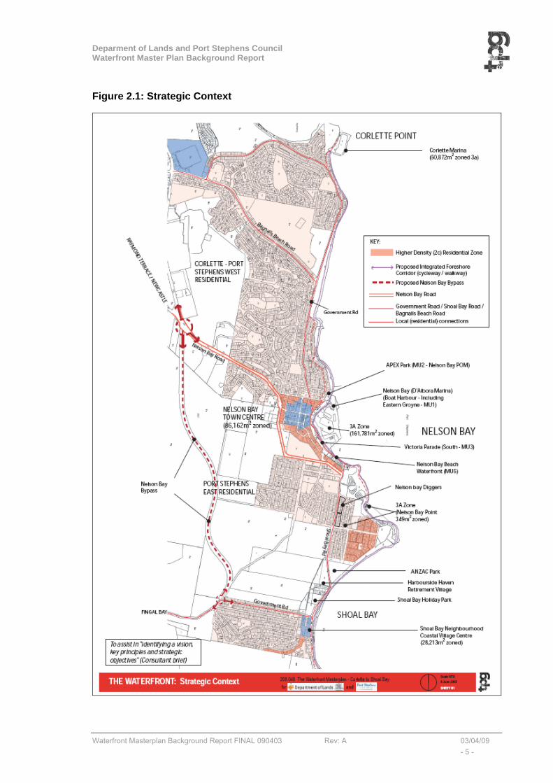
The Waterfront Master Plan relates to the foreshore of Port Stephens from Corlette to Shoal Bay within the Port Stephens Local Government area (LGA). The strategic context of the waterfront is illustrated in Figure 2.1.
The main strategic issues of relevance to the Waterfront Master Plan are as follows:
• The existing and proposed land uses such as the commercial centres of Nelson Bay and Shoal Bay, and the higher density residential areas around Nelson Bay Centre, East Nelson Bay, and east of Shoal Bay Centre,
• The proposed Nelson Bay Bypass road and the future potential of creating a better road hierarchy around Nelson Bay and Shoal Bay, and
• The clear potential of creating an integrated walkway/cycleway or shared path along the foreshore as an important and attractive tourist feature which will stimulate related activities and employment.
2.2 RELATED STUDIES
Key statutory and strategic documents reviewed during the course of the study and summarised in Appendix A are listed below:
• 2006-8 Port Stephens Foreshore Management Plan (on exhibition) Living on the Edge (Umwell)
• 2006 Local Hunter Regional Strategy - DoP
• 2006 Port Stephens 2006-2010 Social Plan – PSC
• Oct 2006 Draft Regional Conservation Plan
• 2006 Department of Lands Regional Crown Reserve Strategy
• 2005 Crown Lands Policy for Marinas and Waterfront Commercial Tenures
• 2004 Port Stephens State of the Environment report - PSC
• 2003 Integrated Land Use and Transport policy package - DoP
• 2003 NSW Coastal Design Guidelines – UDAS & Coastal Council of NSW
• Jan 2001 Communication and Consultation Strategy – Port Stephens Council
• July 2000 Port Stephens and Myall Lakes Estuary Management Plan (Report No 1287/R04/V2 by Umwelt (Australia) Pty Limited
• 2000 Port Stephens Local Environmental Plan - PSC
• 1997 Marine Parks Act - Port Stephens-Great Lakes Marine Park
• Nelson Bay 2030 Strategy – Creating our Future
• Shoal Bay Foreshore Management Plan and Landscape Strategy,
• Draft Port Stephens (Template) Local Environmental Plan - PSC
• www.portstephens.org.au Port Stephens – Blue Water Paradise
Deparment of Lands and Port Stephens Council Waterfront Master Plan Background Report
Waterfront Masterplan Background Report FINAL 090403 Rev: A 03/04/09 - 5 -
Figure 2.1: Strategic Context
Deparment of Lands and Port Stephens Council Waterfront Master Plan Background Report
Waterfront Masterplan Background Report FINAL 090403 Rev: A 03/04/09 - 6 -
2.3 THE WATERWAY
Adjoining the waterfront, the controls and use of the water under the provisions of the 1997 Marine Parks Act are of particular relevance. 1997 Marine Parks Act - Port Stephens-Great Lakes Marine Park Sanctuary Zone – Waterway east of Fly Point. This zone provides the highest level of protection by allowing only activities that do not harm plants, animals or habitats. Sanctuary zones allow for guided tours, boating, snorkelling and diving.
3. MASTERPLAN FRAMEWORK
3.1 INTRODUCTION
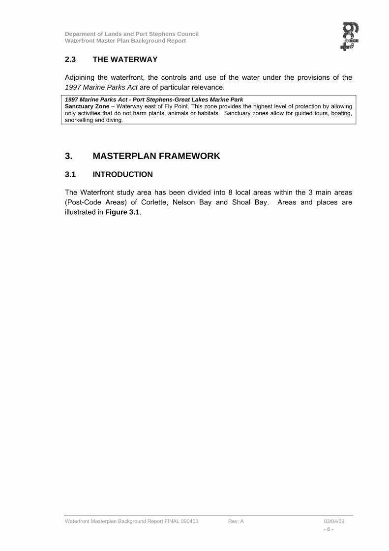
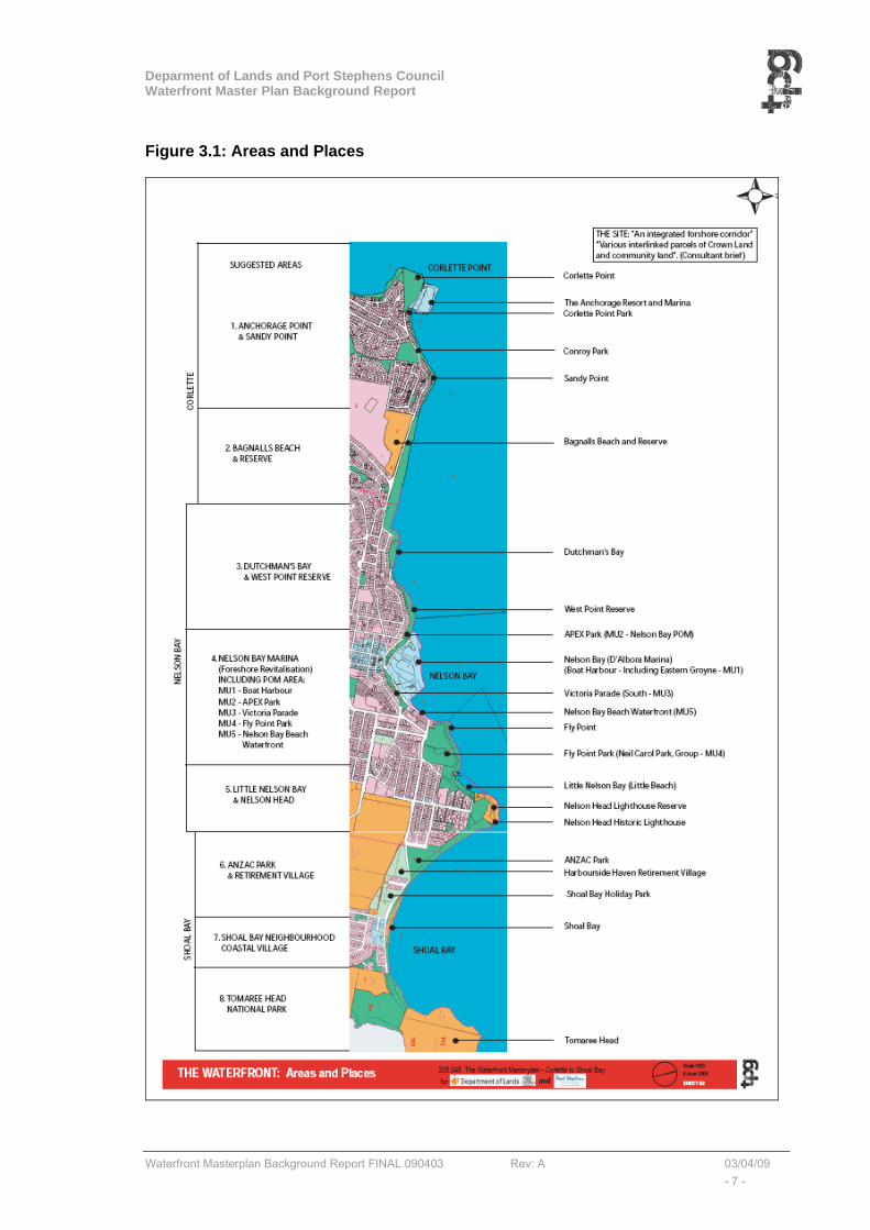
The Waterfront study area has been divided into 8 local areas within the 3 main areas (Post-Code Areas) of Corlette, Nelson Bay and Shoal Bay. Areas and places are illustrated in Figure 3.1.
Deparment of Lands and Port Stephens Council Waterfront Master Plan Background Report
Waterfront Masterplan Background Report FINAL 090403 Rev: A 03/04/09 - 7 -
Figure 3.1: Areas and Places

Deparment of Lands and Port Stephens Council Waterfront Master Plan Background Report
Waterfront Masterplan Background Report FINAL 090403 Rev: A 03/04/09 - 8 -
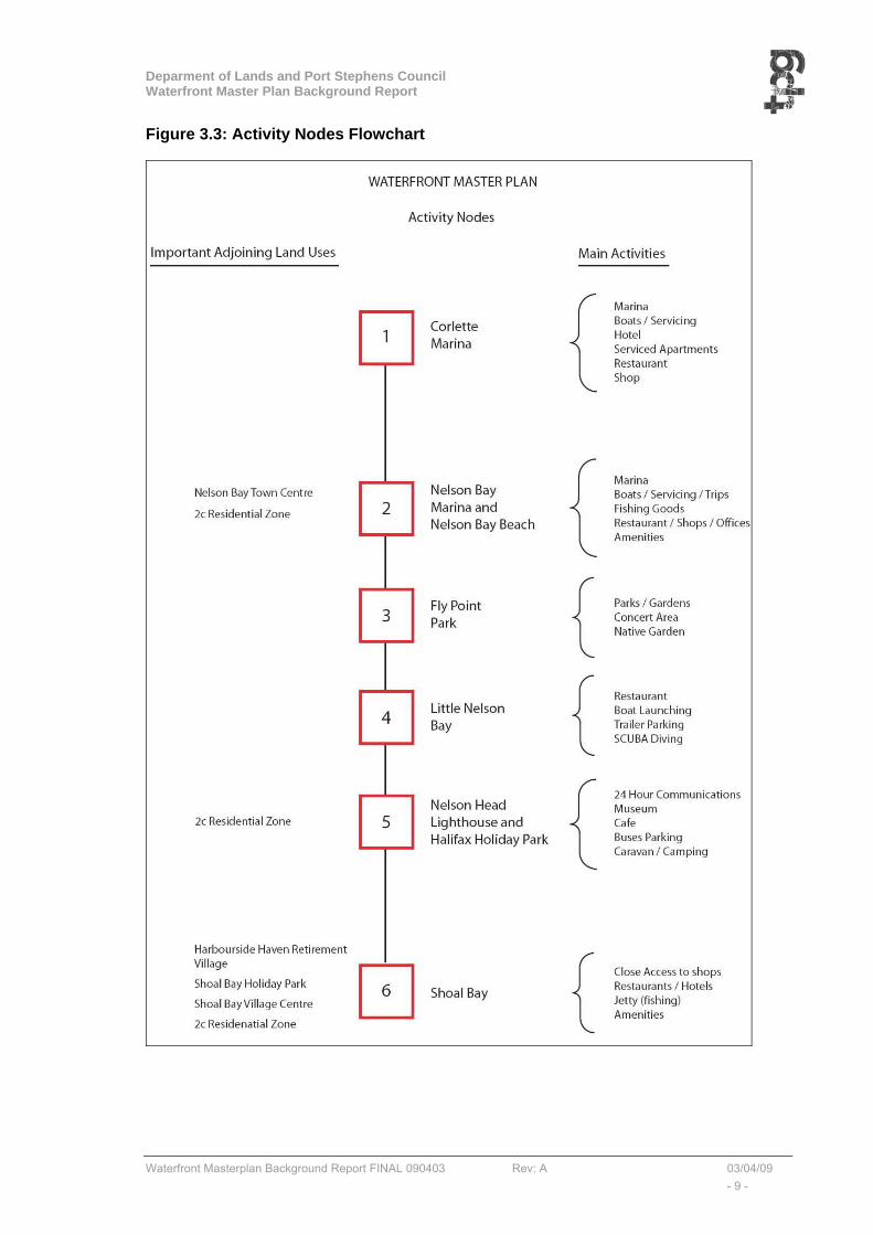
3.2 ACTIVITY NODES
Within the waterfront corridor there are 6 “activity nodes” illustrated in Figure 3.2. The main activities identified within each node is itemised in Figure 3.3. It is noticeable that the western end of the waterfront is less active than the eastern end. The western end has a lower density “hinterland”, whilst the eastern end is in close proximity to the commercial centres of Nelson Bay and Shoal Bay, and the higher density “2c” residential zones at Nelson Bay, Little Beach and Shoal Bay.
Figure 3.2: Activity Nodes
Deparment of Lands and Port Stephens Council Waterfront Master Plan Background Report
Waterfront Masterplan Background Report FINAL 090403 Rev: A 03/04/09 - 9 -
Figure 3.3: Activity Nodes Flowchart
Deparment of Lands and Port Stephens Council Waterfront Master Plan Background Report
Waterfront Masterplan Background Report FINAL 090403 Rev: A 03/04/09 - 10 -
3.3 THE SHARED PATH (INTEGRATED WALKWAY/CYCLEWAY)
The key element within the Waterfront Master Plan is the implementation of an integrated walkway and cycleway or “shared path” providing the opportunity for an interesting and uninterrupted journey from Corlette Point to Shoal Bay (and vice-versa). The shared path links the main activity nodes.
There are 4 types of “shared path”; (1) the standard template, (2) the Bushland Option (compacted stone material), (3) the Elevated Boardwalk Option, and (4) the Cantilevered cliff edge option. These 4 types are described below.
(1) Standard template:
The integrated cycleway/walkway is seen as a “shared path”. A “shared path” is defined by the RTA as “designated for use by bicycle riders and pedestrians. The shared path begins and ends at a “shared path” sign”. The pathway has a minimum width of 2.75m.
The shared path is to be designed in accordance with:
• NSW Bicycle Guidelines Version 1.2 - RTA/Pub 03.286
• Guide to Traffic Engineering Practice - Part 14, Bicycles (Austroads 1999)
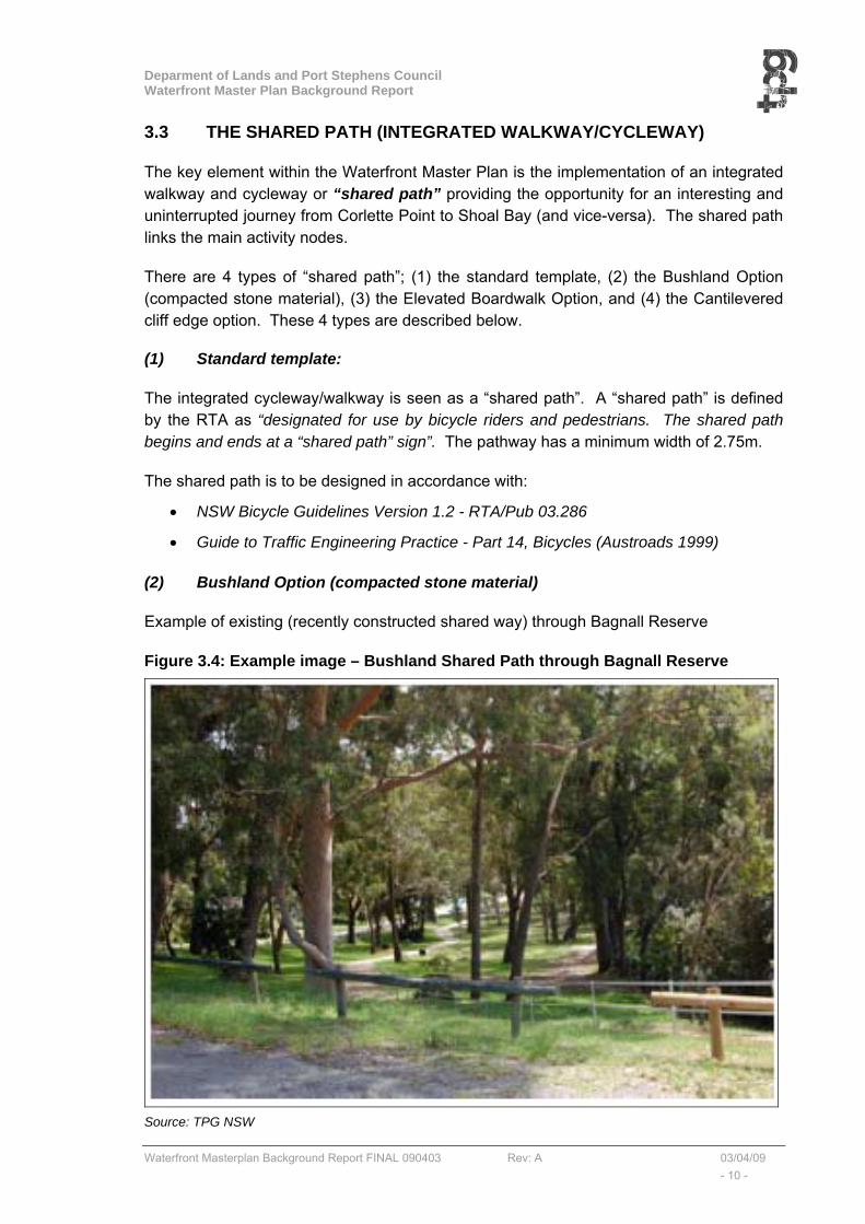
(2) Bushland Option (compacted stone material)
Example of existing (recently constructed shared way) through Bagnall Reserve
Figure 3.4: Example image – Bushland Shared Path through Bagnall Reserve
Source: TPG NSW
Deparment of Lands and Port Stephens Council Waterfront Master Plan Background Report
Waterfront Masterplan Background Report FINAL 090403 Rev: A 03/04/09 - 11 -
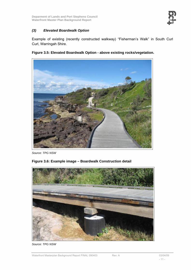
(3) Elevated Boardwalk Option
Example of existing (recently constructed walkway) “Fisherman’s Walk” in South Curl Curl, Warringah Shire.
Figure 3.5: Elevated Boardwalk Option - above existing rocks/vegetation.
Source: TPG NSW
Figure 3.6: Example image – Boardwalk Construction detail
Source: TPG NSW
Deparment of Lands and Port Stephens Council Waterfront Master Plan Background Report
Waterfront Masterplan Background Report FINAL 090403 Rev: A 03/04/09 - 12 -
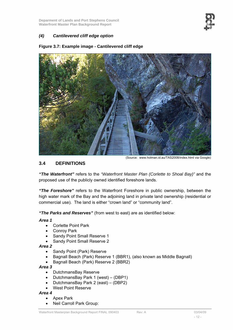
(4) Cantilevered cliff edge option
Figure 3.7: Example image - Cantilevered cliff edge
3.4 DEFINITIONS
“The Waterfront” refers to the “Waterfront Master Plan (Corlette to Shoal Bay)” and the proposed use of the publicly owned identified foreshore lands.
“The Foreshore” refers to the Waterfront Foreshore in public ownership, between the high water mark of the Bay and the adjoining land in private land ownership (residential or commercial use). The land is either “crown land” or “community land”.
“The Parks and Reserves” (from west to east) are as identified below:
Area 1 • Corlette Point Park • Conroy Park • Sandy Point Small Reserve 1 • Sandy Point Small Reserve 2
Area 2 • Sandy Point (Park) Reserve • Bagnall Beach (Park) Reserve 1 (BBR1), (also known as Middle Bagnall) • Bagnall Beach (Park) Reserve 2 (BBR2)
Area 3 • DutchmansBay Reserve • DutchmansBay Park 1 (west) – (DBP1) • DutchmansBay Park 2 (east) – (DBP2) • West Point Reserve
Area 4 • Apex Park • Neil Carroll Park Group:
(Source: www.holman.id.au/TAS2008/index.html via Google)
Deparment of Lands and Port Stephens Council Waterfront Master Plan Background Report
Waterfront Masterplan Background Report FINAL 090403 Rev: A 03/04/09 - 13 -
o Neil Carroll Park, o Fly Point Reserve, o Bill Strong Oval and o Port Stephens Native Flora Garden.
Area 5 • Little Beach • Nelson Head Lighthouse Reserve, • Halifax Caravan Park • Beach Road to Harwood Avenue foreshore reserve.
Area 6 • Anzac Park, • Shoal Bay Caravan Park, • The foreshore east of Anzac Park
Area 7 • The foreshore in front of Shoal Bay Neighbourhood Coastal Village Centre
Area 8 • The foreshore in front of Shoal Bay Road
Deparment of Lands and Port Stephens Council Waterfront Master Plan Background Report
Waterfront Masterplan Background Report FINAL 090403 Rev: A 03/04/09 - 14 -
4. THE WATERFRONT AREAS
The Waterfront study area has been divided into 8 local areas within the 3 main areas (Post-Code Areas) of Corlette, Nelson Bay and Shoal Bay. Areas and places within and adjoining the Waterfront are illustrated earlier in Figure 3.1.
This section describes the eight areas from west to east.
Each area is described in relation to its existing character, public domain, movement and parking, and the built form on adjoining land. Specific implementation actions are recommended for each area, whilst general implementation actions leading to the improvement of the whole Waterfront corridor will form part of future Guidelines (see Sections 5.2 to 5.6). These future Guidelines will provide the detailed description of the main elements envisaged in the Masterplan. It is suggested that guidelines should be prepared for the following:
• Shared Path Guidelines
• Signage Guidelines
• Landscape Guidelines,
• Amenities, Play Equipment, Furniture Guidelines, and
• Urban Design Controls for adjoining land
4.1 AREA 1: CORLETTE (CORLETTE POINT PARK TO SANDY POINT RESERVE)
4.1.1 Area 1: Description and commentary
The Corlette Area (Area 1) extends from Corlette Point Park in the west to Sandy Point Reserve in the east. The Corlette Point Park is to the east of, and adjoining the Anchorage Resort and Marina which provides the dominant land use at the western end of the Waterfront and consists of:
• 90 serviced modern floating marina berths;
• Visitor day berthing for restaurant access;
• Diesel and unleaded fuelling, LP gas and pump-out services;
• Runabout, cruiser, yacht, and jet ski hire facilities;
• Various charters and cruises;
• Sea-plane sightseeing and whale-watch flights;
• Boutique resort shop and general store;
• 80 deluxe Peppers Anchorage Resort guest rooms;
• Conference & convention centre
• A restaurant and bar;

Deparment of Lands and Port Stephens Council Waterfront Master Plan Background Report
Waterfront Masterplan Background Report FINAL 090403 Rev: A 03/04/09 - 15 -
• Landscaped swimming pool with kiosk service;
• Indoor spa, saunas and gymnasium; and
• Car parking and boat trailer parking
The Corlette Area (Area 1) is generally a thin strip of “community land” that runs between the high water mark of the Bay and the rear of the private detached residential dwellings that are aligned, and gain vehicular access from Sandy Point Road. This is a narrow, heavily modified environment. Area 1 contains Conroy and Corlette Parks, which are described in “www.portstephens.org.au Port Stephens – Blue Water Paradise” as having swimming, and picnic activities with BBQ, Car Park, Playground, Showers, and toilet facilities.
Area 1 can be described within the following 4 sections from west to east:
(i) Corlette Point Park
Corlette Point Park is a small park containing grassed area, BBQ, children’s play equipment, etc. The park is accessed from Corlette Point Road (western extension from Sandy Point Road), with car parking adjoining the Anchorage Resort car parking. A shared path crosses through the park, linking the “boardwalk” of the Resort with the foreshore to the east.
(ii) Foreshore between Corlette Point Park and Conroy Park,
This section of the foreshore is characterised by a mixture of private and public uses. From Corlette Point Park to Conroy Park, there is a ‘Public Reserve’ footpath that runs along the foreshore behind the residential dwellings along Sandy Point Road.
(iii) Conroy Park
Conroy Park has a BBQ kiosk and several picnic tables. The park also has an asphalted informal parking area.
(iv) Sandy Point and its adjoining foreshores
From Conroy Park, an informal grassed path provides a link to the Sandy Point. Sandy Point and its adjoining foreshores can be separated into 3 segments created by 2 “green wedge areas” which allow access from Sandy Point Road. From west to east:
• The first segment is relatively wide and could easily accommodate a generous shared path,
• The second segment narrows towards the end but can still accommodate a shared path. Towards the end of the segment, the path is interrupted by several ‘unauthorised’ private boat ramps.
• In the final segment unauthorised works and uses are further evident. At several points pedestrian thoroughfare is difficult and bicycle access near impossible.
Deparment of Lands and Port Stephens Council Waterfront Master Plan Background Report
Waterfront Masterplan Background Report FINAL 090403 Rev: A 03/04/09 - 16 -
All three segments will require Council to formally delineate private and public land.
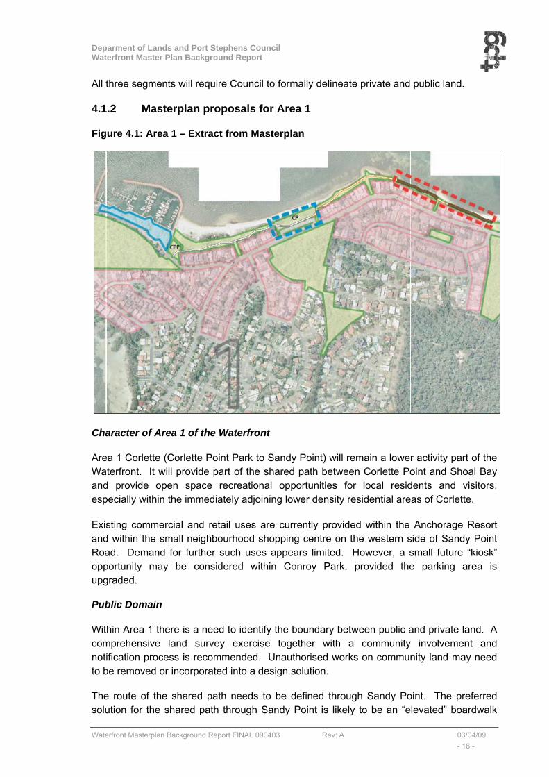
4.1.2 Masterplan proposals for Area 1
Figure 4.1: Area 1 – Extract from Masterplan
Character of Area 1 of the Waterfront
Area 1 Corlette (Corlette Point Park to Sandy Point) will remain a lower activity part of the Waterfront. It will provide part of the shared path between Corlette Point and Shoal Bay and provide open space recreational opportunities for local residents and visitors, especially within the immediately adjoining lower density residential areas of Corlette.
Existing commercial and retail uses are currently provided within the Anchorage Resort and within the small neighbourhood shopping centre on the western side of Sandy Point Road. Demand for further such uses appears limited. However, a small future “kiosk” opportunity may be considered within Conroy Park, provided the parking area is upgraded.
Public Domain
Within Area 1 there is a need to identify the boundary between public and private land. A comprehensive land survey exercise together with a community involvement and notification process is recommended. Unauthorised works on community land may need to be removed or incorporated into a design solution.
The route of the shared path needs to be defined through Sandy Point. The preferred solution for the shared path through Sandy Point is likely to be an “elevated” boardwalk
Deparment of Lands and Port Stephens Council Waterfront Master Plan Background Report
Waterfront Masterplan Background Report FINAL 090403 Rev: A 03/04/09 - 17 -
option (see Figures 3.3 and 3.4). Landscaping and property definition alongside the shared path should follow the Waterfront “Guidelines” (see Section 5.4).
Future improvements to the parks (Corlette Point and Conroy) and small reserves (Sandy Point 1 and 2) should follow the Waterfront “Guidelines” (see Section 5.8).
The plan will be to maintain existing native vegetation, and focus on plantings that are compatible, and native.
Movement and Parking
Area 1 of the Waterfront is serviced by Sandy Point Road which is a local collector road, running parallel to the foreshore and linking Corlette Point to Nelson Bay. Access to Area 1 from Government Road can only be gained via Corlette Point Park, Conroy Park, and Sandy Point Reserves 1 and 2. This existing traffic and access arrangement is unlikely to change.
Off-street parking for approximately 14 cars is provided at Corlette Point Park and 55 cars at Conroy Park. Only limited opportunity exists for increasing off-street car parking provision within Area 1.
Built Form and Adjoining Land
The immediately adjoining private land to the south of Area 1 contains the row of single detached dwelling houses (generally two storeys in height) which gain their vehicular access directly from Sandy Point Road (or Corlette Point Road which links onto Sandy Point Road). The built form of these properties is controlled by the provisions of Port Stephens Residential DCP 2007. Additional measures are recommended in the Master Plan to assist in achieving appropriate aesthetic controls and landscaping to frame the Waterfront shared path.
4.1.3 Waterfront Specific Implementation Actions
The following specific implementation actions, in addition to the general improvements put forward in the waterfront Guidelines, are proposed within Area 1 of the Waterfront Master Plan:
• Introduce signage that welcomes pedestrians to the Anchorage boardwalk (public space) and identifies existing cafe,
• Prepare and undertake a comprehensive land survey exercise together with a community involvement and notification process, to identify:
- the exact boundary between private and public land on the foreshore, and
- the extent of unauthorised works on public foreshore land.
• PSC to notify and take action against unauthorised works along the foreshore as determined.
Deparment of Lands and Port Stephens Council Waterfront Master Plan Background Report
Waterfront Masterplan Background Report FINAL 090403 Rev: A 03/04/09 - 18 -
• Prepare a detailed design of the proposed shared path, including an elevated boardwalk over unauthorised works1.
• Prepare and implement hard/soft landscaping treatments to delineated public/private land (use of indigenous rather than exotic plantings);
• A small future “kiosk” commercial opportunity could be considered within Conroy Park, provided parking facilities are upgraded.
1 In considering the final design over the unauthorised works, the solution needs to be achievable. As
suggested after CRG2, consideration should also be given to a boardwalk over the water rather than over the
existing structures. This option would be more expensive, would require Marine Park approval and would
need to satisfactorily address seagrass issues. An appropriate fibreglass product could be suitable for this
option.

Deparment of Lands and Port Stephens Council Waterfront Master Plan Background Report
Waterfront Masterplan Background Report FINAL 090403 Rev: A 03/04/09 - 19 -
4.2 AREA 2: BAGNALL BEACH AND RESERVE
4.2.1 Area 2 Description and commentary
Area 2 is characterised by the heavily vegetated Bagnall Beach Reserve – it is the most significant natural area in the Waterfront corridor. The Bagnall Beach and Reserve Area (Area 2) extends from Sandy Point (Park) Reserve in the west to the boundary of DutchmansBay in the east, a distance of approximately 1.1km. The Bagnall Beach Area (Area 2) is generally a wider strip of “crown land” that runs between the high water mark of the Bay in the north and Government Road in the south.
Area 2 contains Bagnall Beach – an approved “Dog on/off lead” area. This beach, is described in “www.portstephens.org.au Port Stephens – Blue Water Paradise” as having swimming, kite surfing, and picnic activities with BBQ, Car Park, Playground, Showers, and toilet facilities.
Area 2 can be described within the following 5 sections from west to east:
(i) Sandy Point (Park) Reserve (SPPR)
Sandy Point (Park) Reserve (SPPR) is also known locally as west Bagnall Beach Reserve or “Pantowara”. SPPR is a small park with informal parking area and children’s play area. Bagnall Beach Reserve forms the remainder of the area. Area around stormwater outlet is susceptible to erosion and Council is currently investigating measures that will stop/slow down the rate of erosion
(ii) Reserve between Sandy Point (Park) and Bagnall Beach (BBR1).
From Sandy Point (Park) Reserve a gravel shared path cuts through the heavily vegetated Bagnall Beach Reserve. The shared path runs through to Bagnall Beach (Park) Reserve 1 (BBR1).
(iii) Bagnall Beach (Park) Reserve 1 (BBR1)
At Bagnall Beach Reserve 1 (BBR1), (also known locally as Middle Bagnall), there is an informal area for parking and a toilet block. Due to vandalism, this facility has recently been closed. Access to BBR1 is via a driveway off Sandy Point Road. This access is considered to be in an unsafe location as visibility from the west is poor.
(iv) Reserve between BBR1 and BBR2
The shared path continues through the dense vegetation towards Bagnall Beach Reserve 2 (BBR2), where it splits in two. One path continues through the vegetation, whilst the other runs along the road. Both paths then join at BBR2.
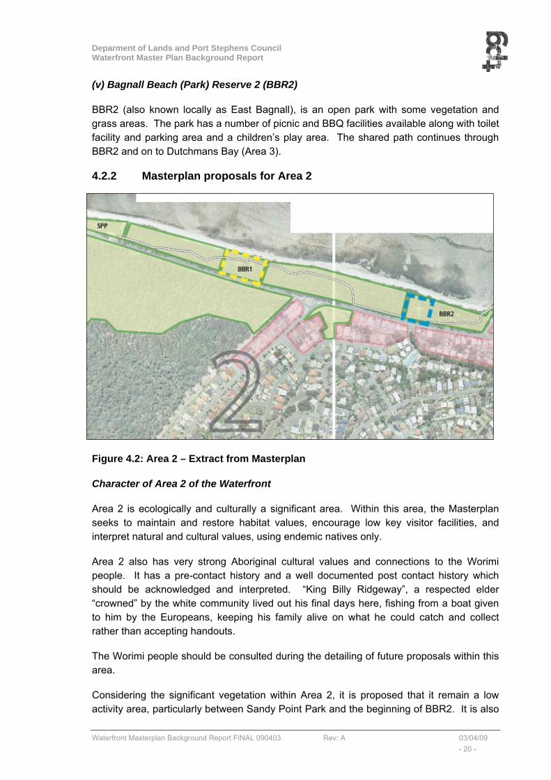
Deparment of Lands and Port Stephens Council Waterfront Master Plan Background Report
Waterfront Masterplan Background Report FINAL 090403 Rev: A 03/04/09 - 20 -
(v) Bagnall Beach (Park) Reserve 2 (BBR2)
BBR2 (also known locally as East Bagnall), is an open park with some vegetation and grass areas. The park has a number of picnic and BBQ facilities available along with toilet facility and parking area and a children’s play area. The shared path continues through BBR2 and on to Dutchmans Bay (Area 3).
4.2.2 Masterplan proposals for Area 2
Figure 4.2: Area 2 – Extract from Masterplan
Character of Area 2 of the Waterfront
Area 2 is ecologically and culturally a significant area. Within this area, the Masterplan seeks to maintain and restore habitat values, encourage low key visitor facilities, and interpret natural and cultural values, using endemic natives only.
Area 2 also has very strong Aboriginal cultural values and connections to the Worimi people. It has a pre-contact history and a well documented post contact history which should be acknowledged and interpreted. “King Billy Ridgeway”, a respected elder “crowned” by the white community lived out his final days here, fishing from a boat given to him by the Europeans, keeping his family alive on what he could catch and collect rather than accepting handouts.
The Worimi people should be consulted during the detailing of future proposals within this area.
Considering the significant vegetation within Area 2, it is proposed that it remain a low activity area, particularly between Sandy Point Park and the beginning of BBR2. It is also
Deparment of Lands and Port Stephens Council Waterfront Master Plan Background Report
Waterfront Masterplan Background Report FINAL 090403 Rev: A 03/04/09 - 21 -
suggested that the area around BBR1 undergo weed removal and management. This will ‘open up’ the Waterfront and allow for natural surveillance of BBR1. The BBR1 facilities would be improved by either reopening the existing toilet.
Bagnall Beach is also the only area within the Waterfront where dogs are permitted. It is considered that such an allowance be maintained in order to encourage the use of the Waterfront.
Public Domain
Within Area 2 there is a need to resolve the future of BBR1 and its facilities. The current amenities block is closed because of vandalism and anti-social behaviour.
The preferred alignment of the shared path through Area 2 is likely to be along its current route although upgraded in accordance with the Waterfront “Guidelines” (see Section 5.2).
An opportunity exists for an ‘all ages’ playground and ‘kiosk’ to be established within BBR2. The playground would include play equipment for younger children, whilst also providing equipment that would appeal to teenagers (e.g. skate park style ramps/rails etc). The ‘kiosk would cater for all ages and provide both a rest stop for walkers/cyclists and an activity for parents supervising their children. Bike racks would also be installed to encourage cyclists to stop in the park.
Future improvements to the parks (Sandy Point (Park) Reserve, and BBR2) should follow the Waterfront “Guidelines” (see Section 5.5).
Movement and Parking
Area 2 of the Waterfront is serviced by Government Road which is a local collector road running parallel to the foreshore and linking Corlette Point to Nelson Bay. Access to Area 2 from Government Road can either be gained via Sandy Beach (Park) Reserve, BBR1 and BBR2) or directly from Government Road. This existing traffic and access arrangement is unlikely to change. However it is suggested that the entrance into BBR1 be moved further west to improve the current limited sight visibility for the BBR1 access road.
Off-street parking is provided at Sandy Point (Park) Reserve, at BBR1 and at BBR2 however, upgrading of these parking areas is required. Only limited opportunity exists for increasing off-street car parking provision at these 3 locations.
Built Form and Adjoining Land
The immediately adjoining private land to the south of Area 2 (generally to the south of Government Road) contains a row of single detached dwelling houses (generally two storeys in height) which gain their vehicular access directly from Government Road. The built form of these properties is controlled by the provisions of Port Stephens Residential DCP 2007. Additional controls are recommended in the Master Plan to assist in achieving appropriate aesthetic controls and landscaping to frame the Waterfront shared path.
Deparment of Lands and Port Stephens Council Waterfront Master Plan Background Report
Waterfront Masterplan Background Report FINAL 090403 Rev: A 03/04/09 - 22 -
4.2.3 Waterfront Specific Implementation Actions
The following specific implementation actions, in addition to the general improvements put forward in the waterfront Guidelines, are proposed within Area 2 of the Master Plan:
• Potential to construct a shared path bridge and viewing platform over the stormwater outlet on the eastern side of Sandy Point. Structure to be designed with consideration of proposed erosion mitigation measures.
• Consult further with the Aboriginal Community (Worimi People) re potential use of BBR1,
• In addition to general Waterfront Signage, there is additional potential to install clear signage and/or story boards at Bagnall Beach along the shared path. Consistent, coherent signage (as opposed to cluttered excessive signage) will improve visual amenity,
• Vehicular access to BBR1 is to be reconsidered to improve road safety, including potential to re-route the access road more directly from Government Road rather than using the existing route from near the roundabout.
• Remove exotic vegetation and weeds between BBR1 and Government Road to ‘open-up’ the BBR1 amenities and allow for greater passive surveillance.
• Continue use of Bagnall Beach for dog “off-lead” walking and consider a small future “kiosk” commercial opportunity and all-ages play area at BBR2.
Deparment of Lands and Port Stephens Council Waterfront Master Plan Background Report
Waterfront Masterplan Background Report FINAL 090403 Rev: A 03/04/09 - 23 -
4.3 AREA 3 – DUTCHMANSBAY AND WEST POINT RESERVE
4.3.1 Area 3 Description and commentary
The area of Dutchmans Bay and West Point Reserve (Area 3) extends from the eastern boundary of BBR2 in the west to West Point Reserve in the east.
Area 3 is generally a strip of “crown land” that runs between the high water mark of the Bay in the north and a line of generally two storey residential dwellings that front the local streets, (Burbong Street, Christmas Bush Avenue, Gloucester Street and Thurlow Avenue), in the south.
Area 3 contains Dutchmans Beach – with quiet, calm waters. This beach, is described in “www.portstephens.org.au Port Stephens – Blue Water Paradise” as having swimming, walking track, and picnic activities with BBQ, Car Park, Playground, Showers, and toilet facilities.
The western end of Area 3 is a heavily modified environment with a recreation focus and a strong European cultural history. Until the 1950’s the area was owned and occupied by commercial fishers. Existing native vegetation includes paperbarks and blackbutts. The old Motel was reportedly the first “Motor Inn” in Australia, giving it a long tourism association
The eastern end of Area 3 contains the “Bridle Path” – the historic horse route into town. This area contains high value native vegetation, has important habitat and ecological values (including sea eagle and cormorant roost trees), significant views, and important interpretative opportunities. There has been extensive clearing and modification of natural vegetation within this area.
Area 3 can be described further within the following 4 sections from west to east:
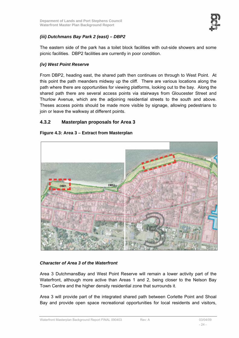
(i) Dutchmans Bay Reserve
The shared path continues from BBR2 through to Dutchmans Bay Reserve. This reserve has two vehicle entry points, from Burbong Street on the western end and from Christmas Bush Avenue on the eastern side. Both vehicle access points end in a car park servicing two small parks. There is no east-west vehicle access between the two car parks. The 2 small parks are referenced as DBP1 (west) and DBP2 (east). The western and eastern ends of the reserve are linked together by the shared path.
(ii) Dutchmans Bay Park 1 (west) - DBP1
The western end of the park has a children’s play area and a mixture of picnic tables and bench seating.
Deparment of Lands and Port Stephens Council Waterfront Master Plan Background Report
Waterfront Masterplan Background Report FINAL 090403 Rev: A 03/04/09 - 24 -
(iii) Dutchmans Bay Park 2 (east) – DBP2
The eastern side of the park has a toilet block facilities with out-side showers and some picnic facilities. DBP2 facilities are currently in poor condition.
(iv) West Point Reserve
From DBP2, heading east, the shared path then continues on through to West Point. At this point the path meanders midway up the cliff. There are various locations along the path where there are opportunities for viewing platforms, looking out to the bay. Along the shared path there are several access points via stairways from Gloucester Street and Thurlow Avenue, which are the adjoining residential streets to the south and above. Theses access points should be made more visible by signage, allowing pedestrians to join or leave the walkway at different points.
4.3.2 Masterplan proposals for Area 3
Figure 4.3: Area 3 – Extract from Masterplan
Character of Area 3 of the Waterfront
Area 3 DutchmansBay and West Point Reserve will remain a lower activity part of the Waterfront, although more active than Areas 1 and 2, being closer to the Nelson Bay Town Centre and the higher density residential zone that surrounds it.
Area 3 will provide part of the integrated shared path between Corlette Point and Shoal Bay and provide open space recreational opportunities for local residents and visitors,
Deparment of Lands and Port Stephens Council Waterfront Master Plan Background Report
Waterfront Masterplan Background Report FINAL 090403 Rev: A 03/04/09 - 25 -
especially within the immediately adjoining lower density residential areas of Corlette to the south, and the higher density residential areas of Nelson Bay to the east.
Due to the nature of the topography, the shared path has an up-slope climb from Dutchmans Beach to West Point Reserve. Around West Point Reserve, the foreshore is heavily vegetated with mature trees. The Masterplan seeks to maintain important existing native vegetation, particularity signature blackbutts and paperbarks whilst allowing mixed plantings. Occasional breaks in the vegetation allow dramatic views from elevated positions across the Bay.
Area 3 was not considered appropriate for a commercial opportunity.
Public Domain
Within Area 3 of the Waterfront, the main elements are already established.
The preferred alignment of the shared path through Area 3 is likely to be along its current route (and grade), although upgraded in accordance with the shared path Waterfront “Guidelines” (see Section 5.2).
Future improvements to the parks (DBP1 and DBP2) should follow the Waterfront “Guidelines” (see Section 5.5). Within the West Point Reserve, there are clear opportunities to create viewing/observation platform along the northern part of the walkway/cycleway, to take advantage of the potential views across the Bay.
Some of the areas alongside the Bridle Path need to be re-vegetated, particularly where Thurlow Road residents have cleared areas beyond their property boundary. Revegetation should occur in accordance with the landscaping principles established as part of the Masterplan (see Guidelines Section 5.4). Further clearing and modifications should be prevented and the land better managed, in consultation with adjoining private owners. A minimum of 10 m native vegetation area is proposed “above the shared path” for endemic native vegetation. This planting area should be managed with neighbour involvement as a “vegetation asset protection zones”.
Movement and Parking
Area 3 has two vehicle entry points from local roads: from Burbong Street on the western end and from Christmas Bush Avenue on the eastern side. Both vehicle access points end in a car park servicing two small parks (DBP1 & DBP2). There is no east-west vehicle access between the two car parks. Because the access is via local roads within residential areas it will be difficult to encourage greater intensity of use within Area 3.
This existing traffic and access arrangement is unlikely to change.
Off-street parking is provided at DBP1 and approximately 25 car spaces are available at DBP2. Only limited opportunity exists for increasing off-street car parking provision at these 2 locations.
Built Form and Adjoining Land

Deparment of Lands and Port Stephens Council Waterfront Master Plan Background Report
Waterfront Masterplan Background Report FINAL 090403 Rev: A 03/04/09 - 26 -
The immediately adjoining private land to the south of Area 3 (generally to the south of Government Road) contains a row of single detached dwelling houses (generally two storeys in height) which gain their vehicular access directly from the local road network. The built form of these properties is controlled by the provisions of Port Stephens Residential DCP 2007.
Additional measures are recommended in the Master Plan to assist in achieving appropriate aesthetic controls and landscaping to frame the Waterfront shared path (see Section 5.4).
4.3.3 Waterfront Specific Implementation Actions
The following specific implementation actions, in addition to the general improvements put forward in the Waterfront Guidelines, are proposed within Area 3 of the Waterfront Master Plan:
• Formalise parking and improve the turning area for vehicles at DBP1.
• Identify appropriate locations to create viewing/observation platforms along the northern part of the shared path along the Bridle Walk, to take advantage of the potential views across the Bay. Consult with NPWS for possible contribution to marine park interpretation on any sites that are developed,
• Some of the areas alongside the Bridle Path need to be re-vegetated. Revegetation in accordance with the landscaping principles (see Guidelines Section 5.4). Further clearing and modifications should be prevented and the land better managed, in consultation with adjoining private owners. A minimum of 10 m native vegetation area “above the shared path” for endemic native vegetation is proposed. This planting area should be managed with neighbour involvement as a “vegetation asset protection zones”.
• Identify appropriate locations to improve signage, particularly to encourage linkages through the adjoining residential zones to the south, to indicate stairs that access to Thurlow Avenue.

Deparment of Lands and Port Stephens Council Waterfront Master Plan Background Report
Waterfront Masterplan Background Report FINAL 090403 Rev: A 03/04/09 - 27 -
4.4 AREA 4 – NELSON BAY
4.4.1 Area 4 Description and commentary
The area of Nelson Bay (Area 4) extends from the eastern boundary of West Point Reserve in the west, to Fly Point Park (Neil Carol Park) in the east. Area 4 equates to the area already considered in the adopted Nelson Bay Foreshore Plan of Management February 2008. This document forms the Plan of Management for Crown land within the Nelson Bay foreshore precinct. The Plan of Management is a joint Department of Lands (Lands) and Port Stephens Council (Council) initiative.
Within Area 4 there are 5 management units as identified in the Plan of Management and illustrated in Figure 4.1:
• Management Unit 1 – Nelson Bay Boat Harbour
• Management Unit 2 – Apex Park
• Management Unit 3 – Victoria Parade (South)
• Management Unit 4 – Neil Carroll Park Group
• Management Unit 5 – Nelson Bay Beach Waterfront
Figure 4.4: Nelson Bay Management Units
Source: Nelson Bay Foreshore Plan of Management
Deparment of Lands and Port Stephens Council Waterfront Master Plan Background Report
Waterfront Masterplan Background Report FINAL 090403 Rev: A 03/04/09 - 28 -
(i) Management Unit 1 – Nelson Bay Boat Harbour
This area includes the working harbour and the existing commercial and tourism precinct. The whole of the Nelson Bay Boat Harbour site is zoned for business use under the Port Stephens LEP 2000 and is a crown land reserve.
The shared path continues from Area 3 down slope past the Tourist Information Office and continues along the southern foreshore edge of the Boat Harbour. The path through Nelson Bay is wider that the path leading to the marina and allows for walkers and cyclists to use the path simultaneously. Just beyond the marina itself, there is a children’s play area, however it is poorly positioned next to the road and limited seating is available for parents. The path continues along the foreshore, past the whale watching boat marina and the recently built toilet block towards Fly Point Park.
The Boat Harbour area presents a relatively sheltered environment with a general maritime character. There is potential for increased public use and enjoyment of this waterfront location through the introduction of appropriate recreational improvements and tourism/leisure experiences.
Traffic and parking congestion (including bus queuing and parking) is an issue at this locality, particularly during holiday periods. Boat mooring accommodation within the boat harbour is approaching capacity and additional vessel accommodation is needed to meet the future needs of commercial, tourism and recreational boating users. There is also a need to rationalise commercial fishing infrastructure to meet the future requirements of that industry. There are opportunities to make this harbour precinct a more attractive location for the local community and visitors to the site and to further develop tourism related experiences.
(ii) Management Unit 2 – Apex Park
This area is a crown land reserve, and includes the land bounded by Teramby Road, Victoria Parade and Laman Street. Apex Park currently provides the main pedestrian link between the Nelson Bay CBD and the foreshore and is the site for annual ANZAC day services. A tourist information centre is also located at this site. The site was the original “village green” and has special historic and social significance.
The area contains a number of items of local heritage and cultural significance including the cenotaph, the remains of the memorial steps and the site of the original town well. The embankments of this reserve at the Teramby Road frontage are densely vegetated but are also subject to infestation by noxious/environmental weeds. Bank stability also needs to be effectively managed.
The opportunity exists to improve the amenity of this open space area through the provision of more seating, public art and improved lighting. The reconstruction of the former rotunda in the park could provide a forum for light entertainment (jazz etc.) which could assist in further promoting and facilitating the exchange of pedestrians between foreshore and CBD.
Deparment of Lands and Port Stephens Council Waterfront Master Plan Background Report
Waterfront Masterplan Background Report FINAL 090403 Rev: A 03/04/09 - 29 -
(iii) Management Unit 3 – Victoria Parade (South)
This area consists of all Crown land situated on the southern side of Victoria Parade and extending, in part, through to Magnus Street. The site is underutilized in terms of formal public recreation use although this is largely a consequence of landform (steep embankments along much of Victoria Parade). The embankments at the eastern portion of this reserve are densely vegetated but are also subject to infestation by noxious/environmental weeds. The area contains an opportunity for additional car parking facilities as a part solution to car parking congestion within the broader foreshore precinct and as a site for the relocation of existing car parking facilities from waterfront areas such as the eastern groyne.
(iv) Management Unit 5 – Nelson Bay Beach Waterfront
Nelson Bay Foreshore is described in “www.portstephens.org.au Port Stephens – Blue Water Paradise” as perfect for paddling and relaxing. It’s activities are listed as swimming and picnic areas and its facilities are metered car parking, play equipment, shop, disabled toilets, and hire facilities (paddle boats).
This area contains the Nelson Bay beach waterfront (east of the boat harbour) and waterside Crown land towards Fly Point. This area is a popular swimming and leisure area for residents and visitors. Increased pedestrian traffic however, has had adverse impacts on the stability of beach embankment areas and general dunal vegetation. Sand movement/loss is also an issue requiring management as is the unauthorised removal of vegetation from the site.
The shared path continues along the northern edge of Victoria Parade. Some 100 metres from the intersection of Victoria Parade and Shoal Bay Road, the shared path narrows dramatically due to the location of a sewer pump/ventilation stack. At the intersection, the path narrows again and limits efficient passage.
The general streetscape is relatively unattractive and consists, in part, of a patchwork of pavement areas, unsightly overhead power lines and an unsightly utility installation. The lack of convenient parking at this location is an issue during holiday periods. The opportunity exists to further protect recreational assets, stabilize the beach and associated embankments, enhance public access and improve the aesthetic qualities of this site.
(v) Management Unit 4 – Neil Carroll Park Group
This area (MU4) is located to the east of MU5, and includes all Crown land currently managed by Port Stephens Council within the area bounded by Victoria Parade, Shoal Bay Road and Dixon Drive and includes:
• Neil Carroll Park,
• Fly Point Reserve,
• Bill Strong Oval and
• Port Stephens Native Flora Garden.

Deparment of Lands and Port Stephens Council Waterfront Master Plan Background Report
Waterfront Masterplan Background Report FINAL 090403 Rev: A 03/04/09 - 30 -
Area 4 contains Fly Point Aquatic Reserve which is a haven for divers, with shaded grassy areas. Fly Point is described in “www.portstephens.org.au Port Stephens – Blue Water Paradise” as having the following activities: snorkelling, diving, fish feeding, picnic, and a walking track through Native Flora Gardens. Nearby activities are listed as an Amphitheatre, BBQ, car park, shelter, toilets & skate ramp.
The walkway continues towards Fly Park. The path ends at the entrance of Fly Point Park where Victoria Parade continues through the park as a one way shared pedestrian and vehicle access through to Little Beach. There is a potential for this access to be closed to vehicles and made into a pedestrian/cyclist only access, with opportunity for viewing platforms and formalised picnic areas.
This reserve system will continue to be used for a variety of purposes including concerts and related events, picnics, general public recreation and sporting events. The reserve is the venue for the Legacy Craft Markets and Australia Day citizenship ceremonies. The northern section of the reserve is densely vegetated and forms the Port Stephens Native Flora Garden which is also a location for wedding ceremonies. A skate ramp has also been constructed on the western side of Cultural Close.
The western portion of the reserve system is used for concerts and other stage events and has a natural amphitheatre appearance with panoramic water views. A stage has been constructed at the north-western corner of this area. The site includes a number of items of local heritage and cultural significance.
There is potential for increased public use and enjoyment of this reserve system through enhanced recreational improvements and use for concert and event activity. The site is also well suited to activities such as wedding ceremonies. Land in the vicinity of Cultural Close has the capacity to be further developed for car and bus parking use and may, in part, provide a solution to car and bus parking congestion within the broader foreshore precinct.
Deparment of Lands and Port Stephens Council Waterfront Master Plan Background Report
Waterfront Masterplan Background Report FINAL 090403 Rev: A 03/04/09 - 31 -
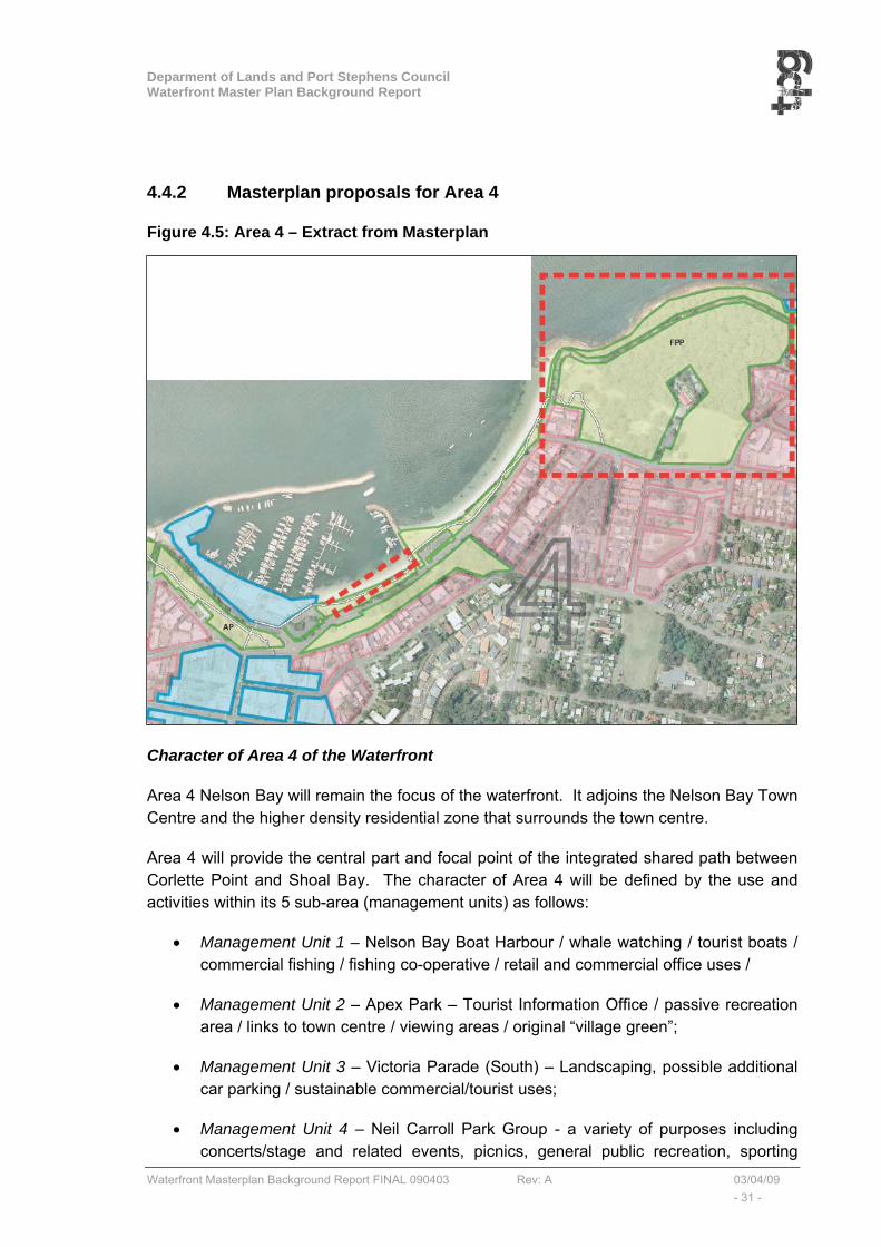
4.4.2 Masterplan proposals for Area 4
Figure 4.5: Area 4 – Extract from Masterplan
Character of Area 4 of the Waterfront
Area 4 Nelson Bay will remain the focus of the waterfront. It adjoins the Nelson Bay Town Centre and the higher density residential zone that surrounds the town centre.
Area 4 will provide the central part and focal point of the integrated shared path between Corlette Point and Shoal Bay. The character of Area 4 will be defined by the use and activities within its 5 sub-area (management units) as follows:
• Management Unit 1 – Nelson Bay Boat Harbour / whale watching / tourist boats / commercial fishing / fishing co-operative / retail and commercial office uses /
• Management Unit 2 – Apex Park – Tourist Information Office / passive recreation area / links to town centre / viewing areas / original “village green”;
• Management Unit 3 – Victoria Parade (South) – Landscaping, possible additional car parking / sustainable commercial/tourist uses;
• Management Unit 4 – Neil Carroll Park Group - a variety of purposes including concerts/stage and related events, picnics, general public recreation, sporting
Deparment of Lands and Port Stephens Council Waterfront Master Plan Background Report
Waterfront Masterplan Background Report FINAL 090403 Rev: A 03/04/09 - 32 -
events (including a skate ramp), venue for the Legacy Craft Markets and Australia Day citizenship ceremonies, (northern section of the reserve is densely vegetated and forms the Port Stephens Native Flora Garden, and
• Management Unit 5 – Nelson Bay Beach Waterfront – swimming and leisure area / foreshore stabilisation works and erosion control measures;
Public Domain
Within Area 4 of the Waterfront, the main elements are already established.
The preferred alignment of the shared path through Area 4 is likely to be along its current route (and grade), although upgraded in accordance with the shared path Waterfront “Guidelines” (see Section 5.2).
Future improvements to the parks (Apex Park and Neil Carroll Park Group) should follow the Waterfront “Guidelines” (see Section 5.5). Within Apex Park and around Fly Point Reserve, there are clear opportunities to create viewing/observation platform along the walkway/cycleway, to take advantage of the potential views across the Bay.
Movement and Parking
Area 4, Nelson Bay, is accessed via Nelson Bay Road from the south, Government Road from the west, and Shoal Bay Road from the east. Victoria Parade is the main internal road within Area 4, from its intersection with Stockton Road in the west to the start of Shoal Bay Road in the east. Victoria Parade also extends through Fly Point Reserve, becoming a one-way road in an easterly direction.
In the longer term, the future proposed Nelson Bay By-Pass road has the potential to remove extraneous traffic from Victoria Parade. In the shorter term, improvements could be made to the “inner” town centre by-pass route via Stockton Street/Dowling Street and Magnus Street.
Off-street parking is currently provided around the Nelson Bay Marina.
Traffic and parking congestion (including bus queuing and parking) is an issue at this locality, particularly during holiday periods. The removal of car parking from public recreational areas (such as the eastern groyne), is a priority subject to the provision of alternative car parking facilities within easy access of the foreshore.
The removal of car parking from waterfront locations can provide more public recreation space and assist in minimising the potential adverse impact of polluted stormwater discharges into the waterway.
Within the Neil Carroll Park area, land in the vicinity of Cultural Close has the capacity to be further developed for car and bus parking use and may, in part, provide a solution to car and bus parking congestion within the broader foreshore area. Crown land on the southern side of Victoria Road and Teramby Road may also provide opportunity for car parking.
Deparment of Lands and Port Stephens Council Waterfront Master Plan Background Report
Waterfront Masterplan Background Report FINAL 090403 Rev: A 03/04/09 - 33 -
The preferred option for vehicular traffic through Neil Carroll Park is to allow and design for 2-way traffic movement up to the proposed parking and turn-around area. Beyond this point (currently a one-way traffic road), vehicular traffic will be prohibited (except for emergency vehicles). A separate and dedicated shared path (cyclists and pedestrians) would be provided with access to viewing platforms and formalised picnic areas.
Built Form and Adjoining Land
The immediately adjoining private land to the south of Area 4 is predominantly within a higher residential “2c” density, around the Nelson Bay town centre. These residential properties (generally 2 storey detached houses and 3-5 storey residential flat buildings) gain their vehicular access from Laman Street in the west and from Magnus Street in the east. The built form of these properties is controlled by the provisions of Port Stephens Residential DCP 2007. Additional measures are recommended in the Master Plan to assist in achieving appropriate aesthetic controls and landscaping to frame the Waterfront shared path (see Section 5.6).
The recommendations for the area relate to the provision of a commercial link between the foreshore and Nelson Bay Township, to facilitate an exchange of pedestrian traffic between foreshore and township. Such a link would need to be designed to preserve views from the residences along the adjoining Magnus Street ridge line and preserve and enhance pedestrian access from Magnus Street to the waterfront.
* Nelson Bay 2030 Strategy is considering ways to improve connections between the foreshore and the town centre. Opportunities to create connections or establish connecting themes could be considered for various points along the Corlette to Shoal Bay foreshore; * Council has a current resolution to review the existing height and use controls for the foreshore lands around Nelson Bay. This consideration will directly impact on the Master Plan. Council also has a current resolution to review Foreshore Controls around the Port Stephens estuary.
4.4.3 Waterfront Specific Implementation Actions
The following specific implementation actions, in addition to the general improvements put forward in the waterfront Guidelines, are proposed within Area 4 of the Waterfront Master Plan:
• Undertake detailed traffic study to assess current car parking and access arrangements with a view to relocate car parking away from the marina and create more useable recreational areas and commercial opportunities within Area 4. This study should also assess the manoeuvrability of buses and larger vehicles turning around and exiting Neil Carol Park westwards onto Shoal Bay Road (see below),
• Provide a turning area and parking within Fly Point Park, to prevent through traffic movement eastwards along Victoria Parade to allow pedestrian only access.
• Identify appropriate locations to improve signage, particularly to encourage linkages through the adjoining residential zone and into the Nelson Bay Town Centre.

Deparment of Lands and Port Stephens Council Waterfront Master Plan Background Report
Waterfront Masterplan Background Report FINAL 090403 Rev: A 03/04/09 - 34 -
• Identify opportunity to conserve and enhance local heritage items and investigate the potential to establish an interpretative centre along the Waterfront.
• Explore opportunities to establish sustainable commercial/tourism uses within the boat harbour precinct in accordance with the Nelson Bay Foreshore Plan of Management, and
• Encourage the potential for increased public use and enjoyment of the Fly Park reserve system through enhanced recreational improvements and use for concert and event activity. The site is also well suited to activities such as wedding ceremonies.

Deparment of Lands and Port Stephens Council Waterfront Master Plan Background Report
Waterfront Masterplan Background Report FINAL 090403 Rev: A 03/04/09 - 35 -
4.5 AREA 5 LITTLE BEACH
4.5.1 Area 5 Description and Commentary
Area 5 extends from the eastern edge of Fly Point Park in the west to the start of Anzac Park (Harwood Avenue) in the east. Area 5 contains the following 4 distinct areas (from west to east):
(i) Little Beach,
(ii) Nelson Head Lighthouse Reserve,
(iii) Halifax Caravan Park, and
(iv) Beach Road to Harwood Avenue foreshore.
(i) Little Beach
As the path continues from Fly Point Park through to Little Beach, it passes the Little Beach Marina and Café/Restaurant (C’S). The restaurant is on land zoned 3A commercial.
Little Beach is described in “www.portstephens.org.au Port Stephens – Blue Water Paradise” as suitable for family and social club gathering with gentle waters and ideal for young children. Its activities are listed as BBQ, boat ramp, car park, shop, playground, public jetty, showers, toilets, and play area for the disabled.
Little Bay boat ramp is the most popular ramp in NSW at peak periods and boats often overflow to the Shoal Bay ramp (area 8). The Little Bay ramp needs to be upgraded particularly in regard to boat trailer parking and manoeuvring.
(ii) Nelson Head Lighthouse Reserve
The Nelson Head Lighthouse Reserve contains the Nelson Head historic lighthouse. Adjoining the lighthouse on top of Nelson Head are the Coast Guard Buildings (24hrs communications), the café, museum and associated car parking. Access and parking (particularly buses) is particularly difficult during peak periods.
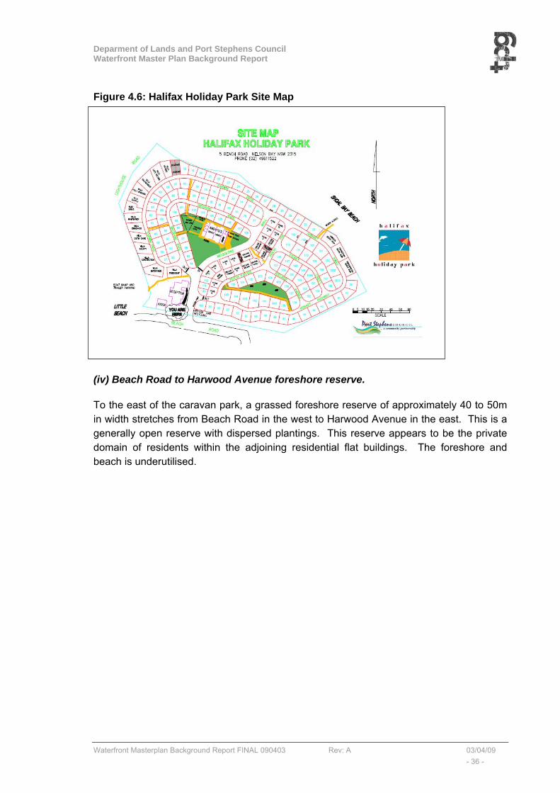
(iii) Halifax Caravan Park
The Halifax Caravan Park is on crown land under the control of Port Stephens Council. Figure 4.2 shows the site plan for the Park.
Deparment of Lands and Port Stephens Council Waterfront Master Plan Background Report
Waterfront Masterplan Background Report FINAL 090403 Rev: A 03/04/09 - 36 -
Figure 4.6: Halifax Holiday Park Site Map
TOM ATTACH SITE PLAN
(iv) Beach Road to Harwood Avenue foreshore reserve.
To the east of the caravan park, a grassed foreshore reserve of approximately 40 to 50m in width stretches from Beach Road in the west to Harwood Avenue in the east. This is a generally open reserve with dispersed plantings. This reserve appears to be the private domain of residents within the adjoining residential flat buildings. The foreshore and beach is underutilised.

Deparment of Lands and Port Stephens Council Waterfront Master Plan Background Report
Waterfront Masterplan Background Report FINAL 090403 Rev: A 03/04/09 - 37 -
4.5.2 Masterplan proposals for Area 5
Figure 4.7: Area 5 – Extract from MasterplanCharacter of Area 5 of the Waterfront
The character of Area 5 will be defined primarily by the existing use and activities (described above), within its 4 sub-areas as follows:
(i) Little Beach – C’s Café, boat ramp & jetty, park amenities, shop and beach
(ii) Nelson Head Lighthouse Reserve – lighthouse, communications, museum, café, tourist destination.
(iii) Halifax Caravan Park – caravan park & amenities, café, and
(iv) Beach Road to Harwood Avenue foreshore – grassed reserve, passive recreation.
Public Domain
The preferred alignment of the shared path through Area 5 is to be along the edge of the foreshore and designed in accordance with the shared path Waterfront “Guidelines” (see Section 5.2). The route of the shared path will be realigned to avoid the amenities building at Little Bay.

Deparment of Lands and Port Stephens Council Waterfront Master Plan Background Report
Waterfront Masterplan Background Report FINAL 090403 Rev: A 03/04/09 - 38 -
The preferred (longer term2) alignment will be around the cliff edge of Nelson Head as an extension of the existing track that leads to the scuba diving site. This will provide a spectacular (cantilevered or elevated) route with uninterrupted views across the bay. The structure will be generally above ground level. In the interim, it is proposed to connect a shared path from the Halifax Caravan Park café alongside Beach Road and through the Beach Road-Harwood Avenue Reserve to Anzac Park. This would be a unique and spectacular feature of the Area and the foreshore walk in general. Little Beach Area has the potential to accommodate a unique experience for visitors.
Around Nelson Head, there are clear opportunities to create viewing/observation platform along the walkway/cycleway, to take advantage of the potential views across the Bay.
Movement and Parking
Area 5, Little Beach, is accessed via Dixon Drive (from Shoal Bay Road) and Victoria Parade (East) from the west, to connect into Beach Road. To the east of area 5 there is no road connection to the foreshore, the closest local residential streets being Columbia Close, Weatherby Close, Voyager Close, Ondine Close, and Harwood Avenue.
Existing parking is available at Little Nelson Beach and boat ramp, and adjoining the Little Nelson Lighthouse. No parking is available to service the Beach Road to Harwood Avenue foreshore reserve.
Built Form and Adjoining Land
Adjoining Area 5, Little Beach to the south of Beach Road is an area occupied by residential flat buildings of between 3 and 5 storeys.
4.5.3 Waterfront Specific Implementation Actions
The following specific implementation actions, in addition to the general improvements put forward in the waterfront Guidelines, are proposed within Area 5 of the Waterfront Master Plan:
• Improve parking and access to the Café (C’S)
• Undertake a detailed traffic study to assess current car parking, manoeuvring and access arrangements within Area 5 with a view to:
o Accommodate the proposed shared path around Nelson Head
o Maintaining the “fish filleting area” which is very popular with fisherman (the attracted pelicans also are a feature for visitors, particularly children);
o Identify additional car (and trailer) parking spaces
o Improve manoeuvrability of trailers and bus access, and
o Provide greater accessibility to service the Beach Road to Harwood Avenue foreshore reserve.
2 It has been assumed that this would be a “longer term” option as it will be a more expensive construction.
Deparment of Lands and Port Stephens Council Waterfront Master Plan Background Report
Waterfront Masterplan Background Report FINAL 090403 Rev: A 03/04/09 - 39 -
• The shared path is to be aligned along Beach Road to separate pedestrians/cyclists from the boat launching/trailer activities. The existing toilet block to be relocated.
• Address sand build-up at boat ramp and signage requirements in consultation with Marine Park Authority and NSW Maritime.
• Consider details of the following shared path alignments via Nelson Head:
- around cliff face of Nelson Head (longer term option), together with a stepped/stair access to Nelson Lighthouse from the east,
- along the northern side of Beach Road to the area along eastern side of Halifax Park (short term option). This option is to be provided regardless of longer term access around Nelson Head.
- Potential to go around northern side of Halifax Park (could also serve as a fire break) – may require the removal of several cabins from the park.
• create an improved commercial/tourist facility opportunity:
- adjoining, or as an extension to the existing caravan park café, and/or
- Within the triangular parcel of land to the east and adjoining the Halifax Caravan Park, (Potential to establish picnic area and improved beach access behind Halifax Park).
• Investigate the potential to establish an interpretative centre at Little Beach
Deparment of Lands and Port Stephens Council Waterfront Master Plan Background Report
Waterfront Masterplan Background Report FINAL 090403 Rev: A 03/04/09 - 40 -
4.6 AREA 6 ANZAC PARK
4.6.1 Area 6 Description and Commentary
Area 6 extends from Harwood Avenue in the west to Government Road in the east. Shoal Bay Road runs through the middle of Area 6 from west to east. Along its eastern alignment, Shoal Bay Road runs immediately to the south and parallel with the foreshore. Area 6 contains the following 4 distinct areas (from west to east):
(i) Anzac Park,
(ii) Harbourside Haven Retirement Village,
(iii) the foreshore east of Anzac Park, and
(iv) Shoal Bay Caravan Park.
(i) Anzac Park,
Anzac Park is heavily vegetated and in recent years has been maintained and regenerated by the local community. An informal gravel road, which is a continuation of Beach Road, is located along the foreshore, with an informal parking area halfway along the road. There are walking tracks scattered within the reserve and there are several access points to the beach along the road.
(ii) Harbourside Haven Retirement Village
The Harbourside Haven Retirement Village contains 154 Self Care Villas, 2 x 40 unit Hostels and a 58 bed Nursing Home. The village is located in two parcels both of which are on land zoned 6(c).
A shared path runs along the southern boundary of the village.
(iii) the Foreshore east of Anzac Park
The foreshore east of Anzac Park stretches to Government Road. It has a narrow width of 30 to 40 metres and is bounded on its southern side by Shoal Bay Road.
Access for pedestrians and cyclists is difficult along this stretch of foreshore as the only footpath is on the southern side of Shoal Bay Road.
At the western end near Anzac Park, pedestrians are required to cross Shoal Bay Road at a point where visibility is reduced. To access the foreshore, pedestrians are again required to cross Shoal Bay Road, approximately 100m from its intersection with Government Road. Between these two crossing points, there is little opportunity to provide a continuous path along the foreshore.
Deparment of Lands and Port Stephens Council Waterfront Master Plan Background Report
Waterfront Masterplan Background Report FINAL 090403 Rev: A 03/04/09 - 41 -
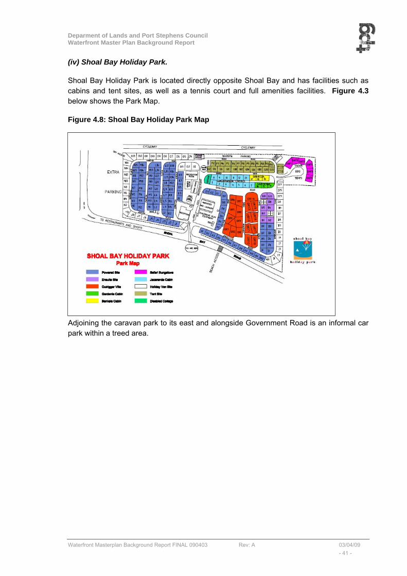
(iv) Shoal Bay Holiday Park.
Shoal Bay Holiday Park is located directly opposite Shoal Bay and has facilities such as cabins and tent sites, as well as a tennis court and full amenities facilities. Figure 4.3 below shows the Park Map.
Figure 4.8: Shoal Bay Holiday Park Map
Adjoining the caravan park to its east and alongside Government Road is an informal car park within a treed area.
Deparment of Lands and Port Stephens Council Waterfront Master Plan Background Report
Waterfront Masterplan Background Report FINAL 090403 Rev: A 03/04/09 - 42 -
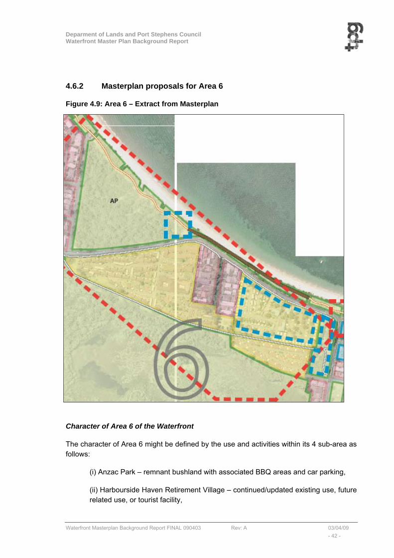
4.6.2 Masterplan proposals for Area 6
Figure 4.9: Area 6 – Extract from Masterplan
Character of Area 6 of the Waterfront
The character of Area 6 might be defined by the use and activities within its 4 sub-area as follows:
(i) Anzac Park – remnant bushland with associated BBQ areas and car parking,
(ii) Harbourside Haven Retirement Village – continued/updated existing use, future related use, or tourist facility,
Deparment of Lands and Port Stephens Council Waterfront Master Plan Background Report
Waterfront Masterplan Background Report FINAL 090403 Rev: A 03/04/09 - 43 -
(iii) The foreshore east of Anzac Park – improved foreshore and facilities including a continuous walkway/cycleway, and
(iv) Shoal Bay Caravan Park – continued/updated existing use, future related use, or tourist facility,
There are clearly redevelopment opportunities associated with the Harbourside Haven Retirement Village and the Shoal Bay Caravan Park, and these could be framed by the waterfront proposals
Public Domain
The preferred alignment of the shared path through Area 6 is along the foreshore side of the Shoal Bay Road. The shared path would be constructed in accordance with the shared path Waterfront “Guidelines” (see Section 5.2). To minimise any potential impact on amenity, new commercial development should consider a stepped back design with appropriate landscaping.
Future improvements to Anzac Park should follow the Waterfront “Guidelines” (see Section 5.5). Potential exists to improve the attractiveness of the Anzac Park foreshore particularly
Movement and Parking
Area 6 is accessed via Shoal Bay Road from the west and east. Shoal Bay Road is the only road connection between Nelson Bay to the west and Shoal Bay to the east and as a consequence it carries all traffic both local and regional. Until the proposed Nelson Bay By-Pass is built there currently appears no alternative to this situation.
This road also runs to the south of, and parallel with the foreshore and thus presents limited opportunity for major improvements to the foreshore. An option to re-align Shoal Bay Road to the rear of the retirement village and Holiday Park may present itself with any future redevelopment proposals for those sites. Such an option could result in the closing of the existing road to limited access traffic thus “widening” the potential future foreshore. A wider foreshore would allow the integrated shared path together with improved beach facilities and parking.
Built Form and Adjoining Land
The Tomaree National Park adjoins Area 6 to the south.
4.6.3 Waterfront Specific Implementation Actions
The following specific implementation actions, in addition to the general improvements put forward in the waterfront Guidelines, are proposed within Area 6 of the Waterfront Master Plan:
• Prepare details of the shared pathway assuming the following options:
Deparment of Lands and Port Stephens Council Waterfront Master Plan Background Report
Waterfront Masterplan Background Report FINAL 090403 Rev: A 03/04/09 - 44 -
o Short term (above ground/elevated boardwalk) shared path within the foreshore, on the northern side of Shoal Bay Road through to Shoal Bay.
o Long term upgrade of a wider foreshore (following re-location of Shoal Bay Road to the south behind Harbourside Haven and Shoal Bay Park).
• Undertake a detailed traffic study to assess road, parking and access arrangements within Area 6 with a view to:
o Accommodate the shared path options
o Identify sufficient car parking for the various options (parking areas, both off Shoal Bay Road and Harwood Avenue to be considered.),
o Allow greater accessibility to service the foreshore reserve.
• create an improved commercial opportunity (tourist facility or the like) at:
o The corner of Anzac Park (area already cleared)
o The Corner of Shoal Bay Road and Government Road, and/or
o The Shoal Bay Holiday Park.
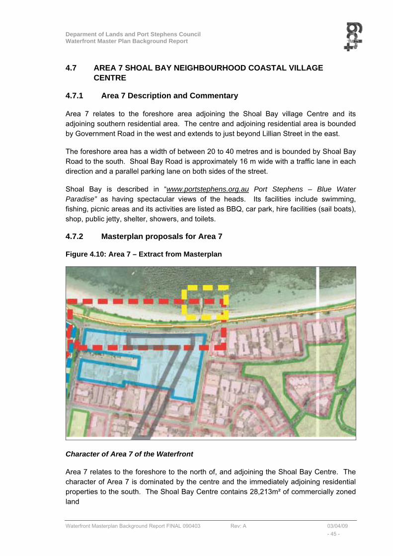
Deparment of Lands and Port Stephens Council Waterfront Master Plan Background Report
Waterfront Masterplan Background Report FINAL 090403 Rev: A 03/04/09 - 45 -
4.7 AREA 7 SHOAL BAY NEIGHBOURHOOD COASTAL VILLAGE CENTRE
4.7.1 Area 7 Description and Commentary
Area 7 relates to the foreshore area adjoining the Shoal Bay village Centre and its adjoining southern residential area. The centre and adjoining residential area is bounded by Government Road in the west and extends to just beyond Lillian Street in the east.
The foreshore area has a width of between 20 to 40 metres and is bounded by Shoal Bay Road to the south. Shoal Bay Road is approximately 16 m wide with a traffic lane in each direction and a parallel parking lane on both sides of the street.
Shoal Bay is described in “www.portstephens.org.au Port Stephens – Blue Water Paradise” as having spectacular views of the heads. Its facilities include swimming, fishing, picnic areas and its activities are listed as BBQ, car park, hire facilities (sail boats), shop, public jetty, shelter, showers, and toilets.
4.7.2 Masterplan proposals for Area 7
Figure 4.10: Area 7 – Extract from Masterplan
Character of Area 7 of the Waterfront
Area 7 relates to the foreshore to the north of, and adjoining the Shoal Bay Centre. The character of Area 7 is dominated by the centre and the immediately adjoining residential properties to the south. The Shoal Bay Centre contains 28,213m² of commercially zoned land
Deparment of Lands and Port Stephens Council Waterfront Master Plan Background Report
Waterfront Masterplan Background Report FINAL 090403 Rev: A 03/04/09 - 46 -
Public Domain
Area 7 of the Waterfront all relates to the public domain, whether within the Shoal Bay Road corridor or within the foreshore area.
The preferred alignment of the shared path through Area 7 is likely to be along its current route (and grade) at the northern edge of the grassed area, although upgraded in accordance with the shared path Waterfront “Guidelines” (see Section 5.2).
Future improvements to the Shoal Bay Centre reserve should follow the Waterfront “Guidelines” (see Section 5.5).
Movement and Parking
Area 7, Nelson Bay, is accessed via Shoal Bay Road from the west and east. Government Road also provides access from the west.
In the longer term, the future proposed Nelson Bay By-Pass road will facilitate direct access to Shoal Bay from the south, along Government Road, without the need to travel through Nelson Bay.
Parking within Area 7 is provided “on-street” along Shoal Bay Road, Government Road, and Bullecourt Street. Informal off-street parking is available on the south western corner of the Shoal Bay Road / Government Road intersection.
The Shoal Bay Village represents an opportunity to establish a destination that is pedestrian and family friendly with a mixture of uses and activities all year round. Even without a re-alignment of the Shoal Bay Road (through Area 6) or the construction of the Nelson Bay Bypass, there is still the potential to make Shoal Bay Road along the northern edge of the shopping village a one-way street heading east. Reducing the requirements for vehicular traffic lanes and reducing on-street parking will allow more land to be used for recreational use within the foreshore. Opportunities might be made available for extended restaurants/coffee shop activities on the northern side of Shoal Bay Road (either extended operations for existing outlets, or new operations). Reducing the traffic flow will assist in improving the amenity for residents and visitors.
Reducing traffic flow and speed within Shoal Bay Road by a one-way flow and traffic calming devices, will maintain traffic flow and essential services. The proposed one-way system suggests in-coming traffic “east-bound” from Government Road / Shoal Bay Road, with exiting traffic (west bound), turning left up Tomaree Road and then right along Messines Street to reconnect to Government Road. The intersection of Messines Road with Government Road is also the likely intersection point (roundabout) of a potential west-east road through the rear of the Shoal Bay Holiday Park within Area 6.
The foreshore walk on the beach side will require significant upgrading and would require a detailed landscape design. Smaller walkways would connect the beach to the shared path and to the commercial activities.
Deparment of Lands and Port Stephens Council Waterfront Master Plan Background Report
Waterfront Masterplan Background Report FINAL 090403 Rev: A 03/04/09 - 47 -
Built Form and Adjoining Land
Adjoining the Area 7 foreshore area are the Shoal Bay village Centre and its southern residential area.
The village centre generally contains buildings of 3-4 storeys (retail/commercial at ground with residential/hotel accommodation above) facing north to the Bay. Most of these properties can be serviced from the rear (southern side), from Bullecourt Street. A variable building line defines the properties on the southern side of Shoal Bay Road, and a narrow public footpath is provided.
The southern residential area contains approximately 14 residential buildings with a frontage to Shoal Bay Road within land zoned residential 2(a).
4.7.3 Waterfront Specific Implementation Actions
The following specific implementation actions, in addition to the general improvements put forward in the waterfront Guidelines, are proposed within Area 7 of the Waterfront Master Plan:
• Consider redesigning Shoal Bay Road for ‘one-way traffic movement eastbound’ between Government Road and Tomaree Road within the shopping village. This will allow:
o Widening of pedestrian access along shopfronts
o Slow vehicles to create safer pedestrian access between shops and the foreshore
o Investigate potential for commercial activities along the northern side of Shoal Bay Road
• Undertake a detailed traffic study to assess current car parking and access arrangements within Area 7 with a view to:
o Accommodate the shared path and one-way traffic arrangements
o Identify additional/re-configured car parking
o Allow manoeuvrability of trailers and buses around the one-way system,
o Ensure adequate accessibility to service both commercial properties and the foreshore reserve.
• Consider future of the Shoal Bay Jetty. Whilst it is recommended that the jetty should be maintained and if possible expanded (potential for commercial/tourist activity), the option of demolition should also be assessed. The southern part of the jetty is on land zoned 6(a) which permits restaurants and tourist facilities whilst the northern part of the jetty is on land zoned 7(a) which permits tourist facilities. Any potential commercial/tourist activity on the jetty must take into account and minimise any potential adverse impacts on views.
Deparment of Lands and Port Stephens Council Waterfront Master Plan Background Report
Waterfront Masterplan Background Report FINAL 090403 Rev: A 03/04/09 - 48 -
• Undertake beach improvements including a review of the location of dinghy racks, rationalise access steps to the beach and continue dune stabilisation.
• Consider undertaking site specific DCP or Urban Design Study for the Shoal Bay Village Centre. Recommendations to include an appropriate “entry statement” at the junction of Government Road and Shoal Bay Road, and the creation of a village centre space with convenient link to the beach at the narrowing of Shoal Bay Road.

Deparment of Lands and Port Stephens Council Waterfront Master Plan Background Report
Waterfront Masterplan Background Report FINAL 090403 Rev: A 03/04/09 - 49 -
4.8 AREA 8 TOMAREE NATIONAL PARK
4.8.1 Area 8 Description and Commentary
Area 8 relates to the foreshore area between Shoal Bay urban area in the west (Lillian Street) to the gates of the Tomaree Lodge (DADHC) in the east. Tomaree Lodge is located within Tomaree Head.
Tomaree Head is the southern coastal headland at the entrance to Port Stephens. It is narrowly joined to the mainland by a sand isthmus which connects Shoal Bay Beach to Zenith Beach on the ocean side. Tomaree Head is on land zoned 7(f1)-Environmental Protection (Coastal Lands)
There are two parts within Area 8:
• Shoal Bay Road to Tomaree Head, and
• Tomaree Head
4.8.2 Masterplan proposals for Area 8
Figure 4.11: Area 8 – Extract from Masterplan
Deparment of Lands and Port Stephens Council Waterfront Master Plan Background Report
Waterfront Masterplan Background Report FINAL 090403 Rev: A 03/04/09 - 50 -
Character of Area 8 of the Waterfront
Area 8 relates to the foreshore to the north of, and adjoining the land between the Shoal Bay Centre to the west and the Tomaree Head to the east. The character of Area 8 is dominated by the Tomaree National Park which includes all of the hinterland to the south and east of the foreshore.
It should be noted that the Tomaree Head Hospital site is not administered by DoL or Council. However, NSW Health will be encouraged to work with DoL and Council on parking solutions and further planning solutions on the site.
Public Domain
Area 8 of the Waterfront all relates to the public domain, whether within the Tomaree Head Road corridor or within the foreshore area.
The preferred alignment of the shared path through Area 8 is likely to be along the northern edge of the road, although upgraded in accordance with the “shared path” “Guidelines” (see Section 5.).
Movement and Parking
Area 8 is accessed via Shoal Bay Road from the west and Tomaree Head Road to the east. Parking within Area 8 is provided “on-street” along Tomaree Head Road or “informally” along the sides of the street.
Built Form and Adjoining Land
Adjoining the Area 8 foreshore area is the Tomaree National Park.
4.8.3 Waterfront Specific Implementation Actions
The following specific implementation actions, in addition to the general improvements put forward in the waterfront Guidelines, are proposed within Area 8 of the Waterfront Master Plan:
• Formalised parking to be provided along Shoal Bay Road foreshore.
• Continue beach stabilisation measures already undertaken by Council at Shoal Bay foreshore,
• Further investigations and negotiations with National Parks and Wildlife Service (NPWS) required. Potential to formalise parking on NPWS land along Shoal Bay Road - on the southern side
• Improvements to the boat ramp to be undertaken in consultation with NSW Maritime Department, to allow for greater access and to assist in alleviating excessive boat traffic at Little Bay
Deparment of Lands and Port Stephens Council Waterfront Master Plan Background Report
Waterfront Masterplan Background Report FINAL 090403 Rev: A 03/04/09 - 51 -
• Formalise turning area and parking at the end of Shoal Bay Road (next to DADHC land). Potential to establish commercial activity (café/kiosk type facility) to improve security as well as provide amenity for tourists and visitors,
• Further investigations and negotiations with the NSW Department of Health with a view to providing additional/shared parking with the Tomaree Lodge lands.
• Shoal Bay Road to be made ‘one-way’ from boat ramp to Tomaree Head and then existing access through Tomaree National Park to be used to exit the area. This “switch back” will however need to be improved to allow safer access. Improve manoeuvrability / road design to allow vehicles with boat trailers and buses to access to the east of the boat ramp.
• Investigate the potential to establish interpretative signage at Tomaree.
Deparment of Lands and Port Stephens Council Waterfront Master Plan Background Report
Waterfront Masterplan Background Report FINAL 090403 Rev: A 03/04/09 - 52 -
5. IMPLEMENTATION
5.1 INTRODUCTION
The Waterfront Masterplan has been prepared as a strategic Masterplan that can guide the future use and development of approximately 8 kilometres of Crown and Community land on the north-eastern shoreline of Port Stephens between the townships of Corlette and Shoal Bay. After exhibition and further consideration of these strategic proposals it will be necessary to agree to a final Masterplan and commence implementation.
To aid implementation it is suggested that detailed “Guidelines” should be prepared and agreed. The Guidelines will provide the detailed description of the main elements envisaged in the Masterplan. It is suggested that guidelines should be prepared for the following:
• Shared Path Guidelines
• Signage Guidelines
• Landscape Guidelines,
• Amenities, Play Equipment, Furniture Guidelines, and
• Urban Design Controls for adjoining land
Apart from the general advice provided in all of the relevant plans and documents referenced in Appendix A, further utilisation is recommended of some of the still relevant information previously recommended in the “Shoal Bay Foreshore Management Plan and Landscape Strategy” prepared by EJE Landscape Consultants and Hunter Recreation Planning Consultants in June 1994 (SBP 94). Reference is made to this SBP document.
5.2 SHARED PATH GUIDELINES
The proposed integrated cycleway/walkway is seen as a “shared path”. A “shared path” is defined by the RTA as “designated for use by bicycle riders and pedestrians. The shared path begins and ends at a “shared path” sign”.
The shared path is to be designed in accordance with:
• NSW Bicycle Guidelines Version 1.2 - RTA/Pub 03.286
• Guide to Traffic Engineering Practice - Part 14, Bicycles (Austroads 1999)
Relevant information is also available in the Shoal Bay Foreshore Management Plan (SBP):
• Pathways (SBP 94 – Section 9.2.)
• Cycleway Design (SBP 94 – Section 9.2.5 page 59)
The following elements will be detailed in the Shared Path Guidelines:

Deparment of Lands and Port Stephens Council Waterfront Master Plan Background Report
Waterfront Masterplan Background Report FINAL 090403 Rev: A 03/04/09 - 53 -
Dimensions and Examples
See Fig 4.3 “Bicycle Path (not in a road reserve),” and Section 4.5 Shared Path (not in a road reserve) - RTA Bicycle Guidelines, and
See Austroads (Part 14 – section 6.6.3) for dimensions and examples.
Width
Minimum 2.75m wide
Material
Either asphalt, concrete for main path with crushed stone through “bushland” sections and “boardwalk” on elevated sections.
Colour
Distinctive colour is recommended (Mediterranean blue for example) to make the Waterfront easily identifiable (same blue colour as in the existing Nelson Bay / Port Stephens signs (see Figure 5.1 below). Colour to be coordinated with signage policy.
Note: RTA recommends “green” colour for cycleways not shared zones.
Linemarking
See Section 8.2 of the RTA Guidelines.
Drainage
See Section 8.4 of the RTA Guidelines.
5.3 SIGNAGE GUIDELINES
A clear and attractive set of signs will be an important element in establishing the Waterfront as a unique and interesting place to visit. Comprehensive signage guidelines need to be prepared and agreed. Signs should be colour co-ordinated with other waterfront elements such as the amenities buildings and furniture. Signage shall be consistent with SEPP 64 and Council policy.
Signs will include and relate to:
• Interpretive signs (informative and decorative),
• information signs (directional)
• regulatory signs (Council guidelines), and
• traffic control signs (as per RTA guidelines).
Refer to Signage Audit of Corlette (referred to by Margaret Wilkinson following CRG2).
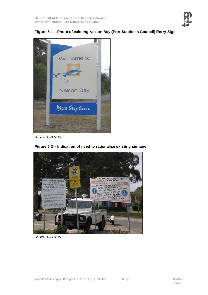
Deparment of Lands and Port Stephens Council Waterfront Master Plan Background Report
Waterfront Masterplan Background Report FINAL 090403 Rev: A 03/04/09 - 54 -
Figure 5.1 – Photo of existing Nelson Bay (Port Stephens Council) Entry Sign
Source: TPG NSW
Figure 5.2 – Indication of need to rationalise existing signage
Source: TPG NSW
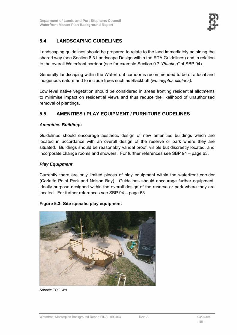
Deparment of Lands and Port Stephens Council Waterfront Master Plan Background Report
Waterfront Masterplan Background Report FINAL 090403 Rev: A 03/04/09 - 55 -
5.4 LANDSCAPING GUIDELINES
Landscaping guidelines should be prepared to relate to the land immediately adjoining the shared way (see Section 8.3 Landscape Design within the RTA Guidelines) and in relation to the overall Waterfront corridor (see for example Section 9.7 “Planting” of SBP 94).
Generally landscaping within the Waterfront corridor is recommended to be of a local and indigenous nature and to include trees such as Blackbutt (Eucalyptus pilularis).
Low level native vegetation should be considered in areas fronting residential allotments to minimise impact on residential views and thus reduce the likelihood of unauthorised removal of plantings.
5.5 AMENITIES / PLAY EQUIPMENT / FURNITURE GUDELINES
Amenities Buildings
Guidelines should encourage aesthetic design of new amenities buildings which are located in accordance with an overall design of the reserve or park where they are situated. Buildings should be reasonably vandal proof, visible but discreetly located, and incorporate change rooms and showers. For further references see SBP 94 – page 63.
Play Equipment
Currently there are only limited pieces of play equipment within the waterfront corridor (Corlette Point Park and Nelson Bay). Guidelines should encourage further equipment, ideally purpose designed within the overall design of the reserve or park where they are located. For further references see SBP 94 – page 63.
Figure 5.3: Site specific play equipment
Source: TPG WA

Deparment of Lands and Port Stephens Council Waterfront Master Plan Background Report
Waterfront Masterplan Background Report FINAL 090403 Rev: A 03/04/09 - 56 -
Furniture
A guideline is to be prepared which details a new Waterfront range of picnic shelters with tables, seats and BBQs, bench seating separate to shelters, lighting, bollards and barriers to be designed or selected from a prefabricated range of products. Materials must be salt and vandal resistant.
The location of furniture should overcome the present visual impression of scattered elements. For further references see:
• Design Considerations (SBP 94 – Section 9.2.4page 59)
• Preferred Furniture Selection (SBP 94 – Section 9.3 – 9.3.1 page 60-61)
• Preferred Finishes (SBP 94 – Section 9.3.2 page 62)
5.6 URBAN DESIGN CONTROLS FOR LAND ADJOINING WATERFRONT
In addition to the above Guidelines, it is suggested that additional urban design controls be considered for development within the land which immediately adjoins the waterfront. These controls will supplement controls already existing in the Port Stephens DCP 2007 which provides information to support development that retains and enhances the character of the Port Stephens local government area. The existing DCP provides principles and controls for development that is site responsive, innovative and that contributes to the character of each locality. The DCP contains site specific controls for certain areas, as well as general controls for the entire Local Government Area. The general controls of relevance to development adjoining the waterfront are in relation to:
• Parking, traffic and transport;
• Commercial and mixed use development;
• Single and dual occupancy dwellings;
• Villa and town house developments; and
• Residential flat buildings.
It is suggested that additional site specific urban design controls be considered for development within the land to supplement existing DCP controls and relate primarily to the following areas:
• (1) Detached two storey residential (Corlette)
• (2) Multi-storey residential (Nelson Bay and Little Beach)
• (3) Commercial centres (Nelson Bay and Shoal Bay)
Development along the foreshore should be sympathetic to the desired future character of the area particularly in terms of:
• Bulk, scale & density;
• External appearance; and
• Landscaping.
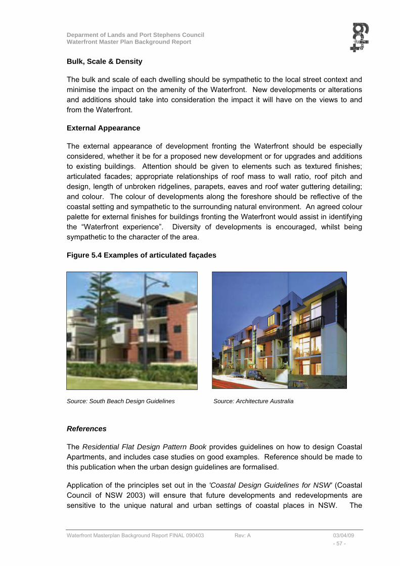
Deparment of Lands and Port Stephens Council Waterfront Master Plan Background Report
Waterfront Masterplan Background Report FINAL 090403 Rev: A 03/04/09 - 57 -
Bulk, Scale & Density
The bulk and scale of each dwelling should be sympathetic to the local street context and minimise the impact on the amenity of the Waterfront. New developments or alterations and additions should take into consideration the impact it will have on the views to and from the Waterfront.
External Appearance
The external appearance of development fronting the Waterfront should be especially considered, whether it be for a proposed new development or for upgrades and additions to existing buildings. Attention should be given to elements such as textured finishes; articulated facades; appropriate relationships of roof mass to wall ratio, roof pitch and design, length of unbroken ridgelines, parapets, eaves and roof water guttering detailing; and colour. The colour of developments along the foreshore should be reflective of the coastal setting and sympathetic to the surrounding natural environment. An agreed colour palette for external finishes for buildings fronting the Waterfront would assist in identifying the “Waterfront experience”. Diversity of developments is encouraged, whilst being sympathetic to the character of the area.
Figure 5.4 Examples of articulated façades
Source: South Beach Design Guidelines Source: Architecture Australia
References
The Residential Flat Design Pattern Book provides guidelines on how to design Coastal Apartments, and includes case studies on good examples. Reference should be made to this publication when the urban design guidelines are formalised.
Application of the principles set out in the 'Coastal Design Guidelines for NSW' (Coastal Council of NSW 2003) will ensure that future developments and redevelopments are sensitive to the unique natural and urban settings of coastal places in NSW. The
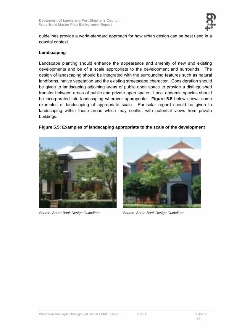
Deparment of Lands and Port Stephens Council Waterfront Master Plan Background Report
Waterfront Masterplan Background Report FINAL 090403 Rev: A 03/04/09 - 58 -
guidelines provide a world-standard approach for how urban design can be best used in a coastal context.
Landscaping
Landscape planting should enhance the appearance and amenity of new and existing developments and be of a scale appropriate to the development and surrounds. The design of landscaping should be integrated with the surrounding features such as natural landforms, native vegetation and the existing streetscape character. Consideration should be given to landscaping adjoining areas of public open space to provide a distinguished transfer between areas of public and private open space. Local endemic species should be incorporated into landscaping wherever appropriate. Figure 5.5 below shows some examples of landscaping of appropriate scale. Particular regard should be given to landscaping within those areas which may conflict with potential views from private buildings.
Figure 5.5: Examples of landscaping appropriate to the scale of the development
Source: South Bank Design Guidelines Source: South Bank Design Guidelines
Deparment of Lands and Port Stephens Council Waterfront Master Plan Background Report
Waterfront Masterplan Background Report FINAL 090403 Rev: A 03/04/09 - 59 -
5.7 COMMERCIAL OPPORTUNITIES
One of the objectives of the brief for this study was that the Masterplan should strike an appropriate balance between the essential environmental, landscape, cultural and recreation values of the foreshore and the need for the sustainable commercial activity/nodes that that can assist with the economic development of the foreshore and its ongoing maintenance.
As a consequence, the following locations listed in Table 5.1, have been identified as appropriate for further consideration as sustainable commercial activities or nodes.
Table 5.1: Potential Commercial Opportunities
Area Location Commentary 1 Conroy Park (CP) A small future “kiosk” commercial opportunity could be considered
within Conroy Park. 2 Bagnall Beach
Reserve 2 (BBR2) Continue use of Bagnall Beach for dog walking and consider a small future “kiosk” commercial opportunity at BBR2.
3 Dutchmans Bay & West Point Reserve
No opportunities identified
4 Nelson Bay Boat Harbour
Explore commercial opportunities identified in the Nelson Bay Foreshore Plan of Management.
4 Fly Park There is potential for increased public use and enjoyment of this reserve system through enhanced recreational improvements and use for concert and event activity. The site is also well suited to activities such as wedding ceremonies.
5 Little Beach/Shoal Bay
create an improved commercial/tourist facility opportunity • adjoining, or as an extension to the existing caravan park
café, and/or • Within the triangular parcel of land to the east and
adjoining the Halifax Caravan Park, (Potential to establish picnic area and improved beach access behind Halifax Park).
6 Anzac Park Shoal Bay Holiday Park
create an improved commercial opportunity (tourist facility or the like) at:
• The corner of Anzac Park (area already cleared) • The Corner of Shoal Bay Road and Government Road,
and/or • The Shoal Bay Holiday Park.
7 Shoal Bay Village Foreshore
Opportunities will be made available for extended restaurants/coffee shop activities on the northern side of Shoal Bay Road (either extended operations for existing outlets, or new operations).
7 Shoal Bay Jetty Consider future of the Shoal Bay Jetty. Whilst it is recommended that the jetty should be maintained and if possible expanded (potential for commercial/tourist activity),
8 Tomaree National Park
Potential to establish commercial activity (café/kiosk type facility) to improve security as well as provide amenity for tourists and visitors (near entry to DADHC land).

Deparment of Lands and Port Stephens Council Waterfront Master Plan Background Report
Waterfront Masterplan Background Report FINAL 090403 Rev: A 03/04/09 - Appendix -
APPENDIX A Summary review of relevant existing plans and policies

Deparment of Lands and Port Stephens Council Waterfront Master Plan Background Report
Waterfront Masterplan Background Report FINAL 090403 Rev: A 03/04/09 - Appendix -
WATERFRONT MASTERPLAN – Corlette to Shoal Bay. SUMMARY REVIEW OF EXISTING PLANS AND POLICIES.
Source: Expressions of Interest, Consultancy Services, Foreshore Planning – Port Stephens NSW (DoL and PORT STEPHENS COUNCIL)
Deparment of Lands and Port Stephens Council Waterfront Master Plan Background Report
Waterfront Masterplan Background Report FINAL 090403 Rev: A 03/04/09 - Appendix -
List of Existing Plans and Policies 1. Nelson Bay Foreshore Plan of Management (Adopted), Department of Lands,
February 2008 2. Port Stephens Community Settlement and Infrastructure Strategy, Port Stephens
Council, 2007 3. Port Stephens Development Control Plan, Port Stephens Council, 2007 4. Economic Development Strategy – Port Stephens Council & Buchanan, October
2007 5. Port Stephens Flood Prone Map, Port Stephens Council, 2007 6. Policy for Tourist and Associated Facilities on Crown Land, Department of Lands,
2007 7. Port Stephens Foreshore Management Plan (on exhibition) Living on the Edge,
Umwell, 2006-2008 8. Lower Hunter Regional Strategy, Department of Planning, August 2006 9. Port Stephens 2006-2010 Social Plan, Port Stephens Council, 2006 10. Draft Regional Conservation Plan, Department of Conservation and Climate
Change, October, 2006 11. 2006 Department of Lands Regional Crown Reserve Strategy (Department of
Lands) 12. Crown Lands Policy for Marinas and Waterfront Commercial Tenures, Department
of Lands, 2005 13. Port Stephens State of the Environment report, Port Stephens Council, 2004 14. Integrated Land Use and Transport policy package, Department of Planning, 2003 15. NSW Coastal Design Guidelines – UDAS & Coastal Council of NSW, 2003 16. Communication and Consultation Strategy, Port Stephens Council, January 2001 17. Port Stephens and Myall Lakes Estuary Management Plan (Report No
1287/R04/V2 by Umwelt (Australia) Pty Limited, July 2000 18. Port Stephens Local Environmental Plan, Port Stephens Council, January 2000 19. Marine Parks Act - Port Stephens-Great Lakes Marine Park, 1997 20. Nelson Bay 2030 Strategy – Creating our Future, Port Stephens Council 21. Shoal Bay Foreshore Management Plan and Landscape Strategy, 22. Draft Port Stephens (Template) Local Environmental Plan, Port Stephens Council 23. www.portstephens.org.au Port Stephens – Blue Water Paradise
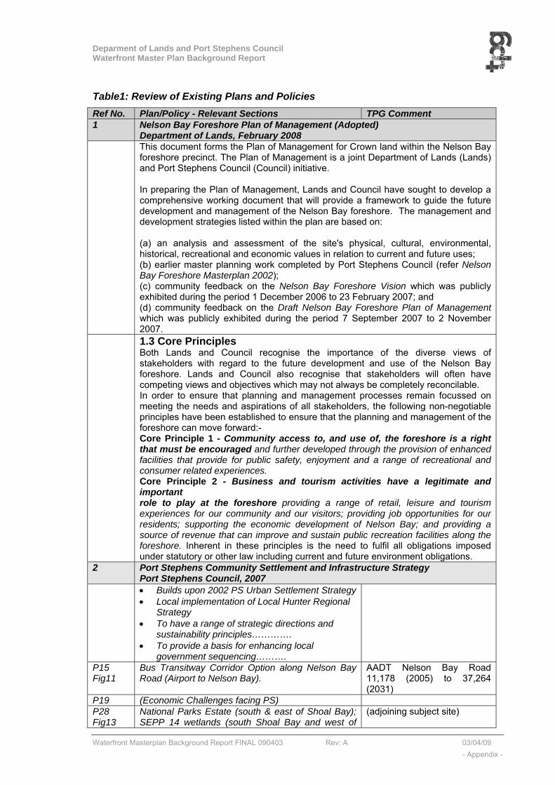
Deparment of Lands and Port Stephens Council Waterfront Master Plan Background Report
Waterfront Masterplan Background Report FINAL 090403 Rev: A 03/04/09 - Appendix -
Table1: Review of Existing Plans and Policies Ref No. Plan/Policy - Relevant Sections TPG Comment 1 Nelson Bay Foreshore Plan of Management (Adopted)
Department of Lands, February 2008 This document forms the Plan of Management for Crown land within the Nelson Bay
foreshore precinct. The Plan of Management is a joint Department of Lands (Lands) and Port Stephens Council (Council) initiative. In preparing the Plan of Management, Lands and Council have sought to develop a comprehensive working document that will provide a framework to guide the future development and management of the Nelson Bay foreshore. The management and development strategies listed within the plan are based on: (a) an analysis and assessment of the site's physical, cultural, environmental, historical, recreational and economic values in relation to current and future uses; (b) earlier master planning work completed by Port Stephens Council (refer Nelson Bay Foreshore Masterplan 2002); (c) community feedback on the Nelson Bay Foreshore Vision which was publicly exhibited during the period 1 December 2006 to 23 February 2007; and (d) community feedback on the Draft Nelson Bay Foreshore Plan of Management which was publicly exhibited during the period 7 September 2007 to 2 November 2007.
1.3 Core Principles Both Lands and Council recognise the importance of the diverse views of stakeholders with regard to the future development and use of the Nelson Bay foreshore. Lands and Council also recognise that stakeholders will often have competing views and objectives which may not always be completely reconcilable. In order to ensure that planning and management processes remain focussed on meeting the needs and aspirations of all stakeholders, the following non-negotiable principles have been established to ensure that the planning and management of the foreshore can move forward:- Core Principle 1 - Community access to, and use of, the foreshore is a right that must be encouraged and further developed through the provision of enhanced facilities that provide for public safety, enjoyment and a range of recreational and consumer related experiences. Core Principle 2 - Business and tourism activities have a legitimate and important role to play at the foreshore providing a range of retail, leisure and tourism experiences for our community and our visitors; providing job opportunities for our residents; supporting the economic development of Nelson Bay; and providing a source of revenue that can improve and sustain public recreation facilities along the foreshore. Inherent in these principles is the need to fulfil all obligations imposed under statutory or other law including current and future environment obligations.
2 Port Stephens Community Settlement and Infrastructure Strategy Port Stephens Council, 2007
• Builds upon 2002 PS Urban Settlement Strategy• Local implementation of Local Hunter Regional
Strategy • To have a range of strategic directions and
sustainability principles…………. • To provide a basis for enhancing local
government sequencing……….
P15 Fig11
Bus Transitway Corridor Option along Nelson Bay Road (Airport to Nelson Bay).
AADT Nelson Bay Road 11,178 (2005) to 37,264 (2031)
P19 (Economic Challenges facing PS) P28 Fig13
National Parks Estate (south & east of Shoal Bay); SEPP 14 wetlands (south Shoal Bay and west of
(adjoining subject site)
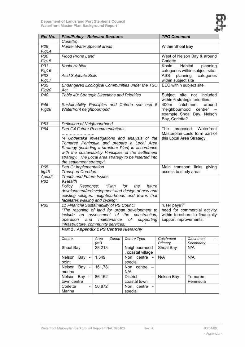
Deparment of Lands and Port Stephens Council Waterfront Master Plan Background Report
Waterfront Masterplan Background Report FINAL 090403 Rev: A 03/04/09 - Appendix -
Ref No. Plan/Policy - Relevant Sections TPG Comment Corlette)
P29 Fig14
Hunter Water Special areas Within Shoal Bay
P30 Fig15
Flood Prone Land West of Nelson Bay & around Corlette
P31 Fig16
Koala Habitat Koala Habitat planning categories within subject site.
P32 Fig17
Acid Sulphate Soils ASS planning categories within subject site
P35 Fig20
Endangered Ecological Communities under the TSC Act
EEC within subject site
P40 Table 40: Strategic Directions and Priorities Subject site not included within 6 strategic priorities.
P46 Fig26
Sustainability Principles and Criteria see esp 5 Waterfront neighbourhood
400m catchment around “neighbourhood centre” – example Shoal Bay, Nelson Bay, Corlette?
P53 Definition of Neighbourhood P64 Part G4 Future Recommendations
…………………… “4 Undertake investigations and analysis of the Tomaree Peninsula and prepare a Local Area Strategy (including a structure Plan) in accordance with the sustainability Principles of the settlement strategy. The Local area strategy to be inserted into the settlement strategy”.
The proposed Waterfront Masterplan could form part of this Local Area Strategy.
P65 fig45
Part G: Implementation Transport Corridors
Main transport links giving access to study area.
Apdx2, P81
Trends and Future Issues 9.Health Policy Response: “Plan for the future development/redevelopment and design of new and existing villages, neighbourhoods and towns that facilitates walking and cycling”.
P82 11 Financial Sustainability of PS Council “The rezoning of land for urban development to include an assessment of the construction, operation and maintenance of supporting infrastructure, community services; “
“user pays?” need for commercial activity within foreshore to financially support improvements.
Part 1 : Appendix 1 PS Centres Hierarchy Centre Area Zoned
(m2) Centre Type Catchment –
Primary Catchment – Secondary
Shoal Bay 28,213 Neighbourhood, coastal village
Shoal Bay N/A
Nelson Bay - point
1,349 Non centre - special
N/A N/A
Nelson Bay - marina
161,781 Non centre – N/A
Nelson Bay – town centre
86,162 District – coastal town
Nelson Bay Tomaree Peninsula
Corlette - Marina
50,872 Non centre - special

Deparment of Lands and Port Stephens Council Waterfront Master Plan Background Report
Waterfront Masterplan Background Report FINAL 090403 Rev: A 03/04/09 - Appendix -
Ref No. Plan/Policy - Relevant Sections TPG Comment 3 Port Stephens Development Control Plan
Port Stephens Council, 2007 The Port Stephens Development Control Plan 2007
(DCP) is a suite of documents that provides practical information to support development that retains and enhances the natural and cultural heritage values of Port Stephens local government area. The DCP applies to all land zoned under the Port Stephens Local Environment Plan 2000 (LEP) and provides standards for development as well as local controls for specific areas within the LGA.
4 Economic Development Strategy Port Stephens Council & Buchanan, October 2007
This Strategy focuses on practical ways of shaping the economic future of Port Stephens.
The major advantages of Port Stephens relate to its location; industry base; and economic infrastructure.
The major constraints of Port Stephens include: limited higher order knowledge based services; skills shortage; gaps in infrastructure; a current weakness in the tourism market; and limited public transport.
The foreshore masterplan can draw upon these strengths, namely the location; and strengthen the constraints – mainly related to the tourism market.
The services & tourism economy is based around Salamander Bay and Nelson
Bay, with many tourism related jobs subjected to seasonal flux’s. Employment in this sector was estimated to provide some 4400 jobs in 2007. Strengthening of the tourism sector will help to sustain future growth. Viable tourism related commercial ventures along the foreshore will help contribute to growth of this sector.
Salamander Bay & Nelson Bay have a concentration of in-person service jobs
provided by tourist facilities such as motels, hotels, serviced apartments, holiday parks, marinas and cafes. Tourism provides some 8% (1350) of total jobs. Fishing is a minor contributor to employment in the area.
More than 10,000 new jobs will need to be created in order to accommodate the predicted population growth of the region over a 25 year period to 2031. Commercial opportunities and an expanding tourism sector will potentially provide some of the required employment.
Beautification and accessibility to the foreshore as implemented by the masterplan will positively contribute to the patronage of these tourism facilities resulting in increased economic progress.
Development of a medium strategy to boost PS tourism industries. Improvement
of tourism areas and facilities, in addition to the broadening tourism even will aid in this. The foreshore is the major drawcard for the tourism sector of Port Stephens and therefore the implementation of the masterplan will have a positive influence on the major tourist areas. This strategy should include things like events, short breaks market, eco-tourism, whale cruises, the Marine Park, food related market, and the business market.
There is a need for better integration of town centres and key waterfront tourism
areas. Planning in the area has an absence of clear and articulated vision for the future.
The Waterfront Masterplan will provide a strategic vision for the waterfront from Shoal Bay to Corlette. Similarly, there is a lack of strategic direction in economic and tourism development. The tourism sector saw the previous events strategy as a way of expanding the market, though more strategic work is required. The masterplan will provide a strategic basis for future work.
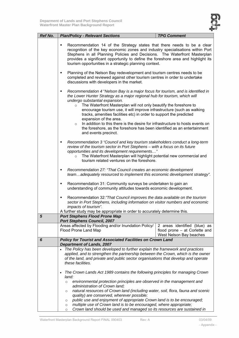
Deparment of Lands and Port Stephens Council Waterfront Master Plan Background Report
Waterfront Masterplan Background Report FINAL 090403 Rev: A 03/04/09 - Appendix -
Ref No. Plan/Policy - Relevant Sections TPG Comment Recommendation 14 of the Strategy states that there needs to be a clear
recognition of the key economic zones and industry specialisations within Port Stephens in all Planning Policies and Decisions. The Waterfront Masterplan provides a significant opportunity to define the foreshore area and highlight its tourism opportunities in a strategic planning context.
Planning of the Nelson Bay redevelopment and tourism centres needs to be
completed and reviewed against other tourism centres in order to undertake discussions with developers in the market.
Recommendation 4 “Nelson Bay is a major focus for tourism, and is identified in
the Lower Hunter Strategy as a major regional hub for tourism, which will undergo substantial expansion.
o The Waterfront Masterplan will not only beautify the foreshore to encourage tourism use, it will improve infrastructure (such as walking tracks, amenities facilities etc) in order to support the predicted expansion of the area.
o In addition to this there is the desire for infrastructure to hosts events on the foreshore, as the foreshore has been identified as an entertainment and events precinct.
Recommendation 3 “Council and key tourism stakeholders conduct a long-term
review of the tourism sector in Port Stephens – with a focus on its future opportunities and its development requirements…”
o The Waterfront Masterplan will highlight potential new commercial and tourism related ventures on the foreshore.
Recommendation 27: “That Council creates an economic development
team…adequately resourced to implement this economic development strategy”. Recommendation 31: Community surveys be undertaken to gain an
understanding of community attitudes towards economic development. Recommendation 32:”That Council improves the data available on the tourism
sector in Port Stephens, including information on visitor numbers and economic impacts of tourism”.
A further study may be appropriate in order to accurately determine this. 5 Port Stephens Flood Prone Map
Port Stephens Council, 2007 Areas affected by Flooding and/or Inundation Policy/
Flood Prone Land Map 2 areas identified (blue) as flood prone – at Corlette and West Nelson Bay beaches
6 Policy for Tourist and Associated Facilities on Crown Land Department of Lands, 2007
• The Policy has been developed to further explain the framework and practices applied, and to strengthen the partnership between the Crown, which is the owner of the land, and private and public sector organisations that develop and operate these facilities.
• The Crown Lands Act 1989 contains the following principles for managing Crown
land: o environmental protection principles are observed in the management and
administration of Crown land; o natural resources of Crown land (including water, soil, flora, fauna and scenic
quality) are conserved, wherever possible; o public use and enjoyment of appropriate Crown land is to be encouraged; o multiple use of Crown land is to be encouraged, where appropriate; o Crown land should be used and managed so its resources are sustained in
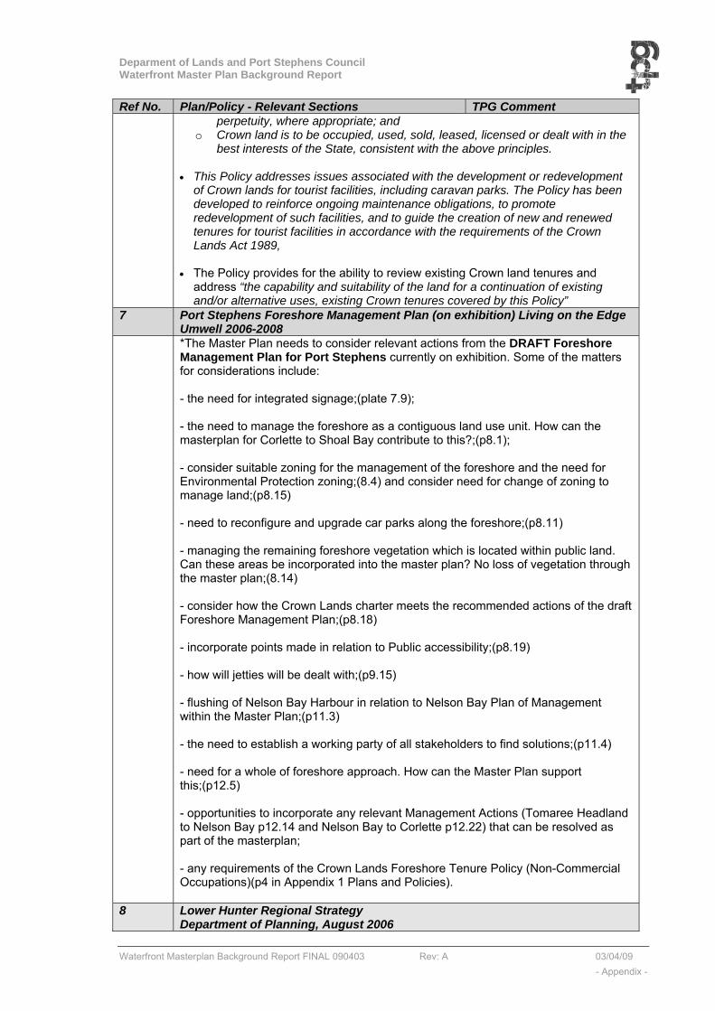
Deparment of Lands and Port Stephens Council Waterfront Master Plan Background Report
Waterfront Masterplan Background Report FINAL 090403 Rev: A 03/04/09 - Appendix -
Ref No. Plan/Policy - Relevant Sections TPG Comment perpetuity, where appropriate; and
o Crown land is to be occupied, used, sold, leased, licensed or dealt with in the best interests of the State, consistent with the above principles.
• This Policy addresses issues associated with the development or redevelopment
of Crown lands for tourist facilities, including caravan parks. The Policy has been developed to reinforce ongoing maintenance obligations, to promote redevelopment of such facilities, and to guide the creation of new and renewed tenures for tourist facilities in accordance with the requirements of the Crown Lands Act 1989,
• The Policy provides for the ability to review existing Crown land tenures and
address “the capability and suitability of the land for a continuation of existing and/or alternative uses, existing Crown tenures covered by this Policy”
7 Port Stephens Foreshore Management Plan (on exhibition) Living on the Edge Umwell 2006-2008
*The Master Plan needs to consider relevant actions from the DRAFT Foreshore Management Plan for Port Stephens currently on exhibition. Some of the matters for considerations include: - the need for integrated signage;(plate 7.9); - the need to manage the foreshore as a contiguous land use unit. How can the masterplan for Corlette to Shoal Bay contribute to this?;(p8.1); - consider suitable zoning for the management of the foreshore and the need for Environmental Protection zoning;(8.4) and consider need for change of zoning to manage land;(p8.15) - need to reconfigure and upgrade car parks along the foreshore;(p8.11) - managing the remaining foreshore vegetation which is located within public land. Can these areas be incorporated into the master plan? No loss of vegetation through the master plan;(8.14) - consider how the Crown Lands charter meets the recommended actions of the draft Foreshore Management Plan;(p8.18) - incorporate points made in relation to Public accessibility;(p8.19) - how will jetties will be dealt with;(p9.15) - flushing of Nelson Bay Harbour in relation to Nelson Bay Plan of Management within the Master Plan;(p11.3) - the need to establish a working party of all stakeholders to find solutions;(p11.4) - need for a whole of foreshore approach. How can the Master Plan support this;(p12.5) - opportunities to incorporate any relevant Management Actions (Tomaree Headland to Nelson Bay p12.14 and Nelson Bay to Corlette p12.22) that can be resolved as part of the masterplan; - any requirements of the Crown Lands Foreshore Tenure Policy (Non-Commercial Occupations)(p4 in Appendix 1 Plans and Policies).
8 Lower Hunter Regional Strategy Department of Planning, August 2006
Deparment of Lands and Port Stephens Council Waterfront Master Plan Background Report
Waterfront Masterplan Background Report FINAL 090403 Rev: A 03/04/09 - Appendix -
Ref No. Plan/Policy - Relevant Sections TPG Comment • Region’s population increasing by 4,400 people
each year • Population is older and continuing to age at a
faster rate than state average • Occupancy rate of dwellings decreasing 2.5ppd
(2001) to 2.1ppd (2031)
High level of out-migration (younger people) %multi unit dwellings to increase in suitable locations
9 Port Stephens 2006-2010 Social Plan Port Stephens Council, 2006
Future Challenges facing PS: • Ageing Population & infrastructure needs • Conflicting interests and desires of existing &
new residents • Tourism • Community Cohesion • Transport • Community access and mobility, pathways,
motor scooter access • Negative impacts of high tourist numbers in
peak periods (parking, access, anti-social behaviour, loss of resident amenity).
• Community safety • Walkability of neighbourhoods for access to
local facilities
10 Draft Regional Conservation Plan Department of Environment, Conservation and Climate Change, October 2006
• Partner document to Regional strategy • 25 year program to direct and drive
conservation efforts – important areas around Port Stephens
• Guidelines for Biodiversity Certification 11 Regional Crown Reserve Strategy
Department of Lands, 2006 • Most public parks, walking trails etc are Crown
Reserves. • Regional Crown reserves have been established
to allow for sustainable management and better distribution of funding for maintenance promoting tourism and use by the public.
• Regional Crown Reserves ensures use and management of the Land supports regional economies & public requirements, and to direct resources to where they are most needed.
• They allow for a holistic management approach, in consultation with the community, so as to be sensitive to community needs.
12 Crown Lands Policy for Marinas and Waterfront Commercial Tenures Department of Lands, 2005
• Aims to strengthen the relationship between the Crown & the operator of commercial premises on waterfronts adjoining/on Crown Land.
• Direction guidance to DoL for development of new and renewed tenures for marinas & waterfront in accordance with Crown Lands Act 1989.
• Encourages environmental management of waterfront, whilst recognising the benefit of ongoing commercial tenure
• Waterfront Commercial uses include, but not
Deparment of Lands and Port Stephens Council Waterfront Master Plan Background Report
Waterfront Masterplan Background Report FINAL 090403 Rev: A 03/04/09 - Appendix -
Ref No. Plan/Policy - Relevant Sections TPG Comment limited to, marinas, clubs, commercial premises, retail, restaurants, kiosks, tourist and recreation facilities (not including caravan parks).
• Tenures potentially will not be renewed if it is seen to be in the public benefit (could be the case with masterplan).
• Conditions for development for specific tenures • Also provides explanation for things like level of
rent; redevelopment; ownership of improvements; rights to transfer tenures etc.
• New areas of Crown Land may arise for tenure as a result of the Masterplan
• 13 Port Stephens State of the Environment report
Port Stephens Council, 2004 Report on Ecology and Conservation in PS. • Uses the Pressure-State-Response Model.
• Pressures include things like increased population and influx of tourism
• Many actions, strategies and plans in response. • Recommended Actions include: clear strategies
to facilitate sustainable management; clear reporting systems; education on sustainability; economic development that is consistent with sustainability; mitigate adverse impacts of tourism.
• Tomaree Peninsula is the fastest growing area in Port Stephens
• Recommended action is integrated Pedestrian and cycle plan
• unauthorised dumping an issue • 31.5% of respondents said peace & quiet is most
like aspect in Port Stephens •
• Responses & Recommendations can be accommodated in Masterplan.
14 Integrated Land Use and Transport policy package Department of Planning 2001-2003
Draft SEPP “Integration of Land Use and Transport” Improve pedestrian and cycle access (Principles 6&7)
15 NSW Coastal Design Guidelines UDAS & Coastal Council of NSW, 2003
The diverse beauty of the NSW coast is at risk from developments which pay little attention to urban design principles. Application of the principles set out in the 'Coastal Design Guidelines for NSW' (Coastal Council of NSW 2003) will ensure that future developments and redevelopments are sensitive to the unique natural and urban settings of coastal places in NSW. The guidelines provide a world-standard approach for how urban design can be best used in a coastal context. The Minister for Planning has issued a Direction under section 117 of the Environmental Planning and Assessment Act 1979 to all local councils in the coastal zone regarding the Coastal Design Guidelines 2003. In preparing a draft local environmental plan, councils are required to include provisions that give effect to and are consistent with the Coastal Design Guidelines, unless the inconsistency is justified by an environmental study or strategy. ……..“need to rethink conventional planning practice in light of increasing pressure for development. The often ad-hoc approach to decision making, on a site by site basis, can be replaced by an urban design process that is responsive to the character of the place”
Five principles for coastal settlement structure describe elements of the public

Deparment of Lands and Port Stephens Council Waterfront Master Plan Background Report
Waterfront Masterplan Background Report FINAL 090403 Rev: A 03/04/09 - Appendix -
Ref No. Plan/Policy - Relevant Sections TPG Comment domain and the built form that reinforces it. They are presented as best practice outcomes and form the basis for understanding, debating and designing the present and future form of coastal settlements in NSW. The five principles are: 1. Defining the footprint and boundary of the settlement describes how to establish the outer limits of a settlement to protect the important visual and natural setting. 2. Connecting open spaces illustrates how open space creates recreation, conservation, public access, cultural and heritage opportunities in and around the settlement. 3. Protecting the natural edges of the settlement shows how the coastal edge is protected and understood as a public place, with public access and ecological values including mitigating the impacts of natural hazards. 4. Reinforcing the street pattern highlights how streets enliven centres, connect important places within and around the settlement, allow for improved choice when moving from place to place, and provide commercial and social benefits. 5. Appropriate buildings in a coastal context shows how specific development relates to the site's natural features and to its location within the settlement.
16 Communication and Consultation Strategy Port Stephens Council, January 2001
Community involvement in decision making “The development of partnerships with all our
stakeholders through the constant exchange of information and honest, timely communications”.
Consultation programmes for each project with peer review (to provide support and suggestions for improvement).
30 April 08 – TPG meeting with PS community exchange group
Maintain a community data base (Mail/phone) “Include an E Mail forum for discussion of issues”. Check whether E Mail
contacts? 17 Port Stephens and Myall Lakes Estuary Management Plan (Report No
1287/R04/V2 by Umwelt (Australia) Pty Limited Umwelt, July 2000
Plate1 Beach erosion at Shoal Bay (p 4.1) Plate2 Nelson Bay Harbour (p4.1) “The document presents a plan for managing the
Port Stephens and Myall Lakes estuary over a period of 5 to 10 years. The Estuary Management Plan is intended to guide the use and development of the estuary and its surroundings, so that the environment and lifestyle that are highly valued by the community are protected and enhanced”.
How is the “estuary and surroundings defined?”. Prepared in accordance with: • The NSW Coastal Policy
(1997), and • The NSW Estuary
Management Policy (1992).
The EMS & EMP is supervised by the PS & ML EMC, which is a joint committee of the PS & Great Lakes Councils.
Other “relevant studies” referenced in the PS & MLEMP: • Coastline Management Study and Plan for Shoal Bay • Stormwater Management Plan for Port Stephens • Regional Biodiversity Study (Port Stephens)
Sect3 P3.1
Priority Actions: EPIs Remedial Works (structural or ecological) Monitoring Programmes Education Programmes Community Services (foreshore facilities such as boat ramps, wharves and jetties etc).
P3.3 “Finalise the review of the PSLEP, to include measures to enhance protection of foreshore
Deparment of Lands and Port Stephens Council Waterfront Master Plan Background Report
Waterfront Masterplan Background Report FINAL 090403 Rev: A 03/04/09 - Appendix -
Ref No. Plan/Policy - Relevant Sections TPG Comment vegetation, and to require consent for certain waterway uses”. “Prepare and implement a management plan for Nelson Bay Harbour” “Prepare comprehensive and complete Foreshore Management Plan for the whole estuary” “Prepare a Boating Management Plan for port Stephens and Myall Lakes, including moorings, waste management, zonings, access and facilities, navigation”. “Install stormwater controls in Nelson Bay, Shoal Bay, little Beach….” “Commence beach renourishment at Shoal Bay, as recommended by the Coastline Management Study”. “Follow up compliance audits of marinas and slipways”
P4.1 to 4.3
Fig 4.1a – Management Zone A1 – Tomaree Head to Corlette
Section 4.1 P5.7 Table 5.2 – Core Indicators for ecologically
sustainable estuary management • Proportion of foreshore with natural riparian veg
extending more than 10m from shoreline (Aerial photo interpretation and field checking every 3years)
• Usage of foreshore facilities (Boat ramps and walkways – would require community surveys at agreed intervals / 3 years)
P5.14 N11 Install signage at boat ramps (see W1) about marine fauna
P5.19 N26 Implement recommendations of PORT STEPHENS COUNCIL stormwater management plan, particularly re quality controls at Shoal Bay, Little Beach, Nelson Bay…….
P5.31 C18a Installation of oil separating devices / GPTs / constructed wetlands at Little Beach, Nelson Bay Harbour.
P5.34 D1 Coastline Plan for Shoal bay D7
P5.46 W1 User Needs Surveys P5.47 W5 Alternative parking at Little Beach P5.47 W7 Signs at ramps & jetties P5.50 W14 Foreshore Management Plan for Port
Stephens (review all foreshore structures)
P5.51 W15 Management Plan for Nelson Bay Harbour P5.52 W20 Implement Stormwater Controls P5.61 L8 Protect Visual Catchment of Estuary P5.61 L9 Prepare Foreshore Management Plan 18 2000 Port Stephens Local Environmental Plan
Port Stephens Council, 2000 Relevant Definitions:

Deparment of Lands and Port Stephens Council Waterfront Master Plan Background Report
Waterfront Masterplan Background Report FINAL 090403 Rev: A 03/04/09 - Appendix -
Ref No. Plan/Policy - Relevant Sections TPG Comment bed and breakfast establishment means a dwelling-house used (in addition to its use as a principal place of residence) for the provision of temporary accommodation for not more than 6 tourists or travellers at any one time in not more than 3 bedrooms in the dwelling-house. camp or caravan site means a site used for the purpose of: (a) placing moveable dwellings within the meaning of the Local Government Act 1993 for permanent accommodation, or for the temporary accommodation of tourists, or (b) the erection, assembly or placement of cabins for the temporary accommodation of tourists. community land means land classified or reclassified as community land within the meaning of the Local Government Act 1993. hotel means the premises to which a hotelier’s licence granted under the Liquor Act 1982 relates. (Prohibited in the 2a and 2c residential zones). marina means a pontoon, jetty, pier, wharf or the like, used or intended to be used to provide moorings for boats used for pleasure, recreation or commercial purposes and includes: (a) slipways, and (b) facilities for the repair, maintenance and fuelling of or the provision of accessories and parts for, boats or boating enthusiasts, and (c) facilities for the storage or provision of food, and (d) facilities for wholesale and retail sales, and for commercial, industrial and heavy engineering works and other activities connected with the fishing industry. market means an open-air area or an existing building used for the purpose of selling, exposing or offering goods, merchandise or materials for retail sale by independent stall holders, and includes temporary structures and existing permanent structures used for that purpose on an intermittent or occasional basis. precinct, in relation to the Nelson Bay (West) Area, means a precinct shown by black edging and identified as “Foreshore”, “Hill Tops”, “Lower Slopes”, “Town Centre Edge”, “Town Centre Housing”, “Upper Slopes” or “Wahgunyah Neighbourhood”, on the map marked “Nelson Bay (West) Area” deposited in the office of the Council. recreation area means: (a) a children’s playground, (b) an area used for sporting activities or sporting facilities, (c) an area used to provide recreational facilities for the physical, cultural or intellectual welfare of the community, and (d) an area used by a body of persons associated for the purposes of the physical, cultural or intellectual welfare of the community to provide recreational facilities for those purposes, but does not include a racecourse, race track or a showground. (permissible in 6c and 6a zone) recreation facility means a building or place used for sporting, recreation or leisure activities, whether or not operated for the purpose of gain, but does not include a building or place elsewhere specifically defined in this Dictionary. (permissible in 6c and 6a zone) restaurant means a building or place used principally for providing prepared food to people for consumption on the premises or to take away (or for preparing both kinds of food). (permissible in 6c and 6a zone and in the 2c but not the 2a residential zone) tourist boat means a boat taking fare paying passengers, being a boat that is berthed or based in Port Stephens for more than 20 days per annum. tourist facility means an establishment providing primarily for tourist accommodation or recreation, or both. (permissible in 6c not 6a zone, and in the 2c but not the 2a residential zone)
Current Zoning of the waterfront land 6a, 6c, 7a, 7c, 7(f1), 7(w) 6a - Zone No 6 (a) (General Recreation “A” Zone)—
(1) Description of the zone The General Recreation “A” Zone contains land that is currently used or is available
to be used for both active and passive recreation. The zone generally relates to

Deparment of Lands and Port Stephens Council Waterfront Master Plan Background Report
Waterfront Masterplan Background Report FINAL 090403 Rev: A 03/04/09 - Appendix -
Ref No. Plan/Policy - Relevant Sections TPG Comment recreation reserves, foreshores, bushland and other land reserved for the public. It can include a number of recreational developments, such as playing fields, children’s playgrounds and bushland parks, and may include services and facilities catering for users of the reserve.
(2) Objectives of the zone The objectives of the General Recreation “A” Zone are: (a) to identify publicly owned land and ensure that it is available for open space
recreation, and (b) to provide an open space network to serve the present and future recreational
needs of residents and visitors, and (c) to permit development associated with, or complementary to, open space, and (d) to allow development on foreshores where that development is water related and
enhances the recreational use or natural environment of the foreshore, and (e) to preserve the aesthetics of land which is prominent and visible to the public
along foreshore areas, and (f) to reserve privately owned land that is essential for future public open space and
to provide for its acquisition by the Council. 6c - Special Recreation “C” Zone
1) Description of the zone The Special Recreation “C” Zone includes privately and publicly owned land used for
recreational purposes such as licensed clubs, golf courses, bowling clubs and the like.
(2) Objectives of zone The objectives of the Special Recreation “C” Zone are to enable privately and
publicly operated recreational development in suitable and accessible localities and to ensure facilities do not reduce the amenity of the locality or its environmental quality.
(3) Development allowed without development consent Exempt development. Works for the purpose of landscaping, gardening or bushfire hazard reduction. (4) Development allowed only with development consent Development for the purpose of: • advertisements,• agriculture,• aquaculture,• camp or caravan
sites,• clearing,• clubs,• dams,• earthworks,• forestry,• marinas,• race tracks,• recreation areas,• recreation facilities,• restaurants,• telecommunications facilities,• tourist facilities,• utility installations
Zone No 7 (a) (Environment Protection “A” Zone)—
(1) Description of the zone The Environment Protection “A” Zone is comprised of lands which are environmentally sensitive or of particular environmental interest. It includes water catchment areas, wetlands and areas of significant flora or fauna habitat. Development in this zone is generally comprised of scattered residential development and development for the purpose of tourist accommodation sympathetic to, and compatible with, the natural environment and its features. (2) Objectives of the zone The objectives of the Environment Protection “A” Zone are to encourage the conservation and proper management of environmentally sensitive land and to ensure that existing and future land uses and land management practices do not detract from the environmental values of the land, and, in particular: (a) to protect significant wildlife habitats, water catchment areas and coastal lands, and (b) to regulate development to avoid inappropriate uses of land, being uses which would destroy or damage a habitat ecosystem (particularly that of wetlands), significant vegetation or wildlife, and (c) to promote the regeneration of areas of significant vegetation, and their corridors,
Deparment of Lands and Port Stephens Council Waterfront Master Plan Background Report
Waterfront Masterplan Background Report FINAL 090403 Rev: A 03/04/09 - Appendix -
Ref No. Plan/Policy - Relevant Sections TPG Comment for the protection of native fauna and flora species and to maintain their diversity, and (d) to encourage development compatible with, and sympathetic to, the preservation of the natural environment and based on the principles of ecologically sustainable development, and (e) to regulate development so that it does not adversely affect and is not adversely affected by coastal processes, in both the short and long term, and (f) to maintain the visual character of coastal landscapes, hillscapes and ridgelines and the availability of land for coastal recreation and access, and (g) to ensure the sensitive use of renewable resources to maintain the integrity of the resource base and provide for its continued use by future generations, and (h) to conserve biological diversity and ecological integrity. (3) Development allowed without development consent Exempt development. (4) Development allowed only with development consent Development for the purpose of: • agriculture, • aquaculture,• bed and breakfast establishments,• bushfire hazard reduction,• clearing,• community facilities,• dams,• dual occupancy housing,• dwelling-houses,• earthworks,• home employment,• places of assembly,• places of public worship,• recreation areas,• recreation facilities,• tourist facilities,• utility installations. Subdivision permitted by clause 33.
Zone No 7 (c)—Environment Protection “C” (Water Catchment) Zone
(1) Description of the zone The Environment Protection “C” (Water Catchment) Zone is comprised of lands
which are environmentally sensitive and are also in the care and control of the Hunter Water Corporation. Development in this zone generally relates to the on-going and long-term management of the surface and groundwater catchment by the Hunter Water Corporation. There are also other sympathetic and compatible uses of the land in the zone.
(2) Objectives of the zone The objectives of the Environment Protection “C” (Water Catchment) Zone are: (a) to ensure the protection of water catchment areas to safeguard the quality and
quantity of groundwater and surface water, and (b) to regulate development so as to avoid uses of land that would destroy or
damage the quality or quantity of groundwater or surface water. (3) Development allowed without development consent Exempt development. (4) Development allowed only with development consent Development for the purpose of: • agriculture,• bushfire hazard reduction,• clearing,• community
facilities,• dams,• dwelling-houses,• earthworks,• recreation areas,• recreation facilities,• tourist facilities,• utility installations. Subdivision permitted by clause 33
Zone No 7 (f1)—Environment Protection “F1” (Coastal Lands) Zone (1) Description of the zone The land within the Environment Protection “F1” (Coastal Lands) Zone is identified as being land located along the coastline that is, for aesthetic or environmental reasons, environmentally sensitive, and is generally held in public ownership. (2) Objectives of the zone The objectives of the Environment Protection “F1” (Coastal Lands) Zone are: (a) to identify and protect coastal lands which are recognised as being environmentally sensitive, and (b) to safeguard sections of the coast which are significant tourist and recreational areas and to promote only environmentally and aesthetically sympathetic

Deparment of Lands and Port Stephens Council Waterfront Master Plan Background Report
Waterfront Masterplan Background Report FINAL 090403 Rev: A 03/04/09 - Appendix -
Ref No. Plan/Policy - Relevant Sections TPG Comment development, and (c) to regulate development so that it does not adversely affect and is not adversely affected by coastal processes, in both the short and long term. (3) Development allowed without development consent Exempt development. (4) Development allowed only with development consent Development for the purpose of: • agriculture,• aquaculture,• bed and breakfast establishments,• bushfire hazard reduction,• camp or caravan sites,• clearing,• community facilities,• dams, • dual occupancy housing,• dwelling-houses,• earthworks,• home employment,• places of assembly,• places of public worship,• recreation areas,• recreation facilities,• tourist facilities,• utility installations. Subdivision permitted by clause 34.
Zone No 7 (w)—Environment Protection “W” (Waterways) Zone (1) Description of the zone The Environment Protection “W” (Waterways) Zone applies to the Port Stephens
waterway including Tilligerry Creek. Development in this zone is generally of a low impact nature that is sympathetic to, and compatible with, the natural environment.
(2) Objectives of the zone The objectives of the Environment Protection “W” (Waterways) Zone are to minimise
the impacts caused by commercial operations on the marine life and ecology of the Port Stephens waterways and to provide for such activities and facilities which:
(a) are compatible with the existing or planned future character of the waterways and adjoining foreshores, and
(b) protect and maintain the viability of the oyster, prawn and fishing industries of the Port whilst enabling a balance of compatible recreational uses, and
(c) maintain the integrity of the waterways resource base and provide for its continued use by future generations, and
(d) ensure there is provision for multiple use of the waterways of Port Stephens having regard to the use and zoning of adjoining waterfront lands, and
(e) protect and enhance the aquatic environment and the significant marine habitats of Port Stephens, and
(f) protect and enhance the natural environment based on the principles of ecologically sustainable development including biological diversity and ecological integrity, and
(g) do not adversely affect and are not adversely affected by coastal processes, in both the short and long term.
(3) Development allowed without development consent Development for the purpose of: • boating activities, except development for the purpose of tourist boats, • maintenance dredging. Exempt development. (4) Development allowed only with development consent Any development not included in Item 3
Summary Tourist facilities not permissible in 6(a) and 2(a) zoned land
Heritage (within Precinct 4) The planning area includes the following items which have been identified on the Port Stephens LEP as being heritage items of local significance: �Laman Street Road Reserve - Former oil-burning street lamp – corner of Laman Street and Government Road. �Reserve No 64421 - Pt Lot 154, DP 753204 1A and 8 Laman Street (221.1/1 and 221.8) - Apex Park Group, including Cenotaph, well, remains of the memorial steps and tree specimen of Ficus rubiginosa (Port Jackson Fig). �DP 753204 1 Lighthouse Road (1031.1) - The Native Flora Reserve, including site of former migrant camp, foundations of HMAS Assault, Aboriginal scar tree, burial
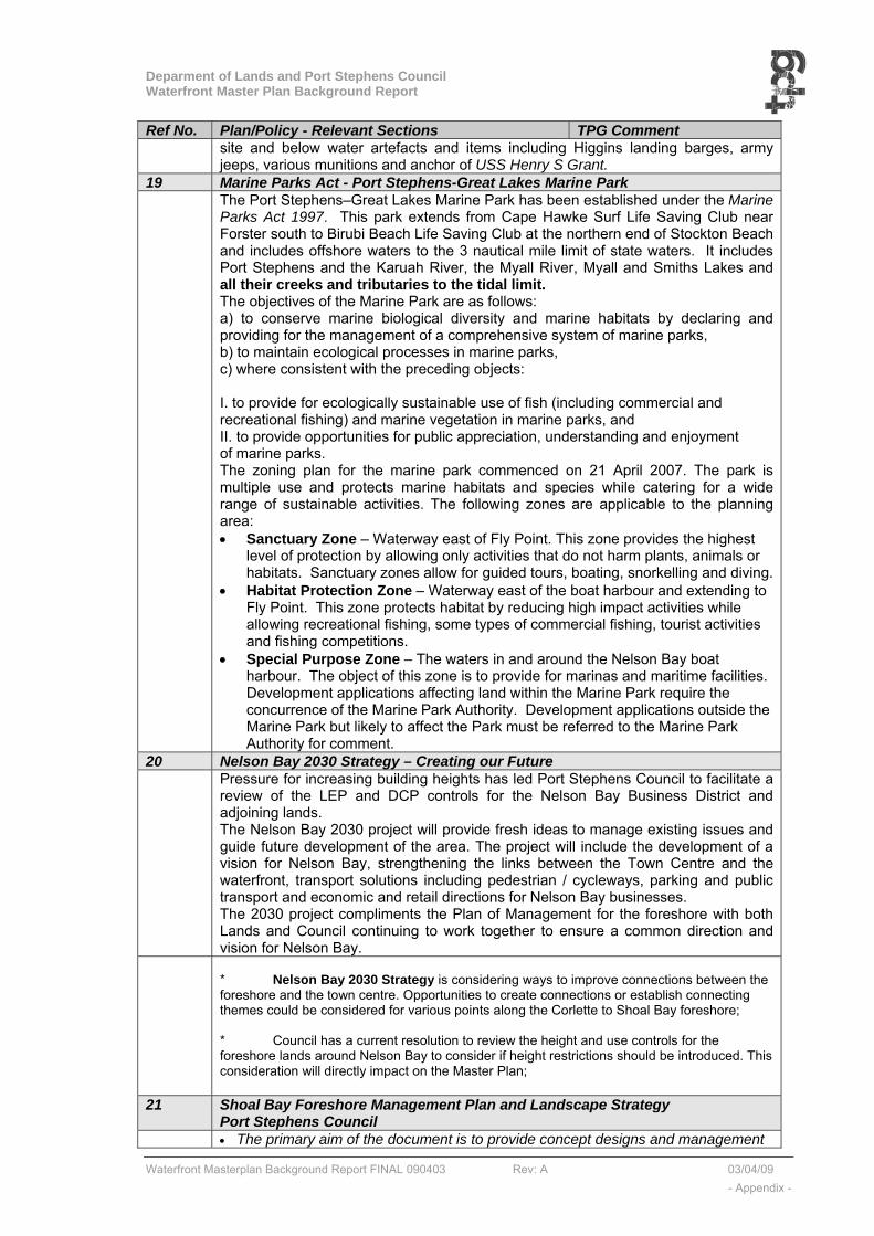
Deparment of Lands and Port Stephens Council Waterfront Master Plan Background Report
Waterfront Masterplan Background Report FINAL 090403 Rev: A 03/04/09 - Appendix -
Ref No. Plan/Policy - Relevant Sections TPG Comment site and below water artefacts and items including Higgins landing barges, army jeeps, various munitions and anchor of USS Henry S Grant.
19 Marine Parks Act - Port Stephens-Great Lakes Marine Park The Port Stephens–Great Lakes Marine Park has been established under the Marine
Parks Act 1997. This park extends from Cape Hawke Surf Life Saving Club near Forster south to Birubi Beach Life Saving Club at the northern end of Stockton Beach and includes offshore waters to the 3 nautical mile limit of state waters. It includes Port Stephens and the Karuah River, the Myall River, Myall and Smiths Lakes and all their creeks and tributaries to the tidal limit. The objectives of the Marine Park are as follows: a) to conserve marine biological diversity and marine habitats by declaring and providing for the management of a comprehensive system of marine parks, b) to maintain ecological processes in marine parks, c) where consistent with the preceding objects: I. to provide for ecologically sustainable use of fish (including commercial and recreational fishing) and marine vegetation in marine parks, and II. to provide opportunities for public appreciation, understanding and enjoyment of marine parks. The zoning plan for the marine park commenced on 21 April 2007. The park is multiple use and protects marine habitats and species while catering for a wide range of sustainable activities. The following zones are applicable to the planning area: • Sanctuary Zone – Waterway east of Fly Point. This zone provides the highest
level of protection by allowing only activities that do not harm plants, animals or habitats. Sanctuary zones allow for guided tours, boating, snorkelling and diving.
• Habitat Protection Zone – Waterway east of the boat harbour and extending to Fly Point. This zone protects habitat by reducing high impact activities while allowing recreational fishing, some types of commercial fishing, tourist activities and fishing competitions.
• Special Purpose Zone – The waters in and around the Nelson Bay boat harbour. The object of this zone is to provide for marinas and maritime facilities. Development applications affecting land within the Marine Park require the concurrence of the Marine Park Authority. Development applications outside the Marine Park but likely to affect the Park must be referred to the Marine Park Authority for comment.
20 Nelson Bay 2030 Strategy – Creating our Future Pressure for increasing building heights has led Port Stephens Council to facilitate a
review of the LEP and DCP controls for the Nelson Bay Business District and adjoining lands. The Nelson Bay 2030 project will provide fresh ideas to manage existing issues and guide future development of the area. The project will include the development of a vision for Nelson Bay, strengthening the links between the Town Centre and the waterfront, transport solutions including pedestrian / cycleways, parking and public transport and economic and retail directions for Nelson Bay businesses. The 2030 project compliments the Plan of Management for the foreshore with both Lands and Council continuing to work together to ensure a common direction and vision for Nelson Bay.
* Nelson Bay 2030 Strategy is considering ways to improve connections between the foreshore and the town centre. Opportunities to create connections or establish connecting themes could be considered for various points along the Corlette to Shoal Bay foreshore; * Council has a current resolution to review the height and use controls for the foreshore lands around Nelson Bay to consider if height restrictions should be introduced. This consideration will directly impact on the Master Plan;
21 Shoal Bay Foreshore Management Plan and Landscape Strategy Port Stephens Council
• The primary aim of the document is to provide concept designs and management

Deparment of Lands and Port Stephens Council Waterfront Master Plan Background Report
Waterfront Masterplan Background Report FINAL 090403 Rev: A 03/04/09 - Appendix -
Ref No. Plan/Policy - Relevant Sections TPG Comment guidelines that will preserve the essential character of Shoal Bay whilst allowing the area to be developed in a controlled manner for the benefit of the local community and tourists alike.
• It details various cultural plantings (a mix of both local and exotic species) and indigenous vegetation occurring in the Shoal Bay area. It identifies four main vegetation associations in the area that will be useful in the repopulation of vegetation in the area.
• Details of visual significance and visual character (as well as visual detractors), allowing for visual interpretation of the coastline.
• Heritage sites are identified (including Aboriginal and European and Natural). • The landscape assessment divides Shoal Bay into 5 distinct zones, providing
specific opportunities and constraints for each. • Users surveys were undertaken to determine the community attitude towards the
existing condition and desired future outcomes; some of which were considered in the management considerations for the areas. The management considerations focus on things such as scenic qualities and natural habitats, and tourism and carrying capacities.
• A landscape masterplan has been prepared highlighting landscaping initiatives tailored to each individual zone.
• This document is thorough in its coverage of the area and its consultation vital in future direction for the foreshore at Shoal Bay.
22 Draft Port Stephens (Template) Local Environmental Plan
Port Stephens Council Unavailable at present time 23 Port Stephens – Blue Water Paradise
www.portstephens.org.au Port Stephens Beach and Bay
Guide activities facilities
Conroy and Corlette Parks (Precinct 1) -
Swimming, picnic
BBQ, Car Park, Playground, Showers, Toilets
Bagnall Beach (Precinct 2) – the foreshore reserve is an approved “Dog on/off lead” area
Swimming, kite surfing, picnic
BBQ, Car Park, Playground, Showers, Toilets
Dutchmans Beach (Precinct 3) – Quiet, calm waters
Swimming, picnic, walking track
BBQ, Car Park, Playground, Showers, Toilets
Fly Point (Precinct 4)-- This Aquatic Reserve is a haven for divers. Shady grasses areas.
Snorkelling, diving, fish feeding, picnic, walking track through Native Flora Gardens.
Amphitheatre, BBQ, car park, shelter, toilets & skate ramp nearby.
Nelson Bay Foreshore (Precinct 4) – perfect for paddling and relaxing. Located in the heart of Nelson Bay.
Swimming, picnic
Metered car parking, play equipment, shop, disabled toilets, hire facilities (paddle boats).
Little Beach (Precinct 5) - Suitable for family and social club gathering. Gentle Waters. Ideal for young children.
Swimming, lighthouse, picnic.
BBQ, Boat Ramp, car park, shop, playground, public jetty, showers, toilets, & play area for the disabled.
Shoal Bay (Precincts 6&7) – spectacular views of the heads.
Swimming, fishing, picnic
BBQ, car park, hire facilities (sail boats), shop, public jetty, shelter, showers, toilets.
Department of Lands 2005. Managing Reserved and Dedicated Crown Lands – A Handbook for Trusts Department of Lands and Port Stephens Council 2006 – Exhibition Document: Nelson Bay Foreshore – A Vision for the Future
Deparment of Lands and Port Stephens Council Waterfront Master Plan Background Report
Waterfront Masterplan Background Report FINAL 090403 Rev: A 03/04/09 - Appendix -
Ref No. Plan/Policy - Relevant Sections TPG Comment Suters Architects 2002 – Nelson Bay Foreshore Masterplan Umwelt 2006. Living on the Edge – A Foreshore Management Plan for Port Stephens (Draft)
Deparment of Lands and Port Stephens Council Waterfront Master Plan Background Report
Waterfront Masterplan Background Report FINAL 090403 Rev: A 03/04/09 - Appendix -
APPENDIX B Notes from Community Reference Group Meetings
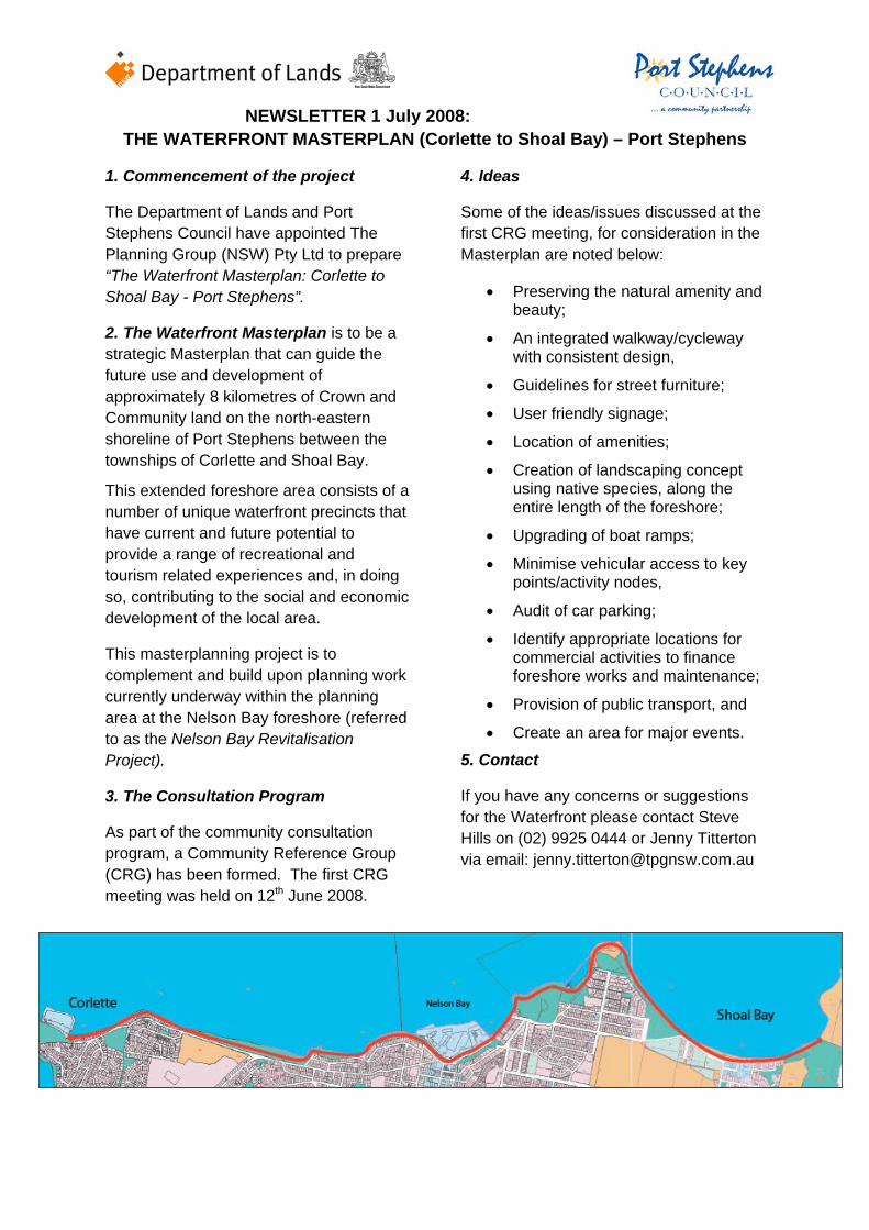
NEWSLETTER 1 July 2008: THE WATERFRONT MASTERPLAN (Corlette to Shoal Bay) – Port Stephens
1. Commencement of the project
The Department of Lands and Port Stephens Council have appointed The Planning Group (NSW) Pty Ltd to prepare “The Waterfront Masterplan: Corlette to Shoal Bay - Port Stephens”.
2. The Waterfront Masterplan is to be a strategic Masterplan that can guide the future use and development of approximately 8 kilometres of Crown and Community land on the north-eastern shoreline of Port Stephens between the townships of Corlette and Shoal Bay.
This extended foreshore area consists of a number of unique waterfront precincts that have current and future potential to provide a range of recreational and tourism related experiences and, in doing so, contributing to the social and economic development of the local area.
This masterplanning project is to complement and build upon planning work currently underway within the planning area at the Nelson Bay foreshore (referred to as the Nelson Bay Revitalisation Project).
3. The Consultation Program
As part of the community consultation program, a Community Reference Group (CRG) has been formed. The first CRG meeting was held on 12th June 2008.
4. Ideas
Some of the ideas/issues discussed at the first CRG meeting, for consideration in the Masterplan are noted below:
• Preserving the natural amenity and beauty;
• An integrated walkway/cycleway with consistent design,
• Guidelines for street furniture;
• User friendly signage;
• Location of amenities;
• Creation of landscaping concept using native species, along the entire length of the foreshore;
• Upgrading of boat ramps;
• Minimise vehicular access to key points/activity nodes,
• Audit of car parking;
• Identify appropriate locations for commercial activities to finance foreshore works and maintenance;
• Provision of public transport, and
• Create an area for major events.
5. Contact
If you have any concerns or suggestions for the Waterfront please contact Steve Hills on (02) 9925 0444 or Jenny Titterton via email: [email protected]
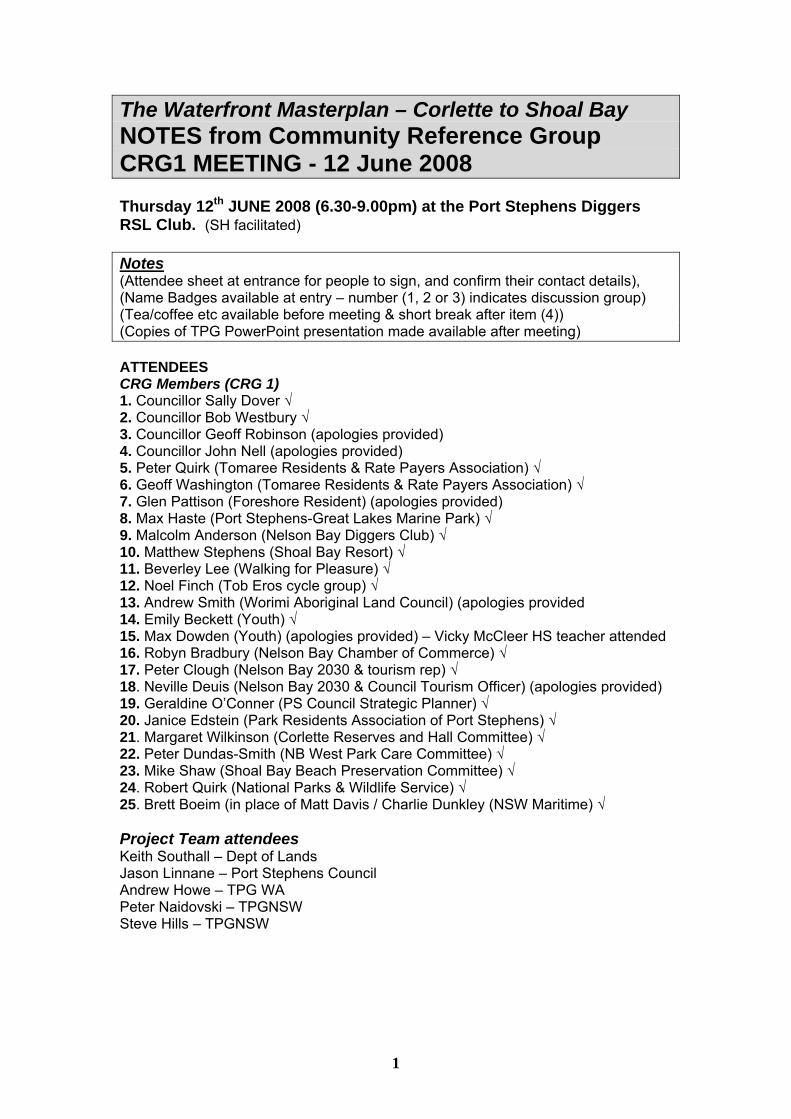
1
The Waterfront Masterplan – Corlette to Shoal Bay NOTES from Community Reference Group CRG1 MEETING - 12 June 2008 Thursday 12th JUNE 2008 (6.30-9.00pm) at the Port Stephens Diggers RSL Club. (SH facilitated) Notes (Attendee sheet at entrance for people to sign, and confirm their contact details), (Name Badges available at entry – number (1, 2 or 3) indicates discussion group) (Tea/coffee etc available before meeting & short break after item (4)) (Copies of TPG PowerPoint presentation made available after meeting) ATTENDEES CRG Members (CRG 1) 1. Councillor Sally Dover √ 2. Councillor Bob Westbury √ 3. Councillor Geoff Robinson (apologies provided) 4. Councillor John Nell (apologies provided) 5. Peter Quirk (Tomaree Residents & Rate Payers Association) √ 6. Geoff Washington (Tomaree Residents & Rate Payers Association) √ 7. Glen Pattison (Foreshore Resident) (apologies provided) 8. Max Haste (Port Stephens-Great Lakes Marine Park) √ 9. Malcolm Anderson (Nelson Bay Diggers Club) √ 10. Matthew Stephens (Shoal Bay Resort) √ 11. Beverley Lee (Walking for Pleasure) √ 12. Noel Finch (Tob Eros cycle group) √ 13. Andrew Smith (Worimi Aboriginal Land Council) (apologies provided 14. Emily Beckett (Youth) √ 15. Max Dowden (Youth) (apologies provided) – Vicky McCleer HS teacher attended 16. Robyn Bradbury (Nelson Bay Chamber of Commerce) √ 17. Peter Clough (Nelson Bay 2030 & tourism rep) √ 18. Neville Deuis (Nelson Bay 2030 & Council Tourism Officer) (apologies provided) 19. Geraldine O’Conner (PS Council Strategic Planner) √ 20. Janice Edstein (Park Residents Association of Port Stephens) √ 21. Margaret Wilkinson (Corlette Reserves and Hall Committee) √ 22. Peter Dundas-Smith (NB West Park Care Committee) √ 23. Mike Shaw (Shoal Bay Beach Preservation Committee) √ 24. Robert Quirk (National Parks & Wildlife Service) √ 25. Brett Boeim (in place of Matt Davis / Charlie Dunkley (NSW Maritime) √ Project Team attendees Keith Southall – Dept of Lands Jason Linnane – Port Stephens Council Andrew Howe – TPG WA Peter Naidovski – TPGNSW Steve Hills – TPGNSW
2
CRG1 AGENDA 1) Introductions (KS/SH) - Project Team - Waterfront CRG Members (around table / name and organisation) 2) The Brief and Project Requirements (PowerPoint - SH) 3) Overview of the Existing Situation - Other plans & policies / strategic overview (SH) - The Waterfront 8 Areas (SH & PN) 4) Initial Comment on ISSUES and SOLUTIONS - Initial Comments on MAIN ISSUES within the 8 areas - Some suggested design Solutions (from WA and elsewhere) (AH) TEA/COFFEE 5) Break into 3 GROUPS (to consider 8 local areas of the Waterfront) - Groups managed by SH, AH and PN - Consider and respond to AGENDA for group discussion - Appoint group spokesperson to report back to main meeting 6) Presentations by 3 Groups 7) Discussion and Conclusions - next meeting CRG2 (10th July 08 not appropriate as in school holidays). Agreed revised date for CRG2 is Thursday 24th July 2008 at Nelson Bay RSL - any other comments/queries please contact TPG tel 99250444, or E Mail [email protected]
3
THE WATERFRONT MASTERPLAN ITEM 5 - GROUP DISCUSSION AGENDA (for each of the 3 groups) Each Group considered in 2 parts: i) the overall Waterfront Masterplan (Corlette to Shoal Bay), and ii) the local areas (1 to 8), ie the areas nominated to each group. (Group 1 = Areas 1, 2, 3,& 4), (Group 2 = Areas 5, 6), and (Group 3 = Areas 7 & 8).
1) The Overall Masterplan • (a) What are the key issues that should be considered in this “integrated
foreshore corridor”? (eg the walkway/cycleway/landscaping/facilities) • (b) What is an appropriate balance “between the essential environmental,
landscape, cultural and recreation values of the foreshore and the need for the sustainable commercial activity/nodes that that can assist with the economic development of the foreshore and its ongoing maintenance” (ie selected commercial activity only where appropriate? Or some activity within each of the 8 areas?, and what TYPE of activity?)
• (c) What is your vision for the Waterfront? • (d) What are the key principles and strategic objectives? (eg road access / car
parking provision / visual amenity / community facilities?) 2) The Local Areas (Area 1 to Area 8) • (a) Consider the presentation drawings of the existing situation within your
nominated local areas (drawings 1). • (b) What do you think are the site strengths, weaknesses, opportunities and
constraints within these local areas?. • (c) Consider the initially identified key issues that should be considered in
each of the local areas (drawings 2). Are there other issues that should be addressed (please record)
• (d) In each of these areas what is an appropriate balance “between the essential environmental, landscape, cultural and recreation values of the foreshore and the need for the sustainable commercial activity/nodes that that can assist with the economic development of the foreshore and its ongoing maintenance” (is there a potential and appropriate commercial activity available within each area?)
• (e) What are the possible solutions to address those key issues identified in each of your local areas?. How would they address the agreed key principles and objectives of the overall masterplan (see 1(d) above).
4
CRG 1 – ITEM 5 - Community Workshop Comments
(1) Group 1 – Areas 1, 2, 3 and 4
General Issues • Sort out roads – vehicles • Fingal Bay link road (Nelson Bay Bypass) • Prioritise road patterns – minimise cars and movement by ‘one way’ • Global warming rise in water level – 700mm/100yrs • Reduce road widths to increase pathway space • Endemic native plant species to be used for landscaping • Retain old growth forest areas. • Develop a tree register • Conduct a risk assessment of development on Black-Butt trees • Aboriginal cultural trees and foreshore features need to be considered particularly
at Inner Light (light house), Halifax and Bagnalls Beach. • Street furniture guidelines are required, which outline a standard pattern. • An area for major events is needed • Continuous foreshore ‘public space’ • All car parking to be removed from waterfront locations • Tourist buses to stop at the bowling club or elsewhere
Areas 1, 2, 3 and 4 Ideas • Detail design and claim on land for total walkway/cycleway • Clarify issues of private use of public land (especially towards Corlette Point) –
remove illegal developments • Take into consideration Aboriginal significance of Bagnalls Beach • Solve middle toilet block problem at Bagnalls Beach Reserve 1 and manage it –
Do not close toilet.
(2) Group 2 – Area 5 and 6
General issues • Importance of preserving natural beauty and amenity – No.1 goal • Is current permanent public transport adequate? How would lack of transport
provision be improved? Bay Explorer runs during peak periods – is this adequate – should it be extended? Park and Ride facility could be provided just out of Nelson Bay, where tourist would park their vehicles and catch a bus to their intended destination.
• Pedestrian safety – vehicle/pedestrian mix at some point unsafe. Possible closure of unnecessary roads (eg road through Fly Point).
• Existing boat ramp at Little Nelson Bay too busy during the peak periods. Potential to enhance existing unused boat ramps (i.e. Shoal Bay) to disperse peak ramp traffic.
• Car parking at the eastern end of Shoal Bay inadequate. Potential to utilise part of National Park land on southern side of road as parking area.
• Interruption of cycleway/walkway at Corlette needs remedy. Strive to have continuous walkway/cycleway to facilitate transport, people movement and increased activity.
• A consistent approach to the width of walkways/cycleways is needed. • Car parking – objection of local residents to paying for use of parking areas.
Suggested that local residents should be issued with parking stickers. • Commercial opportunities critical to site in appropriate position. Potential to have a
commercial activity (eg kiosk/café) at the eastern end of Shoal Bay – would provide improved security and be a destination point.

5
• Possible extension of Halifax and Shoal Bay Caravan parks to improve availability of accommodation during peak periods.
• Eastern end of Anzac Park (i.e. cleared area) may be suitable for commercial opportunity
Area 5 and 6 Ideas • Possibility of relocating Shoal Bay Road to the rear of Harbourview Retirement
Village. • If Shoal Bay Road relocation fails, there should be an alternative beach access
route. • Design Goal – close Beach Road and provide walkway/cycleway access for entire
route (find alternative car parking • Close roadway over Fly Point and convert to pedestrian traffic only • Possible continuous walkway from Nelson Head back down to Beach Road at the
rear of Halifax Holiday Park. • Enhance access from Little Beach to dive point at the Base of Fly Point roadway
(3) Group 3 – Areas 7 and 8
General Issues • Pedestrian access – geography • Connecting cycleways • Foreshore not connected • Boat access – ramps etc • Sustainable business • Balance between uses • Logic to locate • Not a lot of legibility – signage • Signage needs to be user friendly • Children friendly • Style and culture for area needs to be identified
Area 7 Issues • little opportunity to connect to water • safe pedestrian access • Jetty – needs to be looked at (lifespan of existing work is 3-5 years – cost to
rebuild to keep iconic look) • Access to boat ramp and Tomaree Headland needs to be improved • Look at footpath treatments/setbacks • Parkview by-pass/Fingal Bay
Area 7 Ideas • Zone area for seasonal kids entertainment • More picnic areas with shade • Traffic calming pedestrian crossing from shops to beach • Potential to close road during peak seasonal periods – pedestrian mall with
increased activities • Make Shoal Bay Road through village ‘one way’, however concern over the
capability of surrounding roads to handle extra capacity
Area 8 • Better parking required • Boat ramp needs upgrading • More natural path in keeping with the surrounding environment, linking Shoal Bay
to Tomaree Head.
The Waterfront Masterplan – Corlette to Shoal Bay NOTES from Community Reference Group CRG2 MEETING – 24 July 2008 Thursday 24th July 2008 (6.30-9.00pm) at the Port Stephens Diggers RSL Club. (SH facilitated) Notes (Attendee sheet at entrance for people to sign), (Name Badges available at entry) (Tea/coffee etc available ATTENDEES CRG Members (CRG 2) Attendees 1. Councillor Sally Dover (apologies) – represented by Kevin Mosley √ 5. Peter Quirk (Tomaree Residents & Rate Payers Association) √ 6. Geoff Washington (Tomaree Residents & Rate Payers Association) √ 7. Judy Washington (Tomaree Residents & Rate Payers Association) √ 13. Noel Finch (Tob Eros cycle group) √ 17. Robyn Bradbury (Nelson Bay Chamber of Commerce) √ 19. Neville Deuis (Nelson Bay 2030 & Council Tourism Officer) √ 20. Geraldine O’Conner (PS Council Strategic Planner) √ 24. Mike Shaw (Shoal Bay Beach Preservation Committee) √ 25. Robert Quirk (National Parks & Wildlife Service) √ 26. Matt Davis (NSW Maritime) √ 27. Al Kemp (Nelson Head Lighthouse) √ Apologies 2. Councillor Bob Westbury apologies provided 3. Councillor Geoff Robinson (apologies provided) apologies provided 4. Councillor John Nell (apologies provided) 8. Glen Pattison (Foreshore Resident) apologies provided 9. Max Haste (Port Stephens-Great Lakes Marine Park) apologies provided 10. Malcolm Anderson (Nelson Bay Diggers Club) apologies provided 11. Matthew Stephens (Shoal Bay Resort) apologies provided 12. Beverley Lee (Walking for Pleasure) apologies provided 14. Andrew Smith (Worimi Aboriginal Land Council) apologies provided 15. Emily Beckett (Youth) (apologies – SH/PN/GMcC attended meeting 24/7/08 at Tomaree High School with “Leader Group” (11 students) to gain the ideas and requirements of young people√ 16. Max Dowden (Youth) (apologies – see above) 18. Peter Clough (Nelson Bay 2030 & tourism rep) apologies provided 21. Janice Edstein (Park Residents Association of Port Stephens) apologies provided 22. Margaret Wilkinson (Corlette Reserves and Hall Committee) apologies provided 23. Peter Dundas-Smith (NB West Park Care Committee) apologies provided Project Team attendees Keith Southall – Dept of Lands Jason Linnane – Port Stephens Council Peter Naidovski – TPGNSW Steve Hills – TPGNSW
CRG2 AGENDA 1) Introductions (SH) - Brief outline of meeting format - Any outstanding issues from previous CRG1 meeting - Brief description of the Masterplan, approach and general outcomes 2) The Draft Waterfront Masterplan - Area by Area description of Draft Masterplan and identified issues/solutions (SH & PN) - General discussion by all on an area by area basis (see below) 3) Closing Comments - Final comments taken from CRG members - any other comments/queries please contact TPG tel 99250444, or E Mail [email protected]
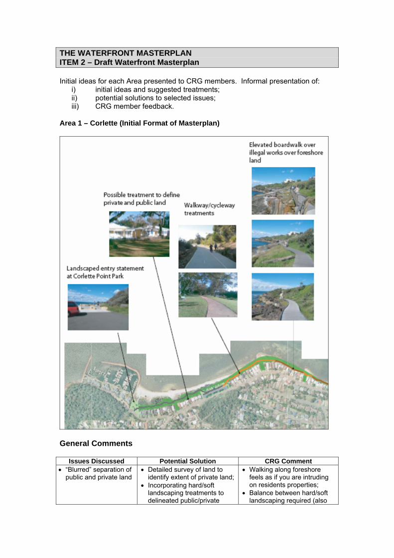
THE WATERFRONT MASTERPLAN ITEM 2 – Draft Waterfront Masterplan Initial ideas for each Area presented to CRG members. Informal presentation of:
i) initial ideas and suggested treatments; ii) potential solutions to selected issues; iii) CRG member feedback.
Area 1 – Corlette (Initial Format of Masterplan)
General Comments
Issues Discussed Potential Solution CRG Comment • “Blurred” separation of
public and private land • Detailed survey of land to
identify extent of private land; • Incorporating hard/soft
landscaping treatments to delineated public/private
• Walking along foreshore feels as if you are intruding on residents properties;
• Balance between hard/soft landscaping required (also

land; use of indigenous Vs exotic plantings;
• Landscaped area will have to be maintained by someone – at the moment, owners maintain these areas. If Council implements landscaping, owners will have to maintain it.
• Illegal works along public foreshore land (including boat ramps, steps, patios/verandas, etc.)
• Detailed survey of land to identify extent of private land;
• Council together with affected residents to determine course of action;
• Potential solution to construct raised boardwalk over illegal works
• Strong action against illegal works required.
• Informal pedestrian access on grassed foreshore.
• Detailed survey of land to identify extent of private land and public foreshore;
• Formalise pedestrian walkway with concrete (other material also possible) shared path.
• Path should be as far away as possible from existing dwellings.
• Path should comply with minimum RTA guidelines and Australian Standards
• Establishment of commercial opportunities along foreshore
• Corlette Point Park potential commercial node.
• Corlette Point Park has limited parking available to support a commercial activity.
• Conroy Park a better location, as parking is readily available
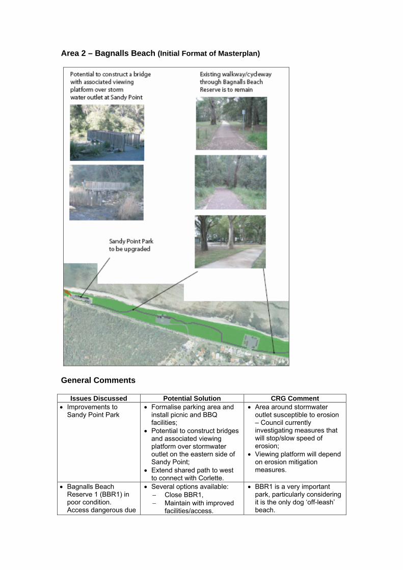
Area 2 – Bagnalls Beach (Initial Format of Masterplan)
General Comments
Issues Discussed Potential Solution CRG Comment • Improvements to
Sandy Point Park • Formalise parking area and
install picnic and BBQ facilities;
• Potential to construct bridges and associated viewing platform over stormwater outlet on the eastern side of Sandy Point;
• Extend shared path to west to connect with Corlette.
• Area around stormwater outlet susceptible to erosion – Council currently investigating measures that will stop/slow speed of erosion;
• Viewing platform will depend on erosion mitigation measures.
• Bagnalls Beach Reserve 1 (BBR1) in poor condition. Access dangerous due
• Several options available: − Close BBR1, − Maintain with improved
facilities/access.
• BBR1 is a very important park, particularly considering it is the only dog ‘off-leash’ beach.
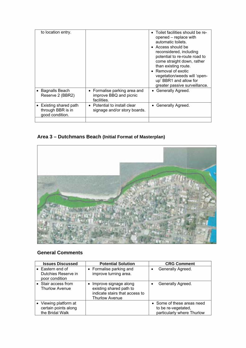
to location entry. • Toilet facilities should be re-opened – replace with automatic toilets.
• Access should be reconsidered, including potential to re-route road to come straight down, rather than existing route.
• Removal of exotic vegetation/weeds will ‘open-up’ BBR1 and allow for greater passive surveillance.
• Bagnalls Beach Reserve 2 (BBR2)
• Formalise parking area and improve BBQ and picnic facilities.
• Generally Agreed.
• Existing shared path through BBR is in good condition.
• Potential to install clear signage and/or story boards.
• Generally Agreed.
Area 3 – Dutchmans Beach (Initial Format of Masterplan)
General Comments
Issues Discussed Potential Solution CRG Comment • Eastern end of
Dutchies Reserve in poor condition
• Formalise parking and improve turning area.
• Generally Agreed.
• Stair access from Thurlow Avenue
• Improve signage along existing shared path to indicate stairs that access to Thurlow Avenue
• Generally Agreed.
• Viewing platform at certain points along the Bridal Walk
• Some of these areas need to be re-vegetated, particularly where Thurlow

Road residents have cleared areas beyond their property boundary
• Landscaping principles need to be established as part of the Masterplan
Area 4 – Nelson Bay (Initial Format of Masterplan)
General Comments
Issues Discussed Potential Solution CRG Comment • Improvement of
landscaping along Nelson Bay
• • More park area required – there is an old plan to reclaim part of d’Albora Marina. There is a potential

to create a similar treatment as Darling Harbour – stepped amphitheatre
• Path along Victoria Parade
• Path should be re-aligned to be along the road in order to separate pedestrians with static activities (i.e. stalls, picnics, etc)
• Closure of existing road through Fly Point Park to Little Bay.
• Pedestrian only access beyond parking area at Fly Point Park
• Close existing road through Fly Point Park and make pedestrian only access to Little Bay.
• Formalise parking area at Fly Point Park, [provide turn back area and formalise access to dive-spot (allow drop-off only)
• Potential to establish picnic areas and viewing platforms.
• Vehicle access should be maintained due to: − Potential for increased
traffic congestion at intersection of Victoria Parade / Shoal Bay Road.
− Difficulty of right out on to Shoal Bay Road.
− Use of buses to access Little Bay – scenic route.
• Separation between pedestrian and vehicle area should be formalised in order to make it safer.
Area 5 – Little Nelson Bay (Initial Format of Masterplan)
General Comments
Issues Discussed Potential Solution CRG Comment • Existing C’s
Café/Restaurant (boat slipway access)
• Improve parking area and access to café.
• C’s Café/Restaurant currently up for sale
• Pedestrian access Provide new shared path along • Path should be re-aligned to
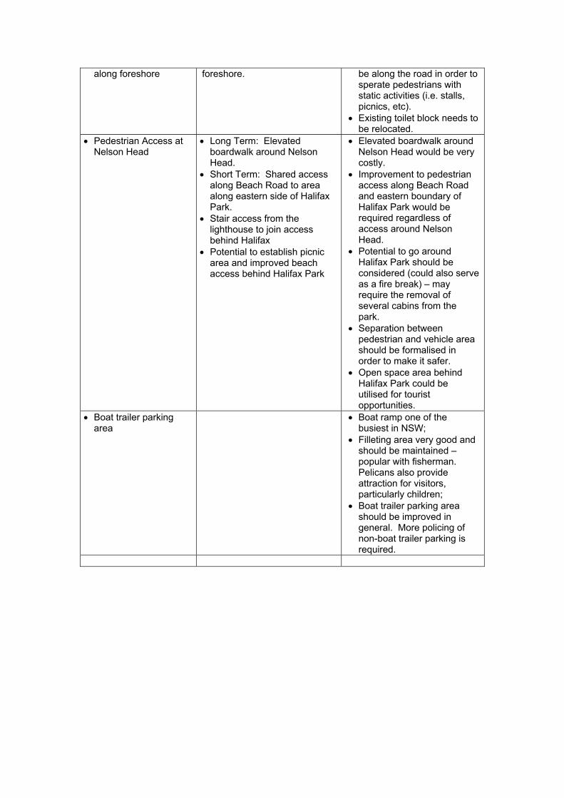
along foreshore foreshore. be along the road in order to sperate pedestrians with static activities (i.e. stalls, picnics, etc).
• Existing toilet block needs to be relocated.
• Pedestrian Access at Nelson Head
• Long Term: Elevated boardwalk around Nelson Head.
• Short Term: Shared access along Beach Road to area along eastern side of Halifax Park.
• Stair access from the lighthouse to join access behind Halifax
• Potential to establish picnic area and improved beach access behind Halifax Park
• Elevated boardwalk around Nelson Head would be very costly.
• Improvement to pedestrian access along Beach Road and eastern boundary of Halifax Park would be required regardless of access around Nelson Head.
• Potential to go around Halifax Park should be considered (could also serve as a fire break) – may require the removal of several cabins from the park.
• Separation between pedestrian and vehicle area should be formalised in order to make it safer.
• Open space area behind Halifax Park could be utilised for tourist opportunities.
• Boat trailer parking area
• Boat ramp one of the busiest in NSW;
• Filleting area very good and should be maintained – popular with fisherman. Pelicans also provide attraction for visitors, particularly children;
• Boat trailer parking area should be improved in general. More policing of non-boat trailer parking is required.
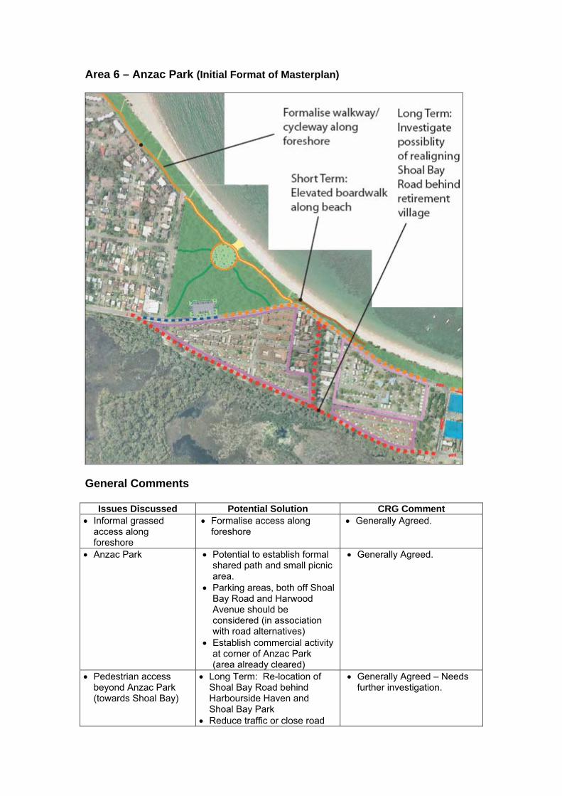
Area 6 – Anzac Park (Initial Format of Masterplan)
General Comments
Issues Discussed Potential Solution CRG Comment • Informal grassed
access along foreshore
• Formalise access along foreshore
• Generally Agreed.
• Anzac Park • Potential to establish formal shared path and small picnic area.
• Parking areas, both off Shoal Bay Road and Harwood Avenue should be considered (in association with road alternatives)
• Establish commercial activity at corner of Anzac Park (area already cleared)
• Generally Agreed.
• Pedestrian access beyond Anzac Park (towards Shoal Bay)
• Long Term: Re-location of Shoal Bay Road behind Harbourside Haven and Shoal Bay Park
• Reduce traffic or close road
• Generally Agreed – Needs further investigation.
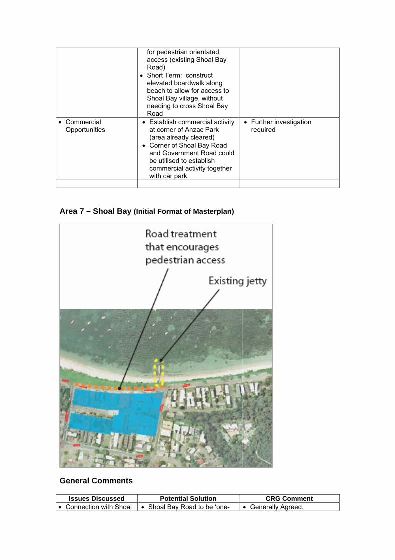
for pedestrian orientated access (existing Shoal Bay Road)
• Short Term: construct elevated boardwalk along beach to allow for access to Shoal Bay village, without needing to cross Shoal Bay Road
• Commercial Opportunities
• Establish commercial activity at corner of Anzac Park (area already cleared)
• Corner of Shoal Bay Road and Government Road could be utilised to establish commercial activity together with car park
• Further investigation required
Area 7 – Shoal Bay (Initial Format of Masterplan)
General Comments
Issues Discussed Potential Solution CRG Comment • Connection with Shoal • Shoal Bay Road to be ‘one- • Generally Agreed.

Bay Village and the foreshore
way’ between Government Road and Tomaree Road at shopping village. This will allow: − Widening of pedestrian
access along shopfronts − Slow vehicles to create
safer pedestrian access to foreshore
− Provide extension of commercial activities along foreshore
• Shared pathway along foreshore should generally be along roadway.
• Path could meander back and forth from the foreshore – in at points where there is beach access.
• Future of jetty • Two options need to be considered:
• Option 1 – demolish jetty • Option 2 – maintain and if
possible expand (potential for commercial activity)
• The jetty should be maintained
• Zoning of jetty to be investigated – could already be zoned for commercial purposes.
Area 8 – Tomaree Head (Initial Format of Masterplan) General Comments
Issues Discussed Potential Solution CRG Comment • Shoal Bay Road to
Tomaree Head • Formalise parking along
Shoal Bay Road – on the foreshore side − Potential to work with
National Parks and Wildlife Service (NPWS) to formalise parking on NPWS land along Shoal Bay Road.
• Improve boat ramp to allow for greater access – could alleviate boat traffic at Little Bay
• Generally Agreed. Further investigations and negotiations with NPWS required.
• Improvements to the boat ramp will have to be done in consultation with NSW Maritime Dept.
• Tomaree Head • Turning area and parking at the end of Shoal Bay Road (at Dept. of Heath land)
• Potential to establish commercial activity (café/kiosk type facility).
• May not be enough area to provide turning circle and parking.
• Shoal Bay Road should be made ‘one-way’ from boat ramp to Tomaree Head and use of existing access through Tomaree National Park to be used to exit area.
Switch back needs to be improved to allow safer access to road Access to vehicles with boat trailers and buses to be limited beyond boat ramp.
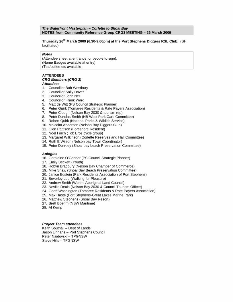
The Waterfront Masterplan – Corlette to Shoal Bay NOTES from Community Reference Group CRG3 MEETING – 26 March 2009 Thursday 26th March 2009 (6.30-9.00pm) at the Port Stephens Diggers RSL Club. (SH facilitated) Notes (Attendee sheet at entrance for people to sign), (Name Badges available at entry) (Tea/coffee etc available ATTENDEES CRG Members (CRG 3) Attendees 1. Councillor Bob Westbury 2. Councillor Sally Dover 3. Councillor John Nell 4. Councillor Frank Ward 5. Matt de Witt (PS Council Strategic Planner) 6. Peter Quirk (Tomaree Residents & Rate Payers Association) 7. Peter Clough (Nelson Bay 2030 & tourism rep) 8. Peter Dundas-Smith (NB West Park Care Committee) 9. Robert Quirk (National Parks & Wildlife Service) 10. Malcolm Anderson (Nelson Bay Diggers Club) 11. Glen Pattison (Foreshore Resident) 12. Noel Finch (Tob Eros cycle group) 13. Margaret Wilkinson (Corlette Reserves and Hall Committee) 14. Ruth E Wilson (Nelson bay Town Coordinator) 15. Peter Dunkley (Shoal bay beach Preservation Committee) Aplogies 16. Geraldine O’Conner (PS Council Strategic Planner) 17. Emily Beckett (Youth) 18. Robyn Bradbury (Nelson Bay Chamber of Commerce) 19. Mike Shaw (Shoal Bay Beach Preservation Committee) 20. Janice Edstein (Park Residents Association of Port Stephens) 21. Beverley Lee (Walking for Pleasure) 22. Andrew Smith (Worimi Aboriginal Land Council) 23. Neville Deuis (Nelson Bay 2030 & Council Tourism Officer) 24. Geoff Washington (Tomaree Residents & Rate Payers Association) 25. Max Haste (Port Stephens-Great Lakes Marine Park) 26. Matthew Stephens (Shoal Bay Resort) 27. Brett Boehm (NSW Maritime) 28. Al Kemp Project Team attendees Keith Southall – Dept of Lands Jason Linnane – Port Stephens Council Peter Naidovski – TPGNSW Steve Hills – TPGNSW
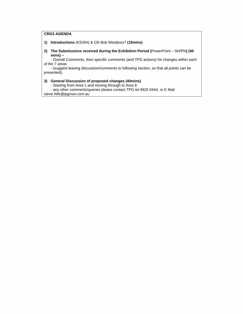
CRG3 AGENDA 1) Introductions (KS/SH) & Cllr Bob Westbury? (10mins) 2) The Submissions received during the Exhibition Period (PowerPoint – SH/PN) (40
mins) – - Overall Comments, then specific comments (and TPG actions) for changes within each
of the 7 areas - (suggest leaving discussion/comments to following section, so that all points can be
presented). 3) General Discussion of proposed changes (40mins)
- Starting from Area 1 and moving through to Area 8 - any other comments/queries please contact TPG tel 9925 0444, or E Mail
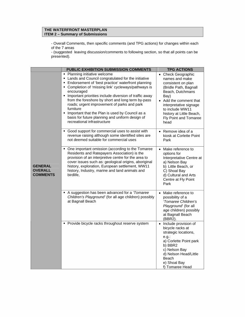
THE WATERFRONT MASTERPLAN ITEM 2 – Summary of Submissions
- Overall Comments, then specific comments (and TPG actions) for changes within each of the 7 areas - (suggested leaving discussion/comments to following section, so that all points can be presented).
PUBLIC EXHIBITION SUBMISSION COMMENTS TPG ACTIONS Planning initiative welcome Lands and Council congratulated for the initiative Endorsement of ‘best practice’ waterfront planning Completion of ‘missing link’ cycleways/pathways is
encouraged Important priorities include diversion of traffic away
from the foreshore by short and long term by-pass roads; urgent improvement of parks and park furniture
Important that the Plan is used by Council as a basis for future planning and uniform design of recreational infrastructure
• Check Geographic names and make consistent on plan (Bridle Path, Bagnall Beach, Dutchmans Bay)
• Add the comment that interpretative signage to include WW11 history at Little Beach, Fly Point and Tomaree head
Good support for commercial uses to assist with
revenue raising although some identified sites are not deemed suitable for commercial uses
• Remove idea of a kiosk at Corlette Point Park
One important omission (according to the Tomaree
Residents and Ratepayers Association) is the provision of an interpretive centre for the area to cover issues such as: geological origins, aboriginal history, exploration, European settlement, WW11 history, Industry, marine and land animals and birdlife,
• Make reference to options for Interpretative Centre at a) Nelson Bay b) Little Beach, or C) Shoal Bay d) Cultural and Arts Centre at Fly Point Park
A suggestion has been advanced for a ‘Tomaree
Children’s Playground’ (for all age children) possibly at Bagnall Beach
• Make reference to possibility of a ‘Tomaree Children’s Playground’ (for all age children) possibly at Bagnall Beach (BBR2).
GENERAL OVERALL COMMENTS
Provide bicycle racks throughout reserve system • Include provision of bicycle racks at strategic locations, e.g.: a) Corlette Point park b) BBR2 c) Nelson Bay d) Nelson Head/Little Beach e) Shoal Bay f) Tomaree Head
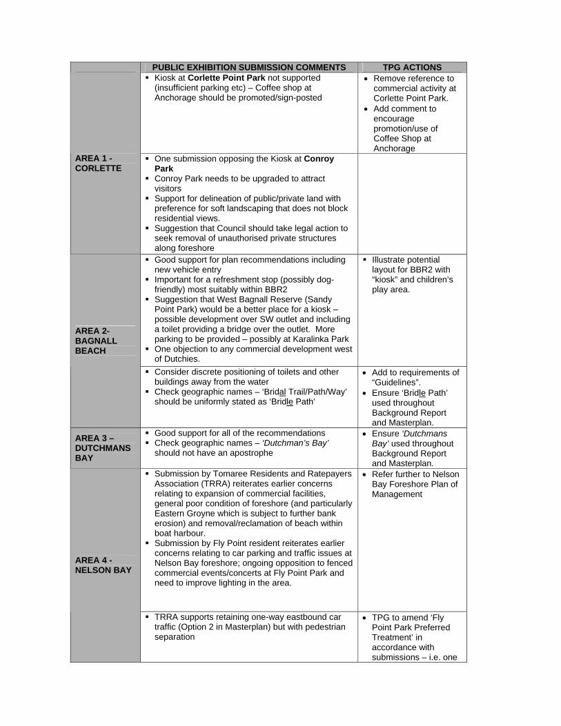
PUBLIC EXHIBITION SUBMISSION COMMENTS TPG ACTIONS Kiosk at Corlette Point Park not supported
(insufficient parking etc) – Coffee shop at Anchorage should be promoted/sign-posted
• Remove reference to commercial activity at Corlette Point Park.
• Add comment to encourage promotion/use of Coffee Shop at Anchorage
AREA 1 - CORLETTE
One submission opposing the Kiosk at Conroy Park
Conroy Park needs to be upgraded to attract visitors
Support for delineation of public/private land with preference for soft landscaping that does not block residential views.
Suggestion that Council should take legal action to seek removal of unauthorised private structures along foreshore
Good support for plan recommendations including new vehicle entry
Important for a refreshment stop (possibly dog-friendly) most suitably within BBR2
Suggestion that West Bagnall Reserve (Sandy Point Park) would be a better place for a kiosk – possible development over SW outlet and including a toilet providing a bridge over the outlet. More parking to be provided – possibly at Karalinka Park
One objection to any commercial development west of Dutchies.
Illustrate potential layout for BBR2 with “kiosk” and children’s play area.
AREA 2- BAGNALL BEACH
Consider discrete positioning of toilets and other buildings away from the water
Check geographic names – ‘Bridal Trail/Path/Way’ should be uniformly stated as ‘Bridle Path’
• Add to requirements of “Guidelines”.
• Ensure ‘Bridle Path’ used throughout Background Report and Masterplan.
AREA 3 – DUTCHMANS BAY
Good support for all of the recommendations Check geographic names – ‘Dutchman’s Bay’
should not have an apostrophe
• Ensure ‘Dutchmans Bay’ used throughout Background Report and Masterplan.
Submission by Tomaree Residents and Ratepayers Association (TRRA) reiterates earlier concerns relating to expansion of commercial facilities, general poor condition of foreshore (and particularly Eastern Groyne which is subject to further bank erosion) and removal/reclamation of beach within boat harbour.
Submission by Fly Point resident reiterates earlier concerns relating to car parking and traffic issues at Nelson Bay foreshore; ongoing opposition to fenced commercial events/concerts at Fly Point Park and need to improve lighting in the area.
• Refer further to Nelson Bay Foreshore Plan of Management
AREA 4 - NELSON BAY
TRRA supports retaining one-way eastbound car traffic (Option 2 in Masterplan) but with pedestrian separation
• TPG to amend ‘Fly Point Park Preferred Treatment’ in accordance with submissions – i.e. one
PUBLIC EXHIBITION SUBMISSION COMMENTS TPG ACTIONS way vehicular access
not to continue after parking and vehicle turning area, and replaced by delineated pedestrian/cycle area
Good support for the Plan’s recommendations
Existing Café’s (C’s and Lighthouse) need upgrading
• Add comment in Master Plan.
AREA 5 – LITTLE BEACH
Little Beach and Fly Point areas should include interpretative signage relating to WW11 histories
• To include the need to: “Investigate the potential to install Interpretative Signage for Little Beach and the Waterfront in general”
Good support for Plan’s recommendations New (southern) access point for Shoal Bay Rd may
present a problem for Harbourside residents
• Noted. To be assessed in proposed traffic study.
AREA 6 – ANZAC PARK
Removal of caravan park facilities needs to be balanced (cheap holiday accommodation at present time). However this site also presents a great opportunity for a high class resort (but with low profile design)
Any commercial development at Shoal Bay and Government Road intersection should be of a ‘stepped-back’ design and incorporate screen landscaping
Add “need for a stepped-back’ design and incorporate screen landscaping’ for any future commercial redevelopment.
AREA 7 – SHOAL BAY
Good support for plan’s recommendations Important that any development on Shoal bay jetty
does not impede views
Add the importance of avoiding adverse impact on views of any development on Shoal bay jetty.
AREA 8 – TOMAREE HEAD
Good support for plan recommendations Interpretative signage (WW11 history) is to be encouraged.
• To include the need to: “Investigate the potential to install ‘Interpretative Signage’ for Tomaree Head”.
No consideration of long term use of Tomaree Hospital site for major resort hotel?
• Add additional note to this effect.
GUIDELINES
Important to develop and adhere to guidelines covering paths, signage, landscaping etc
• Add additional note to this effect.
THE WATERFRONT MASTERPLAN ITEM 3 – General Discussion
- Starting from Area 1 and moving through to Area 7 - any other comments/queries please contact TPG tel 9925 0444, or E Mail [email protected]
Area 1 – Corlette
Area Issue Discussed CRG Comments Kiosk at Corlette Point Park
Kiosk not supported (insufficient parking
etc). Coffee shop at Anchorage should be utilised, however signage identifying the café should be installed.
Kiosk at Conroy Park
Conroy Park commercial activity objected to by one CRG member because of it location in relation to residents and adjacent cliff.
AREA 1 - CORLETTE
Public private land at the rear of properties along the Waterfront of Area 1
Support for delineation of public/private land with soft landscaping that does not block residential views.
Suggestion that Council should take legal action to seek removal of unauthorised private structures along foreshore.
Survey of Area 1 to be carried out ASAP. One option to resume land in Area 1 over a
longer period of time, so impact on residents is minimised.
Urgent action required on the impact of erosion in the area. However a cost benefit analysis is required to determine the cost effectiveness of any erosion measures, particularly in relation to the impacts of climate change.
Anchorage DA consent to be checked as there may be a condition of consent requiring them to carry out such work up to Sandy Point.
Area 2 – Bagnall Beach
Area Issue Discussed CRG Comments
AREA 2- BAGNALL BEACH
Access to BBR1 to remain CRG member commented that the access should remain as is. A new access would require vegetation removal and the nominated location is quite steep.
Opening of the area by removing some vegetation also not supported as the area has significant vegetation.
Also, the fact that the area is secluded gives it its strength.
Toilets at Sandy Point Park Toilets should be put at Sandy Point Park and the toilet at BBR1 to be removed.
Kiosk at Dutchmans Beach Dutchmans Beach used to have a kiosk
and should be consider as a place where a kiosk can be locate, rather than BBR2
A movable kiosk is a possibility, which can be utilised during peak periods and stored during off-peak. Potential for existing cafes to manage such operations.
All ages park BBR2 good location for all-ages park. Positive feedback in relation to establishing health and fitness related activities in BBR2.
Area 3 – Dutchmans Beach
Area Issue Discussed CRG Comments Boat activity in the area • Existing boat activity in the area is
dangerous and speeding boats/jet skies come very close to swimmers AREA 3 –
DUTCHMANS BAY Beach access • Beach access needs to be improved to
manage the impacts of erosion. Current access adding to erosion.
Area 4 – Nelson Bay
Area Issue Discussed CRG Comments Fly Point Park • No vehicle access through to Little Nelson
Bay preferred by CRG members • Access to the point where the road is
closed to vehicle access will have to be considered in detail, especially of a turn-around area is to be established – may not have enough room.
AREA 4 - NELSON BAY Parking at ‘old hospital’ • Consider the potential for bus and car
parking at the old hospital just outside Neil Carroll Park.
• Limits impacts on views, the need for vehicles to enter at Fly Point and traffic congestion.

Reclamation of Nelson Bay • Urgent action required on ‘beautifying’ the Nelson Bay foreshore.
• All options need to be considered. • ‘Circus’ activities on foreshore should be
prohibited after Easter – Council has not guaranteed the operators that they will be able to utilise the space beyond Easter.
Area 5 – Little Nelson Bay
Area Issue Discussed CRG Comments Good support for the Plan’s
recommendations
Existing Café’s (C’s and Lighthouse)
• Further efforts should be made to better ‘advertise’ the cafes..
AREA 5 – LITTLE BEACH Interpretative signage • Little Beach and Fly Point areas should
include interpretative signage relating to WW11 histories
Area 6 – Anzac Park
Area Issue Discussed CRG Comments Re-location of Shoal Bay Rd behind
retirement village Concern that relocation of the road would
impact on access of some residents with the recreational and other activities provided in the village.
If the village where redeveloped, impacts would be eliminated.
If viable, whole retirement village site should be redeveloped into a new village, catering for all retirees.
Retirement living Exploration of hi-end retirement living needed.
Retirement living (affordable or otherwise) allows for permanent residents that in turn support the local economy.
Shoal Bay Road at Anzac Road If Shoal Bay Road is relocated, there should be access to Anzac Park if a commercial/tourist activity is located on the corner
Anzac Park pinch point The Anzac Park pinch point has been identified as a sea level rise ‘hot spot’. Future use and management would require consideration.
AREA 6 – ANZAC PARK
War memorial in Anzac Park
Anzac park was formally used as a training ground for beach landings during WWII. The area is therefore ideal for some sort of interpretative signage or memorial.
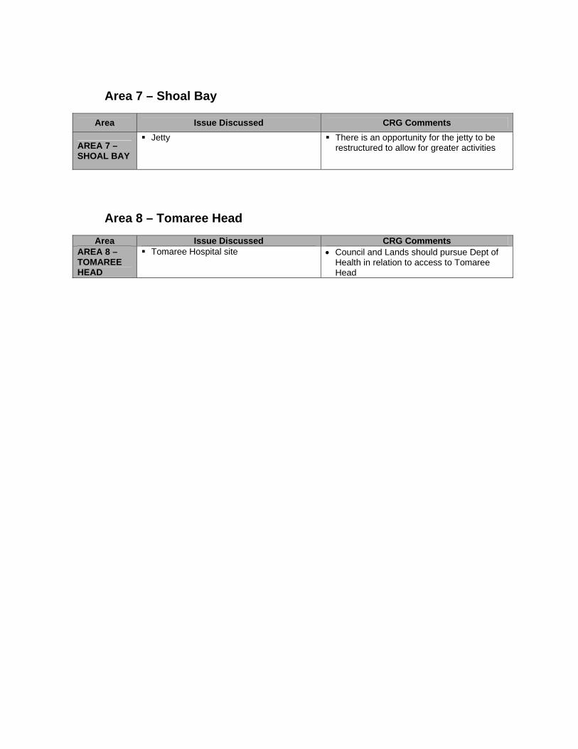
Area 7 – Shoal Bay
Area Issue Discussed CRG Comments
AREA 7 – SHOAL BAY
Jetty There is an opportunity for the jetty to be restructured to allow for greater activities
Area 8 – Tomaree Head
Area Issue Discussed CRG Comments AREA 8 – TOMAREE HEAD
Tomaree Hospital site • Council and Lands should pursue Dept of Health in relation to access to Tomaree Head