aerial lidar acquisition report
TRANSCRIPT
AERIAL LIDAR ACQUISITION REPORT
__________________
PRESTON COUNTY AND
NORTH BRANCH (POTOMAC)
LIDAR *.LAS1.2 DATA
COMPREHENSIVE AND BARE EARTH
WEST VIRGINIA
DEPARTMENT OF ENVIRONMENTAL PROTECTION
JUNE 2013
PREPARED BY:
WVU NATURAL RESOURCE ANALYSIS CENTER
2014 AGRICULTURAL SCIENCES
PO BOX 6108
MORGANTOWN, WV 26506-6108
TABLE OF CONTENTS
Section 1:………………………………………………………………………….Overview
Section 2:…………………………………………………..GPS Base Station Data
Section 3:………………………………….…….LiDAR Systems Specifications
SECTION 1: OVERVIEW
Project Name: Preston County/North Branch of Potomac Airborne
LiDAR
NRAC was contracted to perform an aerial acquisition survey of the pertinent mine
areas in and around Preston County and the North Branch of the Potomac for the
purpose of high-resolution (1-meter) airborne LiDAR to ultimately produce products
(digital elevation models, contours, flood and surface modeling, change detection,
permit boundaries, etc) for the public. The Preston/North Branch project was
collected between 28 Mar 2011 and 21 April 2011 and is composed of 1,374
working segments, covering 748,624 acres.
LiDAR data was collected by the Optech ALTM-3100 100k Hz Multi-pulse LiDAR
system mounted in a Piper Navajo PA-31. The ALTM-3100 collects up to four
returns per pulse, as well as backscatter reflectance (intensity) data. The aerial
LiDAR was collected at the following sensor specifications:
Post Spacing (Average): 3.3 ft / 1.0 meter Flying Height (Above Ground Level): 5,000-ft / 1,524 meters
Flying Height (Mean Sea Level): Varies with terrain Average Ground Speed: 135 knots (155 MPG) Scanner Pulse Rate Frequency: 70,000 Hz
Scanner Frequency / Field of View: 35 Hz / 36 degrees (18 half angle) Overlap (Average): 30%
Flight line acquisition was performed around weather, winds, GPS PDOP, vegetation
emergence conditions, and fuel, collecting data in as few missions as possible, as
close together as possible, to ensure consistency across the project area.
The data collected was flown back to the WVU NRAC office in Morgantown, WV,
extracted, viewed, and quality controlled such that immediate re-flights could be
performed if necessary.
NRAC’s aerial acquisition team coordinated with the necessary Air Traffic Control
and Restricted Airspace personnel prior to flying to ensure permissions.
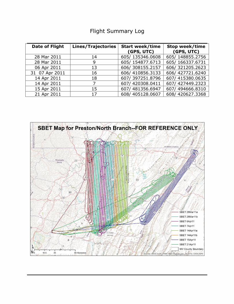
Flight Summary Log
Date of Flight Lines/Trajectories Start week/time
(GPS, UTC)
Stop week/time
(GPS, UTC)
28 Mar 2011 14 605/ 135346.0608 605/ 148855.2756
28 Mar 2011 9 605/ 154877.6713 605/ 166337.6731
06 Apr 2011 13 606/ 308155.2157 606/ 321205.2623
31 07 Apr 2011 16 606/ 410856.3133 606/ 427721.6240
14 Apr 2011 18 607/ 397251.8796 607/ 415380.0635
14 Apr 2011 7 607/ 420308.0411 607/ 427449.2323
15 Apr 2011 15 607/ 481356.6947 607/ 494666.8310
21 Apr 2011 17 608/ 405128.0607 608/ 420627.3368
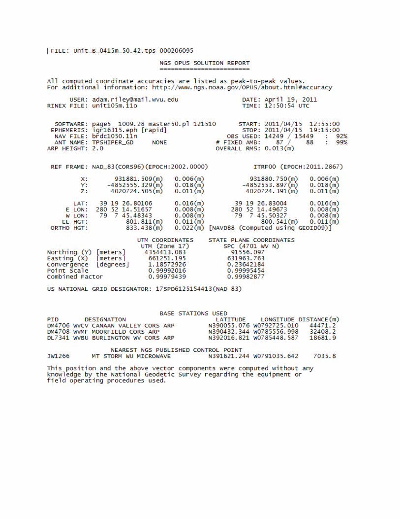
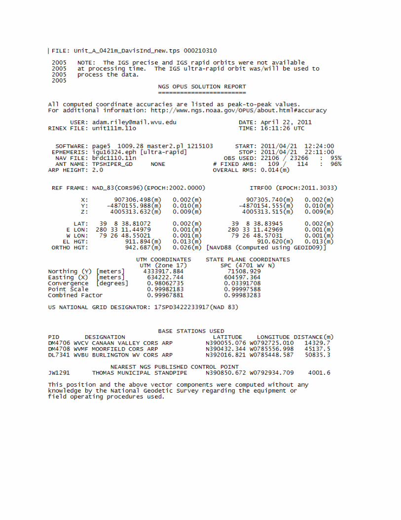
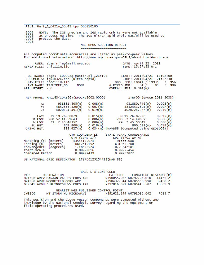
SECTION 2: GPS BASE STATION DATA
Ground GPS data is collected via two TOPCON HiPER GD dual-frequency, 12-
channel geodetic quality receivers. Locations occupied for collection are either
registered National Geodetic Survey (NGS) control monuments, or created Online
Positioning User’s Service (NGS OPUS) control points.
NRAC determines appropriate locations for GPS base station collections and only
operates equipment/occupies site with appropriate permissions. Locations are
determined based off baseline length from rover (aircraft) to base stations, site
assessments (view of sky, obstructions [masks], and multipath sources), along with
permissions/access.
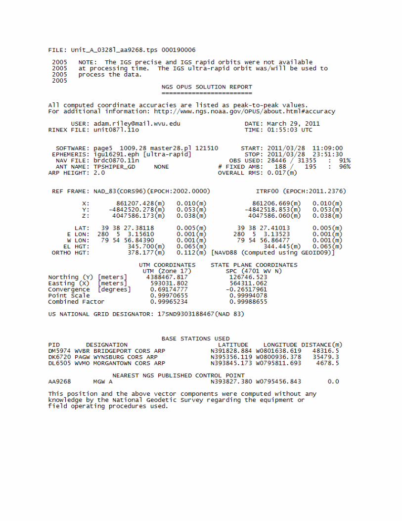
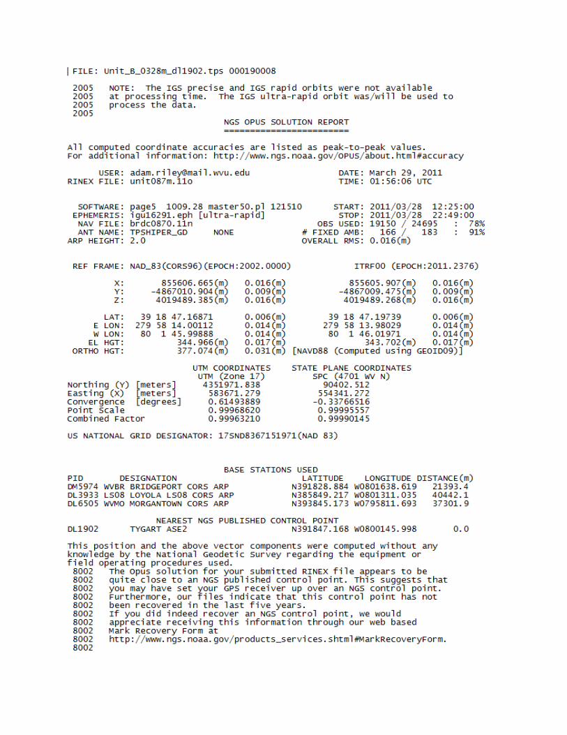
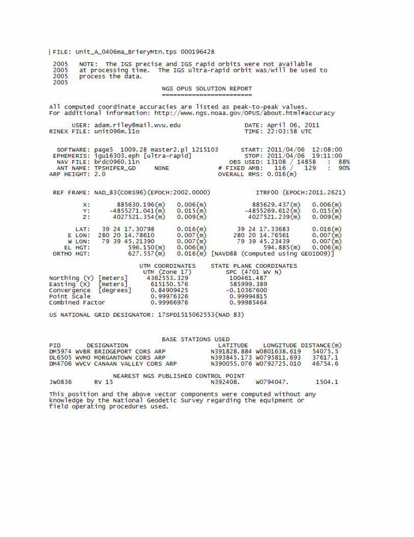
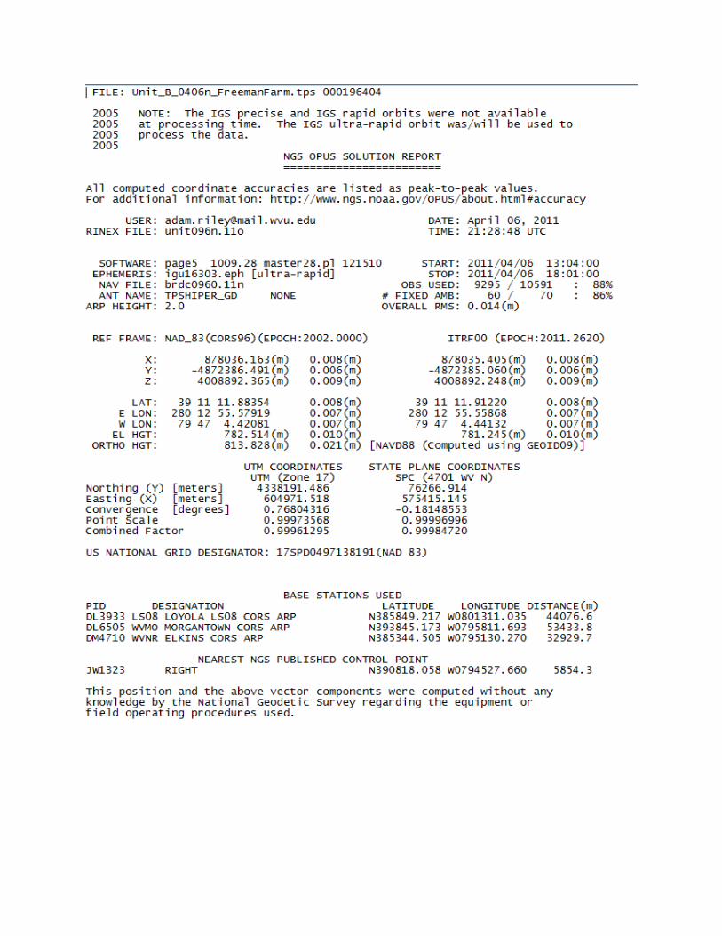
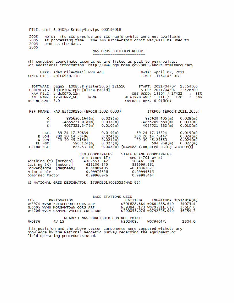
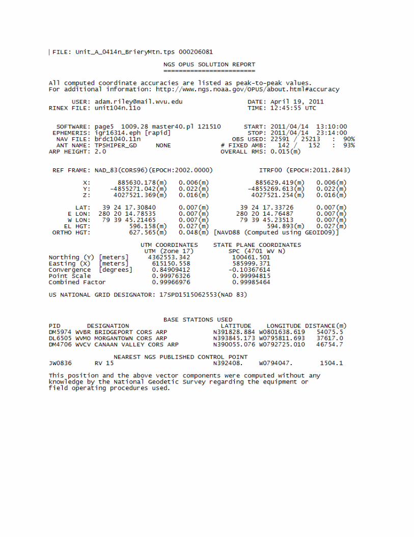
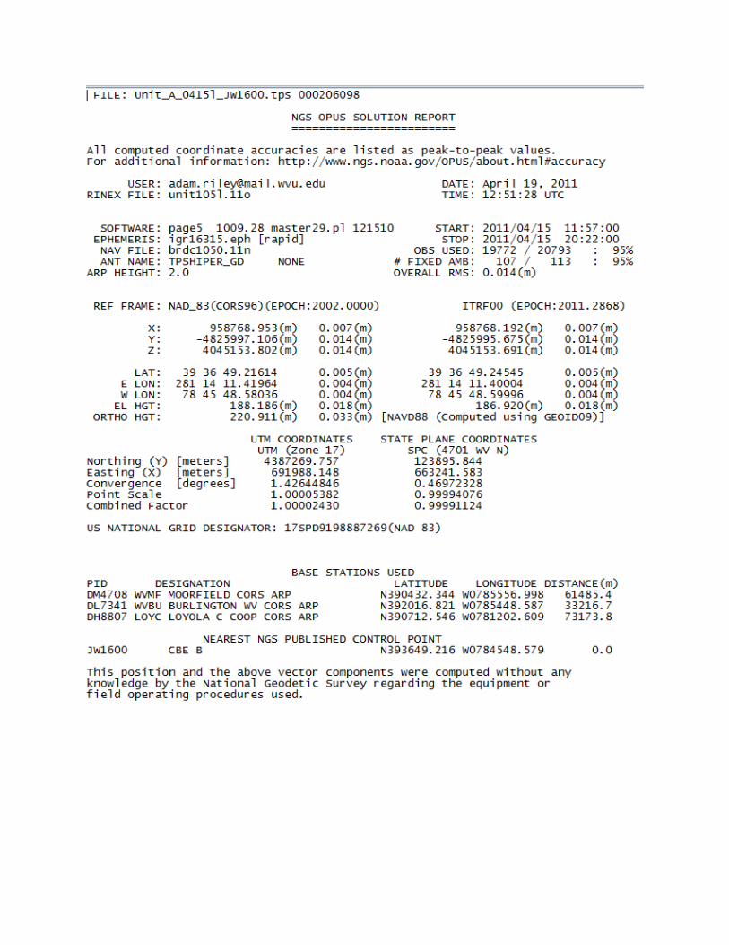
Base stations locations for the Preston and North Branch project area are detailed
with the following NGS OPUS Datasheets (dates are referenced in file name):
NOTE: NGS monuments are described by their PID (AA9258, DL1902, etc)

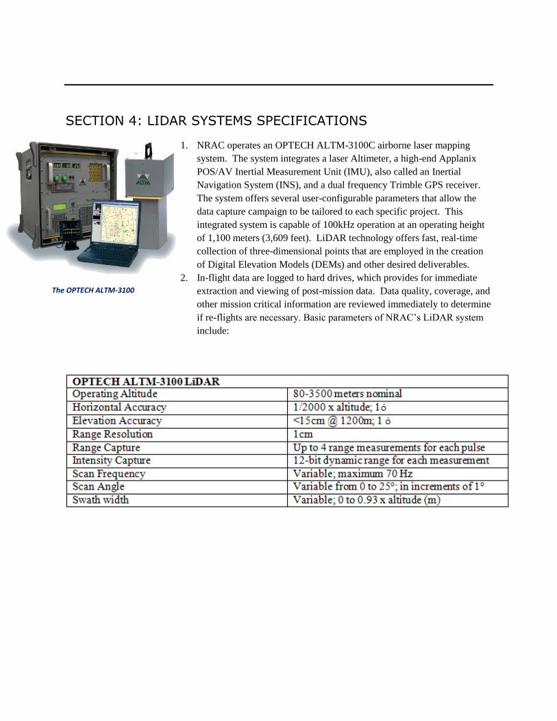
SECTION 4: LIDAR SYSTEMS SPECIFICATIONS
1. NRAC operates an OPTECH ALTM-3100C airborne laser mapping
system. The system integrates a laser Altimeter, a high-end Applanix
POS/AV Inertial Measurement Unit (IMU), also called an Inertial
Navigation System (INS), and a dual frequency Trimble GPS receiver.
The system offers several user-configurable parameters that allow the
data capture campaign to be tailored to each specific project. This
integrated system is capable of 100kHz operation at an operating height
of 1,100 meters (3,609 feet). LiDAR technology offers fast, real-time
collection of three-dimensional points that are employed in the creation
of Digital Elevation Models (DEMs) and other desired deliverables.
2. In-flight data are logged to hard drives, which provides for immediate
extraction and viewing of post-mission data. Data quality, coverage, and
other mission critical information are reviewed immediately to determine
if re-flights are necessary. Basic parameters of NRAC’s LiDAR system
include:
The OPTECH ALTM-3100