alberta transportation...alberta transportation mobile rwis pilot report december 2016 | 9 should...
TRANSCRIPT

Alberta Transportation
Winter 2015-2016 December, 2016

Alberta Transportation Mobile RWIS Pilot Report December 2016 | 2
Table of Contents
Introduction ................................................................................................................................... 3
Pilot goals ................................................................................................................................................... 3
Mobile RWIS Technology ............................................................................................................. 4
Equipment Description ............................................................................................................................... 4
MARWIS-UMB Observations ..................................................................................................................... 5
Connected Vehicle vs. Mobile RWIS Technology ...................................................................................... 6
Mobile RWIS Pilot Description ...................................................................................................... 7
Weather Conditions During MARWIS-UMB Pilot ........................................................................ 10
Mobile RWIS Observations vs. Static RWIS Observations ...................................................................... 11
Using Mobile Weather Observations and Existing RWIS ............................................................ 14
Data Collection for New Roadway Types .................................................................................... 18
Winter Maintenance Operation Value ......................................................................................... 20
Case Study: Highway 541 on March 2, 2016 ........................................................................................... 20
Perspective from AT District Maintenance Engineer ............................................................................... 21
Additional Feedback and Lessons Learned ................................................................................ 22
MARWIS-UMB Observation Location ...................................................................................................... 22
MARWIS-UMB Battery Considerations .................................................................................................... 22
MARWIS-UMB Calibration ....................................................................................................................... 22
Future Uses of Mobile Observations ........................................................................................... 23
Summary and Conclusions ......................................................................................................... 25
MARWIS-UMB Pilot Project Contacts ......................................................................................... 27
Appendix A ................................................................................................................................. 28
Alberta Transportation Mobile RWIS Pilot Report December 2016 | 3
Introduction
Alberta Transportation (AT) has installed an extensive network of over 100 Road Weather Information
Stations (RWIS) throughout the province. AT’s Maintenance Decision Support System (MDSS)
utilizes observations from RWIS to provide treatment recommendations for individual plow routes.
Locations further away from RWIS observations rely on assumed road conditions to provide treatment
recommendations.
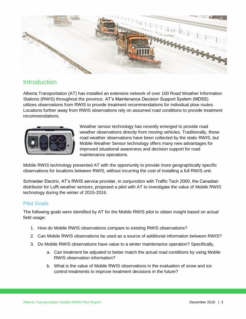
Weather sensor technology has recently emerged to provide road
weather observations directly from moving vehicles. Traditionally, these
road weather observations have been collected by the static RWIS, but
Mobile Weather Sensor technology offers many new advantages for
improved situational awareness and decision support for road
maintenance operations.
Mobile RWIS technology presented AT with the opportunity to provide more geographically specific
observations for locations between RWIS, without incurring the cost of installing a full RWIS unit.
Schneider Electric, AT’s RWIS service provider, in conjunction with Traffic Tech 2000, the Canadian
distributor for Lufft weather sensors, proposed a pilot with AT to investigate the value of Mobile RWIS
technology during the winter of 2015-2016.
Pilot Goals
The following goals were identified by AT for the Mobile RWIS pilot to obtain insight based on actual
field usage:
1. How do Mobile RWIS observations compare to existing RWIS observations?
2. Can Mobile RWIS observations be used as a source of additional information between RWIS?
3. Do Mobile RWIS observations have value to a winter maintenance operation? Specifically,
a. Can treatment be adjusted to better match the actual road conditions by using Mobile
RWIS observation information?
b. What is the value of Mobile RWIS observations in the evaluation of snow and ice
control treatments to improve treatment decisions in the future?

Alberta Transportation Mobile RWIS Pilot Report December 2016 | 4
Mobile RWIS Technology
Mobile RWIS technology generally has the following characteristics:
A downward-facing sensor installed on specific road
maintenance vehicles collects direct measurements of the
pavement condition, pavement temperature, presence of
chemicals, friction, etc. of the roadway.
Targeted observations are collected in locations where road
condition information is specifically required for making
operational decisions.
Data collection is controlled directly by the road maintenance
agency:
o Weather observations can be taken before, during and after
a storm.
o Information can be gathered at all times of day through both
day and night patrols.
o Installed sensors on road maintenance vehicles ensures
coverage of primary and secondary roads.
Equipment Description
The Mobile RWIS technology chosen for the AT pilot was the Mobile Advanced RWIS (MARWIS-
UMB) device from Lufft, Inc. This device utilizes infrared measuring via four emitting and two receiving
diodes that capture the reflecting behavior of the road surface at varying wave lengths. Due to the
different spectral properties of various substances — e.g. water and ice — the road state can be
deduced from the captured values. MARWIS-UMB delivers values for road temperature, dew point
temperature, relative humidity at road temperature, water film height, road state, ice percentage and
friction.
As ice particles increase on the road surface, the friction coefficient delivered by MARWIS-UMB falls,
providing valuable information for the treatment decision-making process.
Due to the open interface protocols, MARWIS-UMB can be easily integrated into existing winter
maintenance monitoring networks. Similarly, MARWIS-UMB can communicate directly with the control
system of plow vehicles.
MARWIS-UMB sensors have been tested by Lufft for accuracy up to speeds of 85 kilometers per
hour, so vehicles traveling in normal traffic are able to obtain accurate road observations.
Detailed information on the MARWIS-UMB technology, including range of operation parameters, is
available in the MARWIS-UMB User Manual located in Appendix A or http://www.lufft-
marwis.de/en_US/features.

Alberta Transportation Mobile RWIS Pilot Report December 2016 | 5
MARWIS-UMB Observations
The MARWIS-UMB device utilized in the AT pilot collected the following information:
Road surface temperature
The road surface temperature is measured with a non-invasive pyrometer which is fully integrated into
the sensor.
Dew point temperature
The dew point temperature is the temperature where the current partial water vapor pressure equals
the saturated vapor pressure, indicating condensation, e.g., in the form of fog.
Relative humidity at road temperature
The calculation of the relative humidity at road temperature is based on the absolute humidity and the
road temperature. It can be used as an indicator for impending formation of dew or frost.
Water film height
The water film height on the road surface is measured with non-invasive optical spectroscopy. The
water film height indicates the proportion of liquid water on the roadway.
Road condition
The road condition is determined from the measurement of water film height, road surface
temperature and ice percentage. The sensor deduces the road conditions of dry, damp, wet, snow /
ice as well as critical and chemical wetness. The values which are supposed to be used in the
calculation of the road condition can be set, e.g., highest, lowest or average road temperature of the
last covered road section. For this purpose, predefined settings are available for selection.
Ice percentage
With the data from the optical spectroscopy, the frozen part of the aqueous solution on the road is
determined and delivered as ice percentage.
Friction
Friction describes the adhesion of tires on the road surface. This can be reduced due to ambient
conditions such as rain or snow. The value of the friction is scaled between 0.1 and 1.0. High values
indicate high adhesion, low values stand for low adhesion. The highest value (1.0) will be achieved
when the road is dry whereas the lowest result (0.1) represents water on ice.
Note: The grip of a road is determined basically by the consistency of its surface. The friction
value of the MARWIS-UMB indicates to which degree the maximum possible grip of a specific
road is reached, respectively how much it has been reduced by ambient conditions. Therefore,
identical friction values of the MARWIS-UMB on different road surfaces mean different grip.

Alberta Transportation Mobile RWIS Pilot Report December 2016 | 6
Connected Vehicle vs. Mobile RWIS Technology
Connected Vehicle is a broad term describing a range of technology which allows vehicles to connect
with other vehicles and to connect to nearby infrastructure for the purposes of sharing information to
support safety and mobility. Connected Vehicle technology collects information from standard sensors
commonly installed on the majority of vehicles traveling within the transportation network. The
following characteristics generally apply when Connected Vehicle data is used to support winter road
maintenance decisions:
Pavement and weather conditions are inferred rather than directly measured, using
observations from ABS, wipers, headlights, etc.
A large number of public vehicles provide observations, so data must be verified and
aggregated.
Availability of data depends on driver behavior:
o Most vehicles drive primarily in “good” (dry) weather.
o The majority of trips occur during the day.
o Most frequent routes of travel are focused on major routes, leaving less travelled areas
without data.
Alberta Transportation is investigating both Mobile RWIS and Connected Vehicle technologies to
understand the potential for both types of observations to improve the safety and efficiency of the
provincial transportation network.

Alberta Transportation Mobile RWIS Pilot Report December 2016 | 7
Mobile RWIS Pilot Description
Alberta Transportation utilizes contracted highway
maintenance services throughout the province. Volker
Stevin is the Highway Maintenance Contractor (HMC) in
southern Alberta, which includes Calgary.
Volker Stevin routinely patrols the roads between October
15 and April 15 of each year as part of their winter road
maintenance contract. During the daytime, primary roads
(single or double digit highways) are inspected five to
seven days a week, depending on weather conditions.
Secondary roads (triple digit highways) are inspected at
least three times per week during the day. During the night,
selected primary roads are checked seven days a week.
Road inspections are performed as needed outside of the
October 15 and April 15 season.
Since routine road patrols were already being performed
by Volker Stevin, patrol vehicles provided an ideal platform
to install Mobile RWIS. MARWIS-UMB weather sensors
were installed on two Volker Stevin patrol vehicles during
the summer of 2015 and were utilized throughout the
winter of 2015-2016. Schneider Electric’s primary contract
at Volker Stevin for this pilot was Carl Bodkin
Alberta Transportation Highway
Maintenance Contractors (HMCs)
MARWIS-UMB installed on Volker Stevin night patrol vehicle

Alberta Transportation Mobile RWIS Pilot Report December 2016 | 8
Components on each truck included a MARWIS-UMB sensor, mounting bracket and an in-cab tablet
with a cellular data plan. MARWIS-UMB data was geo-referenced using the tablet’s GPS and
distributed through a data cloud. This data was stored in a database hosted by Lufft and made
available for display in near real-time within Alberta Transportation’s WeatherSentry Online® Platinum
Pavement Forecast Edition (WeatherSentry) application from Schneider Electric.
The tablet installed in the cab of the patrol vehicle displayed real-time data from the MARWIS-UMB
sensor directly to the driver.
MARWIS-UMB installed on Volker Stevin day patrol vehicle
In-cab tablet displaying MARWIS-UMB observations

Alberta Transportation Mobile RWIS Pilot Report December 2016 | 9
Should the cell connection experience a low quality signal or break down entirely, the iPad® stores the
collected observations and uploads them when connection has been re-established.
This same data was displayed in WeatherSentry, showing both the latest vehicle position,
observations from each MARWIS-UMB, and a three-hour history of weather observations for further
analysis.
A diagram of the overall MARWIS-UMB data flow is provided below.
Real-time and historical MARWIS-UMB observations displayed in WeatherSentry
MARWIS-UMB data flow diagram

Alberta Transportation Mobile RWIS Pilot Report December 2016 | 10
Weather Conditions During MARWIS-UMB Pilot
During the 2015-2016 winter season, Alberta’s winter was warmer and drier than average, particularly
in southern Alberta where the MARWIS-UMB were being utilized by Volker Stevin. This pattern
resulted in limited opportunities to test the sensors during full winter precipitation events. However,
significant information was collected during this pilot to address the project goals.
Alberta winter 2015/16 recap (Nov/Mar)

Alberta Transportation Mobile RWIS Pilot Report December 2016 | 11
Mobile RWIS Observations vs. Static RWIS Observations
Alberta Transportation has deployed over 100 RWIS stations
throughout the province to collect accurate, timely data to provide
intelligence on current road weather conditions. The breadth and
scope of Alberta’s RWIS installation makes it one of the largest
RWIS networks in North America.
A comparison of MARWIS-UMB observations to existing static
RWIS observations was performed during the winter of 2015-16. As
a patrol vehicle passed by a static RWIS, MARWIS-UMB weather
observations were compared with the RWIS observations.
During the pilot, the two Volker Stevin patrol vehicles typically
travelled in and around Calgary. MARWIS-UMB to RWIS
comparisons were made along Highway 2 south of Calgary at the
OKOTOKS RWIS and east-west through Calgary along Highway 1
at the STONEY TRAIL RWIS. Volker Stevin also purchased a hand-
held road temperature gauge as an additional data measurement
tool. Volker Stevin consistently collected road temperatures via
MARWIS-UMB that were within 1-2 degrees Celsius of the static
RWIS road temperature observations throughout the winter.
Comparisons of MARWIS-UMB vs. RWIS road temperatures
utilizing WeatherSentry showed similar consistencies. An example
is shown in the following WeatherSentry screen shot:
Alberta Transportation’s static
RWIS network
Comparison of MARWIS-UMB (upper left) and RWIS (background) observations on March 22, 2016

Alberta Transportation Mobile RWIS Pilot Report December 2016 | 12
While it may seem logical to expect an embedded pavement sensor (RWIS) and a remote pavement
sensor (MARWIS-UMB) to produce exactly the same pavement temperature readings, due to the
differences in how each sensor takes measurements, some differences can and should be expected.
A memo produced by micKS (http://micks.de/en/) on this subject identified the following potential
differences between embedded and remote pavement temperature observations:
1. A +/- 1C difference between embedded and remote surface temperatures has been measured
in optimal and stable conditions.
2. Embedded surface temperatures change more slowly than remote temperatures.
3. Differences in incoming or outgoing solar radiation can result in differences of +/- 3C.
4. Data sampling frequency differences should be considered when comparing temperatures;
gradients of +/- 2C per minute are possible.
A qualitative comparison was performed between the pavement condition reported by MARWIS-UMB
and camera images taken by RWIS. Overall, there was good agreement between the pavement
condition as judged by the RWIS camera image and the pavement condition that was measured by
the MARWIS-UMB. One such example is shown below, where MARWIS-UMB observations indicate a
wet/chemically wet road condition, which is supported by the RWIS camera image:
Comparison of RWIS camera and MARWIS-UMB pavement condition

Alberta Transportation Mobile RWIS Pilot Report December 2016 | 13
Volker Stevin also produced ad-hoc camera images during the pilot to document road conditions, but
mostly during timeframes where MARWIS-UMB observations did not match the actual road
conditions. These instances were utilized to calibrate the MARWIS-UMB sensors. Future Mobile
RWIS implementations would benefit from images collected by installed dashboard cameras to
capture regular images with the purpose of corroborating mobile observations with actual road
conditions.
The following example shows MARWIS-UMB readings which require further calibration, due to the
fact that the pavement condition of DRY from the MARWIS-UMB does not agree with the conditions
being observed out the windshield.
In-cab MARWIS-UMB display (reading DRY) in obviously wet conditions

Alberta Transportation Mobile RWIS Pilot Report December 2016 | 14
Using Mobile Weather Observations and Existing RWIS
MARWIS-UMB readings were not only taken in and around existing RWIS during the winter of 2015-
16, but wherever Volker Stevin patrol vehicles travelled. In doing so, several valuable characteristics
of mobile observations were identified as part of this trial, such as providing insight for locations
between RWIS, providing additional observation parameters beyond what is currently available from
RWIS, covering additional geographies and capturing spatial variations.
In the example below, the start and end points of the MARWIS-UMB pavement condition observations
agreed well with the DRY pavement condition readings coming from the RWIS network around
Calgary. But as the MARWIS-UMB travelled along Highway 40 from south to north, variations in
pavement condition were observed, showing icy conditions (pink and purple) during the first half of the
trip, turning to wet conditions (green) during the second half of the trip. This demonstrated that while
the RWIS observations were accurate for the locations they represent, spatial variations do exist in-
between RWIS that can be identified by MARWIS-UMB.
MARWIS-UMB observations between two RWIS locations:
Colorized breadcrumb trail depicts pavement condition of Highway 40.

Alberta Transportation Mobile RWIS Pilot Report December 2016 | 15
Another example showed ICE WARNINGs observed by the RWIS network in Calgary, with the
MARWIS-UMB travelling along Highway 2 showing icy conditions (pink dots). The MARWIS-UMB also
showed several stretches of dry conditions (brown dots) along Highway 2, demonstrating again that
spatial variations can and do exist between RWIS and can be identified by MARWIS-UMB.
MARWIS-UMB provided measurements of the spatial variations in pavement temperature that winter
maintenance organizations knew existed between RWIS. One such example is show below, where
patrol vehicles equipped with MARWIS-UMB drove a section of Highway 68 with elevation gain and
loss as well as variations in sun/shade. Over a relatively small distance of less than 15 kilometers, the
pavement temperature dropped from 2C to -8C as the MARWIS-UMB travelled from east to west.
These spatial variations in pavement temperature can have an impact on chemical effectiveness and
treatment strategies during winter precipitation events.
MARWIS-UMB observations between RWIS sites:
Colorized breadcrumb trail depicts pavement condition of Highway 2.

Alberta Transportation Mobile RWIS Pilot Report December 2016 | 16
MARWIS-UMB also provided additional parameters beyond what was available from the RWIS
network. Examples of these additional parameters include ice percentage and friction, shown in the
examples below. Ice percent shows promise to more specifically identify smaller sections of pavement
where icy conditions may be occurring, allowing a more targeted response by the HMC. Friction
provides a summarized green-yellow-red indication of where pavement conditions are deteriorating
and accidents may be more likely to occur.
MARWIS-UMB pavement temperature variations on Highway 68
MARWIS-UMB ice percentage observations

Alberta Transportation Mobile RWIS Pilot Report December 2016 | 17
MARWIS-UMB friction observations overlaid on Environment Canada radar

Alberta Transportation Mobile RWIS Pilot Report December 2016 | 18
Data Collection for New Roadway Types
MARWIS-UMB also provided weather observations in sections of roadway that may not have had any
information available in previous winters. These included secondary highways, on/off ramps,
overpasses and in-town roads. Examples of MARWIS-UMB readings taken in these locations are
shown below.
MARWIS-UMB observations for in-town roads
MARWIS-UMB observations for secondary roads

Alberta Transportation Mobile RWIS Pilot Report December 2016 | 19
MARWIS-UMB observations for on/off ramps and overpasses

Alberta Transportation Mobile RWIS Pilot Report December 2016 | 20
Winter Maintenance Operation Value
Volker Stevin identified labor scheduling and material costs as major factors to consider in their winter
maintenance decision-making to meet Level of Service requirements in the most cost efficient
manner. Labor decisions must also be based on maximum timeframes under which employees may
work, coupled with the requirement to call in spare operators at any time of the night or day.
Chemicals for treating roadways are often over-estimated to ensure that the entire roadway can be
treated, even if the conditions are not consistent throughout the plow route.
Case Study: Highway 541 on March 2, 2016
On March 2, 2016, MARWIS-UMB technology was utilized by Volker Stevin decision-makers to utilize
their labor and material resources more effectively and efficiently:
Because there is spotty cell service along Highway 541, the typical procedure for patrol
vehicles was to make the 30-minute drive, then phone in the results of the patrol when the
truck was back in cellular range. If problem areas were identified anywhere along Highway 541
after the patrol route was travelled, typically two plow trucks and 24 tons of material were
dispatched to treat the roadway.
On March 2, 2016, a patrol vehicle with a MARWIS-UMB patrolled Highway 541. The
MARWIS-UMB data was routinely updating in WeatherSentry, since data transmission can be
accomplished through a weaker cell signal that a cell phone call requires. A supervisor back at
the garage immediately saw the weather observations from the patrol vehicle. The supervisor
also saw that weather observations from MARWIS-UMB showed that only a portion of
Highway 541 contained problem areas. This information allowed the supervisor to immediately
dispatch resources to deal with these problem areas, rather than waiting until the patrol vehicle
finished the route. The supervisor decided to dispatch one plow truck with 12 tons of material,
since the MARWIS-UMB observations showed that the entire stretch of roadway was not
affected. The second plow that would have typically been dispatched to Highway 541 could
then be assigned to address a different road with the other 12 tons of material.
What typically occurs (before mobile observations)
What actually occurs (with mobile observations)
Pickup checking hwy-541 (spotty cell service)
Drives route for 30 minutes, assessing
problem areas
Contacts supervisor and dispatches two
plow trucks with 24 tons of material
Pickup checking hwy-541 (spotty cell service)
Supervisor sees problem area back at the
garage as pickup drives
Immediately dispatches one plow truck
with 12 tons of material to problem area
Other plow can attend to a different road

Alberta Transportation Mobile RWIS Pilot Report December 2016 | 21
By utilizing the various aspects of MARWIS-UMB as described in this document, Volker Stevin
summarized the technology as a “key decision-making tool” during the 2015-16 winter season.
Perspective from AT District Maintenance Engineer
Dave Gray, P.Eng., is Alberta Transportation’s Maintenance Innovations Engineer, responsible for the
Edson District where the MARWIS-UMB pilot was conducted. Dave stated that MARWIS-UMB
observations utilized in this pilot successfully contributed to better treatment decisions for specific
road conditions. He also said that they provided AT with data to analyze treatment decisions and how
they could be improved in the future. However, the mild winter did not provide many opportunities to
work with a fully representative set of storms, so he felt additional testing would be warranted.
In the future, Dave would like to see MARWIS-UMB observations collected in more remote locations,
such as those far from existing RWIS. Mobile observations would also be valuable within known
microclimates, to understand weather conditions that may not be occurring in surrounding areas.

Alberta Transportation Mobile RWIS Pilot Report December 2016 | 22
Additional Feedback and Lessons Learned
In utilizing MARWIS-UMB during the winter of 2015-2016, Volker Stevin provided additional feedback
regarding the installation, configuration and data characteristics. The following items should be
considered when deploying MARWIS-UMB for road maintenance operations decision-making.
MARWIS-UMB Observation Location
Agencies should be cognizant of where the MARWIS-UMB is pointing when it is installed. Volker
Stevin originally installed the MARWIS-UMB on the roof of the vehicle and pointed it at the centerline
of the roadway. The readings from MARWIS-UMB installed in this fashion were found not to be
representative of the actual road conditions, as typically the centerline represented worse road
conditions than the rest of the roadway.
MARWIS-UMB Battery Considerations
Volker Stevin also pointed out that it was necessary to remember to unplug the MARWIS-UMB if the
patrol vehicle was not moving for long periods of time. Keeping the MARWIS-UMB plugged in to a
stationary vehicle drained the truck battery after about one day.
MARWIS-UMB Calibration
Common feedback from Volker Stevin was the necessity to properly set up and configure the
MARWIS-UMB before using the data for decision-making. MARWIS-UMB contains a variety of
settings to affect the readings coming from the sensor. These calibrations take some time and effort to
get settled and an agency should not expect this to be “plug and play”.
The overall conclusion is that once calibrated, MARWIS-UMB provided good in-storm data, but that
storm “fringes” (before and after a storm) requires the time and effort to properly calibrate the sensor.
Volker Stevin also noted that the MARWIS-UMB sensed very small amounts of moisture and
chemicals, which was difficult to confirm just by driving down the road.
MARWIS-UMB settings screen

Alberta Transportation Mobile RWIS Pilot Report December 2016 | 23
Future Uses of Mobile Observations
Mobile observations could be utilized as input into pavement models to produce a more spatially
granular pavement forecast in the geographies where mobile observations are taken. As mobile
observations are taken throughout a winter season, the pavement forecast would routinely be
modified based on this information, allowing small scale changes in treatment and response to be
made to keep the road free of snow and ice. The example below shows MARWIS-UMB data in the
lower-left part of the screenshot laid over the top of a route-based pavement forecast.
Cameras mounted within the vehicle containing a Mobile RWIS could add significant value to the
overall data collected by providing a picture of current road as well as weather conditions. Volker
Stevin took pictures to document anomalies during the pilot, however an integrated camera image
taken at specific intervals could be displayed against the mobile observations to provide additional
context.
Patrol vehicles are routinely deployed before, during and after a storm. As these patrol vehicles
visually assess the effectiveness of the applied treatments after a storm, a mobile weather sensor
could provide quantitative metrics to use in this performance measurement process. Variables such
as friction could be used to support performance measurement across highway maintenance
contractors.
MARWIS-UMB observations (lower left) on top of route-based pavement forecast

Alberta Transportation Mobile RWIS Pilot Report December 2016 | 24
MARWIS-UMB-equipped vehicle (right) “following” a plow truck
(captured by RWIS camera on left)

Alberta Transportation Mobile RWIS Pilot Report December 2016 | 25
Summary and Conclusions
The following conclusions were made during Alberta Transportation’s Mobile RWIS pilot during the
winter of 2015-2016:
1. Mobile RWIS observations compared well with existing RWIS observations
MARWIS-UMB was more sensitive to moisture and chemical presence than RWIS. Users should be aware of temporal and spatial gradients when comparing MARWIS-UMB to
RWIS temperatures. MARWIS-UMB observation target siting considerations are required (i.e., wheel tracks,
shoulder, centerline, etc.).
2. Mobile RWIS provided additional information between RWIS observations
MARWIS-UMB provided additional parameters beyond what was available from RWIS, such
as friction and ice percentage. MARWIS-UMB provided weather observations over areas that may not have had
observations, such as on/off ramps, overpasses, secondary highways and in-town roads. MARWIS-UMB provided good in-storm data but storm “fringes” took time and effort to properly
calibrate the sensor.
3. Mobile RWIS add value to a winter maintenance operation
Volker Stevin called it a “key decision-making tool”. Alberta Transportation gained confidence in the value of mobile sensor technology to assist in
making better treatment decisions. MARWIS-UMB technology allows agencies to control their own destiny in weather intelligence
gathering, including observations taken at night, during a storm and over sections of roadway
where observations are specifically required (ramps, overpasses, etc.). Observations are immediately communicated, providing valuable information directly to
decision makers. Cost savings can be realized through a more targeted road treatment plan, leading to labor
and resource savings realized by both the highway maintenance contractor and the
government.
Alberta Transportation Mobile RWIS Pilot Report December 2016 | 26
4. Future use of Mobile RWIS
Due to the mild winter, there were limited opportunities to test the Mobile RWIS under
disruptive winter road conditions.
Additional testing is warranted based on initial results.
Mobile RWIS data has the potential to influence both pavement forecasts and MDSS
treatment recommendations to provide more accurate, location-specific guidance to road
maintenance operations.
Mobile RWIS data has the potential to provide performance measurement and verification of
treatment strategies, particularly when the mobile sensors are utilized on a larger number of
patrol vehicles.
Camera images collected in conjunction with Mobile RWIS observations would greatly
enhance the situational analysis capabilities of the road conditions.
The data collected by Mobile RWIS has the potential to be utilized and displayed in additional
ways that were not explored in the AT pilot.
Future use of Mobile RWIS within AT present the opportunity to define best practices.
Alberta Transportation Mobile RWIS Pilot Report December 2016 | 27
MARWIS-UMB Pilot Project Contacts
Alberta Transportation
Beata Bielkiewicz, P. Eng.
ITS Engineer
(780) 415-4877
Dave Gray, P. Eng.
Maintenance Innovation Engineer
(780) 723-8516
Volker Stevin
Carl Bodkin
Highway Maintenance Contractor
403-312-9271
Schneider Electric
Jeremy Duensing
Transportation Product Manager
(952) 882-4554
Lufft/Traffic Tech 2000
Sam Aebi
Managing Director
(514) 497-9139

Alberta Transportation Mobile RWIS Pilot Report December 2016 | 28
Appendix A
Please click on document above to access