barossa prescribed water resources area 2009
TRANSCRIPT

WATER ALLOCATION PLANBarossa Prescribed Water Resources Area
2009

October 2007
Consultation DocumentThis document has been prepared by the Adelaide and Mount Lofty Ranges Natural Resources Management Board for the purposes of consultation and is not State government policy.
CopyrightThis work is copyright. Apart from any use permitted under the Copyright Act 1968 (Cwlth), no part may be reproduced by any process without prior written permission from the Adelaide and Mount Lofty Ranges Natural Resources Management Board. Requests and enquiries concerning reproduction and rights should be directed to the Director, Policy and Planning, Adelaide and Mount Lofty Ranges Natural Resources Management Board, 205 Greenhill Road Eastwood SA 5063.
DisclaimerThe Adelaide and Mount Lofty Ranges Natural Resources Management Board and the Government of South Australia, their employees and their servants do not warrant or make any representation regarding the use or results of use of the information contained herein as to its correctness, accuracy, currency or otherwise. The Adelaide and Mount Lofty Ranges Natural Resources Management Board and the Government of South Australia, their employees and their servants expressly disclaim all liability or responsibility to any person using the information or advice contained herein.
March 2009


TABLE OF CONTENTS
III
Table of Contents 1 Introduction ................................................................................................................... 1
1.1 Water Resources of the Barossa Valley............................................................... 1
1.2 The Barossa Prescribed Water Resources Area.................................................. 1
2 Needs of Water Dependent Ecosystems.................................................................... 3
2.1 The Environmental Flows Project......................................................................... 3
2.2 Barossa Prescribed Water Resources Area Surface Water Budget .................... 7
2.3 Summary of Impacts........................................................................................... 11
2.4 Water Quantity Requirements of Ecosystems.................................................... 12
3 Effects on Other Water Resources ........................................................................... 16
3.1 Trends in Underground Water ............................................................................ 19
3.2 Potential Impacts of Climate Change ................................................................. 24
4 Capacity of the Resource to Meet Demands............................................................ 25
4.1 Background of water allocation and use in the Barossa Prescribed Area ......... 25
4.2 Current Allocations ............................................................................................. 26
4.3 Future Demand................................................................................................... 28
4.4 Capacity to meet Demand .................................................................................. 29
5 Water Allocation Criteria............................................................................................ 32
5.1 General Principles .............................................................................................. 32
5.2 Conversion of Area Based Allocations to Volumetric Allocations....................... 33
5.3 Allocation of Underground Water ....................................................................... 35
5.4 Allocation of Watercourse and Surface Water Resources ................................. 36
5.5 Allocation of Water Drained or Discharged to a Well ......................................... 38
6 Transfer Criteria .......................................................................................................... 40

BAROSSA WATER ALLOCATION PLAN
IV
6.1 General Transfer Criteria .................................................................................... 40
6.2 Transfer of Underground Water Allocations ....................................................... 41
6.3 Transfer of Watercourse and Surface Water Allocations ................................... 41
6.4 Transfer of Allocation to Recover Water Drained or Discharged to a Well ........ 42
7 Permits for Water Affecting Activities ...................................................................... 44
7.1 General ............................................................................................................... 44
7.2 Water Storage and Diversions (Dams)............................................................... 45
7.3 Use of Imported Water and Effluent ................................................................... 50
7.4 Draining or Discharging Water into a Well (Artificial Recharge)......................... 51
7.5 Well Construction................................................................................................ 55
8 Monitoring ................................................................................................................... 58
8.1 Regional Monitoring............................................................................................ 58
8.2 Property Level Monitoring................................................................................... 59
9 Glossary of Terms ...................................................................................................... 60

TABLE OF CONTENTS
V
Tables
Table 1: Current total dam storage in the Barossa........................................................................ 8
Table 2: Indicators of Impact on Environmental Flows................................................................ 10
Table 3 - Summary of Flow Impacts by Zone (within the Prescribed Area) ................................ 11
Table 4: Ecological flow requirements for the Pool in Flaxman Reach ....................................... 12
Table 5: Ecological Flow Requirements for the Transition Reach............................................... 13
Table 6: Ecological Requirements for the Incised Reach............................................................ 13
Table 7: Allocation and Use by Aquifer ....................................................................................... 17
Table 8: Volume based Surface water Allocations in the Prescribed Area ................................. 26
Table 9: Area based Surface water Allocations in the Prescribed Area...................................... 26
Table 10: Volume based Watercourse Allocations in the Prescribed Area................................. 27
Table 11: Area based Watercourse Allocations in the Prescribed Area ..................................... 27
Table 12: Current Volume based Underground water Allocations in the Prescribed Area ......... 27
Table 13: Current Area based Underground Water Allocations in the Prescribed Area ............. 28
Table 14: Authorisations in Greenock Creek............................................................................... 28
Table 15: Irrigation Crop Conversion Rates ................................................................................ 35
Table 16 - Sub catchment Capacity Limits .................................................................................. 46
Table 17 - Rainfall and Run-off for the Prescribed Area ............................................................. 46
Figures
Figure 1 Location Plan................................................................................................................... 2
Figure 2 Gawler River Process Zones within the Barossa ............................................................ 5
Figure 3 The Hydrologic Cycle ...................................................................................................... 8
Figure 4 Permanent Pools in the Barossa................................................................................... 14
Figure 5 Stream Order in the Barossa Prescribed Water Resources Area................................. 15
Figure 6 Diagrammatic Representation of Underground Water Systems in the Barossa........... 18
Figure 7 Underground Water Salinity (2005/06) in the Fractured Rock Aquifers........................ 22
Figure 8 Underground Water Salinity (2005/06) in the Sedimentary Aquifers ............................ 23
Figure 9 Surface and Watercourse Water Management Zones.................................................. 43
Figure 10 Sub Catchments for Dam Development...................................................................... 47
Figure 11 Rainfall in the Barossa ................................................................................................ 48


INTRODUCTION
1
1 Introduction
This document is the water allocation plan for the Barossa Prescribed Water Resources Area (the “Prescribed Area”), pursuant to Chapter 4, Part 2, Division 2 of the Natural Resources Management Act 2004. This water allocation plan replaces the Water Allocation Plan for the Barossa Prescribed Water Resources Area dated December 2000.
1.1 Water Resources of the Barossa Valley
Within the Prescribed Area a wide number of water sources are used to support the irrigation industry. The prescribed water resources include underground water, surface water, and water pumped from watercourses. In addition the region is supported through the use of imported water delivered via the Barossa Infrastructure Limited (BIL) scheme, the use of SA Water Mains off peak supply and SA Water Mains peak supply. In addition some irrigators hold River Murray Licences, which are delivered through SA Water infrastructure. A number of irrigators in the Barossa would use one or more of these various water sources on their properties.
1.2 The Barossa Prescribed Water Resources Area
The Prescribed Area is centred approximately 60 km north-east of Adelaide (Figure 1). The prescribed water resources include underground water, watercourses and surface water.
The underground water resources of the Barossa Valley floor were first prescribed on 1 July 1989. On the 14 May 1992, the Governor of South Australia declared that the North Para River and its tributaries, within the area bounded by the bold broken line in GRO Plan No. 327/1992 (“the defined area”), are proclaimed watercourses pursuant to Section 33 (1) and (2) of the Water Resources Act 1990 (now administered under the Natural Resources Management Act 2004). The proclamation also applied to existing wells and any future wells to be drilled within the defined area.
On the 17 December 1998, the surface waters within the defined area were proclaimed by the Governor of South Australia pursuant to Section 8 of the Water Resources Act 1997 (now administered under the Natural Resources Management Act 2004).
On the 19 May 2005, the Governor of South Australia declared that all watercourses and surface water in the Greenock Creek catchment area, as delineated on GRO Plan No. 128/2004, are prescribed as part of the Barossa Prescribed Water Resources Area, pursuant to Section 8(1) of the Water Resources Act 1997 (now administered under the Natural Resources Management Act 2004).

BAROSSA WATER ALLOCATION PLAN
2
Figure 1 Location Plan

NEEDS OF WATER DEPENDENT ECOSYSTEMS
3
2 Needs of Water Dependent Ecosystems
Water dependent ecosystems are made up of an array of interlinking components, which rely on each other for survival, as well as enough good quality water for their survival. These ecosystems have a complex dependence on water availability and flow. Not only is the total volume of water these systems receive important for their survival, but also how and when that water is delivered.
The natural flow pattern seen in rivers, streams and wetlands is made up of a number of basic components:
Magnitude – volume of water Frequency – number of times particular flow occurs Duration – how long specific flow events last Timing – when flows occur Rate of change of hydrological condition – how quickly things change
A number of studies have been undertaken that have provided an understanding of the needs of water dependent ecosystems in the Prescribed Area. Two important studies that have contributed to the development of polices to manage farm dams (see Section 7.2) are:
Determination of Environmental Water Requirements for the Gawler River System; and
The Barossa Prescribed Water Resources Area Surface Water Budget.
Key aspects of these studies are presented in the following sections.
2.1 The Environmental Flows Project
In 1999 a study was undertaken to determine the environmental water requirements of the Gawler River. This study included the North Para River in the Barossa.
The Gawler River system, like many Australian rivers and streams, is naturally very variable. Natural flow conditions would have varied from no flow to large flooding events.
The biological composition of ecosystems is determined by the permanent or temporary presence of standing or flowing water. Therefore the type of ecosystem present in a river is dependent on the natural flow regime of that river.
The purpose of the environmental flows project was to determine the environmental water requirements of the Gawler River.

BAROSSA WATER ALLOCATION PLAN
4
Environmental water requirements can be defined as the water regime (volume, timing, frequency) that is required to support ecological processes and maintain the biodiversity of water dependent ecosystems. Flow bands are used as a method to describe environmental water requirements.
A number of factors were considered when determining the environmental flow requirements for the Gawler River system. These included; river habitat types, geomorphology (or landforms), macroinvertebrates, fish species and vegetation.
In order to more clearly define the environmental water requirements of the system, the Gawler River was divided into seven zones based on geomorphology (see Figure 2 for zones in the Barossa and immediately downstream). For each zone the environmental water requirements were determined for a range of flow bands (see below).
Of those seven sections, three are in the Barossa. More information on those zones, and the zone immediately downstream of the prescribed area, is presented in the following sections.
What are flow bands?
Flow bands have been used as the basis for defining the environmental flow requirements for the Gawler River. A required flow regime is defined for each flow band. The following flow bands have been used in this study.
No flow conditions: During long dry summers, the Gawler River system would naturally stop flowing, resulting in a number of isolated pools along the system. These pools form an important summer refuge for many species of aquatic plants and animals.
Low flow or base flow conditions: During dry seasons these low flows (also known as freshets) may last between a few days and several weeks. These flows are ecologically important for a number of reasons:
improved water quality in isolated pools stranded over summer; pool connection to allow for migration of certain species; may trigger breeding events; can replenish underground water supplies or soil moisture for riparian plants; and can release organic material to provide resources.
Medium flow conditions: These higher level flows, with associated higher energy levels, have the ability to move sediment and organic matter down the river system. Such flows are important for channel and habitat maintenance. For example, these flows can remove fine sediment from between gravels, which reinvigorates microhabitats. These flow bands are also useful in controlling the proliferation of aquatic macrophytes such as Typha sp. and Phragmites australis.
High flow conditions: High flow conditions provide water for floodplain vegetation, can flush out pollutants and dilute salinity, and can help to maintain geomorphic processes such as the movement and re-deposition of sediment throughout the system.

NEEDS OF WATER DEPENDENT ECOSYSTEMS
5
Figure 2 Gawler River Process Zones within the Barossa
Flow Bands in the Barossa
Zone 5 – Incised Zone (North Para River between the junction of Lyndoch Creek and Nuriootpa)
This zone has a relatively intact canopy of river red gums but a highly modified understorey. The zone is characterised by a highly degraded channel, typically gully-like with very little

BAROSSA WATER ALLOCATION PLAN
6
in-channel structure and steep banks. In-stream processes are greatly reduced because of the degraded state of this zone.
The zone consists of pools separated by short channel constrictions. These constrictions are generally associated with major bedrock bars or localised sediment deposits.
Reduced flows and increased nutrients have seen the increased growth of introduced plants within the river channel and riparian zone. Riparian vegetation is badly degraded and needs rehabilitation to restore in-stream and bank habitat.
Tanunda Creek, a tributary of this zone, contains the water mite, Austrotrombella sp nov. This species has very limited distribution and was only found in one ephemeral pool in the Kaiser Stuhl Conservation Park on Tanunda Creek. Jacob’s Creek, another tributary of this zone, contains the larvae from the genus of caddisfly called Orphninotrichia. It is considered the distribution of this species in South Australia is limited to the Fleurieu Peninsula.
The major flow issue for this zone is the reduced variety of flow bands to support a variety of ecosystems.
Zone 6 – Transition Zone (North Para River between Nuriootpa and Light Pass)
This is a high energy zone, characterised by a series of small floodplains (probably of different ages) inset into remnant high level terraces. This zone is likely to be a sediment source zone. This is suggested by the terrace formations and active lowering of the bed of the modern channel.
Major changes to this zone since settlement include the construction of levees to protect vineyards from flooding. This has severed many channel-floodplain connections, for example the input of organic material from the floodplain to the stream environment. The levees may also be reducing the rate of natural aquifer recharge in the area.
This zone has highly modified vegetation. Although there are a number of river red gums (Eucalyptus camaldulensis) that still exist, the original understorey vegetation is virtually non-existent. Introduced plants include dog rose (Rosa canina), fennel (Foeniculum vulgare), wild oats (Avena sp.) and ash (Fraxinus rotundifolia).
Ecological processes have been disrupted due to the highly altered nature of this zone. The levee banks have isolated the stream from the surrounding floodplain and have simplified the channel complexity. Some sections of good pool-riffle habitat remain.
The major flow issue for this zone is the lack of linkage between the channel and the floodplain.
Zone 7 – Pool Zone (North Para River in the Flaxman Valley)
This zone contains a few good pool-riffle-run habitats but also a substantial amount of degraded habitat, which is generally the result of impacts from stock access to watercourses and the construction of dams (either on or off stream).
Riparian vegetation varies through this zone. A continuous cover of river red gums remains, with some elements of understorey vegetation. Understorey species include kangaroo thorn (Acacia paradoxa), river bottle brush (Callistemon sieberi), dog rose (Rosa canina) (exotic

NEEDS OF WATER DEPENDENT ECOSYSTEMS
7
species) and mixed pasture grasses. Macrophytes include club-rush (Isolepis sp), rush (Juncus sp) and bulrush (Typha sp).
The major flow issue for this zone is dams and storages on the main channel, which reduce flow within the channel, and if on-stream, provides a barrier to fish movement and fragments channel habitats.
Zone 4 – Mobile Zone (North Para River between the town of Gawler and the junction with Lyndoch Creek)
This zone is immediately downstream of the Prescribed Area.
The zone is characterised by relatively mobile bed sediment, large sediment storage areas within the channel, and an active channel. The zone contains well-developed inset floodplain features such as benches and small point bar systems.
Condition of the riparian zone varies through this zone. There is still generally continuous cover of river red gums through the zone with the understory vegetation being modified to a range of mixed pasture grasses. Macrophytes are common in the stream channel. Species include common reed (Phragmites australis), bulrush (Typha sp), sharp-leaf club-rush (Schoenoplectus pungens), and spiny flat-sedge (Cyperus gymnocaulos).
The key species in this zone are the snail, Thiara balannensis (which has a restricted distribution, was collected on the North Para River at Willaston, but has never been consistently collected from any sites), and water pennies (Sclerocyphon fuscus), both of which are considered to be worthy of conservation.
Key issues for this zone are protecting underground water fed hyporheic habitat, maintaining the pool-riffle sequences, and maintaining the riparian condition through riparian flows.
2.2 Barossa Prescribed Water Resources Area Surface Water Budget
A catchment water balance model was developed to help understand water movement through the catchment. The model recreated the hydrological cycle in the Barossa. Local information on rainfall, topography and soil types was used to estimate water runoff on a sub-catchment basis. A general diagram of the hydrological cycle is presented in Figure 3.

BAROSSA WATER ALLOCATION PLAN
8
Figure 3 The Hydrologic Cycle
The model was calibrated by comparing estimated runoffs to available rainfall and measured flows at gauging stations.
The model was constructed to simulate the current level of dam development within the Barossa. The information on dams was based on aerial photography.
The model is able to be “run” both with the dams, and under “natural” conditions (i.e. without the dams). This allows the model to be used to estimate how flows have changed as a result of dams, and what level of impact this has had on the environmental water requirements.
The model is based on the current level of dam development (as at March 2005) in the Barossa (Table 1). The information on dam development has also been assessed against the environmental flow requirements to determine the level of impact of dams for different flow bands. This has taken account of the differing use patterns associated with irrigation and stock and domestic dams. The impacts (based on modelled results) are summarised in Table 2.
Table 1: Current total dam storage in the Barossa
Percentage of Total Dam Volume Sub-catchment
Irrigation Dams Stock or Domestic Dams
Total Dam Volume (ML)
Greenock 90 % 10 % 1,050
Tanunda 85 % 15 % 650
Jacobs 80 % 20 % 844
Duckponds 0 % 100 % 295
Lyndoch 45 % 55 % 688
Angaston 30 % 70 % 106
Valley Floor (including Light) 44 % 56 % 2,099

NEEDS OF WATER DEPENDENT ECOSYSTEMS
9
Upper Flaxman 66 % 34 % 1,858
Lower Flaxman 28 % 72 % 1,135
Total 8,725
Note that percentage figures have been rounded

BAROSSA WATER ALLOCATION PLAN
10
Table 2: Indicators of Impact on Environmental Flows
LEVEL OF IMACT FOR VARIOUS FLOW BANDS
Sub-catchment and zone
Base flow Pool
Connection Flow
Bank Full Flow
Over Bank Flow
Spell duration High High None None Upper Flaxman Valley (Pool Zone) Frequency/ seasonality Very High Very High Low Low
Spell duration Very High Moderate None None Lower Flaxman Valley (Pool Zone) Frequency/ seasonality Very High Very High Moderate Low
Spell duration Very High Moderate None None Lower Flaxman Valley (Transition Zone) Frequency/ seasonality Very High Very High Moderate Low
Spell duration High Low None Moderate Tanunda Creek (Incised Zone) Frequency/ seasonality Very High High Low Moderate
Spell duration Low Low None None Jacob Creek (Incised Zone) Frequency/ seasonality Low Low Low Low
Spell duration Moderate High Moderate None Yaldara (Incised Zone) Frequency/ seasonality Moderate Very High High None
Definition of level of impact: The level of impact is defined by the difference between the flows in the river, when the model is run with the current level of dam development and compared to a run with no dams (what would have been the natural condition). None 0% Low 1-10% Moderate 11-30% High 31-50% Very High 50%+ Source: Barossa Prescribed Area Surface Water Budget
Definition of terms: Spell Duration: Provides an indication of the impact for the length of time over which a flow band has been met. Frequency/ seasonality: Indicates how the frequency or season of meeting the required flow band has changed

NEEDS OF WATER DEPENDENT ECOSYSTEMS
11
2.3 Summary of Impacts
Table 3 summarises the major changes in flow as a result of dam development in the Barossa, and is based on information from both the Gawler River Environmental Flows Report and the Barossa Prescribed Area Surface Water Budget.
Table 3 - Summary of Flow Impacts by Zone (within the Prescribed Area)
Zone Key Flow Issues
Zone 5 – Incised Zone North Para River between Lyndoch Creek and Nuriootpa
Reduced variety of flow bands to support a variety of ecosystems. North Para River at Yaldara gauging station shows high impacts (duration) and very high (seasonality) for pool connection flows. Tanunda Creek shows high (duration) and very high (seasonality) impacts for base flows, and high (seasonality) impacts for pool connection flows.
Zone 6 – Transition Zone North Para River between Nuriootpa and Light Pass
Lack of links between the channel and the floodplain. North Para River in the lower Flaxman Valley shows very high impacts (duration and seasonality) for base flows, and very high impacts (seasonality) for pool connection flows.
Zone 7 – Pool Zone North Para River in the Flaxman Valley
The major flow issue for this zone is dams and storages on the main channel, which reduce flow within the channel, and if on-stream, provides a barrier to fish movement and fragments channel habitats. The upper Flaxman Valley shows high (duration) and very high (seasonality) impacts on both base flow and pool connection flows. The lower Flaxman Valley shows very high (duration and seasonality) impacts on base flows, and very high (seasonality) impacts on pool connection flows.
Source – Gawler River Environmental Flows Report and Barossa Prescribed Area Surface Water Budget
What does this mean?
The majority of impacts in all three zones relate to the base flows and pool connection flows, particularly at Yaldara (which is influenced by most of the Barossa area – see Figure 2). Changes in the duration of base flow and pool connection flows, and changes in the seasonality of base flow and pool connection flows (generally a delay by 1-2 months for the onset of flows) can have the following impacts:
Declining water quality in pools, as no additional flows to improve quality; May limit migration of some species between pools; May not trigger breeding events for some species (e.g. some fish species); May result in reduced water to recharge underground water; May result in reduced water through the soil profile to support riparian vegetation.
How can these impacts be addressed?
The best way to address the impacts of altered flow regimes in the Barossa is to increase the duration of base and pool connection flows, and to ensure that the frequency and seasonality more closely resembles what would have occurred naturally.

BAROSSA WATER ALLOCATION PLAN
12
This can be achieved in several ways, including:
Limiting the total volume of water captured and stored in dams, to provide water for environmental flows (see Section 7.2 for policies limiting total dam storage); and
Allowing low flows to bypass dam storage.
Significantly within the Prescribed Area, the permanent pools (see Figure 4) are likely to be important sites of water dependent ecosystems. The maintenance of unregulated flows in the third, fourth and fifth order watercourses (Figure 5) and the maintenance of base flows through minimising underground water extraction near these higher order watercourses is critical for the maintenance of these ecosystems.
2.4 Water Quantity Requirements of Ecosystems
The ecological flow requirements for the water dependent ecosystems of the Barossa are presented in Tables 4, 5 and 6 (Based on requirements defined in the Determination of Environmental Water Requirements for the Gawler River System and the Barossa Surface Water Budget).
Table 4: Ecological flow requirements for the Pool in Flaxman Reach
Description Peak flow* (m3/s)
Daily flow* (ML)
Average frequency Importance
Baseflow < 1 < 0.22 > yearly
Maintaining water level and quality in permanent pools. Riparian zone vegetation condition.
Freshets < 1 0.22 > yearly Maintain water quality and levels in pools.
Pool connection < 1 0.46 Yearly Maintaining connection and water quality. Fish breeding and migration.
Mid flow maintenance n/a n/a Yearly
(desirable) Pool scouring
Bank full 4.5 265 Every 3
years
Habitat reset, sediment sorting and habitat modification and long-term maintenance.
Overbank 16 890
Every 10 years
(minimum)
Mass recruitment and breeding of fish.
* as measured at Penrice Gauging Station (AW505517)

NEEDS OF WATER DEPENDENT ECOSYSTEMS
13
Table 5: Ecological Flow Requirements for the Transition Reach
Description Peak flow* (m3/s)
Daily flow* (ML)
Average frequency Importance
Baseflow Unknown Unknown All year Maintain and protect recharge zone and hyporheic habitat.
Freshets < 1 6 Weekly Maintain and protect recharge zone and quality of pool water.
Pool connection
< 1 14 Yearly
Maintain and protect recharge zone. Maintain riffle fauna. Fish migration and recruitment. Water supply downstream.
Mid flow maintenance N/a N/a Yearly
(desirable)
Maintain and protect recharge zone. Pool scouring and maintain habitat complexity. Water supply downstream.
Bank full 4.5 265 Every 3
years
Maintain and protect recharge zone. Provide organic inputs to pool environment.
Overbank 16 890 Every 10 years
Floodplain maintenance and organic inputs to channel.
* as measured at Penrice Gauging Station (AW505517)
Table 6: Ecological Requirements for the Incised Reach
Description Peak flow* (m3/s)
Daily flow* (ML)
Average frequency Importance
Baseflow < 1 < 0.5 All year Maintain water quality in permanent pools
Freshets < 1 1.4 Weekly Maintain water quality in permanent pools
Pool connection
5 330 Yearly
Maintain water flowing over riffles between pools. Fish migration and recruitment. Water supply downstream.
Mid flow maintenance 24 1520 Yearly
Major habitat reset flows responsible for vegetation removal, sediment sorting and habitat modification.
Bank full 75 4650 < Yearly
Major habitat reset flows responsible for vegetation removal, sediment sorting and habitat modification.
Overbank > 75 > 4650 < Yearly Floodplain maintenance and organic input to channel.
* as measured at Yaldara Gauging Station (AW505502)

BAROSSA WATER ALLOCATION PLAN
14
Figure 4 Permanent Pools in the Barossa

NEEDS OF WATER DEPENDENT ECOSYSTEMS
15
Figure 5 Stream Order in the Barossa Prescribed Water Resources Area

BAROSSA WATER ALLOCATION PLAN
16
3 Effects on Other Water Resources
While it is known that significant interactions occur between surface water, watercourse and underground water, assigning quantities to each of the processes is difficult due to the lack of availability of data, and the difficulty in obtaining that data due to the complex nature of the surface and underground water systems of the Barossa.
Interactions are known to occur between four major water bodies in the Prescribed Area including:
The fractured rock aquifers underlying the Prescribed Area The watercourses of the North Para River and its tributaries The upper sedimentary aquifers of the valley floor and The lower sedimentary aquifers of the valley floor.
Underground Water
The underground water system in the Barossa comprises of numerous aquifers that can be broadly grouped into three principle aquifer systems: an Upper Aquifer; a Lower Aquifer; and a Fractured Rock Aquifer (see Figure 6). These aquifers are hydraulically connected and any one can be a source of recharge or a point of discharge to one or both of the other aquifers depending on the location within the valley.
Recharge to the aquifer systems is sourced predominately from excess winter rainfall. The fractured rock aquifers outcropping the Barossa Ranges along the eastern boundary of the Prescribed Area are recharged by rainfall and the water flows in a general westerly direction, towards the deeper sedimentary aquifers of the valley floor. Technical investigations have shown the lateral flow from the fractured rock is the main source of recharge for the deeper sedimentary aquifers from which approximately 50% of the underground water is extracted for irrigation in the region. It is estimated that this lateral flow may be up to 1,680 ML per year.
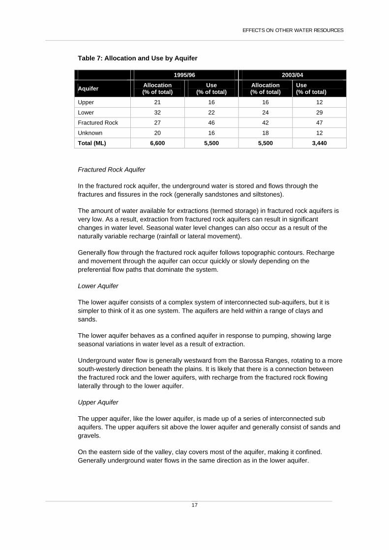
A summary of the allocation and use by aquifer is presented in Table 7.
EFFECTS ON OTHER WATER RESOURCES
17
Table 7: Allocation and Use by Aquifer
1995/96 2003/04
Aquifer Allocation (% of total)
Use (% of total)
Allocation (% of total)
Use (% of total)
Upper 21 16 16 12
Lower 32 22 24 29
Fractured Rock 27 46 42 47
Unknown 20 16 18 12
Total (ML) 6,600 5,500 5,500 3,440
Fractured Rock Aquifer
In the fractured rock aquifer, the underground water is stored and flows through the fractures and fissures in the rock (generally sandstones and siltstones).
The amount of water available for extractions (termed storage) in fractured rock aquifers is very low. As a result, extraction from fractured rock aquifers can result in significant changes in water level. Seasonal water level changes can also occur as a result of the naturally variable recharge (rainfall or lateral movement).
Generally flow through the fractured rock aquifer follows topographic contours. Recharge and movement through the aquifer can occur quickly or slowly depending on the preferential flow paths that dominate the system.
Lower Aquifer
The lower aquifer consists of a complex system of interconnected sub-aquifers, but it is simpler to think of it as one system. The aquifers are held within a range of clays and sands.
The lower aquifer behaves as a confined aquifer in response to pumping, showing large seasonal variations in water level as a result of extraction.
Underground water flow is generally westward from the Barossa Ranges, rotating to a more south-westerly direction beneath the plains. It is likely that there is a connection between the fractured rock and the lower aquifers, with recharge from the fractured rock flowing laterally through to the lower aquifer.
Upper Aquifer
The upper aquifer, like the lower aquifer, is made up of a series of interconnected sub aquifers. The upper aquifers sit above the lower aquifer and generally consist of sands and gravels.
On the eastern side of the valley, clay covers most of the aquifer, making it confined. Generally underground water flows in the same direction as in the lower aquifer.

BAROSSA WATER ALLOCATION PLAN
18
Figure 6 Diagrammatic Representation of Underground Water Systems in the Barossa

EFFECTS ON OTHER WATER RESOURCES
19
Underground and Surface Water
There is limited data available to show the detail of interactions between the underground water and surface water resources across the Prescribed Area, although strong interactions are known to exist. The section of the North Para River between Lights Pass and the town of Nuriootpa is a ‘losing stream’ where water from the watercourse recharges the Upper Aquifers. Current estimates suggest that approximately 1,200 ML per year of water recharges to the upper aquifers of the valley floor from creeks and streams.
Between Nuriootpa and Tanunda the North Para River is a ‘gaining stream’ with underground water naturally discharging to the watercourse and contributing to stream base flow. It has been estimated that approximately 2,000 ML is discharged annually from underground water to the watercourse.
Within the Prescribed Area, the permanent pools (see Figure 4) are likely to be areas where underground water discharges to watercourses. These permanent pools are important sites of water dependent ecosystems. The maintenance of unregulated flows in the third, fourth and fifth order watercourses are important to maintaining these ecosystems.
Downstream of the Prescribed Area, the North Para River joins the South Para River at the town of Gawler and flows along the Gawler River to Gulf St Vincent. The Gawler River flows over the Northern Adelaide Plains Prescribed Wells Area, which is also a significant water resource. The main channel of the Gawler River has now been prescribed and will be considered as part of the development of the water allocation plan for the Western Mount Lofty Ranges. There is minimal interaction between the Gawler River and the major projection aquifers (T1 and T2) of the Northern Adelaide Plains. There is some interaction with the upper Quaternary aquifers of the Northern Adelaide Plains, however these aquifers are not used as a significant source of irrigation water in the region.
The Tertiary aquifers of the Northern Adelaide Plains are not considered to be recharged from the Barossa area.
3.1 Trends in Underground Water
There are a range of variables that can influence underground water levels, including water use, rainfall and stream flow. While broad trends can be established (see below), it is difficult to clearly determine causal relationships because of lack of data over time for some variables. The following information has been sourced from a report prepared for the Adelaide and Mount Lofty Ranges NRM Board by Resource and Environmental Management, titled “Groundwater Investigations to Support Water Allocation Planning in the Barossa”.

BAROSSA WATER ALLOCATION PLAN
20
Fractured Rock Aquifer
Water Levels
Between 1975 and 1987 water levels were generally declining or stable. Declining levels are thought to result from below average rainfall conditions and the increased number of wells taking underground water.
Similarly water levels continued to be generally stable or declining between 1988 and 2001, with the exception of a rise in water level in 1992, which coincides with the wet spring in 1992. It is likely that these declines are a result of increased underground water use, as those wells that do show a decline are in areas with more intense water use.
Between 2001 and 2004 underground water levels have remained stable or risen. It is believed that increased water levels are primarily a result of decreased underground water use, which may be a result of increased use of imported water (e.g. BIL).
Salinity
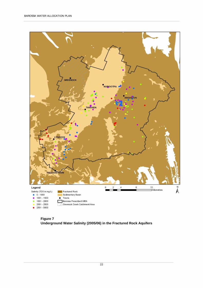
Salinity in the fractured rock aquifer generally ranges from 500 mg/L to greater than 3,000 mg/L, and is highly variable across the Barossa.
Salinity distribution in current production bores is shown in Figure 7.
Lower Aquifer
Water Levels
Between 1975 and 1992 underground water levels were generally declining. Water levels stabilised between 1992 and 1994, and then continued to decline between 1994 and 2000. Since 2000 water levels have stabilised or risen slightly, although levels are still below pre-development levels.
The decline in water levels between 1975 and 1987 is likely to be a result of a period of below average rainfall and an increase in water use (as indicated by increases in the number of wells constructed during this period).
The stabilisation of water levels around 1992 is likely to be a result of the wet spring in that year.
Between 1994 and 2002 water levels in the area west of Angaston continued to decline (although by less than 0.25 m/yr). This is likely to be a result of the high intensity of use in the area at that time. Over the past two years water levels have started to rise again (by around 0.2-0.5 m) in this area, which is likely to be as a result of growers switching to BIL water, and higher spring rainfall. Higher spring rainfall both delays the start of irrigation (and hence water use) and increases recharge. Despite this, some monitoring wells west of Angaston continue to show a decline in underground water levels.
Salinity
Underground water salinity in the lower aquifer is generally around 500-3,000 mg/L. North of Nuriootpa underground water salinity is more typically between 1,500 and 3,000 mg/L.

EFFECTS ON OTHER WATER RESOURCES
21
Some wells adjacent to one another show different salinities suggesting that there is variability across the aquifer system.
Salinity distribution in current production bores is shown in Figure (part of the sedimentary basin).
Upper Aquifer
Underground Water Levels
Annual fluctuations in underground water level in the upper aquifer are greater than in either the fractured rock or lower aquifers. This indicates that the upper aquifer is more directly influenced by rainfall recharge, although this is likely to vary across the Barossa, with variability of the overlying soils and clays.
Between 1972 and 1987 water levels generally declined by less than 0.25 m/yr. Generally by 1987 water levels had begun to stabilise. There was a sharp increase in water levels following the wet spring of 1992. From 1994 to 2002 water levels continued to decline, generally by around 0.25 m/yr, with some wells near the high intensity use area west of Angaston declining by 0.5 m/yr.
Southwest of Angaston underground water levels have continued to decline, despite the relatively low (less than 50 ML) intensity of underground water use. This area coincides with the high (150 to 300 ML per year) intensity underground water use area for the lower aquifer. The declining underground water levels in the upper aquifer suggest there is a strong potential for downward leakage (to the lower aquifer).
Over the last two years underground water levels have generally risen, most likely as a result of decreased underground water use and increased recharge from the wetter spring months. An exception to this trend is around Lyndoch, where two monitoring wells continue to show a decline in water levels.
Underground water Salinity
Underground water salinity in the upper aquifer generally ranges from 1,000 mg/L to greater than 6,000 mg/L. Salinity is highest in the area north of Nuriootpa. Water in the area between Nuriootpa, Tanunda and Angaston generally has salinity in excess of 1500 mg/L. Higher salinities in the upper aquifer are the primary reason a number of growers are using BIL water instead of underground water.
Other wells, notably several within close proximity to Nuriootpa showed an improvement in underground water quality. The reason for the improved salinity is unclear, as the wells do not appear to be influenced by their proximity to known aquifer storage and recovery operations.
Salinity distribution in current production wells is shown in Figure 8 (part of the sedimentary basin).
BAROSSA WATER ALLOCATION PLAN
22
Figure 7 Underground Water Salinity (2005/06) in the Fractured Rock Aquifers

EFFECTS ON OTHER WATER RESOURCES
23
Figure 8 Underground Water Salinity (2005/06) in the Sedimentary Aquifers

BAROSSA WATER ALLOCATION PLAN
24
3.2 Potential Impacts of Climate Change
Many projections have been made about the likely effects of climate change. CSIRO has predicted that mean temperature is likely to increase by 0.4 – 0.9 degrees Celsius in the southern half of the State by 2030 (compared with levels 15 years ago).
These projections and possible effects do have uncertainties associated with them, relating to when these changes will become noticeable and how severe they will be. Despite these uncertainties it is widely agreed that the likely future effects of climate change in South Australia will include:
more hot and very hot days; reductions in average annual rainfall; an increase in the frequency and severity of droughts; an increase in the frequency and severity of floods; an increase in the risk of bushfires; rising sea levels; increased evaporation.
How climate change will influence the availability of water from the prescribed resources of the Barossa is unclear at this stage. Ongoing monitoring and evaluation during the life of this water allocation plan will contribute to a review of the capacity of the resource for the next water allocation plan.

CAPACITY OF THE RESOURCE TO MEET DEMAND
25
4 Capacity of the Resource to Meet Demands
A number of factors have been taken into account in providing for the allocation of water for the Prescribed Area, including the present and anticipated future water needs of occupiers of land, and the water needs of the ecosystems which depend on water.
The current volume of licensed water use for irrigation purposes in the prescribed area is summarised in Section 4.2 and the expected future demand for water is summarised in Section 4.3.
4.1 Background of water allocation and use in the Barossa Prescribed Area
Accurately quantifying the historical water use in the Barossa is difficult for a number of reasons. Firstly, not all water resource extractions have been metered, and secondly some allocations are still area based (not volumetric) making it difficult to get accurate water use figures for these area based licences.
Recent changes in policy have provided for better metering of water resources, allowing for more accurate recording of water extraction and use into the future. Property level monitoring through Irrigation Annual Reporting and the conversion of area based licences to a volumetric allocation under this Water Allocation Plan will also allow for more accurate recording of water extraction and use in the Prescribed Area.
Irrigation Annual Reporting has provided some information on the total volume of water extracted for all volumetric and area based allocations for all water sources in the Barossa. The estimated volume of extraction during 2004/2005 was 6,245 ML. The total volume of water allocated during 2004/2005 for all reported sources was 10,884 ML as volumetric allocations and 1,972 Ha as area based allocations. These figures include all surface water, underground water, Barossa Infrastructure Limited (BIL), SA Water and effluent water allocated and extracted for use in the Prescribed Area. These figures may not represent the total water extraction and allocation, as only 88% of irrigation reporting forms were returned.
The use from the BIL pipeline is currently at 4,200 ML/yr (this includes some use outside of the Prescribed Area) but it has the potential to deliver up to 7,000 ML/yr under its current licence. The BIL water provides for greater flexibility in irrigation management and it is believed that underground water demand has been reduced in favour of BIL water in some areas as a result of an increase in underground water salinity, poor flow and better quality BIL water.

BAROSSA WATER ALLOCATION PLAN
26
4.2 Current Allocations
Surface water
Current surface water allocations are shown in Tables 8 and 9. The current volume of water allocated as surface water allocations is approximately 561.1 ML with a further area based allocation of 675.6 Ha, which equates to approximately 930 ML.
Existing area based allocations will be converted to volumetric allocations under this Water Allocation Plan.
Table 8: Volume based Surface water Allocations in the Prescribed Area
Allocation Purpose Vol (kL) Number of Licences
Industrial 44,000 6 1
Irrigation 516,633 15
Stock & Domestic 500 2
Total 561,133 23 1) Industrial licences are classified as volumetric, but not all licences have a volume assigned to the licence as yet.
Table 9: Area based Surface water Allocations in the Prescribed Area
Allocation Purpose Area (Ha) Number of Licences
Cut Flowers 8 1
Fodder 3 1
Fruit Trees 1.6 2
Lawn/ Recreation Area 10.1 1
Lucerne 3.6 3
Native Flowers 1.5 1
Native Trees 2.5 1
Nursery 8.5 1
Pasture Full 31.6 4
Pasture Start / Finish 15 1
Stonefruit 3 1
Vegetables 1 1
Vines 583.7 42
Walnut Trees 2.5 1
Total 675.6 61
Watercourse Water
Current watercourse allocations are shown in Tables 10 and 11. The current volume of water allocated as watercourse allocations is approximately 916.5 ML with a further area based allocation of 1,216 Ha, which equates to approximately 1,402 ML.

CAPACITY OF THE RESOURCE TO MEET DEMAND
27
Existing area based allocations will be converted to volumetric allocations under this Water Allocation Plan.
Table 10: Volume based Watercourse Allocations in the Prescribed Area
Allocation Purpose Vol (kL) Number of Licences
Irrigation 916,010 24
Stock & Domestic 500 1
Total 916,510 25
Table 11: Area based Watercourse Allocations in the Prescribed Area
Allocation Purpose Area (Ha) Number of Licences
Environmental Garden 8 1
Eucalypts 0.3 1
Fruit Trees 1.8 1
Fruit Trees (Olives) 2 1
Lawn/ Recreation Area 1 1
Lucerne 24.6 7
Pasture Full 16.8 7
Pistachio 2.4 1
Stonefruit 2 1
Vegetables 0 1
Vines 1,157.1 58
Total 1,216 80
Underground Water
Current underground water allocations are shown in Tables 12 and 13. The current volume of water allocated as underground water allocations is approximately 5,975 ML with a further area based allocation of 639.4 Ha, which equates to approximately 1,172 ML.
Existing area based allocations will be converted to volumetric allocations under this Water Allocation Plan.
Table 12: Current Volume based Underground water Allocations in the Prescribed Area
Allocation Purpose Total Volume (kL) Number of Licences
Stock and/or Domestic 31,700 54
Environmental 0 1
Industrial 46,630 251
Irrigation 5,731,618 282
Recreational 165,329 9
Total 5,975,277 371

BAROSSA WATER ALLOCATION PLAN
28
1) Industrial licences are classified as volumetric, but not all licences have a volume assigned to the licence as yet.
Table 13: Current Area based Underground Water Allocations in the Prescribed Area
Allocation Purpose Total Area (Ha) Number of Licences
Fruit Trees 21.9 4
Lawn / Recreation Area 12.4 7
Lucerne 34 11
Pasture Full 65.2 9
Pasture Start / Finish 10.6 2
Stonefruit 21.4 7
Vegetables 0 1
Vines 473.9 40
Total 639.4 81
Greenock Creek Authorisations
Licences and allocations have not yet been issued for the Greenock Creek Catchment Area. Initial authorisations have been issued to existing users, and the current area authorised is presented in Table 14. Allocations will be provided to authorised water users in Greenock Creek as part of this water allocation plan.
Table 14: Authorisations in Greenock Creek
Allocation Purpose Total Area (Ha) Number of Authorisations
Vines 478 26
Fruit trees, olives, other 12.7 3
Total 490.7 29 There are also a number of authorisations for which crops have not been identified within the administration database. Therefore the total areas and numbers of authorisations indicated in Table 14, is not a complete summary of all crops or authorisations within Greenock Creek.
4.3 Future Demand
The demand for water in the Barossa is expected to increase. New demands for water are predicted to be in the following areas:
Residential and associated urban growth (commercial, general industrial, public utility and public institutional use);
Primary production expansion, particularly vines; Winery Grape crushing and processing; and Other industries
There are likely to also be other demands for water in the region.

CAPACITY OF THE RESOURCE TO MEET DEMAND
29
Residential and Urban
The Wine Industry Impact Review (Barossa and Light Regional Development Board, 2004) forecasted that 2,330 new dwellings would be required in the Barossa and Light region between 2001 and 2011 (233 dwellings per year) in response to the creation of 3,000 full-time wine industry related jobs.
The ‘Population Projection Enquiry System’ available from Planning SA presents anticipated population changes across the State. Estimates for the Barossa Council area indicate an increase of 2,481 people between 1996 and 2016 (124 people per year). Assuming 2.3 persons per household and household use of 300 kL/annum an additional average residential demand increase of 16 ML/yr could be expected.
Primary Production
An assessment of soil and land information for the Prescribed Area(not including the Greenock Creek area) indicates that the future potential for viticulture is 12,470 ha excluding the existing area of viticulture (7,660 ha). Potential for new vines also exists for neighbouring catchments, particularly to the north and west. Growth areas over the next 5 years are predicted to be in the St Kitts, Ebenezer East, Angaston and Seppeltsfield to Turretfield areas.
Projections for wine demand suggest that the land would be fully developed by 2025. Based on water demand of 1 ML/ha/yr for irrigating vines, the increase in demand for water in the order of 12,500 ML within the prescribed area is expected to occur by 2025 (based on an average increase in water use of 625 ML/year). However, this is dependent on the impact of climate change and the future rate/Ha required for sustainable production.
Wineries
Forecasts indicate that volumes of grapes crushed and processed in the Barossa, sourced both locally and externally, will continue to increase. The Wine Industry Impact Review (Barossa and Light Regional Development Board, 2004) forecasted that in 2011, 601,600 tonnes of grapes will be crushed or processed in the Barossa (on average increase of 26,050 tonnes per year). Water demand will depend on the relative amounts of crushing and processing. Based on a water demand of 2-5 kL/tonne for crushing/processing, water demand would increase on average 52 – 130 ML/year.
4.4 Capacity to meet Demand
Watercourse and Surface Water Resources
The watercourse and surface water resources of the Prescribed Area are characterised by high annual variability of flow. The annual rainfall distribution varies considerably across the Barossa Valley from an average of 800 mm/yr in the highland areas to an average of 500 mm/yr in the north - west of the Prescribed Area.
Modelling of the Prescribed Area has shown that approximately 8,725 ML of water is held in dams in the Barossa, of this total volume approximately 4,980 ML (57%) is held in licensed irrigation dams. The remainder (43%) is held within unlicensed dams that are used for stock

BAROSSA WATER ALLOCATION PLAN
30
and/or domestic purposes. These existing stock and/or domestic dams are not controlled through the water allocation plan.
Current allocations are estimated at approximately 3,800 ML/yr (surface water and watercourse allocations) including existing volumetric allocations and estimated volumes allocated equivalent to existing area based allocations.
Total allocations are only estimates because of data quality on allocations and because a number of allocations are still area based (see Section 4.2).
Modelling indicates that dam development has reduced average stream flow in the North Para River system at Yaldara by an estimated 20%. During years of low flow the reduction can be as much as 60%. Modelling has indicated that the majority of impacts of reduced flow occur at the lower flows (base flow and pool connection flows) (see Table 2).
During the development of this water allocation plan it has been concluded that the current level of development approximates the sustainable extraction level for surface water and watercourse allocations. Close monitoring of both flow and river health is required to assess this over the next five years. There is no intention to change allocations at this stage, however, this policy will be reviewed when both allocation and use can be better quantified, following conversion of allocations to a volume and the implementation of a more comprehensive metering program in the Barossa. In recognition of the impact at lower flows, a number of policies have been introduced in this water allocation plan to improve low flows.
Underground Water
Current levels of underground water allocation are estimated to be approximately 5,500 ML, although total allocations are only estimates because of data quality on allocations and because a number of allocations are still area based and also do not have meters (see Section 4.2). Current use was estimated to be around 2,000 ML (based on 04/05 irrigation reporting data), which is significantly less than the current allocation. Anecdotal evidence suggests that a number of irrigators are using alternative water sources (e.g. BIL) in preference to their underground water allocations. This is supported by irrigation annual reporting data which indicates irrigators often use multiple sources of water in place of their underground water allocation.
A number of water balances have been undertaken at various times for the Barossa. Because of the lack of information available on inter-relationships between the aquifer systems, these water balances are indicative only. The water balances undertaken to date, are also generally focussed on the sedimentary aquifers of the valley floor and do not include the fractured rock aquifers in the hills areas.
A review of underground water trends has shown that underground water levels are not generally showing signs of stress. Therefore it is not considered necessary to adjust allocations at this time, particularly as the level of allocation is unclear, the water balance is uncertain, and there is still some uncertainty which aquifer some allocations are extracted from. Close monitoring of water level and salinity will be ongoing to determine if the level of allocation needs to be reviewed in the future.

CAPACITY OF THE RESOURCE TO MEET DEMAND
31
Meeting Future Demands
The demand for water is projected to increase. The anticipated future demands for water cannot be met by any increase beyond current levels of water allocation from existing underground water, surface water or watercourse water. The demand may be met through increased use of imported water or reclaimed (effluent) water. The anticipated increase in future demand also needs to consider the potential changes to the volume of water available as a result of climate change.
The capacity of the land to sustain existing irrigation and future irrigation development is thought to be good. Although there are soil types that are known to be susceptible to water logging and salinisation, the capacity of the land is not generally the limiting factor in the Barossa, however the capacity of the land to support irrigation should be considered in any future increase in water use within the region.
The policies in this plan protect against the unsustainable use of prescribed water resources and limit further development that relies on access to these water resources. Amongst other things, this has led to the planning and provision of water for irrigation from sources external to the Barossa Prescribed Water Resources Area.
Changes in land value due to water management policies have stabilised in the years since prescription. The greatest impact on land value due to the availability of water will result from proximity to infrastructure developed to transport and distribute imported water or reclaimed water for irrigation. The policies in this plan have no impact on the placement and design of public or private water distribution infrastructure.

BAROSSA WATER ALLOCATION PLAN
32
5 Water Allocation Criteria
5.1 General Principles
The following objectives and principles are general and apply to the taking and use of prescribed underground water, water from watercourses and surface water (collectively referred to in this plan as “water resources”) in the Prescribed Area. The use of imported water and effluent water is a water affecting activity, and is addressed in Section 7.3 of this plan.
Objectives
1. Allocate water resources for sustainable use.
2. Maintain and where appropriate enhance the quality of water resources.
3. Ensure efficient use of water resources.
4. Maintain and enhance ecosystems dependant on water resources.
5. Minimise the impact of water use on prescribed water resources, other water resources, other water users and the environment.
6. Promote the sustainable use of water for agricultural and other economic enterprises within social and environmental limits.
7. Ensure that general statutory duties as listed under Section 9 of the Natural Resources Management Act 2004 are complied with.
Principles
The following general principles apply to the allocation of water resources.
1. Water will be allocated by the volume that may be taken in a water use year, and in accordance with the objectives and principles of this plan.
2. Pursuant to Section 153(1) of the Natural Resources Management Act 2004, water licences may be endorsed with water (holding) allocations.
3. From the date of adoption, the allocation of water will be limited to:
a) allocations resulting from the conversion of a water (holding) allocation to a water (taking) allocation;

WATER ALLOCATION CRITERIA
33
b) allocations resulting from the conversion of a water (taking) allocation to a water (holding) allocation;
c) rollover allocations;
d) roof runoff allocations; and
e) allocations of water that have previously been drained or discharged for the purposes of managed aquifer recharge.
4. A water (holding) allocation may only be converted to a water (taking) allocation if the water allocation criteria objectives and principles and the transfer criteria objectives and principles can be met.
5. Water resources must be used efficiently in a manner that is appropriate to the relevant industry or crop, taking into account local climatic, land, soil, water and topographic circumstances.
5.2 Conversion of Area Based Allocations to Volumetric Allocations
6. All conversions will occur and take effect on the 1 July following the first full water use year after the date of adoption of this plan.
7. An exemption under principle 10, or the application of an alternative crop conversion factor under principle 12, will only be considered by the relevant authority at the request of the licensee. A request from a licensee must be made within 6 months of the date of adoption of this plan.
8. All area based allocations will be converted to a volume, based on the formula in principle 9 below, the area endorsed on the licence and the conversion factors outlined below in Table 15.
9. Allocated volume (ML) = area endorsed on licence (ha) x conversion factor (ML/ha) provided that where a surface water allocation relating to a dam is converted to a volume, the resulting allocation may not exceed the total storage capacity of the dam. For the purposes of this principle, the dam storage capacity is deemed to be as stated on the licence unless a more accurate volume has been determined by a licensed surveyor using a method acceptable to the Minister.
10. An exemption to Principle 9 may be granted where a dam with a storage capacity of less than 5 ML that is located on a permanently flowing stream, is filled with ‘top up’ flows to meet allocation throughout the irrigation season, or that is filled by episodic flow events on an ephemeral stream. This exemption may be granted only if records demonstrate reliability of supply and the historic application of this system.
11. For those crops not covered by Table 15, area based allocations will be converted to a volume based on the area endorsed on the licence, the average water use from the 03/04 to 06/07 water use years, and a reasonable theoretical crop water requirement. Assessments of water use and theoretical crop water requirements will be made on a

BAROSSA WATER ALLOCATION PLAN
34
case by case basis based on the assessment of technical information, recognised standards and the capacity of the resource.
12. Where a licensee with an area based surface water or watercourse water allocation can demonstrate that the relevant crop conversion factor in Table 15 is inappropriate for their business because of local variations in soil type or structure, in variety of crop or other variable, then, subject to compliance with Principle 13, an alternative crop conversion factor may be applied by the relevant authority up to a maximum of 150% of the crop conversion factor outlined in Table 15.
13. Where a licence holder requests an alternative crop conversion factor in accordance with principles 7 and 12, the licence holder must provide an independent report that states the reasons for consideration of an alternative crop conversion factor and that contains:
a) a description and assessment by appropriately qualified professionals of:
o soil characteristics including Readily Available Water (RAW), type and profile;
o irrigation system design and system audit including efficiency and maintenance; and
o management systems such as soil moisture monitoring, water use records, and scheduling.
b) a description of:
o crop type and variety and density where applicable.
14. In the case of a single licence endorsed with an area based allocation which can be taken from more than one resource, the licence will be varied in accordance with the principles in section 5.2. In addition the following principles will also apply:
a) Allocations converted to a volume in accordance with section 5.2 will be assigned to a resource/s using the following hierarchy:
o surface water, followed by
o underground water, followed by
o watercourse water.
b) Surface water will be allocated first, up to a maximum of 70% of dam storage capacity. Dam storage capacity is as defined in principle 9.
c) The assignment of an allocation to a resource/s takes into account
o historical use of the resource; and
o any other information the Minister deems appropriate.

WATER ALLOCATION CRITERIA
35
Table 15: Irrigation Crop Conversion Rates
Crop Type Conversion Factor
Vines 1 ML/ha
Lucerne and Pasture 5 ML/ha
Starter Pasture 1 ML/ha
Vegetables 5 ML/ha
Woodlots 1 ML/ha
Native Flowers 1 ML/ha
Cut Flowers 4 ML/ha
Recreation 5 ML/ha
5.3 Allocation of Underground Water
The following principles apply to the allocation of underground water made following the adoption of this plan and are in addition to the general objectives and principles outlined in Section 5.1.
Principles
15. Water cannot be allocated where it will be extracted from within 100 metres of a third, fourth or fifth order stream as shown on Figure 5.
16. Water may only be allocated where the Minister is satisfied that the proposed location of taking, and the proposed manner of taking and use of the water will have no significant detrimental impact on:
a) the water resource;
b) water dependent ecosystems;
c) existing water users, either licensed or stock and/or domestic users;
d) the productive capacity of the land, including but not limited to, increases in land salinisation, waterlogging, or perched water tables;
e) the amount or duration of discharge from underground water to surface water/watercourses, and must not detrimentally affect any ecosystems that depend on that discharge; or
f) the quality of the underground water or surface water/watercourse water.

BAROSSA WATER ALLOCATION PLAN
36
Underground Water Rollover
17. At the end of any water use year if a licensee has not used or transferred all of their annual volumetric underground water allocation, the licensee may carry over the unused portion (“rollover credit”) up to a maximum of 10% of their annual allocation for taking in the following water use year.
18. The amount of underground water available to a licensee for taking in any one year, including the maximum rollover credit, will not exceed 110% of the annual underground water allocation endorsed on the licence. The rollover credit will be deemed to have been taken before the annual allocation.
5.4 Allocation of Watercourse and Surface Water Resources
Principles
The following principles apply to the allocation of surface water and water from watercourses made following the adoption of this plan. References to the location of allocations apply only to new allocations made under this plan and do not affect existing allocations or infrastructure. They are in addition to the objectives and general principles outlined in Section 5.1.
19. Surface water and watercourse water cannot be allocated where it will be taken from a third, fourth or fifth order stream as shown on Figure 5.
20. Following the date of adoption, water may only be taken or diverted by dams, walls or other structures where the manner and timing of the taking allows flows at appropriate times and of sufficient duration and volume to sustain water dependant ecosystems.
21. Water may only be taken when the threshold flow rate for that location is exceeded, where the threshold flow rate is defined by Section 7.2, principles 63 - 64.
Impact of Taking and Use of Surface Water and Watercourse Water
22. Water may only be allocated where the Minister is satisfied that the proposed location of taking, and the proposed manner of taking and use of the water will have no significant detrimental impact on:

WATER ALLOCATION CRITERIA
37
a) the water resource;
b) water dependent ecosystems;
c) existing water users, either licensed or stock and/or domestic users;
d) the productive capacity of the land, including but not limited to, increases in land salinisation, waterlogging, or perched water tables;
e) the amount or duration of discharge from surface water/watercourses to underground water resources, and must not detrimentally affect any ecosystems that depend on that discharge; or
f) the quality of the underground water or surface water/watercourse water.
Surface and Watercourse Water Rollover
23. At the end of any water use year if a licensee has not used or transferred all of their annual volumetric surface or watercourse water allocation, the licensee may carry over the unused portion (“rollover credit”) up to a maximum of 30% of that annual allocation for taking at any time in the following water use year.
24. The amount of water that may be taken in any one year, including the maximum rollover credit, must not exceed 130% of the annual surface or watercourse water allocation. The rollover credit will be deemed to have been used before the annual allocation.
25. A rollover credit can only be granted as an allocation where the water is taken through a water meter.
Allocation of roof runoff (surface water)
Roof runoff is considered to be surface water under the Natural Resources Management Act 2004, and therefore requires a licence for use (except for stock and domestic Use). By notice in the South Australian Government Gazette on 16 March 2006 (page 906), the capture and use of roof runoff less than 500 kilolitres per annum is exempt for requiring a licence. The following principles apply to surface water captured as roof runoff for the purposes of commercial (but not irrigation), industrial, environmental or recreational use. These principles are additional to those general principles set out in Section 5.1.
26. Surface water can be collected from roof runoff without the need for a water licence where the volume of water deemed to be collected from the connected roof area is equal to or less than 500 kilolitres per annum.
27. A water licence is required for surface water collected from roof runoff greater than 500 kilolitres per annum and up to a maximum of 2000 kilolitres per annum.
28. Where surface water collected from roof runoff is greater than 2000 kilolitres per annum, that portion of the water captured that would have naturally run-off from the site must be returned to the environment

BAROSSA WATER ALLOCATION PLAN
38
29. For the purposes of principles 26 – 28 the volume of water deemed to be collected from the connected roof area is determined as follows:
Captured volume (kL) = roof area (m2) x mean annual rainfall for the site (mm) 1000
Where mean annual rainfall is determined by Figure 11.
30. For the purposes of principle 28 the natural run-off from the site is determined as follows:
Natural run-off (kL) = roof area (m2) x annual run-off (mm) 1000
Where annual run-off is based on the run-off that equates to mean annual site rainfall as outlined in Table 17 and mean annual rainfall is determined by Figure 11.
31. For the purposes of principle 28, water should be returned to the environment by as close as practical to the natural path. Determination of natural path should be based on a site specific assessment undertaken by the licensee.
32. For the purposes of principle 28, water returned to the environment must be done so in a manner so as not to cause erosion, waterlogging, a rise in the level of underground water or other detrimental impacts to the local environment.
33. All water taken under this section must be directed to closed water storage facilities (holding tanks).
5.5 Allocation of Water Drained or Discharged to a Well
The following principles apply to the allocation of water drained or discharged to a well in accordance with a permit under Section 127(3)(c) of the Natural Resources Management Act 2004. They are in addition to the objectives and general principles set out in Section 5.1.
Principles
34. Allocations may be granted for the recovery of water drained or discharged to a well during a water use year, and:
a) will be calculated as a percentage of the volume of water drained or discharged in the previous water-use year, under a permit pursuant to Section 127(3)(c) of the Act; and
b) at the end of any water use year if a licensee has not used all of their allocation to recover water drained or discharged to a well the licensee may carry over the unused portion of the allocation for taking at a time during the next two water use years.

WATER ALLOCATION CRITERIA
39
35. For the purposes of principle 34(a), the percentage of water drained or discharged recovered for use may not exceed 80% of the water drained or discharged in any water use year except where the water drained or discharged has been imported into the prescribed area via a pipeline or channel, in which case no more than 100% shall be allocated for taking in any water use year.

BAROSSA WATER ALLOCATION PLAN
40
6 Transfer Criteria
6.1 General Transfer Criteria
The following objectives and principles apply to the transfer of underground water, surface and watercourse water (collectively referred to in this plan as “water resources”) in the Prescribed Area. This section of the plan does not apply to imported water or effluent water.
Objectives
The following objectives apply to the transfer of water resources in the Barossa Prescribed Water Resources Area:
a) Allocate and use water resources in a sustainable manner.
b) Maintain and, where possible, enhance the quality of water resources.
c) Maintain and ensure efficient use of water resources.
d) Maintain and enhance ecosystems dependant on water resources.
e) Minimise the impact of water use on prescribed water resources, other water resources, other water users and the environment.
f) Promote the sustainable use of water for agricultural and other economic enterprises within social and environmental limits.
Principles
The following general principles apply to the transfer of water resources:
36. Transfers of water resources may only occur where the taking and use of the water as a result of the transfer will be in accordance with the relevant objectives and principles set out in Section 5 of this plan.
37. Water allocated as part of a roll over credit under Sections 5.3 and 5.4 of this plan can not be transferred, except where the transfer does not involve a change to the location of the point of taking.
38. An allocation in respect of the underground water resource may only be transferred as an allocation from the underground water resource.
39. An allocation in respect of the surface water resource may only be transferred as an allocation from the surface water resource.

TRANSFER CRITERIA
41
40. An allocation in respect of the watercourse water resource may only be transferred as an allocation from the watercourse water resource.
41. An allocation of roof runoff (surface water) may not be transferred except where there is no change to the location to the point of taking.
42. In the case of either the transfer of the whole of an allocation to another licence or the transfer of a licence including its entire allocation(s) to another person, and where there is no variation to the location from which the water is authorised to be taken, the transfer criteria in sections 6.2 – 6.4 do not apply.
6.2 Transfer of Underground Water Allocations
The following principles apply to the transfer of underground water only. They are in addition to the objectives and general principles set out in Section 6.1.
Principles
43. The transfer of an underground water allocation must not result in the total allocation (from all aquifers) being greater than 300 ML within a 1 kilometre radius of the new point of extraction.
44. An allocation of underground water may not be transferred into a stressed area. A stressed area is defined as an area where there has been:
a) a declining trend of the monitored underground water level of 1 metre or more over the three water use years prior to the date of application; or
b) an increasing trend of the monitored underground water salinity of 50 mg/L or more over the three water use years prior the date of application.
45. The transfer of underground water must not occur from an area of high underground water salinity (above 1,500 mg/L) to an area of low underground water salinity (below 1,500 mg/L).
6.3 Transfer of Watercourse and Surface Water Allocations
The following principles apply to the transfer of surface water and water in watercourses only. They are in addition to the objectives and general principles set out in Section 6.1.
Principles
46. Transfer of allocations may occur between different management zones only where it can be demonstrated by the proponent to the satisfaction of the Minister that the transfer will not cause a detrimental impact to the timing and duration of flows at, or downstream from, the new location.
47. For the purposes of principle 46, management zones are defined on Figure 9.

BAROSSA WATER ALLOCATION PLAN
42
48. An allocation may only be transferred to a licence to take from an off stream dam.
49. Transfers of allocations (whether whole or in part) between licences pertaining to different dams either within or between different sub catchments may not be approved unless the relevant authority is satisfied that, consistent with the criteria for a permit under section 7.2 of this plan, there has been a reduction in the capacity of the dam to which the licence endorsed with the allocation proposed for transfer pertains, by a volume equal to or greater than the capacity of a new dam constructed for the allocation purposed of the proposed transfer.
6.4 Transfer of Allocation to Recover Water Drained or Discharged to a Well
Principles
50. An allocation to recover water drained or discharged to a well issued under Section 5.5 of this plan may only be transferred where there is no change to the location of the point of taking, or where the new point of taking is within the same property/site.

TRANSFER CRITERIA
43
Figure 9 Surface and Watercourse Water Management Zones

BAROSSA WATER ALLOCATION PLAN
44
7 Permits for Water Affecting Activities
Section 127 of the Natural Resources Management Act 2004 requires a permit for various water affecting activities listed in Section 127(3) of the Act, and those activities in Section 127(5) of the Act that are identified in this plan.
A person can only undertake any of the activities listed in this section if authorised to do so by a permit granted by the relevant authority.
Permits will only be granted if the activity complies with the relevant objectives and principles of this section.
For the purposes of this plan the relevant authority is:
a) in the case of an activity referred to in sections 127(3)(a), (b) or (c), or sections 127(5)(i) or (j) of the Act – the Minister; and
b) in the case of an activity referred to in Sections 127(3)(d) – the Board.
7.1 General
The following objectives apply to all water affecting activities within the boundary of the Prescribed Area. They are additional to the objectives and principles that apply to the specific activities set out in the following sections.
Objectives
1. Protect the quantity and quality of water resources.
2. Maintain natural hydrological systems and environmental flows.
3. Prevent deterioration in the quality of surface water, underground water or water in a watercourse or lake.
4. Protect and restore the natural character of watercourses and floodplains.
5. Protect the ecological functions of water resources and dependent biological diversity.

PERMITS FOR WATER AFFECTING ACTIVITIES
45
7.2 Water Storage and Diversions (Dams)
The objectives and principles that follow apply specifically to an activity under Section 127(3)(d) comprising the erection, construction or enlargement of a dam, wall or other structure that will collect or divert water flowing in a prescribed watercourse or surface water flowing over land in a surface water prescribed area, except for roof runoff exempted by the Notice of Authorisation to Take Water dated 9 March 2006 (published in the South Australian Government Gazette 16 March 2006 page 906).
This policy generally applies where a permit for a water affecting activity would be issued. Dams that have a wall height greater than 3 metres or a volume greater than 5 ML require development approval, instead of a permit for a water affecting activity. Development approval is issued by local councils. Applications received by Council are referred to the Board for direction. The Board will consider the policies within this Water Allocation Plan when providing direction to Council.
Objectives
1. Maintain and improve the quality and quantity of water flowing in the Barossa Prescribed Water Resources Area.
2. Ensure that dams, walls or other water collection or diversion mechanisms in watercourses and drainage paths are constructed and managed in a manner which:
a) protects the needs of downstream users;
b) protects water quality and quantity; and
c) protects ecosystems dependent on these resources.
Principles
Sub-Catchment Capacity Limit
51. The total capacity of all dams (other than turkeys nest dams) in a sub-catchment must not exceed the Total Allowable Dam Storage Volume outlined in column 4 of Table 16.
52. For the purposes of principle 51, sub-catchments are shown in Figure 10.
53. A permit for the erection, construction or enlargement of a dam within a sub-catchment may only be granted if the relevant authority is satisfied that the total capacity of water capable of being retained by other existing dams, walls and other structures in the sub-catchment has been reduced by a volume equal to or greater than the proposed capacity of the proposed dam, wall or other structure.

BAROSSA WATER ALLOCATION PLAN
46
Table 16 - Sub catchment Capacity Limits
Column 1 Column 2 Column 3 Column 4
Sub Catchment Current dam storage volume (ML)
Allowable new dam storage volume (ML)
Total allowable dam storage volume (ML)
Greenock 1,050 0 1,050
Tanunda 650 16 666
Jacob 844 94 938
Duckponds 295 0 295
Lyndoch 688 0 688
Angaston 106 0 106
Valley Floor (including Light) 2,098 0 2,098
Upper Flaxman 1,858 4 1,862
Lower Flaxman 1,135 36 1,171
Total Barossa PWRA 8,724 150 8,874
Source Barossa Surface Water Budget – Hydrological Model
Property Capacity Limit
54. The combined capacity of all dams on a property (allowable volume) must not exceed 30% of the annual run-off of that property.
55. For the purposes of principle 54, the allowable volume is calculated as follows:
Allowable Volume (for a new dam) = (0.3 x R x A) – existing property dam storage
Where: R = run-off (based on runoff from Table 17 and rainfall in Figure 11) A = area of the catchment above proposed dam within property boundary (km2)
Table 17 - Rainfall and Run-off for the Prescribed Area
Mean Annual Rainfall (mm) Annual Run-off (mm)
< 500 10
501 – 550 25
551 – 600 35
601 – 650 45
651 – 700 65
701 – 750 90
751 – 800 110
> 800 115
Source: Barossa Surface Water Budget – Hydrological Model

PERMITS FOR WATER AFFECTING ACTIVITIES
47
Figure 10 Sub Catchments for Dam Development

BAROSSA WATER ALLOCATION PLAN
48
Figure 11 Rainfall in the Barossa

PERMITS FOR WATER AFFECTING ACTIVITIES
49
Stock and Domestic Dams
56. Dams for stock and/or domestic purposes may only be constructed if there is insufficient or inadequate water available on the property, such that:
a) the proposed location of the dam is not within 500 metres of a SA Water supply pipeline on contiguous land, i.e. land adjoining the pipeline; or
b) the flow rate of water from all wells on the property for stock and/or domestic purposes is less than 0.1 litre/sec; or
c) the salinity, as measured by total dissolved solids, of the water from all wells is greater than:
ii) 1500 mg/L for general domestic purposes;
iii) 1000 mg/L if the water is used for drinking purposes; or
iv) 3000 mg/L for stock purposes
Location
57. Dams must not be located in ecologically sensitive areas or in any location that creates a detrimental impact on an ecologically sensitive area, including immediately upstream or downstream of these areas.
58. Dams must not be located in areas prone to erosion.
59. Dams must not be located on-stream.
60. Dams must not be located where it is likely to adversely affect the migration of aquatic biota.
Flow Regime
61. Collection or diversion of water flowing in a watercourse or over land should not adversely affect downstream water dependent ecosystems by causing reduced stream flow duration, lengthened periods of no or low flow, or any other impact.
62. Provision shall be made for flow to pass the dam via a diversion structure such that the diversion structure includes a device that prevents the diversion of water from the watercourse or drainage path during periods of flow at or below the threshold flow rate.
63. For the purposes of principle 62, the threshold flow rate (litres/second) means:
a) The flow rate of a watercourse or drainage line (litres/sec) determined by multiplying the unit threshold flow rate (litres/sec/square kilometre) by the area of catchment (square kilometres) that contributes to the watercourse or drainage line located above the point where the water is diverted from the watercourse; or

BAROSSA WATER ALLOCATION PLAN
50
b) 2 litres/second, whichever is the greater value.
64. For the purposes of principle 63, the unit threshold flow rate of a sub-catchment can be determined by dividing the 10th percentile flow rate (litres/second) for a sub-catchment by the area of the sub-catchment (square kilometres), where the 10th percentile flow rate is the flow rate (litres/second) obtained from a time weighted annual flow duration curve (with the time step being 1 day – mean flow) which is greater than or equal to 10% of all flows during that period.
Dam Construction and Design
65. Dams must be sited and constructed to:
a) minimise the loss of soil from the site through soil erosion and siltation; and
b) minimise the removal or destruction of in-stream or riparian vegetation.
66. Dam construction must be undertaken in a manner that prevents silt or sediments entering the watercourse. This can be achieved in a number of ways, including, but not limited to the use of erosion and sediment control measures such as catch/diversion drains, re-vegetation, hay bale barriers, filter fences, sediment traps and basins.
7.3 Use of Imported Water and Effluent
The objectives and principles that follow apply specifically to an activity under Section 127(5)(i), for the application of water on land in the course of carrying on a business at a rate that exceeds 1 kL/ha/yr if the water has been brought into the Prescribed Area by means of a pipe or other channel.
The objectives and principles that follow also apply to an activity under Section 127(5)(j), using effluent in the course of carrying on a business at a rate that exceeds 1 kL/ha/yr. Note that if the use of effluent is managed through a licence issued by the Environment Protection Authority, this section may not apply.
Objectives
1. The sustainable use of imported water or effluent that does not adversely impact on:
a) Structures or ecosystems through a rise in underground water levels; or
b) The natural flow of watercourses; or
c) The quality of surface water, underground water or water in watercourses; or
d) Productive capacity of the land through rising underground water levels, salinity, sodicity, water logging or nutrient levels; or
e) The condition, biodiversity or extent of water dependent ecosystems.

PERMITS FOR WATER AFFECTING ACTIVITIES
51
Principles
67. Use of imported water or effluent water must not:
a) cause a rise in the underground water level sufficient to detrimentally affect structures or ecosystems;
b) adversely affect the natural flow of water or the quality of surface water, underground water or water in a watercourse or lake;
c) adversely affect the productive capacity of the land by causing salinity, sodicity, waterlogging, perched water tables or other such impacts; or
d) adversely affect water dependent ecosystems.
68. Any storage facility for effluent must have no natural catchment and be constructed:
a) to prevent leakage to the surrounding soils other than in an approved aquifer storage and recovery scheme;
b) to prevent overflow to the surface of the land surrounding the dam;
c) to prevent overflow into a watercourse.
7.4 Draining or Discharging Water into a Well (Artificial Recharge)
The objectives and principles that follow apply specifically to an activity under Section 127(3)(c) of the NRM Act 2004 comprising the draining or discharging of water directly or indirectly into a well (“artificial recharge”). They are additional to those expressed for all water affecting activities.
In addition to the requirements outlined below for drainage or discharge into a well, an Aquifer Storage and Recovery development will also require a water licence for the recovery component of the scheme, which must be in accordance with the policies for the allocation of water drained or discharged to a well outlined in Section 5.5 of this water allocation plan.
Objectives
1. The sustainable operation and management of aquifer storage and recovery schemes;
2. Reasonable and practicable measures taken to avoid the discharge of waste to the receiving underground water resource during the draining or discharging of water into a well;
3. Drainage or discharge into a well so as not to cause environmental harm;
4. Drainage or discharge of water directly or indirectly into the aquifer so as not to adversely affect:

BAROSSA WATER ALLOCATION PLAN
52
a) the quality of underground water;
b) the integrity of the aquifer, for example, but not limited to, the aquifer’s confining layer and the ability of the aquifer to transmit water;
c) watertables, for example, but not limited to, water logging, land salinisation and damage to infrastructure (roads, buildings, foundations etc.);
d) any underground water dependant ecosystem or ecologically sensitive area that depends on the underground water resource;
e) the ability of other persons to lawfully take from that underground water; or
f) the longevity of operations.
Principles
69. Water may be drained or discharged into a well where the water quality criteria outlined in principle 73 and 75, of the water to be drained or discharged, does not exceed the water quality criteria outlined in the EPA Environment Protection (Water Quality) Policy or any subsequent policy.
70. An exception to the requirements to meet the EPA Environment Protection (Water Quality) Policy or any subsequent policy may be granted in the case of salinity, where water to be drained or discharged must be equal or better quality as the ambient underground water.
Site Suitability
71. Where drainage or discharge to the well is proposed a permit will only be issued where a risk assessment is undertaken to the satisfaction of the Minister. This risk assessment must be consistent with the National Water Quality Management Strategy – Australian Guidelines for Water Recycling: Managing Health & Environmental Risks, Phase 1 2006 and other related documents current at the time, and include:
a) where drainage or discharge is proposed to be by pressure injection, investigation into the suitability of the draining or discharging site, including but not limited to tests for transmissivity, maximum injection pressures and calculated likely impacts on the integrity of the well and confining layers, and impacts of potentiometric head changes to other underground water users.
b) where drainage or discharge to the well is proposed to be under gravity, a permit to drain or discharge water into a well will only be issued where sufficient information is available prior to commencement of operations to demonstrate that the draining or discharging of that water will not cause adverse impacts or risks related to rising water tables.
c) an appropriate operation or management plan demonstrating that operational procedures and monitoring regime are in place to protect the integrity of the aquifer, minimise the wastage of water and protect the discharge site on an ongoing basis.

PERMITS FOR WATER AFFECTING ACTIVITIES
53
d) a water quality assessment which identifies hazards in the source water.
e) a report on the consequences and impacts to the native underground water resource where the water quality characteristics (salinity and chemistry composition) of the water to be discharge differs to that of the native underground water.
72. Roof runoff (surface water) that is drained or discharged into a well via a closed system of capture and transport is exempt from meeting the requirements of principles 71(a), (b), (c) and (d), provided that the system is equipped with a mechanism to divert first flush water.
Monitoring Prior to Commencement of Operations
73. For the purposes of principles 69 and 70 the following samples must be taken prior to the commencement of aquifer storage and recovery:
a) one sample (unless otherwise specified by the approval authority) of the ambient underground water.
b) one or more samples of the source water, at a time to adequately represent the water that will be injected (e.g. winter runoff for surface water) and the potential variability of water quality within the source water, and
c) all samples must be collected in accordance with Australian Standard AS5667, Water quality – sampling.
74. For the purpose of principle 73 the ambient underground water sample must be collected from the proposed point of injection, or as near as possible to the proposed point of injection, and from the same aquifer as that in which storage is proposed, as recommended by the approval authority. The following parameters in the ambient underground water (at a minimum) must be sampled, analysed and reported to the approval authority:
a) pH, TDS, turbidity, ammonia, nitrate, nitrite, total phosphorus, sodium, chloride, sulphate, calcium, magnesium, bicarbonate, iron, total arsenic, total boron, total cadmium, total chromium, total lead, total manganese and total zinc.;
b) Additional parameters may be required following discussions with the relevant approval authority.
75. For the purposes of principle 73, the following parameters in the source water (at a minimum) must be sampled, analysed and reported to the approval authority:
a) Surface water (dam, lake, including imported water that has been held in a catchment dam) or water directly pumped from a watercourse or roof runoff:
i) pH, TDS, turbidity, ammonia, nitrate, nitrite, total phosphorus, sodium, chloride, sulphate, calcium, magnesium, bicarbonate, iron, total arsenic, total boron, total cadmium, total chromium, total lead, total manganese, total zinc, total coliforms and faecal coliforms.

BAROSSA WATER ALLOCATION PLAN
54
ii) where the water to be drained or discharged comes from a source likely to contain pesticides, Giardia, Cryptosporidium, volatile organic compounds and petroleum hydrocarbons (including but not limited to water from land used for intensive agriculture or industrial purposes) those substances, material and characteristics.
iii) additional parameters may be required following discussions with the approving authority.
b) Imported water (e.g. BIL, SA Water):
i) pH, TDS, turbidity, ammonia, nitrate, nitrite, total phosphorus, sodium, chloride, sulphate, calcium, magnesium, bicarbonate, iron, total arsenic, total boron, total cadmium, total chromium, total lead, total manganese, total zinc, total coliforms and faecal coliforms.
ii) If the water provider can supply analysis results for the parameters outlined in principle 75(b)(i), no additional monitoring is required prior to the commencement of aquifer storage and recovery.
iii) If the water has been treated by chlorination, sufficient representative samples must be taken and analysed for trihalomethanes.
iv) additional parameters may be required following discussions with the approving authority.
c) Treated effluent
i) pH, TDS, turbidity, ammonia, nitrate, nitrite, total phosphorus, sodium, chloride, sulphate, calcium, magnesium, bicarbonate, iron, total arsenic, total boron, total cadmium, total chromium, total lead, total manganese, total zinc, total coliforms and faecal coliforms
ii) If the water provider can supply adequate water quality data for the parameters outlined in principle 75(c)(i) to the approving authority, additional testing may not be required.
iii) additional parameters may be required following discussions with the approving authority
Ongoing Monitoring
76. One sample (unless otherwise directed by the approval authority) must be taken of the ambient underground water annually at the point of injection and samples must be analysed for the parameters outlined in principle 74.
77. Sampling of the source water must be undertaken on an ongoing basis, and analysed for the relevant parameters as outlined in principle 75. If a review of monitoring results indicates that concentrations of a parameter are absent or below detection limits, that parameter does not need to continue to be monitored on an ongoing basis, unless otherwise specified by the approval authority. The following sampling regime applies:

PERMITS FOR WATER AFFECTING ACTIVITIES
55
a) Roof runoff water does not need to be sampled on an ongoing basis unless otherwise directed by the approving authority.
b) surface water and watercourse water: If the total volume of water injected is 20 ML/yr or less, samples must be taken annually. If the total volume of water injected is more than 20 ML/yr, the frequency of sampling will be determined in conjunction with the approval authority.
c) Imported water (e.g. BIL, SA Water): If the total volume of water injected is 20 ML/yr or less, samples must be taken annually. If the total volume of water injected is more than 20 ML/yr, the frequency of sampling will be determined in conjunction with the approval authority. Sampling is not required if the supplier of the water:
i) ensures the water quality criteria will be maintained at a consistent level year round, or
ii) provides regular water quality analysis to the approving authority.
d) Treated effluent: If the total volume of water injected is 20 ML/yr or less, samples must be taken annually. If the total volume of water injected is more than 20 ML/yr, the frequency of sampling will be determined in conjunction with the approval authority. Sampling is not required if the supplier of the water:
i) ensures the water quality criteria will be maintained at a consistent level year round, or
ii) provides regular water quality analysis to the approving authority.
78. For the purposes of principles 76 and 77, an Annual Report of monitoring results shall be submitted to the approval authority. The required reporting period, the format and content of the report, and the date at which the annual report will be due will be will be determined in conjunction with the approval authority.
7.5 Well Construction
The following objectives and principles apply to permits for activities relating to wells under Section 127(3)(a) and (b) of the Natural Resources Management Act 2004, comprising the drilling, plugging, backfilling or sealing of a well and the repairing, replacing or altering the casing, lining or screen of a well.
Objectives
1. To ensure the drilling, plugging, backfilling or sealing of a well occurs in a manner that will protect the quality of underground water resources;
2. To minimise the impact of repair, replacement or alteration of the casing lining or screen of wells on the underground water resources;

BAROSSA WATER ALLOCATION PLAN
56
3. To protect the underground water resources from pollution, deterioration and undue depletion;
4. To ensure the integrity of headworks are maintained; and
5. To ensure that wells are constructed in the correct aquifer system.
Principles
79. Well construction must occur in accordance with the approved general specification as provided by the approval authority.
Impact of well works on water quality and integrity of the aquifer
80. The equipment, materials and methods used in the drilling, plugging, backfilling or sealing of a well, or the replacement or alteration of the casing, lining or screen of a well shall not adversely affect the quality of the underground water resource.
81. Aquifers must be protected during the drilling, plugging, backfilling or sealing of a well, or the replacement or alteration of the casing, lining or screen of a well, to prevent adverse impacts upon the integrity of the aquifer.
82. If the new well is a replacement for an existing well, the new well shall be located:
a) no further than 20 metres from the existing well; and
b) if the existing well is within 100 metres of a third, fourth or fifth order stream (as shown on Figure 5), the replacement well shall be located no closer to the stream than the existing well that it is replacing.
83. New wells constructed for the purpose of taking underground water must not be located within 300 metres of an existing well that is endorsed on a permit or licence to drain or discharge water to the underground aquifer and is being used for aquifer storage and recovery unless:
a) the new well will be completed in an aquifer that is not in direct hydraulic connection with the aquifer into which the water is being drained or discharged;
b) the new well is part of the existing aquifer storage and recovery scheme incorporating the existing well or wells within 300 metres;or
c) if it is a replacement for an existing well, no further than 20 metres from the existing well.
Sealing between aquifers
84. Where a well passes or will pass through two or more aquifers, an impervious seal must be made and maintained between such aquifers.
Design of Headworks

PERMITS FOR WATER AFFECTING ACTIVITIES
57
85. The headworks of a well from which a licensed allocation is to be taken must be constructed so that the extraction of water from the well can be metered without interference.
Wells for Drainage or Discharge
86. The headworks for the draining or discharge of water must be constructed so that extraction and draining or discharge operations can be metered without interference.
87. The headworks for the drainage or discharge of water must be constructed so that water cannot leak if the well becomes clogged.
88. Wells constructed for the drainage or discharge of water at pressures greater than gravity must be pressure cemented along the full length of the casing.

BAROSSA WATER ALLOCATION PLAN
58
8 Monitoring
This monitoring program is specifically to monitor the state of the prescribed water resources to provide information for future water allocation planning processes. A range of additional monitoring programs are likely to be undertaken in the region as part of other projects.
8.1 Regional Monitoring
This section of the plan provides for regular monitoring and evaluation of the capacity of the resource to meet the demands for that water on a continuing basis. This monitoring will form part of the Board’s Monitoring and Evaluation Reporting Framework, which will identify responsible parties.
Underground Water
Regional monitoring requirements for the underground water resources within the Prescribed Area will be met through the underground water observation well network located across the Barossa.
The monitoring program will:
Monitor wells in the upper (including the shallow water table), lower and fractured rock aquifer systems, distributed across the region;
Monitor and record water level at least once every three months; Monitor water salinity at the beginning and end of the irrigation season.
A regional underground water status report will be produced every two years, to report on short and long term trends in water level and salinity across all aquifers in the Barossa.
Watercourse and Surface water
The regional monitoring requirements for watercourse and surface water resources of the prescribed area will be met through a network of stream flow gauges, which will monitor stream flow and salinity. The data will be collected on a continuous basis, and stored as part of the State Water Archive. Data will be evaluated and reported on at least once every three years.
The four gauging stations to be monitored will be:
North Para River at Mt McKenzie; North Para River at Penrice; North Para River at Yaldara; and Greenock Creek.

MONITORING
59
In addition, monitoring of river health will be undertaken in accordance with the methods/protocols defined by the Quantifying Health in Ephemeral Rivers Project.
Results of watercourse and surface water monitoring programs will be evaluated and reported on at least once every three years.
Monitoring status reports will be made available on the Board’s website.
8.2 Property Level Monitoring
The following information will be provided to the Minister by licensees and permit holders (imported water or effluent) on or before 31 July each year as part of Irrigation Annual Reporting:
the volume and source(s) of a water allocation or other water entitlement; where applicable, the volume and nature of any water storage; type of crop(s) irrigated; the area of crop(s) irrigated; the total volume of water applied to each crop type; the volume of water allocated and used for aquifer storage and recovery; the location of the property or properties where allocations are used; licence and permit numbers; meter numbers and meter readings; well numbers; licensee name, address and contact details; if relevant, the timing of continuing development; and other information as required by the Minister
In addition to the above monitoring requirements, all licensed underground water users will be required to submit an annual water sample collected from licensed wells for salinity testing.
Information will be collated into a district annual report and provided to irrigators.

BAROSSA WATER ALLOCATION PLAN
60
9 Glossary of Terms
Act – means the Natural Resources Management Act 2004.
Ambient underground water – means the underground water that is present prior to the commencement of aquifer storage and recovery, and may be the native underground water or mixed underground water.
Approval authority – the relevant authority as determined by the Minister or their delegates.
Aquifer – a sand, gravel or rock formation capable of storing or conveying water below the surface of the land.
Area based water allocation – An allocation of water that entitles the licensee to irrigate a specified area of land for a specified period of time usually per water use year.
Artificially recharged water – Water that is drained or discharged into the aquifers.
Barossa Infrastructure Limited (BIL) – Water supply authority providing River Murray water via SA Water infrastructure to the Barossa.
Base flow – The water in a stream that results from underground water discharge to the stream. (This discharge often maintains flows during seasonal dry periods and has important ecological functions.)
Biodiversity – The variety of life forms: the different life forms including plants, animals and micro-organisms, the genes they contain and the ecosystems (see below) they form. It is usually considered at three levels — genetic diversity, species diversity and ecosystem diversity.
CSIRO – Commonwealth Scientific and Industrial Research Organisation
Ecosystem – Any system in which there is an interdependence upon and interaction between living organisms and their immediate physical, chemical and biological environment.
Effluent – Domestic wastewater and industrial wastewater.
Environmental flows – minimum flows of water (by volume and season) necessary to maintain aquatic biota and ecosystem processes.
Ephemeral – Those streams or wetlands that usually contain water only on an occasional basis after rainfall events.

GLOSSARY OF TERMS
61
Fractured rock aquifers – occur where underground water is stored and moves through joints and fractures in the rocks.
Geomorphology – from Greek words for earth and form, is the study of landforms and landscapes, particularly from the standpoint of origin. Geomorphology seeks to relate specific landforms to the formative processes that operate in different environments.
Habitat – An area in which a specific plant or animal naturally lives, grows and reproduces; the area that provides a plant or animal with adequate food, water, shelter and living space.
Headworks – any assembly on top of a well and located between the well casing and the water delivery system.
Hydrologic cycle – The cyclic transfer of water vapour from the Earth's surface via evaporation or transpiration into the atmosphere, from the atmosphere via precipitation back to earth, and through runoff into streams, rivers, and lakes and the oceans.
Hyporheic – The wetted zone among sediments below and alongside rivers. It is a refuge for some aquatic fauna.
Imported water – Water that is not native to the area.
Irrigation annual reporting – Property level monitoring undertaken by licence and permit holders in the Prescribed Area.
Low flow bypass – a structure installed on a dam that acts to prevent low flows being removed from the stream and captured in the dam, helping to mimic a more natural flow regime.
Macroinvertebrates – Animals without backbones which live all or part of their life cycle in or on the bottom of a body of water. Their presence is affected by the quality of water and habitat of the waterway.
Macrophytes – Higher aquatic plants. They have roots and differentiated tissues and maybe emergent (bulrushes, reeds), submergent (water milfoil, bladderwort) or floating plants (duckweed, lily pads).
Managed aquifer recharge -- The process of recharging water into an aquifer for the purpose of storage and subsequent withdrawal.
Natural resources management plan – means a plan developed under Chapter 4 of the Act.
Natural resources management region – means a Natural Resources Management Region established under Chapter 3 Part 3 Division 1 of the Act.
Off stream dam – a dam used to store water that is diverted or collected from a watercourse or surface water run-off, by a wall or other structure. Off-stream dams will normally capture a limited volume of surface water from the catchment above the dam.

BAROSSA WATER ALLOCATION PLAN
62
On stream dam – a dam, wall or other structure placed on, or constructed across, a watercourse or drainage path for the purpose of holding back and storing the natural flow of that watercourse or the surface water run-off flowing along that drainage path.
Permanent pool – a pool, or body, of water that remains within a watercourse throughout the year, although the level of water present may fluctuate.
pH – A measure of acidity and alkalinity of a solution that is a number on a scale on which a value of 7 represents neutrality, lower numbers indicate increasing acidity, and higher numbers indicate increasing alkalinity. Each unit of change represents a tenfold change in acidity or alkalinity and is the negative logarithm of the effective hydrogen-ion concentration or hydrogen-ion activity in gram equivalents per litre of the solution.
Property/site – adjoining land where the owner or occupier of the land is the same and the land is used for the same purpose as defined by Revenue SA as Contiguous Land (for the purposes of the Emergency Services Levy).
PWRA – Prescribed Water Resources Area.
Quaternary aquifers – Aquifers that were formed in the last 2 million years. Refer to aquifers for more definition.
Roof runoff – surface water that flows off an elevated structure and is collected in a closed water storage facility.
SA mains water – River Murray water provided via SA Water infrastructure.
Salinity – A measure of the concentration of mineral salts, usually sodium chloride, dissolved in water. Salinity may be measured by weight (total dissolved solids), electrical conductivity, or osmotic pressure.
Sedimentary aquifers – occur in low lying points of the landscape where underground water flows through the pore spaces within the sediments.
Surface water – means (a) water flowing over land (except in a watercourse) after (i) having fallen as rain or hail or having precipitated in any other manner; or (ii) after rising to the surface naturally from the underground, (b) water of the kind referred to in paragraph (a) that has been collected in a dam or reservoir.
TDS –Total dissolved solids. A quantitative measure of the residual minerals dissolved in water that remain after evaporation of a solution. Usually expressed in milligrams per litre.
Tertiary aquifers – Aquifers that were formed 2 million – 65 million years ago. Refer to aquifers for more definition.
Third order stream – Stream order based on the Strahler technique. All upper tributaries are Stream Order 1. Where two 1st order stream converge a 2nd order stream is formed, where two second order streams converge a 3rd order stream is formed and so on.
To take water – to take water from a resource includes: to take water by pumping or siphoning the water; top stop, impede or divert the flow of water over land (whether in a watercourse or not) for the purpose of collecting the water; to divert the flow of water in a

GLOSSARY OF TERMS
63
watercourse from the watercourse; to release water from a lake; to permit water to flow under natural pressure from a well; to permit stock to drink from a watercourse, a natural or artificial lake, a dam or reservoir.
Topographic contours – refers to the surface landscape of a geographic area, especially changes in elevation.
Transfer – A transfer of a licence (including its water allocation) to another person, or the whole or part of the water allocation of a licence to another licensee or the Minister under Part 3, Division 3, Section 157 of the Act. The transfer may be absolute or for a limited period and requires the approval of the Minister.
Turkeys nest dam – An off-stream dam that does not capture any surface water from the catchment above the dam.
Underground water – (more commonly referred to as groundwater) means (a) water occurring naturally below ground level, (b) water pumped, diverted or released into a well for storage underground.
Volumetric water allocation – An allocation of water expressed on a water licence as a volume (e.g. kilolitres) to be used over a specified period of time, usually per water use year (as distinct from any other sort of allocation).
Water (holding) allocation – in respect of a water licence means the quantity of water that the licensee is entitled to request that the Minister convert to a water (taking) allocation under Chapter 7 Part 3 Division 2 of the Act.
Water (taking) allocation – in respect of a water licence means the quantity of water that the licensee is entitled to take and use pursuant to the licence.
Water affecting activity – Activities referred to in Part 2, Division 2, Section 127 of the Act.
Water allocation – (a) in respect of a water licence means the water (taking) allocation or the water (holding) allocation endorsed on the licence; (b) in respect of water taken pursuant to an authorisation under Section 128 of the Act means the maximum quantity of water that can be taken and used pursuant to the authorisation
Water Allocation Plan – means a water allocation plan prepared by a regional NRM Board under Chapter 4 Part 2 of the Act.
Water Dependant Ecosystems – Those parts of the environment, the species composition and natural ecological processes, which are determined by the permanent or temporary presence of flowing or standing water, above or below ground. The in-stream areas of rivers, riparian vegetation, springs, wetlands, floodplains, estuaries and lakes are all water-dependent ecosystems.
Water licence – means a licence granted under Chapter 7 Part 3 authorising the holder (subject to the taking of any step or steps required by the Act) to take (or to hold) water from a watercourse, lake or well or to take (or to hold) surface water from a surface water prescribed area and includes a licence granted under that Part endorsed with a water (holding) allocation.

BAROSSA WATER ALLOCATION PLAN
64
Water quality criteria – means the concentrations, levels or amounts of the substances, materials or characteristics.
Water resource – means a watercourse or lake, surface water, underground water, stormwater (to the extent that it is not within a preceding item) and effluent.
Water use Year – Water use is measured for licence and permit holders from 1 July until 30 June every year.
Watercourse – means a river, creek or other natural watercourse (whether modified or not) in which water is contained or flows whether permanently or from time to time and includes – (a) a dam or reservoir that collects water flowing in a watercourse, (b) a lake through which water flows, (c) a channel (but not a channel declared by regulation to be excluded from the ambit of this definition) into which the water of a watercourse has been diverted, (d) part of a watercourse, (e) an estuary through which water flows, (f) any other natural resource, or class of natural resource, designated as a watercourse for the purposes of the Act by an NRM Plan.
Well – (a) an opening in the ground excavated for the purpose of obtaining access to underground water; (b) an opening in the ground excavated for some other purpose but that gives access to underground water; (c) a natural opening in the ground that gives access to underground water.

205 Greenhill Road Eastwood SA 5063Phone: 8273 9100Fax: 8271 9585Email: [email protected]
Printed on recycled papers using world's best practiceISO 14001 Environment Management Systems.