fargo-moorhead metropolitan council of … packets/2017...fargo-moorhead metropolitan council of...
TRANSCRIPT

Fargo-Moorhead Metropolitan Council of Governments
Email: [email protected] http://www.fmmetrocog.org
701-232-3242 • FAX 701-232-5043 • Case Plaza Suite 232 • One 2nd Street North • Fargo, North Dakota 58102-4807
Red Action Items require roll call votes.
NOTE: Full Agenda packets can be found on the Metro COG Web Site at http://www.fmmetrocog.org – Committees
Metro COG is committed to ensuring all individuals, regardless of race, color, sex, age, national origin, disability/handicap, sexual orientation, and/or income status have access to Metro COG’s programs and services. Meeting facilities will be accessible to mobility impaired individuals. Metro COG will make a good faith effort to accommodate requests for translation services for
meeting proceedings and related materials. Please contact Savanna Leach, Metro COG Executive Secretary, at 701-232-3242 at least five days in advance of the meeting if any special accommodations are required for any member of the public to be able to
participate in the meeting.
A PLANNING ORGANIZATION SERVING
FARGO, WEST FARGO, HORACE, CASS COUNTY, NORTH DAKOTA AND MOORHEAD, DILWORTH, CLAY COUNTY, MINNESOTA
478th Transportation Technical Committee Fargo-Moorhead Metropolitan Council of Governments
THURSDAY, October 12, 2017 – 10:00 a.m. Metro COG Conference Room
AGENDA
1. Call to Order and Introductions 2. Approve the Agenda Action Item 3. Consider Minutes of the September 21, 2017 TTC Meeting Action Item 4. Public Input Opportunity – William Christian Public Input 5. Final Draft Metro COG Railroad Crossing Safety Study Report – William Christian Action Item 6. Fargo/West Fargo Parking and Access Requirement Study
– Michael Maddox, AICP Action Item 7. Bicycle / Pedestrian Committee Citizen Appointment – Dan Farnsworth Action Item 8. Aerial Photography / LiDAR Completion – Savanna Leach Information Item 9. Upcoming TA Grant Solicitations – Dan Farnsworth Information Item 10. Additional Business Information Item 11. Adjourn REMINDER: The next TTC meeting will be held Thursday, November 9th, 2017 in the Metro COG Conference Room at 10:00 a.m.
477th Meeting of the FM Metro COG Transportation Technical Committee
Thursday, September 14th, 2017 – 10:00 am Metro COG Conference Room
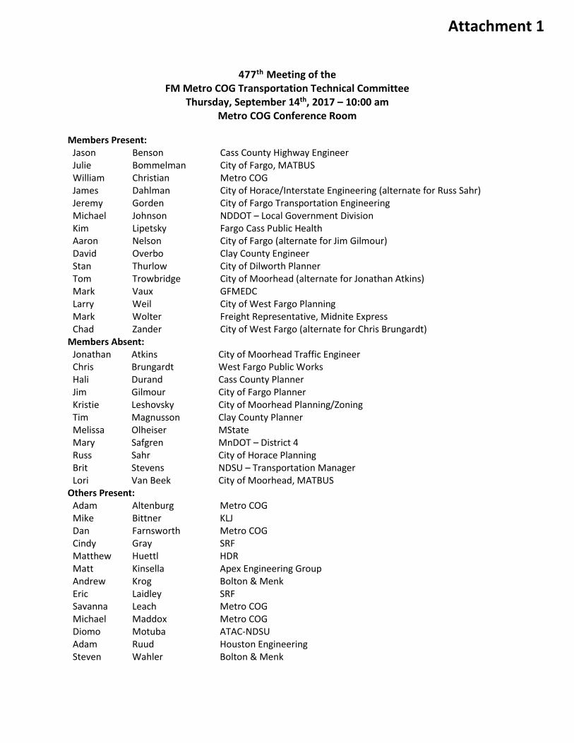
Members Present: Jason Benson Cass County Highway Engineer Julie Bommelman City of Fargo, MATBUS William Christian Metro COG James Dahlman City of Horace/Interstate Engineering (alternate for Russ Sahr) Jeremy Gorden City of Fargo Transportation Engineering Michael Johnson NDDOT – Local Government Division Kim Lipetsky Fargo Cass Public Health Aaron Nelson City of Fargo (alternate for Jim Gilmour) David Overbo Clay County Engineer Stan Thurlow City of Dilworth Planner Tom Trowbridge City of Moorhead (alternate for Jonathan Atkins) Mark Vaux GFMEDC Larry Weil City of West Fargo Planning Mark Wolter Freight Representative, Midnite Express Chad Zander City of West Fargo (alternate for Chris Brungardt)
Members Absent: Jonathan Atkins City of Moorhead Traffic Engineer Chris Brungardt West Fargo Public Works Hali Durand Cass County Planner Jim Gilmour City of Fargo Planner Kristie Leshovsky City of Moorhead Planning/Zoning Tim Magnusson Clay County Planner Melissa Olheiser MState Mary Safgren MnDOT – District 4 Russ Sahr City of Horace Planning Brit Stevens NDSU – Transportation Manager Lori Van Beek City of Moorhead, MATBUS
Others Present: Adam Altenburg Metro COG Mike Bittner KLJ Dan Farnsworth Metro COG Cindy Gray SRF Matthew Huettl HDR Matt Kinsella Apex Engineering Group Andrew Krog Bolton & Menk Eric Laidley SRF Savanna Leach Metro COG Michael Maddox Metro COG Diomo Motuba ATAC-NDSU Adam Ruud Houston Engineering Steven Wahler Bolton & Menk
Attachment 1

477th Meeting of the FM Metro COG Transportation Technical Committee – page 2 Thursday, September 14th, 2017
1. CALL TO ORDER AND INTRODUCTIONS The meeting was called to order at 10:00 am, on September 14th, 2017 by Chairman Christian. A quorum was present.
2. Approve the 477th TTC Meeting Agenda Chairman Christian asked if there were any questions or changes to the 477th TTC Meeting Agenda. Mr. Christian noted that Agenda Item #10 will be an action item, instead of an information item as listed.
Motion: Approve the 477th TTC Meeting Agenda. Mr. Benson moved, seconded by Mr. Wolter. MOTION, PASSED. 14-0. Motion carried unanimously.
3. APPROVE August 10th, 2017 TTC MEETING MINUTES Chairman Christian asked if there were any questions or changes to the August 10th, 2017 TTC Meeting Minutes.
Motion: Approve the August 10th, 2017 TTC Minutes. Mr. Wolter moved, seconded by Mr. Johnson. MOTION, PASSED. 14-0. Motion carried unanimously.
4. Public Comment Opportunity No public comments were made or received.
No MOTION
5. Presentation on the Uses of Airsage Data Mr. Motuba presented on the Uses of Airsage Data. Airsage data can be used in a few ways: primarily for trip distribution, or origin-destination values, travel time data, and for a secondary method of calculating traffic volume. This information was purchased from AirSage as a joint effort with the The Forks MPO and the BisMan MPO via the NDDOT.
No MOTION.
**Ms. Bommelman joined the meeting at 10:20 AM
6. Final Draft FM Regional Freight Plan Mr. Altenburg presented the Final Draft of the Fargo-Moorhead Regional Freight Plan. The Fargo-Moorhead Regional Freight Plan is intended to help guide freight investments in the region that support the safety, social equity, economic productivity, sustainability and livable community goals established under Metro COG Long Range Transportation Plan (LRTP).
Motion: Recommend Policy Board approval of the final draft of the Fargo-Moorhead Regional Freight Plan. Mr. Overbo moved, seconded by Mr. Wolter. MOTION, PASSED. 15-0. Motion carried unanimously.

477th Meeting of the FM Metro COG Transportation Technical Committee – page 3 Thursday, September 14th, 2017
7. Draft 2017 FM Regional Profile Mr. Altenburg presented the draft of the 2017 Fargo-Moorhead Regional Profile. The Profile reports upon conditions associated with the region’s transportation system and analyzes trends and changes in socio-economic conditions influencing the Fargo-Moorhead metro area. Additionally, the Profile serves as a tool to evaluate the accuracy of projections and assumptions set forth in various elements of the LRTP, TIP, and other plans and programs.
Motion: Recommend Policy Board approval of the Final Draft of the 2017 Metropolitan Profile. Mr. Weil moved, seconded by Mr. Benson. MOTION, PASSED. 15-0. Motion was carried unanimously.
**Mr. Weil left the meeting at 10:45 AM **Mr. Vaux left the meeting at 10:57 AM
8. Final Draft Metro COG 2018-2021 Transportation Improvement Program (TIP) Mr. Maddox presented the Final Draft of the Metro COG 2018-2021 Transportation Improvement Program (TIP). NDDOT is not moving forward with a 2018 STIP at this point; Mr. Johnson explained this issue further. Mr. Johnson said that there is a good possibility that the 2018 TIP will not be approved, but reminded the committee that the 2017-2020 TIP is approved and is still valid until 2017. Until the 2018 TIP is approved, all amendments moving forward will be to the existing 2017 TIP. Mr. Christian stated that it is federally-mandated that the COG develop a new TIP at least once every four years, but we update our TIP every year. Mr. Maddox said that the TIP will need to be approved, to present to MnDOT, which started their STIP program late, but is in the final stages of development of their portion. Mr. Gorden shared concerns with two of the Fargo projects that will need to be switched in order. Mr. Johnson stated that he is aware of their need to swap, but will need to be addressed during the solicitation of projects.
Motion: Recommend Policy Board approval of the Final Draft Metro COG Transportation Improvement Program (TIP) AS-IS, with the caveat that the Fargo projects (52nd Ave and 64th Ave South) will be switched in order. Mr. Gorden moved, seconded by Mr. Benson. MOTION, PASSED. 13-0. Motion carried unanimously.
9. Draft Metro COG 2045 Long Range Transportation Plan RFP Mr. Christian presented the draft 2045 Long Range Transportation Plan RFP. Mr. Christian noted a few minor changes that were made after the original document was mailed. Mr. Johnson stated that he did not have any objections to the document.
Motion: Recommend Policy Board approval of the 2045 Long Range Transportation Plan RFP and for release, pending approval from the NDDOT. Mr. Thurlow moved, seconded by Ms. Lipetzky. MOTION, PASSED. 12-0. *
477th Meeting of the FM Metro COG Transportation Technical Committee – page 4 Thursday, September 14th, 2017
Motion carried unanimously *Mr. Gorden did not leave the meeting, but was not present during the vote.
10. Proposed BikeFM Membership with the Bicycle Alliance of MN Mr. Farnsworth presented the proposed membership of BikeFM with the Bicycle Alliance of MN. The Bicycle Alliance of MN, a not for profit (501c3) organization with the mission of making MN a more bicycle-friendly state, is impressed with BIKE FM’s efforts and is receptive to BIKE FM becoming a chapter of the Bicycle Alliance of MN. If BIKE FM becomes a chapter of the Alliance, efforts on the North Dakota side will still be allowed. The benefits of BIKE FM becoming a chapter of the Bicycle Alliance of MN include Funding opportunities the Alliance’s donation channels, Accounting and other non-profit (501c3) services would be handled by the Alliance, and publicity of BIKE FM would be increased by being under the umbrella of the Alliance. It was questioned if there would be a fee associated with the membership. Mr. Farnsworth said there is no fee.
MOTION: Recommend Policy Board approval that BIKE FM enter into an agreement with the Bicycle Alliance of MN to become a chapter of the Bicycle Alliance of MN. Mr. Trowbridge moved, seconded by Mr. Gorden. MOTION, Passed. 13-0. Motion carried unanimously.
11. Additional Business Mr. Christian handed out a flyer for an upcoming training event: The National Traffic Incident Management Train-the-Trainer Session planned for the Fargo-Moorhead region on Tuesday, October 24, 2017 at the Clay County Joint Public Works Facility in Moorhead. This training is open to all and is being provided as part of the Alternate Route and TIM Guidebook development work taking place in the Fargo-Moorhead region.
12. Adjourn The 477th Regular Meeting of the TTC was adjourned on September 14th, 2017 at 11:17 a.m.
THE NEXT FM METRO COG TRANSPORTATION TECHNICAL COMMITTEE MEETING WILL BE HELD OCTOBER 12th, 2017, 10:00 A.M. AT THE FM METRO COG CONFERENCE ROOM, ONE NORTH 2ND STREET, CASE PLAZA SUITE 232, FARGO, ND.
Respectfully Submitted,
Savanna Leach Executive Secretary

Fargo-Moorhead Metropolitan Council of Governments
Email: [email protected] http://www.fmmetrocog.org
701-232-3242 • FAX 701-232-5043 • Case Plaza Suite 232 • One 2nd Street North • Fargo, North Dakota 58102-4807
A PLANNING ORGANIZATION SERVING
FARGO, WEST FARGO, HORACE, CASS COUNTY, NORTH DAKOTA AND MOORHEAD, DILWORTH, CLAY COUNTY, MINNESOTA
To: Transportation Technical Committee From: William A. Christian Date: October 6, 2017 Re: Public Input Opportunity
The Public Comment Opportunity is an open forum for the public to provide comments about specific items on this month’s agenda, as well as any other issues directly pertaining to Metro COG policies, programs, or documents.
Comments to the TTC will be limited to two minutes per individual, or at the discretion of the TTC Chair.
Requested Action: None.
Agenda Item 4
Fargo-Moorhead Metropolitan Council of Governments
Email: [email protected] http://www.fmmetrocog.org
701-232-3242 • FAX 701-232-5043 • Case Plaza Suite 232 • One 2nd Street North • Fargo, North Dakota 58102-4807
A PLANNING ORGANIZATION SERVING
FARGO, WEST FARGO, HORACE, CASS COUNTY, NORTH DAKOTA AND MOORHEAD, DILWORTH, CLAY COUNTY, MINNESOTA
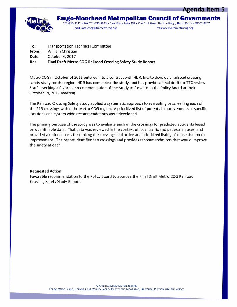
To: Transportation Technical Committee From: William Christian Date: October 4, 2017 Re: Final Draft Metro COG Railroad Crossing Safety Study Report
Metro COG in October of 2016 entered into a contract with HDR, Inc. to develop a railroad crossing safety study for the region. HDR has completed the study, and has provide a final draft for TTC review. Staff is seeking a favorable recommendation of the Study to forward to the Policy Board at their October 19, 2017 meeting. The Railroad Crossing Safety Study applied a systematic approach to evaluating or screening each of the 215 crossings within the Metro COG region. A prioritized list of potential improvements at specific locations and system wide recommendations were developed. The primary purpose of the study was to evaluate each of the crossings for predicted accidents based on quantifiable data. That data was reviewed in the context of local traffic and pedestrian uses, and provided a rational basis for ranking the crossings and arrive at a prioritized listing of those that merit improvement. The report identified ten crossings and provides recommendations that would improve the safety at each. Requested Action: Favorable recommendation to the Policy Board to approve the Final Draft Metro COG Railroad Crossing Safety Study Report.
Agenda Item 5
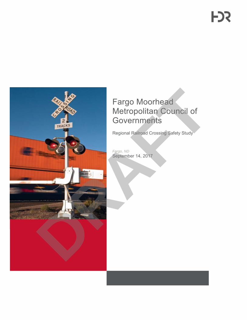
Fargo Moorhead Metropolitan Council of Governments Regional Railroad Crossing Safety Study
Fargo, ND
September 14, 2017
DRAFT

Fargo Moorhead Metropolitan Council of Governments Regional Railroad Crossing Safety Study
September 14, 2017 | i
Contents
1 Executive Summary ............................................................................................................................ 1 1.1 Findings and Recommendations ............................................................................................... 1
1.1.1 At-Grade Crossing Improvements ................................................................................ 1 1.1.2 Region-wide Issues and Concerns .............................................................................. 2
1.2 Potential Funding Sources ........................................................................................................ 4
2 Project Background ............................................................................................................................. 4
3 At-Grade Crossing Analysis ................................................................................................................ 7 3.2 Project Crossing Analysis Methodology .................................................................................. 10
3.2.1 First Level Screening Methodology ............................................................................ 10 3.2.2 First Level Screening Results .................................................................................... 11 3.2.3 Second Level Screening Methodology....................................................................... 12 3.2.4 Second Level Screening Results ............................................................................... 15 3.2.5 Third Level Analysis Methodology ............................................................................. 18 3.2.6 Third Level Analysis by Crossing ............................................................................... 20
4 Trends and Issues ............................................................................................................................. 51 4.1 Hazardous Material Routes ..................................................................................................... 51 4.2 Quiet Zones ............................................................................................................................. 53 4.3 ENS Signs ............................................................................................................................... 56 4.4 Trespassers and Pedestrians ................................................................................................. 57 4.5 Signal Timing ........................................................................................................................... 58
5 Economic Considerations .................................................................................................................. 60 5.1 State Funds and Federal-Source Funds Administered by the State - Minnesota................... 60
5.1.1 Section 130 Program (Title 23 of United States Code (USC) Section 130) ............... 60 5.1.2 Grade Crossing Safety Account Program .................................................................. 62 5.1.3 Antiquated Equipment Replacement Program ........................................................... 62 5.1.4 Other Funding ............................................................................................................ 62
5.2 State Funds and Federal-Source Funds Administered by the State – North Dakota ............. 63 5.2.1 Section 130 Program (Title 23 of United States Code (USC) Section 130) ............... 63 5.2.2 House Bill 102 ............................................................................................................ 63
5.3 Federal Funds – Both States .................................................................................................. 64 5.3.1 Nationally Significant Freight and Highway Projects (FASTLANE) ........................... 64 5.3.2 Infrastructure for Rebuilding America (INFRA) .......................................................... 65 5.3.3 Transportation Investment Generating Economic Recovery Grants (TIGER) ........... 66 5.3.4 Transportation Infrastructure Finance and Innovation Act (TIFIA) ............................. 67 5.3.5 Railroad Rehabilitation and Improvement Financing (RRIF) ..................................... 68 5.3.6 BNSF Crossing Closure ............................................................................................. 68
6 Appendices ........................................................................................................................................ 71 6.1 Appendix A – FRA Formulas ................................................................................................... 72 6.2 Appendix B – First Level Screening Results ........................................................................... 73 6.3 Appendix C – Second Level Screening Field Review Forms .................................................. 74 6.4 Appendix D – School Bus Crossing Regulations and Guidelines ........................................... 75 6.5 Appendix E – Second Level Screening Results ...................................................................... 76 6.6 Appendix F – City of Moorhead Preemption Documentation .................................................. 77
DRAFT

Fargo Moorhead Metropolitan Council of Governments Regional Railroad Crossing Safety Study
ii | September 14, 2017
Tables
Table 3-1. First Level Screening Criteria .................................................................................................... 11 Table 3-2. Second Level Screening Criteria ............................................................................................... 12 Table 3-3. School Bus Crossings ................................................................................................................ 13 Table 3-4. Second Level Screening Results ............................................................................................... 16 Table 3-5. Crossing Summary – Hawley Pedestrian Path .......................................................................... 20 Table 3-6. Proposed Mitigation Probable Costs – Hawley Pedestrian Path ............................................... 21 Table 3-7. Crossing Summary – Parke Ave S ............................................................................................ 23 Table 3-8. Proposed Mitigation Probable Costs – Parke Ave S ................................................................. 24 Table 3-9. Crossing Summary – 12th Ave S ................................................................................................ 27 Table 3-10. Proposed Mitigation Probable Costs - 12th Ave S ................................................................... 29 Table 3-11. Crossing Summary – 1st Ave N ................................................................................................ 31 Table 3-12. Proposed Mitigation Probable Costs - 1st Ave N ..................................................................... 31 Table 3-13. Crossing Summary – 50th Ave S .............................................................................................. 33 Table 3-14. Proposed Mitigation Probable Costs – 50th Ave S ................................................................... 34 Table 3-15. Crossing Summary – S. Main Street ....................................................................................... 36 Table 3-16. Proposed Mitigation Probable Costs - S. Main Street ............................................................. 37 Table 3-17. Crossing Summary – 1st St. S .................................................................................................. 39 Table 3-18. Proposed Mitigation Probable Costs – 1st St. S....................................................................... 40 Table 3-19. Crossing Summary – Partridge Ave ........................................................................................ 42 Table 3-20. Proposed Mitigation Probable Costs - Partridge Ave .............................................................. 43 Table 3-21. Crossing Summary – 230th St S .............................................................................................. 45 Table 3-22. Proposed Mitigation Probable Costs - 230th St S .................................................................... 46 Table 3-23. Crossing Summary – CR-17 .................................................................................................... 48 Table 3-24. Proposed Mitigation Probable Costs ....................................................................................... 49 Table 5-1. Third Level Crossings Summary ................................................................................................ 70
Figures
Figure 3-1. School Bus Crossing Locations ................................................................................................ 14 Figure 3-2. Second Level Crossing Locations ............................................................................................ 17 Figure 3-3. Third Level Crossing Locations ................................................................................................ 19 Figure 3-4. Hawley Pedestrian Path ........................................................................................................... 22 Figure 3-5. Parke Ave S .............................................................................................................................. 26 Figure 3-6. 12th Ave S ................................................................................................................................ 30 Figure 3-7. 1st Ave N .................................................................................................................................. 32 Figure 3-8. 50th Ave S ................................................................................................................................ 35 Figure 3-9. S. Main Street ........................................................................................................................... 38 Figure 3-10. 1st St. S .................................................................................................................................. 41 Figure 3-11. Partridge Ave .......................................................................................................................... 44 Figure 3-12. 230th St S ............................................................................................................................... 47 Figure 3-13. CR-17 ..................................................................................................................................... 50 Figure 4-1. Fargo-Moorhead Quiet Zones .................................................................................................. 55
DRAFT

Fargo Moorhead Metropolitan Council of Governments Regional Railroad Crossing Safety Study
September 14, 2017 | iii
This page is intentionally left blank.
DRAFT

DRAFT

Fargo Moorhead Metropolitan Council of Governments Regional Railroad Crossing Safety Study
September 14, 2017 | 1
1 Executive Summary The Fargo-Moorhead (FM) area, a major metropolitan area along the Red River located across two states, is situated on one of BNSF Railway’s main corridors of commerce, and a junction location for several other railroad lines. The FM area grew alongside of and with the railroads that served the area and are part of the fabric of the community. As a result, the region includes numerous crossings of the BNSF Railway and to a lesser extent, that of the Otter Tail Valley and Red River Valley and Western Railroads. In addition to the freight railroads that operate in the region, the area is served by Amtrak’s Empire Builder passenger train. Although several major roadways have already been grade separated from those rail lines, most remain as at-grade or level crossings. Each of those locations are shared rail, vehicle, pedestrian and bicycle crossings, and safety is a concern for the citizens that must travel across them, the passengers on board the passenger trains, and the railroads that must operate upon them.
This Railroad Crossing Safety Study applied a systematic approach to evaluating or screening each of the 215 crossings within the FM Metropolitan Council of Governments (Metro COG) boundaries and provides a prioritized listing of improvements at specific locations and also some system wide recommendations.
The primary purpose of this study is to evaluate each of the crossings for predicted accidents based on quantifiable data, review those crossings in the context of local traffic and pedestrian uses, provide a rational basis for ranking of the crossings, and arrive at a prioritized listing of those that merit improvement. This report identifies ten crossings and provides recommendations that would improve the safety at each.
A secondary purpose of this study is to provide a regional context to rail safety by addressing rail safety trends and issues that may assist the FMCOG in developing and implementing a broader, area wide, rail safety plan.
1.1 Findings and Recommendations 1.1.1 At-Grade Crossing Improvements
One of the primary methods for increasing public safety as it relates to the freight railroad network is by reducing at-grade crossing hazards. As part of this study, a grade crossing analysis was conducted to provide a rational basis for ranking at-grade railroad crossings to arrive at a prioritized listing of crossings which merit consideration for further study and potential mitigation measures. Due to the large number of crossings within the study area a tiered screening approach was utilized and conducted in three phases; First Level, Second Level, and Third Level. All crossings within the study area were scored uniformly under an initial screening (First Level) based on analysis using verified data from project stakeholders (local agencies, FRA, NDDOT & MnDOT) and desktop review to develop an initial ranking or score for each crossing.
Following the First Level of screening and consultation with the SRC and Metro COG staff, a selected subset of crossings was advanced to a Second Level screening. Each of the selected crossings in the Second Level screening was reviewed in the field to collect
DRAFT

Fargo Moorhead Metropolitan Council of Governments Regional Railroad Crossing Safety Study
2 | September 14, 2017
additional information not readily available via a desktop review or existing data sources and to verify FRA data. Upon completion of the field reviews, crossing scores were updated to include the additional items and the project crossing rankings were adjusted accordingly.
There are a total of 18 items that are included within the first two levels of screening. The items are very similar and in alignment with the NDDOT’s grade crossing risk factors. In addition, five items were included within the screening criteria that have origins in the MnDOT grade crossing assessment criteria.
The screening and analysis of the crossings within the FM Metro COG resulted in ten crossings which received recommended improvements in the Third Level analysis. These ten crossings are described in detail in Section 3 of this report but are summarized here:
Crossing and Location Recommendations
Pedestrian Crossing – Hawley, MN Upgrade pedestrian crossing surface and approach with pedestrian maze.
Parke Ave – Glyndon, MN Upgrade crossing with non-mountable median or 4-quad gates. Update adjacent sidewalk with pedestrian maze.
12th Ave S – Moorhead, MN Upgrade with 4-quad gates or combination gates and median.
1st Ave N – Moorhead, MN Add gates to existing active warning devices.
50th St S - Sabin, MN (and other crossings on CR 52 corridor)
Additional advance warning signage with warning beacon.
S Main St – Dilworth, MN Upgrade crossing surface and existing medians.
1st St – Sabin, MN Add STOP sign to westbound approach.
Partridge Ave – Glyndon, MN Close crossing in conjunction with Parke Ave upgrades OR upgrade crossing with non-mountable median or 4-quad gates.
230th Ave – Hawley, MN Improve warning device visibility. Upgrade crossing with 4-quad gates and traffic control barriers for 17th Ave intersection.
CR-17 – Fargo, ND Realign 32nd Ave east approach OR upgrade crossing with 4-quad gates and traffic control barriers for 32nd Ave east approach.
1.1.2 Region-wide Issues and Concerns
Transport of Hazardous Commodities There are many commodities that neither originate nor terminate within the FM Metro COG region but move through the area. Some of these commodities move in “unit trains,” trains carrying a single commodity (such as crude oil or ethanol) and are referred to as High Hazard Flammable Trains (HHFTs). Derailments and collisions of HHFTs are of special concern if the derailment or collision results in release of those commodities. Section 4.1 of this report describes in greater detail the issues, concerns, and recommendations however in general, we recommend that the FM Metro COG Local
DRAFT

Fargo Moorhead Metropolitan Council of Governments Regional Railroad Crossing Safety Study
September 14, 2017 | 3
Emergency Planning Committees (LEPCs) include participation by the BNSF Railway and develop a Hazmat Task Force to develop guidance and work with emergency management coordinators to develop incident specific response plans.
Locomotive Horn Quiet Zones At present, according to the FRA database, there are 24 crossings located within established Quiet Zones. Although the measures used to establish a quiet zone are primarily driven by the desire to silence the horns, these measures serve to enhance the visibility of the warning devices to the traveling public and tend to reduce the risky behaviors that some motorists take by driving around gates. It is our recommendation that whenever crossings are improved or warning devices enhanced at crossings within the FM Metro COG area, they should consider future establishment of additional quiet zones or inclusion within an existing quiet zone.
Emergency Notification Systems (ENS) The FRA created a rule that requires operating railroads to have an Emergency Notification System (ENS) in place which includes signage posted at every highway-rail grade crossing. The purpose of the ENS sign is to provide the public with critical emergency contact information. The information contained on the ENS sign enables the public to reach the railroad responsible for the crossing and to identify the specific crossing in the event of an emergency. Our recommendation is that that the existence and purpose of these signs be communicated to those that would primarily benefit. This could include general safety awareness campaigns and more targeted information campaigns targeting those that are most likely to arrive at crossings where prompt contact with the operating railroad’s train dispatchers is necessary. Those that are responsible for emergency response and establishing a safety perimeter around an incident should know that the zone will be free from passing trains. These responders would include emergency medical responders, tow truck operators, bus drivers, law enforcement, and city, county and state roadway workers.
Trespasser and Pedestrian Issues Nationwide, there are more railroad related fatalities involving trespassers on railroad rights-of-way and then in any other category, including crossing collisions. The current focus of the FRA and rail safety advocates, such as Operation Lifesaver, are shifting more towards addressing and hopefully reducing this upward trend in trespasser safety. Note that trespass fatalities do not include pedestrians struck at pedestrian crossings but alongside of the tracks on railroad rights of way. The distinction between the two is that Pedestrians are those at controlled locations where they belong and Trespassers who are on railroad rights of way where they should not be.
It is our recommendation that Pedestrian Safety can be improved with enhanced signage, lights, gates and bells which can be more easily seen and heard by those on foot or bicycle. Another approach is to physically direct and control pedestrian movement as they cross the tracks. This can be done with “Z” fencing which forces a pedestrian to dismount a bicycle and/or requires them to focus and pay attention as they travel thru the “Z”. The purpose of both of these approaches is the same; provide enhanced visual and audio warning devices, clear visibility of the track zone, and force
DRAFT

Fargo Moorhead Metropolitan Council of Governments Regional Railroad Crossing Safety Study
4 | September 14, 2017
those who are not paying attention to focus on crossing the tracks safely. Crossing and sidewalk improvements where pedestrians are anticipated should be an integral part of planning those improvements.
Trespasser Safety is more difficult to control and is primarily a function of identifying problematic areas within the FM Metro COG area and then educating the trespassers individually or targeting student or other demographic groups for education. Law enforcement should include these areas on their normal patrols. We also recommend establishing a dialog and working with the local railroad safety officers and public coordinators to jointly address this issue.
Signal Timing and Coordination Main Avenue and Center Avenue (also known as Trunk Highway 10) are east-west arterials through the Moorhead, MN downtown area with the BNSF track located between the two streets. The downtown includes five streets that connect Main Avenue and Center Avenue, each with an at-grade crossing at the BNSF track.
Along Main Avenue and Center Avenue, the intersections with the streets crossing the BNSF tracks are signalized with a pre-timed preemption plan that is called when a train travels through the downtown. The common approach to operating traffic signals with railroad preemption is to not allow any green indication towards the at-grade crossing. At the bequest of the downtown business community, special permission was granted by MnDOT to allow all movements at the signalized intersections during a railroad preemption. Queues from the railroad crossing have been observed to extend across the crosswalks and into the intersection. New or upgraded signal controllers could allow the City to operate a different peak period railroad preemption plan, which is when the queues are most often observed. Inexpensive Do Not Block Intersection markings and signing could be deployed, but effectiveness relies on drivers’ voluntary compliance.
1.2 Potential Funding Sources Both the States of Minnesota and North Dakota administer Federal safety funds for improvements at at-grade crossings as well as some state specific funds which may be available for improvements within the FM Metro COG area. Section 5 of this report describes in some detail those funds, eligibility requirements, and methods of applying for those funds. In addition to state and federal funds, the BNSF Railway offers funding assistance for permanent closure of an existing crossing. It is our recommendation that access to these funds (state, federal, and BNSF) be considered.
2 Project Background The Fargo-Moorhead Metropolitan Council of Governments (Metro COG) serves as the COG and Metropolitan Planning Organization (MPO) for the greater Fargo-Moorhead metropolitan area. As the designated MPO for the Fargo-Moorhead metropolitan area, Metro COG is responsible under federal law to maintain a continuous comprehensive and coordinated transportation planning process. Metro COG represents eleven cities and two counties situated within two States.
DRAFT

Fargo Moorhead Metropolitan Council of Governments Regional Railroad Crossing Safety Study
September 14, 2017 | 5
As part of its planning process Metro COG retained the services of HDR to provide a railroad crossing study that considered all at-grade crossings within the area and to identify and prioritize locations where safety improvements are warranted for further study and/or implementation of improvements. This report describes the processes and methodologies of that study.
The process specifically included and addressed five work elements or tasks:
1. Taking direction from and working with a Study Review Committee (SRC) composed of Metro COG members review all 209 at-grade crossings within the area and conduct this study with a quantifiable and defensible analysis. In addition to working directly under the direction of the SRC, HDR coordinated with and included local governments, state agencies, and the general public with the process.
2. Develop a Hazard Index for quantifying and ranking of safety issues or factors at the crossings. Whereas the states of Minnesota and North Dakota each use a “Hazard Index” of their own, this study was charged with developing a Hazard Index that was uniformly applied within the two-state region and also addressed characteristics that are unique to the area and may not have been included in statewide indices or rankings.
3. Identify trends and issues that influence safety issues for both freight and passenger movements and their interaction with the traveling public and surface freight movement. This included looking at population, employment, and industrial outlooks for the area. In addition, the study was to address the transport of specific commodities and goods shipped by rail that travel thru the area and the exposure that those commodities has on safety.
4. Include within the scope of the study was a process for soliciting and gathering input from key stakeholders and the general public.
5. The study and analysis provides recommendations to improve safety at specific crossings. This includes, but is not limited to, additional traffic control devices, geometric improvements, crossing improvements, closures or consolidations or groupings of crossings, implementation of intelligent transportation systems deployments, and other measures that might increase the safety at at-grade crossings. The recommended improvements include order of magnitude cost estimates to accomplish the recommendations for each of the crossings in 2017 dollars. Finally, the study identifies potential funding sources for the improvements.
HDR was retained by the Metro COG for the study in the fall of 2016 with the study concluded and completed within approximately a 12 month timeline. DRAFT

Fargo Moorhead Metropolitan Council of Governments Regional Railroad Crossing Safety Study
6 | September 14, 2017
Key Project Milestones
DRAFT

Fargo Moorhead Metropolitan Council of Governments Regional Railroad Crossing Safety Study
September 14, 2017 | 7
3 At-Grade Crossing Analysis One of the primary methods for increasing public safety as it relates to the freight railroad network is by reducing at-grade crossing hazards. At-grade crossings are locations where the public, either on foot or in a vehicle, will physically cross over freight railroad tracks; thereby creating a potential exposure for a vehicle/pedestrian collision with a train.
State and Federal standards have been developed to protect both vehicle/pedestrian roadway users and railroad traffic from these potential exposures. Due to the extremely long stopping distance and other operational constraints inherent with railroad train traffic, it is typically incumbent upon the roadway user to avoid potential collisions with the assistance of the crossing warning devices present at crossing.
Crossing Warning Protection Methods Various levels of warning protection are used to help roadway users recognize an upcoming at-grade crossing so that they can yield to a train if required or safely crossing the tracks. Crossing warning protection is generally divided into two categories:
Passive Warning Devices – which include the standard Cross-Buck sign (which is required to be posted at all at-grade crossings) and other Manual on Uniform Traffic Control Devices (MUTCD) roadway signs such as STOP or YIELD signs. Passive crossings have no train detection equipment on the railroad tracks; they are present to make the roadway user aware of the potential conflict while crossing the tracks.
Active Warning Devices – which include Flashing Light Signals (FLS), automated gate arms, and other devices that utilize train detection systems located on the railroad tracks to inform motorists that a train is either approaching or present at the crossing.
Crossings with active warning devices are typically considered to provide a higher level of safety for roadway users than passive crossings due to their ability to alert motorists of the presence of trains; removing the need for roadway users to make a decision to cross the tracks based on their available sight lines of the track, roadway geometry or other factors. However, both installation and maintenance costs associated with active warning devices and their on-track detection systems can prohibit their use at all at-grade crossing locations within an area.
In addition to standard passive and active warning device crossings, additional features can be added to both crossing types to provide incremental safety improvements at the crossing.
For passive crossings, this may be the installation of additional signage (potentially upgrading a cross-buck to a STOP sign), improving the crossing sight lines by removing visual obstructions such as dense vegetation, or improving the overall crossing condition by upgrading surface materials and lighting.
Typical modern active crossings include the installation of mast mounted FLS indicators with an automated gate arm that physically blocks the oncoming traffic from crossing the tracks. However, many legacy active crossings exist which only include FLS indicators
DRAFT

Fargo Moorhead Metropolitan Council of Governments Regional Railroad Crossing Safety Study
8 | September 14, 2017
without gates. Upgrading these crossing to include the automated gates can provide a noticeable increase in the safety of the crossing. Mast mounted FLS indicators can also be upgraded to cantilever mounted FLS to further improve visibility of the flashing signals; especially in multi-lane and heavy truck traffic roadway corridors.
Active crossings with both FLS and standard gates (2-quad) can be further upgraded to include either a non-mountable median or a 4-quadrant (4-quad) gates system. Both of these upgrades improve crossing safety by eliminating or greatly reducing the ability for a motorist to either deliberately, or inadvertently drive around a downed automated gate arm. It should be noted that depending on the agreement reached between the road authority and the railroad, the incremental maintenance cost for additional warning devices (such as additional gates in a 4-quad system) may be the responsibility of the road authority.
Non-mountable Median
4-Quad
DRAFT

Fargo Moorhead Metropolitan Council of Governments Regional Railroad Crossing Safety Study
September 14, 2017 | 9
In some instances, it is advantageous to completely eliminate the potential conflict at the crossing, in those cases two additional options remain.
Crossing Closure – is the closing of the roadway across the tracks. This approach is typically taken at lower volume roads where viable alternatives exist nearby to otherwise cross over the tracks. Or, where two or more adjacent crossings require safety upgrades, and crossing closures are used to offset costs or other impacts associated with improvements to the adjacent crossings.
Grade Separation – Is the construction of a structure which physically separates the roadway from the railroad tracks, eliminating the potential conflict. Grade separations typically consist of a highway bridge above the railroad tracks or a highway depression below the railroad tracks (with the tracks on a bridge structure) due to the greater flexibly in roadway alignment geometry over allowable railroad alignment geometry. Grade Separations are costly and are typically reserved for crossing locations with both high vehicular and railroad traffic; and/or other significant public safety concerns such as emergency access.
Various methods have been developed to aid in determining which crossings pose the greatest risk to public safety, and therefore should be a priority when funding upgrades to crossing warning devices or potential closure and grade separation candidates. The Federal Railroad Administration (FRA) and Federal Highway Administration (FHWA) have an accident prediction model which is widely used and forms the basis for the FRA’s safety criteria and approach when it evaluates warning device upgrades to at-grade crossings. The model generally applies weightings based on various attributes of the crossing to equations of train and vehicle speeds and number of trains and vehicles per day. It also factors in accident history at that crossing within the most recent 5 year period. The FRA’s model is primarily a predictor of how many accidents could be anticipated to occur at that location within a 20 year time frame. This is the basis for evaluation of quiet zone establishment and allows the user to assume various upgrades or improvements and determine of the overall corridor risk index is beneath an allowable threshold.
Each State DOT is required by federal regulation to evaluate the adequacy of warning devices and create its own prioritization statewide for improvement of safety at all of its public at-grade crossings. Many states use the FRA model as a basis of their approaches and adjust it with their own criteria which may include classification of roadway type, sight visibility, land use, geographic distribution, and to a limited extent political or policy based decisions. In addition to the FHWA/FRA model, there are several other generally accepted indexes that other states developed, such as Texas and New Hampshire, and were adopted by other states.
From discussions with both the North Dakota Department of Transportation (NDDOT) and Minnesota Department of Transportation (MnDOT), each state’s respective approach was reviewed and formed the basis of the Study’s grade crossing analysis methodology. As NDDOT currently uses a hybrid ranking approach based on the FRA model with modifying factors, and MnDOT is transitioning to an index approach looking primarily at the presence of certain risk factors; the methodology implemented by this study looked to synthesize the two approaches to best capture hazardous crossings which would likely receive higher consideration for safety improvements by each State’s
DRAFT

Fargo Moorhead Metropolitan Council of Governments Regional Railroad Crossing Safety Study
10 | September 14, 2017
respective approach. It should be noted that crossings which received high scores in the First Level and Second Level screening in this study will be considered in a pool with all other at-grade crossings in their respective State’s for various funding sources. Crossings which are considered especially hazardous within the Study Area may not score as high when compared against other crossings within the State.
3.2 Project Crossing Analysis Methodology The purpose of this grade crossing analysis is to provide a rational basis for ranking at-grade railroad crossings to arrive at a prioritized listing of crossings which merit consideration for further study and potential mitigation measures. Due to the large number of crossings within the study area a tiered screening approach was utilized and conducted in three phases; First Level, Second Level, and Third Level. All crossings within the study area were scored uniformly under an initial screening (First Level) based on analysis using verified data from project stakeholders (local agencies, FRA, NDDOT & MnDOT) and desktop review to develop an initial ranking or score for each crossing. The results of the First Level screening were ranked from worst (or greatest concern) to best (least concern).
Following this quantitative analysis, the list was vetted through a qualitative analysis. This review and analysis included input from the Study Review Committee (SRC) and Metro COG staff to review the results and determine if additional crossings warranted consideration for Second Level screening or if some crossings may not benefit from further analysis.
Following the First Level of screening and consultation with the SRC and Metro COG staff, a selected subset of crossings was advanced to a Second Level screening. The Second Level screening is by its nature more subjective than the First Level screening. Each of the selected crossings in the Second Level screening was reviewed in the field to collect additional information not readily available via a desktop review or existing data sources and to verify FRA data. Upon completion of the field reviews, crossing scores were updated to include the additional items and the project crossing rankings were adjusted accordingly.
There are a total of 18 items that are included within the first two levels of screening. The items are very similar and in alignment with the NDDOT’s grade crossing risk factors. In addition, five items were included within the screening criteria that have origins in the MnDOT grade crossing assessment criteria. Two of these items are tailored to address a more urban area such as the Fargo-Moorhead Metro COG service area and include proximity to hospitals, fire stations and EMS stations or routes located on designated public bus routes. These factors were included in the First Level screening. The method included three additional factors in the Second Level of screening to address designated pedestrian or bicycle trails, areas of high expected economic or population growth and special use areas.
3.2.1 First Level Screening Methodology First Level screening was uniformly applied to all crossings in the study area. It includes as its base the FRA accident prediction model, which factors in both highway and train traffic, number of tracks, roadway surface material, train speed, highway type, number of
DRAFT

Fargo Moorhead Metropolitan Council of Governments Regional Railroad Crossing Safety Study
September 14, 2017 | 11
highway lanes, type of warning devices, and accident history. This accident risk prediction is by its nature a low number as it predicts the probability of an accident occurring at that crossing within one year. FRA collision prediction formulas are provided in Appendix A – FRA Formulas. Under the NDDOT evaluation criteria, this number is multiplied by 1000 to arrive at a whole number that is easier to work with. For example, if the accident prediction is 0.050 (a single predicted accident within 20 years) the score for our First Level screening would be 50. Crossings within the study area are likely to have scores, following the multiplication, in the range of 10 to 80. The FRA accident prediction criteria then serves as the foundation for addition of unique factors that are not included in the FRA formula. Added to this score are points for proximity of hospitals, fire stations and EMS stations and schools. If a crossing is on a public bus route, it gets an additional score. If the posted roadway speeds are greater than 30 miles per hour, a graduated score is also added. If the crossing is located on the designated Amtrak passenger train route, an additional score is added. Finally, a roadway skew score is added depending on the skew angle of the track and crossing. The scoring criteria for First Level screening is shown in Table 3-1:
Table 3-1. First Level Screening Criteria
Criteria Score Description
A FRA Accident Prediction Formula Result multiplied by 1000
Likely to be less than a 80 score following multiplication
B Hospital, Fire Station, or EMS Station Nearby 1/4 mile
20 Nearby sensitive use by infirmed or near emergency call centers
C School Nearby within 1/4 mile 25 Nearby dense sensitive populations
D Transit Route (Bus Route) 20 Located on designated public bus routes
E Roadway Speed > 30 mph 10 - 30 If roadway speed is between 31 and 45 mph = 10 between 46 and 55 mph = 20 greater than 56 mph = 30
F Passenger Rail (Amtrak) Route 25 Possibility of injury to train passengers
G Roadway skewed to Track 0 - 20 If roadway angle with track 61 - 90 degrees = 0 31 - 60 degrees = 10 00 - 30 degrees = 20
H Roadway intersection within 200 feet
20 Possibility of traffic queuing
Total Score (Level 1 Screening) - Sum of all scores
3.2.2 First Level Screening Results The full First Level screening results are provided in Appendix B – First Level Screening Results. Crossing scores ranged from a low of 0 to a high of 159. Based on a qualitative review of this list along with input from Metro COG and the SRC, the top 25% of the crossings from the First Level screening results (55 crossings from the initial 215) were considered for Second Level screening.
DRAFT

Fargo Moorhead Metropolitan Council of Governments Regional Railroad Crossing Safety Study
12 | September 14, 2017
In addition to First Level screening scores, crossings were also vetted against known project lists for scheduled or potential grade separation projects or other improvements; crossing locations which were not viable grade separation candidates due to a variety of site constraints; and locations where in-place active warning systems were already maximized (i.e., 4-quad gate systems or gates and 100’ non-mountable medians). Crossings which met these criteria were removed from Second Level screening consideration. A total of 33 roadway crossings and one pedestrian only crossing were selected for Second Level screening.
3.2.3 Second Level Screening Methodology Each crossing selected for Second Level screening was reviewed in the field and scored with an additional set of criteria that are not included within the FRA formula or readily available from a desktop analysis. Field review forms are provided in Appendix C – Second Level Screening Field Review Forms. Second Level screening includes criteria that are more subjective in nature and the applied scores depend upon the number or severity of the item. These items include the number of school buses per day, if the crossing is located on a truck route where hazardous material transport is routine or a rail segment with a high probability of hazardous material transport, if the crossing is on a designated recreational trail or bike route, if situated in an area planned for high expected economic or population growth, if the crossing is in a highly developed urban area, or if there exist special uses such as near an event center, college/university or entertainment district then the crossing is scored accordingly. These items are weighted based on conditions observed and noted in the field review as well as concerns brought up during stakeholder meetings. Finally, factors for impairment at crossings due to sight obstructions or roadway profile issues are also included in the Second Level screening. Second Level screening scores were added to the crossing’s First Level score for a cumulative total.
The scoring criteria for the Second Level screening are shown in Table 3-2.
Table 3-2. Second Level Screening Criteria
Criteria Score Description
J Number of School Bus Crossings 5 - 25 Higher used crossings get higher score
K Designated Trail or Bike Route 10 Factors for greater pedestrian use
L Hazardous Materials Route 5 - 25 Score depends upon level and type
M High Expected Economic/Population Growth 5 - 20 Score depends upon level of growth
N Developed or Urban Area 10 - 20 Score depends upon level and type
O Special Use Area (i.e., CBD or campus) 10 - 20 Score depends upon level and type
P Local Issue/Concern 5 - 30 Score depends upon level and type
Q Vertical Curve or Humped Crossing 10 - 40 10 points per quadrant impaired
R Visual Obstruction or sight lines – gated crossing 5 - 20 5 points per quadrant obstructed
S Visual Obstruction or sight lines – without gates 25 - 100 25 points per quadrant obstructed
Total Score (Level 2 Screening) - Sum of all scores
DRAFT

Fargo Moorhead Metropolitan Council of Governments Regional Railroad Crossing Safety Study
September 14, 2017 | 13
School Bus Crossings
Railroad crossing procedures are one of the most important safety issues for school bus drivers. Every state has different laws and regulations for crossing railroad tracks in a school bus, however, all school bus crossing laws must at a minimum meet the Code of Federal Regulations,49 CFR 392.10. Excerpts from 49 CFR 392.10, ND Century Code, and Minnesota Statute are provided in Appendix D – School Bus Crossing Regulations and Guidelines.
Table 3-3 provides a list of railroad crossings that school busses cross and Figure 3-1 provides a map showing school bus crossing locations in the MetroCOG area.
Table 3-3. School Bus Crossings
Crossing ID Railroad Street City School District School Buses
Per Day
062901T BNSF 190TH ST S HAWLEY HAWLEY 2
071009F BNSF 9TH ST EAST FARGO West Fargo 1
092956M BNSF C-0928 (CR-20) FARGO West Fargo 4
092950W BNSF C-0949 (CR-17) FARGO West Fargo 31
081388K BNSF 28TH ST SE HARWOOD West Fargo 5
062589A BNSF 110 AVE S COMSTOCK MOORHEAD 2
071415C BNSF 1ST AVE NORTH MOORHEAD MOORHEAD 21
062576Y BNSF 12TH AV S MOORHEAD MOORHEAD 14
062925G BNSF 1ST AVE S MOORHEAD MOORHEAD 3
062582C BNSF 60TH AVE S MOORHEAD MOORHEAD 1
062577F BNSF 28TH AVE SO MOORHEAD MOORHEAD 17
080730S OTVR 40TH AVE S MOORHEAD MOORHEAD/DGF 6
080738W OTVR 1ST ST SO SABIN MOORHEAD 1
080734U OTVR 60TH AVE SO SABIN MOORHEAD 3
080740X OTVR 90TH AVE SO SABIN MOORHEAD 1
080732F OTVR 50TH AVE S SABIN MOORHEAD 4
062943E BNSF S. MAIN ST DILWORTH DGF 4
062939P BNSF 70TH ST S DILWORTH DGF 4
062920X BNSF PARKE AVE S GLYNDON DGF 68
062909X BNSF PARTRIDGE AVE GLYNDON DGF 4
062911Y BNSF 100TH ST S GLYNDON DGF 6
DRAFT

DRAFT

Fargo Moorhead Metropolitan Council of Governments Regional Railroad Crossing Safety Study
September 14, 2017 | 15
The transportation directors of the West Fargo, Fargo, Moorhead, and Dilworth-Glyndon-Felton school districts and the superintendent of Hawley Public Schools provided information on school bus crossings.
The Fargo School District does not use any of the crossings subject to the Second Level screening, although there is some concern that the crossing at 25th St South does not ride very well.
The West Fargo School District has no major issues or concerns with school bus crossings on current bus routes. The district did mention that there was a rough crossing (071086F) but BNSF fixed it after the School District representative called them.
The Hawley Public School District provided concerns with a crossing outside of the Metro COG area on 280th Street North. This crossing is difficult for busses to cross due to visibility and the tracks coming at a skew to the road. This crossing was not included in our analysis as it was outside of the study area; it is recommended that these concerns be brought to the attention of the local road authorities and the railroad.
Designated Bike Trails The crossings selected for the Second Level screening where crosschecked against the 2017 FM Bikeways Map put out by FM Metro COG. It was found that five crossings in the Second Level screening were located along designated bikeways. These five crossings are 12th Ave S in Moorhead, 50th Ave S in Sabin, S Main St in Dilworth, CR-17 in Fargo, and 28th Ave S in Moorhead.
3.2.4 Second Level Screening Results The Second Level Screening results are provided in Appendix E – Second Level Screening Results, a summary table of the results is provided in Table 3-4.
DRAFT

Fargo Moorhead Metropolitan Council of Governments Regional Railroad Crossing Safety Study
16 | September 14, 2017
Table 3-4. Second Level Screening Results
Railroad Street City State Second Level Screening Result
BNSF PEDESTRIAN PATH HAWLEY MN NA (95)
BNSF PARKE AVE S GLYNDON MN 172
BNSF 12TH AVE S MOORHEAD MN 143
BNSF 1ST AVE NORTH MOORHEAD MN 140
OTVR 50TH AVE S SABIN MN 134
BNSF S. MAIN ST DILWORTH MN 133
OTVR 1ST ST SO SABIN MN 128
BNSF PARTRIDGE AVE GLYNDON MN 128
BNSF 230TH ST S HAWLEY MN 125
BNSF CR-17 FARGO ND 115
BNSF 9TH ST EAST WEST FARGO ND 114
BNSF BOLLEY DRIVE FARGO ND 111
BNSF 190TH ST S HAWLEY MN 111
BNSF 1ST AVE S MOORHEAD MN 109
OTVR 40TH AVE S MOORHEAD MN 107
BNSF 3RD AVE CASSELTON ND 106
OTVR 60TH AVE SO SABIN MN 106
BNSF 161ST AVE SE MAPLETON ND 105
BNSF 28TH AVE SO MOORHEAD MN 103
OTVR 90TH AVE SO SABIN MN 100
BNSF MAIN AVE FARGO ND 99
BNSF 110 AVE S COMSTOCK MN 95
BNSF 27TH ST N FARGO ND 89
OTVR 150TH AVE SO BARNESVILLE MN 87
BNSF 100TH ST S GLYNDON MN 84
BNSF 60TH AVE S MOORHEAD MN 84
BNSF 28TH ST SE HARWOOD ND 80
BNSF 3RD ST ARGUSVILLE ND 78
BNSF CR-20 FARGO ND 73
BNSF 70TH ST S DILWORTH MN 73
BNSF 15TH AVE CASSELTON ND 73
BNSF 90TH ST S GLYNDON MN 72
RRVW 163RD AVE SE KINDRED ND 69
BNSF 1ST STREET ARGUSVILLE ND 68
Second Level crossings are also displayed in Figure 3-2. Second Level Crossing Locations
DRAFT

DRAFT
Fargo Moorhead Metropolitan Council of Governments Regional Railroad Crossing Safety Study
18 | September 14, 2017
Crossing scores ranged from a low of 58 to a high of 172. Based on a qualitative review of this list along with input from Metro COG and the SRC, the top ten crossings from the Second Level screening were advanced to the Third Level for further analysis. Second Level screening results for those crossings that will not be considered for Third Level analysis can still give valuable insight when prioritizing crossing improvements in the future.
3.2.5 Third Level Analysis Methodology Crossings included in the Third Level analysis are listed in the following sections and they are shown in Figure 3-3. Third Level Crossing Locations
Each of these crossings has been analyzed individually. Proposed mitigation to address safety concerns at each crossing has been set forth in the following sections. Visual representation of the mitigation as well as initial cost estimates have been compiled for each crossing as well. Note the cost information provided is for planning level purposes only. Unit prices provided are based on past project experience and discussion with project stakeholders. Upgrades to active warning devices (such as adding 4-quad gates to an existing 2-quad gate system) assume the installation of a completely new system due to general upgrades in minimum component requirements for crossing devices circuitry. If the existing equipment is compatible with upgrades to a modern 4-quad or 3-quad system, its possible capital costs could be significantly reduced. Further study and engineering will be required for each crossing to better refine cost information.
DRAFT

DRAFT

Fargo Moorhead Metropolitan Council of Governments Regional Railroad Crossing Safety Study
20 | September 14, 2017
3.2.6 Third Level Analysis by Crossing
Pedestrian Path, Hawley, MN – 062894K
Table 3-5. Crossing Summary – Hawley Pedestrian Path
Existing Warning Device No Signs/Signals
Railroad BNSF
Trains per Day/Timetable Speed 55 / 75 MPH
AADT/Posted Speed Limit N/A
First Level Screening Score N/A (45)
Second Level Screening Score N/A (95)
The existing crossing is a pedestrian at-grade crossing that serves as the primary pedestrian crossing of the BNSF double track mainline (and one industry siding) through the town of Hawley, MN. The crossing is located just south of the town’s grain elevator roughly connecting the existing sidewalk on 5th St west of the tracks with 5th St east of the tracks. The existing crossing surface is gravel with concrete crossing panels on the double track mainline and timber panels crossing the industry siding track. No warning signs are currently present at the crossing.
As the crossing is pedestrian only, it did not receive a First Level screening score (the lack of roadway traffic data or pedestrian counts does not allow for a FRA accident prediction score). Significant local concern for the current state of the crossing, its key function as a pedestrian connection between the west side of Hawley (where the commercial district and school is located) to the east side (with residential developments) and the complete lack of any warning devices at the crossing elevated it in our Risk Index through its Second Level screening score.
Proposed Mitigation
Due to the critical function as a pedestrian connection for the town of Hawley, this crossing was not considered for closure. Further, since there are no other active warning devices along the mainline track in this location, and the existing grade separation at Valley St (approximately 750 feet south) is currently not suitable for pedestrian use due to lack of sidewalk or roadway shoulders through the roadway under track portal; crossing relocation or consolidation was not considered feasible.
Adding active warning devices at this crossing may prove cost prohibitive, as would the construction of a dedicated pedestrian grade separation. Further, active warning devices may be less effective at pedestrian crossings as the public can travel around downed gates much more easily than motor vehicle traffic.
Due to these factors, proposed improvements include the installation of passive pedestrian at-grade crossing signage and the upgrade to the existing crossing surface and crossing approaches to minimum American with Disabilities Act (ADA) standards, which will serve to better define the crossing location and alert both train traffic and pedestrians of the potential for conflict at this specific location (rather than a larger zone
DRAFT

Fargo Moorhead Metropolitan Council of Governments Regional Railroad Crossing Safety Study
September 14, 2017 | 21
through the town). In addition to general crossing and approach surface improvements, recommended improvements include the installation of pedestrian mazes and tactile warning tiles which meet ADA standards and installing additional site lights through a street light on the east side of the crossing.
Due to the known timetable speeds at the crossing, there is a potential for frequent train traffic which exceeds 70 MPH through the crossing. Further confirmation of typical train speeds should be determined, as they may trigger a recommendation for the installation of active pedestrian trail warning devices per the MUTCD. If recommended, active pedestrian trail warning devices (gates and FLS) would cost approximately $100,000.
Table 3-6. Proposed Mitigation Probable Costs – Hawley Pedestrian Path
Item Unit Unit Cost Quantity Extension
Passive Signage - per approach EA $1,000.00 4 $4,000.00
New Crossing Surface TF $1,000.00 24 $24,000.00
New PCC Sidewalk SF $4.00 631 $2,524.00
New PCC Ped Ramp/Maze SF $10.00 312 $3,120.00
Tactile Warning Tile SF $50.00 36 $1,800.00
New Street Light EA $5,000.00 1 $5,000.00
Fence LF $50.00 208 $10,400.00
Subtotal $50,844.00
Contingency LS 30% $15,253.20
Total $66,097.20
DRAFT

3-4
DRAFT

Fargo Moorhead Metropolitan Council of Governments Regional Railroad Crossing Safety Study
September 14, 2017 | 23
Parke Ave S, Glyndon, MN – 062920X
Table 3-7. Crossing Summary – Parke Ave S
Existing Warning Device Gates
Railroad BNSF
Trains per Day/Timetable Speed 56 / 75 MPH
AADT/Posted Speed Limit 1600 / 30 MPH
First Level Screening Score 122
Second Level Screening Score 172
The at-grade crossing at Parke Ave includes both a paved two lane roadway and adjacent pedestrian sidewalk. Parke Ave acts as the primary north/south roadway in Glyndon, MN; connecting the northern half of the town and access to US Highway 10 with the southern half of the town which includes the local high school. The roadway and sidewalk cross the BNSF double track mainline, which sees over 50 trains a day at a maximum time table speed of 75 MPH. Vehicular traffic is 1600 vehicles per day, and an unknown volume of pedestrians. The crossing location is further complicated by the presence of the industry track spur approximately 125 feet north of the BNSF mainline. Though the rail traffic volumes were considered low for the industry crossing, the crossing acts as an additional site feature for motorists and pedestrians to consider when approaching the much higher volume BNSF mainline from the north; potentially increasing driver confusion.
The crossing did not have a particularly high FRA accident prediction score, owning primarily to the relatively low volume of vehicles and the presence of active warning devices including flashing light signals and gates. The close proximity to the local high school contributed to Parke Ave scoring highly in the Frist Level screening; in addition to the proximity of emergency services and adjacent intersections.
Second Level screening results were impacted by the location of the school, which produces a high volume of school bus crossings and creates a local concern due to the low level of protection for the existing pedestrian sidewalk, which likely sees high volumes of foot traffic in low light situations bother before and after school as well as before and after events taking place at the school and surrounding athletic facilities.
Proposed Mitigation
As Parke Ave serves as the primary north/south roadway through Glyndon; with access to both US Highway 10 and the location high school, this crossing was not considered for closure. The existing crossing has active warning devices with flashing light signals and gates. The addition of a non-mountable roadway median or upgrade to a 4-quad gate system would serve to further improve crossing safety by limiting the ability of motorists to drive around a downed gate arm either inadvertently or to “beat a train”. This may be a greater concern at this location with the close proximity to the high school and more inexperienced drivers.
The installation of non-mountable medians would be the preferred alternative at this location, as there is adequate distance between the crossing and the nearest adjacent
DRAFT
Fargo Moorhead Metropolitan Council of Governments Regional Railroad Crossing Safety Study
24 | September 14, 2017
roadway intersection or access point both north and south of the crossing to install a full 100’ long median. Further, medians would have a lower capital cost, and would not require potential upgrades to the railroad signal system to allow for vehicle detection or gate down timing (to avoid potentially trapping motorists between the downed gates. Snow removal should be considered if medians are proposed, which may lead to some roadway widening to maintain minimum lane width and truck pull-out lanes (which may also benefit the high volume of school busses crossing at this location).
The existing pedestrian sidewalk crossing is approximately 4-5’ wide, with a concrete surface and asphalt approaches. There are no passive or active warning devices present at the existing crossing. This pedestrian sidewalk would benefit from an improved crossing surface and walkway leading up to the tracks which meet ADA standards to encourage pedestrian use at the crossing as opposed to potential trespass crossings elsewhere in the relatively open corridor through town. We would also recommend the installation of pedestrian mazes and tactile warning tiles to further improve pedestrian safety at the crossing.
Table 3-8. Proposed Mitigation Probable Costs – Parke Ave S
Item Unit Unit Cost Quantity Extension
Pedestrian Crossing Upgrade
Passive Signage - per approach EA $1,000.00 2 $2,000.00
New Crossing Surface TF $1,000.00 16 $16,000.00
New PCC Sidewalk SF $4.00 160 $640.00
New PCC Ped Ramp/Maze SF $10.00 312 $3,120.00
Tactile Warning Tile SF $50.00 24 $1,200.00
Fence LF $50.00 120 $6,000.00
Subtotal $28,960.00
4-Quad Gate Upgrade
4-Quad Gate System EA $500,000.00 1 $500,000.00
Non-Mountable Median Upgrade
New Curb & Gutter LF $20.00 420 $8,400.00
New PCC Median Pavement SF $9.00 1600 $14,400.00
Road Surface Widening SY $50.00 260 $13,000.00
Subtotal $35,800.00
Mitigation Option Totals
Ped + 4-Quad Subtotal $528,960.00
Contingency LS 30% $158,688.00
DRAFT

Fargo Moorhead Metropolitan Council of Governments Regional Railroad Crossing Safety Study
September 14, 2017 | 25
Table 3-8. Proposed Mitigation Probable Costs – Parke Ave S
Ped + 4-Quad Total $687,648.00
Ped + Median Subtotal $64,760.00
Contingency LS 30% $19,428.00
Ped + Median Total $84,188.00
DRAFT

INSTALL HANDRAIL
INSTALL HANDRAIL
INSTALL 50 LF OF FENCING
INSTALL 50 LF OF FENCING
INSTALL CONCRETE MEDIANS
OR
INSTALL 4 QUAD GATES
INSTALL FENCE TO GATE
INSTALL FENCE TO GATE
PAR
KE A
VE
EXISTING GATE
EXISTING GATE
100' CONCRETE MEDIAN
100' CONCRETE MEDIAN
WARNING PANELS
INSTALL DETECTABLE
0
Drawn By:
Date:
Date:
Revised:
9/8/2017 11:33:53 AM dbergers c:\pwworking\central01\d0432845\001_062920X_Parke_Ave_Glyndon.dgn
Checked By:
Figure
10'
9/1/2017
D. BERGERSON
N. STADEM
Proposed Mitigation9/5/2017
3.6.2
40'20'
062920X-Parke Ave, Glyndon, MN
3-5
DRAFT

Fargo Moorhead Metropolitan Council of Governments Regional Railroad Crossing Safety Study
September 14, 2017 | 27
12th Ave S, Moorhead, MN – 062576Y
Table 3-9. Crossing Summary – 12th Ave S
Existing Warning Device Gates
Railroad BNSF
Trains per Day/Timetable Speed 8 / 25 MPH
AADT/Posted Speed Limit 4605 / 30 MPH
First Level Screening Score 88
Second Level Screening Score 143
The existing at-grade crossing at 12th Ave S in Moorhead is a paved two lane roadway with a west bound left turn lane on the west side of the crossing. 12th Ave is a major east/west arterial in South Moorhead with access to US Highway 52 east of the crossing and I-94 via 20th St west of the crossing. The surrounding land use is a mix of industrial (to the east) and residential (to the west); with the industrial land use including some potential hazardous material generators for both rail and truck. The roadway crosses the BNSF Moorhead Subdivision mainline and four industry siding tracks, which see approximately 8 trains a day at a maximum time table speed of 25 MPH. Vehicular traffic is 4605 vehicles per day. The large number of tracks crossing the roadway at this location creates a unique situation within the Fargo-Moorhead Metro COG; with this crossing having by far the most amount of tracks crossing the roadway of any location in the study area; which can potentially impact motorist and pedestrian sight lines at the crossing if moving trains and/or parked rail cars are present on one or more tracks while another train passes through the crossing.
In addition to the high number of tracks, there is limited storage space between the west side of the crossing and 20th St S. There is less than 50 feet from the west bound stop bar on 12th Ave at the 20th St intersection to the dynamic envelop to the western most track a the crossing (which is presumably the mainline). The relatively high traffic volumes for both 12th Ave and 20th St have the potential to create traffic queues for westbound vehicles on 12th Ave that could extend across the tracks. Also, the industrial land use (including potential hazardous materials) could create a higher volume of truck traffic, in which a single 40-ft or longer tractor-trailer could take up the entire queue length and potentially foul the tracks. It is understood that signal preemption with the adjacent traffic signals on 20th St is present at the active warning devices at the crossing; though the timing of the preemption and the adequacy to clear a queue (including truck traffic) prior to the arrival of a train is unknown.
The crossing did not have a particularly high FRA accident prediction score, owning primarily to the relatively low train volumes at slower timetable speeds and the presence of active warning devices including flashing light signals and gates. The close proximity to the adjacent 20th St intersection contributed to the Frist Level screening; in addition to the proximity of schools and 12th Ave’s use as a transit and bike corridor.
Second Level screening results were impacted by the location of potential hazardous material originators for both rail and, perhaps more significantly due to the issues with storage capacity at the intersection, truck traffic.
DRAFT

Fargo Moorhead Metropolitan Council of Governments Regional Railroad Crossing Safety Study
28 | September 14, 2017
Proposed Mitigation
As 12th Ave serves as a major east/west arterial roadway through South Moorhead, this crossing was not considered for closure unless is could be consolidated with other roadways as part of a grade separation project. The close proximity to 20th St, as well as the total number of tracks, makes 12th Ave an unlikely candidate for grade separation itself. The high number of tracks crossing the roadway creates a unique situation and poses a safety hazard to the public using the roadway, as well as reducing functionality of the siding tracks for the railroad. It may be worth discussing with both the serving railroad (BNSF) and the industries which utilize the siding tracks if they could be relocated further south, both reducing the total number of tracks at the 12th Ave crossing as well as increasing the functionality of the railroad siding tracks. If the total number of tracks were reduced, consideration should be given to reducing tracks on the west side of the crossing to increase the storage capacity to 20th St; though it is noted that this would be less desirable from a track geometry standpoint as the current mainline track is on the west.
The existing crossing has active warning devices with flashing light signals and gates. The addition of a non-mountable roadway median or upgrade to a 4-quad gate system would serve to further improve crossing safety by limiting the ability of motorists to drive around a downed gate arm either inadvertently or to “beat a train”. This may be greater concern at this location due to the large number of tracks, which may give motorists or pedestrians a false sense that the train which is activating the warning devices has passed and cleared the crossing if it is visually blocked by another train or railcar on an adjacent track between the motorist and the active train.
The installation of non-mountable medians would be feasible on the east side of this crossing, as there is adequate distance between the crossing and the nearest adjacent roadway intersection to install a full 100’ long median; though an access point on the south side of the roadway would be impacted; requiring either restricted (right in, right out) access or relocation . There in not adequate room between 20th St and the crossing to install an effective median on the west side of the crossing; wide turns from trucks entering 12th Ave from 20th St and the existing turn lane also make use of a median unlikely on this approach to the crossing. Medians would have a lower capital cost, and would not require potential upgrades to the railroad signal system to allow for vehicle detection or gate down timing (to avoid potentially trapping motorists between the downed gates. Snow removal should be considered if medians are proposed, which may lead to some roadway widening to maintain minimum lane width and truck pull-out lanes. Though not desirable at a typical crossing, a hybrid median and additional gate system may be considered at this location. However, if an additional gate is to be added at one approach; than the update to a complete 4-quad system should be considered as any additional updates to the railroad signal system will already be in play. Due to the close proximity to the traffic signal at 20th St, costs to install a 3-quad or 4-quad system will likely be higher than at a more isolated location.
Additional advance warning signs, such as W10-11b; which indicates limited storage capacity from an intersection to track behind the motorist, should also be considered at this crossing. The existing traffic signal preemption should be confirmed to be adequate for the traffic using the roadway.
DRAFT
Fargo Moorhead Metropolitan Council of Governments Regional Railroad Crossing Safety Study
September 14, 2017 | 29
Table 3-10. Proposed Mitigation Probable Costs - 12th Ave S
Item Unit Unit Cost Quantity Extension
Advanced Warning Signage - per approach EA $1,000.00 1 $1,000.00
4-Quad Gate Upgrade
4-Quad Gate System EA $750,000.00 1 $750,000.00
3 Quad & Non-Mountable Median Upgrade
3-Quad Gate System EA $500,000.00 1 $500,000.00
New Curb & Gutter LF $20.00 110 $2,200.00
New PCC Median Pavement SF $9.00 800 $7,200.00
Road Surface Widening SY $50.00 1600 $80,000.00
Subtotal $589,400.00
Mitigation Option Totals
4-Quad Subtotal $751,000.00
Contingency LS 30% $225,300.00
4-Quad Total $976,300.00
3-Quad + Median Subtotal $590,400.00
Contingency LS 30% $177,120.00
3-Quad + Median Total $767,520.00
DRAFT

CONSIDER CROSSING CLOSURE
OR
INSTALL 4 QUAD GATES
12TH AVE S
20T
H S
T S
EXISTING GATE
EXISTING GATE
100' CONCRETE MEDIAN
NEXT CROSSING
1/2 MILE TO
NEXT CROSSING
1 MILE TO
48'
0
Drawn By:
Date:
Date:
Revised:
9/8/2017 11:34:06 AM dbergers c:\pwworking\central01\d0432845\002_062576Y_12thAveS_Moorhead.dgn
Checked By:
Figure
20'
062576Y - 12th Ave S, Moorhead, MN9/1/2017
D. BERGERSON
N. STADEM
Proposed Mitigation9/5/2017
3.6.3
80'40'
BEHIND
YOU
HIGH
WAY
BETW
EEN
50 F
EET
TRACK
S
W10
-11b
3-6DRAFT

Fargo Moorhead Metropolitan Council of Governments Regional Railroad Crossing Safety Study
September 14, 2017 | 31
1st Ave N, Moorhead, MN – 071415C
Table 3-11. Crossing Summary – 1st Ave N
Existing Warning Device Flashing Lights with Medians
Railroad BNSF
Trains per Day/Timetable Speed 2 / 10 MPH
AADT/Posted Speed Limit 7890 / 30 MPH
First Level Screening Score 100
Second Level Screening Score 140
The at-grade crossing at 1th Ave N is a paved four lane roadway with alternating center medians and left turn lanes. The roadway intersects US 10 east of the crossing, and continues west through downtown Moorhead and across the Red River to downtown Fargo. Currently, nearly 8000 vehicles per day use 1st Ave N, traveling at 30 MPH. The crossing is located near the junction of the BNSF Prosper Subdivision mainline and the BNSF P-Line, which serves the Moorhead American Crystal Sugar plant.
The existing single track crossing has a moderate skew angle with 1st Ave. There are flashing light signals present at the crossing, and 50 foot non-mountable medians.
Proposed Mitigation
The current active warning devices does not include and gates or cantilevered flashing light signals. This is likely due to the relatively low volume of rail traffic at the crossing compared to other BNSF lines in the region. However, as this is the only major roadway railroad crossing in the downtown Moorhead area, the lack of gates may create driver confusion, with motorists assuming gates should be present and potentially ignoring the stand along flashing light signals. In addition, which multiple traffic lanes in each direction, it is possible that a larger vehicle on the curb side lane may block the sight line to the FLS for a driving in the center lane approaching the crossing.
As the current crossing already has active warning devices present, and a non-mountable median installed, we recommend completing the active warning device system for 1st Ave N through the installation of a 2-quad gate system to work in tandem with the existing medians.
Table 3-12. Proposed Mitigation Probable Costs - 1st Ave N
Item Unit Unit Cost Quantity Extension
Install Active 2 Gate System EA $200,000.00 1 $200,000.00
Subtotal $200,000.00
Contingency LS 30% $60,000.00
Total $260,000.00
DRAFT

1ST AVE N
INSTALL GATES
LIGHT SIGNALS (FLS)
EXISTING FLASHING
LIGHT SIGNALS (FLS)
EXISTING FLASHING
0
Drawn By:
Date:
Date:
Revised:
9/8/2017 11:34:20 AM dbergers c:\pwworking\central01\d0432845\003_071415C_1stAveN_Moorhead.dgn
Checked By:
Figure
20'
071415C - 1st Ave N, Moorhead, MN9/1/2017
D. BERGERSON
N. STADEM
Proposed Mitigation9/5/2017
3.6.4
80'40'
3-7
DRAFT

Fargo Moorhead Metropolitan Council of Governments Regional Railroad Crossing Safety Study
September 14, 2017 | 33
50th Ave S, Sabin, MN – 080732F
Table 3-13. Crossing Summary – 50th Ave S
Existing Warning Device Crossbucks
Railroad OTVR
Trains per Day/Timetable Speed 2 / 40 MPH
AADT/Posted Speed Limit 265 / 55 MPH
First Level Screening Score 64
Second Level Screening Score 134
The existing at-grade crossing at 50th Ave S north of Sabin is a paved two lane highway (CR 75) which intersects County Rd 52 (CR 52) immediately west of the crossing. CR 52 is a major arterial roadway in this area of the study. The roadway has been realigned from its original orientation to create a 90 degree crossing with the railroad and to a perpendicular intersection with CR 52. The intersection with CR 52 is approximately 55 feet west of the crossing. 50th Ave crosses the Ottertail Valley Railroad mainline, which sees approximately 2 trains a day at a maximum time table speed of 40 MPH. Vehicular traffic is 265 vehicles per day at a statutory roadway speed of 55 MPH. The crossing is protected with passive warning devices. Though this particular crossing has some unique characteristics among the numerous section line roads crossing this corridor of the Ottertail Valley railroad, including the realigned roadway geometry, many the characteristics which lead to the crossing scoring highly on the hazard analysis are present at other crossings along this corridor; and mitigation measures applied at this location should be considered at the other section line crossings which intersect CR 52 along this corridor.
The primary concern at his location is the poor sight lines for northbound traffic on CR 52 turning right onto 50th Ave. As both CR 52 and 50th Ave have statutory speed limits of 55 MPH, with no traffic control devices at the highway intersection or railroad crossing; it is possible that motorists making this move may do so at high speeds. The close proximity from the parallel CR 52 to the tracks makes it very difficult for motorist to see a train traveling in the same direction as them coming up from behind. With less than 60 ft between CR 52 and the passive crossing, there is very little time for a motorist to be able to see an oncoming train and make a decision to stop or progress through the crossing. The limited storage space between the west side of the crossing and CR 52 causes a concern for larger vehicles. Westbound traffic may potentially queue onto the tracks while stopping for traffic on the perpendicular CR 52; however the relatively low traffic volumes indicate that this is likely not an issue for most traffic unless long tractor-trailers or farm equipment are on the roadway. This situation is present at other crossing along the CR 52 corridors between South Moorhead and the study area boundary (though the realigned roadway at 50th Ave results in the shortest distance from the intersection with Highway 52 to the crossing for northbound right turn movements):
40th Street
50th Street
60th Avenue
DRAFT

Fargo Moorhead Metropolitan Council of Governments Regional Railroad Crossing Safety Study
34 | September 14, 2017
70th Avenue
Proposed Mitigation
Installation of active warning devices at the 50th Ave crossing (as well as other crossing along the corridor) would significantly increase safety at these crossing locations. However, due to the overall train and traffic volumes in this area, and the lack of existing active devices; they are likely cost prohibitive.
Improving the effectiveness of the passive warning devices is a lower cost approach that can still yield benefits to this individual crossing’s safety, as well as other crossings on the corridor. Increasing advance warning signage to make motorists more aware of the upcoming tracks and limited storage distance from CR 52 to the crossing would help to encourage vehicle traffic to be more prepared to stop at the tracks if required. This may be accomplished by adding an additional set of W10-3R advanced warning signs on CR 52 closer to the intersection for 50th Ave to augment the existing W10-3R signs located approximately 750 feet from the intersection. The W10-3R signs could be further reinforced through the addition of a flashing amber beacon or other lighting device. The flashing beacon would not be tired to train traffic and would not require any upgrades to the existing track circuitry, but could be motion activated for vehicular traffic.
Stop signs for eastbound traffic are also a consideration at this location, which would force motorists to stop at the crossing; regardless if a train was present or not. This would eliminate the issue of inadequate driver decision time and would better take advantage of the otherwise adequate sight lines down the tracks in both directions that the existing roadway geometry nullifies. Stops signs would not be required for westbound traffic as the approaching roadway provides sufficient approaching sight distance. If stops signs are installed at this location, W3-1 (stop ahead) signs should also be added to CR 52 with the W10-3R signs.
To address the limited storage, W10-11a (for eastbound traffic) and W10-11b (for westbound traffic) should also be added to 50th Ave, and considered for other crossings along the corridor.
Table 3-14. Proposed Mitigation Probable Costs – 50th Ave S
Item Unit Unit Cost Quantity Extension
Passive Signage - per approach EA $1,000.00 1 $1,000.00
Advanced Warning Signage - per approach
EA $1,000.00 2 $2,000.00
Solar Powered Amber Beacon EA $10,000.00 2 $20,000.00
Subtotal $23,000.00
Contingency LS 30% $6,900.00
Total $29,900.00
DRAFT
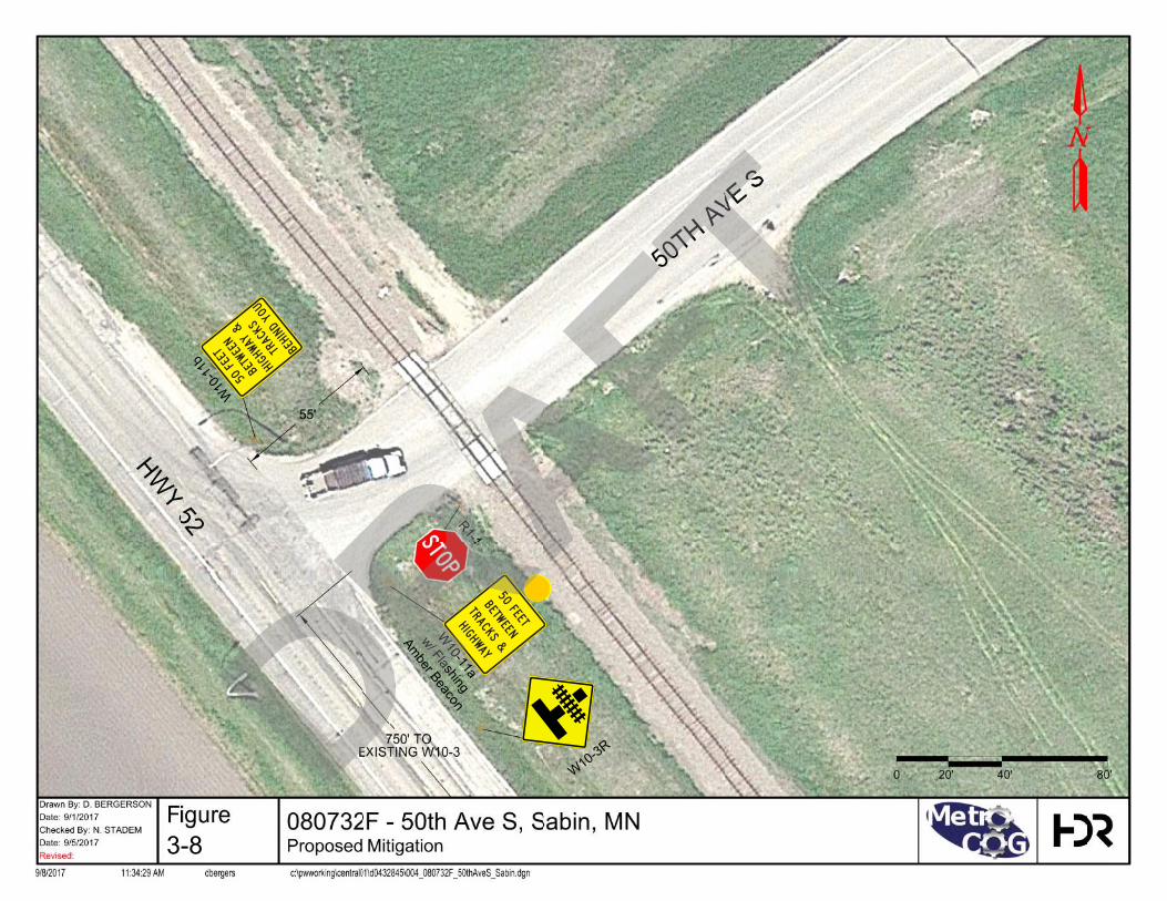
H I G HWAYT RACK S
B ETWE E N50 F E ET
W10-11a
w/ Flashing
Amber Beacon
BEHIND YOU
HIGHWAY
BETWEEN
50 FEET TRACKS
W10
-11b
W10-3R
3-8
DRAFT

Fargo Moorhead Metropolitan Council of Governments Regional Railroad Crossing Safety Study
36 | September 14, 2017
S. Main Street, Dilworth, MN – 062943E
Table 3-15. Crossing Summary – S. Main Street
Existing Warning Device Crossbucks
Railroad BNSF
Trains per Day/Timetable Speed 68 / 79 MPH
AADT/Posted Speed Limit 300 / 30 MPH
First Level Screening Score 93
Second Level Screening Score 133
The existing at-grade crossing is a paved two lane north/south roadway which crosses over the BNSF double track mainline and one yard lead track in the middle of BNSF’s Dilworth Yard. The crossing is located near the middle of the approximately 20,000 foot long yard facility, with the 34th St S overpass located approximately 1 mile to the west and the 70th St at-grade crossing and CR-11 overpass approximately 2 miles to the east. Main St serves a small neighborhood south of the BNSF Yard and provides access to the majority of the town of Dilworth and US Highway 10. The roadway currently sees approximately 300 vehicles per day, traveling at 30 MPH. Further to the south, the frontage on I-94 and growing developments along the east side of Moorhead (around the Horizon Middle School) creates a potential for population growth in the immediate area which may increase vehicular traffic on the roadway. The BNSF double track mainline and yard lead carries approximately 68 trains per day traveling up to 79 MPH, though trains on the yard lead would be traveling at significantly reduced speeds, which can lead to longer crossing blockages as BNSF is switching cars in the yard.
The crossing’s First Level screening score was primarily impacted by the proximity to schools and emergency services, plus its location on the high traffic BNSF double main. The Second Level screening score was influenced by the growth potential south of the BNSF yard and the mixture of mainline rail traffic and intra-yard switching moves over the crossing which has a high potential for crossing delays. The existing warning devices include active gates and flashing light signals, with non-mountable medians installed on both the north and south approach, though the south side median is less than the desired 100’ length.
Proposed Mitigation
As the crossing already has active gates and flashing lights, as well as non-mountable medians; potential safety upgrades which leave the crossing at-grade are limited. An upgrade to a 100’ long median on the south approach may be considered, though the current length is likely due to the existing BNSF yard access. If the median is extended, that access point may be relocated further south, or have limited (right in, right out) access.
Crossing closure may be considered at this location, though the alternative access points crossing the tracks to the west and east, at one and two miles respectively; are at a significant distance to impact local motorists’ traffic patterns. It is also likely that local
DRAFT

Fargo Moorhead Metropolitan Council of Governments Regional Railroad Crossing Safety Study
September 14, 2017 | 37
traffic already funnels to the existing grade separations east and west of Main St due to the existing high volume of train traffic.
Grade separation would be a challenge at this location, with the close proximity to 2nd Ave SW to the north (approximately 200 feet) limiting the ability to place a grade separated structure without impacting the existing street grid north of the crossing. There appears to be adequate room to the south for a structure. The existing structure on 34th St N approximately one mile to the west would likely make a second structure at Main St redundant with current traffic volumes, though future growth may change this consideration. Further, removing the at-grade crossing at this location would greatly benefit BNSF’s potential yard operations, allowing for longer tracks which would not block any vehicular traffic. For these reasons, a grade separation may be a future consideration at this crossing.
Based on the current traffic volumes, and assuming that a crossing closure is not feasible due to the distance to alternative crossing locations for the neighborhood immediately south of the BNSF yard, we would recommend improvements to the existing crossing median and roadway surface as an incremental increase for crossing safety.
Table 3-16. Proposed Mitigation Probable Costs - S. Main Street
Item Unit Unit Cost Quantity Extension
New Curb & Gutter LF $20.00 420 $8,400.00
New PCC Median Pavement SF $9.00 160 $1,440.00
Road Surface Widening (both approaches)
SY $50.00 360 $18,000.00
Subtotal $24,840.00
Contingency LS 30% $8,352.00
Total $36,192.00
DRAFT
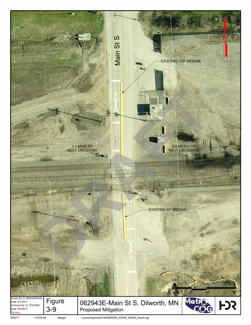
Main St S
EXISTING 100' MEDIAN
EXISTING 60' MEDIAN
NEXT CROSSING
1.1 MILE TO
NEXT CROSSING
2.4 MILES TO
0
Drawn By:
Date:
Date:
Revised:
9/8/2017 11:34:38 AM dbergers c:\pwworking\central01\d0432845\005_062943E_SMainSt_Dilworth.dgn
Checked By:
Figure
20'
9/1/2017
D. BERGERSON
N. STADEM
Proposed Mitigation9/5/2017
3.6.6
062943E-Main St S, Dilworth, MN
80'40'
3-9
DRAFT

Fargo Moorhead Metropolitan Council of Governments Regional Railroad Crossing Safety Study
September 14, 2017 | 39
1st St S., Sabin MN – 080738W
Table 3-17. Crossing Summary – 1st St. S
Existing Warning Device Crossbucks
Railroad OTVR
Trains per Day/Timetable Speed 2 / 40 MPH
AADT/Posted Speed Limit 170 / 30 MPH
First Level Screening Score 73
Second Level Screening Score 128
The existing at-grade crossing on 1st St in Sabin, MN is a two lane roadway crossing the Ottertail Valley mainline, approximately 115’ east of the intersection with CR 52 located near the south side of town. The roadway transitions from a paved local road on the west side of the crossing to a gravel section road (CR-67) to the east. The crossing’s existing warning devices are passive crossbucks.
1st Ave had a relatively low FRA accident prediction score due to low traffic volumes on the roadway and railroad. The First Level screening score was increased due to the skew angle of the crossing and the close proximity of the CR 52 intersections. The crossing also had accident history (with the most recent incident occurring in 2014) which contributed to the FRA accident prediction value. The Second Level screening score was increased due to the poor approaching sight lines in the northeast quadrant of the crossing.
As the current conditions allow for motorists to travel over the crossing without coming to a stop and with no active warning devices to indicate if a train is approaching, adequate approaching sight distances are critical at this location. During the Second Level screening field review, approaching and clearing sight distances were assessed for each crossing based on the existing roadway speed limit and maximum timetable speed of the railroad. At this location, a motorist traveling at 30 MPH would need to see a train traveling at 40 MPH at a distance of 396 feet down the tracks while 220 feet from the crossing. The actual observed approaching sight distance down the tracks in the northeast quadrant was 78 feet, a full 318 feet less than required. The sight distance in this quadrant is obstructed by trees and large vegetation on a private residential lot. Existing public road right-of-way and railroad right-of-way is clear of visual obstructions. DRAFT
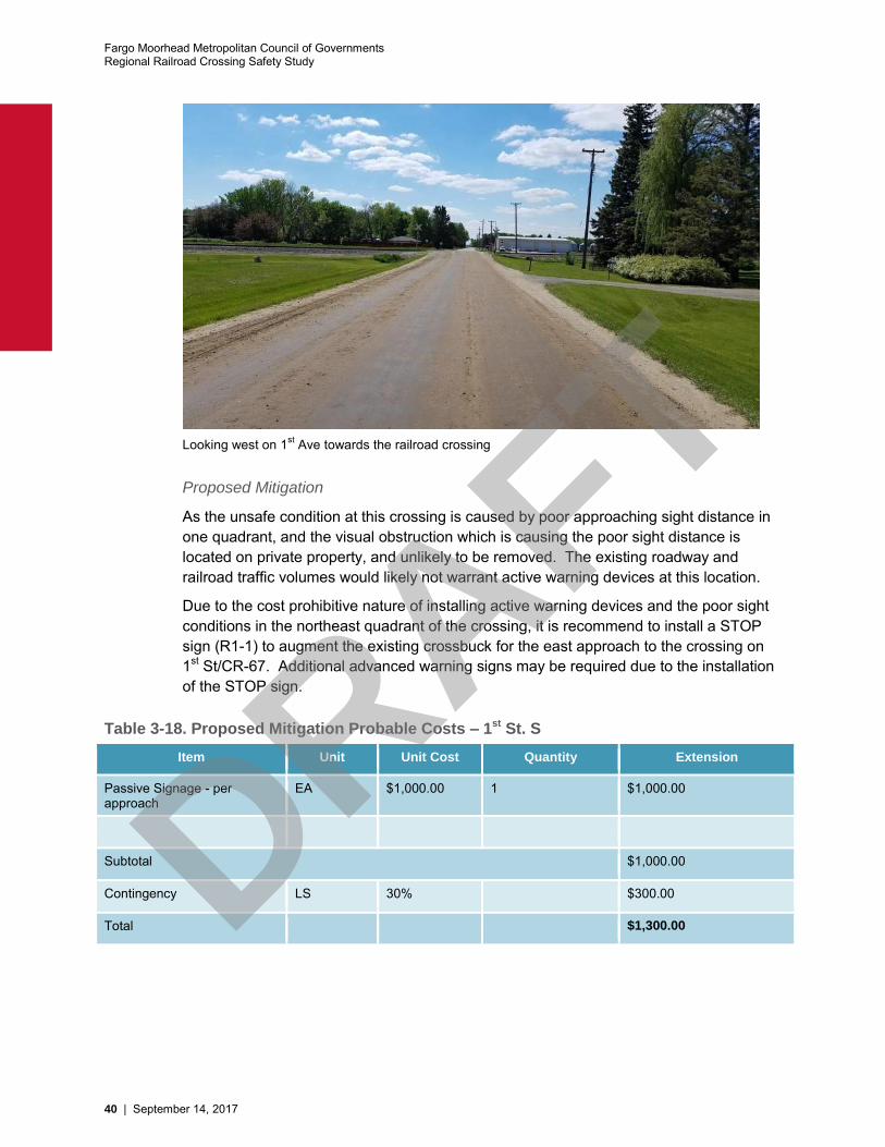
Fargo Moorhead Metropolitan Council of Governments Regional Railroad Crossing Safety Study
40 | September 14, 2017
Looking west on 1st Ave towards the railroad crossing
Proposed Mitigation
As the unsafe condition at this crossing is caused by poor approaching sight distance in one quadrant, and the visual obstruction which is causing the poor sight distance is located on private property, and unlikely to be removed. The existing roadway and railroad traffic volumes would likely not warrant active warning devices at this location.
Due to the cost prohibitive nature of installing active warning devices and the poor sight conditions in the northeast quadrant of the crossing, it is recommend to install a STOP sign (R1-1) to augment the existing crossbuck for the east approach to the crossing on 1st St/CR-67. Additional advanced warning signs may be required due to the installation of the STOP sign.
Table 3-18. Proposed Mitigation Probable Costs – 1st St. S
Item Unit Unit Cost Quantity Extension
Passive Signage - per approach
EA $1,000.00 1 $1,000.00
Subtotal $1,000.00
Contingency LS 30% $300.00
Total $1,300.00
DRAFT

3-10
DRAFT

Fargo Moorhead Metropolitan Council of Governments Regional Railroad Crossing Safety Study
42 | September 14, 2017
Partridge Ave, Glyndon MN – 062909X
Table 3-19. Crossing Summary – Partridge Ave
Existing Warning Device Gates
Railroad BNSF
Trains per Day/Timetable Speed 56 / 75 MPH
AADT/Posted Speed Limit 850 / 30 MPH
First Level Screening Score 118
Second Level Screening Score 128
The existing at-grade crossing at Partridge Ave consists of a paved two lane roadway crossing the BNSF double track mainline approximately 350 feet east of Parke Ave. Partridge Ave connects a portion of the northern half of Glyndon, MN to the neighborhood south of the tracks and provides access to US highway 10 to the north. Partridge Ave ends two blocks south of the crossing at the intersection with 7th St in Glyndon. The roadway crosses the BNSF double track mainline, which sees over 50 trains a day at a maximum time table speed of 75 MPH. In addition to the double track mainline, there is an industry spur located within the limits of the crossing for a total of three tracks crossing the roadway; though the rail traffic volumes were considered low for the industry crossing.
The crossing did not have a particularly high FRA accident prediction score, owning primarily to the relatively low volume of vehicles on the roadway and the presence of active warning devices including flashing light signals and gates. The close proximity to the local high school contributed to Partridge Ave scoring highly in the Frist Level screening; in addition to the proximity of emergency services and adjacent intersections.
Second Level screening results were impacted by the location of the school, which produces a moderate volume of school buses.
Proposed Mitigation
The close proximity to Parke Ave allows for the opportunity to close Partridge Ave to help offset costs associated with safety improvements at Parke; as well as completely eliminating a point of conflict between motorists/pedestrians and train traffic. Partridge serves the same neighborhoods of Glyndon north and south of the tracks; which there close proximities do not allow for any potential benefits of having multiple crossings in the same community such as increased emergency service transit options in case of a train blocking the town. As Parke Ave serves as the primary north/south roadway through Glyndon; with access to both US Highway 10 and the high school; while Partridge Ave ends roughly two blocks south of the crossing, this crossing was considered a more likely candidate for closure than Parke Ave.
If closure is not considered a feasible mitigation for the crossing, upgrades to the existing warning devices may be considered. The existing crossing has active warning devices with flashing light signals and gates. The addition of a non-mountable roadway median or upgrade to a 4-quad gate system would serve to further improve crossing safety by limiting the ability of motorists to drive around a downed gate arm either inadvertently or
DRAFT
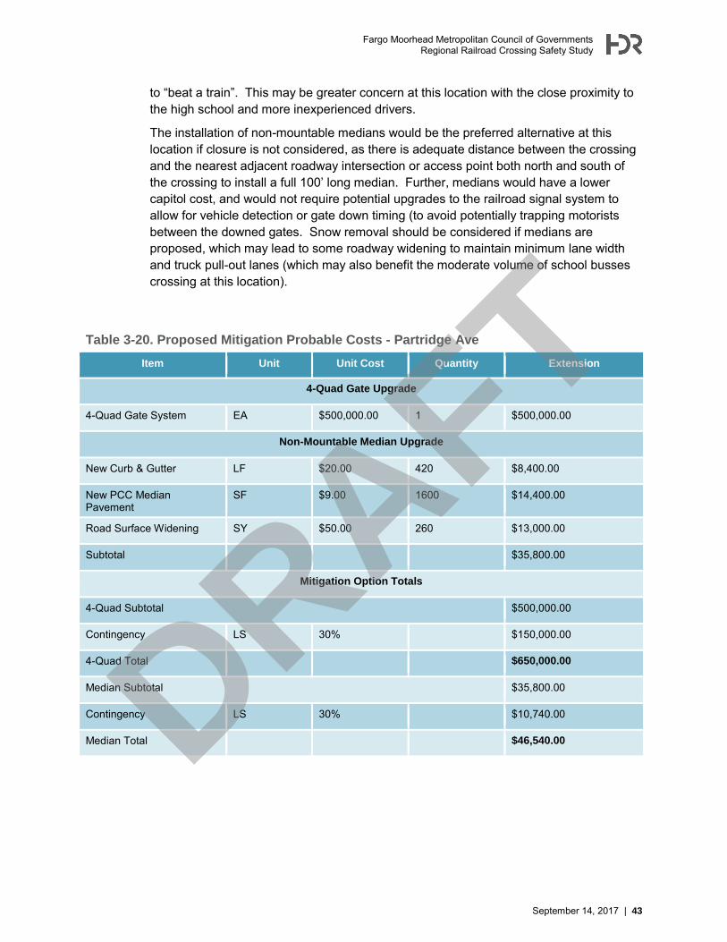
Fargo Moorhead Metropolitan Council of Governments Regional Railroad Crossing Safety Study
September 14, 2017 | 43
to “beat a train”. This may be greater concern at this location with the close proximity to the high school and more inexperienced drivers.
The installation of non-mountable medians would be the preferred alternative at this location if closure is not considered, as there is adequate distance between the crossing and the nearest adjacent roadway intersection or access point both north and south of the crossing to install a full 100’ long median. Further, medians would have a lower capitol cost, and would not require potential upgrades to the railroad signal system to allow for vehicle detection or gate down timing (to avoid potentially trapping motorists between the downed gates. Snow removal should be considered if medians are proposed, which may lead to some roadway widening to maintain minimum lane width and truck pull-out lanes (which may also benefit the moderate volume of school busses crossing at this location).
Table 3-20. Proposed Mitigation Probable Costs - Partridge Ave
Item Unit Unit Cost Quantity Extension
4-Quad Gate Upgrade
4-Quad Gate System EA $500,000.00 1 $500,000.00
Non-Mountable Median Upgrade
New Curb & Gutter LF $20.00 420 $8,400.00
New PCC Median Pavement
SF $9.00 1600 $14,400.00
Road Surface Widening SY $50.00 260 $13,000.00
Subtotal $35,800.00
Mitigation Option Totals
4-Quad Subtotal $500,000.00
Contingency LS 30% $150,000.00
4-Quad Total $650,000.00
Median Subtotal $35,800.00
Contingency LS 30% $10,740.00
Median Total $46,540.00
DRAFT
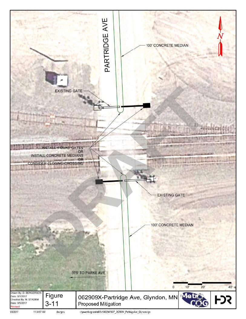
3-11
DRAFT
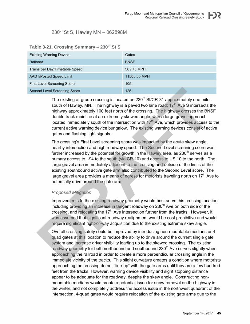
Fargo Moorhead Metropolitan Council of Governments Regional Railroad Crossing Safety Study
September 14, 2017 | 45
230th St S, Hawley MN – 062898M
Table 3-21. Crossing Summary – 230th St S
Existing Warning Device Gates
Railroad BNSF
Trains per Day/Timetable Speed 56 / 75 MPH
AADT/Posted Speed Limit 1150 / 55 MPH
First Level Screening Score 105
Second Level Screening Score 125
The existing at-grade crossing is located on 230th St/CR-31 approximately one mile south of Hawley, MN. The highway is a paved two lane road; 17th Ave S intersects the highway approximately 100 feet north of the crossing. The highway crosses the BNSF double track mainline at an extremely skewed angle, with a large gravel approach located immediately south of the intersection with 17th Ave, which provides access to the current active warning device bungalow. The existing warning devices consist of active gates and flashing light signals.
The crossing’s First Level screening score was impacted by the acute skew angle, nearby intersection and high roadway speed. The Second Level screening score was further increased by the potential for growth in the Hawley area, as 230th serves as a primary access to I-94 to the south (via CR-10) and access to US 10 to the north. The large gravel area immediately adjacent to the crossing and outside of the limits of the existing southbound active gate arm also contributed to the Second Level score. The large gravel area provides a means of egress for motorists traveling north on 17th Ave to potentially drive around the gate arm.
Proposed Mitigation
Improvements to the existing roadway geometry would best serve this crossing location, including providing an increase in tangent roadway on 230th Ave on both side of the crossing, and relocating the 17th Ave intersection further from the tracks. However, it was assumed that significant roadway realignment would be cost prohibitive and would require significant right-of-way acquisition due to the existing extreme skew angle.
Overall crossing safety could be improved by introducing non-mountable medians or 4-quad gates at this location to reduce the ability to drive around the current single gate system and increase driver visibility leading up to the skewed crossing. The existing roadway geometry for both northbound and southbound 230th Ave curves slightly when approaching the railroad in order to create a more perpendicular crossing angle in the immediate vicinity of the tracks. This slight curvature creates a condition where motorists approaching the crossing do not “line-up” with the gate arms until they are a few hundred feet from the tracks. However, warning device visibility and sight stopping distance appear to be adequate for the roadway, despite the skew angle. Constructing non-mountable medians would create a potential issue for snow removal on the highway in the winter, and not completely address the access issue in the northwest quadrant of the intersection. 4-quad gates would require relocation of the existing gate arms due to the
DRAFT

Fargo Moorhead Metropolitan Council of Governments Regional Railroad Crossing Safety Study
46 | September 14, 2017
crossing skew in order to “square-up” the gates, which would increase the potential cost of installation, in addition to any upgrades in of the existing active warning device equipment.
An intermediate step to increase warning device visibility without the increase costs and circuitry upgrades of a 4-quad gate system would be the installation of supplemental flashing light signals, either as a cantilevered signal or secondary signal mast on the opposite side of the roadway. The installation of supplemental flashing light signals should not affect the existing crossing gate timing or circuitry.
In either case, installation of a barrier is recommended to eliminate the ability for motorists to drive around the existing or proposed gate arm location in the large gravel area on the north approach to the crossing at the intersection with 17th Ave. This would be a low cost solution that would provide flexibility for temporary conditions (such as removal for maintenance) while further protecting the crossing. The barriers may limit access for BNSF signal crews to the active warning device bungalow off of 230th Ave, though access would still be maintained off of 17th Ave.
Table 3-22. Proposed Mitigation Probable Costs - 230th St S
Item Unit Unit Cost Quantity Extension
4-Quad Gate Upgrade
4-Quad Gate System EA $500,000.00 1 $500,000.00
Barrier/W-beam Guiderail LF $30.00 60 $1,800.00
Subtotal $501,800.00
Cantilever FLS Upgrade
Cantilever FLS EA $100,000.00 1 $100,000.00
Barrier/W-beam Guiderail LF $30.00 60 $1,800.00
Subtotal $101,800.00
Mitigation Option Totals
4-Quad Subtotal $501,800.00
Contingency LS 30% $150,540.00
4-Quad Total $652,340.00
Cantilever Subtotal $101,800.00
Contingency LS 30% $30,540.00
Cantilever Total $132,340.00
DRAFT
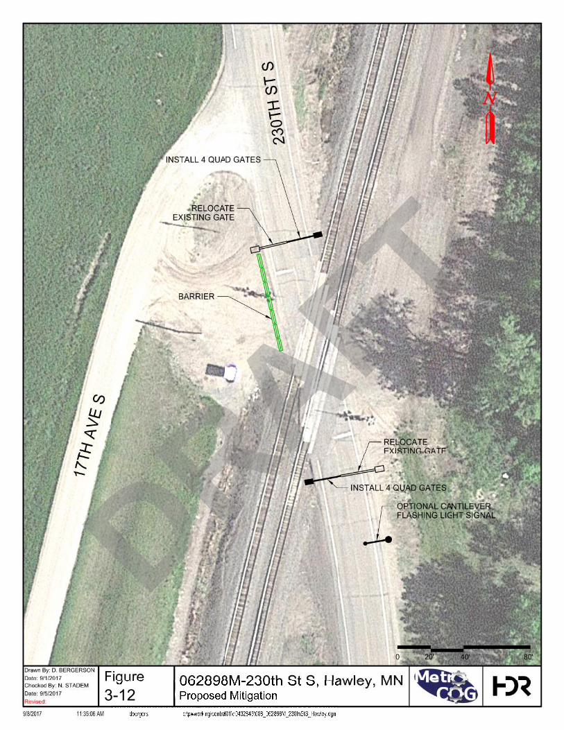
3-12
DRAFT

Fargo Moorhead Metropolitan Council of Governments Regional Railroad Crossing Safety Study
48 | September 14, 2017
CR-17, Fargo ND – 092950W
Table 3-23. Crossing Summary – CR-17
Existing Warning Device Gates
Railroad BNSF
Trains per Day/Timetable Speed 38 / 40 MPH
AADT/Posted Speed Limit 1970 / 55 MPH
First Level Screening Score 65
Second Level Screening Score 115
The existing at-grade crossing on CR-17 consist of a two lane paved north/south highway crossing the BNSF Proposer Subdivision mainline. CR-17 intersects with 32nd Ave both north and south of the crossing, with the west approach being located south of the crossing on CR-17, and the north approach for 32nd Ave being located approximately 50 feet north of the crossing on CR-17. This offset intersection is due to a realignment of 32nd Ave which serves to consolidate both the CR-17 and 32nd Ave crossings to a single location on CR-17. The highway provides north/south access from West Fargo to Harwood, ND with agricultural and residential land use nearby. The highway currently sees 1970 vehicles per day traveling at 55 MPH. The BNSF Proposer mainline sees approximately 38 trains per day traveling at a maximum timetable speed of 40 MPH.
The First Level screening results were impacted by the close proximity of the 32nd Ave intersections and higher roadway speed. There is a recent accident history at the crossing, with an incident occurring there in 2011. The Second Level screening results were further influenced by the 32nd Ave intersection located north of the crossing, which creates a very tight turning radius for westbound vehicles traveling on 32nd Ave to southbound CR-17. The realignment of 32nd Ave created a condition where the turning radius for the intersection runs directly into the crossing surface. Further, the single gate arms for southbound CR-17 are located on the west side of the crossing, leaving he left turn movement from 32nd Ave to CR-17 completely unprotected by gates. A similar condition is present at the south approach, however, due to the larger distance from the crossing to the intersection (approximately 80 feet vs. 50 feet) the issue is less pronounced. A relatively high number of school bus crossings also contributed to the Second Level screening score.
Proposed Mitigation
Alternatives were considered to eliminate the unprotected left turns from westbound 32nd Ave to southbound CR-17. These included both the addition of warning devices at the crossing and a further realignment of the roadway to increase the offset from the intersection of CR-17 to the crossing.
Sidelights (FLS) are present on the existing active warning device mast on the north approach facing east down 32nd Ave, which provides warning to westbound motorists if a train is approaching the crossing. This is particular important for westbound trains, as they would be approaching a westbound motorist from behind and would be difficult to see in advance of the crossing. However, even with the sidelight present, westbound
DRAFT

Fargo Moorhead Metropolitan Council of Governments Regional Railroad Crossing Safety Study
September 14, 2017 | 49
motorists are still able to easily drive around a downed gate arm due to the roadway geometry. Non-mountable medians are not feasible at this location due to the close proximity to the intersection (though they may be an option if the roadway was re-aligned). An upgrade to a 4-quad gate system would help to reduce the ability for motorists to drive around a downed gate, however the skew of the crossing would likely still require a barrier to block westbound motorists on 32nd Ave from driving around the additional gate mast.
Realignment of the roadway would increase the separation between the crossing and the intersection and allow westbound traffic from 32nd to CR-17 to enter the highway well north of the active warning devices, both providing increased visibility of the crossing, and allowing for the single gate arm to function as it is intended. However, roadway realignment would likely have a higher capital cost than updating the warning devices, while also requiring the acquisition of additional right-of-way. Due to the potential costs associated with both the installation and maintenance of a 4-quad gate system, which would still likely require additional traffic barriers to restrict left turn movements from 32nd Ave to CR 17; roadway realignment would be recommended at this location to create further separation from the crossing to the roadway intersection.
Table 3-24. Proposed Mitigation Probable Costs
Item Unit Unit Cost Quantity Extension
4-Quad Gate Upgrade
4-Quad Gate System EA $500,000.00 1 $500,000.00
Barrier/W-beam Guiderail LF $30.00 25 $750.00
Subtotal $500,750.00
Roadway Re-alignment
Construct new gravel section road
LF $150.00 600 $90,000.00
ROW Acquisition LS $50,000.00 1 $50,000.00
Subtotal $140,000.00
Mitigation Option Totals
4-Quad Subtotal $500,750.00
Contingency LS 30% $150,225.00
4-Quad Total $650,975.00
Re-alignment Subtotal $140,000.00
Contingency LS 30% $42,000.00
Re-alignment Total $182,000.00
DRAFT

CO
UN
TY R
OA
D 1
7
32ND AVE NW
32ND AVE NW
INSTALL 4 QUAD GATES
OF 32ND AVE NW
CONSIDER REALIGNMENT
EXISTING GATE
EXISTING GATE
BARRIER
0
Drawn By:
Date:
Date:
Revised:
9/8/2017 11:35:18 AM dbergers c:\pwworking\central01\d0432845\009_092950W_CR17_Fargo.dgn
Checked By:
Figure
20'
092950W - County Road 17, Fargo, ND9/1/2017
D. BERGERSON
N. STADEM
Proposed Mitigation9/5/2017
3.6.10
80'40'
3-13
DRAFT
Fargo Moorhead Metropolitan Council of Governments Regional Railroad Crossing Safety Study
September 14, 2017 | 51
4 Trends and Issues 4.1 Hazardous Material Routes
Within the last ten years there has been a significant increase in the transport by rail of crude oil and ethanol in the Northern Plains states. Much of this rail traffic moves in “unit trains,” trains carrying a single commodity (such as crude oil or ethanol) moving intact between origin and destination without intermediate switching or combining with other freight commodities. These trains are referred to as High Hazard Flammable Trains (HHFTs). Derailments and collisions of HHFTs has increased in parallel with the increase in frequency of operation of this type of train. Several major HHFT derailments and collisions have occurred in the U.S., including in the Northern Plains states, which in some cases have included large releases of crude oil and ethanol and subsequent fires. To date in the U.S., one fatality has been attributed to an HHFT derailment or collision, and none to crude oil; however, a major derailment of a crude oil unit train in Canada resulted in multiple fatalities.
In response to the increase in HHFT accidents, the FRA, the Pipeline and Hazardous Materials Safety Administration (PHMSA), and U.S. freight railroads individually and collectively through the Association of American Railroads (AAR) made numerous changes in railroad safety regulations and safety designed to reduce the risk of HHFT derailments and collisions, reduce the risk of impact breach and explosion of tank cars carrying flammable liquids, and improve the response and recovery capability of railroads, and state and local first responders.
Specific to the Fargo-Moorhead area, crude oil shipments by rail from the Bakken Field, many of which pass through Fargo-Moorhead, peaked in late 2014 at approximately 850,000 barrels per day, or approximately 11 HHFT trains daily, and currently is between 2 and 4 HFFT trains per day. This reduction is due to changing market conditions for crude oil. Crude oil transportation by rail is market dependent and future volumes are not predictable with any accuracy.
U.S. railroads are economically regulated by the federal government through the U.S. Surface Transportation Board as common carriers and as such, they must transport any commodity legal for transport that is tendered to them, provided, however, that railroads within a broad limit can establish commercial terms and conditions for transportation services that may render transportation by rail uneconomic for shippers. Economic regulation of goods transported interstate is exclusive to the federal government and states and localities are prohibited by law from enforcing additional regulations. Similarly, the safety of U.S. railroads is regulated by the federal government through the FRA for railroad operations and track and infrastructure safety, and for tank cars by PHMSA. States and localities may enact certain safety regulations provided that they enhance the federal mission and do not inhibit interstate commerce. In practice, state and local regulations are generally limited to being an extension of FRA regulations and are enforced in cooperation with the FRA.
States and localities have enacted effective methods for reducing risk of HHFT accidents, and improving recovery and response. These include:
DRAFT

Fargo Moorhead Metropolitan Council of Governments Regional Railroad Crossing Safety Study
52 | September 14, 2017
Developing cooperative infrastructure improvement programs with railroads to improve track, bridges, and grade crossings, to reduce risk of track- or bridge-caused accidents, grade-crossing collisions with motor vehicles, and programs to install defect detection devices or track and bridge visual and electronic inspections, for earlier detection and repair of defects in track, bridges, and tank cars that could lead to accidents.
Cooperative programs with railroads to improve safety awareness of motorists at grade crossings.
Cooperative programs with shippers of crude oil and ethanol to improve tank car inspection for defects that could lead to derailments.
Cooperative programs with railroads, first responders, and state agencies to improve communication, training, exercises, and response and recovery methods.
Grade-crossing signal improvement programs and grade-crossing separation and closure programs.
Recommendations
Below is a list of recommended action items for the Metro COG to consider in addressing local emergency preparedness in the event of a hazardous material incident on a rail line within the COG area,
Local Emergency Planning Committees (LEPC) should actively seek attendance/membership by railroads and shippers.
Consider developing a HHFT incident response planning committee or Hazmat Task Force to develop guidance and work with LEPCs and emergency management coordinators to develop incident specific response plans.
Identify ways to improve HHFT incident training, preparedness, and response capabilities for emergency managers and responders.
Consider conducting a Risk and Vulnerability analysis to identify and map, critical infrastructure and vulnerable populations located within 0.5 mile of all railroad main tracks, HHFT routes, and major yards to determine areas of highest risk.
Prioritize preparedness, response, or mitigation actions for higher risk areas to reduce the risk and improve response efforts.
Develop and maintain a response capabilities list/database of all the railroads response capabilities including: equipment caches, location, team training and certification levels, and procedures for activation, deployment, and mobilization.
Develop and maintain list/database of private contractors operating in the state/region to include capabilities, location, certifications, training, and equipment available to local emergency managers, first responders, and incident responsible parties.
Identify how railroads are contacted and coordinated with during an incident and share that information with local emergency managers and responders.
DRAFT
Fargo Moorhead Metropolitan Council of Governments Regional Railroad Crossing Safety Study
September 14, 2017 | 53
4.2 Quiet Zones A locomotive horn quiet zone is a zone or linear corridor upon which the routine sounding of locomotive horns at crossings is prohibited. The FRA has determined that the audible sounding of locomotive horns as trains approach an at-grade crossing are a warning device, similar to signs, flashers, gates and bells that combined provide warning to motorists and pedestrians. Communities desiring to silence those horns to lessen what some consider being undesirable noise can establish Quiet Zones. The FRA created a rule and provides guidance to communities that allow for the silencing of those horns under normal operations provided that the corridor, or zone, meets certain requirements.
Quiet zones can be established in a number of ways, although each zone must meet a number of minimum requirements. Those requirements are established in Section 222.35 of the Federal Register, Volume 71, Number 159, dated Thursday August 17, 2006:
Zones must be greater than or equal to one-half mile in length.
Zones must include active warning devices, consisting of flashing lights, automatic gates and constant warning time circuitry at each crossing. If reasonable and practical, each crossing must also contain power-out indicators.
Zones must include advance static warning signs on each approach to each crossing. Specifically, these signs shall notify the motorist that train horns are not sounded at the crossing. These signs shall conform to the Manual on Uniform Traffic Control Devices (MUTCD).
Zones must be equipped with one or more automatic bells.
All private crossings in the zone must be evaluated by a diagnostic team. Each private crossing must be equipped or treated as recommended by the diagnostic team.
Sounding of horns at pedestrian crossings is not obligatory unless State Law requires it.
Each crossing in the zone must be in compliance with the requirements of the MUTCD.
In addition to these minimum requirements, the zone must show that the relative safety of the crossing is not compromised with the silencing of train horns. This is shown through one of three methods.
1. Each crossing within the zone exhibits one or more Supplemental Safety Measures (SSM), defined in the August 17, 2006 Federal Register as “a safety system or procedure…that is determined by the Associate Administrator to be an effective substitute for the locomotive horn in the prevention of highway-rail casualties”.
2. The zone’s Quiet Zone Risk Index (QZRI) falls below the Nationwide Significant Risk Threshold (NSRT) with or without the use of additional safety measures at one or more crossings.
a. QZRI is defined in the Federal Register as “the measure of risk to the motoring public which reflects the Crossing Corridor Risk Index for a quiet zone, after an
DRAFT

Fargo Moorhead Metropolitan Council of Governments Regional Railroad Crossing Safety Study
54 | September 14, 2017
adjustment ti account for increased risk due to lack of locomotive horn use at the crossings within the zone and reduced risk due to implementation, if any, of SSM’s and ASM’s with the quiet zone”.
b. NSRT is defined in the Federal Register as “a number reflecting a measure of risk, calculated on a nationwide basis, which reflects the average level or risk to the motoring public at public highway-rail grade crossings equipped with flashing lights and gates at which locomotive horns are sounded”.
3. Safety measures are provided at one or more crossings, which brings the QZRI below the Risk Index with Horns.
According to the FRA database, there are 24 crossings within quiet zones in the FM Metro COG area, as shown in Figure 4-1. Fargo-Moorhead Quiet Zones.
DRAFT

DRAFT

Fargo Moorhead Metropolitan Council of Governments Regional Railroad Crossing Safety Study
56 | September 14, 2017
It should be noted that the establishment of quiet zones does not entirely eliminate the sounding of locomotive horns. Locomotive engineers will continue to sound the horn when he or she has reason to believe that they are appropriate or required by operating rules. Examples of this would include pedestrians or trespassers near the track outside of the crossing areas, pedestrians at the crossing who appear to be distracted, motorists fouling the track or ignoring warning devices, and to alert railroad workers alongside of the track.
Recommendations
Although the measures used to establish a quiet zone are primarily driven by the desire to silence the horns, these measures serve to enhance the visibility of the warning devices to the traveling public and tend to reduce the risky behaviors that some motorists take by driving around gates to avoid what is anticipated to be a lengthy wait while stopped for a passing train. It is our recommendation that whenever crossings are improved or warning devices enhanced at crossings within the study area, they should be done in such a way to qualify for future establishment of a quiet zone. Additionally, this treatment will enhance motorist awareness of crossing safety and result in a “safer” crossing.
4.3 ENS Signs Following several high profile crossing incidents and collisions in which trucks or equipment became stuck or disabled at a crossing and responders, including emergency responders, failed to notify the railroad of the situation, the FRA created a rule that requires operating railroads to have an Emergency Notification System (ENS) in place, including signage at each crossing. The purpose of the ENS sign is to provide the public with critical emergency contact information in the event of an emergency. These signs are posted at every highway-rail grade crossing. The information contained on the ENS sign enables the public to reach the railroad responsible for the crossing and to identify the specific crossing in the event of an emergency.
Each at-grade crossing within the FMCOG study area is required to have such a sign prominently displayed. Those requirements are established in Section 234.307 of the Federal Register, dated Thursday June 12, 2012:
Emergency Notification System means a system in place by which a railroad receives, processes, and responds to telephonic reports of an unsafe condition at a highway-rail or pathway grade crossing. An Emergency Notification System includes the following components:
1. The signs, placed and maintained at the grade crossings that display the information necessary for the public to report an unsafe condition at the grade crossing to the dispatching railroad by telephone;
2. The method that the railroad uses to receive and process a telephone call reporting the unsafe condition;
3. The remedial actions that a railroad takes to address the report of the unsafe condition; and
DRAFT
Fargo Moorhead Metropolitan Council of Governments Regional Railroad Crossing Safety Study
September 14, 2017 | 57
4. The recordkeeping conducted by a railroad in response to the report of the unsafe condition at the grade crossing.
INFORMATION TO BE DISPLAYED
Each ENS sign located at each highway-rail or pathway grade crossing as required by §234.311 shall display the necessary information for the dispatching railroad to receive reports of unsafe conditions at the crossing. This information, at a minimum, includes the following:
The toll-free telephone number
An explanation of the purpose of the sign (e.g., “Report emergency or problem to __”); and
The U.S. DOT National Crossing Inventory number assigned to that crossing.
SIGN SIZE AND OTHER PHYSICAL FEATURES.
Each ENS sign shall:
Measure at least 12 inches wide by 9 inches high;
Be retroreflective;
Have legible text (i.e., letters and numerals) with a minimum character height of 1 inch for the information required in paragraph (b) of this section; and
Have white text set on a blue background with a white border, except that the U.S. DOT National Crossing Inventory number may be black text set on a white rectangular background.
Recommendations
Our recommendations are that the existence and purpose of these signs be communicated to those that would primarily benefit. This could include general safety awareness campaigns and more targeted information provided to those that are likely to arrive at crossings where prompt contact with the operating railroad’s train dispatchers is necessary. It is important for those that are responsible for emergency response and establishing a safety perimeter around an incident to know that the zone will be free from passing trains. These responders would include emergency medical responders, tow truck operators, bus drivers, law enforcement, and city, county and state roadway workers. It is important for them to know how to efficiently and quickly contact the railroad when needed.
4.4 Trespassers and Pedestrians Nationwide In 2016 there were 787 fatalities in the entire rail industry. Sixty-two percent of those fatalities were trains striking trespassers, 34 percent were either trains striking vehicles or vehicles running into trains at at-grade crossings, and the remaining 6 percent were rail employees, passengers on trains, or others not included above. Historically funding and promoting of rail safety has been focused on reducing accidents between vehicles and trains and this effort has been quite successful. Crossing accidents (of which fatalities is a subset) have decreased by 23 percent over the last 10
DRAFT
Fargo Moorhead Metropolitan Council of Governments Regional Railroad Crossing Safety Study
58 | September 14, 2017
years while trespass accidents have risen. The current focus of the FRA and rail safety advocates such as Operation Lifesaver are shifting more towards addressing and hopefully reducing this upward trend in trespasser safety. Note that trespass fatalities do not include pedestrians struck at pedestrian crossings but alongside of the tracks on railroad rights of way. The distinction between the two is that Pedestrians are those at controlled locations where they belong and Trespassers who are on railroad rights of way where they should not be.
Recommendations
Pedestrian safety can be improved with enhanced signage, lights, gates and bells which can be more easily seen and heard by those on foot or bicycle. Another approach is to physically direct and control pedestrian movement as they cross the tracks. This can be done with “Z” fencing which forces a pedestrian to dismount a bicycle and/or requires them to focus and pay attention as they travel thru the “Z”. The purpose of both of these approaches is the same; provide enhanced visual and audio warning devices, clear visibility of the track zone, and force those who are not paying attention to focus on crossing the tracks safely. Crossing and sidewalk improvements where pedestrians are anticipated should be an integral part of planning those improvements.
Trespasser safety is more difficult to control and is primarily a function of identifying problematic areas within the Metro COG area and then educating the trespassers individually or targeting student or other demographic groups for education. Law enforcement should include these areas on their normal patrols and stop, talk to, and address the safety concerns with observed trespassers. We also recommend establishing a dialog with the local railroad safety officers and public coordinators who will appreciate the effort and willingly cooperate with you to jointly address this issue.
4.5 Signal Timing Main Avenue and Center Avenue (also known as Trunk Highway 10) are east-west arterials through the Moorhead, MN downtown area with the BNSF track located between the two streets. The downtown includes five streets that connect Main Avenue and Center Avenue, each with an at-grade crossing at the BNSF track. The streets that cross the BNSF tracks are:
4th Street South
5th Street South
8th Street South
11th Street South
14th Street South
Between 4th Street S and 14th Street S, the volumes along Center Avenue range from 7100 to 9600 vehicles per day (vpd) while Main Avenue has daily volumes that range from 9500 to 16,600 vpd. Volumes of the streets crossing the BNSF track are 1400 to 3900 vpd, except for 8th Street S with a reported 10,000 vpd crossing the tracks.
Along Main Avenue and Center Avenue, the intersections with the streets crossing the BNSF tracks are all signalized with a pretimed preemption plan that is called when a train
DRAFT
Fargo Moorhead Metropolitan Council of Governments Regional Railroad Crossing Safety Study
September 14, 2017 | 59
travels through the downtown. The common approach to operating traffic signals with railroad preemption is summarized by MnDOT in their 2015 Traffic Engineering Manual:
If a signalized intersection is near a railroad crossing, the traffic control signals may have a preemption system connected with the railway approach signal system that allows vehicles to safely clear the railroad tracks, and modifies the operation of the signal to allow traffic movements that do not conflict with the train while it is present. (SOURCE: 2015 TRAFFIC ENGINEERING MANUAL. MINNESOTA DEPARTMENT OF TRANSPORTATION, CHAPTER 9 – TRAFFIC SIGNALS, LAST UPDATE APRIL 2017.)
Through special permission granted by MnDOT in 2008 (see Appendix F – City of Moorhead Preemption Documentation), the railroad preemption in downtown Moorhead allows all movements at the intersections, including movements towards the rail grade crossing. The request was sponsored by the business leaders that are located between the railroad tracks and Main Avenue or Center Avenue. Without the special operation of the railroad preemption, the business leaders’ concerns were that customers would not be able to reach their access when a train is traveling through the area.
While operating the signals in this manner, the City staff observed that the queue from the railroad crossing will extend into the intersection. The queue typically blocks only a single lane, but longer vehicles have been known to block multiple lanes. While City staff are not aware of any crashes that resulted from queues into the intersection, the behavior presents a greater potential for a crash. Furthermore, stopped vehicles also block the crosswalk at the signals which can create difficulties for pedestrians crossing the intersection.
Recommendations
Two countermeasures have been identified for the City as potential solutions to the observed behavior. The treatments can be used together or separately. The suggestions include:
Because the queues extending into the intersection are most commonly observed during the peak period, an option is to operate the traffic signals with a different preemption plan during the peak period. In order to operate a signal with different time-of-day railroad preemptions, updated signal controllers or update to the controller software will be required. This change to the signal timing is anticipated to have minimal impact to businesses since most business located between Main Avenue and Center Avenue also have access directly to either Main or Center Avenue.
Do Not Block Intersection markings with appropriate signing can be used to delineate the area vehicles should not stop. The treatment relies on drivers’ voluntary compliance with the markings; therefore, it is not effective in all instances.
DRAFT

Fargo Moorhead Metropolitan Council of Governments Regional Railroad Crossing Safety Study
60 | September 14, 2017
5 Economic Considerations The funding opportunities listed in this report are those that are found to be most relevant for the scope of at-grade crossing safety within the FM Metro COG area:
State Funds and Federal Funds Administered by Minnesota
State Funds and Federal Funds Administered by North Dakota
Nationally Significant Freight and Highway Project (FASTLANE)
Infrastructure for Rebuilding America (INFRA)
Transportation Investment Generating Economic Recovery (TIGER)
Transportation Infrastructure Finance and Innovation Act (TIFIA)
Railroad Rehabilitation and Improvement Financing (RRIF)
BNSF Crossing Closure
This report summarizes the project description, eligibility requirements, evaluation criteria, and application process for the listed programs.
5.1 State Funds and Federal-Source Funds Administered by the State - Minnesota MnDOT administers and manages the state railroad-highway grade crossings improvement program. The FRA maintains an inventory of public crossing. However, MnDOT is expected to provide updates to the information about the crossings and conduct regular reviews of crossings to identify safety concerns and cost-effective mitigation measures that could be implemented within the budgetary allocations. The program is financed primarily through federal aid funds channeled to state agencies (including Minnesota) as well as state funds which may be coming from the general revenues, bond issues, special tax assessments, and other sources.
5.1.1 Section 130 Program (Title 23 of United States Code (USC) Section 130) Title 23 of USC Section 130 provides funding to states annually for the elimination of hazards at highway-railway crossings. The funding is an annual set-aside for railway-highway crossing improvements under 23 USC 130(e). The funds are set-aside from the Highway Safety Improvement Program (HSIP) apportionment. The total annual amount of funding amounts to about $6 million and is projected to increase to about $6.6 million by 2020.1
Section 103 Grade Crossing Safety Program provides federal grants through the Fixing America’s Surface Transportation Act (FAST Act) for the elimination of hazards at
1 FHWA, spreadsheet summary of apportioned funds by state https://safety.fhwa.dot.gov/hsip/xings/.
DRAFT

Fargo Moorhead Metropolitan Council of Governments Regional Railroad Crossing Safety Study
September 14, 2017 | 61
railway-highway crossings.2 The funds are set-aside from the Highway Safety Improvement Program (HSIP) apportionment. The Section 130 program funds are eligible for projects at all public crossings including roadways, bike trails and pedestrian paths. Half of a state's apportionment is dedicated for the installation of protective devices at crossings (which are covered at 90% by the funds). The remainder of the funds apportionment can be used for any hazard elimination project, including protective devices.3 Also, up to 2 percent of the Section 130 funding may be used for compilation and analysis of data to support the reporting requirements.
The following types of projects are eligible for funding under this program:4
Various types of signals and signal upgrades;
Crossing closures and consolidations;
Improving sight conditions by removal of visual obstructions, and
Improving roadway geometrics and/or grades.
Grade crossing surface improvements, or surface improvements on approach roads are not eligible for funding under this program; it is expected that the local authorities would provide funding for this aspect of the improvements.
Specific candidate crossings for improvements are identified in a number of ways including
Project solicitation from local road authorities and railroads as part of the annual State Transportation Improvement Program (STIP) development process.
Requests from local authorities or railways.
Department’s staff own knowledge of various crossings and their issues.
Identified crossings are prioritized and entered in a queue of projects. HDR understands that as of Summer 2017, funds have been committed until 2021.5 Solicitation letters will likely be sent to local road authorities and government agencies this fall for funding requests for projects planned in 2021 and beyond. Projects funded through this program will have a 90-10 split, with 10% of the funding expected to come from the project sponsor (typically, the local road authority or government agency). Successful projects tend to fall under the following categories:
• Upgrade passive warning devices to active/gates
• Crossings with high roadway or train traffic volumes
• Crossings exhibiting a growth in roadway or train volumes
• Crossings with multiple high risk factors present 2 http://www.dot.state.mn.us/congressional/d4/freight.html 3 https://safety.fhwa.dot.gov/hsip/xings/ 4 Minnesota Department of Transportation, Office of Freight and Commercial Vehicle Operations, Rail Administration, “Railroad–Highway Grade Crossing Safety Improvement Program Project Development Process”; http://www.dot.state.mn.us/ofrw/PDF/projectdevelopmentprocess.pdf. 5 Based on communications with MnDOT.
DRAFT
Fargo Moorhead Metropolitan Council of Governments Regional Railroad Crossing Safety Study
62 | September 14, 2017
5.1.2 Grade Crossing Safety Account Program A Minnesota Grade Crossing Safety Account (Minnesota Statutes Section 219.1651) is created in the special revenue fund, consisting of money credited to the account by law. Money in the account is appropriated to the commissioner of transportation for rail-highway grade crossing safety projects on public streets and highways, including engineering costs.6
The state Grade Crossing Safety Account Program provides state funding for smaller projects to enhance safety at highway-rail grade crossings. Projects funded through this program typically have total capital costs below $100,000, and demonstrate noticeable safety improvements through “spot” upgrades. Projects include circuitry upgrades, minor roadway geometric changes, vegetation removal, and LED light replacement.7
MnDOT Districts 1 & 4 (which include the Study area) typically have $250,000 per year to distribute for these projects. Inquires should be made to the MnDOT District Office or District Project Manager at the Office of Freight and Commercial Vehicles.
5.1.3 Antiquated Equipment Replacement Program The Minnesota state Antiquated Equipment Replacement Program provides state funding to replace obsolete warning and signal systems at selected grade crossings. This program is a supplement to the federal set-aside which is not sufficient to cover all grade crossings safety needs in the state. Funding is provided from state general obligation bonds. Over the fiscal years 2010-2015, the Minnesota Legislature appropriated annually $2 to $5 million of general obligation bonds for this program. For fiscal year 2017, the appropriation amounted to $1 million. 8
In addition to this funding, the program receives $1,000,000 annually from the Minnesota Grade Crossing Safety Account in the special revenue fund. This account is used for smaller safety improvements at crossings such as circuitry upgrades.
5.1.4 Other Funding Other funding from special programs and initiatives may be available from time to time. For example, in March 2015 governor Dayton proposed a Railway Safety Improvements investment package of about $330 million over 10 years. The package was envisioned for funding of safety improvements at 75 grade crossings across the state, grade separations at four major crossings, as well as implementation of quiet zones in communities along busy rail lines, training for emergency managers and first
6 The Office of the Revisor of Statutes, 2016 Minnesota Statutes;
https://www.revisor.mn.gov/statutes/?id=219.1651 7Congressional Transportation Status Reports; Freight, Rail and Waterways Sections;
http://www.dot.state.mn.us/congressional/d4/freight.html. 8 Based on State of Minnesota capital budget requests documents.
DRAFT

Fargo Moorhead Metropolitan Council of Governments Regional Railroad Crossing Safety Study
September 14, 2017 | 63
responders.9 This proposal called for funding from a combination of assessments on the four largest railroads that operate in Minnesota, state general obligation bonds, and increases to taxes paid by railroads. This proposal was, however, not approved
5.2 State Funds and Federal-Source Funds Administered by the State – North Dakota Similarly as in Minnesota, NDDOT administers the state Railroad-Highway Crossings Safety Program with the purpose to reduce the number of crashes at public crossings.
As for Minnesota, the key sources of funding are federal funds apportioned through Section 130 (as outlined below). Other sources of funding are rather small.
5.2.1 Section 130 Program (Title 23 of United States Code (USC) Section 130) Similarly to Minnesota, North Dakota receives federal funding through Title 23 of USC Section 130 for the elimination of hazards at highway-railway crossings. The funds received are subject to similar rules and project eligibility criteria. The amount of funds received in fiscal year 2016 was $3.7 million. Funding is projected to increase to about $4.1 million by 2020.10
Specific crossing improvements are determined in a consensus-style manner by a diagnostic team comprised of representatives of the local road authority, operating railroad and the NDDOT. All on-site diagnostic reviews conclude with a consensus decision to implement appropriate safety enhancements. The cost-sharing ratio to install or upgrade a protective device is 90 percent federal and 10 percent local highway authority. If the project is on a township road or in a city of less than 5,000 population, the county is also asked to assist with the local match.11
5.2.2 House Bill 102 The 62nd state legislature passed House Bill 102 which amends and reenacts section 57-43.2-19 of the North Dakota Century Code. The amendment provides funding of up to $230,000 that may be used by the Department of Transportation for additional highway-rail grade crossing safety projects. 12
Beginning in 2011, political subdivisions (such as a city, county, or township) may apply for grants as well. There is an application procedure with an application form that has to be submitted to NDDOT and processed in the order of receipt.
9 Office of Governor Mike Dayton and Lt. Governor Tina Smith, March 15, 2015;
https://mn.gov/governor/blog/?id=1055-91303 10 FHWA, spreadsheet summary of apportioned funds by state https://safety.fhwa.dot.gov/hsip/xings/. 11 Based on: North Dakota department of Transportation, “2040 North Dakota State Rail Plan, Draft Plan”,
May 2017, Section 1.10.2. 12 See application form and background information https://www.dot.nd.gov/forms/SFN59141.pdf.
DRAFT

Fargo Moorhead Metropolitan Council of Governments Regional Railroad Crossing Safety Study
64 | September 14, 2017
Grant applicants must provide 10% matching funds for the project costs although no local matching funds are required for a highway-rail grade crossing on a state highway. Grants for a single crossing may not exceed $80,000 and grants for all crossings within a city may not exceed a cumulative amount of $80,000.
Applications are prioritized based on their score from FRAs Accident Prediction System and award grants are provided as fund availability permits.
5.3 Federal Funds – Both States The federal government operates a few programs that offer funding, mostly grants, for infrastructure projects of national and regional significance. Applicants typically include a state or group of states, metropolitan planning organizations, local governments, tribal governments, and other organizations that may be responsible for some infrastructure and thus have vested interest in infrastructure projects.
Funding is awarded on a competitive basis after a comprehensive review of applications and based on criteria that include project technical feasibility, expected socio-economic outcomes, and readiness for implementation.
These programs are typically envisioned for larger projects with total capital costs in the range of several million dollars. Therefore, most grade crossing safety improvements projects will likely be too small to be eligible, except perhaps for grade separation projects. Also the grants are typically offered only for a share of total project costs and require certain co-share from non-federal (such as local) sources of funds. Below is a brief overview of programs which may be applicable to grade crossings safety improvements projects.
5.3.1 Nationally Significant Freight and Highway Projects (FASTLANE)
This federal grant is meant to provide financial assistance to nationally and regionally significant freight and highway projects that align with the program goals to improve safety, efficiency, and the reliability of the movement of freight and people. Although the FASTLANE program has been replaced by another Federal program, information specific to FASTLANE is provided here for reference purposes as general information regarding eligibility and conditions of federally funded aid programs. The previous version of the grant offered $4.5 billion in assistance from 2016-2020 including $800 million for 2016 from the FAST Act. The application deadline for 2016 Fiscal Year (FY) round of applications was June 1, 2016. For FY 2017, this program was effectively replaced by the INFRA Grants program described next. It is possible that a program similar to the FASTLANE grant with similar eligibility may be made available in the future, contingent on the Federal government funding future versions of the program.
For the 2016 FY opportunities, eligible projects included the following:
Highway freight projects on the national highway freight network
Highway or bridge projects on the national highway system including in the national scenic area or meant to add capacity to improve mobility
DRAFT
Fargo Moorhead Metropolitan Council of Governments Regional Railroad Crossing Safety Study
September 14, 2017 | 65
Highway grade crossing or grade separation project
Freight project that is intermodal or freight rail project within boundaries of public or private rail, water or intermodal facility and is necessary to facilitate direct intermodal interchange, transfer or access into or out of the facility or will make significant improvement on the national highway freight network
The project should demonstrate a range of characteristics indicative of its importance to the regional and national transportation of freight and people, for example potential for reduction in bottlenecks, or for improvements in the safety, efficiency, and reliability of transportation.
The grants were divided into those intended for large projects and small projects. 10% of funding was set aside for small projects. 25% of funding was set aside for rural projects defined as those in an area outside an urbanized area with a population of over 200,000.
The minimum size of a large project was set at $100 million for most states and about $50 million in smaller states. There was no minimum size of a small project. However, the minimum grant award was set at $25 million for large projects and $5 million for small projects. For all projects, federal funding from this grant can’t exceed 60% of the total eligible project costs and only an additional 20% can come from other sources of federal funding.
5.3.2 Infrastructure for Rebuilding America (INFRA) The INFRA program provides dedicated, discretionary funding for projects that address critical issues facing highways and bridges.
The INFRA grant program is authorized as the Nationally Significant Freight and Highway Projects program. The INFRA grants were formerly referred to as Fostering Advancements in Shipping and Transportation for the Long-term Achievement of National Efficiencies (FASTLANE) grants. Therefore, this program effectively replaces FASTLANE grants discussed earlier. The FY 2017 funding opportunity was announced August 2, 2017 with the application deadline on November 2, 2017.
INFRA utilizes updated criteria with a key focus on
Supporting regional and national economic vitality (e.g. reduction in crashes, elimination of bottlenecks, reduction in barriers separating workers from employment centers)
Leveraging of federal funding
Potential for innovation in the project delivery and permitting processes, including public-private partnerships
Eligible projects for INFRA grants are: Highway freight projects carried out on the National Highway Freight Network (23 U.S.C. 167); highway or bridge projects carried out on the National Highway System (NHS), including projects that add capacity on the Interstate System to improve mobility or projects in a national scenic area; railway-highway grade crossing or grade separation projects; or a freight project that is (1) an intermodal or rail project, or (2) within the boundaries of a public or private freight rail, water (including ports), or intermodal facility.
DRAFT

Fargo Moorhead Metropolitan Council of Governments Regional Railroad Crossing Safety Study
66 | September 14, 2017
The minimum size of a large project is $100 million for most states and about $50 million in smaller states. There is no minimum size of a small project. The minimum grant award was set at $25 million for large projects and $5 million for small projects. For all projects, federal funding from this grant can’t exceed 60% of the total eligible project costs and only an additional 20% can come from other sources of federal funding.
INFRA grants may be used for up to 60 percent of future eligible project costs. Other Federal assistance may satisfy the non-Federal share requirement for an INFRA grant, but total Federal assistance for a project receiving an INFRA grant may not exceed 80 percent of the future eligible project costs. Non-Federal sources include State funds originating from programs funded by State revenue, local funds originating from State or local revenue-funded programs, private funds or other funding sources of non-Federal origins.
5.3.3 Transportation Investment Generating Economic Recovery Grants (TIGER)
The Transportation Investment Generating Economic Recovery (TIGER) grant is to be used to fund capital investments in surface transportation infrastructure that will have a significant impact on the nation, a region, or a metropolitan area. This grant will recognize projects that advance key transportation goals such as safety, innovation, and opportunity. The funding is allocated to transit (28.5%), Planning (1.3%), Rail (21.4%), Road (32.7%), Bicycle and Pedestrian (4.6%) and Port (11.4%).
The TIGER grants opportunity been through seven rounds since 2009, providing funding to a total of 381 applications requesting $4.6 billion. The 2017 FY funding opportunity was announced on September 6, 2017 with the application deadline on October 16, 2017.
The range of eligible projects is similar to that in previous rounds of TIGER and includes:
Highway or bridge projects eligible under title 23
Public transportation projects eligible under chapter 53 of title 49, US code
Port infrastructure investments (including inland port infrastructure and land ports of entry)
Intermodal projects
Passenger and freight rail transportation projects
Per the FY 2017 Appropriations Act, TIGER Discretionary Grants may be used for up to 80 percent of a project located in an urban area and up to 100 percent of the costs of a project located in a rural area (defined as areas outside an Urbanized Area as designated by the US Census Bureau).
The FY 2017 Appropriations Act specifies that TIGER Discretionary Grants may not be less than $5 million and not greater than $25 million, except that for projects located in rural areas (as defined in Section C.3.ii.) the minimum TIGER Discretionary Grant size is $1 million.
DRAFT

Fargo Moorhead Metropolitan Council of Governments Regional Railroad Crossing Safety Study
September 14, 2017 | 67
The applicants are evaluated based on the following criteria grouped into primary and secondary criteria.
Primary selection criteria include
Improved safety
Economic competitiveness
State of good repair
Quality of life
Environmental Sustainability
Secondary selection criteria include:
Innovation
Partnerships
Applicants must demonstrate the responsiveness of a project to pertinent selection criteria with the most relevant information that they can provide, regardless of whether that information has been specifically requested or identified in the notice.
Applicants must also provide evidence of the feasibility of reaching project milestones, financial capacity and commitment in order to support project readiness.
5.3.4 Transportation Infrastructure Finance and Innovation Act (TIFIA)
The TIFIA provides direct loans, loan guarantees and standby lines of credit to finance surface transportation projects of national and regional significance. Eligible applicants include state and local governments, transit agencies, railroad companies, special authorities, special districts, and private entities. The TIFIA credit program is designed to fill market gaps and leverage substantial private co-investment by providing supplemental and subordinate capital, often on more advantageous terms than in the financial market.
This program provides support to following projects:
Any type of project eligible for federal assistance through existing surface transportation programs is eligible
International bridges and tunnels
Intercity passenger bus and rail facilities and vehicles
Publicly owned freight rail facilities
Private facilities providing public benefit for highway uses
Intermodal freight transfer facilities or projects providing access to such facilities
Service improvements on or adjacent to the national highway system and projects located within the boundary of a port terminal under certain conditions
An eligible project must be included in the applicable State Transportation Improvement Program. Major requirements include a capital cost of at least $50 million (or 33.3
DRAFT

Fargo Moorhead Metropolitan Council of Governments Regional Railroad Crossing Safety Study
68 | September 14, 2017
percent of a state's annual apportionment of Federal-aid funds, whichever is less) or $15 million in the case of ITS. TIFIA credit assistance is limited to a maximum of 33 percent of the total eligible project costs. Senior debt must be rated investment grade. The project also must be supported in whole or in part from user charges or other non-Federal dedicated funding sources and be included in the state's transportation plan
The US Department of Transportation notes that the Fixing America’s Surface Transportation (FAST) Act included substantive changes to the TIFIA program as well as the RRIF program discussed below. As of the time of writing this report, the Department is working to implement these changes. The Department advises that during the transition period, TIFIA and RRIF remain open for applications, and potential applicants interested in the programs should proceed under existing program guidance. 13
5.3.5 Railroad Rehabilitation and Improvement Financing (RRIF)
The RRIF program was established by the Transportation Equity Act for the 21st Century (TEA-21) and amended by the Safe Accountable, Flexible and Efficient Transportation Equity Act: A Legacy for Users (SAFETEA-LU) .This program provides direct loans and load guarantees up to $35 billion to finance the development of railroad infrastructure. Priority is given to those that provide public benefits, including benefits to public safety, the environment, and economic development. Not less than $7.0 billion is reserved for projects benefiting freight railroads other than Class I carriers. Direct loans can be used to finance up to 100% of a railroad project with repayment periods up to 35 years and interest rates equal to the government cost of borrowing.
Eligible borrowers include railroads, state and local governments, government-sponsored authorities and corporations, joint ventures that include at least one railroad, and limited option freight shippers who intend to construct a new rail connection.
The funding may be used to:
Acquire, improve, or rehabilitate intermodal or rail equipment or facilities, including track, components of track, bridges, yards, buildings and shops
Refinance outstanding debt incurred for the purposes listed above
Develop or establish new intermodal or railroad facilities
As noted under the TIFIA program in the previous section, the RRIF program is currently being revised but remains open to applicants under the current program guidance.
5.3.6 BNSF Crossing Closure The BNSF, similar to other class I railroads, has the ability to offer funding for grade crossing improvements; typically as part of a larger program that would also include crossing closures in an effort to reduce the total number of at-grade crossings on their system. In addition, they also offer reimbursements to local government agencies for the stand-alone closure of public crossings. The amount received will vary by crossing and location and is subject to the terms of the closure agreement.
13 See https://www.transportation.gov/buildamerica/programs-services/rrif.
DRAFT

Fargo Moorhead Metropolitan Council of Governments Regional Railroad Crossing Safety Study
September 14, 2017 | 69
Inquiries into BNSF’s crossing closure program should be made to the local Manager of Public Projects.
5.4 Funding Summary Table 5-1. Third Level Crossings Summary provides a summary of the ten Third Level crossings, with the recommended mitigation measure and budgetary cost estimate. For each of the ten crossings, potential funding sources are noted based on the scope of the mitigation project, potential project costs, and project location.
DRAFT

Table 5-1. Third Level Crossings SummaryCrossing and
LocationRecommendation
Mitigation Budgetary Cost Estimate
Section 130 Grade Crossing Safety
Program - Minnesota
Grade Crossing Safety Account Program -
Minnesota
Antiquated Equipment Replacement Program
- Minnesota
Section 130 Grade Crossing Safety Program - North
Dakota
House Bill 102 - North Dakota
INFRA/TIGER - Federal
BNSF Crossing Closure
Pedestrian Crossing – Hawley, MN
Upgrade pedestrian crossing surface and approach with pedestrian maze.
$66,000 (ped maze option) X
Parke Ave – Glyndon, MN
Upgrade crossing with non-mountable median or 4-quad gates. Update adjacent sidewalk with pedestrian maze.
$85,000 (median with ped maze option) X X X (if Partridge Closure
pursued)
12th Ave S – Moorhead, MN
Upgrade with 4-quad gates or combination gates and median.
$770,000 (3-quad with median option) X X
Would be a consideration if railroad yard relocation is pursued in the future
1st Ave N – Moorhead, MN
Add gates to existing active warning devices. $260,000 x X
50th St S - Sabin, MN (and other crossings on CR 52 corridor)
Additional advance warning signage with warning beacon.
$30,000 X
S Main St – Dilworth, MN
Upgrade crossing surface and existing medians.
$36,000 X X
Would be a consideration if grade separation is pursued in the future
1st St – Sabin, MN Add STOP sign to westbound approach. $1,300 X
Partridge Ave – Glyndon, MN
Close crossing in conjunction with Parke Ave upgrades OR upgrade crossing non-mountable median or 4-quad gates.
$47,000 (median option) X X X (if Partridge Closure
pursued)
230th Ave – Hawley, MN
Improve warning device visibility. Upgrade crossing with 4-quad gates and traffic control barriers for 17th Ave intersection.
$133,000 (cantilever option) X
CR-17 – Fargo, ND
Realign 32nd Ave east approach OR upgrade crossing with 4-quad gates and traffic control barriers for 32nd Ave east approach.
$182,000 (re-alignment option) X X DRAFT

Fargo-Moorhead Metropolitan Council of Governments
Email: [email protected] http://www.fmmetrocog.org
701-232-3242 • FAX 701-232-5043 • Case Plaza Suite 232 • One 2nd Street North • Fargo, North Dakota 58102-4807
A PLANNING ORGANIZATION SERVING
FARGO, WEST FARGO, HORACE, CASS COUNTY, NORTH DAKOTA AND MOORHEAD, DILWORTH, CLAY COUNTY, MINNESOTA
To: Transportation Technical Committee From: Michael Maddox, AICP Date: October 4, 2017 Re: Fargo/West Fargo Parking and Access Requirement Study
Metro COG staff released a Request for Proposal (RFP) for the Fargo/West Fargo Parking and Access Requirement Study was originally on July 14, 2017. Upon the proposal submittal date of August 4, 2017, Metro did not receive any consultant proposals to complete the Study.
Metro COG then released the RFP again on August 16, 2017. Upon the proposal submittal date, Metro COG received one (1) response to the RFP by the due date and time, from Ulteig partnering with Sam Schwartz.
After review of the proposal, an interview with the proposing consultant was scheduled for October 9, 2017. As of the writing of this staff report, the interview has not occurred. Once that interview occurs, staff anticipates that the selection committee will decide to proceed with Ulteig partnering with Sam Schwartz. Staff will then enter into contract negotiations with the consultant and will hopefully have a final contract with a revised scope of work prepared by the October TTC meeting. This contract will be distributed at the TTC meeting for review.
Requested Action: Staff is requesting the TTC recommend approval of the selection of Ultieg partnering with Sam Schwartz and approve the contract for services for the completion of the Fargo/West Fargo Parking and Access Requirement Study, pending comment from the local jurisdictions and the NDDOT.
Agenda Item 6
Fargo-Moorhead Metropolitan Council of Governments
Email: [email protected] http://www.fmmetrocog.org
701-232-3242 • FAX 701-232-5043 • Case Plaza Suite 232 • One 2nd Street North • Fargo, North Dakota 58102-4807
A PLANNING ORGANIZATION SERVING
FARGO, WEST FARGO, HORACE, CASS COUNTY, NORTH DAKOTA AND MOORHEAD, DILWORTH, CLAY COUNTY, MINNESOTA
To: Transportation Technical Committee From: Dan Farnsworth Date: October 6, 2017 Re: Bicycle / Pedestrian Committee Citizen Appointment
The Metropolitan Bicycle & Pedestrian Committee has long since had a citizen seat on the Metropolitan Bicycle & Pedestrian Committee. Over the years, Metro COG has lost contact with the two citizens filling this seat. After contacting the citizens, Metro COG learned that one citizen has since moved away and the other was no longer receiving email notifications. After talking to the second citizen, she suggested Metro COG provide the opportunity to other citizens. After discussion with the Metropolitan Bicycle & Pedestrian Committee it was decided that a new citizen would be selected based on an application process and would be selected via a three-person committee. In addition, the new citizen seat would serve a term of two years. In this case the term would begin after Policy Board approval (October 2017) and end in 2019. 21 days was provided for citizens to submit applications and the applications were advertised using all means of contact available to Metro COG. Metro COG received a total of six applications by the July 28th deadline. Upon review by the three-person committee, Jason Gates of Fargo was the top ranked candidate. This candidate comes to the TTC with favorable recommendation by both the three-person selection committee and the Metropolitan Bicycle & Pedestrian Committee.
Requested Action: Metro COG is requesting favorable recommendation to the Policy Board to select Jason Gates as the citizen representative to the Metropolitan Bicycle & Pedestrian Committee and to serve a two-year term concluding at the end of year 2019.
Agenda Item 7

Fargo-Moorhead Metropolitan Council of Governments
Email: [email protected] http://www.fmmetrocog.org
701-232-3242 • FAX 701-232-5043 • Case Plaza Suite 232 • One 2nd Street North • Fargo, North Dakota 58102-4807
A PLANNING ORGANIZATION SERVING
FARGO, WEST FARGO, HORACE, CASS COUNTY, NORTH DAKOTA AND MOORHEAD, DILWORTH, CLAY COUNTY, MINNESOTA
To: Transportation Technical Committee From: Savanna Leach Date: October 4, 2017 Re: Aerial Photography / LIDAR Completion
Metro COG as part of the local consortium contracted with Merrick and Company to fly aerial photos of the region as well as to provide various sets of elevation/contour mapping, Planimetrics and impervious surface data. Merrick has delivered the final sets Aerial photos, LIDAR and Digital Ortho Imagery to Metro COG. The consortium member reviewed and approved the data sets prior to them being finalized. The final, approved data is currently being distributed to local jurisdictions. Delivery of the final elevation / contour mapping and the Planimetrics compilation and impervious surface data is anticipated to be complete by the end of the year. The consortium members will have the opportunity to review all remaining data prior to accepting final delivery of the products. Requested Action: None.
Agenda Item 8

Fargo-Moorhead Metropolitan Council of Governments
Email: [email protected] http://www.fmmetrocog.org
701-232-3242 • FAX 701-232-5043 • Case Plaza Suite 232 • One 2nd Street North • Fargo, North Dakota 58102-4807
A PLANNING ORGANIZATION SERVING
FARGO, WEST FARGO, HORACE, CASS COUNTY, NORTH DAKOTA AND MOORHEAD, DILWORTH, CLAY COUNTY, MINNESOTA
To: Transportation Technical Committee From: Dan Farnsworth Date: October 6, 2017 Re: Upcoming TA Grant Solicitations
The Transportation Alternatives (TA) program, formerly TAP, is a federally-funded grant opportunity for projects that provide enhancements to alternative means of transportation such as bicycle/pedestrian trails, safe routes to school projects, crosswalk improvements, and more.
Grant solicitations have recently been announced for jurisdictions within MN and are forthcoming for jurisdictions in ND. These solicitations and associated dates are as follows: North Dakota
The annual Transportations Alternatives (TA) grant solicitation has not been officially announced by NDDOT however it is expected to be announced shortly. Meanwhile, jurisdictions are encouraged to begin initial work on their applications. We are asking all applications to be submitted to Metro COG by December 5th, 2017.
Minnesota
The annual Transportations Alternatives (TA) grant solicitation was recently announced on October 2nd. Those seeking to apply will need to submit a letter of intent by October 31st. These letters are to be submitted online at the following link: www.mndot.gov/ta . If the project is found to be eligible, applicants will be asked to complete an application which will be due to Wayne Hurley (WCI) by January 12th, 2018. Please visit www.mndot.gov/ta for more information.
If you have any questions, feel free to contact Dan Farnsworth at 701-232-3242 ex 35 or [email protected]. Requested Action: None.
Agenda Item 9