fargo-moorhead metropolitan flood risk management project … · 2019-01-07 · 19 jan 2011 1...
TRANSCRIPT

19 Jan 2011 1
Lqnusujo
Fargo-Moorhead Metropolitan Flood Risk Management Project
US Army Corps of Engineers BUILDING STRONG®
Industry Day – Project Magnitude June 27, 2012

Design details are preliminary and may change. The information presented is provided for general
overview and discussion purposes only.
June 2012 2

June 2012 3
Project Overview
Structural features Outlet
Aqueducts
Diversion Inlet
Water Storage Area 1
Wild Rice River Structure
Red River Structure
Wolverton Creek Structure
Current Design Reaches Schedule
Outlet/Design Reach 1 Magnitudes of Quantities
Presentation Overview

June 2012 4
Plan components Diversion channel constructed in
North Dakota 20,000 cubic feet per second 50,000 acre feet storage area 150,000 acre feet staging area 35-mile diversion 12 miles of tie-back embankments Control structures on the Red & Wild
Rice rivers Aqueduct & spillway structures on
the Sheyenne & Maple rivers Rock ramp drop structures on the
Lower Rush & Rush rivers Meandering low-flow channel Non-structural mitigation for impacts
in the storage & staging areas
Federally Recommended Plan

June 2012 5
Outlet

6 June 2012
Outlet Structure

Maple River Sheyenne River
June 2012 7
Aqueducts -Maple & Sheyenne Rivers

8 June 2012
Tributary Aqueduct – Maple River
From Feasibility Report

9 June 2012
Tributary Aqueduct – Maple River
From Feasibility Report

10 June 2012
Tributary Aqueduct – Maple River
From Feasibility Report

11 June 2012
Tributary Aqueducts – Maple River
From Feasibility Report

12 June 2012
Tributary Aqueduct – Sheyenne River
From Feasibility Report
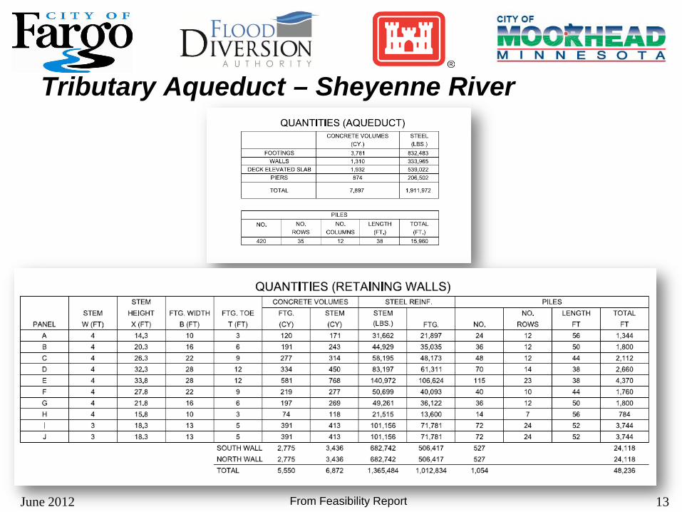
13 June 2012
Tributary Aqueduct – Sheyenne River
From Feasibility Report

June 2012 14
Diversion Inlet Water Storage Area 1 Wild Rice River Structure Red River Structure Wolverton Creek Structure

15 June 2012
Diversion Inlet
From Feasibility Report
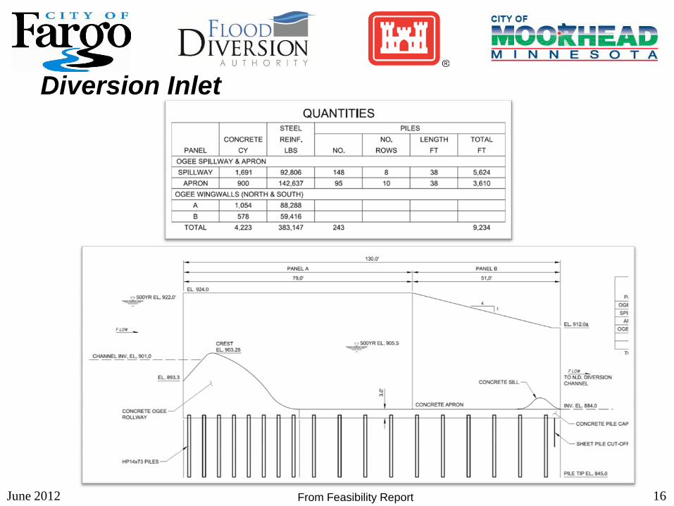
16 June 2012
Diversion Inlet
From Feasibility Report

17 June 2012
Water Storage Area 1
From Feasibility Report
18 June 2012
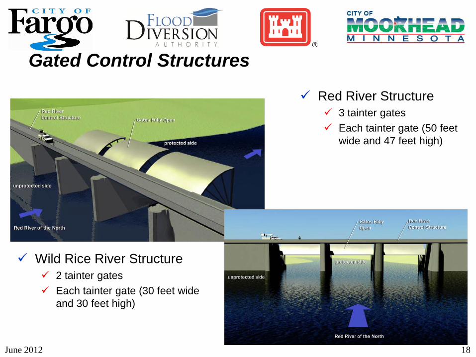
Red River Structure 3 tainter gates Each tainter gate (50 feet
wide and 47 feet high)
Wild Rice River Structure 2 tainter gates Each tainter gate (30 feet wide
and 30 feet high)
Gated Control Structures

19 June 2012
Gated Control Structure – Wild Rice River
From Feasibility Report

20 June 2012
Gated Control Structure – Wild Rice River
From Feasibility Report

21 June 2012
Gated Control Structure – Wild Rice River
From Feasibility Report

22 June 2012
Gated Control Structure – Red River
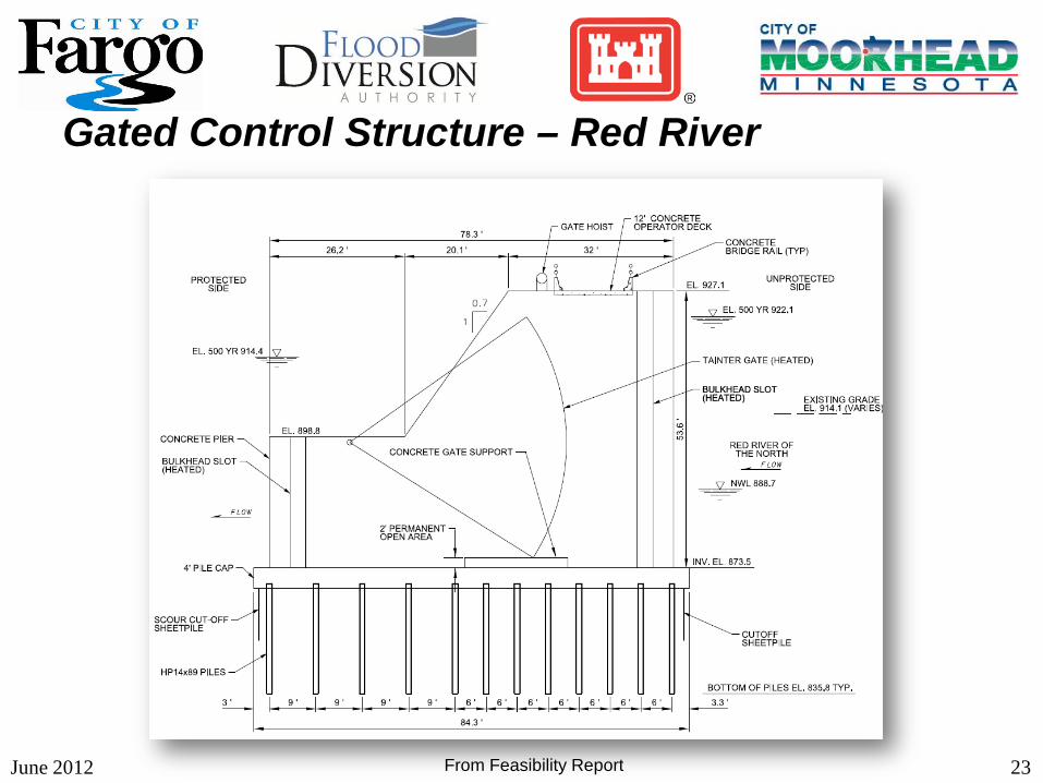
23 June 2012
Gated Control Structure – Red River
From Feasibility Report

24 June 2012
Gated Control Structure – Red River
From Feasibility Report
25 June 2012
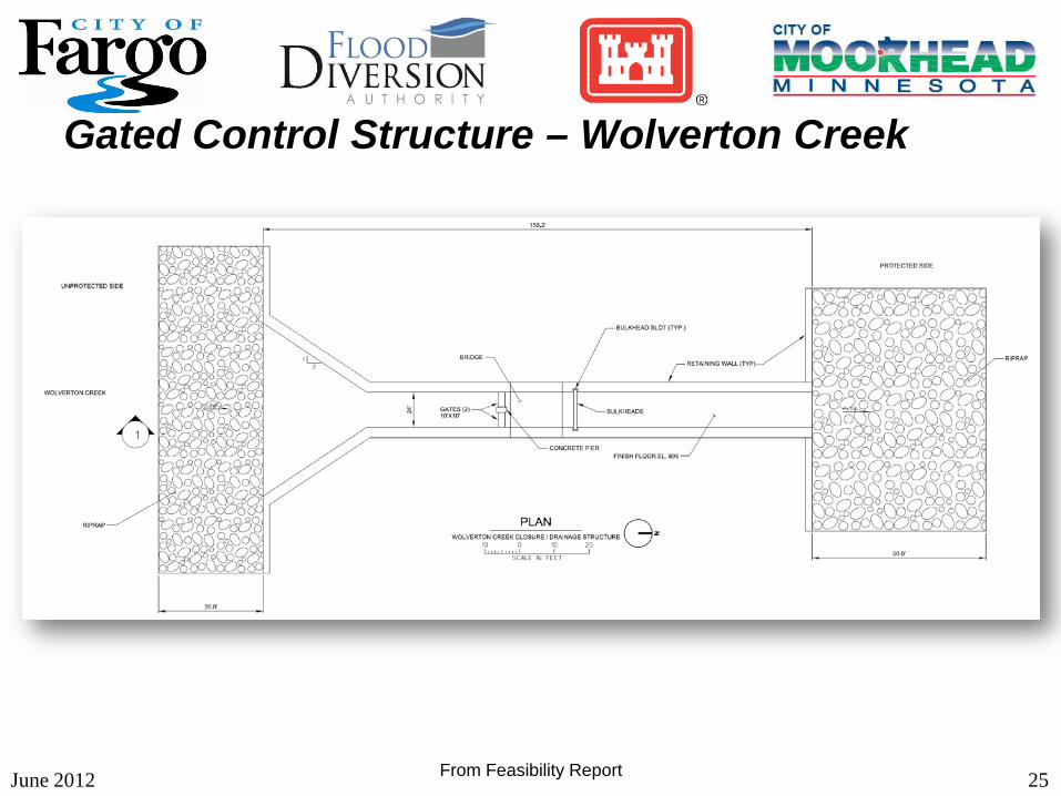
Gated Control Structure – Wolverton Creek
From Feasibility Report

26 June 2012
Gated Control Structure – Wolverton Creek
From Feasibility Report

June 2012 27
Approximately 28 design components The number of components could be
adjusted during the design process
Design Reaches

June 2012 28
Item Starting
Stationing Ending
Stationing Estimated Excavation
Quantity (cu. yds) Outlet/Design
Reach 1 0+00 225+00 5,200,000
Design Reach 2 225+00 300+00 1,900,000
Design Reach 3 300+00 325+00 Sponsor reach
Design Reach 4 325+00 521+00 4,500,000
Design Reach 5 521+00 656+00 3,000,000
Design Reach 6 656+00 683+00 Sponsor reach
Design Reach 7 683+00 725+00 1,300,000
Design Reach 8 725+00 834+00 2,600,000
Design Reach 9 834+00 870+00 390,000
Design Reach 10 870+00 901+00 Sponsor reach
Design Reach 11 901+00 1161+00 6,100,000
Design Reach 12 1161+00 1319+00 3,600,000
Design Reach 13 1319+00 1423+00 2,500,000
Design Reach 14 1423+00 1436+00 Sponsor reach
Design Reaches

June 2012 29
Item Starting Stationing
Ending Stationing
Estimated Excavation Quantity
(cu. yds) Design Reach 15 1436+00 1492+00 1,200,000 Design Reach 16 1492+00 1560+00 1,400,000 Design Reach 17 1560+00 1732+00 4,200,000 Design Reach 18 1732+00 1767+00 850,000 Design Reach 19 1767+00 1777+00 Sponsor reach Design Reach 20 1777+00 1847+00 1,700,000 Design Reach 21 1847+00 1920+00 1,500,000 Design Reach 22 n/a n/a n/a Design Reach 23 n/a n/a n/a Design Reach 24 n/a n/a n/a
Christine n/a n/a n/a Comstock n/a n/a n/a Mitigation n/a n/a n/a Recreation n/a n/a n/a
Design Reaches

Current Design Reaches Outlet/Design Reach 1
CR 31/4 Bridge (Local Sponsor)
Design Reach 2
Design Reach 3 – I-29/CR
81/Railroad Bridges (Local Sponsor)
Design Reach 4 – Includes Rush River Structure
CR 32 Bridge (Local Sponsor)
June 2012 30

Current Design Reaches Design Reach 5 – Includes Lower
Rush River Structure
CR 22 Bridge (Local Sponsor)
Design Reach 6 – CR 20/Rail Road Bridges (Local Sponsor)
Design Reach 7 – Maple River Aqueduct
June 2012 31

June 2012 32
Drayton Dam – Fish Passage
Wild Rice River – Fish Passage
Buffalo River – River Restoration
Mitigation

COE Designed Reaches-Current Schedule
June 2012 33
Outlet/Design Reach 1 April 2013 – Design completion
Design Reach 2 June 2013 – Design completion
Design Reach 4 – Includes Rush River Structure October 2013 – Design completion
Design Reach 5 – Includes Lower Rush River Structure October 2013 – Design completion
Design Reach 7 – Maple River Aqueduct Fall 2014 – Design completion
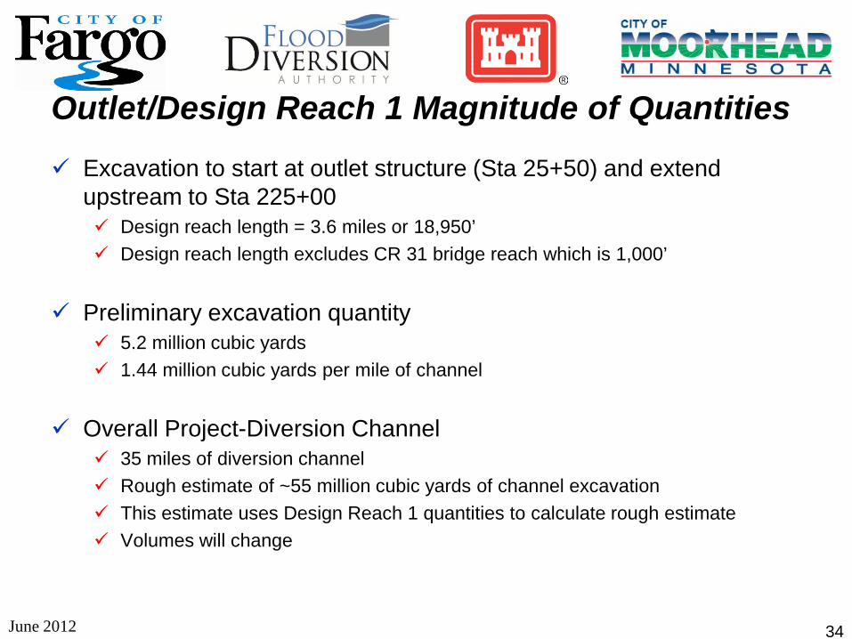
Outlet/Design Reach 1 Magnitude of Quantities
June 2012 34
Excavation to start at outlet structure (Sta 25+50) and extend upstream to Sta 225+00 Design reach length = 3.6 miles or 18,950’ Design reach length excludes CR 31 bridge reach which is 1,000’
Preliminary excavation quantity 5.2 million cubic yards 1.44 million cubic yards per mile of channel
Overall Project-Diversion Channel 35 miles of diversion channel Rough estimate of ~55 million cubic yards of channel excavation This estimate uses Design Reach 1 quantities to calculate rough estimate Volumes will change

June 2012 35
Typical Cross Section

June2012 36
Questions?