general meeting minutes - city of gladstone november 2011...general meeting minutes ... councillor g...
TRANSCRIPT

GENERAL MEETING MINUTES
HELD AT THE COUNCIL CHAMBERS - CIVIC CENTRE 101 GOONDOON STREET, GLADSTONE
ON TUESDAY 1 NOVEMBER 2011
COMMENCING AT 9.00AM
Stuart Randle CHIEF EXECUTIVE OFFICER

GLADSTONE REGIONAL COUNCIL GENERAL MEETING MINUTES - 01/11/2011.
PRESENT
ELECTED MEMBERS
Councillor - Mayor G M Sellers
Councillor M M Brushe
Councillor C W Butler
Councillor C E Cameron
Councillor C R Chapman
Councillor R A Hansen
Councillor L J Paton
Councillor G E McDonald
OFFICERS
Mr S Randle (Chief Executive Officer)
Mrs V Hankinson (Assistant to the Chief Executive Officer)
Mr C Ross (Media & Communications Officer)
Mr C F Dendle (Director Corporate and Community Services)
Ms L A Dowling (Director Planning and Environment)
Mr P Keech (Director Infrastructure Services)
Mr M D Holmes (Chief Financial Officer)
Mr A E Kearns (Chief Planner)
Mr T Shoer (Business Improvement Manager)
APOLOGY Cr. Burnett tendered an apology for the meeting. G/11/786 Council Resolution: Moved Cr Brushe Seconded Cr Paton That Cr. Burnett's apology be received.
----2---

GLADSTONE REGIONAL COUNCIL GENERAL MEETING MINUTES - 01/11/2011.
-----3-----
GENERAL MEETING MINUTES TABLE OF CONTENTS
ITEM SUBJECT PAGE
G/1 MAYORAL STATEMENT ON CURRENT ISSUES 6
G/2 MESSAGES OF CONDOLENCE 6
G/3 CONFIRMATION OF MINUTES 6
G/3/1 CONFIRMATION OF MINUTES OF GENERAL MEETING 18 OCTOBER 2011
6
G/4 BUSINESS ARISING FROM MINUTES 7
G/5 OFFICERS' REPORTS 7
G/5.1 OFFICE OF THE CEO 7
G/5.2 CORPORATE AND COMMUNITY SERVICES 7
G/5.2.1 RENEWAL OF SPECIAL LEASE LOT 1 M47512 7
G/5.2.2 APPLICATION TO PURCHASE RECLAIMED UNALLOCATED STATE LAND
7
G/5.2.3 PROPOSED STREET NAMES FOR LITTLE CREEK ESTATE STAGES 12-14 LOT 902 SP235934
8
G/5.3 INFRASTRUCTURE SERVICES 9
G/5.3.1 APPLICATION FOR PERMANENT ROAD CLOSURE ADJOINING LOT 2 ON RP889922, PARISH OF TONDOON
9
G/5.3.2 CONTESTABLE ELECTRICITY ACCOUNTS 10
G/5.4 PLANNING AND ENVIRONMENT 10
G/5.4.1 DEVELOPMENT APPLICATION - DA/347/2011 - MATERIAL CHANGE OF USE OF PREMISES - TELECOMMUNICATIONS FACILITY (LOW IMPACT) AND RECONFIGURING A LOT (30 YEAR LEASE) - 780 MARSH ROAD, DIGLUM
11
G/5.4.2 DEVELOPMENT APPLICATION DA/360/2011 - MATERIAL CHANGE OF USE OF PREMISES (SMALL LOT HOUSING) AND RECONFIGURING A LOT (1 INTO 2) - 1 BRANDO LANE, WEST GLADSTONE
12
G/5.4.3 DEVELOPMENT APPLICATION 406/2011 - MATERIAL CHANGE OF USE OF PREMISES (SMALL LOT HOUSING) AND RECONFIGURING A LOT (1 INTO 2) -
16

GLADSTONE REGIONAL COUNCIL GENERAL MEETING MINUTES - 01/11/2011.
-----4-----
11 DARTMOUTH CLOSE, CLINTON
G/5.4.4 DEVELOPMENT APPLICATION DA/348/2011 PRELIMINARY APPROVAL DWELLING HOUSES AND MATERIAL CHANGE OF USE OF PREMISES FOR SMALL LOT HOUSING AND RECONFIGURING A LOT (1 INTO 2) AT 2 THE OAKS ROAD, TANNUM SANDS
20
G/5.4.5 DEVELOPMENT APPLICATION DA/410/2011 - MATERIAL CHANGE OF USE OF PREMISES - DUPLEX - 3 BRANDO LANE, WEST GLADSTONE
24
G/5.4.6 DEVELOPMENT APPLICATION DA/364/2011 - MATERIAL CHANGE OF USE OF PREMISES MULTIPLE UNIT RESIDENTIAL (6 UNITS) - 2 VIEW STREET, WEST GLADSTONE
27
G/5.4.7 DEVELOPMENT APPLICATION DA/382/2011 - MATERIAL CHANGE OF USE OF PREMISES (20 UNITS) - 38A KENT STREET, WEST GLADSTONE
37
G/5.4.8 DEVELOPMENT APPLICATION DA/331/2011 - MATERIAL CHANGE OF USE OF PREMISES - MULTIPLE UNIT RESIDENTIAL (12 UNITS) - 71- 73 TOOLOOA STREET & 104 OFF LANE, SOUTH GLADSTONE
48
G/5.4.9 DEVELOPMENT APPLICATION 277/2011 - MATERIAL CHANGE OF USE OF PREMISES - MULTIPLE DWELLING (6 UNITS) - SUPERSEDED PLANNING SCHEME FOR MIRIAM VALE SHIRE - LOT 19 RP861421, THOMSON STREET, AGNES WATER
59
G/5.4.10 DEVELOPMENT APPLICATION DA/188/2010 MATERIAL CHANGE OF USE OF PREMISES MULTIPLE UNIT RESIDENTIAL (3 UNITS) AND RECONFIGURING A LOT (1 INTO 2) AND BOUNDARY REALIGNMENT AT 12 GAPPARIS STREET AND 146 SUN VALLEY ROAD, KIN KORA
70
G/5.4.11 REQUEST TO NEGOTIATE DECISION NOTICE - DEVELOPMENT APPLICATION 20621/2008 - PRELIMINARY APPROVAL OVERRIDING THE PLANNING SCHEME FOR A MASTER PLANNED URBAN COMMUNITY "HEIDELBERG" COMPRISING RESIDENTIAL, LOCAL INDUSTRY, COMMERCIAL, OPEN SPACE & RECREATION
75
G/5.4.12 PEST SURVEY PROGRAM - RURAL LAND PROTECTION
98
G/5.4.13 PROPOSED MAJOR AMENDMENT TO THE GLADSTONE PLAN - REVIEW OF SUBMISSION
98

GLADSTONE REGIONAL COUNCIL GENERAL MEETING MINUTES - 01/11/2011.
-----5-----
G/5.4.14 DISPOSAL OF SURPLUS GOVERNMENT LAND (LOT 296 CTN1470)
100
G/5.4.15 STRATEGIC REVIEW - INFRASTRUCTURE PROVISION (EXTENDING THE WATER SERVICE AREA AT AGNES WATER)
101
G/5.5 CHIEF FINANCIAL OFFICER 102
G/5.5.1 QUARTERLY ASSESSMENT OF THE IMPLEMENTATION OF THE 2011/2012 OPERATIONAL PLAN: QUARTER 1
102
G/6 COUNCILLOR REPORTS 102
G/6.1 COUNCILLOR REPORT 102
G/7 QUESTIONS FROM THE PUBLIC GALLERY 108
G/8 CONFIDENTIAL ITEMS 108
G/9 MEETING CLOSE 108

GLADSTONE REGIONAL COUNCIL GENERAL MEETING MINUTES - 01/11/2011.
-----6-----
G/1 MAYORAL STATEMENT ON CURRENT ISSUES Annual Commonwealth Bank Australia (CBA) / Queensland Treasury Corporation (QTC) Australasian Fixed Income Conference On Friday 28th October CEO Stuart Randle and I attended the Fourth Annual CBA/QTC Australasian Fixed Income Conference and Infrastructure Tour. Treasurer Andrew Fraser and Minister for Finance, Natural Resources & Arts Rachel Nolan hosted bankers and International investors to a tour of the Gladstone Region. In the group were bankers from Asia, Europe and the Middle East along with domestic and international private sector fund managers. The conference is designed to provide investors the opportunity to view elements of the significant capital works program currently being undertaken in Queensland and to demonstrate that it is an attractive, safe and secure place to invest. Gladstone was the only area in Queensland visited and gives a clear indication that our importance is recognised. The Gladstone tour comprised a bus tour of land based industry and also a boat trip on the harbour where Leo Zussino, CEO of the Ports Corporation gave a very detailed verbal presentation on Gladstone industry. G/2 MESSAGES OF CONDOLENCE Nil. G/3 CONFIRMATION OF MINUTES G/3/1 CONFIRMATION OF MINUTES OF GENERAL MEETING 18
OCTOBER 2011
Responsible Officer: Chief Executive Officer Executive Summary: Confirmation of the minutes of the General Meeting held on the 18 October 2011. Officer's Recommendation: That the minutes of the General Meeting of Council held on the 18 October 2011 be confirmed. G/11/ 787 Council Resolution: Moved Cr Hansen Seconded Cr Chapman That the Officer's Recommendation be adopted.
CARRIED
GLADSTONE REGIONAL COUNCIL GENERAL MEETING MINUTES - 01/11/2011.
-----7-----
G/4 BUSINESS ARISING FROM MINUTES Nil. G/5 OFFICERS' REPORTS Nil. G/5.1 OFFICE OF THE CEO Nil. G/5.2 CORPORATE AND COMMUNITY SERVICES G/5.2.1 RENEWAL OF SPECIAL LEASE LOT 1 M47512
Responsible Officer: Director Corporate & Community Services Executive Summary: This report seeks Council's views on an application to renew the Term Lease over Lot 1 on M47512. Officer's Recommendation: Council advise the Department of Environment and Resource Management that it offers no objection to the granting of a new Term Lease over Lot 1 on M47512.
G/11/ 788 Council Resolution: Moved Cr Brushe Seconded Cr Chapman That the Officer's Recommendation be adopted.
CARRIED G/5.2.2 APPLICATION TO PURCHASE RECLAIMED
UNALLOCATED STATE LAND
Responsible Officer: Director Corporate & Community Services Executive Summary: This report seeks Council's views on an application to purchase reclaimed Unallocated State Land by the Gladstone Ports Corporation. Officer's Recommendation: Council advise the Department of Environment and Resource Management (DERM) that it offers no objection to the Gladstone Ports Corporation’s applications:
GLADSTONE REGIONAL COUNCIL GENERAL MEETING MINUTES - 01/11/2011.
-----8-----
1. To purchase an area of Unallocated State Land at Auckland Point identified in yellow in DERM’s email of 7 October 2011,
2. To lease an area of USL at Barney Point identified in pink in DERM’s email of 7 October 2011, and
3. To lease an area of tidal USL adjoining Lot 78 on CTN1295 identified in blue in DERM’s email of 7 October 2011.
G/11/ 789 Council Resolution: Moved Cr Paton Seconded Cr McDonald That the Officer's Recommendation be adopted.
CARRIED G/5.2.3 PROPOSED STREET NAMES FOR LITTLE CREEK ESTATE
STAGES 12-14 LOT 902 SP235934
Responsible Officer: Director Corporate and Community Services Executive Summary: This report provides Council with information on a request from Norris Clarke & O’Brien to name new road reserves within Stages 12 -14 of the Little Creek Estate that are part of the development application 10630/2008/DA in Kirkwood. This report recommends that the roads be named Peter Corones Drive, Blackburn Court, Bragg Court, Cornforth Crescent, Florey Place and Eccles Close Officer's Recommendation: That:
1. Council approve the following road names
Peter Corones Drive; Blackburn Court; Bragg Court; Cornforth Crescent; Florey Place; and Eccles Close
2. Norris Clarke & O’Brien be advised of the approved names.
G/11/ 790 Council Resolution: Moved Cr Hansen Seconded Cr Cameron That the Officer's Recommendation be adopted.
CARRIED

GLADSTONE REGIONAL COUNCIL GENERAL MEETING MINUTES - 01/11/2011.
-----9-----
G/5.3 INFRASTRUCTURE SERVICES G/5.3.1 APPLICATION FOR PERMANENT ROAD CLOSURE
ADJOINING LOT 2 ON RP889922, PARISH OF TONDOON
Responsible Officer: Director Infrastructure Services Executive Summary: The purpose of this report is to allow Council to revise its position in relation to an application for a permanent road closure adjoining Lot 2 on RP889922 (DERM ref Case ID 2011/003248). Officer's Recommendation: That Council advise the Department of Environment and Resource Management (DERM) that it is not opposed to the permanent closure of the access adjoining Lot 2 on RP889922, Parish of Tondoon, provided that the applicant creates a legal drainage easement 7m wide along the boundary shared with 14 Pluto Street Gladstone at their expense. Meeting Discussion: The meeting invited representatives of the Uniting Church and Rainbow Valley Early Learning Centre to address the meeting on future plans for this area. It was noted that the proposal is to expand the Child Care Centre to provide more child care and after school places for our community which is currently in very high demand. The meeting noted that Rainbow Valley Early Learning Centre currently has a waiting of 300 children and they are having to turn away people every week. The proposal is to also site Radio Rhema on land adjacent to the centre. The Uniting Church representative expressed a preference of not having the 7 metre wide easement restriction preferring that any stormwater management issues be addressed in conjunction with the development applications at the appropriate time. Officers considered that the easement requirement provides the best protection for all landowners given that it could be some time before the various development proposals are commenced. In considering the easement restriction, it was suggested that Council would not object to infrastructure that does not impeded the flow of stormwater being constructed within the easement area (ie. carparks, driveways, etc). The easement would however restrict buildings and other structures within the easement area. G/11/ 791 Council Resolution: Moved Cr Hansen Seconded Cr Brushe That the Department of Environment and Resource Management (DERM) be advised that:- 1. Council is not opposed to the permanent closure of the access adjoining Lot 2 on
RP889922, Parish of Tondoon, provided that the applicant creates a legal drainage

GLADSTONE REGIONAL COUNCIL GENERAL MEETING MINUTES - 01/11/2011.
-----10-----
easement 7m wide along the boundary shared with 14 Pluto Street Gladstone at their expense.
2. Council offers no objection to the newly created easement being utilised for any
infrastructure that does not impede the flow of surface water (ie. carparking, driveways, etc).
CARRIED
G/5.3.2 CONTESTABLE ELECTRICITY ACCOUNTS
Responsible Officer: Director Infrastructure Services Executive Summary: This report is to formalise the tender methodology for the purchase of electricity from retail suppliers for the contestable electricity accounts Gladstone Regional Council currently has. Officer’s Recommendation: That: 1. Council call for Expressions of Interest for the provision of retail electricity;
2. The Chief Executive Officer be authorised to approve offers based on the
proposed procurement strategy; and
3. A report will be submitted to Council for endorsement once a contract for provision of retail electricity is signed.
G/11/ 792 Council Resolution: Moved Cr Chapman Seconded Cr Hansen That Council call for Expressions of Interest for the provision of retail electricity and a report be prepared for Council's consideration.
CARRIED
G/5.4 PLANNING AND ENVIRONMENT Cr. Cameron advised that he is an adjoining landowner to the property that has a development application to be considered in Item G/5.4.1 and therefore he could potentially have a conflict of interest in the matter. The balance of members considered that Cr. Cameron does not have a conflict of interest by being an adjoining landowner. Cr. Butler and Cr. Cameron also advised that as Directors of the Gladstone Area Water Board they could potentially have a conflict of interest in item G/5.4.1. Cr. Butler and Cr. Cameron left the meeting during consideration of the matter.

GLADSTONE REGIONAL COUNCIL GENERAL MEETING MINUTES - 01/11/2011.
-----11-----
G/5.4.1 DEVELOPMENT APPLICATION - DA/347/2011 - MATERIAL
CHANGE OF USE OF PREMISES - TELECOMMUNICATIONS FACILITY (LOW IMPACT) AND RECONFIGURING A LOT (30 YEAR LEASE) - 780 MARSH ROAD, DIGLUM
Responsible Officer: Chief Planner Development Application:
Application Number: DA/347/2011
Applicant: Gladstone Area Water Board
Owner: Mr R A Cullen and Mrs L M Cullen
Date of Receipt: 6 June 2011
Location: 780 Marsh Road, Diglum QLD 4680
RPD: Lot 58 CTN 295
Area: 1,287 ha
Current Use of Land: Vacant
Zoning: Rural
Proposal: Telecommunications Facility (Low Impact) and Reconfiguring a Lot (30 Year Lease)
Submissions Close Date: 21 October 2011
Number of Submissions: Nil
Executive Summary: A development application has been received for a Material Change of Use - Telecommunications Facility (Low Impact) and Reconfiguring a Lot (30 Year Lease), at 780 Marsh Road, Diglum. The subject site is situated within the Rural Zone of the Calliope Rural Locality, under the Calliope Planning Scheme 2007. The Impact Assessable application proposes a solar powered, radio receiver tower to monitor the quality of water running into Lake Awoonga. The application is considered to comply with the relevant requirements of the Calliope Planning Scheme 2007 and is therefore recommended for approval subject to reasonable and relevant conditions. Officer's Recommendation: That the proposed Material Change of Use of Premises - Telecommunications Facility (Low Impact) and Reconfiguring a Lot (30 Year Lease) be approved subject to the following conditions: 1. The development shall be carried out in accordance with the following approved
plans, and with any modifications required by conditions of this permit.
Plan Name Drawn By Drawing Number
Date
Plan of Lease A - Survey Plan - - 1/11/2010 Gladstone Area Water Board - Mongrel Mountain Repeater
Gladstone Area Water Board
- -

GLADSTONE REGIONAL COUNCIL GENERAL MEETING MINUTES - 01/11/2011.
-----12-----
Station Site (access track) Detail Survey Mongrel Mountain
Fredriksen Maclean & Associates
3919-02 01/11/2010
Indicative photo of the proposed structure
Photograph - -
except where amendments are required to satisfy the conditions of this approval.
2. Prior to the submission of the plan of subdivision to Council, the Lessee is to
reinstate survey marks and install new survey marks in their correct position in accordance with the plan of subdivision, and the work is to be certified in writing by a surveyor.
3. Appropriate erosion and sedimentation control measures are to be utilised
during the construction and decommissioning of the structure. 4. The Lessee must conduct regular routine maintenance of the leasehold land for
the duration of the lease. This is to include brush cutting and weed management.
END OF CONDITIONS
G/11/ 793 Council Resolution: Moved Cr Hansen Seconded Cr Chapman That the Officer's Recommendation be adopted.
CARRIED Crs. Cameron and Butler rejoined the meeting at this point. G/5.4.2 DEVELOPMENT APPLICATION DA/360/2011 - MATERIAL
CHANGE OF USE OF PREMISES (SMALL LOT HOUSING) AND RECONFIGURING A LOT (1 INTO 2) - 1 BRANDO LANE, WEST GLADSTONE
Responsible Officer: Chief Planner Development Application:
Application Number: DA/360/2011
Applicant: Hagan & Baum Pty Ltd C/- Brazier Motti Pty Ltd
Owner: Hagan & Baum Pty Ltd
Date Of Receipt: 7 July 2011
Location: 1 Brando Lane, West Gladstone
RPD: Lot 1 SP206871
Area: 835m²
Current Use Of Land: Vacant

GLADSTONE REGIONAL COUNCIL GENERAL MEETING MINUTES - 01/11/2011.
-----13-----
Zoning: Residential
Proposal: Material Change of Use - Small Lot Housing and Reconfiguring a Lot (1 into 2)
Submissions Close Date: 26 September 2011
Number Of Submissions: 1 ‘properly made’ submission
Executive Summary: An Impact Assessable Development Application for a Material Change of Use of Premises (Small Lot Housing) and Reconfiguring a Lot (1 into 2) has been received by Council on 7 July 2011. One (1) ‘properly made’ submission was received by Council during the notification period raising issues regarding a covenant, value of houses, setbacks, parking, aesthetics and traffic. The proposal is considered to generally comply with the requirements of the Planning Scheme and is therefore recommended for approval subject to reasonable and relevant conditions. Officer's Recommendation: That the application for a Material Change of Use of Premises for Small Lot Housing and Reconfiguring a Lot (1 into 2) at 1 Brando Lane, West Gladstone be approved subject to the following conditions: 1. Development is to be carried out in accordance with the submitted application and
nominated building envelopes including the following:
Plan Name Drawing No. Drawn By Date Proposed Reconfiguration 75513/001 B Brazier Motti 6 July 2011 Site Plan Sheet 1 Smartarch n/a Floor Plan Residence 1 Sheet 2 Smartarch n/a Elevations Residence 1 Sheet 3 Smartarch n/a Floor Plan Residence 2 Sheet 2 Smartarch n/a Elevations Residence 2 Sheet 3 Smartarch n/a
except where amendments are required to satisfy the conditions of this approval.
2. Each allotment must be developed as a house / land package with all buildings and
associated site development works (including driveways) to be completed prior to the signing and sealing of the plan of the survey by Council. A development permit for Building Works must be obtained prior to the construction of the proposed dwellings. The construction of the dwellings and any associated site development works must be completed prior to the lodgement of the relevant plan of survey to Council for signing and sealing.
3. All alterations to services and municipal facilities necessitated by the proposal shall
be the responsibility of the applicant. Building Works 4. Allotment shaping (earthworks), stormwater drainage infrastructure (inter-allotment
drainage), retaining walls along common boundaries (that are not an integral part of the residential dwelling) and building platforms within each allotment are to be constructed under the Operational Works Permit.

GLADSTONE REGIONAL COUNCIL GENERAL MEETING MINUTES - 01/11/2011.
-----14-----
5. The location of the proposed dwellings shall comply with Council Policy 19.7 - Revision 1 Building Adjacent to and Over Sewers, Stormwater and Water Assets.
6. An 1800mm high screen fence is required along the side and rear boundaries of
each allotment. A screen fence no less than 1200mm in height shall be constructed along the Brando Lane and Chaplin Court road frontages. In addition fences, screens and retaining walls are not more than 1 metre high within a truncation made by 4 equal chords of a 6 metre radius curve at the corner of the two road frontages. The screen fencing is to be installed prior to signing and sealing of the plan of survey by Council.
Operational Works 7. Submission for approval of a Development Application for Operational Works must
be completed for additional water, sewer and stormwater infrastructure which indicates full detailed working plans and specifications of all civil engineering work to Council’s Standards. Such plans and specifications shall be prepared by a Registered Professional Engineer in Queensland (RPEQ) and be accompanied by the relevant fee based on an approved estimate of cost.
8. As part of the Operational Works application separate connections are to be
provided to the reticulated water supply and sewerage for each lot. 9. The civil works being executed under the supervision of a RPEQ, on completion,
give to Council “as constructed” details of the civil works including certification from the supervising RPEQ that all civil works have been completed in accordance with the approved plans and specifications. Council reserves the right to utilise for its own purposes and the sale of information provided within the “as constructed” drawings provided by the applicant.
10. Completion of the civil works and lodgement of the relevant plan of survey within
two (2) years of Council approving the engineering drawings. 11. All works to be designed and constructed in accordance with the following:
GCC Road Transport Design Standard 2005 GCC Water Reticulation Standard 2003 GCC Sewerage Design Standard 2005 Gladstone Storm Water Management Strategy – Drainage Management
Document 2000 Transportation 12. Provision of a minimum of two (2) on site car parking spaces per lot, one (1) of
which must be covered is required. Car parking spaces shall be drained in accordance with Part 14, Schedule 2, Division 4 of the Planning Scheme and AS2890.1.
13. Invert crossing and driveway is to be in accordance with Council’s Standard
Drawings RT-0055. 14. At the developers expense, construct a turn around area in the form of a cul-de-sac
head at the end of Brando Lane. Stormwater

GLADSTONE REGIONAL COUNCIL GENERAL MEETING MINUTES - 01/11/2011.
-----15-----
15. The applicant shall demonstrate that each individual allotment is capable of being
drained of its potential roof water without affecting adjoining lots. Where roofwater from proposed allotments cannot be drained into the kerb and channel using approved kerb adapters, piped roofwater drainage collection systems are to be provided for each allotment in accordance with Council’s Standard Drawings.
Landscaping 16. A landscape Plan is to be submitted for approval prior to the issuing of a
Development Permit for Operational Works. The landscaping of the site shall incorporate:
a. 3m wide landscaping is to be provided along the Brando Lane frontage,
and 1 metre landscaping except where a driveway exists. This landscaping is to consist of medium mature trees spaced evenly apart with thick vegetated undergrowth;
b. Landscaping of at least 0.5m along the retaining wall in proposed lot 2 c. The landscaping provided shall be in accordance with Council’s
preferred landscape plant list; d. Fencing detail will be provided on each lot including the retaining wall,
indicating fence design, materials, locations and perspectives; e. Open space areas will be included illustrated on each site including
dimensions and area; and f. Details of how appropriate access for maintenance purposes is
achieved to the steep slope area at the rear of each lot
The landscaping plan shall contain the following information:
i. Outline of the buildings; ii. Existing trees; iii. Trees to be removed; iv. Proposed planting (quantity, species, and expected mature
heights) v. Paths and paving (location and materials); vi. The method of planting and proposed maintenance program of
the landscaping; and vii. A specific maintenance program for the steep slope area at the
rear of the lot. 17. All landscaping referred in Condition 16 above is to be maintained to an appropriate
standard at all times. 18. Appropriate erosion and sedimentation control measures are to be utilised during
any Building Works or Operational Works carried out as a result of the development.
Easement 19. If required an easement shall be created in the benefit of Gladstone Regional
Council, for the purpose of stormwater drainage, over: a) all inter-allotment drainage infrastructure (3m minimum width from a
property boundary)

GLADSTONE REGIONAL COUNCIL GENERAL MEETING MINUTES - 01/11/2011.
-----16-----
b) overland drainage paths and constructed open channels (width of easement to provide for convenient access to the infrastructure for operation and maintenance purposes)
20. If required an easement shall be created in the benefit of Gladstone Regional
Council, for the purpose of wastewater drainage, over all new and existing sewers and sewerage infrastructure not in road reserves or not in land controlled by Council. The easement created is to be a minimum 3.0m wide. Where the sewer is located within 2.5m of a property boundary, the easement shall extend to the property boundary.
21. If required an easement shall be created in the benefit of Gladstone Regional
Council for the purpose of water supply over all new and existing mains and water supply infrastructure not in road reserves or not in land controlled by Council. The easement created shall be a minimum of 6m wide and where practical shall be located adjacent to a property boundary.
22. The location of easements is to be finalised at the Operational Works phase and
the easements are to be registered in conjunction with the Plan of Survey Advice to Applicant An adopted infrastructure charge notice in relation to the infrastructure charges applicable to this development has been provided separately. G/11/ 794 Council Resolution: Moved Cr Butler Seconded Cr Cameron That the Officer's Recommendation be adopted.
CARRIED Cr. Brushe suggested that Council place an article in Council's community newsletter outlining the difference between statutory and developer covenants. G/5.4.3 DEVELOPMENT APPLICATION 406/2011 - MATERIAL
CHANGE OF USE OF PREMISES (SMALL LOT HOUSING) AND RECONFIGURING A LOT (1 INTO 2) - 11 DARTMOUTH CLOSE, CLINTON
Responsible Officer: Chief Planner Development Application:
Application Number: DA/406/2011
Applicant: Glacier Properties Pty Ltd c/- Brazier Motti Pty Ltd
Owner: Mrs S I Kardum
Date Of Receipt: 19 August 2011
Location: 11 Dartmouth Close, Clinton
RPD: Lot 289 SP 200673

GLADSTONE REGIONAL COUNCIL GENERAL MEETING MINUTES - 01/11/2011.
-----17-----
Area: 1,087m²
Current Use Of Land: Vacant
Zoning: Residential
Proposal: Material Change of Use (Small Lot Housing) and Reconfiguring A Lot (1 into 2)
Submissions Close Date: 14 October 2011
Number Of Submissions: Nil
Executive Summary: An Impact Assessable Development Application was received by Council for a Material Change of Use (Small Lot Housing) and Reconfiguring A Lot (1 into 2) on 19 August 2011. No submissions were received during the Public Notification period. The application is considered to generally comply with the requirements of The Gladstone Plan and is therefore recommended for approval, subject to reasonable and relevant conditions. Officer's Recommendation: That the proposed application for a Material Change of Use (Small Lot Housing) and Reconfiguring A Lot (1 into 2) at 11 Dartmouth Close, Clinton be approved, subject to the following conditions: 1. Development is to be carried out in accordance with the submitted application
and nominated building envelopes including the following:
Plan Name Plan No. Drawn By Date Proposed Reconfiguration
755-43-001B Brazier Motti 15 August 2011
except where amendments are required to satisfy the conditions of this approval, including:
Amend the Proposed Reconfiguration Plan (Plan No. 75543-001B) to show '6m Building Setback' instead of '4m Building Setback' for Lot 2.
2. The plan of survey is to be signed and sealed prior to any building works
commencing on the allotments. 3. The applicant is required to obtain a Development Permit for Building and
Plumbing Works in accordance with the Sustainable Planning Act 2009 for any future dwellings contained on the proposed lots. Construction is to comply with the Building Act 1975, the Building Code of Australia and the requirements of other relevant authorities.
4. The Building Works application must detail the proposed location of water tanks
as required by Part 25 of the Queensland Development Code.
5. All alterations to services and municipal facilities necessitated by the development shall be the responsibility of the applicant and are to be carried out at the applicant’s expense.

GLADSTONE REGIONAL COUNCIL GENERAL MEETING MINUTES - 01/11/2011.
-----18-----
6. A Development Permit for Operational Works must be obtained from Council prior to the commencement of construction. The Development Application for Operational Works is to include the following:
a) earthworks (including retaining walls) b) roadworks (including all works within the road reserve, e.g. driveway
accesses) c) water infrastructure d) sewerage infrastructure e) stormwater management f) electrical / telecommunications
The design and supporting calculations / documentation associated with these works must be certified by a Registered Professional Engineer of Queensland (RPEQ).
7. The Development Permit for Operational Works must include the site development works associated with preparing the site for building works. These works are to include:
a) earthworks and retaining walls b) inter-allotment stormwater drainage infrastructure c) driveway crossovers d) water service connections e) sewerage service connections
8. The invert crossing and driveway to each allotment is to be in accordance with Council’s Standard Drawings RT-0055.
9. Separate connections are to be provided from Council’s reticulated water supply
to the front property boundary of each lot. Work on Council’s live water supply infrastructure is to be carried out by Council at the applicant’s expense.
10. Separate connections are to be provided to Council’s sewerage infrastructure for
each lot. Work on Council’s live sewerage infrastructure is to be carried out by Council at the applicant’s expense.
11. An easement must be created in the benefit of Gladstone Regional Council and at
no cost to Council, for the purpose of wastewater drainage, over all new and existing sewers and sewerage infrastructure not in road reserves or not in land controlled by Council. The easement created is to be a minimum 3.0m wide.
12. An easement must be created in the benefit of Gladstone Regional Council and at
no cost to Council, for the purpose of stormwater drainage, over the inter-allotment drainage works within each allotment. The easement created is to be a minimum 3.0m wide.
13. Inter-allotment stormwater drainage infrastructure is to incorporate the following:
1. bolt down grated field inlet pits (minimum 600x600) 2. drainage lines to be SN8 PVC (sewer) pipe (minimum 225mm diameter)
14. All works to be designed and constructed in accordance with the following:
a) Roads and Transport Standard 2005 (Joint CSC and GCC) b) Gladstone City Council Subdivision Guidelines, Rev 4, Nov 02 (Section 7)

GLADSTONE REGIONAL COUNCIL GENERAL MEETING MINUTES - 01/11/2011.
-----19-----
c) Water Supply Standard 2006 (Joint CSC and GCC) d) Sewerage Design Standard 2003 (Joint CSC and GCC)
15. Earthworks on the site must be carried out in accordance with AS 3798 and good
engineering practice. Geotechnical supervision shall be to Level 1. The geotechnical testing authority shall provide a report to Council, setting out the inspections, sampling and testing it has carried out, and the locations and results thereof. The geotechnical report must be certified a RPEQ experienced in this type of work.
16. Allotment batters and retaining walls located along the side and rear property
boundaries of residential allotments are to be constructed as follows:
a) embankment slopes and retaining walls located along the rear and side boundaries of adjoining allotments are to be constructed within the allotment located on the low side of the common boundary.
b) the maximum batter slope for earth embankments is to be 1 vertical to 3 horizontal (subject to slope stability and appropriate landscaping / soil stabilisation considerations).
17. Retaining walls are to comply with the following requirements:
a) The design life of retaining walls shall be at least fifty (50) years and retaining walls shall be designed to safely withstand the impact of a 1.8m high solid fence constructed along the top of the retaining wall. Fence loadings to include dead, live and wind loads.
b) Retaining walls must not impose loads on underground services within allotments or external to allotments, including but not limited to water, sewerage, stormwater, electrical, telecommunication or other services. In particular, retaining wall footings must not impose loads on the electrical / telecommunication service corridor which is located in the footpath (verge) adjacent to the front property boundary and must allow for the installation and maintenance of these services.
c) The design and construction of retaining walls must be certified by a Registered Professional Engineer of Queensland (RPEQ) experienced in this type of work. The design certificate and the construction certificate must be location specific and must include: design life, design standards, allowable fence loads and any special
provisions / constraints in regards to fence type, fence footing, foundation etc. (for the information of future fence designers / constructors).
a statement that the retaining wall structure will not impose loads on underground services, including but not limited to water, sewerage, stormwater, electrical, telecommunication or other services and that the design / construction of same allows for the installation and maintenance of these services.
18. The electrical design must be certified by a RPEQ (experienced in this type of
work) for compliance with AS1158 and for compliance with the requirements of Ergon Energy.
19. All electrical and telecommunication infrastructure (conduits etc) needed to
prepare for the connection of electrical and telecommunication cabling to the allotments is to be installed as part of the operational works.

GLADSTONE REGIONAL COUNCIL GENERAL MEETING MINUTES - 01/11/2011.
-----20-----
20. An agreement shall be entered into with Ergon Energy for the provision of underground power to each of the proposed allotments. A certificate of Electricity Supply from Ergon Energy for the supply and reticulation of electricity to each allotment is to be submitted to Council prior to the sealing of the Plan of Survey by Council.
21. Provision is to be made for telecommunication and (where applicable) for gas
services to be installed at the time of construction of the operational works. Proof of the supply of necessary works and / or guarantee of adequate distribution equipment to each allotment from each service provider shall be submitted to Council prior to the sealing of the Plan of Survey by Council.
22. Provision of an 1800 mm high screen fence to the side and rear boundaries of
both allotments, other than that section within 6 metres of the Dartmouth Close and Wyara Close frontage which shall be no greater than 1.2 metres in height. The screen fencing is to be provided prior to the signing and sealing of the plan of survey.
END OF CONDITIONS
Advice to Applicant: An adopted infrastructure charge notice in relation to the infrastructure charges applicable to this development has been provided separately. G/11/ 795 Council Resolution: Moved Cr Paton Seconded Cr Brushe That the Officer's Recommendation be adopted.
CARRIED G/5.4.4 DEVELOPMENT APPLICATION DA/348/2011 PRELIMINARY
APPROVAL DWELLING HOUSES AND MATERIAL CHANGE OF USE OF PREMISES FOR SMALL LOT HOUSING AND RECONFIGURING A LOT (1 INTO 2) AT 2 THE OAKS ROAD, TANNUM SANDS
Responsible Officer: Chief Planner Development Application:
Application Number: DA/348/2011 Applicant: Bartley Burns Owner: R Whittingham Date of Receipt: 6 June 2011 Location: 2 The Oaks Road, Tannum Sands RPD: Lot 1 RP 605875 Area: 1,014m2 Current Use of Land: Vacant Zoning: Residential

GLADSTONE REGIONAL COUNCIL GENERAL MEETING MINUTES - 01/11/2011.
-----21-----
Proposal: Preliminary Approval Dwelling Houses and Material Change of Use or Premises for Small Lot Housing and Reconfiguring a Lot (1 into 2)
Submissions Close Date: 26 September 2011 Number of Submissions: Three Properly Made Submissions
Executive Summary: An Impact Assessable Development Application for a Preliminary Approval Dwelling Houses and Material Change of Use or Premises for Small Lot Housing and Reconfiguring a Lot (1 into 2) was received by Council on 6 June 2011. During the Public Notification period the application received 3 properly made submissions. The main issues raised within these submissions included a belief that there would be a reduction of the overall amenity of the area, inappropriate lot sizes and potential for sea level rise and erosion to the beach front. The application is considered to generally comply with the relevant sections of The Calliope Planning Scheme and is therefore recommended for approval, subject to reasonable and relevant conditions. Officer's Recommendation: That the application for a Preliminary Approval Dwelling Houses and Material Change of Use or Premises for Small Lot Housing and Reconfiguring a Lot (1 into 2) at 2 The Oaks Road, Tannum Sands, be approved subject to the following conditions: 1. Development is to be carried out in accordance with the submitted application and
nominated building envelopes including the following:
Plan Name Plan No. Drawn By Date Site Drawings Sheet Number 1 Think Tank Architects 20/5/2011 Subdivision Layout Sheet Number 2 Think Tank Architects 20/5/2011 Figure 1 - Building Envelope
Sheet Number 3 Think Tank Architects 20/5/2011
Table 1 - Level of Assessment Table
Table 1 (page 4 Planning Report)
Bartley Burns June 2011
except where amendments are required to satisfy the conditions of this approval as follows;
The front setback of the nominated building envelopes is to be amended to a 6 metre setback from The Oaks Road frontage. Amended plans demonstrating this is to be included with the application for Operational Works.
2. The relevant plan of survey is to be signed and sealed prior to the issue of any
building works for a dwelling on the proposed new lot. 3. All alterations to services and municipal facilities necessitated by the proposal shall
be the responsibility of the applicant. 4. Future Applications for self assessable development are to comply with the building
design components of the Table 1 - Level of Assessment Table referred to in Condition 1, including any required amendments.
Operational Works

GLADSTONE REGIONAL COUNCIL GENERAL MEETING MINUTES - 01/11/2011.
-----22-----
5. Submission for approval of a Development Application for Operational Works must
be completed for additional water, sewer and stormwater infrastructure which indicates full detailed working plans and specifications of all civil engineering work to Council’s Standards. Such plans and specifications shall be prepared by a Registered Professional Engineer in Queensland (RPEQ) and be accompanied by the relevant fee based on an approved estimate of cost.
6. As part of the Operational Works application separate connections are to be
provided to the reticulated water supply and sewerage for each lot. 7. An easement must be created in the benefit of Gladstone Regional Council and at
no cost to Council, for the purpose of wastewater drainage, over all new and existing sewers and sewerage infrastructure not in road reserves or not in land controlled by Council. The easement created is to be a minimum 3.0m wide.
8. An easement must be created in the benefit of Gladstone Regional Council and at
no cost to Council, for the purpose of stormwater drainage, over the inter-allotment drainage works within each allotment. The easement created is to be a minimum 3.0m wide.
9. The civil works being executed under the supervision of a RPEQ, on completion,
give to Council “as constructed” details of the civil works including certification from the supervising RPEQ that all civil works have been completed in accordance with the approved plans and specifications. Council reserves the right to utilise for its own purposes and the sale of information provided within the “as constructed” drawings provided by the applicant.
10. Completion of the civil works and lodgement of the relevant plan of survey within
two (2) years of Council approving the engineering drawings. 11. All works to be designed and constructed in accordance with the following:
GCC Road Transport Design Standard 2005 GCC Water Reticulation Standard 2003 GCC Sewerage Design Standard 2005 Gladstone Storm Water Management Strategy – Drainage Management
Document 2000 12. The electrical design must be certified by a RPEQ (experienced in this type of work)
for compliance with AS1158 and for compliance with the requirements of Ergon Energy.
13. All electrical and telecommunication infrastructure (conduits etc) needed to prepare
for the connection of electrical and telecommunication cabling to the allotments is to be installed as part of the operational works.
14. An agreement shall be entered into with Ergon Energy for the provision of
underground power to each of the proposed allotments. A certificate of Electricity Supply from Ergon Energy for the supply and reticulation of electricity to each allotment is to be submitted to Council prior to the sealing of the Plan of Survey by Council.
15. Provision is to be made for telecommunication and (where applicable) for gas
services to be installed at the time of construction of the operational works. Proof of the supply of necessary works and / or guarantee of adequate distribution

GLADSTONE REGIONAL COUNCIL GENERAL MEETING MINUTES - 01/11/2011.
-----23-----
equipment to each allotment from each service provider shall be submitted to Council prior to the sealing of the Plan of Survey by Council.
Building Works 16. The applicant is required to obtain a Development Permit for Building and Plumbing
Works in accordance with the Sustainable Planning Act 2009 for any future dwellings contained on the proposed lots. Construction is to comply with the Building Act 1975, the Building Code of Australia and the requirements of other relevant authorities.
17. Development of the site shall ensure that future dwellings are located and designed
so that floor levels are 1 metre above the 100 year ARI flood and storm event. Compliance is to be demonstrated as part of the Operational Works application.
18. Allotment shaping (earthworks), stormwater drainage infrastructure (inter-allotment
drainage), sewerage extension, retaining walls along common boundaries (that are not an integral part of the residential dwelling) and building platforms within each allotment are to be constructed under the Operational Works Permit.
19. The location of the proposed dwellings shall comply with Council Policy 19.7 -
Revision 1 Building Adjacent to and Over Sewers, Stormwater and Water Assets. 20. Provision of an 1800 mm high screen fence to the side and rear boundaries of both
allotments, other than that section within 6 metres of The Oaks Road frontage which shall be no greater than 1.2 metres in height. The screen fencing is to be installed prior to signing and sealing of the plan of survey by Council.
Transportation 21. As part of any future Building Works applications, the applicant shall provide an
invert crossing and driveway to both allotments in accordance with Council’s Standard Drawings RT-0055.
Stormwater 22. The applicant shall demonstrate that each individual allotment is capable of being
drained of its potential roof water without affecting adjoining lots. Where roof water from proposed allotments cannot be drained into the kerb and channel using approved kerb adapters, piped roof water drainage collection systems are to be provided for each allotment in accordance with Council’s Standard Drawings.
Advice to Applicant An adopted infrastructure charge notice in relation to the infrastructure charges applicable to this development has been provided separately. G/11/ 796 Council Resolution: Moved Cr Paton Seconded Cr McDonald That the Officer's Recommendation be adopted.
CARRIED

GLADSTONE REGIONAL COUNCIL GENERAL MEETING MINUTES - 01/11/2011.
-----24-----
G/5.4.5 DEVELOPMENT APPLICATION DA/410/2011 - MATERIAL
CHANGE OF USE OF PREMISES - DUPLEX - 3 BRANDO LANE, WEST GLADSTONE
Responsible Officer: Chief Planner Development Application:
Application Number: DA/410/2011
Applicant: Hagan & Baum Pty Ltd C/- Brazier Motti Pty Ltd
Owner: Hagan & Baum Pty Ltd
Date of Receipt: 25 August 2011
Location: 3 Brando Lane, West Gladstone
RPD: Lot 8 on SP206871
Area: 861m²
Current Use of Land: Vacant
Zoning: Residential
Proposal: Material Change of Use (Duplex)
Submissions Close Date: 14 October 2011
Number Of Submissions: One (1) ‘properly made’ submission
Executive Summary: An Impact Assessable development Application for a Material Change of Use of Premises Duplex was received by Council on 25 August 2011. One ‘properly made’ submission was received by council during the notification period and raised concerns regarding a covenant, house values, parking, dust and aesthetics. The proposal is considered to generally comply with the requirements of the Planning Scheme and is therefore recommended for approval subject to reasonable and relevant conditions. Officer's Recommendation: That the application for a Material Change of Use of Premises for a Duplex Unit at 3 Brando Lane, West Gladstone be approved subject to the following conditions:
1. Development is to be carried out generally in accordance with the submitted application including the following plans:
Drawing Name Drawing No. Drawn By
Site Plan Lot 8 Sheet no. 1 Hartland Consultants Residence 3 Floor Plan Sheet no. 2 Hartland Consultants Residence 3 Elevations Sheet no. 3 Hartland Consultants Residence 4 Floor Plan Sheet no. 2 Hartland Consultants Residence 4 Elevations Sheet no. 3 Hartland Consultants
except where amendments are required to satisfy the conditions of approval, including:
2. The Site Layout Plan is to be amended to include the location of mail boxes and
clothes drying facilities.

GLADSTONE REGIONAL COUNCIL GENERAL MEETING MINUTES - 01/11/2011.
-----25-----
Operational Works
3. An Operational Works Permit must be obtained for earthworks should the volume of earthworks exceeding 100m³.
4. All earthworks on the site must be carried out in accordance with AS 3798 and
good engineering practice. Geotechnical supervision shall be to Level 1. Building Works
5. All alterations to services and municipal facilities necessitated by the
development shall be the responsibility of the applicant.
6. Any security lighting shall be so designed to ensure that nuisance is not caused to adjoining areas by the spillage of light.
7. The applicant is required to obtain a Development Permit for Building and
Plumbing Works in accordance with the Sustainable Planning Act 2009. Construction is to comply with the Building Act 1975, the Building Code of Australia and the requirements of other relevant authorities.
8. Building Works application shall detail the proposed location of water tanks as
required by Part 25 of the Queensland Development Code.
9. Appropriate erosion and sediment control measures are to be utilised during any building works carried out in association with the development.
Transportation
10. Provision of a total of 4 car parking spaces is to be provided with 1 space per unit to be covered and 1 space per unit covered or uncovered. The 4 car parking spaces are to be provided through the use of 2 double lockup garages. Car parking spaces and driveways shall be sealed, drained and line marked in accordance with Part 14, Schedule 2, Division 4 of the Planning Scheme and AS2890.1.
11. The proposed access driveway is to be constructed in accordance with
Council’s Standard Drawing RT-0055. The applicant shall obtain an approval from Council under Local Law 12 - Roads for the proposed driveway.
Water Infrastructure
12. New water connections necessitated by the development are the responsibility of the applicant. Water connection applications are to be made to Council for a quotation for the necessary works.
13. Individual water meters (sub-metering) shall be provided for each unit in
accordance with the Water and Other Legislation Amendment Act 2007.
14. Any strata titling of the development will require certification from a Hydraulic Engineer that the metering of water for the development complies with the Water and Other Legislation Amendment Act 2007.
Stormwater Infrastructure

GLADSTONE REGIONAL COUNCIL GENERAL MEETING MINUTES - 01/11/2011.
-----26-----
15. All roof water and paved areas within the development site is to be collected,
treated and discharged into the existing drainage system in accordance with the Gladstone City Council Stormwater Management Strategy “Drainage Management Document”. Stormwater drainage is to be designed for paved areas to cater for an ARI 10 year event, roof areas an ARI 100 year event and surcharge/overland flows an ARI 100 year event, without affecting adjoining allotments.
16. Prior to the issuing of a Development Permit for Building Works, the applicant is
required to submit to Council details demonstrating how the roof water and paved areas within the development will be discharged into the existing drainage system. This water is not to be directed or onto any adjoining allotments, nor are they to be affected by water runoff or pooling.
17. Any filling carried out on site is to be in accordance with AS3798-1996 and shall
be certified by a suitable qualified person as being carried out in accordance with the standards and specification. The certification shall indicate level of testing responsibility that has been used i.e. Level 1 or Level 2.
18. All works to be designed and constructed in accordance with the following: GCC Road and Transport Design Standard 2005 GCC Stormwater Design Standard GCC Water Reticulation Standard 2003 GCC Sewerage Design Standard 2005 Gladstone Storm Water Management Strategy – Drainage Management
Document. Landscaping
19. A Landscaping Plan is to be submitted with building works application and must incorporate;
a. 1.5 metres of vegetation along the sites frontage; b. 1 metre landscaping along the retaining wall; c. All landscaping is to be maintained to an appropriate standard at all
times; d. The landscaping provided shall be in accordance with Council’s
preferred landscape plant list; and e. Details of how appropriate access for maintenance purposes is
achieved to the steep slope area at the rear of each lot.
The landscaping plan shall contain the following information:
i. Outline of the buildings; ii. Existing trees; iii. Trees to be removed; iv. Proposed planting (quantity, species, and expected mature heights) v. Paths and paving (location and materials); vi. The method of planting and proposed maintenance program of the
landscaping; and vii. A specific maintenance program for the steep slope area at the rear of
the lot.

GLADSTONE REGIONAL COUNCIL GENERAL MEETING MINUTES - 01/11/2011.
-----27-----
20. All landscaping, referred to in condition 19 above is to be maintained to an appropriate standard at all times.
21. Provision of an 1800 mm high screen fence to side and rear boundaries, other
than that section forward of the building line which shall be no greater than 1.2 metres in height, the details of which are to be submitted with any building works application on the site.
Advice to Applicant An adopted infrastructure charge notice in relation to the infrastructure charges applicable to this development has been provided separately. G/11/ 797 Council Resolution: Moved Cr Cameron Seconded Cr Chapman That the Officer's Recommendation be adopted.
CARRIED G/5.4.6 DEVELOPMENT APPLICATION DA/364/2011 - MATERIAL
CHANGE OF USE OF PREMISES MULTIPLE UNIT RESIDENTIAL (6 UNITS) - 2 VIEW STREET, WEST GLADSTONE
Responsible Officer: Chief Planner Development Application:
Application Number: DA/364/2011
Applicant: Simon MacLeod C/- LG Planning Services
Owner: Simon Macleod
Date Of Receipt: 4 July 2011
Location: 2 View Street, West Gladstone
RPD: Lot 11 G1435
Area: 1,050m²
Current Use Of Land: Single Detached Dwelling
Zoning: Residential (Higher Density) Zone
Proposal: Material Change of Use - Multiple Unit Residential (6 Units)
Submissions Close Date: 13 October 2011
Number Of Submissions: 1 ‘properly made’ submission
Executive Summary: An Impact Assessable Development Application for a Material Change of Use of Premises for Multiple Unit Residential (6 units) was received by Council on 4 July 2011.

GLADSTONE REGIONAL COUNCIL GENERAL MEETING MINUTES - 01/11/2011.
-----28-----
The proposal requires Impact Assessment against The Gladstone Plan 2006 and the applicable Public Notification. There was 1 ‘properly made’ submission received by Council during the public notification period which raised concerns regarding height, character, privacy, noise, density, parking and vegetation. The proposal for 6 multiple residential units is considered to comply with the requirements of the Planning Scheme. As such, it is therefore recommended for approval subject to reasonable and relevant conditions. Officer's Recommendation: That the application for a Material Change of Use of Premises – Multiple Unit Residential (6 Units) at 2 View Street, West Gladstone be approved subject to the following conditions.
1. Development is to be carried out in accordance with the submitted application including the following plans:
Plan Name Plan Number Drawn By Date Site Plan MAC302A PH Build 16 May 2011 Landscape Plan MAC302C PH Build 16 May 2011 Ground Floor Plans MAC303A PH Build 16 May 2011 Second Floor Plans MAC303B PH Build 16 May 2011 Third Floor Plans MAC303C PH Build 16 may 2011 SE & NW Elevations Units 1 – 4 MAC304A PH Build 16 May 2011 All Elevations Units 5 + 6 MAC304B PH Build 16 May 2011 NE and SW Elevations MAC304C PH Build 16 May 2011
except where amendments are required to satisfy the conditions of approval, including: An amended roof design replacing the flat roof to include a skillion roof with
a minimum 10 degree roof pitch and maximum 15 degree pitch and an articulated and varying form in the roofline, to be submitted to Council for approval prior to the issue of a Development Permit for Building Works. The amended roof design must not exceed the maximum height limit of 12 metres, and must not cast shadows over greater than 30% to any adjoining residential lot between the hours of 9:00am and 3:00pm on 22 June.
Building Works
2. The applicant / developer is required to obtain a Development Permit for Building Works in accordance with the Sustainable Planning Act 2009 to remove the existing structures from the site in accordance with the Building Act 1975.
3. The applicant is required to obtain a Development Permit for Building and
Plumbing Works in accordance with the Sustainable Planning Act 2009. Construction is to comply with the Building Act 1975, the Building Code of Australia and the requirements of other relevant authorities.
4. All lighting at ground level and associated with illuminating ground level areas
must be focussed downwards and be provided with hoods, shades or other permanent devices to direct illumination downwards and not allow upward

GLADSTONE REGIONAL COUNCIL GENERAL MEETING MINUTES - 01/11/2011.
-----29-----
lighting to adversely affect the residential uses on the site and surrounding sites.
5. Any security lighting shall be so designed to ensure that nuisance is not caused
to adjoining areas by the spillage of light.
6. Provision of an 1800 mm high screen fence to side, and rear boundaries other than that section forward of the building line which shall be no greater than 1.2 metres in height. The details of which are to be submitted with any Building Works application on the site.
7. Open storage / bin storage areas are to be adequately screened so as not to
detract from the visual amenity of the area. One way of achieving compliance with this condition is as follows:
a) outdoor storage areas are situated in locations not visible from the street b) a 1.8m solid screen fence is located around storage areas.
8. All plant and equipment (including air conditioners, exhaust fans and the like)
are to be housed, screened and located so that these do not cause environmental nuisance or harm to the residential uses on the site and surrounding sites.
9. Provision is to be made for an allocated waste reciprocal area/s adequate to
service the development. The waste reciprocal area must comply with the following where applicable:
a. Mobile Wheelie Bins
Provision of an allocated waste reciprocal area/s adequate to store the mobile wheelie-bins for all units. The standing room for the wheelie-bin is to allow for two (2) 240 litre mobile garbage bins per unit.
10. Nominated communal open space areas shall be permanently accessible to all
residents of the development and may not be allocated to any particular units or units for exclusive use and/or access.
Operational Works
11. A Development Permit for Operational Works must be obtained from Council prior to the commencement of construction. The Development Application for Operational Works is to include the following:
a) earthworks (including retaining walls) b) roadworks (including all works within the road reserve, e.g. driveway
access) c) water infrastructure d) sewerage infrastructure e) stormwater management (including erosion & sediment control) f) landscaping
The design and supporting calculations / documentation associated with these works must be certified by a Registered Professional Engineer of Queensland (RPEQ).

GLADSTONE REGIONAL COUNCIL GENERAL MEETING MINUTES - 01/11/2011.
-----30-----
12. Operational works shall be designed and constructed in accordance with Council's relevant standards at the time of lodgement of an application for an Operational Works Permit and in accordance with the relevant Australian Standards and good engineering practice. Council’s current standards include:
a) Roads and Transport Standard 2005 (Joint CSC and GCC) b) Gladstone City Council Subdivision Guidelines, Rev 4, Nov 02 (Section 7) c) Water Supply Standard 2006 (Joint CSC and GCC) d) Sewerage Design Standard 2003 (Joint CSC and GCC)
13. The Operational Works drawings shall contain adequate information to position
each component of infrastructure by coordinates to GDA94 and levels to Australian Height Datum (AHD). The drawings shall also indicate the identification number, position and recorded level of the Permanent Survey Mark (PSM) from which the project’s horizontal and vertical position was derived.
14. The Operational Works are to be executed under the supervision of a RPEQ.
The applicant / developer must give to the Council, construction certificates from such supervising engineer, that the work has been constructed in accordance with the Operational Works Permit and good engineering practice, together with relevant quality assurance, operation and maintenance, and “as constructed” documentation. This includes provision of a CCTV report on all sewer mains installed as part of the development.
15. The “as constructed” drawings and associated electronic documentation are to
be certified by the supervising engineer and by a registered surveyor stating that the as constructed information shown on the “as constructed” drawings represent a complete and accurate record of the works as executed. Council reserves the right to utilise for its own purposes and the sale of information provided within the “as constructed” drawings provided by the applicant / developer.
16. Where the appointment of a principal contractor is applicable under the
Queensland Workplace Health and Safety Act 1995, no operational works are to commence until a copy of Form 34 “Notice of appointment of principal contractor” is received by WH&S Qld, by the Principal Contractor and by Council. Similarly, Council must be provided with evidence of any change in the appointment of a Principal Contractor throughout the course of the project.
17. The lodgement of a maintenance bond at the commencement of the “on-
maintenance” period, the equal of five (5) per centum of the total estimated cost of construction (minimum $ 10,000), to be held by the Council during the maintenance / performance verification period, being not less than twelve (12) months. The commencement of the ‘on maintenance’ period will not occur until all outstanding works have been completed, including the receipt of acceptable ‘as constructed’ information.
18. The applicant is responsible for and is to bear the cost of any alterations to,
extension of, or upgrading of Council assets / infrastructure or other service authorities’ infrastructure necessitated by the approval of this development (including but not limited to earthworks, retaining structures, roadworks, pedestrian / bicycle pathways, stormwater drainage, water supply, sewerage, electrical and telecommunication services, reticulated gas etc.).

GLADSTONE REGIONAL COUNCIL GENERAL MEETING MINUTES - 01/11/2011.
-----31-----
Landscaping
19. All landscaping must be compliant with approved Landscape Plan Dwg. No. MAC302C, prepared by PH Build dated 16 May 2011.
20. All landscaping referred to in the approved Landscape Plan above is to be
maintained to an appropriate standard at all times. Transportation
21. Provision of a 2.0 metre wide concrete footpath for the full extent of the View Street frontage of the site. The applicant is required to obtain an approval as part of an application to Council for Operational Works.
22. Provision of 9 car parking spaces on site including 6 covered spaces and 3
visitor spaces. These spaces and all vehicle movement areas are to be constructed, drained, linemarked and maintained in accordance with Part 14, Schedule 2, Division 4 of the Planning Scheme and AS2890.1.
23. The proposed access driveways are to be constructed in accordance with
Council’s Standard Drawing RT-0055.
24. Removal of any existing unused invert crossings, with reinstatement of the kerb and channel to match existing construction.
25. Any manholes located on the proposed driveway are to be covered with Class
D Covers to AS 3996, and are to be maintained at finished surface levels and remain accessible at all times.
Earthworks
26. All earthworks on the site must be carried out in accordance with AS 3798 and good engineering practice. Geotechnical supervision shall be to Level 1.
Sewerage Infrastructure
27. A new sewer is to be constructed along the southern side of View Street and along the western side of Ormonde Street to connect into Council’s existing sewer in Side Street. The intent of this line is to divert Council’s sewer around the subject development site. The applicant is to be responsible for the design and construction of the new sewer and associated maintenance holes. The design is to incorporate a 150mm diameter sewer stub in the maintenance hole at the intersection of View Street and Ormonde Street to provide for a future sewer along Ormonde Street. Council will assist with the cost of constructing the diversion line by funding the section of sewer along Ormonde Street.
28. The existing Council sewer passing through the site is to be disconnected,
disinfected, sealed and made redundant.
29. The sanitary drainage shall drain to a single connection point at an existing or proposed concrete maintenance hole (1050mm diameter) on the municipal sewer main.

GLADSTONE REGIONAL COUNCIL GENERAL MEETING MINUTES - 01/11/2011.
-----32-----
30. The location of the proposed buildings shall comply with Council Policy 19.7 - Revision 1 - Building Adjacent to and Over Sewers, Stormwater and Water Assets.
Water Infrastructure
31. New water connections necessitated by the development are the responsibility of the applicant / developer. Water connection applications are to be made to Council for a quotation for the necessary works.
32. Individual water meters (sub-metering) shall be provided for each unit in
accordance with the Water and Other Legislation Amendment Act 2007.
33. Any strata titling of the development will require certification from a Hydraulic Engineer that the metering of water for the development complies with the Water and Other Legislation Amendment Act 2007. Council uses Elster Smart Metering System or equivalent.
Stormwater Management
34. The design of the Operational Works must comply with the following stormwater management (quantity) criteria: a) Stormwater infrastructure must adequately drain the site and must cater for
stormwater flows through the site (if applicable) and discharge any runoff from the site to a “lawful point of discharge” as defined in Section 3.02 of the Queensland Urban drainage Manual – Volume 1, 2nd edition 2007. The stormwater drainage system is to be designed to cater for a 1 in 10 year ARI minor storm event and a 1 in 100 year ARI major storm event. The stormwater management report must demonstrate there will be no
worsening of stormwater runoff from the site as a result of the proposed development of the site for all design storm events up to and including a storm event with an average recurrence interval of 1 in 100 years.
The report must be certified by the responsible RPEQ in accordance with the following: “I am aware that the Gladstone Regional Council may rely upon the content and findings of this report including the recommendations, conclusions, results, calculations, plans, graphs, tables, attachments etc., for the purposes of development assessment. In my opinion, the Council can rely upon the information contained within the report and there are no reservations or qualifications in respect to the information other than set out in the report itself. I confirm that the development site is above the controlling 1 in 100 year ARI flood level and that there will be no worsening of stormwater runoff from the site as a result of the proposed development of the site.”
35. The design of the Operational Works shall comply with the following stormwater
management (quality) criteria: Water Sensitive Urban Design (WSUD) measures must be implemented to achieve the pollutant load reductions listed below. The proposed treatment train shall be modelled using “MUSIC” (Model for Urban Stormwater Improvement Conceptualisation) developed by the eWater cooperative research centre

GLADSTONE REGIONAL COUNCIL GENERAL MEETING MINUTES - 01/11/2011.
-----33-----
(eWater CRC). The water quality objectives in terms of the minimum percentage reduction in mean annual pollutant loads from the unmitigated development are as follows: Total Suspended Solids (TSS) 85% reduction Total Phosphorus (TP) 70% reduction Total Nitrogen (TN) 45% reduction Gross Pollutants (> 5mm) 90% reduction
Alternatively, the applicant may enter into an infrastructure agreement with Council generally in accordance with the following:
The applicant is to provide partial on-site treatment including the use of on-site rainwater tanks and sediment reduction measures and pay a monetary contribution to Council for Council to commence the planning, design, construction and maintenance of additional nutrient removal treatment measures external to the site.
ENVIRONMENTAL HEALTH SPECIFIC CONDITIONS
SCHEDULE A - GENERAL CONDITIONS A1 In carrying out the activity, all reasonable and practical measures are to be taken
to minimise releases and the likelihood of releases of contaminants to the environment, except as otherwise provided by the conditions of this development approval.
A2 The holder of this development approval must:
(a) install and operate all works and control equipment, and (b) take all measures, perform all acts and do all things, necessary to ensure
compliance with the conditions of this development approval. A3 Notwithstanding any other condition of this development approval, this
development approval does not authorise any release of contaminants that causes or is likely to cause an environmental nuisance beyond the boundaries of the registered place.
END OF SCHEDULE A
SCHEDULE B - AIR B1 Odour and visible contaminants, including but not limited to dust, smoke, fumes
and aerosols must not be released to the environment in a manner that will or may cause environmental harm or environmental nuisance unless such release is authorised.
B2 All lights (signage, security etc) are to be installed and positioned in a manner
that does not create a light nuisance to adjoining properties. Outdoor lights must not be angled onto adjoining properties and shall comply with the requirements of Australian Standard 4282 – Control of the obtrusive effects of outdoor lighting.
END OF SCHEDULE B
SCHEDULE C – WATER / STORMWATER
GLADSTONE REGIONAL COUNCIL GENERAL MEETING MINUTES - 01/11/2011.
-----34-----
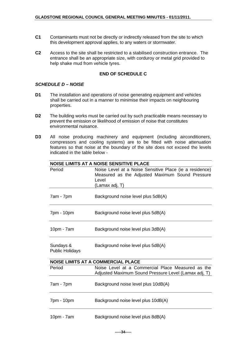
C1 Contaminants must not be directly or indirectly released from the site to which
this development approval applies, to any waters or stormwater. C2 Access to the site shall be restricted to a stabilised construction entrance. The
entrance shall be an appropriate size, with corduroy or metal grid provided to help shake mud from vehicle tyres.
END OF SCHEDULE C
SCHEDULE D – NOISE D1 The installation and operations of noise generating equipment and vehicles
shall be carried out in a manner to minimise their impacts on neighbouring properties.
D2 The building works must be carried out by such practicable means necessary to
prevent the emission or likelihood of emission of noise that constitutes environmental nuisance.
D3 All noise producing machinery and equipment (including airconditioners,
compressors and cooling systems) are to be fitted with noise attenuation features so that noise at the boundary of the site does not exceed the levels indicated in the table below -
NOISE LIMITS AT A NOISE SENSITIVE PLACE Period Noise Level at a Noise Sensitive Place (ie a residence)
Measured as the Adjusted Maximum Sound Pressure Level (Lamax adj, T)
7am - 7pm Background noise level plus 5dB(A) 7pm - 10pm Background noise level plus 5dB(A) 10pm - 7am Background noise level plus 3dB(A) Sundays & Background noise level plus 5dB(A) Public Holidays NOISE LIMITS AT A COMMERCIAL PLACE Period Noise Level at a Commercial Place Measured as the
Adjusted Maximum Sound Pressure Level (Lamax adj, T) 7am - 7pm Background noise level plus 10dB(A) 7pm - 10pm Background noise level plus 10dB(A) 10pm - 7am Background noise level plus 8dB(A)

GLADSTONE REGIONAL COUNCIL GENERAL MEETING MINUTES - 01/11/2011.
-----35-----
Sundays & Background noise level plus 5dB(A) Public Holidays
END OF SCHEDULE D SCHEDULE E – WASTE MANAGEMENT E1 Where waste is a contaminant, waste must not be released to the environment
where the release will or may cause environmental harm or environmental nuisance, unless such release is authorised.
E2 The waste storage area/s are to be sufficient in size to house all waste
collection containers including recycling waste containers. The waste storage area/s must be suitably enclosed and imperviously paved, with a hose cock and hose fitted in close proximity to the enclosure to ensure the area can be easily and effectively cleaned.
E3 The minimum overhead clearance required for mobile wheelie bin collection
vehicles is 4200 mm. Access for the collection of the wheelie bin is not to be impeded by any overhead obstructions such as trees, wires or other structures. This minimum height clearance is to be maintained at all times.
END OF SCHEDULE E
SCHEDULE F - MONITORING AND REPORTING F1 All complaints received by the holder of this development approval relating to
releases of contaminants from the activity must be recorded and kept in a log book with the following details:
(i) time, date and nature of complaint; (ii) type of communication (telephone, letter, personal etc.); (iii) name, contact address and contact telephone number of complainant
(note: if the complainant does not wish to be identified then "Not identified" is to be recorded);
(iv) response and investigation undertaken as a result of the complaint; (v) name of person responsible for investigating complaint; and (vi) action taken as a result of the complaint investigation and signature of
responsible person.
F2 As soon as practicable after becoming aware of any emergency or incident which results in the release of contaminants not in accordance, or reasonably expected to be not in accordance with the conditions of this development approval, the holder of the registration certificate to which this development approval relates, must notify the administering authority of the release by telephone or facsimile.
F3 The notification of emergencies or incidents as required by condition F2 must
include but not be limited to the following:
(i) the operator of the activity to which this development approval relates; (ii) the location of the emergency or incident; (iii) the name and telephone number of the designated contact person; (iv) the time of the release;

GLADSTONE REGIONAL COUNCIL GENERAL MEETING MINUTES - 01/11/2011.
-----36-----
(v) the time the holder of the registration certificate became aware of the release;
(vi) the suspected cause of the release; (vii) the environmental harm and or environmental nuisance caused,
threatened, or suspected to be caused by the release; and (viii) actions taken to prevent further any release and mitigate any
environmental harm and/or environmental nuisance caused by the release.
F4 Not more than 14 days following the initial notification of an emergency or
incident, the holder of the development approval must provide written advice of the information supplied in accordance with condition number F3 in addition to: (i) proposed actions to prevent a recurrence of the emergency or incident; (ii) outcomes of actions taken at the time to prevent or minimise
environmental harm and or environmental nuisance; and (iii) the results of any environmental monitoring performed.
END OF SCHEDULE F
SCHEDULE G - DEFINITIONS G1 For the purposes of this development approval the following definitions apply:
(a) "L(Amax adj, T)" means the average maximum A- weighted sound pressure level, adjusted for noise character and measured over a time period of not less than 15 minutes, using Fast response
(b) "commercial place" means a place used as an office or for business or
commercial purposes.
(c) "noise sensitive place" means - a) a dwelling, mobile home or caravan park, residential marina or other
residential premises; or b) a motel, hotel or hostel; or c) a kindergarten, school, university or other educational institution; or d) a medical centre or hospital; or e) a protected area ; or f) a park or gardens.
G2 For the purposes of this development approval any term not otherwise defined
in the Environmental Protection Act 1994, and the Sustainable Planning Act 2009 and any subordinate legislation made pursuant to these Acts or in the Definitions Schedule of this development approval has the meaning conferred to that term in its common usage.
END OF SCHEDULE G
END OF CONDITIONS
Advice to Applicant An adopted infrastructure charge notice in relation to the infrastructure charges applicable to this development has been provided separately.

GLADSTONE REGIONAL COUNCIL GENERAL MEETING MINUTES - 01/11/2011.
-----37-----
Meeting Discussion: It was noted that the report did not have the correct submission attached to it. Accordingly, it was resolved to hold the matter over until the next General meeting to allow members to review the correct submission to the application. G/5.4.7 DEVELOPMENT APPLICATION DA/382/2011 - MATERIAL
CHANGE OF USE OF PREMISES (20 UNITS) - 38A KENT STREET, WEST GLADSTONE
Responsible Officer: Chief Planner Development Application:
Application Number: DA/382/2011
Applicant: Dickson Wise Pty Ltd ATF Dickson Wise Trust C/- LG Planning Services
Owner: Dickson Wise Pty Ltd ATF Dickson Wise Trust
Date Of Receipt: 8 July 2011
Location: 38 & 38A Kent Street, West Gladstone
RPD: Lots 2 & 3 on RP606304
Area: 2,036m²
Current Use Of Land: Two Detached Dwellings on each separate lot
Zoning: Residential (Higher Density)
Proposal: Multiple Unit Residential (20 Units)
Submissions Close Date: 13 October 2011
Number Of Submissions: 3 ‘properly made’ submissions
Executive Summary: An Impact Assessable Development Application for a Material Change of Use of Premises for Multiple Unit Residential (20 Units) was received by Council on 8 July 2011. The proposal required impact assessment against The Gladstone Plan 2006 and the applicable Public Notification. There were 3 ‘properly made’ submissions received by Council during the notification period. The proposal is for 20 multiple residential units and for the most part is considered to comply with the requirements of the Planning Scheme. Where the application does not comply with the Planning Scheme, specifically height and setbacks, sufficient justification has been provided. As such the application is therefore recommended for approval subject to reasonable and relevant conditions. Officer’s Recommendation: That the application for a Material Change of Use of Premises – Multiple Unit Residential (20 Units) at 38 & 38A Kent Street, West Gladstone be approved subject to the following conditions.
1. Development is to be carried out in accordance with the submitted application including the following plans:

GLADSTONE REGIONAL COUNCIL GENERAL MEETING MINUTES - 01/11/2011.
-----38-----
Plan Name Plan Number Drawn By Date Site Plan ADA101 Rev 02 Marchese Partners 05/04/2011 Basement Plan ADA200 Rev 02 Marchese Partners 20/04/2011 Ground Plan ADA201 Rev 04 Marchese Partners 05/04/2011 Level 1 Plan ADA202 Rev 02 Marchese Partners 06/04/2011 Level 2 Plan ADA203 Rev 04 Marchese Partners 07/04/2011 Elevations Sheet 1 ADA400 Rev 02 Marchese Partners 06/04/2011 Elevations Sheet 2 ADA401 Rev 02 Marchese Partners 06/04/2011 Elevations Sheet 3 ADA402 Rev 02 Marchese Partners 03/05/2011 Landscape Concept Issue A Conlon Birrel 23/06/2011 Report Landscape Architects
except where amendments are required to satisfy the conditions of approval, including:
An amended roof design to include a skillion roof with a minimum 7 degree
roof pitch and an articulated and varying form in the roofline, to be submitted to Council for approval prior to the issue of a Development Permit for Building Works. The amended roof design must not exceed 12.6 metres in height.
2. All alterations to services and municipal facilities necessitated by the
development shall be the responsibility of the applicant. Building Works
3. The applicant / developer is required to obtain a Development Permit for Building Works in accordance with the Sustainable Planning Act 2009 to remove the existing structures from the site in accordance with the Building Act 1975.
4. The applicant is required to obtain a Development Permit for Building and
Plumbing Works in accordance with the Sustainable Planning Act 2009. Construction is to comply with the Building Act 1975, the Building Code of Australia and the requirements of other relevant authorities.
5. All lighting at ground level and associated with illuminating ground level areas
must be focussed downwards and be provided with hoods, shades or other permanent devices to direct illumination downwards and not allow upward lighting to adversely affect the residential uses on the site and surrounding sites.
6. Any security lighting shall be so designed to ensure that nuisance is not caused
to adjoining areas by the spillage of light.
7. Provision of an 1800 mm high screen fence to side, and rear boundaries except where acoustic fencing is required and other than that section forward of the building line which shall be no greater than 1.2 metres in height. The details of which are to be submitted with any Building Works application on the site.
8. Open storage / bin storage areas are to be adequately screened so as not to
detract from the visual amenity of the area. One way of achieving compliance with this condition is as follows:
a) outdoor storage areas are situated in locations not visible from the street

GLADSTONE REGIONAL COUNCIL GENERAL MEETING MINUTES - 01/11/2011.
-----39-----
b) a 1.8m solid screen fence is located around storage areas.
9. All plant and equipment (including air conditioners, exhaust fans and the like) are to be housed, screened and located so that these do not cause environmental nuisance or harm to the residential uses on the site and surrounding sites.
10. Provision is to be made for an allocated waste reciprocal area/s adequate to
service the development. The waste reciprocal area must comply with the following where applicable:
a) Mobile Wheelie Bins Provision of an allocated waste reciprocal area/s adequate to store the
mobile wheelie-bins for all units. The standing room for the wheelie-bin is to allow for two (2) 240 litre mobile garbage bins per unit; or
b) Bulk Bins Provision is to be made for an allocated waste reciprocal area/s
adequate to store the bulk bins to service all units. This bin area shall be of sufficient size to cater for the number of proposed units and is to include impervious paving, suitable drainage, and shall be contained in a suitable form of enclosure.
Provision of a site plan with turning circles demonstrating that sufficient manoeuvrability area is provided to allow for a refuse collection vehicle to access the designated refuse bin area and enter and exit the site in a forward direction.
Applicant / developer is required to demonstrate that the internal road is designed to cater for a fully loaded refuse vehicle to service the bulk bin. Written indemnification is required by Council to cover access to the site by its refuse collection contractor.
Details of the proposed bulk bin service area to be submitted to Council for approval from Council's Environmental Health and Compliance Department prior to the issue of a Development Permit for Building Works.
11. Nominated communal open space areas shall be permanently accessible to all
residents of the development and may not be allocated to any particular units or units for exclusive use and/or access.
Operational Works
12. A Development Permit for Operational Works must be obtained from Council prior to the commencement of construction. The Development Application for Operational Works is to include the following:
a) earthworks (including retaining walls) b) roadworks (including all works within the road reserve, e.g. driveway
access) c) water infrastructure d) sewerage infrastructure e) stormwater management (including erosion & sediment control) f) landscaping
The design and supporting calculations / documentation associated with these works must be certified by a Registered Professional Engineer of Queensland (RPEQ).

GLADSTONE REGIONAL COUNCIL GENERAL MEETING MINUTES - 01/11/2011.
-----40-----
13. Operational works shall be designed and constructed in accordance with Council's relevant standards at the time of lodgement of an application for an Operational Works Permit and in accordance with the relevant Australian Standards and good engineering practice. Council’s current standards include:
a) Roads and Transport Standard 2005 (Joint CSC and GCC) b) Gladstone City Council Subdivision Guidelines, Rev 4, Nov 02 (Section 7) c) Water Supply Standard 2006 (Joint CSC and GCC) d) Sewerage Design Standard 2003 (Joint CSC and GCC)
14. The Operational Works drawings shall contain adequate information to position
each component of infrastructure by coordinates to GDA94 and levels to Australian Height Datum (AHD). The drawings shall also indicate the identification number, position and recorded level of the Permanent Survey Mark (PSM) from which the project’s horizontal and vertical position was derived.
15. The Operational Works are to be executed under the supervision of a RPEQ.
The applicant / developer must give to the Council, construction certificates from such supervising engineer, that the work has been constructed in accordance with the Operational Works Permit and good engineering practice, together with relevant quality assurance, operation and maintenance, and “as constructed” documentation. This includes provision of a CCTV report on all sewer mains installed as part of the development.
16. The “as constructed” drawings and associated electronic documentation are to
be certified by the supervising engineer and by a registered surveyor stating that the as constructed information shown on the “as constructed” drawings represent a complete and accurate record of the works as executed. Council reserves the right to utilise for its own purposes and the sale of information provided within the “as constructed” drawings provided by the applicant / developer.
17. Where the appointment of a principal contractor is applicable under the
Queensland Workplace Health and Safety Act 1995, no operational works are to commence until a copy of Form 34 “Notice of appointment of principal contractor” is received by WH&S Qld, by the Principal Contractor and by Council. Similarly, Council must be provided with evidence of any change in the appointment of a Principal Contractor throughout the course of the project.
18. The lodgement of a maintenance bond at the commencement of the “on-
maintenance” period, the equal of five (5) per centum of the total estimated cost of construction (minimum $ 10,000), to be held by the Council during the maintenance / performance verification period, being not less than twelve (12) months. The commencement of the ‘on maintenance’ period will not occur until all outstanding works have been completed, including the receipt of acceptable ‘as constructed’ information.
19. The applicant is responsible for and is to bear the cost of any alterations to,
extension of, or upgrading of Council assets / infrastructure or other service authorities’ infrastructure necessitated by the approval of this development (including but not limited to earthworks, retaining structures, roadworks, pedestrian / bicycle pathways, stormwater drainage, water supply, sewerage, electrical and telecommunication services, reticulated gas etc.).

GLADSTONE REGIONAL COUNCIL GENERAL MEETING MINUTES - 01/11/2011.
-----41-----
Landscaping
20. All landscaping must be in accordance with the Landscape Concept Report prepared by Conlon Birrel landscape Architects dated 23 June 2011.
21. All landscaping referred to in condition 20 above is to be maintained to an
appropriate standard at all times. Transportation
22. Provision of 31 car parking spaces on site including 21 covered spaces and 10 visitor spaces including a single wash bay. These spaces and all vehicle movement areas are to be constructed, drained, linemarked and maintained in accordance with Part 14, Schedule 2, Division 4 of the Planning Scheme and AS2890.1.
23. The applicant / developer is to submit a Traffic Engineer’s Certification of all
vehicle movements with swept path within the site for compliance with AS2890.1, at the time of lodgement of the Operational Works application.
24. The applicant / developer is to provide a reinforced concrete or bitumen sealed
driveway (prime and two coat 16/10 spray seal) constructed for the full length of the driveway from the front property boundary to the proposed building platform. Footpath crossovers are to be in accordance with Council’s Standard Drawing RT-0056.
25. Provision of a 1 metre wide line marked footpath for the full extent of the access
easement. 26. The proposed access driveways are to be constructed in accordance with
Council’s Standard Drawing RT-0055.
27. Removal of any existing unused invert crossings, with reinstatement of the kerb and channel to match existing construction in Kent Street.
28. Any manholes located on the proposed driveway are to be covered with Class
D Covers to AS 3996, and are to be maintained at finished surface levels and remain accessible at all times.
Earthworks
29. All earthworks on the site must be carried out in accordance with AS 3798 and good engineering practice. Geotechnical supervision shall be to Level 1. The geotechnical testing authority shall provide a report to Council, setting out the inspections, sampling and testing it has carried out, and the locations and results thereof. The geotechnical report must be certified a RPEQ experienced in this type of work.
30. All new retaining wall works, including associated excavation, surface and
subsurface drainage works, shall be wholly constructed within the development site. The location of the retaining wall in relation to property boundaries shall be dimensioned / detailed on the drawings.
31. Retaining walls are to comply with the following requirements:

GLADSTONE REGIONAL COUNCIL GENERAL MEETING MINUTES - 01/11/2011.
-----42-----
a) The design life of retaining walls shall be at least fifty (50) years and
retaining walls shall be designed to safely withstand the impact of a 1.8m high solid fence constructed along the top of the retaining wall. Fence loadings to include dead, live and wind loads.
b) Retaining walls must not impose loads on underground services within allotments or external to allotments, including but not limited to water, sewerage, stormwater, electrical, telecommunication or other services. In particular, retaining wall footings must not impose loads on the electrical / telecommunication service corridor which is located in the footpath (verge) adjacent to the front property boundary and must allow for the installation and maintenance of these services.
c) The design and construction of retaining walls must be certified by a Registered Professional Engineer of Queensland (RPEQ) experienced in this type of work. The design certificate and the construction certificate must be location specific and must include: design life, design standards, allowable fence loads and any special
provisions / constraints in regards to fence type, fence footing, foundation etc. (for the information of future fence designers / constructors).
a statement that the retaining wall structure will not impose loads on underground services.
Sewerage Infrastructure
32. The sanitary drainage shall drain to a single connection point at an existing or proposed concrete maintenance hole (1050mm diameter) on the municipal sewer main.
33. The location of the proposed buildings shall comply with Council Policy 19.7 -
Revision 1 - Building Adjacent to and Over Sewers, Stormwater and Water Assets.
34. An easement / easements for the purpose of wastewater drainage shall be
created over all new and existing sewers and sewerage infrastructure not in road reserves or not in land controlled by Council. The easement(s) created is to be a minimum 3.0m wide. Where the sewer is located within 2.5m of a property boundary, the easement shall extend to the property boundary.
Water Infrastructure
35. New water connections necessitated by the development are the responsibility of the applicant / developer. Water connection applications are to be made to Council for a quotation for the necessary works.
36. Individual water meters (sub-metering) shall be provided for each unit in
accordance with the Water and Other Legislation Amendment Act 2007.
37. Any strata titling of the development will require certification from a Hydraulic Engineer that the metering of water for the development complies with the Water and Other Legislation Amendment Act 2007. Council uses Elster Smart Metering System or equivalent.
Stormwater Management

GLADSTONE REGIONAL COUNCIL GENERAL MEETING MINUTES - 01/11/2011.
-----43-----
38. The applicant / developer is to submit (for approval) a stormwater management plan as part of the Operational Works application. The plan must address both quantity and quality aspects of stormwater management and certified by a RPEQ experienced in this type of work.
39. The design of the Operational Works must comply with the following stormwater
management (quantity) criteria: a) Stormwater infrastructure must adequately drain the site and must cater for
stormwater flows through the site (if applicable) and discharge any runoff from the site to a “lawful point of discharge” as defined in Section 3.02 of the Queensland Urban drainage Manual – Volume 1, 2nd edition 2007. The stormwater drainage system is to be designed to cater for a 1 in 10 year ARI minor storm event and a 1 in 100 year ARI major storm event. The stormwater management report must demonstrate there will be no
worsening of stormwater runoff from the site as a result of the proposed development of the site for all design storm events up to and including a storm event with an average recurrence interval of 1 in 100 years.
The report must be certified by the responsible RPEQ in accordance with the following: “I am aware that the Gladstone Regional Council may rely upon the content and findings of this report including the recommendations, conclusions, results, calculations, plans, graphs, tables, attachments etc., for the purposes of development assessment. In my opinion, the Council can rely upon the information contained within the report and there are no reservations or qualifications in respect to the information other than set out in the report itself. I confirm that the development site is above the controlling 1 in 100 year ARI flood level and that there will be no worsening of stormwater runoff from the site as a result of the proposed development of the site.”
40. The design of the Operational Works shall comply with the following stormwater
management (quality) criteria: Water Sensitive Urban Design (WSUD) measures must be implemented to achieve the pollutant load reductions listed below. The proposed treatment train shall be modelled using “MUSIC” (Model for Urban Stormwater Improvement Conceptualisation) developed by the eWater cooperative research centre (eWater CRC). The water quality objectives in terms of the minimum percentage reduction in mean annual pollutant loads from the unmitigated development are as follows: Total Suspended Solids (TSS) 85% reduction Total Phosphorus (TP) 70% reduction Total Nitrogen (TN) 45% reduction Gross Pollutants (> 5mm) 90% reduction
Alternatively, the applicant may enter into an infrastructure agreement with Council generally in accordance with the following:
The applicant is to provide partial on-site treatment including the use of on-site rainwater tanks and sediment reduction measures and pay a monetary contribution to Council for Council to commence the planning, design,

GLADSTONE REGIONAL COUNCIL GENERAL MEETING MINUTES - 01/11/2011.
-----44-----
construction and maintenance of additional nutrient removal treatment measures external to the site.
Miscellaneous
41. Amalgamation of Lot 2 RP606304 and Lot 3 RP606304 onto one title prior to the issue of the final Certificate of Classification.
42. The site is to be maintained in a clean and orderly state at all times.
43. Any strata titling of the proposed development can only provide for a total of 20
units.
ENVIRONMENTAL HEALTH SPECIFIC CONDITIONS
SCHEDULE A - GENERAL CONDITIONS A1 In carrying out the activity, all reasonable and practical measures are to be taken
to minimise releases and the likelihood of releases of contaminants to the environment, except as otherwise provided by the conditions of this development approval.
A2 The holder of this development approval must:
(a) install and operate all works and control equipment, and (b) take all measures, perform all acts and do all things, necessary to ensure
compliance with the conditions of this development approval. A3 Notwithstanding any other condition of this development approval, this
development approval does not authorise any release of contaminants that causes or is likely to cause an environmental nuisance beyond the boundaries of the registered place.
END OF SCHEDULE A
SCHEDULE B - AIR B1 Odour and visible contaminants, including but not limited to dust, smoke, fumes
and aerosols must not be released to the environment in a manner that will or may cause environmental harm or environmental nuisance unless such release is authorised.
B2 All lights (signage, security etc) are to be installed and positioned in a manner
that does not create a light nuisance to adjoining properties. Lights must not be angled onto adjoining properties.
END OF SCHEDULE B
SCHEDULE C – WATER / STORMWATER C1 Contaminants must not be directly or indirectly released from the site to which
this development approval applies, to any waters or stormwater. C2 Access to the site shall be restricted to a stabilised construction entrance. The
entrance shall be an appropriate size, with corduroy or metal grid provided to help shake mud from vehicle tyres.

GLADSTONE REGIONAL COUNCIL GENERAL MEETING MINUTES - 01/11/2011.
-----45-----
C3 The vehicle wash down area must be impervious, covered, bunded to exclude
any stormwater and drained to either the sewer under the conditions of a trade waste permit or collected for recycling/disposal using a system approved by Council. Where no cover can be provided, the drainage system must be capable of accepting the first 20mm of contaminated stormwater falling within the bunded area and fitted with an automatic stormwater diversion valve.
END OF SCHEDULE C
SCHEDULE D – NOISE D1 The installation and operations of noise generating equipment and vehicles
shall be carried out in a manner to minimise their impacts on neighbouring properties.
D2 The building works must be carried out by such practicable means necessary to
prevent the emission or likelihood of emission of noise that constitutes environmental nuisance.
D3 All noise producing machinery and equipment (including airconditioners,
compressors and cooling systems) are to be fitted with noise attenuation features so that noise at the boundary of the site does not exceed the levels indicated in the table below -
NOISE LIMITS AT A NOISE SENSITIVE PLACE Period Noise Level at a Noise Sensitive Place (ie a residence)
Measured as the Adjusted Maximum Sound Pressure Level (Lamax adj, T)
7am - 7pm Background noise level plus 5dB(A) 7pm - 10pm Background noise level plus 5dB(A) 10pm - 7am Background noise level plus 3dB(A) Sundays & Background noise level plus 5dB(A) Public Holidays NOISE LIMITS AT A COMMERCIAL PLACE Period Noise Level at a Commercial Place Measured as the
Adjusted Maximum Sound Pressure Level (Lamax adj, T) 7am - 7pm Background noise level plus 10dB(A) 7pm - 10pm Background noise level plus 10dB(A) 10pm - 7am Background noise level plus 8dB(A)
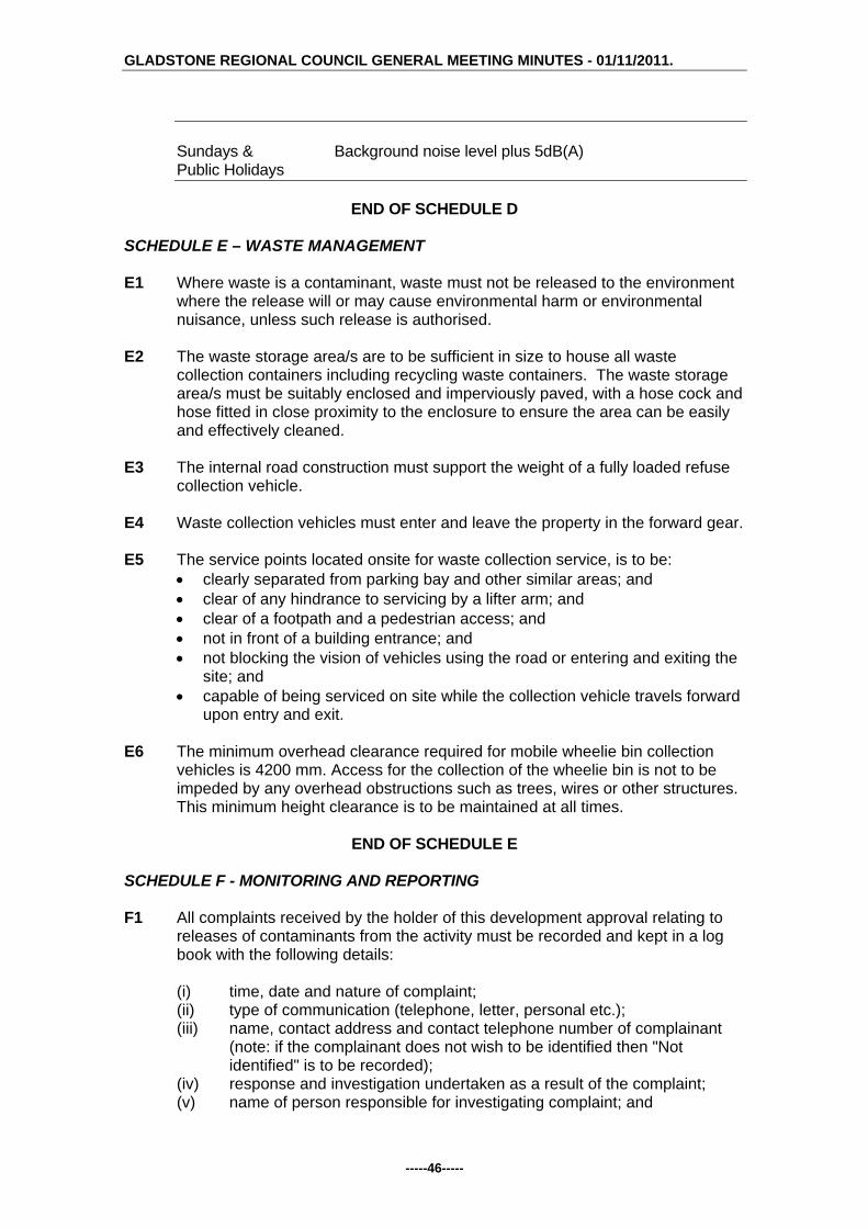
GLADSTONE REGIONAL COUNCIL GENERAL MEETING MINUTES - 01/11/2011.
-----46-----
Sundays & Background noise level plus 5dB(A) Public Holidays
END OF SCHEDULE D SCHEDULE E – WASTE MANAGEMENT E1 Where waste is a contaminant, waste must not be released to the environment
where the release will or may cause environmental harm or environmental nuisance, unless such release is authorised.
E2 The waste storage area/s are to be sufficient in size to house all waste
collection containers including recycling waste containers. The waste storage area/s must be suitably enclosed and imperviously paved, with a hose cock and hose fitted in close proximity to the enclosure to ensure the area can be easily and effectively cleaned.
E3 The internal road construction must support the weight of a fully loaded refuse
collection vehicle. E4 Waste collection vehicles must enter and leave the property in the forward gear. E5 The service points located onsite for waste collection service, is to be:
clearly separated from parking bay and other similar areas; and clear of any hindrance to servicing by a lifter arm; and clear of a footpath and a pedestrian access; and not in front of a building entrance; and not blocking the vision of vehicles using the road or entering and exiting the
site; and capable of being serviced on site while the collection vehicle travels forward
upon entry and exit. E6 The minimum overhead clearance required for mobile wheelie bin collection
vehicles is 4200 mm. Access for the collection of the wheelie bin is not to be impeded by any overhead obstructions such as trees, wires or other structures. This minimum height clearance is to be maintained at all times.
END OF SCHEDULE E
SCHEDULE F - MONITORING AND REPORTING F1 All complaints received by the holder of this development approval relating to
releases of contaminants from the activity must be recorded and kept in a log book with the following details:
(i) time, date and nature of complaint; (ii) type of communication (telephone, letter, personal etc.); (iii) name, contact address and contact telephone number of complainant
(note: if the complainant does not wish to be identified then "Not identified" is to be recorded);
(iv) response and investigation undertaken as a result of the complaint; (v) name of person responsible for investigating complaint; and

GLADSTONE REGIONAL COUNCIL GENERAL MEETING MINUTES - 01/11/2011.
-----47-----
(vi) action taken as a result of the complaint investigation and signature of responsible person.
F2 As soon as practicable after becoming aware of any emergency or incident which
results in the release of contaminants not in accordance, or reasonably expected to be not in accordance with the conditions of this development approval, the holder of the registration certificate to which this development approval relates, must notify the administering authority of the release by telephone or facsimile.
F3 The notification of emergencies or incidents as required by condition F2 must
include but not be limited to the following:
(i) the operator of the activity to which this development approval relates; (ii) the location of the emergency or incident; (iii) the name and telephone number of the designated contact person; (iv) the time of the release; (v) the time the holder of the registration certificate became aware of the
release; (vi) the suspected cause of the release; (vii) the environmental harm and or environmental nuisance caused,
threatened, or suspected to be caused by the release; and (viii) actions taken to prevent further any release and mitigate any
environmental harm and/or environmental nuisance caused by the release.
F4 Not more than 14 days following the initial notification of an emergency or
incident, the holder of the development approval must provide written advice of the information supplied in accordance with condition number F3 in addition to: (i) proposed actions to prevent a recurrence of the emergency or incident; (ii) outcomes of actions taken at the time to prevent or minimise
environmental harm and or environmental nuisance; and (iii) the results of any environmental monitoring performed.
END OF SCHEDULE F
SCHEDULE G - DEFINITIONS G1 For the purposes of this development approval the following definitions apply:
(a) "L(Amax adj, T)" means the average maximum A- weighted sound pressure level, adjusted for noise character and measured over a time period of not less than 15 minutes, using Fast response
(b) "commercial place" means a place used as an office or for business or
commercial purposes.
(c) "noise sensitive place" means - a) a dwelling, mobile home or caravan park, residential marina or other
residential premises; or b) a motel, hotel or hostel; or c) a kindergarten, school, university or other educational institution; or d) a medical centre or hospital; or e) a protected area ; or f) a park or gardens.

GLADSTONE REGIONAL COUNCIL GENERAL MEETING MINUTES - 01/11/2011.
-----48-----
G2 For the purposes of this development approval any term not otherwise defined in the Environmental Protection Act 1994, and the Sustainable Planning Act 2009 and any subordinate legislation made pursuant to these Acts or in the Definitions Schedule of this development approval has the meaning conferred to that term in its common usage.
END OF SCHEDULE G
END OF CONDITIONS
Advice to Applicant An adopted infrastructure charge notice in relation to the infrastructure charges applicable to this development has been provided separately. G/11/ 798 Council Resolution: Moved Cr McDonald Seconded Cr Butler That the Officer's Recommendation be adopted.
CARRIED G/5.4.8 DEVELOPMENT APPLICATION DA/331/2011 - MATERIAL
CHANGE OF USE OF PREMISES - MULTIPLE UNIT RESIDENTIAL (12 UNITS) - 71- 73 TOOLOOA STREET & 104 OFF LANE, SOUTH GLADSTONE
Responsible Officer: Chief Planner Development Application:
Application Number: DA/331/2011
Applicant: HPC Urban Design & Planning Pty Ltd
Owner: Mr A Mitchell
Date Of Receipt: 10 May 2011
Location: 71 & 73 Toolooa Street and 104 Off Lane, South Gladstone
RPD: Lots 8 & 10 RP 606041, Gladstone, Lot 14 RP 619431, Gladstone
Area: 2,972m2
Current Use Of Land: Dwellings (3)
Zoning: Residential (Higher Density)
Proposal: Multiple Unit Residential - Stage 1 (8 Units) & Stage 2 (4 Units)
Submissions Close Date: N/A (Code Assessable)
Number Of Submissions: N/A (Code Assessable)
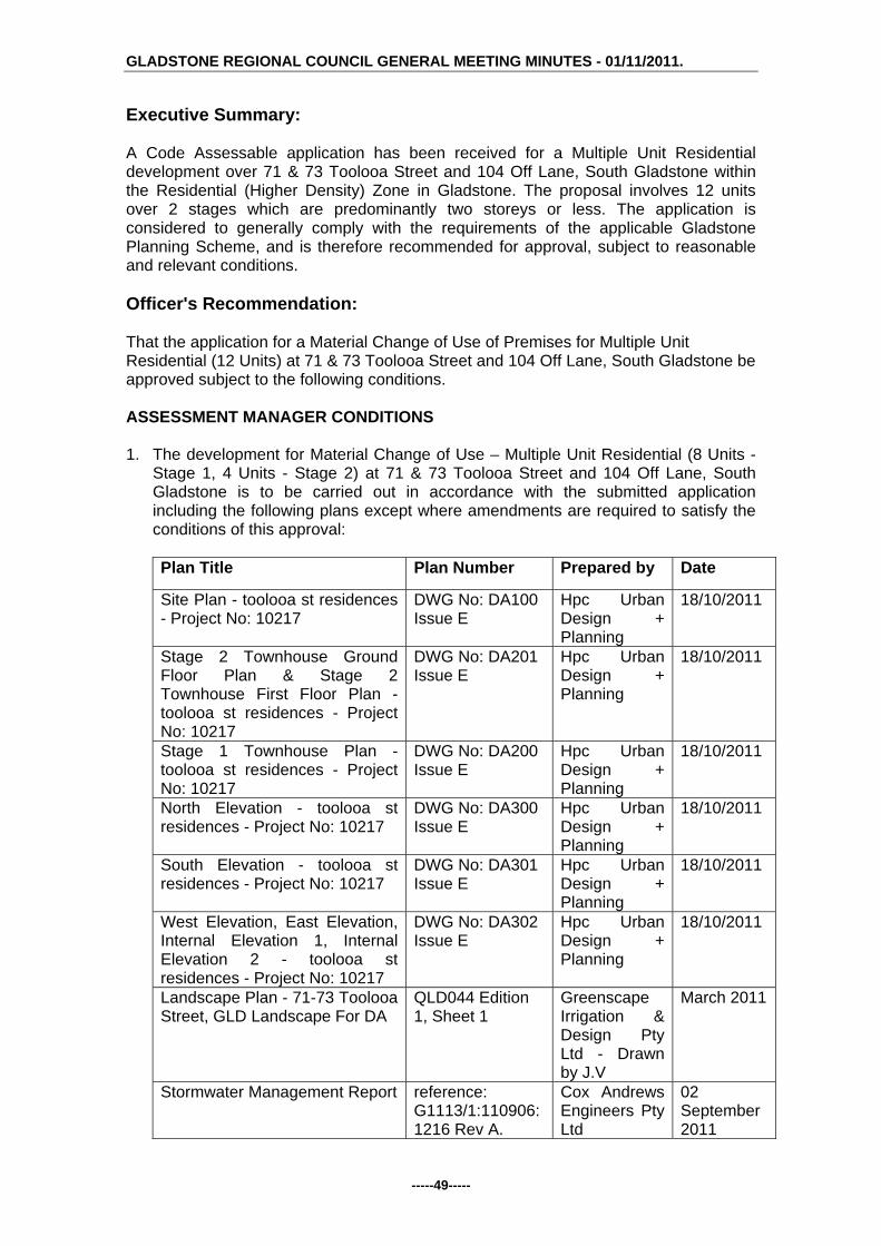
GLADSTONE REGIONAL COUNCIL GENERAL MEETING MINUTES - 01/11/2011.
-----49-----
Executive Summary: A Code Assessable application has been received for a Multiple Unit Residential development over 71 & 73 Toolooa Street and 104 Off Lane, South Gladstone within the Residential (Higher Density) Zone in Gladstone. The proposal involves 12 units over 2 stages which are predominantly two storeys or less. The application is considered to generally comply with the requirements of the applicable Gladstone Planning Scheme, and is therefore recommended for approval, subject to reasonable and relevant conditions. Officer's Recommendation: That the application for a Material Change of Use of Premises for Multiple Unit Residential (12 Units) at 71 & 73 Toolooa Street and 104 Off Lane, South Gladstone be approved subject to the following conditions. ASSESSMENT MANAGER CONDITIONS 1. The development for Material Change of Use – Multiple Unit Residential (8 Units -
Stage 1, 4 Units - Stage 2) at 71 & 73 Toolooa Street and 104 Off Lane, South Gladstone is to be carried out in accordance with the submitted application including the following plans except where amendments are required to satisfy the conditions of this approval:
Plan Title Plan Number Prepared by Date
Site Plan - toolooa st residences - Project No: 10217
DWG No: DA100 Issue E
Hpc Urban Design + Planning
18/10/2011
Stage 2 Townhouse Ground Floor Plan & Stage 2 Townhouse First Floor Plan - toolooa st residences - Project No: 10217
DWG No: DA201 Issue E
Hpc Urban Design + Planning
18/10/2011
Stage 1 Townhouse Plan - toolooa st residences - Project No: 10217
DWG No: DA200 Issue E
Hpc Urban Design + Planning
18/10/2011
North Elevation - toolooa st residences - Project No: 10217
DWG No: DA300 Issue E
Hpc Urban Design + Planning
18/10/2011
South Elevation - toolooa st residences - Project No: 10217
DWG No: DA301 Issue E
Hpc Urban Design + Planning
18/10/2011
West Elevation, East Elevation, Internal Elevation 1, Internal Elevation 2 - toolooa st residences - Project No: 10217
DWG No: DA302 Issue E
Hpc Urban Design + Planning
18/10/2011
Landscape Plan - 71-73 Toolooa Street, GLD Landscape For DA
QLD044 Edition 1, Sheet 1
Greenscape Irrigation & Design Pty Ltd - Drawn by J.V
March 2011
Stormwater Management Report reference: G1113/1:110906:1216 Rev A.
Cox Andrews Engineers Pty Ltd
02 September 2011

GLADSTONE REGIONAL COUNCIL GENERAL MEETING MINUTES - 01/11/2011.
-----50-----
2. Provide a minimum of 30m2 in private open and recreation space to Units 5, 6, 7
and 8. Building Works 3. Permanent privacy screening that allows no more than 25% visual permeability is
provided to balconies and windows on the east and western elevations of the residential building.
4. Fixed and permanent sun shading is provided to all windows with an orientation of
+ or – 45 degrees of due west and due east. 5. Nominated communal open space areas are permanently accessible to all
residents of the development and may not be allocated to any particular units or units for exclusive use and/or access.
6. A Development Permit for Building and Plumbing Works is to be obtained in
accordance with the Sustainable Planning Act 2009. Construction is to comply with the Building Act 1975, the Building Code of Australia and the requirements of other relevant authorities. This includes appropriate access and facilities for the disabled and compliance with the relevant fire classification requirements in accordance with the Building Code of Australia.
7. Separate application for Building Works approval is required to remove or demolish
existing structures from the site, including any sealing of sewer connections until new building work commences.
8. Appropriate erosion and sedimentation control measures are to be utilised during
any Building Works carried out as a result of the development. 9. All plant and equipment (including air conditioners, exhaust fans and the like) are to
be housed, screened and located so that these do not cause environmental nuisance or harm to the residential uses on surrounding sites. Additionally, the roof form is to be shaped to cap the building and to screen roof plant and other equipment when viewed from public spaces or adjoining properties.
10. Provision of an 1800 mm high screen fence to side and rear boundaries, other than
that section forward of the building line which shall be no greater than 1.2 metres in height, the details of which are to be submitted with any building works application on the site.
11. Building Works application shall detail the proposed location of water tanks as
required by Part 25 of the Queensland Development Code. 12. The floor material and thickness to all floors above car parking areas is such that
internal residential sleep disturbance noise levels are not exceeded. Operational Works 13. A Development Permit for Operational Works must be obtained from Council prior
to the commencement of construction. The Development Application for Operational Works is to include the following:
a) earthworks (including retaining walls)

GLADSTONE REGIONAL COUNCIL GENERAL MEETING MINUTES - 01/11/2011.
-----51-----
b) roadworks (including all works within the road reserve, e.g. driveway access) c) water infrastructure d) sewerage infrastructure e) stormwater management (including erosion & sediment control) f) landscaping
The design and supporting calculations / documentation associated with these works must be certified by a Registered Professional Engineer of Queensland (RPEQ).
14. Operational works shall be designed and constructed in accordance with Council's
relevant standards at the time of lodgement of an application for an Operational Works Permit and in accordance with the relevant Australian Standards and good engineering practice. Council’s current standards include:
a) Roads and Transport Standard 2005 (Joint CSC and GCC) b) Gladstone City Council Subdivision Guidelines, Rev 4, Nov 02 (Section 7) c) Water Supply Standard 2006 (Joint CSC and GCC) d) Sewerage Design Standard 2003 (Joint CSC and GCC)
15. The operational works drawings shall contain adequate information to position each
component of infrastructure by coordinates to GDA94 and levels to Australian Height Datum (AHD). The drawings shall also indicate the identification number, position and recorded level of the Permanent Survey Mark (PSM) from which the project’s horizontal and vertical position was derived.
16. The Operational Works are to be executed under the supervision of a RPEQ. The
applicant / developer must give to the Council, construction certificates from such supervising engineer, that the work has been constructed in accordance with the Operational Works Permit and good engineering practice, together with relevant quality assurance, operation and maintenance, and “as constructed” documentation.
17. The “as constructed” drawings and associated electronic documentation are to be
certified by the supervising engineer and by a registered surveyor stating that the as constructed information shown on the “as constructed” drawings represent a complete and accurate record of the works as executed. Council reserves the right to utilise for its own purposes and the sale of information provided within the “as constructed” drawings provided by the applicant / developer.
18. Where the Queensland Workplace Health and Safety Act 1995 requires the
appointment of a principal contactor, no operational works are to commence until a copy of Form 34 “Notice of appointment of principal contractor” is received by WH&S Qld, the Principal Contractor and by Council. Similarly, Council must be provided with evidence of any change in the appointment of a Principal Contractor throughout the course of the project.
19. The lodgement of a maintenance bond on completion of the civil works, the equal of
five (5) per centum of the total estimate (minimum bond of $ 1,000), to be held by the Council during the maintenance period being not less than twelve (12) months and the commencement of the ‘on maintenance’ period will not occur until all outstanding works, including the receipt of acceptable ‘as constructed’ information have been completed.

GLADSTONE REGIONAL COUNCIL GENERAL MEETING MINUTES - 01/11/2011.
-----52-----
20. Any alterations to, extension of, or upgrading of Council assets / infrastructure or other service authorities’ infrastructure necessitated by this MCU proposal (including earthworks, retaining structures, roadworks, pedestrian / bicycle pathways, stormwater drainage, water supply, sewerage, electrical and telecommunication services, reticulated gas etc.) shall be the responsibility of the applicant / developer.
Landscaping 21. A landscape plan is to be submitted for approval prior to the issuing of a
Development Permit for Operational Works. The landscaping of the site shall incorporate:
a. Outline of the buildings; b. Existing trees (height, location); c. Trees to be removed; d. Proposed planting (quantity, species and expected mature height); e. Paths and paving (location and materials); and f. The method of planting and the proposed maintenance program. g. All areas of landscaping as shown on the Landscape Plan - 71-73 Toolooa
Street, GLD Landscape For DA; h. Additional landscaping along the properties side boundaries; i. Species selected should be capable of reaching a mature height of at least
10 metres; and j. The landscaping provided shall be in accordance with Council's preferred
landscape plant list. 22. All landscaping referred to in Condition 21 above is to be maintained to an
appropriate standard at all times. Transportation 23. Where not existing, provision of 1.2 metre wide concrete footpath for the full extent
of the Toolooa Street and Off Lane frontages of the site. The footpath shall be of a non-skid surface acceptable to Council and be flat and continuous in grade.
24. Non-paved footpath (verge) areas fronting the development site are to be top soiled
and turfed. 25. Provision of a minimum of 19 car parking spaces on site in accordance with the
approved plan, being DWG No: DA100 Issue E (Site Plan). These spaces and all vehicle movement areas are to be constructed, drained, linemarked and maintained in accordance with Part 14 Division 4 of the Planning Scheme for the City of Gladstone and AS 2890.1.
26. The applicant is to submit a Traffic Engineer’s Certification of all vehicle movements
through the site including a swept path analysis demonstrating compliance with AS2890.1 as part of an application for Building Works. All vehicles must have the ability to enter and leave the site in a forward gear.
27. Subject to site specific design requirements of the responsible RPEQ, the proposed
access driveway is to be constructed in accordance with Council's Standard Drawing RT-0055. The applicant is required to obtain an approval from Council under Local Law 21 - Roads for the proposed crossover. This includes the removal of existing invert crossings with construction of kerb and channel to this portion of

GLADSTONE REGIONAL COUNCIL GENERAL MEETING MINUTES - 01/11/2011.
-----53-----
Toolooa Street and Off Lane. The splayed portion of the proposed driveway is not to encroach on the frontage of the adjoining allotment
Earthworks 28. Any filling carried out on site is to be in accordance with AS3798-1996 (Level 1
supervision). 29. The subject site is identified as an area which may contain acid sulphate soils.
Earthwork operations must be managed to :
a) maintain the water quality and ecological health of the receiving environment;
b) avoid adverse effects on environmentally sensitive areas; and c) avoid accelerated corrosion of assets such as buildings, structures, roads
and other infrastructure. Lighting 30. All lighting at ground level and associated with illuminating ground level areas must
be focused downwards and be provided with hoods, shades or other permanent devices to direct illumination downwards and not allow upward lighting to adversely affect the residential uses on this site and the adjoining the sites.
31. Any security lighting shall be so designed to ensure that nuisance is not caused to
adjoining areas by the spillage of light. Sewerage Infrastructure 32. The sanitary drainage (hose drains) from all dwellings within the site are to drain to
a new (privately owned and maintained) maintenance hole (1050mm diameter) within the site. The maintenance hole is to be connected to the existing municipal sewer main at one point only.
33. A CCTV inspection and is to be carried out to verify the condition of the existing
municipal sewerage infrastructure within the site. The existing sewerage infrastructure within the site must be replaced should the CCTV inspection (or other type of inspection) indicate that it does not have a life expectancy of at least 25 years.
34. All existing house connection junctions are to be sealed in a workmanship like
manner. 35. The location of the proposed buildings shall comply with Council Policy 19.7 -
Revision 1 - Building Adjacent to and Over Sewers, Stormwater and Water Assets. 36. An easement is to be created in the benefit of Gladstone Regional Council, and at
no cost to Council for the purpose of wastewater drainage, over the existing sewers and sewerage infrastructure within the site. The easement created is to be a minimum 3.0m wide. The easement must be created prior to the occupation or use of the premises.
Water Infrastructure

GLADSTONE REGIONAL COUNCIL GENERAL MEETING MINUTES - 01/11/2011.
-----54-----
37. Individual water meters (sub-metering) shall be provided for each unit in accordance with the Water and Other Legislation Amendment Act 2007.
38. Any strata titling of the development will require certification from a Hydraulic
Engineer that the metering of water for the development complies with the Water and Other Legislation Amendment Act 2007.
39. The site is to be serviced via a single metered water connection. The connection
from Council’s water main to the front property boundary and any metering arrangements is to be carried out by Council at the applicant / developer’s expense.
Stormwater Management 40. Stormwater infrastructure must adequately drain the site and must cater for
stormwater flows through the site (if applicable) and discharge any runoff from the site to a “lawful point of discharge” as defined in Section 3.02 of the Queensland Urban drainage Manual – Volume 1, 2nd edition 2007.
The stormwater drainage system is to be designed to cater for a 1 in 10 year ARI storm event and a 1 in 100 year ARI major storm event.
41. The design of the operational works shall comply with the following stormwater management (quality) criteria: Water Sensitive Urban Design (WSUD) measures must be implemented to achieve the pollutant load reductions listed below. The proposed treatment train shall be modelled using “MUSIC” (Model for Urban Stormwater Improvement Conceptualisation) developed by the eWater cooperative research centre (eWater CRC). The water quality objectives in terms of the minimum percentage reduction in mean annual pollutant loads from the unmitigated development are as follows:
Total Suspended Solids (TSS) 85% reduction Total Phosphorus (TP) 70% reduction Total Nitrogen (TN) 45% reduction Gross Pollutants (> 5mm) 90% reduction
42. The stormwater management works shall be generally in accordance with the
Stormwater Management Report prepared by Cox Andrews Engineers Pty Ltd dated 2 September 2011 (reference: G1113/1:110906:1216 Rev A).
Refuse Management 43. A Refuse Management Report to be submitted to Council and approved by The
Environment and Regulation Department prior to the issue Building works approval. The report is to provide details including:
(i) bin storage areas including any applicable screening; (ii) types of bins to be used; (iii) areas for refuse collection; (iv) waste removal vehicle movements to, from, and throughout the site; and (iv) how waste is to be collected and removed from the site.
Miscellaneous

GLADSTONE REGIONAL COUNCIL GENERAL MEETING MINUTES - 01/11/2011.
-----55-----
44. The site is to be maintained in a clean and orderly state at all times. 45. Separate outdoor clothes drying facilities shall be provided and appropriately sited
for each dwelling unit. 46. Any strata titling of the proposed development can only provide for a total of 12
units. 47. The approved use of the site is for Multiple Unit Residential and any other use will
require a separate Development Application to Council.
ENVIRONMENTAL HEALTH SPECIFIC CONDITIONS SCHEDULE A - GENERAL CONDITIONS A1 In carrying out the activity, all reasonable and practical measures are to be taken
to minimise releases and the likelihood of releases of contaminants to the environment, except as otherwise provided by the conditions of this development approval.
A2 The holder of this development approval must:
(a) install and operate all works and control equipment, and (b) take all measures, perform all acts and do all things, necessary to ensure
compliance with the conditions of this development approval. A3 Notwithstanding any other condition of this development approval, this
development approval does not authorise any release of contaminants that causes or is likely to cause an environmental nuisance beyond the boundaries of the registered place.
END OF SCHEDULE A
SCHEDULE B - AIR B1 Odour and visible contaminants, including but not limited to dust, smoke, fumes
and aerosols must not be released to the environment in a manner that will or may cause environmental harm or environmental nuisance unless such release is authorised.
B2 All lights (signage, security etc) are to be installed and positioned in a manner
that does not create a light nuisance to adjoining properties. Lights must not be angled onto adjoining properties.
END OF SCHEDULE B
SCHEDULE C – WATER / STORMWATER C1 Contaminants must not be directly or indirectly released from the site to which
this development approval applies, to any waters or stormwater. C2 Access to the site shall be restricted to a stabilised construction entrance. The
entrance shall be an appropriate size, with corduroy or metal grid provided to help shake mud from vehicle tyres.
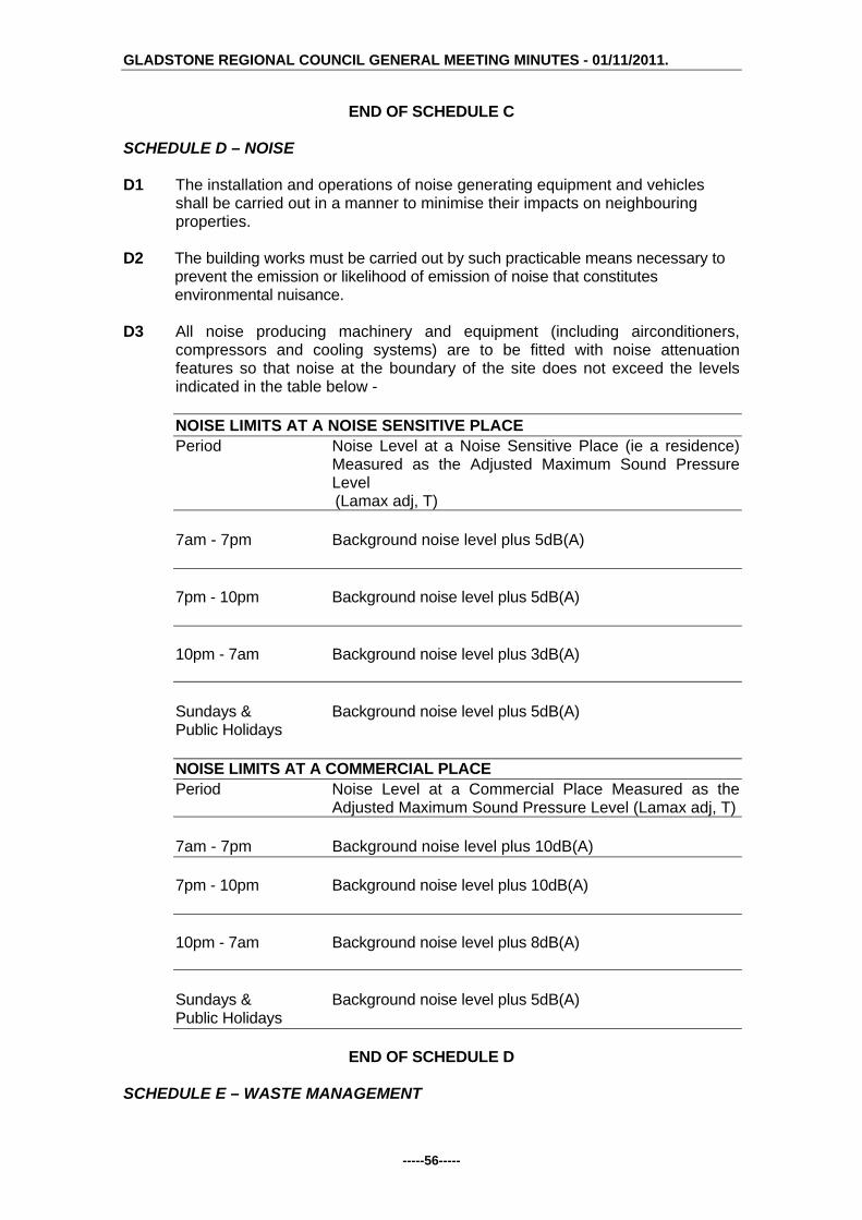
GLADSTONE REGIONAL COUNCIL GENERAL MEETING MINUTES - 01/11/2011.
-----56-----
END OF SCHEDULE C SCHEDULE D – NOISE D1 The installation and operations of noise generating equipment and vehicles
shall be carried out in a manner to minimise their impacts on neighbouring properties.
D2 The building works must be carried out by such practicable means necessary to
prevent the emission or likelihood of emission of noise that constitutes environmental nuisance.
D3 All noise producing machinery and equipment (including airconditioners,
compressors and cooling systems) are to be fitted with noise attenuation features so that noise at the boundary of the site does not exceed the levels indicated in the table below -
NOISE LIMITS AT A NOISE SENSITIVE PLACE Period Noise Level at a Noise Sensitive Place (ie a residence)
Measured as the Adjusted Maximum Sound Pressure Level
(Lamax adj, T) 7am - 7pm Background noise level plus 5dB(A) 7pm - 10pm Background noise level plus 5dB(A) 10pm - 7am Background noise level plus 3dB(A) Sundays & Background noise level plus 5dB(A) Public Holidays NOISE LIMITS AT A COMMERCIAL PLACE Period Noise Level at a Commercial Place Measured as the
Adjusted Maximum Sound Pressure Level (Lamax adj, T) 7am - 7pm Background noise level plus 10dB(A) 7pm - 10pm Background noise level plus 10dB(A) 10pm - 7am Background noise level plus 8dB(A) Sundays & Background noise level plus 5dB(A) Public Holidays
END OF SCHEDULE D SCHEDULE E – WASTE MANAGEMENT

GLADSTONE REGIONAL COUNCIL GENERAL MEETING MINUTES - 01/11/2011.
-----57-----
E1 Where waste is a contaminant, waste must not be released to the environment
where the release will or may cause environmental harm or environmental nuisance, unless such release is authorised.
E2 Waste collection containers including recycling waste containers are to be
stored at each individual dwelling. E3 The minimum overhead clearance required for mobile wheelie bin collection
vehicles is 4200 mm. Access for the collection of the wheelie bin is not to be impeded by any overhead obstructions such as trees, wires or other structures. This minimum height clearance is to be maintained at all times.
END OF SCHEDULE E
SCHEDULE F - MONITORING AND REPORTING F1 All complaints received by the holder of this development approval relating to
releases of contaminants from the activity must be recorded and kept in a log book with the following details:
(i) time, date and nature of complaint; (ii) type of communication (telephone, letter, personal etc.); (iii) name, contact address and contact telephone number of complainant
(note: if the complainant does not wish to be identified then "Not identified" is to be recorded);
(iv) response and investigation undertaken as a result of the complaint; (v) name of person responsible for investigating complaint; and (vi) action taken as a result of the complaint investigation and signature of
responsible person.
F2 As soon as practicable after becoming aware of any emergency or incident which results in the release of contaminants not in accordance, or reasonably expected to be not in accordance with the conditions of this development approval, the holder of the registration certificate to which this development approval relates, must notify the administering authority of the release by telephone or facsimile.
F3 The notification of emergencies or incidents as required by condition F2 must
include but not be limited to the following:
(i) the operator of the activity to which this development approval relates; (ii) the location of the emergency or incident; (iii) the name and telephone number of the designated contact person; (iv) the time of the release; (v) the time the holder of the registration certificate became aware of the
release; (vi) the suspected cause of the release; (vii) the environmental harm and or environmental nuisance caused,
threatened, or suspected to be caused by the release; and (viii) actions taken to prevent further any release and mitigate any
environmental harm and/or environmental nuisance caused by the release.

GLADSTONE REGIONAL COUNCIL GENERAL MEETING MINUTES - 01/11/2011.
-----58-----
F4 Not more than 14 days following the initial notification of an emergency or incident, the holder of the development approval must provide written advice of the information supplied in accordance with condition number F3 in addition to: (i) proposed actions to prevent a recurrence of the emergency or incident; (ii) outcomes of actions taken at the time to prevent or minimise
environmental harm and or environmental nuisance; and (iii) the results of any environmental monitoring performed.
END OF SCHEDULE F
SCHEDULE G - DEFINITIONS G1 For the purposes of this development approval the following definitions apply:
(a) "L(Amax adj, T)" means the average maximum A- weighted sound pressure level, adjusted for noise character and measured over a time period of not less than 15 minutes, using Fast response
(b) "commercial place" means a place used as an office or for business or
commercial purposes.
(c) "noise sensitive place" means - a) a dwelling, mobile home or caravan park, residential marina or other
residential premises; or b) a motel, hotel or hostel; or c) a kindergarten, school, university or other educational institution; or d) a medical centre or hospital; or e) a protected area ; or f) a park or gardens.
G2 For the purposes of this development approval any term not otherwise defined
in the Environmental Protection Act 1994, and the Sustainable Planning Act 2009 and any subordinate legislation made pursuant to these Acts or in the Definitions Schedule of this development approval has the meaning conferred to that term in its common usage.
END OF SCHEDULE G
END OF CONDITIONS
Advice to Applicant: An Adopted Infrastructure Charge Notice in relation to the infrastructure charges applicable to this development will be provided separately. G/11/ 799 Council Resolution: Moved Cr Paton Seconded Cr Butler That the Officer's Recommendation be adopted.
CARRIED

GLADSTONE REGIONAL COUNCIL GENERAL MEETING MINUTES - 01/11/2011.
-----59-----
G/5.4.9 DEVELOPMENT APPLICATION 277/2011 - MATERIAL
CHANGE OF USE OF PREMISES - MULTIPLE DWELLING (6 UNITS) - SUPERSEDED PLANNING SCHEME FOR MIRIAM VALE SHIRE - LOT 19 RP861421, THOMSON STREET, AGNES WATER
Responsible Officer: Chief Plannner Development Application:
Application Number: DA/277/2011
Applicant: Mr Stephen Mezes
Owner: Mr B S McClean & Mrs L J Hall
Date Of Receipt: 29 March 2011
Location: Lot 19 RP 861421, Thomson Street, Agnes Water
RPD: Lot 19 RP 861421
Area: 1.4 Ha
Current Use Of Land: Dwelling
Zoning: Urban (Higher Density/Visitor Accommodation) (Part) / Coastal Protection (Part) - Superseded Planning Scheme
Medium Density Residential (Part) / Conservation (Part) - Current Planning Scheme
Proposal: Multiple Dwelling (6 Units)
Submissions Close Date: 15 July 2011
Number Of Submissions: 1
Executive Summary: Council received a request for an application to be considered under the Superseded Planning Scheme for Miriam Vale Shire on 16 February 2011, and which was approved by Council on 3 March 2011. Subsequently, an Impact Assessable Development Application was received for a Multiple Dwelling (6 Units) on 29 March 2011. The Public Notification period commenced on 24 June 2011 and concluded on 15 July 2011 and was repeated from 17 August 2011 to 7 September 2011 due to an inadequate timeframe for the first notification period. One submission was received by an adjoining land owner during the first public notification period, which raised concerns relating to an existing access easement document and the terms of that document. The application is considered to generally comply with the requirements of the Superseded Planning Scheme for Miriam Vale Shire and is therefore recommended for approval, subject to reasonable and relevant conditions. Officer's Recommendation: That the proposed Multiple Dwelling (6 Units) at Lot 19, Thomson Street, Agnes Water be approved subject to the following conditions.

GLADSTONE REGIONAL COUNCIL GENERAL MEETING MINUTES - 01/11/2011.
-----60-----
1. The development is to be carried out in accordance with the submitted application including the following plans except when amendments are required to satisfy the conditions of this approval:
Plan Number Plan Name Date 01 Site Plan 25 March 2011 02 Access and Parking 25 March 2011 03 1 - Villa Ground Level 25 March 2011 04 1 - Villa Floor Plan 25 March 2011 05 1 - Villa Elevations W&S 25 March 2011 06 1 - Villa Elevations N&E 25 March 2011 07 2 - Villa Ground Level 25 March 2011 08 2 - Villa Floor Plan 25 March 2011 09 2 - Villa Bed Floor Plan 25 March 2011 10 2 - Villa Elevations W&S 25 March 2011 11 2 - Villa Elevations N&E 25 March 2011 12 3 - Villa Ground Level 25 March 2011 13 3 - Villa Floor Plan 25 March 2011 14 3 - Villa Elevations W&S 25 March 2011 15 3 - Villa Elevations N&E 25 March 2011 16 4 - Villa Ground Level 25 March 2011 17 4 - Villa Floor Plan 25 March 2011 18 4 - Villa Elevations W&S 25 March 2011 19 4 - Villa Elevations N&E 25 March 2011 20 5 - Studio Apartment 25 March 2011 21 5 - Studio Elevations W&S 25 March 2011 22 5 - Studio Elevations N&E 25 March 2011 23 6 - Relocated Existing 25 March 2011 24 6 - Relocated Elevations
W&S 25 March 2011
25 6 - Relocated Elevations N&E
25 March 2011
2. Compliance with Department of Environment and Resource Management Referral
Agency Conditions, dated 1 June 2011. Operational Works 3. A Development Permit for Operational Works must be obtained from Council prior
to the commencement of construction. The Development Application for Operational Works is to include the following:
a) earthworks (including retaining walls) b) roadworks c) water infrastructure d) sewerage infrastructure e) stormwater management f) street lighting and electrical / telecommunications conduits g) landscaping, environmental protection and associated works
The design and supporting calculations / documentation associated with these works must be certified by a Registered Professional Engineer of Queensland (RPEQ).

GLADSTONE REGIONAL COUNCIL GENERAL MEETING MINUTES - 01/11/2011.
-----61-----
4. Operational works shall be designed and constructed in accordance with Council's relevant standards at the time of lodgement of an application for an Operational Works Permit and in accordance with the relevant Australian Standards and good engineering practice. Council’s current standards include:
Miriam Vale Shire Council,
Planning Scheme Policy No.1 Engineering Standards for Development Works
5. The operational works drawings shall contain adequate information to position each
component of infrastructure by coordinates to GDA94 and levels to Australian Height Datum (AHD). The drawings shall also indicate the identification number, position and recorded level of the Permanent Survey Mark (PSM) from which the project’s horizontal and vertical position was derived.
6. The operational works are to be executed under the supervision of a RPEQ. The
applicant / developer must give to the Council, construction certificates from such supervising engineer, that the work has been constructed in accordance with the Operational Works Permit and good engineering practice, together with relevant quality assurance, operation and maintenance, and “as constructed” documentation. This includes provision of a CCTV report on all sewer mains installed as part of the development.
7. The “as constructed” drawings and associated electronic documentation are to be
certified by the supervising engineer and by a registered surveyor stating that the as constructed information shown on the “as constructed” drawings represent a complete and accurate record of the works as executed. Council reserves the right to utilise for its own purposes and the sale of information provided within the “as constructed” drawings provided by the applicant / developer.
8. Where the appointment of a principal contractor is applicable under the Queensland
Workplace Health and Safety Act 1995, no operational works are to commence until a copy of Form 34 “Notice of appointment of principal contractor” is received by WH&S Qld, by the Principal Contractor and by Council. Similarly, Council must be provided with evidence of any change in the appointment of a Principal Contractor throughout the course of the project.
9. The lodgement of a maintenance bond at the commencement of the “on-
maintenance” period, the equal of five (5) per centum of the total estimated cost of construction (minimum $ 10,000), to be held by the Council during the maintenance / performance verification period, being not less than twelve (12) months. The commencement of the ‘on maintenance’ period will not occur until all outstanding works have been completed, including the receipt of acceptable ‘as constructed’ information.
10. The applicant is responsible for and is to bear the cost of any alterations to,
extension of, or upgrading of Council assets / infrastructure or other service authorities’ infrastructure necessitated by the approval of this development (including but not limited to earthworks, retaining structures, roadworks, pedestrian / bicycle pathways, stormwater drainage, water supply, sewerage, electrical and telecommunication services, reticulated gas etc.).
Earthworks

GLADSTONE REGIONAL COUNCIL GENERAL MEETING MINUTES - 01/11/2011.
-----62-----
11. All earthworks on the site must be carried out in accordance with AS 3798 and good engineering practice. Geotechnical supervision shall be to Level 1. The geotechnical testing authority shall provide a report to Council, setting out the inspections, sampling and testing it has carried out, and the locations and results thereof. The geotechnical report must be certified a RPEQ experienced in this type of work.
12. All new retaining wall works, including associated excavation, surface and
subsurface drainage works, shall be wholly constructed within the development site. The location of the retaining wall in relation to property boundaries shall be dimensioned / detailed on the drawings.
13. Retaining walls are to comply with the following requirements: a) The design life of retaining walls shall be at least fifty (50) years and
retaining walls shall be designed to safely withstand the impact of a 1.8m high solid fence constructed along the top of the retaining wall. Fence loadings to include dead, live and wind loads.
b) Retaining walls must not impose loads on underground services within allotments or external to allotments, including but not limited to water, sewerage, stormwater, electrical, telecommunication or other services. In particular, retaining wall footings must not impose loads on the electrical / telecommunication service corridor which is located in the footpath (verge) adjacent to the front property boundary and must allow for the installation and maintenance of these services.
c) The design and construction of retaining walls must be certified by a Registered Professional Engineer of Queensland (RPEQ) experienced in this type of work. The design certificate and the construction certificate must be location specific and must include: design life, design standards, allowable fence loads and any special
provisions / constraints in regards to fence type, fence footing, foundation etc. (for the information of future fence designers / constructors).
a statement that the retaining wall structure will not impose loads on underground services.
Transportation 14. Enter into an Infrastructure Agreement with Council in respect of:
a). The timing and process associated with:
Dedicating Easement H on RP 861421 as road across the subject site consistent with the requirements for the Miriam Vale Shire Council Planning Scheme Policy No.1, at no cost to Council; and
Construction of the new road is to be at the applicant’s expense and
constructed in accordance with the requirements outlined in the Miriam Vale Shire Council Planning Scheme Policy No.1,
b). Payment of contributions or construction (providing for applicable credits
against infrastructure charges listed in the Adopted Infrastructure Charges Notice) of the following works within the existing Thomson Street road reserve, based on the percentage share of the increase in vehicular traffic generated by the proposed development towards:

GLADSTONE REGIONAL COUNCIL GENERAL MEETING MINUTES - 01/11/2011.
-----63-----
Construction of Thomson Street to an Access Place Standard as outlined in the Miriam Vale Shire Council Planning Scheme Policy No.1, including provision of a culvert to a 1 in 10 year ARI design standard and intersection with Captain Cook Drive.
15. Provision of 13 car parking spaces on site including 10 covered spaces and 3
visitor spaces. These spaces and all vehicle movement areas are to be constructed, drained, linemarked and maintained in accordance with Part 14, Schedule 2, Division 4 of the Planning Scheme and AS2890.1.
16. The applicant / developer is to submit a Traffic Engineer’s Certification (RPEQ) of
representative vehicle movements (including a garbage truck) with swept path diagrams within the site for compliance with AS2890.1, at the time of lodgement of the Operational Works application.
Water Infrastructure 17. New water connections necessitated by the development are the responsibility of
the applicant / developer. Water connection applications are to be made to Council for a quotation for the necessary works.
18. Individual water meters (sub-metering) shall be provided for each unit in
accordance with the Water and Other Legislation Amendment Act 2007. 19. Any strata titling of the development will require certification from a Hydraulic
Engineer that the metering of water for the development complies with the Water and Other Legislation Amendment Act 2007. Council uses Elster Smart Metering System or equivalent.
Sewerage Infrastructure 20. A wastewater management strategy is to be submitted to Council (for approval) as
part of the first Operational Works Development Application for the proposed development. Wastewater management options are to include (without being limited to):
a) on-site treatment, and b) provision of a privately owned and operated sewage pumping station
within the development property and a rising main to discharge into Council’s sewerage infrastructure at the intersection of Thomson Street and Captain Cook Drive, together with the associated easements through adjoining properties. Ongoing operation and maintenance arrangements will also need to be resolved.
Stormwater Management 21. The applicant / developer is to submit (for approval) a stormwater management
plan as part of the first operational works application. The plan must address both quantity and quality aspects of stormwater management and certified by a RPEQ experienced in this type of work.
22. Appropriate erosion and sediment control measures are to be utilised during any
operational or building works carried out in association with the development. Erosion and sediment control measures are to be implemented generally in accordance with the principles / practices described in the publication:

GLADSTONE REGIONAL COUNCIL GENERAL MEETING MINUTES - 01/11/2011.
-----64-----
ICEA Best Practice Erosion & Sediment Control – November 2008. International Erosion Control Association (Australasia), Picton NSW.
Landscaping 23. A landscape plan is to be submitted (for approval) as part of operational works
application and is incorporate:
a) Existing trees onsite which do not need to be cleared for construction or access to the site are to be retained.
b) The landscaping provided shall be in accordance with Council's preferred landscape plant list.
c) The landscaping plan shall also contain the following information: Outline of the buildings; Existing trees (height location); Trees to be removed; Proposed planting (quantity, species and expected mature height); Paths and paving (location and materials); and The method of planting and the proposed maintenance program.
24. All landscaping is to be maintained to an appropriate standard at all times. 25. Vegetation is only to be disturbed where associated with the approved building
envelope, car parking areas and vehicular access. Building Works 26. The applicant / developer is required to obtain a Development Permit for Building
and Plumbing Works in accordance with the Sustainable Planning Act 2009. Construction is to comply with the Building Act 1975, the Building Code of Australia and the requirements of other relevant authorities.
27. The applicant / developer is required to obtain a Development Permit for Building
Works in accordance with the Sustainable Planning Act 2009 to remove the existing structures from the site in accordance with the Building Act 1975.
28. Proposed buildings, roof materials and ancillary structures are to be:
Colour matched to the predominant vegetation cover, using greens and earth tones in accordance with section 4.11.6 of the Superseded Planning Scheme for Miriam Vale Shire; and
Use materials that reduce glare and reflection.
To this end, prior to approval of a building works application over the site submit for approval by Council, details on proposed materials and finishes.
29. Any security lighting shall be so designed to ensure that nuisance is not caused to
adjoining areas by the spillage of light. 30. Open storage / bin storage areas are to be adequately screened so as not to
detract from the visual amenity of the area. One way of achieving compliance with this condition is as follows:
a) outdoor storage areas are situated in locations not visible from the street b) a 1.8m solid screen fence is located around storage areas.

GLADSTONE REGIONAL COUNCIL GENERAL MEETING MINUTES - 01/11/2011.
-----65-----
31. All plant and equipment (including air conditioners, exhaust fans and the like) are to
be housed, screened and located so that these do not cause environmental nuisance or harm to the residential uses on the site and surrounding sites.
32. Provision is to be made for an allocated waste reciprocal area/s adequate to
service the development. The waste reciprocal area must comply with the following where applicable:
a) Mobile Wheelie Bins Provision of an allocated waste reciprocal area/s adequate to store the
mobile wheelie-bins for all units. The standing room for the wheelie-bin is to allow for two (2) 240 litre mobile garbage bins per unit; or
b) Bulk Bins Provision is to be made for an allocated waste reciprocal area/s
adequate to store the bulk bins to service all units. This bin area shall be of sufficient size to cater for the number of proposed units and is to include impervious paving, suitable drainage, and shall be contained in a suitable form of enclosure.
Provision of a site plan with turning circles demonstrating that sufficient manoeuvrability area is provided to allow for a refuse collection vehicle to access the designated refuse bin area and enter and exit the site in a forward direction.
Applicant / developer is required to demonstrate that the internal road is designed to cater for a fully loaded refuse vehicle to service the bulk bin. Written indemnification is required by Council to cover access to the site by its refuse collection contractor.
Details of the proposed bulk bin service area to be submitted to Council for approval from Council's Environmental Health and Compliance Department prior to the issue of a Development Permit for Building Works.
33. Nominated communal open space areas shall be permanently accessible to all
residents of the development and may not be allocated to any particular units or units for exclusive use and/or access.
Bushfire Management 34. In order to satisfy the requirements of the Queensland Government’s State
Planning Policy 01/03 “Mitigating the Impacts of Flood Bushfire and Landslide”, the applicant / developer is to provide the following prior to Council issuing an Operational Works Permit for the development:
a. a Bushfire Management Plan in accordance with State Planning Policy
and its Guidelines.
b. obtain written permission (where relevant) from the owner of the adjoining land for the clearing a firebreak to comply with the requirements of the State Planning Policy and its guide. The applicant / developer shall then prepare a plan and specification for such clearing for approval by Council and (where relevant) by the adjoining land owner. The developer shall then prepare the firebreak in accordance with the approved plans as stated above.
Miscellaneous

GLADSTONE REGIONAL COUNCIL GENERAL MEETING MINUTES - 01/11/2011.
-----66-----
35. Any signage associated with the development will require separate approval from Council.
36. Units 5 and 6, as shown on the Site Plan, are not permitted to be separately strata titled. Any strata titling of the development is to allow for a maximum 5 units.
37. Separate outdoor clothes drying facilities shall be provided and appropriately sited
for each dwelling unit. 38. The easement referred to in Easement Document C690292 is to be amended
through the Department of Environment and Resource Management for access to more than one dwelling on the subject site. Confirmation of the amendment to the Easement Document is to be submitted to Council prior to the issue of an Operational Works approval.
ENVIRONMENTAL HEALTH SPECIFIC CONDITIONS SCHEDULE A - GENERAL CONDITIONS A1 In carrying out the activity, all reasonable and practical measures are to be taken
to minimise releases and the likelihood of releases of contaminants to the environment, except as otherwise provided by the conditions of this development approval.
A2 The holder of this development approval must:
(a) install and operate all works and control equipment, and (b) take all measures, perform all acts and do all things, necessary to ensure
compliance with the conditions of this development approval. A3 Notwithstanding any other condition of this development approval, this
development approval does not authorise any release of contaminants that causes or is likely to cause an environmental nuisance beyond the boundaries of the registered place.
END OF SCHEDULE A
SCHEDULE B - AIR B1 Odour and visible contaminants, including but not limited to dust, smoke, fumes
and aerosols must not be released to the environment in a manner that will or may cause environmental harm or environmental nuisance unless such release is authorised.
B2 All lights (signage, security etc) are to be installed and positioned in a manner
that does not create a light nuisance to adjoining properties. Lights must not be angled onto adjoining properties.
END OF SCHEDULE B
SCHEDULE C – WATER / STORMWATER C1 Contaminants must not be directly or indirectly released from the site to which
this development approval applies, to any waters or stormwater.

GLADSTONE REGIONAL COUNCIL GENERAL MEETING MINUTES - 01/11/2011.
-----67-----
C2 Access to the site shall be restricted to a stabilised construction entrance. The entrance shall be an appropriate size, with corduroy or metal grid provided to help shake mud from vehicle tyres.
END OF SCHEDULE C
SCHEDULE D – NOISE D1 The installation and operations of noise generating equipment and vehicles
shall be carried out in a manner to minimise their impacts on neighbouring properties.
D2 The building works must be carried out by such practicable means necessary to
prevent the emission or likelihood of emission of noise that constitutes environmental nuisance.
D3 All noise producing machinery and equipment (including airconditioners,
compressors and cooling systems) are to be fitted with noise attenuation features so that noise at the boundary of the site does not exceed the levels indicated in the table below -
NOISE LIMITS AT A NOISE SENSITIVE PLACE Period Noise Level at a Noise Sensitive Place (ie a residence)
Measured as the Adjusted Maximum Sound Pressure Level (Lamax adj, T)
7am - 7pm Background noise level plus 5dB(A) 7pm - 10pm Background noise level plus 5dB(A) 10pm - 7am Background noise level plus 3dB(A) Sundays & Background noise level plus 5dB(A) Public Holidays NOISE LIMITS AT A COMMERCIAL PLACE Period Noise Level at a Commercial Place Measured as the
Adjusted Maximum Sound Pressure Level (Lamax adj, T) 7am - 7pm Background noise level plus 10dB(A) 7pm - 10pm Background noise level plus 10dB(A) 10pm - 7am Background noise level plus 8dB(A) Sundays & Background noise level plus 5dB(A)

GLADSTONE REGIONAL COUNCIL GENERAL MEETING MINUTES - 01/11/2011.
-----68-----
Public Holidays
END OF SCHEDULE D SCHEDULE E – WASTE MANAGEMENT E1 Where waste is a contaminant, waste must not be released to the environment
where the release will or may cause environmental harm or environmental nuisance, unless such release is authorised.
E2 Provision is to be made for an allocated waste reciprocal area/s adequate to
store the mobile wheelie-bins for all dwellings. The standing room for the wheelie-bins is to allow for two x 240 litre mobile garbage bins per dwelling.
E3 The internal road construction must support the weight of a fully loaded refuse
collection vehicle. E4 Waste collection vehicles must enter and leave the property in the forward gear. E5 Adequate provisions for kerb-side waste collection must be provided on the
private internal road at the front of each premises. E6 Vehicles used for waste and recyclables collection are dual axle vehicles with
an overall length of 11.8 metres and a width of 3 metres. Provision is to be made to allow collection vehicles to access the frontage of all premises. Cul de sacs are to be so designed to allow collection vehicles to safely negotiate the street without the need for excessive manoeuvring including reversing into or out of the street.
E7 The minimum overhead clearance required for mobile wheelie bin collection
vehicles is 4200 mm. Access for the collection of the wheelie bin is not to be impeded by any overhead obstructions such as trees, wires or other structures. This minimum height clearance is to be maintained at all times.
END OF SCHEDULE E
SCHEDULE F - MONITORING AND REPORTING F1 All complaints received by the holder of this development approval relating to
releases of contaminants from the activity must be recorded and kept in a log book with the following details:
(i) time, date and nature of complaint; (ii) type of communication (telephone, letter, personal etc.); (iii) name, contact address and contact telephone number of complainant
(note: if the complainant does not wish to be identified then "Not identified" is to be recorded);
(iv) response and investigation undertaken as a result of the complaint; (v) name of person responsible for investigating complaint; and (vi) action taken as a result of the complaint investigation and signature of
responsible person.
F2 As soon as practicable after becoming aware of any emergency or incident which results in the release of contaminants not in accordance, or reasonably expected to be not in accordance with the conditions of this development approval, the

GLADSTONE REGIONAL COUNCIL GENERAL MEETING MINUTES - 01/11/2011.
-----69-----
holder of the registration certificate to which this development approval relates, must notify the administering authority of the release by telephone or facsimile.
F3 The notification of emergencies or incidents as required by condition F2 must
include but not be limited to the following:
(i) the operator of the activity to which this development approval relates; (ii) the location of the emergency or incident; (iii) the name and telephone number of the designated contact person; (iv) the time of the release; (v) the time the holder of the registration certificate became aware of the
release; (vi) the suspected cause of the release; (vii) the environmental harm and or environmental nuisance caused,
threatened, or suspected to be caused by the release; and (viii) actions taken to prevent further any release and mitigate any
environmental harm and/or environmental nuisance caused by the release.
F4 Not more than 14 days following the initial notification of an emergency or
incident, the holder of the development approval must provide written advice of the information supplied in accordance with condition number F3 in addition to: (i) proposed actions to prevent a recurrence of the emergency or incident; (ii) outcomes of actions taken at the time to prevent or minimise
environmental harm and or environmental nuisance; and (iii) the results of any environmental monitoring performed.
END OF SCHEDULE F
SCHEDULE G - DEFINITIONS G1 For the purposes of this development approval the following definitions apply:
(a) "L(Amax adj, T)" means the average maximum A- weighted sound pressure level, adjusted for noise character and measured over a time period of not less than 15 minutes, using Fast response
(b) "commercial place" means a place used as an office or for business or
commercial purposes.
(c) "noise sensitive place" means - a) a dwelling, mobile home or caravan park, residential marina or other
residential premises; or b) a motel, hotel or hostel; or c) a kindergarten, school, university or other educational institution; or d) a medical centre or hospital; or e) a protected area ; or f) a park or gardens.
G2 For the purposes of this development approval any term not otherwise defined
in the Environmental Protection Act 1994, and the Sustainable Planning Act 2009 and any subordinate legislation made pursuant to these Acts or in the Definitions Schedule of this development approval has the meaning conferred to that term in its common usage.

GLADSTONE REGIONAL COUNCIL GENERAL MEETING MINUTES - 01/11/2011.
-----70-----
END OF SCHEDULE G Advice to Applicant: An adopted infrastructure charge notice in relation to the infrastructure charges applicable to this development has been provided separately.
END OF CONDITIONS G/11/ 800 Council Resolution: Moved Cr Chapman Seconded Cr McDonald That the Officer's Recommendation be adopted.
CARRIED G/5.4.10 DEVELOPMENT APPLICATION DA/188/2010 MATERIAL
CHANGE OF USE OF PREMISES MULTIPLE UNIT RESIDENTIAL (3 UNITS) AND RECONFIGURING A LOT (1 INTO 2) AND BOUNDARY REALIGNMENT AT 12 GAPPARIS STREET AND 146 SUN VALLEY ROAD, KIN KORA
Responsible Officer: Chief Planner Development Application:
Application Number: DA/188/2010
Applicant: Mr R Groth c/- Jones Flint & Pike Urban Consultants Pty Ltd
Owner: Mr R Groth
Date of Receipt: 13 July 2010
Location: 12 Gapparis Street & 146 Sun Valley Road, Kin Kora
RPD: Lot 834 RP840077 & Lot 4 SP224170
Area: 3,547m2
Current Use of Land: Vacant and Duplex
Zoning: Residential
Proposal: Material Change of Use - Multiple Unit Residential (3 Units), Reconfiguring a Lot (1 into 2) and Boundary Realignment
Submissions Close Date: 26 September 2011
Number of Submissions: 7 Properly made Submissions
Executive Summary: An Impact Assessable Development Application for Multiple Unit Residential (3 Units), Reconfiguring a Lot (1 into 2) and Boundary Realignment was received by Council on

GLADSTONE REGIONAL COUNCIL GENERAL MEETING MINUTES - 01/11/2011.
-----71-----
13 July 2010. During the Public Notification period the application received 7 properly made submissions. The main issues raised within these submissions included increased traffic and noise, potential impacts on existing residents privacy and views, increased stormwater run off, inappropriate development in the Residential Zone and a reduced amenity of the area. It is noted that the submissions specifically relate to the unit component rather than the reconfiguration component of the development. The proposal has been assessed against the Gladstone Planning Scheme and based on the assessment detailed in this report it is recommended that the application be approved in part for the reconfiguration component but the multiple unit residential component be refused. It is considered appropriate to refuse the proposed unit component of this application as it is considered to be non compliant with the Planning Scheme. This non compliance specifically relates to the location of a higher density residential development in the Residential Zone on an allotment with unsuitable access and topography. Officer's Recommendation: That the application at 12 Gapparis Street & 146 Sun Valley Road, Kin Kora, for a Material Change of Use for Multiple Unit Residential (3 units) component be refused and the Reconfiguring a Lot (1 into 2) & Boundary Realignment component be approved subject to the following conditions. Reasons for Refusal – Multiple Unit Residential (3 Units) 1. The proposed development does not comply with the Overall Outcomes of the
Suburban Locality Code (2)(b) as the allotment is not considered to be conveniently located or serviceable given the topography and shared battleaxe arrangement access to the site.
2. The proposed development does not comply with the Overall Outcomes sought for the Suburban Locality Code and the Central Precinct (6)(a) as the proposal is for high density residential development in the Residential Zone and does not demonstrate an overriding need for such a development in this zone.
3. The development exceeds the maximum building height of 9 metres for residential buildings as specified within the Residential Code and as such is considered to be inconsistent with the character of the existing urban environment.
4. The development does not comply with the minimum setback requirements to side and rear boundaries as specified within the Residential Code and therefore does not maintain privacy, sunlight and breezes to adjoining properties.
5. The issues raised by submitters are considered to have general merit. Approval Conditions - Reconfiguring a Lot (1 into 2) & Boundary Realignment 1. Development is to be carried out in accordance with the submitted application and
nominated building envelopes including the following:
Plan Name Plan No. Drawn By Date Proposal Plan for Reconfiguring a Lot
G2870-04A Jones Flint & Pike 19/8/2009

GLADSTONE REGIONAL COUNCIL GENERAL MEETING MINUTES - 01/11/2011.
-----72-----
except where amendments are required to satisfy the conditions of this approval as follows;
The proposed battleaxe handle is to form part of proposed Lot 5 with an access easement in favour of proposed lot 6.
2. All structures, improvements and services for each lot are to be wholly contained
within the respective lot. 3. All alterations to services and municipal facilities necessitated by the proposal shall
be the responsibility of the applicant. 4. A separate metered water service is to be provided to each allotment. 5. A separate sanitary drainage system is to be provided for each allotment with a
separate connection to Council’s sewerage infrastructure. 6. Plumbing and Drainage Permits must be obtained from Council for the
modifications needed to the water supply and sanitary drainage systems to each allotment.
7. All alterations to services and municipal facilities necessitated by the proposal shall
be the responsibility of the applicant and the applicant is to bear the cost of same. 8. The above infrastructure works must be completed prior to the endorsement of the
plan of reconfiguration by Council. 9. The location of the proposed dwellings shall comply with Council Policy 19.7 -
Revision 1 Building Adjacent to and Over Sewers, Stormwater and Water Assets. 10. Invert crossing and driveway is to be in accordance with Council’s Standard
Drawings RT-0055. 11. The applicant shall demonstrate that each individual allotment is capable of being
drained of its potential roof water without affecting adjoining lots. Where roof water from proposed allotments cannot be drained into the kerb and channel using approved kerb adapters, piped roof water drainage collection systems are to be provided for each allotment in accordance with Council’s Standard Drawings.
12. An agreement shall be entered into with Ergon Energy for the provision of
underground power. A certificate of Electricity Supply is to be obtained from Ergon Energy prior to the sealing of the Plan of survey, for the supply and reticulation of electricity to each allotment.
13. Provision is to be made for and opportunity given for Telstra and the Gas
Corporation to install their reticulation at the time of construction.
ENVIRONMENT AND REGULATION DEPARTMENT SPECIFIC CONDITIONS
SCHEDULE A - GENERAL CONDITIONS A1 The holder of this development approval must:
(a) install and operate all works and control equipment, and

GLADSTONE REGIONAL COUNCIL GENERAL MEETING MINUTES - 01/11/2011.
-----73-----
(b) take all measures, perform all acts and do all things, necessary to ensure compliance with the conditions of this development approval.
A2 Notwithstanding any other condition of this development approval, this
development approval does not authorise any release of contaminants that causes or is likely to cause an environmental nuisance beyond the boundaries of the registered place.
A3 Any records required to be held as a condition of this development approval must
be kept at the site to which this development approval relates for a period of at least five years and be made available for examination by an authorised person upon request. The record retention requirements for this condition will be satisfied if any daily and weekly records are kept for a period of at least three years and these records are then kept in the form of annual summaries after that period.
SCHEDULE B - AIR B1 Odour and visible contaminants, including but not limited to dust, smoke, fumes
and aerosols must not be released to the environment in a manner that will or may cause environmental harm or environmental nuisance unless such release is authorised.
B2 Suitable screens and/or barriers shall be erected during excavation and building
works, where required, to reduce the emission of dust, water effluent or other matter from the site.
SCHEDULE C – WATER / STORMWATER C1 Contaminants must not be directly or indirectly released from the site to which
this development approval applies, to any waters or stormwater. C2 Access to the site shall be restricted to a stabilised construction entrance. The
entrance shall be an appropriate size, with corduroy or metal grid provided to help shake mud from vehicle tyres. Sediment control measures must be implemented and adequate to prevent sediment erosion, such as sediment fencing, ground cover & vegetation and diversion flow.
SCHEDULE D – NOISE D1 The installation and operations of noise generating equipment and vehicles
shall be carried out in a manner to minimise their impacts on neighbouring properties.
SCHEDULE E – WASTE MANAGEMENT E1 Where waste is a contaminant, waste must not be released to the environment
where the release will or may cause environmental harm or environmental nuisance, unless such release is authorised.
E2 An area shall be set aside for segregation and storage of recyclable solid
wastes. E3 Where a no-cost recycling service is available, recyclable waste must not be
deposited into the general waste stream.

GLADSTONE REGIONAL COUNCIL GENERAL MEETING MINUTES - 01/11/2011.
-----74-----
E4 Building refuse shall not be stored on a public place during building operations. All refuse shall be satisfactorily contained on site and stored in bulk refuse bins where appropriate.
E5 Provision is to be made for an allocated waste reciprocal area/s adequate to
store the mobile wheelie-bins for all dwellings. The standing room for the wheelie-bins is to allow for two x 240 litre mobile garbage bins per dwelling.
SCHEDULE F - MONITORING AND REPORTING F1 All complaints received by the holder of this development approval relating to
releases of contaminants from the environmentally relevant activity must be recorded and kept in a log book with the following details:
(i) time, date and nature of complaint; (ii) type of communication (telephone, letter, personal etc.); (iii) name, contact address and contact telephone number of complainant (note:
if the complainant does not wish to be identified then "Not identified" is to be recorded);
(iv) response and investigation undertaken as a result of the complaint; (v) name of person responsible for investigating complaint; and (vi) action taken as a result of the complaint investigation and signature of
responsible person.
F2 As soon as practicable after becoming aware of any emergency or incident which results in the release of contaminants not in accordance, or reasonably expected to be not in accordance with the conditions of this development approval, the holder of the registration certificate to which this development approval relates, must notify the administering authority of the release by telephone or facsimile.
F3 The notification of emergencies or incidents as required by condition F2 must
include but not be limited to the following:
(i) the operator of the activity to which this development approval relates; (ii) the location of the emergency or incident; (iii) the name and telephone number of the designated contact person; (iv) the time of the release; (v) the time the holder of the registration certificate became aware of the release; (vi) the suspected cause of the release; (vii) the environmental harm and or environmental nuisance caused, threatened,
or suspected to be caused by the release; and (viii) actions taken to prevent further any release and mitigate any environmental
harm and/or environmental nuisance caused by the release. F4 Not more than 14 days following the initial notification of an emergency or
incident, the holder of the registration certificate to which the development approval applies, must provide written advice of the information supplied in accordance with condition number F3 in addition to: (i) proposed actions to prevent a recurrence of the emergency or incident; (ii) outcomes of actions taken at the time to prevent or minimise
environmental harm and or environmental nuisance; and (iii) the results of any environmental monitoring performed.
SCHEDULE G - DEFINITIONS

GLADSTONE REGIONAL COUNCIL GENERAL MEETING MINUTES - 01/11/2011.
-----75-----
G1 For the purposes of this development approval any term not otherwise defined
in the Environmental Protection Act 1994, and the Sustainable Planning Act 2009 and any subordinate legislation made pursuant to these Acts or in the Definitions Schedule of this development approval has the meaning conferred to that term in its common usage.
Advice to Applicant An adopted infrastructure charge notice in relation to the infrastructure charges applicable to this development has been provided separately. G/11/ 801 Council Resolution: Moved Cr Hansen Seconded Cr Cameron That the Officer's Recommendation be adopted.
CARRIED G/5.4.11 REQUEST TO NEGOTIATE DECISION NOTICE -
DEVELOPMENT APPLICATION 20621/2008 - PRELIMINARY APPROVAL OVERRIDING THE PLANNING SCHEME FOR A MASTER PLANNED URBAN COMMUNITY "HEIDELBERG" COMPRISING RESIDENTIAL, LOCAL INDUSTRY, COMMERCIAL, OPEN SPACE & RECREATION
Responsible Officer: Chief Planner Development Application:
Application Number: DA 20621/2008
Applicant: Turich Developments Pty Ltd, Suite 3/9 Capital Place, Birtinya Qld 4575
Owner: Peter Turich (12 lots) and Gladstone Regional Council (1 lot)
Date of Receipt: 14 March 2008
Representations Made: 21 September 2011
Location: 64, 96, 138, 178, 200 and 240 Gladstone Benaraby Road, Wurdong Heights
RPD: Lot 1 RP608779, Lot 25 CTN 1967, Lots 26, 27, 28, 33 & 36 P4041, Lot 1 RP612624, Lot 2 RP612623, Lots 3 & 4 RP612625, Lot 35 CTN 1238 and Lot 2 SP142970, Parish of Boyne
Area: 496 hectares
Current Use of Land: Residential and Rural
Zoning: Urban Expansion, Rural and Community Use
Proposal: Request to Negotiate Conditions issued with the Preliminary Approval Overriding the

GLADSTONE REGIONAL COUNCIL GENERAL MEETING MINUTES - 01/11/2011.
-----76-----
Planning Scheme for a Master Planned Community comprising Residential, Local Industry, Commercial, Open Space and Recreation, Conservation & Community Uses
Submissions Close Date: 28 June 2011
Number of Submissions: 7 submissions including 1 petition (containing 29 signatures)
Representations Received: 21 September 2011
Executive Summary: An application for Preliminary Approval overriding the Calliope Planning Scheme 2007 was lodged with Council on 14 March 2008, and has been processed under the Integrated Planning Act 1997. The applicant is proposing a Master Planned Urban Community Development with 284.2 hectares proposed to be utilised for residential development with an indicative yield of 2,900 dwellings. An area comprising 14.5 hectares is proposed to be utilised as Commercial (maximum GFA 10,000m2) and Higher Density development (comprising 255 units) and will be incorporated into Key Site 1 of the Heidelberg development. The proposed development was decided by Council on 16 August 2011 with the applicant "stopping the clock" on 2 September 2011 to discuss and clarify the intent of some of the conditions contained within the Decision Notice. The applicant made representations to Council on 21 September 2011 with regard to a number of conditions which are outlined in the body of this report. It should also be noted that there have been a series of ongoing meetings between the applicant and Council Officers to discuss these matters. Taking into consideration the following requests and further discussions with Council Officers, it is considered that of the 39 conditions that the Applicant made representations on, 29 are to be amended, 1 deleted and 9 unchanged. It is therefore recommended that Council issue a Negotiated Decision Notice to the applicant with the highlighted amendments. Officer's Recommendation: That Council issue a Negotiated Decision Notice for Development Application 20621/2008 - Preliminary Approval Planning Scheme (under s3.1.6 of the Integrated Planning Act 1997) for a Preliminary Approval Overriding the Calliope Shire Planning Scheme for a Material Change of Use (MCU) and Reconfiguring a Lot (ROL) for a Master Planned Urban Community Development comprising of residential development (indicative yield of 2,900 dwellings), a commercial land use component (maximum of 10,000m2 of GFA and including 255 dwellings) Local Industry, Open Space & Recreation, Conservation and Community Uses for be approved subject to the following amendments: a) Conditions No. 4, 5, 7, 9, 10, 15, 17, 18, 23, 33, 45, 46, 47, 50, 52, 53, 57, 61,
70, 71, and Preliminary Approval Document Conditions No. 2, 3, 4, 5, 7, 16, 27, 29, and 32 be amended;
b) Conditions No. 13, 19, 22, 26, 37, 38, 62, 68 and Preliminary Approval Document Condition 26 remain unchanged;
c) Condition No. 8 be deleted.

GLADSTONE REGIONAL COUNCIL GENERAL MEETING MINUTES - 01/11/2011.
-----77-----
Such that the application is approved as follows: Negotiated Decision Notice for Development Application 20621/2008 - Preliminary Approval Planning Scheme (under s3.1.6 of the Integrated Planning Act 1997) for a Preliminary Approval Overriding the Calliope Shire Planning Scheme for a Material Change of Use (MCU) and Reconfiguring a Lot (ROL) for a Master Planned Urban Community Development comprising of residential development (indicative yield of 2,900 dwellings), a commercial land use component (maximum of 10,000m2 of GFA and including 255 dwellings) Local Industry, Open Space & Recreation, Conservation and Community Uses for be approved subject to the following amendments:
1. This Preliminary Approval is pursuant to Section 3.1.6 of the Integrated Planning Act 1997 and varies the effect of the Calliope Shire Planning Scheme 2007 to the extent provided for in the preliminary approval document of the "Heidelberg Master Planned Community Plan of Development", except where amendments are required to satisfy the conditions of this approval. This approval does not authorise assessable development to occur.
2. In accordance with section 3.5.21(1)(a) of the Integrated Planning Act 1997, the
first change of use under this approval must be completed within 4 years starting the day the approval takes effect.
3. Any future development application is to be assessed against the provisions of
the Calliope Shire Planning Scheme 2007 including overlays and use codes, The Heidelberg Master Planned Community Plan of Development and the Heidelberg Master Planned Community Locality Code.
The Heidelberg Preliminary approval document overrides the Boyne Island Tannum Sands Locality Code and Assessment Tables, Calliope Frame Locality Code and Assessment Tables, Residential Code, Advertising Device Code, Environment and Infrastructure Code, Estate Sales & Display Home Code, Operational Works (Earthworks) Code, and Development on Steep Land Overlay Code. However, the Open Space and Recreation provisions which are to apply to the approval have been extracted from the Boyne Island Tannum Sands Locality Code. Where development is not generally in accordance with the Heidelberg Master Planned Community Locality approval document, the development will be subject to the level of assessment and relevant development requirements of the Calliope Shire Planning Scheme 2007.
4. Assessable development must not commence until a development permit
for a Reconfiguration of a Lot or Material Change of Use has been issued under the Integrated Development Assessment System of the Sustainable Planning Act 2009.
5. The development is to be undertaken generally in accordance with the
Sequencing Plan Identified as Appendix B: Indicative Development Sequencing Plan received by Council on 29 April 2011 as part of Response to the Information Request
6. In order for assessable development to be carried out, the following future
Development Permits are required: Material Change of Use of Premises, Reconfiguring a Lot, carrying out Operational work, carrying out Building Work

GLADSTONE REGIONAL COUNCIL GENERAL MEETING MINUTES - 01/11/2011.
-----78-----
and carrying out Plumbing or Drainage work. 7. The developer must pay to Council, an Infrastructure contribution
(headworks) for external water supply and sewerage, roads, parks and stormwater in accordance with "Gladstone Regional Council's Adopted Infrastructure Charges Resolution (No. 1) - 2011" for the whole of the site. These charges may be offset by the provision of identified trunk infrastructure by the developer as agreed to by Council. The type of trunk infrastructure, timing of, delivery and value of these works eligible for an offset are to be detailed as part of an Infrastructure Agreement that is to be finalised prior to the issue of an Operational Works approval for Stage 1. The amounts so payable will be detailed in the conditions of approval for the subsequent Development Permits for Material Change of Use and Reconfiguring of a Lot.
8. DELETED
9. In addition to the requirements of the Department of Environment and
Resource Management concurrence agency conditions, clearing of vegetation is to be undertaken on a staged basis only. The extent of clearing permitted with an Operational Works Permit for a particular stage of development is to be clearly defined on the Operational Works Drawings for that stage. The applicant / developer is to submit (for approval) a Vegetation Management Master Plan for the total development as part of the Material Change of Use or Reconfiguring a Lot application for the first (chronological) stage of the development. The extent of clearing permitted with each stage of the development is to be generally in accordance with the Vegetation Management Master Plan..
10. The former Calliope Shire Planning Scheme shall be amended to reflect
the approval. At the applicant's expense the existing zone of Rural is to be replaced by the urban zonings, including Residential, Commercial, Community Use and Open Space and Recreation Zones.
CONCURRENCE AGENCY
11. Development is to comply with Department of Transport and Main Roads Referral Agency Amended Response (Concurrence Agency) conditions dated 9 August 2011 (Reference 500/239 LCH:rzl E19263 (DCT 1099) BRIS - 1617) (See Attached).
12. Development is to comply with Department of Environment and Resource
Management (Concurrence Agency) conditions dated 13 July 2011 (DERM Ref no. 325466 - DA/08/00027) (See Attached).
13. Development is to comply with Department of Infrastructure and Planning
Referral Agency (Advice Agency) conditions dated 17 June 2008 (Reference: RAA 276) (See Attached).
14. Development is to comply with Ergon Energy Referral Agency (Advice Agency)
conditions dated 27 March 2009 (Reference mb:ks) (See Attached). PLANS OF DEVELOPMENT 15. Development is to be carried out in accordance with the submitted

GLADSTONE REGIONAL COUNCIL GENERAL MEETING MINUTES - 01/11/2011.
-----79-----
application for Preliminary Approval Overriding the Planning Scheme for Material Change of Use (MCU) and Reconfiguring a Lot (ROL) for a Master Planned Urban Community Development comprising of residential development (indicative yield of 2,900 dwellings), a commercial land use component (including 255 dwellings) Local Industry, Open Space & Recreation, Conservation and Community Uses) as depicted on the following plans, except where amendments are required to satisfy the conditions of this approval:
Plan Title Prepared By Date Heidelberg Master Planned Community Structure Plan
Attached as Appendix B for Heidelberg Master Planned Community Plan of Development prepared by Urban 21, dated 27/04/2011.
Received by Council on 29/04/2011 as part of Information Response
Heidelberg Master Planned Community Road Hierarchy and Pedestrian/ Cycle Network
Attached as Appendix C for Heidelberg Master Planned Community Plan of Development prepared by Urban 21, dated 27/04/2011.
Received by Council on 29/04/2011 as part of Information Response
Heidelberg Master Planned Community Open Space and Conservation Network
Attached as Appendix D for Heidelberg Master Planned Community Plan of Development prepared by Urban 21, dated 27/04/2011.
Received by Council on 29/04/2011 as part of Information Response
Appendix B: Indicative Development Sequencing Plan
Attached as Appendix B of letter submitted as Response to Information Request - Development Application DA08/0027, prepared by Urban 21 Property Solutions
Letter dated 27/04/2011. Received by Council on 29/04/2011 as part of Information Response
Except where modifications are required to satisfy the conditions of this Development Permit, including:
Amendment of the plans to reflect the deletion of any reference to Local
Park (sporting). Whilst there is a Local Park (sporting) identified in the Open Space and Conservation Network map. It is considered that the provision of sporting facilities within this development is not required given the close proximity to Dennis Park, and the Boyne Tannum sports complex.
Amendment of the Structure Plan provided to Council as part of the
Information Response on 29 April 2011 to show the secondary Commercial Centre shown at the intersection of East-West Arterial and North-South Arterial Roads to be a "Local Centre" rather than a Neighbourhood Centre.
Documentation forming part of the Decision Notice is as follows:

GLADSTONE REGIONAL COUNCIL GENERAL MEETING MINUTES - 01/11/2011.
-----80-----
Report Title Prepared By Date RFI Response Housing Need Assessment, dated
Urban 21 Property Solutions
April 2011
Heidelberg Project Needs Assessment: Population and Housing Needs Study
AEC Group April 2011
Traffic Impact Assessment Cardno Eppell Olsen 19 April 2011
Flood Impact Assessment for Preliminary Development Approval
Cardno 6 April 2011
RFI Response DA/08/0027 Water & Sewer
Cardno April 2011
Coastal Management Response to Information Request
Saunders Havill Group
8 April 2011
Vegetation Management 1999 Response to Information Request
Saunders Havill group
27 April 2011
16. Overall development yield for the site is to be generally consistent with the
submitted application, although the layout maybe amended within subsequent applications to reflect the conditions of this approval.
PLANNING SCHEME
17. The first application for a Development Permit for a Reconfiguration of Lot
and/or Material Change of Use for Key Site 1 will be accompanied with a Security Management Plan, which specifies security patrol, surveillance and other security and response methods and security management of the public and private domain within and surrounding the site, and is to be amended with each subsequent application for a Development Permit for Material Change of Use and a Reconfiguration of Lot.
18. The first application for a Development Permit for a Reconfiguration of Lot
and/or Material Change of Use for Key Site 1 will be accompanied with a Plan of Management to address all operational and management procedures to be employed, to ensure that the premises can operate without disturbance to the surrounding locality. The plan must reflect the separate residential and commercial components of the use. The Plan of Management is to be amended with each subsequent application for a Development Permit for Material Change of Use and a Reconfiguration of Lot.
19. The first application for a Development Permit for a Reconfiguration of Lot
and/or Material Change of Use will be accompanied with a site specific Noise Management Plan which must be submitted to the Council for approval and comment prior to any works commencing on site and complied with during any construction works. The plan must be prepared by a suitably qualified person and include confirmation of the level of community consultation that has, is and will be undertaken with Building Managers/occupiers of the main adjoining noise sensitive properties likely to be most affected by site works and the operation of plant/machinery. The noise management plan is to be amended with each subsequent application for a Development Permit for Material Change of Use and a Reconfiguration of Lot.
20. The first application for a Development Permit for a Reconfiguration of Lot

GLADSTONE REGIONAL COUNCIL GENERAL MEETING MINUTES - 01/11/2011.
-----81-----
and/or a Material Change of Use will be accompanied with a site specific Flood Management Plan which must be submitted to the Council for approval and comment prior to any works commencing on site to ensure appropriate measures and requirements are in place and complied with during any construction works. The plan must be prepared by a suitably qualified person. The Flood Management Plan is to be amended with each subsequent application for a Development Permit for Material Change of Use and a Reconfiguration of Lot.
21. In order to satisfy the requirements of the Queensland Government’s State
Planning Policy 01/03 “Mitigating the Impacts of Flood Bushfire and Landslide”, the applicant / developer is to submit to Council for approval the following information with the first application for a Development Permit for Material Change of Use:
a) a Bushfire Management Plan in accordance with State Planning Policy
and its Guidelines. b) obtain written permission (where relevant) from the owner of the
adjoining land for the clearing a firebreak to comply with the requirements of the State Planning Policy and its guide. The applicant / developer shall then prepare a plan and specification for such clearing for approval by Council and (where relevant) by the adjoining land owner. The developer shall then prepare the firebreak in accordance with the approved plans as stated above.
The plan must be prepared by a suitably qualified person. The Bushfire Management Plan is to be amended with each subsequent application for a Development Permit for Material Change of Use.
22. The first application for a Development Permit for a Reconfiguration of Lot, Material Change of Use and/or Operational Works must include a Construction Environmental Management Plan for the entire site.
23. The first application for a Development Permit for Material Change of Use
or Reconfiguration of a Lot in the Commercial Precinct, referred to as the Key Site 1 in the Structure Plan received with the Information Response on 29 April 2011, is to be accompanied by a site specific Urban Design Master Plan (subject to a Code Assessable application) which will specifically detail what is proposed in this area. The Urban Design Master Plan is to be compliant with the Amended Plan of Development and the applicable Planning Scheme Codes and Overlays within the Calliope Shire Planning Scheme 2007. The Urban Design Master Plan is to include information relating to:
a. A layout of the building and car park areas; b. The use, location (building envelopes) and approximate floor space of
proposed commercial premises, the number of and density of residential dwellings and the respective car parking areas for these uses;
c. Uses and gross floor areas to comply with the provisions of The Heidelberg Master Planned Community - Plan of Development Assessment Table 3.1 under Use Class ‘Business’;
d. The height of all buildings; e. Demonstration of a high quality built form which is responsive to the site,
provides high amenity interfaces between buildings and adjacent uses and builds on and further complements the character of the site;

GLADSTONE REGIONAL COUNCIL GENERAL MEETING MINUTES - 01/11/2011.
-----82-----
f. Active frontages to key pedestrian interfaces where appropriate; g. Activation of the streetscapes through the siting of built form and
landscaping where practicable and appropriate; h. That the built form is appropriate for the aspect and climatic conditions
through a built form and architectural style that includes covered walkways, eaves and awnings over the footpath for its full width and frontage except for any driveways;
i. A built form which encourages natural surveillance of the surrounding streets, car parks, and primary pedestrian linkages through the site;
j. Safe, direct and attractive pedestrian linkages through the site from key access points including connections to car parking, public transport, residential land (where practicable and appropriate) and the educational establishment;
k. The development of a ‘street’ or ‘mall’ environment that promotes good pedestrian connections and accessibility;
l. The staging and anticipated timing of development; m. The use of environmentally sustainable principles into the design of new
built form, car parks and landscapes; n. Linkages from car parks to the shops they serve by pedestrian routes
which are landscaped and lined by active frontages; o. The use of design features for people of all abilities in compliance with
relevant Disability Regulation; p. A statement of Landscape Design Intent for the site to include:
a. Notated Concept Plans at a suitable scale (and/or in text form with graphics and photographs) prepared by a suitably qualified Landscape Designer addressing and articulating the landscape design principles intended for the Key Site 1;
b. Concepts demonstrating compliance with Heidelberg Master Plan Community POD Specific Outcomes O2/Acceptable Solutions S.2. Table 3-9.;
q. A Traffic Management Plan indicating: a. Vehicle, pedestrian and bicycle access through the site and to the
surrounding transport and footpath network; b. Ingress and egress points and the estimated levels of usage; c. Any proposed off site traffic management treatments; d. The level, allocation and location of car parking on the land; e. Provision for the loading and unloading of vehicles; f. Access to public transport, pedestrian and bicycle movement and
connections including the positioning of the education establishment ;
g. An integrated approach to safe accessible public transport, pedestrian, bicycle connections and other private vehicular transport.
24. The site is to be maintained in a clean and orderly state at all times.
Staging Plan
25. The applicant / developer is to submit (for approval) a staging plan for the total development defining the extent (area) within each stage and the associated sequencing of the staged development as part of the Material Change of Use or Reconfiguring a Lot application for the first (chronological) stage of the development.
Earthworks

GLADSTONE REGIONAL COUNCIL GENERAL MEETING MINUTES - 01/11/2011.
-----83-----
26. The applicant / developer is to submit (for approval) a finished surface master
plan for the total development site showing existing contours (1.0m spacing) and indicative finished surface contours (1.0m spacing) within each stage of the development as part of the Material Change of Use or Reconfiguring a Lot application for the first (chronological) stage of the development. The plan is to show preliminary road gradings (longitudinal sections) for bus routes (neighbourhood collector roads and for major roads and is to incorporate indicative allotment shaping strategies for each stage.
27. The applicant / developer is to submit (for approval) a preliminary finished
surface plan showing existing contours (0.5m spacing) and preliminary finished surface contours (0.5m spacing) with each development application (Reconfiguring a Lot) for each stage of the development. The plan is to show building pad locations and the proposed location and height of retaining walls, preliminary road gradings for all roads (longitudinal sections), overland flow paths for stormwater drainage etc. The preliminary finished surface plan for each stage must extend sufficiently into the adjoining areas (within the development site and external to the development site) to demonstrate that the proposed works are in accordance with the finished surface master planning for the total development and are in accordance with good engineering practice.
28. Allotment batters and retaining walls located along the side and rear property
boundaries of residential allotments are to be constructed as follows:
a) embankment slopes and retaining walls located along the rear and side boundaries of adjoining allotments are to be constructed within the allotment located on the low side of the common boundary.
b) the maximum batter slope for earth embankments is to be 1 vertical to 3 horizontal (subject to slope stability and appropriate landscaping / soil stabilisation considerations).
c) where it is not feasible to construct the batters / retaining structures within the adjoining property e.g. along common boundaries with existing properties and along road reserves etc., vertical retaining walls are to be constructed along the boundary.
Transportation
29. Preliminary design details of the road layout are to be submitted with future development applications for a Development Permit for a Material Change of use or Reconfiguring a Lot, with detail designs to be submitted with subsequent Operational works applications. Road specifications are to be in accordance with Council's Roads and Transport Standard 2005 and its relevant amendment, except where specified in the Heidelberg Master Planned Community Plan of Development.
30. The applicant / developer is to submit (for approval) a road hierarchy master
plan for the total development showing the classification of each road / street within the development for all “Neighbourhood Collector” streets (bus routes and non-bus routes) and for major roads as part of the Material Change of Use or Reconfiguration of a Lot application for the first (chronological) stage of the development.
31. The applicant / developer is to submit (for approval) a public transport master
plan for the total development as part of the Material Change of Use or

GLADSTONE REGIONAL COUNCIL GENERAL MEETING MINUTES - 01/11/2011.
-----84-----
Reconfiguring a Lot application for the first (chronological) stage of the development. Bus routes are to be clearly defined and are to incorporate public transport facilities with convenient pedestrian access. Indented bus bays and associated facilities (bus shelter, bus stop seat etc) are to be provided such that the maximum straight line distance is to be 400m to a stop for 90% of the lots proposed in a subdivision.
32. The applicant / developer is to submit (for approval) a bikeway / pathway
master plan for the total development as part of the Material Change of Use or Reconfiguring a Lot application for the first (chronological) stage of the development. Pedestrian and bicycle networks are required to address the internal needs for the subject development and connectivity to the existing network, adjoining developments and Council’s planned pedestrian and cycle networks.
33. Pedestrian footpaths (concrete pathways) must be provided on one side
of all minor roads and on at least one side of all bus routes and major roads. Pedestrian footpaths may be deleted around the curved radius of a cul-de-sac head except where a continuous pathway is needed to provide pedestrian connectivity from the cul-de-sac head to other areas of the site.
34. As an indication for future applications, pathways are to be 2m in width on
major roads, 1.5m on minor roads and 2.4m in width for off-road pathways (predominantly for park/ esplanade linkages) with mowed edges of approximately 2m to allow safe passage by all users. Concrete pathways shall be reinforced and construction and control joints shall be dowelled. Pathways may need to be on structure in environmentally sensitive areas.
35. There must be a pathway linkage to the existing pedestrian and cycle networks
in the Boyne Island Tannum sands vicinity, in particular connections to Turtle Way and the Dennis Park sporting complex to encourage use of this sporting facility. The design for this may be incorporated into the Open Space and Conservation Network Masterplan.
36. The section of road servicing the southern portion of the site (shown as a
“Neighbourhood Collector incorporating bus route” on the proposed Heidelberg Master Planned Community, Road Hierarchy and Pedestrian/Cycle Network Plan) and fronting the proposed Community Use (School) and the Commercial land is to be classified as a divided carriageway Sub Arterial road in accordance with the Typical Sub Arterial road section depicted on Cardno Drawing R1236-02-01-002 (Rev D). In addition, there must be no access to individual residential allotments along this road from the sub arterial section of the road to the loop in the road at the southern end of the site.
37. The applicant / developer is to submit (for approval) a conceptual layout for the
intersection of the proposed divided carriageway sub arterial road with Pioneer Drive as part of the Material Change of Use or Reconfiguring a Lot application for the first (chronological) stage of the development. The layout is to be developed in conjunction with Council’s Infrastructure Planning Unit and is to take into account the planned extension of Pioneer Drive across the Boyne River.
38. Any future Development Permit application for a Material Change of Use will
address car parking requirements for all proposed uses including residential,

GLADSTONE REGIONAL COUNCIL GENERAL MEETING MINUTES - 01/11/2011.
-----85-----
commercial uses, shopping centre and community use components of the development with the relevant provisions in Schedule 2 of the Calliope Shire Planning Scheme 2007 (and any subsequent amendments). All spaces and all vehicle movement areas are to be constructed, drained, linemarked and maintained in accordance with Part 14, Schedule 2, Division 2 of the Planning Scheme (or that which is in place at time of lodgement) and AS2890.1.
Water Infrastructure
39. The applicant / developer is to submit (for approval) a water supply master plan for the total development (internal reticulation) as part of the Material Change of Use or Reconfiguration of a Lot application for the first (chronological) stage of the development. The master plan is to be developed in conjunction with Council’s Infrastructure Planning Unit and is to incorporate appropriate pressure zoning and network analyses demonstrating compliance with Council’s water supply standards.
40. The applicant / developer is to submit (for approval) a water network analysis as
part of the Material Change of Use or Reconfiguring a Lot application for each stage of the development. The results of the analysis must demonstrate that the water supply works proposed for each particular stage will provide the required level of service.
41. The applicant / developer is to submit (for approval) a water supply master plan
for the external works required to service the total development as part of the Material Change of Use or Reconfiguring a Lot application for the first (chronological) stage of the development. The master plan is to be developed in conjunction with Council’s Infrastructure Planning Unit and is to incorporate appropriate pressure zoning and network analyses demonstrating compliance with Council’s water supply standards. The plan must also identify the external works needed to service the development at each stage of the development.
Sewerage Infrastructure
42. The applicant / developer is to submit (for approval) a sewerage master plan for
the total development (internal reticulation) as part of the Material Change of Use or Reconfiguring a Lot application for the first (chronological) stage of the development. The master plan is to be developed in conjunction with Council’s Infrastructure Planning Unit and is to demonstrate compliance with Council’s sewerage standards.
43. The applicant / developer is to submit (for approval) a sewerage master plan for
the total development (internal reticulation) as part of the Material Change of Use or Reconfiguring a Lot application for the first (chronological) stage of the development. The master plan is to be developed in conjunction with Council’s Infrastructure Planning Unit and is to demonstrate compliance with Council’s sewerage standards.
Stormwater Management
44. The applicant / developer is to submit (for approval) a conceptual master plan for stormwater management of the total development as part of the Material Change of Use or Reconfiguring a Lot application for the first (chronological) stage of the development. The plan must address both quantity and quality aspects of stormwater management and certified by a RPEQ experienced in

GLADSTONE REGIONAL COUNCIL GENERAL MEETING MINUTES - 01/11/2011.
-----86-----
this type of work.
45. Stormwater works shall comply with the following stormwater management (quantity) criteria:
a. The “minor” stormwater drainage system is to be designed for a 1
in 5 year ARI storm event with the “major” system designed for a 1 in 100 year ARI event.
b. A rear of allotment drainage system is to be designed (where required) to collect surface runoff (from each allotment) for a 1 in 10 year ARI storm event.
c. Q100 flows from the major drainage system and from external catchments must not encroach on the residential allotments.
d. Subject to the above, all works including detention basins shall be designed in accordance with QUDM (2007).
46. Stormwater works shall comply with the following stormwater
management (quality) criteria:
a. The water quality objectives in terms of the minimum percentage reduction in mean annual pollutant loads from the unmitigated development are as follows:
Total Suspended Solids (TSS) 85% reduction Total Phosphorus (TP) 70% reduction Total Nitrogen (TN) 45% reduction Gross Pollutants (> 5mm) 90% reduction
b. Surface runoff is to be collected and conveyed to WSUD treatment
devices located within the road reserves or dedicated drainage reserves created for this purpose.
c. Stormwater quality improvement devices (SQIDs) in Council
controlled road reserves are to comply with the following criteria: I. with the exception of mandatory topsoiling and turfing of all
footpaths (verges / nature strips), stormwater quality improvement devices must not be located in the footpath (verge);
II. treatment measures may be located in traffic management devices (traffic islands and medians);
d. Stormwater quality improvement devices must be “sustainable” ie
natural, durable, long term treatment measures with minimal operation and maintenance requirements.
Landscaping 47. The applicant / developer is to submit (for approval) a conceptual master
plan for landscaping works over the total development as part of the Material Change of Use or Reconfiguring a Lot application for the first (chronological) stage of the development. The plan is to include the following:
a. Staging of the development; b. Conceptual design for any communal and open space landscaped
areas and rehabilitation areas;

GLADSTONE REGIONAL COUNCIL GENERAL MEETING MINUTES - 01/11/2011.
-----87-----
c. Landscaping to soften visual impact of development; d. Deleted e. Landscaping near electricity supply lines i.e. 11kVA lines. These
need to be identified on the plan; f. Provision for a 25m wide vegetated buffer either side of a
watercourse i.e. Wurdong Creek; g. Any amenity or privacy planting; h. Any street planting within the road network; i. Any entry statements and embellishments, including blocked
walls, paved roads, plantings and areas around 'detention basins'; j. Linkages to pathway systems; k. Any proposed signage, including indicative locations and styles of
interpretive and directional signage.
48. The applicant / developer is to submit (for approval) a site specific landscaping plan as part of the Material Change of Use or Reconfiguring a Lot application for each stage of the development.
Open Space 49. The applicant / developer is to submit (for approval) a conceptual master plan for
open space and conservation over the total development as part of the Material Change of Use or Reconfiguring a Lot application for the first (chronological) stage of the development.
50. The applicant / developer is to submit (for approval) a site specific Open Space and Conservation Plan as part of the Material Change of Use or Reconfiguring a Lot application for each stage of the development. The plan must be prepared by a suitably qualified person and be in respect of communal open space areas and any other open space areas that are outside the street network and proposed private lots.
The plan must include the following:
a. Planning and management strategies; b. Ongoing management / maintenance regimes:
i) Open Space within the Commercial Precinct including communal space;
ii) Open areas outside street network; iii) Landscaping within the street network and entry points; iv) Any other landscaping relevant to individual sites i.e. Local
Centre; c. Timing as to the hand over of land to Council; d. Proposed signage, including indicative locations and styles of
interpretive and directional signage; e. Proposed irrigations systems; f. Types of parkland proposed and where relevant details including
but not limited to the proposed on and off street parking facilities for cars and bikes, fully grassed coverage, water bubblers, seating and play equipment and other park embellishments.
51. In addition to the preliminary Open Space and Conservation network included as
part of this Preliminary Approval title "Heidelberg Master Planned Community: Open Space and Conservation Network" as received by Council on 29 April 2011, the network is to include a 50m buffer to the road at Pioneer Drive, the proposed

GLADSTONE REGIONAL COUNCIL GENERAL MEETING MINUTES - 01/11/2011.
-----88-----
access road (Refer to Figure 24 in the Assessment Report for location), and the boundary of the site to the south south-east (in addition to that shown only over the waterway). The buffer is to preserve the visual the amenity of the Parkland Memorial Gardens and mitigate potential odours that may escape from the crematorium facility, which may become a source of complaint from the adjacent neighbours.
52. An average continuous corridor, 30 metres in width with a minimum width of 20m, is to be provided throughout the development site, providing linkages between large parcels of significant vegetation within the site and adjoining vegetation off-site and natural features. This corridor may be incorporated into the Open Space and Conservation Network.
53. The developer shall undertake on-site revegetation utilising plants
indigenous to the particular vegetation unit in which the need to revegetate arises. Such areas may include, but may not necessarily be limited to, roads, pedestrian accesses and the like.
Operational Works
54. A separate operational works permit is required for each stage of the development.
The application for each stage must clearly identify the extent of work, the scope of work and estimated cost of construction of the works.
55. A Development Permit for Operational Works must be obtained from Council prior
to the commencement of construction. The Development Application for Operational Works is to include the following:
earthworks roadworks stormwater management water infrastructure sewerage infrastructure electrical conduits and street lighting landscaping, environmental protection and associated works installation of pit and pipe infrastructure for the NBN Co (National
Broadband Network)
The design and supporting calculations / documentation associated with these works must be certified by a Registered Professional Engineer of Queensland (RPEQ).
56. Operational works shall be designed and constructed in accordance with Council's relevant standards (and subsequent amendments) at the time of lodgement of an application for an Operational Works Permit and in accordance with the relevant Australian Standards and good engineering practice. Council’s current standards include:
d) Roads and Transport Standard 2005 (Joint CSC and GCC) e) Calliope Shire Council, Stormwater Drainage Design Standard, Oct 1989
and the Queensland Urban Drainage Manual. f) Water Supply Standard 2006 (Joint CSC and GCC) g) Sewerage Design Standard 2003 (Joint CSC and GCC)
GLADSTONE REGIONAL COUNCIL GENERAL MEETING MINUTES - 01/11/2011.
-----89-----
57. Any alterations to, extension of, or upgrading of Council assets / infrastructure or other service authority infrastructure necessitated by a MCU or ROL proposal (including earthworks, retaining structures, roadworks, pedestrian / bicycle pathways, stormwater drainage, water supply, sewerage, electrical and telecommunication services, reticulated gas etc) shall be the responsibility of the applicant. Development offsets may be claimable against Infrastructure Charges for Trunk Infrastructure required to be provided by the developer. Any offsets shall form part of the Infrastructure Agreement entered into between the applicant and Council under Condition 7.
58. Appropriate erosion and sediment control measures are to be implemented when
carrying out operational works or building works associated with the development. Reconfiguring a Lot 59. This is a Preliminary Approval for Reconfiguration of a Lot. This approval does not
authorise assessable development to occur and a future application is required for a Development Permit.
60. Any application lodged for a lot less than 600m2 is to be accompanied by a Concept Layout Plan which identifies the building area, private open space areas for each dwelling unit, landscaped areas, car parking and fencing, roadways and finished site levels and floor levels.
61. A detailed Buffer Plan is to be submitted for Council approval for the southern boundary interface between proposed residential development and adjoining rural zoned land. The Buffer Plan is to comply with State Planning Policy 1/92 (SPP 1/92) Development and Conservation of Agricultural Land and relevant Planning Guidelines for separating Agricultural and Residential Land Uses. The Buffer Plan shall include a plan and section and provide details on proposed topography, planting species and demonstrated compliance with SPP 1/92. The submitted Buffer Plan shall be generally in accordance with the Benaraby Road - Gladstone - Buffer Plan (5901 L 01, 02 and 03) dated 30 August 2011 prepared by the Saunders Havill Group with the densely vegetated buffer to be no smaller than 40 metres wide.
Construction of the buffer and planting of vegetation is to commence from the date of the first Development approval for Operational Works granted by Council.
62. Prior to the submission of the plan of survey to Council, the developer shall
eliminate or control any/all declared pests or weeds on the site in accordance with Council's Policy 4.22 'Control of Declared Plants - New Subdivisions'.
63. A plan of reconfiguration shall be submitted to Council in an acceptable form for endorsement by Council after fulfilling the conditions of the relevant development permits for the development within the stated currency period for the development.
64. The applicant / developer is responsible for ensuring that upon completion of the
works in any future applications, all survey marks are in their correct position in accordance with the relevant plan(s) of reconfiguration, and shall furnish to the Council a certificate from a licensed surveyor confirming same.
a) The pre-requisites for endorsement of the plan of reconfiguration by
Council include (but may not be limited to):

GLADSTONE REGIONAL COUNCIL GENERAL MEETING MINUTES - 01/11/2011.
-----90-----
b) compliance with the relevant decision notice(s) relating to the plan of survey ( i.e. material change of use, reconfiguring a lot, operational works etc.);
c) payment of rates and charges [Schedule 19 Table 1- 2.1(a)(iii) of the Sustainable Planning Regulation 2009].
d) three copies of the plan of reconfiguration and easement documents; e) endorsement of the plan of reconfiguration and other legal documents
by the relevant land owner(s); f) easement, transfer or land surrender documents; g) pegging of allotment boundaries (including licensed surveyor's
certificate); h) road names; i) the plan(s) of reconfiguration covering the whole of the land contained in
staged developments; j) evidence from service providers (electrical, telecommunication, gas etc.)
confirming that satisfactory arrangements have been made for the provision of electrical and telecommunication, gas etc. services;
k) payment of infrastructure headworks contributions; l) acceptance of the operational works “on maintenance” (including but not
limited to the successful completion of the construction phase works, lodgement of the applicable "as constructed" and quality control documentation and certificates, and payment of the maintenance / performance verification security bond);
65. Should the plan of reconfiguration not be lodged for registration within the period
prescribed by Section 341 of the Sustainable Planning Act 2009, and the Council is requested to re-endorse its consent on the plan of reconfiguration, the Council may, prior to re-endorsing its consent thereon, require the applicant / developer to increase the security lodged for the maintenance of the works within the reconfiguration. A fee is applicable for re-endorsement of the plan of reconfiguration.
66. Naming of streets within the proposed development is to be in accordance with
Council's Naming of Streets, Roads, Parks, Bridges and Other Places policy number 3.06.01.
67. Provision and standards for all infrastructure works (including roads, water,
sewerage, power, telecommunications, including NBN etc) will be undertaken in accordance with the relevant requirements of Gladstone Regional Council, the Queensland State Government and the Commonwealth Government;
MISCELLANEOUS
68. Any future applications will be subject to the revised Queensland Coastal Plan 2011
and any relevant provisions and requirements will apply. 69. Prior to or accompanying the first application for a Development Permit for a
material Change of Use of Reconfiguration of a Lot is to be accompanied by a copy of the "Heidelberg Master Planned community Plan of development" which has been amended in accordance with the listed changes below and to reflect the conditions of this approval.
70. Any proposed advertising sign over 2 metres in height and wider than 1.2 metres (with the exception of Banner Signs) will require a separate application to Council for Building Work approval. Any Banner Signs

GLADSTONE REGIONAL COUNCIL GENERAL MEETING MINUTES - 01/11/2011.
-----91-----
proposed that are higher than 10 metres will require a separate application to Council for Building work approval. All signs are to be structurally certified. All signs are to comply with Section 4 of the Building Regulation 2006.
71. Each application for a Development Permit for Material Change of Use for the commercial uses will be accompanied with a materials schedule and samples identifying the design details of the proposed building facades including all external finishes, colours and glazing.
72. Each application for a Development Permit for Material Change of Use will be accompanied with an external lighting strategy for the relevant stage. The lighting strategy must include information and scale drawings of the location and type of lighting proposed.
73. The expansion requirements of major infrastructure (existing or planned), such as power transmission corridors, are protected from the constraints of inappropriate surrounding development.
AMENDMENTS PRELIMINARY APPROVAL DOCUMENT
1. Item 1.2 - Applicability & Intent - Page 4, to the list of lots included in Heidelberg Master Planning Community ADD Lot 2 on RP612623 AND Lot 35 on CTN1238.
2. Item 2.1 - Roads and Circulation Network - Page 5 - Roads- AMEND dot
point 1 - to include specification for minimum carriageway width of 11m.
3. Item 2.1 - Roads and Circulation Network - Page 5 - Roads- AMEND dot point 2 - to include specification for minimum carriageway width of 11m.
4. Item 2.1 - Roads and Circulation Network - Page 5 - Roads - AMEND dot
point 3 to detail a road reserve 20m in width, with a minimum carriage width of 11m.
5. Item 2.1 - Roads and Circulation Network - Page 5 - Roads - AMEND line
14 to refer to a network of lower order collector roads as 16.5m minimum and access streets as 14.5m minimum.
6. Item 2.2 - Environmental Considerations and Open Space - Page 6 - Summary
of Buffers, dot points ADD 50m buffer to road at Pioneer Drive (in addition to that shown only over the waterway).
7. Division 3 - Assessment Table for the Heidelberg Master Planned
Community Locality - Page 12 - Table 3-1 Assessment Categories and Relevant Assessment Criteria for Making a Material Change of Use - AMEND Assessment Level for Local Industry Precinct and Industry (Low Impact) Use Class by REMOVING Impact and replacing it with Code and retaining "Except for Concrete Batch Plants which are Impact Assessable".
8. Division 3 - Assessment Table for the Heidelberg Master Planned Community
Locality - Page 13 - Table 3-1 Assessment Categories and Relevant Assessment Criteria for Making a Material Change of Use - AMEND Assessment Level for Commercial Precinct Residential Other Use Class to be Code Assessable for a Multiple Unit Residential if "3 habitable storeys or less"

GLADSTONE REGIONAL COUNCIL GENERAL MEETING MINUTES - 01/11/2011.
-----92-----
9. Division 5 - Item 3.9 - Page 23 - Table 3-3 - Residential Purposes and for
Development in the Residential Precinct - AMEND Probable and Acceptable Solutions 2.3 (S2.3) to ensure this is not confused with a duplex, therefore it will read: "Sites which are subject to intensification of residential densities (except for duplex) and for Residential Other Use Class…"
10. Division 5 - Item 3.9 - Page 23 - Table 3-4 Development Standards for
Residential Development in the Residential Precinct - AMEND Maximum Building Height for Multiple Unit Residential, Aged Persons Accommodation, Accommodation Building, Motel, Resort to "3 storeys*".
11. Division 5 - Item 3.9 - Page 24 - Table 3-5 Open Space and Recreation
Purposes and for Development in the Open Space and Recreation Precinct and Conservation Precinct - AMEND S1.1 dot point 3 to read " A "Local Park" >1ha and <5ha".
12. Division 5 - Item 3.9 - Page 25 - Table 3-5 Open Space and Recreation
Purposes and for Development in the Open Space and Recreation Precinct and Conservation Precinct - AMEND Specific Outcome O7 to read: "Pathway linkages are surfaced with bitumen or concrete, drained (including stormwater drainage) and landscaped." AND "Where pathways are to be located in an environmentally sensitive area, the pathway may be built as a structure, such as boardwalk, and include viewing platforms."
13. Division 5 - Item 3.9 - Page 28 - Table 3-7 Development in the Local Industry
Precinct - REMOVE the Specific Outcome and Probable and Acceptable Solution which refers to Workers Accommodation as an Interim Use of the Local Industry Precinct.
14. Division 5 - Item 3.10 - Page 29 - Table 3-9 Development within the Heidelberg
Local Centre (Key Site 1) - AMEND S1 - dot points 4 and 5 to refer to 3 habitable storeys instead of 6 habitable stories.
15. Division 5 - Item 3.11 - Page 30 - AMEND title of Item 3.11 to include a capital
S for the word Shire. 16. Division 5 - Item 3.11 - Page 30 - Table 9-39 Development on Steep Land -
AMEND S1.1 to add "Where development is permitted on steep land, each of the proposed allotments is to be prepared to accommodate the construction of a specific building design. The site preparation works including retaining walls (where not an integral part of the building structure), shaping of the allotments, stormwater drainage works, scour protection works, driveways, and provision for underground services is generally to be carried out as part of the reconfiguring a lot / operational works process.
17. Division 5 - Item 3.11 - Page 31 - Table 9-39 Development on Steep Land -
AMEND S1.2 to detail "Development is only permitted on land with a slope greater than 15% and not exceeding 30% where …"
18. Division 5 - Item 3.11 - Page 31 - Table 9-39 Development on Steep Land -
AMEND S1.3 to detail "Development on sites in excess of 15% and not greater than 30% may only occur when: …"

GLADSTONE REGIONAL COUNCIL GENERAL MEETING MINUTES - 01/11/2011.
-----93-----
19. Division 5 - Item 3.11 - Page 31 - Table 9-39 Development on Steep Land - AMEND S1.3 dot point 6 to read "Residential premises must be provided with the required service infrastructure which is capable of being maintained by Council".
20. Item 3.11 - Page 31 - Table 9-39 Development on Steep Land - AMEND
Probable and Acceptable Solutions to include an ADDITIONAL dot point to read "Unstable plasticity clays and sandy soils are not used as fill."
21. Item 3.11 - Page 32 - Table 9-39 Development on Steep Land - AMEND S3.2
item (ii) to read "Plans depicting proposed earthworks, retaining and access." 22. Item 3.12 - Page 32 - AMEND title of Item 3.12 to include a capital S for the
word Shire. 23. Item 3.12 - Page 34 - Division 2 Advertising Devices Code - Table 10-2
Temporary Signage associated with the sales and marketing of a Master Planned Community - AMEND S1.2 to be in alignment with The Queensland Development Code AND to ADD two extra dot points reading "On-premises signs avoid creating a hazard in terms of height clearance and excessive or reflective lighting" and "Avoid disruption to the amenity of the area".
24. Item 3.12 - Page 34 - Division 2 Advertising Devices Code - Table 10-2
Temporary Signage associated with the sales and marketing of a Master Planned Community - AMEND the second S1.2 section listed to become S1.3 and refer to "All signage must be constructed in a robust and professional manner meeting all necessary structural specifications."
25. Item 3.12 - Page 34 - Division 2 Advertising Devices Code - Table 10-2
Temporary Signage associated with the sales and marketing of a Master Planned Community - ADD a further Probable and Acceptable Solution (S1.3) to read "Signs are to be on premises signs which only advertise information pertaining to the Heidelberg Master Planned Community or its related development".
26. Division 7 - Estate Sales & Display Home Code - Page 38 - Table 10-7
Advertising Signs - AMEND S1.1 to read "Advertising signs do not exceed a total display area of 10m2 for each display home or estate sales office site."
27. Division 7 - Estate Sales & Display Home Code - Page 38 - Table 10-7
Operations - AMEND S1.1 to reflect the operation of Display Homes for a maximum of 3 years from the date of commencement of the use.
28. Division 7 - Estate Sales & Display Home Code - Page 38 - Table 10-7
Operations - ADD a Specific Outcome under the subheading 'Operations' to detail that "Display Homes are capable of reverting to residential uses consistent with the locality or other removal at the cessation of the use."
29. Division 7 - Estate Sales & Display Home Code - Page 38 - Table 10-7
Operations - AMEND Probable and Acceptable Solutions under heading "Operations" to be labelled S2.1 and S2.2 AND AMEND S2.2 to reflect one (1) off-street parking space to be provided for each employee at the sales office and frontage to a sealed road to allow for roadside parking
30. Page 42 - INSERT Division 12 - Reconfiguring a Lot Code on this page before

GLADSTONE REGIONAL COUNCIL GENERAL MEETING MINUTES - 01/11/2011.
-----94-----
the Residential Code. A copy of the entire Reconfiguring a Lot Code may be inserted from the Calliope Shire Planning Scheme with an amended Lot Sizes and Dimensions Table (Table 10-14 of the Planning Scheme) OR the Heidelberg Master Planned Community Plan of Development may partially override the Planning Scheme and provide an amended Lot Sizes and Dimensions Table with reference to other aspects directed to the Calliope Shire Planning Scheme. Regardless of method of inclusion, specific information on minimum lot sizes and frontages, cul-de-sacs and access lanes must be included in the Plan of Development, along with separate drainage and water connections to be provided for any duplex developments.
31. Page 42 - Division 13 - Residential Code - AMEND the Residential Code Table
10-15 to ADD the Building Envelope, Siting & Design provisions (Specific Outcomes and Probable and Acceptable Solutions) from the Calliope Planning Scheme 2007 (O1 - O5 and S1.1 - S5). A variation may be added in terms of site cover for terrace housing provisions on smaller lots (300m2 to 450m2 lots).
32. Page 42 - Division 13 - Residential Code - AMEND the Residential Code
Table 10-15 to ADD provisions relating to the variation of design and articulation of the buildings
33. Page 42 - Division 13 - Residential Code - AMEND the Residential Code Table
10-15 to REMOVE the reference to duplexes in S1.1. This section should only refer to dwelling houses as duplexes are not to be located on lots smaller than 800m2.
34. Descriptions for "Local Centre" and Neighbourhood Centre" within the
Heidelberg Master Planned Community area need to be in line with the definition given for these in Schedule 1 - Dictionary of the Calliope Planning Scheme 2007. Therefore, AMEND references the Heidelberg Local Centre (Key Site 1) on Pages 20 and 29 to refer to "Key Site 1 - Neighbourhood Centre".
Likewise, the Structure Plan provided to Council as part of the Information Response on 29 April 2011 is to be AMENDED to show the secondary Commercial Centre shown at the intersection of East-West Arterial and North-South Arterial Roads to be a "Local Centre" rather than a Neighbourhood Centre.
ENVIRONMENTAL HEALTH CONDITIONS
SCHEDULE A - GENERAL CONDITIONS A1 The holder of this development approval must:
(a) install and operate all works and control equipment, and (b) take all measures, perform all acts and do all things, necessary to
ensure compliance with the conditions of this development approval. A2 Notwithstanding any other condition of this development approval, this
development approval does not authorise any release of contaminants that causes or is likely to cause an environmental nuisance beyond the boundaries of the registered place.
A3 Any records required to be held as a condition of this development approval
must be kept at the site to which this development approval relates for a period of at least five years and be made available for examination by an authorised

GLADSTONE REGIONAL COUNCIL GENERAL MEETING MINUTES - 01/11/2011.
-----95-----
person upon request. The record retention requirements for this condition will be satisfied if any daily and weekly records are kept for a period of at least three years and these records are then kept in the form of annual summaries after that period.
END OF SCHEDULE A
SCHEDULE B - AIR B1 Odour and visible contaminants, including but not limited to dust, smoke, fumes
and aerosols must not be released to the environment in a manner that will or may cause environmental harm or environmental nuisance unless such release is authorised.
B2 Suitable screens and/or barriers shall be erected during excavation and building
works, where required, to reduce the emission of dust, water effluent or other matter from the site.
B3 No incineration or open burning shall be carried out on site. B4 Following site preparation and clearing, all greenwaste material for disposal
shall be stockpiled and removed to an approved refuse disposal facility or wood chipped on site. Burning of material prior to removal is not permitted due to interferences with the surrounding areas.
B5 During construction, stockpiles and areas of bare soil or earth that are likely to
become eroded must be adequately protected – by upslope surface water diversion, downslope sediment fencing and temporary surface coverings.
END OF SCHEDULE B
SCHEDULE C – WATER / STORMWATER C1 Contaminants must not be directly or indirectly released from the site to which
this development approval applies, to any waters or stormwater. C2 Access to the site shall be restricted to a stabilised construction entrance. The
entrance shall be an appropriate size, with corduroy or metal grid provided to help shake mud from vehicle tyres.
C3 A stormwater management plan must be submitted for approval prior to
commencement of site clearing, construction or earthworks. C4 The stormwater management plan should report on environmental site
constraints (including soil erosion hazards) and provide details of measures designed to minimize soil erosion, mitigate flow rates and capture mobilized sediment. It should also include a contour diagram (or series of diagrams) showing: excavation and stockpile sites; roads; trenches and pollution control measures.
C5 A suitably skilled site supervisor should be appointed to supervise
implementation of the stormwater management plan. They should inspect the site on each working day and log observations of any deficiencies. This log should be made available for inspection on demand by any authorised officer.
END OF SCHEDULE C

GLADSTONE REGIONAL COUNCIL GENERAL MEETING MINUTES - 01/11/2011.
-----96-----
SCHEDULE D – NOISE D1 The installation and operations of noise generating equipment and vehicles
shall be carried out in a manner to minimise their impacts on neighbouring properties.
END OF SCHEDULE D
SCHEDULE E – WASTE MANAGEMENT E1 Where waste is a contaminant, waste must not be released to the environment
where the release will or may cause environmental harm or environmental nuisance, unless such release is authorised.
E2 An area shall be set aside for segregation and storage of recyclable solid
wastes. E3 Where a no-cost recycling service is available, recyclable waste must not be
deposited into the general waste stream. E4 Vehicles used for waste and recyclables collection are dual axle vehicles with
an overall length of 11.8 metres and a width of 3 metres. Provision is to be made to allow collection vehicles to access the frontage of all premises. Cul de sacs are to be so designed to allow collection vehicles to safely negotiate the street without the need for excessive manoeuvring including reversing into or out of the street.
E5 Building refuse shall not be stored on a public place during building operations.
All refuse shall be satisfactorily contained on site and stored in bulk refuse bins where appropriate.
E6 Building materials shall not be stored on Council’s footpaths. No construction
work is to take place on the footpath.
END OF SCHEDULE E SCHEDULE F - MONITORING AND REPORTING F1 All complaints received by the holder of this development approval relating to
releases of contaminants from the environmentally relevant activity must be recorded and kept in a log book with the following details:
(i) time, date and nature of complaint; (ii) type of communication (telephone, letter, personal etc.); (iii) name, contact address and contact telephone number of complainant
(note: if the complainant does not wish to be identified then "Not identified" is to be recorded);
(iv) response and investigation undertaken as a result of the complaint; (v) name of person responsible for investigating complaint; and (v) action taken as a result of the complaint investigation and signature of
responsible person.
F2 As soon as practicable after becoming aware of any emergency or incident which results in the release of contaminants not in accordance, or reasonably

GLADSTONE REGIONAL COUNCIL GENERAL MEETING MINUTES - 01/11/2011.
-----97-----
expected to be not in accordance with the conditions of this development approval, the holder of the registration certificate to which this development approval relates, must notify the administering authority of the release by telephone or facsimile.
F3 The notification of emergencies or incidents as required by condition F2 must
include but not be limited to the following:
(i) the operator of the activity to which this development approval relates; (ii) the location of the emergency or incident; (iii) the name and telephone number of the designated contact person; (iv) the time of the release; (v) the time the holder of the registration certificate became aware of the
release; (vi) the suspected cause of the release; (vii) the environmental harm and or environmental nuisance caused,
threatened, or suspected to be caused by the release; and (viii) actions taken to prevent further any release and mitigate any
environmental harm and/or environmental nuisance caused by the release.
F4 Not more than 14 days following the initial notification of an emergency or
incident, the holder of the registration certificate to which the development approval applies, must provide written advice of the information supplied in accordance with condition number F3 in addition to: (i) proposed actions to prevent a recurrence of the emergency or incident; (ii) outcomes of actions taken at the time to prevent or minimise
environmental harm and or environmental nuisance; and (iii) the results of any environmental monitoring performed.
END OF SCHEDULE F
SCHEDULE G - DEFINITIONS G1 For the purposes of this development approval any term not otherwise defined
in the Environmental Protection Act 1994, and the Integrated Planning Act 1997 and any subordinate legislation made pursuant to these Acts or in the Definitions Schedule of this development approval has the meaning conferred to that term in its common usage.
END OF SCHEDULE G
END OF CONDITIONS
G/11/ 802 Council Resolution: Moved Cr Chapman Seconded Cr Brushe That the Officer's Recommendation be adopted.
CARRIED

GLADSTONE REGIONAL COUNCIL GENERAL MEETING MINUTES - 01/11/2011.
-----98-----
G/5.4.12 PEST SURVEY PROGRAM - RURAL LAND PROTECTION
Responsible Officer: Director Planning and Environment Executive Summary: This report seeks Council approval to implement a Pest Survey Program to meet Council's obligation to monitor the provisions of the Land Protection (Pest & Stock Route Management) Act 2002. Officer's Recommendation: That Council adopt the Pest Survey Program for the period 1st December 2011 to 29th February 2012 as tabled. G/11/ 803 Council Resolution: Moved Cr Cameron Seconded Cr McDonald That the Officer's Recommendation be adopted.
CARRIED G/5.4.13 PROPOSED MAJOR AMENDMENT TO THE GLADSTONE
PLAN - REVIEW OF SUBMISSION
Responsible Officer: Manager Regional Strategy Executive Summary: The proposed major amendments to The Gladstone Plan were on public consultation from 18 July 2011 to 30 August 2011. During this period one submission was received which requires consideration by Council. This report details the submission, and the recommended response. Officer's Recommendation: 1. That further to the previous Council resolution of 1 March 2011 and to the
matters raised during the notification process, Council amend The Gladstone Plan as follows:-
Strategic Framework Plan 2 Lot 5 SP238945 - change to Commercial
Lot 21 RP807587 - change to Urban Lot 2 RP618899 - change to Urban Change reference to Strategic Framework Plan 2/1 and add Adopted date.
Suburban Locality Code Table 7.23 (S10) Table 7.24 (S1) Table 7.25 (S1)
Amend wording as follows:- Where the subject land has a common boundary with a State-controlled road, any landscaping that is within 10 metres of a

GLADSTONE REGIONAL COUNCIL GENERAL MEETING MINUTES - 01/11/2011.
-----99-----
lot boundary adjoining a State-controlled road shall be planted in accordance with the Department of Transport and Main Roads' Road Landscape Manual.
Suburban Locality Code Assessment Table - Business Use Class
Amend wording as follows:- For Lot 5 on SP238945 and Lot 87 on RP611756; Exempt where involving no building work or involving minor building work; otherwise Code For all other land; Code where involving no building work or involving minor building work; otherwise Impact
Suburban Locality Code Overall Outcomes Kin Kora Precinct (5e)
Add wording as follows: Any future expansion of the Kin Kora commercial centre on Lot 5 SP238945 should provide for improved traffic access/movements on local and State-controlled road networks.
Suburban Locality Code Amend Table Reference in part 7.4(1) to Table 7-1. Amend Table 7.23, 7.24 & 7.25 as required by DTMR, except where mentioned above.
North West Locality Code Amend the North West Locality Code to include provisions for development in the Community Purpose Zone.
Eastern Harbour Locality Code Amend the Eastern Harbour Locality Code to include provisions for development in the Commercial Zone as per the Temporary Local Planning Instrument 1/2011.
Strategic Framework Plan 1 Lot 5 SP238945 - change to Commercial Lot 21 RP807587 - change to Urban Lot 2 RP618899 - change to Urban Lot 32 SP221482 - change to Commercial Change reference to Strategic Framework Plan 1/1 and add Adopted date.
Suburban Locality Plan 4 Lot 5 SP238945 - change to Commercial Lot 21 RP807587 - change to Urban Expansion Lot 2 RP618899 - change to Urban Expansion Lot 32 SP221482 - change to Commercial Change reference to Strategic Framework Plan 1/1 and add Adopted date.
Gladstone City Council Planning Scheme Map
Amend to reflect the abovementioned zoning changes.

GLADSTONE REGIONAL COUNCIL GENERAL MEETING MINUTES - 01/11/2011.
-----100-----
Change reference to Gladstone City Council Planning Scheme Plan 1/1 and add Adopted Date.
2. Council proceed with the proposed planning scheme amendments with
changes (as detailed above) which the Council is satisfied do not result in the proposed planning scheme amendment being significantly different to the version released for public consultation and give written notice to the Minister seeking approval to adopt the amendments.
3. Council inform the registered owners of the respective properties of the
progress of the amendments. G/11/ 804 Council Resolution: Moved Cr Butler Seconded Cr Paton That the Officer's Recommendation be adopted.
CARRIED G/5.4.14 DISPOSAL OF SURPLUS GOVERNMENT LAND (LOT 296
CTN1470)
Responsible Officer: Manager Regional Strategy Executive Summary: Further discussions on a senior officer level have been undertaken with the Principal Planner from the Department of Education and Training on the proposed disposal of "surplus" education sites in the Council area. This report is centred on a specific allotment (Lot 296 CTN1470) situated at Dalrymple Drive, Toolooa, which Department of Education and Training have verbally confirmed is no longer required as a primary school site. The Urban Land Development Authority has expressed an interest in Lot 296 CTN1470 as part of a potential Urban Development Area. This report recommends that Council provide it's in principal agreement to the disposal of the land, and the further consideration of the land as part of a potential Urban Development Area. Officer's Recommendation: That Council advise the Department of Education and Training that following meetings between the Department's Principal Facilities Planner and Council offers which further explained the future needs planning process for school sites, Council acknowledges that Lot 296 CTN1470 has been identified by the Department as being surplus to requirements, and as such officers in principle support to its disposal and possible consideration in a potential Urban Development Area.

GLADSTONE REGIONAL COUNCIL GENERAL MEETING MINUTES - 01/11/2011.
-----101-----
G/11/ 805 Council Resolution: Moved Cr Paton Seconded Cr Chapman That the Officer's Recommendation be adopted.
CARRIED G/5.4.15 STRATEGIC REVIEW - INFRASTRUCTURE PROVISION
(EXTENDING THE WATER SERVICE AREA AT AGNES WATER)
Responsible Officer: Manager Regional Strategy Executive Summary: This report provides advice into the results of the recent survey of some Agnes Water properties for the potential extension of water services to the Rural Residential properties immediately surrounding the Agnes Water township. Officer's Recommendation: That Council:
1. Advise the community of the outcome of the survey and project feasibility via Council's newsletter, the Council Connection.
2. Advise residents, who responded to the survey, in the areas of Northern and Southern Rural Residential area that the proposal to extend water services to their properties is not viable due to the lack of community support.
3. Advise owners in the Commercial area, that further investigations will be undertaken with respect to the provision of water and wastewater services.
4. Respond to all letters of comment which were received as part of the survey process.
G/11/ 806 Council Resolution: Moved Cr Cameron Seconded Cr Paton That the Officer's Recommendation be adopted.
CARRIED

GLADSTONE REGIONAL COUNCIL GENERAL MEETING MINUTES - 01/11/2011.
-----102-----
G/5.5 CHIEF FINANCIAL OFFICER G/5.5.1 QUARTERLY ASSESSMENT OF THE IMPLEMENTATION OF
THE 2011/2012 OPERATIONAL PLAN: QUARTER 1
Responsible Officer: Chief Financial Officer Executive Summary: The attachment that forms this report details the progress towards the implementation of Gladstone Regional Council's Operational Plan 2011/2012 for the period ending 30 September 2011. Officer's Recommendation: That the information be noted and the report be received. G/11/ 807 Council Resolution: Moved Cr Brushe Seconded Cr Chapman That the Officer's Recommendation be adopted.
CARRIED G/6 COUNCILLOR REPORTS G/6.1 COUNCILLOR REPORT Responsible Officer: Chief Executive Officer Executive Summary: Cr Sellers and Cr. Brushe submit the following reports. 1. CR. SELLERS: Control Group The Control Group set up in the Gladstone Region comprising DEEDI, DERM, Liz Cunningham Member for Gladstone, Ken O’Dowd Member for Flynn, Gladstone Regional Council – CEO and Mayor, Fisheries Qld, Safe Food Qld, Bio Security, Qld Health and GPC. The meetings have been on a Monday and a Thursday and it was decided to reduce frequency to once a week and on a Monday. The Scientific Advisory Panel appointed to give oversight to the investigation will visit Gladstone on the 16th November. A meeting has been arranged with Council and Member for Flynn Ken O’Dowd and Member for Gladstone Liz Cunningham will be invited to attend. Library Openings BER BER (Building Education Revolution) facilities were opened with Senator John Hogg in attendance at Gladstone South State School, Miriam Vale State School, Bororen State

GLADSTONE REGIONAL COUNCIL GENERAL MEETING MINUTES - 01/11/2011.
-----103-----
School and Baptist Christian School. Councillors attended several of these functions and the pride in the new facilities was evident at each of these events. School Presentation Evenings Councillors have been busy attending School Presentation Functions across the region at St Stephens Lutheran College, Gladstone State High, Tannum Sands High School and Toolooa State High School. These Award Ceremonies were a showcase of the talent we have in our young people and the excellent work happening in our local schools. RADF
Applicant
Category Purpose of Grant Amount
SUNfest 2012
Building Community
Cultural Capacity
employing a professional chalk artist to work with SUNfest participants and wider community during SUNfest 2012.
$4132
Natisha Strudwick
Building Community
Cultural Capacity
engage professional artists to workshop with youth to present CQ play Juice.
$2405
Nhulundu Wooribah Indigenous Health Organisation Inc.
Contemporary Collections/Storie
s
photography and storytelling of 12 local Elders, including audio
$6830
Lorna McGrath
Developing Regional Skills
attend artspoken conference
$730
Creative Gladstone Region Inc.
Building Community
Cultural Capacity
hosting 5 innovative workshops inlcluding 2 residencies during 2012
$7700
Agnes Water Social Ukulele Musicians Club
Cultural Tourism
composing and perfoming a club song for the 1770 Dragon Boat Club, developing AWSUM group
$1395
Gladstone Regional Council RADF Committee
Arts Policy Development and Implementation
engage professional facilitator to lead an innovation session to develop Cultural Policy Implementation Plan
$1428

GLADSTONE REGIONAL COUNCIL GENERAL MEETING MINUTES - 01/11/2011.
-----104-----
Gladstone Regional Council Youth Development Officer
Building Community
Cultural Capacity
host two workshops in wearable art for youth
$1040
TOTAL $25660.00
Central Queensland Local Government Association The AGM was held on Thursday 20th October at Gracemere. Elections were held and Cr Cedric Marshall was elected President. A new Constitution and MOU was adopted. This was followed by a Management Committee and elections were held and Cr Craig Butler as Vice President, Cr Tony Williams as Treasurer and Cr Brad Carter as Secretary. The following items were discussed: Low Carbon Australia; Central Qld Regional Plan Update; 5 Point State Election Plan; Celebration Dinner and the RSPCA van. Sister City Advisory Management Committee AGM The Annual General Meeting of the Gladstone -Saiki City Sister City Advisory Management Group was held on Thursday 20th October. The committee for the 2011/12 year is:
President: Wendy Marsh
Vice-President: Julie Charles
Secretary: Luis Arroyo
Committee members:
Maureen Mason, Tennille Dykstra, Roz Donohue, John Abood, Bev Fellows,
Julie Charles, Pamela Whitlock, Peter O’Dwyer, Hiroko Price.
Golding Conference 2011 - RBS Morgans Industry Gala Dinner This was held as part of GEA’s Golding Industry Conference on the 20th of October. The night was a wonderful winding up function and the highlight of the evening was the presentation of several new awards.
Cyril Golding was the first inductee into the Industry Hall of Fame. Boris Antic of Gladstone Pressure Welders was awarded the Forty Calis
Memorial Award James Robertson the Wayne Peachey Memorial Award.
Safe Work Week During Safe Work Week, Councillors expressed their appreciation to all staff members for the excellent result in the Safety Audit and the awarding of a Gold Award. Small morning and afternoon teas were held across the region and councillors, CEO and Directors attended where possible. Annual CBA/QTC Australasian Fixed Income Conference On Friday 28th October CEO Stuart Randle and I attended the Fourth Annual CBA/QTC Australasian Fixed Income Conference and Infrastructure Tour. Treasurer Andrew Fraser and Minister for Finance, Natural Resources & Arts Rachel Nolan hosted bankers and International investors to a tour of the Gladstone Region. In the group were bankers from Asia, Europe and the Middle East along with domestic and international private sector fund managers. The Conference is designed to provide

GLADSTONE REGIONAL COUNCIL GENERAL MEETING MINUTES - 01/11/2011.
-----105-----
investors the opportunity to view elements of the significant capital works program currently being undertaken in Queensland and to demonstrate that it is an attractive, safe and secure place to invest. 2. CR. BRUSHE: Gladstone Chamber of Commerce & Industry Inc AGM The Annual General Meeting of the Gladstone Chamber of Commerce and Industry Inc was held recently. Cr Rick Hansen was elected as Chamber President, Vice President Rocky Donovan, Julie Robinson as Treasurer and the position of Secretary left unfilled. Other Board Members are Rocky Donovan, Brad Smith, Sanath Alahakoon, Belinda Burgmann, John Gollinelli, Cr Maxine Brushe and Genee Crosby. Artspoken Conference, Bundaberg I recently attended the Artspoken Regional Arts Conference held in Bundaberg that also included the State wide RADF Forum. Seven other members of the local RADF committee also took the opportunity to attend and gain knowledge of their RADF role and the Arts across the State. A highlight of the conference for me was a talk given by the previous Victorian State Emergency Services Commissioner, Bruce Esplin. Bruce was the Commissioner at the time of the Black Saturday bushfires and his talk revolved around the way in which the arts had helped in bringing community together and aiding the healing process. He, himself is a sculptor and on his retirement was asked to take up a position on the Regional Arts Victoria Board. What really struck home with me, was a graph he showed of the Phases of Disaster, and clearly realising that we (the Gladstone Region) currently fit very easily within this graph at this point in time. Whilst we do not fit the Natural Disaster mould, we are a region that is hurting; we have residents being displaced, and residents unable to stay in their home town due to escalating costs, leaving all that they know behind. We have one of our greatest assets, the harbour, being destroyed before our eyes. Beyond the doom and gloom though, Bruce’s message was clear that bringing the community together through arts was a great way to move forward. There is an opportunity to learn from the Victorian situation to allow our region to acknowledge the issues we are faced with, and to “bring order from disorder”. We will be exploring this further. 3. REPORTS FROM THE FLOOR OF THE MEETING: Endeavour Foundation Years of Service Awards Evening Cr. Cameron reported that he had attended the Endeavour Foundation Years of Service Awards Evening on the 25 October 2011. It had been a great evening and Cr. Cameron appreciated the opportunity to attend. Gladstone Harbour - Impacts of Industrial Development - Media Coverage Cr. Cameron again raised concerns about the lack of funding being made available to the region to compensate for the loss of access to Gladstone Harbour and to assist with the development of infrastructure to cope for the unprecedented growth occurring as a result of the gas industries siting in the region and associated port expansions. Cr. Cameron reiterated some of his comments made at Council's General Meeting on the 18 October on this issue. Cr. Cameron suggested that our region needs to consider voicing its concerns similar to the way that the newly formed KAFDA group (Keppel and Fitzroy Delta Alliance) is doing in the Rockhampton Regional area.

GLADSTONE REGIONAL COUNCIL GENERAL MEETING MINUTES - 01/11/2011.
-----106-----
Cr. Cameron also commented that he believed that the local daily newspaper is being censored to some extent by virtue of the industry organisations spending significant funds on newspaper advertising. Cr. Cameron suggested that it appears that the newspaper is reluctant to print adverse public comment, opinions and SMSs in the newspaper and on their website on the harbour health and social impact issues; as a result of the significant funding being spent on promotional advertising by these organisations. He considered that the newspaper has let the local community down by not doing their job objectively. Cr Hansen commented that it is his understanding the Gladstone Hospital's High Dependency Unit has recently been downgraded, which is just another example of the how little funding is being invested in the social infrastructure of this rapidly growing community. Lack of Social Infrastructure associated with the Unprecedented Industrial Development and associated Growth Cr. Brushe read from a prepared statement as follows: "As we approach the first anniversary of the first FID for LNG plants being made, it is timely to reflect on what has occurred over the last 12 months and see how we have travelled. A little over 12 months ago, we sat in this room with LNG and State Government representatives in a discussion about the need for quality social infrastructure for this region to counter the avalanche about to engulf us. The reply was "You're getting 6000 jobs, what more to you want?" We knew then that we were in for a rough ride! They were right, yes, we got 6000+ jobs but at what cost to our community? We laboured for some time over the Social Infrastructure Strategic Plan, evaluated Social Infrastructure Management Plans (SIMPs), Environmental Impact Statements (EISs) and were promised so much. Yes, some dollars have been invested in social impact mitigation projects such as rental stress, health initiatives that should have been funded by State Government the same as they have in many other places in the State and one significant promise of dollars for proposed water front development by WICET. What about the other side of the coin….what has our community endured over the last 12 months, and the 6000+ workers haven't even arrived yet! Our beautiful harbour and rivers - now brown and disgusting from dredge plume; Our great fishing and crabbing - in serious trouble that no one knows how to fix; Our affordable lifestyle - gone Our elderly residents wanting to stay and retire here - leaving in droves Locals wanting to work - unable to due to lack of child care Local businesses struggling to maintain staff Families being separated, kicked out of rentals, having to leave town because they
are no longer able to live here; To name but a few. The Gladstone Observer used to have a slogan - "We live here because we love it". The majority of residents in the past would have agreed with this slogan but I don't believe that we could get the same result if we asked our residents today. Many believe that we are becoming little more than an accommodation camp.

GLADSTONE REGIONAL COUNCIL GENERAL MEETING MINUTES - 01/11/2011.
-----107-----
In the Government's LNG document, they state that they will support social infrastructure through the development of the Gladstone Foundation. Yes the Foundation has been set up and despite best efforts, it remains without any money. What are industry issues with the Foundation? Why are they not investing money through the Foundation? What is the State's fall back position for this region if industry does not invest through the Foundation? How do we as a Region demand and receive the support that is required to deal with the hurt our community is suffering due to continual escalation of industrial development? The direct approaches to industry and government have failed in the past but Council has shown it is willing and able to manage infrastructure dollars efficiently and effectively so if the Foundation is the problem, we need to make these approaches again and start to get the dollars working on the ground. The Gladstone Region has faced issues like this before and risen above the mire to be stronger than ever. But this is unprecedented growth, not just population growth but unprecedented social impacts - we are a community under stress. We are resilient, we are strong but we deserve support - we deserve compensation - we deserve better from those reaping the greatest rewards in export dollars and royalties, and it is time for the dollars to be paid." Keppel and Fitzroy Delta Alliance (KAFDA) Cr. Chapman reported on the activities of a newly formed environmental group KAFDA which is giving a voice to the concerns of environmental groups in the Rockhampton Regional area who do not want to see their local waterways/environment "becoming another Gladstone". The group is opposed to further large scale development of the waterways/harbour including areas of north Curtis Island and Balaclava Island. Cr. Chapman advised that he will continue to follow the group's activities as some of the areas of concern fall within the Gladstone Region's boundaries (ie. the area from Raglan Creek north to the Rockhampton Regional Council boundary). Roseberry Community Services Cr. Butler advised that he and Cr. Sellers and Cr. Chapman had attended the annual general meeting of Roseberry Community Services. He commended the wonderful work of this organisation and was concerned to learn that their government funding is declining at a time when the demand for services is growing rapidly. Cr. Butler could not understand why other larger organisations in the CQ area are receiving increased funding when the demand for their services is stable, whereas the demand on Roseberry Community Services' programs is extremely high and yet their funding is being reduced. Cr. Butler considered this to be just another example of our region being 'short changed' when it comes to government investment in social infrastructure. Delays in Flood Damaged Road Repairs Cr. Butler raised concerns on the lack of progress being made with flood damage repairs to road infrastructure. Cr. Butler was concerned that unless repairs are done in advance of the coming wet season, there is potential for Council to loose some major road infrastructure assets (ie. culverts, drainage structures and the like). The meeting discussed the considerable delays associated with the Government imposed processes for contracting the works and preparation of the necessary cost estimates, tender documentation and quality assurance processes which are required in order to access the Federal Government and Queensland Reconstruction Authority's (QRA) flood recovery funds. Council submitted its first batch of documentation to LGIS

GLADSTONE REGIONAL COUNCIL GENERAL MEETING MINUTES - 01/11/2011.
-----108-----
in July and only just recently to QRA and has not yet received approval to proceed. Council is also still waiting for the Government to reimburse Council for the initial emergent flood recovery works done immediately following the December floods. It was agreed that Officers prepare a report on the flood recovery process from Council's perspective with a view to preparing a submission to the State Government on reforms it considers are required to expedite future flood recovery efforts. Officer's Recommendation: That the Councillor reports be received. G/11/ 808 Council Resolution: Moved Cr Butler Seconded Cr Cameron That the Officer's Recommendation be adopted.
CARRIED G/7 QUESTIONS FROM THE PUBLIC GALLERY Nil. G/8 CONFIDENTIAL ITEMS Nil. G/9 MEETING CLOSE In closing the meeting, the Mayor commented that she has lived in Gladstone most of her life and she loves it. The region has so much to offer and she believes that it has a great future. Cr. Brushe endorsed these comments, but she added that it needs to be acknowledged by other tiers of government and the media that this community is hurting as a result of the unprecedented growth and steps need to be taken now to assist the region to cope with the growth issues. There being no further business the Mayor formally closed the meeting.
THE MEETING CLOSED AT 11.14AM
CERTIFICATION I hereby confirm that I have read the minutes and they are a true and correct record of the proceedings of the meeting. I certify that these 108 pages form the official copy of Gladstone Regional Council General Meeting Minutes of the 1 November 2011.
...................................................... Mayor Gail Sellers
Date ………/………/………...