the philippine security interests in panatag shoal
TRANSCRIPT

RAPPORTEUR’S REPORT
The Philippine Security Interests In Panatag Shoal 17 July 2012, University of the Philippines College of Law

2
ABSTRACT
This report presents the abridged lecture of Professor Jay L. Batongbacal entitled “The Philippine Security Interests in Panatag Shoal”, a summary of the reaction of Rear Admiral Vicente M. Agdamag (Ret.), and the reaction of Professor Herman Joseph S. Kraft.
The lecture was organized by the U.P. Vanguard, Inc. and the Hans Koechler Political and Philosophical Society. It was held on 17 July 2012 at the Malcolm Theater, University of the Philippines College of Law, Diliman, Quezon City, Philippines.
ACKNOWLEDGEMENTS
The lecture would not have been possible without the special participation of Hermenegildo C. Dumlao, Gilbert R.T. Reyes, Jaime S. De Los Santos, Aristeo Ambrosio O. Carino, Jose Raymund Apostol, Noli D. Hernandez and Maria Lourdes O. Macrohon. Solomon F. Lumba served as Rapporteur.
3
TABLE OF CONTENTS
Lecture of Professor Jay L. Batongbacal ............................................................................................. 4 Reaction of Rear Admiral Vicente M. Agdamag (Ret.) ...............................................................14 Reaction of Professor Herman Joseph S. Kraft ..............................................................................16 Annex A – Program .................................................................................................................................... 19

4
Lecture of Professor Jay L. Batongbacal
Bajo de Masinloc (Panatag Shoal) and the Kalayaan Group
There is a tendency to confuse Bajo de Masinloc with the rest of the Kalayaan Island Group simply because it is also located in the West Philippine Sea. But while both features are claimed by China, these are completely separate places; the basis of Philippine sovereignty and jurisdiction over them are very different; and our specific interests in each are likewise different. Impliedly, the approaches toward addressing any issues that arise from them should also be different.
Bajo de Masinloc is known by many names. Panatag Shoal is the operational designation by the Philippine Navy. Scarborough Reef or Shoal is its historical and international name on all nautical charts. In certain scientific circles, it is known as Scarborough Seamount. It received its name Scarborough from the British ship H.M.S. Scarborough, a ship that was wrecked there around the time that the British conducted the very first systematic and accurate charting of the South China Sea in 1812. Early Spanish cartographers designated it Panacot, which, together with Galit to the north and Lumbay to the south, comprised one of three oceanic reefs marked as navigational hazards for the galleons sailing into/from Manila and the Visayas. It is possible, though, that all three names actually referred to the same feature, given that until the invention and widespread use of the ship-based chronometer by the British in the 1790s, mariners were really prone to making mistakes in mapping the uncharted seas.
Legally, it is designated as Bajo de Masinloc, which is the designation that shall be used henceforth. The designation came from Spanish mariners and cartographers. It translates into “low-lying part of Masinloc,” (not “under Masinloc” or “below Masinloc” or “lower Masinloc” as erroneously stated by many quarters) which in nautical usage refers specifically to a reef or shoal visible just beneath the water.
Bajo de Masinloc and the Philippines
Bajo de Masinloc was ceded to the United States by Spain through the Treaty of Washington of 1900 and not through the Treaty of Paris of 1898. Under the Treaty of Washington, all islands, reefs and features under Spanish sovereignty and jurisdiction, under a “title or claim of title,” at the time of the Treaty of Paris, even if outside the Treaty of Paris lines, were considered as having also been ceded as if they were inside the lines. It is thus included in the first official American map of the Philippine Islands, issued in 1900 by the US Bureau of Coast and Geodetic Surveys and based on the work of Fr. Jose Algue, SJ and Filipino draftsmen of the Manila Observatory.
5
Since that time, Bajo de Masinloc has been constantly under the direct
administration and control of the Philippine government, primarily for the purposes of safety of navigation. It was, after all, a well-known shipwreck site, and indeed, the responsibility for surveillance of the reef and ensuring it was well-marked as a navigational hazard was placed squarely on the Philippines. It was for this reason that a lighthouse was constructed on the reef later in the 1960s, and all published international sailing directions from the 1800s onwards included Scarborough Reef/Shoal prominently as a part of the Philippine coast. Its status as a hazard to navigation never changed, as it featured prominently in several more shipwrecks due to bad weather in the early days of shipping; even up to a few years ago, the Philippine Coast Guard rescued stranded mariners from the shoal. Occasionally, the wreck and the ruins of the lighthouse (which was destroyed by typhoon sometime in the 1980s) were used as a target range by the Philippine and US military, which issued and publicized appropriate international notices in accordance with standard international practice. And all throughout these years, the place has been a fishing ground of the small- to medium-scale commercial fishermen of Zambales, who refer to it by its colloquial name, “Karburo.”
There is thus absolutely no question that Bajo de Masinloc has been part of the Philippines even during colonial times, and since its birth as an independent nation-State.
The Chinese Claim
China strongly insists that it was the first to discover Bajo de Masinloc (which it calls Huangyan Island) during the Yuan Dynasty and to incorporate it as part of its territory. However, this claim suffers from severe internal inconsistencies. First, the Yuan Dynasty was established by Kublai Khan in the 13th century. At the time, China was only a part of the great Mongol Empire. Going by the implied logic of acquisition by the supposed sovereign of the time, then Bajo de Masinoloc should therefore belong to Mongolia.
Second, Bajo de Masinloc could not have possibly been on any map of the Yuan Dynasty, or any other ancient Chinese map for that matter. According to the China Daily, it first appeared on Chinese maps in January 1935 as one of the features officially listed by the Water Mapping Committee. Furthermore, the name officially given by this Committee was...Scarborough Shoal. It is very odd that the first official Chinese name for a place they supposedly discovered would be an English name. The fact is that Bajo de Masinloc did not receive any distinctly Chinese designation until 1947, at which time they called it Minzhu Reef. The Chinese did not consider it an island at all, not until nearly forty years later in 1983 when they began calling it Huangyan Island.
Third, Chinese chronicles state that as early as from the 7th to 10th century (618-906), Philippine inhabitants had established contact with China under the

6
Tang Dynasty. The Chinese of the time knew very well that the islands of the Philippines were inhabited by coastal seafaring peoples; in fact, their early records speak in fear of the slave-raiding parties of the Visayans reaching China’s Fujian coast, as well as the lucrative trade in metals, weapons, musical instruments, and gold jewelry from as far south as Butuan, which was apparently the major regional port polity at the time. It was precisely because of the profitability of that trade that Chinese traders during the Yuan Dynasty asked their government to begin sending official trade missions. Thus, if ever the Yuan Dynasty mariners came to the Philippines, or any of its parts, it was because the Filipinos were already there. They were not journeys of discovery of hidden lands, but deliberate voyages to trade with pre-existing peoples.
Philippine Security Interests A. Territorial Security To craft an appropriate response to Chinese incursions, it is first necessary to
identify the Philippine security interests in Bajo de Masinloc and determine which of these interests are implicated in the incursions. To be clear, the Philippines certainly has an interest in securing its territory. The Philippines does not wish any part of its territory to be taken by China, as what happened with Mischief Reef back in 1995 and 1999. The concern is especially heightened because of various incidents last year in the West Philippine Sea, especially on the Recto Bank.
But to view Bajo de Masinloc through such a narrow prism is to prevent the
Philippines from seeing and exploring the full range of responses at its disposal. What are these other security interests, if any?
B. Environmental Security The Philippines is a world leader in the conservation of marine resources,
especially at the local levels: it has participated in leading-edge research into coral ecosystems and been a premier learning site for coral management. It pioneered in the conservation of giant clams, introducing culture, breeding, and re-population techniques. Its extensive national and international fishing interests have also resulted in much awareness about the dangers of illegal, unreported and unregulated fishing, for which it has earned a certain zeal in protecting marine resources. The Philippines learned the importance of these species the hard way: these resources were close to depletion on account of hundreds of years of exploitation, but fortunately it has also taken action to maintain and rehabilitate at least those that remain. Thus, the Philippines has a bona fide interest in protecting the environment. Chinese activities in Bajo de Masinloc contradict this interest and undermine Philippine conservation efforts.
7
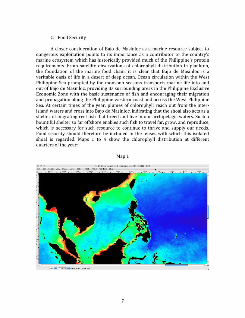
C. Food Security A closer consideration of Bajo de Masinloc as a marine resource subject to
dangerous exploitation points to its importance as a contributor to the country's marine ecosystem which has historically provided much of the Philippine’s protein requirements. From satellite observations of chlorophyll distribution in plankton, the foundation of the marine food chain, it is clear that Bajo de Masinloc is a veritable oasis of life in a desert of deep ocean. Ocean circulation within the West Philippine Sea prompted by the monsoon seasons transports marine life into and out of Bajo de Masinloc, providing its surrounding areas in the Philippine Exclusive Economic Zone with the basic sustenance of fish and encouraging their migration and propagation along the Philippine western coast and across the West Philippine Sea. At certain times of the year, plumes of chlorophyll reach out from the inter-island waters and cross into Bajo de Masinloc, indicating that the shoal also acts as a shelter of migrating reef fish that breed and live in our archipelagic waters. Such a bountiful shelter so far offshore enables such fish to travel far, grow, and reproduce, which is necessary for such resource to continue to thrive and supply our needs. Food security should therefore be included in the lenses with which this isolated shoal is regarded. Maps 1 to 4 show the chlorophyll distribution at different quarters of the year:
Map 1

8
Map 2
Map 3

9
Map 4
D. Freedom of Navigation Bajo de Masinloc's geographical position is strategic vis-a-vis Manila and
Subic. From this position, it is possible to conduct short to medium-range surveillance of marine and air traffic into the country's two largest port areas for both civilian and military purposes. Although militarily, like most of the islands in the South China Sea, their value in wartime is nominal (they are basically small stationary targets in open water), their value in peacetime is great. Similar to Mischief Reef, a permanent installation on Bajo de Masinloc represents long-range shelters and staging areas for all manner of marine activities (military and civilian) that extends the Chinese reach well into the archipelago and beyond. Military analysts would see the occupation of Bajo de Masinloc as part of a network of offshore multi-purpose installations with which China could effectively blanket the entire South China Sea, and all the maritime traffic within it. Any movement in this direction will certain cause jitters among military and commercial maritime powers because of the threat to freedom of navigation that it may represent. This security interest is one that is shared by the Philippines with all maritime states.
These four interests are arguably implicated in the Chinese incursions, and
immediately relates to the Philippines' previously avowed policy of multi-lateral engagement in the South China Sea. If the Philippine response is anchored purely on the preservation of territorial integrity, the Philippines ultimately shares no interests with any other State; realpolitik dictates that no other coastal State will

10
suffer any ill effects whether the Bajo de Masinloc is Chinese or Filipino. But, if cast as an issue of deliberate environmental degradation, illegal, unreported or unregulated fishing, or a potential threat to freedom of navigation, then the possibility of multi-lateral interests unfold. To be sure, it is not just a matter of imaginative spin doctoring, and requires more in terms of hard evidence, as well as entirely different approaches to communication with China and the rest of the region and the world. But the exercise demonstrates the value of being clear on what interests are sought to be protected in order to craft the appropriate responses to pursue. One wonders whether the stand-off would have lasted this long, had from the very beginning the incident been properly addressed and portrayed as a State-sponsored frustration of efforts to protect endangered species, instead of a territorial contest. Diplomacy is an art of language; it is also an art of presentation.
Options and Looking Forward
The manner in which the issue of the Chinese incursions has been handled, especially in the mass media, has not been ideal. The Filipino people have been bombarded with sensationalistic descriptions of Chinese and Filipino ships in a tense showdown around a pile of rocks in the middle of the ocean, with incredibly loose talk of the possibility of war. Various protagonists in government have issued a flurry of statements whose implications make long-time observers in the academe uncomfortably cringe or reluctantly clap, increasingly unsettled by their rash and insensitive character, and the incredibly mounting odds for miscalculation and provocation throughout this whole affair. The twists and turns in this incident have been worrisome; alarm-bells were ringing, but no one seemed to notice. For example, from the Chinese perspective, it appears that the Philippines (unofficially) broke off diplomatic contact with the Chinese Embassy in the early stages of the stand-off. Normally, breaking off diplomatic contact is the prelude to a declaration of war. Then the Philippines publicly declared its intention to hail China before an international court without its consent, giving up on the cooperative track of bilateral negotiation and seeking an adversarial track unilaterally. Most people assume that just because litigation does not involve the use of force, it is a “diplomatic” solution; however, most practicing litigators know that their craft is basically the art of war without bloodshed, where “the winner takes all and the loser takes the fall.” In litigation practice, the closest analogue to diplomacy is in fact called “alternative dispute resolution mechanisms,” which precisely provides alternatives to litigation. It includes bilateral negotiation of compromise agreements. And, in the most surreal instance, the President was widely reported to have asked to the United States to send spy planes to the shoal. That would make the Philippines the only nation to publicly ask another to spy for us, and announce it to the world, no less. Thankfully, the administration has finally taken the single most important action it should have taken three months ago: for everyone to work in silence.

11
At this point, it is probably too late for recriminations as the situation is fluid and dynamic. What are the options available to the Philippines and would any of them be an appropriate response?
First, there is the legal option which has been given much prominence in
recent months. It has been announced that the Philippines intends to take China before an international tribunal over the matter of Bajo de Masinloc, without its consent. Some think that this is possible, and the only recourse of the Philippines on account of its inherent military weakness. In my assessment, it is highly unlikely that any court, whether the International Tribunal for the Law of the Sea or the International Court of Justice, would ever take cognizance of such a case.
From the Department of Foreign Affair's (DFA) own published position
paper, and in the view of some academics, the Philippines seeks to sidestep the issue of sovereignty over the shoal and attempts to portray it as an issue of enforcement of sovereign rights in the Exclusive Economic Zone (EEZ). It also gives the impression that such a case will be basically a question of interpretation of the United Nations Convention on the Law of the Sea (UNCLOS) provisions, such as whether the shoal qualifies as an island.
An attempt to pursue such a case would be ill-advised. Even assuming that
China disregards its own reservations to the UNCLOS dispute settlement mechanisms, which specifically place the case as described by the DFA outside their scope, it is not possible to avoid the issue of sovereignty over the shoal, which both parties admit at the very least to have rocks always above water at high tide and therefore entitled to at least a territorial sea of 12 nautical miles. This creates a territorial sea area nearly as large as Manila Bay, or Lingayen Gulf.
From all accounts, whether Chinese or Filipino, the questioned activities have
been taking place at the very center of this zone, right inside the shoal's perimeter. It would be pointless to discuss EEZ rights, which in law must exist beyond the territorial sea, unless the issue of sovereignty over the rocks is resolved. To insist on pursuing a case for violation of EEZ rights where the activities are completely within territorial waters is like suing a person for trespassing into the backyard after finding him in flagrante delicto stealing the appliances of your house. Moreover, to put the question of whether or not those rocks generate an EEZ before an international court is an ill-advised and totally unnecessary gambit. At present, the Philippine position as defined by Republic Act No. 9522 and based on the current maps of the Philippine EEZ, is that the shoal does not generate its own EEZ. This effectively enclaves the shoal in a territorial zone and leaves the surrounding EEZ to the Philippines. China will find it difficult to contest this position because it has taken a similar one with respect to its disputes against Japan, that a mere rock (Okino-Torishima in the Pacific Ocean) cannot generate an EEZ. Why then should the Philippines make that position subject to the decision of an international tribunal, which may find basis to rule otherwise? It is as if the Philippines is giving the Chinese side a 50% chance of expanding their jurisdictional claim, this time to

12
an EEZ projected from the shoal, on the basis of the judgment of a third party over which it has no control. While the Philippines may indeed ultimately need to resort to international litigation in order to protect its rights in the West Philippine Sea, the current problem over Bajo de Masinloc, as described by the DFA, is not the proper issue to begin it with.
Second, there is the bilateral option, a negotiated settlement. However, based
on previous statements and positions, it appears that the Philippines a priori gives up on this option, and resigns itself to the fact that it is the weaker party compared to China. The problem with this fatalist position is that it does not appear to adequately consider what is the national interest and objective to be pursued. If the idea is a bilateral negotiation that finally settles who has sovereignty over the shoal, then it is probably true that engaging in negotiations would be pointless because neither side is likely to give up its position. But such an analysis is borne out of a simplistic consideration of negotiation as a zero-sum game, a process of haggling. Both sides have already invested too heavily in their positions to back down. However, scores of specialist institutions and hundreds of trained negotiators have long surpassed this conceptual obstacle, and determined that there are so many ways and means of achieving compromise and solving what were thought to be insurmountable problems. The resignation to weakness also does not consider many lessons of history where David actually did slay Goliath: take a look at Vietnam vis-a-vis the United States in the Vietnam War. Just because one is militarily or economically weak does not mean that one cannot be victorious.
The fundamental requirements for these kinds of solutions are a clear
definition and understanding of one's own interests; formidable political will; proper framing of the problem; and a well-designed strategy. For example, is the objective at this point to vindicate sovereignty over Bajo de Masinloc, or is it to ensure that it is not occupied at all? These are different and separable objectives, requiring different approaches, and correspondingly have different chances of being achieved. But what is required is a clarity in one's own interests, before determining the appropriate course of action to protect it. Obviously, this requires quite a lot of investment in capacity-building, purposeful preparation, and sound strategy, something that the country sorely needs especially in all of its international negotiation initiatives.
Third, which is that being pursued is the option of multi-lateral engagement.
Actually, this is probably more difficult in execution than even the bilateral option. In addition to requiring the same basic building blocks, effective multi-lateral engagement is more complex because the Philippines must be able to deal with multiple varied and sometimes incongruent interests between multilateral partners. Multi-lateralism is not a mere task of persuading a large number to ally against one; it takes a long process of negotiating common interests with each and every one. It would be naïve to expect that within this year the Philippines can negotiate ASEAN and other stakeholders into presenting a specific united front against the Chinese position. Despite certain commonalities, each country will essentially look out only

13
for its own national interests, and these will not necessarily coincide immediately with the Philippines' position. If recent press reports about progress within the ASEAN on the Code of Conduct are any indication, even the “basic elements” that have apparently been agreed upon look like a rehash of phraseology from previous ASEAN documents. This is a cause for concern, in that the Philippines may be investing too much time and resources on an issue which takes time away from other equally important issues within ASEAN. The fact that it has similar territorial issues with Vietnam, Malaysia, and Brunei, which are inherently connected with its issues with China, seems to have been completely pushed beyond the horizon. At this point, we can only await with interest for the results of the Philippines' latest initiative, and pray that it turns out substantially better than the last one.
Concluding Remarks When the President said that the Armed Forces of the Philippines does not
have the capability to surveil Bajo de Masinloc, thus prompting him to consider asking for US overflights, did anyone question whether this was an accurate assessment? Is it true that the Philippines is not even capable of quick reconnaisance, i.e. taking pictures and making an aerial ocular inspection of the shoal, a mere 124M (about 250km) from its shores? Did anyone not check that even the Air Force's venerable SF-260 trainers have a range of over a 1000M, and can therefore go to and return from Bajo de Masinloc several times on a full tank of gas? An SF-260 carries two persons: one can pilot while the other can be trained to take photos with an SLR camera fitted with a telephoto lens. Isn't that all that is needed to verify the activity on the shoal?
From just this instance, one realizes that actually, the Philippines has many
hidden resources, and that we are not so helpless as we think we are. Too long have we internalized this pessimistic idea of weakness, this self-defeating attitude of helplessness. It is high time that we break free of the shackles of self-imposed and self-sustained ineffectiveness. When faced with bullying, one cannot always expect others to be the ones to take the cudgels. One has to stand up for oneself. It is long past time that in this issue, as well as many others, that we did so.

14
Reaction of Rear Admiral Vicente M. Agdamag (Ret.)
I agree with the lecture of Prof. Jay L. Batongbacal. In fact, based on the Treaty of Washington of 1900, Bajo de Masinloc is part of the maritime territory of the Philippines.
Prior to 1995, there were only three known Chinese structures in the Kalayaan Island Group. These were in Subi, Johnson, and Fiery Cross Reefs. In 1995, a rudimentary structure was discovered in Mischief Reef. It has now evolved into a military fortress complete with a radar and helicopter pad.
Historically, China has been willing to use force when matters of sovereignty and territory are involved. China considers Bajo de Masinloc as part of its so-called 9-dash line, the demarcation line that it uses for its claim to around 80% the South China Sea. The line is as shown (Map 5). Beyond the 9-dash line is a line called the First Island Chain1 and, beyond that, the Second Island Chain.2 China seeks to control the waters within these island chains.
Map 5
1 It links Okinawa Prefecture, Taiwan and the Philippines. 2 It links the Ogasawara Island Chain, Guam and Indonesia.

15
To date, China has not given any specific coordinates for the 9-dash line but
has mentioned early this year that it will start mapping some reefs and shoals in the South China Sea.. These surveys are important because it allows safe passage through an area even in nighttime if one has a hydrographic map. They are also manpower-intensive which is the reason why there are so many Chinese fishing boats in the area.
The claim also threatens freedom of navigation, not only of the Philippines but of other countries as well. Around 60% of the world’s cargo pass through the South China Sea which has four important maritime routes: Manila-Sunda Strait to Cape Town, Aden; San Francisco, Seattle, Panama, Honolulu via Luzon Strait, San Bernardino Strait, Surigao Strait to Hongkong, Singapore, Manila; Guam via Surigao Strait to Singapore, Bombay, Calcutta, Rangoon; and Hong Kong, Shanghai to Singapore, Aden. Furthermore, almost all shipping from the United States must pass through three narrow Philippine straits—the Luzon, San Bernardino and Surigao straits.
It is not surprising that China would seek to control the waters in and around the Philippines. According to famed naval strategist Alfred Mahan, sea power is control of the narrow seas and the Philippines, as stated, has three narrow straits through which almost all shipping from the Pacific must pass. It also has many deep harbors and is the strategic heartland of Asia.
There are five instruments of national power: political, diplomatic and legal, informational, economic and military. The three options presented by Prof. Batongbacal—legal, bilateral and multilateral, relate to the diplomatic and legal. In addition to the three options of Prof. Batongbacal, the Philippines must utilize all five to protect Bajo de Masinloc and its interests in the West Philippine Sea.

16
Reaction of Professor Herman Joseph S. Kraft
There are four key points to Professor Batongbacal’s presentation. First, the
issue has been enflamed by a lack of restraint in the way that the issue has been represented by both sides to their respective publics. The “undiplomatic language” utilized by both sides has contributed to escalating tensions over the situation in Panatag Shoal. Second, there is a difference between the case of the Kalayaan Island Group and Panatag Shoal. The latter is not sitting on a rich reserve of gas and oil – but there is much fishery resource in the area. The Philippine claim to Panatag Shoal has a stronger basis with international navigational charts going back to the 18th century conceding jurisdiction and responsibility over the shoal as navigational hazards being exercised by the Spanish colonial government. Third, the Philippine approach as far as this crisis is concerned has been wrong inasmuch as it has brought the country into a direct confrontation with China over the question of sovereignty over the shoal. This is an approach which unless the Philippines is prepared to face up to China militarily is not likely to lead to an end favorable to the country. It is also too dependent on the assumption that the US will come to the defense of the Philippine claim to Panatag Shoal should the situation lead to even limited hostilities. Fourth, the Philippines should reflect on what interests are involved in the current situation and that perhaps a reframing of the issue to de-emphasize the issue of sovereignty could best lead to a de-escalation of the issue as well as the generation of international support for the position of the Philippines.
These four points are important because of the information they provide (which are not popularly known); but they should be appreciated in the context of current international developments in order for the country to make more fully informed decisions on how to respond to the situation. First, the changing international context with the rise of China and the subsequent economic crisis of the United States. The latter has created the impression of the decline of American hegemony. The former on the other hand has led to a change in the balance of power that may scholars believe allow China to challenge the United States for at the very least dominance in the Asia Pacific. The American response to the rise of China has been a strategic realignment of its military forces (the “pivot” to the Asia Pacific) which China considers as threatening. In this context, Panatag Shoal is part of the “first island chain line” which China utilizes as the outer bounds defining the area that it seeks to deny US access to in the event of conflict. Second, the post-Cold War period defined by the emergence of multilateral activism in the international system (which the coming into effect of the UNCLOS had fitted into quite well) was now being overtaken by this emerging dynamic between China and the US. Third, this dynamic is increasingly making the second track of the Philippine strategy on the question of sovereignty in the West Philippine Sea, i.e. ASEAN, ineffective. As the last AMM had shown, China’s allies in ASEAN have effectively prevented the association from taking a united position. On the other hand, such a united position could have just as well gone against the Philippines – that ASEAN could have decided not to

17
have anything to do with the Panatag Shoal issue. Despite being one of the original founding members of ASEAN, the Philippines has not been able to exercise influential leadership within the Association at the strategic level. It is in fact not recognized to be one of the stronger members of ASEAN by the international community. Fourth, more tactically, the situation in Panatag Shoal must contend with the internal political dynamics of Chinese leadership succession – a process that is fraught with uncertainty even as the successor is already well known. The need to posture both domestically and, even more so, internationally to show strength and resolution is an accepted part of the process. In this context, it is unlikely that the Philippines will find a China that is willing to be conciliatory especially in the face of what it has represented to be provocative actions and statements from the Philippines.
In the face of these developments, the actions of the Philippines play right
into the power dynamic between China and the United States. Dr. Batongbacal’s suggestion that it might be best to rethink certain accepted truths about how we have approached the general question of the territorial dispute over the West Philippine Sea, and take a look at alternative ways of reframing the issue. This is not to say that sovereignty is no longer the issue. It will continue to be so. The best time to settle sensitive issues, however, is when emotions are not heated up and everyone involved is in a sober frame of mind. This is something to be settled later, not now (especially now when tensions remain high). At the same time, adopting a less self-interested posture (i.e. the legitimacy of the sovereign claim of the Philippines to Panatag Shoal and the KIG) and representing the issue as a question of general interest and concern (i.e. environmental security and the preservation of biodiversity in the area) may lead to greater sympathy from the international community for the Philippines and place in bad light Chinese “aggression” in the area.
This approach makes a lot of sense. The problem, however, lies in its operationalization. Maneuvering out of the hole we have dug ourselves in will also have to be filled up using the same flawed diplomatic instrument that got us there in the first place. As intimated by Dr. Batongbacal, a major factor in the escalation of the issue was the “undiplomatic” actions and language used by both sides at the start of the problem in April 2012. The poor quality of our diplomacy has contributed to the situation faced by the Philippines over Panatag Shoal and the crude way by which we tried to play the US card made it worse. The proposal of Dr. Batongbacal will require a certain level of diplomatic dexterity that we have so far not exhibited ourselves to be capable of. Contributing to this is the apparent lack of political guidance at the highest levels of political leadership of the country over this issue. To be able to de-escalate the immediate problem with minimal loss (i.e. losing Panatag Shoal to effective Chinese occupation) and be able to reframe the issue over the short term and medium term seems to be beyond the capacity of our diplomacy and our political leadership at the moment. Even as this might be the best approach we can take in the immediate term, can we do it? Or are we likely to find a Chinese structure in Panatag Shoal as part of their strategy of creating facts on the ground? If

18
that is the case, our options become even more constrained and will likely push us inevitably into the power dynamic between China and the United States.

19