geophysical survey report 19 - queen's university belfast · this report details the results...
TRANSCRIPT

Geophysical Survey Report 19
The O’Connor’s Stronghold, Co. Armagh
The O’Connor’s Stronghold, Co. Armagh
Geophysical investigations at the site of a 17th century outshot chimney stack
SMR No.: ARM 002:001
Grid Ref: H 9299 6425
On behalf of
Northern Ireland Environment Agency (NIEA)
Sapphire Mussen
CAF GSR 19
Contents
List of Figures ........................................................................................................................................................... 2
1 Summary ......................................................................................................................................................... 3
2 Introduction ..................................................................................................................................................... 5
3 Background to the Survey ............................................................................................................................. 5
4 Cartographic Evidence .................................................................................................................................. 6
5 The Survey Site ............................................................................................................................................... 7
6 Survey Specific Information .......................................................................................................................... 8
7 Earth Resistance Survey Results ................................................................................................................. 9
8 Discussion of Survey Results ..................................................................................................................... 12
9 Conclusion .................................................................................................................................................... 15
10 Bibliography .................................................................................................................................................. 16
The Figures ............................................................................................................................................................. 17

2
List of Figures
Figure 1 Map showing the approximate location of the O’Connor’s Stronghold
Figure 2 Map showing the location of the 2012 gridded survey area
Figure 3 Edited sketch based on Thomas Philips map of 1685-86
Figure 4 Extracts from 6-inch Ordnance Survey maps showing Derrywarragh Island
Figure 5 Shade plot of resistance data
Figure 6 Shade plot of resistance data following the application of High Pass Filter
Figure 7 Shaded relief plot of resistance data
Figure 8 Simplified interpretations of resistance survey data
3
1.0 Summary
1.1 Site Specific Information
Site Name: The O’Connor Stronghold
Townland: Maghery
SMR No.: ARM 002:001
The remains of the O’Connor stronghold and its immediate vicinity are in
state protection.
Grid Ref.: H 9299 6425
County: Armagh
Dates of Survey: 24th-25
th April 2012
Surveyors: Sapphire Mussen and Cormac McSparron, Centre for Archaeological
Fieldwork, Queens University Belfast.
Size of area surveyed: 0.16 hectares
Weather conditions: Inclement, high winds
Geology: Bedrock geology of clay, sand and lignite with alluvium deposits
Current land use: Grazing fields
Survey type: Electrical resistance
4
1.2 Abstract
A limited geophysical survey was carried out in April 2012 which covered the area immediately
surrounding the upstanding chimney stack. This revealed a number of definite linear anomalies of
both high and low resistance levels which appear to be consistent with boundaries, ridges and
paths which can be viewed in aerial photographs of the site. A number of amorphous high
resistance spreads and linear features around the site may be indicative of garden features,
surfaces or walls associated with the 17th century house, or remains of earlier structures on the
island. There appears to be a superimposition of anomalies of contrasting resistance levels which
would be suggestive of successive periods of use and alteration of the site. Unexpectedly, the
area immediately surrounding the chimney stack gave very little in terms of positive earth
resistance readings although this could be indicative of a lack of sunken foundations which would
be typical of houses of the period. Interpretation and comprehension of the anomalies present
has been greatly compromised by the size of the area surveyed. To attempt to establish a clear
understanding of this site from such a small survey area is almost futile and it is advisable that
future survey work be carried out on a greater area to add to and enhance our current
understanding of the site.
5
2.0 Introduction
This report details the results of an investigative geophysical survey carried out at the site of
O'Connor's Stronghold in County Armagh. It is identified in the Northern Ireland Sites and
Monuments Record (NISMR ARM 002:001) as the remains of a 17th century fortified house. Only
an outshot chimney stack now survives and the surrounding land is used for grazing purposes.
Wide ridges and furrows encountered when walking over the site provide evidence of a period of
lazy bed cultivation. The site occupies an area of raised land on the northern coast of
Derrywarragh Island which is situated on the south-western tip of Lough Neagh, a short distance
from Coney Island and cut off from the mainland by the River Blackwater and the Maghery canal
(figure 1). Detailed information regarding the O’Connor’s Stronghold is scant and it was proposed
that through limited investigative geophysical research of the area immediately surrounding the
upstanding chimney stack (figure 2), enough evidence would be uncovered to determine the
extent of the house foundations and thereby provide an archaeological assessment of the site
with a view to informing its future management strategy. This research was carried out in April of
2012 and a discussion of the results is provided in Section 8. Recommendations for further work
are given in Section 9.
3.0 Background to the survey
3.1 The 2012 geophysical survey was carried out in an attempt to investigate the extent of the
remains of O’Connor Stronghold. Written references to the monument are scant as it seems to
have received very little academic attention. In 1837 the Ordnance survey memoirs refer to a ruin
on the island that was known as ‘the chimney’s’ (Day & McWilliams 1991, 121). Details of the
original structure, its form, erection and destruction are all unclear, as are details regarding the
origins of the name ‘O’Connor’s Stronghold’; In a letter written by T.G.F Paterson1 in 1927 it is
stated that the ruin is known locally as ‘O’Neill’s castle’ and “Nobody in the district knows of
O’Connor’s Stronghold”.
3.2 The surviving architectural evidence of the out-shot chimney stack at O’Connor’s Stronghold
suggests that it is the remaining section of a fine early 17th century house, having direct parallels
with a number of other buildings from this period (Donnelly et al. 2004, 127).
3.3 During the first quarter of the 17th century, the land in which O’Connor’s Stronghold is situated
was owned by an English army captain by the name of Sir Toby Caulfield. Caulfield erected his
principle residence at Ballydonnelly-now Castlecaulfield in County Tyrone and it has been
suggested that the building on Derrywarragh Island may have been constructed by Caulfield as a
6
second residence either for himself, for his family, or as residence for one of his tenants in the
period after 1607 (Donnelly et al. 2004, 127).
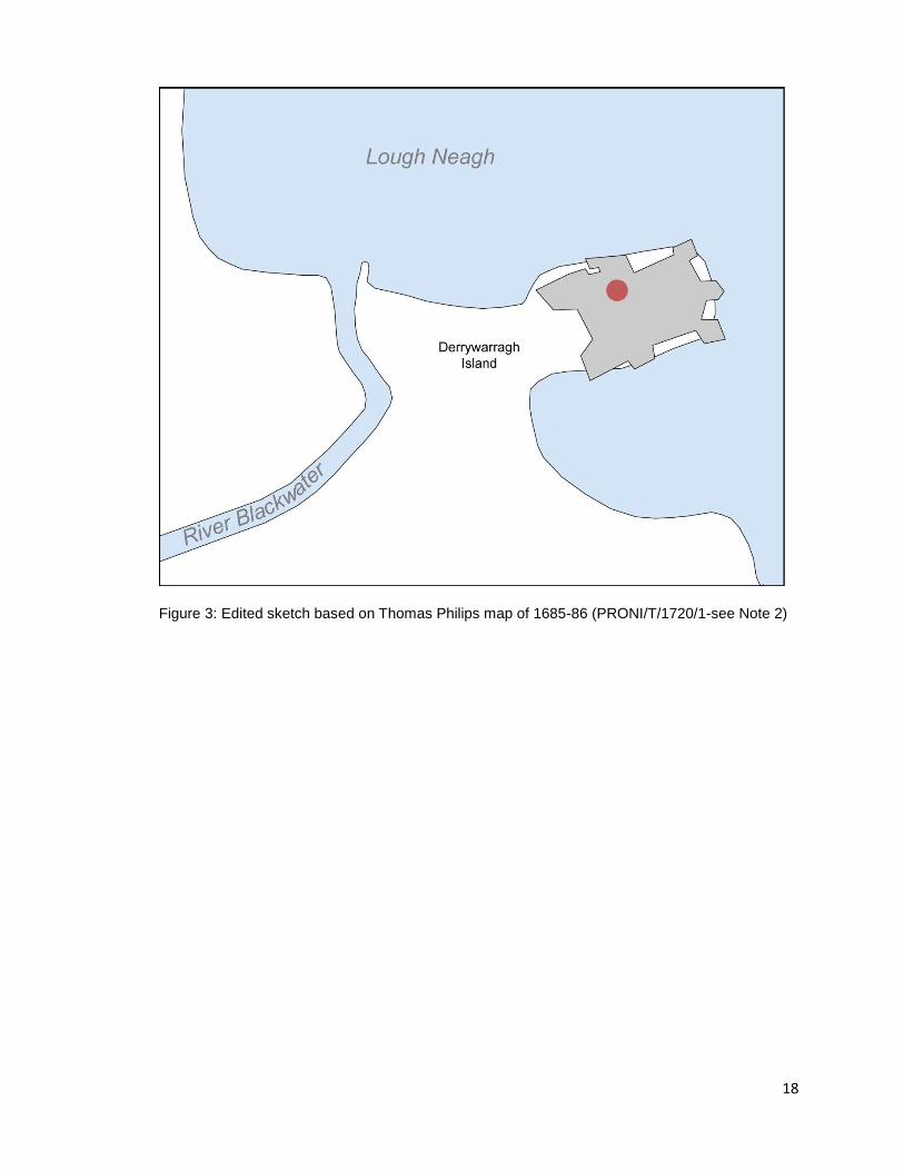
3.4 Thomas Philips’ plan of 1685-86 of a proposed new artillery fort on Derrywarragh Island indicates
that the new fort would have overlain the position of Caulfield’s building with the inference being
that the house had been abandoned by the 1680’s or was viewed as being of such limited value
that it might be demolished to enable the occupation of its site by the new fort. As such it can be
suggested that the O’Connor’s Stronghold had become ruinous or been destroyed by the end of
the 17th century (Donnelly et al. 2004, 128). It is likely that work for the proposed new fort was
never carried out and certainly never saw completion, perhaps Derrywarragh Island itself proved
too uninhabitable.
4.0 Cartographic evidence
A proposed but never realised layout for an artillery fort to be constructed on Derrywarragh Island
is depicted on a plan of the peninsula made in 1685-86 by Sir Thomas Philips2 (figure 3). The
location of this proposed fort overlies the location of the current ruins which could infer that at this
stage, the early 17th century house had been either already abandoned or plans to demolish it
were underway to allow for construction of the new fort. Subsequent maps of 1765 and 1785
depict a tower on the island (Brett 1999 cited in Donnelly et al 2004, 124). The 1st edition
ordnance survey map of 1829-1835 denotes ‘ruins’ and the peninsula named as ‘Derrywarragh
Island’ (figure 4). It is not until the revised 1857-1932 3rd
edition ordnance survey map that the title
of ‘O’Connor’s Stronghold is first marked ‘in ruins’ (figure 4). Field divisions which run northeast to
southwest across the site are shown on maps from 1857 onwards (figure 4). These divisions are
now only evident on the ground in the form of earthen ridges.

7
5.0 The Survey Site
5.1 The scheduled monument of O’ Connor’s stronghold is sited on an area of raised grassland at the
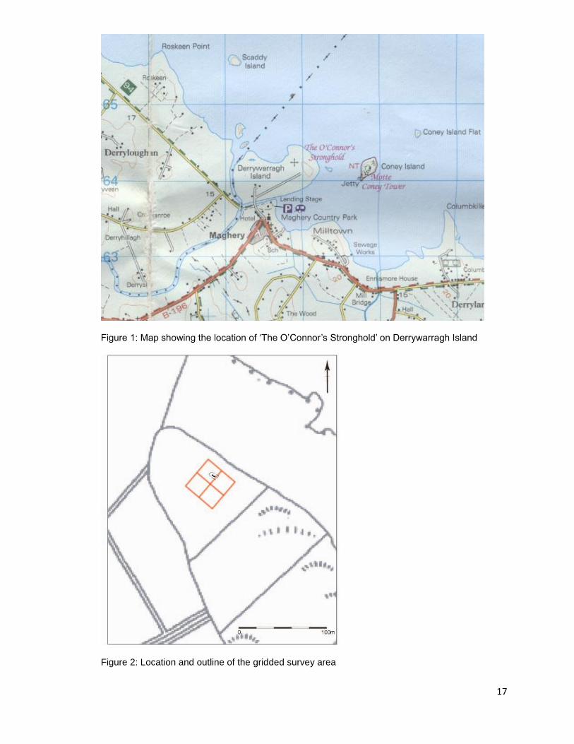
north-eastern tip of Derrywarragh Island, on the south-western shores of Lough Neagh (figure 1).
The surveyed area covers 0.16 hectares in the immediate vicinity of the still standing out-shot
chimney-stack (figure 2). The land rises in the form of a low mound to the southeast of the
structure and is wholly furrowed by evidence of lazy bed cultivation ridges running along the same
alignment as what appear to be earthen field boundaries (southwest to northeast). What appears
to be an earth cut route way bounds the aforementioned mound of the site from southeast to
northwest, skirting around the western edge of the survey site and ending at the north-eastern
point of the island. To the northeast of the monument the island drops off in steep slopes to the
shores of the Lough. The edges of Derrywarragh Island are delineated by rough hedge and thorn
bushes. The land surrounding the monument is currently used as rough pasture for grazing and is
fairly open to the elements. The strong winds which often come off the shores of Lough Neagh
may be in part accountable for the deterioration of the monument itself.
5.2 The current upstanding structure consists of an out-shot chimney-stack of mortared basalt rubble
with flues and fireplace hoods lined with red sandstone, standing to a height of approximately
10m. The fireplace hoods have collapsed on the north-eastern face to reveal an internal tiered
flue system that would have served fireplaces on the ground, first and second floors within the
now demolished main section of the building (Donnelly et al. 2004, 123). The decorative chimney
shafts which crown the chimney stack are of red brick. The location of three fireplaces in the
north-eastern face of the structure, along with a number of put-lug holes for floor and ceiling
supports would suggest that the now demolished house stood on the north-eastern side of the
surviving chimney stack.
5.3 Rapid deterioration of the structure during the 20th century can be gauged when a comparison is
made between a photograph taken around 1910 from the south of the ruin and photographs taken
during a survey of the structure in 2004 (Donnelly et al. 2004, 124). Such photographic evidence
shows that the decorative brickwork shaft which was intact not so long ago, has since
deteriorated and mostly collapsed leaving only a fragmented portion of brickwork in situ.
8
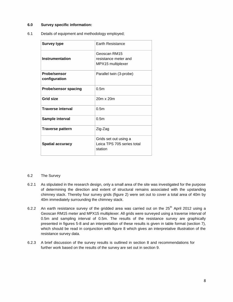
6.0 Survey specific information:
6.1 Details of equipment and methodology employed;
Survey type Earth Resistance
Instrumentation Geoscan RM15
resistance meter and
MPX15 multiplexer
Probe/sensor
configuration Parallel twin (3-probe)
Probe/sensor spacing 0.5m
Grid size 20m x 20m
Traverse interval 0.5m
Sample interval 0.5m
Traverse pattern Zig-Zag
Spatial accuracy Grids set out using a
Leica TPS 705 series total
station
6.2 The Survey
6.2.1 As stipulated in the research design, only a small area of the site was investigated for the purpose
of determining the direction and extent of structural remains associated with the upstanding
chimney stack. Thereby four survey grids (figure 2) were set out to cover a total area of 40m by
40m immediately surrounding the chimney stack.
6.2.2 An earth resistance survey of the gridded area was carried out on the 25th April 2012 using a
Geoscan RM15 meter and MPX15 multiplexer. All grids were surveyed using a traverse interval of
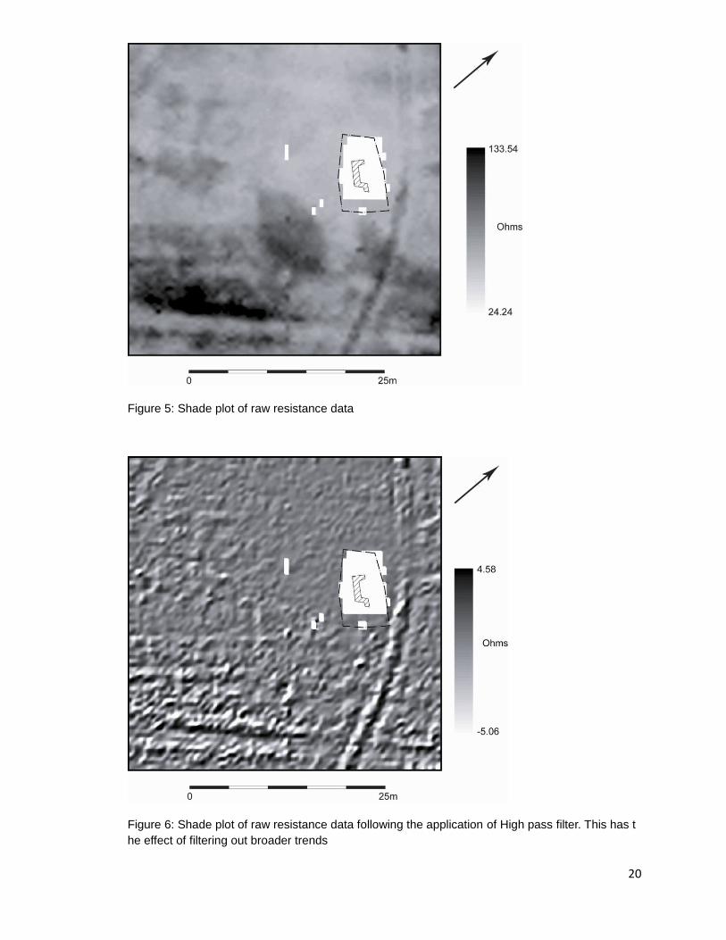
0.5m and sampling interval of 0.5m. The results of the resistance survey are graphically
presented in figures 5-8 and an interpretation of these results is given in table format (section 7),
which should be read in conjunction with figure 8 which gives an interpretative illustration of the
resistance survey data.
6.2.3 A brief discussion of the survey results is outlined in section 8 and recommendations for
further work based on the results of the survey are set out in section 9.

9
7.0 Earth resistance survey results
Code Description Interpretation
r1 Linear high resistance anomaly of regular width
(approximately 2m) running in a shallow curve from
northwest to southeast along the north-eastern edge of
the survey grid. Runs directly between the current
upstanding out-shot chimney stack and the steep north-
eastern edge of the island.
The regular appearance and high resistance readings of this anomaly could
suggest that it is a hard-core pathway the date of which is unknown as any
evidence of a path here is absent from the Ordnance Survey maps of the
island. The results indicate that it truncates all other detected features
suggesting it is much later in date. The fact that it does not show up on any
of the maps suggests that it may never have been officially surfaced.
r2 Banded high and low resistance anomaly running north
to south across the north-western corner of the survey
area, approximately 2.5m in width.
This anomaly represents a section of what appears to be a path or route
way running from north to south along the break of the hill before curving off
in an easterly direction across the site. The nature of the resistance
suggests it is a path which has been dug out rather than trampled in. The
low resistance area would represent the pathway itself and the finer bands
of high resistance which flank it would represent the cast up material and
cleared stone from the formation of the path. Whilst heavily denuded in
places and overgrown this path is clearly visible on the ground and in aerial
photography of the site. Its form on the ground with a flat area flanked by
uneven ground on either side suggests that it has been purposely formed
and possibly intended for use over a long period of time. As this feature
does not make an appearance on any of the Ordnance Survey maps it
could be suggested that it is much earlier in date, possibly early Christian.
r3a-f Banded linear anomalies of high and low resistance
running from southwest to northeast along the south-
eastern edge of the site. r3a is fairly straight and regular
The banded appearance of these anomalies is likely a remnant of their
formation. Linear earthen ridges of up to 0.6m and furrows are easily visible
on the ground surface in this area of the site. They are also visible in aerial

10
in width (approximately 2m). r3b is more bowed in shape
but fairly parallel to r3a and is of roughly the same width.
Flanking r3a and r3b and also lying directly between
them are distinct areas of high resistance; r3c-r3f. All lie
to the southeast of the chimney stack and run in a
southwest to northeast direction. These anomalies are
less distinctive towards the north-eastern end where they
appear to have been truncated by the linear anomaly r1.
photographs in which a distinctive bowed shape not dissimilar to that of r3b
can be seen. These ridges coincide with one of the field divisions marked on
Ordnance Survey maps of the area from 1857 onwards (figure 4). Without
knowing the exact nature of the original field divisions a definite explanation
for the bands of resistance is difficult. It can only be suggested that the field
divisions may have been low dry stone walls constructed of field clearance
material which later tumbled and became covered with earth which would
explain the lines of high resistance. The low resistance bands may be relict
of ditches or gullies dug on either side of the field boundary which may
rapidly have become silted up. The absence of such field divisions on the
1832 Ordnance Survey map and their appearance on maps from 1857
onwards would suggest that they were first constructed within this time
period, probably whilst the site was in use for lazy bed cultivation which is
also evident in the round surface of the site and which respect to the
orientation of the field divisions. Evidence of the truncation of these
anomalies by r1 is also evident in the ground surface suggesting that the
field divisions were already in a state of disuse by the time this potential
pathway was in regular use.
r4 Linear anomaly of low resistance approximately 2m in
width running from southwest to northeast along the
north-western edge of the survey area. Appears to be
flanked by patches of higher resistance.
Likely to be evidence of lazy bed cultivation. Much of the survey area
appears to have faint traces of this form of activity; r4 represents the most
distinctive evidence. Lazy bed cultivation ridges are visible in the ground
surface across the entire site and are likely to have compromised the
discovery of other anomalies of archaeological distinction as the ground
surface has been much disturbed and reused. If cultivation of lazy beds was
taking place in the early to mid-19th century, the time in which the field
11
divisions first made an appearance on the Ordnance Survey maps, earlier
17th century features would have been heavily truncated and loose stone
likely removed.
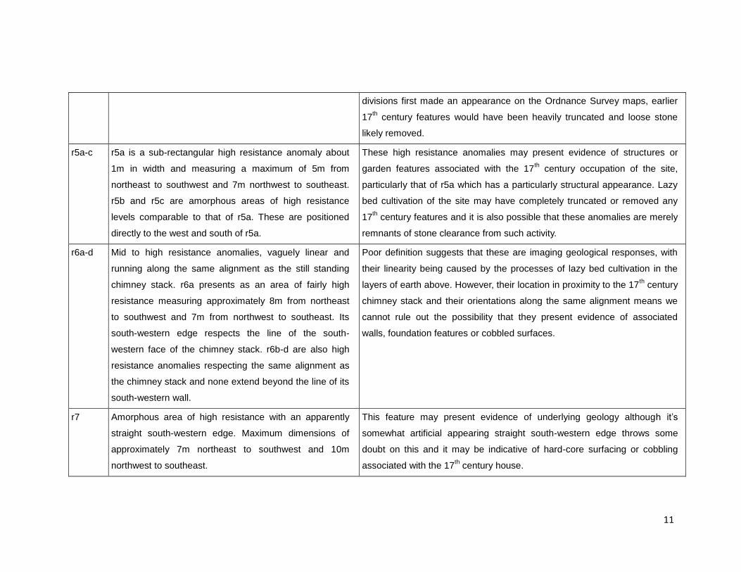
r5a-c r5a is a sub-rectangular high resistance anomaly about
1m in width and measuring a maximum of 5m from
northeast to southwest and 7m northwest to southeast.
r5b and r5c are amorphous areas of high resistance
levels comparable to that of r5a. These are positioned
directly to the west and south of r5a.
These high resistance anomalies may present evidence of structures or
garden features associated with the 17th century occupation of the site,
particularly that of r5a which has a particularly structural appearance. Lazy
bed cultivation of the site may have completely truncated or removed any
17th century features and it is also possible that these anomalies are merely
remnants of stone clearance from such activity.
r6a-d Mid to high resistance anomalies, vaguely linear and
running along the same alignment as the still standing
chimney stack. r6a presents as an area of fairly high
resistance measuring approximately 8m from northeast
to southwest and 7m from northwest to southeast. Its
south-western edge respects the line of the south-
western face of the chimney stack. r6b-d are also high
resistance anomalies respecting the same alignment as
the chimney stack and none extend beyond the line of its
south-western wall.
Poor definition suggests that these are imaging geological responses, with
their linearity being caused by the processes of lazy bed cultivation in the
layers of earth above. However, their location in proximity to the 17th century
chimney stack and their orientations along the same alignment means we
cannot rule out the possibility that they present evidence of associated
walls, foundation features or cobbled surfaces.
r7 Amorphous area of high resistance with an apparently
straight south-western edge. Maximum dimensions of
approximately 7m northeast to southwest and 10m
northwest to southeast.
This feature may present evidence of underlying geology although it’s
somewhat artificial appearing straight south-western edge throws some
doubt on this and it may be indicative of hard-core surfacing or cobbling
associated with the 17th century house.

12
8.0 Discussion of survey results
8.1 At a first glance the survey results are rather puzzling as the area immediately surrounding the
supposedly 17th century upstanding out-shot chimney stack is almost completely featureless. The
lack of resistance in this area would suggest that the area is completely waterlogged which would
not be surprising given the fairly marshy nature of the site. However, as the remainder of the
survey area is brought into view it can be seen that a number of high and low resistance
anomalies are clearly being detected overlying a fairly homogenous background of low
resistance. The low background readings are likely a result of the fairly waterlogged nature of the
site however this proves to be of an advantage as any solid features or areas of hard standing
within the site are presented in the form of very stark areas of high resistance. Through further
processing of the raw results, particularly through the application of High Pass Filter to dilute
some of the more broad background trends, some of the fainter resistance anomalies become
somewhat clearer and may be separated from the background geology of the site.
8.2 Among the most obvious features detected in the survey are the paths or route-ways (r1 and r2).
These were effectively imaged using the survey techniques employed and appear as definite
linear features running across the western corner of the site and from northwest to southeast
across the north-eastern edge of the survey area. They present as regular in width and can be
seen quite clearly in aerial photographs of the site. The high resistance nature of r1 suggests that
it is likely to consist of rough hard-core surfacing whilst r2 appears to consist of a shallow cutting
along the break of the hill slope and possibly much earlier in date. r1 appears to truncate all other
features within the survey area and as such probably post-dates the 17th century occupation and
early 19th century cultivation of the site. Where r1 runs off the island to the northwest of the site a
number of steps can be found leading down to the shore which supports the suggestion that this
was once a well-used path or route way. Neither of these possible route-ways are depicted on the
Ordnance Survey maps which could suggest that they were either not deemed substantial
enough to be mapped, or that they predated the Ordnance Survey mapping of the area.
8.3 The resistance anomalies r3a-f can clearly be seen as features in the ground surface of the site
and probably represent what is most likely one of the field divisions of the site as depicted on
Ordnance Survey maps of 1857 onwards (figure 4). Their appearance as bands of high and low
resistance may be indication that these were low stone walls constructed from field clearance
material which later tumbled and became covered by a sod layer. Whilst r3c and r3f may
represent tumble from this field boundary it is also likely that they are remnants of stone
clearance during periods of lazy bed cultivation, the latter flanking the field divisions very closely
on each side in order to allow for maximum land usage. The bands of low resistance r3a and
r3b may be suggestive of narrow silted up ditches or drainage gullies along the length of the
13
field division. These anomalies likely predate the anomaly r1 which appears to truncate r3a-f at
the north-eastern end.
8.4 Much of the survey area shows traces of lazy bed cultivation which can be seen in the form of
wide ridges and furrows across the ground surface of the site. Anomaly r4 presents the most
distinctive evidence of such activity within the resistance survey data. It is likely that any such
activity has compromised the discovery of any other anomalies of archaeological distinction
within the survey as the ground surface has been much disturbed and reused. The lazy beds
seen across the site seem to be placed with respect to the field divisions (r3a-f) which once
crossed the area suggesting that they are contemporary and that lazy bed cultivation was taking
place in the early to mid-19th century. This could also mean that any earlier 17
th century features
would have been heavily truncated and loose field stone likely removed.
8.5 Substantial evidence for the 17th century house or associated features is lacking in the survey
data. The most likely evidence is found in anomalies r5 through to r7. The high resistance
anomalies of r5a to r5c may present evidence of structures or garden features associated with
the 17th century occupation of the site, r5a in particular is of interest due to its almost
rectangular form suggestive of building remains. However, none of the r5 anomalies are along
the same alignment as the upstanding chimney stack which would throw some doubt on their
association with the 17th century structure, perhaps instead, being the remnants of earlier
occupation of the site or of stone clearance from lazy bed cultivation of the site.
8.6 Anomalies r6a-d are lacking in definition and have a vague linearity to them which may be
effects of the underlying geology coupled with the processes of the lazy bed cultivation above.
However this linearity and their close proximity to the 17th century chimney stack could also be
taken as evidence of associated features, perhaps as the remains of walls, foundation features
or cobbled surfaces. This suggestion can be reinforced if the location of these anomalies to the
north and east of the upstanding structure is taken into account as its three fireplaces open onto
its north-eastern face where the now demolished structure is most likely to have once stood.
8.7 The high resistance of anomaly r7 may be representative of underlying geology although the
somewhat artificial appearance of its fairly straight south-western edge throws some doubt on
this and it may be indicative of hard-core surfacing or cobbling associated with the 17th century
house.
8.8 Overall, a specific lack of clarity in the resistance survey results is probably resultant from the
waterlogged nature of the site and extensive ground surface disturbance in the area, mainly

14
through stone clearance for use elsewhere and through lazy bed cultivation. However, evidence
for activity associated with the 17th century occupation of the site cannot be completely
discounted as there are a number of anomalies which present potential occupational evidence
for the site, knowing for certain whether these are 17th century or earlier would require further
investigation.
15
9.0 Conclusion
The earth resistance survey was undertaken at this site in order to shed some light on the nature
and extent of any structural remains or features associated with the upstanding, presumably 17th
century out-shot chimney stack of Derrywarragh Island, otherwise known as 'O'Connor's
Stronghold'. It was hoped that surveying a small gridded area of its immediate surroundings
would provide indication of the original orientation and lie of the associated house. The results
provided little conclusion as to this matter with a distinct lack of findings in the area immediately
surrounding the upstanding structure. A plausible explanation for the lack of structural remains in
its vicinity may be that the area has seen much use and disturbance, namely through cultivation.
Substantial dug foundations are likely to have been absent from a 17th century house such as
this, thereby aside from the chimney stack, the only remains of the ruinous building would have
been its lower courses which were most probably robbed out for clearance purposes and for
reuse of stone elsewhere. It is worth consideration that further understanding of the site and the
features located during the course of this survey can only be achieved through further
investigative work, in particular through further surveying of a wider area surrounding the
structure. Whilst this may not necessarily provide further solid evidence of the 17th century house,
outlines of earlier structures may be located and a better understanding of the use and
occupation of the site within a wider context may be provided.
16
10.0 Bibliography
Donnelly, C, Moore, P, & McGranaghan, C, 2004. O’Connor’s Stronghold, Derrywarragh Island,
Maghery, County Armagh. Ulster Journal of Archaeology, Vol. 63, 123-129.
Day, A & McWilliams, P (eds) 1991. Ordnance Survey Memoirs of Ireland: Parishes of
County Armagh I, 1835-38. Institute of Irish Studies, Belfast.
Notes
1 Letter written by T.G.F. Paterson, addressed to Dr Chart on 31st October 1927. Referenced
from NISMR SM7 file; ARM 002:001.
2 Edited version of Thomas Philips map taken from a copy held in the NISMR SM7 file; ARM
002:001. Original held at the Public Records Office; PRONI/T/1720/1.
17
Figure 1: Map showing the location of ‘The O’Connor’s Stronghold’ on Derrywarragh Island
Figure 2: Location and outline of the gridded survey area
18
Figure 3: Edited sketch based on Thomas Philips map of 1685-86 (PRONI/T/1720/1-see Note 2)

19
Figure 4: Comparison of cartographic representations of the survey area from 1829 to 1964
20
Figure 5: Shade plot of raw resistance data
Figure 6: Shade plot of raw resistance data following the application of High pass filter. This has t
he effect of filtering out broader trends

21
Figure 7: Shade relief plot of resistance data. Here the most prominent anomalies can be most
clearly seen

22
Figure 8: Graphic summary of earth resistance anomalies; to be read in conjunction with the
interpretative results given in Section 7.0